Embed Size (px)
Citation preview
WHATCOM COUNTY WATER RESOURCES PUBLIC WORKS DEPARTMENT 322 N. Commercial Street, Suite 210 Bellingham, WA 98225 FRANK M. ABART Telephone: (360) 676-6692 Director FAX: (360) 738-4561 www.whatcomcounty.us
MEMORANDUM
TO: The Honorable Jack Louws, Whatcom County Executive, and Honorable Members of the Whatcom County Council
THROUGH: Frank M. Abart, Director FROM: Gary S. Stoyka, Natural Resources Manager DATE: February 10, 2014
RE: February 2014 Council Surface Water Work Session Please refer to the proposed agenda below for the next Surface Water Work Session. Supporting documents will be distributed at or before the meeting.
AGENDA
Date: Tuesday, February 18, 2014
Time: 10:30 a.m. to 12:00 p.m.
Place: Civic Center Garden Level Conference Room
Time Topic Council Action
Requested Background Information
Attached
10:30 AM – 11:00 AM
BBWARM Funding Request for Birch Point Flooding Study
Discussion
None
11:00 AM – 12:00 PM
Syre Farm Bank Stabilization Alternatives Analysis
Discussion
River Bank Stabilization Alternatives Assessment Report
If you have questions, please feel free to call me at (360) 676-6876, extension 50618.
cc: Frank Abart Mike McFarlane Remy McConnell
Joe Rutan Jeff Hegedus Josh Fleischmann Kirk Christensen Roland Middleton Sue Blake
Paula Cooper John Thompson Karen Frakes Dana Brown-Davis Lonni Cummings George Boggs
John Wolpers Kraig Olason Martha Blakely Jennifer Paulson Atina Casas
Mike Donahue Erika Douglas Jill Nixon Cathy Craver Mark Personius
RIVER BANK STABILIZATION ALTERNATIVES
ASSESSMENT
SYRE FARM
Prepared for Whatcom County Flood Control Zone
District
Prepared by Herrera Environmental Consultants, Inc.

Note: Some pages in this document have been purposely skipped or blank pages inserted so that this document will copy correctly when duplexed.

RIVER BANK STABILIZATION ALTERNATIVES
ASSESSMENT
SYRE FARM
Prepared for
Whatcom County Flood Control Zone District
322 N. Commercial Street, Suite 120
Bellingham, Washington 98225
Prepared by
Herrera Environmental Consultants, Inc.
2200 Sixth Avenue, Suite 1100
Seattle, Washington 98121
Telephone: 206/441-9080
August 26, 2013


i
jr 13-05649-000 syre farm river bank stabilization alternatives assessment
CONTENTS
1. Introduction ............................................................................................ 1
1.1. Background ...................................................................................... 1
1.2. Scope of Analysis ............................................................................... 1
1.3. Overview of Report Contents ................................................................. 1
2. Analysis Methods and Description of Alternatives ................................................ 3
2.1. Geomorphic Assessment ....................................................................... 3
2.2. Alternatives Development and Analysis ..................................................... 3
2.2.1. No Action ............................................................................. 3
2.2.2. Rock Revetment with Mitigation .................................................. 4
2.2.3. Log Revetment ....................................................................... 4
2.2.4. Engineered Logjams ................................................................. 9
2.2.5. Preliminary Cost Estimates for Action Alternatives ........................... 10
3. Analysis Results ....................................................................................... 13
3.1. Geomorphic Setting ........................................................................... 13
3.2. Channel Migration Characteristics At and Near Syre Farm .............................. 13
3.3. Geomorphic Response to Alternatives...................................................... 24
3.3.1. No Action ............................................................................ 24
3.3.2. Rock Revetment .................................................................... 24
3.3.3. Log Revetment ...................................................................... 25
3.3.4. Engineered Logjams ................................................................ 25
4. Discussion ............................................................................................. 27
5. References ............................................................................................ 29
Appendix A Planning Level Cost Estimates
ii
jr 13-05649-000 syre farm river bank stabilization alternatives assessment
TABLES
Table 1. Summary of Action Alternative Planning-Level Cost Estimates. ....................... 10
Table 2. Surface Geology of the Nooksack River Valley Near Syre Farm. ....................... 14
Table 3. Frequency of Occupation by Unvegetated Channel (from Collins and Sheikh
2004, Fig.12). .................................................................................. 14
Table 4. Types of Bank Erosion Observed at Syre Farm. ........................................... 16
Table 5. Nooksack River Channel Migration Characteristics Near Syre Farm, 1859-
2013. ............................................................................................ 19
Table 6. Bank Stabilization Alternatives Summary. ................................................. 27
FIGURES
Figure 1. Vicinity Map, Syre Farm near Deming, Washington. ...................................... 2
Figure 2. Design Concept: Rock Revetment Alternative. ............................................ 5
Figure 3. Design Concept: Log Revetment Alternative. .............................................. 7
Figure 4. Design Concept: ELJ Deflector Alternative. ............................................... 11
Figure 5. Historical Channel Migration in the Vicinity of Syre Farm. ............................. 17
Figure 6. Distance from SR 9 to Left Bank of Nooksack River at Syre Farm. ..................... 25
August 2013
River Bank Stabilization Alternatives Assessment—Syre Farm 1
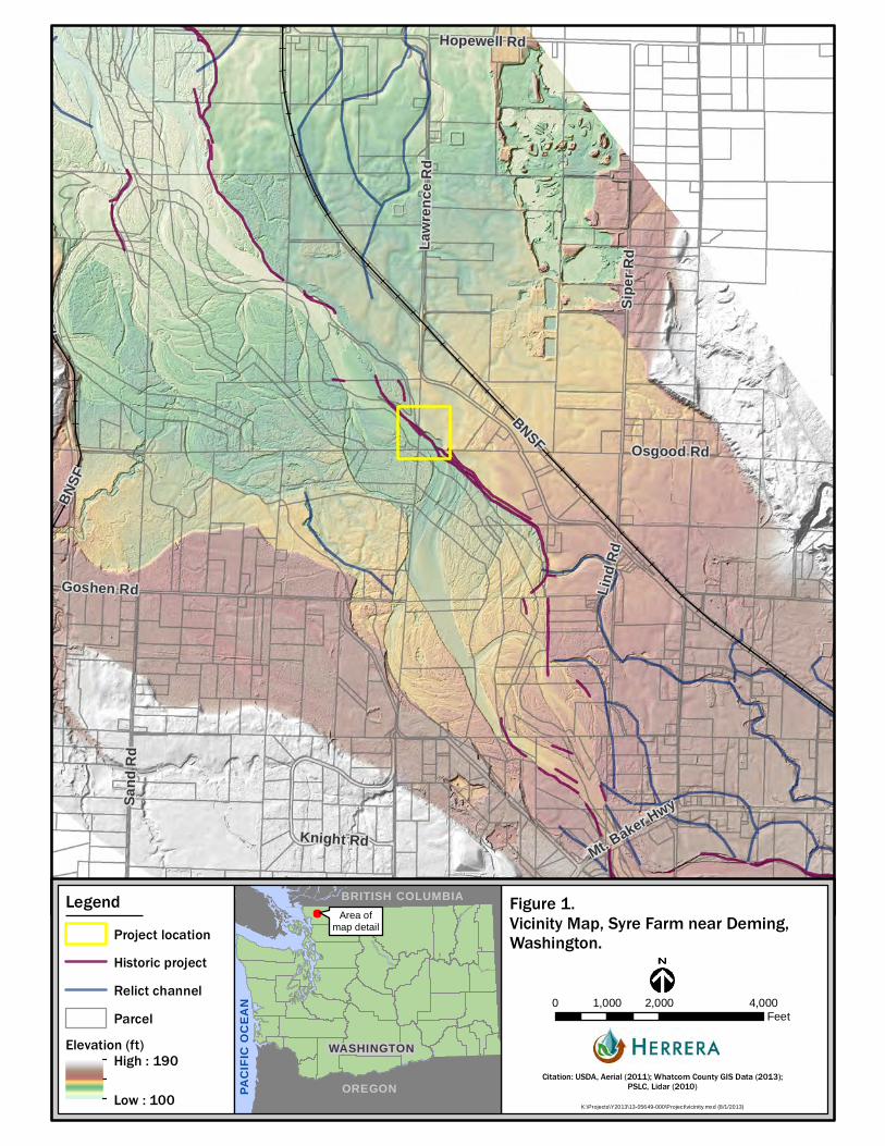
1. INTRODUCTION
1.1. Background
The Whatcom County Flood Control Zone District (FCZD) is evaluating the potential impacts
of, and possible responses to, bank erosion occurring on the right (north) bank of the
Nooksack River at the Syre Farm near Deming (Figure 1). Between 2006 and 2013, the right
bank of the Nooksack River at Syre Farm retreated approximately 300 feet due to erosion
during flood events. The initial bank retreat formed an arcuate (bow-shaped) scarp at what
is now the upstream end of the eroded bank. The scarp that formed initially between 2005
and 2007 was 190 feet long and extended 150 feet inland (perpendicular to the channel
alignment) from the prior bank location. Subsequent erosion progressed perpendicular to the
bank and in a downstream direction. In 2011, logs were anchored with ballast boulders and
cedar trees were shingled along the bank in an attempt to slow the rate of erosion, but this
was not successful. The cedar trees washed away and the anchored logs were subsequently
displaced and moved downstream in flood events through much of the scarp length, and the
bank continued to erode. In July of 2013, the length of the eroded bank scarp was 1,200 feet
and the point of greatest bank recession had translated 470 feet downstream.
1.2. Scope of Analysis
Whatcom County sought assistance from Herrera Environmental Consultants (Herrera) to
qualitatively analyze the causes of bank erosion and its expected outcome if no action is
taken and to evaluate several conceptual bank stabilization alternatives. Work performed by
Herrera included a site visit, analysis of background information provided by Whatcom
County, conceptual design of three bank stabilization alternatives, and an assessment of the
advantages and disadvantages of each alternative, including the ―no action‖ alternative.
1.3. Overview of Report Contents
The remainder of this report presents a description of the bank stabilization alternatives
evaluated and the methods and results of analyses of existing conditions and the potential
effectiveness and cost of those alternatives. The purpose of this information is to support the
FCZD in selecting a course of action at the site.
Hopewell Rd
Mount B
aker H
wy
Nook
sack
Rd
Osgood Rd
Knight Rd
Lind R
d
Roberts Rd
Goshen Rd
Siper
RdLa
wren
ce R
d
Sand
Rd
BNSF
BNSF
Mt. Baker Hwy
K:\Projects\Y2013\13-05649-000\Project\vicinity.mxd (8/1/2013)
0 2,000 4,0001,000Feet
LegendProject locationHistoric projectRelict channelParcel
Elevation (ft)High : 190
Low : 100 PACI
FIC
OCEA
N
OREGON
WASHINGTON
BRITISH COLUMBIAArea of
map detail
Citation: USDA, Aerial (2011); Whatcom County GIS Data (2013);PSLC, Lidar (2010)
Figure 1. Vicinity Map, Syre Farm near Deming,Washington.
August 2013
River Bank Stabilization Alternatives Assessment—Syre Farm 3
2. ANALYSIS METHODS AND DESCRIPTION OF
ALTERNATIVES
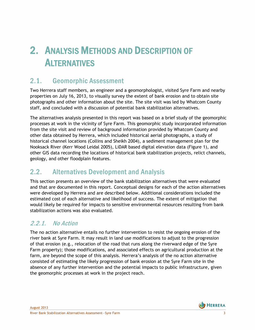
2.1. Geomorphic Assessment
Two Herrera staff members, an engineer and a geomorphologist, visited Syre Farm and nearby
properties on July 16, 2013, to visually survey the extent of bank erosion and to obtain site
photographs and other information about the site. The site visit was led by Whatcom County
staff, and concluded with a discussion of potential bank stabilization alternatives.
The alternatives analysis presented in this report was based on a brief study of the geomorphic
processes at work in the vicinity of Syre Farm. This geomorphic study incorporated information
from the site visit and review of background information provided by Whatcom County and
other data obtained by Herrera, which included historical aerial photographs, a study of
historical channel locations (Collins and Sheikh 2004), a sediment management plan for the
Nooksack River (Kerr Wood Leidal 2005), LiDAR based digital elevation data (Figure 1), and
other GIS data recording the locations of historical bank stabilization projects, relict channels,
geology, and other floodplain features.
2.2. Alternatives Development and Analysis
This section presents an overview of the bank stabilization alternatives that were evaluated
and that are documented in this report. Conceptual designs for each of the action alternatives
were developed by Herrera and are described below. Additional considerations included the
estimated cost of each alternative and likelihood of success. The extent of mitigation that
would likely be required for impacts to sensitive environmental resources resulting from bank
stabilization actions was also evaluated.
2.2.1. No Action
The no action alternative entails no further intervention to resist the ongoing erosion of the
river bank at Syre Farm. It may result in land use modifications to adjust to the progression
of that erosion (e.g., relocation of the road that runs along the riverward edge of the Syre
Farm property); those modifications, and associated effects on agricultural production at the
farm, are beyond the scope of this analysis. Herrera’s analysis of the no action alternative
consisted of estimating the likely progression of bank erosion at the Syre Farm site in the
absence of any further intervention and the potential impacts to public infrastructure, given
the geomorphic processes at work in the project reach.
August 2013
4 River Bank Stabilization Alternatives Assessment—Syre Farm
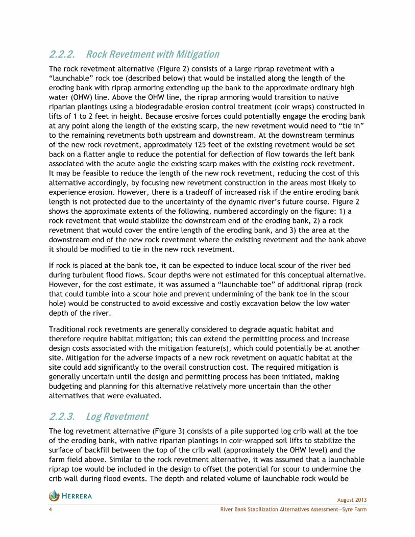
2.2.2. Rock Revetment with Mitigation
The rock revetment alternative (Figure 2) consists of a large riprap revetment with a
―launchable‖ rock toe (described below) that would be installed along the length of the
eroding bank with riprap armoring extending up the bank to the approximate ordinary high
water (OHW) line. Above the OHW line, the riprap armoring would transition to native
riparian plantings using a biodegradable erosion control treatment (coir wraps) constructed in
lifts of 1 to 2 feet in height. Because erosive forces could potentially engage the eroding bank
at any point along the length of the existing scarp, the new revetment would need to ―tie in‖
to the remaining revetments both upstream and downstream. At the downstream terminus
of the new rock revetment, approximately 125 feet of the existing revetment would be set
back on a flatter angle to reduce the potential for deflection of flow towards the left bank
associated with the acute angle the existing scarp makes with the existing rock revetment.
It may be feasible to reduce the length of the new rock revetment, reducing the cost of this
alternative accordingly, by focusing new revetment construction in the areas most likely to
experience erosion. However, there is a tradeoff of increased risk if the entire eroding bank
length is not protected due to the uncertainty of the dynamic river’s future course. Figure 2
shows the approximate extents of the following, numbered accordingly on the figure: 1) a
rock revetment that would stabilize the downstream end of the eroding bank, 2) a rock
revetment that would cover the entire length of the eroding bank, and 3) the area at the
downstream end of the new rock revetment where the existing revetment and the bank above
it should be modified to tie in the new rock revetment.
If rock is placed at the bank toe, it can be expected to induce local scour of the river bed
during turbulent flood flows. Scour depths were not estimated for this conceptual alternative.
However, for the cost estimate, it was assumed a ―launchable toe‖ of additional riprap (rock
that could tumble into a scour hole and prevent undermining of the bank toe in the scour
hole) would be constructed to avoid excessive and costly excavation below the low water
depth of the river.
Traditional rock revetments are generally considered to degrade aquatic habitat and
therefore require habitat mitigation; this can extend the permitting process and increase
design costs associated with the mitigation feature(s), which could potentially be at another
site. Mitigation for the adverse impacts of a new rock revetment on aquatic habitat at the
site could add significantly to the overall construction cost. The required mitigation is
generally uncertain until the design and permitting process has been initiated, making
budgeting and planning for this alternative relatively more uncertain than the other
alternatives that were evaluated.
2.2.3. Log Revetment
The log revetment alternative (Figure 3) consists of a pile supported log crib wall at the toe
of the eroding bank, with native riparian plantings in coir-wrapped soil lifts to stabilize the
surface of backfill between the top of the crib wall (approximately the OHW level) and the
farm field above. Similar to the rock revetment alternative, it was assumed that a launchable
riprap toe would be included in the design to offset the potential for scour to undermine the
crib wall during flood events. The depth and related volume of launchable rock would be

3
21
Syre FarmHouse
Existing rockrevetment
Existing rockrevetment
UV9
High flowoverflow channel
Existing sidechannel
Log structuresin the aerialare no longeron the site
Nooksack River
Revetment to follow the approximateJuly 2013 bank line
Set back existing revetment
Citron TrustCitron TrustCitron Trust
Citron Trust
Existingnatural
jam
390416052070
390416052070
390420478524
390421198493
390417400278
390417400278
390420391414
390420334473
390416052070
390416036168
390416093222
390421198493
390416089120390416052070
390420334514
390421098335390420517431
390416014221
390416124028
390416124100
Figure 2. Design Concept: Rock RevetmentAlternative.
K:\Projects\Y2013\13-05649-000\Project\Rock_Revet_Final.mxd (8/23/2013)
Citation: USDA, Aerial (2011); Whatcom County, GPS (2013);WCAR, Parcel (2006)
0 250 500125ft
Coordinates: NAD 1983 Washington State Plane North FIPS 4601 Feet
Legend
Existing log jam
") 2013 GPS bank lineRock revetmentExisting revetmentParcel


3
21
Syre FarmHouse
Existing rockrevetment
Existing rockrevetment
UV9
High flowoverflow channel
Existing sidechannel
Log structuresin the aerialare no longeron the site
Nooksack River
Revetment to follow the approximateJuly 2013 bank line
Set back existing revetment
Citron Trust
Existingnatural
jam
390416052070
390416052070
390420478524
390421198493
390417400278
390417400278
390420391414
390420334473
390416052070
390416036168
390416093222
390421198493
390416089120390416052070
390420334514
390421098335390420517431
390416014221
390416124028
390416124100
Figure 3. Design Concept: Log RevetmentAlternative.
K:\Projects\Y2013\13-05649-000\Project\Site_map.mxd (8/23/2013)
Citation: USDA, Aerial (2011); Whatcom County, GPS (2013);WCAR, Parcel (2006)
0 250 500125ft
Coordinates: NAD 1983 Washington State Plane North FIPS 4601 Feet
Legend
Existing log jam
") 2013 GPS bank lineLog revetment
! PileExisting revetmentParcel


August 2013
River Bank Stabilization Alternatives Assessment—Syre Farm 9
reduced with the log revetment alternative through the use of pilings to hold the logs in place, and because the potential scour depth would be less due to increased hydraulic roughness (and reduced flow velocities as a result of that roughness). The log revetment would tie into the existing rock revetments upstream and downstream.
As with the rock revetment alternative, this design includes laying back a portion of the existing downstream revetment to a flatter slope to reduce the potential for deflection of flows towards the left bank. It may be feasible to reduce the length of the log revetment and the extent of the tie-in with existing revetments with further design development and evaluation. However, for this planning level alternatives analysis, a reduced log revetment length was not addressed in detail. Figure 3 shows the approximate extents of the following, numbered accordingly on the figure: 1) a log revetment that would stabilize the downstream end of the eroding bank, 2) a log revetment that would cover the entire length of the eroding bank, and 3) the area at the downstream end of the new log revetment where the existing revetment and the bank above it should be modified to tie in the new log revetment.
Unlike the rock revetment alternative, a log revetment may be considered “self-mitigating” with respect to environmental impacts because it can be designed to enhance aquatic habitat. This reduces some of the uncertainty with regard to the permitting process and overall project cost relative to the rock revetment alternative.
2.2.4. Engineered Logjams The engineered logjam (ELJ) alternative (Figure 4) consists of constructing four flow-deflecting logjams on the right-bank gravel bar upstream of the eroding bank and one logjam on the left bank at the inlet to the existing high flow overflow channel. The ELJs would be approximately 70 to 90 feet wide and consist of driven timber piles (driven well below scour depth) with large log pieces layered from below the channel bed elevation to at or near the flood water elevations within the reach. The intent of these logjams would be to create hydraulic roughness that reduces flow velocities, absorb erosive energy during large floods, and direct flow away from the eroding right bank and toward the entrance of the existing left-bank overflow channel. The ELJs could encourage deposition of cobbles and gravel on the downstream (leeward) side of each structure with the potential for vegetated islands/bars to develop over the long term in front of the bank, providing greater erosion protection as they evolve. This alternative would also include grading and enhancement of the existing high flow overflow channel to improve hydraulic conveyance at both low and high flows and to enhance side channel functions. Woody habitat structures would be constructed within the overflow channel to improve habitat complexity.
ELJs have successfully been used for this purpose in many locations throughout western Washington, including in the Nooksack River. However, since the ELJs would not tie into the existing revetments upstream and downstream of the eroding bank, there would remain potential for the river to periodically erode portions of the bank between ELJs. If designed appropriately, the ELJs would prevent this from being a significant ongoing problem and could effectively protect Syre Farm from worsening loss of land. Similar to the log revetment alternative, ELJs could be considered self-mitigating in regards to environmental permitting process and requirements.
August 2013
10 River Bank Stabilization Alternatives Assessment—Syre Farm
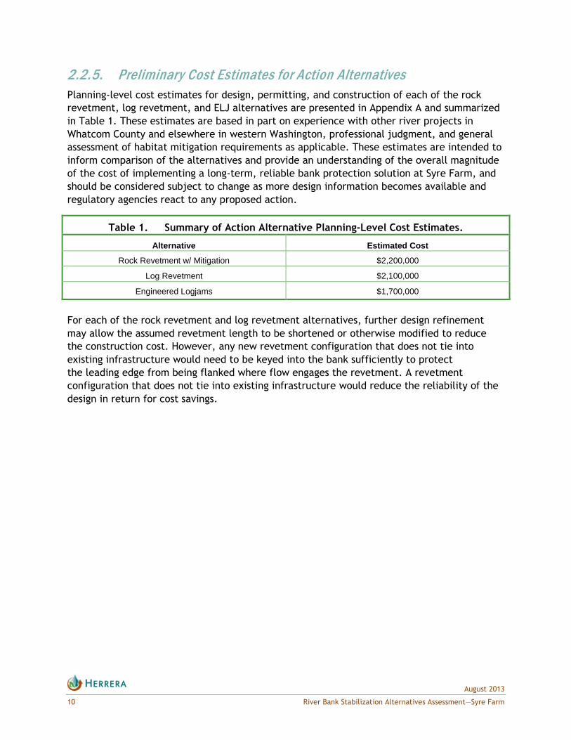
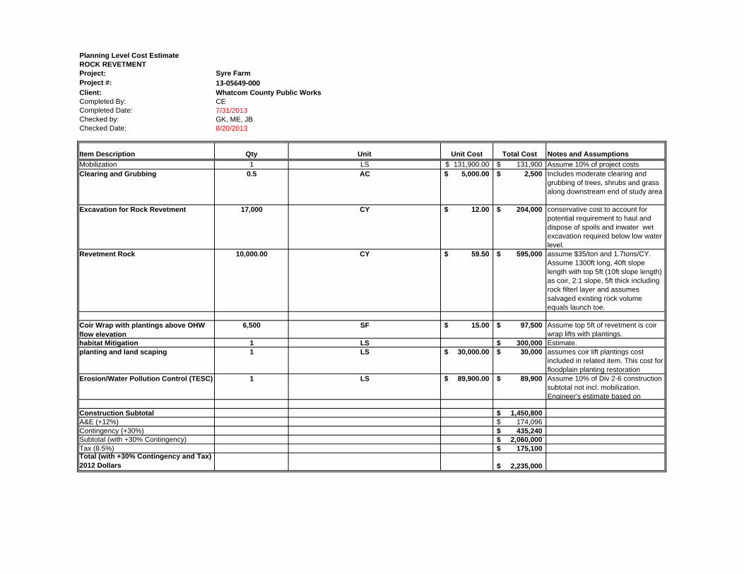
2.2.5. Preliminary Cost Estimates for Action Alternatives
Planning-level cost estimates for design, permitting, and construction of each of the rock
revetment, log revetment, and ELJ alternatives are presented in Appendix A and summarized
in Table 1. These estimates are based in part on experience with other river projects in
Whatcom County and elsewhere in western Washington, professional judgment, and general
assessment of habitat mitigation requirements as applicable. These estimates are intended to
inform comparison of the alternatives and provide an understanding of the overall magnitude
of the cost of implementing a long-term, reliable bank protection solution at Syre Farm, and
should be considered subject to change as more design information becomes available and
regulatory agencies react to any proposed action.
Table 1. Summary of Action Alternative Planning-Level Cost Estimates.
Alternative Estimated Cost
Rock Revetment w/ Mitigation $2,200,000
Log Revetment $2,100,000
Engineered Logjams $1,700,000
For each of the rock revetment and log revetment alternatives, further design refinement
may allow the assumed revetment length to be shortened or otherwise modified to reduce
the construction cost. However, any new revetment configuration that does not tie into
existing infrastructure would need to be keyed into the bank sufficiently to protect
the leading edge from being flanked where flow engages the revetment. A revetment
configuration that does not tie into existing infrastructure would reduce the reliability of the
design in return for cost savings.

")
")")
")")")")")
")")")
")")")
")
")
")
")
")
")
")
")
")
")
")
")
")
")
")")
")
")")
")")")
")")")
")")")")")
")")
")")") ") ")") ")")")
Syre FarmHouse
Existing rockrevetment
Existing rockrevetment
UV9
High flowoverflow channel
Existing sidechannel
Log structuresin the aerialare no longeron the site
Nooksack River
Deflector(location may
move)
Citron Trust
Existingnatural
jam
390416052070
390416052070
390420478524
390421198493
390417400278
390417400278
390420391414
390420334473
390416052070
390416036168
390416093222
390421198493
390416089120390416052070
390420334514
390421098335390420517431
390416014221
390416124028
390416124100
Figure 4. Design Concept: ELJ Deflector Alternative.
K:\Projects\Y2013\13-05649-000\Project\Deflector_jam.mxd (8/23/2013)
Citation: USDA, Aerial (2011); Whatcom County, GPS (2013);WCAR, Parcel (2006)
0 250 500125ft
Coordinates: NAD 1983 Washington State Plane North FIPS 4601 Feet
Legend
Existing log jam
Deflector ELJ
") 2013 GPS bank lineExisting revetmentParcel


August 2013
River Bank Stabilization Alternatives Assessment—Syre Farm 13
3. ANALYSIS RESULTS
3.1. Geomorphic Setting
The upper Nooksack River floodplain is inset into a Pleistocene glacial outwash surface.
Within the alluvial valley, the channel has migrated widely, at least since deforestation of
the valley bottom. Prior to European occupation and resultant deforestation, the river may
have consisted of multiple stable channels branching around forested islands, but since
deforestation it has consisted of multiple rapidly migrating channels and gravel bars. Young
forests have formed on some of the more persistent bars, but do not appear competent to
restrict channel locations.
On the opposite side of the river from Syre Farm, the left bank can be characterized as
young forested floodplain dissected by side channels and relict channel scars. The right bank
floodplain at the farm is disconnected from flooding by high banks and revetments, and
is currently cultivated for farming with a wood lot occupying the location of a 1950s era
channel. Herrera staff visited the left bank side channel on July 16, 2013, to determine the
probability of the side channel becoming reoccupied by the mainstem flow, or the potential
that mainstem flow might become bifurcated between the side channel and the current
mainstem channel. Flow was occurring in the side channel at the time of the site visit,
with some indications that flow had recently increased through the side channel (recently
recruited trees from the banks of the side channel). A natural logjam at the side channel inlet
and the hydraulically rough channel form indicate that notable flow increases in the left bank
side channel (as a proportion of the total river flow at any point in time) are possible but
unlikely in the foreseeable future.
River channel migration is conditioned by the nature of the geologic materials that form the
valley and floodplain. The surface geology of the Nooksack River valley in the vicinity of Syre
Farm is comprised of three types of material (Table 2). Descriptions of these materials
included in Table 2 are taken from Jones (1999).
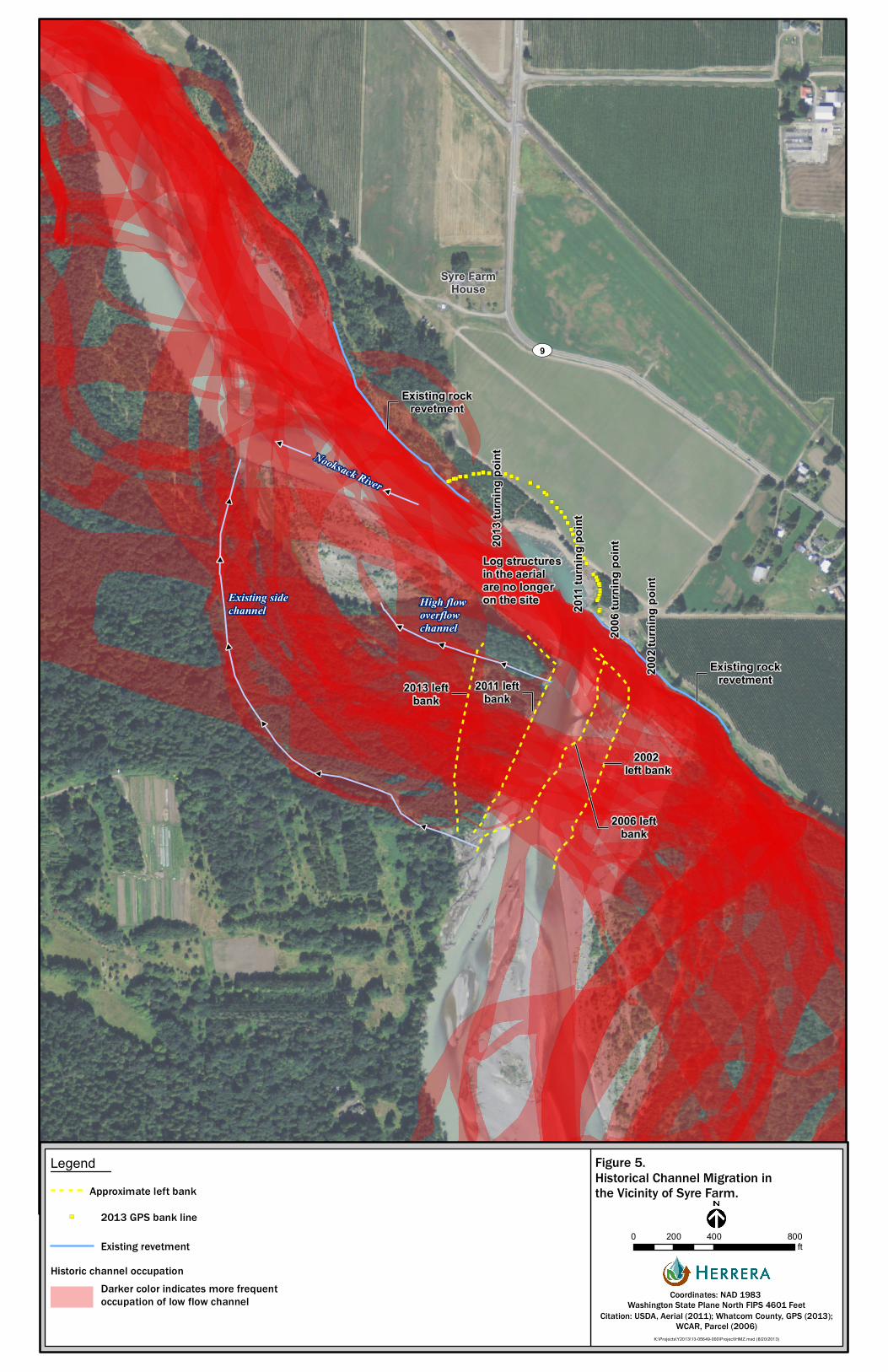
3.2. Channel Migration Characteristics At and Near Syre Farm
Channel migration in the vicinity of the Syre Farm site has tended to take the form of
switching from one side of the valley to the other rather than gradual migration across
the floodplain. The right boundary of this zone of migration has been along the Syre Farm
property. The left boundary has been at the large side-channel on the Citron Trust property
across the river from the Syre Farm. Collins and Sheikh (2004) calculated the frequency of
occupation by unvegetated channel from the historical aerial photograph record from 1933 to
2002. Table 3 lists the frequency and characteristic patterns of channel occupation mapped
by Collins and Sheikh for the area between 1 mile upstream (river mile [RM] 30) and 1 mile
downstream (RM 28) of the Syre Farm property. Upstream of Syre Farm, the Nooksack River
has tended toward occupying the center of the floodplain, with occupation of the left and
right margins observed in less than 30 percent of the historical aerial photograph sets. Across

August 2013
14 River Bank Stabilization Alternatives Assessment—Syre Farm
from the Syre Farm property, the river has tended to split into main and secondary channels,
with the main channel switching to either side of the floodplain every few decades.
Downstream of the currently eroding bank, the river has more evenly occupied the floodplain,
with the highest frequencies of occupation (50 to 60 percent of the time) toward the right
and left margins of the historically active floodplain.
Table 2. Surface Geology of the Nooksack River Valley Near Syre Farm.
Location Material
Incised floodplain Qal - Alluvium (Holocene), generally stratified and well-sorted sand, gravel, and silt;
deposited in streambeds, alluvial fans, floodplains, spits, deltas, beaches, and terraces of
the Nooksack River
Valley margin terraces:
Northeast
South
West
Northwest
Qvrg/Qvrf - Vashon recessional and Sumas Stade outwash deposits (Pleistocene),
moderately-to- poorly-sorted gravel and sand with small amounts of silt and clay. Includes
some ice-contact deposits, glaciomarine deposits, lacustrine deposits; may also include
Bellingham drift and Deming sand deposits from the Everson Interstade. Qvrg consists of
the coarser deposits and Qvrf generally consists of the finer deposits
Valley margin terrace:
East
Qvt/Qvtse - Vashon and Sumas Stade till deposits (Pleistocene), predominantly fine-
grained deposits consisting of unsorted and unstratified glacial sediments from clay-to-
boulder in size that vary in compaction and composition throughout the Puget Sound
Lowland; includes the Kulsham drift and some ice-contact deposits
Table 3. Frequency of Occupation by Unvegetated Channel (from Collins and Sheikh 2004, Fig.12).
Location Maximum
Occupation % Notes
RM 30 Variable, tending toward center of
floodplain
>70 <30% of the time between 1933 and 2002 the
channel was located along the left and right
margins of the floodplain
RM 29 Adjacent to Syre Farm 70-90 Tendency to split flow with main and secondary
channels at left and right edge of floodplain
Adjacent to Citron Trust property 80-100
Downstream of Syre Farm <30
RM 28 Variable across width of floodplain 50-60 More frequent left and right side of floodplain
Different parts of the Nooksack River floodplain in the Syre Farm vicinity can be assigned
differing degrees of vulnerability to channel migration, depending on their composition and
history of occupation by the active channel. We defined four categories of vulnerability, as
follows:
1. Negligible: outwash/till terraces located in an area with no sign of channel
occupation over aerial photograph record
2. Low: alluvium located in an area with no sign of channel occupation over
aerial photograph record

August 2013
River Bank Stabilization Alternatives Assessment—Syre Farm 15
3. Moderate: alluvium located in an area that has been occupied by the channel less
than 50 percent of the time over aerial photograph record
4. High: alluvium located in an area that has been occupied by the channel
greater than 50 percent of the time over historical record
Based on these criteria, the currently eroding portion of the Syre Farm property had a low
vulnerability to channel migration prior to 2005 (relative to other areas within the reach).
The same can be said of the existing conditions on the Citron Trust property south of the
side channel. The portion of the Syre Farm property downstream of the current extent of
eroding bank has a moderate vulnerability to channel migration, and the portion of the
Citron Trust property north of the side channel has a moderate to high vulnerability. The
Syre Farm property was protected by riprap revetments for most of the aerial photograph
record; considering that the river ran alongside the Syre Farm property for much of that
time, it is likely that in the absence of those revetments the property would have been in
the moderate or high vulnerability class due to more extensive encroachment by the river.
Bank erosion and consequent channel migration can occur through a variety of mechanisms,
including bank scour, bank slumping, bank undercutting, head-cut erosion, lateral (inflow)
erosion, and wave-induced erosion (Catchments and Creeks 2010). On rivers, wave-induced
erosion is generally only found where velocities are relatively slow and near-bank boat traffic
is frequent, neither of which are likely to be true of the Syre Farm site. Bank scour occurs
when high velocity flows remove material from the entire height of a bank, usually at the
outside of a meander bend. Bank undercutting, on the other hand, consists of the removal of
material from the toe of the bank by high velocity flows, leading to planar, rotational, or
cantilever slope failure. Sapping failures occur when water that is driven into permeable
layers by the river on the rising limb of a peak flow event drains out of those layers on the
receding limb, carrying sediment with it. The removal of material and resulting weakness in
the permeable layer leads to cantilever failure of overlying layers (Imanshoar et al. 2012;
Hagerty 1992).
Successful stabilization of an eroding river bank requires correct identification of the
mechanism(s) and cause(s) of erosion (Catchments and Creeks 2010). Based upon information
provided by the County and our observations at Syre Farm (summarized in Table 4), it appears
that the bank erosion has occurred due to a combination of toe scour, sapping, and cantilever
slope failure. Although no direct evidence of sapping was observed during the site visit, the
arcuate shape of the receding bank at Syre Farm, the presence of soil layers with different
apparent permeability, and the undercut banks seen in site photographs are all consistent
with sapping failure. When piping/sapping is a significant factor, toe protection by itself
is not usually sufficient to stop bank erosion (Hagerty 1992). Successful bank stabilization
typically requires a combination of bank toe reinforcement with rock or wood and additional
measures to restrict the loss of subsurface sediment through piping (e.g., protecting the face
of the bank with an appropriately-gaged geotextile layer).
Despite its historically low frequency of occupation by the active river channel, the floodplain
area landward and downstream of the eroding bank at Syre Farm clearly is vulnerable to
channel migration in the near term. A closer look at the history of channel migration in

August 2013
16 River Bank Stabilization Alternatives Assessment—Syre Farm
the area directly adjacent to and upstream of Syre Farm (Figure 5, Table 5) suggests that
a change in the approach direction of the main channel sometime between 1998 and 2002
initiated changes in the pattern of bank migration and channel occupation of the floodplain in
the area. Prior to 1998, the unvegetated channel generally approached the Syre Farm area
from the east and/or southeast. Between 1998 and 2002, the direction of mainstem flow
reoriented to approach from the south-southwest, resulting in a roughly perpendicular
approach to the Syre Farm revetment, which began to fail sometime between 2002 and 2006.
As long as the river is being forced to make a right-angle turn at Syre Farm, it is likely that
the main flow will continue to run along the failing bank, undercutting the toe and fostering
piping/sapping erosion of permeable layers within it.
Table 4. Types of Bank Erosion Observed at Syre Farm.
Bank Erosion Mechanism Characteristics
Bank undercutting
(Catchments and Creeks Pty 2010)
tension cracks parallel to bank,
collapsed bank material washed away,
undercutting along toe,
lateral movement of channel bank
Piping/Sapping
(Hagerty 1992)
Presence of soil layers with differing permeability,
Overhanging bank,
Failed blocks at toe
The locus of right bank erosion is expected to continue to move downstream because right
bank bar growth upstream of Syre Farm is encouraging the low-flow channel to the left
(west). The location of the low-flow channel is significant for two reasons. First, during
low flows some of the finer material at the toe of the eroding bank slope may be carried
downstream. Second, the low-flow channel location is where the deepest and fastest flows
occur during flood events. As the low flow channel moves left (west) upstream of Syre Farm,
its point of intersection with the eroding bank moves downstream, and so therefore does
the point of greatest potential for bank erosion. Figure 5 shows the westward migration of
the left bank of the river, and the consequent movement of the turning point downstream.
If the rate of migration observed since 2011 continues, the turning point will likely be
downstream of the eroded bank by 2015. Given the pattern of channel switching observed
in the aerial photograph record, there is potential for the main channel to reoccupy one or
more of the left bank overflow channels, leaving the bank at Syre Farm on a side channel
and thus less exposed to toe-scouring flows. However, predictions of when or exactly how
this potential shift in mainstem channel alignment might occur are not feasible due to the
dynamic nature of riverine processes and the uncertain nature of the variables associated
with large scale channel movements.
Photographs of the Nooksack River channel and its floodplain at and near the Syre Farm site
taken on July 16, 2013, are presented on the following pages.
")")")")")")")")
")")")
")")")
")
")")
")")")
")
")")
")")
")")
")
")")")
")")")
")")")")")
")")")")")")")")")
") ")")") ")")")
Syre FarmHouse
Existing rockrevetment
UV9
High flowoverflow channel
Existing sidechannel
Log structuresin the aerialare no longeron the site
2013 leftbank
2011 leftbank
2006 leftbank
2002 left bank
2002
turn
ing po
int
2006
turn
ing po
int
2011
turn
ing po
int
Existing rockrevetment
Nooksack River20
13 tu
rning
point
Figure 5. Historical Channel Migration inthe Vicinity of Syre Farm.
K:\Projects\Y2013\13-05649-000\Project\HMZ.mxd (8/20/2013)
Citation: USDA, Aerial (2011); Whatcom County, GPS (2013);WCAR, Parcel (2006)
0 400 800200ft
Coordinates: NAD 1983 Washington State Plane North FIPS 4601 Feet
LegendApproximate left bank
") 2013 GPS bank line
Existing revetmentHistoric channel occupation
Darker color indicates more frequentoccupation of low flow channel


August 2013
River Bank Stabilization Alternatives Assessment—Syre Farm 19
Table 5. Nooksack River Channel Migration Characteristics Near Syre Farm, 1859-2013.
Map or Photo Year
Time Since
Prior Map or Photo
(yrs)
Direction of Approaching
River
Syre Farm Citron Trust Property State Route 9 Perpendicular Main Channel
Approach
Channel Type: Main (M) or
Secondary (S) or None (X)
Distance from Pre-2005 Bank
(ft)
Channel Type: Main (M) or
Secondary (S) or None (X)
Distance from 2013 Left Bank
(ft)
Closest Approach of
Left Bank (ft)
Direction to Closest
Approach
Eastward Migration Distance
Intercept Distance From Upstream End of Syre Farm Bank Erosion
(ft)
1859 SE M 0 X - 780 SW - -
1885 26 SE X 540 M 60 1,670 S - -
1906 21 E, SE, S S 70 M 100 1,000 SSW - -
1933 27 E, ESE S 110 M 370 560 WSW - -
1938 5 E, SE S -370 a M 360 410 SW - -
1950 12 ESE, SE M -120 a S 380 660 SW - -
1955 5 SE, SSE M 0 S 340 780 SW - -
1967 12 SE M 0 S 320 780 SW - -
1976 9 ESE S 0 S 280 780 SW - -
1980 4 E S 0 M 290 780 SW - -
1986 6 ESE S 0 M 280 780 SW - -
1995 9 SE, ESE M 0 S 0 780 SW - -
1998 3 SE M 0 S 0 780 SW - -
2002 4 SSW M 0 S 0 780 SW 0 c -390
2006 4 SSW M -70 S* 0 780 SW 150 -150
2010 4 SSW M -180 S 0 780 SW 340 0
2011 1 SSW M -180 b S 0 780 SW 420 80
2013 2 SSW M -270 S 0 660 S 770 640
a Downstream of current (2013) eroding bank b No lateral expansion of eroded area, but 130 feet downstream extension of eroding bank c Reference bank position (2002)

August 2013
20 River Bank Stabilization Alternatives Assessment—Syre Farm
Photo showing the eroding right bank, the wooded area in the background, and the farm road and planted field to the right.

August 2013
River Bank Stabilization Alternatives Assessment—Syre Farm 21
Photo showing the right bank aggrading bar upstream of the eroding bank at Syre Farm, with the vegetated left bank floodplain to the left.
August 2013
22 River Bank Stabilization Alternatives Assessment—Syre Farm
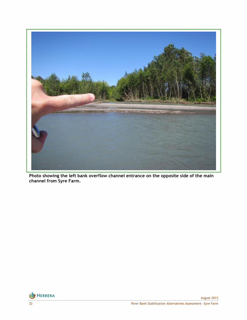
Photo showing the left bank overflow channel entrance on the opposite side of the main channel from Syre Farm.

August 2013
River Bank Stabilization Alternatives Assessment—Syre Farm 23
Photo showing right bank materials at the downstream end of the eroding bank, with fine soil material above the more permeable coarse channel bed material below, also showing overhanging bank condition.
August 2013
24 River Bank Stabilization Alternatives Assessment—Syre Farm
3.3. Geomorphic Response to Alternatives
3.3.1. No Action
With no stabilization of the right bank at Syre Farm, it can be expected that the bank will
continue to erode and retreat, and that the point of greatest retreat will continue to migrate
downstream. The rate of retreat is likely to slow over the next few years, because as the
left bank continues to erode and the right bank cobble bar upstream continues to aggrade
the meander and related locus of erosion will continue to shift west, eventually shifting
beyond the Syre Farm or avulsing through the left bank floodplain, where the main channel
was located as recently as 1986. Unless the main channel shifts, it is likely that the rock
revetment downstream of the currently-eroding bank will continue to unravel episodically
during flood events, potentially allowing the river to cut into the forested area behind
the revetment, as it did early in the 20th century. The time frame for these potential
developments could be accelerated with large channel-changing flood events or slowed if
future flooding is benign. The potential for large scale flooding similar to what occurred in
the mid-1990s, that delivers large volumes of sediment and debris, makes predictions of
channel migration on a yearly and subreach scale uncertain.
The recent bank erosion at Syre Farm has raised concerns that State Route 9 (SR 9) could be
threatened. Figure 6 shows the distance from the current location of SR 9 to the right bank
of the Nooksack River between 1859 and 2013. For most of that period, the distance has been
constant due to the Syre Farm revetment. In the first few years after the revetment failed,
that continued to be the case. The landward and downstream progression of erosion since
2011 has caused the distance between the river and SR 9 to shrink by approximately 120 feet,
from approximately 780 feet to 660 feet, but bank erosion is propagating in a direction that
will take it further away from SR 9, and the upstream end of the failing bank has stabilized.
It is therefore unlikely that SR 9 is in any short-term danger of being attacked by the river.
It should be noted, however, that the area downstream of the currently eroding bank is at
moderate risk from channel migration, and that realignment of the river upstream of Syre
Farm could change the rate and direction of bank erosion in this vulnerable bank area. A
threat to SR 9 could arise if the river breaches the revetment and erodes the forest that lies
between the revetment and the corner of SR 9 where it turns north at the entrance to Syre
Farm.
3.3.2. Rock Revetment
Rock revetments act as hard, hydraulically smooth banks and can often attract the mainstem
low flow of rivers as a result, further exacerbating an erosion problem as the channel ―hugs‖
the revetment and erodes unprotected bank areas downstream. Tying into the existing
revetment would reduce the potential for downstream erosion to occur, but in general
construction of a rock revetment on the right bank at Syre Farm would encourage the
mainstem to ―occupy‖ the right bank more frequently than it would if the bank was allowed
to erode or if a more roughened bank revetment design was constructed (see the log
revetment discussion below). More frequent occupation of the right side of the floodplain
would correspond to less frequent occupation of the left side of the floodplain, potentially

August 2013
River Bank Stabilization Alternatives Assessment—Syre Farm 25
allowing the development of more mature vegetation there. If that occurs, overflow channels
in the left bank floodplain could fill in with sediment trapped by the vegetation, thereby
encouraging the river to occupy the right bank even more.
Figure 6. Distance from SR 9 to Left Bank of Nooksack River at Syre Farm.
3.3.3. Log Revetment
Because the log revetment alternative would be designed to be hydraulically rough, this
alternative would be less likely to entrain the mainstem channel along its length than a rock
revetment would. This would result in a similar probability of the mainstem flow reoccupying
the left bank channel migration zone as described above for the ―no action‖ alternative. Both
rock and log revetments would prevent the channel from migrating further into the Syre Farm
property, and so both of these alternatives would keep the channel generally within the
bounds of its historical migration corridor.
3.3.4. Engineered Logjams
Construction of engineered logjams on the right bank bar upstream of Syre Farm would
accelerate the process of channel migration away from the eroding right bank and encourage
more frequent occupation of mainstem flow within the left bank historic channel migration
zone. This alternative would not, however, do anything to increase slope stability at the
eroded bank along Syre Farm. The ELJs would encourage sediment deposition directly
downstream of them, which would further reinforce the deflection of flow and energy away
from the right bank and create the potential for a forested floodplain or forested island/side
channel mosaic to develop between the ELJs and the Syre Farm property.


August 2013
River Bank Stabilization Alternatives Assessment—Syre Farm 27
4. DISCUSSION
The eroding bank at Syre Farm is located in a dynamic reach of the Nooksack River with a
record of frequent channel switching from one side of the floodplain to the other. Although
the historical record suggests that the Syre Farm property should be at a relatively low risk
due to channel migration, recent changes in the direction from which the river approaches
the farm changed its vulnerability. The recent loss of revetment and subsequent bank retreat
at Syre Farm clearly indicate that the revetment was inadequate to prevent bank erosion with
the current channel alignment. While it is likely that the main force of the river will not be
directed at the Syre Farm bank for more than another 2 or 3 years as the locus of flow energy
migrates downstream on the right bank, prevention of further erosion at Syre Farm in the
meantime will require some action. Of the four alternatives analyzed in this report (see
Table 6), the ELJ alternative would have the least likelihood of triggering permitting and
mitigation complications, but is less likely to arrest bank erosion in the short term and would
mainly serve to accelerate the pace of leftward channel migration upstream of Syre Farm.
The rock revetment alternative would be likely to arrest bank erosion, but it has a high
likelihood of triggering mitigation and permitting complications. To predictably arrest bank
erosion at Syre Farm, the log revetment alternative is recommended for its combination of a
high likelihood of success in stopping bank erosion coupled with a medium to low likelihood of
triggering complicated permitting and mitigation requirements.
Table 6. Bank Stabilization Alternatives Summary.
Alternative
Likelihood of Arresting Right Bank
Erosion Construction Cost
Likelihood of Requiring Habitat Mitigation and a Complicated
Permitting Process
No Action Low None None
Rock Revetment High High High
Log Revetment High High Medium/Low
ELJs Medium High Low

August 2013
River Bank Stabilization Alternatives Assessment—Syre Farm 29
5. REFERENCES
Catchments and Creeks Pty, Ltd. 2010. Watercourse erosion – part 1: Erosion types and their
causes. www.catchmentsandcreeks.com.au/docs/Watercourse-erosion-1.pdf.
Collins, B. and A. Sheikh. 2004. Historical channel locations of the Nooksack River. Prepared
for Whatcom County Public Works Department by University of Washington, Department of
Earth and Space Sciences.
Hagerty, D.J. 1992. Identification of piping and sapping erosion of streambanks. US Army
Corps of Engineers Flood Control Channels Research Program Contract Report HL-92-1.
Imanshoar, F., M.R.M. Tabatabai, Y. Hassanzadeh, and M. Rostamipoor. 2012. Experimental
study of subsurface erosion in river banks. World Academy of Science, Engineering, and
Technology 61.
Jones, M.A. 1999. Geologic Framework for the Puget Sound Aquifer System, Washington and
British Columbia. USGS Professional Paper 1414-C.
Kerr Wood Leidal, 2005, Nooksack River sediment management plan: summary of background
information. Prepared for Whatcom County Flood Control District by Kerr Wood Leidal
Associates Ltd., Burnaby, B.C.

APPENDIX A
Planning-Level Cost Estimates


Project: Syre FarmProject #: 13‐05649‐000Client: Whatcom County Public WorksCompleted By: CECompleted Date: 7/31/2013Checked by: GK, ME, JBChecked Date: 8/20/2013
Item Description Qty Unit Unit Cost Total Cost Notes and Assumptions
Mobilization 1 LS 97,900.00$ 97,900$ Assume 10% of project costsClearing and Grubbing 1.0 AC 5,000.00$ 5,000$ Includes moderate clearing and
grubbing of trees, shrubs and grass along access and side channels
ELJ construction 5 EA 88,250.00$ 441,250$ Excavation 1,500 CY 10.00$ 15,000$ Key Logs 50 EA 600.00$ 30,000$ assume 10 key logs every 30ftracking logs 150 EA 75.00$ 11,250$ assume 10 racking logs every 30ftTimber Pilings 20 EA 1,200.00$ 24,000$ assume one every 10ftAssembly of Structure 1 EA 8,000.00$ 8,000$ Side Channel Enhancement 2 EA 217,777.78$ 435,556$ starter channel and inlet excavation 7,222 CY 8.00$ 57,778$ Assumes 1300ft of starter
channel/inet excavation and can waste spoils on site.
Side channel habitat log structures 26 EA 5,000.00$ 130,000$ Assumes one every 100ft of channel
side channel planting and land scaping 1 LS 30,000.00$ 30,000$ This cost for floodplain and ELJ, starter channel planting restoration
Erosion/Water Pollution Control (TESC) 1 LS 97,100.00$ 97,100$ Assume 10% of Div 2-6 construction subtotal not incl. mobilization. Engineer's estimate based on
Construction Subtotal 1,076,806$ A&E (+15%) 161,520.83$ Contingency (+30%) 323,042$ Subtotal (with +30% Contingency) 1,561,000$ Tax (8.5%) 132,685$ Total (with +30% Contingency and Tax) 2012 Dollars 1,694,000$
Planning Level Cost EstimateDEFLECTOR ELJ

Project: Syre FarmProject #: 13‐05649‐000Client: Whatcom County Public WorksCompleted By: CECompleted Date: 7/31/2013Checked by: GK, ME, JBChecked Date: 8/20/2013
Item Description Qty Unit Unit Cost Total Cost Notes and Assumptions
Mobilization 1 LS 121,400.00$ 121,400$ Assume 10% of project costsClearing and Grubbing 0.5 AC 5,000.00$ 2,500$ Includes moderate clearing and
grubbing of trees, shrubs and grass along downstream end of study area
Excavation for Log Revetment 10,000 CY 12.00$ 120,000$ conservative unit cost to account for potential requirement to haul and dispose of spoils and inwater wet excavation required below low water level. Quantity less than rock revetment to acount for log roughness moving scour away from toe so less depth/excavation required. Assumes layback existing bank and excavate for toe.
Revetment Rock 5,000.00 CY 59.50$ 297,500$ assume $35/ton and 1.7tons/CY. Assume 1300ft long, 40ft slope length with top 5ft (10ft slope length) as coir and 50% less rock than rock revetment to acount for log volume and reduced quantity needed for toe rock). Same geometry assumed as Rock Rev.
Key Logs 650 EA 600.00$ 390,000$ assume 10 key logs every 30ftracking logs 433 EA 75.00$ 32,500$ assume 10 racking logs every 30ftTimber Pilings 130 EA 1,200.00$ 156,000$ assume one every 10ftCoir Wrap with plantings above OHW flow elevation
6,500 SF 15.00$ 97,500$ Assume top 5ft of revetment is coir wrap lifts with plantings.
planting and land scaping 1 LS 30,000.00$ 30,000$ assumes coir lift plantings cost included in related item. This cost for floodplain planting restoration
Erosion/Water Pollution Control (TESC) 1 LS 87,700.00$ 87,700$ Assume 8% of Div 2-6 construction subtotal not incl. mobilization. Estimate. Reduced from rock
Construction Subtotal 1,335,100$ A&E (+15%) 200,265$ Contingency (+30%) 400,530$ Subtotal (with +30% Contingency) 1,936,000$ Tax (8.5%) 164,560$ Total (with +30% Contingency and Tax) 2012 Dollars
2,101,000$
Planning Level Cost EstimateLOG REVETMENT
Project: Syre FarmProject #: 13‐05649‐000Client: Whatcom County Public WorksCompleted By: CECompleted Date: 7/31/2013Checked by: GK, ME, JBChecked Date: 8/20/2013
Item Description Qty Unit Unit Cost Total Cost Notes and Assumptions
Mobilization 1 LS 131,900.00$ 131,900$ Assume 10% of project costsClearing and Grubbing 0.5 AC 5,000.00$ 2,500$ Includes moderate clearing and
grubbing of trees, shrubs and grass along downstream end of study area
Excavation for Rock Revetment 17,000 CY 12.00$ 204,000$ conservative cost to account for potential requirement to haul and dispose of spoils and inwater wet excavation required below low water level.
Revetment Rock 10,000.00 CY 59.50$ 595,000$ assume $35/ton and 1.7tons/CY. Assume 1300ft long, 40ft slope length with top 5ft (10ft slope length) as coir, 2:1 slope, 5ft thick including rock filterl layer and assumes salvaged existing rock volume equals launch toe.
Coir Wrap with plantings above OHW flow elevation
6,500 SF 15.00$ 97,500$ Assume top 5ft of revetment is coir wrap lifts with plantings.
habitat Mitigation 1 LS 300,000$ Estimate.planting and land scaping 1 LS 30,000.00$ 30,000$ assumes coir lift plantings cost
included in related item. This cost for floodplain planting restoration
Erosion/Water Pollution Control (TESC) 1 LS 89,900.00$ 89,900$ Assume 10% of Div 2-6 construction subtotal not incl. mobilization. Engineer's estimate based on
Construction Subtotal 1,450,800$ A&E (+12%) 174,096$ Contingency (+30%) 435,240$ Subtotal (with +30% Contingency) 2,060,000$ Tax (8.5%) 175,100$ Total (with +30% Contingency and Tax) 2012 Dollars 2,235,000$
Planning Level Cost EstimateROCK REVETMENT