Embed Size (px)
Citation preview

Sentinel-2
The ESA Sentinels will be the first series of
loperational satellites to meet the Earthobservation needs of the European Union-
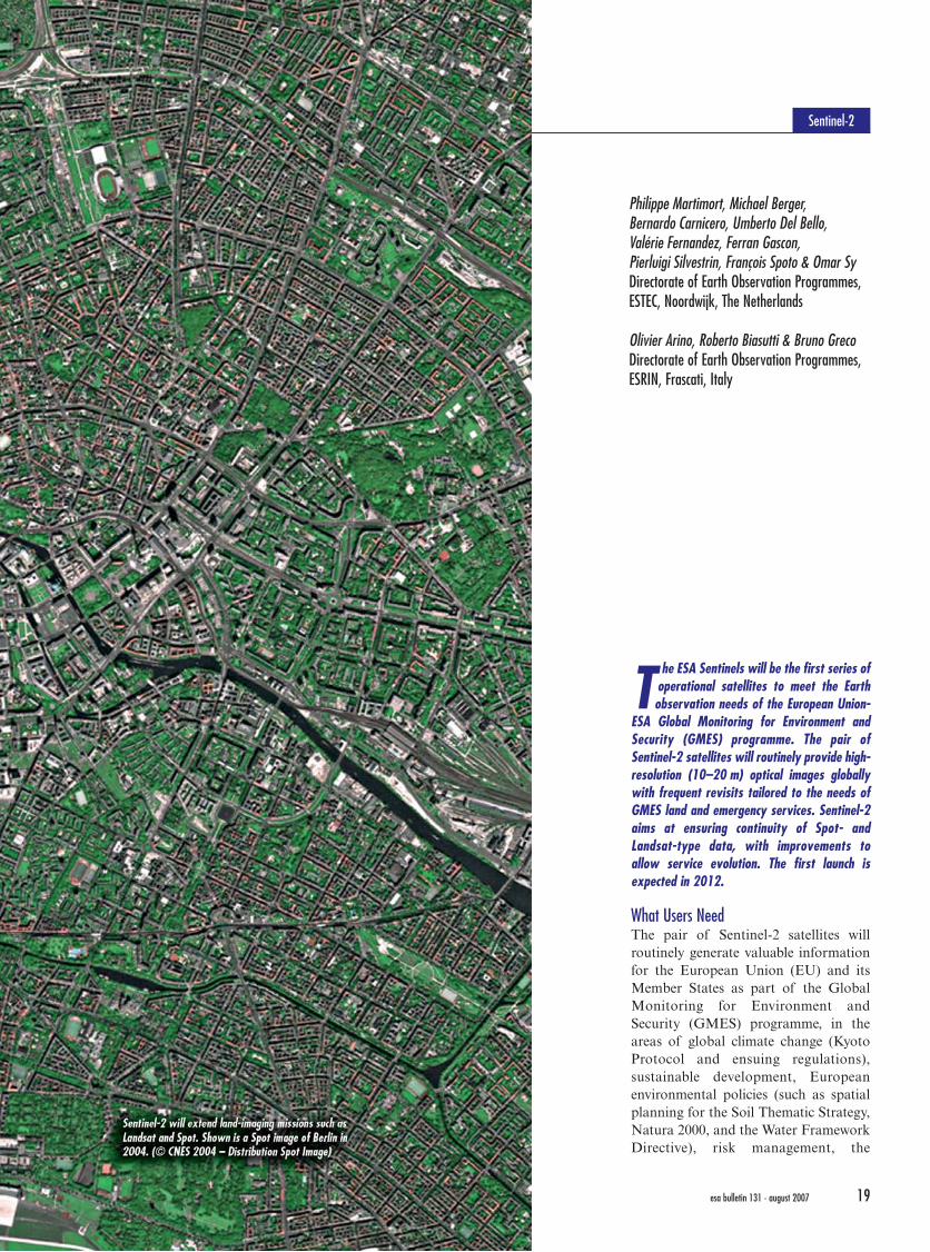
ESA Global Monitoring for Environment andSecurity (GMES) programme. The pair ofSentinel-2 satellites will routinely provide high-resolution (10–20 m) optical images globallywith frequent revisits tailored to the needs ofGMES land and emergency services. Sentinel-2aims at ensuring continuity of Spot- andLandsat-type data, with improvements toallow service evolution. The first launch isexpected in 2012.
What Users NeedThe pair of Sentinel-2 satellites willroutinely generate valuable informationfor the European Union (EU) and itsMember States as part of the GlobalMonitoring for Environment andSecurity (GMES) programme, in theareas of global climate change (KyotoProtocol and ensuing regulations),sustainable development, Europeanenvironmental policies (such as spatialplanning for the Soil Thematic Strategy,Natura 2000, and the Water FrameworkDirective), risk management, the
Philippe Martimort, Michael Berger,Bernardo Carnicero, Umberto Del Bello,Valérie Fernandez, Ferran Gascon,Pierluigi Silvestrin, François Spoto & Omar Sy Directorate of Earth Observation Programmes,ESTEC, Noordwijk, The Netherlands
Olivier Arino, Roberto Biasutti & Bruno GrecoDirectorate of Earth Observation Programmes,ESRIN, Frascati, Italy
esa bulletin 131 - august 2007 19
Martimort 8/1/07 4:59 PM Page 18
Sentinel-2
The ESA Sentinels will be the first series of
loperational satellites to meet the Earthobservation needs of the European Union-
ESA Global Monitoring for Environment andSecurity (GMES) programme. The pair ofSentinel-2 satellites will routinely provide high-resolution (10–20 m) optical images globallywith frequent revisits tailored to the needs ofGMES land and emergency services. Sentinel-2aims at ensuring continuity of Spot- andLandsat-type data, with improvements toallow service evolution. The first launch isexpected in 2012.
What Users NeedThe pair of Sentinel-2 satellites willroutinely generate valuable informationfor the European Union (EU) and itsMember States as part of the GlobalMonitoring for Environment andSecurity (GMES) programme, in theareas of global climate change (KyotoProtocol and ensuing regulations),sustainable development, Europeanenvironmental policies (such as spatialplanning for the Soil Thematic Strategy,Natura 2000, and the Water FrameworkDirective), risk management, the
Philippe Martimort, Michael Berger,Bernardo Carnicero, Umberto Del Bello,Valérie Fernandez, Ferran Gascon,Pierluigi Silvestrin, François Spoto & Omar Sy Directorate of Earth Observation Programmes,ESTEC, Noordwijk, The Netherlands
Olivier Arino, Roberto Biasutti & Bruno GrecoDirectorate of Earth Observation Programmes,ESRIN, Frascati, Italy
esa bulletin 131 - august 2007 19
Martimort 8/1/07 4:59 PM Page 18

Common Agricultural Policy, develop-ment and humanitarian aid, andcommon foreign and security policy.
To meet these needs, Sentinel-2 datawill underpin the routine generation ofproducts such as: generic land-cover,land-use and change maps, and riskmapping and fast images for disasterrelief. They will also evolve towards thegeneration of geophysical variables likeleaf coverage, leaf chlorophyll contentand leaf water content.
GMES will use Sentinel-2 along withwith other optical satellites to providecomplete observations. Conversely,Sentinel-2 will be a member of the land-surface imaging constellation of theinternational Committee on EarthObservation Satellites (CEOS), who willcoordinate access to the missions of thesame type (especially for Landsat data-continuity) to improve the finalinformation for users. Sentinel-2 willensure European independence whilecontributing to the global push forimproved land imaging.
These goals have driven the designtowards a dependable multispectralEarth-observation system that ensurescontinuity for Landsat and Spot obser-vations and improves data availabilityfor users. That, in turn, has identifiedpriority improvements over pastsatellites.
Geographic coverageThe mission is dedicated to the full andsystematic coverage of land surfaces(including major islands) from 56ºS(southern Americas) to +83ºN (northernGreenland), providing cloud-free productsevery 15–30 days. To achieve this and forreliability, a constellation of two opera-tional satellites is required, yielding5 days between revisits. At thebeginning, with only one satellite, thegap is 10 days (although opticalinstruments on other GMES satelliteswill help to fill the gaps).
Additionally, some limited geograph-ical areas will be reachable within1–3 days in emergencies such as floodsand earthquakes by rolling and tiltingthe satellite.
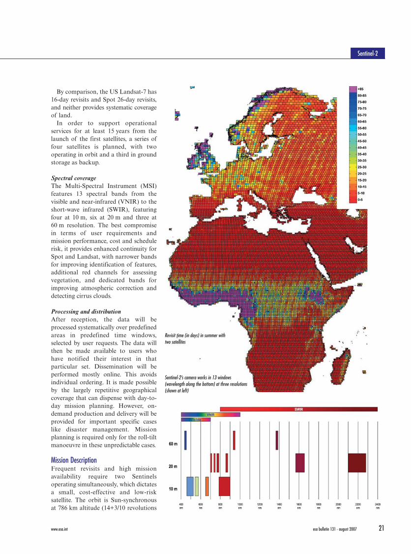
By comparison, the US Landsat-7 has16-day revisits and Spot 26-day revisits,and neither provides systematic coverageof land.
In order to support operationalservices for at least 15 years from thelaunch of the first satellites, a series offour satellites is planned, with twooperating in orbit and a third in groundstorage as backup.
Spectral coverageThe Multi-Spectral Instrument (MSI)features 13 spectral bands from thevisible and near-infrared (VNIR) to theshort-wave infrared (SWIR), featuringfour at 10 m, six at 20 m and three at60 m resolution. The best compromisein terms of user requirements andmission performance, cost and schedulerisk, it provides enhanced continuity forSpot and Landsat, with narrower bandsfor improving identification of features,additional red channels for assessingvegetation, and dedicated bands forimproving atmospheric correction anddetecting cirrus clouds.
Processing and distributionAfter reception, the data will beprocessed systematically over predefinedareas in predefined time windows,selected by user requests. The data willthen be made available to users whohave notified their interest in thatparticular set. Dissemination will beperformed mostly online. This avoidsindividual ordering. It is made possibleby the largely repetitive geographicalcoverage that can dispense with day-to-day mission planning. However, on-demand production and delivery will beprovided for important specific caseslike disaster management. Missionplanning is required only for the roll-tiltmanoeuvre in these unpredictable cases.
Mission DescriptionFrequent revisits and high missionavailability require two Sentinelsoperating simultaneously, which dictatesa small, cost-effective and low-risksatellite. The orbit is Sun-synchronousat 786 km altitude (14+3/10 revolutions
Earth Observation
esa bulletin 131 - august 2007esa bulletin 131 - august 2007 www.esa.intwww.esa.int 2120
Sentinel-2
leaf area
leaf chlorophyll content
fractional vegetation cover
leaf water content
Revisit time (in days) in summer with two satellites
Four typical products extracted from a simulatedSentinel-2 image (top). Different combinations ofwavelengths reveal different features in the landscape
Sentinel-2’s camera works in 13 windows(wavelength along the bottom) at three resolutions(shown at left)
Martimort 8/1/07 4:59 PM Page 20
Common Agricultural Policy, develop-ment and humanitarian aid, andcommon foreign and security policy.
To meet these needs, Sentinel-2 datawill underpin the routine generation ofproducts such as: generic land-cover,land-use and change maps, and riskmapping and fast images for disasterrelief. They will also evolve towards thegeneration of geophysical variables likeleaf coverage, leaf chlorophyll contentand leaf water content.
GMES will use Sentinel-2 along withwith other optical satellites to providecomplete observations. Conversely,Sentinel-2 will be a member of the land-surface imaging constellation of theinternational Committee on EarthObservation Satellites (CEOS), who willcoordinate access to the missions of thesame type (especially for Landsat data-continuity) to improve the finalinformation for users. Sentinel-2 willensure European independence whilecontributing to the global push forimproved land imaging.
These goals have driven the designtowards a dependable multispectralEarth-observation system that ensurescontinuity for Landsat and Spot obser-vations and improves data availabilityfor users. That, in turn, has identifiedpriority improvements over pastsatellites.
Geographic coverageThe mission is dedicated to the full andsystematic coverage of land surfaces(including major islands) from 56ºS(southern Americas) to +83ºN (northernGreenland), providing cloud-free productsevery 15–30 days. To achieve this and forreliability, a constellation of two opera-tional satellites is required, yielding5 days between revisits. At thebeginning, with only one satellite, thegap is 10 days (although opticalinstruments on other GMES satelliteswill help to fill the gaps).
Additionally, some limited geograph-ical areas will be reachable within1–3 days in emergencies such as floodsand earthquakes by rolling and tiltingthe satellite.
By comparison, the US Landsat-7 has16-day revisits and Spot 26-day revisits,and neither provides systematic coverageof land.
In order to support operationalservices for at least 15 years from thelaunch of the first satellites, a series offour satellites is planned, with twooperating in orbit and a third in groundstorage as backup.
Spectral coverageThe Multi-Spectral Instrument (MSI)features 13 spectral bands from thevisible and near-infrared (VNIR) to theshort-wave infrared (SWIR), featuringfour at 10 m, six at 20 m and three at60 m resolution. The best compromisein terms of user requirements andmission performance, cost and schedulerisk, it provides enhanced continuity forSpot and Landsat, with narrower bandsfor improving identification of features,additional red channels for assessingvegetation, and dedicated bands forimproving atmospheric correction anddetecting cirrus clouds.
Processing and distributionAfter reception, the data will beprocessed systematically over predefinedareas in predefined time windows,selected by user requests. The data willthen be made available to users whohave notified their interest in thatparticular set. Dissemination will beperformed mostly online. This avoidsindividual ordering. It is made possibleby the largely repetitive geographicalcoverage that can dispense with day-to-day mission planning. However, on-demand production and delivery will beprovided for important specific caseslike disaster management. Missionplanning is required only for the roll-tiltmanoeuvre in these unpredictable cases.
Mission DescriptionFrequent revisits and high missionavailability require two Sentinelsoperating simultaneously, which dictatesa small, cost-effective and low-risksatellite. The orbit is Sun-synchronousat 786 km altitude (14+3/10 revolutions
Earth Observation
esa bulletin 131 - august 2007esa bulletin 131 - august 2007 www.esa.intwww.esa.int 2120
Sentinel-2
leaf area
leaf chlorophyll content
fractional vegetation cover
leaf water content
Revisit time (in days) in summer with two satellites
Four typical products extracted from a simulatedSentinel-2 image (top). Different combinations ofwavelengths reveal different features in the landscape
Sentinel-2’s camera works in 13 windows(wavelength along the bottom) at three resolutions(shown at left)
Martimort 8/1/07 4:59 PM Page 20

per day) with a 10:30 a.m. descendingnode. This local time is the bestcompromise between minimising cloudcover and ensuring suitable Sunillumination. It is close to the Landsatlocal time and matches Spot’s, allowingthe seamless combination of Sentinel-2data with historical images to buildlong-term time series. The two satelliteswill work on opposite sides of the orbit.
The ground station network mustprovide long contact times in order todownlink all the observations; at leastfour core stations are required. Onepolar station for telemetry, tracking andcontrol is sufficient. To a limited extent,the system will also allow directreception by local user stations for near-realtime applications.
The SatellitesA compact 1 t satellite will be launchedon ESA’s Vega (baseline, with Rockot asbackup). The satellite is designed for a
filter assemblies are being developedbefore the main project begins. Each pre-development involves two manufacturersto reduce risks, foster competition andmeet ESA’s geographical return require-ments for the main phase.
Ground segmentThe ground segment includes a FlightOperations Segment for commandingthe satellite, and a decentralised PayloadData Ground Segment, an evolvingmulti-mission infrastructure for missionplanning, data reception, processing,archiving, quality control and dissemin-ation.
7-year lifetime, with propellant for12 years of operations, including de-orbiting at the end. The roof-shapedconfiguration with a fixed body-mounted solar array as defined inPhase-A/B1 leads to a simple mechani-cal design, without solar array deploy-ment or drive mechanisms. The satelliteis controlled in 3-axes via high-ratemulti-head startrackers, mounted on thecamera structure for better pointingaccuracy and stability, and gyroscopesand a satnav receiver. Power comes fromhigh-efficiency gallium arsenide triple-junction solar cells and a lithium-ionbattery. The satellite is tilted at 22.5º toits roll axis to maximise the illuminationof its solar array.
Images are stored in a 2 Tbit solid-state mass memory before down-linking at 450 Mbit/s in the X-band.Command and control is performedthrough an omni-directional S-bandantenna.
The users in the dispersed ServiceSegment will take data from differentsatellites in combination with non-spacedata to deliver customised services tothe final users.
Sentinel-2 will be a key Europeansource of data for the GMES LandFast-Track Monitoring Services and willcontribute to the GMES Risk Fast-Track Services. It will provide continuityof data to ESA’s GMES Service Elementprojects such as forestry (GSE ForestMonitoring), soil and water resourcesmapping, urban mapping and classifica-tion (SAGE, Urban Services, Coast-watch, GSE Land, RISK-EOS).
ConclusionThe Sentinel-2 wide-swath high-resolu-tion multispectral system will provideimproved continuity for Spot- andLandsat-type observations, with improvedrevisit time, coverage area, spectralbands, swath width, and radiometricand geometric image quality, meetingGMES needs for operational land andemergency services.
The Sentinel-2 Definition Phase-A/B1was performed by ESA in 2005 and 2006with an industrial consortium led byAstrium GmbH (mission prime, platform,system engineering), with Astrium SAS asthe major subcontractor (payload, systemsupport). Following the completion ofthis phase in January 2007, the Invitationto Tender for the Implementation Phasewas released in February 2007. ThisPhase-B2/C/D/E1 is expected to start inOctober 2007, with launch of the firstsatellite projected for 2012. e
Multispectral instrumentMSI features a three-mirror anastigmattelescope with a pupil diameter of about150 mm; it is the key to the high imagequality across the wide field of view of290 km (Landsat 185 km, Spot 120 km).The telescope structure and mirrors aremade of silicon carbide to minimisethermal deformation.
The VNIR focal plane employs mono-lithic CMOS (complementary metaloxide semiconductor) detectors, whilethe SWIR uses a mercury-cadmium-telluride detector hybridised on aCMOS read-out circuit. A dichroicbeam-splitter separates the VNIR andSWIR channels. A combination ofpartial onboard calibration, using a Sundiffuser, and calibration with groundtargets will guarantee high radiometricperformance.
The detector signals are digitised athigh resolution (12-bit), and state-of-the-art lossy data compression reducesthe data volume. The compression ratiowill be fine-tuned for each spectral bandto ensure that there is no significanteffect on image quality.
A shutter prevents direct viewing ofthe Sun in orbit and contaminationduring launch. The average observationtime per orbit is 16.3 minutes, with apeak value of 31 minutes.
In order to mitigate the developmentrisks and secure the developmentschedule, the technologies for building thecritical VNIR and SWIR detectors and
Earth Observation
esa bulletin 131 - august 2007esa bulletin 131 - august 2007 www.esa.intwww.esa.int 2322
Sentinel-2
The complex light path within the camera allows a more compactinstrument. FPA is the Focal Plane Assembly.
Simulated Sentinel-2 colour composite images using thered/green/blue bands (above) and near-infrared/red/green(below)
Sentinel-2’s multispectral camera
Secondary mirror
Fold mirror
VNIR/Pan FPA
Primary mirror
Tertiary mirror
Dichroic and compensator
SWIR FPA
An example of how the multispectral images fromAn example of how the multispectral images fromSentinelSentinel -- 2 will be analysed to reveal land-use2 will be analysed to reveal land-use
Martimort 8/1/07 4:59 PM Page 22