Embed Size (px)
Citation preview

What is Network Analyst?What is Network Analyst?
•• Extension for analyzing transportation networksExtension for analyzing transportation networks
–– Four network solversFour network solvers
•• Uses Network DatasetsUses Network Datasets
RouteRoute
Closest FacilityClosest Facility
Service AreaService Area
Origin-Destination (OD) Cost Matrix
Origin-Destination (OD) Cost Matrix

Specialized layersSpecialized layers
•• Network layerNetwork layer
–– References a network datasetReferences a network dataset
–– Appears in table of contentsAppears in table of contents
and Network Analyst toolbarand Network Analyst toolbar
•• Network analysis layerNetwork analysis layer
–– Composite layer forComposite layer for
network solvernetwork solver
–– Appears in table of contentsAppears in table of contents
and Network Analyst Windowand Network Analyst Window
Network Layer
Network
Analysis Layer

Network Analyst in ArcMapNetwork Analyst in ArcMap
Network Analyst
Window
Network Analyst
Window
Network Analyst toolbar
Network Analyst toolbar
Network Analyst toolbox
Geoprocessing Tools
Network Analyst toolbox
Geoprocessing Tools

Network Analyst in GeoprocessingNetwork Analyst in Geoprocessing
Tool dialogTool dialog
ScriptScript
InputNetworkDataset
Make ODCost Matrix
Layer
NetworkAnalystLayer
ModelModel
Command lineCommand line

DemoDemo
•• Route Solving in Route Solving in ArcMapArcMap

Time windowsTime windows
•• Defines interval of time (start/end) a stop should be Defines interval of time (start/end) a stop should be
visited by a routevisited by a route
–– Network location propertiesNetwork location properties
–– Time or date values supportedTime or date values supported
–– May affect the total costMay affect the total cost
Route solver resultRoute solver result Route solver result with time windowsRoute solver result with time windows
7:00 AM
7:15 AM
7:00 AM
7:15 AM
7:00 AM
9:45 AM
7:00 AM
9:45 AM
8:00 AM
10:00 AM
8:00 AM
10:00 AM
7:30 AM
7:45 AM
7:30 AM
7:45 AM

•• Finds the Finds the route(sroute(s) that minimize travel cost between ) that minimize travel cost between
incidents and facilitiesincidents and facilities
•• OptionsOptions
–– ImpedanceImpedance
–– Cutoff valueCutoff value
–– Number of facilities to findNumber of facilities to find
–– Direction of travelDirection of travel
–– DirectionsDirections
•• ApplicationsApplications
–– Emergency vehicle dispatchEmergency vehicle dispatch
–– Customer to storesCustomer to stores
Closest Facility solverClosest Facility solver
FacilityFacility
IncidentIncident
RouteRoute

•• Cutoff valueCutoff value
•• Direction of travelDirection of travel
Closest Facility optionsClosest Facility options
Incident
Facility
5
Cutoff = 5Cutoff = 5
Facility 2 Facility 1
Incident to facilityIncident to facility
Accident
Facility to incidentFacility to incident
Fire

DirectionsDirections
•• Generated from Route and Closest Facility solver resultsGenerated from Route and Closest Facility solver results
•• OptionsOptions
–– Expandable inset mapsExpandable inset maps
•• Feature labels supportedFeature labels supported
–– Reported unitsReported units
•• DistanceDistance
•• Travel timeTravel time
–– Running time/distanceRunning time/distance
–– Time windowsTime windows
–– Print optionsPrint options

Service Area solverService Area solver
•• Finds the area or edges that can be traversed within a Finds the area or edges that can be traversed within a
specified costspecified cost
•• OptionsOptions
–– ImpedanceImpedance
–– Multiple break valuesMultiple break values
–– Direction of travelDirection of travel
•• Away from or towards facilityAway from or towards facility
–– Polygon and line optionsPolygon and line options
•• ApplicationsApplications
–– Fire response zonesFire response zones
–– Customer service areasCustomer service areas
Lines
Polygons

•• Polygon typePolygon type
•• Multiple facilities optionsMultiple facilities options
•• Overlap typeOverlap type
Service Area polygon optionsService Area polygon options
RingsRings DisksDisks
oror
oror
oror
DetailedDetailedGeneralizedGeneralized
Separate polygons per facility
Separate polygons per facility oror Merge polygons
by break
Merge polygons by break
Not overlapping polygons
Not overlapping polygons

Service Area polygon trimming optionsService Area polygon trimming options
•• Trim PolygonsTrim Polygons
–– Minimizes polygons in sparse areasMinimizes polygons in sparse areas
–– Specify trim distanceSpecify trim distance
Untrimmed PolygonsUntrimmed Polygons Trimmed Polygons (9.2)Trimmed Polygons (9.2)

Service Area line optionsService Area line options
•• Generate measures (used for linear referencing)Generate measures (used for linear referencing)
•• Split lines at breaksSplit lines at breaks
•• Overlap optionsOverlap options
0 82
2
2
4 lines4 lines
82 6
6 lines6 lines
2 Facilities2 Facilities
oror
Breaks: 2 6 8Breaks: 2 6 8
OverlappingOverlapping Not overlappingNot overlapping
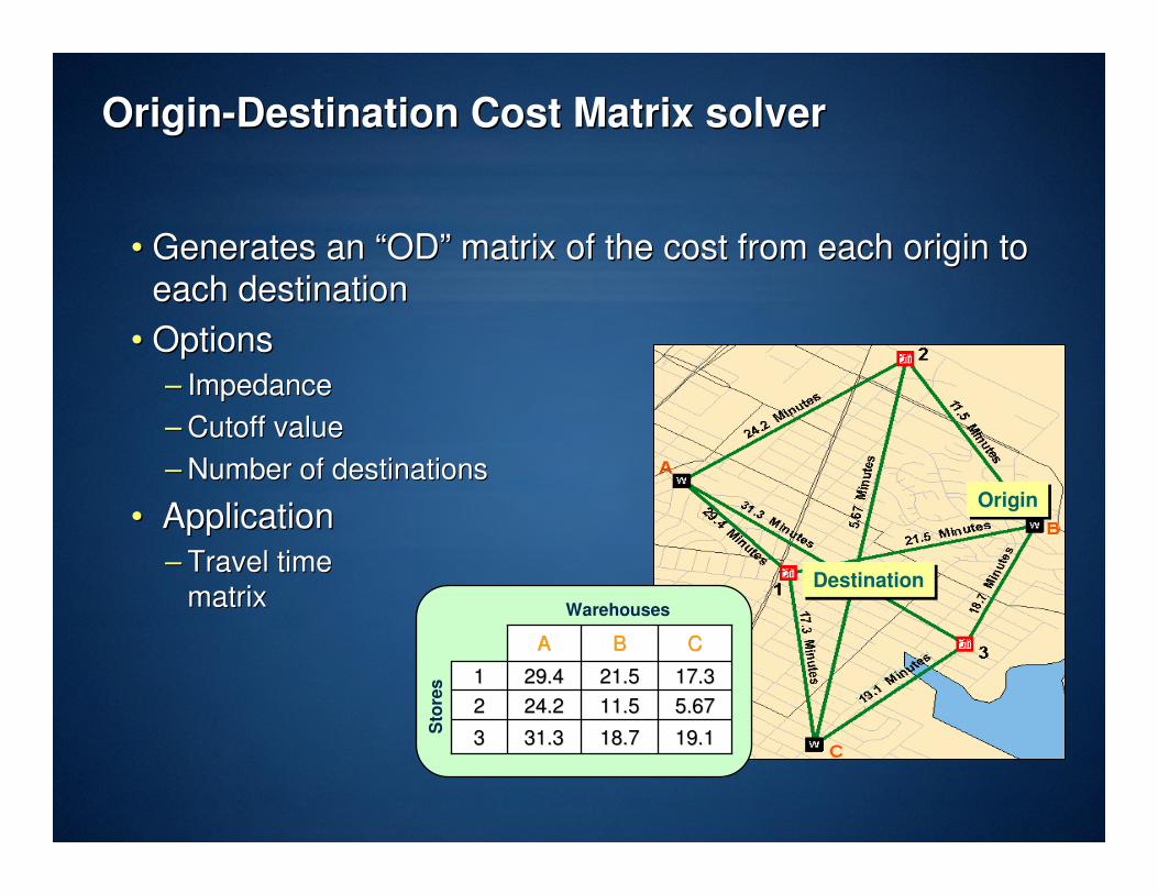
OriginOrigin--Destination Cost Matrix solverDestination Cost Matrix solver
•• Generates an Generates an ““ODOD”” matrix of the cost from each origin to matrix of the cost from each origin to
each destinationeach destination
•• OptionsOptions
–– ImpedanceImpedance
–– Cutoff value Cutoff value
–– Number of destinations Number of destinations to findto find
•• ApplicationApplication
–– Travel timeTravel time
matrixmatrix
OriginOrigin
DestinationDestination
Warehouses
Sto
res
19.119.118.718.731.331.333
5.675.6711.511.524.224.222
17.317.321.521.529.429.411
CCBBAA

Curb approachCurb approach
•• Specifies side of vehicle a route will approach a locationSpecifies side of vehicle a route will approach a location
–– Network location propertyNetwork location property
•• Critical for applications where you want the vehicle to Critical for applications where you want the vehicle to
park park ““curbsidecurbside”” and not cross the streetand not cross the street
–– Examples: Downtown deliveries and school bus stopsExamples: Downtown deliveries and school bus stops
Right side of vehicleVictoria
Elementary
CurbApproachCurbApproachNameNameRedlands
Route will approach location on the
vehicle’s “right side”
Route will approach location on the
vehicle’s “right side”

HierarchyHierarchy
•• Minimizes impedance while favoring higher order roadsMinimizes impedance while favoring higher order roads
•• Basic assumption:Basic assumption:
–– Higher order roads are Higher order roads are ““fasterfaster”” (time),(time),
not necessarily not necessarily ““shortershorter”” (distance)(distance)
•• Hierarchy classifies network edges into three ranks when the Hierarchy classifies network edges into three ranks when the
network dataset is builtnetwork dataset is built
–– Ranks: lower number = higher order roadRanks: lower number = higher order road
PrimaryPrimarySecondarySecondaryLocalLocal

Reasons to use hierarchyReasons to use hierarchy
•• Faster calculation of resultsFaster calculation of results
•• Ideal for performing network analysis on long distancesIdeal for performing network analysis on long distances
–– E.g., Driving from Los Angeles to New YorkE.g., Driving from Los Angeles to New York
primarily using interstate highwaysprimarily using interstate highways
•• Does not apply to service area analysisDoes not apply to service area analysis
Los AngelesLos Angeles
New YorkNew York

Exact route vs. hierarchical routeExact route vs. hierarchical route
•• Hierarchical route may not be the shortest route, but is Hierarchical route may not be the shortest route, but is
typically more realistictypically more realistic
1
2
10
30
HierarchicalHierarchical
1
2
10
30
Exact route = Non-hierarchical
Exact route = Non-hierarchical

Network datasetsNetwork datasets
•• Network designed for ArcGIS Network AnalystNetwork designed for ArcGIS Network Analyst
•• Built from simple featuresBuilt from simple features
•• Supports transportation modelingSupports transportation modeling
•• Source dataSource data
–– Geodatabase feature classesGeodatabase feature classes
–– ShapefilesShapefiles
–– StreetMapStreetMap datadata
•• PrePre--built network datasetbuilt network dataset

Network element typesNetwork element types
•• Three types of network elementsThree types of network elements
–– EdgeEdge
•• Derived from line featuresDerived from line features
•• BiBi--directionaldirectional
–– JunctionJunction
•• Derived from point featuresDerived from point features
–– Turn (optional)Turn (optional)
•• Derived from line features or turn tablesDerived from line features or turn tables
•• Describes transitions between edgesDescribes transitions between edges

•• Points of coincidence should exist where line features cross Points of coincidence should exist where line features cross
or intersector intersect
–– Enables network connectivity to be modeledEnables network connectivity to be modeled
Coincident GeometriesCoincident Geometries
Case 1
Good qualityGood quality Poor qualityPoor quality
Case 2
Good qualityGood quality Poor qualityPoor quality

Creating coincident geometryCreating coincident geometry
•• Include sources in a TopologyInclude sources in a Topology
•• Use the Geoprocessing Integrate ToolUse the Geoprocessing Integrate Tool
•• Both methods compare features and makes vertices Both methods compare features and makes vertices
within the cluster tolerance coincidentwithin the cluster tolerance coincident
–– Inserts vertices where features intersectInserts vertices where features intersect
–– Snaps features that are not coincidentSnaps features that are not coincident

Common fields for street dataCommon fields for street data
•• Fields hold network attribute dataFields hold network attribute data
•• Need attributes for good network analysisNeed attributes for good network analysis
Helps generate network
locations and directions
TextStreet name or
Address data
May be used to calculate
travel time
IntegerSpeed
Calculate fastest routeDoubleTravel time
Calculate shortest routeDoubleLength
Helps determine one way
streets
TextOneway
ApplicationData typeField name

Connectivity policiesConnectivity policies
•• Edge connectivity policiesEdge connectivity policies–– End pointEnd point
–– Any vertexAny vertex
•• Junction connectivity policiesJunction connectivity policies–– HonorHonor
–– OverrideOverride

Elevation fields (ZElevation fields (Z--levslevs))
0
0
0
0
0
0
0
0
0
1
0
0
0
1
0
0
IntersectionIntersection
OverpassOverpass
•• Attributes that specify the Attributes that specify the ““levellevel”” at endpointsat endpoints
•• Applied to line features with coincident endpointsApplied to line features with coincident endpoints

•• Used to control navigation through the networkUsed to control navigation through the network
•• Every attribute has 5 properties:Every attribute has 5 properties:
–– NameName
–– Use by defaultUse by default
–– Usage typeUsage type
–– UnitsUnits
–– Data typeData type
•• Can add, remove, or modify attributes once createdCan add, remove, or modify attributes once created
Network attributesNetwork attributes

Network dataset attributesNetwork dataset attributes
•• Attributes associated with network elementsAttributes associated with network elements
–– Edges, junctions, and turnsEdges, junctions, and turns
Speed
Oneway
Drivetime
Length
Network dataset Network dataset
attributesattributes
•• All elements in the network have the same set of attributes All elements in the network have the same set of attributes
with potentially different valueswith potentially different values
Length = 100 Drivetime = 10 Oneway = false Speed = 10 Length = 0
Drivetime = 2 Oneway = false Speed = 5
Length = 0 Drivetime = 0 Oneway = false Speed = 0

Cost attributesCost attributes
•• Value that is accumulated as you traverse a network Value that is accumulated as you traverse a network
elementelement
–– Examples: Distance, driving time, walking timeExamples: Distance, driving time, walking time
•• Values are apportioned along edgesValues are apportioned along edges
Distance = 1000 m Drivetime = 5 min Walktime = 20 min
Distance = 1000 m Drivetime = 5 min Walktime = 20 min
Distance = 1000 mDistance = 1000 m
12 12
Distance = 600 mDistance = 600 m

Restriction attributesRestriction attributes
•• A boolean condition that has one of two values:A boolean condition that has one of two values:
–– Restricted (true) or Traversable (false)Restricted (true) or Traversable (false)
F_endpoint T_endpoint
F_endpoint T_endpoint
TF directionalityTF directionality
One-way directionalityOne-way directionality Restricted turnsRestricted turns
FT directionalityFT directionality

Hierarchy attributesHierarchy attributes
•• Integer values representing ranksInteger values representing ranks
•• Enables multiEnables multi--level classification of edge elementslevel classification of edge elements
•• Used when finding paths in a network datasetUsed when finding paths in a network dataset
•• Network solvers currently support three levelsNetwork solvers currently support three levels
–– Example: Road typeExample: Road type
1 = highway1 = highway
2 = major road2 = major road
3 = local street3 = local street

PavementPavementDirt RoadDirt Road4 lanes4 lanes
Descriptor attributesDescriptor attributes
•• Description that is true for the entire length of the network Description that is true for the entire length of the network
elementelement
•• Used for detailed driving directions or to help derive other Used for detailed driving directions or to help derive other
attributesattributes
Number of lanesNumber of lanes
2 lanes2 lanes
Road materialRoad material

EvaluatorsEvaluators
•• A function that determines attribute values for network A function that determines attribute values for network
elements in a network datasetelements in a network dataset
–– Three different types:Three different types:
•• Field Field –– Assign an existing attribute field from a network sourceAssign an existing attribute field from a network source
•• Constant Constant –– Assign a constant valueAssign a constant value
•• VBScript VBScript –– Assign expression to generate custom valuesAssign expression to generate custom values
•• Custom evaluators can be developedCustom evaluators can be developed
Constant – “true” (implies all turns restricted)TurnRestriction
VBScript – use attributes Length/SpeedLimitDriveTime
Field – assign the [speed] fieldSpeedLimit
Field – assign the [meters] fieldLength
EvaluatorAttribute

Attribute ParametersAttribute Parameters
•• Some attribute evaluators need additional info at runtimeSome attribute evaluators need additional info at runtime
–– Vehicle characteristicsVehicle characteristics
–– Current speeds per road classCurrent speeds per road class
•• Parameter values set within Network Analyst by usersParameter values set within Network Analyst by users
•• Used by VBScript evaluators returning attribute valuesUsed by VBScript evaluators returning attribute values

Turn featuresTurn features
•• Line features in a specialized feature classLine features in a specialized feature class
•• Two methods to generateTwo methods to generate
–– Create new turn features in an ArcMap edit sessionCreate new turn features in an ArcMap edit session
–– Convert turn table Convert turn table �� line feature classline feature class
•• Complex turn movements supportedComplex turn movements supported

DemonstrationDemonstration
•• Network DatasetNetwork Dataset
•• Web EditingWeb Editing

Multimodal exampleMultimodal example
local streetlocal street
exit pointsexit points
rail linerail line
Yellow bus stationYellow bus station
rail stationrail station
highwayhighway
Yellow bus lineYellow bus line
rampramp
Blue bus stationBlue bus station
walking pathwalking path
Blue bus lineBlue bus line