Embed Size (px)
Citation preview

1
What do you see?
Message of the Day: Depending on our management objectives sometimes we need to see beneath the trees
FOR 274: Forest Measurements and Inventory
Principals of Surveying
• Introduction
• Leveling
• Distances
• Terrain Description
• US Public Land Survey
An Introduction to Surveying: Social and Land
In Natural Resources we survey populations to gain representative information about something
We also conduct land surveys to record the fine-scale topographic detail of an area
We use both kinds of surveying in Natural Resources

2
What do you see?
Our ability to use appropriate management responses may depend on aesthetic qualities of how that activity affected the resource.
Social Surveying: Where it all Began
Charles Booth:
“The Life and Labor of the People in London”
He used direct observationsof a sample of London’s populations with repeated standard measurements
His findings had direct policy implications
Social Surveying: Where it all Began
The result of Booth’s survey was a spatially explicit map of poverty in London in 1898
3
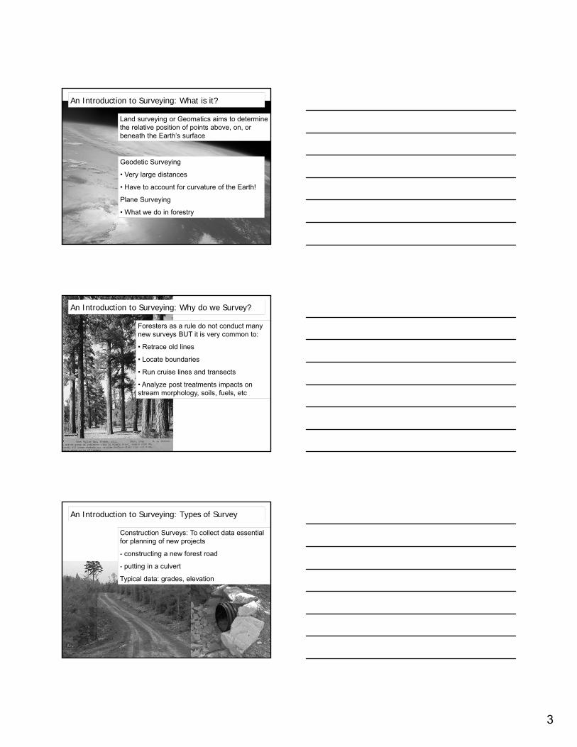
An Introduction to Surveying: What is it?
Land surveying or Geomatics aims to determine the relative position of points above, on, or beneath the Earth’s surface
Geodetic Surveying
• Very large distances
• Have to account for curvature of the Earth!
Plane Surveying
• What we do in forestry
An Introduction to Surveying: Why do we Survey?
Foresters as a rule do not conduct many new surveys BUT it is very common to:
• Retrace old lines
• Locate boundaries
• Run cruise lines and transects
• Analyze post treatments impacts on stream morphology, soils, fuels, etc
An Introduction to Surveying: Types of Survey
Construction Surveys: To collect data essential for planning of new projects
- constructing a new forest road
- putting in a culvert
Typical data: grades, elevation

4
An Introduction to Surveying: Types of Survey
Hydrological Surveys: To collect data on stream channel morphology or impacts of treatments on erosion potential
- Depths of water features
- Mapping Shorelines
An Introduction to Surveying: Types of Survey
Topographic Surveys: To obtain data on natural and man-made features on the Earth's surface to produce a 3D topographic map
Typical Steps include:
- Establish horizontal & vertical controls
- Locating features that may be wanted by the survey
- Compute distances, angles, and elevations
An Introduction to Surveying: Types of Survey
Land, boundary, and Cadastral (public land) Surveys: To establish property lines and property corners
Original Surveys: establish new lines and corners in unsurveyed locations
Retracement Surveys: recover previously established boundary lines
Sub-division Surveys: delineate new parcels of ownership
Condominium Surveys: provide legal record of ownership

5
An Introduction to Surveying: Types of Survey
Ground, Aerial, and Satellite Surveys: To collect data over extended spatial scales
Later courses like FOR 375 and FOR 472 will cover this is detail
An Introduction to Surveying: The Main Points
Forestry surveying does not need engineering precision equipment
- It is rare that 1/10” accuracy is needed
However, although less $$$ the equipment we do use is still very accurate
An Introduction to Surveying: The Main Points
When surveying:
- Carefully plan the Survey
- It is difficult to find forgotten equipment
A survey can be ruined by:
1 missing point
1 incorrectly recorded point
Include in your plan ways to double check your data!!!

6
Leveling: DefinitionsVertical Line: A line that follows the direction of gravity (defined by a plumb line)
Level Surface: A surface (curved on earth) where every point is perpendicular to the plumb line
Horizontal Surface: A plane perpendicular to the plumb line
Vertical Datum: A level surface to which elevations are referenced. At the Datum, elevations are set to zero.
Benchmark: A permanent object with elevation accuracy measured.
Elevation: Distance along the vertical line from the vertical datum to a particular object.
Leveling: The process of measuring elevations of points (or differences in elevation)
Leveling: Measuring Elevation Differences
The most common method to measure elevation differences is differential leveling.
Foresight is often called “– sight”
Backsight is often called “+ sight”
Step 1: Place the instrument between A and B and make it level.
Step 2: Read off the scale at A (the backsight).
The Height of the Instrument (HI) is then:
HI = ZA + BS
Step 3: Read off the scale at B (the foresight).
The Elevation at B, ZB, is then:
ZB = HI – FS
Leveling: Measuring Elevation Differences
Another common method to measure elevation differences is trigonometric leveling. We use this principal a lot in forestry!
Uses: • Slope Correction• Plot Sizes• Heights

7
Land Surveying Equipment: The Theodolite
A Theodolite measures both horizontal and vertical angles
Transits are specialized Theodolites that have a telescope that can “flip over or transit the scope” to allow back-sighting
Land Surveying Equipment: Laser Rangefinders
Laser rangefinders use this relationships to calculate distance:
Distance = speed of light * (time/2)
The time refers to time of pulse to go from the instrument to the tree and back again
Land Surveying Equipment: Total Stations
Total Stations are essentially a combination of a Theodolite and a laser rangefinder
Total Stations are commonly used civil engineering projects due to there versatility and accuracy

8
Leveling: Sources of Error
Instrumental Errors: Errors caused by limitations in the equipment• Loose tripod legs, crosshair out of alignment, etc.
Natural Errors: Errors caused by the environment you are working in• Curvature of the Earth, • Refraction of light when measuring through a scope, • Metal measuring sticks can expand/contract depending on the temperature• Wind can cause instruments to wobble• Rough terrain can make leveling the instrument difficult
Human Errors and Mistakes• Rushing or misreading a measure• Not using equipment correctly• Not understanding what a measure means• Recording data incorrectly
Horizontal Distance Measurements: The Chain
The chain (66 feet) is the fundamental unit of horizontal measurement used by foresters
It is also called the surveyor’s or Gunter’s chain
1 Chain = 100 Links
All distances in US Land surveys are in chains and links
1 sq mile = 80 x 80 chains
1 acre = 10 sq chains
Horizontal Distance Measurements: The Chain
A Chain can be measured with:
Pacing
The Hip Chain
Surveyor’s Chain or Rope
Large tapes

9
Horizontal Distance Measurements: The ChainPacing out a chain is one of the simplest and most useful assets for a timber cruiser
Expert pacers are accurate to 1 foot in 80 on level terrain
A pace is commonly defined as two natural steps – i.e. each time the same foot touches the ground
However, slope and obstacles may alter the length of your pace and this will need to be accounted for
Horizontal Distance Measurements: Sloping Ground
When it is not practical for two people to hold a tape level on rough sloping ground of is an object is in the way, the “breaking tape” method can be used.
1. A horizontal distance is measured out so the uphill end is on the ground (say 100’).
2. A chaining pin is then placed at the ground.
3. A 2nd horizontal distance is then measured and pin placed.
4. Repeat until end and add up all the measures.
Horizontal Distance Measurements: Sloping Ground
To correct for slope, we use the trigonometric leveling method.

10
Terrain Descriptors: Aspect, Slope, & Slope Form
Aspect is measured with your compass and is the predominant direction of the slope from plot center. Usually thought of ecologically in terms of cardinal directions but generally recorded as an Azimuth.
Terrain Descriptors: Aspect, Slope, & Slope Form
Slope is generally measured with a clinometer by averaging readings to something at eye level uphill and downhill.
Clinometers come in 3 scales:
• % scale (most common)• Topographic scale• degrees
tan(α) = (rise/run) = % scale reading
tan(35°) = (70/100) = 0.70 = 70%
Deg = tan-1 (% / 100)
43%: deg = tan -1 (0.43) = 23.27%
General Site Measurements: Aspect and Slope
If the aspect or slope gradually changes across the site:
Record the average
Concave slopes: gradual increase in slopeConvex slopes: gradual decrease in slope.
Each slope form can be scene as you go up hill or across hill.

11
General Site Measurements: Aspect and Slope
If the site is on a canyon bottom or narrow ridge top use the aspect of those features and the average slope of the two sides
General Site Measurements: Aspect and Slope
If the site is on a canyon bottom or narrow ridge top but is mostly on one side of a hill use the aspect and slope of that hill-side
General Site Measurements: Slope Position

12
General Site Measurements: Slope Position
FOR 274: Forest Measurements and Inventory
Measures of Land Area
• Area Measures
• Reading Maps
• US Public Land Survey
Area Determination: A Simple Closed Transverse
Purpose: Locate approximate boundaries of a tract and determine the enclosed area
Most surveys involve 3 or 4 people:
- 2 people chain horizontal distances
- 1 person establishes compass lines and records values

13
Area Determination: A Simple Closed Transverse
Start at most reliable property corner:
If you have one record each corner with a GPS unit
Area Determination: An Example of Methods
So how can we measure the forest cover in this image?
Area Determination: Dot Grids
Each block = 8 ac
If 40 dots per block square then each dot ~ 0.2 acres
Points:
May use denser grids to increase precision or when the region is small
Should use average of several random orientations

14
Area Determination: Line Intercept
Total Length = 140 inches
Assume % of area of each land cover class (forest, clearcut, ag, etc) = proportion of line intercepting that class
e.g., 14 inches of clearcut = 14/140 = 10% of the area
Area Determination: Planimeter
If map scale is known
A planimeter can be used by tracing the outline of the desired area and scaling it against a know area.
Area Determination: Via a GIS
If map scale and “projection” is known
Use ARC to create a polygon and basic functions to calculate area of each polygon

15
Map Reading: Projections
Longitude & Latitude
UTM Coordinates Northings(blue line)
UTM Coordinates Eastings
(blue line)
Known UTM Position
Universal Transverse Mercator (UTM):
• Grid system to find position (NATO)
• Entire earth divided into grid (like Lat/Long) but its put into 60 zones
• This is based on a scale in meters north and meters east (northing and easting)
Map Reading: Projections
Reading The Map:
• 5166000 meters North
• 5165000 meters North
• 5164000 meters North
• One blue dash to the next is a travel distance of 1,000 meters (3,281 feet)
Map Reading: UTM An Example
USGS Topo Quad in Maryland: UTM Zone 18:
Point 001 would be read as:–18 435000 E –18 4248000 N
18 435000 E means Point 001 is in Zone 18 and it is 000 meters
east of the nearest reference line (435)

16
Map Reading: UTM An ExamplePoint 002 is exactly half way between 435 and 436 UTM reference marks
Point 002 would be read as:– 18 435500 E – 18 4248500 N
How Far Away Are The 2 points?
Map Reading: UTM An Example
A2 + B2 = C2
5002 + 5002 = (250000 + 250000) 2 = (500,000) 2
707.1 meters, or 2,320 feet
Map Reading: UTM An Example
003
How far from 001 to 003?

17
FOR 274: Forest Measurements and Inventory
Topographic Maps and the U.S. Public Land Survey
• Using Topographic Maps
• The U.S. Public Land Survey
Topographic Maps: An Overview
What are Topographic maps:
• The standard maps in forestry
• 1:24000 scale on 7.5° Topos
• Great detail
• Topographical relief
Topographic Maps: An Overview
Following the Lines:• Where the land slopes steeply, contours are close together, and in flat areas the contours are far apart. • If >=2 contours touch = cliff • Contours lines can never cross • Where contours cross ravines and stream valleys you see a "V" shape, with the V always pointing upstream.

18
Topographic Maps: An Overview
• Map Title
• Adjoining USGS Map Titles
• Longitude & Latitude
• UTM Coordinates
• Public Land Survey System (T&R)
Topographic Maps: An Overview
• Map Distance Scale
–Absolute
–Reference
• Contour Interval
• Projection
Topographic Maps: An Overview
• Magnetic Declination–Check the Year!
• This is from the Moscow West Quad
–36 years ago declination was 20°
–Today it is 15°
• Shows 3 North References
– True North
– Magnetic North
– UTM Grid North

19
U.S. Public Land Survey: An Overview
NORTHWEST ORDINANCES OF 1784, 1785, and 1787:
Enacted by the U.S. Congress for the purpose of establishing orderly and equitable procedures for the settlement and political incorporation of the Northwest Territory
U.S. Public Land Survey: An Overview
Before the Public Land Survey:
13 colonies divided by “metes and bounds”
These include divisions with only descriptions:
“From the pine tree to the hedge row to the river and back to the pine tree”
U.S. Public Land Survey: An Overview
Sub-divisions:
• Rectangular System established and maintained by the BLM
• Basis is a grid created at a reference point for each state, Boise in Idaho
• Land divided into a grid of 6-mile squares designated as townships and ranges
• Townships running north-south
• Ranges running east-west

20
Standard Parallels
(East-West)
Guide Meridians
(North-South)
Township6 miles x
6 miles = 36 square miles
Each 1 mile square is a
Section (640 acres) and is
numbered
Sections are subdivided into parcels
Independent Initial Point
Principal Meridian
(north-South)
Baseline(East-West)
Standard Parallels
Guide Meridians
** Board

21
Take Home Message: Site conditions can greatly influence how surveys and measurements are conducted

22
Extra Credit Assignment (due Monday):
Draw a site map that describes where the kiosk is, what main features (including vegetation and terrain) are around it, and how a tourist to Moscow could find it.