Embed Size (px)
Citation preview
EarthComm200
Chapter 2 Plate Tectonics
Learning OutcomesIn this section, you will
• Draw a topographic map from a model.
• Explore the meanings of contour line, contour interval, and relief.
• Interpret topographic maps.
• Recognize volcanic landforms on a topographic map and predict where lava would flow on them.
• Identify basic relationships between magma composition and type of volcano formed.
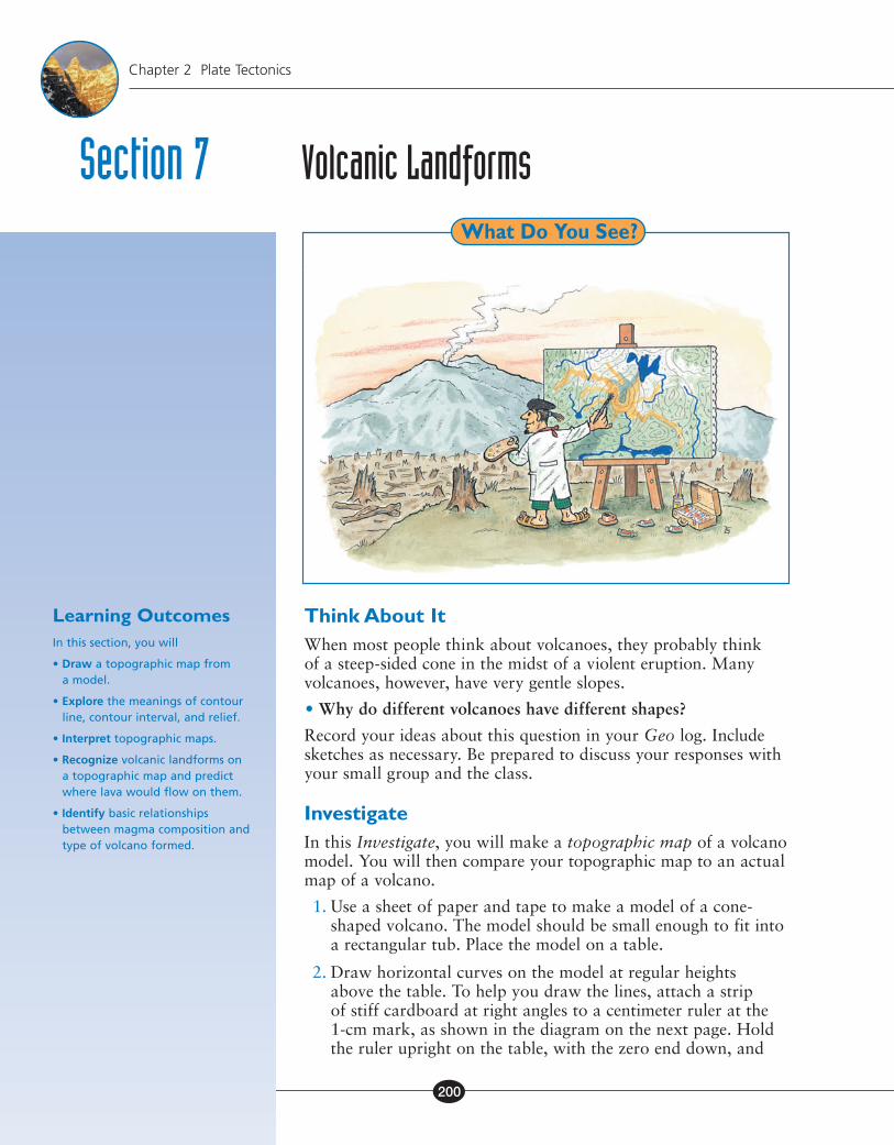
Think About ItWhen most people think about volcanoes, they probably think of a steep-sided cone in the midst of a violent eruption. Many volcanoes, however, have very gentle slopes.
• Why do different volcanoes have different shapes?
Record your ideas about this question in your Geo log. Include sketches as necessary. Be prepared to discuss your responses with your small group and the class.
InvestigateIn this Investigate, you will make a topographic map of a volcano model. You will then compare your topographic map to an actual map of a volcano.
1. Use a sheet of paper and tape to make a model of a cone-shaped volcano. The model should be small enough to fit into a rectangular tub. Place the model on a table.
2. Draw horizontal curves on the model at regular heights above the table. To help you draw the lines, attach a strip of stiff cardboard at right angles to a centimeter ruler at the 1-cm mark, as shown in the diagram on the next page. Hold the ruler upright on the table, with the zero end down, and
Section 7 Volcanic LandformsWhat Do You See?
EC_Natl_SE_C2.indd 200 7/12/11 1:28:17 PM
EarthComm201
Section 7 Volcanic Landforms
move it around the model so that the cardboard strip is near the surface of the model. Make a series of small dots on the model at this 1-cm height, and then connect the dots to form a horizontal curve. Repeat this with the cardboard strip attached at the 2-cm mark. Continue increasing the height above the table by 1 cm until you reach the top of the model.
3. Place the model into a rectangular tub.
4. Clip an overhead transparency onto a clear clipboard. Lay the clipboard on the tub.
5. Look straight down into the top of the tub at the lines you drew on the volcano. With a grease pencil or marker, trace the lines onto the transparency. Be sure to keep looking straight down whenever you are tracing the lines. Also, it might help to keep one eye closed.
These are contour lines, or lines of equal elevation above Earth’s surface.
6. Remove the transparency from the box. Write an elevation on each line of the transparency. Let each centimeter in height on the model represent 100 m in elevation on the map. The numbers should increase toward the center of the transparency.
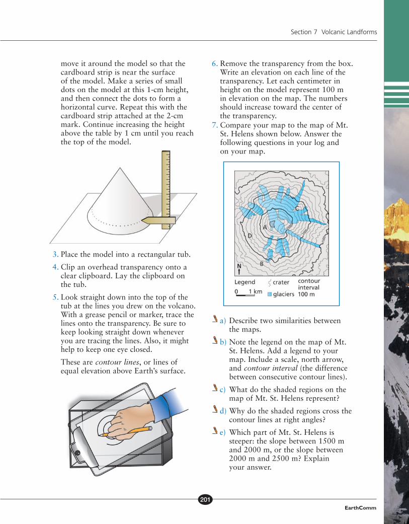
7. Compare your map to the map of Mt. St. Helens shown below. Answer the following questions in your log and on your map.
a) Describe two similarities between the maps.
b) Note the legend on the map of Mt. St. Helens. Add a legend to your map. Include a scale, north arrow, and contour interval (the difference between consecutive contour lines).
c) What do the shaded regions on the map of Mt. St. Helens represent?
d) Why do the shaded regions cross the contour lines at right angles?
e) Which part of Mt. St. Helens is steeper: the slope between 1500 m and 2000 m, or the slope between 2000 m and 2500 m? Explain your answer.
EC_Natl_SE_C2.indd 201 7/12/11 1:28:17 PM
EarthComm202
Chapter 2 Plate Tectonics
f) What are the lowest and highest elevations on the map of Mt. St. Helens? What is the difference in elevation between these two points?
g) Note the locations A, B, C, and D on the map. If lava erupted at point A, would it flow toward point B, C, or D? Explain your answer.
TOPOGRAPHY OF VOLCANIC REGIONS Topographic Maps In the Investigate, you made a topographic map of a model volcano. You also compared this to the topographic map of an actual volcano. Topographic maps have contour lines. These are curves that connect all points at the same elevation. The contour interval is the difference in elevation between contour lines that are next to one another. A topographic map shows how steep or gentle a slope is. It also shows the elevation and shape of the land. Relief is the difference in elevation between the highest and lowest points on the map.
The following are some important points to consider when interpreting topographic maps.
• Contour lines never cross. (However, two or more can run together, where there is a vertical cliff).
• The closer together the contour lines, the steeper the slope.
• Contour lines for closed depressions, such as a volcanic crater, are marked with “tick marks.” (These are short lines at right angles to the contour line.) The marks point downward into the depression.
• On most topographic maps, every fifth contour line is darker. Its elevation is always marked.
Magma Composition Volcanoes are often pictured as cone-shaped mountains. However, volcanoes come in many shapes and sizes. Ice, wind, and rain can change the shape of a volcano. These changes can take place between eruptions or after the volcano becomes dormant. A large eruption or giant landslide can remove the top or side of a volcano. The chemical composition of magma can have an even greater effect on the shape the volcano takes as it forms.
Magma is melted rock (a liquid). Magma may also contain dissolved gases. The most abundant chemical elements in magma are silicon and oxygen. As the magma cools, minerals form. Silicon and oxygen are the building blocks of the most common minerals. They are called silicate minerals and form from magmas. One silicon atom and four oxygen
Geo Wordscontour line: a line on a map that connects points of equal elevation of the land surface.
contour interval: the vertical distance between the elevations represented by two successive contour lines on a topographic map.
topographic map: a map showing the topographic features of the land surface.
relief: the physical configuration of a part of Earth’s surface, with reference to variations of height and slope or to irregularities of the land surface.
Digging Deeper
EC_Natl_SE_C2.indd 202 7/12/11 1:28:18 PM
EarthComm203
Section 7 Volcanic Landforms
atoms become tightly bonded together. They form an ion called the silicate ion. These combine with ions of other elements. Mainly, they combine with aluminum, iron, calcium, sodium, potassium, and magnesium to form silicate minerals. You will learn more about minerals and rocks in another chapter.
Igneous rock is rock that is formed when molted materials become solid. When geologists analyze an igneous rock, they express the results as a percent of several “oxides.” These include SiO2, Al2O3, or CaO. In one way, this is deceiving. Real oxide minerals are a very small part of most igneous rocks. However, it is just a generally accepted practice. Because silicon and oxygen are the most abundant elements in magmas, the “oxide” SiO2, called silica, is the most abundant “oxide.”
The percentage of silica in magma varies widely. This is important to know for two reasons. First, magmas rich in silica tend to have more dissolved gases. Second, silica content affects how easily magma flows. Magmas that are rich in silica do not flow nearly as easily as magmas that are poor in silica. Because of this, silica-rich magmas are more likely to remain below Earth’s surface, at shallow depths, rather than flowing freely out onto the surface. These two factors combine to make eruptions of silica-rich magmas likely to be dangerously explosive. Here is why. As the magma rests below the surface, the dissolved gases gradually bubble out. This is because the pressure on the magma is much less than it was down deep in Earth where the magma was formed. It is just like what happens when you pour a carbonated drink into a glass. The carbon dioxide dissolved in the liquid gradually bubbles out of solution. Unlike your carbonated drink, however, the magma is viscous. The bubbles cannot readily escape. Viscosity refers to the property of a substance to resist flowing. Instead, the bubbles build up pressure in the magma. This often leads to a violent explosion. Table 1 shows how magma properties relate to magma composition.
Table 1: Properties of Magma as They Relate to Magma Composition
Magma PropertyMagma Composition
Low Silica Medium Silica High Silica
Silica content (% SiO2) ~50 ~60 ~70
Viscosity lowest medium highest
Tendency to form lava highest medium lowest
Tendency to erupt explosively lowest medium highest
Melting temperature highest medium lowest
Volume of an eruption highest medium lowest
Geo Wordssilica: silicon dioxide (SiO2), the most abundant oxide in magma.
viscosity: the property of a substance to offer internal resistance to flow; its internal friction.
EC_Natl_SE_C2.indd 203 7/12/11 1:28:18 PM
EarthComm204
Chapter 2 Plate Tectonics
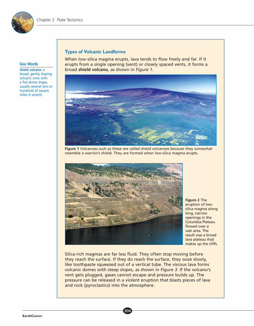
Types of Volcanic Landforms When low-silica magma erupts, lava tends to flow freely and far. If it erupts from a single opening (vent) or closely spaced vents, it forms a broad shield volcano, as shown in Figure 1.
Figure 1 Volcanoes such as these are called shield volcanoes because they somewhat resemble a warrior’s shield. They are formed when low-silica magma erupts.
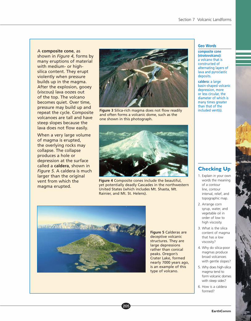
Silica-rich magmas are far less fluid. They often stop moving before they reach the surface. If they do reach the surface, they ooze slowly, like toothpaste squeezed out of a vertical tube. The viscous lava forms volcanic domes with steep slopes, as shown in Figure 3. If the volcano’s vent gets plugged, gases cannot escape and pressure builds up. The pressure can be released in a violent eruption that blasts pieces of lava and rock (pyroclastics) into the atmosphere.
Geo Wordsshield volcano: a broad, gently sloping volcanic cone with a flat-dome shape, usually several tens or hundreds of square miles in extent.
Figure 2 The eruption of low-silica magma along long, narrow openings in the Columbia Plateau flowed over a vast area. The result was a broad lava plateau that makes up the cliffs.
EC_Natl_SE_C2.indd 204 7/12/11 1:28:18 PM
EarthComm205
Section 7 Volcanic Landforms
A composite cone, as shown in Figure 4, forms by many eruptions of material with medium- or high- silica content. They erupt violently when pressure builds up in the magma. After the explosion, gooey (viscous) lava oozes out of the top. The volcano becomes quiet. Over time, pressure may build up and repeat the cycle. Composite volcanoes are tall and have steep slopes because the lava does not flow easily.
When a very large volume of magma is erupted, the overlying rocks may collapse. The collapse produces a hole or depression at the surface called a caldera, shown in Figure 5. A caldera is much larger than the original vent from which the magma erupted.
Figure 5 Calderas are deceptive volcanic structures. They are large depressions rather than conical peaks. Oregon’s Crater Lake, formed nearly 7000 years ago, is an example of this type of volcano.
Geo Wordscomposite cone (stratovolcano): a volcano that is constructed of alternating layers of lava and pyroclastic deposits.
caldera: a large basin-shaped volcanic depression, more or less circular, the diameter of which is many times greater than that of the included vent(s).
Checking Up1. Explain in your own
words the meaning of a contour line, contour interval, relief, and topographic map.
2. Arrange corn syrup, water, and vegetable oil in order of low to high viscosity.
3. What is the silica content of magma that has a low viscosity?
4. Why do silica-poor magmas produce broad volcanoes with gentle slopes?
5. Why does high-silica magma tend to form volcanic domes with steep sides?
6. How is a caldera formed?
Figure 3 Silica-rich magma does not flow readily and often forms a volcanic dome, such as the one shown in this photograph.
Figure 4 Composite cones include the beautiful, yet potentially deadly Cascades in the northwestern United States (which includes Mt. Shasta, Mt. Rainier, and Mt. St. Helens).
EC_Natl_SE_C2.indd 205 7/12/11 1:28:18 PM
EarthComm206
Chapter 2 Plate Tectonics
Think About It AgainAt the beginning of this section, you were asked the following:
• Why do different volcanoes have different shapes?
Record your ideas about this question now. Be sure to explain how magma composition affects the shape and structure of a volcano.
Reflecting on the Section and the ChallengeYou made a map from a model of a volcano. The map showed lines of equal elevation. These lines are contour lines, and the map is a topographic map. You can use topographic maps to predict volcanic hazards. Gravity pulls the lava erupted from volcanoes downhill. A topographic map shows the paths the lava might take. The chemical composition of magma affects the shape of the volcano. Silica-rich magma does not flow readily and often forms a volcanic dome. Shield volcanoes are formed when low-silica magma erupts. You may want to include questions about the connection between the shape of volcanoes and the chemical composition of magma as part of your game.
Understanding and Applying
1. What is the contour interval on the topographic map of Mt. St. Helens in the Investigate?
2. Sketch a contour map of a volcano that shows a:
a) gentle slope
b) steep slope
c) nearly vertical cliff
d) crater or depression at the top
3. Imagine that your paper model was a real volcano. Lava begins to erupt from the top. Shade your topographic map to show where a stream of lava would flow. Explain your drawing.
4. For the volcanoes shown in Figures 1 and 4, sketch a topographic map. Show what the volcano would look like from above. Apply the general rules for interpreting topographic maps. Include a simple legend.
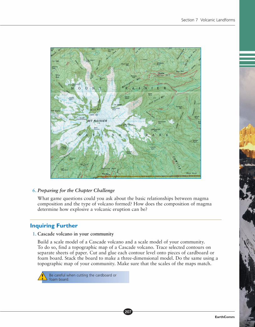
5. Use a copy of the topographic map on the next page, or obtain a topographic map of your state or region, to do the following:
a) Record the contour interval, and the highest and lowest elevations. Calculatethe relief.
b) Identify areas that look like the volcanic landforms you explored in this section. Describe possible paths of lava flows.
EC_Natl_SE_C2.indd 206 7/12/11 1:28:19 PM
EarthComm207
Section 7 Volcanic Landforms
6. Preparing for the Chapter Challenge
What game questions could you ask about the basic relationships between magma composition and the type of volcano formed? How does the composition of magma determine how explosive a volcanic eruption can be?
Inquiring Further 1. Cascade volcano in your community
Build a scale model of a Cascade volcano and a scale model of your community. To do so, find a topographic map of a Cascade volcano. Trace selected contours on separate sheets of paper. Cut and glue each contour level onto pieces of cardboard or foam board. Stack the board to make a three-dimensional model. Do the same using a topographic map of your community. Make sure that the scales of the maps match.
Be careful when cutting the cardboard or foam board.
EC_Natl_SE_C2.indd 207 7/12/11 1:28:19 PM