Embed Size (px)
Citation preview

What are drylands?
Background information for a meeting to discuss drylands in the revised Nelson/Marlborough CMS
Grant Norbury and Susan WalkerLandcare Research, Dunedin and AlexandraMarch 2010

Drylands:
Contain some of the most transformed, least protected and most threatened native ecosystems and species in New Zealand
Are unstable, seral, rapidly changing, invaded

In seeking to protect and restore drylands, we face:
Limited knowledge, experience and science to support biodiversity managers
Poor agency and community awareness of dryland biodiversity and its protection needs

A first attempt to define a New Zealand Dryland Zone
Area ~ 50,500 km2
Rogers et all (2005) Science for Conservation. http://www.doc.govt.nz/upload/documents/science-and-technical/SFC258.pdf

Dryland “Types”(including Manawatu)
A. Gisborne-Hawke’s Bay
This is the most northerly group of dryland environments. On average, they experience the most variable rainfall, the least severe and latest frosts, the highest winter and summer solar radiation, and the highest mean annual temperatures.
C. Wairarapa – Wellington Coast – Nelson. Typically comprising young, fine sediments, often poorly-drained substrates with saline chemical limitations to forest growth, low atmospheric and soil moisture deficits.
D. Coastal Marborough – Kaikoura Coast – inland North Canterbury The driest and sunniest dryland environment type, experiencing the highest atmospheric and soil moisture deficits and the highest average summer solar radiation. Soil fertility is generally high, and there are few chemical limitations to plant growth.
H: Mackenzie Basin and Central Otago
This group of environments covers the steeply sloping foothills of these basins, and is characterised by low atmospheric water deficts, low mean annual temperatures, low solar radiation inputs, and severe, early winter frosts, all reflecting southern latitude. Soils are often alluvial, and predominantly derived from schist.
G: Inland southern south island basins and valley floorsComplex of Nine groups, highly variable, cool, with v. variable moisture regimes and substrates. Most totara, fairly high notsol, 6.Mat & 7.Hall (share high with H), High Comp1 (share high with H), southerly, low mat, low junes, lwo decsol, highest jdgfrost, among earliersty fafrost, lowest rnvar, r2pet, among highest pendef (but low octvpd), high acidp, high sc (but not as high as h), among highest al, highest elev.
B. North Island Hill Country
Relatively moist (high rainfall: potential evapotranspiration ratio) environment with infertile soils, often derived from younger sedimentary rocks such as mudstones and siltstones.
C. Wairarapa – Wellington Coast – Nelson - Manawatu
Typically comprising young, fine sediments, often poorly drained substrates with saline chemical limitations to forest growth, low atmospheric and soil moisture deficits.
D. Coastal Marborough – Kaikoura Coast – inland North Canterbury
The driest and sunniest dryland environment type, experiencing the highest atmospheric and soil moisture deficits and the highest average summer solar radiation. Soil fertility is generally high, and there are few chemical limitations to plant growth.
G: Inland southern South Island basins and valley floors
This group of environments is highly variable, and distinguished by high elevation, severe frosts, low mean annual temperatures, low solar radiation inputs and relatively consistent annual rainfall. Soil moisture deficits are high, but atmospheric water deficts tend to be low. Soils are generally schist and alluvium derived and relatively fertile (with high acid-soluble phosphate).
F: Canterbury Plains and Otago inland basin alluvium and loess
These environments combine low temperatures and low solar radiation inputs, which reflect southern latitude, with characteristic alluvial and loessial substrates.
E: Marlborough – North Canterbury The highest-elevation group of dryland environments, including relatively steeply sloping, well-drained foothills of the Marlborough and North Canterbury mountain ranges, characterised by high atmospheric moisture deficits. Older substrates predominate, and calcareous younger sedimentary rocks and older sedimentary rocks (e.g argillite) feature strongly.
The Units we grouped into “Types” are (LENZ Lvl IV) land environments
“Types” are defined based on environmental factors only (not plants and animals)

Area ~ 50,500 km2
Dryland ecosystems have been extensively cleared
TOTAL NZ LAND AREA
REMAINING PREDOMINANTLYINDIGENOUS ECOSYSTEMS
REST OF NZ
43.7% cleared
19.4%DRYLAND
83.4% cleared
DRYLANDS

Area ~ 50,500 km2TOTAL NZ LAND AREA
AREA LEGALLY PROTECTED(COVENANTS, DOC etc)
REST OF NZ
38.1% protected
19.4%DRYLAND
2.4% protected
DRYLANDS
And have extremely poor protection

Area ~ 50,500 km2TOTAL NZ LAND AREA
PROPORTION OF NZ’s MOST THREATENED PLANTS
19.4%DRYLAND
32.4%DRYLAND
ACUTELY THREATENED PLANTS
41.7%DRYLAND
CHRONICALLY THREATENED PLANTS
But support high proportions of NZ’s most threatened plants, invertebrates and lizards
NB lists & %s not updated to Townsend et al
2008/ de Lange et al 2009!!!

Area ~ 50,500 km2TOTAL NZ LAND AREA
19.4%DRYLAND
DRYLANDS:226 THREATENED PLANTS
ALL of NZ:1000 THREATENED PLANTS
Acutely Threatened
Chronically Threatened
At Risk
Facts & figures
THREAT CATEGORIES (PLANTS)

D. Coastal Marborough – Kaikoura Coast
•Driest and sunniest •Highest air and soil moisture deficits •High summer solar radiation •Soil fertility generally high (alluvial)
Drylands in the Nelson/Marlborough patch
C. Frosty northern lowland alluvium
•Relatively moist, with young, fine sediments, often poorly drained

E: Marlborough – North Canterbury hill country
•High elevation (inland, hilly)•Steep slopes •High air moisture deficits (nor’westers!)•Limestone and argillite are geological features
Drylands in the Nelson/Marlborough patch
G: Inland southern South Island basins and valley floors
•Highly variable, but distinguished by: inland, so high elevation cool, severe frosts, low solar radiation
•Big soil water deficits, BUT low air water deficits•Fertile alluvium-derived soils
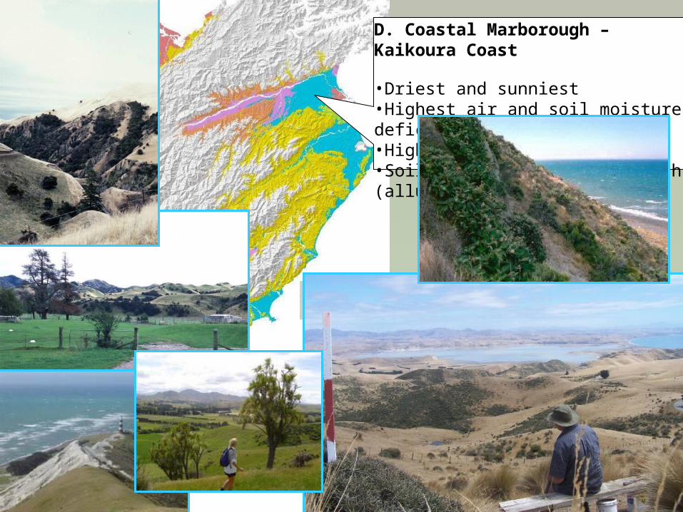
D. Coastal Marborough – Kaikoura Coast
•Driest and sunniest •Highest air and soil moisture deficits •High summer solar radiation •Soil fertility generally high (alluvial)

E: Marlborough – North Canterbury hill country
G: Inland southern South Island basins and valley floors

E: Marlborough – North Canterbury hill country
…& down towards Nick Head’s patch…

All of NZ Drylands
Acutely ThreatenedChronically ThreatenedAt RiskCritically UnderprotectedUnderprotectedNo threat category

Threatened environments
• Combination of 3 national datasets
• Divides country into 6 threat categoriesbased mainly on:
past loss of indigenous vegetation (% indigenous cover left)
but also on:
current legal protection (% protected)

Threatened environmentsCategory Category Criteria Category Name
1 <10% indigenous cover left Acutely Threatened
2 10–20% left Chronically Threatened
3 20–30% left At Risk
4 >30% left and <10% protected
Critically Underprotected
5 >30% left and 10–20% protected
Underprotected
6 >30% left and >20% protected
Less Reduced and Better Protected
No Data
based on indigenous cover left, no matter how much protected
based on indigenous cover left (>30%) left AND how much protected

Threatened Environment Classification
Nelson-Marlborough ConservancyAll
Drylands only

Environment Threat Categories (Proportion Land Area)
This Region’s Threatened EnvironmentsNew Zealand Nelson-Marlborough
Conservancy as a whole

Environment Threat Categories (Proportion Land Area)
This Region’s Threatened EnvironmentsNew Zealand
Nelson-Marlborough DRYLANDS