Embed Size (px)
Citation preview

WFS: A Technical Overview
201 Loudoun Street SW
Leesburg, VA 20175
www.imagemattersllc.com
A technology development and professional services company
Jeff Ehman, Ph.D.

Copyright © 2009 Image Matters LLC. All rights reserved. | www.imagemattersllc.com Page 2
Topics
• WFS Overview– WFS Defined– Need and Purpose
• WFS Technical Details– OGC Service Model– OGC WFS Interface – requests and responses– OGC Filter Specification– Live Examples
• Compliant Software• Resources

Copyright © 2009 Image Matters LLC. All rights reserved. | www.imagemattersllc.com 3
• WFS is an acronym for the Web Feature Service standard
• WFS is a type of standard known as an interface specification which defines protocols whereby a machine in one location can communicate with a machine in another location regardless of operating system, software vendor, etc.
• WFS enables requests and transfers of feature geometries (e.g., X,Y coordinate pairs that comprise points, lines, and polygons) and associated topologies.
• The feature data is encoded in a type of XML called Geometry Markup Language, or GML.
• The WFS spec was developed through the Open Geospatial Consortium, Inc. ® (OGC)
• Another OGC standard, Web Map Service (WMS), enables communication for transferring pictures of features, not the feature geometries themselves.
What is a WFS ?

Copyright © 2009 Image Matters LLC. All rights reserved. | www.imagemattersllc.com Page 4
WMS vs. WFS
• Both are OGC Interface Specifications
• WMS = Web Map Service; delivers pictures of features from geographic datasets
• WMS payload is an image (.gif, .tif, .jpeg, .png)
• WFS = Web Feature Service; delivers coordinate pair and attribute value for the features of the geographic data set.
• WFS payload is XML; features are expressed in GML

Copyright © 2009 Image Matters LLC. All rights reserved. | www.imagemattersllc.com 5
• An enabling technology for Geospatial Data Roll-up (GDR)
• Provide access to local data by IDHS
• Improve coordination for state response
• Could provide access to others, e.g., for mutual aid
– save lives
– protect property
• Improve efficiencies– conserve resources, by moving
to automated, on-demand data sharing, and moving away from costly ETL processes
Why do we need WFS locally?
From DHS GMO – GEA
“Geospatial Technology Patterns”

Copyright © 2009 Image Matters LLC. All rights reserved. | www.imagemattersllc.com
6
The Problem
IDHS
County B County C
County DCounty A
• Most existing internet map and data servers are not “interoperable” – each has vendor-specific access method
– access often requires human operator
– different data models used; no standard application schemas
Copyright © 2009 Image Matters LLC. All rights reserved. | www.imagemattersllc.com 7
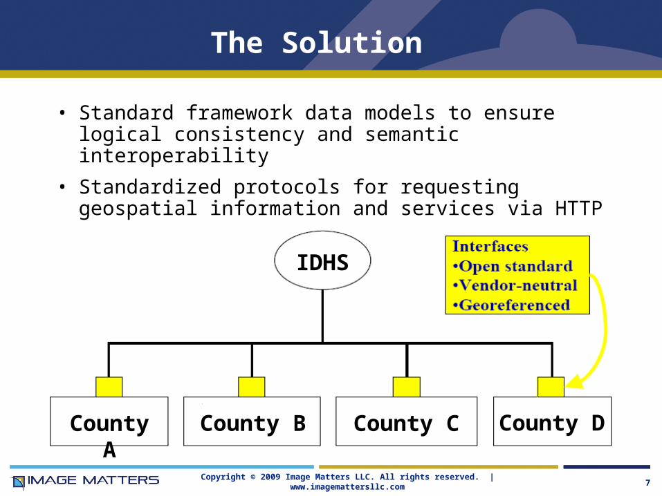
The Solution
IDHS
County B County C County DCounty A
• Standard framework data models to ensure logical consistency and semantic interoperability
• Standardized protocols for requesting geospatial information and services via HTTP
Copyright © 2009 Image Matters LLC. All rights reserved. | www.imagemattersllc.com 8
Interoperability defined
Interoperability – the capability to communicate, execute programs, or transfer data among various functional units in a manner that requires the user to have little or no knowledge of the unique characteristics of those units.
OGC® Glossary of Terms - http://www.opengeospatial.org/ogc/glossary/
Copyright © 2009 Image Matters LLC. All rights reserved. | www.imagemattersllc.com Page 9
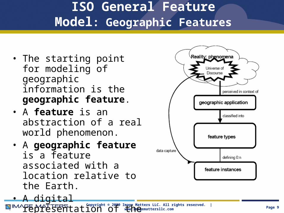
ISO General Feature Model: Geographic Features
• The starting point for modeling of geographic information is the geographic feature.
• A feature is an abstraction of a real world phenomenon.
• A geographic feature is a feature associated with a location relative to the Earth.
• A digital representation of the real world can be thought of as a set of features.

Copyright © 2009 Image Matters LLC. All rights reserved. | www.imagemattersllc.com Page 10
Characteristics of a Geospatial Feature
• One Feature per real-world entity
• Features have a unique, persistent ID
• Features are typed (tagged with semantics)
• Features have descriptions (no uniqueness constraint)
• One or more attributes with name, type value and optional description
• Variety of attribute data types (integer, real, geometry, raster, feature references, etc.)

Copyright © 2009 Image Matters LLC. All rights reserved. | www.imagemattersllc.com Page 11
Introduction to Web Services
• Before the WWW– Isolated, Single-computational-tier
• Batch processing, hard-copy reports • Interactive Applications and Transaction Processing • CODASYL and RDBMS Databases
– Client (application) / Server (database)
– Distributed, Fine-Grained, Multi-tier Processing in controlled (COM, EJB, CORBA) networked processing environments
• Via the WWW– Information Distribution via Hyperlinked Pages
– Interactive (DNS, HTTP, HTML) Web Applications for Human Users
– Portals for Centralized, Branded, Access to Pages and Apps
– Coarse-Grained Web Services for Software Application “Users” on open standardized (HTTP, XML, UDDI, WSDL, SOAP) WWW
– Web Services combined in Service Oriented Architectures

Copyright © 2009 Image Matters LLC. All rights reserved. | www.imagemattersllc.com 12
service - performance of work (a function) by one for another. • There are three related ideas:
o The capability to perform work for another o The specification of the work offered for another o The offer [or request] to perform work for another
• Note the distinction is made between a capability and the ability to bring that capability to bear
service - A collection of operations, accessible through an interface, that allows a user to evoke a behavior of value to the user. [ISO – 19119]
In a web service, the specification, offering, discovery, request, and performance of work relies upon an Internet protocol backbone
Definitions: (web) service

Copyright © 2009 Image Matters LLC. All rights reserved. | www.imagemattersllc.com 13
OGC General Service Model
Registry/Catalog/
Directory/Broker
ServiceClient
PublishFind
Bind and Interact
Bind
Find Publish

Copyright © 2009 Image Matters LLC. All rights reserved. | www.imagemattersllc.com 14
User Applications
Metadata update
Metadata search and retrieval
CatalogCatalogCatalogs
Middleware
Clients
Servers
Geoprocessing Services
Access totransformed data
ServiceChaining
Direct data accessFeaturesContent
RepositoriesCoveragesOther data
“The Interoperability Stack”

Copyright © 2009 Image Matters LLC. All rights reserved. | www.imagemattersllc.com
Bind
Find Publish
Registry
ClientService
Data CatalogService RegistriesData modelsVocabulariesSymbolisation rules
DataStylingGazetteerAuthenticationGeocoding
ChainValue AddIntegration
Thin Client
Thick Client
Web BrowserHosted Application
Plug-insMobile Devices
Desktop GIS
Value Added Providers
Users
Providers
InfrastructureServices
Geospatial Web Services Architecture Functional Model
Copyright © OGC 2008

Copyright © 2009 Image Matters LLC. All rights reserved. | www.imagemattersllc.com 16
• WFS is a Web Service
• The WFS specification is a OGC Implementations Specification– WFS, Version 1.1.0, OGC Document 04-094 – Filter, Version 1.1.0, OGC Document 04-095– WFS Schema Corrigendum, OGC Document 06-027r1
• The WFS operations support INSERT, UPDATE, DELETE, QUERY and DISCOVERY operations on vector geographic features using HTTP as the distributed computing platform.
• QUERY and DISCOVERY operations are mandatory.
• Basic interface, as does WMS, allows user/client to specify Bounding Box (AOI) and Coordinate Reference System
• The OGC FILTER specification defines how to use OGC Query Language to perform query operations (same as Catalog)
• Returns features as GML encoding
What is a WFS ?

Copyright © 2009 Image Matters LLC. All rights reserved. | www.imagemattersllc.com 17
Purpose of WFS
• Allows a client to retrieve and update geospatial data encoded in Geography Markup Language (GML) from one or more servers with WFS interface.
• Web clients and services can combine, use and manage geodata -- the feature information behind a map image -- from different sources.
• Defines interfaces for data access and manipulation operations on geographic features using HTTP as the distributed computing platform.
• Uses the OGC Filter grammar, an XML-encoding of a system-neutral query predicate.
• Developers can build clients that keep complexity “under the hood”.

Copyright © 2009 Image Matters LLC. All rights reserved. | www.imagemattersllc.com 18
Web Feature Server Specification
• A Basic Web Feature Server can handle 3 types of operations:
– GetCapabilities. Describes using an XML-encoding the capabilities of the service, e.g. the features that are available and the supported transactional operations.
– DescribeFeatureType. Provides a description of the structure of a one, many, or all feature types (i.e. the schema that describes the attributes);
– GetFeature. Provides access to features based on a filter that constrains the request using spatial and non-spatial parameters.
• Transactional WFS (“WFS-T”) implementations support these:
– Transaction. Insert/Update/Delete features
– LockFeature: Lock Feature records for exclusive access.
– GetFeatureWithLock: equivalent to GetFeature but locks feature records too
• Additional (optional) operations:
– GetGmlObject. Allows retrieval of features and elements by ID; responds with an XML document fragment containing the result set. The value of the gml:id attribute on the object is used as a unique key to retrieve complex elements.
Copyright © 2009 Image Matters LLC. All rights reserved. | www.imagemattersllc.com 19
© 2007 Open Geospatial Consortium
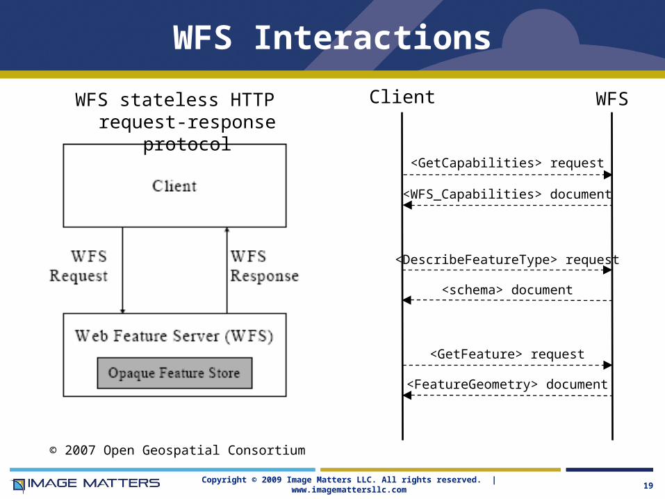
WFS Interactions
WFS stateless HTTP request-response protocol
Client WFS
<WFS_Capabilities> document
<FeatureGeometry> document
<GetCapabilities> request
<GetFeature> request
<schema> document
<DescribeFeatureType> request
Copyright © 2009 Image Matters LLC. All rights reserved. | www.imagemattersllc.com
HTTP as a Distributed Computing Platform
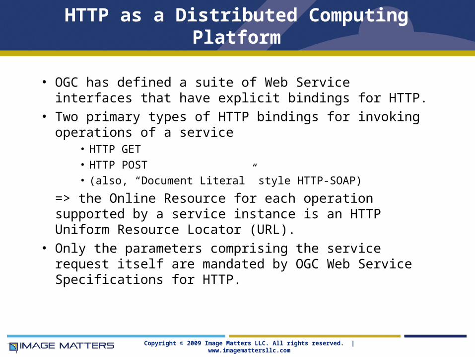
• OGC has defined a suite of Web Service interfaces that have explicit bindings for HTTP.
• Two primary types of HTTP bindings for invoking operations of a service
• HTTP GET • HTTP POST• (also, “Document Literal” style HTTP-SOAP)
=> the Online Resource for each operation supported by a service instance is an HTTP Uniform Resource Locator (URL).
• Only the parameters comprising the service request itself are mandated by OGC Web Service Specifications for HTTP.
Copyright © 2009 Image Matters LLC. All rights reserved. | www.imagemattersllc.com
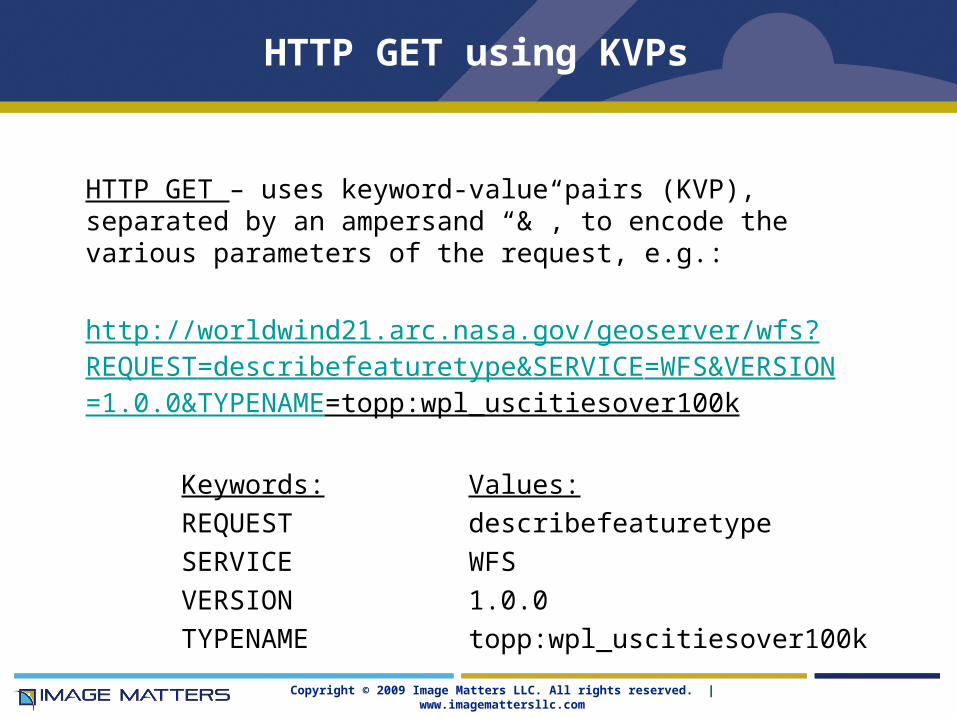
HTTP GET using KVPs
HTTP GET – uses keyword-value pairs (KVP), separated by an ampersand “&”, to encode the various parameters of the request, e.g.:
http://worldwind21.arc.nasa.gov/geoserver/wfs?REQUEST=describefeaturetype&SERVICE=WFS&VERSION=1.0.0&TYPENAME=topp:wpl_uscitiesover100k
Keywords: Values:
REQUEST describefeaturetype
SERVICE WFS
VERSION 1.0.0
TYPENAME topp:wpl_uscitiesover100k

Copyright © 2009 Image Matters LLC. All rights reserved. | www.imagemattersllc.com
HTTP POST using XML
HTTP POST – uses XML as the encoding language, e.g.:
<?xml version="1.0"?>
<DescribeFeatureType Version="1.1.0" Service="WFS"
xmlns="http://www.opengis.net/wfs"
xmlns:topp="http://www.openplans.org/topp"
xmlns:tiger="http://www.census.gov"
xmlns:xsi="http://www.w3.org/2001/XMLSchema-instance"
xsi:schemaLocation="http://www.opengis.net/wfs http://schemas.opengis.net/wfs/1.1.0/WFS.xsd">
<TypeName>topp:wpl_uscitiesover100k</TypeName>
</DescribeFeatureType>
This XML would be “POST”ed to http://worldwind21.arc.nasa.gov/geoserver/wfs
Copyright © 2009 Image Matters LLC. All rights reserved. | www.imagemattersllc.com 23
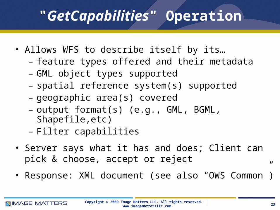
"GetCapabilities" Operation
• Allows WFS to describe itself by its…– feature types offered and their metadata– GML object types supported– spatial reference system(s) supported– geographic area(s) covered– output format(s) (e.g., GML, BGML, Shapefile,etc)– Filter capabilities
• Server says what it has and does; Client can pick & choose, accept or reject
• Response: XML document (see also “OWS Common”)

Copyright © 2009 Image Matters LLC. All rights reserved. | www.imagemattersllc.com 24
How does Client use Capabilities?
• Client can directly issue GetCapabilities request to particular server
• Catalog can poll (harvest) Capabilities from servers to build up a “cache” of feature-server descriptions
• Clients can query Catalog to find data and servers
• Request syntax:
http://host:port/script?SERVICE=WFS&VERSION=1.1.0&REQUEST=GetCapabilities
• Response: XML-structured metadata

Copyright © 2009 Image Matters LLC. All rights reserved. | www.imagemattersllc.com 25
GetCapabilities Request and Response
http://frameworkwfs.usgs.gov/framework/wfs/wfs.cgi?REQUEST=getcapabilities&SERVICE=WFS

Copyright © 2009 Image Matters LLC. All rights reserved. | www.imagemattersllc.com 26
“DescribeFeatureType" Operation
• Function: generate a schema description of feature types served by the WFS implementation – the “GML Application Schema” – the structure of the way the feature-level data is available
• Describes how feature instances are to be encoded:– for input (for transaction operations i.e., Insert and Update)– for output (in response to GetFeature and GetGMLObject
requests)
• Output format is, by default: text/xml;subtype=gml/3.1.1
http://frameworkwfs.usgs.gov/framework/wfs/wfs.cgi?REQUEST=describefeaturetype&SERVICE=WFS&VERSION=1.1.0&TYPENAME=gubs:GovernmentalUnitCE

Copyright © 2009 Image Matters LLC. All rights reserved. | www.imagemattersllc.com 27
KVP DescribeFeatureType annotated
http://host:port/script?VERSION=m.n.o&REQUEST=DescribeFeatureType&TYPENAME=type_list&OUTPUTFORMAT=text/xml
http://host:port/script? Your URL (onlineResource)
VERSION=m.n.o& Version number
REQUEST=DescribeFeatureType& Indicates this operation
TYPENAME=type_list& One or more feature type names
OUTPUTFORMAT=text/xml;& text/gml;subtype=gml/3.1.1 • Note: Bold parameters are mandatory.• Note: these parameters apply only for KVP-encoded requests; HTTP POST binding requires a valid XML-encoded request

Copyright © 2009 Image Matters LLC. All rights reserved. | www.imagemattersllc.com 28
DescribeFeatureType Response
http://frameworkwfs.usgs.gov/framework/wfs/wfs.cgi?REQUEST=describefeaturetype&SERVICE=WFS&VERSION=1.1.0&TYPENAME=gubs:GovernmentalUnitCE
[Partial Response]
<xs:element name="GovernmentalUnitCE" type="gubs:GovernmentalUnitCEType" substitutionGroup="gml:_Feature"/>
<xs:complexType name="GovernmentalUnitCEType">
<xs:complexContent>
<xs:extension base="gml:AbstractFeatureType">
<xs:sequence>
<xs:element name="unitId" type="fw:IdentifierPropertyType"/>
<xs:element name="typeAbbreviation" type="xs:string" minOccurs="0" maxOccurs="1"/>
<xs:element name="instanceName" type="xs:string"/>
<xs:element name="instanceAlternateName" type="xs:string" minOccurs="0" maxOccurs="unbounded"/>
<xs:element name="officialDescription" type="xs:string" minOccurs="0" maxOccurs="1"/>
<xs:element name="instanceCode" type="xs:string"/>
<xs:element name="codingSystemReference" type="xs:string" minOccurs="0" maxOccurs="unbounded"/>
<xs:element name="effectiveDate" type="xs:date" minOccurs="0" maxOccurs="2"/>
<xs:element name="geometry" type="gml:SurfacePropertyType"/>
<xs:element name="extended" type="fw:ExtendedAttributePropertyType" minOccurs="0" maxOccurs="unbounded"/>
<xs:element name="governmentalUnitType">

Copyright © 2009 Image Matters LLC. All rights reserved. | www.imagemattersllc.com 29
"GetFeature" Operation
• Allows retrieval of features encoded in GML– Must know the information model (Application Schema)
of the target features (types, semantics, structure)– Feature Types are listed in Capabilities document– Often, but not necessarilly, the name of the feature
element indicates its Feature Type
• GetFeature contains one or more <Query> elements– Queries are expressed using the OGC Filter grammar
• Responds with one of:– a complete response document (a
wfs:FeatureCollection element)– the number of features that a request would return – exception report
Copyright © 2009 Image Matters LLC. All rights reserved. | www.imagemattersllc.com 30
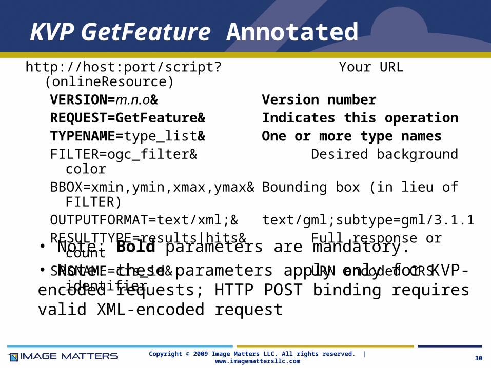
KVP GetFeature Annotatedhttp://host:port/script? Your URL (onlineResource)
VERSION=m.n.o& Version numberREQUEST=GetFeature& Indicates this operationTYPENAME=type_list& One or more type namesFILTER=ogc_filter& Desired background colorBBOX=xmin,ymin,xmax,ymax& Bounding box (in lieu of FILTER)OUTPUTFORMAT=text/xml;& text/gml;subtype=gml/3.1.1 RESULTTYPE=results|hits& Full response or countSRSNAME=crs_id& URN encoded CRS
identifier
• Note: Bold parameters are mandatory.• Note: these parameters apply only for KVP-encoded requests; HTTP POST binding requires valid XML-encoded request

Copyright © 2009 Image Matters LLC. All rights reserved. | www.imagemattersllc.com 31
GetFeature XML HTTP-POST Request
<GetFeature xmlns="http://www.opengis.net/wfs" xmlns:gml="http://www.opengis.net/gml" xmlns:ogc="http://www.opengis.net/ogc" xmlns:xlink="http://www.w3.org/1999/xlink" xmlns:xsi="http://www.w3.org/2001/XMLSchema-
instance" xsi:schemaLocation="http://www.opengis.net/wfs version="1.0.0" service="WFS" outputFormat="x-
application/gml:3:0"> <Query typeName="topp:wpl_uscitiesover100k"
srsName="EPSG:4326"> <ogc:Filter> <ogc:Intersects>
<ogc:PropertyName>topp:geom</ogc:PropertyName>
<gml:Box srsName="EPSG:4326"> <gml:coordinates>-157.858,18.013 -
65.9577,61.218 </gml:coordinates> </gml:Box> </ogc:Intersects> </ogc:Filter> </Query></GetFeature>

Copyright © 2009 Image Matters LLC. All rights reserved. | www.imagemattersllc.com 32
GetFeature Response
<?xml version="1.0" encoding="UTF-8"?><wfs:FeatureCollection xmlns:wfs="http://www.opengis.net/wfs"
xmlns:topp="http://www.openplans.org/topp" xmlns:gml="http://www.opengis.net/gml" xmlns:xsi="http://www.w3.org/2001/XMLSchema-instance" xsi:schemaLocation="http://www.openplans.org/topp http://worldwind21.arc.nasa.gov:80/geoserver/wfs/DescribeFeatureType?typeName=topp:wpl_uscitiesover100k http://www.opengis.net/wfs http://worldwind21.arc.nasa.gov:80/geoserver/schemas/wfs/1.0.0/WFS-basic.xsd"><gml:boundedBy>
<gml:Box srsName="http://www.opengis.net/gml/srs/epsg.xml#4326"><gml:coordinates
xmlns:gml="http://www.opengis.net/gml" decimal="." cs="," ts=" ">-123.08560181,18.01305962 -65.95777893,47.65889359</gml:coordinates>
</gml:Box></gml:boundedBy><gml:featureMember>
<topp:wpl_uscitiesover100k fid="wpl_uscitiesover100k.1"><topp:latitude>33.52056</topp:latitude><topp:longitude>-86.8025</topp:longitude><topp:full_name_nd>Birmingham</topp:full_name_nd><topp:geom>
<gml:Point srsName="http://www.opengis.net/gml/srs/epsg.xml#4326">
<gml:coordinates xmlns:gml="http://www.opengis.net/gml" decimal="." cs="," ts=" ">-86.8025,33.52056</gml:coordinates>
</gml:Point></topp:geom>
</topp:wpl_uscitiesover100k></gml:featureMember>
</wfs:FeatureCollection>
Copyright © 2009 Image Matters LLC. All rights reserved. | www.imagemattersllc.com 33
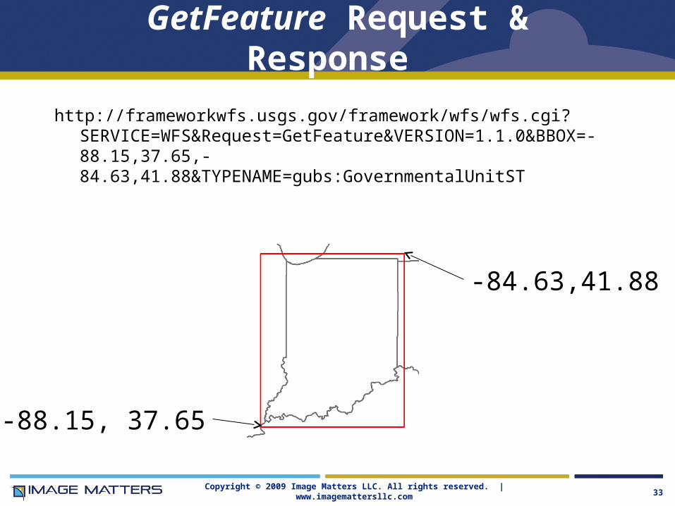
GetFeature Request & Response
http://frameworkwfs.usgs.gov/framework/wfs/wfs.cgi?SERVICE=WFS&Request=GetFeature&VERSION=1.1.0&BBOX=-88.15,37.65,-84.63,41.88&TYPENAME=gubs:GovernmentalUnitST
-84.63,41.88
-88.15, 37.65

Copyright © 2009 Image Matters LLC. All rights reserved. | www.imagemattersllc.com 34
OGC Filter
• logicalOps (AND, OR, NOT)• comparisonOps
– PropertyIsEqualTo (binary)– PropertyIsNotEqualTo (binary)– PropertyIsLessThan (binary)– PropertyIsGreaterThan (binary)– PropertyIsLessThanOrEqualsTo (binary)– PropertyIsGreaterThanOrEqualsTo (binary)– PropertyIsLike– PropertyIsNull– PropertyIsBetween
• spatialOps– Equals (property+geometry|envelope)– Disjoint (property+geometry|envelope)– Touches (property+geometry|envelope)– Within (property+geometry|envelope)– Overlaps (property+geometry|envelope)– Crosses (property+geometry|envelope)– Intersects (property+geometry|envelope)– Contains (property+geometry|envelope)– DWithin (property+geometry+distance)– Beyond (property+geometry+distance)– BBOX (property+envelope)
Used to constrain the property values of an object type in order to subset (filter) collections of objects
Filtering a query is a restriction in order to return exactly the desired subset.
There are two main types of filter operators: – Spatial
– Comparison.
Logical operators are used to combine the other filters to make more complex queries.
Filter makes WFS powerful*

Copyright © 2009 Image Matters LLC. All rights reserved. | www.imagemattersllc.com 35
WFS Software & OGC Compliance
• OGC offers free tests and testing software for technology providers to confirm that their products are compliant with OpenGIS standards.
• Providers can then submit products for certification.• Certified products can carry the OGC "Certified
Compliant" mark to formally signify adherence to OGC standards.
• For the Web Feature Service implementations, “Certified Compliant” means the software was successfully tested for WFS with Filter Encoding (1.1.0)
• Products can be registered as “Implementing” – attempted to follow instructions – without complying.
• List at http://www.opengeospatial.org/resource/products

Copyright © 2009 Image Matters LLC. All rights reserved. | www.imagemattersllc.com 36
WFS Server Software – $
**Company has implemented WFS 1.0 or 1.1 for one or more other products not listed here
Company Software Name WFS Version
OGC Compliant
Implementing
Autodesk MapGuide Enterprise 2007, 2008 1.0 X**Cadcorp Cadcorp SIS Map Server 6.2 1.0 XCubewerx CubeSERV Web Feature Server 4.6 1.0 (T) X (1.1)ESRI ArcIMS 9.2, 9.3
Server 9.3; GIS Portal Toolkit 2.0GIS Portal Toolkit 3.1
1.01.01.1
XXX
Galdos Systems, Inc Cartalinea Geographic Data Server 2.0 1.0 X
GenaWare GenaWare 8 1.0 XIntergraph GeoMedia WebMap 05.01 1.0 X X (T)Leica Geosystems RedSpider Web 3.4 1.0 (T) X 1.1**PB MapInfo Corp MapXtreme 2005 6.6 1.0 X
PCI Geomatics Geomatica - WebServer Suite 10.0 1.0 XSafe Software FME 2008 1.0, 1.1 X

Copyright © 2009 Image Matters LLC. All rights reserved. | www.imagemattersllc.com 37
WFS Server Software – Open Source
Company Software Name Compliance Status
topp.openplans.org GeoServer 1.3GeoServer 1.5
Compliant 1.0 (T)Implementing
lat/lon deegree Web Feature Service 2.3 Implementing 1.1
UMN MapServer Project MapServer 4.2 Implementing 1.0

Copyright © 2009 Image Matters LLC. All rights reserved. | www.imagemattersllc.com 38
WFS implementations (a sample)
• USGS Framework
http://frameworkwfs.usgs.gov/framework/wfs/wfs.cgi?request=getcapabilities&service=wfs
• EPA Superfund: http://geodata.epa.gov/wfsconnector/com.esri.wfs.Esrimap/NPL_FS?request=getcapabilities&service=wfs
• EPA Hazardous Waste: http://geodata.epa.gov/wfsconnector/com.esri.wfs.Esrimap/RCR_FS?request=getcapabilities&service=wfs
• EPA Toxic Releases: http://geodata.epa.gov/wfsconnector/com.esri.wfs.Esrimap/TRI_FS?request=getcapabilities&service=wfs
• WRAP TSS: http://victor.cira.colostate.edu/geoserver/wfs?REQUEST=getcapabilities&SERVICE=WFS
• Arkansas GEOSTOR: http://www.geostor.arkansas.gov/wfsconnector/com.esri.wfs.Esrimap/GEOSTOR_ALL_FEATURE_LAYERS?version=1.0.0
• Galdos Demo: http://wfs.galdosinc.com:8880/wfs/http?Request=GetCapabilities&service=WFS&
• Ionic Boston Demo: http://webservices.ionicsoft.com/ionicweb/wfs/BOSTON_ORA?version=1.0.0&
• Intergraph Demo: http://regis.intergraph.com/wfs/casil/request.asp?SERVICE=WFS&VERSION=1.0.0&

Copyright © 2009 Image Matters LLC. All rights reserved. | www.imagemattersllc.com 39
WFS Resources• OGC:
– Specifications • WFS V1.1.0 (04-094): http://www.opengeospatial.org/standards/wfs• WFS 1.1.0 Schema Corrigendum (06-027r1): http://www.opengeospatial.org/standards/wfs• Filter V1.1 (04-095): http://www.opengeospatial.org/standards/filter• GML V3.0 (02-023r4): http://www.opengeospatial.org/standards/gml• GML V3.1.1 (03-105r1): http://www.opengeospatial.org/standards/gml• GML Simple Features Profile V1.0.0 (06-049r1): http://www.opengeospatial.org/standards/gml
– Compliance testing: http://www.opengeospatial.org/resource/testing– Resources: http://www.opengeospatial.org/resource
• Other “recipes”: http://www.opengeospatial.org/resource/cookbooks
• Lists of implementations– http://www.opengeospatial.org/resource/products– http://docs.codehaus.org/display/GEOS/Available+WMS+and+WFS+servers– http://atlas.lsu.edu/central/displayOGCWFSfeature.htm – http://udig.refractions.net/confluence/display/UDIG/Test+Servers
• Open Source projects– Deegree: http://www.deegree.org/ (reference implementation)– Geotools: http://geotools.codehaus.org/– Geoserver: http://docs.codehaus.org/display/GEOS/Home– MapServer: http://mapserver.gis.umn.edu/
Copyright © 2009 Image Matters LLC. All rights reserved. | www.imagemattersllc.com Page 40
Image Matters Web Services Activities
• Open Geospatial Consortium (OGC) Support– Key roles as architects and engineers in development and execution of the
Interoperability Program, where OGC specifications are defined, developed, and tested
– Co-authors or key contributors to many OGC specifications (GML, SWE, OpenLS, CSW, WCS, et al)
– Deep knowledge of OGC specifications, their normative schema and best-practices for application and use.
• NOAA Support– Developing GML Schemas for IOOS data conforming to OGC O&M and
Climate Science Modeling Language (CSML) for use in an OGC SOS
• Advanced Web Applications, Services & Frameworks– Web 2.0, GeoWeb, Sensor Web, and Semantic Web
– USGS, FEMA, EPA, NGA, DHS ICE, DHS S&T, Air Force, Army, others
• EA Development – Standards-based SOA (S-SOA) – FEA, DHS, USSS