Embed Size (px)
Citation preview
0
Wetland Delineation and Assessment Report For Honsinger Family Trust - 4700 Glacier Highway Juneau, Alaska - Rich Harris
7/27/2015
R. Harris Wetland Delineation July 2015
1
Bosworth Botanical Consulting Koren Bosworth
Table of Contents
Introduction ................................................................................................................................. 2
Methods ....................................................................................................................................... 3
Project Area ................................................................................................................................. 4
Project Area Plant List ........................................................................................................... 10
Results ....................................................................................................................................... 11
Conclusion ................................................................................................................................. 12
References ................................................................................................................................. 14
Appendix-A - WESPAK-SE (version 1.4) - Assessment Scores .............................................. 15
Appendix-B - COE Wetland Delineation Data Sheets - Attached file ...................................... 17
R. Harris Wetland Delineation July 2015
2
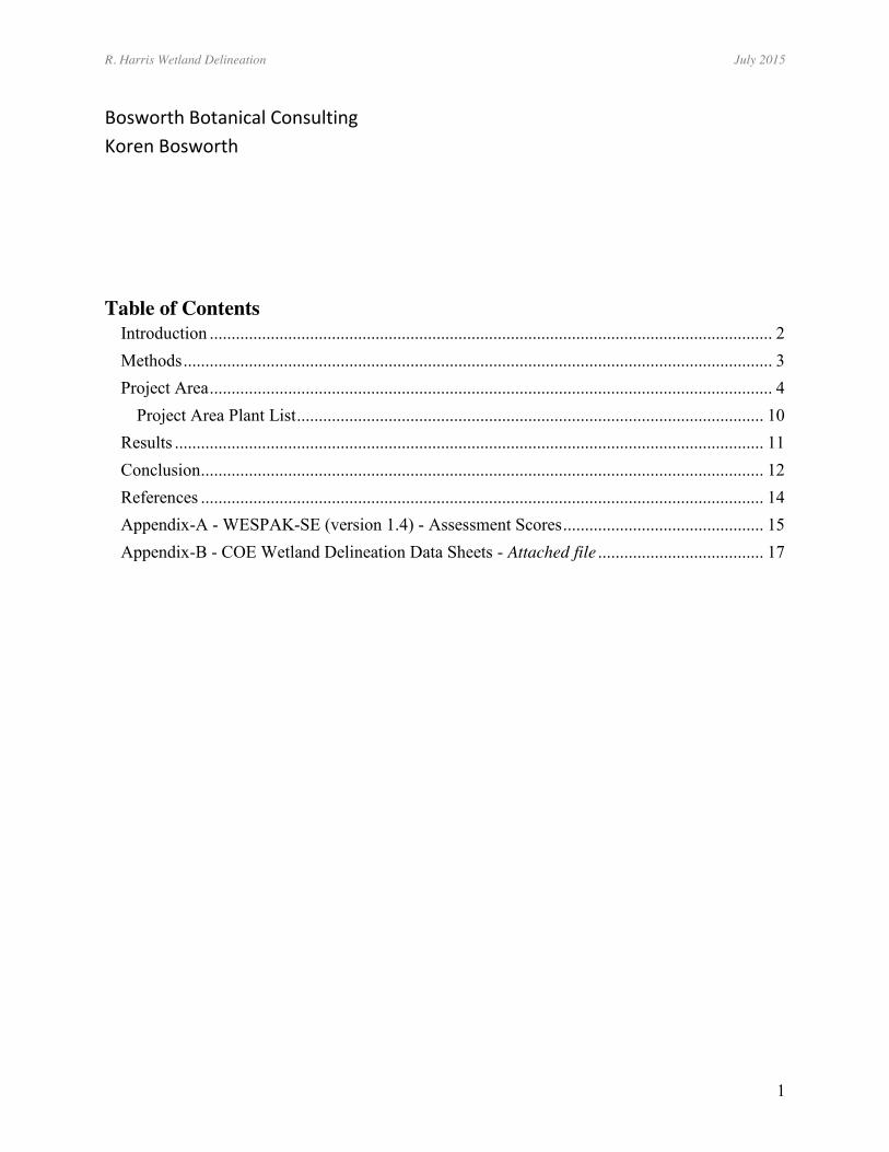
US Army Corps of Engineers Wetland Delineation and Assessment for: the Honsinger Family Trust Property at
7400 Glacier Hwy. Project- Juneau, AK.
Applicant: Rich Harris 907-723-4791 Agent: Koren Bosworth – Bosworth Botanical Consulting 165 Behrends Ave Juneau, AK 99801 907-723-1931 [email protected]
Introduction
Rich Harris wants to develop a part of the rectangular 20.7 acre parcel at 7400 Glacier Hwy. The parcel is found on the north side of the old Glacier Highway, just east of Fred Meyers and west of the CBJ maintenance shop. The most distinct landmark is the new Vista del Sol development on the western boundary of the project area (Figure 1).
Figure 1 - Location map for the project.
Project Area
R. Harris Wetland Delineation July 2015
3
Methods The project area was visited first as part of the onsite wetland mapping and assessment phase of the Juneau Wetland Management Plan - Update in May 2015. At this time the wetland boundaries were mapped using a mapping grade Trimble GPS with sub-meter accuracy and a wetland assessment was done using WESPAK-SE (version 1.4)field and office forms. The raw function scores, and the raw value scores obtained from the assessment were normalized by comparing the raw WESPAK-SE scores to the WESPAK-SE scores of all of the 143 field calibration wetland sites around SE Alaska, to see where it fits; the WESPAK-SE calculator spreadsheet does this automatically using commonly-used formulas. On July 19, 2015 the site was seen again to revisit and document the wetland boundaries that were mapped earlier. The visit was after a very rainy July and many of the streams that hadn't been flowing in May were now flowing.
The Army COE delineation methodology was used, as outlined in the 1987 Corps of Engineers Wetland Delineation Manual - for Routine Determinations and supplemented by the, Regional Supplement to the Corps of Engineers Wetland Delineation Manual: Alaska Region – November, 2007.
Representative sample points were done at any significant change in vegetation, soils or hydrology. Sample points were recorded using a Garmin Rino 530HCx, WAAS-enabled, GPS receiver.
At each sampling point, the wetland status of that point was determined by observing indicators of hydrophytic vegetation, hydric soil, and wetland hydrology. Wetland and upland areas that were big enough to be mapped separately were delineated and flagged.
Vegetation was divided into three strata; tree, shrub and forb, and each layer was classified using the prevalence index (a weighted-average wetland indicator status of all plant species in the sample plot) and the dominance test (more than 50% of the dominant plant species across all strata are rated obligate, facultative wet or facultative). The 2012 U.S. Army Corps of Engineers National Wetland Plant List –Alaska Region was used to classify plants. Hydrology was determined using two methods: (1) visually, if the water table is at or above the surface, or (2) with a soil pit. The presence of standing water, depth to free water in the soil pit, and depth to saturated soils were recorded. Other primary and secondary hydrology indicators were recorded, such as presence of watermarks, sediment deposits, drift deposits, iron deposits, hydrogen sulfide odor, geomorphic position, and drainage patterns in wetlands. Soil pits were dug to a depth of 12-18 inches, or to bedrock or sediment refusal, to determine if indicators of hydric soils were present. Soil colors were determined from a moist sample with the Munsell Soil Color Chart. This information is all recorded on the Alaska Region Corps Routine Wetland Determination Data Form that is filled out for each sample point and included with this report.
R. Harris Wetland Delineation July 2015
4
The sample point data was added to the May JWMP map.
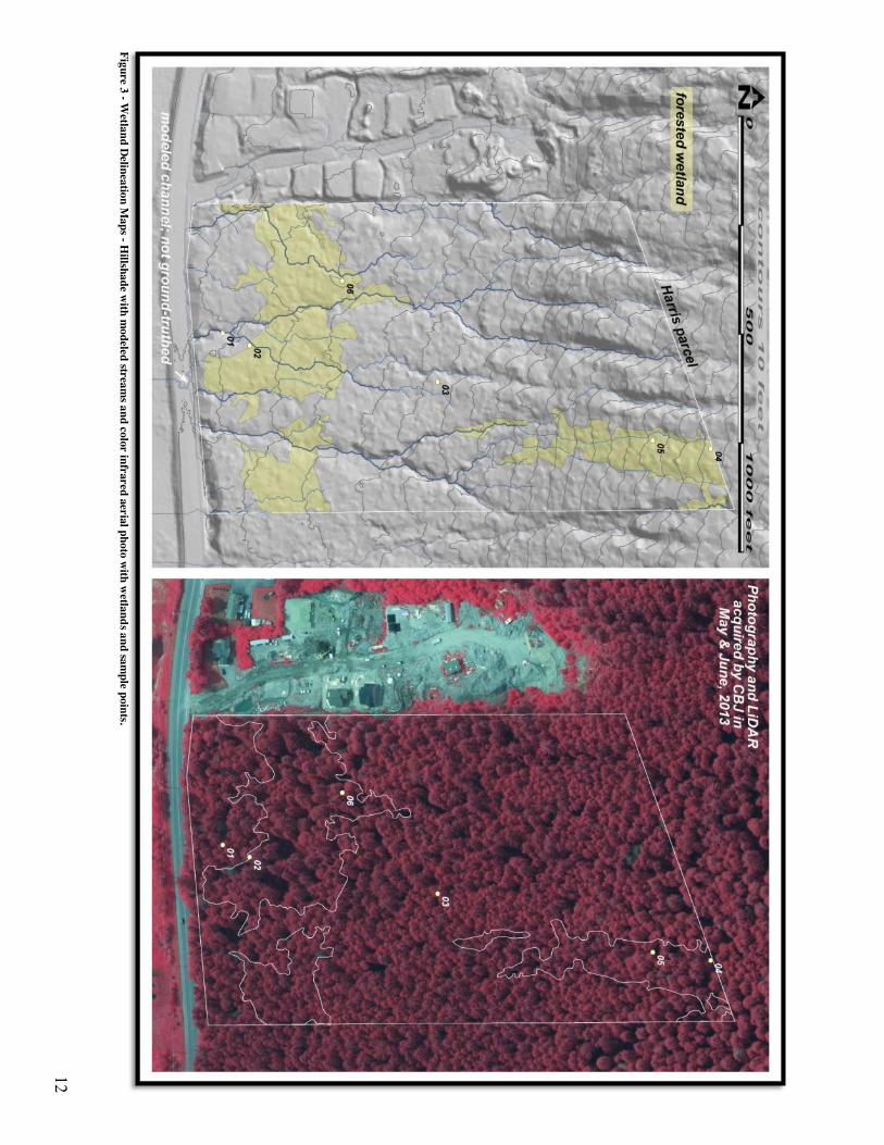
The basis for the stream's shown on the delineation map is a stream layer created by the CBJ GIS staff from the 2013 lidar. The intensity of the streams was adjusted to what we were seeing on the surface in the field. We ended up using steam orders five through eight. Orders five through six are seasonal streams and 7 through 8 are perennial streams. The larger modeled streams used on the map were field checked on both visits to the site.
Project Area The project area is located near the junction between a small patch of older deltaic deposits (silty sands and gravels) and the usual glacio-marine deposits (dense silt) that are found on the lower hillsides of the Gastineau Channel area. Both types generally create a restrictive layer that perches the water table and creates wetlands.
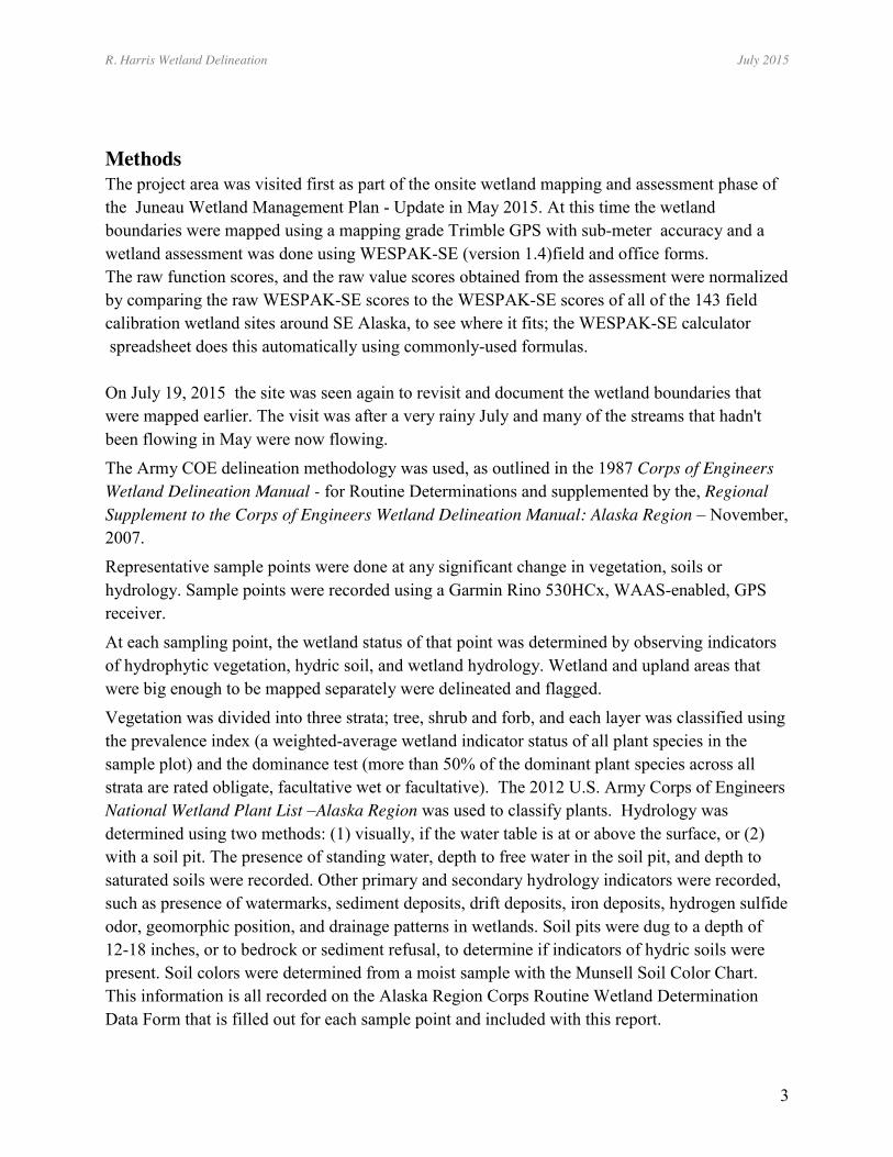
There are four small perennial streams that leave the project area at the lower, south or Glacier Highway edge. These streams have multiple tributaries that are likely seasonal or ephemeral streams. These seasonal or ephemeral streams, arise in the lower, flatter part of the project area. The upper, steeper part of the project area has deep stream gullies that seem to dry the surrounding area (Figure 2). The stream on the west edge of the project area has been captured on its lower part by a ditch dug to drain the Vista del Sol development on the west side of the project area. The streams of the project area are all collected in a ditch along the lower Glacier Highway edge and the ditch then drains in a culvert under Glacier Highway to another culvert under Egan Drive and out into the tidally-influenced Mendenhall Wetlands and into the ocean at Gastineau Channel.
R. Harris Wetland Delineation July 2015
5
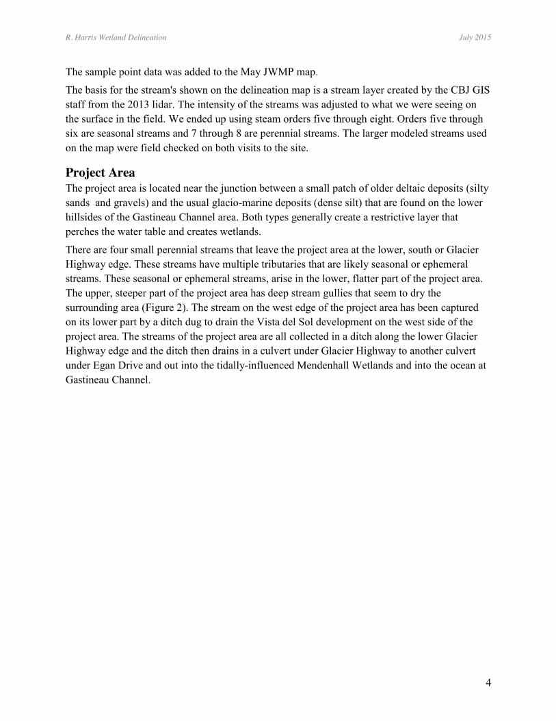
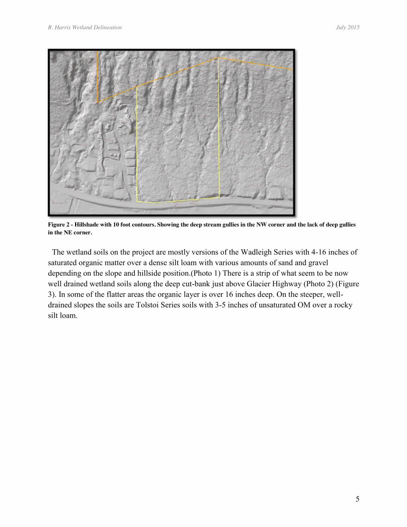
Figure 2 - Hillshade with 10 foot contours. Showing the deep stream gullies in the NW corner and the lack of deep gullies in the NE corner. The wetland soils on the project are mostly versions of the Wadleigh Series with 4-16 inches of saturated organic matter over a dense silt loam with various amounts of sand and gravel depending on the slope and hillside position.(Photo 1) There is a strip of what seem to be now well drained wetland soils along the deep cut-bank just above Glacier Highway (Photo 2) (Figure 3). In some of the flatter areas the organic layer is over 16 inches deep. On the steeper, well-drained slopes the soils are Tolstoi Series soils with 3-5 inches of unsaturated OM over a rocky silt loam.
R. Harris Wetland Delineation July 2015
6
Photo 1- Wadleigh Series soil with 8 inches of saturated peat over a dense glaciomarine sediment of sandy silt loam at sample pt #2.
Photo 2 - Four inches of well-drained organic matter over a sandy silt loam at sample pt. #1.
R. Harris Wetland Delineation July 2015
7
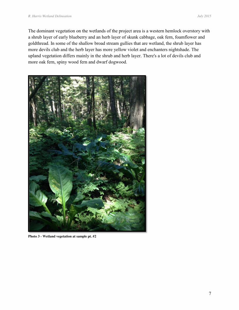
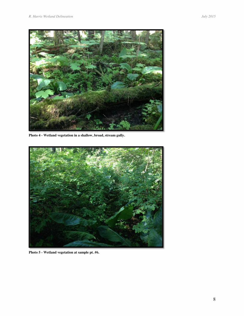
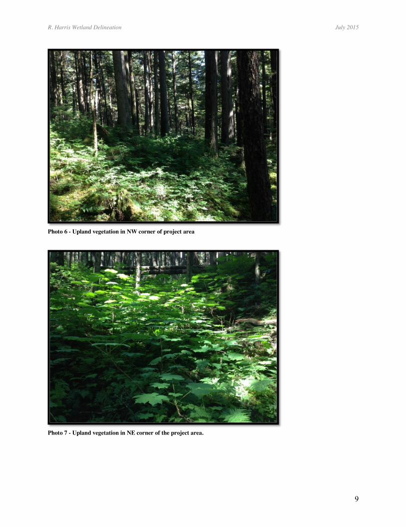
The dominant vegetation on the wetlands of the project area is a western hemlock overstory with a shrub layer of early blueberry and an herb layer of skunk cabbage, oak fern, foamflower and goldthread. In some of the shallow broad stream gullies that are wetland, the shrub layer has more devils club and the herb layer has more yellow violet and enchanters nightshade. The upland vegetation differs mainly in the shrub and herb layer. There's a lot of devils club and more oak fern, spiny wood fern and dwarf dogwood.
Photo 3 - Wetland vegetation at sample pt. #2
R. Harris Wetland Delineation July 2015
8
Photo 4 - Wetland vegetation in a shallow, broad, stream gully.
Photo 5 - Wetland vegetation at sample pt. #6.
R. Harris Wetland Delineation July 2015
9
Photo 6 - Upland vegetation in NW corner of project area
Photo 7 - Upland vegetation in NE corner of the project area.
R. Harris Wetland Delineation July 2015
10
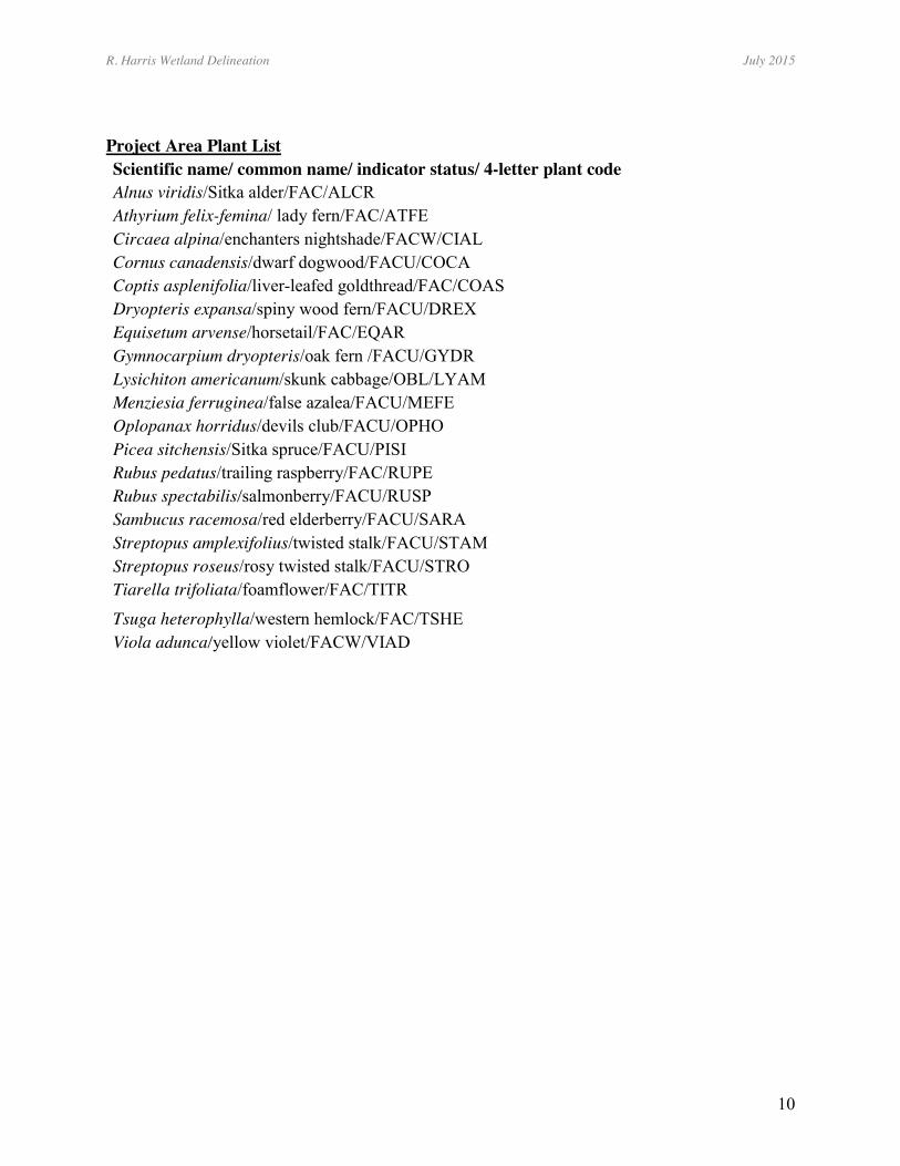
Project Area Plant List Scientific name/ common name/ indicator status/ 4-letter plant code Alnus viridis/Sitka alder/FAC/ALCR Athyrium felix-femina/ lady fern/FAC/ATFE Circaea alpina/enchanters nightshade/FACW/CIAL Cornus canadensis/dwarf dogwood/FACU/COCA Coptis asplenifolia/liver-leafed goldthread/FAC/COAS Dryopteris expansa/spiny wood fern/FACU/DREX Equisetum arvense/horsetail/FAC/EQAR Gymnocarpium dryopteris/oak fern /FACU/GYDR Lysichiton americanum/skunk cabbage/OBL/LYAM Menziesia ferruginea/false azalea/FACU/MEFE Oplopanax horridus/devils club/FACU/OPHO Picea sitchensis/Sitka spruce/FACU/PISI Rubus pedatus/trailing raspberry/FAC/RUPE Rubus spectabilis/salmonberry/FACU/RUSP Sambucus racemosa/red elderberry/FACU/SARA Streptopus amplexifolius/twisted stalk/FACU/STAM Streptopus roseus/rosy twisted stalk/FACU/STRO Tiarella trifoliata/foamflower/FAC/TITR
Tsuga heterophylla/western hemlock/FAC/TSHE Viola adunca/yellow violet/FACW/VIAD
R. Harris Wetland Delineation July 2015
11
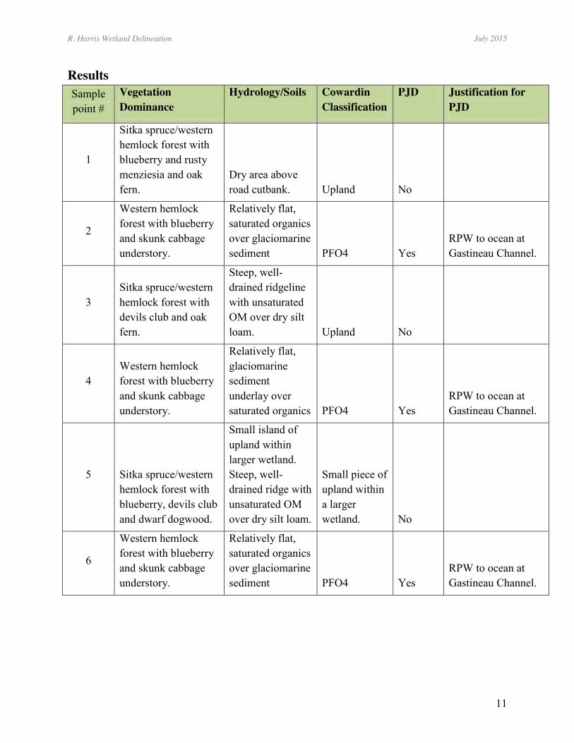
Results Sample point #
Vegetation Dominance
Hydrology/Soils Cowardin Classification
PJD Justification for PJD
1
Sitka spruce/western hemlock forest with blueberry and rusty menziesia and oak fern.
Dry area above road cutbank. Upland No
2
Western hemlock forest with blueberry and skunk cabbage understory.
Relatively flat, saturated organics over glaciomarine sediment PFO4 Yes
RPW to ocean at Gastineau Channel.
3 Sitka spruce/western hemlock forest with devils club and oak fern.
Steep, well-drained ridgeline with unsaturated OM over dry silt loam. Upland No
4 Western hemlock forest with blueberry and skunk cabbage understory.
Relatively flat, glaciomarine sediment underlay over saturated organics PFO4 Yes
RPW to ocean at Gastineau Channel.
5 Sitka spruce/western hemlock forest with blueberry, devils club and dwarf dogwood.
Small island of upland within larger wetland. Steep, well-drained ridge with unsaturated OM over dry silt loam.
Small piece of upland within a larger wetland. No
6
Western hemlock forest with blueberry and skunk cabbage understory.
Relatively flat, saturated organics over glaciomarine sediment PFO4 Yes
RPW to ocean at Gastineau Channel.
R. Harris Wetland Delineation July 2015
12
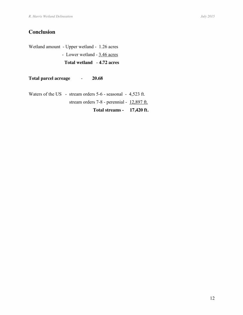
Conclusion
Wetland amount - Upper wetland - 1.26 acres
- Lower wetland - 3.46 acres
Total wetland - 4.72 acres
Total parcel acreage - 20.68
Waters of the US - stream orders 5-6 - seasonal - 4,523 ft.
stream orders 7-8 - perennial - 12,897 ft.
Total streams - 17,420 ft.
12
Figure 3 - Wetland D
elineation Maps - H
illshade with m
odeled streams and color infrared aerial photo w
ith wetlands and sam
ple points.

12
References Cowardin, L.M., V. Carter, F.C. Golet, and E.T. LaRoe. 1979. Classification of Wetlands and Deepwater Habitats of the United States. Office of Biological Services, USDI Fish and Wildlife Service. Washington, D.C. FES/OBS-79-31. 131pp. Miller, Robert D. 1975. Surficial Geology Map of the Juneau Urban Area and Vicinity, Alaska. Map. I-885 USGS. Fairbanks, Alaska. Pojar, Jim and Andy MacKinnon. 1994. Plants of the Pacific Northwest Coast. Lone Pine Publishing, Vancouver, B.C., Canada. Reed Jr., Porter B., 1988. National List of Plant Species That Occur in Wetlands: Alaska (Region A). U.S.D.I, Fish and Wildlife Service, Research and Development, Washington, DC. 79 pp. Schoephorster, Dale B. and Clarence E. Furbush. 1974. Soils of the Juneau Area, Alaska. United States Department of Agriculture, Soil Conservation Service. Palmer, Alaska. 50pp. U.S. Army Corps of Engineers, U.S. Army Corp of Engineers Wetlands Delineation Manual, Technical Report Y-87-1, Environmental Laboratory. U.S. Army Engineer Waterways Experiment Station, Vicksburg, MS. US Army Corps of Engineers, Oct. 2007. Regional Supplement to the Corps of Engineers Wetland Delineation Manual: Alaska Region, Environmental Laboratory, ERDC/EL TR-06-x, US Army Engineer Research and Development Center, Vicksburg, MS.
R. Harris Wetland Delineation July 2015
15
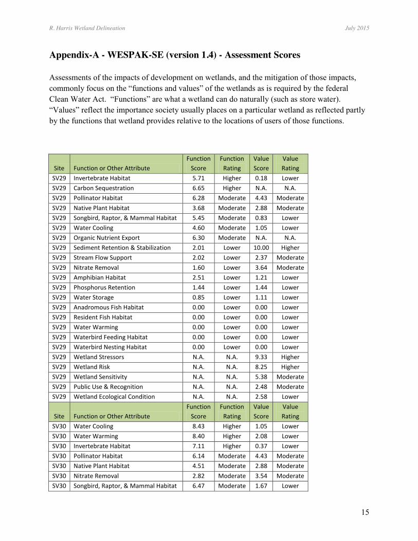
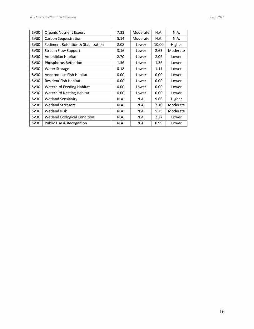
Appendix-A - WESPAK-SE (version 1.4) - Assessment Scores Assessments of the impacts of development on wetlands, and the mitigation of those impacts, commonly focus on the “functions and values” of the wetlands as is required by the federal Clean Water Act. “Functions” are what a wetland can do naturally (such as store water). “Values” reflect the importance society usually places on a particular wetland as reflected partly by the functions that wetland provides relative to the locations of users of those functions.
Site Function or Other Attribute Function
Score Function
Rating Value Score
Value Rating
SV29 Invertebrate Habitat 5.71 Higher 0.18 Lower SV29 Carbon Sequestration 6.65 Higher N.A. N.A. SV29 Pollinator Habitat 6.28 Moderate 4.43 Moderate SV29 Native Plant Habitat 3.68 Moderate 2.88 Moderate SV29 Songbird, Raptor, & Mammal Habitat 5.45 Moderate 0.83 Lower SV29 Water Cooling 4.60 Moderate 1.05 Lower SV29 Organic Nutrient Export 6.30 Moderate N.A. N.A. SV29 Sediment Retention & Stabilization 2.01 Lower 10.00 Higher SV29 Stream Flow Support 2.02 Lower 2.37 Moderate SV29 Nitrate Removal 1.60 Lower 3.64 Moderate SV29 Amphibian Habitat 2.51 Lower 1.21 Lower SV29 Phosphorus Retention 1.44 Lower 1.44 Lower SV29 Water Storage 0.85 Lower 1.11 Lower SV29 Anadromous Fish Habitat 0.00 Lower 0.00 Lower SV29 Resident Fish Habitat 0.00 Lower 0.00 Lower SV29 Water Warming 0.00 Lower 0.00 Lower SV29 Waterbird Feeding Habitat 0.00 Lower 0.00 Lower SV29 Waterbird Nesting Habitat 0.00 Lower 0.00 Lower SV29 Wetland Stressors N.A. N.A. 9.33 Higher SV29 Wetland Risk N.A. N.A. 8.25 Higher SV29 Wetland Sensitivity N.A. N.A. 5.38 Moderate SV29 Public Use & Recognition N.A. N.A. 2.48 Moderate SV29 Wetland Ecological Condition N.A. N.A. 2.58 Lower
Site Function or Other Attribute Function
Score Function
Rating Value Score
Value Rating
SV30 Water Cooling 8.43 Higher 1.05 Lower SV30 Water Warming 8.40 Higher 2.08 Lower SV30 Invertebrate Habitat 7.11 Higher 0.37 Lower SV30 Pollinator Habitat 6.14 Moderate 4.43 Moderate SV30 Native Plant Habitat 4.51 Moderate 2.88 Moderate SV30 Nitrate Removal 2.82 Moderate 3.54 Moderate SV30 Songbird, Raptor, & Mammal Habitat 6.47 Moderate 1.67 Lower
R. Harris Wetland Delineation July 2015
16
SV30 Organic Nutrient Export 7.33 Moderate N.A. N.A. SV30 Carbon Sequestration 5.14 Moderate N.A. N.A. SV30 Sediment Retention & Stabilization 2.08 Lower 10.00 Higher SV30 Stream Flow Support 3.16 Lower 2.65 Moderate SV30 Amphibian Habitat 2.70 Lower 2.06 Lower SV30 Phosphorus Retention 1.36 Lower 1.36 Lower SV30 Water Storage 0.18 Lower 1.11 Lower SV30 Anadromous Fish Habitat 0.00 Lower 0.00 Lower SV30 Resident Fish Habitat 0.00 Lower 0.00 Lower SV30 Waterbird Feeding Habitat 0.00 Lower 0.00 Lower SV30 Waterbird Nesting Habitat 0.00 Lower 0.00 Lower SV30 Wetland Sensitivity N.A. N.A. 9.68 Higher SV30 Wetland Stressors N.A. N.A. 7.10 Moderate SV30 Wetland Risk N.A. N.A. 5.75 Moderate SV30 Wetland Ecological Condition N.A. N.A. 2.27 Lower SV30 Public Use & Recognition N.A. N.A. 0.99 Lower

R. Harris Wetland Delineation July 2015
17
Appendix-B - COE Wetland Delineation Data Sheets - Attached file