Embed Size (px)
Citation preview
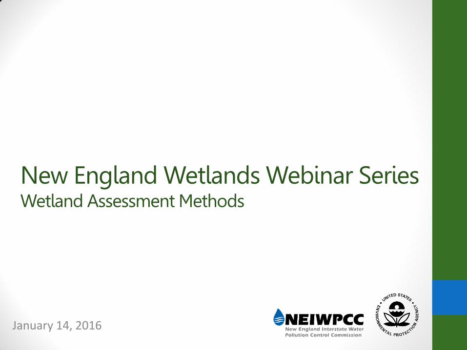
New England Wetlands Webinar Series Wetland Assessment Methods
January 14, 2016
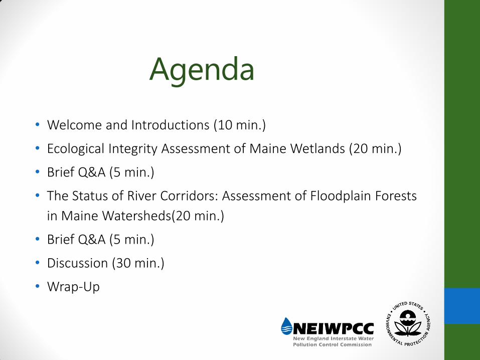
• Welcome and Introductions (10 min.)
• Ecological Integrity Assessment of Maine Wetlands (20 min.)
• Brief Q&A (5 min.)
• The Status of River Corridors: Assessment of Floodplain Forests
in Maine Watersheds(20 min.)
• Brief Q&A (5 min.)
• Discussion (30 min.)
• Wrap-Up
Agenda
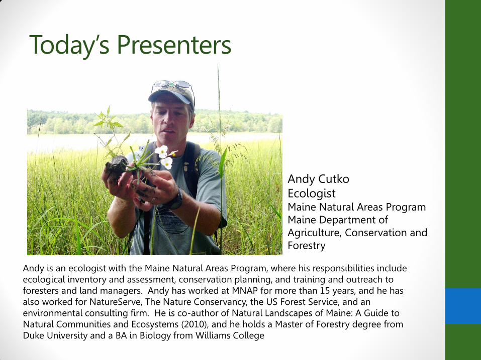
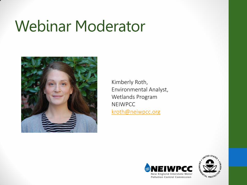
Today’s Presenters
Andy is an ecologist with the Maine Natural Areas Program, where his responsibilities include ecological inventory and assessment, conservation planning, and training and outreach to foresters and land managers. Andy has worked at MNAP for more than 15 years, and he has also worked for NatureServe, The Nature Conservancy, the US Forest Service, and an environmental consulting firm. He is co-author of Natural Landscapes of Maine: A Guide to Natural Communities and Ecosystems (2010), and he holds a Master of Forestry degree from Duke University and a BA in Biology from Williams College
Andy Cutko Ecologist Maine Natural Areas Program Maine Department of Agriculture, Conservation and Forestry
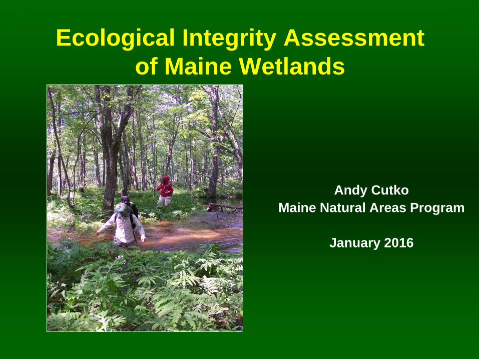
Ecological Integrity Assessment
of Maine Wetlands
Andy Cutko
Maine Natural Areas Program
January 2016
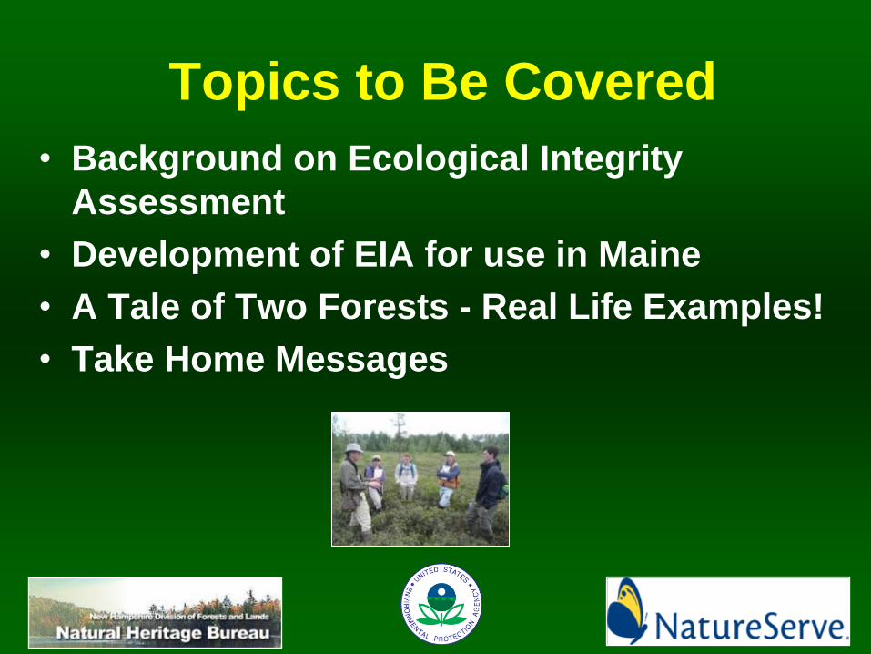
Topics to Be Covered
• Background on Ecological Integrity
Assessment
• Development of EIA for use in Maine
• A Tale of Two Forests - Real Life Examples!
• Take Home Messages

Assessing Ecological Integrity
• A set of indicators of
ecosystem structure,
function, and
composition
• Emphasis on range
of natural variation –
and what’s outside it!
• Ensure links with
management needs
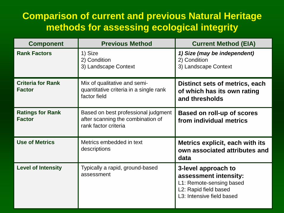
Comparison of current and previous Natural Heritage
methods for assessing ecological integrity
Component Previous Method Current Method (EIA)
Rank Factors 1) Size
2) Condition
3) Landscape Context
1) Size (may be independent)
2) Condition
3) Landscape Context
Criteria for Rank
Factor
Mix of qualitative and semi-
quantitative criteria in a single rank
factor field
Distinct sets of metrics, each
of which has its own rating
and thresholds
Ratings for Rank
Factor
Based on best professional judgment
after scanning the combination of
rank factor criteria
Based on roll-up of scores
from individual metrics
Use of Metrics Metrics embedded in text
descriptions
Metrics explicit, each with its
own associated attributes and
data
Level of Intensity Typically a rapid, ground-based
assessment 3-level approach to
assessment intensity: L1: Remote-sensing based
L2: Rapid field based
L3: Intensive field based
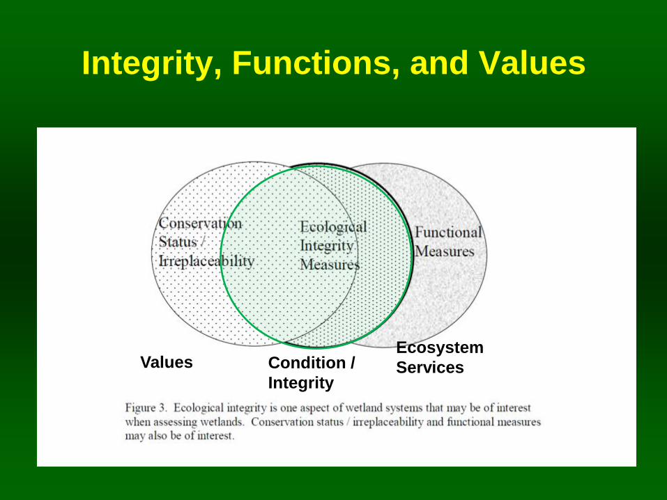
Integrity, Functions, and Values
Values Condition /
Integrity
Ecosystem
Services
Topics to Be Covered
• Background on EIA
• Development of EIA for use in Maine
• A Tale of Two Forests - Real Life Examples!
• Take Home Messages
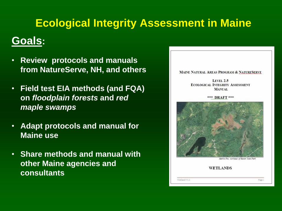
Ecological Integrity Assessment in Maine
Goals:
• Review protocols and manuals
from NatureServe, NH, and others
• Field test EIA methods (and FQA)
on floodplain forests and red
maple swamps
• Adapt protocols and manual for
Maine use
• Share methods and manual with
other Maine agencies and
consultants
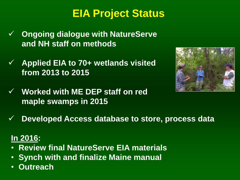
Ongoing dialogue with NatureServe
and NH staff on methods
Applied EIA to 70+ wetlands visited
from 2013 to 2015
Worked with ME DEP staff on red
maple swamps in 2015
EIA Project Status
In 2016:
• Review final NatureServe EIA materials
• Synch with and finalize Maine manual
• Outreach
Developed Access database to store, process data
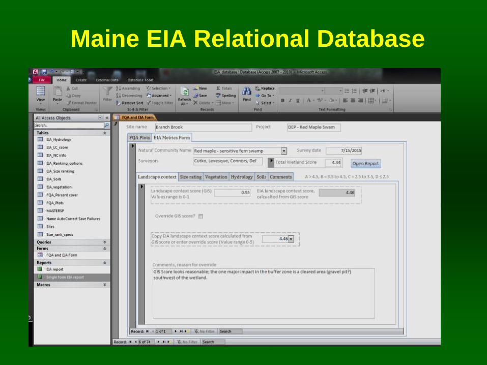
Maine EIA Relational Database
Topics to Be Covered
• Background on EIA
• Development of EIA for use in Maine
• A Tale of Two Forests - Real Life Examples!
• Take Home Messages
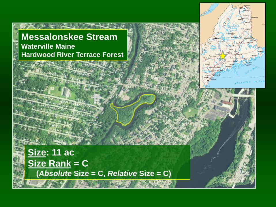
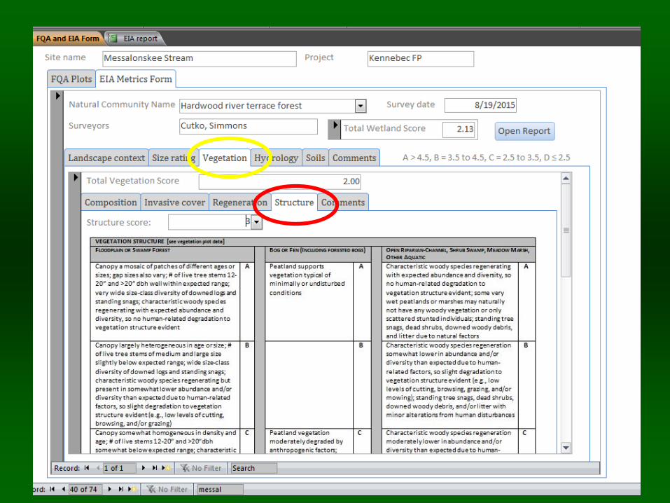
Messalonskee Stream Waterville Maine
Hardwood River Terrace Forest
Size: 11 ac
Size Rank = C (Absolute Size = C, Relative Size = C)
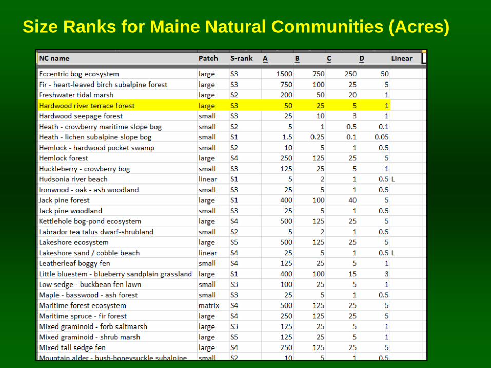
Size Ranks for Maine Natural Communities (Acres)
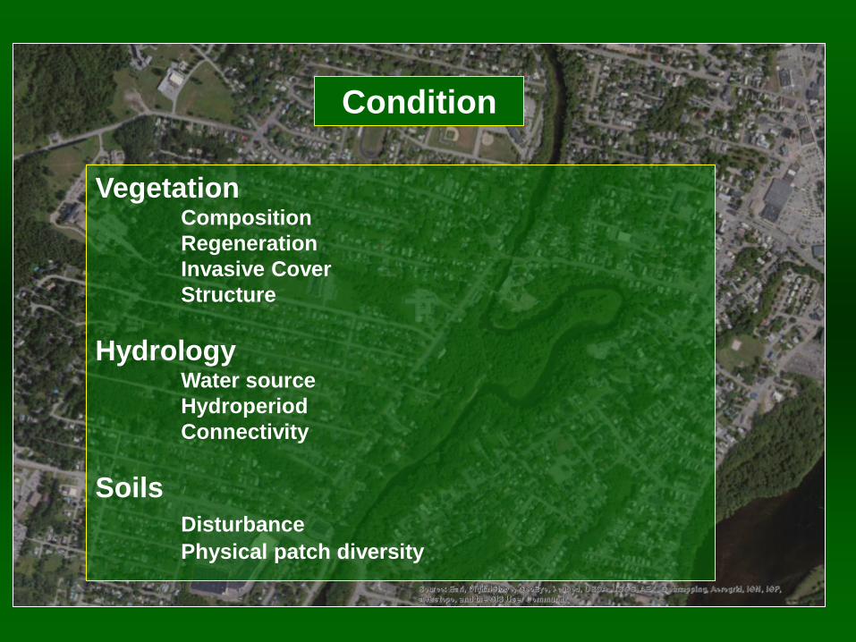
Condition
Vegetation Composition
Regeneration
Invasive Cover
Structure
Hydrology Water source
Hydroperiod
Connectivity
Soils
Disturbance
Physical patch diversity
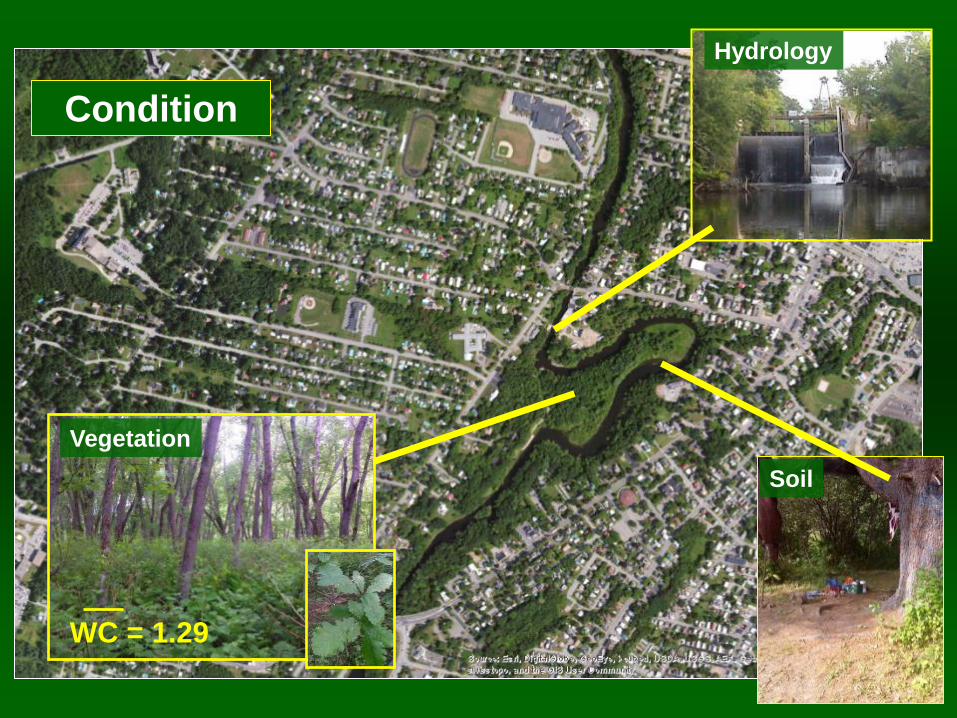
Condition
Hydrology
Soil
Vegetation
WC = 1.29
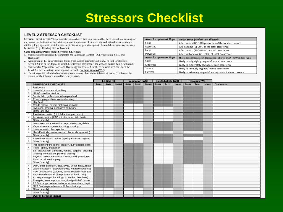
Stressors Checklist 1
LEVEL 2 STRESSOR CHECKLIST Stressors: direct threats; “the proximate (human) activities or processes that have caused, are causing, or
may cause the destruction, degradation, and/or impairment of biodiversity and natural processes (e.g.,
ditching, logging, exotic pest diseases, septic tanks, or pesticide spray). Altered disturbance regime may
be stressor (e.g., flooding, fire, or browse).
Some Important Points about Stressors Checklists.
1. Stressors checklists must be completed for Landscape Context (LC), Vegetation, Soils, and
Hydrology.
2. Assessment of LC is for stressors found from system perimeter out to 250 m (not for stressors
beyond 250 m or the degree to which LC stressors may impact the wetland system being evaluated).
3. Stressors for Vegetation, Soils, and Hydrology are assessed for the very same area for which the
Level 2.5 metrics ratings were applied, i.e. to the wetland system (WS).
4. Threat impact is calculated considering only present observed or inferred stressors (if inferred, the
reason for the inference should be clearly stated).
Assess for up to next 10 yrs Threat Scope (% of system affected)
Small Affects a small (1-10%) proportion of the total occurrence
Restricted Affects some (11-30%) of the total occurrence
Large Affects much (31-70%) of the total occurrence
Pervasive Affects all or most (71-100%) of total occurrence
Assess for up to next 10 yrs Threat Severity (degree of degradation in Buffer or AA ( for Veg, Soil, Hydro)
Slight Likely to only slightly degrade/reduce occurrence
Moderate Likely to moderately degrade/reduce occurrence
Serious Likely to seriously degrade/reduce occurrence
Extreme Likely to extremely degrade/destroy or eliminate occurrence
LC [250 m] Vegetation [WS] Soil/Substrate [WS] Hydrology [WS] STRESSORS CHECKLIST Scope Sever Impact Scope Sever Impact Scope Sever Impact Scope Sever Impact Comments Residential D Industrial, commercial, military E Utility/powerline corridor V Sports field, golf course, urban parkland L Row-crop agriculture, orchard/nursery O Hay field P Roads (gravel, paved, highway), railroad Livestock, grazing, excessive herbivory Other [specify]: R Passive recreation (bird, hike, trample, camp) E Active recreation (ATV, mt bike, hunt, fish, boat) C Other [specify]: Woody resource extraction: logs, shrub cuts, debris V Vegetation management: cutting, mowing E Invasive exotic plant species G Herb-Pesticide, vector control, chemicals (give evid) Other [specify]: N Altered nat disturb regime [specify expected regime] D Other [specify]: Incr sediment/org debris, erosion, gully (logged sites) S Filling, spoils, excavation O Soil disturbance: trampling, vehicle, pugging, skidding I Grading, compaction, plowing, discing L Physical resource extraction: rock, sand, gravel, etc Trash or refuse dumping Other [specify]: H Dam, ditch, diversion, dike, levee, unnat inflow, reser Y Water extraction (lake/groundwat; wat table lowered) D Flow obstructions (culverts, paved stream crossings) R Engineered channel (riprap, armored bank, bed) O Actively managed hydrology (controlled lake level) L Tide gate, weir/drop structure, dredged inlet/channel O PS Discharge: treatmt water, non-storm disch, septic G NPS Discharge: urban runoff, farm drainage Y Other [specify]: Other [specify]: Overall Stressor Impact
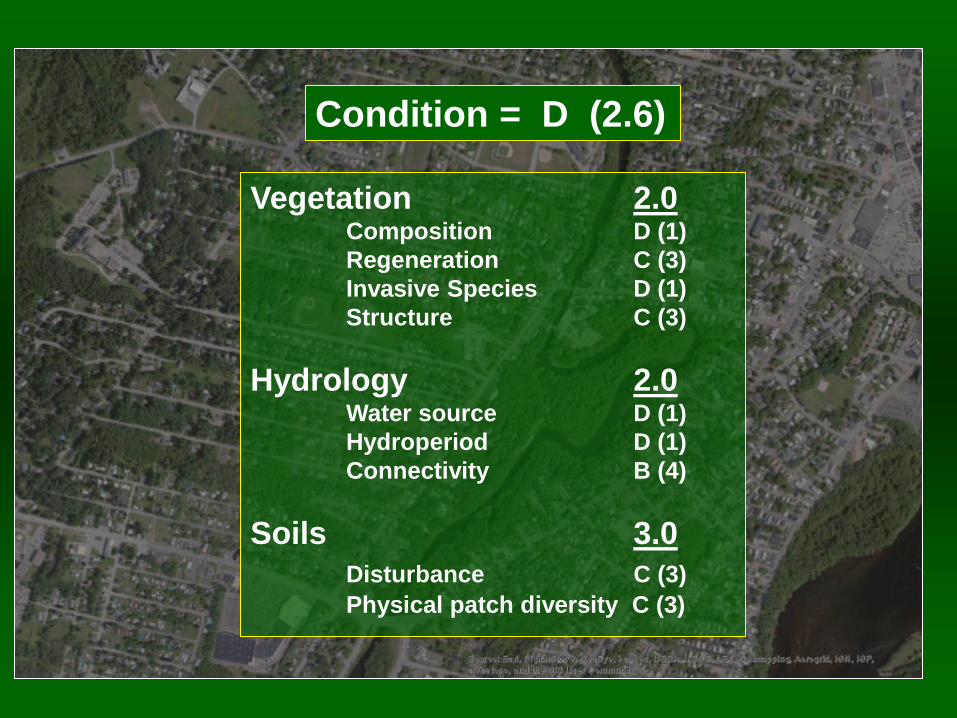
Condition = D (2.6)
Vegetation 2.0 Composition D (1)
Regeneration C (3)
Invasive Species D (1)
Structure C (3)
Hydrology 2.0 Water source D (1)
Hydroperiod D (1)
Connectivity B (4)
Soils 3.0
Disturbance C (3)
Physical patch diversity C (3)
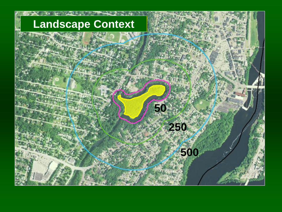
Landscape Context
50
250
500
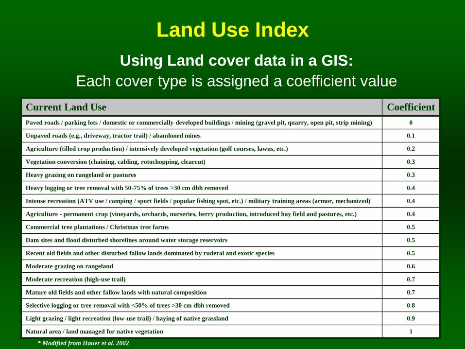
Land Use Index
Using Land cover data in a GIS:
Each cover type is assigned a coefficient value
Current Land Use Coefficient
Paved roads / parking lots / domestic or commercially developed buildings / mining (gravel pit, quarry, open pit, strip mining) 0
Unpaved roads (e.g., driveway, tractor trail) / abandoned mines 0.1
Agriculture (tilled crop production) / intensively developed vegetation (golf courses, lawns, etc.) 0.2
Vegetation conversion (chaining, cabling, rotochopping, clearcut) 0.3
Heavy grazing on rangeland or pastures 0.3
Heavy logging or tree removal with 50-75% of trees >30 cm dbh removed 0.4
Intense recreation (ATV use / camping / sport fields / popular fishing spot, etc.) / military training areas (armor, mechanized) 0.4
Agriculture - permanent crop (vineyards, orchards, nurseries, berry production, introduced hay field and pastures, etc.) 0.4
Commercial tree plantations / Christmas tree farms 0.5
Dam sites and flood disturbed shorelines around water storage reservoirs 0.5
Recent old fields and other disturbed fallow lands dominated by ruderal and exotic species 0.5
Moderate grazing on rangeland 0.6
Moderate recreation (high-use trail) 0.7
Mature old fields and other fallow lands with natural composition 0.7
Selective logging or tree removal with <50% of trees >30 cm dbh removed 0.8
Light grazing / light recreation (low-use trail) / haying of native grassland 0.9
Natural area / land managed for native vegetation 1
* Modified from Hauer et al. 2002
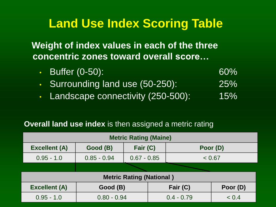
Land Use Index Scoring Table
Overall land use index is then assigned a metric rating
Weight of index values in each of the three
concentric zones toward overall score…
• Buffer (0-50): 60%
• Surrounding land use (50-250): 25%
• Landscape connectivity (250-500): 15%
Metric Rating (Maine)
Excellent (A) Good (B) Fair (C) Poor (D)
0.95 - 1.0 0.85 - 0.94 0.67 - 0.85 < 0.67
Metric Rating (National )
Excellent (A) Good (B) Fair (C) Poor (D)
0.95 - 1.0 0.80 - 0.94 0.4 - 0.79 < 0.4
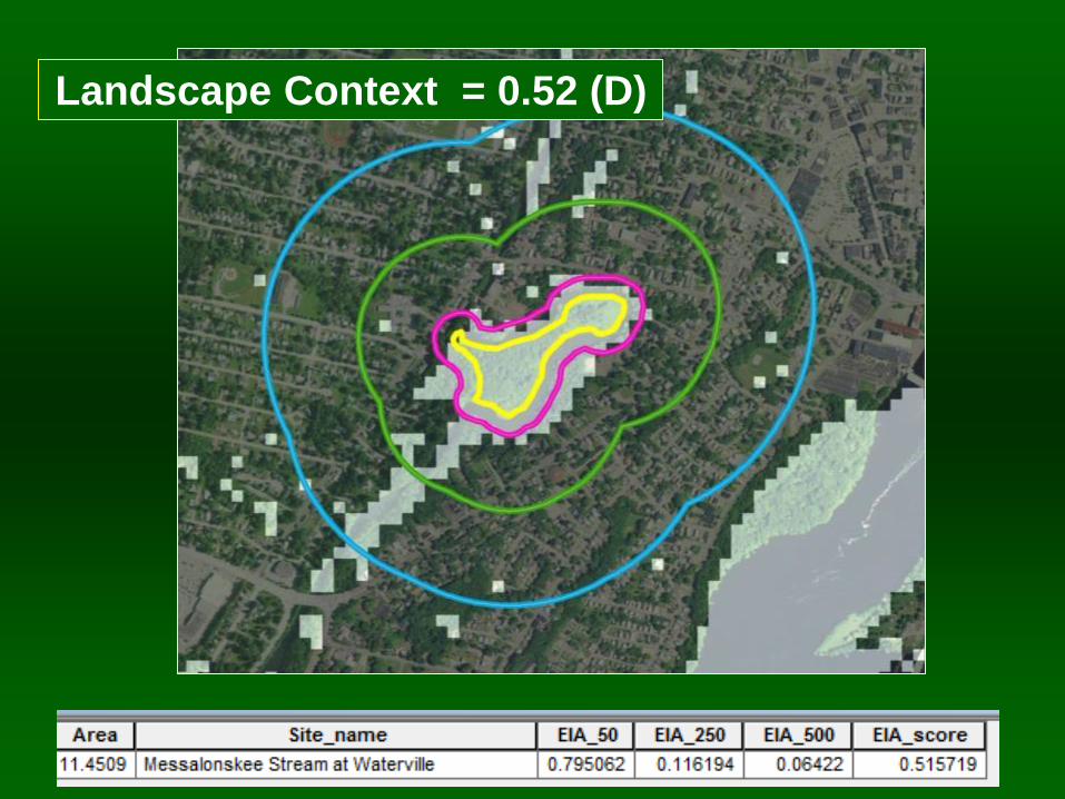
Landscape Context = 0.52 (D)
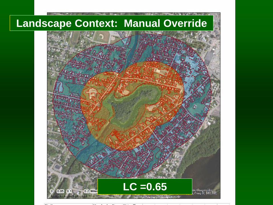
Landscape Context: Manual Override
LC =0.65
Ecological Integrity Assessment
Overall wetland rank = D (2.13)
LC
Stressor
Checklist
LC Rank Specs Size Rank Specs
Size Metrics Size = C
Condition Metrics Condition = C
LC Metrics LC = B
Condition Rank Specs
Condition Rank = D LC Rank = D
Condition
Stressor
Checklist
Size Rank = C
EIA Level Rapid Recon Form
Plot data
Post-
Field
General
Form
Field
LC Index GIS
Calculation
Metric1 Metric1
Metric2
Vegetation
Metric1
Metric2 |
Metric7 = C
Soil/Substrate
Metric1
Metric2
Metric3
Hydrology
Metric1
Metric2
Metric3
Pre-Field
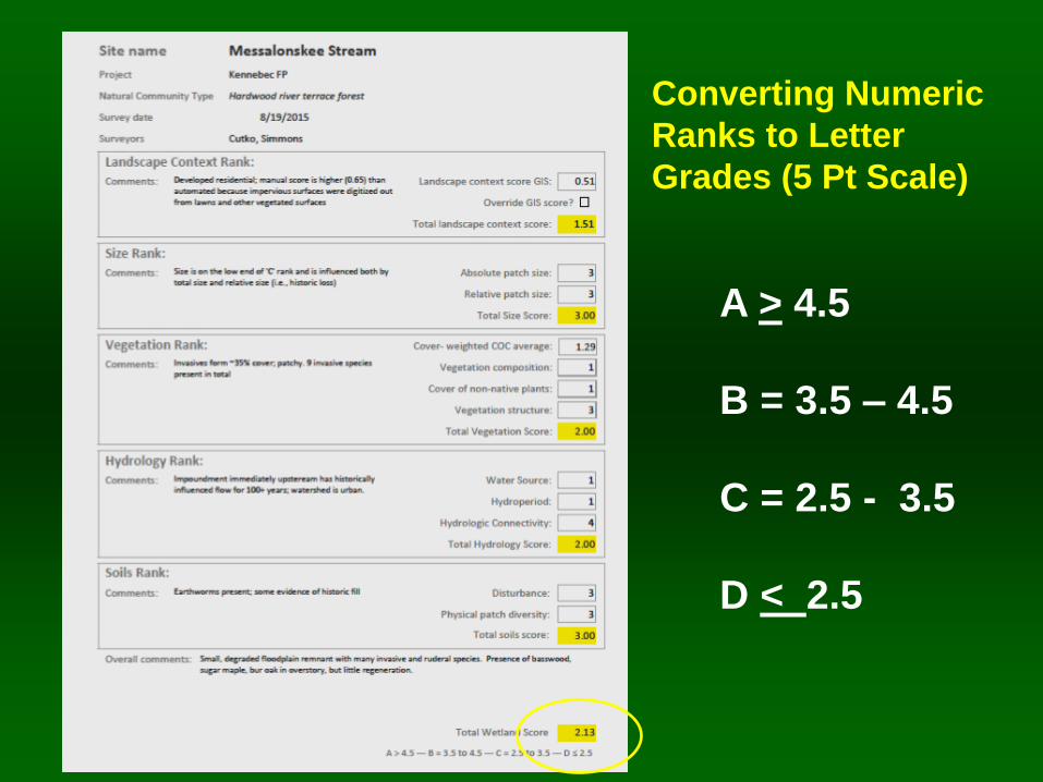
A > 4.5
B = 3.5 – 4.5
C = 2.5 - 3.5
D < 2.5
Converting Numeric
Ranks to Letter
Grades (5 Pt Scale)
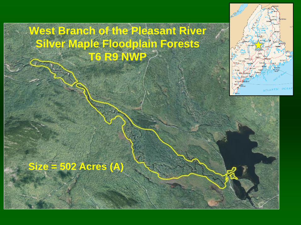
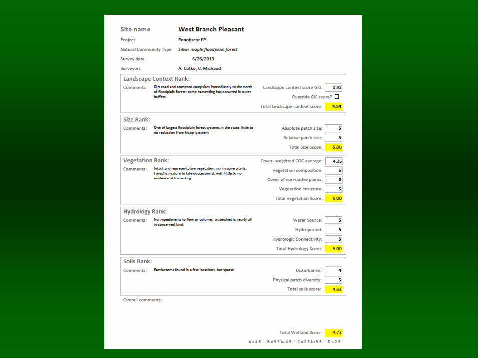
West Branch of the Pleasant River
Silver Maple Floodplain Forests
T6 R9 NWP
Size = 502 Acres (A)
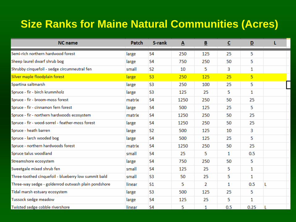
Size Ranks for Maine Natural Communities (Acres)
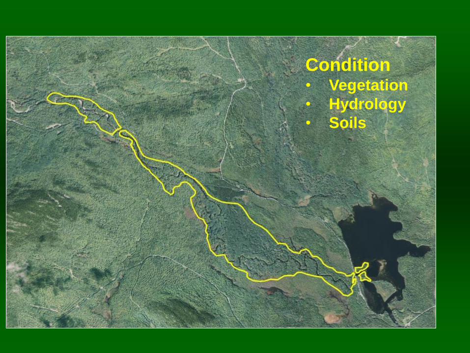
Condition • Vegetation
• Hydrology
• Soils
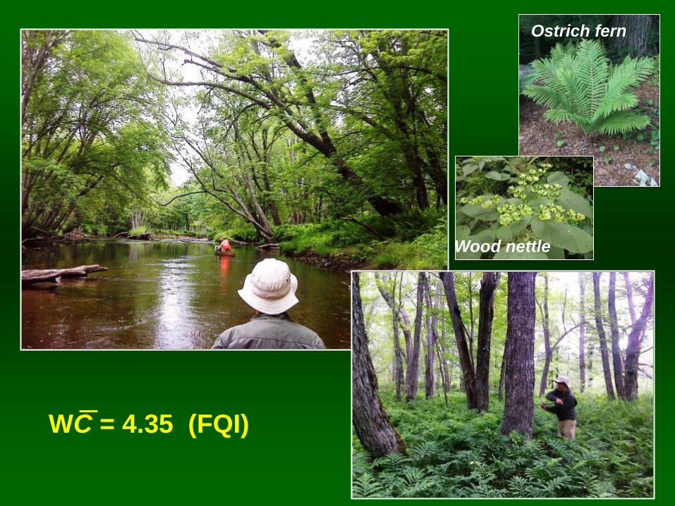
WC = 4.35 (FQI)
Wood nettle
Ostrich fern
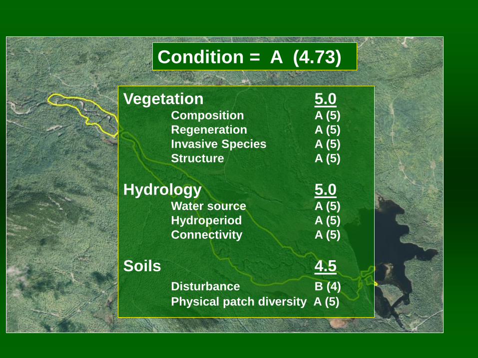
Condition = A (4.73)
Vegetation 5.0 Composition A (5)
Regeneration A (5)
Invasive Species A (5)
Structure A (5)
Hydrology 5.0 Water source A (5)
Hydroperiod A (5)
Connectivity A (5)
Soils 4.5
Disturbance B (4)
Physical patch diversity A (5)
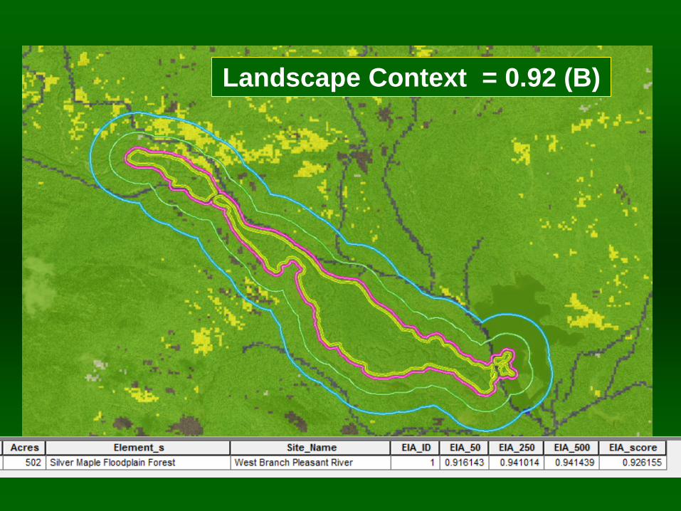
Landscape Context = 0.92 (B)
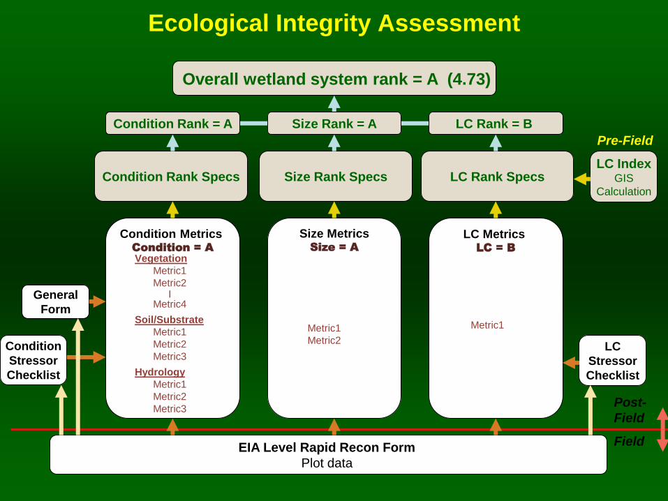
Ecological Integrity Assessment
Overall wetland system rank = A (4.73)
LC
Stressor
Checklist
LC Rank Specs Size Rank Specs
Size Metrics Size = A
Condition Metrics Condition = A
LC Metrics LC = B
Condition Rank Specs
Condition Rank = A LC Rank = B
Condition
Stressor
Checklist
Size Rank = A
EIA Level Rapid Recon Form
Plot data
Post-
Field
General
Form
Field
LC Index GIS
Calculation
Metric1 Metric1
Metric2
Vegetation
Metric1
Metric2 |
Metric4
Soil/Substrate
Metric1
Metric2
Metric3
Hydrology
Metric1
Metric2
Metric3
Pre-Field
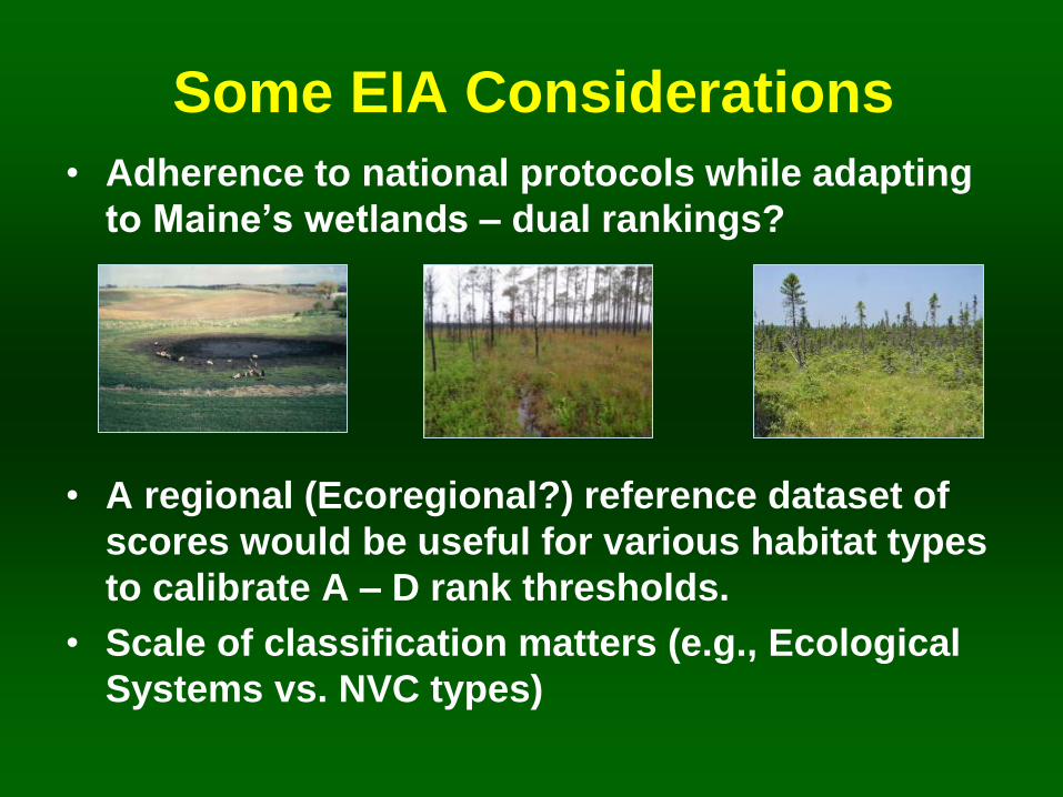
Some EIA Considerations
• Adherence to national protocols while adapting
to Maine’s wetlands – dual rankings?
• A regional (Ecoregional?) reference dataset of
scores would be useful for various habitat types
to calibrate A – D rank thresholds.
• Scale of classification matters (e.g., Ecological
Systems vs. NVC types)
EIA: Take Home Messages
• EIA provides a more consistent, repeatable
method for evaluating wetland condition and
conservation value
• Work by NatureServe, NH Heritage and others
has provided a foundation for use of EIA across
the region
• Further work is needed to develop a reference
set of EIA scores for wetlands (NWCA?) to help
calibrate scores
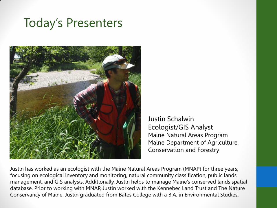
Today’s Presenters
Justin Schalwin Ecologist/GIS Analyst Maine Natural Areas Program Maine Department of Agriculture, Conservation and Forestry
Justin has worked as an ecologist with the Maine Natural Areas Program (MNAP) for three years, focusing on ecological inventory and monitoring, natural community classification, public lands management, and GIS analysis. Additionally, Justin helps to manage Maine’s conserved lands spatial database. Prior to working with MNAP, Justin worked with the Kennebec Land Trust and The Nature Conservancy of Maine. Justin graduated from Bates College with a B.A. in Environmental Studies.
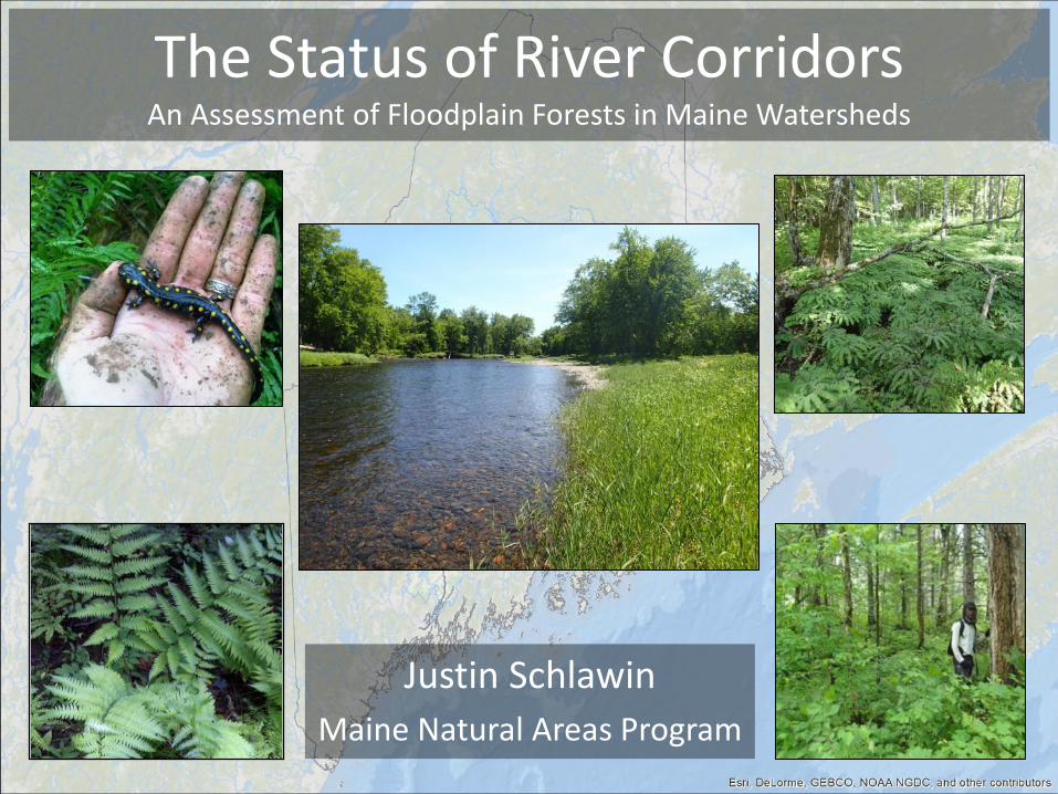
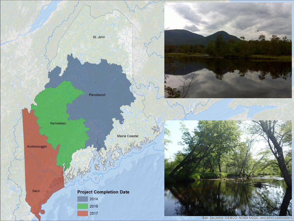
The Status of River Corridors An Assessment of Floodplain Forests in Maine Watersheds
Justin Schlawin
Maine Natural Areas Program
Topics to be covered
• Context/ background
• Rare floodplain forest types in Maine
• Landscape analysis
• Landowner contact
• Field survey results
• Conservation outcomes
• Next steps
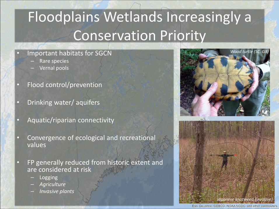
Floodplains Wetlands Increasingly a Conservation Priority
• Important habitats for SGCN – Rare species – Vernal pools
• Flood control/prevention
• Drinking water/ aquifers • Aquatic/riparian connectivity
• Convergence of ecological and recreational
values
• FP generally reduced from historic extent and are considered at risk – Logging – Agriculture – Invasive plants
Japanese knotweed (invasive)
Wood turtle (SC, G3)
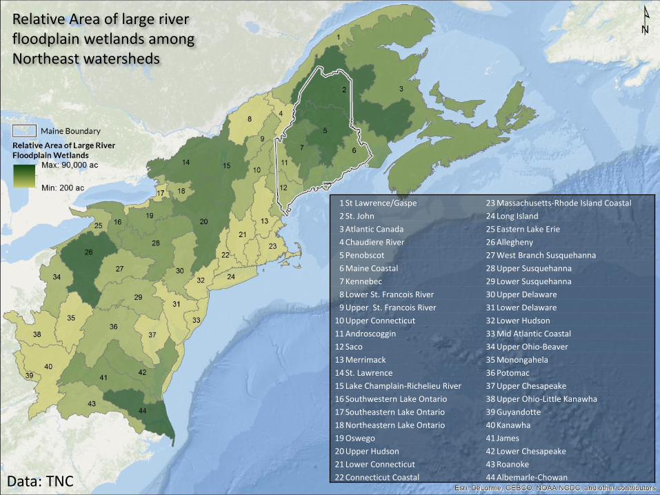
Data: TNC
Relative Area of large river floodplain wetlands among Northeast watersheds
1 St Lawrence/Gaspe 23 Massachusetts-Rhode Island Coastal
2 St. John 24 Long Island
3 Atlantic Canada 25 Eastern Lake Erie
4 Chaudiere River 26 Allegheny
5 Penobscot 27 West Branch Susquehanna
6 Maine Coastal 28 Upper Susquehanna
7 Kennebec 29 Lower Susquehanna
8 Lower St. Francois River 30 Upper Delaware
9 Upper St. Francois River 31 Lower Delaware
10 Upper Connecticut 32 Lower Hudson
11 Androscoggin 33 Mid Atlantic Coastal
12 Saco 34 Upper Ohio-Beaver
13 Merrimack 35 Monongahela
14 St. Lawrence 36 Potomac
15 Lake Champlain-Richelieu River 37 Upper Chesapeake
16 Southwestern Lake Ontario 38 Upper Ohio-Little Kanawha
17 Southeastern Lake Ontario 39 Guyandotte
18 Northeastern Lake Ontario 40 Kanawha
19 Oswego 41 James
20 Upper Hudson 42 Lower Chesapeake
21 Lower Connecticut 43 Roanoke
22 Connecticut Coastal 44 Albemarle-Chowan

Data: TNC
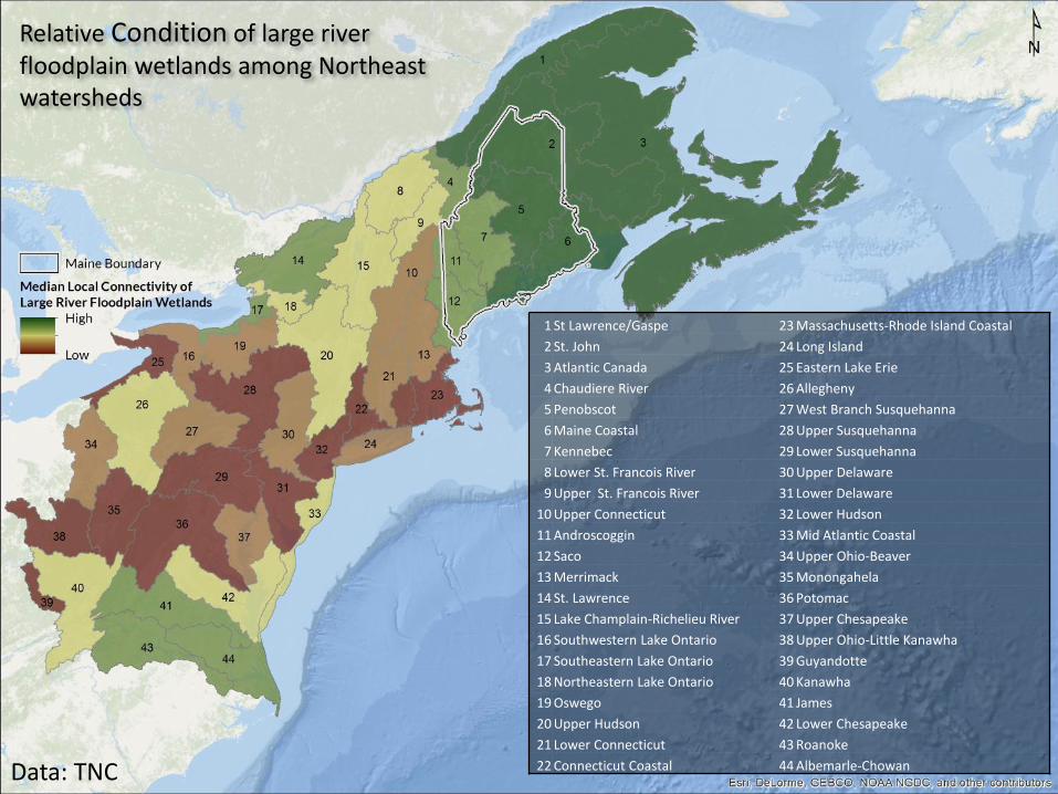
Relative Condition of large river floodplain wetlands among Northeast watersheds
1 St Lawrence/Gaspe 23 Massachusetts-Rhode Island Coastal
2 St. John 24 Long Island
3 Atlantic Canada 25 Eastern Lake Erie
4 Chaudiere River 26 Allegheny
5 Penobscot 27 West Branch Susquehanna
6 Maine Coastal 28 Upper Susquehanna
7 Kennebec 29 Lower Susquehanna
8 Lower St. Francois River 30 Upper Delaware
9 Upper St. Francois River 31 Lower Delaware
10 Upper Connecticut 32 Lower Hudson
11 Androscoggin 33 Mid Atlantic Coastal
12 Saco 34 Upper Ohio-Beaver
13 Merrimack 35 Monongahela
14 St. Lawrence 36 Potomac
15 Lake Champlain-Richelieu River 37 Upper Chesapeake
16 Southwestern Lake Ontario 38 Upper Ohio-Little Kanawha
17 Southeastern Lake Ontario 39 Guyandotte
18 Northeastern Lake Ontario 40 Kanawha
19 Oswego 41 James
20 Upper Hudson 42 Lower Chesapeake
21 Lower Connecticut 43 Roanoke
22 Connecticut Coastal 44 Albemarle-Chowan
Topics to be covered
• Context/ background
• Rare floodplain forest types in Maine
• Landscape analysis
• Landowner contact
• Field survey results
• Conservation outcomes
• Next steps
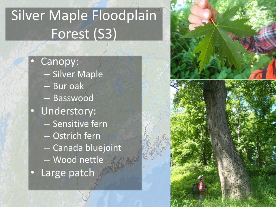
Silver Maple Floodplain Forest (S3)
• Canopy: – Silver Maple – Bur oak – Basswood
• Understory: – Sensitive fern – Ostrich fern – Canada bluejoint – Wood nettle
• Large patch
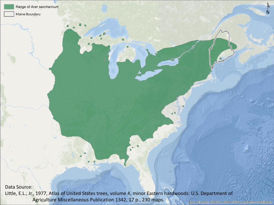
Data Source: Little, E.L., Jr., 1977, Atlas of United States trees, volume 4, minor Eastern hardwoods: U.S. Department of Agriculture Miscellaneous Publication 1342, 17 p., 230 maps.
Data: TNC
Relative Condition of large river floodplain wetlands among Northeast watersheds
1 St Lawrence/Gaspe 23 Massachusetts-Rhode Island Coastal
2 St. John 24 Long Island
3 Atlantic Canada 25 Eastern Lake Erie
4 Chaudiere River 26 Allegheny
5 Penobscot 27 West Branch Susquehanna
6 Maine Coastal 28 Upper Susquehanna
7 Kennebec 29 Lower Susquehanna
8 Lower St. Francois River 30 Upper Delaware
9 Upper St. Francois River 31 Lower Delaware
10 Upper Connecticut 32 Lower Hudson
11 Androscoggin 33 Mid Atlantic Coastal
12 Saco 34 Upper Ohio-Beaver
13 Merrimack 35 Monongahela
14 St. Lawrence 36 Potomac
15 Lake Champlain-Richelieu River 37 Upper Chesapeake
16 Southwestern Lake Ontario 38 Upper Ohio-Little Kanawha
17 Southeastern Lake Ontario 39 Guyandotte
18 Northeastern Lake Ontario 40 Kanawha
19 Oswego 41 James
20 Upper Hudson 42 Lower Chesapeake
21 Lower Connecticut 43 Roanoke
22 Connecticut Coastal 44 Albemarle-Chowan
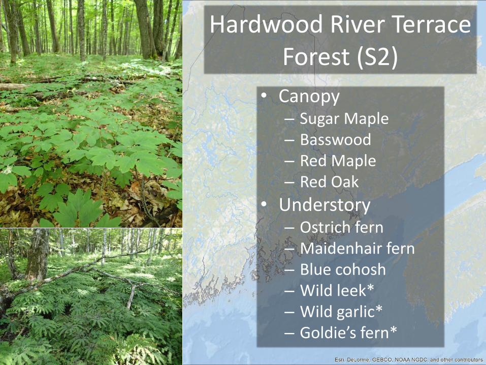
Hardwood River Terrace Forest (S2)
• Canopy – Sugar Maple – Basswood – Red Maple – Red Oak
• Understory – Ostrich fern – Maidenhair fern – Blue cohosh – Wild leek* – Wild garlic* – Goldie’s fern*
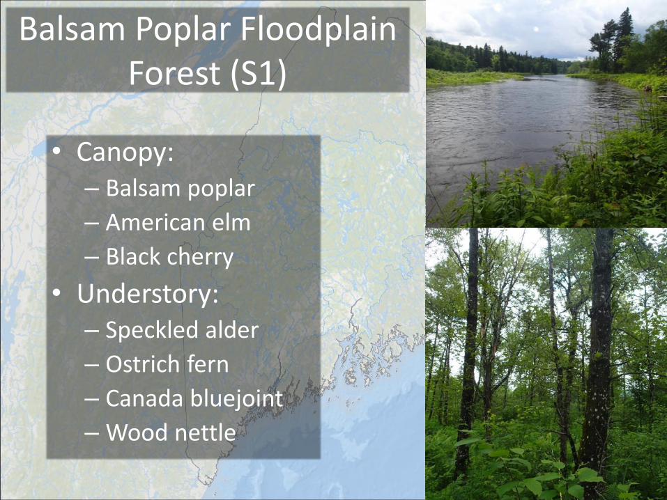
Balsam Poplar Floodplain Forest (S1)
• Canopy: – Balsam poplar
– American elm
– Black cherry
• Understory: – Speckled alder
– Ostrich fern
– Canada bluejoint
– Wood nettle
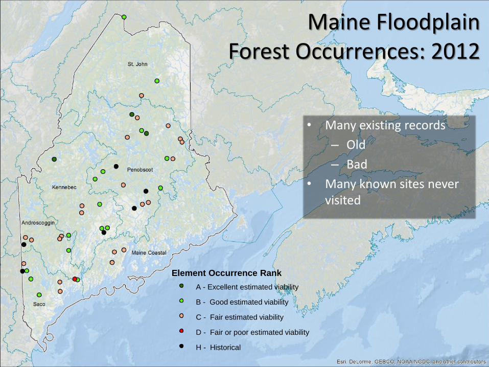
• Many existing records
– Old
– Bad
• Many known sites never visited
Maine Floodplain Forest Occurrences: 2012
Element Occurrence Rank
A - Excellent estimated viability
B - Good estimated viability
C - Fair estimated viability
H - Historical
D - Fair or poor estimated viability
Topics to be covered
• Context/ background
• Rare floodplain forest types in Maine
• Landscape analysis
• Landowner contact
• Field survey results
• Conservation outcomes
• Next steps
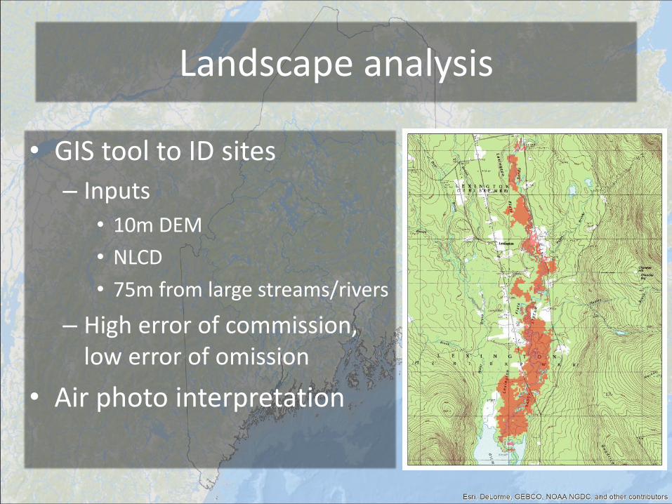
Landscape analysis
• GIS tool to ID sites
– Inputs
• 10m DEM
• NLCD
• 75m from large streams/rivers
– High error of commission, low error of omission
• Air photo interpretation
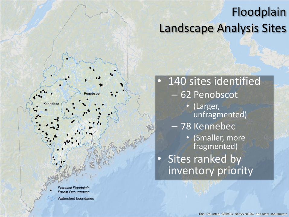
• 140 sites identified – 62 Penobscot
• (Larger, unfragmented)
– 78 Kennebec • (Smaller, more
fragmented)
• Sites ranked by inventory priority
Floodplain
Landscape Analysis Sites
Topics to be covered
• Context/ background
• Rare floodplain forest types in Maine
• Landscape analysis
• Landowner contact
• Field survey results
• Conservation outcomes
• Next steps
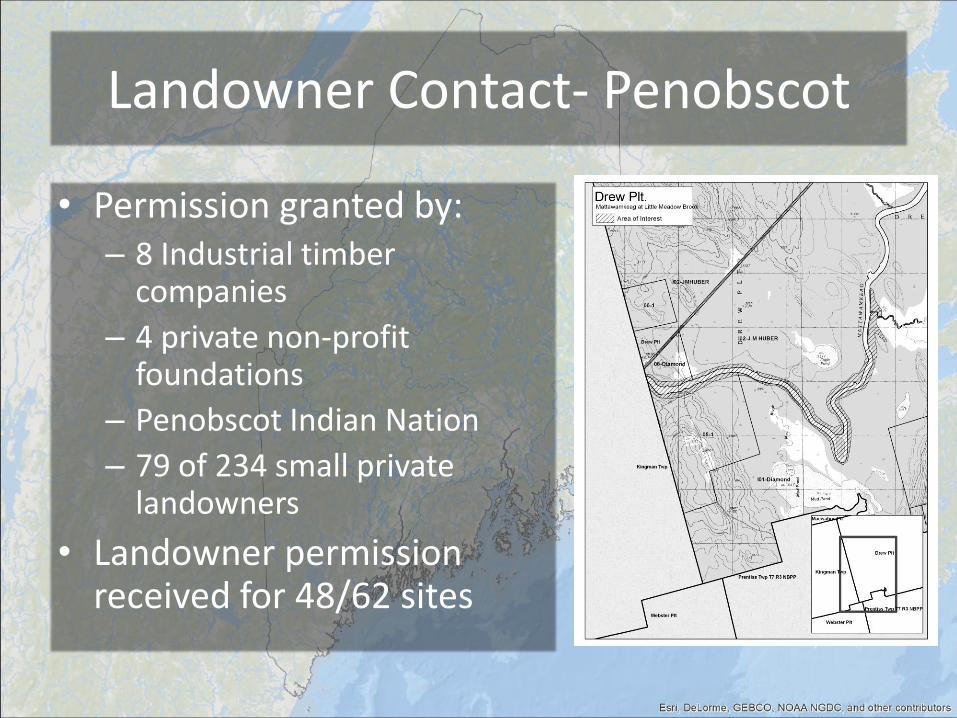
Landowner Contact- Penobscot
• Permission granted by: – 8 Industrial timber
companies
– 4 private non-profit foundations
– Penobscot Indian Nation
– 79 of 234 small private landowners
• Landowner permission received for 48/62 sites
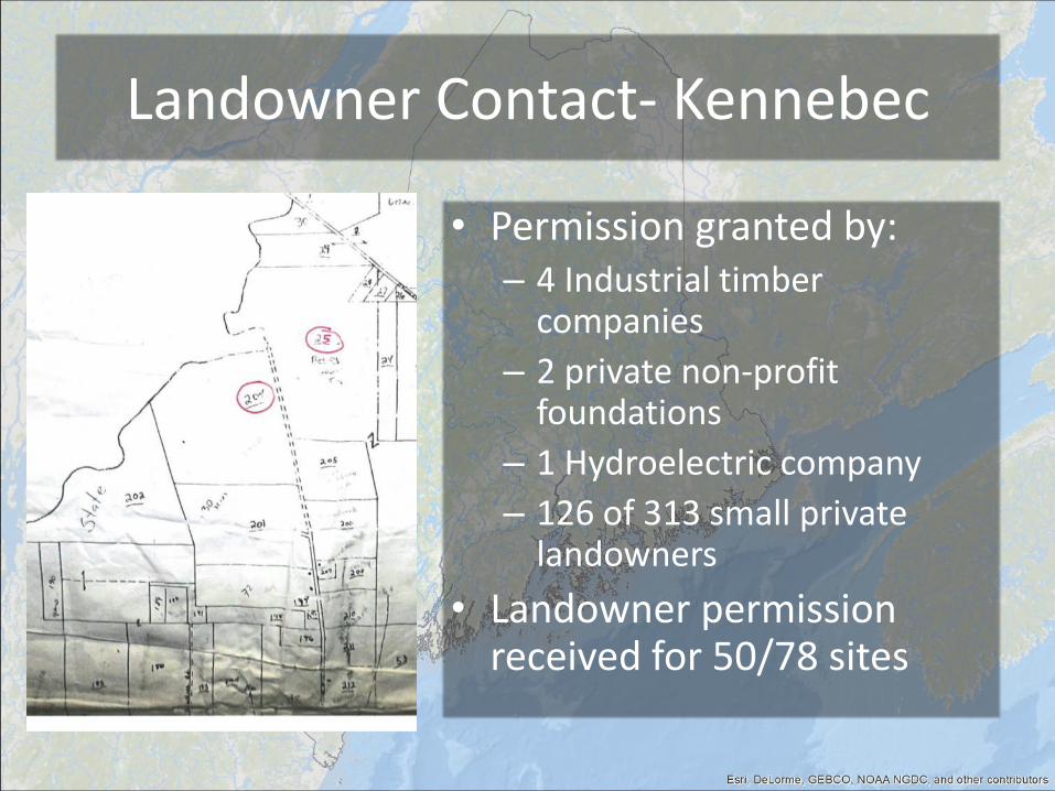
Landowner Contact- Kennebec
• Permission granted by: – 4 Industrial timber
companies
– 2 private non-profit foundations
– 1 Hydroelectric company
– 126 of 313 small private landowners
• Landowner permission received for 50/78 sites

Topics to be covered
• Context/ background
• Rare floodplain forest types in Maine
• Landscape analysis
• Landowner contact
• Field survey results
• Conservation outcomes
• Next steps
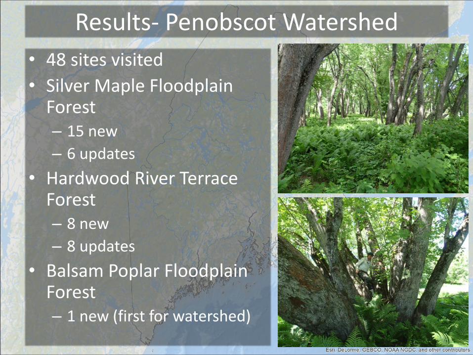
Results- Penobscot Watershed
• 48 sites visited
• Silver Maple Floodplain Forest – 15 new
– 6 updates
• Hardwood River Terrace Forest – 8 new
– 8 updates
• Balsam Poplar Floodplain Forest – 1 new (first for watershed)
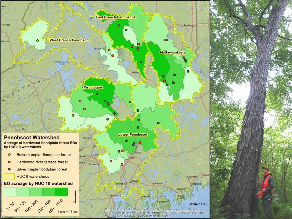
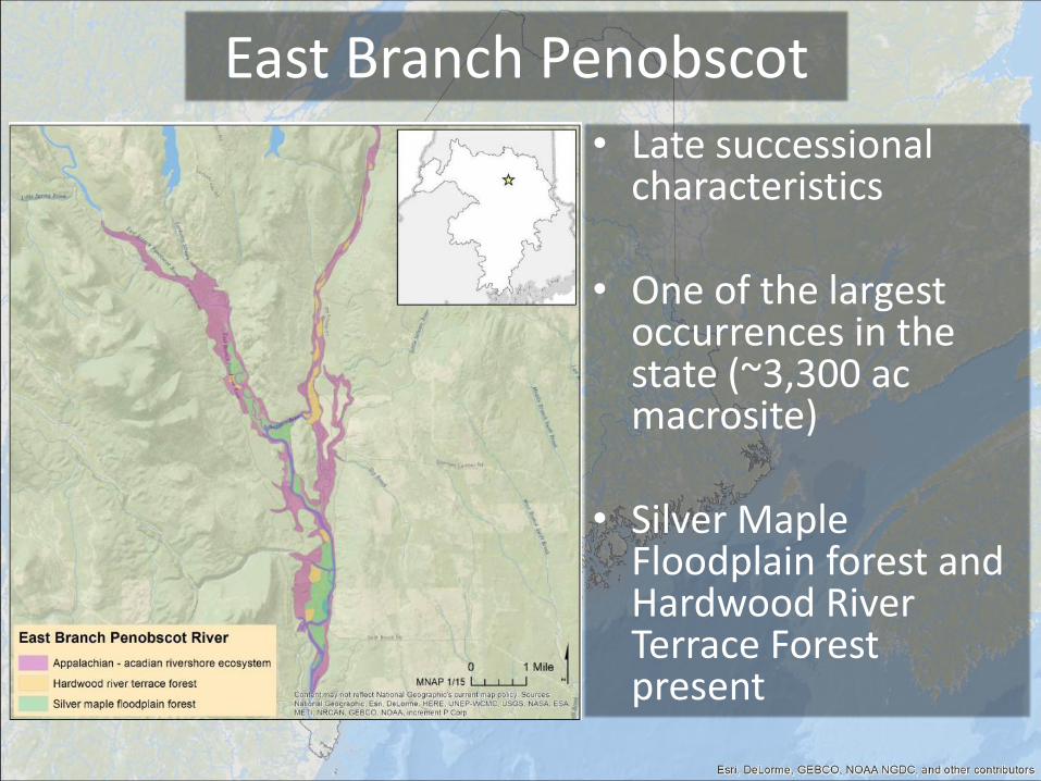
East Branch Penobscot
• Late successional characteristics
• One of the largest occurrences in the state (~3,300 ac macrosite)
• Silver Maple Floodplain forest and Hardwood River Terrace Forest present
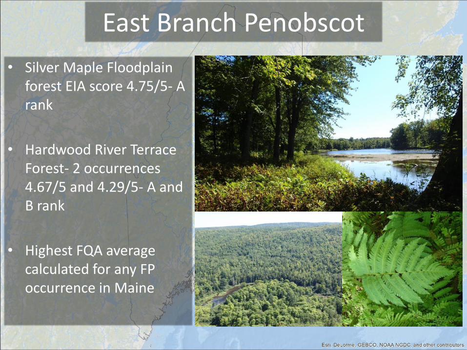
East Branch Penobscot
• Silver Maple Floodplain forest EIA score 4.75/5- A rank
• Hardwood River Terrace Forest- 2 occurrences 4.67/5 and 4.29/5- A and B rank
• Highest FQA average calculated for any FP occurrence in Maine
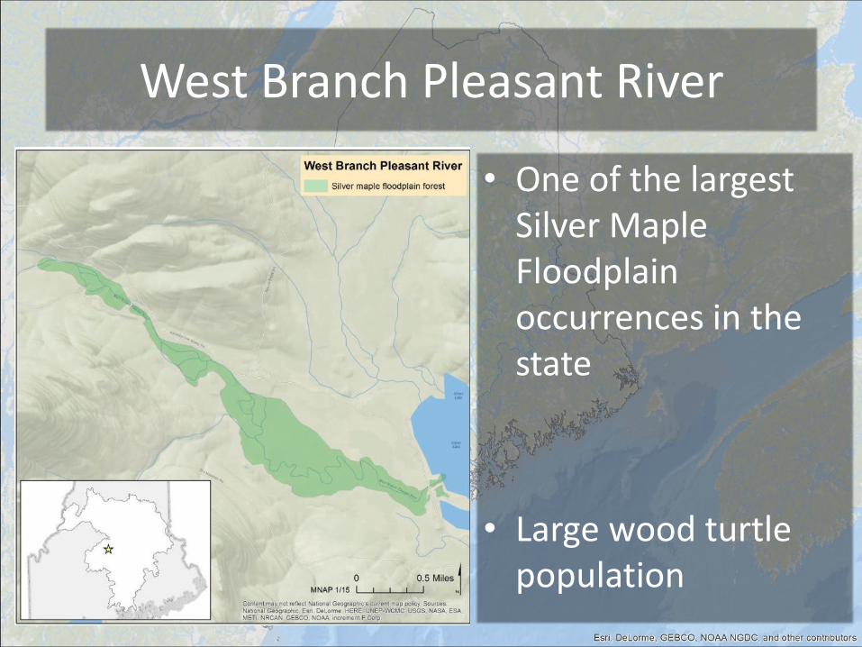
West Branch Pleasant River
• One of the largest Silver Maple Floodplain occurrences in the state
• Large wood turtle population
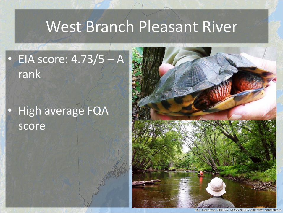
West Branch Pleasant River
• EIA score: 4.73/5 – A rank
• High average FQA score
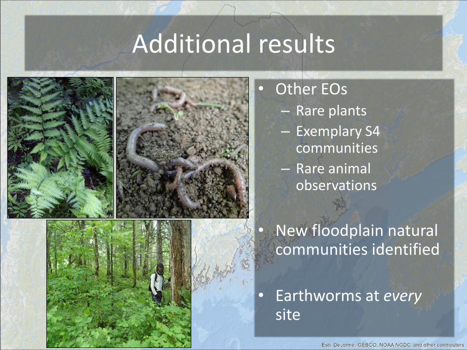
Additional results
• Other EOs – Rare plants
– Exemplary S4 communities
– Rare animal observations
• New floodplain natural communities identified
• Earthworms at every site
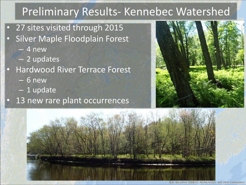
Preliminary Results- Kennebec Watershed • 27 sites visited through 2015 • Silver Maple Floodplain Forest
– 4 new – 2 updates
• Hardwood River Terrace Forest – 6 new – 1 update
• 13 new rare plant occurrences
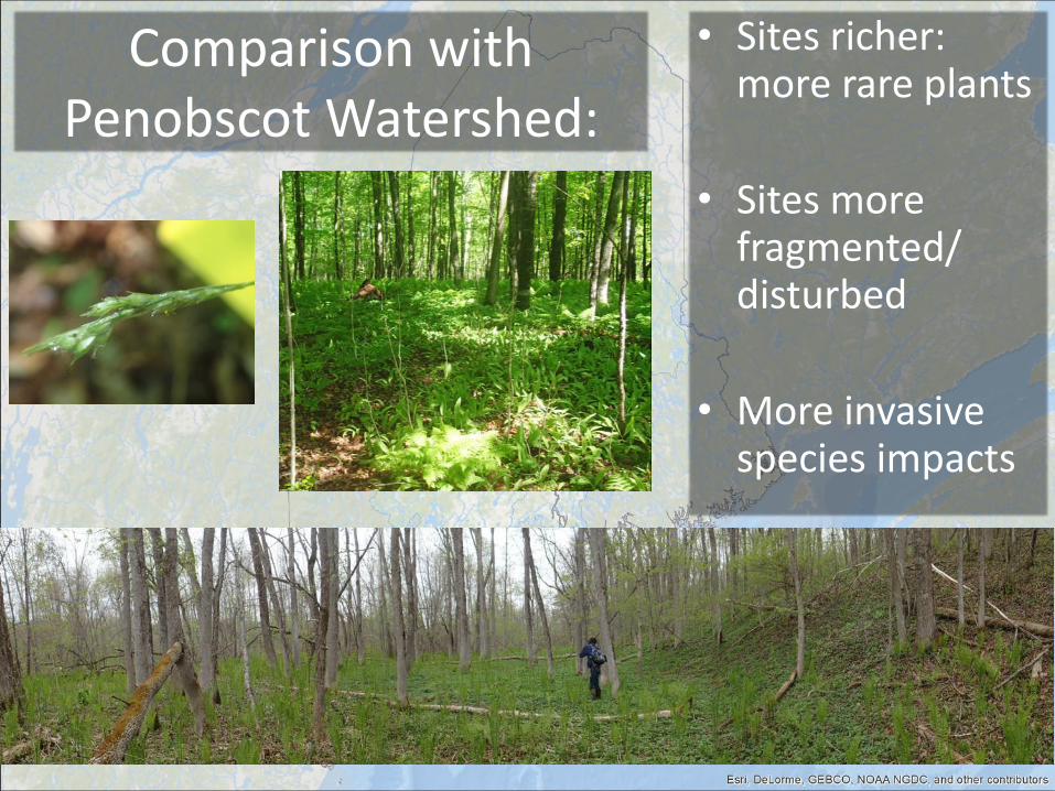
Comparison with Penobscot Watershed:
• Sites richer: more rare plants
• Sites more fragmented/ disturbed
• More invasive species impacts
Topics to be covered
• Context/ background
• Rare floodplain forest types in Maine
• Landscape analysis
• Landowner contact
• Field survey results
• Conservation outcomes
• Next steps
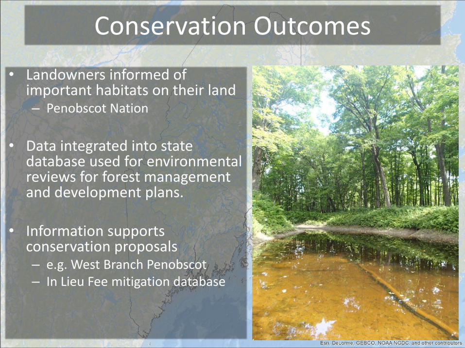
Conservation Outcomes
• Landowners informed of important habitats on their land – Penobscot Nation
• Data integrated into state
database used for environmental reviews for forest management and development plans.
• Information supports conservation proposals – e.g. West Branch Penobscot – In Lieu Fee mitigation database
Topics to be covered
• Context/ background
• Rare floodplain forest types in Maine
• Landscape analysis
• Landowner contact
• Field survey results
• Conservation outcomes
• Next steps

New England Wetlands Webinar Series
Discussion
Thank you
Questions and Comments? Kimberly Roth [email protected] 978-349-2525
Next Steps
Missed an episode?
Stay tuned for the New
England Wetlands Webinar Series webpage for archived
webinars and news!