Embed Size (px)
Citation preview

Wetland and Watercourse
Protection Measures
The Rondout Flood. Source: Chris Bower

New York State Department of State
Office of Planning, Development and Community Infrastructure
99 Washington Avenue
Albany, NY 12231-0001
http://www.dos.ny.gov
Publication Date: June 2019
Contents
2. Wetland and Watercourse Protection Measures ............................................................... 1
2.1 Wetland Protection ............................................................................................................. 3
2.1.1 Simple Wetland Setbacks .................................................................................................. 10
2.1.2 Wetlands Buffer ................................................................................................................ 12
2.1.3 Wetland Conservation Overlay District ............................................................................ 14
2.1.4 Local Freshwater Wetland Law ......................................................................................... 18
2.2 Watercourse Protection.................................................................................................... 43
2.2.1 Simple Watercourse Setbacks .......................................................................................... 52
2.2.2 Stream-Related Zoning Standards .................................................................................... 56
2.2.3 Watercourse Overlay District ............................................................................................ 62
2.2.4 Local Watercourse Law ..................................................................................................... 73
Endnotes ........................................................................................................................... 74
The New York State Department of State (DOS) has prepared a collection of model local laws, in consultation with the New York State Department of Environmental Conservation (NYSDEC) and other stakeholders, that include consideration of future risk due to sea-level rise, storm surge and/or flooding as a result of climate change as required in the New York State Community Risk and Resiliency Act of 2014. Municipal adoption of model local laws is intended to help local governments and their communities increase resiliency. This publication does not establish any legally binding standards or required criteria for state or municipal government to follow. Use of this guidance by a municipality is not a substitute for consultation with an attorney working on behalf of the municipality and municipal officials should consult with an attorney prior to adoption of any local law.

Model Local Laws to Increase Resilience: Chapter 2 1 | P a g e
2. Wetland and Watercourse Protection Measures Communities can increase their resilience to flooding by protecting watercourses, floodplains, wetlands, and the marine coast. An important first step is education and conversations with community stakeholders. Municipal, watershed, and coastal planning can be used to identify and prioritize community assets and establish non-regulatory strategies for conservation and for identification of the most suitable locations for community growth. In addition, municipalities can adopt local laws to define wetlands; and regulate activities that may affect floodplains, watercourses, marine coastal shorelines and freshwater and tidal wetlands and their buffers. These laws can address the need to absorb floodwater and reduce risk; and adjust to changes expected from increased precipitation, storm surges, and sea-level rise, such as the change in wetland character and function, inland migration of tidal wetlands, and increased risk of coastal flooding. Watercourse and tidal flooding are both addressed in this chapter. Watercourse flooding is primarily caused by precipitation, while tidal or storm surge flooding is caused by inundation of seawater along the marine coast. During hurricanes, nor’easters, and other coastal storms the marine coast and its watercourses can be impacted simultaneously by tidal flooding, storm surge and precipitation.
Watercourse – A channel conveying water, such as a natural stream, river, or
artificial channel.
Precipitation that is not absorbed by soil and vegetation is called stormwater runoff. Stormwater runoff is pulled by gravity into watercourse or drainage pathways that follow the topography, traveling towards a common waterbody within the watershed that could be as small as a pond or as large as an ocean. Flooding results when the flow of stormwater runoff is greater than the carrying capacity of nearby watercourses and waterbodies to which it drains.1 Watercourse flooding usually involves a slow buildup of water and a gradual inundation of surrounding land. The presence of non-fragmented (intact) floodplains, wetlands, and forests contributes to a slower release of this stormwater buildup and helps to mitigate damaging peak flows. However, flash flooding, a quick overflow with high water velocities, can result from a combination of short-term intense precipitation events, presence of steep slopes, a short drainage, and a high proportion of impervious surfaces (e.g., buildings, roads, and parking lots) unable to absorb stormwater runoff.2 The extent of associated damage and risk from flooding is related to how land has been developed. As forests, wetlands, and natural areas are increasingly replaced by impervious surfaces, the land's natural ability to store and absorb precipitation decreases and stormwater runoff increases. In addition to the direct threat to homes and buildings, development in floodplains also displaces vegetation that naturally absorbs flood energy and stabilizes banks. The effect of these changes is to increase the severity of flooding.3 Coupled with changing

Model Local Laws to Increase Resilience: Chapter 2 2 | P a g e
weather patterns, increased runoff into watercourses can change watercourse hydraulics and cause stream channels to erode. Channel instability poses threats to the built environment along watercourse corridors. Continued development also threatens the resiliency of coastal areas. The following sections describe various local law techniques and approaches that steer development away from hazardous areas and from natural features that reduce flood risk.
Model Local Laws to Increase Resilience: Chapter 2 3 | P a g e
2.1 Wetland Protection The protection of freshwater and tidal wetlands is an important component of reducing the risk of flooding. In the freshwater environment wetlands, isolated wetlands, and headwater wetlands store water within the watershed, which reduces the quantity of water (peak flows) in streams thereby protecting adjacent and downstream property from flood damage. Functioning wetlands provide many other benefits in addition to flood risk reduction, including clean water and wildlife habitat. Wetlands reduce flood impacts in several ways:
• Wetlands store and slowly release surface water, precipitation, and groundwater, reducing rapid runoff to watercourses.
• Wetlands serve as natural sedimentation areas and filter basins, controlling downstream erosion.
• In floodplain areas, wetlands and their specialized vegetation increase friction and the surface area of water, which slows floodwaters and reduces potential damage.
The ability of a wetland to reduce flooding depends on its landscape location, topography, soil type, soil moisture, and management. New York is thought to have lost 60% of its historic wetlands since 17804, and given that one acre of wetland can typically hold one million gallons of water,5 tremendous stormwater storage capacity has already been lost. Loss of additional wetlands will cause or aggravate flooding, erosion, water quality, and quantity/supply problems and may pose a threat to the public health, safety, and welfare. In the coastal marine environment, tidal wetlands provide additional benefits such as reducing energy from storm surge and wave action. Tidal wetlands are vulnerable to storm surge and increased nuisance tidal flooding caused by sea level rise and are at risk for loss unless soil is allowed time to accumulate or is added to raise wetland elevations or they are provided areas to migrate inland. Collectively, the Long Island Sound, Peconic, and South Shore estuaries lost, on average, 85 acres of native marsh annually from 1974 and 2005/2008.6 For more detailed information on how freshwater and tidal wetlands reduce flood risk, refer to the feature descriptions in the Guidance on Natural Resource Measures.7 Findings of Fact
Findings of fact explain the purpose of a local law to the public, landowners, and regulatory agencies. Findings for wetland laws describe why the municipality has chosen to regulate wetlands and may refer to local plans that establish the importance of wetlands in the community. Municipalities can use the findings section to highlight the importance of wetland protection to reduce flood risk as the climate changes.

Model Local Laws to Increase Resilience: Chapter 2 4 | P a g e
Municipalities can add findings that specifically address climate change and the increased risk of flooding. For example:
“Municipalities throughout New York are already experiencing threats from climate change, including sea level rise, storm surge, and flooding. To protect public health and safety and to minimize the risk to existing development, investment, and public infrastructure, [name of municipality] seeks to promote the protection of natural systems that exist within the community that reduce flood risk.” [Note that the reference to sea level rise and storm surge may not be relevant to all communities.]
The Town of New Paltz wetland and watercourse law has several clear examples of flood-related findings, including this one on buffers:
The integrity of wetlands, waterbodies, and watercourses, and the maintenance of their full function and benefit, is inextricably linked to the presence of intact surrounding natural communities on adjacent buffer areas. Among the essential functions and values provided by riparian buffers is the control of flooding by slowing overland runoff and absorbing and storing substantial amounts of sheet flow, thereby assisting wetlands and watercourses in controlling flooding and gradually releasing flood flows to lower watersheds.
The wetland and watercourse law from the Town of Pawling also included several findings related to flooding in the section on legislative intent.8 Regulation of Wetlands Although state and federal laws regulate activities in or near certain wetlands, not all wetlands are covered by these protections. New York regulates freshwater wetlands greater than 12.4 acres with a 100-foot adjacent area and certain wetlands of unusual local importance. The state also regulates mapped tidal wetlands. Tidal wetlands line much of the saltwater shore, bays, inlets, canals, and estuaries of Long Island, New York City, and Westchester County. They also line the Hudson River in Westchester and Rockland Counties upstream to the salt line. The U.S. Army Corps of Engineers requires permits for filling wetlands of any size that are classified as waters of the United States. In the Adirondack Park, wetlands as small as 1 acre are regulated. In New York State’s Hudson Valley region, it approximately 56% of freshwater wetlands are less than 12.4 acres or isolated, and likely not regulated by the state or federal government.9 Tidal wetlands can be regulated at both the state and local levels and this jurisdiction is concurrent as a DEC permit for a tidal wetland shall be in addition to, and not in lieu of, local permit requirements. Freshwater wetlands may be regulated in several different ways:

Model Local Laws to Increase Resilience: Chapter 2 5 | P a g e
1) a municipality has exclusive jurisdiction to regulate freshwater wetlands not regulated by the state; however, a wetland under 12.4 acres may be regulated by the state if it is deemed to be of unusual local importance; 2) the state may delegate all freshwater wetlands authority to a local government, provided it adopts a local wetland regulation law that is no less protective than state law and the state certifies that the municipality is capable of administering the local law; and 3) state law provides for concurrent local and State jurisdiction of freshwater wetlands and local governments can adopt freshwater wetland regulations already under the jurisdiction of the state if such local regulation is more protective of wetlands than the regulations in effect and no precertification by DEC required.
Many municipalities in New York State have used their home rule authority to complement state and federal programs by enacting local freshwater and tidal wetland laws and other local mechanisms such as wetland permits, zoning overlay districts, zoning setbacks, clearing and grading ordinances, and open space conservation to protect wetlands. Adoption of wetlands provisions in comprehensive plans, and application of environmental review pursuant to the State Environmental Quality Review Act (SEQRA), also help communities protect wetlands by providing policy and analysis in support of local laws.
A community’s approach to protecting wetlands may be influenced by the number of wetlands present in the jurisdiction; the ecosystem-based services those wetlands provide (e.g., flood protection, stormwater control, water treatment, and fish and wildlife habitat); the open space and aesthetic value of the wetlands; how the wetlands contribute to erosion control and protection of subsurface water resources; and what level of regulation is acceptable to the community.10
Size of Regulated Wetlands
Some, but not all, wetlands are protected by the state and federal regulations. To find out if a permit is needed for a specific project or activity, contact the regional Department of Environmental Conservation office or the Army Corps of Engineers.
New York Wetlands >12.4 acres with a 100-foot adjacent area, plus certain wetlands of unusual importance
U.S. Army Corps of Engineers
Wetlands of any size that are considered waters of the United States
Adirondack Park Agency Wetlands as small as 1 acre

Model Local Laws to Increase Resilience: Chapter 2 6 | P a g e
Establishment of Wetland Buffers Communities may extend their protection efforts to land around the wetland, referred to as wetland buffers. Vegetated buffers can reduce the severity of water fluctuations and flooding due to storms by increasing the flood storage capacity of wetlands through better attenuation of stormwater runoff, tidal flooding, and storm surge before it reaches the wetland.11 Buffers which restrict certain activities can help protect property from current flood hazards and future hazards associated with climate change.
Determining the size of the buffer and the activities allowed within it should be informed by the best available scientific information, as well as community challenges, goals, and capacity for enforcement. Some communities prohibit certain activities within wetland buffers, provide for permitted uses, or create a strict non-disturbance area around wetlands. Communities also vary in the size of required wetland buffers. The size of the buffer that is established may be influenced by the physical characteristics and function of the buffer area. For example, minimum buffers to prevent erosion on steep slopes should be greater than on level slopes (e.g., 150 feet versus 100 feet). Buffers should be larger in areas where pollutant filtration is an issue. For example, a minimum of 100 feet is recommended for effective nitrogen removal. 12 Even larger buffers are encouraged for wildlife habitat. In some communities, standard buffer distances have been replaced with variable buffer widths, which are determined on a case-by-case basis. Additional information on regulating wetlands and their buffers are included in the resource section. Municipalities in New York State use a variety of local law techniques to regulate freshwater and tidal wetlands and to establish wetland buffer areas. Local laws should be equal to or exceed state and federal regulations. Key differences are how they define the wetlands and buffers they protect, and the land uses or management activities that are subject to the regulations (i.e., applicability). The table below summarizes the variety of techniques provided in this and other chapters to protect wetlands and their adjacent buffers. All the techniques are flexible and can exempt specific types of activities from regulation (e.g., certain agricultural operations or collecting firewood).
A local wetland law is the most comprehensive approach, as all wetlands, regardless of size or location, play a role in reducing flood risk. It typically regulates more wetlands and more situations than other techniques. For example, it may regulate dredging, filling, dumping, vegetation removal, or building in wetlands as small as ¼ acre with a 100-foot buffer. (See Town of Pawling.)
Overlay zones are useful where wetlands are geographically limited, or where additional protection is desired for sensitive areas. For example, the Village of Trumansburg13 regulates wetlands in its overlay district as small as two acres for projects that require site plan review. In overlay zones that contain drinking water watersheds, the Town of New Castle regulates smaller wetlands and requires larger buffers than it does in its town-wide wetland and watercourse law.14

Model Local Laws to Increase Resilience: Chapter 2 7 | P a g e
Supplemental zoning standards can be used simply to add buffers to federal wetlands in larger projects before the planning board (see Town of Coxsackie) or to require a permit for a range of activities in wetlands of any size (Town of Woodstock). The table that follows summarizes a variety of existing local laws and how they regulate freshwater and tidal wetlands. For additional information, please refer to the text of the local law in question.
Local Wetland Protection Approach
Minimum Wetland
Size
Size of Buffer or Regulated Area
Applicability Technique
Town of Pawling (NY) Wetland and
Watercourse Law15 1/4 acre
100 ft; for wetlands surrounded by steep slopes, the buffer shall extend 100 ft from the top of the slope
Comprehensive. See Section 111-4 of the Town of Pawling law
Local Wetland Law
Town of Poughkeepsie (NY)
1/10 acre 25 ft for 1-5 acres, 50 ft for 5-9 acre, 75 for
Comprehensive. See Section 116-5 of the
Local Wetland Law
Local Wetland Law Options
Technique Description
Local Wetland Law A Local Wetland Law is a resource specific law designed to address the gap in
wetland protection afforded by state and federal regulations by applying to
wetlands smaller than 12.4 acres, additional buffer areas, or regulating a
broader range of human activities.
Wetland Conservation
Overlay District
An overlay district adds standards to the base use and area requirements of
the underlying zoning. The distinction from a local wetlands law is its
application only to a district as defined on the official zoning map; would not
apply to all land use and building approvals in the municipality. An overlay
district could also be used in a town with a wetlands law, to increase
protections in certain watersheds (e.g., Town of New Castle)
Wetlands Buffer Supplemental regulations are part of the zoning law that applies standards
to all lands as defined in the regulations.
Basic Zoning Tools Wetland protection can be incorporated into zoning setbacks, subdivision
regulations, and other basic zoning tools; for more information on these
techniques, see the chapter, Basic Land Use Tools for Resiliency.

Model Local Laws to Increase Resilience: Chapter 2 8 | P a g e
Local Wetland Protection Approach
Minimum Wetland
Size
Size of Buffer or Regulated Area
Applicability Technique
Aquatic Resource Protection Law16
9-12 acres, 100 for more than 12 acres
Town of Poughkeepsie law
Town of New Paltz (NY) Wetlands and Watercourse Protection Law17
1/10 acre and vernal pools 100 sq. ft. or larger
50 ft from edge of wetland for wetlands 1/10 acre to < 1 acre; 100 ft for wetlands > 1 acre; 100 ft for quality vernal pool
Comprehensive. See Section 139-8 of the Town of New Paltz law
Local Wetland Law
Town of Philipstown (NY) Freshwater Wetlands and Watercourses Law18
1/4 acre land within 100 feet of the boundary of controlled wetland
Comprehensive. See Section 93-5 of the Town of Philipstown law
Local Wetland Law
Town of New Castle (NY) Wetlands Law19
1/10 acre 100 ft Comprehensive. See Section 137-3 of the Town of New Castle law
Local Wetland Law
Village of Trumansburg (NY) Wetland Conservation Overlay
District 20
2 acres 100 ft Building projects that require site plan review, including 1- and 2–family buildings on a single lot
Wetland Overlay District
Town of New Castle (NY) Environmental Protection Overlay District21
No minimum size
150 ft Applies to certain drinking watersheds (i.e. Croton, Kensico, and Indian Brook Reservoirs)
Wetland Overlay District
Town of Coxsackie (NY) Natural Resource Protection
Standards 22
Federally regulated wetlands (as determined by the Army Corps of Engineers)
50 ft All development activities except land alteration approved through subdivision or site plan review prior to effective date of law; or land alteration for development of single- or two-family residential lots in single lot ownership; or a minor subdivision
Supplemental Zoning Standards

Model Local Laws to Increase Resilience: Chapter 2 9 | P a g e
Local Wetland Protection Approach
Minimum Wetland
Size
Size of Buffer or Regulated Area
Applicability Technique
Town of Woodstock (NY) Wetland and Watercourse Protection Standards23
No minimum size; excludes stormwater detention basins and artificial ponds < 0.1 acre
100 ft for wetlands > 0.1 acres, 50 ft for smaller wetlands
See Section 260-34C of the Town of Woodstock law
Supplemental Zoning Standards
Town of Ulysses (NY)
Zoning Law 24
Buffer areas apply to federally protected wetlands greater than one-tenth (0.1) acre
Varies from 0 - 100 ft based on zoning district
Depends on zone, primarily applies to structures or buildings
Simple Setbacks
RESOURCES
Local Wetland Regulations. (2013). Kingston, NY: Ulster County Planning Board. 25 McElfish, Jr., J.M., R.L. Kihslinger, and S.S. Nichols. (2008). Planner’s Guide to Wetland Buffers for Local Governments. Washington, DC: Environmental Law Institute. 26 Kusler, J. (2009). Model Ordinances for Regulating wetlands, riparian habitats, and stream buffers. Berne, NY: Association of State Wetland Managers. 27 Westchester County Model Ordinance for Wetland Protection. (1998). Westchester County Soil and Water Conservation District. 28 Wetlands Regulation Guidebook for New York State. (1993). EPA Region 2 EPA-902-R-004. 29 Tidal Wetlands Guidance Document: Living Shoreline Techniques in the Marine District of New York State. (2016). NYS Department of Environmental Conservation, Bureau of Marine Resources.30

Model Local Laws to Increase Resilience: Chapter 2 10 | P a g e
2.1.1 Simple Wetland Setbacks Some wetland protection can be achieved through a standard tool of zoning – a setback requirement. It is a simple technique that prevents building too close to wetlands. The size of the regulated buffer should be increased for environmentally sensitive areas (e.g., shorelines and conservation districts), or areas of more intense use (e.g., industrial and business districts).
USAGE
Amend the sections in the municipal zoning law that describes the purpose, dimensional requirements, and general or development standards of a zoning district. Standards for the setback area, such as the preservation of vegetation (not included here), could be added to the design standards section of the zoning law.
ADAPTED FROM THE FOLLOWING SOURCE
Town of Ulysses (NY) Zoning Law, Article X – Design Standards for Conservation Districts, Section 212-62(A) Stream and Wetland Setbacks31
LANGUAGE
Amend the purpose statement of the zoning district by adding the following language:
Permanent and impermanent streams and wetlands are prominent features of the [insert name of specific district(s)] and the condition of these water bodies directly affects the health of [insert name water body] and the fauna and wildlife that depend on the water for sustenance. As such, it is the intent of this section to ensure the continued preservation and health of these water resources for current and future generations.
Add the following language to the description of dimensional requirements of the desired district:
(X) Setbacks from streams and wetlands. Buildings, structures, paved areas, or storage of construction equipment or machinery shall not be located within [insert number of feet, such as fifty] linear feet of the bank of any permanent or impermanent stream, and one hundred feet of any wetland. The [insert name of review board, such a Planning Board or Conservation Commission] may increase the setback from streams and wetlands by up to fifty percent if they determine that such an increase is necessary to protect water quality or to minimize the impacts of erosion and sedimentation. For the purposes of this section, a wetland is defined by both state and federal governing regulations, however wetland setbacks apply only to federally-protected wetlands greater than one-tenth (0.1) acre.
Add to the general or development standards section of the zoning district description:

Model Local Laws to Increase Resilience: Chapter 2 11 | P a g e
(X) Prior to issuing a permit for proposed development that the Code Enforcement Officer or [insert name of review board] [add the Zoning Board of Appeals if that board issues special use permits] believes may encroach upon the buffer area, the permitting authority may require the applicant to provide a wetland delineation study to determine the wetland’s exact boundaries and to evaluate potential impacts of development on said wetland.
Model Local Laws to Increase Resilience: Chapter 2 12 | P a g e
2.1.2 Wetlands Buffer Supplemental zoning standards can be adopted as additional requirements to underlying zoning district provisions to protect natural features and establish setback buffer areas and restrictions to activities within those buffers. Key purposes of these standards are the retention of wetlands in their natural state to preserve water quality, protect their water retention, and provide flood control functions. Like the other techniques in this chapter to protect wetlands, communities can define for themselves which and how wetlands and buffers are to be protected, and in what circumstances. For example, the Town of Coxsackie Natural Resource Protection Standards apply a 50 -foot buffer around wetlands for certain projects that come before the planning board. The Town of Woodstock used the same mechanism to require a permit for a number of activities (e.g., construction, filling, dumping, and vegetation removal) that affect wetlands of any size.
USAGE
Incorporate into the performance standards section of a municipal zoning law.
ADAPTED FROM THE FOLLOWING SOURCE
Town of Coxsackie (NY) Municipal Code, Chapter 201 Zoning Law, Article VI Natural Resource Protection Standards, Section 201-49 Wetlands32
LANGUAGE
Section X. Wetlands. A. Purpose. It is the purpose of this Section to provide appropriate protection of the [City/Town/Village]’s wetland resources in order to protect wetland functions and values related to surface and ground water protection, wildlife habitat, and flood control. The requirement for buffer areas and the limitations on encroachment into wetlands and buffer areas are intended to be superimposed over the provisions of a zoning district where project review is required and shall be considered as additional requirements to be met by an applicant prior to project approval. B. Geographic applicability of standards. These wetland protection standards shall apply in the following areas [Note: see introduction and sidebar on defining wetlands]:
(1) All wetlands regulated by the NYS Department of Environmental Conservation (NYSDEC) and federal jurisdictional wetland areas within the [City/Town/Village].

Model Local Laws to Increase Resilience: Chapter 2 13 | P a g e
(2) A protected buffer of [insert number of feet, such as one hundred] feet horizontal distance surrounding the boundary of any such wetland, with the exception of NYSDEC jurisdictional wetlands which have a one hundred foot buffer regulated by New York State, shall be subject to the provisions of this section.
C. Field delineation and wetlands report. All applicants shall be required to provide a wetland delineation and wetlands report for the review and approval of the [City/Town/Village] Planning Board.
(1) Applicants shall submit site specific field delineations, delineated by a qualified professional, indicating the location of all wetlands on the property. (2) Delineations shall include NYSDEC regulated wetlands as well as jurisdictional and non-jurisdictional wetlands that meet the criteria for wetlands under federal standards. (3) Delineation of wetland buffer areas shall include one hundred feet for NYSDEC regulated wetlands and [insert number of feet, such as one hundred] feet for all other wetlands. (4) Under no circumstances shall published NYSDEC or National Wetland inventory maps be used as a substitute for field delineation. Applicants are encouraged to submit a field delineation and wetlands report as early in the development review process as possible. (5) The wetlands report should include a marked wetland boundary, as described above; a map that accurately represents those boundaries; and a written report explaining how those boundaries were derived and why they are accurate. (6) The [city/town/village] [insert name of review board, such a Planning Board or Conservation Commission] shall have the authority to invoke technical review by a qualified wetlands consultant, at the applicant’s expense, of any field delineation and wetlands report.
D. Standards for wetlands protection. Consistent with the purposes of this Section, encroachment into wetlands and buffer areas is generally prohibited. If encroachment is unavoidable, then such encroachment(s) must:
(1) Not adversely affect the ability of the property to carry or store flood waters adequately; (2) Not adversely affect the ability of the proposed stormwater treatment system to reduce sedimentation in conformance with the substantive requirements of the NYSDEC State Pollutant Discharge Elimination System (SPDES) General Permit for Construction Activities most current version; and (3) Include appropriate landscaping, stormwater treatment, stream buffering, and/or other mitigation measures that minimize the impact of the encroachment on wetland functions and values identified in the field delineation and wetland report.

Model Local Laws to Increase Resilience: Chapter 2 14 | P a g e
2.1.3 Wetland Conservation Overlay District Overlay Districts are commonly used to protect natural resources that are geographically limited and can be identified at locations shown on a zoning map. Additional standards for development or human activities can apply in an overlay zone in addition to the density, area, and use requirements of underlying zoning districts. Overlay districts are not commonly used for wetlands but may be appropriate in municipalities with limited wetland extent and to provide additional protection in sensitive areas. The Village of Trumansburg Zoning Map33 (below) illustrates both a wetland overlay district and a stream buffer overlay district.
USAGE
Identify the area(s) of the municipality that would be included in the Wetlands Overlay District and prepare a map showing those areas as an overlay to the municipal zoning map. Amend the section of the municipal zoning law that establishes zoning districts to include the new overlay district. This model local law is designed to be used in a community that also has site plan review.
ADAPTED FROM THE FOLLOWING SOURCE

Model Local Laws to Increase Resilience: Chapter 2 15 | P a g e
Village of Trumansburg (NY) Zoning Ordinance, Article VI: Overlay Districts, Section 605 Wetland Conservation Overlay District34
LANGUAGE
Section X. Wetland Conservation Overlay District. A. Purpose. The purpose of this section is to establish requirements for creating and maintaining buffers to protect fragile natural wetland areas within the [City/Town/Village of ________] where changes and/or development would be adverse to the environment, community values, public health, safety and general welfare of the [city/town/village], in accordance with the [City/Town/Village of _________] Comprehensive Plan. B. Applicability and location. The Wetland Conservation Overlay District is superimposed over the basic zoning districts as set forth on the [town/village/city] Zoning Map. The regulations presented in this section shall only apply to those lands located within the boundaries of the Wetland Conservation Overlay District as overlaid on the [town/village/city] Zoning Map. In such overlay district, proposed land uses are subject to the requirements set forth in this section, in addition to those requirements and standards ordinarily applicable to the underlying district. In case of conflict, the more restrictive regulation requirements shall apply. C. Wetland Buffer. A minimum setback of [insert number of feet, such as one hundred fifty] feet shall be required from the delineated boundaries of all wetlands of [insert number of acres, such as two] acres or more within the Wetland Conservation Overlay District. [Note: Other methods besides the size of the wetland can be used to determine whether a buffer should be required.]
(1) Prohibited uses within the wetland buffer.
(a) In the [insert name of zoning district, such as Residential 1] District, the following uses are prohibited in the wetland buffer area: [list the uses permitted in that zoning district that you want to prohibit within the wetland buffer]. (b) In the [insert name of zoning district, such as Downtown Commercial] District, the following uses are prohibited in the wetland buffer area: [list the uses permitted in that zoning district that you want to prohibit within the wetland buffer]. (c) [add additional districts and list of restricted uses as needed]
D. Site Plan Review in Wetland Conservation Overlay Districts. All proposed uses of land or structures in the Wetland Conservation Overlay District not existing as of the effective date of this section shall require site plan review unless exempted by the provisions of this section. Site plan review shall be conducted as set forth in [insert chapter or section number for site plan

Model Local Laws to Increase Resilience: Chapter 2 16 | P a g e
review]. Site plan review conducted within a Wetland Conservation Overlay District shall include, in addition to any other requirements of law, additional project review criteria and additional submission materials.
(1) Submission Materials. In addition to any other materials required by law, the proposed site plan shall show the boundaries of any wetland as determined by field investigation. The [insert name of board authorized to review site plans, such a Planning Board] may require flagging and subsequent survey by a licensed land surveyor. The [insert name of review board] may consult and/or may require the applicants to consult with approved biologists, hydrologists, soil scientists, ecologists, botanists, legal counsel, engineers, or other experts necessary to make this determination. (2) Site Plan Review Criteria. In addition to the standards set forth in the zoning law, the following site plan review standards shall apply throughout a Wetland Conservation Overlay District. Such review shall consider the impact of any proposed use of land or structures on:
(a) The ability of the wetland to filter harmful toxins, nutrients, and sediment from surface and stormwater runoff; (b) The ability of the wetland to store floodwaters and reducing the magnitude of flood events; (c) The ability of the wetland to provide valuable habitat for a diverse array of flora and fauna, including any existing rare, threatened, or endangered species; (d) The ability of the wetland to maintain surface-water flow during dry periods; (e) The impact of any excessive siltation resulting from surface runoff from construction sites, road, bridge, and pipeline construction and lack of erosion control on steep slopes; (f) The impact of pollution by road salt and chemical pollution from parking lots and treated lawns; (g) The impact of pollution by garbage, litter, and refuse; and (h) The impact of a reduction in the flow of watercourses due to destruction of wetlands.
(3) Additional setback. The [insert name of review board] may, in reviewing any site plan within the Wetland Overlay District in accordance with paragraph (D) subparagraph (2), require a buffer area with greater setbacks where it determines that a greater setback is necessary to preserve the flood protection function or other functions of such a wetland.

Model Local Laws to Increase Resilience: Chapter 2 17 | P a g e
(4) Exempt activities. The following activities shall be permitted within a Wetland Overlay District without a Site Plan Review provided they do not require the addition of structures, grading, fill, draining, or dredging:
(a) Normal ground maintenance including mowing, trimming of vegetation. (b) Repair of existing decorative landscaping and planting native species. (c) Repair of existing walkways, walls, and driveways. (d) Public health activities, in emergencies only, of the [list as appropriate the Local Department of Health, County Department of Health and/or New York State Department of Health]. (e) Operation of existing dams and water control devices.

Model Local Laws to Increase Resilience: Chapter 2 18 | P a g e
2.1.4 Local Freshwater Wetland Law More than seventy municipalities in New York have adopted local wetland laws to protect the many benefits that wetlands provide. The recommended approach is to complement state laws and regulate smaller wetlands.35 This approach maximizes the effectiveness of local wetland protection by giving municipalities more control over how wetlands are regulated within their boundaries and providing protection to wetlands and buffers not regulated by the state or federal government, such as smaller isolated wetlands or headwater wetlands. However, municipalities may choose to regulate all state identified freshwater wetlands in place of the New York State Department of Environmental Conservation.36 Municipalities may also opt to regulate additional activities in state-designated wetlands, for example, by limiting vegetation removal in adjacent areas.37 The Town of Pawling has provisions in both its wetland/ watercourse law and its zoning law that allow the planning board to deny the subdivision of any portion of a property which lies within a flood-prone area of any stream or drainage course. This use of similar provisions in zoning and subdivision laws provides coordination for project review and protects the community as well as future landowners in a subdivision from potential harm from flooding. For examples of similar provisions, refer to the Basic Land Use Tools for Resiliency Chapter and the Management of Floodplain Development Chapter. Defining wetlands The definitions section of a local wetland law defines key terms, including which wetlands and how much buffer will be regulated by the local law. Many communities use the federal definition of wetland, which defines wetlands based on its soils, plants, and hydrology. The definition will also include a size limit for regulatory purposes, which varies by community. The Town of New Paltz uses a succinct definition that refers to the Federal definition of wetlands:
WETLAND or FRESHWATER WETLAND - A regulated area that comprises hydric soils and/or is inundated or saturated by surface water or groundwater at a frequency and duration sufficient to support, and that under normal circumstances does support, a prevalence of vegetation typically adapted for life in saturated soil conditions. Wetlands generally include swamps, marshes, bogs, vernal pools, wet meadows, fens and similar areas. For the purposes of this regulation, wetlands are defined in accordance with the methodology set forth in NYCRR Part 664 and in the 1987 Federal Wetlands Delineation Manual. Regulated wetlands do not include detention, infiltration and retention basins. A wetland must have an area greater than 1/10 acre to be a regulated area under this chapter.
Wetland Determination The best approach to identifying the presence and extent of regulated wetlands on a site is an on-the-ground survey by a qualified wetland professional. Since few municipalities have qualified staff or volunteers to perform this function, many with wetlands laws choose to retain a wetlands inspector to conduct wetland determinations, site inspections, and other aspects of a local wetland protection law requiring professional expertise. The New Paltz Wetlands and

Model Local Laws to Increase Resilience: Chapter 2 19 | P a g e
Watercourse Protection Law defines the professional requirements of the wetlands inspector, who is appointed by the Town Board: "A qualified wetlands inspector shall have a degree in a related field from an accredited college or university, a minimum of two years of delineation experience, and scientific knowledge about the biogeophysical structure, function, or interrelationships of terrestrial and aquatic/semiaquatic plant and animal communities." Wetlands Map Some municipalities create a reference wetland map for their local wetland laws while others define wetland by their characteristics such as physical location and vegetation type. The most widely available wetland map is the National Wetland Inventory (NWI), which includes wetlands of all sizes, but has not been completed in some parts of New York State. Neither the NWI maps (nor the NYSDEC Freshwater Wetland maps) will show all of the wetlands in a community. Due to inherent inaccuracies in wetland mapping, these maps often underestimate wetland area and omit smaller and drier wetlands. County soil surveys provide information that can help to predict additional wetlands in a community. On-site investigation is necessary to verify the presence of wetlands that might meet regulatory thresholds and to determine accurate wetland boundaries (see also wetland determination).38 Wetland laws are often combined with watercourse and waterbody protection. Guidance on watercourse protection is provided later in this chapter.
USAGE
Typically adopted as a standalone local law that may include watercourse and waterbody protection. Similar provisions could be integrated into supplementation regulations for zoning.
ADAPTED FROM THE FOLLOWING SOURCE
Town of Pawling (NY) Municipal Code, Chapter 111 Freshwater Wetlands and Watercourse Protection39 Town of Phillipstown (NY) Municipal Code, Chapter 93 Freshwater Wetlands and Watercourses40 Town of Southampton (NY) Municipal Code, Chapter 325 Wetlands41 Town of Brookhaven (NY) Municipal Code, Chapter 81 Wetlands and Waterways42
LANGUAGE
Chapter X. Wetlands and Watercourse Protection Section 1. Title and purpose.

Model Local Laws to Increase Resilience: Chapter 2 20 | P a g e
This chapter shall be known as the "Wetlands and Watercourse Protection Law of the [insert municipal name]." Its purpose is to regulate the dredging, filling, deposition or removal of materials, including vegetation; the diversion or obstruction of water flow; the placement of structures in, and other uses of, the ponds, lakes, reservoirs, natural drainage systems and wetlands located in the [insert municipal name]; and the requirement of permits therefor, providing for the protection and control of wetlands, waterbodies and watercourses. Section 2. Legislative intent. A. The [City Council/Town Board/Village Board of Trustees of _________] has determined that the public interest, health and safety and the economic and general welfare of the residents of the [insert name of municipality] will be best served by providing for the protection, preservation, proper maintenance and use of the [City/Town/Village]’s ponds, lakes, reservoirs, waterbodies, rivers, streams, watercourses, fresh [add if applicable and tidal] wetlands, natural drainage systems, and adjacent land areas from encroachment, spoiling, polluting or elimination resulting from population growth attended by commercial development, housing, road construction and/or disregard for natural resources. B. The wetlands, waterbodies, watercourses, and buffer areas adjacent to wetlands and/or watercourses are valuable natural resources, which serve to benefit the entire [City/Town/Village] and the surrounding region by performing one or more of the following functions:
(1) Providing drainage and flood control through hydrologic absorption, natural storage, and flood conveyance to lessen the danger of life and property caused by flooding and storms. (2) Preventing uncontrolled stormwater drainage. (3) Protecting subsurface water resources, watersheds, and groundwater recharge systems. (4) Providing a common linkage between aquatic systems (aquifers, floodplains, wetlands, lakes, rivers, embayments, ocean, etc.). (5) Preventing watershed diversion of groundwater or subsurface water. (6) Providing a critical living, breeding, nesting, and feeding environment for many forms of wildlife, including but not limited to mammals, wildfowl, shorebirds, rare species, especially endangered and threatened species, and other animals dependent upon the resources wetlands, waterbodies, watercourses, and buffers provide. (7) Treating pollution through natural biological degradation and chemical oxidation. (8) Controlling erosion by serving as sedimentation areas and filter basins, capturing silt and organic matter. (9) Providing sources of nutrients in fresh [add if applicable, brackish, and marine] water food cycles. (10) Serving as nursery grounds and sanctuaries for fish. (11) Providing recreation areas for hunting, fishing, boating, hiking, birdwatching, photography, camping, and other uses.

Model Local Laws to Increase Resilience: Chapter 2 21 | P a g e
(12) Serving as an educational and research resource. (13) Preserving natural resources and open space, which are integral to the character and the social and economic well-being of [insert name of municipality].
C. Buffer Areas adjacent to wetlands, waterbodies, and watercourses provide essential protection mitigating the impacts of activities taking place on surrounding lands. D. The protection of wetlands, waterbodies, watercourses, and buffer areas is a matter of concern to the entire [City/Town/Village]. The establishment of regulatory and conservation practices for wetlands, watercourses, and buffer areas serves to protect the [City/Town/Village] by ensuring review and regulation of any activity on or along wetlands, watercourses, and buffer areas that might adversely affect the [City/Town/Village]'s citizens' health, safety and welfare. E. Wetlands, waterbodies, watercourses, and buffer areas in the [City/Town/Village] and other areas form an ecosystem that is not confined to any one property owner or neighborhood. Experience has demonstrated that effective protection of wetlands, waterbodies, watercourses, and buffer areas requires consistency of approach to preservation and conservation efforts throughout the [City/Town/Village]. F. Loss of wetlands or any activity along waterbodies and watercourses and their buffer areas can cause or aggravate flooding, erosion, sedimentation, diminution of water supply and water quality for drinking and waste treatment and may pose a threat to the health, safety and welfare of the people of [insert name of municipality] and the surrounding region. G. Regulation of wetlands, waterbodies, watercourses, and buffer areas is consistent with the legitimate interests of farmers to graze and water livestock, make reasonable use of water resources, harvest natural products of wetlands, waterbodies, watercourses, and buffer areas, selectively cut timber and fuel wood, and otherwise engage in the use of land for agricultural production. H. The New York State Freshwater Wetlands Act, found in Environmental Conservation Law Sections 24-0101 et seq, authorizes local governments to establish their own procedures for the protection and regulation of NYSDEC designated wetlands lying within their jurisdiction. Part 665 of Title 6 of the Official Compilation of Codes, Rules and Regulations of the State of New York (NYCRR) contains regulations for local government adoption of Article 24 authority. I. This chapter is enacted pursuant to the above-referenced law and any and all applicable laws, rules and regulations of the State of New York, and nothing contained herein shall be deemed to conflict with any such laws, rules or regulations. J. It is the intent of this chapter to incorporate the consideration of wetlands, waterbodies and watercourse protection, as well as that of their buffer areas, into the [City/Town/Village]'s land use and development approval procedures.

Model Local Laws to Increase Resilience: Chapter 2 22 | P a g e
Section 3. Definitions and word usage. A. Except where specifically defined herein, all words used in this chapter shall carry their customary meanings. Words used in the present tense include the future, and the plural includes the singular. The word "shall" is intended to be mandatory. B. As used in this chapter, the following terms shall have the meanings indicated:
Agricultural Activities: All activities directly related to the grazing, growing or raising of crops or livestock, including but not limited to horticulture and fruit production, which operates on 10 acres or more and produces average annual gross sales of agricultural products valued at $10,000 or more. Timber harvesting, pond construction, drainage or permanent alteration of wetlands, waterbodies, watercourses or buffer areas is not included in agricultural activities. Alteration of Vegetation: To change, move or disturb any vegetation, soil, drainageway, or other natural material or system within a wetland, watercourse, or buffer area in such a manner as to cause the death of the plant or to significantly reduce its natural function or benefit thereof to the ecosystem as defined by this chapter. Applicant: Any individual or individuals, firm, partnership, association, corporation, company, organization or other legal entity of any kind, including municipal corporations, governmental agencies or subdivisions thereof, who has a request for a permit to conduct a regulated activity before the Code Enforcement Officer or who has an application pending pursuant to Section 6 of this chapter before the Planning Board. Aquaculture: Controlled or partially controlled raising, breeding or growing, planting of aquatic or marine plant or animal life in any marine or aquatic hatchery or through on-bottom or off-bottom cultivation, and installing cribs, racks and other in-water structures for cultivating these products. It does not include filling, dredging, peat mining or the construction of any buildings or any water-regulating structures, such as dams. Buffer Area: An area surrounding a wetland, waterbody, or watercourse that is also subject to the regulations of this chapter, determined as follows:
(1) For all wetlands, the "buffer area" shall extend to the greater of the following: [insert number of feet, such as 100] feet away from the edge of the wetland boundary, or, in cases where the wetland is bounded with a steep slope 25% or greater, the buffer shall extend [insert number of feet, such as 100] feet from the top of the steep slope. (2) The "buffer area" of a watercourse shall extend to all adjacent surfaces for [insert number of feet, such as 100] feet as measured from the top of the bank of the watercourse.

Model Local Laws to Increase Resilience: Chapter 2 23 | P a g e
[City/Town/Village] Engineer: A licensed professional engineer or firm designated by the [City/Town/Village] to make the determinations required to be made by an engineer under this chapter. Clean Fill: Soil or earth free of all deleterious and/or organic matter and shall be composed of no more than 10% by volume of stone, rocks or boulders with their maximum size measuring no more than 12 inches in either length or diameter. It shall not include: (1) construction or demolition debris; (2) putrescible materials; (3) slag; (4) dredgings from waterways or water bodies; (5) more than 50% clay by weight. Clear Cutting: A method of harvesting where seventy-five percent (75%) or more of the trees of six inches in diameter or greater at breast height (4 1/2 feet) on a controlled area on an applicant's land are to be removed. Code Enforcement Officer: The individual(s) designated by the [City Council/Town Board/Village Board of Trustees] and charged with the enforcement of zoning, building and fire codes. Complete Application: An application which has been declared to be complete by the [Environmental Director]. County SWCD: The [insert name] County Soil and Water Conservation District.
Date of Receipt of Complete Application: A complete application shall be deemed received by the [insert name of review board] on the date of the first regular meeting of the [insert name of review board] following the filing of the complete application and supporting plans with the [insert name of review board] by the Code Enforcement Officer pursuant to the provisions of Section 6 of this chapter. Dams and Water Control Measures and Devices: Barriers used to obstruct the flow of water to raise, lower or maintain the water level in wetlands. Deposit: To fill, place, eject or dump any material. Environmental Director: The individual designated by the [City Council/Town Board/Village Board of Trustees] and charged with reviewing and evaluating the environmental impacts of all wetland permit applications as well as determining their "completeness" in accordance with the provisions of this chapter. [Alternatively, the Planning Board, Planning Director, or Code Enforcement Officer could be charged with making the determination of completeness.] Flood-Prone Area: The channel of a watercourse and its adjacent areas subject to inundation by the one-hundred-year and five-hundred-year recurrence interval floods as shown on a FEMA flood hazard map. [Note: The community should research the definition of flood-prone
Model Local Laws to Increase Resilience: Chapter 2 24 | P a g e
area in their zoning or other local laws to make sure they are consistent. This is a good practice for all definitions.] Freshwater Wetlands Map: The [City/Town/Village of _____] Freshwater Wetlands and Watercourse Map prepared by [insert whom] dated [insert when], was produced [insert how] and is intended to be used as a guide. Final wetland/watercourse boundaries shall be determined by field investigation using criteria described in this chapter. Material: Liquid, solid or gaseous substances, including but not limited to: soil, silt, gravel, rock, sand, clay, peat, mud, debris and refuse; any organic or inorganic compound, chemical agent or matter, including sewage, sewage sludge or effluent; and agricultural, industrial or municipal solid waste. NYSDEC: The New York State Department of Environmental Conservation. Permit or Wetland/Watercourse Permit: That form of [City/Town/Village] approval required by this chapter for the conduct of a regulated activity within any wetland, watercourse or buffer area. Person: See "Applicant." Planning Board: The duly appointed Planning Board of the [City/Town/Village]. [If a different board is designated as the review board for the purposes of issuing wetlands or watercourse permits, add a definition for that board.] Project: Any action resulting in direct or indirect physical or chemical impact on a wetland, watercourse or buffer area, including but not limited to any regulated activity. Remove: To dig, dredge, suck, bulldoze, dragline, blast or otherwise excavate or regrade, or the act thereof. Repair: A customary, usual and normal activity to restore the sound and good state of a structure after decay, dilapidation, injury or partial destruction, and the routine maintenance necessary from time to time to keep a structure in a state of good repair. 6 NYCRR PART 665: NYS Codes, Rules and Regulations section relating to local government implementation of the Freshwaters Wetlands Act and statewide minimum land use regulations for freshwater wetlands. SPDES General Permit for Stormwater Discharges from Construction Activities: A permit under the New York State Pollutant Discharge Elimination System (SPDES) issued to developers of construction activities to regulate disturbance of one or more acres of land, most current version.
Model Local Laws to Increase Resilience: Chapter 2 25 | P a g e
State Environmental Quality Review Act (SEQRA): The law codified in Article 8 of the New York Environmental Conservation Law providing for environmental quality review of actions which may have a significant effect on the environment. Stormwater Pollution Prevention Plan (SWPPP): A plan for controlling stormwater runoff and pollutants from a site during and after construction activities. Structure: Anything constructed or erected, the use of which requires location on or underground or upon another structure or building having location on the ground. The word “structure” shall be construed as though followed by the words “or part thereof.” The term includes but is not limited to tennis courts and swimming pools. Swale: A natural drainage path or vegetated channel used to transport water instead of underground storm sewers or concrete open channels. Timber Harvesting: Any activity which may alter the physical characteristics of any forested land, including but not limited to any activity involving or associated with the cutting of trees, except that the following activities shall not be considered to be timber harvesting: (1) The routine maintenance of roads, easements and rights-of-way and the clearing of farm fence lines; and (2) The clearing of approved subdivision roads, site plans and public utility easements. Waterbody: Any natural or artificial pond, lake, embayment, reservoir, or other area which usually or intermittently contains water and which has a discernible shoreline. Watercourse: Any natural or artificial, permanent or intermittent, public or private waterbody or water segment, such as ponds, lakes, reservoirs, rivers, streams, brooks, estuaries, bays, harbors, oceans, waterways and the like that is contained within, flows through or borders on the [City/Town/Village]. Wetlands: Those geographic areas greater than one-fourth (1/4) acre defined in this chapter as brackish, freshwater, or tidal wetlands, but not including wetlands regulated by the NYSDEC or artificial wetlands. [Note: see introduction and sidebar on defining wetlands.] Wetlands, Artificial: Any water body or wetland not part of a natural system with an area of 300 square feet or more and created for the sole purpose of recreation, aesthetics, biofiltration or stormwater management, including but not limited to ponds, vegetated swales, rain gardens, and the equivalent. Artificial wetlands will include the created water body or wetlands and any natural wetlands that, because of the created feature, become established within the area around the artificial wetland. Artificial wetlands remain artificial wetlands until such time that they become a sustainable ecosystem independent of anthropogenic activities or structures as determined by the Environmental Director. Wetlands, Brackish:
Model Local Laws to Increase Resilience: Chapter 2 26 | P a g e
(1) Lands and submerged lands commonly called "brackish or intermediate marshes," which occur along coastal rivers, streams, creeks, bays, lagoons and coves where fresh and saltwater mix, and which frequently form a transition zone or very narrow band between tidal and coastal fresh marshes. The vegetation of these marshes is highly varied due to the broad range of salinities characteristic of this coastal wetland type and often forms a continuum characterized by a gradual intermixing of tidal and fresh marsh plants. These lands and waters can occur at some distance inland from tidal watercourses and tidally flooded salt marshes and are commonly dominated by aquatic or semiaquatic vegetation of the following types, which depend upon intermittent permanent flooding or sufficiently waterlogged soils to give them a competitive advantage over other species:
(a) Emergent vegetation, including, among others, bulrush (Scirpus robustus), three square (Scirpus americanus), big cordgrass (Spartina cynosuroides), salt meadow grass (Spartina patens), spike grass (Distichlis spicata), purple loosestrife (Lythrum salicaria), soft-stemmed bulrush (Scirpus validus), spike rushes (Eleocharis spp.), water hemp (Acnida cannabina), Mock Bishop weed (Ptilimnium capillaceum), rose mallow (Hibiscus moscheutos), seashore mallow (Kosteletzkya virginica); and common reed (Phragmites spp.), provided that such common reed is underlain by bog, peat, hydric or saturated soils, or is inundated by brackish surface waters. Field indicators of wetland hydrology or inundation shall include, among others, visual observation of inundation, visual observation of soil saturation within 24 inches of the soil surface, water marks (e.g., silt or pollen lines), drift lines (e.g., deposits of water-borne debris), sediment deposits (e.g., sediment that settled out of standing water on plant bases or objects on the ground), staining or matting of soils, leaves or vegetation, drainage patterns in wetlands (e.g., braided channels in wetlands, scouring of debris, evidence of sheet flow), and local soil survey data (e.g., typical water table depths, durations, and soil series mapped in the county). Field indicators of bog, peat, hydric or saturated soils shall include characteristic hydric soil profiles, horizons, composition, color, texture, odor, moisture, taxonomy, and/or soil surveys.
(b) Brackish meadow vegetation, including, among others, sensitive fern (Onoclea sensibilis), halberd-leaved tearthumb (Polygonum arifolium), impatiens (Impatiens capensis), American germander (Teucrium canadense), marsh fern (Thelypteris palustris), soft-stemmed bulrush (Scirpus americanus), purple loosestrife (Lythrum salicaria), bristly foxtail (Setaria geniculata), purple gerardia (Agalinis purpurea) and slender goldenrod (Solidago tenuifolia). (c) Scrub-shrub vegetation or woody vegetation typically less than six meters (20 feet) tall, including shrubs, young trees and trees or shrubs that are small or stunted because of environmental conditions, including, among others, groundsel-tree (Baccharis halimifolia), swamp rose (Rosa palustris), arrowwood (Viburnum dentatum), American elder (Sambucus canadensis) and black gum (Nyssa sylvatica).

Model Local Laws to Increase Resilience: Chapter 2 27 | P a g e
(2) Lands and submerged lands commonly called coastal interdunal marshes which occur as low areas or swales in the dunes or barrier island, or occur as other coastal depressions landward of a rise that are not directly connected to open tidal water or tidal action, where fresh groundwater mixes with salt water and salt spray, and which are dominated by vegetation of the following types, which depend on irregular or permanent flooding or sufficiently waterlogged soils to give them a competitive advantage over other vegetation, including, among others:
(a) aquatic spikerush (Eleocharis parvula), Canada rush (Juncus americanus), rose mallow (Hibiscus moscheutos), three-square (Spircus americanus), salt-meadow grass (Spartina patens), switchgrass (Panicum virgatum), annual salt-marsh fleabane (Pluchea adorata), groundsel-tree (Bacchaaris halimifolia), annual salt marsh aster (Aster subulatus), seaside goldenrod (Solidago sempervirens) and common reed (Phragmites spp.), provided that such common reed is underlain by bog, peat, hydric or saturated soils.
Wetlands, Freshwater:
(1) Lands and submerged lands commonly called marshes, swamps, sloughs, bogs, and, flats or other areas of permanent water retention fed by springs or natural drainage systems supporting aquatic or semiaquatic vegetation of the following types, which depend upon seasonal or permanent flooding or sufficiently waterlogged soils to give them a competitive advantage over other species, including:
(a) Hydric soils, including Canandaigua (Ca), Carlisle (Cc), Fluvaquents (Ff), Halsey
(Ha), Hydraquents (Hy), Livingston (Lv), Medisaprists (Hy), Palms (Pc), Sun (Su), Wayland (Wy);
(b) Potential Hydric Soils (Soils found by field determination to contain hydric inclusions): Kingsbury and Rhinebeck (Kn), Linlithgo (Ln), Massena A (MnA), Massena B (MnB), Punsit (Pz), Udorthents (Ue), Fredon (Fr), Raynham Silt Loam (Ra);
(c) Wetland trees including, among others, red maple, (Acer rubrum), willows (Salix
spp.), black tupelo (Nyssa sylvatica), black spruce (Picea mariana), swamp white oak (Quercus bicolor), red ash (Fraxinus pennsylvanica), American elm (Ulmus americana) larch (Larix laricina), Atlantic white cedar (Chamaecyparis thyoides), white ash (Fraxinus americana), and blue beach (Carpinus caroliniana);
(d) Wetland shrubs including, among others, alder (Alnus spp.), buttonbush
(Cephalanthus occidentalis), bog rosemary (Andromeda giaucophylla), leatherleaf (Chamaedaphne calyculata), highbush bluebery (Vaccinium corymbosum), sweet perperbush (Clethra alnifolia), arrowwood (Viburnum recognitum, V. dentatum), winterberry (Ilex verticillata), dogwood (Cornus spp.), and inkbery (Ilex glabra);
Model Local Laws to Increase Resilience: Chapter 2 28 | P a g e
(e) Woodland herbaceous groundcovers and ferns, including, among others, skunk
cabbage (Symplocarpus foetidus), Canada mayflower (Maianthemum canadense), cinnamon fern (Osmunda cinnamomea), sensitive fern (Onoclea sensibilis), royal fern (Osmunda regalis), marsh fern (Dryopteris thelypteris) and jack-in-the-pulpit (Arisaema triphyllum);
(f) Emergent vegetation, including, among others, cattails (Typha spp.), pickerelweed (Pontederia cordata), bulrushes (Scirpus spp.), arrow-arum (Peltandra virginica), arrowheads (Sagittaria spp.), reed (Phragmites communis), wild rice (Zizania aquatica), bur reeds (Sparganium spp.), purple loosestrife (Lythrum salicaria), swamp loosestrife (Decodon verticillatus) and water plantain (Alisma plantagoaquatica), provided that such common reed is underlain by bog, peat, hydric or saturated soils or is inundated by fresh surface waters;
(g) Rooted, floating-leaved vegetation; including, among others, water lily (Nymphaea odorata), water shield (Brasenia schreberi), and spatterdock (Nuphar spp.).
(h) Free-floating vegetation; including, among others, duckweed (Lemna spp.), big duckweed (Spirodela polyrhiza), and watermeal (Wolffia spp.);
(i) Wet meadow vegetation including, among others, sedges (Carex spp.), rushes (Juncus spp.), cattails (Typha spp.), rice cut-grass (Leersia oryzoides), reed canary grass (Phalaris arundinacea), swamp loosestrife (Decodon verticillatus) and spikerush (Eleocharis spp.);
(j) Bog mat vegetation; including, among others, sphagnum mosses (Sphagnum spp.), bog rosemary (Andromeda glaucophylla), leatherleaf (Chamaedaphne calyculata), pitcher plant (Sarracenia purpurea) and cranberries (Vaccinium macrocarpon and V. oxycoccos); and,
(k) Submergent vegetation; including, among others, pondweeds (Potamogeton spp.), naiads (Naias spp.), bladderworts (Utricularia spp.), wild celery (Vallisneria americana), coontail (Ceratophyllum demersum), water milfoils (Myriophyllum spp.), musk grass (Chara spp.), stonewort (Nitella spp.), waterweeds (Elodea spp.), and water smartweed (Polygonum amphibium).
(2) Lands and submerged lands containing remnants of any vegetation that is not aquatic or semiaquatic that has died because of wet conditions over a sufficiently long period, provided that such wet conditions do not exceed a maximum seasonal water depth of six feet, and provided further that such conditions can be expected to persist indefinitely, barring human intervention;

Model Local Laws to Increase Resilience: Chapter 2 29 | P a g e
(3) Field indicators of wetland hydrology or inundation shall include, among others, visual observation of inundation, visual observation of soil saturation within 24 inches of the soil surface, water marks (e.g., silt or pollen lines), drift lines (e.g., deposits of water-borne debris), sediment deposits (e.g., sediment that settled out of standing water on plant bases or objects on the ground), staining or matting of soils, leaves or vegetation, drainage patterns in wetlands (e.g., braided channels in wetlands, scouring of debris, evidence of sheet flow), and local soil survey data (e.g., typical water table depths, durations, and soil series mapped in the county). Field indicators of bog, peat, hydric or saturated soils shall include characteristic hydric soil profiles, horizons, composition, color, texture, odor, moisture, taxonomy, and/or soil surveys.;
(4) The lands and water shown on the Freshwater Wetlands Map prepared by or for the State of New York pursuant to §24-0301 of the New York State Freshwater Wetlands Act and filed with the [insert county name] County Clerk on or after May 26, 1993, and entitled “New York State Freshwater Wetlands Maps” or any future revisions thereof. (5) Final boundaries of wetlands shall be established on each parcel or parcels by the [insert name] County SWCD or an appropriately qualified individual, as approved by the Planning Board.
Wetlands, Tidal:
(1) All lands lying in the area inundated by tidal action and/or peak lunar tides exhibiting salt marsh peat and saline or brackish soils at their undisturbed surface. (2) All estuaries, tidal fresh marshes, salt meadow, tidal flats and littoral zones. (3) All lands which are dominated by one or more of the following plant species or associations: salt marsh hay (Spartina patens), spike-grass (Distichlis spicata), black grass (Juncus gerardi), saltwater cordgrass (Spartina alerniflora), saltwort (Salsola kali), glasswort (Salicornia spp.), sea lavendar (Limonium carolinanus), salt marsh bulrush or chairmaker's rush (Scirpus spp.), sand spurry (Spergularia marina), groundsel bush (Baccharis halimifolia), high tide bush or marsh elder (Iva frutescens), spikerush (Eleocharis spp.), bent grass (Agrotis spp.), sea blite (Suaeda spp.), umbrella sedges (Fimbrisylis spp.), Rose-mallow (Hibiscus moscheutos), narrow-leaf cattail (Typha angustifolia), arrow-grass (Triglochin maritimum), pickerel weed, (Pontederia cordata), blue flag (Iris versicolor), softstem bulrush (Scirpus validus), tussock sedge (Carex stricta) and common reed (Phragmites spp.), provided that such common reed is underlain by bog, peat, hydric or saturated soils or is inundated by tidal waters.
(4) Field indicators of wetland hydrology or inundation shall include, among others, visual observation of inundation, visual observation of soil saturation within 24 inches of the soil surface, water marks (e.g., silt or pollen lines), drift lines (e.g., deposits of water-borne debris), sediment deposits (e.g., sediment that settled out of standing water on plant bases or objects on the ground), staining or matting of soils, leaves or vegetation,

Model Local Laws to Increase Resilience: Chapter 2 30 | P a g e
drainage patterns in wetlands (e.g., braided channels in wetlands, scouring of debris, evidence of sheet flow), and local soil survey data (e.g., typical water table depths, durations, and soil series mapped in the county). Field indicators of bog, peat, hydric or saturated soils shall include characteristic hydric soil profiles, horizons, composition, color, texture, odor, moisture, taxonomy, and/or soil surveys.
Section 4. Applicability. A. Regulated acts which require a wetland/watercourse permit. Except as otherwise provided in Section 4(b) or Section 6(I) below, it shall be unlawful, in the absence of a permit issued pursuant to this chapter, to conduct any of the following activities in any wetland, watercourse or buffer area:
(1) Construction or installation of any structure or facility, including but not limited to roads, buildings, driveways, parking facilities, swimming pools, tennis courts, bridges, pipes or conduits; installation of sewage disposal systems or sewer outfall; drilling of wells; placing of other obstructions; or driving of pilings. (2) Conduct any form of draining, dredging, excavation or removal of material, either directly or indirectly. (3) Conduct any form of dumping, filling or depositing of material, either directly or indirectly. (4) Introduction of influents of high thermal content capable of causing harmful ecological effects unless water is properly treated in recycling, including but not limited to groundwater heat pumps for other than one-family dwellings. (5) Installation of dry wells, retention basins, filters, open swales, or ponds. (6) Use of chemicals, dyes, fertilizers, animal waste, herbicides, pesticides, deicing materials or similar materials. (7) Alter or grade natural and/or existing man-made features and contours, alter drainage conditions or divert any flow of a wetland, watercourse or waterbody. (8) Construct dams, other water-control devices (including swales), pilings or bridges, whether or not they change the ebb and flow of the water. (9) Installation of drainage or water supply pipes or wells. (10) Clear cutting or other vegetation removal affecting surface water runoff.

Model Local Laws to Increase Resilience: Chapter 2 31 | P a g e
(11) Any other activity that impairs or may impair the natural functions of a wetlands or watercourse as described in Section 2, Paragraph B of this chapter.
B. Exempt Activities. The following activities are allowed without a wetlands/watercourse permit within wetlands, waterbodies, watercourses, or buffer areas, provided that they do not constitute a pollution or erosion hazard, interfere with proper drainage or adversely affect reasonable water use by others. Such acts must conform to Zoning in Chapter [insert number] of the Municipal Code, and any and all other applicable laws and statutes.
(1) Normal grounds maintenance, mowing, gardening, selective trimming, pruning, or bracing of vegetation, removal of dead or diseased vegetation, and decorative landscaping and planting, incidental removal of vegetation, addition of vegetation, but not including the use of fertilizers and pesticides within a buffer area. (2) Repair of existing walkways and walls. (3) Maintenance and repair of preexisting structures which does not increase the existing footprint and/or habitable living area for a residential structure, or does not increase the existing footprint or floor area of a commercial structure. (4) Public health activities including Mosquito control activities approved in writing by the NYSDEC. (5) Operation and maintenance of existing dams, sluices, culverts or other water control structures or devices, which legally existed on the effective date of this chapter, in lakes, involving the adjustment of water elevations less than 18 inches in height for periods of less than one week, after which the water level is returned to its previous level. (6) Public health activities, orders and regulations of the local, State, or County Department of Health for emergencies only. (7) The deposition or removal of the natural products of lands underwater, surface waters, tidal wetlands or freshwater wetlands, by recreational or commercial fishing, shellfishing, aquaculture, hunting, or trapping where otherwise legally permitted and regulated. (8) Agricultural activities, as defined in Section 3, Paragraph B. (9) Any activity for which, prior to the effective date of this chapter, the Planning Board has otherwise granted approval of a preliminary plat, conditional or otherwise, or the Building Inspector has granted a building permit, or, in the case of any activity not requiring action by the Planning Board or the Building Inspector, any otherwise necessary permit has been granted by the [City/Town/Village] official, board, or agency responsible for review of the activity.

Model Local Laws to Increase Resilience: Chapter 2 32 | P a g e
[Note that Municipalities may choose to add other types of activities to the list of
activities that do not need wetland permits. For example:
• Repair and maintenance of existing roadways and bridges
• Construction of wooden docks
• Erection of fences
• Excavation and filling necessary for public stormwater improvements
• Roof-mounted installation of solar panels
• Activities for which a valid unexpired NYS DEC tidal or freshwater wetlands
permit has been issued]
C. The [insert name of review board] may, when it deems it necessary for the health, safety, or welfare of the present and future population of the area and necessary to the conservation of water, drainage and sanitary facilities, deny the subdivision of any portion of the property which lies within the flood-prone area of any stream or drainage course. These flood-prone areas shall be preserved from any and all destruction or damage resulting from clearing, grading or dumping of earth, waste material or stumps, except at the discretion of the Planning Board. [Note: a similar provision should be included in the municipal zoning and subdivision laws. See examples in Basic Land Use Tools for Resiliency Chapter and the Management of Floodplain Development Chapter.] Section 5. Conflicts with other laws. If, in any case, any provisions of this chapter conflict with any other provisions of the Code of the [insert name of City/Town/Village], the provisions which impose the more stringent requirement shall apply. Section 6. Permit applications. A. Wetlands/watercourse permit application.
(1) Any person proposing to conduct or causing to be conducted a regulated activity requiring a permit under this chapter shall file five copies of the permit application with the Code Enforcement Officer on such forms as shall be provided by the Code Enforcement Officer for the activity, together with the filing fee established by resolution of the [City Council/Town Board/Village Board of Trustees]. All costs incurred by the [City/Town/Village] in the review of this application shall be borne by the applicant. (2) All permit applications must include the following:
(a) The name, address and telephone number of the owner(s) of any property on
which the activity would be conducted. (b) The street address and tax map designation of such property.

Model Local Laws to Increase Resilience: Chapter 2 33 | P a g e
(c) A statement of authority from the owner(s) of such property for any agent making application.
(d) A list of adjacent landowners. (e) A sketch of wetland boundaries and site soil designations. (f) A description of proposed activity and purpose. (g) A completed Environmental Assessment Form. (h) Copies of any correspondence and/or any Article 24 Wetland Permit from the
NYSDEC with reference to any adjacent New York State regulated wetland(s). B. Single application required. Where an application has been made to the Code Enforcement Officer, [City Council/Town Board/Village Board of Trustees], Zoning Board of Appeals, or [insert name of other review boards, such as the Planning Board] for an action that is subsequently determined to require a permit pursuant to this chapter, a copy of said application may be submitted as the wetlands/watercourse permit application. C. Additional information. The Environmental Director and/or [insert name of review board] may require the applicant to submit additional information and/or more detailed information and/or plans for the proposed site alterations. Said plans may be required to be certified by an engineer, architect, land surveyor or landscape architect licensed in the State of New York. Such additional information may include any or all of the following:
(1) The location of construction or area proposed to be disturbed and its relation to property lines, roads, waterbodies, wetlands, watercourses and buffer areas. (2) Mapping of soils, waterbodies, wetlands, watercourses and buffer areas on the parcel to be disturbed. (3) Estimated quantities of material for excavation or fill, computed from cross sections and location of disposal sites for excavated materials. (4) Location of any well and the depth, if known, and any subsurface sanitary disposal system within 200 feet of the proposed disturbed area. (5) Existing and adjusted contours at two-foot intervals in the proposed disturbed area, to a distance of 50 feet beyond the disturbed area, and at one-foot intervals on those parts of a plan where one-foot intervals are deemed necessary in order to analyze the impact of the alteration. (6) Details of any drainage system proposed both for conduct of the work and after completion thereof and measures proposed to control erosion both during and after the work.

Model Local Laws to Increase Resilience: Chapter 2 34 | P a g e
(7) A detailed assessment of the functions and values of the affected wetlands, waterbodies, watercourses and buffer areas and the potential impact of the proposed project on each. (8) A completed Full Environmental Assessment Form (EAF). (9) A written narrative explaining the nature of the proposal, including any future development proposals for the property, and whether alternative locations exist for the proposed activity. (10) A Stormwater Pollution Prevention Plan (SWPPP), if required by [select one of the following]
the stormwater provisions contained in Chapter ___ of the [City/Town/Village of ________] municipal code. [OR] the most recent NYSDEC SPDES General Permit for Stormwater Discharges from Construction Activities.
D. Fees for technical review. In the event that an application requires the [City/Town/Village] to incur additional expenses for technical assistance in the review of an application, the applicant shall pay the reasonable expenses incurred by the [City/Town/Village]. The applicant shall be notified of the expenses and shall deposit said necessary funds prior to the cost being incurred. E. Review of applications. The Code Enforcement Officer shall refer all applications and related plan materials to the Environmental Director within five business days of receipt. The Environmental Director may conduct such site inspections as deemed necessary in order to evaluate the application. The review of all applications by the Environmental Director shall involve a two-step process.
(1) Step One: Determination of completeness.
(a) Within 14 days of receipt of the application, the Environmental Director shall determine whether the application is complete and shall submit a written determination to the Code Enforcement Officer. Such written determination shall include a recommendation on whether referrals should be made to the [identify referral parties, such as the Zoning Board of Appeals, Municipal Engineer, the Conservation Advisory Council, and/or the County SWCD].
(i) Incomplete application. If the Environmental Director's finds that the application is incomplete, he or she shall identify the specific information, as described herein, necessary to make the application complete. Within 10 business days of the receipt of the written determination from the Environmental Director that the application is incomplete, the Code Enforcement Officer shall notify the applicant, in writing, of the

Model Local Laws to Increase Resilience: Chapter 2 35 | P a g e
information which must be filed in order to make the application complete.
If the applicant does not provide the requested information within 180 days, the application is automatically deemed abandoned. The [insert name of review board] may grant one six-month extension for the submittal of the requested information upon the written request of the applicant. The declaration of an application as abandoned shall not prevent the submission of a subsequent new application, including fees, which shall be considered without reference to the prior application.
(ii) Complete application. If the Environmental Director's finds that the application is complete, then within 10 business days of the receipt of the written determination, the Code Enforcement Officer shall send a copy of the application and supporting documents to the [insert name of review board] for its review and action. The Code Enforcement Officer shall also send such information to agencies or individuals as recommended by the Environmental Director; who will have up to 30 days to respond in writing.
(b) Where the application concerns a wetland or watercourse that lies within more
than one city, town, or village, the Code Enforcement Officer shall provide a copy of the complete application to the Clerk of the relevant abutting municipality [insert if relevant - and to the chairperson of the _______County Environmental Management Council]. [Note: Additional notifications could be added, such as the chairperson of a local watershed program.]
(c) An application is deemed complete on the earliest of the following dates:
(i) On the day the Code Enforcement Officer receives the written determination of completeness from the Environmental Director; or (ii) On the date the Code Enforcement Officer receives from the applicant the additional information requested by the Environmental Director.
(2) Step Two: Report and recommendation.
(a) Within 30 days after the application is deemed complete, the Environmental Director shall send a report to the [insert name of review board] and Code Enforcement Officer that shall address, at a minimum, the following matters:
(i) A recommendation of approval, disapproval or approval with conditions of the application, based upon an evaluation of the values and functions of the wetland, watercourse and/or buffer area and the potential impact on each.

Model Local Laws to Increase Resilience: Chapter 2 36 | P a g e
(ii) A recommendation on whether any waivers permitted under Section 6(F)(4) should be granted by the Planning Board.
(b) If the application is referred to the [City/Town/Village] Engineer, he or she shall send a report to the [insert name of review board] and Code Enforcement Officer that in addition to addressing the same matters as the Environmental Director, shall make a recommendation whether a performance bond or other security should be provided to guarantee completion of permitted work and required conditions, and if one is recommended the amount of the security.
F. Public hearing and notification.
(1) Within 62 days after receipt of a complete application and Environmental Director’s report and recommendation, the [insert name of review board] shall hold a public hearing on such application, unless the [insert name of review board] waives such public hearing pursuant to Section 6(F)(4) below. (2) The [insert name of review board] shall mail notice of said hearing to the applicant at least ten days before said hearing and shall give public notice of said hearing in a newspaper of general circulation in the [City/Town/Village] at least five days prior to the date thereof. [Optional: The applicant shall notify the adjacent landowners of the public hearing via certified United States mail, return receipt requested, at least 10 days prior to the date of hearing. At the public hearing, the applicant shall provide to the [insert name of review board] certification of mailing of the required notice.] (3) Where practical, the public hearing should be coordinated with any other public hearings required of the applicant.
(4) Waiver of hearing. The [insert name of review board] may make a finding that the proposed activity would have negligible impact on a wetland, watercourse, or buffer area, and may waive the requirement for a hearing.
Section 7. Application review and decision. A. Review Period. Within 62 days of the public hearing; or if the public hearing is waived pursuant to Section 6(F)(4), within 62 days of receipt of the Environmental Director’s report; the [insert name of review board] shall approve, approve with conditions, or deny the application. The time within which the [insert name of review board] must render its decision may be extended by mutual consent of the applicant and such board. B. Decision. In granting, denying or conditioning any permit, the [insert name of review board] shall consider the following:
(1) Evidence offered at any public hearing;
Model Local Laws to Increase Resilience: Chapter 2 37 | P a g e
(2) Reports from other officers, boards, commissions, or agencies; (3) Additional information requested by [insert name of review board]; and (4) All relevant facts and circumstances, including but not limited to the following:
(a) The effect of the proposed activity with reference to the protection or
enhancement of the functions of the affected wetlands, watercourses, waterbodies and/or buffer areas and the benefits they provide, which are generally described in Section 2;
(b) The environmental impacts of the proposed action, including, when applicable, any documentation prepared pursuant to the State Environmental Quality Review Act, Environmental Conservation Law, Article 8;
(c) The alternatives to the proposed action;
(d) Irretrievable commitments of resources that would be involved in the proposed activity;
(e) The character and degree of injury to, or interference with, safety and/or health or the reasonable use of property that the proposed action may reasonably cause;
(f) The suitability or unsuitability of such activity to the area for which it is proposed;
(g) The availability and feasibility of measures that would mitigate negative impacts to the wetland/watercourse/buffer area, including, but not limited to, measures that would preserve the wetland/watercourse/buffer area’s natural capacity to support desirable biological life, prevent flooding, supply water, control sedimentation and/or prevent erosion, assimilate wastes, facilitate drainage and provide recreation and open space.
(h) The proposed activity is in compliance with the standards set forth in 6 NYCRR Section 665.7(e) and Section 665.7(g).
(5) Duly filed written notice by the state, agency or subdivision thereof to the [insert name of review board] that the state or any such agency or subdivision is in the process of acquiring the affected area on which a proposed regulated activity would be located by negotiation or condemnation shall be sufficient basis for denial of a permit for such regulated activity. Such notice shall be in accordance with 6 NYCRR, Section 665.7(i), and may be provided at any time prior to the Planning Board's decision to issue or deny a permit for the regulated activity.

Model Local Laws to Increase Resilience: Chapter 2 38 | P a g e
C. Findings. The applicant shall have the burden of proof with regard to the required findings set forth below. No permit shall be approved by the [insert name of review board] under this chapter unless the [insert name of review board] finds that:
(1) The proposed regulated activity is consistent with the policy of this law to preserve, protect and also conserve freshwater wetlands, watercourses, waterbodies, associated buffer areas and the benefits derived therefrom, to prevent the despoliation and destruction of wetlands, watercourses, waterbodies and buffer areas and to regulate the development of such wetlands, watercourses, waterbodies and buffer areas in order to secure the natural benefits derived therefrom, consistent with the general welfare and the beneficial economic and social development of the [City/Town/Village].
(2) The proposed activity is compatible with the public health and welfare. (3) There is no practicable alternative for the proposed activity on a site which is not a freshwater wetland, watercourse or buffer area or which cannot practicably be relocated on the site so as to eliminate or reduce the intrusion into the wetland and/or buffer area. A practicable alternative is one that is both available to the applicant and capable of fulfilling the overall purpose of the project, such that the alternative is obtainable and feasible, in terms of reasonable costs, existing technology and best available measures, proposed use and project purpose. (4) The proposed activity is in compliance with the standards set forth in 6 NYCRR Section 665.7(e) and Section 665.7(g). (5) Duly filed written notice by the state, agency or subdivision thereof to the [insert name of review board] that the state or any such agency or subdivision is in the process of acquiring the affected area on which a proposed regulated activity would be located by negotiation or condemnation shall be sufficient basis for denial of a permit for such regulated activity. Such notice shall be in accordance with 6 NYCRR, Section 665.7(i), and may be provided at any time prior to the Planning Board's decision to issue or deny a permit for the regulated activity.
D. Filing of decision. The decision of the [insert name of review board] shall be filed in the office of the [City/Town/Village] Clerk within five business days after such decision is rendered, and a copy thereof mailed to the applicant. Section 8. Permits. A. Permit issuance. A permit granted pursuant to this chapter shall be issued by the Code Enforcement Officer in accordance with the decision rendered by the Planning Board. Every permit issued pursuant to this chapter shall contain the following general conditions:

Model Local Laws to Increase Resilience: Chapter 2 39 | P a g e
(1) The Planning Board, Code Enforcement Officer and/or Environmental Director have the right to inspect the project at any reasonable time, including weekends and holidays. (2) The permit holder shall notify the Code Enforcement Officer of the date on which project construction is to begin at least five days in advance of such date. (3) The permit shall be prominently displayed at the project site during the undertaking of the activities authorized by the permit. (4) The boundaries of the project shall be clearly staked or marked. (5) All permits shall be valid for a period of one year, unless otherwise indicated, but shall expire upon completion of the acts specified.
B. Permit conditions. Any permit issued pursuant to this chapter may also be issued with specific conditions beyond those listed above. Such conditions may be attached as are necessary to assure the preservation and protection of affected wetlands, watercourse, and/or buffer area and to assure compliance with the policy and provisions of this law and the provisions of the [insert name of review board]'s rules and regulations. Such conditions the [insert name of review board] may impose include, but are not limited to, requiring the applicant to:
(1) Implement measures designed to protect wetlands, watercourses, and buffers from runoff caused by construction. (2) Implement protective measures for significant trees or other vegetation. (3) Post a performance bond or other security. (4) Notify the Planning Board, Code Enforcement Official, or other designated local official at certain stages of the activity and/or other events, which may trigger an inspection of the activity pursuant to Section 8 of this chapter.
C. Permit renewal. Upon written request of the applicant, the Code Enforcement Officer may renew a permit for a period of one year, if authorized by the [insert name of review board]. The fee for a permit renewal will be determined by resolution of the [City Council/Town Board/Village Board of Trustees]. D. Transfer of permits. Permits may be transferred to new legal owners of the affected property so long as the conditions and plans as approved remain unchanged. Notice of such transfer of permit must be filed with the Code Enforcement Officer within 30 days of the transfer. Section 9. Inspection. A. General procedure. The [insert name of review board], Code Enforcement Officer and/or the Environmental Director may enter upon the lands or waters identified in the application for the

Model Local Laws to Increase Resilience: Chapter 2 40 | P a g e
purpose of inspections to determine compliance with this chapter, permit conditions, and/or for the purpose of undertaking any investigations, examinations, surveys or other activities necessary for the purposes of this chapter. B. Inspection fee. Where the [insert name of review board] deems inspections to be necessary, an applicant shall be required to pay an inspection fee in an amount set forth in a fee schedule established by resolution of the [City Council/Town Board/Village Board of Trustees]. Section 10. Exception. A. The provisions of this chapter shall not apply to any development, alteration or improvement of property for which final approval shall have been obtained and not expired and the approved work not completed prior to the effective date of this chapter. B. As used in this section, the term "final approval" shall mean:
(1) In the case of the subdivision of land, final plat approval or conditional approval of a final plat as such terms are defined in Section [32 of General City Law/276 of Town Law/7-728 of Village Law]. (2) In the case of a site plan not involving the subdivision of land, adoption by the [insert name of review board] of a resolution granting approval. (3) In those cases not covered above, the issuance of a building permit or other authorization for the commencement of the development, alteration or improvement of property or for those developments, alterations or improvements for which the [City/Town/Village] does not require such permits, the actual commencement of the development, alteration or improvement of property.
Section 11. Compliance with other code and regulation provisions. All development and improvement allowed by right or allowed by permit shall also conform with all rules and regulations contained in the Code of the [City/Town/Village of ______] and all other applicable laws and regulations. Section 12. Penalties and corrective actions. A. Stop-work order. The Code Enforcement Officer may issue a stop-work order when he or she finds that the permittee is in violation of the provisions of applicable laws, ordinances and/or regulations; has not complied with any term of such permit issued pursuant to this chapter; has exceeded the authority granted in the permit; or has failed to undertake or complete the project in the manner set forth in the permit. A stop-work order shall be issued by notifying the permittee performing the work to suspend all work. Any person served with a stop-work order shall forthwith suspend all activity until the stop-work order has been rescinded. Such order and notice shall be in writing, shall state the conditions under which work may be resumed and shall be

Model Local Laws to Increase Resilience: Chapter 2 41 | P a g e
served upon the person to whom it is directed either by delivering it to the individual personally or by posting the same upon a conspicuous portion of the area and sending a copy of the same, by registered or certified United States mail, return receipt requested, to the permittee at the address shown on the permit or approval. The Code Enforcement Officer shall immediately notify the Environmental Director and the [insert name of review board] when a stop-work order has been issued. The Environmental Director must inspect and approve corrective actions prior to any lifting of a stop-work order issued. B. Corrective action. If, upon inspection, it is found that there are activities that have not been undertaken in accordance with the permit, the applicant shall be responsible for completing those activities according to the permit. Failure of the Code Enforcement Officer to carry out inspections shall not in any way relieve the applicant or the bonding company of their responsibilities. If a person has been found to have violated any provision of this chapter or conditions imposed by the [insert name of review board] upon an approved permit and whose permit has been suspended or upon whom a stop-work order has been issued, corrective action shall be carried out as follows:
(1) When the terms of an approved permit have been violated and a stop-work order has been issued, the Code Enforcement Officer may provide a reasonable and specified time within which corrective action shall be completed by the violator to restore, insofar as possible, the affected wetland, watercourse and/or controlled area to its condition prior to the violation. (2) When the violation of the terms of the permit is of such a serious nature that the Code Enforcement Officer has suspended the permit or recommends the revocation of the permit, the Code Enforcement Officer shall refer the matter to the [insert name of review board] for its determination.
C. Civil sanctions. Any person who violates, disobeys or disregards any provisions of this chapter, in addition to a criminal sanction, shall be liable to the people of the [City/Town/Village of _______] for a civil penalty. D. Criminal sanctions.
(1) Any infraction of the provisions of this chapter by failure to comply with any of its requirements, including any infraction of a condition of a permit issued pursuant to this chapter, shall constitute a violation.
(a) Any person violating any order of the [City/Town/Village] regulating wetlands shall, for the first offense, be guilty of a violation punishable by a fine not exceeding $350 or a term of imprisonment not to exceed 15 days. (b) Each day's continued violation shall constitute an additional offense.

Model Local Laws to Increase Resilience: Chapter 2 42 | P a g e
(2) A second infraction of the provisions of this chapter, as per the stipulations mentioned above, shall constitute a misdemeanor. For a second and each subsequent infraction by any person within a three-year period, the aforesaid shall be guilty of a Class A misdemeanor punishable by a fine not exceeding $1,000 or a term of imprisonment of not less than 15 days nor more than six months, or both. (3) The [City/Town/Village] shall prosecute persons alleged to have violated the provisions of the law and may seek equitable relief to restrain any violation or threatened violation of its provisions.
E. Injunctions and orders to show cause. Notwithstanding any of the penalties or fines hereinabove provided, the [City/Town/Village] may maintain any action or proceeding in a court of competent jurisdiction to compel compliance with or to restrain by injunction the noncompliance of any provision of this law or permit issued thereunder.
Model Local Laws to Increase Resilience: Chapter 2 43 | P a g e
2.2 Watercourse Protection Watercourses are natural or artificial channels conveying water, including streams and rivers, are integral parts of the landscape that carry water and sediment from headwaters to downstream lakes, estuaries, and the ocean. Watercourse conditions are intimately connected to land uses in the watershed – the land area draining to a particular stream or waterbody. The areas bordering the watercourse -- riparian areas and floodplains – are particularly influential to the health of the waterbody. Streams naturally migrate over time and maintain a balance with their contributing watersheds based on stream slope, flow, and the size and quantity of the sediment particles moved by the stream. Land use changes in the stream’s watershed that result in increased runoff or sediment loads will upset that balance and may result in extensive erosion and sedimentation and increased flood risk, threatening property and infrastructure.43 In addition to land use impacts, stream and river systems throughout New York have been significantly modified in ways that may increase flood risk:
• Straightened stream channels and those cut off from their floodplains by berms allow water to move more rapidly, which can increase its destructive power.
• Human modifications to streams and floodplains for controlling flood waters, such as levees, culverts or bulkheads, are expensive and high-maintenance, and may have negative unintended consequences for both natural habitat and human structures.
• Culverts that are too small for flood flows may clog with debris, causing flooding.
• Stream bank stabilization on one property to address threatening erosion problems may increase risk to other properties.
• Increased development in a watershed increases impervious surfaces, which increases runoff, potentially contributing to flood flows.
The risk of flooding and erosion can be reduced by ensuring that water has area commensurate with anticipated volume to flow in the stream channel, floodwaters can access the floodplain,
Definitions
Riparian areas are the lands and other areas bordering streams, rivers, lakes, marine shorelines, and
other aquatic systems. These areas may include stream banks, uplands, lakeshores, wetlands, and
floodplains.
Riparian buffers are vegetated areas next to water resources that protect water resources from
nonpoint source pollution and provide bank stabilization and aquatic and wildlife habitat. The formal
definition of riparian buffer is diverse and depends on the individual or group defining the term.
Floodplains are areas subject to flooding from an adjoining waterway. The National Flood Insurance
Program uses floodplain delineations to prepare Flood Hazard Maps and Special Flood Hazard Areas.

Model Local Laws to Increase Resilience: Chapter 2 44 | P a g e
and the stream has adequate area to move following its natural dynamics. Maintaining or restoring naturally-vegetated floodplains and other stream buffers can reduce streambank erosion and sediment from entering watercourses, as well as help to slow and store floodwaters. For more detailed information on how watercourses, floodplains, and riparian buffers reduce flood risk, consult “Using Natural Resources to Reduce Risk of Flooding and Erosion in New York.44 Watercourse protection is ideally accomplished within a watershed context. Watersheds and most streams and rivers span multiple municipalities and may require intermunicipal planning approaches to achieve desired outcomes, like reducing flood impacts. At the municipal scale, zoning and other land use tools such as conservation subdivisions (see Basic Land Use Tools for Resiliency Chapter) can be used throughout the watershed to conserve natural areas contributing to stream health and resilience. To reduce flood risk, municipalities should consider limiting development in the floodplain. (See Management of Floodplain Development Chapter.) State and federal regulation of streams is limited. New York State regulates the alteration of the bed and bank of “protected” streams. Protected status is based on designation of streams for human uses such as drinking, swimming, or fishing. The beds of navigable streams are regulated by the federal Army Corps of Engineers (USACOE). No state or federal regulation limits development in stream buffers or riparian areas. Many communities use their police powers to protect additional streams and require development setbacks from streams.
What streams to protect Municipalities have options when defining which watercourses to protect through local regulations. Some municipalities refer to perennial and/or intermittent streams that are portrayed on a map, such as the 7.5' USGS topographic quadrangle. (Several examples from New York State are listed in the table at the end of this section.) The Town of Coxsackie used a broad definition of watercourse in its natural resource protections standards, which includes headwater streams as well as lakes and ponds:
Any natural or artificial, intermittent, seasonal or permanent, and public or private water body or water segment. A water body is intermittently, seasonally or permanently inundated with water and contains a discernible shoreline and
Benefits of Buffers
When left in a natural state, riparian buffer areas provide many critical functions for a healthy
stream. The trees, shrubs, grasses, and other plants provide a natural transition between the
water and the adjacent land that slows surface runoff, provides temporary flood storage,
filters sediment and contaminants, reduces streambank erosion, and serves as critical wildlife
habitat. In contrast, lawns and other maintained landscape areas generally provide little
buffering benefit and can contribute to stream impairment by the overuse of fertilizer and
pesticide chemicals.
Model Local Laws to Increase Resilience: Chapter 2 45 | P a g e
includes ponds, lakes and reservoirs. A watercourse includes rivulets, brooks, creeks, streams, rivers and other waterways flowing in a definite channel with bed and banks and usually in a particular direction.
Small streams and waterbodies are often overlooked. However, scientific evidence clearly shows that healthy headwaters — tributary streams, intermittent streams, and spring seeps — are essential to the health of larger stream and river ecosystems. Watercourse protection to reduce flood risk should apply to smaller streams, because reducing risks upstream will also reduce risk for downstream rivers and lakes. Small headwater streams are more vulnerable because they respond most dramatically to changes in nearby land uses and tend to be located on the steepest sloping and erosion-prone lands. Small streams and tributaries also often have the highest quality aquatic and terrestrial habitats and thus can benefit the most from riparian buffer protection.
Watercourse Setbacks and Buffers Most local watercourse protection laws require development setbacks, or buffers, on streams that prescribe distances between certain activities and the watercourse. A buffer is a strip of undisturbed native vegetation bordering a stream or river, or wetland. The trees, shrubs and plants, and grasses in the buffer provide a natural and gradual transition from terrestrial to aquatic environments. They slow the overland flow of water and act as a sponge, soaking up runoff from rainstorms and slowly releasing it to the stream. Protection or restoration of vegetated buffers along streams and rivers reduces the impacts of watershed stormwater runoff, as well as riverine flooding and erosion. The width of a setback or buffer depends on the type of resource to be protected. For example, absorbing floodwaters from large storm events and protecting habitat requires a wider buffer width than if the objective is simply to preserve the integrity of the streambank. To determine the appropriate width for a vegetated riparian buffer, municipalities should consider the width
Watercourse Maps and Headwaters Some communities choose to protect streams that are identified on a map, most often those
on a U.S. Geological Survey (USGS) topographic map. Keep in mind that all maps have
inherent inaccuracies. USGS maps and data available from the NYSDEC omit many small
streams and waterbodies, so relying on those maps may leave headwaters unprotected. On-
site investigation is necessary to verify the presence of watercourses that might meet
regulatory thresholds, such as intermittent streams that flow on a seasonal basis. The local
law should define these smaller streams since they may not appear on a map, for example:
Intermittent Stream: Surface water drainage channels with definite bed and banks in
which there is not a permanent flow of water. Intermittent streams may be
represented as a dashed line on United State Geological Survey 7.5 Minute
Quadrangle maps.

Model Local Laws to Increase Resilience: Chapter 2 46 | P a g e
of the floodplain, channel stability, slope, adjacent wetlands, wildlife corridors, the area of land draining into the waterbody, and existing land use and structures.45 The table below shows several recommended minimum buffer widths for common stream management objectives. 46
A number of methods can be used to assign buffers widths to watercourses in local laws:
Fixed width. The first option is a fixed-width buffer, which is the most-used by municipalities because it is the simplest to administer. One width may apply to all waterbodies, or the requirements can vary depending on the watercourse. For example, the Town of New Paltz has a 200-foot buffer along the Wallkill River, a 100-foot buffer along all other perennial streams, and a 50-foot buffer along intermittent streams. Fixed-width buffers are a one-size fits all approach that will be more than adequate in some situations and inadequate in others.48 Variable width. Because every stream, parcel, and land use are different, a second option is the variable width approach, which is tailored to site-specific conditions such as slope and intensity of land use. While more science-based, it requires individual site evaluation and may be more difficult to administer.49 Flexible fixed width. A third option is flexible fixed-width buffers, where municipalities determine a standard width and specify criteria for expanding or contracting the buffer, such as to include the 100-year flood plain, undevelopable steep slopes, and/or adjacent wetlands, headwater stream networks, or critical habitats. 50 Streamway setback. A fourth option is the streamway setback, which is a calculated distance adjacent to a stream that provides space for the stream to migrate and allows for natural changes in width, depth, slope and channel meander pattern, and moves development away from the highest risk areas.51
When establishing local laws that promote, establish and protect buffers, it is important to consider the point from which the buffers should be measured. Fixed and variable width buffers are generally determined by measuring inland perpendicular from either the top of bank or the top of slope, depending on the stream channel characteristics. Buffers could also be defined as including the bed and bank of the stream, and measurements adjusted accordingly.
Recommended Minimum Buffer Width for Common Stream Management Objectives47
Purpose of Buffer Minimum Width of Buffer
Bank Stabilization 98 - 164 feet
Retain Nitrogen and Phosphorous to Protect Water Quality 16 – 295 feet
Prevent Erosion (Sediment Input) 32 – 393 feet
Wildlife Habitat 98 feet – 5249 feet
Flood mitigation 65 – 492 feet

Model Local Laws to Increase Resilience: Chapter 2 47 | P a g e
Local watercourse laws may go beyond buffer requirements and regulate activities in the watercourse itself. Town of New Paltz, for example, regulates activities within the stream channel as well as the buffer. Some municipalities define zones within buffers and allow different activities in each zone. An example of this approach is the Model Stream Overlay District in this document, which defines a primary riparian buffer where uses are more restricted than in the secondary riparian buffer. The following table is a summary of the techniques illustrated in this section that can be used to protect watercourses.
Technique Description
Local Watercourse Law
A resource-specific law designed to address the gap in existing state or federal stream protection by regulating activities within unprotected watercourses and lands adjacent to all watercourses. This is usually the most comprehensive approach because it applies to more streams and is more than a setback.
Stream Overlay District
An overlay district that adds standards to the base use and area requirements of underlying zoning. The difference from a local watercourse law is its application only to the district as defined on the official zoning map, such as an area along a specific stream.
Stream-Related Zoning Standards
Standards within a zoning law that apply to all lands with certain natural resource constraints. They can be used simply to require setbacks on streams and can require a permit for a range of activities in within streams. They may also be used as performance standards.
Simple Watercourse Setbacks
A standard setback of specified width from the centerline of any watercourse as defined in the zoning. Simple setbacks are typically only building setbacks that apply to certain projects before the planning board.
The following chart illustrates how municipalities have applied the various local law techniques to regulate watercourses and buffer areas. All the illustrations are more protective than existing state or federal regulations; however, they each provide differing levels of protection. The key differences are in their applicability; i.e., which streams and buffers they protect, and how they define the land uses or management activities that are subject to the regulations. All the techniques are flexible and exempt specific types of activities from regulation (e.g., agricultural operations or collecting firewood).

Model Local Laws to Increase Resilience: Chapter 2 48 | P a g e
Local Watercourse
Protection Approach
Regulated Watercourses Regulated Buffer Applicability Technique
Town of Pawling (NY) Freshwater Wetlands and Watercourse Protection Law52
Any natural or artificial, permanent or intermittent, public or private waterbody or water segment, such as ponds, lakes, reservoirs, rivers, streams, brooks, waterways or natural drainage swales.
100 ft as measured from the top of the bank of the watercourse
A permit is required for all activities identified in Section 111-4 of the Town of Pawling law.
Local Watercourse Law
Town of New Paltz (NY), Wetlands and Watercourse Protection Law53
Any natural, permanent, seasonal, or intermittent channel or water segment, rivers, streams, brooks, naturally occurring impoundments within such channels or other waterways that are contained within, flow through, or border on the town. Artificial water segments, such as swales and ditching, are excluded.
200 ft buffer for Wallkill River 100 ft buffer for perennial watercourse 50 ft buffer for intermittent watercourse
A permit is required for all activities identified in Section 139-8 of the Town of New Paltz law.
Local Watercourse Law
Town of Philipstown (NY), Freshwater Wetlands and Watercourses Law54
Rivers, streams, brooks, ponds, lakes, reservoirs and waterways, whether running constantly or intermittently, which are delineated on the current edition of the United States Department of Interior, Geological Survey, 7.5 Minute Series (Topographic) maps bearing the date 1981 (Peekskill Quadrangle), 1981 (West Point Quadrangle) and 1979 (Oscawana Lake Quadrangle), covering the Town of Philipstown; and any other streams, brooks and waterways which are contained within, flow through, or border on the Town of Philipstown, and any additional streams, brooks and waterways which are delineated on the map as defined in section 93-4 of this law.
100 ft from the mean high-water mark, measured horizontally
A permit is required for all regulated activities listed in Section 93-5 of the law.
Local Watercourse Law
Town of Poughkeepsie (NY), Aquatic Resource Protection Law55
Any watercourse which appears as a solid blue line on the 2003 Aquatic Resources Map of the Town.
50 ft buffer for Wappinger Creek 25 ft for all other watercourses
A permit is required for all activities identified in Section 116-5 of the Town of Poughkeepsie law.
Local Watercourse Law

Model Local Laws to Increase Resilience: Chapter 2 49 | P a g e
Local Watercourse
Protection Approach
Regulated Watercourses Regulated
Buffer Applicability Technique
Town of New Castle (NY), Wetlands Law 56
Any natural or artificial, permanent or intermittent, public or private surface water body or surface water segment, such as ponds, lakes, reservoirs, rivers, streams, brooks or waterways
100 ft A permit is required for all activities identified in Section 137-3 of the Town of New Castle law.
Local Watercourse Law
Model Stream Overlay District for the Moodna Creek Watershed Intermunicipal Council (NY) 57
The full length and width, including the bed and banks, of any watercourse that has a channel which periodically or continuously contains moving water. Excludes constructed drainage-ways, except modified natural streams.
Four options: 2 are fixed width (100 and 200 ft), the other options expand fixed width with floodplains, wetlands, and steep slopes; different activities are regulated in the primary and secondary buffers
To be defined by the municipality; apply to all proposed actions requiring [defined] approval
“Stream” Overlay District
City of Newburgh (NY), Waterbody Protection Overlay District58
The overlay district consists of lands within 100 feet of 9 identified waterbodies, including the Quassaick Creek and Hudson River, as well as several lakes and ponds.
100 ft for principal structures 50 ft for accessory structures larger than 200 sq ft
Site plan review is required to clear, fill, dredge, excavate, deposit materials, and for all construction activities.
Stream Overlay District
Town of Coxsackie (NY), Natural Resource Protection Standards59
Any natural or artificial, intermittent, seasonal or permanent, and public or private water body or water segment. A water body is intermittently, seasonally or permanently inundated with water and contains a discernible shoreline and includes ponds, lakes and reservoirs. A watercourse includes rivulets, brooks, creeks, streams, rivers and other waterways flowing in a definite channel with bed and banks and usually in a particular direction.
150 ft for Hudson River 100 ft for perennial streams (solid blue line on USGS map) 50 ft for intermittent streams (broken blue line on USGS map) 25 ft all other watercourses
Exempts development improvements to single-family or two-family residential lots in single lot ownership; or a minor subdivision.
Zoning Standards

Model Local Laws to Increase Resilience: Chapter 2 50 | P a g e
Local Watercourse Protection Approach
Regulated Watercourses Regulated Buffer
Applicability Technique
Town of Wallkill (NY), Shawangunk Kill Corridor Preservation Overlay District (NY)60
The Shawangunk Kill Corridor, as described on the Town’s Zoning Map.
Manufacturing and Industrial uses: 250 ft Commercial uses: 200 ft Residential uses: varies from 65-100 ft based on the fixed edge of the watercourse at full flow
All uses are prohibited except those exempted in Section 249-105 of the Town of Wallkill law. Special permits for Marinas for non-powered boats, public and private boat entry points, Structures or uses required for the operation of a public utility, such as utility rights-of-way and crossings and Decks for restaurants and in existing cleared areas. in Section 249-107.
Stream Overlay District
Town of Ulysses (NY) Zoning Law61
Watercourses that carry water for at least 6 months of the year.
Residential areas: 50 ft Intermittent streams: 50 ft Perennial streams in areas of more intense use: 50 ft, and may be increased by up to 50% should the Planning Board find it necessary to minimize impacts
Projects that require building permits or planning board approval.
Simple Setbacks

Model Local Laws to Increase Resilience: Chapter 2 51 | P a g e
Town of Woodstock (NY), Wetland and Watercourse Protection Standards62
Any natural, artificial, permanent, seasonal, or intermittent, public or private water segment, such as rivers, streams, brooks, or other waterways that are contained within, flow through, or border on the Town of Woodstock. A watercourse contains a discernible channel, bed, and/or banks and usually flows in a particular direction. Artificial water segments, such as swales and ditching shall not be considered a regulated watercourse, provided they do not discharge directly into a naturally occurring wetland water body or watercourse.
30 to 100 ft depending on the upstream drainage area and the slope of the land, according to "Applicable Watercourse Buffer" map (with default of 30 ft in all other cases)
A permit is required for all activities listed in Section 260-34C of the Town of Woodstock law.
Zoning Standards
RESOURCES
Westchester County: A guide to Aquatic Buffers. (2007). Westchester County Soil and Water Conservation District 63 Conservation Thresholds for Land Use Planners. (2003). Washington, D.C: Environmental Law Institute. 64 Kusler, J. (2016). Model “Riparian” Protection Ordinance. Berne, NY: Association of State Wetland Managers.65 Kusler, J. (2009). Model Ordinances for Regulating Wetlands, Riparian Habitats, and Stream Buffers. Berne, NY: Association of State Wetland Managers.66 Model Stream Overlay District Developed for the Moodna Creek Watershed Intermunicipal Council. (2014). Moodna Creek Watershed Intermunicipal Council Outreach and Education Committee and the Orange County Planning Department.67

Model Local Laws to Increase Resilience: Chapter 2 52 | P a g e
2.2.1 Simple Watercourse Setbacks Some level of watercourse protection can be achieved through a standard tool of zoning – a setback requirement. This is a simple technique that prevents building too close to streams and waterbodies. The size of the setback could be increased for environmentally sensitive areas (e.g., lake shore and conservation districts), or areas of more intensive uses (e.g., industrial and business districts). Setbacks typically have limited applicability. In this example, the setbacks only apply in certain districts.
USAGE
Amend the sections in the municipal zoning law that describe the lot area and yard requirements of a zoning district to add a provision related to stream setbacks. Definitions of “stream,” “stream protection buffer,”” watercourse,” and “wetland” should be added to the definition section of the zoning law, and standards for vegetative buffers added to the design standards section of the zoning law.
ADAPTED FROM THE FOLLOWING SOURCE
Town of Ulysses (NY) Zoning Law, Article IV – Definitions, Article XX – Design Standards, Section 20.6.2 Stream Protection Setback68
LANGUAGE
Add the following definitions to the zoning law:
Bank: That land area immediately adjacent to and which slopes toward the bed of a watercourse and which is necessary to maintain the integrity of the watercourse. Stream: A watercourse that carries water for [insert number of months, Town of Ulysses uses six] months or more throughout a year. The edge of the stream is the bank of the stream or the top edge of the embankment if the stream is more than ten feet below the grade of the surrounding embankment. Stream Protection Buffer: A strip of land on each side of a stream intended to provide several important societal services, including flood reduction, erosion control, groundwater filtration, surface water quality improvement and wildlife habitat. The buffer shall consist of the area included in a stream protection setback and be divided into three sections: streamside, middle, and outer. Watercourse: A permanent or intermittent stream or other body of water, either natural or man-made, which gathers or carries surface water.

Model Local Laws to Increase Resilience: Chapter 2 53 | P a g e
Wetland: Lands, including submerged lands, saturated by water at a frequency and duration sufficient to support vegetation adapted for life in saturated soil conditions. For the purpose of this local law, wetlands are limited to those lands that meet any of the following criteria: are categorized as wetlands by the New York State Department of Environmental Conservation; have been documented and mapped as part of an officially adopted community wetlands inventory; or meet the U.S. Army Corps of Engineers’ definition of a wetland.
Add a stream protection setback standard to each zoning district description:
Stream protection setback [residential areas]. No buildings or other structures, or parking areas, shall be located within [insert number of feet, Town of Ulysses uses 50] feet from the edge of a stream or wetland, as defined in Section [insert number of definition section of zoning law]. OR Stream protection setback [areas of more intense use]. No buildings or other structures, or parking areas, shall be located within [insert number of feet, Town of Ulysses uses 100] feet from the edge of a stream or wetland, as defined in Section [insert number of definition section of zoning law]. With the exception of stream crossings, no roadways shall be located within [insert number of feet, Town of Ulysses uses 50] feet from the edge of a stream or wetland. Structures near streams may also be subject to additional design standards as described in Section [insert section number for design standards for stream protection setbacks.] OR Stream protection setback [environmentally sensitive areas]. No buildings, structures, paved areas, or storage of construction equipment or machinery shall be located within [insert number of feet, Town of Ulysses uses 50] linear feet of the edge of any stream, and [insert number of feet, Town of Ulysses uses 100] feet of any wetland. The [insert name of review board] may increase the area of such protected buffer area by up to 50% if it determines that such an increase is necessary to protect water quality or to minimize or mitigate the impacts of erosion and sedimentation.
Add a design standard: Section X. Stream Protection Buffer. A. Stream Protection Buffer required. Healthy stream sides that are vegetated with native woody trees and shrub plants provide flood reduction, erosion control, groundwater filtration, surface water quality improvement, and wildlife habitat. Therefore, commercial properties and all properties in the [insert zoning districts that this will apply to, such as environmental overlay
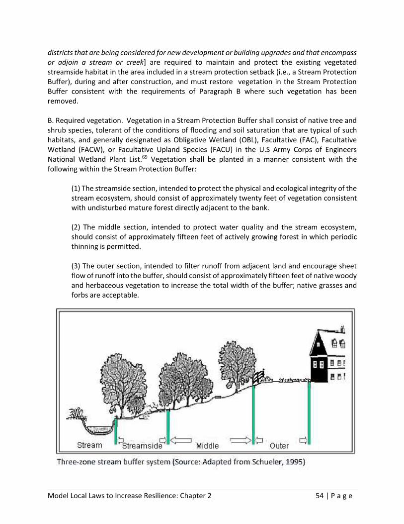
Model Local Laws to Increase Resilience: Chapter 2 54 | P a g e
districts that are being considered for new development or building upgrades and that encompass or adjoin a stream or creek] are required to maintain and protect the existing vegetated streamside habitat in the area included in a stream protection setback (i.e., a Stream Protection Buffer), during and after construction, and must restore vegetation in the Stream Protection Buffer consistent with the requirements of Paragraph B where such vegetation has been removed. B. Required vegetation. Vegetation in a Stream Protection Buffer shall consist of native tree and shrub species, tolerant of the conditions of flooding and soil saturation that are typical of such habitats, and generally designated as Obligative Wetland (OBL), Facultative (FAC), Facultative Wetland (FACW), or Facultative Upland Species (FACU) in the U.S Army Corps of Engineers National Wetland Plant List.69 Vegetation shall be planted in a manner consistent with the following within the Stream Protection Buffer:
(1) The streamside section, intended to protect the physical and ecological integrity of the stream ecosystem, should consist of approximately twenty feet of vegetation consistent with undisturbed mature forest directly adjacent to the bank. (2) The middle section, intended to protect water quality and the stream ecosystem, should consist of approximately fifteen feet of actively growing forest in which periodic thinning is permitted. (3) The outer section, intended to filter runoff from adjacent land and encourage sheet flow of runoff into the buffer, should consist of approximately fifteen feet of native woody and herbaceous vegetation to increase the total width of the buffer; native grasses and forbs are acceptable.

Model Local Laws to Increase Resilience: Chapter 2 55 | P a g e
RESOURCES
Strong, K. (2008). Conserving Natural Areas and Wildlife in Your Community: Smart Growth Strategies for Protecting the Biological Diversity of New York’s Hudson River Valley. Ithaca, NY: New York Cooperative Fish and Wildlife Research Unit, Cornell University, and NYS Department of Environmental Conservation, Hudson River Estuary Program. 70 Stream Processes: A Guide to Living in Harmony with Streams. (2016). Horseheads, NY: Chemung County Soil and Water Conservation District.71 Westchester County: A Guide to Aquatic Buffers. (2007). Westchester County Soil and Water Conservation District.72

Model Local Laws to Increase Resilience: Chapter 2 56 | P a g e
2.2.2 Stream-Related Zoning Standards Supplemental zoning standards can be adopted as additional requirements to underlying zoning district provisions to establish setback buffer areas and restrictions to activities within those buffers. Among the purposes of these standards is to retain areas of annual flooding, floodplains, and wetlands in their natural state to the maximum possible extent to preserve water quality and protect water retention, overflow, and natural functions. The example below defines streams to be protected based on United States Geological Survey Topographical Maps (7.5 minute series), with solid blue lines representing perennial streams and broken blue lines representing intermittent streams. The example was modified to promote stormwater management using practices compatible with buffer protection, rather than stormwater practices that require substantial construction resulting in a larger impact, such as stormwater ponds.
USAGE
Incorporate the supplemental zoning standards into the performance standards section of a municipal zoning law. It would be applicable everywhere in the municipality where resources falling under the definition of “watercourse” exist.
ADAPTED FROM THE FOLLOWING SOURCE
Town of Coxsackie (NY) Zoning Law, Article VI Natural Resource Protection Standards, Section 201-4873
LANGUAGE
Section X. Watercourses A. Definitions. The following definitions shall apply to this section.
(1) Buffer: A designated area along the perimeter of a wetland, fish or wildlife habitat, or other area regulated on a seasonal or permanent basis so as to minimize or mitigate the impact of adjacent activities, such as human related-disturbances. (2) Watercourse: Any natural or artificial, intermittent, seasonal or permanent, public or private water body or water segment. A watercourse is intermittently, seasonally or permanently inundated with water and contains a discernible shoreline, including waterways flowing in a definite channel with bed and banks and usually in a particular

Model Local Laws to Increase Resilience: Chapter 2 57 | P a g e
direction. Watercourses include ponds, lakes and reservoirs rivulets, brooks, creeks, streams, rivers and other waterways. (3) Watercourse Buffer: The Watercourse Buffer is a buffer area surrounding a watercourse that is intended to protect the watercourse from human activity and other encroachment associated with development.
(4) Agricultural: The raising of crops, animals and animal products; forestry; other commonly accepted agricultural operations for commercial purposes, including the sale of products grown on the premises.
B. Watercourse buffer areas. These standards shall apply to any activities proposed within Watercourse Buffers, which shall exist upon:
(1) All land within 100 feet horizontal distance of the center line of any perennial stream as designated by a solid blue line on United State Geological Survey Topographical Maps (7.5 minute series). (2) All land within 50 feet horizontal distance of the center line of any intermittent stream as designated by a broken blue line on United States Geological Survey Topographical Maps (7.5 minute series). (3) All land within 25 feet horizontal distance of the center line of any other watercourse. (4) All lands within 150 feet horizontal distance of the mean high tide mark of the [insert name of river] or the tidal portions of its tributaries.
C. General standards. It is the objective of these standards to promote the establishment of heavily vegetated areas of native vegetation and trees in order to reduce the impacts of stormwater runoff, reduce sedimentation, and increase infiltration and base flows in the [City/Town/Village]'s Watercourses. All lands within a designated Watercourse Buffer defined above shall be left in an undisturbed, naturally vegetated condition. Supplemental planting and landscaping with appropriate species of vegetation necessary to achieve these objectives shall be permitted. The specific standards for the vegetation and maintenance of Watercourse Buffers are as follows:
Watercourse Feature Buffer
Perennial Stream 100 feet
Intermittent Stream 50 feet
Other Watercourses 25 feet
Mean High Tide Mark of Tidal River 150 feet

Model Local Laws to Increase Resilience: Chapter 2 58 | P a g e
(1) The clearing of trees that are not dead, heavily damaged by ice storms or other natural events, or diseased; and the clearing of any other vegetation other than invasive species, is prohibited. (2) Any areas within a Watercourse Buffer not occupied by a structure, whose vegetation is removed or disturbed during development or other human activities, shall promptly be seeded with a naturalized mix of grasses rather than standard lawn grass. If such disturbance to the buffer area impacts tree or shrub species, the disturbed area shall promptly be restored using the same species of trees and shrubs, unless those species were invasive species, in which case native trees and shrubs shall be used. (3) Watercourse Buffers shall not be mowed more than once per calendar year after vegetation establishment. Mowing of buffer areas shall not be undertaken until after August 15th of each year in order to reduce impacts to ground nesting species. Mowing related to agricultural activities is exempt from this requirement. (4) The creation of lawns consisting of cultivated and mowed grass within Watercourse Buffers is prohibited. (5) Snow storage areas designated pursuant to site plan review shall not be located within Watercourse Buffers, unless the applicant can demonstrate that there is no reasonable alternative location for snow storage on the same property, and the site plan and/or stormwater treatment system incorporates measures to reduce the potential for erosion and contaminated runoff entering the associated watercourse as a result of snow melt, such as infiltration areas or enhanced buffer vegetation. (6) Agriculture, horticulture and forestry, including the keeping of livestock, is permitted, provided that any building or structure associated with such uses is located outside the watercourse buffer. Livestock-based agricultural operations should minimize livestock impacts within the Watercourse Buffer to the maximum extent possible. (7) Encroachments necessary to rectify a natural catastrophe for the protection of the public health, safety and welfare are permitted. Such encroachments shall be undertaken so as to minimize the impact and every reasonable effort shall be made to restore the site after the activity is completed. (8) Encroachments are permitted as necessary for building, maintaining, or improving public facilities in those cases where there is no practicable alternative to encroaching upon the Watercourse Buffer. (9) Public recreation paths located at least ten feet from the bank of the watercourse are permitted. Outdoor recreation facilities are permitted provided any building or structure (including parking and driveways) associated with such use is located outside the watercourse buffer.
Model Local Laws to Increase Resilience: Chapter 2 59 | P a g e
(10) The following green infrastructure practices for stormwater management, as described in Chapter 5 of the New York State Stormwater Management Design Manual,74 (SWDM) may be permitted in the Watercourse Buffer as long as such facilities and practices are designed and built consistent with the criteria as set forth in the SWDM:
5.1.1 Preservation of Undisturbed Areas 5.1.2 Preservation of Buffers 5.1.3 Reduction of Clearing and Grading 5.1.4 Locating Development in Less Sensitive Areas 5.1.5 Open Space Design 5.3.1 Conservation of Natural Areas 5.3.2 Sheetflow to Riparian Buffers
(11) Where there is no feasible alternative method for providing safe access and where the roadway or access drive is located at least 10 feet from the bank of the watercourse, a roadway or access drive is permitted for the purpose of gaining access to land on the opposite side of the Watercourse Buffer or providing safe access to an approved use. (12) Utility structures, including power, telephone, cable, sewer and water, [insert if desired, gas or oil pipelines, having a diameter of __ or less] are permitted, so long as encroachment is limited to the minimum extent necessary, and there is no feasible alternative for providing or extending utility services.
D. Preexisting structures. Expansion and construction of preexisting structures within a Watercourse Buffer may be approved by the [insert name of review board] as a [special use/conditional use], provided the requirements of the underlying zoning district, [delete if not
A model local law from the Huron River Watershed Council provides an exemption for
construction of a single-family residence that is part of a plat for subdivision or approved
site plan prior to the date the new provision is adopted, including the usual appurtenances,
provided that:
(a) Based on the size, shape or topography of the property, it is not reasonably possible to
construct a single-family dwelling without encroaching upon the riparian buffer area;
(b) The dwelling conforms to all other zoning regulations;
(c) Septic tanks or drain fields are not located within the riparian buffer area;
(d) The dwelling avoids to the maximum extent practicable disturbance of the riparian
forest buffer area.

Model Local Laws to Increase Resilience: Chapter 2 60 | P a g e
applicable] the requirements in the [City/Town/Village] Flood Damage Prevention Law, and the following standards are met:
(1) The structure to be expanded or reconstructed was originally constructed prior to the adoption of these standards. For purposes of these regulations, expansion includes the construction of detached accessory structures, including garages and utility sheds. (2) The expanded or reconstructed structure does not extend any closer, measured in terms of horizontal distance as defined in Paragraph B, than the closest point of the structure prior to its expansion or improvement. (3) The total footprint area of the expanded or reconstructed structure shall not be more than fifty percent larger than the footprint of the structure lawfully existing on the date of the adoption of these standards. For purposes of these regulations, reconstruction includes but is not limited to razing the existing structure and/or foundation and constructing a new structure in accordance with the provisions of the underlying zoning district regulations and this section (4) An erosion control plan for construction is submitted by a licensed engineer or other qualified professional (i.e., certified professional in erosion and sediment control) detailing the controls that will be put in place to protect the associated watercourse. (5) A landscaping plan showing plans to preserve, maintain and supplement existing trees and ground cover vegetation in the Watercourse Buffer is submitted and the [city/town/village] [insert name of review board] finds that the overall plan will provide a visual and vegetative buffer for the lake and/or stream.
E. Watercourse alteration and relocation. The alteration, relocation or culverting of a watercourse shall only be permitted following the review and approval of the Planning Board. In reviewing applications to alter, relocate, or culvert a watercourse, the Planning Board shall be authorized to invoke reasonable technical review, at the applicant's expense, by a suitable professional in hydrology or geomorphology, and/or to rely on the issuance of a stream disturbance permit (Article 15 of the New York Environmental Conservation Law) issued by the New York State Department of Environmental Conservation. The [insert name of review board] shall deny an application to alter, relocate, or culvert a watercourse unless it finds that such activity:
(1) is necessary to accomplish a clear public purpose or objective; (2) will not reduce the ability of the watercourse to adequately carry or store floodwaters; (3) will not have an adverse impact on downstream or upstream water quality;
Model Local Laws to Increase Resilience: Chapter 2 61 | P a g e
(4) will not adversely affect the use and enjoyment of adjacent properties; and (5) will not affect adversely the habitat value of the watercourse or the areas or wetlands immediately adjacent thereto.
F. Inspection. The Code Enforcement Officer may enter upon the lands or waters for the purpose of inspection to determine compliance with this section.

Model Local Laws to Increase Resilience: Chapter 2 62 | P a g e
2.2.3 Watercourse Overlay District Overlay districts may be established to protect streams, establish buffer areas, and restrict activities within buffers. Such districts are geographically limited and defined on a zoning map. The standards included in an overlay district are in addition to the density, area, and use requirements of the underlying zoning district. The example which follows is from a model local law created for the Moodna Creek Watershed Intermunicipal Council in Orange County, New York. A stream is broadly defined in this model, and includes intermittent as well as permanent streams, although the definition excludes constructed drainage-ways, including water bars, swales, and roadside ditches, unless they were constructed by channelizing or otherwise modifying a natural stream, wetland, or waterbody of any kind. There are four different buffer width options, all of which have primary and secondary areas with different standards. Options A and C are fixed width buffers; options B and D allow buffers to expand to cover the floodplain and riparian wetlands. The example is applicable to regulated activities in all land use approval processes, including approvals for subdivisions, site plans, building permits and variances. Stream buffer widths contained in the model law were determined using scientific guidance set forth in Conservation Thresholds for Land Use Planners, published by the Environmental Law Institute in 2003, and Conservation Buffers: Design Guidelines for Buffers, Corridors, and Greenways, published by the United States Department of Agriculture in 2008. One of the uses described as permitted within the buffer area is limited tree cutting, forestry or vegetation management done pursuant to plans by certain professionals. The local law states that any harvesting must furthermore be done in accordance with the New York State Forestry Best Management Practices for Water Quality – BMP Field Guide, which is available from the NYS Department of Environmental Conservation.75
USAGE
Identify the area(s) of the municipality that would be included in the Watercourse Overlay District and prepare a map showing those areas as an overlay to the municipal zoning map. Amend the section of the municipal zoning law that establishes zoning districts to include the new overlay district.
ADAPTED FROM THE FOLLOWING SOURCE
Stream Corridor Overlay Model Local Law (2014), Developed for the Moodna Creek Watershed Intermunicipal Council by the Council’s Outreach & Education Committee with technical assistance from the Orange County (NY) Planning Department76
Model Local Laws to Increase Resilience: Chapter 2 63 | P a g e
LANGUAGE
Section X. Watercourse Overlay District A. Findings. The [City Council/Town Board/Village Board of Trustees] of the [city/town/village] hereby finds that the encroachment of development activities into stream corridors could create a public and private nuisance, degrade the natural environment, and be harmful to the public health, safety and welfare. Such activities can increase the risk of flooding in the stream corridor, damage water quality in the surface waters within and downstream of the [city/town/village], harm the aesthetic qualities of the [city/town/village], damage wildlife and vegetative habitat, pose additional threats to rare, threatened and endangered species that depend on riparian habitats, and tend to depreciate the value of properties in the [city/town/village]. The [City Council/Town Board/Village Board of Trustees] finds that these problems can be diminished by applying a primary and a secondary riparian buffer to all stream corridors within the [city/town/village] in keeping with the standards established in this local law. C. Purpose. The purpose of this Section is to establish requirements for creating and maintaining buffers to protect the water quality in the streams of the [city/town/village] and the natural environment around them, thereby protecting public health, safety and welfare in this [city/town/village]. This Section promotes the prevention of sediment, nutrient and pollutant loads from entering streams by maintaining stream buffers measured from the top of the stream bank with a width to be determined by the conditions adjacent to the stream corridor. Research has shown that the distances set forth within this local law are effective at filtering nutrients and pollutants to protect water quality. Additionally, creating buffers for structures and improvements from highly erodible streams will help minimize future property damage and other impacts associated with streambank erosion. Although it is not mandated in this Section, the [city/town/village] strongly encourages landowners to maintain stream buffers of 330 feet from the top of stream bank on undeveloped land, where feasible, in order to protect wildlife and vegetative habitat. D. Definitions. As used in this Section, the following terms shall have the meanings indicated: [Alternatively, these definitions may be incorporated into the list of other zoning definitions. Make sure they are consistent with existing definitions.]
Bank: the lateral confines of a stream, river, or other watercourse that contain the normal flow of the watercourse.
Buffer: land on each side of a stream that shall be left vegetated to provide riparian corridor functions. Buffers are measured horizontally from the top of the stream bank in a direction directly perpendicular to the bank and in the horizontal plane.
Development Activities: the construction, reconstruction, conversion, structural alteration, relocation, or enlargement of any structure or improvement that requires a permit or

Model Local Laws to Increase Resilience: Chapter 2 64 | P a g e
approval from the [City/Town/Village], including that intended for agricultural use; and any mining excavation, landfill, or land disturbance, including grading and filling.
Green Infrastructure Practices: stormwater management practices that maintain or restore natural stormwater flow pattern by allowing the water to permeate slowly into the ground and be used by plants. Green infrastructure practices generally incorporate higher functioning site design and low-impact development design techniques.
Highly Erodible Soils: Soils that have a maximum potential for erosion that equals or exceeds eight times the tolerable erosion rate.77
Improvement: alterations to the land that enhance the utility or value of the site and/or any structures thereon.
Intermittent Stream: surface water drainage channels with definite bed and banks in which there is not a permanent flow of water (and may be represented as a dashed line on United State Geological Survey (USGS) 7.5 Minute Quadrangle maps). Sometimes referred to as “ephemeral stream.”
Impervious Surface: any paved, hardened or structural surface including, but not limited to, buildings, dams, decks, driveways, parking areas, patios, streets, swimming pools, tennis courts, walkways, and other non-permeable structures and improvements. Impervious surfaces include compacted shale, gravel, and packed dirt, as well as other materials that become impervious when compacted.
Parcel: a designated tract or area of land established by plat, subdivision, or as otherwise permitted by law, to be separately owned, used, developed, or built upon.
Perennial Stream: a stream that typically flows continuously throughout the year in a natural or man-made channel (which may be represented as a solid blue line on United States Geological Survey (USGS) 7.5 Minute Quadrangle maps).
Pollutant: dredged spoil, solid waste, incinerator residue, filter backwash, sewage, garbage, sewage sludge, munitions, chemical wastes, biological materials, radioactive materials other than those regulated under the Atomic Energy Act of 1954 as amended (42 U.S.C. § 2011 et seq.), heat, wrecked or discarded equipment, rock, sand, cellar dirt and industrial, municipal and agricultural waste discharged into water. 78
Riparian: of, inhabiting or situated on the bank of a natural course of water such as a river.
Steep Slope: any slope of 15% grade or greater.
Stream: the full length and width, including the bed and banks, of any watercourse that has a channel which periodically or continuously contains moving water and has a defined bed,

Model Local Laws to Increase Resilience: Chapter 2 65 | P a g e
and has banks that serve to confine water at low to moderate flows (and may be represented as either a solid or dashed blue line on United States Geological Survey (USGS) 7.5 Minute Quadrangle maps). For the purpose of this Local Law, constructed drainage-ways, including water bars, swales, and roadside ditches, are not considered streams, unless they were constructed by channelizing or otherwise modifying a natural stream, wetland, or water body of any kind.
Structure: anything constructed or erected on or under the ground or upon another structure or building.
Tolerable Erosion Rate: The maximum rate of soil erosion that is equaled by the rate of soil development, thus allowing an equilibrium between the amounts of soil lost and gained. Values for allowable soil loss for different soil types may be found in Section II of the Field Office Technical Guide (FOTG) for the County of [insert name of county] maintained by the Natural Resources Conservation Service of the U.S. Department of Agriculture.
Top of Stream Bank: the primary edge of the ordinary high water mark, or break in slope for a watercourse that maintains the integrity of the watercourse.
Undeveloped Land: A parcel of land that does not contain residential and/or commercial structures that have been issued certificates of occupancy or the equivalent from the City/Town/Village Code Enforcement Officer. Land that contains structures constructed without valid building permits or other approvals, and/or which have not been issued a certificate of occupancy or the equivalent shall be considered to be undeveloped. Wetlands: lands, including submerged lands, saturated by water at a frequency and duration sufficient to support vegetation adapted for life in saturated soil conditions. For the purpose of this local law, wetlands are limited to those lands that meet any of the following criteria: 1) are categorized as wetlands by the New York State Department of Environmental Conservation (NYSDEC); 2) have been documented and mapped as part of an officially adopted community wetlands inventory; and/or 3) meet the U.S. Army Corps of Engineers’ definition of a wetland.
E. Applicability. This Section shall apply to all proposed actions requiring approval by the [insert name of approval authority, such as code enforcement officer or Planning Board]. The Riparian Buffer Area, both Primary and Secondary, shall be acknowledged and displayed graphically on all plans and relevant materials that are submitted to the [city/town/village] as part of any land use approval process, including approvals for subdivisions, site plans, building permits and appeals for variances. These requirements do not supersede or replace any greater applicable requirements established under state, federal or local law. F. Protection requirements for perennial streams. The required buffer shall be established for all development activities, as defined in Paragraph D, that occur in proximity to perennial streams with additional considerations for wetlands, highly erodible soils, 100-year floodplains and steep

Model Local Laws to Increase Resilience: Chapter 2 66 | P a g e
slopes. The buffer shall be subdivided into a Primary Riparian Buffer and a Secondary Riparian Buffer that protects overall water quality by limiting development in accordance with the adjacent land’s ability to filter sediment, nutrients and other pollutants. The buffer will provide stability to the stream and stream bank. The minimum total buffer width for all perennial streams is [insert minimum size based on protection options in F(2)] as measured from the top of the stream bank. There is no established maximum buffer width. The [city/town/village] shall require the delineation of any applicable Primary or Secondary Riparian Buffers on all subdivision plats, site plan applications, special permits, special approval and variance applications, building permit applications, and excavation or fill permit applications, even in the event that a stream is not located within the subject parcel but the Primary Riparian Buffer and/or the Secondary Riparian Buffer is located on the subject parcel. This delineation shall be subject to review and approval by the appropriate board or officer. Said delineation shall also be referenced in any deed for any parcel located wholly or partly within any Primary or Secondary Riparian Buffers, which shall state that: The premises hereby conveyed are subject to a Primary and/or Secondary Riparian Buffer established pursuant to the “Watercourse Overlay Local Law of the [City/Town/Village of ______], as shown on [plat or other map or permit] recorded in the Office of the County Clerk on [insert date] in [book/page/file/drawer].” Prior to any soil-disturbing activity requiring a permit or approval by the [city/town/village], the Primary Riparian Buffer and Secondary Riparian Buffer shall be clearly delineated on site and shall be left undisturbed or otherwise protected throughout the construction phase.
(1) Riparian Buffer Area. [Select one of the following options]
[Protection Option A] The Riparian Buffer will begin at the top of the stream bank and extend a minimum of 100 feet horizontally measured in a direction directly perpendicular to the stream bank in a horizontal plane. The Buffer area will be subdivided into a Primary Riparian Buffer extending 50 feet from the stream bank, and a Secondary Riparian Buffer extending 50 feet from the outward boundary of the Primary Riparian Buffer. OR [Protection Option B] The Riparian Buffer will begin at the top of the stream bank and extend a minimum of 200 feet horizontally measured in a direction directly perpendicular to the stream bank in a horizontal plane. The Buffer area will be subdivided into a Primary Riparian Buffer extending 100 feet from the stream bank, and a Secondary Riparian Buffer extending 100 feet from the outward boundary of the Primary Riparian Buffer.

Model Local Laws to Increase Resilience: Chapter 2 67 | P a g e
OR
[Protection Option C] The Primary Riparian Buffer will begin at the top of the stream bank and extend a minimum of 100 feet horizontally measured in a direction directly perpendicular to the stream bank in a horizontal plane. The Buffer area will be divided into a Primary Riparian Buffer extending 50’ from the stream bank and a Secondary Riparian Buffer extending 50’ from the outward edge of the Primary Riparian Buffer. Should a wetland or a 100-year floodplain exist at least partially within the Secondary Riparian Buffer, the entirety of that area will be included within the Secondary Riparian Buffer and will be subject to the restrictions afforded to the Secondary Riparian Buffer. Should a steep slope or highly erodible soils exist partially within the Secondary Riparian Buffer, that steep slope or highly erodible soil area up to a maximum of 400 feet from the stream bank shall be included within the Secondary Riparian Buffer. OR

Model Local Laws to Increase Resilience: Chapter 2 68 | P a g e
[Protection Option D - Recommended for all Class A streams.] The Riparian Buffer will begin at the top of the stream bank and extend a minimum of 200 feet horizontally measured in a direction directly perpendicular to the stream bank in a horizontal plane. The Buffer area will be divided into a Primary Riparian Buffer extending 100’ from the stream bank and a Secondary Riparian Buffer extending 100’ from the outward edge of the Primary Riparian Buffer. Should a wetland or a 100-year floodplain exist at least partially within the Secondary Riparian Buffer, the entirety of that area will be included within the Secondary Riparian Buffer and will be subject to the restrictions afforded to the Secondary Riparian Buffer. Should a steep slope or highly erodible soils exist partially within the Secondary Riparian Buffer, that steep slope or highly erodible soil area up to a maximum of 400 feet from the stream bank shall be included within the Secondary Riparian Buffer (2) Primary Riparian Buffer
(a) Purpose. The function of the Primary Riparian Buffer is to protect the physical and ecological integrity of the portion of the riparian corridor in closest proximity to the stream through protection and enhancement of the vegetation. Vegetation provides erosion protection, shade, leaf litter, woody debris, wildlife habitat, and filtering of sediment, nutrient and pollutant loads to the stream. (b) Permitted Uses. Development and use within the Primary Riparian Buffer are restricted to the following uses, which in aggregate may modify or cause adverse impacts to no more than 10% of the entire Primary Riparian Buffer unless more area is necessary for the protection of human health, public utility usage, or public infrastructure.
(i])Benches or seating; (ii) Implementation of educational and scientific research activities that enhance or otherwise do not negatively impact the composition or health of the existing vegetation; (iii) Flood control structures, bioretention areas or other green infrastructure stormwater management practices, and stream bank stabilization measures approved by the Orange County Soil and Water Conservation District, U.S. Natural Resource Conservation Service, U.S. Army Corps of Engineers, or NYSDEC; (iv) Maintenance of roadways or impervious surfaces existing at the time of the adoption of this provision; (v) Culverts or other stream crossings necessary to construct a driveway, transportation route, or public utility structures necessary to provide

Model Local Laws to Increase Resilience: Chapter 2 69 | P a g e
access or utility service to a parcel, which are designed to minimize negative impacts to the stream and Primary Riparian Buffer; (vi) Public water supply infrastructure, including wells, public wastewater outfall structures, and associated pipes; (vii) Public access and water-dependent public recreational facilities, including boat ramps, docks, foot trails leading directly to the stream, fishing platforms, and overlooks; (viii) Public sewer lines and/or other utility easements. (ix) Techniques to remove invasive species; (x) Non-paved recreational trails no wider than 10 (Additional Protection Option: 5) feet that either provide access to the stream or are part of a continuous trail system running roughly parallel to the stream; (xi) Storage of nonmotorized recreational watercraft measuring less than 15 feet in length; (xii) Use of temporary erosion control measures, including but not limited to silt fencing, that are installed, maintained and removed after site stabilization is completed according to New York Standards and Specifications for Erosion and Sediment Control, most current version; (xiii) Limited tree cutting, forestry or vegetation management done in accordance with a Forest Stewardship Plan prepared by the Department of Environmental Conservation, a forester who is certified by the Society of American Foresters or such successor organization as is later created, or a Cooperating Consulting Forester with the New York State Department of Environmental Conservation. Any harvest must furthermore be done in accordance with the New York State Forestry Best Management Practices for Water Quality – BMP Field Guide. Vegetation management may not compromise the integrity of the stream bank or negatively impact the function of the Primary Riparian Buffer. Tree cutting within 25 [Additional Protection Option: 50] feet of the top of stream bank is prohibited. Any such activity must retain at a minimum 60% [Additional Protection Option: 95%] of the preexisting tree canopy in the Primary Riparian Buffer at all times. Notwithstanding the foregoing, removal of trees in any location shall be permitted where such trees pose an imminent threat to property or public safety.
(3) Secondary Riparian Buffer

Model Local Laws to Increase Resilience: Chapter 2 70 | P a g e
(a) Purpose. The function of the Secondary Riparian Buffer is to filter sediment, nutrients and pollutants in runoff and slow the rate at which runoff enters the Primary Riparian Buffer. (b) Permitted Uses. Uses within the Secondary Riparian Buffer are restricted to the following:
(i) All uses permitted in the Primary Riparian Buffer; (ii) Minor recreational structures and improvements to allow passive recreation in the Secondary Riparian Buffer such as decks, picnic tables, playground equipment, and small concrete slabs, which each may not exceed 200 square feet in area, and which in aggregate may occupy no more than 10% of the Secondary Riparian Buffer area on the parcel; (iii) Fences, provided such structures do not impede floodwaters; (iv) Landscaping, planting or routine maintenance activities that do not encroach upon or negatively impact the Primary Riparian Buffer.
G. Prohibited Activities in the Riparian Buffer. The following activities are explicitly prohibited in both the Primary and Secondary Riparian Buffers.
(1) Storage or placement of any hazardous materials, including any sewage system. All sewage systems, including drain fields and raised systems, must be located a minimum of 100 feet from a perennial stream. [For additional protection, change to 150 feet.] (2) Knowing or unknowing introduction of invasive vegetative species that may impact vegetation present within the stream corridor. For a listing of invasive vegetation to avoid, refer to the NYSDEC List of Prohibited and Regulated Invasive Species in 6 NYCRR Part 575 and the NYSDEC Division of Materials Management Bureau of Pest Management. If invasive or nuisance species are present on your property, NYSDEC may have developed a protocol to combat that species. Refer to the NYSDEC website for additional information. (3) Waste storage and disposal, including but not limited to disposal and/or dumping of snow and ice, recyclable materials, manure, hazardous or noxious chemicals, used automobiles or appliances, and other abandoned materials. (4) Any combination of permitted or exempt activities that may compromise or alter more than 10% of the combined Primary and Secondary Riparian Buffer area that lies within a parcel.

Model Local Laws to Increase Resilience: Chapter 2 71 | P a g e
(5) Mining or removal of soil, sand and gravel, and quarrying of raw materials. (6) Widening, straightening or otherwise altering the beds or banks of streams, except where the NYSDEC has issued a permit expressly allowing such activities on the parcel. (7) Application of herbicides, pesticides, fertilizers, or other chemicals that contain hazardous substances, as defined in 6 NYCRR Part 597. (8) Parking of motorized vehicles, including watercraft. (9) Construction or replacement of private wells within 100 feet of perennial streams. (10) Altering habitat of threatened or endangered species, as defined at 6 NYCRR Part 182.
H. Protection Requirements for Intermittent Streams. Although seasonal or temporary in nature, ephemeral and intermittent streams provide the same ecological and hydrological functions as perennial streams by moving water, nutrients, and sediment through watersheds. These streams provide hydrological connections across the landscape, absorb high volumes of water during storm events and other high-water flows to reduce erosion and improve water quality. For those streams classified as intermittent, only the Primary Riparian Buffer shall apply, and it shall be measured in the same manner as provided for a perennial stream in Paragraph F(1) of this Section. All provisions applicable to the Primary Riparian Buffers for perennial streams shall apply to intermittent streams.
I. Exemptions. The following activities are exempt from the requirements of this Section:
(1) Agricultural activities on parcels that meet New York State Department of Agriculture and Market’s definition of a farm operation at 1 NYCRR Section 391.1(c). (2) Repair or maintenance of any lawful use of land that was approved for such parcel on or before the effective date of this Local Law, or if no approval was required for such use, was lawfully in existence as of said date.
Farm Operations
1 NYCRR Part 391.1(c) defines farm operation as the land and on-farm buildings, equipment,
and practices which contribute to the production, preparation and marketing of crops,
livestock and livestock products as a commercial enterprise.

Model Local Laws to Increase Resilience: Chapter 2 72 | P a g e
[If incorporating as a separate article in the municipal code, include sections on administration and enforcement, as well as severability. See the Moodna Creek Watershed model for sample language.]
RESOURCES
New York State Standards and Specifications for Erosion and Sediment Control (Blue Book). (2005). NYS Department of Environmental Conservation.79

Model Local Laws to Increase Resilience: Chapter 2 73 | P a g e
2.2.4 Local Watercourse Law Many New York municipalities have found local watercourse laws to be an effective technique to fill the gaps in state and federal protection. The example below regulates activities in watercourses as well as a 100-foot buffer measured horizontally from the top of the bank. It requires a permit for construction of structures, roads, and driveways; and for filling, dredging, grading, polluting, damming, or any other activity that may affect the functions of wetlands, watercourses and buffer areas defined in the law.
USAGE
A standalone local law, and often combined with wetland and waterbody protection.
ADAPTED FROM THE FOLLOWING SOURCE
Town of Pawling (NY) Chapter 111: Freshwater Wetlands and Watercourse Protection80
LANGUAGE
Refer to Section 2.1.4 Local Freshwater Wetland Law. The introduction to Section 2.2: Watercourse Protection has guidance on defining the watercourses to be protected, defining the regulated buffer, and determining which activities require a permit.

Model Local Laws to Increase Resilience: Chapter 2 74 | P a g e
Endnotes
1 Elevated Residential Structures, FEMA 54 (1984). Retrieved 6/1/18 from
http://www.fema.gov/media-library-data/20130726-1509-20490-6744/fema54.pdf
2Ibid.
3 Ibid.
4 Freshwater and tidal combined, Natural History of New York. Retrieved 6/1/18 from http://www.dec.ny.gov/docs/wildlife_pdf/nathist.pdf
5 United States Environmental Protection Agency. (2006). Wetlands: Protecting Life and Property from Flooding Office of Wetlands, Oceans, and Watersheds. Retrieved 6/1/18 from
https://www.epa.gov/sites/production/files/2016-02/documents/flooding.pdf
6 Long Island Tidal Wetlands Trends Analysis Prepared for the New England Interstate Water Pollution Control Commission, NYS DEC (July 2015). Retrieved 6/1/18 from
http://www.dec.ny.gov/docs/fish_marine_pdf/bmrwetlandstrends1.pdf
7 New York State Guidance on Natural Resource Measures. Available soon at https://www.dec.ny.gov/energy/102559.html 8 Town of Pawling (NY) Wetland and Watercourse Law (1993). Retrieved 6/1/18 from http://ecode360.com/6968447 9 Zucker, L. and L. Lau. 2009. An analysis of the size and distribution of geographically isolated, small wetlands in the Hudson River Estuary Watershed. Report prepared for the Hudson River Estuary Biodiversity Program. Cornell University, Ithaca, NY.
10 Strong, K. 2008. Conserving Natural Areas and Wildlife in Your Community: Smart Growth Strategies for Protecting the Biological Diversity of New York’s Hudson River Valley. New York Cooperative Fish and Wildlife Research Unit, Cornell University, and New York State Department of Environmental Conservation, Hudson River Estuary Program. Ithaca, N.Y.
11 McElfish, Jr., J.M., R.L. Kihslinger, and S.S. Nichols. 2008. Planner’s Guide to Wetland Buffers for Local Governments. Environmental Law Institute, Washington, DC. Retrieved 6/1/18 from
http://www.eli.org/research-report/planners-guide-wetland-buffers-local-governments
12 Ibid.

Model Local Laws to Increase Resilience: Chapter 2 75 | P a g e
13 Village of Trumansburg (NY) Zoning Ordinance, Article 6, Section 605 Wetland Conservation Overlay District. Retrieved 6/1/18 from
http://locallaws.dos.ny.gov/sites/default/files/drop_laws_here/ECMMDIS_appid_DOS20150218075528_45/Content/09021343800092eb.pdf
14 Town of New Castle (NY) Wetlands Law (1990). Retrieved 6/1/18 from
http://ecode360.com/11774386
15 Town of Pawling (NY) Wetland and Watercourse Law (1993). Retrieved 6/1/18 from http://ecode360.com/6968447
16 Town of Poughkeepsie (NY) Aquatic Resource Protection Law (2003). Retrieved 6/1/18 from
http://ecode360.com/6321213
17 Town of New Paltz (NY) Wetlands and Watercourse Protection Law (2011). Retrieved 6/1/18 from http://ecode360.com/9168154
18 Town of Philipstown (NY) Freshwater Wetlands and Watercourses Law (1991). Retrieved 6/1/18 from http://ecode360.com/6317362
19 Town of New Castle (NY) Wetlands Law (1990). Retrieved 6/1/18 from
http://ecode360.com/11774386
20 Village of Trumansburg (NY) Wetland Conservation Overlay District (2012). Retrieved 6/1/18 from http://locallaws.dos.ny.gov/sites/default/files/drop_laws_here/ECMMDIS_appid_DOS20150218075528_45/Content/09021343800092eb.pdf
21 Town of New Castle (NY) Environmental Protection Overlay District (2002). Retrieved 6/1/18 from http://ecode360.com/11759229
22 Town of Coxsackie (NY) Natural Resource Protection Standards (2008). Retrieved 6/1/18 from
http://ecode360.com/13876388
23 Town of Woodstock (NY) Wetland and Watercourse Protection Standards (2011). Retrieved 6/1/18 from http://ecode360.com/109422

Model Local Laws to Increase Resilience: Chapter 2 76 | P a g e
24 Town of Ulysses (NY) Zoning Law. Retrieved 6/1/18 from
https://www.ecode360.com/28859962
25Local Wetland Regulations. (2013). Kingston, NY: Ulster County Planning Board. Retrieved 6/1/18 from http://ulstercountyny.gov/sites/default/files/documents/wetland_guide.pdf
26 McElfish, Jr., J.M., R.L. Kihslinger, and S.S. Nichols. (2008). Planner’s Guide to Wetland Buffers for Local Governments. Washington, DC: Environmental Law Institute. Retrieved 6/1/18 from http://www.eli.org/research-report/planners-guide-wetland-buffers-local-governments
27 Kusler, J. (2009). Model Ordinances for Regulating wetlands, riparian habitats, and stream buffers. Berne, NY: Association of State Wetland Managers. Retrieved 6/1/18 from http://www.aswm.org/pdf_lib/model_ordinance_1209.pdf
28 Westchester County Model Ordinance for Wetland Protection. (1998). Westchester County Soil and Water Conservation District. Retrieved 6/1/18 from https://planning.westchestergov.com/images/stories/reports/WetlandOrdinance.pdf
29 Wetlands Regulation Guidebook for New York State. (1993). EPA Region 2 EPA-902-R-004. Retrieved 6/1/18 from
https://nepis.epa.gov/Exe/ZyNET.exe/9101NYGT.TXT?ZyActionD=ZyDocument&Client=EPA&Index=1991+Thru+1994&Docs=&Query=&Time=&EndTime=&SearchMethod=1&TocRestrict=n&Toc=&TocEntry=&QField=&QFieldYear=&QFieldMonth=&QFieldDay=&IntQFieldOp=0&ExtQFieldOp=0&XmlQuery=&File=D%3A%5Czyfiles%5CIndex%20Data%5C91thru94%5CTxt%5C00000030%5C9101NYGT.txt&User=ANONYMOUS&Password=anonymous&SortMethod=h%7C-&MaximumDocuments=1&FuzzyDegree=0&ImageQuality=r75g8/r75g8/x150y150g16/i425&Display=hpfr&DefSeekPage=x&SearchBack=ZyActionL&Back=ZyActionS&BackDesc=Results%20page&MaximumPages=1&ZyEntry=1&SeekPage=x&ZyPURL#
30 Tidal Wetlands Guidance Document: Living Shoreline Techniques in the Marine District of New York State. (2016). NYS Department of Environmental Conservation, Bureau of Marine Resources. Retrieved 6/1/18 from
http://www.dec.ny.gov/docs/fish_marine_pdf/dmrlivingshoreguide.pdf
31 Town of Ulysses (NY) Zoning Law. Retrieved 6/1/18 from
https://www.ecode360.com/28859962

Model Local Laws to Increase Resilience: Chapter 2 77 | P a g e
32 Town of Coxsackie (NY) Municipal Code, Chapter 201 Zoning Law, Article VI Natural Resource Protection Standards, Section 201-49 Wetlands. Retrieved 6/1/18 from
http://ecode360.com/13876388
33 Village of Trumansburg (NY) Zoning Map (2012). Retrieved 6/1/18 from http://trumansburg-ny.gov/wp-content/uploads/2016/12/ZoningMap.pdf
34 Village of Trumansburg (NY) Wetland Conservation Overlay District. Retrieved 6/1/18 from
http://trumansburg-ny.gov/wp-content/uploads/2016/12/2012ZoningOrdinance.pdf
35 Municipalities may regulate wetlands under the authority of the zoning enabling statutes, Municipal Home Rule Law, or Article 24 of the Environmental Conservation Law.
36 6 NYCRR Part 665. For more information, see local implementation sections 24-0501 to 24-0705 in the NYS DEC publication, Article 24 Freshwaters (1997) at http://www.dec.ny.gov/docs/wildlife_pdf/wetart24b.pdf
37 Although municipalities may assume regulatory authority over State-designated wetlands pursuant to Article 24 of the Environmental Conservation Law, this is not a recommended approach. As of May 2018, only three local governments in New York have done so.
38 Text adapted from Creating a Natural Resources Inventory: A Guide for Communities in the Hudson River Estuary Watershed (2014). Retrieved 6/1/18 from
http://www.dec.ny.gov/docs/remediation_hudson_pdf/nriall.pdf
39 Town of Pawling (NY) Wetland and Watercourse Law. Retrieved 6/1/18 from
http://ecode360.com/6968447
40 Town of Phillipstown (NY) Freshwater Wetlands and Watercourses Law (1991). Retrieved 6/1/18 from http://ecode360.com/6317362
41 Town of Southampton (NY) Wetlands Law, Chapter 325. Retrieved 6/1/18 from
http://ecode360.com/8700002
42 Town of Brookhaven (NY) Municipal Code, Chapter 81 Wetlands and Waterways. Retrieved 6/1/18 from https://ecode360.com/8596082

Model Local Laws to Increase Resilience: Chapter 2 78 | P a g e
43 Chester County (PA) Watershed Primer Part 3: Streams and Riparian Buffers. Retrieved 6/1/18 from http://www.chesco.org/2089/Watershed-Primer-Part-3---Strms-RpBuffer
44 Using Natural Resources to Reduce Risk of Flooding and Erosion in New York. NYS DEC, NYS DOS, 2018. ADD LINK WHEN AVAILABLE
45 Vermont League of Cities and Towns. Creating an Effective Riparian Buffer Ordinance (2007). Municipal Assistance Center Technical Paper #2. Montpelier, VT. Retrieved 6/1/18 from
http://www.hinesburg.org/stormwater/vlct-riparianbuffer-techpaper-2007.pdf
46 Hawes, Ellen and Smith Markelle, Riparian Buffer Zones: Functions and Recommended Widths (2005). Retrieved 6/1/18 from http://eightmileriver.org/resources/digital_library/appendicies/09c3_Riparian%20Buffer%20Science_YALE.pdf
47 Kennedy, C., Wilkinson, J. B., Balch, J., & Environmental Law Institute (2003). Conservation thresholds for land use planners. Washington, D.C: Environmental Law Institute.
48 River Banks & Buffers, Guidance for Communities in Northern New Jersey Watersheds, No.7. North Jersey Resource Conservation and Development (2002). Retrieved 6/1/18 from
http://northjerseyrcd.org/wp-content/uploads/2010/03/7_Guidance_for_Community.pdf
49 Ibid
50 Ibid
51 For additional information about streamway setbacks and river meandering, see the Vermont Agency of Natural Resources’ River Corridor Protection Guide, written by Mike Kline and Kari Dolan (2008). Retrieved 6/1/18 from
http://anr.vermont.gov/sites/anr/files/co/planning/documents/guidance/River%20Corridor%20Protection%20Guide.pdf
52 Town of Pawling (NY) Wetland and Watercourse Law. Retrieved 6/1/18 from
http://ecode360.com/6968447
53 Town of New Paltz (NY) Wetlands and Watercourse Protection Law. Retrieved 6/1/18 from http://ecode360.com/9168154

Model Local Laws to Increase Resilience: Chapter 2 79 | P a g e
54 Town of Philipstown (NY) Freshwater Wetlands and Watercourses Law. Retrieved 6/1/18 from http://ecode360.com/6317362
55 Town of Poughkeepsie (NY) Aquatic Resource Protection Law. Retrieved 6/1/18 from http://ecode360.com/6321213
56 Town of New Castle (NY) Wetlands Law. Retrieved 6/1/18 from
http://ecode360.com/11774386
57Moodna Creek Watershed Intermunicipal Council (NY), Model Stream Overlay District (2014). Retrieved 6/1/18 from http://waterauthority.orangecountygov.com/PROJECTS/MOODNA_CREEK_WATERSHED/Model%20Local%20Law%20Stream%20Corridor%20Mgmt.pdf
58 City of Newburgh (NY) Waterbody Protection Overlay District. Retrieved 6/1/18 from http://ecode360.com/30538880
59 Town of Coxsackie (NY) Natural Resource Protection Standards. Retrieved 6/1/18 from http://ecode360.com/13876388
60 Town of Wallkill (NY) Shawangunk Kill Corridor Preservation Overlay District. Retrieved 6/1/18 from http://ecode360.com/30555215
61 Town of Ulysses (NY) Municipal Code, Chapter 212 Zoning. Retrieved 6/1/18 from https://www.ecode360.com/28859962
62 Town of Woodstock (NY) Wetland and Watercourse Protection Standards. Retrieved 6/1/18 from http://ecode360.com/109422
63 Westchester County: A guide to Aquatic Buffers. (2007). Westchester County Soil and Water Conservation District. Retrieved 6/1/18 from: https://planning.westchestergov.com/images/stories/stormwater/aquaticbuffersguide.pdf 64 Conservation Thresholds for Land Use Planners. (2003). Washington, D.C: Environmental Law Institute. Retrieved 6/1/18 from https://www.eli.org/sites/default/files/eli-pubs/d13-04.pdf 65 Kusler, J. (2016). Model “riparian” Protection Ordinance. Berne, NY: Association of State Wetland Managers. Retrieved 6/1/18 from: https://www.aswm.org/pdf_lib/model_riparian_protection_ordinance_kusler_030916.pdf

Model Local Laws to Increase Resilience: Chapter 2 80 | P a g e
66 Kusler, J. (2009). Model Ordinances for Regulating Wetlands, Riparian Habitats, and Stream Buffers. Berne, NY: Association of State Wetland Managers. Retrieved online from: https://www.aswm.org/pdf_lib/model_ordinance_1209.pdf 67Model Stream Overlay District Developed for the Moodna Creek Watershed Intermunicipal Council. (2014). Moodna Creek Watershed Intermunicipal Council Outreach and Education Committee and the Orange County Planning Department. Retrieved 6/1/18 from http://waterauthority.orangecountygov.com/PROJECTS/MOODNA_CREEK_WATERSHED/Model%20Local%20Law%20Stream%20Corridor%20Mgmt.pdf
68 Town of Ulysses (NY) Municipal Code, Chapter 212 Zoning. Retrieved 6/1/18 from
https://www.ecode360.com/28859962
69 U.S Army Corps of Engineers, State of New York 2014 Wetland Plant List. Retrieved 6/1/18 from http://rsgisias.crrel.usace.army.mil/nwpl_static/data/DOC/lists_2014/States/pdf/NY_2014v1.pdf
70 Strong, K. (2008). Conserving Natural Areas and Wildlife in Your Community: Smart Growth Strategies for Protecting the Biological Diversity of New York’s Hudson River Valley. Ithaca, NY: New York Cooperative Fish and Wildlife Research Unit, Cornell University, and NYS Department of Environmental Conservation, Hudson River Estuary Program. Retrieved 6/1/18 from https://www.dec.ny.gov/docs/remediation_hudson_pdf/hrebch.pdf
71 Stream Processes: A Guide to Living in Harmony with Streams. (2016). Horseheads, NY: Chemung County Soil and Water Conservation District. Retrieved 6/1/18 from http://www.stcplanning.org/usr/Program_Areas/Water_Resources/StreamProcessesGuide.pdf
72 Westchester County: A Guide to Aquatic Buffers. (2007). Westchester County Soil and Water Conservation District. Retrieved 6/1/18 from http://planning.westchestergov.com/images/stories/stormwater/aquaticbuffersguide.pdf
73 Town of Coxsackie (NY) Natural Resource Protection Standards. Retrieved 6/1/18 from http://ecode360.com/13876388
74 New York State Stormwater Management Design Manual. Retrieved 6/1/18 from http://www.dec.ny.gov/docs/water_pdf/swdm2015entire.pdf

Model Local Laws to Increase Resilience: Chapter 2 81 | P a g e
75 New York State Forestry Best Management Practices for Water Quality – BMP Field Guide, NYS Department of Conservation. Retrieved 6/1/18 from http://www.dec.ny.gov/docs/wildlife_pdf/yfiforestrybmp.pdf
76Moodna Creek Watershed Intermunicipal Council (NY), Model Stream Overlay District (2014). Retrieved 6/1/18 from http://waterauthority.orangecountygov.com/PROJECTS/MOODNA_CREEK_WATERSHED/Model%20Local%20Law%20Stream%20Corridor%20Mgmt.pdf
77 The maximum potential erosion rate for any given soil can be determined by using the following formula: R*K*LS/T < 8, where R= rainfall, K= erodibility value of the soil, LS= the slope factor, and T= the tolerable erosion rate; factors K, LS, and T are established by the Natural Resources Conservation Service. Highly erodible soils must be verified in the field; a list of highly erodible soils is available from the Orange County Soil and Water Conservation Service.
78 Definition of “pollutant” from the federal Clean Water Act, 40 CFR 122.2.
79 New York State Standards and Specifications for Erosion and Sediment Control (Blue Book). (2005). NYS Department of Environmental Conservation. Retrieved 6/1/18 from https://www.dec.ny.gov/chemical/29066.html 80 Town of Pawling (NY) Wetland and Watercourse Law. Retrieved 6/1/18 from
http://ecode360.com/6968447