Embed Size (px)
Citation preview

West Sussex Joint Strategic Needs Assessment Briefing INDICES OF DEPRIVATION 2015 – CHICHESTER
Ryan Walkley West Sussex Public Health and Social Care Research Unit,
West Sussex County Council
December 2015

Source: IMD2015 DCLG
Public Health and Social Research Unit WSCC
Index of Deprivation 2015
OVERALL DEPRIVATION – CHICHESTER
This maps shades LSOAs according to their relative deprivation ranking.
The most deprived areas are shaded dark blue, and the least deprived shaded dark yellow.
The darkest blue shading represents areas within the most deprived 10% in England.
Deprivation Rank
(National decile)
1 (Most deprived)
2
3
4
5
6
7
8
9
10 (Least deprived)

Source: IMD2015 DCLG
Public Health and Social Research Unit WSCC
Index of Deprivation 2015
INCOME DEPRIVATION – CHICHESTER
This maps shades LSOAs according to their relative deprivation ranking.
The most deprived areas are shaded dark blue, and the least deprived shaded dark yellow.
The darkest blue shading represents areas within the most deprived 10% in England.
Deprivation Rank
(National decile)
1 (Most deprived)
2
3
4
5
6
7
8
9
10 (Least deprived)

Source: IMD2015 DCLG
Public Health and Social Research Unit WSCC
Index of Deprivation 2015
EMPLOYMENT DEPRIVATION – CHICHESTER
This maps shades LSOAs according to their relative deprivation ranking.
The most deprived areas are shaded dark blue, and the least deprived shaded dark yellow.
The darkest blue shading represents areas within the most deprived 10% in England.
Deprivation Rank
(National decile)
1 (Most deprived)
2
3
4
5
6
7
8
9
10 (Least deprived)

Source: IMD2015 DCLG
Public Health and Social Research Unit WSCC
Index of Deprivation 2015
EDUCATION, SKILLS AND TRAINING DEPRIVATION – CHICHESTER
This maps shades LSOAs according to their relative deprivation ranking.
The most deprived areas are shaded dark blue, and the least deprived shaded dark yellow.
The darkest blue shading represents areas within the most deprived 10% in England.
Deprivation Rank
(National decile)
1 (Most deprived)
2
3
4
5
6
7
8
9
10 (Least deprived)
Source: IMD2015 DCLG
Public Health and Social Research Unit WSCC
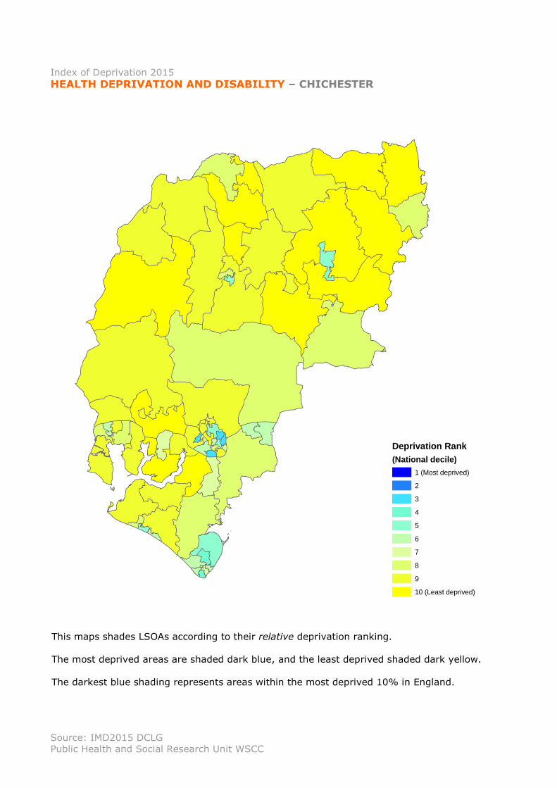
Index of Deprivation 2015
HEALTH DEPRIVATION AND DISABILITY – CHICHESTER
This maps shades LSOAs according to their relative deprivation ranking.
The most deprived areas are shaded dark blue, and the least deprived shaded dark yellow.
The darkest blue shading represents areas within the most deprived 10% in England.
Deprivation Rank
(National decile)
1 (Most deprived)
2
3
4
5
6
7
8
9
10 (Least deprived)

Source: IMD2015 DCLG
Public Health and Social Research Unit WSCC
Index of Deprivation 2015
CRIME DEPRIVATION– CHICHESTER
This maps shades LSOAs according to their relative deprivation ranking.
The most deprived areas are shaded dark blue, and the least deprived shaded dark yellow.
The darkest blue shading represents areas within the most deprived 10% in England.
Deprivation Rank
(National decile)
1 (Most deprived)
2
3
4
5
6
7
8
9
10 (Least deprived)

Source: IMD2015 DCLG
Public Health and Social Research Unit WSCC
Index of Deprivation 2015
BARRIERS TO HOUSING AND SERVICES– CHICHESTER
This maps shades LSOAs according to their relative deprivation ranking.
The most deprived areas are shaded dark blue, and the least deprived shaded dark yellow.
The darkest blue shading represents areas within the most deprived 10% in England.
Deprivation Rank
(National decile)
1 (Most deprived)
2
3
4
5
6
7
8
9
10 (Least deprived)

Source: IMD2015 DCLG
Public Health and Social Research Unit WSCC
Index of Deprivation 2015
LIVING ENVIRONMENT DEPRIVATION– CHICHESTER
This maps shades LSOAs according to their relative deprivation ranking.
The most deprived areas are shaded dark blue, and the least deprived shaded dark yellow.
The darkest blue shading represents areas within the most deprived 10% in England.
Deprivation Rank
(National decile)
1 (Most deprived)
2
3
4
5
6
7
8
9
10 (Least deprived)