Embed Size (px)
Citation preview
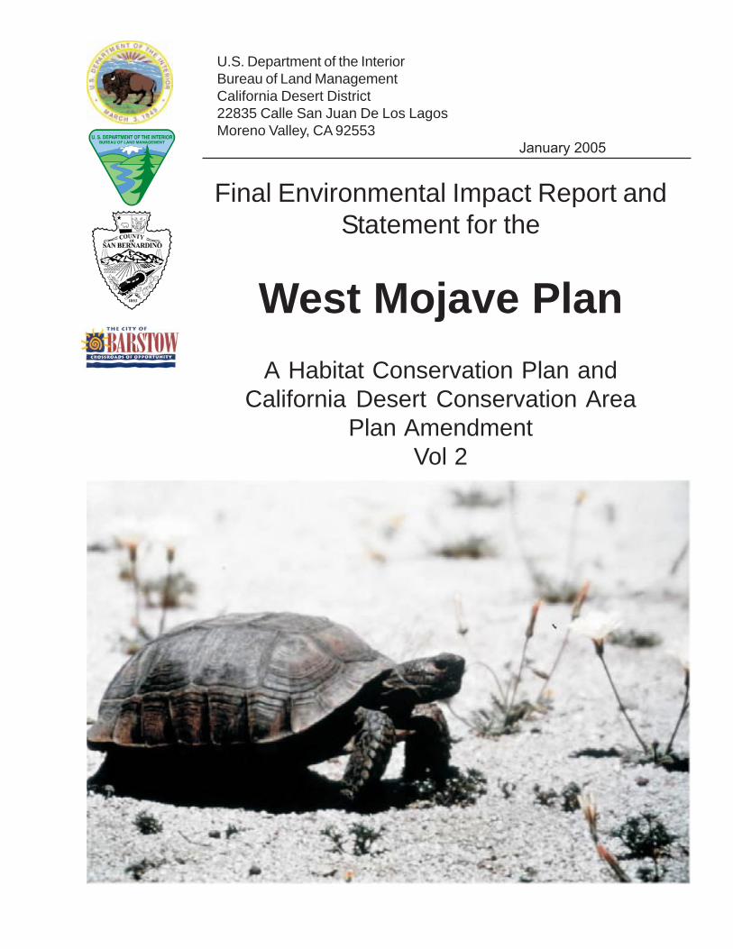
U.S. Department of the InteriorBureau of Land ManagementCalifornia Desert District22835 Calle San Juan De Los LagosMoreno Valley, CA 92553
January 2005
Final Environmental Impact Report andStatement for the
West Mojave PlanA Habitat Conservation Plan and
California Desert Conservation AreaPlan Amendment
Vol 2
BLM/CA/ES-2004-005 + 1790 - 1600

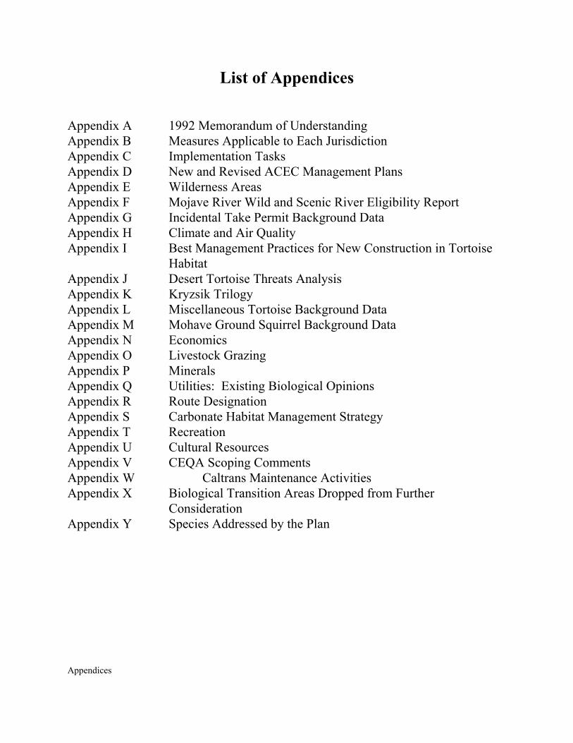
Appendices
APPENDICES
Appendices
List of Appendices Appendix A 1992 Memorandum of Understanding Appendix B Measures Applicable to Each Jurisdiction Appendix C Implementation Tasks Appendix D New and Revised ACEC Management Plans Appendix E Wilderness Areas Appendix F Mojave River Wild and Scenic River Eligibility Report Appendix G Incidental Take Permit Background Data Appendix H Climate and Air Quality Appendix I Best Management Practices for New Construction in Tortoise
Habitat Appendix J Desert Tortoise Threats Analysis Appendix K Kryzsik Trilogy Appendix L Miscellaneous Tortoise Background Data Appendix M Mohave Ground Squirrel Background Data Appendix N Economics Appendix O Livestock Grazing Appendix P Minerals Appendix Q Utilities: Existing Biological Opinions Appendix R Route Designation Appendix S Carbonate Habitat Management Strategy Appendix T Recreation Appendix U Cultural Resources Appendix V CEQA Scoping Comments Appendix W Caltrans Maintenance Activities Appendix X Biological Transition Areas Dropped from Further
Consideration Appendix Y Species Addressed by the Plan

Appendices
APPENDIX A
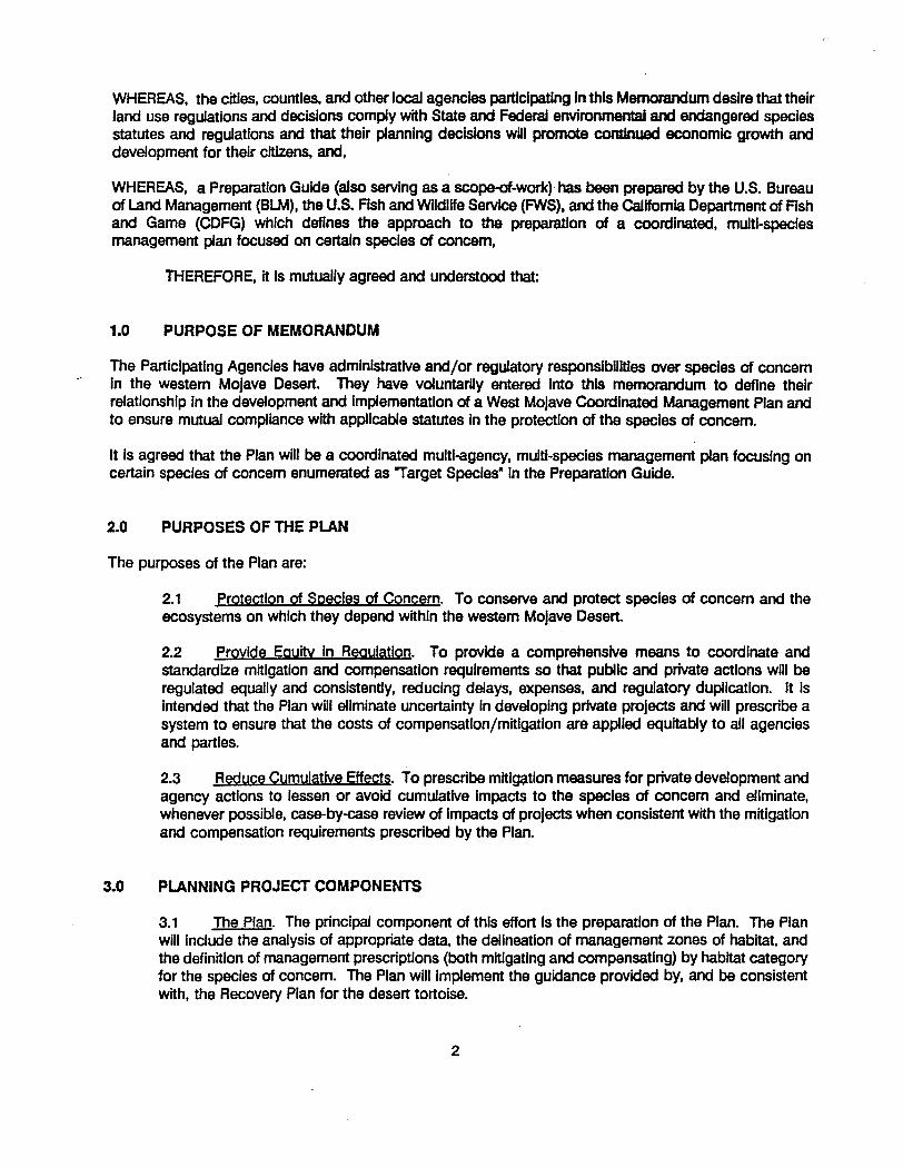
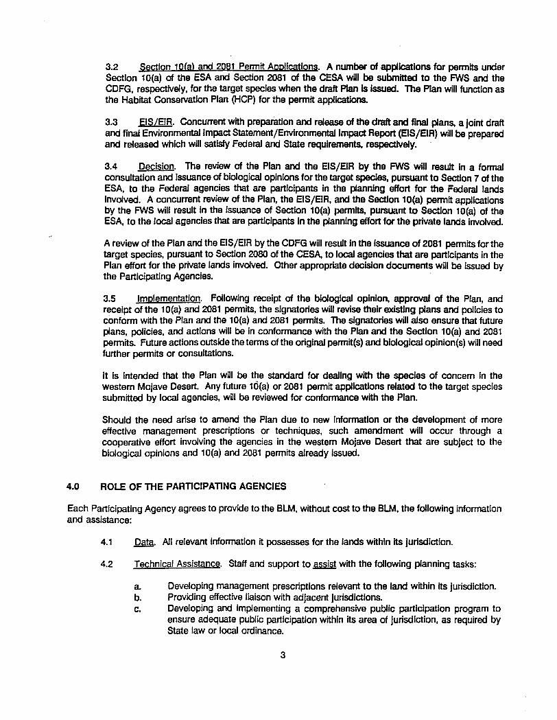
1992 MEMORANDUM OF UNDERSTANDING

Appendices


Appendices

Appendices
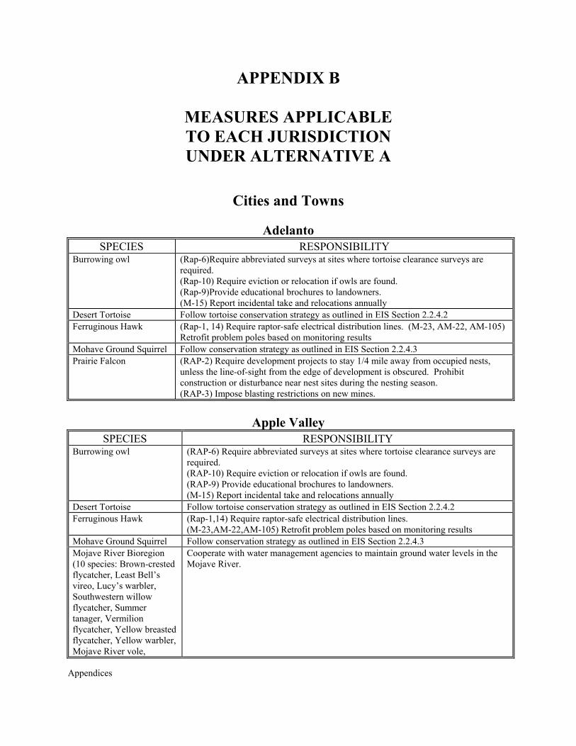
APPENDIX B
MEASURES APPLICABLE TO EACH
JURISDICTION

Appendices
Appendices
APPENDIX B
MEASURES APPLICABLE TO EACH JURISDICTION UNDER ALTERNATIVE A
Cities and Towns
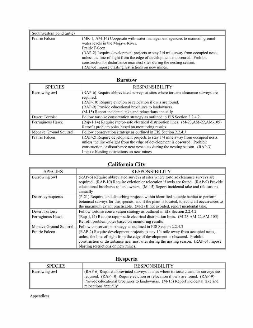
Adelanto SPECIES RESPONSIBILITY
Burrowing owl (Rap-6)Require abbreviated surveys at sites where tortoise clearance surveys are required. (Rap-10) Require eviction or relocation if owls are found. (Rap-9)Provide educational brochures to landowners. (M-15) Report incidental take and relocations annually
Desert Tortoise Follow tortoise conservation strategy as outlined in EIS Section 2.2.4.2 Ferruginous Hawk (Rap-1, 14) Require raptor-safe electrical distribution lines. (M-23, AM-22, AM-105)
Retrofit problem poles based on monitoring results Mohave Ground Squirrel Follow conservation strategy as outlined in EIS Section 2.2.4.3 Prairie Falcon (RAP-2) Require development projects to stay 1/4 mile away from occupied nests,
unless the line-of-sight from the edge of development is obscured. Prohibit construction or disturbance near nest sites during the nesting season. (RAP-3) Impose blasting restrictions on new mines.
Apple Valley
SPECIES RESPONSIBILITY Burrowing owl (RAP-6) Require abbreviated surveys at sites where tortoise clearance surveys are
required. (RAP-10) Require eviction or relocation if owls are found. (RAP-9) Provide educational brochures to landowners. (M-15) Report incidental take and relocations annually
Desert Tortoise Follow tortoise conservation strategy as outlined in EIS Section 2.2.4.2 Ferruginous Hawk (Rap-1,14) Require raptor-safe electrical distribution lines.
(M-23,AM-22,AM-105) Retrofit problem poles based on monitoring results Mohave Ground Squirrel Follow conservation strategy as outlined in EIS Section 2.2.4.3 Mojave River Bioregion (10 species: Brown-crested flycatcher, Least Bell’s vireo, Lucy’s warbler, Southwestern willow flycatcher, Summer tanager, Vermilion flycatcher, Yellow breasted flycatcher, Yellow warbler, Mojave River vole,
Cooperate with water management agencies to maintain ground water levels in the Mojave River.
Appendices
Southwestern pond turtle) Prairie Falcon (MR-1, AM-14) Cooperate with water management agencies to maintain ground
water levels in the Mojave River. Prairie Falcon (RAP-2) Require development projects to stay 1/4 mile away from occupied nests, unless the line-of-sight from the edge of development is obscured. Prohibit construction or disturbance near nest sites during the nesting season. (RAP-3) Impose blasting restrictions on new mines.
Barstow
SPECIES RESPONSIBILITY Burrowing owl (RAP-6) Require abbreviated surveys at sites where tortoise clearance surveys are
required. (RAP-10) Require eviction or relocation if owls are found. (RAP-9) Provide educational brochures to landowners. (M-15) Report incidental take and relocations annually
Desert Tortoise Follow tortoise conservation strategy as outlined in EIS Section 2.2.4.2 Ferruginous Hawk (Rap-1,14) Require raptor-safe electrical distribution lines. (M-23,AM-22,AM-105)
Retrofit problem poles based on monitoring results Mohave Ground Squirrel Follow conservation strategy as outlined in EIS Section 2.2.4.3 Prairie Falcon (RAP-2) Require development projects to stay 1/4 mile away from occupied nests,
unless the line-of-sight from the edge of development is obscured. Prohibit construction or disturbance near nest sites during the nesting season. (RAP-3) Impose blasting restrictions on new mines.
California City
SPECIES RESPONSIBILITY Burrowing owl (RAP-6) Require abbreviated surveys at sites where tortoise clearance surveys are
required. (RAP-10) Require eviction or relocation if owls are found. (RAP-9) Provide educational brochures to landowners. (M-15) Report incidental take and relocations annually
Desert cymopterus (P-21) Require land disturbing projects within identified suitable habitat to perform botanical surveys for this species, and if the plant is located, to avoid all occurrences to the maximum extant practicable. (M-2) If not avoided, report incidental take.
Desert Tortoise Follow tortoise conservation strategy as outlined in EIS Section 2.2.4.2 Ferruginous Hawk (Rap-1,14) Require raptor-safe electrical distribution lines. (M-23,AM-22,AM-105)
Retrofit problem poles based on monitoring results Mohave Ground Squirrel Follow conservation strategy as outlined in EIS Section 2.2.4.3 Prairie Falcon (RAP-2) Require development projects to stay 1/4 mile away from occupied nests,
unless the line-of-sight from the edge of development is obscured. Prohibit construction or disturbance near nest sites during the nesting season. (RAP-3) Impose blasting restrictions on new mines.
Hesperia
SPECIES RESPONSIBILITY Burrowing owl (RAP-6) Require abbreviated surveys at sites where tortoise clearance surveys are
required. (RAP-10) Require eviction or relocation if owls are found. (RAP-9) Provide educational brochures to landowners. (M-15) Report incidental take and relocations annually
Appendices
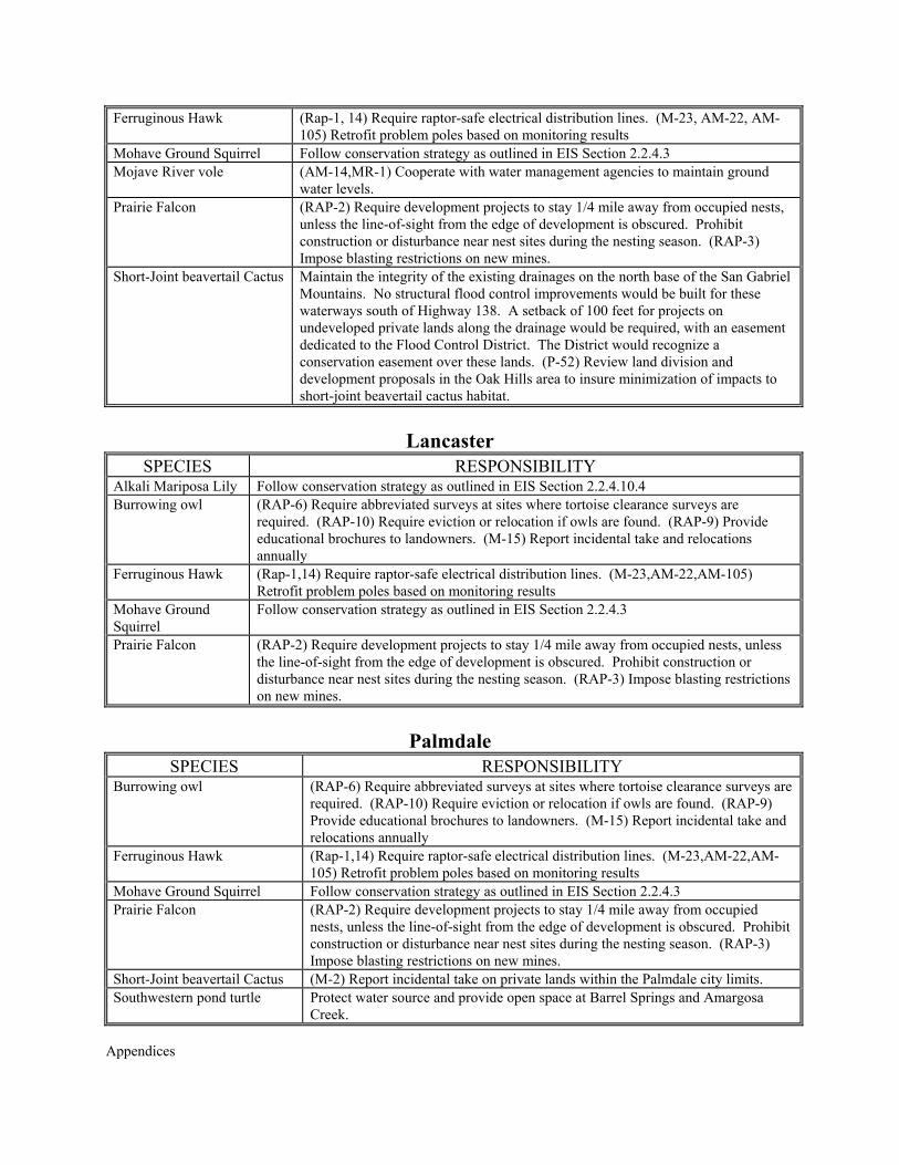
Ferruginous Hawk (Rap-1, 14) Require raptor-safe electrical distribution lines. (M-23, AM-22, AM-105) Retrofit problem poles based on monitoring results
Mohave Ground Squirrel Follow conservation strategy as outlined in EIS Section 2.2.4.3 Mojave River vole (AM-14,MR-1) Cooperate with water management agencies to maintain ground
water levels. Prairie Falcon (RAP-2) Require development projects to stay 1/4 mile away from occupied nests,
unless the line-of-sight from the edge of development is obscured. Prohibit construction or disturbance near nest sites during the nesting season. (RAP-3) Impose blasting restrictions on new mines.
Short-Joint beavertail Cactus Maintain the integrity of the existing drainages on the north base of the San Gabriel Mountains. No structural flood control improvements would be built for these waterways south of Highway 138. A setback of 100 feet for projects on undeveloped private lands along the drainage would be required, with an easement dedicated to the Flood Control District. The District would recognize a conservation easement over these lands. (P-52) Review land division and development proposals in the Oak Hills area to insure minimization of impacts to short-joint beavertail cactus habitat.
Lancaster
SPECIES RESPONSIBILITY Alkali Mariposa Lily Follow conservation strategy as outlined in EIS Section 2.2.4.10.4 Burrowing owl (RAP-6) Require abbreviated surveys at sites where tortoise clearance surveys are
required. (RAP-10) Require eviction or relocation if owls are found. (RAP-9) Provide educational brochures to landowners. (M-15) Report incidental take and relocations annually
Ferruginous Hawk (Rap-1,14) Require raptor-safe electrical distribution lines. (M-23,AM-22,AM-105) Retrofit problem poles based on monitoring results
Mohave Ground Squirrel
Follow conservation strategy as outlined in EIS Section 2.2.4.3
Prairie Falcon (RAP-2) Require development projects to stay 1/4 mile away from occupied nests, unless the line-of-sight from the edge of development is obscured. Prohibit construction or disturbance near nest sites during the nesting season. (RAP-3) Impose blasting restrictions on new mines.
Palmdale
SPECIES RESPONSIBILITY Burrowing owl (RAP-6) Require abbreviated surveys at sites where tortoise clearance surveys are
required. (RAP-10) Require eviction or relocation if owls are found. (RAP-9) Provide educational brochures to landowners. (M-15) Report incidental take and relocations annually
Ferruginous Hawk (Rap-1,14) Require raptor-safe electrical distribution lines. (M-23,AM-22,AM-105) Retrofit problem poles based on monitoring results
Mohave Ground Squirrel Follow conservation strategy as outlined in EIS Section 2.2.4.3 Prairie Falcon (RAP-2) Require development projects to stay 1/4 mile away from occupied
nests, unless the line-of-sight from the edge of development is obscured. Prohibit construction or disturbance near nest sites during the nesting season. (RAP-3) Impose blasting restrictions on new mines.
Short-Joint beavertail Cactus (M-2) Report incidental take on private lands within the Palmdale city limits. Southwestern pond turtle Protect water source and provide open space at Barrel Springs and Amargosa
Creek.
Appendices
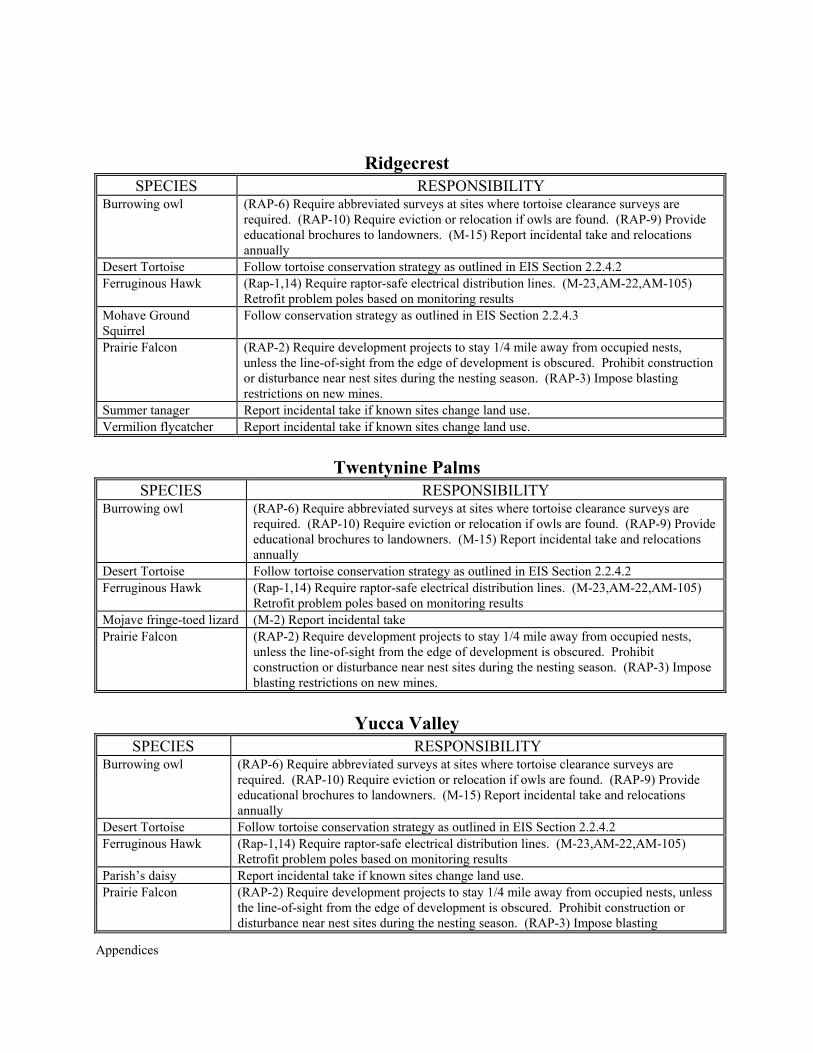
Ridgecrest SPECIES RESPONSIBILITY
Burrowing owl (RAP-6) Require abbreviated surveys at sites where tortoise clearance surveys are required. (RAP-10) Require eviction or relocation if owls are found. (RAP-9) Provide educational brochures to landowners. (M-15) Report incidental take and relocations annually
Desert Tortoise Follow tortoise conservation strategy as outlined in EIS Section 2.2.4.2 Ferruginous Hawk (Rap-1,14) Require raptor-safe electrical distribution lines. (M-23,AM-22,AM-105)
Retrofit problem poles based on monitoring results Mohave Ground Squirrel
Follow conservation strategy as outlined in EIS Section 2.2.4.3
Prairie Falcon (RAP-2) Require development projects to stay 1/4 mile away from occupied nests, unless the line-of-sight from the edge of development is obscured. Prohibit construction or disturbance near nest sites during the nesting season. (RAP-3) Impose blasting restrictions on new mines.
Summer tanager Report incidental take if known sites change land use. Vermilion flycatcher Report incidental take if known sites change land use.
Twentynine Palms
SPECIES RESPONSIBILITY Burrowing owl (RAP-6) Require abbreviated surveys at sites where tortoise clearance surveys are
required. (RAP-10) Require eviction or relocation if owls are found. (RAP-9) Provide educational brochures to landowners. (M-15) Report incidental take and relocations annually
Desert Tortoise Follow tortoise conservation strategy as outlined in EIS Section 2.2.4.2 Ferruginous Hawk (Rap-1,14) Require raptor-safe electrical distribution lines. (M-23,AM-22,AM-105)
Retrofit problem poles based on monitoring results Mojave fringe-toed lizard (M-2) Report incidental take Prairie Falcon (RAP-2) Require development projects to stay 1/4 mile away from occupied nests,
unless the line-of-sight from the edge of development is obscured. Prohibit construction or disturbance near nest sites during the nesting season. (RAP-3) Impose blasting restrictions on new mines.
Yucca Valley
SPECIES RESPONSIBILITY Burrowing owl (RAP-6) Require abbreviated surveys at sites where tortoise clearance surveys are
required. (RAP-10) Require eviction or relocation if owls are found. (RAP-9) Provide educational brochures to landowners. (M-15) Report incidental take and relocations annually
Desert Tortoise Follow tortoise conservation strategy as outlined in EIS Section 2.2.4.2 Ferruginous Hawk (Rap-1,14) Require raptor-safe electrical distribution lines. (M-23,AM-22,AM-105)
Retrofit problem poles based on monitoring results Parish’s daisy Report incidental take if known sites change land use. Prairie Falcon (RAP-2) Require development projects to stay 1/4 mile away from occupied nests, unless
the line-of-sight from the edge of development is obscured. Prohibit construction or disturbance near nest sites during the nesting season. (RAP-3) Impose blasting
Appendices
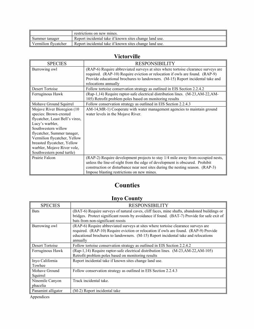
restrictions on new mines. Summer tanager Report incidental take if known sites change land use. Vermilion flycatcher Report incidental take if known sites change land use.
Victorville
SPECIES RESPONSIBILITY Burrowing owl (RAP-6) Require abbreviated surveys at sites where tortoise clearance surveys are
required. (RAP-10) Require eviction or relocation if owls are found. (RAP-9) Provide educational brochures to landowners. (M-15) Report incidental take and relocations annually
Desert Tortoise Follow tortoise conservation strategy as outlined in EIS Section 2.2.4.2 Ferruginous Hawk (Rap-1,14) Require raptor-safe electrical distribution lines. (M-23,AM-22,AM-
105) Retrofit problem poles based on monitoring results Mohave Ground Squirrel Follow conservation strategy as outlined in EIS Section 2.2.4.3 Mojave River Bioregion (10 species: Brown-crested flycatcher, Least Bell’s vireo, Lucy’s warbler, Southwestern willow flycatcher, Summer tanager, Vermilion flycatcher, Yellow breasted flycatcher, Yellow warbler, Mojave River vole, Southwestern pond turtle)
AM-14,MR-1) Cooperate with water management agencies to maintain ground water levels in the Mojave River.
Prairie Falcon (RAP-2) Require development projects to stay 1/4 mile away from occupied nests, unless the line-of-sight from the edge of development is obscured. Prohibit construction or disturbance near nest sites during the nesting season. (RAP-3) Impose blasting restrictions on new mines.
Counties
Inyo County
SPECIES RESPONSIBILITY Bats (BAT-6) Require surveys of natural caves, cliff faces, mine shafts, abandoned buildings or
bridges. Protect significant roosts by avoidance if found. (BAT-7) Provide for safe exit of bats from non-significant roosts
Burrowing owl (RAP-6) Require abbreviated surveys at sites where tortoise clearance surveys are required. (RAP-10) Require eviction or relocation if owls are found. (RAP-9) Provide educational brochures to landowners. (M-15) Report incidental take and relocations annually
Desert Tortoise Follow tortoise conservation strategy as outlined in EIS Section 2.2.4.2 Ferruginous Hawk (Rap-1,14) Require raptor-safe electrical distribution lines. (M-23,AM-22,AM-105)
Retrofit problem poles based on monitoring results Inyo California Towhee
Report incidental take if known sites change land use.
Mohave Ground Squirrel
Follow conservation strategy as outlined in EIS Section 2.2.4.3
Ninemile Canyon phacelia
Track incidental take.
Panamint alligator (M-2) Report incidental take
Appendices
lizard Prairie Falcon (RAP-2) Require development projects to stay 1/4 mile away from occupied nests, unless
the line-of-sight from the edge of development is obscured. Prohibit construction or disturbance near nest sites during the nesting season. (RAP-3) Impose blasting restrictions on new mines.
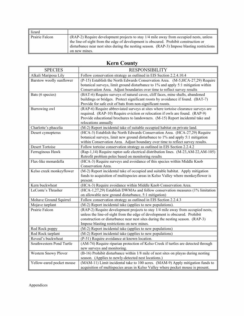
Kern County
SPECIES RESPONSIBILITY Alkali Mariposa Lily Follow conservation strategy as outlined in EIS Section 2.2.4.10.4 Barstow woolly sunflower (P-15) Establish the North Edwards Conservation Area. (M-5,HCA-27,29) Require
botanical surveys, limit ground disturbance to 1% and apply 5:1 mitigation within Conservation Area. Adjust boundaries over time to reflect survey results
Bats (6 species) (BAT-6) Require surveys of natural caves, cliff faces, mine shafts, abandoned buildings or bridges. Protect significant roosts by avoidance if found. (BAT-7) Provide for safe exit of bats from non-significant roosts.
Burrowing owl (RAP-6) Require abbreviated surveys at sites where tortoise clearance surveys are required. (RAP-10) Require eviction or relocation if owls are found. (RAP-9) Provide educational brochures to landowners. (M-15) Report incidental take and relocations annually
Charlotte’s phacelia (M-2) Report incidental take of suitable occupied habitat on private land. Desert cymopterus (HCA-3) Establish the North Edwards Conservation Area. (HCA-27,29) Require
botanical surveys, limit new ground disturbance to 1% and apply 5:1 mitigation within Conservation Area. Adjust boundary over time to reflect survey results.
Desert Tortoise Follow tortoise conservation strategy as outlined in EIS Section 2.2.4.2 Ferruginous Hawk (Rap-1,14) Require raptor-safe electrical distribution lines. (M-23,AM-22,AM-105)
Retrofit problem poles based on monitoring results Flax-like monardella (HCA-3) Require surveys and avoidance of this species within Middle Knob
Conservation Area. Kelso creek monkeyflower (M-2) Report incidental take of occupied and suitable habitat. Apply mitigation
funds to acquisition of multispecies areas in Kelso Valley where monkeyflower is present.
Kern buckwheat (HCA-3) Require avoidance within Middle Knob Conservation Area. LeConte’s Thrasher (HCA-1,27,29) Establish DWMAs and follow conservation measures (1% limitation
on allowable new ground disturbance, 5:1 mitigation) Mohave Ground Squirrel Follow conservation strategy as outlined in EIS Section 2.2.4.3 Mojave tarplant (M-2) Report incidental take (applies to new populations). Prairie Falcon (RAP-2) Require development projects to stay 1/4 mile away from occupied nests,
unless the line-of-sight from the edge of development is obscured. Prohibit construction or disturbance near nest sites during the nesting season. (RAP-3) Impose blasting restrictions on new mines.
Red Rock poppy (M-2) Report incidental take (applies to new populations) Red Rock tarplant (M-2) Report incidental take (applies to new populations) Reveal’s buckwheat (P-51) Require avoidance at known location. Southwestern Pond Turtle (AM-74) Require riparian protection of Kelso Creek if turtles are detected through
new surveys and monitoring. Western Snowy Plover (B-16) Prohibit disturbance within 1/8 mile of nest sites on playas during nesting
season. (Applies to newly-detected nest locations.) Yellow-eared pocket mouse (MAM-11) Limit incidental take to 100 acres. (MAM-9) Apply mitigation funds to
acquisition of multispecies areas in Kelso Valley where pocket mouse is present.
Appendices
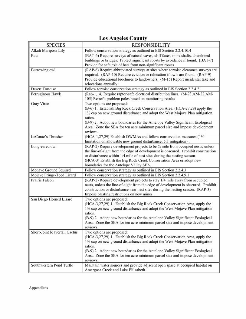
Los Angeles County
SPECIES RESPONSIBILITY Alkali Mariposa Lily Follow conservation strategy as outlined in EIS Section 2.2.4.10.4 Bats (BAT-6) Require surveys of natural caves, cliff faces, mine shafts, abandoned
buildings or bridges. Protect significant roosts by avoidance if found. (BAT-7) Provide for safe exit of bats from non-significant roosts.
Burrowing owl (RAP-6) Require abbreviated surveys at sites where tortoise clearance surveys are required. (RAP-10) Require eviction or relocation if owls are found. (RAP-9) Provide educational brochures to landowners. (M-15) Report incidental take and relocations annually
Desert Tortoise Follow tortoise conservation strategy as outlined in EIS Section 2.2.4.2 Ferruginous Hawk (Rap-1,14) Require raptor-safe electrical distribution lines. (M-23,AM-22,AM-
105) Retrofit problem poles based on monitoring results Gray Vireo Two options are proposed:
(B-6) 1. Establish Big Rock Creek Conservation Area, (HCA-27,29) apply the 1% cap on new ground disturbance and adopt the West Mojave Plan mitigation ratios. (B-9) 2. Adopt new boundaries for the Antelope Valley Significant Ecological Area. Zone the SEA for ten acre minimum parcel size and impose development reviews.
LeConte’s Thrasher (HCA-1,27,29) Establish DWMAs and follow conservation measures (1% limitation on allowable new ground disturbance, 5:1 mitigation) .
Long-eared owl (RAP-2) Require development projects to be ¼ mile from occupied nests, unless the line-of-sight from the edge of development is obscured. Prohibit construction or disturbance within 1/4 mile of nest sites during the nesting season. (HCA-3) Establish the Big Rock Creek Conservation Area or adopt new boundaries for the Antelope Valley SEA.
Mohave Ground Squirrel Follow conservation strategy as outlined in EIS Section 2.2.4.3 Mojave Fringe-Toed Lizard Follow conservation strategy as outlined in EIS Section 2.2.4.9.1 Prairie Falcon (RAP-2) Require development projects to stay 1/4 mile away from occupied
nests, unless the line-of-sight from the edge of development is obscured. Prohibit construction or disturbance near nest sites during the nesting season. (RAP-3) Impose blasting restrictions on new mines.
San Diego Horned Lizard Two options are proposed: (HCA-3,27,29) 1. Establish the Big Rock Creek Conservation Area, apply the 1% cap on new ground disturbance and adopt the West Mojave Plan mitigation ratios. (B-9) 2. Adopt new boundaries for the Antelope Valley Significant Ecological Area. Zone the SEA for ten acre minimum parcel size and impose development reviews.
Short-Joint beavertail Cactus Two options are proposed: (HCA-3,27,29) 1. Establish the Big Rock Creek Conservation Area, apply the 1% cap on new ground disturbance and adopt the West Mojave Plan mitigation ratios. (B-9) 2. Adopt new boundaries for the Antelope Valley Significant Ecological Area. Zone the SEA for ten acre minimum parcel size and impose development reviews.
Southwestern Pond Turtle Maintain water sources and provide adjacent open space at occupied habitat on Amargosa Creek and Lake Elilzabeth.
Appendices
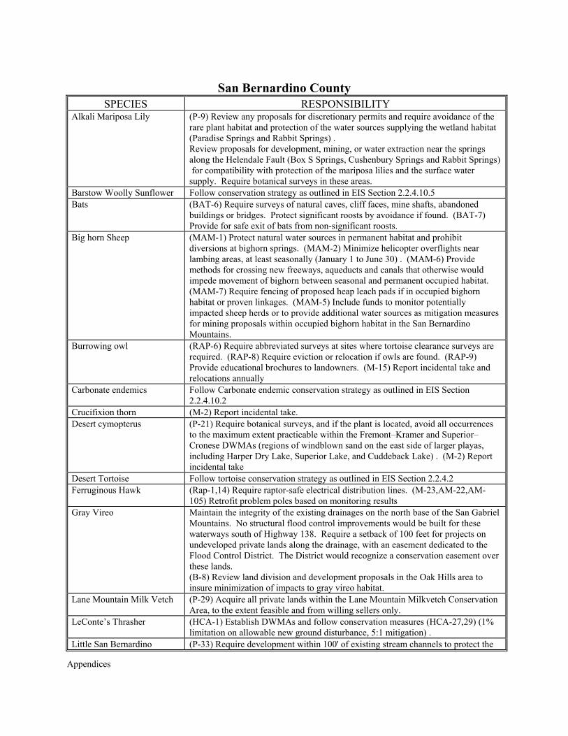
San Bernardino County
SPECIES RESPONSIBILITY Alkali Mariposa Lily (P-9) Review any proposals for discretionary permits and require avoidance of the
rare plant habitat and protection of the water sources supplying the wetland habitat (Paradise Springs and Rabbit Springs) . Review proposals for development, mining, or water extraction near the springs along the Helendale Fault (Box S Springs, Cushenbury Springs and Rabbit Springs) for compatibility with protection of the mariposa lilies and the surface water supply. Require botanical surveys in these areas.
Barstow Woolly Sunflower Follow conservation strategy as outlined in EIS Section 2.2.4.10.5 Bats (BAT-6) Require surveys of natural caves, cliff faces, mine shafts, abandoned
buildings or bridges. Protect significant roosts by avoidance if found. (BAT-7) Provide for safe exit of bats from non-significant roosts.
Big horn Sheep (MAM-1) Protect natural water sources in permanent habitat and prohibit diversions at bighorn springs. (MAM-2) Minimize helicopter overflights near lambing areas, at least seasonally (January 1 to June 30) . (MAM-6) Provide methods for crossing new freeways, aqueducts and canals that otherwise would impede movement of bighorn between seasonal and permanent occupied habitat. (MAM-7) Require fencing of proposed heap leach pads if in occupied bighorn habitat or proven linkages. (MAM-5) Include funds to monitor potentially impacted sheep herds or to provide additional water sources as mitigation measures for mining proposals within occupied bighorn habitat in the San Bernardino Mountains.
Burrowing owl (RAP-6) Require abbreviated surveys at sites where tortoise clearance surveys are required. (RAP-8) Require eviction or relocation if owls are found. (RAP-9) Provide educational brochures to landowners. (M-15) Report incidental take and relocations annually
Carbonate endemics Follow Carbonate endemic conservation strategy as outlined in EIS Section 2.2.4.10.2
Crucifixion thorn (M-2) Report incidental take. Desert cymopterus (P-21) Require botanical surveys, and if the plant is located, avoid all occurrences
to the maximum extent practicable within the Fremont–Kramer and Superior–Cronese DWMAs (regions of windblown sand on the east side of larger playas, including Harper Dry Lake, Superior Lake, and Cuddeback Lake) . (M-2) Report incidental take
Desert Tortoise Follow tortoise conservation strategy as outlined in EIS Section 2.2.4.2 Ferruginous Hawk (Rap-1,14) Require raptor-safe electrical distribution lines. (M-23,AM-22,AM-
105) Retrofit problem poles based on monitoring results Gray Vireo Maintain the integrity of the existing drainages on the north base of the San Gabriel
Mountains. No structural flood control improvements would be built for these waterways south of Highway 138. Require a setback of 100 feet for projects on undeveloped private lands along the drainage, with an easement dedicated to the Flood Control District. The District would recognize a conservation easement over these lands. (B-8) Review land division and development proposals in the Oak Hills area to insure minimization of impacts to gray vireo habitat.
Lane Mountain Milk Vetch (P-29) Acquire all private lands within the Lane Mountain Milkvetch Conservation Area, to the extent feasible and from willing sellers only.
LeConte’s Thrasher (HCA-1) Establish DWMAs and follow conservation measures (HCA-27,29) (1% limitation on allowable new ground disturbance, 5:1 mitigation) .
Little San Bernardino (P-33) Require development within 100' of existing stream channels to protect the
Appendices
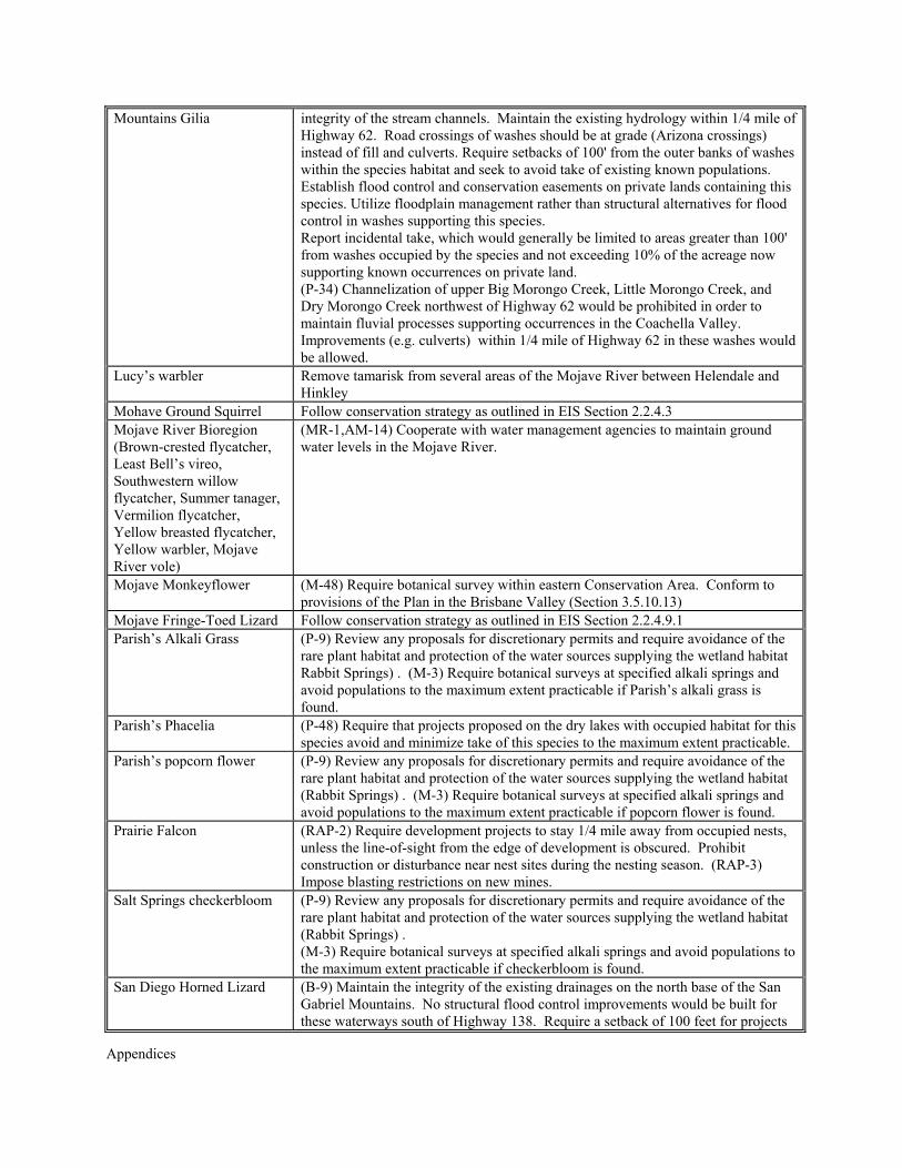
Mountains Gilia integrity of the stream channels. Maintain the existing hydrology within 1/4 mile of Highway 62. Road crossings of washes should be at grade (Arizona crossings) instead of fill and culverts. Require setbacks of 100' from the outer banks of washes within the species habitat and seek to avoid take of existing known populations. Establish flood control and conservation easements on private lands containing this species. Utilize floodplain management rather than structural alternatives for flood control in washes supporting this species. Report incidental take, which would generally be limited to areas greater than 100' from washes occupied by the species and not exceeding 10% of the acreage now supporting known occurrences on private land. (P-34) Channelization of upper Big Morongo Creek, Little Morongo Creek, and Dry Morongo Creek northwest of Highway 62 would be prohibited in order to maintain fluvial processes supporting occurrences in the Coachella Valley. Improvements (e.g. culverts) within 1/4 mile of Highway 62 in these washes would be allowed.
Lucy’s warbler Remove tamarisk from several areas of the Mojave River between Helendale and Hinkley
Mohave Ground Squirrel Follow conservation strategy as outlined in EIS Section 2.2.4.3 Mojave River Bioregion (Brown-crested flycatcher, Least Bell’s vireo, Southwestern willow flycatcher, Summer tanager, Vermilion flycatcher, Yellow breasted flycatcher, Yellow warbler, Mojave River vole)
(MR-1,AM-14) Cooperate with water management agencies to maintain ground water levels in the Mojave River.
Mojave Monkeyflower (M-48) Require botanical survey within eastern Conservation Area. Conform to provisions of the Plan in the Brisbane Valley (Section 3.5.10.13)
Mojave Fringe-Toed Lizard Follow conservation strategy as outlined in EIS Section 2.2.4.9.1 Parish’s Alkali Grass (P-9) Review any proposals for discretionary permits and require avoidance of the
rare plant habitat and protection of the water sources supplying the wetland habitat Rabbit Springs) . (M-3) Require botanical surveys at specified alkali springs and avoid populations to the maximum extent practicable if Parish’s alkali grass is found.
Parish’s Phacelia (P-48) Require that projects proposed on the dry lakes with occupied habitat for this species avoid and minimize take of this species to the maximum extent practicable.
Parish’s popcorn flower (P-9) Review any proposals for discretionary permits and require avoidance of the rare plant habitat and protection of the water sources supplying the wetland habitat (Rabbit Springs) . (M-3) Require botanical surveys at specified alkali springs and avoid populations to the maximum extent practicable if popcorn flower is found.
Prairie Falcon (RAP-2) Require development projects to stay 1/4 mile away from occupied nests, unless the line-of-sight from the edge of development is obscured. Prohibit construction or disturbance near nest sites during the nesting season. (RAP-3) Impose blasting restrictions on new mines.
Salt Springs checkerbloom (P-9) Review any proposals for discretionary permits and require avoidance of the rare plant habitat and protection of the water sources supplying the wetland habitat (Rabbit Springs) . (M-3) Require botanical surveys at specified alkali springs and avoid populations to the maximum extent practicable if checkerbloom is found.
San Diego Horned Lizard (B-9) Maintain the integrity of the existing drainages on the north base of the San Gabriel Mountains. No structural flood control improvements would be built for these waterways south of Highway 138. Require a setback of 100 feet for projects
Appendices
on undeveloped private lands along the drainage, with an easement dedicated to the Flood Control District. The District would recognize a conservation easement over these lands.
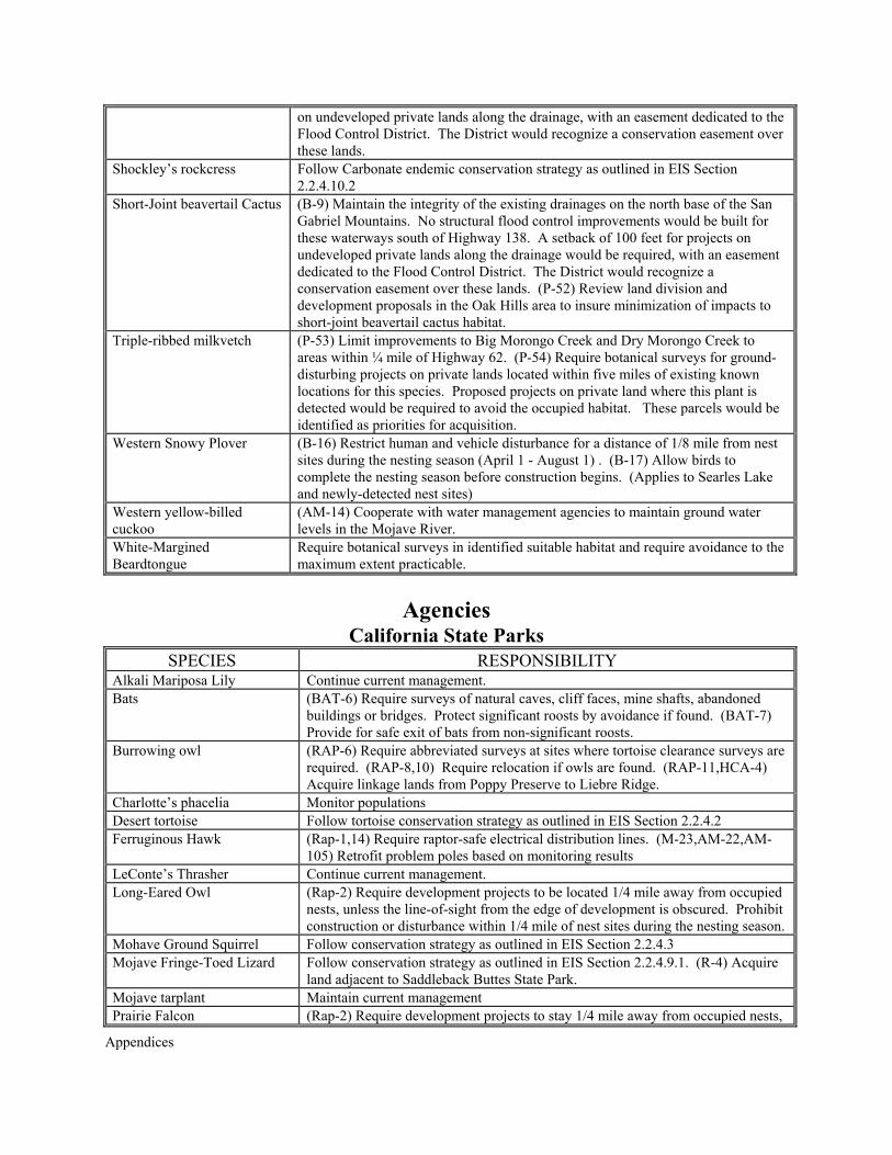
Shockley’s rockcress Follow Carbonate endemic conservation strategy as outlined in EIS Section 2.2.4.10.2
Short-Joint beavertail Cactus (B-9) Maintain the integrity of the existing drainages on the north base of the San Gabriel Mountains. No structural flood control improvements would be built for these waterways south of Highway 138. A setback of 100 feet for projects on undeveloped private lands along the drainage would be required, with an easement dedicated to the Flood Control District. The District would recognize a conservation easement over these lands. (P-52) Review land division and development proposals in the Oak Hills area to insure minimization of impacts to short-joint beavertail cactus habitat.
Triple-ribbed milkvetch (P-53) Limit improvements to Big Morongo Creek and Dry Morongo Creek to areas within ¼ mile of Highway 62. (P-54) Require botanical surveys for ground-disturbing projects on private lands located within five miles of existing known locations for this species. Proposed projects on private land where this plant is detected would be required to avoid the occupied habitat. These parcels would be identified as priorities for acquisition.
Western Snowy Plover (B-16) Restrict human and vehicle disturbance for a distance of 1/8 mile from nest sites during the nesting season (April 1 - August 1) . (B-17) Allow birds to complete the nesting season before construction begins. (Applies to Searles Lake and newly-detected nest sites)
Western yellow-billed cuckoo
(AM-14) Cooperate with water management agencies to maintain ground water levels in the Mojave River.
White-Margined Beardtongue
Require botanical surveys in identified suitable habitat and require avoidance to the maximum extent practicable.
Agencies
California State Parks SPECIES RESPONSIBILITY
Alkali Mariposa Lily Continue current management. Bats (BAT-6) Require surveys of natural caves, cliff faces, mine shafts, abandoned
buildings or bridges. Protect significant roosts by avoidance if found. (BAT-7) Provide for safe exit of bats from non-significant roosts.
Burrowing owl (RAP-6) Require abbreviated surveys at sites where tortoise clearance surveys are required. (RAP-8,10) Require relocation if owls are found. (RAP-11,HCA-4) Acquire linkage lands from Poppy Preserve to Liebre Ridge.
Charlotte’s phacelia Monitor populations Desert tortoise Follow tortoise conservation strategy as outlined in EIS Section 2.2.4.2 Ferruginous Hawk (Rap-1,14) Require raptor-safe electrical distribution lines. (M-23,AM-22,AM-
105) Retrofit problem poles based on monitoring results LeConte’s Thrasher Continue current management. Long-Eared Owl (Rap-2) Require development projects to be located 1/4 mile away from occupied
nests, unless the line-of-sight from the edge of development is obscured. Prohibit construction or disturbance within 1/4 mile of nest sites during the nesting season.
Mohave Ground Squirrel Follow conservation strategy as outlined in EIS Section 2.2.4.3 Mojave Fringe-Toed Lizard Follow conservation strategy as outlined in EIS Section 2.2.4.9.1. (R-4) Acquire
land adjacent to Saddleback Buttes State Park. Mojave tarplant Maintain current management Prairie Falcon (Rap-2) Require development projects to stay 1/4 mile away from occupied nests,
Appendices
unless the line-of-sight from the edge of development is obscured. Prohibit construction or disturbance near nest sites during the nesting season.
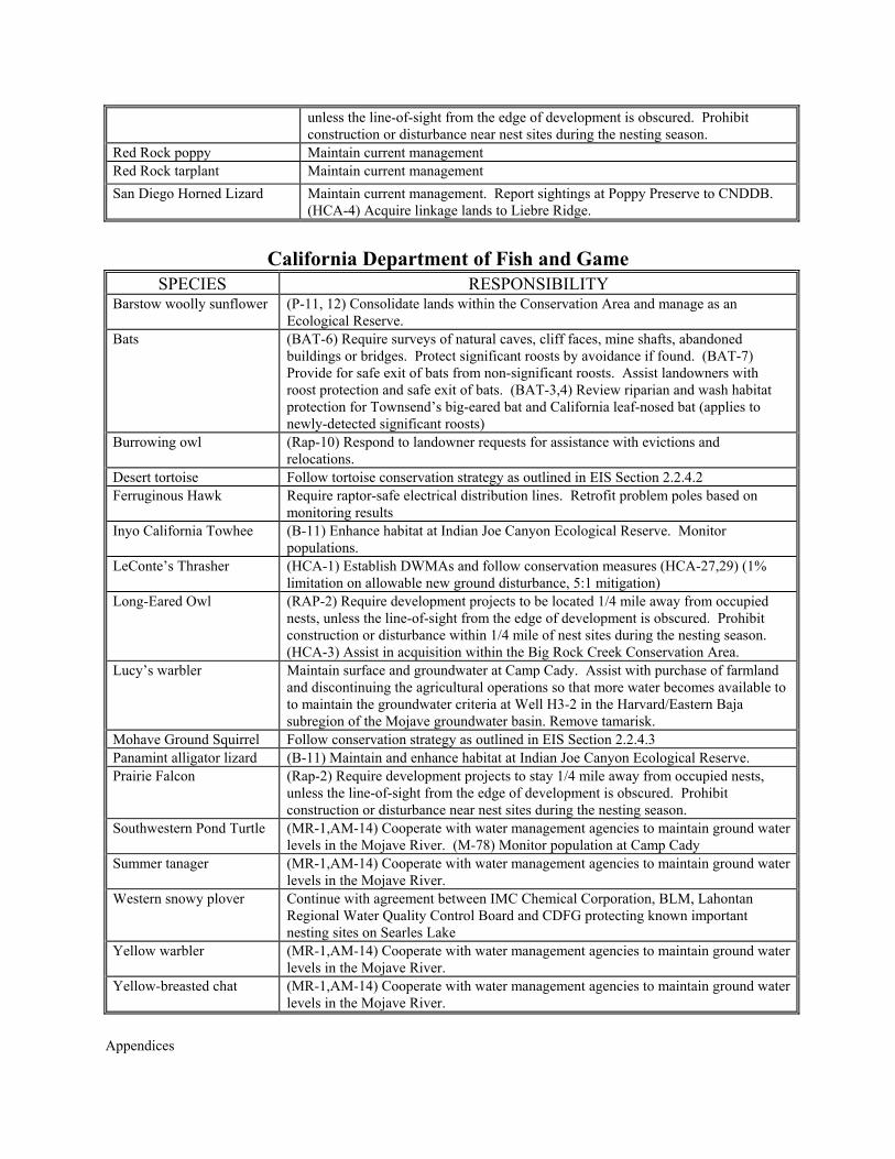
Red Rock poppy Maintain current management Red Rock tarplant Maintain current management San Diego Horned Lizard Maintain current management. Report sightings at Poppy Preserve to CNDDB.
(HCA-4) Acquire linkage lands to Liebre Ridge.
California Department of Fish and Game
SPECIES RESPONSIBILITY Barstow woolly sunflower (P-11, 12) Consolidate lands within the Conservation Area and manage as an
Ecological Reserve. Bats (BAT-6) Require surveys of natural caves, cliff faces, mine shafts, abandoned
buildings or bridges. Protect significant roosts by avoidance if found. (BAT-7) Provide for safe exit of bats from non-significant roosts. Assist landowners with roost protection and safe exit of bats. (BAT-3,4) Review riparian and wash habitat protection for Townsend’s big-eared bat and California leaf-nosed bat (applies to newly-detected significant roosts)
Burrowing owl (Rap-10) Respond to landowner requests for assistance with evictions and relocations.
Desert tortoise Follow tortoise conservation strategy as outlined in EIS Section 2.2.4.2 Ferruginous Hawk Require raptor-safe electrical distribution lines. Retrofit problem poles based on
monitoring results Inyo California Towhee (B-11) Enhance habitat at Indian Joe Canyon Ecological Reserve. Monitor
populations. LeConte’s Thrasher (HCA-1) Establish DWMAs and follow conservation measures (HCA-27,29) (1%
limitation on allowable new ground disturbance, 5:1 mitigation) Long-Eared Owl (RAP-2) Require development projects to be located 1/4 mile away from occupied
nests, unless the line-of-sight from the edge of development is obscured. Prohibit construction or disturbance within 1/4 mile of nest sites during the nesting season. (HCA-3) Assist in acquisition within the Big Rock Creek Conservation Area.
Lucy’s warbler Maintain surface and groundwater at Camp Cady. Assist with purchase of farmland and discontinuing the agricultural operations so that more water becomes available to to maintain the groundwater criteria at Well H3-2 in the Harvard/Eastern Baja subregion of the Mojave groundwater basin. Remove tamarisk.
Mohave Ground Squirrel Follow conservation strategy as outlined in EIS Section 2.2.4.3 Panamint alligator lizard (B-11) Maintain and enhance habitat at Indian Joe Canyon Ecological Reserve. Prairie Falcon (Rap-2) Require development projects to stay 1/4 mile away from occupied nests,
unless the line-of-sight from the edge of development is obscured. Prohibit construction or disturbance near nest sites during the nesting season.
Southwestern Pond Turtle (MR-1,AM-14) Cooperate with water management agencies to maintain ground water levels in the Mojave River. (M-78) Monitor population at Camp Cady
Summer tanager (MR-1,AM-14) Cooperate with water management agencies to maintain ground water levels in the Mojave River.
Western snowy plover Continue with agreement between IMC Chemical Corporation, BLM, Lahontan Regional Water Quality Control Board and CDFG protecting known important nesting sites on Searles Lake
Yellow warbler (MR-1,AM-14) Cooperate with water management agencies to maintain ground water levels in the Mojave River.
Yellow-breasted chat (MR-1,AM-14) Cooperate with water management agencies to maintain ground water levels in the Mojave River.
Appendices
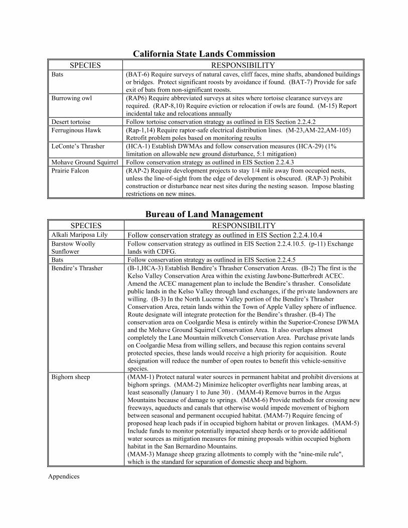
California State Lands Commission SPECIES RESPONSIBILITY
Bats (BAT-6) Require surveys of natural caves, cliff faces, mine shafts, abandoned buildings or bridges. Protect significant roosts by avoidance if found. (BAT-7) Provide for safe exit of bats from non-significant roosts.
Burrowing owl (RAP6) Require abbreviated surveys at sites where tortoise clearance surveys are required. (RAP-8,10) Require eviction or relocation if owls are found. (M-15) Report incidental take and relocations annually
Desert tortoise Follow tortoise conservation strategy as outlined in EIS Section 2.2.4.2 Ferruginous Hawk (Rap-1,14) Require raptor-safe electrical distribution lines. (M-23,AM-22,AM-105)
Retrofit problem poles based on monitoring results LeConte’s Thrasher (HCA-1) Establish DWMAs and follow conservation measures (HCA-29) (1%
limitation on allowable new ground disturbance, 5:1 mitigation) Mohave Ground Squirrel Follow conservation strategy as outlined in EIS Section 2.2.4.3 Prairie Falcon (RAP-2) Require development projects to stay 1/4 mile away from occupied nests,
unless the line-of-sight from the edge of development is obscured. (RAP-3) Prohibit construction or disturbance near nest sites during the nesting season. Impose blasting restrictions on new mines.
Bureau of Land Management
SPECIES RESPONSIBILITY Alkali Mariposa Lily Follow conservation strategy as outlined in EIS Section 2.2.4.10.4 Barstow Woolly Sunflower
Follow conservation strategy as outlined in EIS Section 2.2.4.10.5. (p-11) Exchange lands with CDFG.
Bats Follow conservation strategy as outlined in EIS Section 2.2.4.5 Bendire’s Thrasher (B-1,HCA-3) Establish Bendire’s Thrasher Conservation Areas. (B-2) The first is the
Kelso Valley Conservation Area within the existing Jawbone-Butterbredt ACEC. Amend the ACEC management plan to include the Bendire’s thrasher. Consolidate public lands in the Kelso Valley through land exchanges, if the private landowners are willing. (B-3) In the North Lucerne Valley portion of the Bendire’s Thrasher Conservation Area, retain lands within the Town of Apple Valley sphere of influence. Route designate will integrate protection for the Bendire’s thrasher. (B-4) The conservation area on Coolgardie Mesa is entirely within the Superior-Cronese DWMA and the Mohave Ground Squirrel Conservation Area. It also overlaps almost completely the Lane Mountain milkvetch Conservation Area. Purchase private lands on Coolgardie Mesa from willing sellers, and because this region contains several protected species, these lands would receive a high priority for acquisition. Route designation will reduce the number of open routes to benefit this vehicle-sensitive species.
Bighorn sheep (MAM-1) Protect natural water sources in permanent habitat and prohibit diversions at bighorn springs. (MAM-2) Minimize helicopter overflights near lambing areas, at least seasonally (January 1 to June 30) . (MAM-4) Remove burros in the Argus Mountains because of damage to springs. (MAM-6) Provide methods for crossing new freeways, aqueducts and canals that otherwise would impede movement of bighorn between seasonal and permanent occupied habitat. (MAM-7) Require fencing of proposed heap leach pads if in occupied bighorn habitat or proven linkages. (MAM-5) Include funds to monitor potentially impacted sheep herds or to provide additional water sources as mitigation measures for mining proposals within occupied bighorn habitat in the San Bernardino Mountains. (MAM-3) Manage sheep grazing allotments to comply with the "nine-mile rule", which is the standard for separation of domestic sheep and bighorn.
Appendices
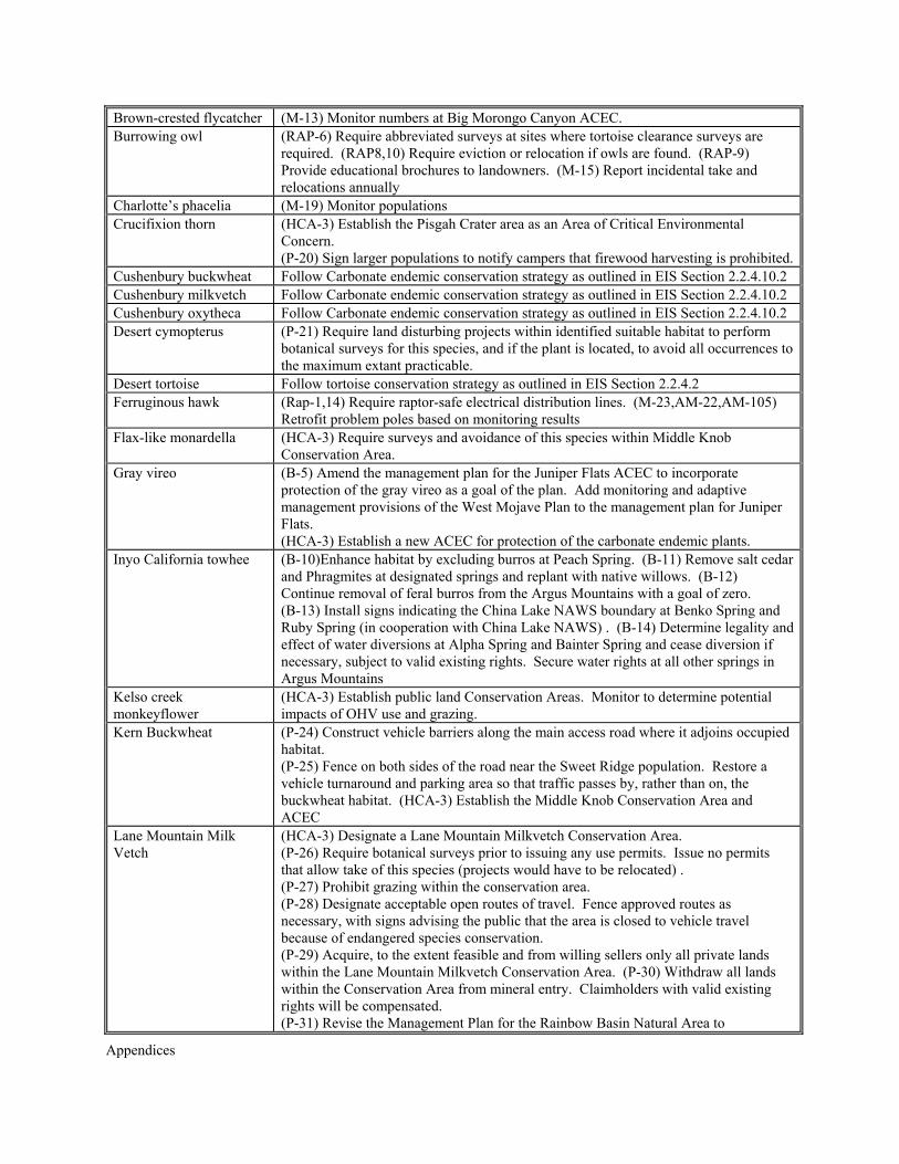
Brown-crested flycatcher (M-13) Monitor numbers at Big Morongo Canyon ACEC. Burrowing owl (RAP-6) Require abbreviated surveys at sites where tortoise clearance surveys are
required. (RAP8,10) Require eviction or relocation if owls are found. (RAP-9) Provide educational brochures to landowners. (M-15) Report incidental take and relocations annually
Charlotte’s phacelia (M-19) Monitor populations Crucifixion thorn (HCA-3) Establish the Pisgah Crater area as an Area of Critical Environmental
Concern. (P-20) Sign larger populations to notify campers that firewood harvesting is prohibited.
Cushenbury buckwheat Follow Carbonate endemic conservation strategy as outlined in EIS Section 2.2.4.10.2 Cushenbury milkvetch Follow Carbonate endemic conservation strategy as outlined in EIS Section 2.2.4.10.2 Cushenbury oxytheca Follow Carbonate endemic conservation strategy as outlined in EIS Section 2.2.4.10.2 Desert cymopterus (P-21) Require land disturbing projects within identified suitable habitat to perform
botanical surveys for this species, and if the plant is located, to avoid all occurrences to the maximum extant practicable.
Desert tortoise Follow tortoise conservation strategy as outlined in EIS Section 2.2.4.2 Ferruginous hawk (Rap-1,14) Require raptor-safe electrical distribution lines. (M-23,AM-22,AM-105)
Retrofit problem poles based on monitoring results Flax-like monardella (HCA-3) Require surveys and avoidance of this species within Middle Knob
Conservation Area. Gray vireo (B-5) Amend the management plan for the Juniper Flats ACEC to incorporate
protection of the gray vireo as a goal of the plan. Add monitoring and adaptive management provisions of the West Mojave Plan to the management plan for Juniper Flats. (HCA-3) Establish a new ACEC for protection of the carbonate endemic plants.
Inyo California towhee (B-10)Enhance habitat by excluding burros at Peach Spring. (B-11) Remove salt cedar and Phragmites at designated springs and replant with native willows. (B-12) Continue removal of feral burros from the Argus Mountains with a goal of zero. (B-13) Install signs indicating the China Lake NAWS boundary at Benko Spring and Ruby Spring (in cooperation with China Lake NAWS) . (B-14) Determine legality and effect of water diversions at Alpha Spring and Bainter Spring and cease diversion if necessary, subject to valid existing rights. Secure water rights at all other springs in Argus Mountains
Kelso creek monkeyflower
(HCA-3) Establish public land Conservation Areas. Monitor to determine potential impacts of OHV use and grazing.
Kern Buckwheat (P-24) Construct vehicle barriers along the main access road where it adjoins occupied habitat. (P-25) Fence on both sides of the road near the Sweet Ridge population. Restore a vehicle turnaround and parking area so that traffic passes by, rather than on, the buckwheat habitat. (HCA-3) Establish the Middle Knob Conservation Area and ACEC
Lane Mountain Milk Vetch
(HCA-3) Designate a Lane Mountain Milkvetch Conservation Area. (P-26) Require botanical surveys prior to issuing any use permits. Issue no permits that allow take of this species (projects would have to be relocated) . (P-27) Prohibit grazing within the conservation area. (P-28) Designate acceptable open routes of travel. Fence approved routes as necessary, with signs advising the public that the area is closed to vehicle travel because of endangered species conservation. (P-29) Acquire, to the extent feasible and from willing sellers only all private lands within the Lane Mountain Milkvetch Conservation Area. (P-30) Withdraw all lands within the Conservation Area from mineral entry. Claimholders with valid existing rights will be compensated. (P-31) Revise the Management Plan for the Rainbow Basin Natural Area to
Appendices
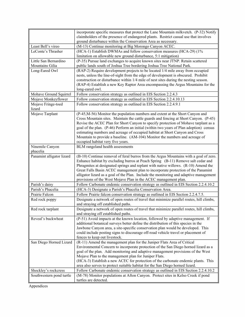
incorporate specific measures that protect the Lane Mountain milkvetch. (P-32) Notify claimholders of the presence of endangered plants. Restrict casual use that involves ground disturbance within the Conservation Area as necessary.
Least Bell’s vireo (M-13) Continue monitoring at Big Morongo Canyon ACEC. LeConte’s Thrasher (HCA-1) Establish DWMAs and follow conservation measures (HCA-29) (1%
limitation on allowable new ground disturbance, 5:1 mitigation) Little San Bernardino Mountains Gilia
(P-35) Pursue land exchanges to acquire known sites near JTNP. Retain scattered public lands south of Joshua Tree bordering Joshua Tree National Park.
Long-Eared Owl (RAP-2) Require development projects to be located 1/4 mile away from occupied nests, unless the line-of-sight from the edge of development is obscured. Prohibit construction or disturbance within 1/4 mile of nest sites during the nesting season. (RAP-4) Establish a new Key Raptor Area encompassing the Argus Mountains for the long-eared owl.
Mohave Ground Squirrel Follow conservation strategy as outlined in EIS Section 2.2.4.3 Mojave Monkeyflower Follow conservation strategy as outlined in EIS Section 2.2.4.10.13 Mojave Fringe-toed lizard
Follow conservation strategy as outlined in EIS Section 2.2.4.9.1
Mojave Tarplant (P-45,M-56) Monitor the population numbers and extent at the Short Canyon and Cross Mountain sites. Maintain the cattle guards and fencing at Short Canyon. (P-45) Revise the ACEC Plan for Short Canyon to specify protection of Mohave tarplant as a goal of the plan. (P-46) Perform an initial (within two years of Plan adoption) census estimating numbers and acreage of occupied habitat at Short Canyon and Cross Mountain to provide a baseline. (AM-104) Monitor the numbers and acreage of occupied habitat very five years.
Ninemile Canyon phacelia
BLM rangeland health assessments
Panamint alligator lizard (B-10) Continue removal of feral burros from the Argus Mountains with a goal of zero.Enhance habitat by excluding burros at Peach Spring (B-11) Remove salt cedar and Phragmites at designated springs and replant with native willows. (R-10) Amend the Great Falls Basin ACEC management plan to incorporate protection of the Panamint alligator lizard as a goal of the Plan. Include the monitoring and adaptive management provisions of the West Mojave Plan in the ACEC management plan.
Parish’s daisy Follow Carbonate endemic conservation strategy as outlined in EIS Section 2.2.4.10.2 Parish’s Phacelia (HCA-3) Designate a Parish’s Phacelia Conservation Area. Prairie Falcon Follow Prairie falcon conservation strategy as outlined in EIS Section 2.2.4.7.5. Red rock poppy Designate a network of open routes of travel that minimize parallel routes, hill climbs,
and straying off established paths. Red rock tarplant Designate a network of open routes of travel that minimize parallel routes, hill climbs,
and straying off established paths. Reveal’s buckwheat (P-51) Avoid impacts at the known location, followed by adaptive management. If
additional botanical surveys better define the distribution of this species in the Jawbone Canyon area, a site-specific conservation plan would be developed. This could include posting signs to discourage off-road vehicle travel or placement of fences to keep out livestock.
San Diego Horned Lizard (R-11) Amend the management plan for the Juniper Flats Area of Critical Environmental Concern to incorporate protection of the San Diego horned lizard as a goal of the plan. Add monitoring and adaptive management provisions of the West Mojave Plan to the management plan for Juniper Flats. (HCA-3) Establish a new ACEC for protection of the carbonate endemic plants. This area also serves to protect suitable habitat for the San Diego horned lizard.
Shockley’s rockcress Follow Carbonate endemic conservation strategy as outlined in EIS Section 2.2.4.10.2 Southwestern pond turtle (M-78) Monitor populations at Afton Canyon. Protect sites in Kelso Creek if pond
turtles are detected.
Appendices
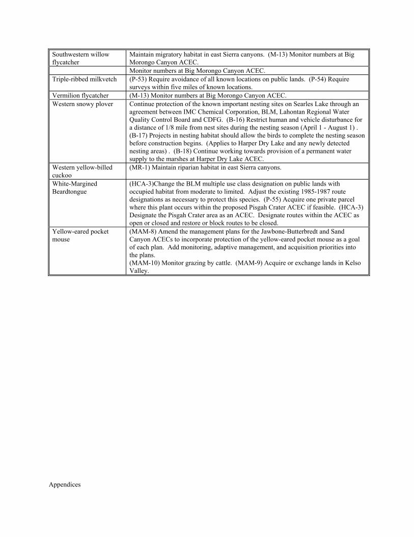
Southwestern willow flycatcher
Maintain migratory habitat in east Sierra canyons. (M-13) Monitor numbers at Big Morongo Canyon ACEC.
Monitor numbers at Big Morongo Canyon ACEC. Triple-ribbed milkvetch (P-53) Require avoidance of all known locations on public lands. (P-54) Require
surveys within five miles of known locations. Vermilion flycatcher (M-13) Monitor numbers at Big Morongo Canyon ACEC. Western snowy plover Continue protection of the known important nesting sites on Searles Lake through an
agreement between IMC Chemical Corporation, BLM, Lahontan Regional Water Quality Control Board and CDFG. (B-16) Restrict human and vehicle disturbance for a distance of 1/8 mile from nest sites during the nesting season (April 1 - August 1) . (B-17) Projects in nesting habitat should allow the birds to complete the nesting season before construction begins. (Applies to Harper Dry Lake and any newly detected nesting areas) . (B-18) Continue working towards provision of a permanent water supply to the marshes at Harper Dry Lake ACEC.
Western yellow-billed cuckoo
(MR-1) Maintain riparian habitat in east Sierra canyons.
White-Margined Beardtongue
(HCA-3)Change the BLM multiple use class designation on public lands with occupied habitat from moderate to limited. Adjust the existing 1985-1987 route designations as necessary to protect this species. (P-55) Acquire one private parcel where this plant occurs within the proposed Pisgah Crater ACEC if feasible. (HCA-3) Designate the Pisgah Crater area as an ACEC. Designate routes within the ACEC as open or closed and restore or block routes to be closed.
Yellow-eared pocket mouse
(MAM-8) Amend the management plans for the Jawbone-Butterbredt and Sand Canyon ACECs to incorporate protection of the yellow-eared pocket mouse as a goal of each plan. Add monitoring, adaptive management, and acquisition priorities into the plans. (MAM-10) Monitor grazing by cattle. (MAM-9) Acquire or exchange lands in Kelso Valley.

Appendices

Appendices
APPENDIX C
IMPLEMENTATION TASKS

Appendices
Appendices
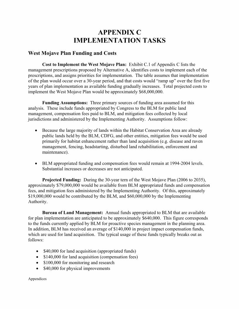
APPENDIX C IMPLEMENTATION TASKS
West Mojave Plan Funding and Costs
Cost to Implement the West Mojave Plan: Exhibit C.1 of Appendix C lists the management prescriptions proposed by Alternative A, identifies costs to implement each of the prescriptions, and assigns priorities for implementation. The table assumes that implementation of the plan would occur over a 30-year period, and that costs would “ramp up” over the first five years of plan implementation as available funding gradually increases. Total projected costs to implement the West Mojave Plan would be approximately $68,000,000.
Funding Assumptions: Three primary sources of funding area assumed for this
analysis. These include funds appropriated by Congress to the BLM for public land management, compensation fees paid to BLM, and mitigation fees collected by local jurisdictions and administered by the Implementing Authority. Assumptions follow:
• Because the large majority of lands within the Habitat Conservation Area are already
public lands held by the BLM, CDFG, and other entities, mitigation fees would be used primarily for habitat enhancement rather than land acquisition (e.g. disease and raven management, fencing, headstarting, disturbed land rehabilitation, enforcement and maintenance).
• BLM appropriated funding and compensation fees would remain at 1994-2004 levels.
Substantial increases or decreases are not anticipated.
Projected Funding: During the 30-year tern of the West Mojave Plan (2006 to 2035), approximately $79,000,000 would be available from BLM appropriated funds and compensation fees, and mitigation fees administered by the Implementing Authority. Of this, approximately $19,000,000 would be contributed by the BLM, and $60,000,000 by the Implementing Authority.
Bureau of Land Management: Annual funds appropriated to BLM that are available
for plan implementation are anticipated to be approximately $640,000. This figure corresponds to the funds currently applied by BLM for proactive species management in the planning area. In addition, BLM has received an average of $140,000 in project impact compensation funds, which are used for land acquisition. The typical usage of these funds typically breaks out as follows:
• $40,000 for land acquisition (appropriated funds) • $140,000 for land acquisition (compensation fees) • $100,000 for monitoring and research • $40,000 for physical improvements

Appendices
• $70,000 for restoration • $50,000 for other proactive programs • $200,000 for enforcement and outreach
BLM has received substantial grant moneys in the past that have been applied to these
actions, such as “green sticker” grants from the State of California for rehabilitation of closed vehicle routes and implementation of the route network, and special congressional appropriations. Grants may amount to many hundreds of thousands of dollars annually, and it is anticipated that they will continue to be obtained in the future. They would play an important role in accelerating plan implementation. Grants, however, are not assured, and have NOT been included in the BLM revenue assumptions discussed above.
Local Jurisdictions: Annual mitigation fee projections associated with local jurisdictions are set forth in the following table. These figures are based upon projections in the EIR/S economic analysis (see, especially, Table 4-38)
Calculate Residential Acreage Calculate Commercial & Industrial Acreage Mining Acreage
Year Housing
Unit Forecast
5 to 1 0.5 to
1 1 to 1 Subtotal 5 to 1 0.5 to
1 1 to 1 Subtotal 5 to 1 0.5 to
1 1 to 1 Subtotal
Total Acreage Fee Estimate
2000 52,440 0 0 0 0 0 0 0 0 0 0 0 0 0 $02005 62,009 14 565 83 662 0 22 10 32 50 25 50 125 819 $592,6432010 65,469 62 7,709 1,820 9,591 1 2,156 505 2,661 300 100 200 600 12,852 $7,176,6312015 69,589 102 8,612 2,691 11,405 1 2,384 725 3,110 300 100 200 600 15,115 $8,608,0902020 74,714 176 8,747 3,392 12,315 2 2,384 869 3,254 300 100 200 600 16,169 $9,598,1842025 77,920 120 7,818 2,827 10,765 1 2,004 672 2,678 300 100 200 600 14,043 $8,290,1132030 82,274 158 8,544 3,575 12,277 2 2,090 788 2,880 300 100 200 600 15,757 $9,415,3842035 86,871 168 8,324 4,001 12,493 2 1,955 887 2,844 300 100 200 600 15,937 $9,721,891Totals 800 50,319 18,389 68,708 8 12,994 4,456 17,459 1,850 625 1,250 3,725 90,692 $53,402,936
The preceding table is based upon data submitted by cities and counties and/or estimates derived from the EIR/S economic analysis. A breakout by jurisdiction follows:
San Bernardino County $18,532,331Kern County $1,492,260Inyo County $100,000Los Angeles County $4,400,550Adelanto $1,062,600Apple Valley $1,062,600Barstow $860,475California City $300,000Hesperia $4,158,000Lancaster $11,842,600Palmdale $6,606,600Ridgecrest $264,495Twentynine Palms $300,000Victorville $3,218,600Yucca Valley $500,000
TOTAL $53,402,936
Appendices
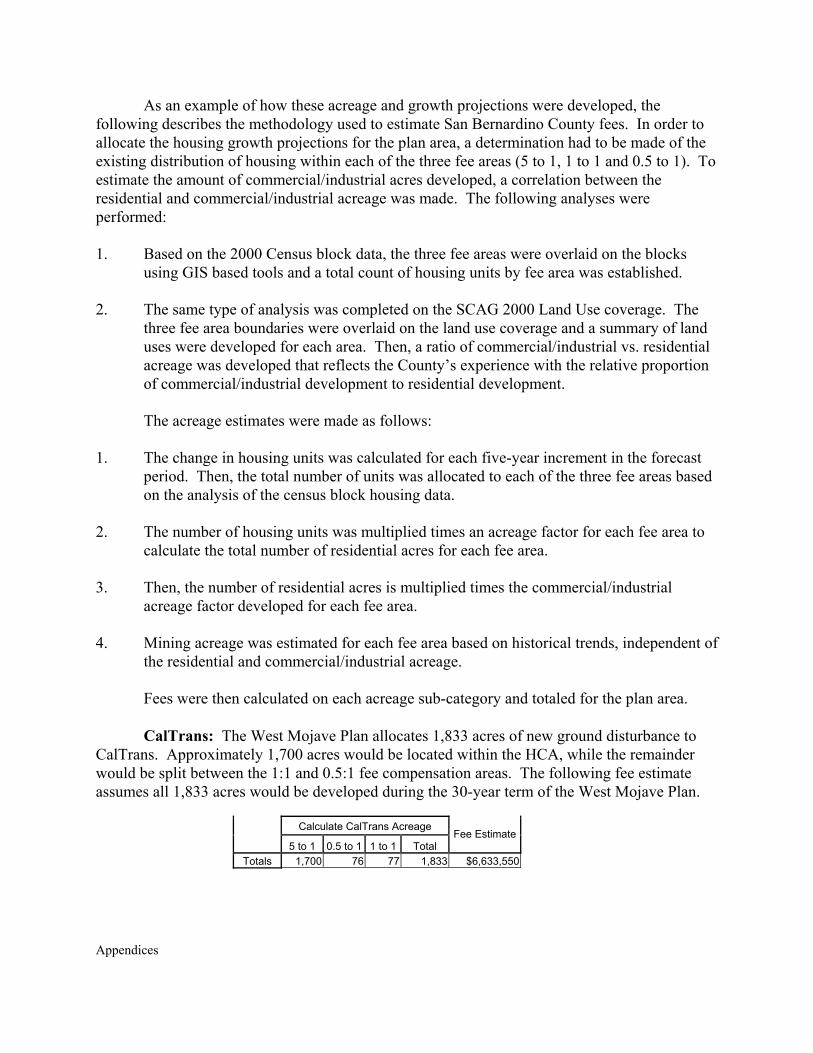
As an example of how these acreage and growth projections were developed, the following describes the methodology used to estimate San Bernardino County fees. In order to allocate the housing growth projections for the plan area, a determination had to be made of the existing distribution of housing within each of the three fee areas (5 to 1, 1 to 1 and 0.5 to 1). To estimate the amount of commercial/industrial acres developed, a correlation between the residential and commercial/industrial acreage was made. The following analyses were performed: 1. Based on the 2000 Census block data, the three fee areas were overlaid on the blocks
using GIS based tools and a total count of housing units by fee area was established. 2. The same type of analysis was completed on the SCAG 2000 Land Use coverage. The
three fee area boundaries were overlaid on the land use coverage and a summary of land uses were developed for each area. Then, a ratio of commercial/industrial vs. residential acreage was developed that reflects the County’s experience with the relative proportion of commercial/industrial development to residential development.
The acreage estimates were made as follows:
1. The change in housing units was calculated for each five-year increment in the forecast
period. Then, the total number of units was allocated to each of the three fee areas based on the analysis of the census block housing data.
2. The number of housing units was multiplied times an acreage factor for each fee area to
calculate the total number of residential acres for each fee area. 3. Then, the number of residential acres is multiplied times the commercial/industrial
acreage factor developed for each fee area. 4. Mining acreage was estimated for each fee area based on historical trends, independent of
the residential and commercial/industrial acreage.
Fees were then calculated on each acreage sub-category and totaled for the plan area. CalTrans: The West Mojave Plan allocates 1,833 acres of new ground disturbance to
CalTrans. Approximately 1,700 acres would be located within the HCA, while the remainder would be split between the 1:1 and 0.5:1 fee compensation areas. The following fee estimate assumes all 1,833 acres would be developed during the 30-year term of the West Mojave Plan.
Calculate CalTrans Acreage
5 to 1 0.5 to 1 1 to 1 Total Fee Estimate
Totals 1,700 76 77 1,833 $6,633,550

Appendices
Draft Tortoise and MGS Implementation Plan
Exhibit C.2 of Appendix C presents a draft Implementation Plan for the Desert Tortoise and Mohave Ground Squirrel conservation strategies.

Appendices
Exhibit C.1
Implementation Tasks Priorities and Costs
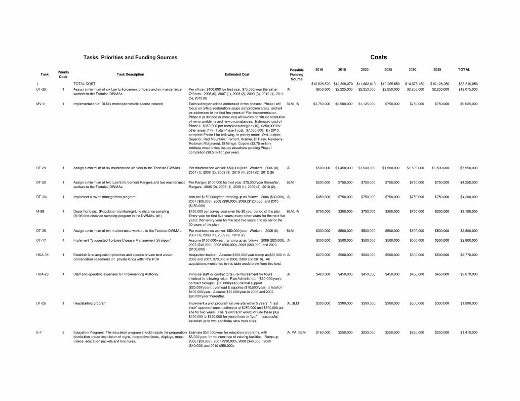
Tasks, Priorities and Funding Sources
TaskPriority Code
Task Description Estimated CostPossible Funding Source
2010 2015 2020 2025 2030 2035 TOTAL
1 TOTAL COST $10,626,520 $12,309,370 $11,602,610 $10,265,650 $10,878,450 $10,128,250 $65,810,850
DT-28 1 Assign a minimum of six Law Enforcement officers and six maintenance workers to the Tortoise DWMAs.
Per officer: $100,000 for first year, $75,000/year thereafter. Officers: 2006 (0), 2007 (1), 2008 (2), 2009 (3), 2010 (4), 2011 (5), 2012 (6)
IA $850,000 $2,225,000 $2,250,000 $2,250,000 $2,250,000 $2,250,000 $12,075,000
MV-9 1 Implementation of BLM's motorized vehicle access network Each subregion will be addressed in two phases: Phase I will focus on critical restoration issues and problem areas, and will be addressed in the first few years of Plan implementation; Phase II (a decade or more out) will involve continued resolution of minor problems and new circumstances. Estimated cost of Phase I: $350,000 per complex subregion (10), $250,000 for other areas (14). Total Phase I cost: $7,000,000. By 2010, complete Phase I for following, in priority order: Ord, Juniper, Superior, Red Mountain, Fremont, Kramer, El Paso, Newberry-Rodman, Ridgecrest, El Mirage, Coyote ($3.75 million). Address most critical issues elsewhere pending Phase I completion ($0.5 million per year)
BLM, IA $3,750,000 $2,500,000 $1,125,000 $750,000 $750,000 $750,000 $9,625,000
DT-28 1 Assign a minimum of six maintenance workers to the Tortoise DWMAs. Per maintenance worker: $50,000/year. Workers: 2006 (0), 2007 (1), 2008 (2), 2009 (3), 2010 (4), 2011 (5), 2012 (6)
IA $500,000 $1,450,000 $1,500,000 $1,500,000 $1,500,000 $1,500,000 $7,950,000
DT-28 1 Assign a minimum of two Law Enforcement Rangers and two maintenance workers to the Tortoise DWMAs.
Per Ranger: $100,000 for first year, $75,000/year thereafter. Rangers: 2006 (0), 2007 (1), 2008 (1), 2009 (2), 2010 (2).
BLM $500,000 $750,000 $750,000 $750,000 $750,000 $750,000 $4,250,000
DT-30+ 1 Implement a raven management program Assume $150,000/year, ramping up as follows: 2006 ($30,000), 2007 ($60,000), 2008 ($90,000), 2009 ($120,000) and 2010 ($150,000)
IA $450,000 $750,000 $750,000 $750,000 $750,000 $750,000 $4,200,000
M-98 1 Desert tortoise: (Population monitoring)·Line distance sampling (M-98) line distance sampling program in the DWMAs. (#1)
$150,000 per survey year over the 30 year period of the plan. Every year for first five years; every other years for the next five years; then every year for the next five years and so on for the 30 years of the plan.
BLM, IA $750,000 $300,000 $750,000 $300,000 $750,000 $300,000 $3,150,000
DT-28 1 Assign a minimum of two maintenance workers to the Tortoise DWMAs. Per maintenance worker: $50,000/year. Workers: 2006 (0), 2007 (1), 2008 (1), 2009 (2), 2010 (2).
BLM $300,000 $500,000 $500,000 $500,000 $500,000 $500,000 $2,800,000
DT-17 4 Implement "Suggested Tortoise Disease Management Strategy." Assume $100,000/year, ramping up as follows: 2006 ($20,000), 2007 ($40,000), 2008 ($60,000), 2009 ($80,000) and 2010 ($100,000)
IA $300,000 $500,000 $500,000 $500,000 $500,000 $500,000 $2,800,000
HCA-36 1 Establish land acquisition priorities and acquire private land and/or conservation easements on private lands within the HCA
Acquisition budget: Assume $100,000/year (ramp up:$30,000 in 2006 and 2007, $70,000 in 2008, 2009 and 2010). All acquisitions mentioned in this table would draw from this fund.
IA $270,000 $500,000 $500,000 $500,000 $500,000 $500,000 $2,770,000
HCA-28 1 Staff and operating expenses for Implementing Authority. In-house staff or contractor(s), reimbursement for hours involved in following roles: Plan Administrator ($30,000/year); contract biologist ($30,000/year); clerical support ($20,000/year); overhead & supplies ($10,000/year), a total of $100,000/year. Assume $75,000/year in 2006 and 2007, $90,000/year thereafter.
IA $420,000 $450,000 $450,000 $450,000 $450,000 $450,000 $2,670,000
DT-26 1 Headstarting program. Implement a pilot program on one site within 5 years. "Fast track" approach costs estimated at $250,000 and $300,000 per site for two years. The "slow track" would include these plus $100,000 to $120,000 for years three to five." If successful, establish up to two additional slow track sites.
IA, BLM $300,000 $300,000 $300,000 $300,000 $300,000 $300,000 $1,800,000
E-7 2 Education Program: The education program should include the preparation, distribution and/or installation of signs, interpretive kiosks, displays, maps, videos, education packets and brochures.
Estimate $50,000/year for education programs, with $5,000/year for maintenance of existing facilities. Ramp-up: 2006 ($20,000), 2007 ($30,000), 2008 ($40,000), 2009 ($40,000) and 2010 ($50,000).
IA, PA, BLM $160,000 $250,000 $250,000 $250,000 $250,000 $250,000 $1,410,000
Costs
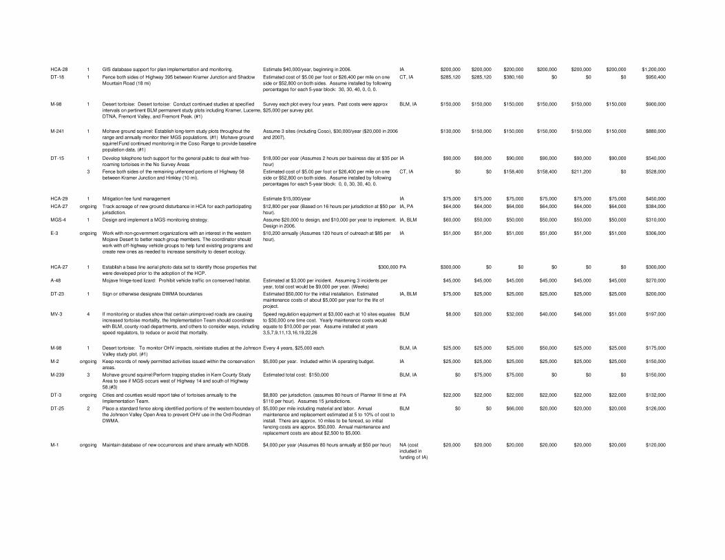
HCA-28 1 GIS database support for plan implementation and monitoring. Estimate $40,000/year, beginning in 2006. IA $200,000 $200,000 $200,000 $200,000 $200,000 $200,000 $1,200,000
DT-18 1 Fence both sides of Highway 395 between Kramer Junction and Shadow Mountain Road (18 mi)
Estimated cost of $5.00 per foot or $26,400 per mile on one side or $52,800 on both sides. Assume installed by following percentages for each 5-year block: 30, 30, 40, 0, 0, 0.
CT, IA $285,120 $285,120 $380,160 $0 $0 $0 $950,400
M-98 1 Desert tortoise: Desert tortoise: Conduct continued studies at specified intervals on pertinent BLM permanent study plots including Kramer, Lucerne, DTNA, Fremont Valley, and Fremont Peak. (#1)
Survey each plot every four years. Past costs were approx $25,000 per survey plot.
BLM, IA $150,000 $150,000 $150,000 $150,000 $150,000 $150,000 $900,000
M-241 1 Mohave ground squirrel: Establish long-term study plots throughout the range and annually monitor their MGS populations. (#1) Mohave ground squirrel:Fund continued monitoring in the Coso Range to provide baseline population data. (#1)
Assume 3 sites (including Coso), $30,000/year ($20,000 in 2006 and 2007).
$130,000 $150,000 $150,000 $150,000 $150,000 $150,000 $880,000
DT-15 1 Develop telephone tech support for the general public to deal with free-roaming tortoises in the No Survey Areas
$18,000 per year (Assumes 2 hours per business day at $35 per hour)
IA $90,000 $90,000 $90,000 $90,000 $90,000 $90,000 $540,000
3 Fence both sides of the remaining unfenced portions of Highway 58 between Kramer Junction and Hinkley (10 mi).
Estimated cost of $5.00 per foot or $26,400 per mile on one side or $52,800 on both sides. Assume installed by following percentages for each 5-year block: 0, 0, 30, 30, 40, 0.
CT, IA $0 $0 $158,400 $158,400 $211,200 $0 $528,000
HCA-29 1 Mitigation fee fund management Estimate $15,000/year IA $75,000 $75,000 $75,000 $75,000 $75,000 $75,000 $450,000
HCA-27 ongoing Track acreage of new ground disturbance in HCA for each participating jurisdiction.
$12,800 per year (Based on 16 hours per jurisdiction at $50 per hour).
IA, PA $64,000 $64,000 $64,000 $64,000 $64,000 $64,000 $384,000
MGS-4 1 Design and implement a MGS monitoring strategy. Assume $20,000 to design, and $10,000 per year to implement. Design in 2006.
IA, BLM $60,000 $50,000 $50,000 $50,000 $50,000 $50,000 $310,000
E-3 ongoing Work with non-government organizations with an interest in the western Mojave Desert to better reach group members. The coordinator should work with off-highway vehicle groups to help fund existing programs and create new ones as needed to increase sensitivity to desert ecology.
$10,200 annually (Assumes 120 hours of outreach at $85 per hour).
IA $51,000 $51,000 $51,000 $51,000 $51,000 $51,000 $306,000
HCA-27 1 Establish a base line aerial photo data set to identify those properties that were developed prior to the adoption of the HCP.
$300,000 PA $300,000 $0 $0 $0 $0 $0 $300,000
A-48 Mojave fringe-toed lizard: Prohibit vehicle traffic on conserved habitat. Estimated at $3,000 per incident. Assuming 3 incidents per year, total cost would be $9,000 per year. (Weeks)
$45,000 $45,000 $45,000 $45,000 $45,000 $45,000 $270,000
DT-23 1 Sign or otherwise designate DWMA boundaries Estimated $50,000 for the initial installation. Estimated maintenance costs of about $5,000 per year for the life of project.
IA, BLM $75,000 $25,000 $25,000 $25,000 $25,000 $25,000 $200,000
MV-3 4 If monitoring or studies show that certain unimproved roads are causing increased tortoise mortality, the Implementation Team should coordinate with BLM, county road departments, and others to consider ways, including speed regulators, to reduce or avoid that mortality.
Speed regulation equipment at $3,000 each at 10 sites equates to $30,000 one time cost. Yearly maintenance costs would equate to $10,000 per year. Assume installed at years 3,5,7,9,11,13,16,19,22,26
BLM $8,000 $20,000 $32,000 $40,000 $46,000 $51,000 $197,000
M-98 1 Desert tortoise: To monitor OHV impacts, reinitiate studies at the Johnson Valley study plot. (#1)
Every 4 years, $25,000 each. BLM, IA $25,000 $25,000 $25,000 $50,000 $25,000 $25,000 $175,000
M-2 ongoing Keep records of newly permitted activities issued within the conservation areas.
$5,000 per year. Included within IA operating budget. IA $25,000 $25,000 $25,000 $25,000 $25,000 $25,000 $150,000
M-239 3 Mohave ground squirrel:Perform trapping studies in Kern County Study Area to see if MGS occurs west of Highway 14 and south of Highway 58.(#3)
Estimated total cost: $150,000 BLM, IA $0 $75,000 $75,000 $0 $0 $0 $150,000
DT-3 ongoing Cities and counties would report take of tortoises annually to the Implementation Team.
$8,800 per jurisdiction. (assumes 80 hours of Planner III time at $110 per hour). Assumes 15 jurisdictions.
PA $22,000 $22,000 $22,000 $22,000 $22,000 $22,000 $132,000
DT-25 2 Place a standard fence along identified portions of the western boundary of the Johnson Valley Open Area to prevent OHV use in the Ord-Rodman DWMA.
$5,000 per mile including material and labor. Annual maintenance and replacement estimated at 5 to 10% of cost to install. There are approx. 10 miles to be fenced, so initial fencing costs are approx. $50,000. Annual maintenance and replacement costs are about $2,500 to $5,000.
BLM $0 $0 $66,000 $20,000 $20,000 $20,000 $126,000
M-1 ongoing Maintain database of new occurrences and share annually with NDDB. $4,000 per year (Assumes 80 hours annually at $50 per hour) NA (cost included in funding of IA)
$20,000 $20,000 $20,000 $20,000 $20,000 $20,000 $120,000
HCA-27 Rate of new ground disturbance and the success of restoration programs should be assessed on a periodic basis and the Plan amended as necessary.
$3,400 per year if performed annually. (Based on 40 hours at $85 per hour)
NA (cost included in funding of IA)
$17,000 $17,000 $17,000 $17,000 $17,000 $17,000 $102,000
A-7 If newly-detected significant roosts for Townsend’s big-eared bat and California leaf-nosed bats are near open routes then provide case-by-case review of open routes within riparian and desert wash habitat. If the new roosts are impacted by open routes then take corrective action within the foraging habitat or establish a new route avoiding the habitat.
$2,000 per project year cost (40 hours at $50 per hour). $5,000 per average relocation costs, estimating three relocations per project year. Total of $17,000 per project year. To be done once every fiver years.
BLM, IA $17,000 $17,000 $17,000 $17,000 $17,000 $17,000 $102,000
MGS-5 3 Mohave ground squirrel: Conduct presence/absence surveys in the northern portion of the Antelope Valley in Kern County.
$100,000 BLM, IA $0 $0 $0 $0 $100,000 $0 $100,000
E-6 ongoing Provide support to the efforts of museums, zoos, and other public institutions to develop pertinent desert tortoise exhibits.
$2,000 annually from 2006-2010, $3000 annually thereafter. IA $10,000 $15,000 $15,000 $15,000 $15,000 $15,000 $85,000
M-3 1 Alkali Mariposa Lily: (M-3) Conduct presence absence surveys at other alkaline springs, seeps, and playas within one year of plan adoption. (#1)
$80,000 IA $10,000 $15,000 $10,000 $15,000 $15,000 $15,000 $80,000
M-208 2 Bendire's thrasher: Monitor periodically population numbers and habitat disturbance in conservation areas. (#2)
$80,000 PA, FS, D, G $0 $80,000 $0 $0 $0 $0 $80,000
MV-XX 2 Route designation on newly acquired lands would occur every five years (or sooner, if judged to be prudent by the Implementation Team), would comply with applicable federal regulations (i.e., NEPA), and be incorporated into the overall route implementation process.
Estimate based on adding 5 new sections of land per year with an average of five miles per section. Estimate 125 miles of new routes over 5 years. Estimate cost of $125 per mile to survey, which equates to $15,625 every 5 years.
BLM $0 $15,625 $15,625 $15,625 $15,625 $15,625 $78,125
HCA-3 ongoing Acquire occupied habitat within the conservation area (149 acres) assuming a willing seller.(Parish's phacelia)
Undetermined, but estimated at $500/acre plus administrative fees
IA $0 $0 $0 $0 $35,000 $40,000 $75,000
MV-8 1 El Paso CAPA: Route designations in the El Paso Mountains and Ridgecrest subregions would be performed after completion of the West Mojave Plan through a community-based collaborative process utilizing the designation methodology developed for the West Mojave Plan.
These two subregions have a relatively large number of routes. Cost including designations, meetings, ACCESS and GIS data base creation and QA/QC would include 3 technical staff in addition to Resource Staff time for 2 months. ($75/hr X 150 hrs/mo X 2 months X 3 = $67,500).
BLM $67,500 $0 $0 $0 $0 $0 $67,500
HCA-33 ongoing Maintain a record of all HRCs awarded by the Implementing Authority $2,000 per year (40 hrs at $50 per hour) IA $10,000 $10,000 $10,000 $10,000 $10,000 $10,000 $60,000
M-98, A-206
ongoing Desert tortoise: Review information regarding plan authorized take of tortoises to determine whether adjustments are needed to the Survey/No-Survey Areas.
$2,000 per year (assumes 40 hrs at $50 per hour) NA (cost included in funding of IA)
$10,000 $10,000 $10,000 $10,000 $10,000 $10,000 $60,000
Rap-11 2 Target identified remnant grassland areas where burrowing owls are known for acquisition.
Survey and analysis by consultant estimated at $50,000. IA $0 $50,000 $0 $0 $0 $0 $50,000
Rap-12 1 Burrowing owl: Complete baseline inventory of conserved habitat. $50,000 IA $50,000 $0 $0 $0 $0 $0 $50,000
M-26 1 Prairie falcon: (M-26) Conduct surveys to determine occupancy and threats at all nests present in 1979 (#1).
$50,000 IA $50,000 $0 $0 $0 $0 $0 $50,000
M-6 3 Townsend's big-eared bat: (M-6) Determine bat numbers in all significant roosts, using CDFG approved methods.(#3)
Estimated at $8,000 per roost IA $8,000 $8,000 $8,000 $8,000 $8,000 $8,000 $48,000
P-1 1 Fence the eastern boundary of the proposed Carbonate ACEC to prevent cattle from trampling the listed plants on small portions of the Rattlesnake allotment and to prevent cattle from entering forest lands near Terrace Springs (along the east side of Arrastre Canyon). (Carbonate endemic plants)
Cost per mile to install smooth four-strand wire on five foot metal posts including material and labor is approximately $5,000 per mile. Annual maintenance and replacement estimated at 5 to 10% of cost to install.
IA $20,000 $5,500 $5,500 $5,500 $5,500 $5,500 $47,500
Bat-1 3 Protect all significant roosts by installing gates over mine entrances and restricting human access.
$5,000 per gate; assume 9 to be installed IA, BLM $0 $5,000 $10,000 $10,000 $10,000 $10,000 $45,000
(M-56) 2 Mojave tarplant : (M-56) Census population at Short Canyon and Cross Mountain every five years. (#2)
20000. Survey during third and fifth blocks. BLM, IA $0 $0 $20,000 $0 $20,000 $0 $40,000
A-54 Mojave tarplant: If existing or new populations are threatened by vehicles or grazing, then protect them by providing barriers to vehicles or livestock.
$1000 study (20 hours at $50 per hour); expected two route relocations per year, $3,000 per incident. This totals to $7,000 per year at five year increments.
$0 $7,000 $7,000 $7,000 $7,000 $7,000 $35,000
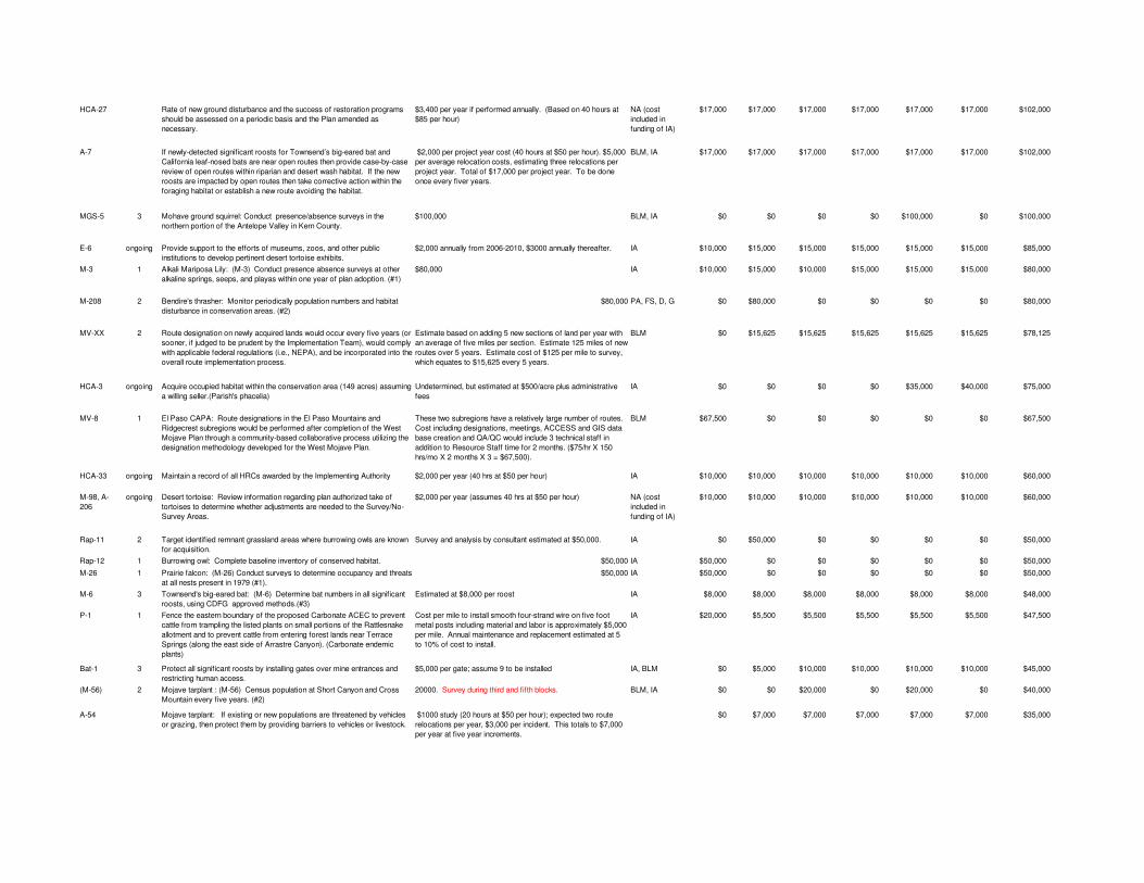
E-5 Develop displays, programs, and materials that can be provided to school districts in the West Mojave planning area. Fund and/or cooperate with existing programs to provide for enhanced outreach to schools in desert communities.
$30,000 (Estimate) IA $5,000 $5,000 $5,000 $5,000 $5,000 $5,000 $30,000
DT-11 2 Develop a standardized revegetation plan (for utilities). $30,000 if done by consultant. Currently done case-by-case. Reduced costs to utilities when standardized plan takes effect.
IA $0 $30,000 $0 $0 $0 $0 $30,000
P-28 Fence and sign approved open routes as necessary within the Coolgardie and West Paradise CA.
1,000 feet to cover a site on two sides at $10 a foot. 3 sites per year; totals $30,000 (this is a one time cost).
BLM $0 $30,000 $0 $0 $0 $0 $30,000
E-12 2 Develop local television outreach that talks about the plight of the tortoise and implementation of the West Mojave Plan.
$30,000 (Estimate) IA $5,000 $5,000 $5,000 $5,000 $5,000 $5,000 $30,000
M-7 ongoing Bats: (M-7) Approved projects that impact bats under the take limit would be reported annually to the CDFG and the USFWS. (Ongoing)
No additional cost. BLM $5,000 $5,000 $5,000 $5,000 $5,000 $5,000 $30,000
M-8 2 Townsend's big-eared bat: (M-8) Conduct periodic surveys in the northern part of planning area with high potential for containing significant roosts. (#2)
$500 per site. BLM $5,000 $5,000 $5,000 $5,000 $5,000 $5,000 $30,000
M-6 3 California leaf-nosed bat: (M-6) Determine bat numbers in all significant roosts, using CDFG approved methods.(#3)
IA $5,000 $5,000 $5,000 $5,000 $5,000 $5,000 $30,000
M-207 1 California leaf-nosed bat:Monitor population numbers using bat houses if installed. (#1)
IA $5,000 $5,000 $5,000 $5,000 $5,000 $5,000 $30,000
M-16 3 Burrowing owl: (M-16) Survey sites in Antelope Valley and along Mojave River (#3).
$30,000 IA $30,000 $0 $0 $0 $0 $0 $30,000
DT-19 3 Desert tortoise:(DT-19) IT monitor mortality along roads and identify measures such as fencing, culverts, signs, or speed regulators to be used to reduce or avoid unacceptable mortality levels.(#3)
$10,000 per survey to be done every ten years. BLM, IA $0 $10,000 $0 $10,000 $0 $10,000 $30,000
M-26 1 Golden eagle: (M-26) Conduct surveys to determine occupancy and threats at all nests present in 1979 (#1).
One-time survey, $30,000 IA $30,000 $0 $0 $0 $0 $0 $30,000
M-27 ongoing Golden eagle: Compile record of electrocutions from incidental observations and reports from the public and utilities.
$1,000 per year (Assumes 20 hours at $50 per hour) NA (cost included in funding of IA)
$5,000 $5,000 $5,000 $5,000 $5,000 $5,000 $30,000
A-33 Kelso Creek monkeyflower: If open routes threaten occupied habitat, then change route designation in area.
$1,000 per year for monitoring (Assumes 20 hours at $50 per hour); $3,000 per incident for sign installation and materials, estimate three incidents per year ($9,000). One year cost will include $1,000 for monitoring and $9,000 for sign implememntation totaly $10,000 per year. Fund monitoring only. Rest absorbed in route implementation task.
$5,000 $5,000 $5,000 $5,000 $5,000 $5,000 $30,000
HCA-3 1 Place signs at edge of playas closed to motor vehicle traffic within the Parish's Phacelia CA.
$25 per sign; 5 signs per incident; 5 sites per year equals about $625 per year. $500 per year for maintenance and relocation of signs.
IA, BLM $0 $5,625 $5,625 $5,625 $5,625 $5,625 $28,125
Bat-5 ongoing Fence around (but not over) open abandoned mine shafts to provide bats access to roosts and to reduce public hazards
$500 per adit; assume 1/year, then 2/year beginning in 2011. IA $2,500 $5,000 $5,000 $5,000 $5,000 $5,000 $27,500
A-84 Western snowy plover: If nest sites are disturbed, then close playa edges to vehicular traffic in spring and provide temporary fencing of nest sites if warranted.
Closure and detail signs; cost of $300 per route; average of three routes. Total of $900 per year for each site.
$4,500 $4,500 $4,500 $4,500 $4,500 $4,500 $27,000
A-230 LeConte's thrasher: If there are OHV conflicts then more intensive management is needed (signing, seasonal restrictions, law enforcement)
$1000 per year (20 hours at $50 per hour), starting with second budget block.
$0 $5,000 $5,000 $5,000 $5,000 $5,000 $25,000
E-8 ongoing Provide annual training for consultants and others working at construction sites to ensure that they have a foundation in training for monitoring.
One day seminar, costing $750 plus facilities cost. IA $3,750 $3,750 $3,750 $3,750 $3,750 $3,750 $22,500
E-11 2 Develop specific outreach plans to 1) maximize the effectiveness of fences constructed along the interface between urbanizing communities and the HCA. 2) to discourage poaching. 3) To reduce raven/tortoise conflicts.
$20,000 (Estimate) IA $0 $20,000 $0 $0 $0 $0 $20,000
M-252 2 Yellow-eared pocket mouse: A trapping survey would be conducted in Kelso Valley as part of the Monitoring Plan
One-time survey, $20,000. $0 $0 $20,000 $0 $0 $0 $20,000
P-25 2 Fence both sides of the road near the Sweet Ridge population. A vehicle turnaround and parking area will be restored so that traffic passes by, rather than on, the buckwheat habitat. (Kern buckwheat)
Two-sides of roads at 300 feet (equals 600 feet) at $10 per foot equals $6,000. If barrier is rebuilt once every 10 years, total estimated cost over 30 years would be $18,000.
IA, $0 $6,000 $0 $6,000 $0 $6,000 $18,000
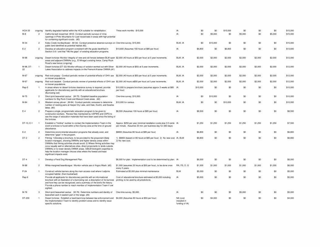
HCA-33 ongoing Identify degraded habitat within the HCA suitable for rehabilitation. Three work months - $15,000 IA $0 $0 $15,000 $0 $0 $0 $15,000
M-8 2 California leaf-nosed bat: (M-8) Conduct periodic surveys of mine openings in Pinto Mountains for Leaf-nosed bats in areas with high potential for containing significant roosts. (#2)
IA $0 $5,000 $0 $5,000 $0 $5,000 $15,000
M-34 2 Kelso Creek monkeyflower: (M-34) Conduct presence absence surveys on public land identified as potential habitat (#2).
One-time survey, $15,000. BLM, IA $0 $15,000 $0 $0 $0 $0 $15,000
E-2 2 Develop an education program consistent with the goals identified in Section 3.8.1 and that "fills the gaps" of existing education programs.
$13,600 (Assumes 160 hours at $85 per hour) IA $6,800 $0 $6,800 $0 $0 $0 $13,600
M-98 ongoing Desert tortoise:·Monitor integrity of new and old fences between BLM open areas and adjacent DWMAs (e.g., El Mirage’s existing fence, Camp Rock Road’s new fence).(ongoing)
$2,000 (40 hours at $50 per hour) at 5 year increments. BLM, IA $2,000 $2,000 $2,000 $2,000 $2,000 $2,000 $12,000
M-98, DT-22
1 Desert tortoise:(DT-22) Monitor efficacy of solution worked out with Silver Lakes Association to address impacts on the Fremont-Kramer DWMA.(#1)
$2,000 (40 hours at $50) at 5 year increments. BLM, IA $2,000 $2,000 $2,000 $2,000 $2,000 $2,000 $12,000
M-67 ongoing Red rock poppy: Conduct periodic review of potential effects of OHV use on known populations.
$2,000 (40 hours at $50 per hour) at 5 year increments. BLM, IA $2,000 $2,000 $2,000 $2,000 $2,000 $2,000 $12,000
M-67 ongoing Red rock tarplant: Conduct periodic review of potential effects of OHV use on known populations.
$2,000 (40 hours at$50 per hour) at 5 year increments. BLM, IA $2,000 $2,000 $2,000 $2,000 $2,000 $2,000 $12,000
Rap-5 1 In areas where no desert tortoise clearance survey is required, provide applicants for discretionary permits with an educational brochure. (Burrowing owl)
$10,000 to prepare brochure (assumes approx 3 weeks at $85 per hour)
IA $10,000 $0 $0 $0 $0 $0 $10,000
M-75 2 Short-joint beavertail cactus: (M-75) Establish baseline population numbers for Big Rock Creek and Mescal Creek areas. (#2)
One-time survey, $10,000. IA $0 $10,000 $0 $0 $0 $0 $10,000
M-84 3 Western snowy plover: (M-84) Conduct periodic censuses to determine number of nesting pairs at Harper Dry Lake, and Dale, Koehn, and Searles lakes. (#3)
$10,000 for census. BLM, IA $0 $0 $10,000 $0 $0 $0 $10,000
E-4 2 Prepare a single, programmatic education program to be given to construction workers. Review files maintained by USFWS and CDFG to see the range of education materials that have been used since the listing of the tortoise.
$8,500 (Assumes 100 hours at $85 per hour) IA $8,500 $0 $0 $0 $0 $0 $8,500
DT-13, E-10 1 Establish a "Hotline" number to contact the Implementation Team in the event a tortoise is found within a Non Survey area at the time of ground disturbance.
Approx. $250 per year (minimal installation costs plus 3.5 cents per minute. Assumes 30 min. per business day for 260 days)
IA $1,250 $1,250 $1,250 $1,250 $1,250 $1,250 $7,500
E-2 2 Determine environmental education programs that already exist, and determine "gaps" in the program.
$6800 (Assumes 80 hours at $85 per hour) IA $6,800 $0 $0 $0 $0 $0 $6,800
DT-2 2 Filming: 1)Develop a brochure, to be provided to the proponent (likely location manager), showing DWMAs and higher density areas within DWMAs that filming activities should avoid. 2) Where filming activities may occur equally well on alternatives sites, direct proponents to lands outside DWMAs or to lower density DWMA areas. 3)BLM biologist's expertise to help the location manager choose sites where the fewest and least significant impacts exist.
1) $6800 (based on 80 hours at $85 per hour) 2) No new cost. 3) No new cost.
IA, BLM $6,800 $0 $0 $0 $0 $0 $6,800
DT-4 1 Develop a Feral Dog Management Plan. $6,000 for plan. Implementation cost to be determined by plan. IA $6,000 $0 $0 $0 $0 $0 $6,000
M-88 2 White-margined beardtongue: Monitor vehicle use of Argos Wash. (#2) $1,000 (assumes 20 hours at $50 per hour), to be done once every 5 years.
RA, FS, D, G $1,000 $1,000 $1,000 $1,000 $1,000 $1,000 $6,000
P-24 1 Construct vehicle barriers along the main access road where it adjoins occupied habitat. (Kern buckwheat)
Estimated at $5,000 plus minimal maintenance BLM $5,000 $0 $0 $0 $0 $0 $5,000
Rap-9 Provide all applicants for discretionary permits with an informational brochure with an illustration of a burrowing owl, a description of its burrows and how they can be recognized, and a summary of the bird's life history. Provide a phone number to reach member of Implementation Team if owl sighted.
Cost of educational brochure estimated at $5,000 including printing; to be used by all jurisdictions.
IA $5,000 $0 $0 $0 $0 $0 $5,000
M-76 3 Short-joint beavertail cactus: (M-76) Determine numbers and identity of beavertail cacti in eastern part of the range. (#3)
One-time survey, $5,000. IA $0 $0 $0 $5,000 $0 $0 $5,000
DT-200 1 Desert tortoise: Establish a feed-back loop between law enforcement and the Implementation Team to identify problem areas and to identify issue specific solutions.
$4,000 (Assumes 80 hours at $50 per hour) NA (cost included in funding of IA)
$0 $4,000 $0 $0 $0 $0 $4,000
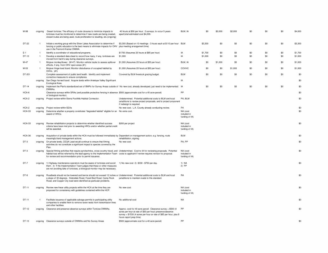
M-98 ongoing Desert tortoise: The efficacy of route closures to minimize impacts to tortoises must be monitored to determine if new roads are being created, closed routes are being used, route proliferation is resulting, etc.(ongoing)
40 hours at $50 per hour; 2 surveys, to occur 5 years apart;total estimated cost $4,000.
BLM, IA $0 $2,000 $2,000 $0 $0 $0 $4,000
DT-22 1 Initiate a working group with the Silver Lakes Association to determine if fencing or public education is the best means to eliminate impacts for OHV use in the Fremont-Kramer DWMA.
$3,300 (Based on 10 meetings - 3 hours each at $110 per hour plus meeting arrangement time)
BLM $3,300 $0 $0 $0 $0 $0 $3,300
E-1 1 Identify a coordinator of educational programs. $1700 (Assumes 20 hours at $85 per hour) IA $1,700 $0 $0 $0 $0 $0 $1,700
DT-13 1 Develop a standard data sheet to record how many, if any, tortoises are moved from harm's way during clearance surveys.
$1,000 IA $1,000 $0 $0 $0 $0 $0 $1,000
M-47 1 Mojave monkeyflower: (M-47) Monitor vehicle tracks to assess spillover effects, if any, from OHV open areas (#1)
$1,000 (Assumes 20 hours at $50 per hour) BLM, IA $0 $1,000 $0 $0 $0 $0 $1,000
M-53 1 Mojave fringe-toed lizard: Monitor disturbance of occupied habitat by OHVs. (#1)
$1,000 (Assumes 20 hours at $50 per hour) COVHC $0 $0 $1,000 $0 $0 $0 $1,000
DT-201 Complete assessment of public land health. Identify and implement corrective measures to ensure compliance.
Covered by BLM livestock grazing budget. BLM $0 $0 $0 $0 $0 $0 $0
ongoing San Diego horned lizard: Acquire lands within Antelope Valley Significant Ecological Area.
IA $0
DT-14 ongoing Implement the Plan's standardized set of BMPs for Survey Areas outside of DWMAs.
No new cost, already developed, just need to be implemented. IA $0 $0 $0 $0 $0 $0 $0
HCA-6 Clearance surveys within SRAs (and possible protective fencing in absence of biological monitor).
$500 (approximate cost for a 40 acre-parcel) PP $0
HCA-2 ongoing Project review within Sierra Foothills Habitat Connector. Undetermined. Potential additional costs to BLM and local jurisditions to review project proposals, and to project proponent if redesign is required.
PA, BLM $0
HCA-2 ongoing Project review within SEAs No new cost. L.A. County already conducting review. PA $0
HCA-33 ongoing Determine whether a property constitutes "degraded habitat" eligible for an award of HRCs.
No extra cost. NA (cost included in funding of IA)
$0
HCA-33 ongoing Review rehabilitation projects to determine whether identified success criteria have been met prior to awarding HRCs and/or whether partial credit will be awarded.
$200 per project NA (cost included in funding of IA)
$0
HCA-36 ongoing Acquisition of private lands within the HCA must be followed immediately by meaningful land management actions.
Dependent on management action, e.g. fencing, route rehabilitation, signing.
BLM $0
DT-3 ongoing On private lands, CEQA Lead would continue to ensure that filming activities do not constitute a significant impact to species covered by the Plan.
No new cost PA, PP $0
DT-3 ongoing Special filming activities that require pyrotechnics, cross-country travel, and habitat loss will be referred by the lead agency to the Implementation Team for review and recommendation prior to permit issuance.
Undetermined. Cost to IA for reviewing proposals. Potential costs to applicant if review requires revision to proposal.
NA (cost included in funding of IA)
$0
DT-7 ongoing 1) Highway maintenance operators must be aware of tortoises and avoid them. 2) If the Implementation Team judges that these or other measures are not avoiding take of tortoises, a biological monitor may be necessary.
1) No new cost 2) $330 - $750 per day. 1) NA 2) PP
$0
DT-8 ongoing Roadbeds should not be lowered and berms should not exceed 12 inches or a slope of 30 degrees. Helendale Road, Fossil Bed Road, Camp Rock Road, and Copper City toad were identified as particular problems.
Undetermined. Potential additional costs to BLM and local jurisditions to maintain roads to this standard.
RA $0
DT-11 ongoing Review new linear utility projects within the HCA at the time they are proposed for consistency with guidelines contained within the HCP.
No new cost NA (cost included in funding of IA)
$0
DT-11 1 Facilitate issuance of applicable salvage permits to participating utility companies to enable them to remove raven nests from transmission lines and other facilities
No additional cost NA $0
DT-12 ongoing Clearance and presence-absence surveys within Tortoise DWMAs. Approx. cost for 40 acre parcel: Clearance survey = $500 (4 acres per hour at rate of $50 per hour) presence/absence survey = $1530 (4 acres per hour ar rate of $85 per hour, plus 8 hours report prep time)
PP $0
DT-13 ongoing Clearance surveys outside of DWMAs and No Survey Areas $500 (approximate cost for a 40 acre-parcel) PP $0
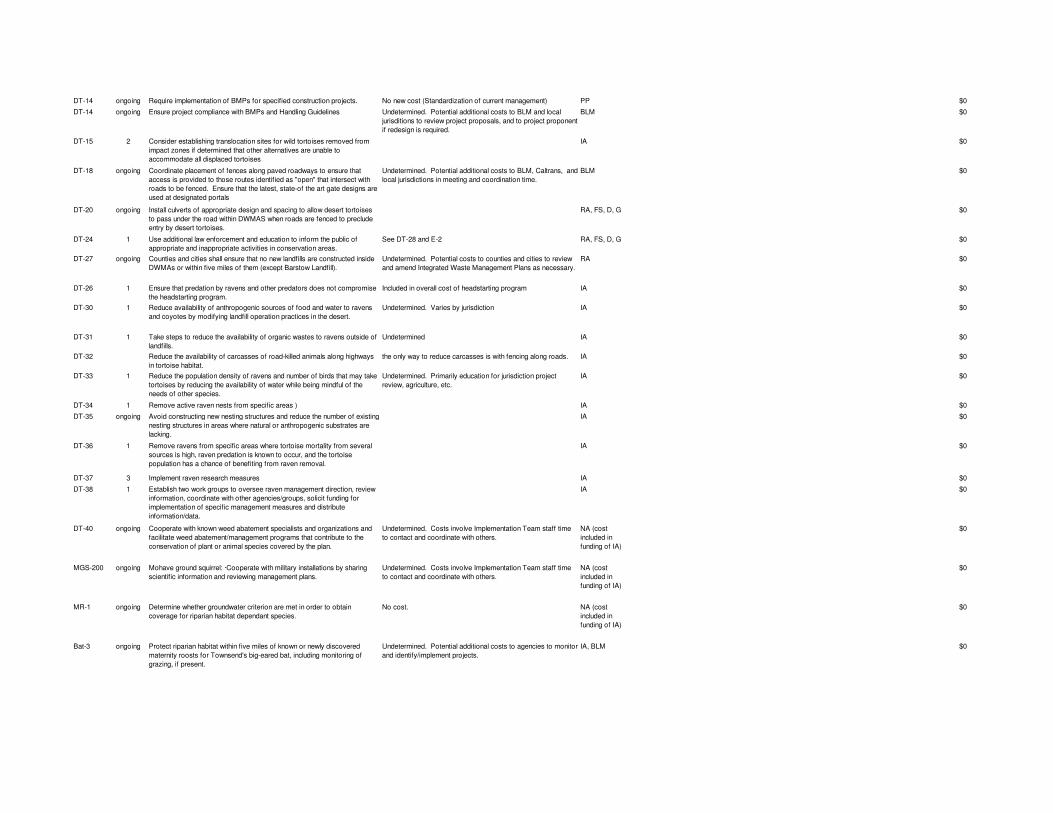
DT-14 ongoing Require implementation of BMPs for specified construction projects. No new cost (Standardization of current management) PP $0
DT-14 ongoing Ensure project compliance with BMPs and Handling Guidelines Undetermined. Potential additional costs to BLM and local jurisditions to review project proposals, and to project proponent if redesign is required.
BLM $0
DT-15 2 Consider establishing translocation sites for wild tortoises removed from impact zones if determined that other alternatives are unable to accommodate all displaced tortoises
IA $0
DT-18 ongoing Coordinate placement of fences along paved roadways to ensure that access is provided to those routes identified as "open" that intersect with roads to be fenced. Ensure that the latest, state-of the art gate designs are used at designated portals
Undetermined. Potential additional costs to BLM, Caltrans, and local jurisdictions in meeting and coordination time.
BLM $0
DT-20 ongoing Install culverts of appropriate design and spacing to allow desert tortoises to pass under the road within DWMAS when roads are fenced to preclude entry by desert tortoises.
RA, FS, D, G $0
DT-24 1 Use additional law enforcement and education to inform the public of appropriate and inappropriate activities in conservation areas.
See DT-28 and E-2 RA, FS, D, G $0
DT-27 ongoing Counties and cities shall ensure that no new landfills are constructed inside DWMAs or within five miles of them (except Barstow Landfill).
Undetermined. Potential costs to counties and cities to review and amend Integrated Waste Management Plans as necessary.
RA $0
DT-26 1 Ensure that predation by ravens and other predators does not compromise the headstarting program.
Included in overall cost of headstarting program IA $0
DT-30 1 Reduce availability of anthropogenic sources of food and water to ravens and coyotes by modifying landfill operation practices in the desert.
Undetermined. Varies by jurisdiction IA $0
DT-31 1 Take steps to reduce the availability of organic wastes to ravens outside of landfills.
Undetermined IA $0
DT-32 Reduce the availability of carcasses of road-killed animals along highways in tortoise habitat.
the only way to reduce carcasses is with fencing along roads. IA $0
DT-33 1 Reduce the population density of ravens and number of birds that may take tortoises by reducing the availability of water while being mindful of the needs of other species.
Undetermined. Primarily education for jurisdiction project review, agriculture, etc.
IA $0
DT-34 1 Remove active raven nests from specific areas ) IA $0
DT-35 ongoing Avoid constructing new nesting structures and reduce the number of existing nesting structures in areas where natural or anthropogenic substrates are lacking.
IA $0
DT-36 1 Remove ravens from specific areas where tortoise mortality from several sources is high, raven predation is known to occur, and the tortoise population has a chance of benefiting from raven removal.
IA $0
DT-37 3 Implement raven research measures IA $0
DT-38 1 Establish two work groups to oversee raven management direction, review information, coordinate with other agencies/groups, solicit funding for implementation of specific management measures and distribute information/data.
IA $0
DT-40 ongoing Cooperate with known weed abatement specialists and organizations and facilitate weed abatement/management programs that contribute to the conservation of plant or animal species covered by the plan.
Undetermined. Costs involve Implementation Team staff time to contact and coordinate with others.
NA (cost included in funding of IA)
$0
MGS-200 ongoing Mohave ground squirrel: ·Cooperate with military installations by sharing scientific information and reviewing management plans.
Undetermined. Costs involve Implementation Team staff time to contact and coordinate with others.
NA (cost included in funding of IA)
$0
MR-1 ongoing Determine whether groundwater criterion are met in order to obtain coverage for riparian habitat dependant species.
No cost. NA (cost included in funding of IA)
$0
Bat-3 ongoing Protect riparian habitat within five miles of known or newly discovered maternity roosts for Townsend's big-eared bat, including monitoring of grazing, if present.
Undetermined. Potential additional costs to agencies to monitor and identify/implement projects.
IA, BLM $0
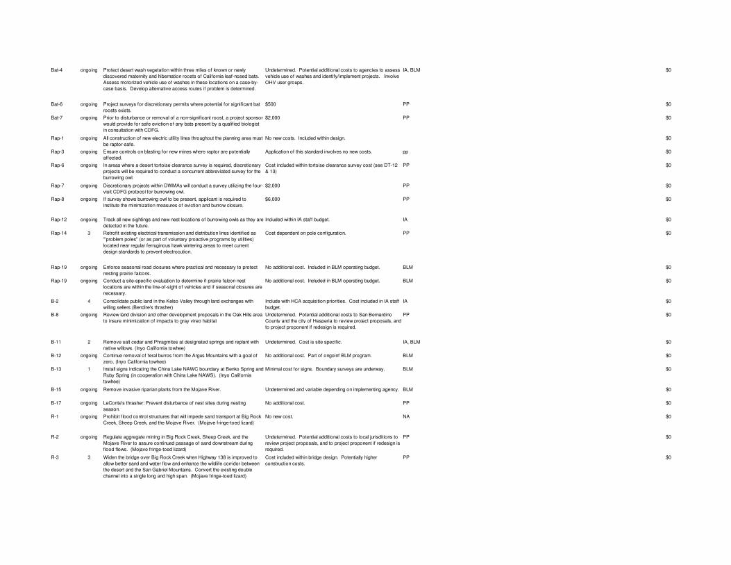
Bat-4 ongoing Protect desert wash vegetation within three miles of known or newly discovered maternity and hibernation roosts of California leaf-nosed bats. Assess motorized vehicle use of washes in these locations on a case-by-case basis. Develop alternative access routes if problem is determined.
Undetermined. Potential additional costs to agencies to assess vehicle use of washes and identify/implement projects. Involve OHV user groups.
IA, BLM $0
Bat-6 ongoing Project surveys for discretionary permits where potential for significant bat roosts exists.
$500 PP $0
Bat-7 ongoing Prior to disturbance or removal of a non-significant roost, a project sponsor would provide for safe eviction of any bats present by a qualified biologist in consultation with CDFG.
$2,000 PP $0
Rap-1 ongoing All construction of new electric utility lines throughout the planning area must be raptor-safe.
No new costs. Included within design. $0
Rap-3 ongoing Ensure controls on blasting for new mines where raptor are potentially affected.
Application of this standard involves no new costs. pp $0
Rap-6 ongoing In areas where a desert tortoise clearance survey is required, discretionary projects will be required to conduct a concurrent abbreviated survey for the burrowing owl.
Cost included within tortoise clearance survey cost (see DT-12 & 13)
PP $0
Rap-7 ongoing Discretionary projects within DWMAs will conduct a survey utilizing the four-visit CDFG protocol for burrowing owl.
$2,000 PP $0
Rap-8 ongoing If survey shows burrowing owl to be present, applicant is required to institute the minimization measures of eviction and burrow closure.
$6,000 PP $0
Rap-12 ongoing Track all new sightings and new nest locations of burrowing owls as they are detected in the future.
Included within IA staff budget. IA $0
Rap-14 3 Retrofit existing electrical transmission and distribution lines identified as "'problem poles" (or as part of voluntary proactive programs by utilities) located near regular ferruginous hawk wintering areas to meet current design standards to prevent electrocution.
Cost dependent on pole configuration. PP $0
Rap-19 ongoing Enforce seasonal road closures where practical and necessary to protect nesting prairie falcons.
No additional cost. Included in BLM operating budget. BLM $0
Rap-19 ongoing Conduct a site-specific evaluation to determine if prairie falcon nest locations are within the line-of-sight of vehicles and if seasonal closures are necessary.
No additional cost. Included in BLM operating budget. BLM $0
B-2 4 Consolidate public land in the Kelso Valley through land exchanges with willing sellers (Bendire's thrasher)
Include with HCA acquisition priorities. Cost included in IA staff budget.
IA $0
B-8 ongoing Review land division and other development proposals in the Oak Hills area to insure minimization of impacts to gray vireo habitat
Undetermined. Potential additional costs to San Bernardino County and the city of Hesperia to review project proposals, and to project proponent if redesign is required.
PP $0
B-11 2 Remove salt cedar and Phragmites at designated springs and replant with native willows. (Inyo California towhee)
Undetermined. Cost is site specific. IA, BLM $0
B-12 ongoing Continue removal of feral burros from the Argus Mountains with a goal of zero. (Inyo California towhee)
No additional cost. Part of ongoinf BLM program. BLM $0
B-13 1 Install signs indicating the China Lake NAWC boundary at Benko Spring and Ruby Spring (in cooperation with China Lake NAWS). (Inyo California towhee)
Minimal cost for signs. Boundary surveys are underway. BLM $0
B-15 ongoing Remove invasive riparian plants from the Mojave River. Undetermined and variable depending on implementing agency. BLM $0
B-17 ongoing LeConte's thrasher: Prevent disturbance of nest sites during nesting season.
No additional cost. PP $0
R-1 ongoing Prohibit flood control structures that will impede sand transport at Big Rock Creek, Sheep Creek, and the Mojave River. (Mojave fringe-toed lizard)
No new cost. NA $0
R-2 ongoing Regulate aggregate mining in Big Rock Creek, Sheep Creek, and the Mojave River to assure continued passage of sand downstream during flood flows. (Mojave fringe-toed lizard)
Undetermined. Potential additional costs to local jurisditions to review project proposals, and to project proponent if redesign is required.
PP $0
R-3 3 Widen the bridge over Big Rock Creek when Highway 138 is improved to allow better sand and water flow and enhance the wildlife corridor between the desert and the San Gabriel Mountains. Convert the existing double channel into a single long and high span. (Mojave fringe-toed lizard)
Cost included within bridge design. Potentially higher construction costs.
PP $0
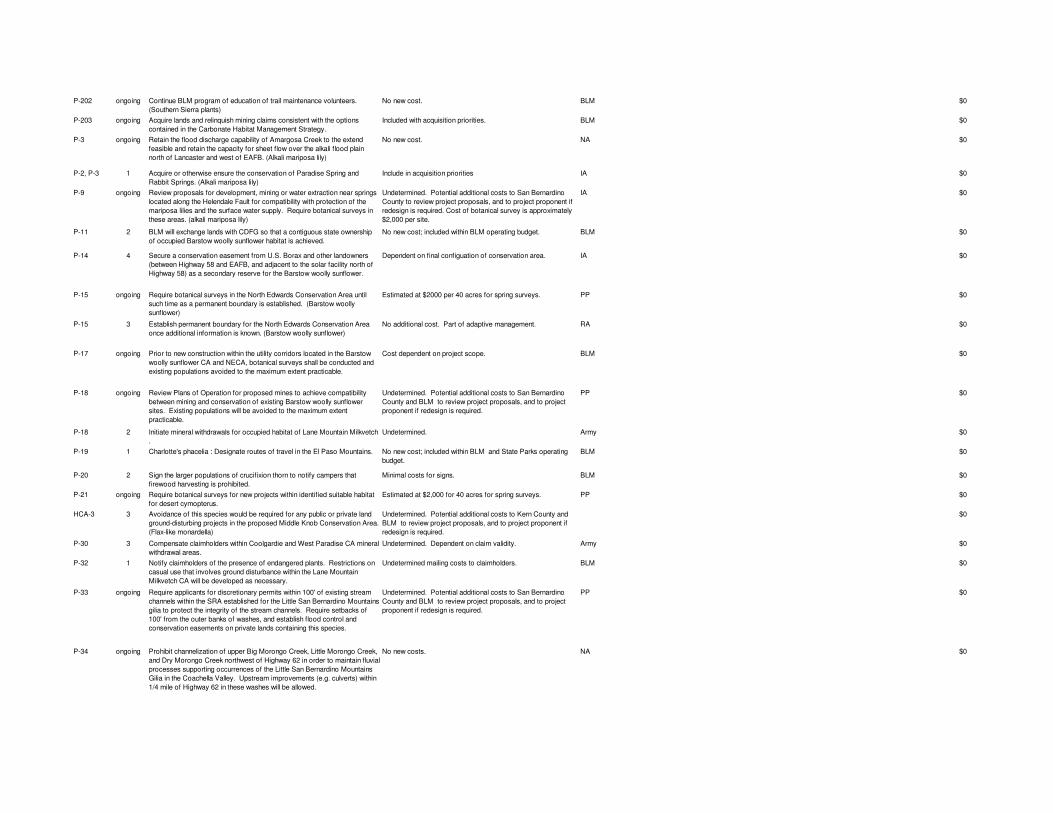
P-202 ongoing Continue BLM program of education of trail maintenance volunteers. (Southern Sierra plants)
No new cost. BLM $0
P-203 ongoing Acquire lands and relinquish mining claims consistent with the options contained in the Carbonate Habitat Management Strategy.
Included with acquisition priorities. BLM $0
P-3 ongoing Retain the flood discharge capability of Amargosa Creek to the extend feasible and retain the capacity for sheet flow over the alkali flood plain north of Lancaster and west of EAFB. (Alkali mariposa lily)
No new cost. NA $0
P-2, P-3 1 Acquire or otherwise ensure the conservation of Paradise Spring and Rabbit Springs. (Alkali mariposa lily)
Include in acquisition priorities IA $0
P-9 ongoing Review proposals for development, mining or water extraction near springs located along the Helendale Fault for compatibility with protection of the mariposa lilies and the surface water supply. Require botanical surveys in these areas. (alkali mariposa lily)
Undetermined. Potential additional costs to San Bernardino County to review project proposals, and to project proponent if redesign is required. Cost of botanical survey is approximately $2,000 per site.
IA $0
P-11 2 BLM will exchange lands with CDFG so that a contiguous state ownership of occupied Barstow woolly sunflower habitat is achieved.
No new cost; included within BLM operating budget. BLM $0
P-14 4 Secure a conservation easement from U.S. Borax and other landowners (between Highway 58 and EAFB, and adjacent to the solar facility north of Highway 58) as a secondary reserve for the Barstow woolly sunflower.
Dependent on final configuation of conservation area. IA $0
P-15 ongoing Require botanical surveys in the North Edwards Conservation Area until such time as a permanent boundary is established. (Barstow woolly sunflower)
Estimated at $2000 per 40 acres for spring surveys. PP $0
P-15 3 Establish permanent boundary for the North Edwards Conservation Area once additional information is known. (Barstow woolly sunflower)
No additional cost. Part of adaptive management. RA $0
P-17 ongoing Prior to new construction within the utility corridors located in the Barstow woolly sunflower CA and NECA, botanical surveys shall be conducted and existing populations avoided to the maximum extent practicable.
Cost dependent on project scope. BLM $0
P-18 ongoing Review Plans of Operation for proposed mines to achieve compatibility between mining and conservation of existing Barstow woolly sunflower sites. Existing populations will be avoided to the maximum extent practicable.
Undetermined. Potential additional costs to San Bernardino County and BLM to review project proposals, and to project proponent if redesign is required.
PP $0
P-18 2 Initiate mineral withdrawals for occupied habitat of Lane Mountain Milkvetch .
Undetermined. Army $0
P-19 1 Charlotte's phacelia : Designate routes of travel in the El Paso Mountains. No new cost; included within BLM and State Parks operating budget.
BLM $0
P-20 2 Sign the larger populations of crucifixion thorn to notify campers that firewood harvesting is prohibited.
Minimal costs for signs. BLM $0
P-21 ongoing Require botanical surveys for new projects within identified suitable habitat for desert cymopterus.
Estimated at $2,000 for 40 acres for spring surveys. PP $0
HCA-3 3 Avoidance of this species would be required for any public or private land ground-disturbing projects in the proposed Middle Knob Conservation Area. (Flax-like monardella)
Undetermined. Potential additional costs to Kern County and BLM to review project proposals, and to project proponent if redesign is required.
$0
P-30 3 Compensate claimholders within Coolgardie and West Paradise CA mineral withdrawal areas.
Undetermined. Dependent on claim validity. Army $0
P-32 1 Notify claimholders of the presence of endangered plants. Restrictions on casual use that involves ground disturbance within the Lane Mountain Milkvetch CA will be developed as necessary.
Undetermined mailing costs to claimholders. BLM $0
P-33 ongoing Require applicants for discretionary permits within 100' of existing stream channels within the SRA established for the Little San Bernardino Mountains gilia to protect the integrity of the stream channels. Require setbacks of 100' from the outer banks of washes, and establish flood control and conservation easements on private lands containing this species.
Undetermined. Potential additional costs to San Bernardino County and BLM to review project proposals, and to project proponent if redesign is required.
PP $0
P-34 ongoing Prohibit channelization of upper Big Morongo Creek, Little Morongo Creek, and Dry Morongo Creek northwest of Highway 62 in order to maintain fluvial processes supporting occurrences of the Little San Bernardino Mountains Gilia in the Coachella Valley. Upstream improvements (e.g. culverts) within 1/4 mile of Highway 62 in these washes will be allowed.
No new costs. NA $0
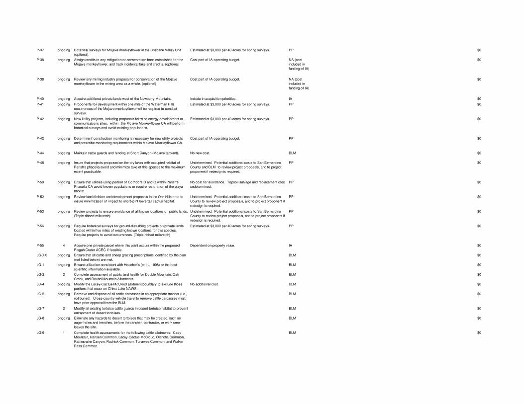
P-37 ongoing Botanical surveys for Mojave monkeyflower in the Brisbane Valley Unit (optional).
Estimated at $3,000 per 40 acres for spring surveys. PP $0
P-38 ongoing Assign credits to any mitigation or conservation bank established for the Mojave monkeyflower, and track incidental take and credits. (optional)
Cost part of IA operating budget. NA (cost included in funding of IA)
$0
P-38 ongoing Review any mining industry proposal for conservation of the Mojave monkeyflower in the mining area as a whole. (optional)
Cost part of IA operating budget. NA (cost included in funding of IA)
$0
P-40 ongoing Acquire additional private lands west of the Newberry Mountains. Include in acquisition priorities. IA $0
P-41 ongoing Proponents for development within one mile of the Waterman Hills occurrences of the Mojave monkeyflower will be required to conduct surveys.
Estimated at $3,000 per 40 acres for spring surveys. PP $0
P-42 ongoing New Utility projects, including proposals for wind energy development or communications sites, within the Mojave Monkeyflower CA will perform botanical surveys and avoid existing populations.
Estimated at $3,000 per 40 acres for spring surveys. PP $0
P-42 ongoing Determine if construction monitoring is necessary for new utility projects and prescribe monitoring requirements within Mojave Monkeyflower CA.
Cost part of IA operating budget. PP $0
P-44 ongoing Maintain cattle guards and fencing at Short Canyon (Mojave tarplant). No new cost. BLM $0
P-48 ongoing Insure that projects proposed on the dry lakes with occupied habitat of Parish's phacelia avoid and minimize take of this species to the maximum extent practicable.
Undetermined. Potential additional costs to San Bernardino County and BLM to review project proposals, and to project proponent if redesign is required.
PP $0
P-50 ongoing Ensure that utilities using portion of Corridors D and Q within Parish's Phacelia CA avoid known populations or require restoration of the playa habitat.
No cost for avoidance. Topsoil salvage and replacement cost undetermined.
PP $0
P-52 ongoing Review land division and development proposals in the Oak Hills area to insure minimization of impact to short-joint bevertail cactus habitat.
Undetermined. Potential additional costs to San Bernardino County to review project proposals, and to project proponent if redesign is required.
PP $0
P-53 ongoing Review projects to ensure avoidance of all known locations on public lands. (Triple-ribbed milkvetch)
Undetermined. Potential additional costs to San Bernardino County to review project proposals, and to project proponent if redesign is required.
PP $0
P-54 ongoing Require botanical surveys for ground-disturbing projects on private lands located within five miles of existing known locations for this species. Require projects to avoid occurrences. (Triple-ribbed milkvetch)
Estimated at $3,000 per 40 acres for spring surveys. PP $0
P-55 4 Acquire one private parcel where this plant occurs within the proposed Pisgah Crater ACEC if feasible.
Dependent on property value. IA $0
LG-XX ongoing Ensure that all cattle and sheep grazing prescriptions identified by the plan (not listed below) are met.
BLM $0
LG-1 ongoing Ensure utilization consistent with Hoechek's (et al., 1998) or the best scientific information available.
BLM $0
LG-2 2 Complete assessment of public land health for Double Mountain, Oak Creek, and Round Mountain Allotments.
BLM $0
LG-4 ongoing Modify the Lacey-Cactus-McCloud allotment boundary to exclude those portions that occur on China Lake NAWS.
No additional cost. BLM $0
LG-5 ongoing Remove and dispose of all cattle carcasses in an appropriate manner (I.e., not buried). Cross-country vehicle travel to remove cattle carcasses must have prior approval from the BLM.
BLM $0
LG-7 2 Modify all existing tortoise cattle guards in desert tortoise habitat to prevent entrapment of desert tortoises.
BLM $0
LG-8 ongoing Eliminate any hazards to desert tortoises that may be created, such as auger holes and trenches, before the rancher, contractor, or work crew leaves the site.
BLM $0
LG-9 1 Complete health assessments for the following cattle allotments: Cady Mountain, Hansen Common, Lacey-Cactus-McCloud, Olancha Common, Rattlesnake Canyon, Rudnick Common, Tunawee Common, and Walker Pass Common.
BLM $0
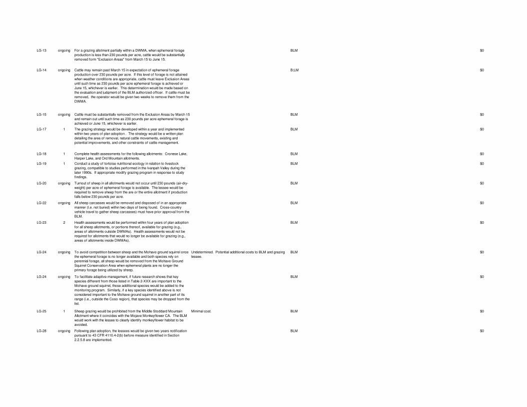
LG-13 ongoing For a grazing allotment partially within a DWMA, when ephemeral forage production is less than 230 pounds per acre, cattle would be substantially removed form "Exclusion Areas" from March 15 to June 15.
BLM $0
LG-14 ongoing Cattle may remain past March 15 in expectation of ephemeral forage production over 230 pounds per acre. If this level of forage is not attained when weather conditions are appropriate, cattle must leave Exclusion Areas until such time as 230 pounds per acre ephemeral forage is achieved or June 15, whichever is earlier. This determination would be made based on the evaluation and judgment of the BLM authorized officer. If cattle must be removed, the operator would be given two weeks to remove them from the DWMA.
B;LM $0
LG-15 ongoing Cattle must be substantially removed from the Exclusion Areas by March 15 and remain out until such time as 230 pounds per acre ephemeral forage is achieved or June 15, whichever is earlier.
BLM $0
LG-17 1 The grazing strategy would be developed within a year and implemented within two years of plan adoption . The strategy would be a written plan detailing the area of removal, natural cattle movements, existing and potential improvements, and other constraints of cattle management.
BLM $0
LG-18 1 Complete health assessments for the following allotments: Cronese Lake, Harper Lake, and Ord Mountain allotments.
BLM $0
LG-19 1 Conduct a study of tortoise nutritional ecology in relation to livestock grazing, compatible to studies performed in the Ivanpah Valley during the later 1990s. If appropriate modify grazing program in response to study findings.
BLM $0
LG-20 ongoing Turnout of sheep in all allotments would not occur until 230 pounds (air-dry-weight) per acre of ephemeral forage is available. The lessee would be required to remove sheep from the are or the entire allotment if production falls below 230 pounds per acre.
BLM $0
LG-22 ongoing All sheep carcasses would be removed and disposed of in an appropriate manner (I.e. not buried) within two days of being found. Cross-country vehicle travel to gather sheep carcasses) must have prior approval from the BLM.
BLM $0
LG-23 2 Health assessments would be performed within four years of plan adoption for all sheep allotments, or portions thereof, available for grazing (e.g., areas of allotments outside DWMAs). Health assessments would not be required for allotments that would no longer be available for grazing (e.g., areas of allotments inside DWMAs).
BLM $0
LG-24 ongoing To avoid competition between sheep and the Mohave ground squirrel once the ephemeral forage is no longer available and both species rely on perennial forage, all sheep would be removed from the Mohave Ground Squirrel Conservation Area when ephemeral plants are no longer the primary forage being utilized by sheep.
Undetermined. Potential additional costs to BLM and grazing lessee.
BLM $0
LG-24 ongoing To facilitate adaptive management, if future research shows that key species different from those listed in Table 2-XXX are important to the Mohave ground squirrel, those additional species would be added to the monitoring program. Similarly, if a key species identified above is not considered important to the Mohave ground squirrel in another part of its range (i.e., outside the Coso region), that species may be dropped from the list.
BLM $0
LG-25 1 Sheep grazing would be prohibited from the Middle Stoddard Mountain Allotment where it coincides with the Mojave Monkeyflower CA. The BLM would work with the lessee to clearly identify monkeyflower habitat to be avoided.
Minimal cost. BLM $0
LG-28 ongoing Following plan adoption, the lessees would be given two years notification pursuant to 43 CFR 4110.4-2(b) before measure identified in Section 2.2.5.8 are implemented.
BLM $0
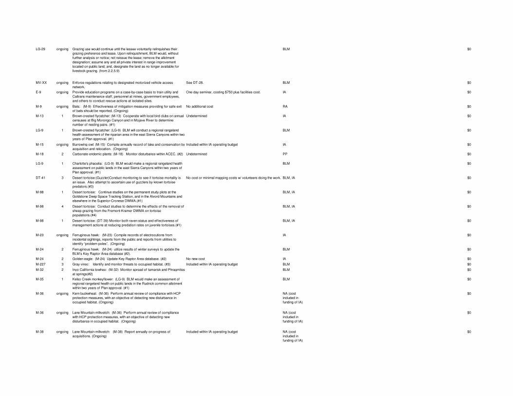
LG-29 ongoing Grazing use would continue until the lessee voluntarily relinquishes their grazing preference and lease. Upon relinquishment, BLM would, without further analysis or notice; not reissue the lease; remove the allotment designation; assume any and all private interest in range improvement located on public land; and, designate the land as no longer available for livestock grazing. (from 2.2.5.9)
BLM $0
MV-XX ongoing Enforce regulations relating to designated motorized vehicle access network.
See DT-28. BLM $0
E-9 ongoing Provide education programs on a case-by-case basis to train utility and Caltrans maintenance staff, personnel at mines, government employees, and others to conduct rescue actions at isolated sites.
One day seminar, costing $750 plus facilities cost. IA $0
M-9 ongoing Bats: (M-9) Effectiveness of mitigation measures providing for safe exit of bats should be reported. (Ongoing)
No additional cost RA $0
M-13 1 Brown-crested flycatcher: (M-13) Cooperate with local bird clubs on annual censuses at Big Morongo Canyon and in Mojave River to determine number of nesting pairs. (#1)
Undetermined IA $0
LG-9 1 Brown-crested flycatcher: (LG-9) BLM will conduct a regional rangeland health assessment of the riparian area in the east Sierra Canyons within two years of Plan approval. (#1)
BLM $0
M-15 ongoing Burrowing owl: (M-15) Compile annually record of take and conservation by acquisition and relocation. (Ongoing)
Included within IA operating budget IA $0
M-18 2 Carbonate endemic plants: (M-18) Monitor disturbance within ACEC. (#2) Undetermined PP $0
LG-9 1 Charlotte's phacelia: (LG-9) BLM would make a regional rangeland health assessment on public lands in the east Sierra Canyons within two years of Plan approval. (#1)
BLM $0
DT-41 3 Desert tortoise:(Guzzler)Conduct monitoring to see if tortoise mortality is an issue. Also attempt to ascertain use of guzzlers by known tortoise predators.(#3)
No cost or minimal mapping costs w/ volunteers doing the work. BLM, IA $0
M-98 1 Desert tortoise: Continue studies on the permanent study plots at the Goldstone Deep Space Tracking Station, and in the Alvord Mountains and elsewhere in the Superior-Cronese DWMA.(#1)
BLM, IA $0
M-98 4 Desert tortoise: Conduct studies to determine the effects of the removal of sheep grazing from the Fremont-Kramer DWMA on tortoise populations.(#4)
BLM, IA $0
M-98 1 Desert tortoise: (DT-39) Monitor both raven status and effectiveness of management actions at reducing predation rates on juvenile tortoises.(#1)
BLM, IA $0
M-23 ongoing Ferruginous hawk: (M-23) Compile records of electrocutions from incidental sightings, reports from the public and reports from utilities to identify “problem poles”. (Ongoing)
IA $0
M-24 2 Ferruginous hawk: (M-24) utilize results of winter surveys to update the BLM’s Key Raptor Area database (#2).
BLM $0
M-24 2 Golden eagle: (M-24) Update Key Raptor Area database. (#2) No new cost IA $0
M-227 3 Gray vireo: Identify and monitor threats to occupied habitat. (#3) Included within IA operating budget BLM $0
M-32 2 Inyo California towhee: (M-32) Monitor spread of tamarisk and Phragmites at springs(#2)
BLM $0
M-35 1 Kelso Creek monkeyflower: (LG-9) BLM would make an assessment of regional rangeland health on public lands in the Rudnick common allotment within two years of Plan approval. (#1)
BLM $0
M-36 ongoing Kern buckwheat: (M-36) Perform annual review of compliance with HCP protection measures, with an objective of detecting new disturbance in occupied habitat. (Ongoing)
NA (cost included in funding of IA)
$0
M-36 ongoing Lane Mountain milkvetch: (M-36) Perform annual review of compliance with HCP protection measures, with an objective of detecting new disturbance in occupied habitat. (Ongoing)
NA (cost included in funding of IA)
$0
M-38 ongoing Lane Mountain milkvetch: (M-38) Report annually on progress of acquisitions. (Ongoing)
Included within IA operating budget NA (cost included in funding of IA)
$0
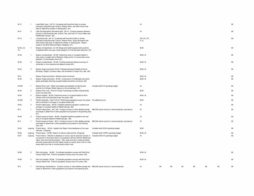
M-13 1 Least Bell's vireo: (M-13) Cooperate with local bird clubs on annual censuses at Big Morongo Canyon, Mojave River, and other known nest sites to determine number of nesting pairs. (#1)
IA $0
M-41 3 Little San Bernardino Mountains gilia: (M-41) Conduct presence absence surveys on BLM parcels near Joshua Tree, and north of Yucca Valley near Rattlesnake Canyon. (#3)
IA $0
M-13 1 Long-eared owl: (M-13) Cooperate with local bird clubs on annual censuses at Big Morongo Canyon, Mojave River, Argus Mountains and other known nest sites, to determine number of nesting pairs. Report results to the BLM National Raptor Database. (#1)
RA, PA, FS, D, G
$0
M-46, LG-18
1 Mojave monkeyflower: LG-18) Range land health assessments would be completed within one year of plan adoption for Ord Mountain allotment. (#1)
BLM $0
M-48 1 Mojave monkeyflower: (M-48) Determine acres of occupied habitat in rainy years on public land in Brisbane Valley portion of conservation area between I-15 and Mojave River (#1). .
BLM, IA $0
M-49 3 Mojave monkeyflower: (M-49) Continue presence absence surveys of remainder of core reserves and adjacent areas (#3).
BLM, IA $0
M-50 2 Mojave fringe-toed lizard: M-50) Delineate blowsand habitat at Alvord Mountain, Pisgah, Cronese Lakes, and northeast of Harper Dry Lake. (#2)
BLM, IA $0
M-51 Mojave fringe-toed lizard: Measure dune movement. BLM, IA $0
M-52 2 Mojave fringe-toed lizard: (M-52) Construction of windbreaks and exotic plants potentially affecting occupied habitat should be monitored. (#2)
BLM, IA $0
M-209 1 Mojave River vole: Obtain and analyze groundwater monitoring well records from Mojave Water Agency on an annual basis. (#1)
Included within IA operating budget IA $0
M-55 2 Mojave River vole: Perform Proper Functioning Condition assessments every five years (#2)
BLM $0
M-56 2 Mojave tarplant: (M-56) Determine acres of occupied habitat at Short Canyon and Cross Mountain every five years. (#2)
BLM, IA $0
M-200 3 Parish's phacelia: (See P-43 & P-46)Census populations every five years, with an estimate of acreage of occupied habitat (#3)
No additional cost. BLM $0
M-60 2 Parish's alkali grass: (M-60) Establish baseline population numbers and acreage of occupied habitat at Rabbit Springs. (#2)
IA $0
M-3 1 Parish's alkali grass: (M-3, 95) Conduct surveys of other alkaline springs and seeps to determine if other populations are present in the planning area. (#1)
$80,000 (same survey for several species; see above) IA $0
M-60 2 Parish's popcorn flower: (M-60) Establish baseline population size and area of occupied habitat at Rabbit Springs. (#2)
IA $0
M-3 1 Parish's popcorn flower: (M-3) Conduct surveys of other alkaline springs and seeps to determine if other populations are present in the Planning area. (#1)
$80,000 (same survey for several species; see above) IA $0
M-24 ongoing Prairie falcon: (M-24) Update Key Raptor Area databases at five-year intervals. (Ongoing)
Included within BLM operating budget BLM $0
M-66 ongoing Prairie falcon: (M-66) Report on falconry take permits. (Ongoing) Included within CDFG operating budget BLM, IA $0
M-97 ongoing Prairie Falcon: Maintain a database of survey reports and new records of occurrence of the prairie falcon in cooperation with the CDFG's NDDB and raptor nest card records program. Also, keep records of newly permitted activities issued within the Key Raptor Areas for prairie falcon and for other areas within one mile of a known prairie falcon nest
Included within IA operating budget IA $0
M-68 2 Red rock poppy: (M-68) Coordinate population surveys with Red Rock Canyon State Park. Perform population census every five years. (#2)
BLM, IA $0
M-68 2 Red rock tarplant: (M-68) Coordinate population surveys with Red Rock Canyon State Park. Perform population census every five years. (#2)
BLM, IA $0
M-3 1 Salt Springs checkerbloom: Conduct surveys of other alkaline springs and seeps to determine if other populations are present in the planning area.
$80,000 (same survey for several species) IA $0 $0 $0 $0 $0 $0 $0
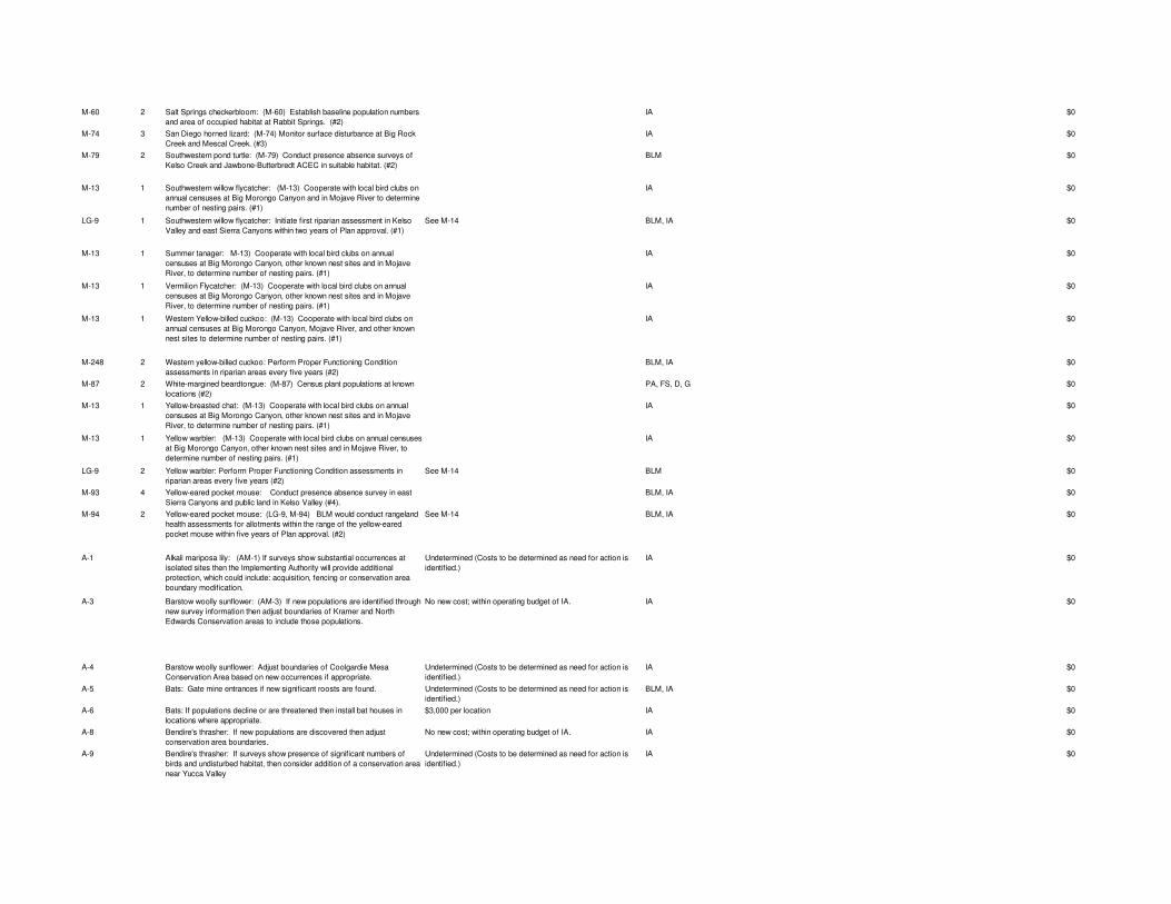
M-60 2 Salt Springs checkerbloom: (M-60) Establish baseline population numbers and area of occupied habitat at Rabbit Springs. (#2)
IA $0
M-74 3 San Diego horned lizard: (M-74) Monitor surface disturbance at Big Rock Creek and Mescal Creek. (#3)
IA $0
M-79 2 Southwestern pond turtle: (M-79) Conduct presence absence surveys of Kelso Creek and Jawbone-Butterbredt ACEC in suitable habitat. (#2)
BLM $0
M-13 1 Southwestern willow flycatcher: (M-13) Cooperate with local bird clubs on annual censuses at Big Morongo Canyon and in Mojave River to determine number of nesting pairs. (#1)
IA $0
LG-9 1 Southwestern willow flycatcher: Initiate first riparian assessment in Kelso Valley and east Sierra Canyons within two years of Plan approval. (#1)
See M-14 BLM, IA $0
M-13 1 Summer tanager: M-13) Cooperate with local bird clubs on annual censuses at Big Morongo Canyon, other known nest sites and in Mojave River, to determine number of nesting pairs. (#1)
IA $0
M-13 1 Vermilion Flycatcher: (M-13) Cooperate with local bird clubs on annual censuses at Big Morongo Canyon, other known nest sites and in Mojave River, to determine number of nesting pairs. (#1)
IA $0
M-13 1 Western Yellow-billed cuckoo: (M-13) Cooperate with local bird clubs on annual censuses at Big Morongo Canyon, Mojave River, and other known nest sites to determine number of nesting pairs. (#1)
IA $0
M-248 2 Western yellow-billed cuckoo: Perform Proper Functioning Condition assessments in riparian areas every five years (#2)
BLM, IA $0
M-87 2 White-margined beardtongue: (M-87) Census plant populations at known locations (#2)
PA, FS, D, G $0
M-13 1 Yellow-breasted chat: (M-13) Cooperate with local bird clubs on annual censuses at Big Morongo Canyon, other known nest sites and in Mojave River, to determine number of nesting pairs. (#1)
IA $0
M-13 1 Yellow warbler: (M-13) Cooperate with local bird clubs on annual censuses at Big Morongo Canyon, other known nest sites and in Mojave River, to determine number of nesting pairs. (#1)
IA $0
LG-9 2 Yellow warbler: Perform Proper Functioning Condition assessments in riparian areas every five years (#2)
See M-14 BLM $0
M-93 4 Yellow-eared pocket mouse: Conduct presence absence survey in east Sierra Canyons and public land in Kelso Valley (#4).
BLM, IA $0
M-94 2 Yellow-eared pocket mouse: (LG-9, M-94) BLM would conduct rangeland health assessments for allotments within the range of the yellow-eared pocket mouse within five years of Plan approval. (#2)
See M-14 BLM, IA $0
A-1 Alkali mariposa lily: (AM-1) If surveys show substantial occurrences at isolated sites then the Implementing Authority will provide additional protection, which could include: acquisition, fencing or conservation area boundary modification.
Undetermined (Costs to be determined as need for action is identified.)
IA $0
A-3 Barstow woolly sunflower: (AM-3) If new populations are identified through new survey information then adjust boundaries of Kramer and North Edwards Conservation areas to include those populations.
No new cost; within operating budget of IA. IA $0
A-4 Barstow woolly sunflower: Adjust boundaries of Coolgardie Mesa Conservation Area based on new occurrences if appropriate.
Undetermined (Costs to be determined as need for action is identified.)
IA $0
A-5 Bats: Gate mine entrances if new significant roosts are found. Undetermined (Costs to be determined as need for action is identified.)
BLM, IA $0
A-6 Bats: If populations decline or are threatened then install bat houses in locations where appropriate.
$3,000 per location IA $0
A-8 Bendire's thrasher: If new populations are discovered then adjust conservation area boundaries.
No new cost; within operating budget of IA. IA $0
A-9 Bendire's thrasher: If surveys show presence of significant numbers of birds and undisturbed habitat, then consider addition of a conservation area near Yucca Valley
Undetermined (Costs to be determined as need for action is identified.)
IA $0
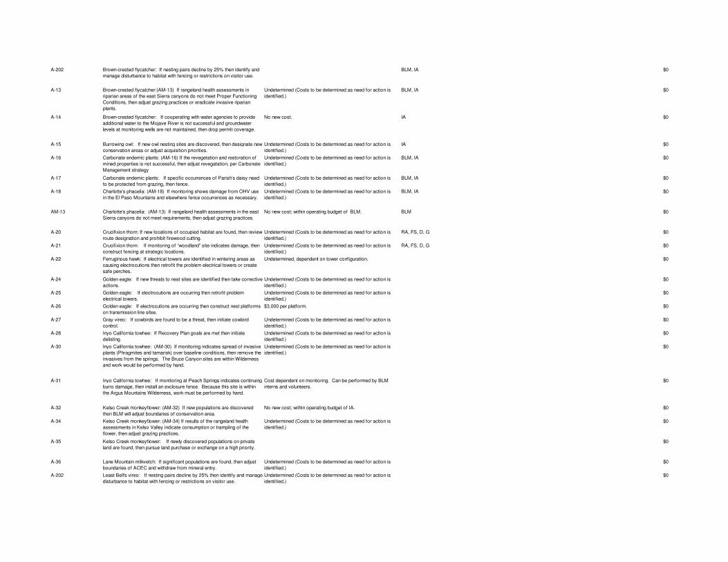
A-202 Brown-crested flycatcher: If nesting pairs decline by 25% then identify and manage disturbance to habitat with fencing or restrictions on visitor use.
BLM, IA $0
A-13 Brown-crested flycatcher:(AM-13) If rangeland health assessments in riparian areas of the east Sierra canyons do not meet Proper Functioning Conditions, then adjust grazing practices or eradicate invasive riparian plants.
Undetermined (Costs to be determined as need for action is identified.)
BLM, IA $0
A-14 Brown-crested flycatcher: If cooperating with water agencies to provide additional water to the Mojave River is not successful and groundwater levels at monitoring wells are not maintained, then drop permit coverage.
No new cost. IA $0
A-15 Burrowing owl: If new owl nesting sites are discovered, then designate new conservation areas or adjust acquisition priorities.
Undetermined (Costs to be determined as need for action is identified.)
IA $0
A-16 Carbonate endemic plants: (AM-16) If the revegetation and restoration of mined properties is not successful, then adjust revegatation, per Carbonate Management strategy
Undetermined (Costs to be determined as need for action is identified.)
BLM, IA $0
A-17 Carbonate endemic plants: If specific occurrences of Parish’s daisy need to be protected from grazing, then fence.
Undetermined (Costs to be determined as need for action is identified.)
BLM, IA $0
A-18 Charlotte's phacelia: (AM-18) If monitoring shows damage from OHV use in the El Paso Mountains and elsewhere fence occurrences as necessary.
Undetermined (Costs to be determined as need for action is identified.)
BLM, IA $0
AM-13 Charlotte's phacelia: (AM-13) If rangeland health assessments in the east Sierra canyons do not meet requirements, then adjust grazing practices.
No new cost; within operating budget of BLM. BLM $0
A-20 Crucifixion thorn: If new locations of occupied habitat are found, then review route designation and prohibit firewood cutting.
Undetermined (Costs to be determined as need for action is identified.)
RA, FS, D, G $0
A-21 Crucifixion thorn: If monitoring of “woodland” site indicates damage, then construct fencing at strategic locations.
Undetermined (Costs to be determined as need for action is identified.)
RA, FS, D, G $0
A-22 Ferruginous hawk: If electrical towers are identified in wintering areas as causing electrocutions then retrofit the problem electrical towers or create safe perches.
Undetermined, dependent on tower configuration. $0
A-24 Golden eagle: If new threats to nest sites are identified then take corrective actions.
Undetermined (Costs to be determined as need for action is identified.)
$0
A-25 Golden eagle: If electrocutions are occurring then retrofit problem electrical towers.
Undetermined (Costs to be determined as need for action is identified.)
$0
A-26 Golden eagle: If electrocutions are occurring then construct nest platforms on transmission line sites.
$3,000 per platform. $0
A-27 Gray vireo: If cowbirds are found to be a threat, then initiate cowbird control.
Undetermined (Costs to be determined as need for action is identified.)
$0
A-28 Inyo California towhee: If Recovery Plan goals are met then initiate delisting.
Undetermined (Costs to be determined as need for action is identified.)
$0
A-30 Inyo California towhee: (AM-30) If monitoring indicates spread of invasive plants (Phragmites and tamarisk) over baseline conditions, then remove the invasives from the springs. The Bruce Canyon sites are within Wilderness and work would be performed by hand.
Undetermined (Costs to be determined as need for action is identified.)
$0
A-31 Inyo California towhee: If monitoring at Peach Springs indicates continuing burro damage, then install an exclosure fence. Because this site is within the Argus Mountains Wilderness, work must be performed by hand.
Cost dependent on monitoring. Can be performed by BLM interns and volunteers.
$0
A-32 Kelso Creek monkeyflower: (AM-32) If new populations are discovered then BLM will adjust boundaries of conservation area.
No new cost; within operating budget of IA. $0
A-34 Kelso Creek monkeyflower: (AM-34) If results of the rangeland health assessments in Kelso Valley indicate consumption or trampling of the flower, then adjust grazing practices.
Undetermined (Costs to be determined as need for action is identified.)
$0
A-35 Kelso Creek monkeyflower: If newly discovered populations on private land are found, then pursue land purchase or exchange on a high priority.
$0
A-36 Lane Mountain milkvetch: If significant populations are found, then adjust boundaries of ACEC and withdraw from mineral entry.
Undetermined (Costs to be determined as need for action is identified.)
$0
A-202 Least Bell's vireo: If nesting pairs decline by 25% then identify and manage disturbance to habitat with fencing or restrictions on visitor use.
Undetermined (Costs to be determined as need for action is identified.)
$0
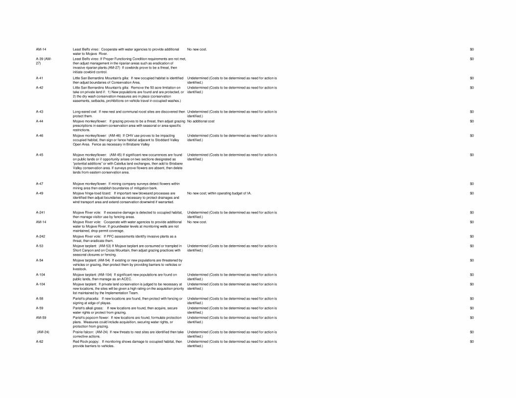
AM-14 Least Bell's vireo: Cooperate with water agencies to provide additional water to Mojave River.
No new cost. $0
A-39 (AM-27)
Least Bell's vireo: If Proper Functioning Condition requirements are not met, then adjust management in the riparian areas such as eradication of invasive riparian plants.(AM-27) If cowbirds prove to be a threat, then initiate cowbird control.
$0
A-41 Little San Bernardino Mountain's gilia: If new occupied habitat is identified then adjust boundaries of Conservation Area.
Undetermined (Costs to be determined as need for action is identified.)
$0
A-42 Little San Bernardino Mountain's gilia: Remove the 50 acre limitation on take on private land if: 1) New populations are found and are protected, or 2) the dry wash conservation measures are in place (conservation easements, setbacks, prohibitions on vehicle travel in occupied washes.)
Undetermined (Costs to be determined as need for action is identified.)
$0
A-43 Long-eared owl: If new nest and communal roost sites are discovered then protect them.
Undetermined (Costs to be determined as need for action is identified.)
$0
A-44 Mojave monkeyflower: If grazing proves to be a threat, then adjust grazing prescriptions in eastern conservation area with seasonal or area-specific restrictions.
No additional cost $0
A-46 Mojave monkeyflower: (AM-46) If OHV use proves to be impacting occupied habitat, then sign or fence habitat adjacent to Stoddard Valley Open Area. Fence as necessary in Brisbane Valley
Undetermined (Costs to be determined as need for action is identified.)
$0
A-45 Mojave monkeyflower: (AM-45) If significant new occurrences are found on public lands or if opportunity arises on two sections designated as “potential additions” or with Catellus land exchanges, then add to Brisbane Valley conservation area. If surveys prove flowers are absent, then delete lands from eastern conservation area.
Undetermined (Costs to be determined as need for action is identified.)
$0
A-47 Mojave monkeyflower: If mining company surveys detect flowers within mining area then establish boundaries of mitigation bank.
$0
A-49 Mojave fringe-toed lizard: If important new blowsand processes are identified then adjust boundaries as necessary to protect drainages and wind transport area and extend conservation downwind if warranted.
No new cost; within operating budget of IA. $0
A-241 Mojave River vole: If excessive damage is detected to occupied habitat, then manage visitor use by fencing areas.
Undetermined (Costs to be determined as need for action is identified.)
$0
AM-14 Mojave River vole: Cooperate with water agencies to provide additional water to Mojave River. If groundwater levels at monitoring wells are not maintained, drop permit coverage.
No new cost. $0
A-242 Mojave River vole: If PFC assessments identify invasive plants as a threat, then eradicate them.
$0
A-53 Mojave tarplant: (AM-53) If Mojave tarplant are consumed or trampled in Short Canyon and on Cross Mountain, then adjust grazing practices with seasonal closures or fencing.
Undetermined (Costs to be determined as need for action is identified.)
$0
A-54 Mojave tarplant: (AM-54) If existing or new populations are threatened by vehicles or grazing, then protect them by providing barriers to vehicles or livestock.
$0
A-104 Mojave tarplant: (AM-104) If significant new populations are found on public lands, then manage as an ACEC.
Undetermined (Costs to be determined as need for action is identified.)
$0
A-104 Mojave tarplant: If private land conservation is judged to be necessary at new locations, the sites will be given a high rating on the acquisition priority list maintained by the Implementation Team.
Undetermined (Costs to be determined as need for action is identified.)
$0
A-58 Parish's phacelia: If new locations are found, then protect with fencing or signing at edge of playas.
Undetermined (Costs to be determined as need for action is identified.)
$0
A-59 Parish's alkali grass: If new locations are found, then acquire, secure water rights or protect from grazing.
Undetermined (Costs to be determined as need for action is identified.)
$0
AM-59 Parish's popcorn flower: If new locations are found, formulate protection plans. Measures could include acquisition, securing water rights, or protection from grazing.
Undetermined (Costs to be determined as need for action is identified.)
$0
(AM-24) Prairie falcon: (AM-24) If new threats to nest sites are identified then take corrective actions.
Undetermined (Costs to be determined as need for action is identified.)
$0
A-62 Red Rock poppy: If monitoring shows damage to occupied habitat, then provide barriers to vehicles.
Undetermined (Costs to be determined as need for action is identified.)
$0
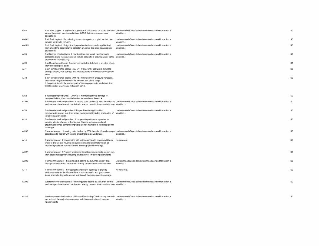
A-63 Red Rock poppy: If significant population is discovered on public land then amend the desert plan to establish an ACEC that encompasses new populations.
Undetermined (Costs to be determined as need for action is identified.)
$0
AM-62 Red Rock tarplant: If monitoring shows damage to occupied habitat, then provide barriers to vehicles.
Undetermined (Costs to be determined as need for action is identified.)
$0
AM-63 Red Rock tarplant: If significant population is discovered on public land then amend the desert plan to establish an ACEC that encompasses new populations.
Undetermined (Costs to be determined as need for action is identified.)
$0
A-59 Salt Springs checkerbloom: If new locations are found, then formulate protection plans. Measures could include acquisition, securing water rights, or protection from grazing.
Undetermined (Costs to be determined as need for action is identified.)
$0
A-69 San Diego horned lizard: If conserved habitat is disturbed in an edge effect, then fence and post signs.
$0
A-71 Short-joint beavertail cactus: (AM-71) If beavertail cactus are disturbed during a project, then salvage and relocate plants within urban development areas.
$0
A-72 Short-joint beavertail cactus: (AM-72) if development pressure increases, then create mitigation banks in the western part of the range.If the populations in the eastern part of the range prove to be distinct, then create smaller reserves as mitigation banks.
$0
A-62 Southwestern pond turtle: (AM-62) If monitoring shows damage to occupied habitat, then provide barriers to vehicles or livestock.
$0
A-202 Southwestern willow flycatcher: If nesting pairs decline by 25% then identify and manage disturbance to habitat with fencing or restrictions on visitor use.
Undetermined (Costs to be determined as need for action is identified.)
$0
A-76 Southwestern willow flycatcher: If Proper Functioning Condition requirements are not met, then adjust management including eradication of invasive riparian plants
Undetermined (Costs to be determined as need for action is identified.)
$0
A-14 Southwestern willow flycatcher: If cooperating with water agencies to provide additional water to the Mojave River is not successful and groundwater levels at monitoring wells are not maintained, then drop permit coverage.
$0
A-202 Summer tanager: If nesting pairs decline by 25% then identify and manage disturbance to habitat with fencing or restrictions on visitor use.
Undetermined (Costs to be determined as need for action is identified.)
$0
A-14 Summer tanager: If cooperating with water agencies to provide additional water to the Mojave River is not successful and groundwater levels at monitoring wells are not maintained, then drop permit coverage.
No new cost. $0
A-227 Summer tanager: If Proper Functioning Condition requirements are not met, then adjust management including eradication of invasive riparian plants
$0
A-202 Vermilion flycatcher: If nesting pairs decline by 25% then identify and manage disturbance to habitat with fencing or restrictions on visitor use.
Undetermined (Costs to be determined as need for action is identified.)
$0
A-14 Vermilion flycatcher: If cooperating with water agencies to provide additional water to the Mojave River is not successful and groundwater levels at monitoring wells are not maintained, then drop permit coverage.
No new cost. $0
A-202 Western yellow-billed cuckoo: If nesting pairs decline by 25% then identify and manage disturbance to habitat with fencing or restrictions on visitor use.
Undetermined (Costs to be determined as need for action is identified.)
$0
A-227 Western yellow-billed cuckoo: If Proper Functioning Condition requirements are not met, then adjust management including eradication of invasive riparian plants
Undetermined (Costs to be determined as need for action is identified.)
$0
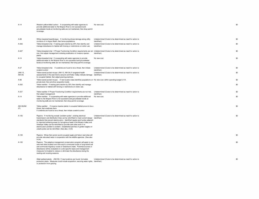
A-14 Western yellow-billed cuckoo: If cooperating with water agencies to provide additional water to the Mojave River is not successful and groundwater levels at monitoring wells are not maintained, then drop permit coverage.
No new cost. $0
A-89 White-margined beardtongue: If monitoring shows damage along utility corridors or in Argos Wash, then fence populations.
Undetermined (Costs to be determined as need for action is identified.)
$0
A-202 Yellow-breasted chat: If nesting pairs decline by 25% then identify and manage disturbance to habitat with fencing or restrictions on visitor use.
Undetermined (Costs to be determined as need for action is identified.)
$0
A-227 Yellow-breasted chat: If Proper Functioning Condition requirements are not met, then adjust management including eradication of invasive riparian plants
Undetermined (Costs to be determined as need for action is identified.)
$0
A-14 Yellow-breasted chat: If cooperating with water agencies to provide additional water to the Mojave River is not successful and groundwater levels at monitoring wells are not maintained, then drop permit coverage.
No new cost. $0
A-27 Yellow-breasted chat: If cowbirds are found to be a threat, then initiate cowbird control
Undetermined (Costs to be determined as need for action is identified.)
$0
(AM-13, AM-34)
Yellow-eared pocket mouse: (AM-13, AM-34) If rangeland health assessments in the east Sierra canyons and Kelso Valley indicate damage to occupied habitat, then adjust grazing practices.
Undetermined (Costs to be determined as need for action is identified.)
$0
A-96 Yellow-eared pocket mouse: If new location data identifies populations on private land, then prioritize acquisition lands.
No new cost; within operating budget of IA. $0
A-202 Yellow warbler: If nesting pairs decline by 25% then identify and manage disturbance to habitat with fencing or restrictions on visitor use.
$0
A-227 Yellow warbler: If Proper Functioning Condition requirements are not met, then adjust management.
Undetermined (Costs to be determined as need for action is identified.)
$0
A-14 Yellow warbler: If cooperating with water agencies to provide additional water to the Mojave River is not successful and groundwater levels at monitoring wells are not maintained, then drop permit coverage.
No new cost. $0
AM-39(AM-27)
Yellow warbler: If invasive riparian plants in occupied habitat prove to be a threat, then eradicate them. If cowbirds are found to be a threat, then initiate cowbird control
$0
A-105 Raptors: If monitoring reveals "problem poles", existing electrical transmission and distribution lines can be retrofitted to meet current design standards that prevent electrocution. Identified regular perch poles adjacent to important wintering areas for ferruginous hawk in the Mojave Valley and Antelope Valley can be retrofitted to provide safe sites even if no electrocution problem is evident. Established perches of golden eagles on unsafe poles can be retrofitted. (See also, A-24)
Undetermined (Costs to be determined as need for action is identified.)
$0
A-105 Raptors: Mines that cannot avoid occupied eagle and falcon nest sites will provide relocated nests in cooperation with the wildlife agencies. (See also A-24)
$0
A-105 Raptors: The adaptive management conservation program will apply to any new nest sites located over time and to communal roosts of long-eared owl and communal migratory roosts of Swainson's hawk. Potential sources of disturbance will be evaluated on a site-specific basis and management measures formulated to reduce or eliminate the disturbance during the nesting and roosting seasons.
$0
A-59 Alkali wetland plants: (AM-59) If new locations are found, formulate protection plans. Measures could include acquisition, securing water rights, or protection from grazing.
Undetermined (Costs to be determined as need for action is identified.)
$0

A-103 Alkali wetland plants: The privately owned portions of the palm oasis and alkali wetland at the Oasis of Mara adjacent to the Joshua Tree National Park headquarters buildings could be considered for acquisition, depending on the feasibility and results of botanical surveys of target species.
$0
R-200 ongoing Southwestern pond turtle: Continue restoration at Camp Cady and Afton Canyon.
M-200 ongoing Monitoring of reference populations of rare plants, especially annuals, will be conducted at reference sites in Conservation Areas on public land.
IA, BLM
M-201 1 Alkali Mariposa Lily: Monitor population numbers and measure groundwater levels in Conservation Area adjacent to LA County treatment ponds. (#1)
M-202 2 Alkali mariposa lily: Measure ground water levels at existing nearby wells inside or within one mile of the Alkali Mariposa lily conservation area. If no wells exist in close proximity, the surface water level may be measured. (#2)
M-203 3 Alkali mariposa lily: Determine plant numbers and area of occupied habitat at new sites identified since plan adoption every five years. (#3)
M-204 2 Barstow woolly sunflower: Establish baseline population numbers and occupied acreage in conservation areas. (#2)
M-205 2 Barstow woolly sunflower: BLM and CDFG will monitor OHV disturbance off designated open routes within the ACEC and Ecological Reserve area. (#2)
M-207 1 Townsend's big-eared bat: Monitor population numbers using bat houses if installed. (#1)
IA
M-209 1 Brown-crested flycatcher: Obtain and analyze groundwater monitoring well records from Mojave Water Agency on an annual basis. (#1)
IA
M-210 ongoing Parish’s daisy: Report new populations of Parish’s daisy within grazing allotments. (Ongoing)
BLM
M-211 2 Cushenbury buckwheat, Cushenbury milkvetch, Cushenbury oxytheca, Parish’s daisy, Shockley’s rockcress: Evaluate revegetation and restoration of mined properties.
BLM, IA
M-212 1 Charlotte’s phacelia: Monitor disturbance to occupied habitat in El Paso Mountains. (#1)
BLM
M-19 2 Charlotte’s phacelia: (M-19) Monitor populations in the Short Canyon and Sand Canyon ACEC's and at Red Rock Canyon State Park. (#2)
BLM, IA
M-200 1 Desert cymopterus:Monitor population numbers in occupied habitat every three years. (#1)
BLM, IA
M-213 1 Desert cymopterus:(LG-18) Assess rangeland health on Harper Lake allotment. (#1)
BLM
DT-21 ongoing Desert tortoise:(DT21) Monitor fences and culverts to ensure fence integrity and unobstructed culverts.(ongoing)
BLM, IA
M-214 1 Desert tortoise:(Headstarting)·Longitudinal monitoring for a minimum of 15 years to determine efficacy of program. (#1)
M-215 1 Desert tortoise:Must monitor and minimize raven impacts on hatchling tortoises at nurseries.(#1)
DT-17 1 Desert tortoise:(DT-17) Monitor for disease outbreaks concurrently with line-distance sampling and plot studies. (#1).
M-216 4 Desert tortoise:Monitor dust emissions from mining sites, agricultural fields, road edges, disturbed playas for toxic elements. (#4)
M-98 1 Desert tortoise:·Monitor tortoise health status concurrently with line-distance sampling and plot studies. (#1)
M-217 ongoing Desert tortoise:Necropsy all ill, dying and recently deceased tortoises as per salvage protocols.(ongoing)
M-218 1 Desert tortoise:Use data from line distance and other surveys to see if new die-off areas have extended further south of Highway 58 than what is reported in the Draft (#1).
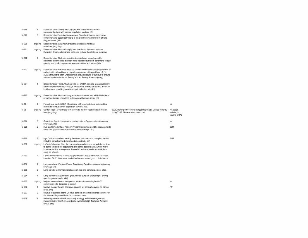
M-219 1 Desert tortoise:Identify feral dog problem areas within DWMAs (concurrently done with tortoise population studies). (#1)
M-219 3 Desert tortoise:Feral dog Management Plan should have a monitoring component that specifically looks at the distribution and intensity of feral dog problems. (#3)
M-220 ongoing Desert tortoise:(Grazing)·Conduct health assessments as scheduled.(ongoing)
M-221 ongoing Desert tortoise:·Monitor integrity and function of fences to maintain Exclusion Areas and minimize cattle use outside the allotment (ongoing)
M-222 1 Desert tortoise:·Allotment-specific studies should be performed to determine the threshold at which there would be sufficient ephemeral forage quantity and quality to promote healthy tortoises and habitat.(#1)
M-223 ongoing Desert tortoise:Presence-absence surveys will be used to (a) report level of authorized incidental take to regulatory agencies; (b) report level of 1% AGD attributed to each jurisdiction; (c) provide results of surveys to ensure appropriate boundaries for Survey and No Survey Areas (ongoing)
M-224 1 Desert tortoise:The BLM will provide for DWMA-directed law enforcement and other public outreach through recreational technicians to help minimize incidences of poaching, vandalism, pet collection, etc.(#1)
M-225 ongoing Desert tortoise: Monitor filming activities on private land within DWMAs to avoid or minimize impacts to tortoises and burrows. (ongoing)
M-22 2 Ferruginous hawk: (M-22) Coordinate with local bird clubs and electrical utilities to conduct winter population surveys. (#2).
IA
M-28 ongoing Golden eagle: Coordinate with utilities to monitor nests on transmission lines (ongoing).
5000, starting with second budget block.Note, utilities currently doing THIS. No new associated cost.
NA (cost included in funding of IA)
M-226 3 Gray vireo: Conduct surveys of nesting pairs in Conservation Area every five years. (#3)
IA
M-228 2 Inyo California towhee: Perform Proper Functioning Condition assessments every five years in conjunction with species surveys. (#2)
BLM
M-229 2 Inyo California towhee: Identify threats or disturbance to occupied habitat, including parasitism by brown-headed cowbirds. (#2)
BLM
M-230 ongoing LeConte's thrasher: Use the new sightings and records compiled over time to define the densest populations, and define specific areas where more intensive vehicle management is needed and where vehicle restrictions could be relaxed.
M-231 2 Little San Bernardino Mountains gilia: Monitor occupied habitat for: weed invasion, OHV disturbance, and other human-caused ground disturbance.
M-232 2 Long-eared owl: Perform Proper Functioning Condition assessments every five years (#2)
M-233 2 Long-eared owl:Monitor disturbance of nest and communal roost sites.
M-234 4 Long-eared owl: Determine if great-horned owls are displacing or preying upon long-eared owls. (#4)
M-235 ongoing Mojave monkey-flower: Incorporate results of monitoring by OHV commission into database (ongoing)
IA
M-236 1 Mojave monkey-flower: Mining companies will conduct surveys on mining lands. (#1)
PP
M-237 2 Mojave fringe-toed lizard: Conduct periodic presence/absence surveys for the Mojave fringe-toed lizard at conserved sites.
M-238 1 Mohave ground squirrel:A monitoring strategy would be designed and implemented by the IT, in coordination with the MGS Technical Advisory Group. (#1)

M-240 ongoing Mohave ground squirrel:On a yearly basis, track the loss of MGS habitat compared to the conservation of MGS habitat resulting from Plan implementation (ongoing)
LG-9 1 Mojave tarplant: (LG-9) BLM will make a regional rangeland health assessment on public lands in the Rudnick common allotment within two years of Plan approval. (#1)
LG-9 1 Ninemile Canyon phacelia: (LG-9) BLM will make a regional rangeland health assessment on public lands in the east Sierra Canyons within two years of Plan approval. (#1)
BLM
M-59 Parish's phacellia: Perform annual report describing vehicle traffic, if any, on specified playas.
No additional cost. BLM
M-242 2 South-western pond turtle: Perform Proper Functioning Condition assessments every five years. (#2)
M-209 1 South-western pond turtle: Obtain and analyze groundwater monitoring well records from Mojave Water Agency on an annual basis. (#1)
M-243 2 South-western willow flycatcher: Perform Proper Functioning Condition assessments every five years. (#2)
M-209 1 South-western willow flycatcher: Obtain and analyze groundwater monitoring well records from Mojave Water Agency on an annual basis. (#1)
M-244 2 Summer tanager: Perform Proper Functioning Condition assessments of the occupied habitat in the Mojave River every five years. (#2)
IA
M-209 1 Summer tanager: Obtain and analyze groundwater monitoring well records from Mojave Water Agency on an annual basis. (#1)
IA
M-245 2 Vermilion flycatcher: Perform Proper Functioning Condition assessments every five years (#2)
BLM, IA
M-209 1 Vermilion flycatcher: Obtain and analyze groundwater monitoring well records from Mojave Water Agency on an annual basis. (#1)
IA
M-246 ongoing Western snowy plover: Monitor disturbance at known nest sites. (Ongoing) BLM, IA
M-247 2 Western yellow-billed cuckoo: Perform Proper Functioning Condition assessments every five years (#2)
BLM
M-209 1 Western yellow-billed cuckoo: Obtain and analyze groundwater monitoring well records from Mojave Water Agency on an annual basis. (#1)
IA
M-249 ongoing White-margined beardtongue: Monitor the Johnson Valley to Parker race.
M-250 2 Yellow-breasted chat: Perform Proper Functioning Condition assessments every five years (#2)
BLM, IA
M-209 1 Yellow-breasted chat: Obtain and analyze groundwater monitoring well records from Mojave Water Agency on an annual basis. (#1)
IA
M-251 2 Yellow warbler: Perform Proper Functioning Condition assessments every five years (#2)
BLM, IA
M-209 1 Yellow warbler: Obtain and analyze groundwater monitoring well records from Mojave Water Agency on an annual basis. (#1)
IA
A-200 Alkali mariposa lily: If population numbers are dependent upon groundwater levels at LA County treatment ponds, then acquire water rights to maintain groundwater levels.
A-201 Barstow woolly sunflower: If adverse impacts to species are detected then revise road network or install fencing based on disturbance surveys within ACEC and Ecological Reserve Area.
BLM, IA
A-203 Burrowing owl: If research shows that active translocation is successful, then utilize this method to establish colonies in protected areas.
IA

A-2
04C
arbo
nate
end
emic
pla
nts:
If m
onito
ring
reve
als
OH
V d
istu
rban
ce th
en s
ign
and
gate
acc
ess
rout
es.
A-2
05D
eser
t cym
opte
rus:
If ra
ngel
and
heal
th a
sses
smen
ts in
dica
te th
at m
ore
than
ha
lf de
sert
cym
optu
rus
flow
erin
g st
alks
are
con
sum
ed, t
hen
adju
st g
razi
ng
prac
tices
, inc
ludi
ng fe
ncin
g.
A-2
07D
eser
t tor
tois
e: If
hab
itat c
ontin
ues
to b
e de
grad
ed a
nd to
rtois
es c
ontin
ue
to d
ie a
t ele
vate
d nu
mbe
rs w
ithou
t any
evi
denc
e of
sus
tain
ed re
crui
tmen
t, th
en IT
, BLM
, reg
ulat
ory
agen
cies
, etc
. sho
uld
cons
ider
est
ablis
hing
new
re
gion
s to
be
fenc
ed th
at a
re a
t lea
st 5
0 sq
uare
mile
s in
siz
e, a
nd m
anag
ed
sim
ilar t
o th
e D
TN
A.
A-2
08D
eser
t tor
tois
e:If
resu
lts o
f pilo
t stu
dies
are
suc
cess
ful,
then
hea
dsta
rting
co
uld
be u
sed
in th
ese
fenc
ed a
reas
to b
olst
er th
e fe
nced
pop
ulat
ion.
A-2
09D
eser
t tor
tois
e:If
the
MO
G, D
MG
, etc
. rec
omm
end
the
use
of th
e la
test
po
pula
tion
cens
us m
etho
ds, t
hen
ensu
re th
at th
ey a
re u
sed.
A-2
10D
eser
t tor
tois
e: If
the
resu
lts o
f pop
ulat
ion
stud
ies
indi
cate
that
reco
very
is
not o
ccur
ring,
then
adj
ust m
anag
emen
t pra
ctic
es a
s ne
eded
A-2
11D
eser
t tor
tois
e: If
the
head
star
ting
prog
ram
pro
ves
effe
ctiv
e in
bol
ster
ing
popu
latio
n, th
en im
plem
ent i
t in
othe
r pla
ces
with
in D
WM
As
whe
re to
rtois
es
have
bee
n ex
tirpa
ted.
A-2
12D
eser
t tor
tois
e:If
the
impe
rmea
ble
barr
iers
bet
wee
n so
me
DW
MA
s pr
ove
a hi
ndra
nce
to g
enet
ic c
onne
ctiv
ity a
nd re
sear
ch s
how
s th
at th
ere
is tr
uly
enou
gh g
enet
ic d
iffer
ence
am
ong
DW
MA
s, th
en tr
ansl
ocat
ion
of in
divi
dual
to
rtois
es s
houl
d be
con
side
red.
Act
ions
cou
ld in
clud
e m
anua
l tra
nsfe
r of
torto
ises
and
/or e
ggs
from
one
pla
ce to
ano
ther
, as
dict
ated
by
then
-av
aila
ble
info
rmat
ion
on tr
ansl
ocat
ion
and
othe
r fac
tors
.
A-2
13D
eser
t tor
tois
e:If
gene
tic d
iffer
ence
bet
wee
n D
WM
As
is e
stab
lishe
d th
en a
he
adst
artin
g pr
ogra
m w
ill be
follo
wed
with
col
lect
ion
of g
ravi
d fe
mal
es a
nd
the
layi
ng o
f pat
hoge
n-fr
ee e
ggs
in e
stab
lishe
d nu
rser
ies.
A-2
14, D
T-
16D
eser
t tor
tois
e:· (
DT
-16)
If th
e Im
plem
enta
tion
Tea
m, M
OG
, etc
. ide
ntify
an
y br
eakt
hrou
gh in
dis
ease
man
agem
ent,
then
it s
houl
d be
inco
rpor
ated
in
to th
e pl
an.
A-2
15D
eser
t tor
tois
e:If
scie
ntifi
c st
udie
s sh
ow th
at th
e sp
read
of d
isea
se c
an b
e cu
rtaile
d th
roug
h th
e cl
osur
e of
cul
verts
, the
n co
nsid
er c
losi
ng c
ulve
rts a
long
fe
nced
road
s.
A-2
16, D
T-
22D
eser
t tor
tois
e:D
T-2
2) If
impa
cts
to th
e Fr
emon
t-Kra
mer
DW
MA
by
OH
V
orig
inat
ing
in th
e S
ilver
Lak
es c
omm
unity
are
not
cur
taile
d fo
llow
ing
the
wor
king
gro
up s
ugge
stio
ns, t
hen
fenc
ing
may
be
nece
ssar
y.
A-2
17D
eser
t tor
tois
e:If
mon
itorin
g or
oth
er in
form
atio
n sh
ows
that
fera
l dog
im
pact
s ar
e ad
vers
ely
affe
ctin
g to
rtois
es w
ithin
DW
MA
s, th
en e
leva
te th
e pr
iorit
y of
this
pro
gram
.
A-2
18D
eser
t tor
tois
e:If
guzz
lers
are
det
erm
ined
to b
e a
prob
lem
, the
n ta
ke
appr
opria
te s
teps
to m
odify
guz
zler
s w
hile
reta
inin
g th
eir f
unct
ion
to p
reve
nt
furth
er to
rtois
e en
trapm
ent.
Inst
all p
reda
tor p
rohi
bitiv
e de
vice
s as
nee
ded.
A-2
19D
eser
t tor
tois
e:If
the
boun
dary
line
s fo
r Sur
vey
vers
us N
o S
urve
y A
reas
are
no
t acc
urat
ely
portr
ayin
g w
here
torto
ise
are
foun
d, th
en m
odify
the
boun
dary
line
s us
ing
the
data
col
lect
ed o
n w
here
ther
e is
take
.
A-2
20D
eser
t tor
tois
e:T
rack
ing
of la
w e
nfor
cem
ent a
ctiv
ities
:If th
ere
are
prob
lem
ar
eas
iden
tifie
d (in
crea
sed
poac
hing
, ille
gal t
arge
t sho
otin
g), t
hen
iden
tify
issu
e-sp
ecifi
c so
lutio
ns (i
ncre
ased
law
enf
orce
men
t pre
senc
e).
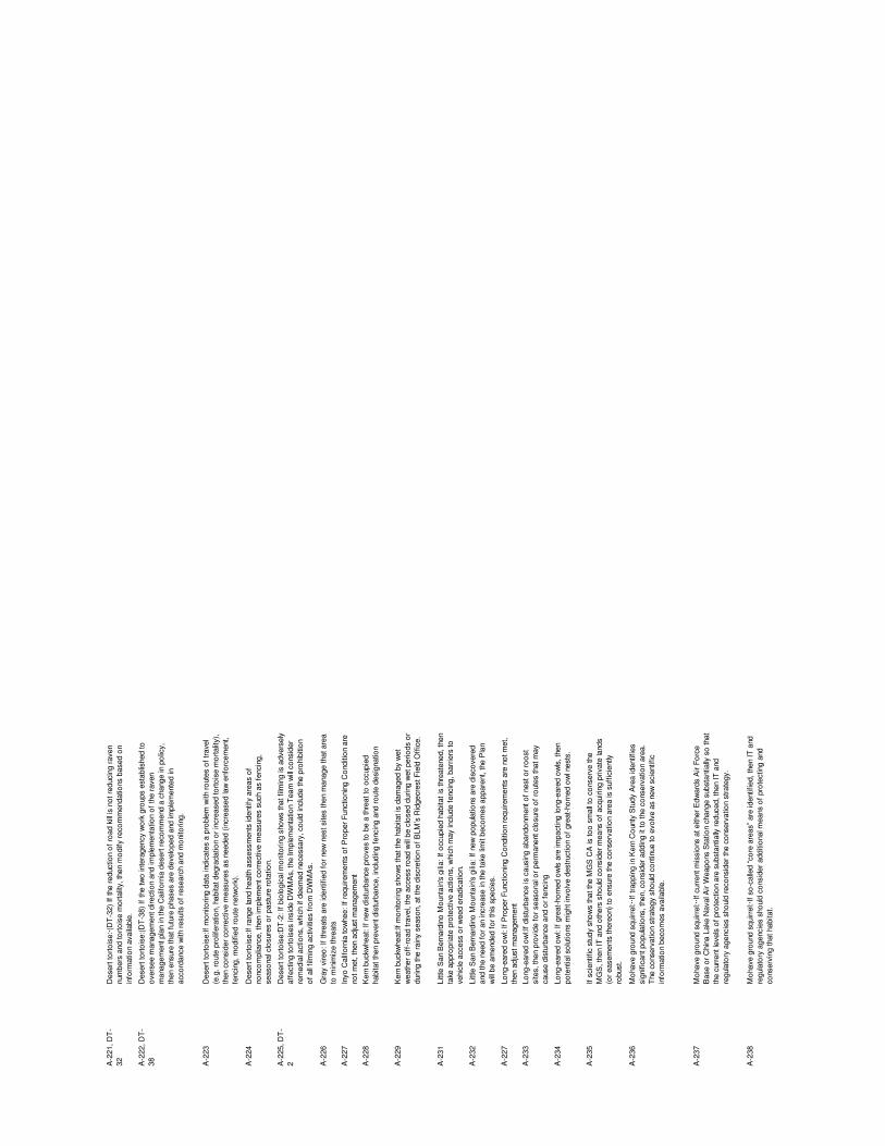
A-2
21, D
T-
32D
eser
t tor
tois
e:·(D
T-3
2) If
the
redu
ctio
n of
road
kill
is n
ot re
duci
ng ra
ven
num
bers
and
torto
ise
mor
talit
y, th
en m
odify
reco
mm
enda
tions
bas
ed o
n in
form
atio
n av
aila
ble.
A-2
22, D
T-
38D
eser
t tor
tois
e:(D
T-3
8) If
the
two
inte
rage
ncy
wor
k gr
oups
est
ablis
hed
to
over
see
man
agem
ent d
irect
ion
and
impl
emen
tatio
n of
the
rave
n m
anag
emen
t pla
n in
the
Cal
iforn
ia d
eser
t rec
omm
end
a ch
ange
in p
olic
y,
then
ens
ure
that
futu
re p
hase
s ar
e de
velo
ped
and
impl
emen
ted
in
acco
rdan
ce w
ith re
sults
of r
esea
rch
and
mon
itorin
g.
A-2
23D
eser
t tor
tois
e:If
mon
itorin
g da
ta in
dica
tes
a pr
oble
m w
ith ro
utes
of t
rave
l (e
.g. r
oute
pro
lifer
atio
n, h
abita
t deg
rada
tion
or in
crea
sed
torto
ise
mor
talit
y),
then
con
side
r cor
rect
ive
mea
sure
s as
nee
ded
(incr
ease
d la
w e
nfor
cem
ent,
fenc
ing,
mod
ified
rout
e ne
twor
k).
A-2
24D
eser
t tor
tois
e:If
rang
e la
nd h
ealth
ass
essm
ents
iden
tify
area
s of
no
ncom
plia
nce,
then
impl
emen
t cor
rect
ive
mea
sure
s su
ch a
s fe
ncin
g,
seas
onal
clo
sure
s or
pas
ture
rota
tion.
A-2
25, D
T-
2D
eser
t tor
tois
e:D
T-2
: If b
iolo
gica
l mon
itorin
g sh
ows
that
film
ing
is a
dver
sely
af
fect
ing
torto
ises
insi
de D
WM
As,
the
Impl
emen
tatio
n T
eam
will
cons
ider
re
med
ial a
ctio
ns, w
hich
if d
eem
ed n
eces
sary
, cou
ld in
clud
e th
e pr
ohib
ition
of
all
film
ing
activ
ities
from
DW
MA
s.
A-2
26G
ray
vire
o: If
thre
ats
are
iden
tifie
d fo
r new
nes
t site
s th
en m
anag
e th
at a
rea
to m
inim
ize
thre
ats
A-2
27In
yo C
alifo
rnia
tow
hee:
If re
quire
men
ts o
f Pro
per F
unct
ioni
ng C
ondi
tion
are
not m
et, t
hen
adju
st m
anag
emen
t A
-228
Ker
n bu
ckw
heat
: If n
ew d
istu
rban
ce p
rove
s to
be
a th
reat
to o
ccup
ied
habi
tat t
hen
prev
ent d
istu
rban
ce, i
nclu
ding
fenc
ing
and
rout
e de
sign
atio
n
A-2
29K
ern
buck
whe
at:If
mon
itorin
g sh
ows
that
the
habi
tat i
s da
mag
ed b
y w
et
wea
ther
off
-roa
d tra
vel,
the
acce
ss ro
ad w
ill be
clo
sed
durin
g w
et p
erio
ds o
r du
ring
the
rain
y se
ason
, at t
he d
iscr
etio
n of
BLM
’s R
idge
cres
t Fie
ld O
ffic
e.
A-2
31Li
ttle
San
Ber
nard
ino
Mou
ntai
n's
gilia
: If o
ccup
ied
habi
tat i
s th
reat
ened
, the
n ta
ke a
ppro
pria
te p
rote
ctiv
e ac
tions
, whi
ch m
ay in
clud
e fe
ncin
g, b
arrie
rs to
ve
hicl
e ac
cess
or w
eed
erad
icat
ion.
A-2
32Li
ttle
San
Ber
nard
ino
Mou
ntai
n's
gilia
: If n
ew p
opul
atio
ns a
re d
isco
vere
d an
d th
e ne
ed fo
r an
incr
ease
in th
e ta
ke li
mit
beco
mes
app
aren
t, th
e P
lan
will
be a
men
ded
for t
his
spec
ies.
A-2
27Lo
ng-e
ared
ow
l: If
Pro
per F
unct
ioni
ng C
ondi
tion
requ
irem
ents
are
not
met
, th
en a
djus
t man
agem
ent
A-2
33Lo
ng-e
ared
ow
l:If d
istu
rban
ce is
cau
sing
aba
ndon
men
t of n
est o
r roo
st
site
s, th
en p
rovi
de fo
r sea
sona
l or p
erm
anen
t clo
sure
of r
oute
s th
at m
ay
caus
e di
stur
banc
e an
d or
fenc
ing
A-2
34Lo
ng-e
ared
ow
l: If
grea
t-hor
ned
owls
are
impa
ctin
g lo
ng-e
ared
ow
ls, t
hen
pote
ntia
l sol
utio
ns m
ight
invo
lve
dest
ruct
ion
of g
reat
-hor
ned
owl n
ests
.
A-2
35If
scie
ntifi
c st
udy
show
s th
at th
e M
GS
CA
is to
o sm
all t
o co
nser
ve th
e M
GS
, the
n IT
and
oth
ers
shou
ld c
onsi
der m
eans
of a
cqui
ring
priv
ate
land
s (o
r eas
emen
ts th
ereo
n) to
ens
ure
the
cons
erva
tion
area
is s
uffic
ient
ly
robu
st.
A-2
36M
ohav
e gr
ound
squ
irrel
:··If
trapp
ing
in K
ern
Cou
nty
Stu
dy A
rea
iden
tifie
s si
gnifi
cant
pop
ulat
ions
, the
n, c
onsi
der a
ddin
g it
to th
e co
nser
vatio
n ar
ea.
The
con
serv
atio
n st
rate
gy s
houl
d co
ntin
ue to
evo
lve
as n
ew s
cien
tific
in
form
atio
n be
com
es a
vaila
ble.
A-2
37M
ohav
e gr
ound
squ
irrel
:··If
curr
ent m
issi
ons
at e
ither
Edw
ards
Air
Forc
e B
ase
or C
hina
Lak
e N
aval
Air
Wea
pons
Sta
tion
chan
ge s
ubst
antia
lly s
o th
at
the
curr
ent l
evel
s of
pro
tect
ion
are
subs
tant
ially
redu
ced,
then
IT a
nd
regu
lato
ry a
genc
ies
shou
ld re
cons
ider
the
cons
erva
tion
stra
tegy
.
A-2
38M
ohav
e gr
ound
squ
irrel
:·If s
o-ca
lled
“cor
e ar
eas”
are
iden
tifie
d, th
en IT
and
re
gula
tory
age
ncie
s sh
ould
con
side
r add
ition
al m
eans
of p
rote
ctin
g an
d co
nser
ving
that
hab
itat.

A-2
39M
ohav
e gr
ound
squ
irrel
:·Use
the
biol
ogic
al a
nd p
opul
atio
n da
ta fr
om G
oal
2, O
bjec
tives
2.2
to m
odify
the
man
agem
ent p
resc
riptio
ns, a
s ne
cess
ary,
to
ensu
re th
e lo
ng-te
rm v
iabi
lity
of th
e sp
ecie
s.
A-2
40M
ojav
e fr
inge
-toed
liza
rd: I
f occ
upie
d ha
bita
t is
impa
cted
by
incr
ease
d di
stur
banc
e th
en in
crea
se la
w e
nfor
cem
ent a
nd/o
r sig
ns.
A-2
43N
inem
ile c
anyo
n ph
acel
ia: I
f Nin
emile
can
yon
phac
elia
are
con
sum
ed o
r tra
mpl
ed th
en a
djus
t gra
zing
pra
ctic
es w
ith s
easo
nal c
losu
res
or fe
ncin
g.
A-2
44P
rairi
e fa
lcon
: P
rairi
e fa
lcon
If n
ewly
dis
cove
red
nest
site
s ar
e di
stur
bed
by v
ehic
ular
traf
fic th
en im
plem
ent s
easo
nal c
losu
res.
A-2
27S
outh
-wes
tern
pon
d tu
rtle:
If P
rope
r Fun
ctio
ning
Con
ditio
n re
quire
men
ts a
re
not m
et, t
hen
adju
st m
anag
emen
t.A
-27
Sum
mer
tana
ger:
(AM
-27)
If c
owbi
rds
prov
e to
be
a th
reat
, the
n in
itiat
e co
wbi
rd c
ontro
l.A
-227
Ver
mili
on fl
ycat
cher
: If P
rope
r Fun
ctio
ning
Con
ditio
n re
quire
men
ts a
re n
ot
met
, the
n ad
just
man
agem
ent i
nclu
ding
era
dica
tion
of in
vasi
ve ri
paria
n pl
ants
A-2
7V
erm
ilion
flyc
atch
er:(A
M-2
7) I
f cow
bird
s pr
ove
to b
e a
thre
at, t
hen
initi
ate
cow
bird
con
trol.
A-2
4(A
M-2
4) I
f new
thre
ats
to n
est s
ites
are
iden
tifie
d th
en ta
ke c
orre
ctiv
e ac
tions
.
Appendices
Exhibit C.2
Draft Implementation Plan For the
Desert Tortoise and Mohave Ground Squirrel
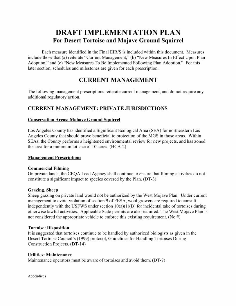
Appendices
DRAFT IMPLEMENTATION PLAN For Desert Tortoise and Mojave Ground Squirrel
Each measure identified in the Final EIR/S is included within this document. Measures
include those that (a) reiterate “Current Management,” (b) “New Measures In Effect Upon Plan Adoption,” and (c) “New Measures To Be Implemented Following Plan Adoption.” For this later section, schedules and milestones are given for each prescription.
CURRENT MANAGEMENT The following management prescriptions reiterate current management, and do not require any additional regulatory action. CURRENT MANAGEMENT: PRIVATE JURISDICTIONS Conservation Areas: Mohave Ground Squirrel Los Angeles County has identified a Significant Ecological Area (SEA) for northeastern Los Angeles County that should prove beneficial to protection of the MGS in those areas. Within SEAs, the County performs a heightened environmental review for new projects, and has zoned the area for a minimum lot size of 10 acres. (HCA-2) Management Prescriptions Commercial Filming On private lands, the CEQA Lead Agency shall continue to ensure that filming activities do not constitute a significant impact to species covered by the Plan. (DT-3) Grazing, Sheep Sheep grazing on private land would not be authorized by the West Mojave Plan. Under current management to avoid violation of section 9 of FESA, wool growers are required to consult independently with the USFWS under section 10(a)(1)(B) for incidental take of tortoises during otherwise lawful activities. Applicable State permits are also required. The West Mojave Plan is not considered the appropriate vehicle to enforce this existing requirement. (No #) Tortoise: Disposition It is suggested that tortoises continue to be handled by authorized biologists as given in the Desert Tortoise Council’s (1999) protocol, Guidelines for Handling Tortoises During Construction Projects. (DT-14) Utilities: Maintenance Maintenance operators must be aware of tortoises and avoid them. (DT-7)
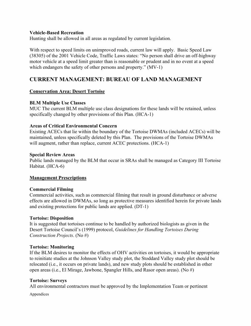
Appendices
Vehicle-Based Recreation Hunting shall be allowed in all areas as regulated by current legislation. With respect to speed limits on unimproved roads, current law will apply. Basic Speed Law (38305) of the 2001 Vehicle Code, Traffic Laws states: “No person shall drive an off-highway motor vehicle at a speed limit greater than is reasonable or prudent and in no event at a speed which endangers the safety of other persons and property.” (MV-1) CURRENT MANAGEMENT: BUREAU OF LAND MANAGEMENT Conservation Area: Desert Tortoise
BLM Multiple Use Classes MUC The current BLM multiple use class designations for these lands will be retained, unless specifically changed by other provisions of this Plan. (HCA-1) Areas of Critical Environmental Concern Existing ACECs that lie within the boundary of the Tortoise DWMAs (included ACECs) will be maintained, unless specifically deleted by this Plan. The provisions of the Tortoise DWMAs will augment, rather than replace, current ACEC protections. (HCA-1) Special Review Areas Public lands managed by the BLM that occur in SRAs shall be managed as Category III Tortoise Habitat. (HCA-6) Management Prescriptions Commercial Filming Commercial activities, such as commercial filming that result in ground disturbance or adverse effects are allowed in DWMAs, so long as protective measures identified herein for private lands and existing protections for public lands are applied. (DT-1) Tortoise: Disposition It is suggested that tortoises continue to be handled by authorized biologists as given in the Desert Tortoise Council’s (1999) protocol, Guidelines for Handling Tortoises During Construction Projects. (No #) Tortoise: Monitoring If the BLM desires to monitor the effects of OHV activities on tortoises, it would be appropriate to reinitiate studies at the Johnson Valley study plot, the Stoddard Valley study plot should be relocated (i.e., it occurs on private lands), and new study plots should be established in other open areas (i.e., El Mirage, Jawbone, Spangler Hills, and Rasor open areas). (No #) Tortoise: Surveys All environmental contractors must be approved by the Implementation Team or pertinent
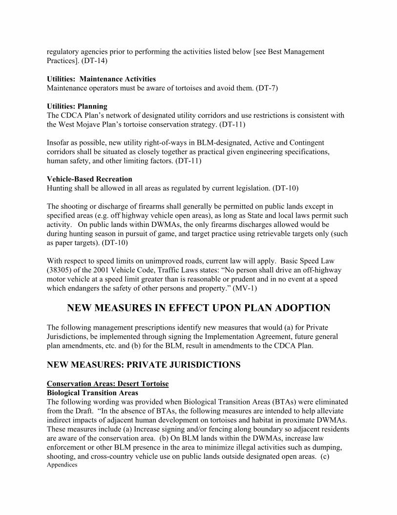
Appendices
regulatory agencies prior to performing the activities listed below [see Best Management Practices]. (DT-14) Utilities: Maintenance Activities Maintenance operators must be aware of tortoises and avoid them. (DT-7) Utilities: Planning The CDCA Plan’s network of designated utility corridors and use restrictions is consistent with the West Mojave Plan’s tortoise conservation strategy. (DT-11) Insofar as possible, new utility right-of-ways in BLM-designated, Active and Contingent corridors shall be situated as closely together as practical given engineering specifications, human safety, and other limiting factors. (DT-11) Vehicle-Based Recreation Hunting shall be allowed in all areas as regulated by current legislation. (DT-10) The shooting or discharge of firearms shall generally be permitted on public lands except in specified areas (e.g. off highway vehicle open areas), as long as State and local laws permit such activity. On public lands within DWMAs, the only firearms discharges allowed would be during hunting season in pursuit of game, and target practice using retrievable targets only (such as paper targets). (DT-10) With respect to speed limits on unimproved roads, current law will apply. Basic Speed Law (38305) of the 2001 Vehicle Code, Traffic Laws states: “No person shall drive an off-highway motor vehicle at a speed limit greater than is reasonable or prudent and in no event at a speed which endangers the safety of other persons and property.” (MV-1)
NEW MEASURES IN EFFECT UPON PLAN ADOPTION
The following management prescriptions identify new measures that would (a) for Private Jurisdictions, be implemented through signing the Implementation Agreement, future general plan amendments, etc. and (b) for the BLM, result in amendments to the CDCA Plan. NEW MEASURES: PRIVATE JURISDICTIONS Conservation Areas: Desert Tortoise Biological Transition Areas The following wording was provided when Biological Transition Areas (BTAs) were eliminated from the Draft. “In the absence of BTAs, the following measures are intended to help alleviate indirect impacts of adjacent human development on tortoises and habitat in proximate DWMAs. These measures include (a) Increase signing and/or fencing along boundary so adjacent residents are aware of the conservation area. (b) On BLM lands within the DWMAs, increase law enforcement or other BLM presence in the area to minimize illegal activities such as dumping, shooting, and cross-country vehicle use on public lands outside designated open areas. (c)
Appendices
Specifically consider and discuss DWMAs associated with these six areas when formulating the Feral Dog Management Plan. (d) Depending on monitoring results, there may need to be subsequent conservation (adaptive) management along the DWMA boundary to minimize impacts from authorized development in adjacent Incidental Take Areas.” (No #) Conservation Areas: Mohave Ground Squirrel Habitat Conservation Area A conservation area would be established for the long-term survival and protection of the MGS. (HCA-2) Sierra Habitat Connector Although this area [Sierra Habitat Connector] is already part of the MGS HCA, special review of projects should occur in this area to ensure that the narrow corridor is not completely severed. (HCA-2) Management Prescriptions Best Management Practices Ground disturbing construction projects authorized by the West Mojave Plan must be conducted in accordance with the “Best Management Practices” (see Appendix I). BMPs shall be implemented in DWMAs and in Survey Areas outside DWMAs when: (a) Tortoise sign is found during the clearance survey (DT-12); or (b) The Authorized Biologist determines that there is a reasonable likelihood that a tortoise may enter into the construction site, use area, or other zone of impact. (DT-14) Projects subject to BMPs may include, but are not limited to, the following: construction of pipelines, utility lines, fiber optic cables, wind energy development, solar energy development, flood control facilities, new mine sites, expansion of existing mine sites into tortoise habitat, cross-country mineral exploration, discretionary commercial, industrial, or residential development (excluding single-family residences outside of DWMAs), new road construction, widening or realignment of existing roads, etc. BMPs normally would not apply to authorized recreation events (e.g., Dual Sport), most maintenance activities along existing linear corridors (unless such activities result in additional loss or degradation of tortoise habitat), and filming activities on lands administered by the BLM (which are covered by a separate set of take avoidance measures). (DT-14) In Survey Areas outside DWMAs, a standardized set of BMPs have been developed, and will be distributed by counties, cities, etc. over the counter when the discretionary permit is issued. (DT-14) Commercial Filming If the Authorized Biologist determines that tortoises would not be affected, the hotline number identified relative to tortoise No Survey Areas shall be given to the pertinent production crew members. If a tortoise is observed in the filming area, in spite of the determination of no likely affect, the measures given below shall still be implemented. (E-10)

Appendices
If the Authorized Biologist determines that tortoises may be affected, the following measures shall be implemented: The Authorized Biologist or Environmental Monitor shall provide the following tortoise information to the entire production crew whose activities may affect tortoises (DT-2): Tortoises are known to occur in the area, and must be avoided at all times. Tortoises are not to be handled by any crew members, and only handled by the Authorized Biologist when necessary (as given above). (DT-2) Present pertinent life history information that will facilitate avoidance of impacts. Examples include seasonal and daily activity patterns of juvenile and adult tortoises; characteristics of burrows, including the terminus of burrows that may be as many as 30-feet distant from the burrow opening; deposition of eggs in nests, which may be in burrows or under shrubs; etc. (DT-2) Pertinent protection afforded by State and endangered species acts, including fines for unauthorized take of tortoises; and outline forms of take that are covered by the WMP (i.e., take that occurs in spite of the measures given herein) and not covered by the WMP (i.e., unauthorized handling of tortoises by crew members, tortoise mortality caused by unauthorized cross-country travel, etc.). (DT-2) The Authorized Biologist or Environmental Monitor shall provide the following take avoidance measures to the entire production crew whose activities may affect tortoises (DT-2): The Authorized Biologist or Environmental Monitor shall work with the Location Manager to visit each film site ahead of the film crew arriving there to locate any burrows or tortoises that need to be avoided; burrows shall be flagged and avoided during filming activities; etc. To avoid all impacts to tortoises and burrows, known locations and other pertinent findings shall be shared with the crew when they arrive at the filming site. (DT-2) There shall be no cross-country vehicle travel by the film crew; all vehicles must be restricted to existing roads. If filming requires cross-country travel, the Authorized Biologist or Environmental Monitor shall survey the area immediately prior to filming to avoid all tortoises and burrows, as given in the previous point. Vehicle tracks shall be eliminated by hand, insofar as possible, by pertinent production crew members after filming is complete and before the crew leaves the site. (DT-3) All vehicles shall be restricted to a speed limit of no more than 20 miles per hour. (MV) A litter-free workplace shall be maintained at all times to avoid attraction of common ravens and other tortoise predators. (DT-31) All pets must be completely controlled by their owners, either on leash or otherwise retained (i.e., maintained in kennels, fenced areas, mobile homes, etc.), and never allowed to run free in
Appendices
the absence of the owner. (DT-4) All local, State, and federal ordinances, regulations, and laws governing the release of hazardous materials and wastes shall be implemented. Additionally, any and all reportable releases shall be reported to the CEQA Lead Agency or Implementation Team within 24 hours of discovering the release. (No #) Authorized Biologists and Environmental Monitors shall maintain records of all desert tortoises and other “covered species” encountered during filming activities, including the following information: (a) the locations (narrative and maps) and dates of observations; (b) general condition and health, including injuries and state of healing and whether animals voided their bladders; (c) locations from which and to which any animals are moved (UTM coordinates derived from a global positioning system - GPS - are preferable); (d) diagnostic markings (i.e., identification numbers or marked lateral scutes); (e) the amount of habitat lost (i.e., cleared of vegetation) or temporarily affected by the activity; and (f) remedial actions taken to restore lost or damaged habitat prior to the crew leaving the site. This report shall be submitted to the Implementation Team and pertinent CEQA Lead Agency (i.e., City or County Filming Commissions) within 30 days of the Authorized Biologist leaving the site. The following measure shall be implemented in tortoise No Survey Areas and in tortoise Survey Areas where the Authorized Biologist determines there would be no impacts to tortoises (E-10): A hotline number shall be provided to pertinent production crew members (e.g., Location Manager) so that the Implementation Team can be contacted if a tortoise is found on the site at the time of ground disturbance. In general, the measures given above for DWMAs and occupied tortoise Survey Areas shall be implemented in tortoise No Survey Areas where tortoises are found. (E-10) Landfills With the exception of the Barstow Landfill expansion, the planning of which has already been initiated, counties and cities shall ensure that no new landfills are constructed inside DWMAs or within five miles of them. (DT-27) Mohave Ground Squirrel The following take-avoidance measures discussed above for application within the DWMAs would also be applied within the MGS Conservation Area: Agriculture, Camping, Commercial Activities, Fire Management, Hunting and Shooting, Native Plant Harvesting, and Utility Construction and Maintenance. (MGS-1) Measures identified for DWMAs and tortoise Survey Areas and No Survey Areas apply where those areas overlap the Mohave Ground Squirrel Conservation Area. (MGS-2) CDFG would not require Cumulative Human Impact Evaluation Forms (CHIEFs) to be completed, nor would trapping be required. (MGS-3)
Appendices
Tortoise: Disposition Within DWMAs, tortoises should be moved from the immediate area of impact to adjacent suitable habitat (or burrow). In general, tortoises should be moved no further than 1,000 feet from the impact area. The potential for these animals to wander back into harm’s way should be taken into account, and the distance given above modified by the Authorized Biologist, as necessary. Temporary or permanent fences may be needed to prevent tortoise immigration into the impact area. (DT-15) Within designated tortoise Survey Areas, (a) If only a small portion of a given site is to be developed then tortoises should be moved to portions of the site that are not to be developed; (b) Tortoises may be moved onto BLM lands if such lands are within (1/2) mile of the impact area; (c) If options (a) and (b) are not available, then tortoises can be moved into the edge of a DWMA that occur within one mile of the site; and (d) If options (a), (b) and (c) are not available then tortoises should be made available for research, educational purposes, captive breeding, zoo placement, adoption through recognized organizations (e.g. California Turtle and Tortoise Club), moved to areas within SRAs referred to above or, if clinically ill, dealt with in a manner consistent with the Berry Salvage Protocol. (DT-15) The following handling guidelines apply as indicated: In all areas, (a) injured, recently dead, ill and dying tortoises should be collected and disposed of as per a recent (June 2001) disposition protocol [Salvaging Injured, Recently Dead, Ill, and Dying Wild, Free-roaming Desert Tortoises (Gopherus agassizii)] developed by Dr. Kristin Berry (“Berry Salvage Protocol”). (DT-15) Tortoise: Surveys In DWMAs, except where No Survey Areas are identified, both presence-absence and clearance surveys must be conducted prior to the commencement of any new ground disturbing activities for which a discretionary permit must be obtained from a local jurisdiction or agency. (DT-12) Within Survey Areas, tortoise clearance surveys will be conducted prior to any new ground disturbance for which a discretionary permit was required. Surveys should follow USFWS protocol (1992) as modified herein. (DT-13) It would still be appropriate to perform reconnaissance surveys for projects in Survey Areas located outside DWMAs where there may be several alternative sites or alignments. (DT-13) Neither presence-absence nor clearance surveys will be required in tortoise No Survey Areas. A hotline number will be provided by the local jurisdiction so that the Implementation Team can be contacted if a tortoise is found on the site at the time of ground disturbance. (DT-13) Utilities: Maintenance Activities Maintenance of existing utilities is allowed, and impacts to tortoises and their habitats must be avoided. Maintenance crews must remain on existing access roads except for the point location of maintenance-related disturbance. Take of tortoises during maintenance activities is not authorized under this Plan. Such take must be authorized on a case-by-case basis. (DT-11)
Appendices
In DWMAs, non-emergency maintenance of utility right-of-ways resulting in ground disturbance should occur between November 1 and March 1. Juvenile tortoises may be active during this time and must be avoided. If maintenance during this period is infeasible and is required between March 2 and October 31 in DWMAs, a biological monitor must be present, or, the proponent must provide an assessment that clearly shows that tortoises will not be affected. (DT-11) As far as possible, road beds should not be lowered and berms should not exceed 12 inches or a slope of 30 degrees. Consider alternatives to grading, such as chain drag. Berms are likely barriers to vehicle straying into adjacent habitats, and should not necessarily be identified for complete removal. (DT-8) Weeds Invasive weeds should not be used in landscaping within or adjacent to DWMAs (e.g., Non-native species should not be used in re-seeding programs). (DT-9) NEW MEASURES: BUREAU OF LAND MANAGEMENT Conservation Areas: Desert Tortoise Desert Wildlife Management Areas Establish four tortoise DWMAs. Tortoise DWMAs shall be managed for tortoise conservation and recovery until which time the tortoise may be delisted as per criteria given in the Recovery Plan or revisions thereof. (HCA-1) Areas of Critical Environmental Concern Public lands administered by the BLM within Tortoise DWMAs will be designated as Areas of Critical Environmental Concern. The West Mojave Plan shall serve as the ACEC management plan so that future ACEC plans for the four Tortoise DWMAs will not be required. (HCA-1) The ACEC designation will require the BLM to manage these lands in accordance with the goals, objectives, management prescriptions, and binding requirements set forth in this CDCA Plan amendment, as these parameters comprise the core components of the ACEC Management Plan for these four DWMAs. (HCA-1) If a provision of an included ACEC management plan conflicts with any of the measures described herein for the Tortoise DWMA, the measures identified by the West Mojave Plan will take precedence and the included ACEC’s Management Plan will be amended. Necessary amendments will be set forth in an appendix to the West Mojave Plan. (HCA-1) BLM Habitat Categories All BLM-managed lands outside Tortoise DWMAs that are within the range of the tortoise shall be managed as BLM Category III Tortoise Habitat. (HCA-1) Conservation Areas: Mohave Ground Squirrel Public lands within the MGS Conservation Area would also be designated as a BLM Wildlife
Appendices
Habitat Management Area in the BLM’s CDCA Plan. The public lands immediately south of Owens Lake that are currently classified by the CDCA Plan as Multiple Use Class M should be reclassified as Multiple Use Class L. (HCA-2) Management Prescriptions Best Management Practices Ground disturbing construction projects authorized by the West Mojave Plan must be conducted in accordance with the “Best Management Practices” (see Appendix I). BMPs shall be implemented in DWMAs and in Survey Areas outside DWMAs when (DT-14): Tortoise sign is found during the clearance survey; or (DT-14) The Authorized Biologist determines that there is a reasonable likelihood that a tortoise may enter into the construction site, use area, or other zone of impact. (DT-14) Projects subject to BMPs may include, but are not limited to, the following: construction of pipelines, utility lines, fiber optic cables, wind energy development, solar energy development, flood control facilities, new mine sites, expansion of existing mine sites into tortoise habitat, cross country mineral exploration, discretionary commercial, industrial, or residential development (excluding single-family residences outside of DWMAs), new road construction, widening or realignment of existing roads, etc. BMPs normally would not apply to authorized recreation events (e.g., Dual Sport), most maintenance activities along existing linear corridors (unless such activities result in additional loss or degradation of tortoise habitat), and filming activities on lands administered by the BLM (which are covered by a separate set of take avoidance measures). (DT-14) Grazing, Cattle The following measures shall be implemented for all cattle allotments managed by the BLM in the West Mojave Plan area. Affected cattle allotments include: Cady Mountain, Cronese Lake, Double Mountain, Hansen Common, Harper Lake, Lacey-Cactus-McCloud, Oak Creek, Olancha, Ord Mountain, Pilot Knob, Rattlesnake Canyon, Round Mountain, Rudnick Common, Tunawee Common, Walker Pass, and Whitewater Canyon. (No #) The lessee may voluntarily relinquish their grazing preference and lease. At which time, the allotment(s) would become unavailable for grazing. Upon relinquishment, BLM will, without further analysis or notice: not reissue the lease; remove the allotment designation; assume any and all private interest in range improvement located on public land; and, designate the land as no longer available for livestock grazing. (LG-29) All cattle carcasses shall be removed and disposed of in an appropriate manner (i.e., not buried) within two days of being found. Cross-country vehicle travel to remove cattle carcasses must have prior approval from the BLM. (LG-5) In cattle allotments outside of DWMAs, ephemeral authorization would only be granted when ephemeral production exceeds 230 pounds per acre. (LG-6)
Appendices
Utilization of perennial plants on all cattle allotments shall not exceed the values given in EIS/R Chapter 2. (LG-1) Unless otherwise noted, all protective measures identified in the Draft (Section 2.2.19.1) shall also be implemented in desert tortoise habitat and the Mohave Ground Squirrel Conservation Area. Affected cattle allotments include: Cady Mountain, Cronese Lake, Hansen Common, Harper Lake, Lacey-Cactus-McCloud, Olancha, Ord Mountain, Pilot Knob, Rattlesnake Canyon, Rudnick Common, Tunawee Common, and Walker Pass. (No #) Any hazards to desert tortoises that may be created, such as auger holes and trenches, shall be eliminated before the rancher, contractor, or work crew leaves the site. (LG-8) Unless otherwise noted, all protective measures identified in Sections 2.2.9.1 and 2.2.9.2 of the Draft shall also be implemented in DWMAs. Affected cattle allotments include Cronese Lake, Harper Lake, and Ord Mountain. (No #) The Pilot Knob Allotment shall be unavailable for livestock grazing. (LG-10) Issuance of temporary non-renewable (TNR) grazing permits shall be prohibited in DWMAs. (LG-11) No ephemeral authorizations shall occur in DWMAs. (LG-10) For a grazing allotment partially within a DWMA, when ephemeral forage production is less than 230 pounds per acre, cattle shall be substantially removed from the DWMA from March 15 to June 15. (LG-13) In years of good winter precipitation and soil moisture presence, cattle may remain past March 15 in expectation of ephemeral forage production over 230 pounds per acre. If this level of forage is not attained when weather conditions (e.g., warming of the soil) are appropriate, cattle must leave the DWMA until such time as 230 pounds per acre ephemeral forage is achieved or June 15, whichever is earlier. This determination will be made based on the evaluation and judgment of the BLM authorized officer. If cattle must be removed, the operator will be given two weeks to remove them from the DWMA. (LG-14) In years of poor winter precipitation or absence of soil moisture, cattle must be removed from the DWMA by March 15 and remain out until such time as 230 pounds per acre ephemeral forage is achieved or June 15, whichever is earlier. (LG-15) The term “substantially removed” recognized that a few individual cattle may wander into the area of seasonal closure despite the operator’s best efforts and regardless of management facilities (e.g., fences, water sources) that are in place. (LG-16) Grazing, Sheep

Appendices
The following measures shall be implemented for all sheep allotments managed by the BLM in the West Mojave Plan area. Affected sheep allotments include: Antelope Valley, Bissell, Boron, Buckhorn Canyon, Cantil Common, Gravel Hills, Hansen Common, Johnson Valley, Lava Mountains, Monolith Cantil, Rudnick Common, Shadow Mountains, Spangler Hills, Stoddard Mountain, Superior Valley, Tunawee Common, and Warren. (No #) The lessee may voluntarily relinquish their grazing preference and lease. At which time, the allotment(s) would become unavailable for grazing. Upon relinquishment, BLM will, without further analysis or notice: not reissue the lease; remove the allotment designation; assume any and all private interest in range improvement located on public land; and, designate the land as no longer available for livestock grazing. (LG-29) Turnout of sheep in all allotments shall not occur until 230 pounds (air-dry-weight) per acre of ephemeral forage is available. The lessee shall be required to remove sheep from the area or the entire allotment if production falls below 230 pounds per acre. (LG-20) Following the removal of lambs, when multiple sheep bands are typically combined, there shall be no more than 1,500 adult sheep in a combined band. (LG-21) All sheep carcasses shall be removed and disposed of in an appropriate manner (i.e., not buried) within two days of being found. Cross-country vehicle travel to gather carcass(es) must have prior approval from the BLM. (LG-22) Unless otherwise noted, all protective measures given in Section 2.2.19.4 of the Draft shall also be implemented in the Mohave Ground Squirrel Conservation Area and the Mohave Monkeyflower Conservation Area. Affected sheep allotments include: Buckhorn Canyon, Cantil Common, Gravel Hills, Hansen Common, Lava Mountains, Monolith Cantil, Rudnick Common, Spangler Hills, Stoddard Mountain, Superior Valley, and Tunawee Common. (No #) In order to avoid competition between sheep and the Mohave ground squirrel once the ephemeral forage is no longer available and both species rely on perennial forage, all sheep shall be removed from the Mohave Ground Squirrel Conservation Area when ephemeral plants are no longer the primary forage being utilized by sheep. (LG-24) The following allotments, found entirely within DWMAs, shall no longer be available for sheep grazing: Buckhorn Canyon, Goldstone, Gravel Hills, and Superior Valley. (LG-26) Mohave Ground Squirrel The following take-avoidance measures discussed above for application within the DWMAs would also be applied within the MGS Conservation Area: Agriculture, Camping, Commercial Activities, Fire Management, Hunting and Shooting, Native Plant Harvesting, and Utility Construction and Maintenance. (MGS-1) Measures identified for DWMAs and tortoise Survey Areas and No Survey Areas apply where those areas overlap the Mohave Ground Squirrel Conservation Area. (MGS-2)
Appendices
CDFG would not require Cumulative Human Impact Evaluation Forms (CHIEFs) to be completed, nor would trapping be required. (MGS-3) Tortoise: Disposition Within DWMAs, Tortoises should be moved from the immediate area of impact to adjacent suitable habitat (or burrow). In general, tortoises should be moved no further than 1,000 feet from the impact area. The potential for these animals to wander back into harm’s way should be taken into account, and the distance given above modified by the Authorized Biologist, as necessary. Temporary or permanent fences may be needed to prevent tortoise immigration into the impact area. (DT-15) Within designated tortoise Survey Areas, (a) If only a small portion of a given site is to be developed then tortoises should be moved to portions of the site that are not to be developed; (b) Tortoises may be moved onto BLM lands if such lands are within (1/2) mile of the impact area; (c) If options (a) and (b) are not available, then tortoises can be moved into the edge of a DWMA that occur within one mile of the site; and (d) If options (a), (b) and (c) are not available then tortoises should be made available for research, educational purposes, captive breeding, zoo placement, adoption through recognized organizations (e.g. California Turtle and Tortoise Club), moved to areas within SRAs referred to above or, if clinically ill, dealt with in a manner consistent with the Berry Salvage Protocol. (DT-15) The following handling guidelines apply as indicated: In all areas, (a) injured, recently dead, ill and dying tortoises should be collected and disposed of as per a recent (June 2001) disposition protocol [Salvaging Injured, Recently Dead, Ill, And Dying Wild, Free-roaming Desert Tortoises (Gopherus agassizii)] developed by Dr. Kristin Berry (“Berry Salvage Protocol”). (DT-15) Tortoise: Surveys In DWMAs, except where No Survey Areas are identified, both presence-absence and clearance surveys must be conducted prior to the commencement of any new ground disturbing activities for which a discretionary permit must be obtained from a local jurisdiction or agency. (DT-12) Within Survey Areas, tortoise clearance surveys will be conducted prior to any new ground disturbance for which a discretionary permit was required. Surveys should follow USFWS protocol (1992) as modified herein. (DT-13) It would still be appropriate to perform reconnaissance surveys for projects in Survey Areas located outside DWMAs where there may be several alternative sites or alignments. (DT-13) Neither presence-absence nor clearance surveys will be required in tortoise No Survey Areas. A hotline number will be provided by the local jurisdiction so that the Implementation Team can be contacted if a tortoise is found on the site at the time of ground disturbance. (DT-13) Utilities: Maintenance Activities Maintenance of existing utilities is allowed, and impacts to tortoises and their habitats must be
Appendices
avoided. Maintenance crews must remain on existing access roads except for the point location of maintenance-related disturbance. Take of tortoises during maintenance activities is not authorized under this Plan. Such take must be authorized on a case-by-case basis. (DT-11) In DWMAs, non-emergency maintenance of utility right-of-ways resulting in ground disturbance should occur between November 1 and March 1. Juvenile tortoises may be active during this time and must be avoided. If maintenance during this period is infeasible and is required between March 2 and October 31 in DWMAs, a biological monitor must be present, or, the proponent must provide an assessment that clearly shows that tortoises will not be affected. (DT-11) As far as possible, roadbeds should not be lowered and berms should not exceed 12 inches or a slope of 30 degrees. Consider alternatives to grading, such as chain drag. Berms are likely barriers to vehicle straying into adjacent habitats, and should not necessarily be identified for complete removal. (DT-14) Utilities: Planning If there is an option to use one or the other corridor, Corridor W is preferred over Corridor H in the Ord-Rodman DWMA. (DT-11) If at all possible, future utilities should be located in an alternative corridor rather than Corridor Q, or as given above, be situated to minimize the width of impact between existing and new utilities. (DT-11) Within existing corridors, areas that are already disturbed should be used rather than disturb new areas within the two- to three-mile wide corridor. (DT-11) Pipelines within DWMAs should be revegetated. Narrowing the construction right of way is suggested in all management areas. (DT-11) Vehicle-Based Recreation Within DWMAs, on public lands administered by the BLM, motorized-vehicle-based camping shall be allowed in previously existing disturbed camping areas adjacent to vehicle routes designated as open. (MV-5) Within DWMAs, motorized vehicle stopping and parking are allowed 50 feet from centerline of the designated route. (MV-5) Weeds Invasive weeds should not be used in landscaping within or adjacent to DWMAs (e.g., Non-native species should not be used in re-seeding programs). (DT-9) NEW MEASURES: IMPLEMENTATION TEAM Management Prescriptions Best Management Practices
Appendices
The Implementation Team should determine the best application of the BMPs, consider them as guidelines, and modify them as necessary. In DWMAs, application of the BMPs should be determined by the Implementation Team on a case-by-case basis, and rely on the results of the newly completed presence-absence survey. (DT-14) All environmental contractors must be approved by the Implementation Team or pertinent regulatory agencies prior to performing the activities listed below. (DT-14) Commercial Filming A report shall be submitted to the Implementation Team and pertinent CEQA Lead Agency (i.e., City or County Filming Commissions) within 30 days of the Authorized Biologist leaving the site. A hotline number shall be provided to pertinent production crew members (e.g., Location Manager) so that the Implementation Team can be contacted if a tortoise is found on the site at the time of ground disturbance. (E-10) If the Implementation Team judges that these or other measures are not avoiding take of tortoises, a biological monitor may be necessary. Hazardous Spills All reportable releases of hazardous materials shall be reported to the CEQA Lead Agency or Implementation Team within 24 hours of discovering the release. Tortoise: Disease Issues relative to desert tortoise diseases (e.g., upper respiratory tract disease, cutaneous dyskeratosis, herpes virus, etc.) should be considered at the level of the interagency desert tortoise Management Oversight Group (MOG). (DT-16) Utilities: Planning New linear utility projects within the Habitat Conservation Area will be reviewed by the Implementation Team at the time they are proposed. (DT-11)
NEW MEASURES TO BE IMPLEMENTED FOLLOWING PLAN ADOPTION
The following management prescriptions would be implemented at the specified time given in order to achieve milestones and avoid the need to have the incidental take permits (Private Jurisdictions) and authorization (BLM) withdrawn. NEW MEASURES TO BE IMPLEMENTED: PRIVATE JURISDICTIONS Outreach & Tracking
Appendices
Within Year 1 Implementation Milestone: Within one year of incidental take authorization, the Implementation Team shall setup the hotline number (E-10), and shall design and implement the jurisdictional tracking system. (M-1, 2) Within No Survey Areas, (a) Develop telephone tech support for the general public to deal with free-roaming tortoises; and (b) Free roaming tortoises should be made available for research, education, captive breeding, zoo placement, adoption through recognized organizations (e.g. California Turtle and Tortoise Club); or, if clinically ill, dealt with in a manner consistent with the Berry Salvage Protocol. (E-10) Incidental take authorized by the Plan is necessarily attached to existing political infrastructure. For example, the Plan would authorize projects subject to discretionary permits but would not track projects subject to ministerial permits. It is important that authorized and unauthorized ground disturbance is tracked by the Plan to determine actual loss of habitat relative to the 1% Allowable Ground Disturbance. Agricultural development in DWMAs, which is not currently covered by the Plan, must be tracked to determine its relative impact, if any. It is generally understood that aerial photographs would be used, in conjunction with reports from participating jurisdictions, to track these forms of ground disturbance. (No #) Feral Dog Management Plan Within Year 2 Implementation Milestone: Within two years of the record of decision, the Implementation Team, BLM, county animal control, and other applicable entities shall develop a Feral Dog Management Plan (FDMP). (DT-5) Within Year 3 Implementation Milestone: Within three years of the record of decision, if feral dogs are shown to be a significant threat to tortoises and other covered species, the earliest phase(s) of the FDMP shall be implemented. (DT-5)
Appendices
NEW MEASURES TO BE IMPLEMENTED: BUREAU OF LAND MANAGEMENT Fencing: Open Areas Within Year 2 Implementation Milestone: Within two years of the record of decision, the BLM shall work with the Implementation Team to determine the specific location along Camp Rock Road to install the fence, determine educational outreach needs, and develop a monitoring protocol. (E-7) A standard fence will be placed along pertinent portions of the western boundary of the Johnson Valley Open Area to prevent OHV use in the Ord-Rodman DWMA to the west and to minimize use in the Cinnamon Hills. (DT-23) The Plan proposes installation of new fences to counteract the effects of Johnson Valley and Stoddard Valley on tortoise populations in the Ord-Rodman DWMA. As with the recently installed fences around the El Mirage Open Area and along the Mojave-Randsburg Road, monitoring will be needed to cure intentional vandalism of the fences. Educational outreach will be a high priority at the time of fencing and thereafter. The desired effects are to reduce tortoise mortality and begin to repair degraded habitats (i.e., in the Cinnamon Hills and southern portions of the Ord-Rodman DWMA coinciding with northern Lucerne Valley), which should be monitored and adaptive management applied, as needed. (DT-23) Feral Dog Management Plan Within Year 2 Implementation Milestone: Within two years of the record of decision, the Implementation Team, BLM, county animal control, and other applicable entities shall develop a Feral Dog Management Plan (FDMP). (DT-5) Within Year 3 Implementation Milestone: Within three years of the record of decision, if feral dogs are shown to be a significant threat to tortoises and other covered species, the earliest phase(s) of the FDMP shall be implemented. (DT-5) Grazing, Cattle Within Year 1 Implementation Milestone: Within one year of the record of decision, the BLM shall modify boundaries as necessary relative to cattle allotments. Within Year 1 Implementation Milestone: The grazing strategy shall be developed within a year of the record of decision. The strategy shall be a written plan detailing the area of removal, natural cattle movements, existing and potential improvements, and other constraints of cattle management. (LG-17)

Appendices
Within Year 1 Implementation Milestone: Health Assessments shall be completed within one year of the record of decision for the Cronese Lake, Harper Lake, and Ord Mountain allotments. (LG-18) Within Year 2 Implementation Milestone: The grazing strategy shall be implemented within two years of the record of decision. (LG-17) Within Year 2 Implementation Milestone: Health Assessments shall be completed within two years of the record of decision for the following cattle allotments: Cady Mountain, Hansen Common, Lacey-Cactus McCloud, Olancha, Rattlesnake Canyon, Rudnick Common, Tunawee Common, and Walker Pass. (LG-9) Within Year 2 Implementation Milestone: Within two years of the record of decision, range fences shall be installed in two places to exclude cattle from high concentration tortoise areas found adjacent to the Ord Mountain Allotment: (a) along the southern boundary of the allotment, west of the Cinnamon Hills, in northern Lucerne Valley; and (b) along the eastern boundary of the allotment, in the vicinity of Box Canyon. (No #) Within Year 3 Implementation Milestone: Within three years of the record of decision (assuming that the grazing strategy given in LG-17 has been implemented), the Implementation Team shall work with the BLM to determine if studies are needed to assess cattle impacts and determine any adaptive management prescriptions that may be required. (No #) Additionally, new management prescriptions would require modified grazing practices in the Ord Mountain, Harper Lake, and Cronese Lakes allotments. These include the exclusion of cattle from specific areas when dry ephemeral forage is below a threshold of 230 pounds/acre. This practice would require rest of certain pastures under these conditions, and would concurrently result in herding cattle onto other portions of the allotment. (LG-13) Another proposal is to strategically place waters so that cattle are concentrated in areas where the fewest tortoise-cattle impacts will occur. The effects of these and other management practices must be monitored to determine if the desired effects (i.e., decreased tortoise mortality and decreased habitat degradation) are being achieved. (No #) Within Year 3 Implementation Milestone: All existing cattle guards in desert tortoise habitat shall be modified within three years of the record of decision to prevent entrapment of desert tortoises. New cattle guards shall be designed and installed to prevent entrapment of desert tortoises. (LG-7) Within Year 3 Implementation Milestone: For cattle allotments outside desert tortoise habitat, DWMAs, and

Appendices
the Mohave Ground Squirrel Conservation Area (Lacey-Cactus McCloud, Olancha, Round Mountain, and Whitewater allotments), Health Assessments shall be completed within three years of the record of decision. (LG-2) Within Year 3 ½ Implementation Milestone: Within six months [3 ½ years] after the completion of a Health Assessment for a specific area (i.e., grazing allotment, watershed, etc.), the BLM shall use the information to make a determination and evaluation, which shall serve as baseline information to develop corrective management strategies. Where Health Assessments show that standards and guidelines are not being achieved, new measures shall be identified to achieve standards and conform with guidelines. The need for specific Allotment Management Plans to be modified or, where none exists, newly drafted, shall be considered. (LG-3) Within Year 10 Implementation Milestone: Grazing will be discontinued on the Whitewater Canyon allotment, pending completion of a study within the next 10 years that assesses livestock grazing compatibility with conservation of the desert tortoise, arroyo toad, riparian values, and with use of, and access to, intermingled private lands. Following study completion, conduct National Environmental Policy Act analysis of management alternatives intended to conserve and provide for these resources and values consistent with the study, and subsequently issue a grazing decision that implements compatible management provisions. (No #) Grazing, Sheep Within Year 1 Implementation Milestone: Within one year of the record of decision, the BLM shall modify boundaries as necessary relative to sheep allotments. (No #) In the following allotments, boundaries shall be modified so that areas within DWMAs shall no longer be available for sheep grazing: Cantil Common, Lava Mountains, Monolith Cantil, Shadow Mountains, and Stoddard Mountain (east of Highway 247 and west of National Trails Highway). (LG-23) Within Year 1 Implementation Milestone: Within one year of the record of decision, the BLM shall work with affected wool growers to avoid impacts to the Mohave Monkeyflower Conservation Area. (LG-24) Sheep grazing shall be prohibited from those portions of the Stoddard Mountain Allotment that occur within the Mohave Monkeyflower Conservation Area. The BLM shall work with the lessee to clearly identify monkeyflower habitat that shall be avoided. (LG-24, 25) Within Year 2 Implementation Milestone: Following the record of decision, the lessees shall be given two years notification pursuant to 43 CFR 4110.4-2(b) before the actions in section 2.2.19.6 of the Draft are implemented. (No #)
Appendices
Within Year 3 Implementation Milestone: Within three years of the record of decision, the Implementation Team shall work with the BLM to determine if studies are needed to assess the impacts of sheep and determine any adaptive management prescriptions that may be required. (No #) The Plan proposes to remove sheep grazing from all DWMAs, which would affect areas south of Shadow Mountain Road in the southern portions of the Fremont-Kramer DWMA. Areas north of Shadow Mountain Road have not been grazed since 1991. The removal of sheep from this area should be followed by studies to determine the efficacy of this measure. (LG-23) There are also opportunities to study the effects of sheep removal on lands north of Kramer Junction, where sheep continue to graze west of Highway 395 but were removed in 1991 east of Highway 395. (No #) Guzzlers Within Year 3 Implementation Milestone: Within three years of the record of decision, the Implementation Team, with input from the CDFG, shall institute a study to determine the impacts of guzzlers on tortoises (if any) inside DWMAs. The results of the study shall be used by the CDFG to implement appropriate actions. (DT-41) Law Enforcement Within Year 1 Implementation Milestone: Within one year of the record of decision, the Implementation Team shall initiate coordination meetings with BLM and other applicable law enforcement agencies to discuss law enforcement needs relative to plan implementation. (No #) Additional law enforcement (ranger patrols) and educational outreach (recreation technicians) shall be used in concert with fencing and signs to inform the public of appropriate and inappropriate activities in conservation areas. (E-7) A minimum of eight (8) Law Enforcement Rangers and eight (8) maintenance workers shall be assigned to the DWMAs. (DT-28) Law Enforcement Rangers should work closely with the Implementation Team to facilitate Plan implementation, enforcement, and adaptive management. (DT-8) It is important that a feedback loop exist between law enforcement and the Implementation Team to identify problem areas, and in the spirit of adaptive management, to identify issue-specific solutions. (DT-28) It is important that anyone designing and implementing an education program work with law enforcement personnel (including BLM, county animal control, USFWS enforcement agents and CDFG rangers) to identify problems and develop solutions. (E-4)
Appendices
Signing Within Year 1 Implementation Milestone: Within one year of the record of decision, the BLM shall work with the Implementation Team to schedule signing of DWMA boundaries and open areas. (E-7) DWMA boundaries should be signed or otherwise designated to identify boundaries and facilitate enforcement. An appropriate number of signs (to be determined) should be strategically placed between the two OHV open areas (Stoddard Valley and Johnson Valley) and the adjacent, Ord-Rodman DWMA. A quick field check should determine if boundary is adequately signed. (E-7) Proper signing on the ground is essential. (E-7) NEW MEASURES TO BE IMPLEMENTED: IMPLEMENTATION TEAM Core Components Within Year 1 Implementation Milestone: Within one year of the record of decision, Core Components shall be designed and implemented by the Implementation Team. (No #) The list of Authorized Biologists and Environmental Monitors maintained by the Implementation Team should be available to the County, City, Filming Commissions, and others to facilitate this requirement. (DT-14) The Implementation Team shall prepare a standard data sheet to record how many, if any, tortoises are moved from harm’s way. The Implementation Team should use these data to determine the actual harassment and mortality take of tortoises authorized by the Plan. The Implementation Team will also reassess these data annually, and modify Survey and No Survey Areas accordingly. (M-1) A hotline number will be provided by the local jurisdiction so that the Implementation Team can be contacted if a tortoise is found on the site at the time of ground disturbance. (E-10) A monitoring strategy will be designed and implemented to ensure that the management program for species is accomplishing its objectives. (M-1, 2) The Implementation Team is tasked with producing a standard data sheet and developing a tracking system to determine how many tortoises are accidentally killed or incidentally harassed as a result of Plan implementation. It is expected that an annual review of this information will enable the Implementation Team, in conjunction with participating jurisdictions, to modify these boundary lines as needed. (M-2)

Appendices
Education Within Year 1 Implementation Milestone: Within one year of incidental take authorization, the Implementation Team shall identify the Education Contractor. (E-1)
A coordinator of educational programs should be identified. The “education coordinator” should work closely with the Implementation Team and/or appropriate regulatory agencies to approve the final education program, judge its efficacy, and ensure appropriate implementation. (E-1) Within Year 1 Implementation Milestone: Upon selection, the education contractor shall meet with the Implementation Team to begin to design the education program. Within one year of incidental take authorization, a “substantially complete” outline of the education program shall be submitted by the contractor to the Implementation Team. (No #) Distribute information and education materials (E-5, 6): through schools, museums, private contractors and organizations
at recreation vehicle shows, off highway vehicle events (e.g., dual sport), and dealer associations (Harley-Davidson, Honda, Suzuki, etc.)
at convenience stores and other walk-in commercial interests consider using restaurant place settings and napkins as part of public outreach
through existing portals, such as Friends of El Mirage and Friends of Jawbone at the Planning Departments of each participating jurisdiction Consider targeting users through green-sticker money, by distributing materials at the time the sticker is purchased through Division of Motor Vehicles. (No #) The first effort of the education coordinator should be to determine environmental education programs that already exist, and to determine gaps in the program. The coordinator should produce and implement the program to, in part, fill in these gaps. The education coordinator should take into consideration the experiences of successful desert education programs, such as the Sand Canyon Environmental Education Program, and the Hands Off Pardner program. (E-2) The education coordinator should work with non-government organizations with an interest in the western Mojave Desert to better reach group members. The coordinator should work with off-highway vehicle groups to help fund existing programs and create new ones as needed to increase sensitivity to desert ecology. (E-3) In drawing up a single, programmatic education program to be given to construction workers, the coordinator should review files maintained by the USFWS and CDFG to see the range of education materials that have been used since the listing of the tortoise, for example. Between 1990 and 1995, for example, such an approach resulted in rescuing 1,455 tortoises out of harm’s way during construction of 171 federally-authorized projects in tortoise-occupied habitats (LaRue and Dougherty 1997). (E-4)
Appendices
Develop displays, programs, and materials that can be provided to school districts in the West Mojave planning area. Fund and/or cooperate with existing programs (San Bernardino County ecological study kits, etc.) to provide for enhanced outreach to schools in desert communities. (E-5) Schools should be targeted at the district level. Although schools in the West Mojave area should be targeted first, it is important to reach the larger area, including the Inland Empire and LA County school districts. (E-5) Provide support to the efforts of museums, zoos, and other public institutions to develop pertinent desert tortoise exhibits, including (E-6): The San Bernardino County museum’s program to develop a desert tortoise exhibit. (E-6) The Mojave Narrows Regional Park’s development of an outdoor interpretive program involving a live-tortoise exhibit. (E-6) Ongoing environmental education at the Lewis Center, other programs supported by Edwards Air Force Base, the BLM’s community outreach program, etc. (E-6) The education program should include the preparation, distribution and/or installation of signs, interpretive kiosks, displays, maps, videos, education packets and brochures. (E-7) Design and erect a new sign at the Desert Tortoise Natural Area; include in the sign appropriate behavior messages and offer an “800" telephone number for information on tortoise adoption. (E-7) Place information kiosks in pertinent parts of the desert. (E-7) Work with Caltrans to design and install separate, free-standing, interpretive kiosks with desert tortoise protection information at highway rest areas. (E-7) Target off highway vehicle use areas, such as El Mirage and Jawbone; distribute materials through volunteer groups associated with those areas. (E-7) Portable displays should be developed and produced, including a portable desert tortoise exhibit, for use at county fairs, shows, agency offices, shopping malls, museums, and the BLM’s California Desert Information Center in Barstow. User-friendly maps should be prepared which show approved routes of travel. Work with university, media and corporate sponsor(s) to develop a quality video on desert tortoises for release to network, local, and cable television stations. Develop educational packets for use in classrooms. Produce a brochure to be distributed by jurisdictions that outlines the farmer’s responsibilities under the endangered species act when developing habitat for target species. Produce a brochure to be distributed by jurisdictions describing the burrowing owl and its habitat features in urban areas. (E-7)
Appendices
Fencing: Highways Within Year 1 Implementation Milestone: Within one year of incidental take authorization, the Implementation Team shall convene a meeting with pertinent jurisdictions to discuss the intent of highway fencing, coordination, priorities, and monitoring needs; eventual culvert placement shall also be discussed. (No #) Intent Proponents wishing to construct new roads or railroads are encouraged to locate them outside of DWMAs. Proponents should implement designs and maintenance procedures that are consistent with the existing terms and conditions identified in various biological opinions for roads; locations of such roads should consider reserve design relative to the DWMAs and other factors. (DT-6) Reduce the availability of carcasses of road-killed animals along highways in tortoise habitat. As some ravens derive most of their food from road kills, erect barrier fences (1/2 to 1/4 inch mesh hardware cloth; Boarman and Sazaki 1996) along roads and highways specified in the fencing table to prevent animals from getting killed on roads. Recommendations may be modified as more information and evaluation becomes available. (H3) Some of the desired effects of fencing highways that require monitoring include: (a) reduction of tortoise mortality; (b) tortoise recolonization of unoccupied habitats immediately adjacent to the highways or interstates; (c) reduction of other vertebrate mortality and its effects on raven predation, scavenging, and nesting within a mile of the fenced highway; (d) tortoise use of culverts to offset the fragmentation of the fenced highway; and (e) reduction of human impacts associated with the highway (such as decreased poaching, pet collection and dumping). (No #) Coordination Placement of fences along paved roadways shall be coordinated among the Implementation Team, the California Department of Transportation, the BLM, county road departments and others to ensure that access is provided to those routes identified as “open” that intersect with roads to be fenced. (DT-18) Immediate fencing is preferable, and will have demonstrable results. The Implementation Team will coordinate with the California Department of Transportation and others to fence identified easements as soon as possible. If an opportunity exists to fence a road but culverts cannot be installed at the time of fencing, the fencing should proceed because reducing mortality of desert tortoises is a more immediate need than promoting genetic interchange. Culverts would be constructed at the time of widening. (DT-21) Priorities Unless new information reveals a better order of priority, the following roads, which are all bounded by proposed DWMAs, will be fenced on both sides in the following order: (i) Highway 395 between Kramer Junction and Shadow Mountain Road; (ii) Highway 395 between Kramer
Appendices
Junction and 20 Mule Team Road; and (iii) the remaining portions of Highway 58 between Kramer Junction and Hinkley. (DT-18) Monitoring The Implementation Team, working with the California Department of Transportation, the BLM, county road departments and others shall ensure that fences and culverts are appropriately monitored, and that fence integrity and unobstructed culverts are maintained throughout the life of this Plan. (DT-21) Additionally, the fences must be monitored to cure breaches and ensure fence integrity. (No #) Culvert Placement Within DWMAs, when roads are fenced to preclude entry by desert tortoises, culverts of appropriate design and spacing to allow desert tortoises to pass under the road shall be installed to avoid habitat fragmentation and to allow continued gene transfer from one side of the road to the other. (DT-21) It is important that the USFWS and other entities (i.e., new Recovery Team members) discuss the closure of culverts as a mechanism to prevent spread of disease. The Draft concluded that the pattern of older and newer die-off regions might suggest spread of disease from the northwest to the south. Newer die-off regions found in two places south of Highway 58 could be an indicator that culverts facilitated spread of disease. These hypotheses merit consideration by experts. Feral Dog Management Plan Within Year 2 Implementation Milestone: Within two years of incidental take authorization, the Implementation Team, BLM, county animal control, and other applicable entities shall develop a Feral Dog Management Plan (FDMP). (DT-5) Within Year 3 Implementation Milestone: Within three years of the record of decision, if feral dogs continue to be a significant threat to tortoises and other covered species, the earliest phase(s) of the FDMP shall be implemented. (DT-5) Headstarting Within Year 1 Implementation Milestone: Within one year of incidental take authorization, the Implementation Team shall meet with BLM, pertinent experts in headstarting, and others to formulate a strategy for implementing headstarting. (No #) Implement a headstarting program in areas where tortoises have apparently been extirpated or numbers significantly reduced. These could include but are not limited to areas west and south of Fremont Peak, Fremont Valley, and the Desert Tortoise Research Natural Area. (DT-26)
Appendices
The following action items shall be implemented throughout the western Mojave Desert. Where headstarting is implemented, ensure that predation by ravens and other predators does not compromise the integrity, function, and success of the program. (DT-26) Law Enforcement Within Year 1 Implementation Milestone: Within one year of the record of decision, the Implementation Team shall initiate coordination meetings with BLM and other applicable law enforcement agencies to discuss law enforcement needs relative to plan implementation. (No #) Additional law enforcement (ranger patrols) and educational outreach (recreation technicians) shall be used in concert with fencing and signs to inform the public of appropriate and inappropriate activities in conservation areas. (E-7) A minimum of eight (8) Law Enforcement Rangers and eight (8) maintenance workers shall be assigned to the DWMAs. (DT-28) Law Enforcement Rangers should work closely with the Implementation Team to facilitate Plan implementation, enforcement, and adaptive management. (DT-28) It is important that a feedback loop exist between law enforcement and the Implementation Team to identify problem areas, and in the spirit of adaptive management, to identify issue-specific solutions. (DT-28) It is important that anyone designing and implementing an education program work with law enforcement personnel (including BLM, county animal control, USFWS enforcement agents and CDFG rangers) to identify problems and develop solutions. (E-4) Mohave Ground Squirrel Within Year 1 Implementation Milestone: Within one year of incidental take authorization, and at least annually thereafter, the Implementation Team shall meet with representatives of military installations (PACIDERM) and the Mohave Ground Squirrel Technical Advisory Committee to discuss management needs for MGS conservation (MGS-6). A group should be established to coordinate with, and assist if requested, staff of the China Lakes Naval Air Weapons Station, the National Training Center at Fort Irwin, and Edwards Air Force Base in devising and implementing MGS conservation programs on those installations. The Implementation Team should meet annually with representatives of these installations and the Mohave Ground Squirrel Technical Advisory Committee to discuss management needs for MGS conservation. (MGS-6) Monitoring: Distance Sampling Within Year 1 Implementation Milestone: Within the first year of incidental take authorization, the
Appendices
Implementation Team shall ensure that distance sampling is funded and implemented. The Plan shall ensure that line distance sampling (or other scientifically credible method, if distance sampling proves ineffective) is implemented in the Fremont-Kramer, Superior-Cronese, Ord-Rodman, and Pinto Mountain DWMAs. (M-98) Within Years 2 to 30 Implementation Milestone: Within the second year of incidental take authorization, and thereafter as scheduled (M-98), the Implementation Team shall ensure that distance sampling is funded and implemented. (No #) Distance sampling would occur in the West Mojave during the following years: 2003, 2004, 2005, 2007, 2009, 2011, 2012, 2013, 2014, 2015, 2017, 2019, 2021, 2022, 2023, 2024, 2025, 2027, 2029, 2031, and 2033. (M-98) Monitoring: Efficacy of Route Network Within Year 3 Implementation Milestone: Within three years of the record of decision, the Implementation Team, with input from pertinent regulatory personnel (e.g., BLM, CDFG, Fort Irwin, USGS, USFWS, among others), shall design a monitoring study to determine the efficacy of the designated route network. (No #) Within Years 4 to 30 Implementation Milestone: Between Year 4 and Year 30 of the record of decision, route network monitoring studies shall be implemented as identified in the schedule associated with preceding Implementation Milestone. (No #) In DWMAs, there is no current proposal to install speed regulators. However, if monitoring or studies show that certain unimproved roads are causing increased tortoise mortality, the Implementation Team should coordinate with BLM, county road departments, and others to consider ways, including speed regulators, to reduce or avoid that mortality. (MV-3) The Plan proposes the closure of a number of unpaved motorized vehicle routes, with the intent of reducing tortoise mortality and habitat degradation. There is widespread concern that reducing routes will lead to more habitat degradation along routes that are designated as “open.” Data should be collected to address the following: (a) Is there more or less cross-country travel before or after reductions? (b) Is there more use (and vandalism) on private lands where route reductions are not occurring? (c) Are new routes being created to replace old ones? (d) Are visitors using closed routes? (e) Given these and other data, where are the best places to focus limited law enforcement resources? (f) Has poaching, illegal target shooting, intentional vandalism, etc. been curtailed or facilitated? (g) Are new concentrated human-use areas (i.e., camp sites, staging areas, dump sites, etc.) forming along “open” routes? And ultimately, (h) Has the route network resulted in more or less tortoise mortality and/or habitat degradation? (No #) The efficacy of this plan [designated route network] needs to be monitored to determine which,
Appendices
if any, management actions have resulted in fewer tortoise mortalities. The monitoring effort may be linked with others: Are ravens predating more heavily on tortoises after highway fences are installed and road-killed vertebrates are less available to ravens? (No #) Monitoring: Specific Tortoise Population Studies Within Year 1 Implementation Milestone: Within one year of incidental take authorization, the Implementation Team shall meet with pertinent agency personnel (e.g., BLM, CDFG, Fort Irwin, USGS, USFWS, among others) to discuss specific population monitoring needs (other than distance sampling), coordination, and implementation. (No #) Within Years 2 to 30 Implementation Milestone: Between Year 2 and Year 30 of incidental take authorization, population monitoring studies shall be implemented as identified in the schedule associated with preceding Implementation Milestone. (No #) It is important to fund continued studies at specified intervals on pertinent BLM permanent study plots, including Kramer, Lucerne, Desert Tortoise Research Natural Area (DTNA) (2 plots), Fremont Valley, and Fremont Peak. In the past, a total of 60 person days was spent on each plot, conducting a capture (first 30 days) recapture (last 30 days) study that was intended, among other things, to determine the density of tortoises on that square mile (i.e., with the exception of one of the plots at the DTNA, the other plots are one square mile in size). Since distance sampling is intended to determine regional densities, it would be appropriate to modify the methodology for the study plots away from a density estimate, and rather focus on demographic, disease, human threats, and other associated data that have traditionally been collected. (No #) It is important to replicate the study plots, perhaps on nearby, square kilometer plots (i.e., Appendix A in the Recovery Plan presents one approach), so that statistical inferences can be drawn for a given region. Thus, additional, new study plots would be randomly situated throughout the region of interest. In the past, these plots have been surveyed at four-year intervals, although a new schedule needs to be considered. Each of the existing study plots is uniquely situated to gauge continued threats and efficacy of conservation measures implemented as part of the Plan, as described in the following sections. (No #) This plot is located several miles west of the community of Silver Lakes, in the southern portion of the Fremont-Kramer DWMA, which is bounded to the north by Highway 58, to the east by the Mojave River, to the south by Shadow Mountain Road (actually several miles south of this road), and to the west by Highway 395. Unlike the northern and northwestern portions of this DWMA, there still appear to be relatively high numbers of tortoises in this area. The Kramer plot, and surrounding areas, are characterized by above-average tortoise sign counts collected since 1998. Known threats include ravens, poaching, off highway vehicle traffic (some of it likely from the Silver Lakes community), dumping, and dirt roads. Monitoring at this and adjacent plots should be structured to see if positive benefits are associated with the following conservation programs: raven management, increased law enforcement, route reductions, urban interface fencing or other control measures at Silver Lakes and fencing Highway 395. (No #)
Appendices
This plot is uniquely situated on the urbanizing interface with Lucerne Valley to the south and the Johnson Valley Open Area to the east; the Stoddard Valley Open Area is not too distant to the west. It occurs in one of three tortoise aggregations found in the Ord-Rodman DWMA. Documented threats include OHV impacts, cattle trespass, bisection by a major transmission line inside a BLM-designated utility corridor, raven predation, tortoise collection and vandalism, and feral dogs. Proactive management prescriptions given elsewhere in this Plan call for signing boundaries in this area, fencing portions of the cattle allotment to prevent cattle trespass, monitoring Camp Rock Road, raven management, route reductions, restrictions to development of new utilities, increased law enforcement, and education of Lucerne Valley residents. The monitoring program on this and replicated plots in the region should focus on the efficacy of these and other conservation programs implemented by the Plan. (No #) Several BLM permanent study plots are found at the DTNA, although like other plots, they have not been regularly funded since the early 1990's. These plots are unique in that they occur in a relatively protected, fenced area in which densities of more than 300 tortoises per square mile were documented in the 1970's and mid-1980's, but where present densities are substantially lower. Monitoring of this plot provides a unique opportunity to see if tortoises can naturally recolonize protected habitats. The fenced DTNA is surrounded by existing impacts that likely serve as “sinks” for tortoises that are relatively protected until they venture into adjacent, unfenced areas. Some of these uses include sheep grazing, intensive OHV use, agriculture and wind-blown dust from the west, indirect impacts associated with mining to the north, feral dog problems both inside and outside the DTNA, release of captive tortoises, raven predation, intentional vandalism of tortoises, and pet collection. Monitoring efforts should consider the efficacy of route reduction, enforcing California City’s sheep grazing policy, increased law enforcement, feral dog management plan, raven management, and education of visitors to the area. (No #) This study plot is located in the Fremont Valley, which is bounded to the north by the El Paso Mountains, to the south by the Rand Mountains, to the east by Red Mountain, and to the west by Koehn Lake. It is very similar to the DTNA plots in terms of observable disturbances, except it does not occur within the relative protection of a fenced area. All the programs mentioned above for the DTNA are also intended to recover tortoises in the Fremont Valley. Unique threats include road kill along Garlock Road, the direct and indirect effects of spreading biosolids in the desert, noise, vibration, and mortality effects of the nearby railroad. Monitoring of the study plot and replicated plots in the Fremont Valley should test the efficacy of conservation measures in bolstering tortoise populations in the northwestern portion of the Fremont-Kramer DWMA. Like DTNA and Fremont Valley, the Fremont Peak study plot has experienced recent declines in tortoise numbers, although fewer tortoises occurred when the BLM’s study plots were first surveyed in the 1970's. Unlike all other study plots mentioned above, the Fremont Peak plot is characterized as a salt bush scrub community (creosote bush scrub characterizes the other plots). Sheep grazing was removed from the area in 1991, although threats persist: natural recolonization of a population that has nearly been extirpated, raven and canid predation, effects of roads (several bisect the plot), and the indirect effects of Highway 395, which is located

Appendices
several miles to the west. Conservation measures are recommended by this Plan that would minimize impacts associated with these and other impacts. Additionally, it is recommended that the pilot headstarting program occur in the vicinity of this plot, so that the beneficial effects of that program may be indirectly gauged by reviving studies on this and replicated plots within the region. (No #) The spatial location of the plots given above fairly well covers the Fremont-Kramer DWMA and southern portion of the Ord-Rodman DWMA, but does not adequately represent the Superior-Cronese or Pinto Mountain DWMAs. The Army’s National Training Center at Fort Irwin, in conjunction with USGS, has established permanent study plots at the Goldstone Deep Space Communications Complex, in the Alvord Mountains, and elsewhere in the Superior-Cronese DWMA. Valuable information may be collected by continuing studies on these or other plots to be established. (No #) There are no permanent plots in the Pinto Mountains, although Joshua Tree National Park has such plots nearby. (No #) Many proactive conservation measures have been recommended that can be tracked at the study plots given above, however it will be necessary to gauge the success and failures of specific conservation programs for their efficacy and modification through adaptive management. Some of these follow (No #): Raven Management Working Group Within Year 1 Implementation Milestone: At which time it is formulated, the BLM shall ensure that it has appropriate personnel committed to serve on the raven management working group. (No #) Establish two work groups to oversee management direction, review information, coordinate with other agencies/groups, solicit funding for implementation of specific management measures, and distribute information/data. The work groups shall meet annually or as needed to discuss raven management actions. One work group would be an Interagency Task Force to coordinate implementation of the program. This group would identify specific areas where lethal removal would be implemented using the criteria outlined above. The other would be a technical and policy oversight team to evaluate the progress of the Plan, interpretation of data, and recommend changes in the overall program based on scientific data. This group would help to determine what thresholds of predation and recruitment are necessary to trigger implementation of a cessation of lethal actions. There shall be data sharing between adjacent bio-regional plans and resource management plans. The goals of the work groups would be to (i) increase efficiency, effectiveness, and scientific validity of raven management in the California deserts, and (ii) ensure that future phases are developed and implemented in accordance with results of research and monitoring outlined above. (DT-38) The Implementation Team shall facilitate issuance of applicable salvage permits, of as long a duration as possible, to participating utility companies to enable them to remove raven nests from transmission lines and other facilities. (No #)

Appendices
Reduce the population density of ravens and number of birds that may take tortoises by reducing the availability to ravens of solid wastes at sanitary landfills. Reduce raven access to organic wastes at landfills: (i) ensure effective cover of waste multiple times each day (either < six (6) inches cover or complete cover of garbage with tarps temporarily), (ii) erect coyote-proof fencing, (iii) render raven-proof all sources of standing water at the landfill, and (iv) keep truck cleaning areas and temporary storage facilities clean and free from organic wastes and standing water. (DT-30) Reduce the availability to ravens of organic wastes outside of landfills. Take the following steps: (i) Encourage the use of self-closing trash bins at transfer stations and roadside rest stops, and behind restaurants, gas stations, and grocery stores; use raven-proof garbage drums at houses and other facilities; and avoid use of plastic bags for street-side pick up in residential areas; (ii) Encourage livestock operators to reduce availability of cattle feed, carcasses, afterbirths, and insects at feedlots and dairy farms; (iii) Use public education and other means to reduce the number of citizens who purposely feed ravens or who inadvertently do so by leaving pet food out where ravens can easily access it; and (iv) clean up illegal dump sites that contain organic wastes. These educational efforts should include, but not be limited to, business and agriculture. (DT-31) Reduce the population density of ravens and number of birds that may take tortoises by reducing the availability of water to ravens while being mindful of the needs of other species. (DT-33) Reduce the impact ravens have on tortoise populations at specific locations by removing raven nests. Remove raven nests (i) in specific areas where raven predation is high and tortoise populations are targeted for special management, and (ii) do so during the egg-laying phase of the raven’s breeding cycle. Any nestlings found should be euthanized using standard humane measures. (DT-34) Avoid constructing new nesting structures and reduce the number of existing nesting structures in areas where natural or anthropogenic substrates are lacking. Reduce availability of nesting sites by observing the following. (i) Within and adjacent to DWMAs, prevent the construction of new structures (e.g., power towers, telephones, billboards, cell phone towers, open warehouses or shade towers, etc.) where alternative natural nesting substrates (e.g., Joshua trees, cliffs) do not already exist within approximately 2 miles. (ii) If they must be built, design such structures in such a way as to prevent ravens from building nests on them. (DT-35) Remove unnecessary towers, abandoned buildings, vehicles, etc., within tortoise management areas that may serve as nesting substrates unless natural structures are in abundance. (DT-35) Remove ravens that are known to prey on tortoises. Selectively shoot individual ravens in areas of high tortoise predation. Ravens will be shot by rifle or shotgun if they show a likelihood of preying on tortoises (e.g., tortoise shells showing evidence consistent with raven predation found beneath or within approximately 1 mile a nest or perch). Ravens will be trapped and humanely euthanized where shooting is not possible (e.g., on powerlines or in residential areas) or
Appendices
unsuccessful. Young ravens found in nests of removed adults will be euthanized humanely if they can be captured safely. Poisoning with DRC-1339 or other appropriate agent may be used against targeted ravens in these limited areas if it is shown by results of the research proposals discussed below to be safe for other animals. Poisoned carcasses will be removed if they can be located. (L-1) Facilitate recovery of critically threatened tortoise populations by removing ravens from specific areas where tortoise mortality from several sources is high, raven predation is known to occur, and the tortoise population has a chance of benefitting from raven removal. Remove all ravens foraging within specific areas (e.g., Desert Tortoise Research Natural Area, DWMAs, pilot headstarting sites, etc.) of historically high tortoise mortality and raven predation, particularly where demographic analyses indicate that juvenile survivorship has been unusually low. Ravens will be shot by rifle or shotgun if they are found foraging, hunting, roosting, or nesting within 0.5 miles of the specific targeted area. Where shooting is not possible (e.g., on powerlines or in recreation and residential areas), ravens will be poisoned (if shown by the research programs recommended below to be safe) or trapped and humanely euthanized. Young ravens found in nests of removed adults will be euthanized humanely if they can be captured safely. (L-2) Determine behavior and ecology of ravens as they pertain to predation on tortoises. Data will be collected by direct observations, radio tracking, diet analysis, wing tagging, and non-invasive behavioral manipulations. (R1) Conduct regional surveys of the California deserts to locate and map ravens and their nests and communal roosts. Inventories would include private and public lands. Project proponents and other interested parties would contribute funds to a coordinated surveying program that would concentrate both on specific sites and broad regional patterns. (R2) Methods will be developed, tested, and implemented to determine effectiveness of and need for raven removal efforts for enhancing recruitment rates of juvenile desert tortoises into adult age-classes. (R-3) Determine efficacy and cost of shooting as a method of eliminating raven predation and increasing tortoise survival. Data have already been collected and partially analyzed. (R-4) Determine if eating hard-boiled eggs may adversely impact animals other than ravens laced with the avicide DRC-1339. (R-5) An experiment should be conducted concerning methyl anthranilate (a non-toxic, grape-flavored food additive, but it is disliked by several species of birds) to determine if: (i) ravens are repelled by the chemical; (ii) it can be applied efficiently at landfills and other raven concentration sites, and on sources of water used by ravens (e.g., septage ponds, stock tanks, etc.); (iii) its repeated application prevents ravens from using the resource (e.g., garbage, water, etc.), and (iv) if methiocarb (Avery et al. 1993, Conover 1984), carbachol (Avery and Decker 1994, Nicolaus et al. 1989) or other compounds work better than methyl anthranilate. (R-6)
Appendices
Determine if: (i) raven dependence on human-provided perches and nest sites aids hunting, nesting, and overall survival; (ii) modifying raven perches, roost sites, and nest sites on a localized basis is an effective way of reducing raven predation on tortoises; and (iii) removal of raven nests early in the breeding cycle will prevent ravens from renesting in that season. (R-7) Determine: (i) if live trapping is a cost effective means of catching ravens, (ii) the relative effectiveness of different live trapping techniques, (iii) where ravens can be relocated practically and legally, and (iv) if relocated ravens will return to the capture site or other desert tortoise habitat. (R-8) Develop a demographic model of raven populations to predict the effect various management alternatives might have on raven populations. (R-9) Determine the extent ravens use commercial and municipal compost piles, then develop and test modifications to composting practices to make them inaccessible to ravens if a problem exists. Develop and test other methods to prevent ravens from accessing food and waste items. (R-10) Determine whether availability to ravens of anthropogenic sources of water could be reduced by modifying sewage and septage containment practices in three possible ways: (i) covering the water, (ii) altering the edge of the pond with vertical walls, (iii) placing monofilament line or screening over the entire pond or (iv) adding methyl anthranilate, or other harmless taste aversive chemicals to standing water sources. Emphasis should be placed on the reduction of water availability during the spring, when ravens are nesting, and summer, when water demands for ravens are high but natural sources are low. (R-11) Monitor both raven status and effectiveness of management actions at reducing predation rates on juvenile tortoises. (DT-39) Revegetation Within Year 2 Implementation Milestone: Within two years of incidental take authorization, the Implementation Team shall see that a standard, programmatic revegetation plan is developed and available to project proponents who are required to revegetate pipelines and other areas as a result of other plan prescriptions. (No #) The following guidelines are recommended for revegetation in DWMAs: Revegetation is the means by which (a) soil surfaces are stabilized (wind and water erosion control); (b) future vehicle use is minimized or eliminated in areas to be revegetated; (c) future vehicle use is minimized or eliminated for travel from the right-of-way into adjacent, undisturbed areas (minimize impacts associated with increased or new access); (d) the spread of exotic weeds is curtailed; and ultimately (e) habitat for the target species (desert tortoise in this case) is restored (see success criteria discussion given in Section 3.3.4). (DT-11) A standardized revegetation plan should be developed by the Implementation Team or its appointee and applied equitably throughout DWMAs.A technical advisory team of regulatory
Appendices
personnel, restoration experts, knowledgeable utilities personnel, and others should be assembled to devise and write the revegetation plan. (DT-11) Silver Lakes Association Within Year 1 Implementation Milestone: Within one year of incidental take authorization, the Implementation Team shall initiate a meeting with the Silver Lakes Association to determine the best way to minimize impacts of that community to the adjacent DWMA. (DT-22) Within Year 2 Implementation Milestone: Within two years of incidental take authorization, following discussions with the Silver Lakes Association, the Implementation Team shall implement protective measures identified during those discussions. Follow-up studies and/or monitoring will be implemented as per the schedule identified during discussions. (DT-22) The Plan proposes that a working group be established by the Implementation Team to work with the Silver Lakes Association and others to minimize the OHV impacts associated with that community on the Fremont-Kramer DWMA, which occurs immediately to the west. Potential solutions include installing a fence line along the western boundary of the community or developing an intensive educational program to minimize and eventually eliminate the impact. The efficacy of either of these approaches must be monitored and adaptive management applied. (DT-22) Tortoise: Disease Within Year 1 Implementation Milestone: Within one year of incidental take authorization, the Implementation Team shall designate one or more of its members to interface with the Management Oversight Group, most likely in the capacity of MOG Techincal Advisory Committee (MOG TAC) member, and continue to be involved, particularly with regards to disease research. (DT-16) Disease research is encouraged, and coordination between the Implementation Team and the appropriate MOG contact should be maintained. Any breakthrough relative to disease management should be incorporated into the West Mojave Plan through adaptive management provisions. (DT-16) At this time, the Plan relies on the Implementation Team adopting disease monitoring protocols as they are identified and endorsed by pertinent experts and, likely, the Management Oversight Group. (DT-17) Tortoise: Disposition During the Life of the Plan Implementation Milestone: The Implementation Team shall consider the need to establish tortoise translocation areas if tortoises displaced as a result of plan implementation are not accommodated through identified translocation guidelines. (No #)
Appendices
If the Implementation Team determines that the above [tortoise disposition] scenarios are not accommodating all wild tortoises removed from impact zones where there is permanent loss of habitat, then it should consider establishing translocation sites into which animals can be placed. (No #) Weeds Within Year 2 Implementation Milestone: Within two years of incidental take authorization, the Implementation Team shall meet with appropriate weed management groups to begin discussions of funding, coordinating, encouraging, implementing, and facilitating weed abatement/management programs that contribute to the conservation of plant or animal species covered by the Plan. (DT-40) The Implementation Team will cooperate with known weed abatement specialists and organizations (including the Kern County Weed Management Agency, the Mono/Inyo Weed Management Area, the Mojave Weed Management Area, and the California Exotic Pest Plant Council) to fund, coordinate, encourage, implement, and facilitate weed abatement/management programs that contribute to the conservation of plant or animal species covered by the Plan. (DT-40)

Appendices
APPENDIX D
NEW AND REVISED ACEC MANAGEMENT PLANS

Appendices
Appendices
APPENDIX D NEW AND REVISED
ACEC MANAGEMENT PLANS
Of the 30 ACECs within the West Mojave designated by the California Desert Conservation Area Plan, several were established for the purpose of protecting important botanical or wildlife resources. Others were established to conserve cultural sites, geological or paleontological resources, or outstanding scenic and recreational values. Some of the specific management plans were prepared in cooperation with the CDFG as Wildlife Habitat Management Plans under the Sikes Act. The Proposed West Mojave Plan would amend twenty-five ACEC plans to incorporate provisions to conserve covered species. In addition, it would establish new ACECs in some areas as part of the conservation strategy.
The following discussion identifies the new measures proposed by the Proposed Plan.
These include the following: (a) Modifications of existing ACEC Plans and (b) Management actions proposed for each of the proposed new ACECs. The West Mojave Plan is intended to serve as the ACEC management plan for each of the new ACECs; no further planning would be required.
Many of the existing ACEC management plans identified a motorized vehicle access
network. These networks have been incorporated into the proposed regional access networks addressed by the alternatives analyzed by this EIR/S. The networks, or a modified version thereof, would be incorporated into the CDCA Plan through the West Mojave planning process. D. 1 MODIFICATIONS OF EXISTING ACEC PLANS D.1.1 Afton Canyon (ACEC 43) (4,726 acres)
The Afton Canyon Natural Area Management Plan (1989) was prepared in cooperation with the CDFG under the Sikes Act and covers a larger area than the ACEC. The plan protects the riparian community of the Mojave River, the scenic values of the canyon, and the adjacent desert habitat in the Cady Mountains, which is occupied habitat for bighorn sheep and contains nest sites for prairie falcon and golden eagle.
Afton Canyon is a BLM showcase for riparian restoration. For over ten years, invasive
tamarisk plants have been removed and replaced with native willows and cottonwoods. The riparian area is fenced to exclude cattle. The canyon supports a relictual population of Western pond turtles and is a potential site for re-introduction of the Mojave tui chub.
Visitor facilities include two campgrounds, an equestrian campground, the Mojave Road,
and interpretative signs and kiosks. Under the Proposed Plan, the CDCA Plan would be amended as necessary to implement
Appendices
these recommendations of the 1989 management plan:
• Expansion of the boundary of the ACEC by 3,840 acres, and deletion of 480 acres , making the expanded ACEC 8,160 acres in size.
• Withdrawal of all lands within the expanded ACEC boundary from mineral entry.
• Changing the CDCA Plan multiple use class designations M to L on certain lands within
the expanded ACEC. The Proposed Plan would amend the Afton Canyon management plan by adding the
following text on page 1, Section “B. Purpose”, following the second paragraph:
This management plan adopts the provisions of the West Mojave Plan for protection of the following species and their habitat:
All species of bats Bighorn sheep Prairie falcon Golden eagle Vermilion flycatcher Yellow-breasted chat Yellow warbler Summer tanager Least Bell’s vireo (potential habitat) Western pond turtle Desert tortoise Mojave fringe-toed lizard
In addition, the management plan allows for the re-introduction of the Mojave tui chub
into the Mojave River at such time as CDFG and USFWS deem appropriate. Activities of the wildlife agencies to restore habitat for the Mojave tui chub, including the removal of non-native fish, would be allowed. All provisions of the West Mojave Plan pertaining to surveys and minimization,
mitigation, and compensation for adverse impacts to biological resources within a Conservation Area would apply within the Afton Canyon Natural Area boundary. D.1.2 Barstow Woolly Sunflower (ACEC 36) (314 acres)
BLM designated 400 acres as the North Harper Dry Lake ACEC in the CDCA Plan to protect the rare Barstow woolly sunflower. The 1982 CDCA Plan Amendment number 16 relocated the ACEC to 314 acres northeast of Kramer Junction and renamed it the Eriophyllum ACEC. It has become generally known as the Barstow woolly sunflower ACEC since that time.
Although the existing ACEC protects a relatively large population of this species, it
represents only a small proportion of the overall range, which is limited to the western Mojave Desert. The desert tortoise and Mohave ground squirrel are also found within the ACEC. The
Appendices
State of California owns nine sections of land to the east and west, which CDFG manages for protection of desert plants and animals.
The Proposed Plan would enlarge the ACEC to encompass additional public lands
northwest of Kramer Junction. Its name would be changed to adopt the more commonly used title, the Barstow Woolly Sunflower ACEC. Adjacent CDFG lands would become a CDFG Ecological Reserve, pending the completion of a land exchange between the BLM and CDFG. These lands, together with some intermixed private parcels, would constitute the West Mojave Plan’s 36,211 acre Barstow Woolly Sunflower Conservation Area. Public lands within the conservation are entirely within the Fremont-Kramer tortoise DWMA.
The primary management measures would be the acquisition of private lands from
willing sellers and designation of vehicle routes. The route designations approved in the West Mojave Plan would be adopted for public lands within the ACEC.
The CDFG will prepare a management plan for state-owned lands after the land exchange
is completed and the Ecological Reserve is designated.
The following language will be added to the ACEC management plan: “ACEC #36 is renamed the Barstow woolly sunflower ACEC.”
All provisions of the Proposed Plan pertaining to surveys and minimization, mitigation,
and compensation for adverse impacts to biological resources within the Barstow woolly sunflower Conservation Area will apply within the ACEC. D.1.3 Bedrock Springs (ACEC 24) (785 acres) Bedrock Spring was designated as an ACEC to protect prehistoric cultural resources: middens, petroglyphs, pictographs, rock shelters and milling features.
The Proposed Plan would adopt the route designations specified in the 1987 ACEC management plan. The ACEC would be included in the Mohave ground squirrel Conservation Area, and all conservation measures applicable to public lands within the conservation area would apply to the ACEC. D.1.4 Black Mountain Cultural Area (ACEC 35) (61,806 acres)
The Black Mountain ACEC is one of the largest ACECs in the western Mojave Desert. The original 5,120-acre designation was expanded to the current size with approval of the 1989/1990 CDCA Plan Amendment Number 2. A management plan was approved in 1988 to protect the prehistoric and Native American values of this area northwest of Barstow. The southeastern half is within the Black Mountain Wilderness.
This ACEC includes critical habitat for the desert tortoise, as well as known occupied
habitat for the Mojave ground squirrel, LeConte’s thrasher, desert cymopterus and Barstow

Appendices
woolly sunflower. Nest sites are present for golden eagle and prairie falcon. The ACEC lies entirely within the proposed Superior-Cronese and Fremont-Kramer DWMAs.
The route designation for the Superior subregion included an inventory of all routes within the Black Mountain ACEC outside designated Wilderness. The West Mojave Plan will amend the ACEC plan to include route designations and protection of covered species as a goal. The DWMAs, if established by the Record of Decision, will be incorporated into the Black Mountain ACEC management plan. D.1.5 Calico Early Man Site (ACEC 40) (898 acres)
This National Register Property was designated as an ACEC by the 1980 CDCA Plan. A management plan was prepared in 1984. The plan designated a network of vehicle access routes, a network designed to protect the evidence of ancient human occupation. This ACEC is located within the Superior-Cronese tortoise DWMA
The ACEC management plan would be modified as follows. All provisions of the West
Mojave Plan pertaining to surveys and minimization, mitigation, and compensation for adverse impacts to biological resources within the Superior Cronese DWMA would apply within the ACEC. D.1.6 Christmas Canyon (ACEC 23) (3,444 acres)
The Christmas Canyon ACEC protects prehistoric values. Most of the ACEC lies within the Spangler Hills Open Area in San Bernardino County. The 1988 ACEC management plan prescribed ways that the archaeological resources could be protected within an area open to recreational vehicle use.
A small portion of the southern edge of the ACEC outside the Open Area will be
included in the Mohave ground squirrel Conservation Area, and all conservation measures applicable to public lands within the CA will apply to the ACEC. This portion of the ACEC will adopt the 1985-87 route designations for public lands, as specified in the June 2003 Record of Decision on the West Mojave Desert Off Road Vehicle Designation Project. D.1.7 Cronese Basin (ACEC 74) (10,226 acres) The BLM designated the Cronese Lakes, north of Interstate 15 between Barstow and Baker, as an ACEC in the 1980 CDCA Plan. A management plan was published in 1985. The purpose of this ACEC is to protect valuable cultural and natural resources, including the ephemeral wetlands present on the lakes, which serve as stopover points for migratory waterbirds and nesting sites for many species during very wet years. Mesquite hummocks and desert willow washes add to the biological importance, and the dunes and sand sheets are occupied habitat for the Mojave fringe-toed lizard. The desert tortoise is found in low densities. The southwest portion of the ACEC is within the Superior-Cronese tortoise DWMA.
Appendices
The Proposed Plan would revise the ACEC management plan to incorporate protection of
blowsand areas for fringe-toed lizard. All conservation measures applicable to public lands within the tortoise DWMA will apply to portions of the ACEC that are included. D.1.8 Darwin Falls
Lands in the former Darwin Falls/Canyon ACEC were added to Death Valley National Park with passage of the California Desert Protection Act in 1994, and are no longer part of the California Desert Conservation Area or the West Mojave planning area. The West Mojave Plan proposes the deletion of the Darwin Falls ACEC. D.1.9 Desert Tortoise Research Natural Area (ACEC 22) (25,695 acres)
The CDCA Plan of 1980 designated lands north of California City in Kern County as an
ACEC and a Research Natural Area. A management plan for the ACEC, prepared under authority of the Sikes Act, was approved in 1988. The ACEC is jointly managed by the BLM, CDFG and the Desert Tortoise Preserve Committee, a non–profit group established to acquire and manage lands for protection of the desert tortoise.
The ACEC for the Desert Tortoise Natural Area would be expanded to include lands acquired by the Desert Tortoise Preserve Committee outside the existing boundaries. The ACEC would also be included in the Mohave ground squirrel Conservation Area and the Fremont-Kramer tortoise DWMA, and all conservation measures applicable to public lands within the conservation area and the tortoise DWMA would apply to the ACEC. D.1.10 Fossil Falls (ACEC 10) (1,667 acres)
The Fossil Falls ACEC was established in 1980 to protect prehistoric values. A management plan was approved in 1986. The Proposed Plan would amend the ACEC management plan by recognizing the provisions applicable to the Mohave ground squirrel Conservation Area. D.1.11 Great Falls Basin (ACEC 12) (9,726 acres)
The Great Falls Basin ACEC management plan was prepared in 1987 in cooperation with the CDFG under the Sikes Act. The ACEC adjoins the Indian Joe Canyon Ecological Reserve and the northern portion is within the Argus Range Wilderness. The southern portion is within a Wilderness Study Area. The entire western boundary is contiguous with the China Lake Naval Air Weapons Station.
The ACEC protects unique and valuable wildlife and scenic resources. Foremost among these are the dozens of seeps and springs that serve as habitat for the threatened Inyo California towhee. Designated Critical Habitat is present within the ACEC. In addition, large populations
Appendices
of quail and chuckar are present, as is a remnant population of bighorn sheep. Raptors nesting within the ACEC include golden eagle, prairie falcon, and long-eared owl. Potential habitat exists for the Panamint alligator lizard.
The ACEC management plan would be amended to prohibit travel on roads previously
designated as open but now part of Wilderness as directed by Congress, and to recognize the provisions applicable to the Mohave Ground Squirrel Conservation Area. In addition, all of the ACEC would fall within the proposed Argus Range Key Raptor Area. D.1.12 Harper Dry Lake (ACEC 37) (475 acres)
The Harper Dry Lake ACEC was established to protect the remnant marshes at the southwestern edge of Harper Dry Lake. The marsh and alkali wetland habitat hold potential for discovery of several rare plant species. The playa bordering the marshes supported nesting Western snowy plovers in the past and these birds were present and probably nesting in 2001 and 2004.
The 1982 management plan for the Harper Dry Lake ACEC would be amended to
incorporate provisions of the West Mojave Plan concerning conservation of the Western snowy plover and rare alkali wetland plant species.
Recent improvements to the Harper Dry Lake ACEC include provision of surface water
to the remnant marsh, and establishment of a parking area, kiosks, and restrooms. In order to accommodate these facilities, BLM would change the existing ACEC boundary by including 110 acres of public lands on the south boundary and deleting 110 acres on the northern boundary (Map 2-5). The southern expansion includes the Watchable Wildlife Site improvements and the northern deletion contains barren lakebed.
Specific changes to the management plan are provided below:
On page 1, Section A. Purpose. Add as a new second paragraph:
Management of the Harper Dry Lake ACEC will implement provisions of the West Mojave Plan regarding conservation of plant and animal species.
On page 1, Section B. Management Objective: Add a new second and third paragraph:
The West Mojave Plan has identified Harper Dry Lake as an area important for conservation of nesting habitat for the Western snowy plover. Management of the marsh and adjacent playa will include measures to protect Western snowy plover nesting areas and to reduce human disturbance to nest sites during the breeding season. The West Mojave Plan also recognizes Harper Dry Lake as an area where several restricted-range alkali wetland species may be discovered. Management of the ACEC will include botanical surveys for alkali wetland plants and incorporation of conservation measures for the plants and their habitat if new occurrences are located.

Appendices
On page 9, under Section C. Resource Summary: Add the following new fourth paragraph:
Harper Dry Lake is recognized as a Key Raptor Area by the BLM, which designated 223 such areas nationwide. Key Raptor Areas are places known to be significant habitats for selected species of birds of prey, and Harper Dry Lake is one of seven Key Raptor Areas in the California desert. The species known to utilize the habitat at Harper Dry Lake are northern harrier, short-eared owl, ferruginous hawk and long-eared owl.
On page 9, under Section C. Resource Summary: Add the following new sixth paragraph:
The alkali wetland community bordering Harper Dry Lake holds potential for discovery of several rare and restricted-range plant species, including, but not limited to:
Alkali mariposa lily (Calochortus striatus) Black sedge (Schoenus nigricans) Cooper rush (Juncus cooperi) Hot springs fimbristylis (Fimbristylis thermalis) Lancaster milkvetch (Astragalus preussii var. laxiflorus) Parish’s alkali grass (Puccinellia parishii) Parish’s phacelia (Phacelia parishii) Parish’s popcorn flower (Plagiobothrys parishii) Parry’s saltbush (Atriplex parishii) Salt Springs checkerbloom (Sidalcea neomexicana)
On page 11, under the Section on Planned Actions, part A. Physical Actions, add new
numbers 6 and 7 as follows:
6. Goal: Protect Western snowy plover nest sites during the breeding season.
Action: Post signs and restrict human access to all areas within a 1/8 mile radius of known or presumed nest sites during the period April 1- August 1 of each year that the Western snowy plover is observed to establish nesting territories.
7. Goal: Protect newly detected occurrences of rare and restricted range alkali wetland plant species. Action: Post signs restricting human and vehicle intrusion onto occupied habitat.
On page 15, Section A (Monitoring), add the following new final paragraph:
A raptor census will be conducted of the Harper Dry Lake Key Raptor Area every five years, subject to available funds. Information will be stored in the BLM nationwide database of Key Raptor Areas.
D.1.13 Jawbone/Butterbredt (ACEC 20) (187,486 acres)
The 1982 Sikes Act Plan for the Jawbone/Butterbredt ACEC addressed the Sierra/ Mojave/ Tehachapi ecotone Wildlife Habitat Management Area, established as a “Special Area”
Appendices
by the CDCA Plan. The ACEC plan incorporated all of the Rudnick Common Grazing Allotment and the vehicle management boundary agreement between the BLM and the Rudnick Estate Trust. Routes of travel were designated for the ACEC, which includes both designated Wilderness and the Dove Springs and Jawbone Canyon Open Areas. The Pacific Crest Trail crosses the ACEC as well.
The ACEC was established to manage and protect significant cultural and wildlife values
of this transition zone between the mountains and the northern portion of the West Mojave planning. Among the wildlife habitats present are Butterbredt Springs, an important migratory bird stopover site, habitat for the yellow-eared pocket mouse in Kelso Valley, and the raptor and vulture migratory corridor between the Kern River Valley and the Mojave River. The West Mojave endemic plant, Kelso Creek monkeyflower, has nearly its entire range located within the ACEC. Protection of the Bendire’s thrasher, Mohave ground squirrel, yellow-eared pocket mouse and Kelso Creek monkeyflower would be added as specific objectives of the ACEC management plan.
The Proposed Plan would establish three new conservation areas within the ACEC boundaries: the Mohave ground squirrel, Kelso Creek monkeyflower, and Bendire’s thrasher conservation areas. All provisions of the West Mojave Plan applicable to these conservation areas will be applicable to the ACEC, including the 1% limitation on allowable ground disturbance and the requirement for a 5:1 mitigation fee ratio.
Bendire’s Thrasher: The Bendire’s Thrasher Conservation Area would consist of 7,678 acres of public land within the identified habitat of 16,273 acres. Public lands would be consolidated through land exchanges, if the private landowners were willing. The existing route designation for the Jawbone-Butterbredt ACEC would remain in place. Vegetation harvesting would be prohibited within the conservation area.
Monitoring provisions (M-10) would establish baseline numbers of Bendire’s thrashers,
utilizing the methodology established in 1985–86 and employed in 2001, within three years for the conservation area. Future monitoring would be habitat-based, with the objective of detecting substantial changes in vegetation and ground disturbance.
Adaptive management (A-8) would include adjustments to the conservation area
boundaries based on thee results of botanical and wildlife monitoring studies.
Kelso Creek Monkeyflower: BLM would establish a conservation area for the Kelso Creek monkeyflower, a western Mojave Desert endemic, on public lands within the range of this species. A total of 1,870 acres of public land in several parcels with occupied and potential habitat would be designated. Conservation prescriptions are:
1. Maintain regional rangeland health standards. Direct grazing away from occupied
habitat. 2. Designate vehicle routes of travel. The existing routes designated for the Jawbone-
Butterbredt ACEC will be used unless monitoring reveals the need for change in
Appendices
areas of occupied habitat. 3. Require botanical surveys for projects on public lands. Require avoidance of Kelso
Creek monkeyflower occurrences.
Monitoring of the habitat will play a key role in the conservation strategy for Kelso Creek monkeyflower. Monitoring prescriptions are:
• (M-34) Continue surveys on public land identified as potential habitat. Document any spillover impacts to public lands from private lands.
• (M-35) BLM will make a determination of regional rangeland health standards on public lands in the Rudnick common allotment within five years of Plan approval. Adaptive management prescriptions are:
• (A-32) Adjust boundaries of conservation area based on survey results. • (A-33) Change route designation as necessary to protect occupied habitat. • (A-34) Adjustments grazing practices and Allotment Management Plans in Kelso Valley
will be made as necessary based on the results of the rangeland health determinations. • (A-35) Pursue land purchase or exchange. • Fence BLM/private property boundaries if spillover impacts are evident.
D.1.14 Juniper Flats (ACEC 45) (2,528 acres)
The CDCA Plan designated an ACEC for the Juniper Flats Cultural Area in 1980. A management plan was prepared in 1988. The foothill area south of Apple Valley containing springs and riparian habitat in a dense stand of junipers was an important Native American habitation and special use site. Juniper Flats also provides important habitat for the San Diego horned lizard and the gray vireo, two unlisted species proposed for protection in the West Mojave Plan. Conservation of these species will be added as a goal of the ACEC management plan. The Willow fire in 2000 burned over the entire ACEC, leading to a temporary closure of the area until vegetative recovery had begun. Juniper Flats is an important equestrian riding area and provides access to the hot springs along Deep Creek on the San Bernardino National Forest. The Proposed Plan would allow construction of a multi-use trailhead within the ACEC, sufficient to allow parking and staging facilities for equestrian users of all recreation lands in the area. As a result of public comment on the Draft EIR/S, the route network for the Juniper subregion, including the ACEC has been modified. The ACEC Plan will adopt the route network changes incorporated in the Approved Plan and Record of Decision for the West Mojave Plan. D.1.15 Last Chance Canyon (ACEC 21) (5,913 acres)

Appendices
The CDCA Plan designated Last Chance Canyon in the El Paso Mountains in 1980. A Plan Amendment in 1984 adjusted the boundaries to include additional prehistoric sites. This amendment implemented a recommendation of the ACEC management plan, which was completed in 1982. The archaeological sites are part of a larger archaeological district placed on the National Register of Historic Places in 1971.
The Proposed Plan would adopt the 1985-87 route designations for this area, except for the east access to Mesa Springs, which was recommended for closure by the 1982 ACEC management plan. A Record of Decision for the Western Mojave Desert Off Road Vehicle Designation Project approved this network in June 2003. This network would be effective on an interim basis, until the completion of a collaborative and community-based program to develop a revised motorized vehicle access network for the El Paso Mountains, including all of the Last Chance Canyon ACEC outside wilderness. Participants in this effort would include the City of Ridgecrest, Kern County, BLM and interested stakeholders. When it is completed, the revised network for the El Paso Mountains would be incorporated into the CDCA and West Mojave Plans through a plan amendment.
The ACEC would be included in the Mohave ground squirrel Conservation Area, and all
conservation measures applicable to public lands within the CA will apply to the ACEC. D.1.16 Manix (ACEC 85) (2,897 acres)
The Manix ACEC, located about 20 miles northeast of Barstow along the Mojave River, was established in 1990 by the BLM to protect paleontological and cultural resources. This site also contains blowsand habitat for the Mojave fringe-toed lizard and the terminus of the Mojave Road. No management plan has been prepared for this ACEC.
The Proposed Plan would designate public lands along the Mojave River within the
ACEC as a conservation area for the Mojave fringe-toed lizard, and all provisions of the West Mojave Plan applicable to conservation areas would apply. The 1985-1987 route designations for this area, as approved in June 2003, apply to this ACEC.
D.1.17 Mojave Fishhook Cactus (ACEC 77) (628 acres)
A 1984 CDCA Plan Amendment established the Mojave fishhook cactus ACEC, and a management plan was completed in 1990. The ACEC is in two separate parcels in the Brisbane Valley. The purpose of the ACEC is to protect the yellow-spined form of the Mojave fishhook cactus. Subsequent studies have shown that this area may be important to the Mohave monkeyflower as well.
The 1990 management plan designated routes for the ACEC but deferred a Plan
Amendment on the route designation. The Proposed Plan would incorporate this route network into the CDCA Plan. The network closes the ACEC to motorized travel except for the road in Section 4 formerly numbered SV 2120. In addition, protection of the Mohave monkeyflower

Appendices
and its habitat would be added as a goal of the ACEC management plan. The multiple use classification for the ACEC would change from Unclassified to L for
the northern parcel and from M to L for the southern parcel.
The Proposed Plan proposes the designation of Brisbane Valley as a tortoise Special Review Area, where additional take-avoidance measures would be implemented to prevent injury or deaths of desert tortoises. The entire Mojave fishhook cactus ACEC would be subject to these provisions. D.1.18 Rainbow Basin – Owl Canyon (ACEC 39) (4,087 acres)
The 1991 management plan for the Rainbow Basin – Owl Canyon ACEC addressed both the ACEC and certain surrounding lands, collectively the Rainbow Basin planning area (RBPA). The management plan designated motorized vehicle routes within the RBPA as open or closed and made recommendations for campground and trail improvements and closure of the natural area to target shooting. Hunting is allowed.
Within the ACEC are two campgrounds, a scenic loop drive, hiking trails and an
interpretive trail. The area is popular with visitors who come to see the colored geological formations.
The June 2003 Western Mojave Desert Off Road Vehicle Designation Project did not
propose any route changes within the ACEC, but proposed changes on lands north of the ACEC but within the RBPA. This area is part of the Coolgardie Mesa conservation area and ACEC. Routes within the Coolgardie Mesa ACEC would be limited to graded/ drained/ natural surface streets and roads and rough bladed or two-track surface routes shown on BLM’s Cuddeback Lake (1997) and Soda Mountains (2000) Desert Access Guides. This action would close about ten links between regional routes in order to reduce disturbance to the federally endangered Lane Mountain milkvetch. In addition, parts of the RBPA outside the ACEC would be withdrawn from mineral entry (P-31). Protection of the Lane Mountain milkvetch would be added as a primary goal of the Natural Area Management Plan on page 4, Section B.
The ACEC would protect two nest sites for the prairie falcon. Continued protection of
the nesting areas would be added as a goal for the management plan. The ACEC would be included in the Mohave ground squirrel Conservation Area and the
Superior-Cronese DWMA, and all conservation measures applicable to public lands within the conservation area and DWMA will apply to the ACEC. D.1.19 Red Mountain Spring (ACEC 26) (717 acres)
The Red Mountain Spring ACEC was designated by the CDCA Plan to protect prehistoric values. It was formerly called Squaw Spring.

Appendices
A 1982 Plan Amendment listed this area as closed to vehicle travel. A management plan was completed in 1987. The Proposed Plan would adopt the route designations specified in the ACEC management plan.
The West Mojave CDCA Plan Amendment would also formally rename this ACEC Red
Mountain Spring. The ACEC would be included in the Mohave ground squirrel Conservation Area and the
Fremont-Kramer tortoise DWMA, and all conservation measures applicable to public lands within the conservation area and DWMA will apply to the ACEC. D.1.20 Rodman Mountains Cultural Area (ACEC 84) (6,204 acres)
The CDCA Plan Amendment for 1988 designated parts of the Rodman Mountains as an ACEC to protect cultural resources. Most of this area is within the Rodman Mountains Wilderness. Portions outside the wilderness are part of the Ord-Rodman route designation subregion. The ACEC also contains raptor nests and limited desert tortoise habitat. No management plan has been prepared.
Most of the ACEC would be included in the Ord-Rodman tortoise DWMA, and all
conservation measures applicable to public lands within the DWMA would apply to the ACEC. D.1.21 Rose Springs (ACEC 7) (859 acres)
An area surrounding Rose Springs in Inyo County was designated as an ACEC by the CDCA Plan to protect prehistoric values. Access is limited by a gate, which has been vandalized in the past.
A management plan was prepared in 1985. It recommended closure of the ACEC to
motorized vehicles. Access is via a transmission line road and the Los Angeles Aqueduct road. The ACEC will be included in the Mohave ground squirrel Conservation Area, and all
conservation measures applicable to public lands within the conservation area would apply to the ACEC. D.1.22 Sand Canyon (ACEC 11) (2,609 acres)
The Sand Canyon ACEC was established to protect riparian habitat and wildlife. Inventories have shown it to be one of the most diverse areas in all the West Mojave for species of small mammals and to support a wide variety of reptiles and birds. Two species nearly endemic to the West Mojave are found within the ACEC: the Ninemile Canyon phacelia and the yellow-eared pocket mouse. The riparian habitat is an important stopover site for migratory birds, including the willow flycatcher.
The 1989 Sand Canyon ACEC management plan would be amended to incorporate
Appendices
provisions of the Proposed Plan for conservation of specific plants and animals. Specific wording changes follow.
On page 1, Introduction, Section A (Purpose and Objectives), add the following language
as a new second paragraph:
Management of the Sand Canyon ACEC will implement provisions of the West Mojave Plan regarding conservation of plant and animal species.
On page 2, Section B ( Management Framework), add a new paragraph after the
paragraph numbered 8:
9. The Sand Canyon ACEC is part of the system of conservation areas designated in the West Mojave Plan for protection of plant and animal species. The West Mojave Plan is an interagency Habitat Conservation Plan allowing incidental take permits to be issued to local jurisdictions for projects on private land under the state and federal endangered species acts. The West Mojave Plan is dependent on resource management within the ACEC for issuance of permits for certain species.
On page 20, Section H (Wildlife), under 2, other species of special concern, add the
following paragraph:
The yellow-eared pocket mouse was detected in Sand Canyon in 1990. This rodent is a West Mojave endemic with a very restricted range in Kern and Inyo counties. It is a BLM sensitive species and is subject to the management prescriptions of the West Mojave Plan.
On page 31, Section E, the goal describing protection and enhancement of wildlife
resources, add a new paragraph:
23. Action: Conduct a small mammal trapping survey, subject to available funds, to determine the acreage of occupied habitat of the yellow-eared pocket mouse (Perognathus xanthonotus). Discussion: The yellow-eared pocket mouse is a West Mojave endemic discovered in Sand Canyon in 1990. Information is needed on its distribution and relative abundance within the ACEC in order to insure proper management of its habitat.
D.1.23 Short Canyon (ACEC 81) (754 acres)
The Short Canyon ACEC was established by an amendment to the CDCA Plan in 1988. A management plan was prepared in 1990. The purpose of the ACEC is to protect the unusual vegetation and diverse flora. The primary management action was to exclude grazing from the ACEC. This measure has been implemented through fencing and placement of cattle guards. Most of the ACEC lies within the Owens Peak Wilderness.
Under the Proposed Plan, the Short Canyon ACEC management plan would be amended
to incorporate provisions of the West Mojave Plan for conservation of specific plants and animals. These changes are presented below.
Appendices
On page 2, Introduction, Section A (Purpose and Objectives), add the following language as a new second paragraph:
Management of the Short Canyon ACEC will implement provisions of the West Mojave Plan regarding conservation of plant and animal species.
On page 6, under section F (Vegetation), replace the third paragraph with the following
text:
Short Canyon is known to support occurrences of Charlotte’s phacelia (Phacelia nashiana), a limited-range plant whose distribution falls almost entirely within the boundaries of the West Mojave Plan. In addition, a significant population of the state-listed Mojave tarplant (Deinandra [Hemizonia] mohavensis) was detected in the canyon in 1998. On page 15, under Section J, the goal describing the monitoring plan, add a new
paragraph:
17. Action: Monitoring of the Mojave tarplant numbers and acreage will be conducted every five years. The baseline numbers and acreage should be established in the first year of implementation of the West Mojave Plan.
D.1.24 Steam Well (ACEC 25) (41 acres)
The Steam Well ACEC protects historic and prehistoric values, primarily petroglyphs. The ACEC lies within the Golden Valley Wilderness in San Bernardino County.
The ACEC would be included in the Mohave ground squirrel Conservation Area, and all
conservation measures applicable to public lands within the conservation area would apply to the ACEC. D.1.25 Trona Pinnacles (ACEC 16) (4,055 acres)
The 1989 management plan for the Trona Pinnacles ACEC focused on protection of the outstanding scenery and geological features of this area ten miles south of Trona. The site is used for commercial filming and sightseeing. At least one prairie falcon nest site was reported within the ACEC, but falcons have not been recorded there for the past ten years.
The Proposed Plan would adopt the 1985-1987 route designations for the Trona
Pinnacles ACEC, as approved in June 2003 by the Western Mojave Desert Off Highway Vehicle Designaation Project. No other changes to the ACEC plan are proposed. D.1.26 Western Rand Mountains (ACEC 2) (17,877 acres) A management plan for the Western Rand Mountains ACEC was completed in 1993. This plan, called the Rand Mountains Fremont Valley Management Plan, included surrounding lands, such as Koehn Lake and lands to the northeast. The Western Rand Mountains ACEC
Appendices
formerly supported high densities of desert tortoises, though tortoise numbers have declined substantially from historical levels. The ACEC is believed to support the Mohave ground squirrel, and is known to harbor the burrowing owl and the LeConte’s thrasher. The ACEC plan was prepared in cooperation with the CDFG under authority of the Sikes Act. It received a “no jeopardy” Biological Opinion from the USFWS.
The plan recommended five amendments to the CDCA Plan:
1. Expand the West Rand ACEC by 13,120 acres. 2. Change Class M lands in the ACEC expansion and adjacent alluvial fan areas to Class L. 3. Designate 32,590 acres as withdrawn from mineral location and entry. 4. Designate open routes of travel. 5. Designate lands southeast of Red Mountain on both sides of the Randsburg-Mojave Road
as Category 1 desert tortoise habitat.
The Rand Mountains Fremont Valley Management Plan reduced the number of open routes by 90%, although compliance has been a problem. Within the ACEC, open and closed routes of travel were identified on the ground with open and closed signs. All open routes were signed and many, but not all, closed routes were signed as closed. In selected areas, hay bails and plastic safety fencing have been used to stop motorcycle use on closed routes or to stop cross-country travel. Hay bails and fencing have been more effective in reducing non-compliance that signs alone.
The plan also established a goal of ranger patrols eight hours per week plus eight hours
each weekend from March 1 to June 30, September 1 to November 1, and holiday weekends. Ranger staffing levels have not increased sufficiently to fully achieve this goal over the entire period since the plan was approved in 1993. Over the past year, one Ranger was assigned primary patrol responsibilities for the Rand Mountains, Fremont Valley and the Desert Tortoise Natural Area. Patrol effort for the region is now meeting the management goal.
The Proposed Plan includes these recommendations to implement the management plan.
In addition, all of the study area except Koehn Lake and disturbed areas near Red Mountain would become part of the Fremont-Kramer DWMA and the Mohave Ground Squirrel Conservation Area. All conservation measures applicable to public lands within the conservation area and DWMA will apply to the ACEC. D.2 MANAGEMENT ACTIONS PROPOSED FOR EACH NEW
ACEC
A detailed description of the management program to be applied within each of the four proposed tortoise DWMAs can be found in Chapter 2. Management actions proposed for other newly proposed ACECs follow.
Appendices
D.2.1 Bendire’s Thrasher Conservation Area (25,129 Acres)
The conservation strategy for Bendire’s thrasher is based on conservation of habitat on public lands where thrashers were seen in 2001 or were abundant in the mid 1980s and conditions appear unchanged. Four public lands conservation areas would be established. These are within Joshua Tree National Park (106,710 acres), the Jawbone-Butterbredt ACEC (7,678 acres), northern Lucerne Valley (9,805 acres) and Coolgardie Mesa (7,646 acres). Prescriptions for management of the conservation areas are given below for northern Lucerne Valley and Coolgardie Mesa. Prescriptions for Jawbone-Butterbredt are provided above in changes of existing ACEC management. No change in management is needed within Joshua Tree National Park.
Designate 9,805 acres of public land as an ACEC within the 11,440-acre polygon of
occupied habitat (B-3). BLM would retain lands within the Town of Apple Valley sphere of influence. Motorized vehicle routes would follow the June 30, 2003 designations for this area within the Granite subregion. Vegetation harvesting would be prohibited. New allowable ground disturbance would be limited to 1% and the 5:1 mitigation fee ration would apply to projects on public lands.
Monitoring provisions (M-10) would establish baseline numbers of Bendire’s thrashers,
utilizing the methodology established in 1985–86 and employed in 2001, within three years for the conservation area. Future monitoring would be habitat-based, with the objective of detecting substantial changes in vegetation and ground disturbance.
Adaptive management (A-8) would include adjustments to the conservation area
boundaries based on survey results. D.2.2 Carbonate Endemic Plants Research Natural Area ACEC (5,155 acres)
BLM would designate public lands within an area east of Highway 18 in the foothills of the San Bernardino Mountains as a Research Natural Area and manage the land as an ACEC to protect four federally listed and one unlisted species of plants, as well as the San Diego horned lizard, gray vireo, and bighorn sheep. Lands within the proposed ACEC would be subject to a standard of no surface occupancy, in order to prevent undue and unnecessary degradation of lands under the surface mining regulations (43CFR 3809). Private lands within the proposed ACEC may be acquired or exchanged for other BLM lands in Lucerne Valley. The acquired lands would be withdrawn from mineral entry. BLM would change the CDCA Plan multiple use class from M to L.
(P-1) The West Mojave Plan will implement provisions of the Carbonate Habitat Management Strategy (CHMS). The CHMS is a cooperative plan developed by the Forest Service, BLM, and mining and environmental stakeholders. It includes very specific criteria for conservation, land acquisition, and mining.
(HCA-3) Conserved federal lands (4,393 acres) within the carbonate habitat management
Appendices
zone described in the CHMS would be designated as the Carbonate Endemic Plants Research Natural Area ACEC (see Map 2-9). The boundaries would adjoin a complementary Research Natural Area proposed for the San Bernardino National Forest.
A Research Natural Area means an area that is established and maintained for the
primary purpose of research and education because the land has one or more of the following characteristics (43 CFR 8223):
• A typical representation of a common plant or animal association; • An unusual plant or animal association; • A threatened or endangered plant or animal species; • A typical representation of common geologic, soil, or water features; or • Outstanding or unusual geologic, soil, or water features.
The proposed RNA meets the characteristics above because it supports an unusual
geologic, soil and plant association and because it contains habitat for threatened and endangered species. Considerable research has been conducted in this area, including botanical surveys, geologic studies, genetic studies of the carbonate endemic plants, and use of the area by bighorn.
No other carbonate or limestone geologic deposits are conserved within the West Mojave
Desert. All of the commercial grade carbonate deposits are mined, and most of the secondary deposits are planned for mining in the future. Some limestone deposits are protected within the Mojave National Preserve, but these do not support threatened and endemic plant species.
The range of the carbonate endemic plants is limited and fragmented, both from natural
patterns of occurrence and past impacts from mining. A RNA on BLM or Forest Service lands alone is not large enough to provide researchers with the ability to study a relatively intact habitat block covering the range of elevations, soil types, geologic substrates and plant communities. The BLM portion of the RNA includes the lowest elevation occurrences of all four listed plants, as well as the desert plant communities and lower grade limestone substrates where the plants occur. The Forest Service lands provide the high-quality limestone, upper elevations and montane plant communities.
The ACEC would consist of the area north of Monarch Flat, the Blackhawk slide and the
area surrounding Round Mountain. Activities within the ACEC would be required to be compatible with protection of the listed carbonate endemic plants.
Management prescriptions for the proposed ACEC are:
1. All existing routes of travel on public land within the proposed ACEC would be designated as open, limited or closed. The boundary road defining the perimeter of the ACEC is an open route. Most other existing routes within the ACEC are limited or closed. These internal routes cross designated critical habitat for the listed plants, but are open for limited use to allow access to claimholders, researchers and other permitted

Appendices
events or activities. Permitted events, such as dual sport rides, can occur but would require monitoring and stipulations to avoid areas of botanical sensitivity adjacent to roads. Route designation Maps 70 and 73 illustrate the proposed network accessing the ACEC and within the ACEC.
2. The multiple use class for lands within the ACEC would change M to L (HCA-9).
3. Acquisition of private lands (762 acres) is an objective of the ACEC. Three options are
presented for acquisition of private land and relinquishment of claims. All three methods may be implemented to achieve the objective. Acquired lands would be withdrawn from mineral entry.
• Option 1. The BLM would initiate or participate in a land exchange for the highest
priority private lands. Public lands bordering the rail spur south of Lucerne Valley would be exchanged for private lands east of Highway 18. The lands along the railway would then be available to mining interests or industrial uses, and the acquired lands east of Highway 18 would be withdrawn from mineral entry.
• Option 2. Mining companies may acquire lands within the ACEC as mitigation for use
of lands west of Highway 18. "Acquisition" can include purchase of mining claims on public lands as well as purchase of fee title to private lands. The claims or title would be conveyed to the BLM, and the acquired lands would be withdrawn from mineral entry.
• Option 3. BLM and Forest Service would prepare an application for Congressional
funding through the Land and Water Conservation Fund. Any funds appropriated through this process would be used to purchase private fee lands within the proposed ACEC and the National Forest. Acquisition funding would also be sought from the Fish and Wildlife Service Section 6 grants to states. Acquired lands would be unavailable for mineral entry.
4. Fire suppression and prescribed fires would not be allowed unless they are used to sustain
natural communities.
5. Pest control would not be allowed unless it can be shown to be necessary to sustain natural communities.
6. Fencing along the eastern boundary of the proposed ACEC would be installed to prevent cattle from trampling the listed plants on small portions of the Rattlesnake allotment and to prevent cattle from entering Forest lands near Terrace Springs. The fencing would be constructed along the east side of Arrastre Canyon.
7. Under provisions of the mining law and regulations (43CFR 3809), all plans of operation
must comply with standards set in the applicable agency land use plan. Within the ACEC, no surface occupancy would be allowed because of the potential for undue degradation to occupied habitat and designated critical habitat. Surface mining would
Appendices
not be consistent with the objectives of a Research Natural Area.
8. Reclamation and revegetation standards specified in the CHMS (Appendix S) would be required for reclamation or restoration projects within the ACEC.
D.2.3 Coolgardie Mesa ACEC The Coolgardie Mesa ACEC would lie within the Superior-Cronese DWMA and contain conservation areas for the desert tortoise, Mohave ground squirrel, Bendire’s thrasher and Lane Mountain milkvetch. It would serve as a multispecies reserve for these four species as well as the Barstow woolly sunflower. Applicable management within the Coolgardie Mesa ACEC would include the 1% limitation on allowable ground disturbance and 5:1 mitigation fee ratio found in all conservation areas as well as:
1. All provisions for conservation and management of the desert tortoise. 2. All provisions for conservation and management of the Mohave ground squirrel. 3. Prohibition of vegetative harvesting. 4. (P-28) Designated routes of travel. Fencing of the approved routes would be
installed as necessary, with signs advising the public that the area is closed to vehicle travel because of endangered species conservation.
5. (P-30) All lands within the Conservation Area will be withdrawn from mineral entry. Claimholders with valid existing rights will be compensated.
6. (P-32) Claimholders should be notified of the presence of endangered plants. Restrictions on casual use that involves ground disturbance within the Conservation Area would be developed as necessary.
7. (P-26) BLM would require botanical surveys prior to issuing any use permits. No permits would be issued which allow take of Lane Mountain milkvetch (projects would have to be relocated).
8. (P-27) No grazing would be permitted within the conservation area. 9. (P-29) All private lands would be acquired, to the extent feasible and from willing
sellers only.
Monitoring provisions (M-10) would establish baseline numbers of Bendire’s thrashers, utilizing the methodology established in 1985–86 and employed in 2001, within three years for the conservation area. Future monitoring would be habitat-based, with the objective of detecting substantial changes in vegetation and ground disturbance.
Monitoring for Lane Mountain milkvetch (M-37) would consist of an annual review of compliance with HCP protection measures, with an objective of detecting new disturbance in occupied habitat. An annual report on the progress of acquisitions would be submitted to USFWS (M-38).
Adaptive management (A-8, A-36)) would include adjustments to the conservation area
Appendices
boundaries based on new surveys. A new conservation area would be established for Lane Mountain milkvetch if a significant population were located outside the existing conservation areas. New conservation areas or additions to existing conservation areas would be withdrawn from mineral entry. D.2.4 Kelso Creek Monkeyflower ACEC (1,870 acres)
Prescriptions for this new conservation area are found under the changes proposed for the
Jawbone-Butterbredt ACEC.
D.2.5 Middle Knob ACEC
The BLM will designate the Middle Knob area as a new Area of Critical Environmental Concern. Management of this area will include requirements for avoidance of all covered species of plants and animals, designation of vehicle routes of travel to ensure compatibility with the purposes of the ACEC and with the Pacific Crest Trail, and a prohibition on new wind energy development on public lands. Private land restrictions will include a requirement for avoidance of any occurrence of the Kern buckwheat by any development proposed for the area.
Surveys for flax-like monardella in suitable habitat would be required for any public
ground-disturbing projects in the Middle Knob Conservation Area. Within the ACEC, BLM will initiate a restoration project to reduce impacts and enhance habitat for the Kern buckwheat. This work will include:
1. (P-24) Barriers to vehicles along the road adjoining occupied habitat. 2. (P-25) Fencing on both sides of the road near the Sweet Ridge population. A vehicle
turnaround and parking area would be restored so that traffic passes by, rather than on, the buckwheat habitat.
Monitoring for the ACEC will consist of:
(M-26) Conduct raptor surveys within three years of Plan adoption to determine current activity at all nests present in 1979 and confirm the baseline numbers.
(M-29) Update Key Raptor Area database at five year intervals. (M-36) For Kern buckwheat, perform an annual review of compliance with HCP
protection measures, with an objective of detecting new disturbance in occupied habitat.
D.2.6 Mojave Fringe-toed Lizard ACEC (28,193 acres and Dale Lake)
Two separate regions would be designated as conservation areas for the Mojave fringe-toed lizard and managed as ACECs. These are found along the Mojave River east of Barstow and in and adjacent to the Sheephole Wilderness east of Twentynine Palms. Three other ACECs (proposed at Pisgah and existing at Manix and Cronese Lakes) will serve to protect this species

Appendices
as well.
BLM would initiate the following conservation actions for the Mojave fringe-toed lizard:
1. Retain public lands within the Mojave River wash. 2. Designate a new conservation area for scattered parcels along the Mojave River. These
lands total 28,193 acres. 3. Change the CDCA MUC from Class M to L. 4. Designate a new conservation area near Dale Lake consisting of public lands within the
Sheephole Wilderness, and BLM managed lands adjacent to the wilderness and Joshua Tree National Park.
D.2.7 Mojave Monkeyflower ACEC (47,057 acres)
Conservation of Mojave monkeyflower is based on establishment of two areas that
include the majority of the known populations. These reserves will become Areas of Critical Environmental Concern on BLM-managed lands in the southern Brisbane Valley and near Daggett Ridge.
Brisbane Valley: BLM would retain 16.5 sections of public land, comprising approximately 10,633 acres, between the Mojave River and Interstate 15. Prescriptions would include:
1. Designation of routes of travel. 2. Retention of public lands for conservation. The conservation area will be deleted from
the lands available for exchange in the Land Tenure Adjustment program. 3. Changing the CDCA MUC from Class M to L. 4. Sheep grazing will be discontinued.
Daggett Ridge: A second part of the Mohave Monkeyflower Conservation Area will
include known occurrences west of the Newberry Mountains Wilderness near Daggett Ridge. This area of 36,424 acres is within the Ord-Rodman DWMA established for the protection of the desert tortoise. BLM will designate the conservation area as an ACEC.
Within the Daggett Ridge portion of the conservation area, BLM will designate routes of travel with the goal of eliminating routes within washes, unnecessary parallel routes, and routes bisecting populations of Mohave monkeyflower. This network is contained within the Newberry-Rodman and Ord Mountains route designation subregions. New utilities locating within the existing corridor will be required to avoid monkeyflower occurrences to the maximum extent practicable and provide mitigation fees for compensation lands where avoidance is infeasible. D.2.8 Parish’s Phacelia ACEC (898 acres)
BLM will establish a new ACEC for conservation of Parish’s phacelia northeast of
Appendices
Barstow along the Manix Trail. The plan would designate 898 acres as a conservation area for this species. Within the Parish’s Phacelia Conservation Area are 386 acres (43%) of private and 512 acres (57%) of public land. Within the conservation area, vehicle travel on the dry lakes will be prohibited and acquisition of occupied habitat on private land will be pursued. Signs will be placed to indicate the boundaries of the ACEC. D.2.9 Pisgah ACEC (14,224 acres)
A new BLM ACEC will be designated for a portion of the Pisgah Crater and surrounding area (Map 2-11). This crater and lava flow, an uncommon landform in the western Mojave Desert, is currently designated as a Research Natural Area. It contains lava tubes of several types, some of which are used as bat roosts. The mix of dark lava and white sand has resulted in interesting color adaptations in the reptiles and small mammal fauna, called cryptic coloration or background color matching. These white and dark forms occurring together represent a location of high genetic biodiversity within species. The ACEC would include areas where populations of crucifixion thorn, white-margined beardtongue, sand linanthus, and Mojave fringe-toed lizard occur. Desert tortoise also occurs in the area. The Pisgah Crater was designated as a Research Natural Area by the 1980 CDCA Plan (page 127 and Map 17). The boundaries of the RNA extended into the Marine Corps base, following the lava flow.
This ACEC would differ from others because of the existing land uses, which include mining, utility easements, rockhounding and competitive recreation events. Existing mineral extraction operations will continue, and the Johnson Valley to Parker vehicle race will be allowed on a specified route within the ACEC. New mining would be allowed, subject to the 1% limitation on new allowable ground disturbance and payment of the 5:1 mitigation fee amount ratio.
Management prescriptions include:
• Designate routes within the ACEC as open or closed and restore or block routes to be closed.
• Change the CDCA multiple use class from M to L. • Acquire private parcels where white-margined beardtongue occurs within the proposed
Pisgah ACEC if feasible. • Allow the Johnson Valley to Parker race with stipulations to protect biological resources. • Mining or other permitted uses would not be allowed to destroy or degrade the lava
tubes.7 • The existing mining operations at Pisgah Crater will not be restricted by these proposals.
Monitoring would include (M-50) delineation of the blowsand habitat at Pisgah to better
define occupied habitat for the fringe-toed lizard. For the white-margined beardtongue, (M-87) BLM or the Implementation Team would census known locations every three years.

Appendices
Adaptive management measures include a prohibition of vehicle traffic on conserved
occupied habitat (A-48) for the fringe-toed lizard and adjustments based on the habitat delineation. Occurrences of the white-margined beardtongue would be fenced along the utility corridors if monitoring shows damage (A-89). D.2.10 West Paradise ACEC The West Paradise ACEC would lie within the Superior-Cronese DWMA and contain conservation areas for the desert tortoise, Mohave ground squirrel, and Lane Mountain milkvetch. It would serve as a multispecies reserve for these three species. Applicable management within the West Paradise ACEC would include the 1% limitation on allowable ground disturbance and 5:1 mitigation fee ratio found in all conservation areas as well as:
1. All provisions for conservation and management of the desert tortoise. 2. All provisions for conservation and management of the Mohave ground squirrel. 3. (P-28) Designated routes of travel. Fencing of the approved routes would be
installed as necessary, with signs advising the public that the area is closed to vehicle travel because of endangered species conservation.
4. (P-30) All lands within the Conservation Area will be withdrawn from mineral entry. Claimholders with valid existing rights will be compensated.
5. (P-29) All private lands would be acquired, to the extent feasible and from willing sellers only.
6. (P-32) Claimholders should be notified of the presence of endangered plants. Restrictions on casual use that involves ground disturbance within the Conservation Area would be developed as necessary.
7. (P-26) BLM would require botanical surveys prior to issuing any use permits. No permits would be issued which allow take of Lane Mountain milkvetch (projects would have to be relocated).
8. (P-27) No grazing would be permitted within the conservation area. Monitoring for Lane Mountain milkvetch (M-37) would consist of an annual review of
compliance with HCP protection measures, with an objective of detecting new disturbance in occupied habitat. An annual report on the progress of acquisitions would be submitted to USFWS (M-38).
Adaptive management (A-36)) would include establishment of a new conservation area or adjustments to the two proposed conservation area boundaries based on new surveys. A new conservation area would be established for Lane Mountain milkvetch if a significant population were located outside the existing conservation areas. New conservation areas or additions to existing conservation areas would be withdrawn from mineral entry.
Appendices
D. 3 EXISTING ACEC PLANS WHICH WOULD NOT BE CHANGED BY THE WEST MOJAVE PLAN
D.3.1 Amboy Crater National Natural Landmark (ACEC 87) (679 acres) An ACEC was designated at Amboy Crater by an amendment to the CDCA Plan in 1989. This area is managed by the Needles Field Office, and contains an access road, parking area and rest rooms. D.3.2 Big Morongo Canyon (ACEC 50) (28,274 acres)
The Big Morongo Canyon ACEC is managed as a wildlife reserve, with emphasis on strict protection of the flora and fauna. This desert oasis is known internationally for its bird diversity, and opportunities are provided for wildlife viewing and photography, including boardwalk trails, interpretive displays and brochures. Expansion of the ACEC in 1996 created a habitat linkage between the Little San Bernardino Mountains and the San Bernardino Mountains, though several private parcels remain to be acquired. The ACEC is one of the West Mojave hotspots, and provides conservation for 14 covered species.
The BLM’s Palm Springs/South Coast Field Office manages the Big Morongo Canyon
ACEC. An amendment to the CDCA Plan covering public lands within the Coachella Valley, including Big Morongo Canyon ACEC, was completed in December 2002. This amendment did not change the boundaries of the ACEC, but it designated routes of travel for public lands. The Proposed Plan proposes no changes to the Big Morongo Canyon ACEC. D.3.3 Soggy Dry Lake Creosote Rings (ACEC 47) (186 acres) The Soggy Dry Lake Creosote Rings Preserve was established to protect ancient vegetation in the Fry Valley, where creosote bushes have developed as clonal rings, attaining an age of up to 11,700 years. A management plan for this ACEC was approved in 1982. The CDFG owns 488 acres adjacent to the ACEC, managed as the King Clone Ecological Reserve. D.3.4 Upper Johnson Valley Yucca Rings (ACEC 46) (353 acres) The CDCA Plan of 1980 established an ACEC for the unique clonal yucca rings found near the Fry Mountains within the Johnson Valley Open Area. The yucca plants are believed to have grown in a manner similar to the ancient creosote rings near Soggy Dry Lake and represent a stable, old plant community. A management plan was completed in 1982, and a Plan Amendment in 1984 adjusted the boundary along parcel lines to make it legally defensible. D.3.5 Whitewater Canyon (ACEC 49) (16,381 acres)
The Whitewater Canyon ACEC straddles the West Mojave Plan boundary, with the upper

Appendices
elevations lying within the planning area. All of the ACEC within the West Mojave Plan lies within the San Gorgonio Wilderness. Wildlife protection is a goal of the ACEC Plan, and the ACEC protects a substantial herd of bighorn sheep and harbors nests of golden eagle and prairie falcon. Significant riparian areas are found in lower Whitewater Canyon (out of the West Mojave) and these are known to support the several covered species of riparian birds as well as the arroyo toad. Potential habitat exists for the triple-ribbed milkvetch within upper Whitewater Canyon. The Pacific Crest Trail and the California Riding and Hiking Trail cross the ACEC.
The BLM’s Palm Springs/South Coast Field Office manages the Whitewater Canyon
ACEC. An amendment to the CDCA Plan covering public lands within the Coachella Valley, including Whitewater Canyon ACEC, was approved in 2002. The Coachella Valley CDCA Plan Amendments did not change the boundaries of the Whitewater Canyon ACEC, but designated routes of travel for public lands.

Appendices
Appendices
APPENDIX E
WILDERNESS AREAS

Appendices
Appendices
APPENDIX E WILDERNESS AREAS
Argus Range: This wilderness contains a 28-mile stretch of the Argus range, a long and narrow mountain chain along the west side of Panamint Valley. Elevations range from 2,800 feet on the east side to more than 7,500 feet on the west side of the wilderness, which is adjacent to the China Lake Naval Air Weapons Station. Steep mountain slopes and highly dissected canyons characterize the Argus Range. Several springs are located within this dry desert mountain range, providing water for a small population of desert bighorn sheep and critical habitat for the Inyo California towhee. At least three golden eagle territories, with five separate nest sites, have been identified. Remains of historic mining activity and a few prehistoric sites are scattered throughout the area. Vegetation types include creosote bush scrub on the lower slopes, scattered pinyon juniper woodland on the high slopes and relatively little vegetation on the steep mountain slopes and canyon walls.
Bighorn Mountains: The rugged Bighorn Mountains in the north-central portion of this wilderness are the foothills of the San Bernardino Mountains. Visitors can experience the rare ecological transition that occurs here, including yucca and Joshua trees on the desert floor and stands of Jeffrey pine at higher elevations, including the 7,500-foot high Granite Peak. Mule deer, mountain lion, bobcat and golden-eagles make their home among the Joshua trees and yucca and stands of Jeffrey pine in the remote, higher elevations. Resident and migratory birds rest along Rattlesnake Canyon Creek, which flows northward through the wilderness to Johnson Valley. This wilderness encompasses both BLM and Forest Service administered lands.
Black Mountain Wilderness: This wilderness is a volcanic flow and mesa with a deposit of fine-grained dune sand in the southeast corner. Elevations range from 2,080 to 3,941 feet at the summit of Black Mountain. Golden eagles and prairie falcons nest and forage in this area, which is also known for its occasional display of spring flowers. The wilderness contains significant prehistoric rock art.
Bright Star: Kelso Peak and associated drainages to the north, south and east is surrounded by this wilderness. To the west, the Kelso Mountain system is contiguous with the Piute Mountain Range in the Sequoia National Forest. Vegetation varies: upper slopes of the 5,000 foot Kelso Peak are dotted with pinyon pine and juniper trees; intervening slopes are brushy with large granite rock outcroppings; and the boulder-strewn valley supports dense stands of Joshua trees. The wilderness supports small numbers of Kelso Creek monkeyflower. The varied habitats of the Mojave Desert, Sierra Nevada, San Joaquin Valley and Transverse Ranges ecoregions allow for a wide diversity of wildlife. The entire wilderness is included within the BLM Jawbone-Butterbredt ACEC, an area set aside for cultural and wildlife values.
Cleghorn Lakes: Named for the dry lakes found near its center, this wilderness contains vastly different natural resources. The east portion is mountainous while the west portion is a vast alluvial slope or bajada. Elevations range from 1,400 feet at the desert floor to the rugged
Appendices
Bullion Mountains, which rise more than 4,100 feet across a 4-mile stretch. The Bullion Mountains include desert bighorn sheep habitat and desert tortoise can be found on the valley floor. Barrel cactus "gardens" and "smoke trees" inhabit some washes. The lakes offer occasional spring wildflower displays and crucifixion thorn has been found near the eastern edge of the wilderness boundary.
Coso Range: This wilderness encompasses the northern section of the Coso Mountain Range, an area of extensive erosion revealing outstanding volcanic displays and numerous valleys and washes. From high points within the wilderness, most notably Joshua Flat, one can obtain outstanding views of the Owens Valley and the eastern Sierra Nevada range. Creosote bush scrub, Mojave mixed woody scruband large stands of Jushua trees are the primary vegetation in the area. Vermillion Canyon and Joshua Flat are two especially scenic areas within this wilderness. Cactus Flat and McCloud Flat are two areas of historic mining activity.
Darwin Falls: Although named Darwin Falls Wilderness, the falls are under the administration of the adjoining Death Valley National Park. The Darwin Plateau and Darwin Hills form the landscape of this wilderness. The plateau, which is cut by numerous shallow depressions and canyons, displays a variety of volcanic rock faces and exposures. Vegetation is typical of a creosote bush scrub community with Joshua tree woodland at higher elevations. Wildlife species include nesting and foraging habitat for prairie falcon.
El Paso Mountains: Numerous reddish-colored buttes and dark, uplifted volcanic mesas dissected by narrow canyons distinguish this wilderness. Badlands topography surrounds Black Mountain, its central feature. The most spectacular attribute of this area is the abundance of cultural sites. The southern portion of the wilderness is included in the Last Chance Archaeological District and is listed on the National Register of Historic Places. Wildlife includes abundant game birds (chuckar and quail), a significant concentration of nesting raptors, and the desert tortoise. Vegetation primarily consists of creosote bush scrub with Joshua Trees on the western side of the mountain.
Golden Valley: The Golden Valley, for which this wilderness is named, is surrounded on either side by two distinct mountain ranges. The Lava Mountains stretch across the northwestern portion of the area, crowned by Dome Mountain at nearly 5,000 feet. This range is cut by several steep-walled canyons that reveal bands of multi-colored sedimentary rocks. The Almond Mountains, rising to an elevation of 4,500 feet, enclose the valley on the southeast. Golden Valley, which is known for its spectacular spring floral displays, lies between the two ranges. The ruggedness of these mountains have helped shelter the valley from human intrusion. The wilderness provides nesting and foraging habitat for raptors and habitat for the desert tortoise and Mohave ground squirrel. Vegetation consists primarily of creosote bush scrub community with Joshua Trees and numerous annuals.
Grass Valley: Nearly three-quarters of this area consists of Grass Valley itself. This valley is the main topographic feature of the wilderness. A series of scattered hills, reddish-brown to yellow in appearance and gently rising to elevations from 200 to 600 feet above the desert valley floor, lie across the western portion of the area. Vegetation is typical of a creosote
Appendices
bush scrub community with a scattering of Joshua trees. Wildlife values include raptor foraging and desert tortoise and Mohave ground squirrel habitat.
Kiavah: This wilderness encompasses the eroded hills, canyons and bajadas of the Scodie Mountains Unit within the Sequoia National Forest -- the southern extremity of the Sierra Nevada Mountains. A unique mixing of several different species of plants and animals occurs within the transition zone between the Mojave Desert and Sierra Nevada Mountains. Desert plants such as creosote bush, Joshua tree, burro bush and shadscale may be found in close association with pinyon pine, juniper, canyon oak and digger/grey pine. The varied vegetation provides habitat for a great diversity of wildlife over a small geographic area. Species of note include raptors, the yellow-eared pocket mouse, a variety of lizards and a number of migrant and resident bird species. This wilderness is part of a National Cooperative Land and Wildlife Management Area and the BLM Jawbone-Butterbredt ACEC.
Newberry Mountains: Noted for its rugged volcanic mountains and deep, maze-like canyons, the topography of the Newberry Mountains wilderness ranges from 2,200 feet in the north to 5,100 feet in the south. The unique desert features are the result of ancient volcanic activity. Desert bighorn sheep have historically traveled this area, and prairie falcons and golden eagles nest on the cliffs. Spring wildflower displays are likely along the west boundary. Small numbers of the Mojave monkeyflower are protected within the wilderness.
Owens Peak: The majority of this wilderness is comprised of the rugged eastern face of the Sierra Nevada Mountains. Owens Peak, the high point of the southern Sierra Nevada, rises more than 8,400 feet. The mountainous terrain has deep, winding, open and expansive canyons, many which contain springs with extensive riparian vegetation. This area is a transition zone between the Great Basin, Mojave Desert and Sierra Nevada ecoregions. Vegetation varies considerably with a creosote desert scrub community on the bajadas, scattered yuccas, cacti, annuals, cottonwood and oak trees in the canyons and valleys and a juniper-pinyon woodland with sagebrush and grey pine on the upper elevations. Wildlife includes mule deer, golden eagle, with four recorded nesting territories, and prairie falcon. The Owens Peak wilderness protects eight southern Sierra Nevada endemic plant species, and its lower elevations contain occupied habitat for Charlotte’s phacelia and Ninemile Canyon phacelia. Evidence of occupation by prehistoric peoples has been found throughout the wilderness. The Pacific Crest Trail passes through the wilderness along its western boundary.
Rodman Mountains: A series of ridges and valleys climbing from 2,000 feet to almost 5,000 feet are the result of faults which cross this wilderness. A lava flow slices this area in two from northwest to southeast, forming a sloping mesa. Colorful escarpments, calico-colored mountains, maze-like canyons and broad, majestic bajadas come together here. Steep canyons and cliff-like walls form dry falls along deep drainage channels, creating cascades during heavy rain storms. More than a half dozen natural water tanks sit within the lava flow. Two of the tanks, Hidden Tank and Deep Tank, hold thousands of gallons of water. One of only seven core raptor breeding areas in the desert is within this wilderness, where prairie falcons and golden eagles areprominent. The mountains themselves are part of the historical range of the desert bighorn sheep. While sheep have not been spotted here, this wildlife species has been seen in
Appendices
the nearby Newberry Mountains.
Sacatar Trail: This wilderness encompasses a portion of the rugged pristine eastern face of the Sierra Nevada Mountains. Topography ranges from valley, canyons and alluvial fans to steep hills that lead into granite peaks and ridgetops reaching elevations of more than 7,800 feet. Vegetation is extremely diversified with creosote bush, Mojave mixed woody scrub and Joshua trees on the lower slopes and cacti and scattered pinyon juniper woodlands on the upper slopes. Several of the canyons are complemented by springs with riparian habitats of cottonwoods, willows and grasses. The Sacatar Trail, an old wagon road and one of the few evidences of man in this area, provides backcountry access into this wilderness. Wildlife within the area includes mule deer, nesting golden eagles, prairie falcon, quail and dove.
San Gorgonio: This wilderness is part of the eastern slope of the San Bernardino Mountains with topography rapidly changing from low, rolling foothills and canyons to steep, rugged mountains. Elevations range from 2,300 to 5,500 feet. Because of this elevation gradient, the wilderness reflects a unique transition between desert, coastal and mountain environments, including the different types of vegetation representative of each elevation. Portions of Mission Creek have been determined to be eligible for Wild River designation by Congress.
Sheephole: The Sheephole Valley, from which this wilderness takes its name, separates the Sheephole Mountains and Calumet Mountains. The Sheepholes are a steep, boulder-strewn, granitic mountain mass. The Calumets take on a similar appearance, although rising only half as high as the 4,600-foot tall Sheepholes. Bighorn sheep utilize the Sheephole range for foraging and as a dispersal corridor, while the desert tortoise occupies the valleys below. The wilderness contains significant habitat for the Mojave fringe-toed lizard. The area’s lack of springs and extreme distances make wilderness travel a challenge for the most experienced desert hiker.
Appendices
APPENDIX F
MOJAVE RIVER WILD AND SCENIC RIVER
ELIGIBILITY REPORT

Appendices
Appendices
MOJAVE RIVER WILD AND SCENIC RIVER ELIGIBILITY REPORT
This report presents the results of an eligibility study on potential additions to the
National Wild and Scenic Rivers System for an identified riverine system in the West Mojave Planning Area. The river considered potentially eligible for designation is the Mojave River, originating near the Forest Service boundary in Hesperia and terminating in the Mojave National Preserve. This eligibility report evolved from the agency mandate to evaluate eligible waterways and the stipulation contained in a lawsuit settlement agreement. Table F-1 shows the findings of eligibility or non-eligibility for each river segment. This report concludes with a discussion of management standards and guidelines applicable to rivers designated under the National Wild and Scenic River (WSR) Act of 1986.
Background: Federal agencies such as the Bureau of Land Management (BLM) have been mandated to evaluate potential additions to the National Wild and Scenic River System (NWSRS) per Section 5(d) of the Wild and Scenic Rivers Act of 1968 (16 United States Code 1271-1287, et seq). Title 36 of the Code of Federal Regulations (CFR), Subpart 297, addresses management of Wild and Scenic Rivers. Title 43 CFR, Subpart 8350, specifically addresses designation of management areas. NWSRS study guidelines have also been published in Federal Register Volume 7, Number 173 (September 7, 1982) for public lands managed by the U.S. Departments of Agriculture and Interior. Additional guidance on wild and scenic rivers (WSR) is provided in BLM Manual 8351.
The NWSRS study process includes three regulatory steps:
1. Determination of what river(s) and/or river segment(s) are eligible for WSR designation;
2. Determination of eligible river(s) and/or segment(s) potential classification with respect to wild, scenic, recreational designation, or any combination thereof, and
3. Conducting a suitability study of eligible river(s) and/or segment(s) for inclusion into the NWSRS via legislative action. An environmental impact statement (EIS) is commonly prepared to document the analysis needed for suitability determination/WSR designation.
Any river or river segment on public lands found eligible for inclusion in the NWSRS is
to be managed as if this river/segment were designated, until such time as a suitability determination is made. This requires management of public lands within 0.25 mile of the subject river or river segment to conform to management standards and guidelines presented in federal agency manuals for wild and scenic rivers until the suitability determination is completed.
If a river or river segment is found suitable for inclusion to the NWSRS, the U.S. Congress must then pass legislation designating this river/segment, prior to its formal addition to the NWSRS. In addition to Federal agencies, private individuals and/or groups, as well as State governments, can nominate rivers and/or segments for inclusion.
Appendices
Only the determinations of eligibility and classification are documented in this report and the impacts evaluated in the attached West Mojave Desert Proposed Plan and Environmental Impact Statement. The remaining suitability determination would be completed in a separate document, and analyzed in an EIS format. The results of the suitability determination would amend CDCA Plan.
To meet eligibility criteria for wild and scenic river designation, a river or segment must be free-flowing in nature and must possess one or more outstandingly remarkable cultural, fish/wildlife, geologic, historic, recreational or scenic values within its immediate proximity. Free flowing, as defined in Section 16(b) of the WSR Act reflects water flowing in a natural condition without impoundment, diversion, straightening, or other modification of the waterway. However, the existence of low dams, diversion works, and other minor structures at the time of designation, does not necessarily bar consideration for inclusion on the NWSRS. Nor are there any minimum river or segment lengths necessary for inclusion. Congress has designated a riverine stretch as short as 4.25 miles. Considerations in defining study rivers and/or study river segments should include land ownership patterns, physical changes in the river/segments and their environs, as well as the type and amount of human modification of lands bordering identified rivers/segments.
The term “Outstandingly Remarkable” is not clearly defined in the NWSRS, necessitating professional judgment by submitting parties. In general, the term is defined as a resource that is considered more than simply ordinary, in the context of the local region. Examples include areas supporting an “A” Scenic Quality Rating (BLM Manual 8400); habitats for threatened and/or endangered plants/animals; exemplary physiographical, ecological, geological or recreational type locations; and areas where little human modification is evident or where terrain is rugged and physically challenging to traverse.
Accessibility, primitive nature, number and type of land developments, structures, water
resource developments, and water quality were all considered in assigning classifications. The primary criteria for the three classifications are outlined below [In: A Compendium of Questions & Answers Relating to Wild & Scenic Rivers (Technical Report of the Interagency Wild and Scenic Rivers Coordinating Council 1999)]:
• Wild River Areas: Those rivers, or sections of rivers, that are free from impoundments,
generally inaccessible except by trail (no roads), with watersheds or shorelines essentially primitive, and having unpolluted waters.
• Scenic River Areas: Those rivers, or sections of rivers, that are free from impoundments,
having shorelines or watersheds largely primitive and undeveloped, but accessible in places by roads (i.e., roads may cross but generally not parallel [in close proximity to] the river. These rivers or segments of rivers are usually more developed than wild and less developed than recreational. This classification may or may not include scenery as an Outstandingly Remarkable Value (ORV).

Appendices
Recreational River Areas: Those rivers or sections of rivers that are readily accessible by road or railroad, may have had some development of the shoreline, and may have had some impoundment or diversion in the past. This classification, does not, however, imply that recreation is an ORV.
Interim Protection: The Wild and Scenic Rivers (WSR) Act and federal guidelines require federal agencies, upon determination of WSR eligibility, to provide interim protection and management for a river’s free-flowing character and any identified outstandingly remarkable values, subject to valid existing rights, until such time as a suitability study is completed. Upon study completion, the federal agency (BLM in this instance) makes a recommendation to Congress, which acts on that recommendation.
Description of River Under Consideration: The Mojave River is the focal hydrologic system of the central portion of the West Mojave Desert planning area. It is a closed groundwater basin and the free-flowing segments of the Mojave River are largely subterranean. It begins its northerly, largely underground flow near Hesperia at the boundary of the San Bernardino National Forest and the CDCA. The two primary forks of the upper watershed, Deep Creek and the West Fork of the Mojave River, converge at the Mojave Forks Dam to form the mainstem of the Mojave River. The tributaries of Horsethief Creek and Little Horsethief Creek enter the West Fork upstream from the dam. Additional tributaries are dammed upstream by Silverwood Lake, within the San Bernardino National Forest.
From the Mojave Forks Dam the Mojave River is free-flowing but without surface water
until it reaches Spring Valley Lake, an adjacent residential subdivision. From Spring Valley, perennial surface flow continues through the Upper and Lower Narrows to the vicinity of Oro Grande, a distance of 8.5 miles. Surface flow between Oro Grande and Barstow is intermittent, supporting light riparian cover intermixed with areas of dense riparian vegetation, including stands of trees. Between Helendale and Camp Cady, near Harvard Road, the river is dry except during storm flows. Water surfaces at Camp Cady for a distance of 1.8 miles, though not in all years. The river is dry downstream again until Afton Canyon, where 2.9 river miles have surface flow and support riparian vegetation. Past Afton Canyon, the river widens into a broad dry wash, terminating at Soda Lake within the Mojave National Preserve. In some years, stormwater flows north into a terminus at the Cronese Basin.
The primary contributor to the surface flow of the Mojave River is bedrock forcing the underground flow to the surface at the Upper and Lower Narrows, Camp Cady, and Afton Canyon. Surface flow is augmented by discharge from Pelican Lake within Mojave Narrows Regional Park, and from the Victor Valley Wastewater Reclamation Authority and City of Barstow sewage treatment plants. Precipitation falling in the San Bernardino Mountains flows to the Mojave River in the headwaters, where dams block it. These dams release storm water at a controlled rate. Rainfall from the north side of the and San Gabriel Mountains drains to the Mojave River primarily via Oro Grande Wash in Victorville.
Most desert washes between Victorville and Mojave National Preserve do not carry

Appendices
stormwater all the way to the Mojave River except in very exceptional wet years. These washes drain the hills in the Brisbane Valley, Fairview Valley, Waterman Hills, and Iron Mountain. Washes draining the Newberry Mountains and Rodman Mountains terminate in the Mojave Valley prior to reaching the Mojave River. Runoff from the Cady Mountains and Cave Mountains similarly rarely reaches the river in Afton Canyon. Exceptions to this pattern are the larger drainages, particularly Bell Mountain Wash, Buckthorn Wash (named Buckhorn Wash on some maps) and Daggett Wash.
Water flow in the Mojave River is greatly reduced by groundwater pumping from pre-settlement and historical periods, and the Mojave River Basin is in severe overdraft. Water rights are allocated according to the Mojave Basin Adjudication, which requires a rampdown of groundwater use in specified sub-basins. The likelihood of a return to historical levels of surface flow in the near future is very low. Lake Silverwood and the Mojave Forks Dam capture stormwater flows at the headwaters, and the San Bernardino County Department of Public Works provides flood protection in the river in several locations. Structural improvements are limited, but regular maintenance in the channel affects the riparian habitat and some of the Outstandingly Remarkable Values on private lands in the middle reaches of the river. The Pleistocene history of the Mojave River involved permanent flow to a series of lakes. In the last Ice Age, extending from 30,000 to 10,000 years ago, the Mojave River discharged to the south into the Mojave Valley, Lavic Lake, Dale Lake, Bristol Lake, and other playas extending nearly to the Colorado River. The river and lakes supported species of invertebrates, fish, amphibians, and pond turtles, and attracted migratory birds dependent on water. Remnant populations of these animals are still present today, and comprise many rare or disjunct species. The ancient river and lakes formed sandy beaches and prevailing winds carried the finer particles to the east, forming hummocks and dunes. These blowsand areas now support unique species of insects, plants, and reptiles, including the Mojave fringe-toed lizard, whose entire distribution can be traced to the former path of the ancient Mojave River and Amargosa River.
Lands along the river are largely in private ownership. Of the 100.5 river miles between Mojave Forks Dam and the Mojave Sink at the west boundary of the Mojave National Preserve, 23.6 miles are managed by BLM. Many of the BLM managed lands are in scattered parcels. Larger blocks of public land exist at the Manix and Afton Canyon ACECs and in the Rasor Open Area. Afton Canyon is the only part of the Mojave River with perennial water on public lands. 3.5 river miles are managed by the Department of Fish and Game at Camp Cady and 2.0 miles are owned by CDFG at Mojave Narrows Regional Park, which is managed by San Bernardino County Department of Regional Parks. Eligibility determinations are made for BLM public lands only.
Description of River Segment(s) Under Consideration: Considerations for National Wild and Scenic Rivers System eligibility are based on resource values, land ownership patterns, shoreline development, proximity of roads and previous river modifications. The eligibility determination made here is for a 2.9 mile segment of the Mojave River near Afton Canyon. The required suitability study on this segment will be deferred until after the Record of Decision for the West Mojave Plan amendment to the CDCA Plan.
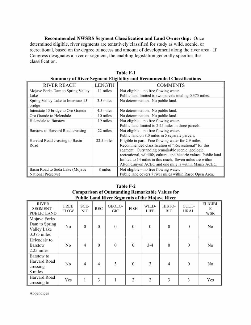
Appendices
Recommended NWSRS Segment Classification and Land Ownership: Once
determined eligible, river segments are tentatively classified for study as wild, scenic, or recreational, based on the degree of access and amount of development along the river area. If Congress designates a river or segment, the enabling legislation generally specifies the classification.
Table F-1 Summary of River Segment Eligibility and Recommended Classifications
RIVER REACH LENGTH COMMENTS Mojave Forks Dam to Spring Valley Lake
11 miles Not eligible – no free flowing water. Public land limited to two parcels totaling 0.375 miles.
Spring Valley Lake to Interstate 15 bridge
3.5 miles No determination. No public land.
Interstate 15 bridge to Oro Grande 4.5 miles No determination. No public land. Oro Grande to Helendale 10 miles No determination. No public land. Helendale to Barstow 19 miles Not eligible – no free flowing water.
Public land limited to 2.25 miles in three parcels. Barstow to Harvard Road crossing 22 miles Not eligible – no free flowing water.
Public land on 8.0 miles in 5 separate parcels. Harvard Road crossing to Basin Road
22.5 miles Eligible in part. Free flowing water for 2.9 miles. Recommended classification of “Recreational” for this segment. Outstanding remarkable scenic, geologic, recreational, wildlife, cultural and historic values. Public land limited to 14 miles in this reach. Seven miles are within Afton Canyon ACEC and one mile is within Manix ACEC.
Basin Road to Soda Lake (Mojave National Preserve)
8 miles Not eligible – no free flowing water. Public land covers 7 river miles within Rasor Open Area.
Table F-2
Comparison of Outstanding Remarkable Values for Public Land River Segments of the Mojave River
RIVER SEGMENT -
PUBLIC LAND
FREE FLOW
SCE-NIC REC GEOLO-
GIC FISH WILD-LIFE
HISTO-RIC
CULT-URAL
ELIGIBLE
WSR Mojave Forks Dam to Spring Valley Lake 0.375 miles
No 0 0 0 0 0 0 0 No
Helendale to Barstow 2.25 miles
No 4 0 0 0 3-4 0 0 No
Barstow to Harvard Road crossing 8 miles
No 4 4 3 0 3 4 0 No
Harvard Road crossing to Yes 1 3 1 2 2 3 3 Yes
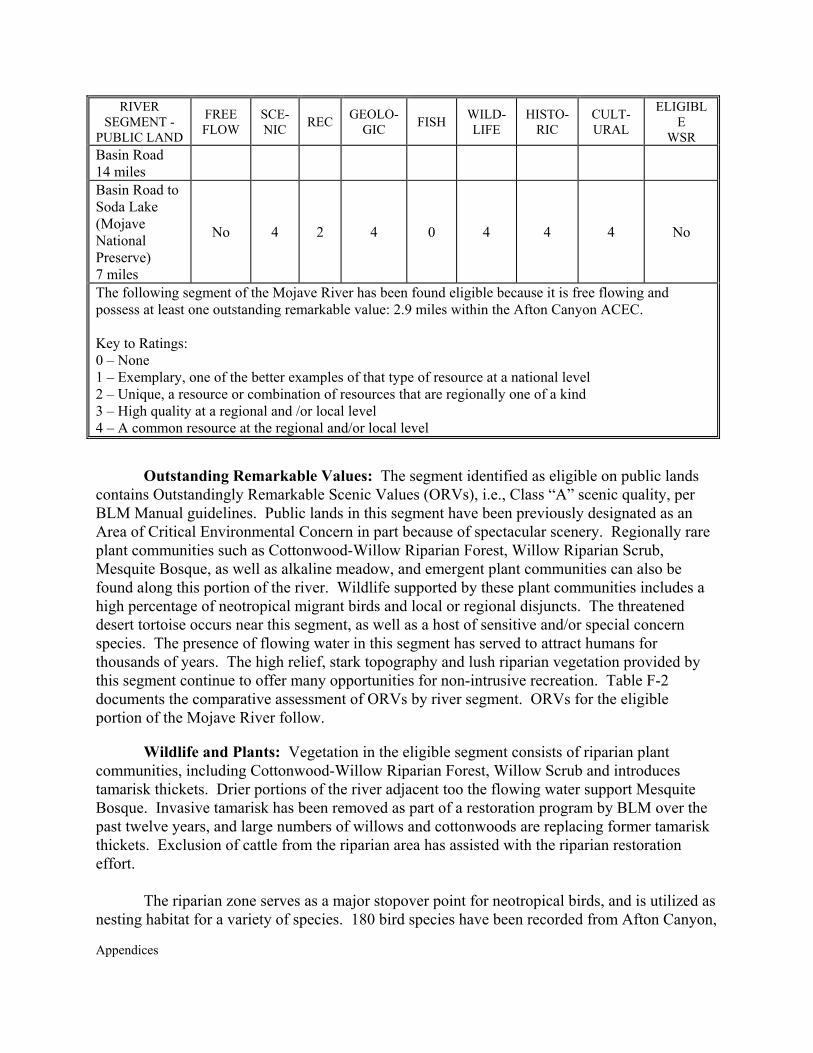
Appendices
RIVER SEGMENT -
PUBLIC LAND
FREE FLOW
SCE-NIC REC GEOLO-
GIC FISH WILD-LIFE
HISTO-RIC
CULT-URAL
ELIGIBLE
WSR Basin Road 14 miles Basin Road to Soda Lake (Mojave National Preserve) 7 miles
No 4 2 4 0 4 4 4 No
The following segment of the Mojave River has been found eligible because it is free flowing and possess at least one outstanding remarkable value: 2.9 miles within the Afton Canyon ACEC. Key to Ratings: 0 – None 1 – Exemplary, one of the better examples of that type of resource at a national level 2 – Unique, a resource or combination of resources that are regionally one of a kind 3 – High quality at a regional and /or local level 4 – A common resource at the regional and/or local level
Outstanding Remarkable Values: The segment identified as eligible on public lands
contains Outstandingly Remarkable Scenic Values (ORVs), i.e., Class “A” scenic quality, per BLM Manual guidelines. Public lands in this segment have been previously designated as an Area of Critical Environmental Concern in part because of spectacular scenery. Regionally rare plant communities such as Cottonwood-Willow Riparian Forest, Willow Riparian Scrub, Mesquite Bosque, as well as alkaline meadow, and emergent plant communities can also be found along this portion of the river. Wildlife supported by these plant communities includes a high percentage of neotropical migrant birds and local or regional disjuncts. The threatened desert tortoise occurs near this segment, as well as a host of sensitive and/or special concern species. The presence of flowing water in this segment has served to attract humans for thousands of years. The high relief, stark topography and lush riparian vegetation provided by this segment continue to offer many opportunities for non-intrusive recreation. Table F-2 documents the comparative assessment of ORVs by river segment. ORVs for the eligible portion of the Mojave River follow. Wildlife and Plants: Vegetation in the eligible segment consists of riparian plant communities, including Cottonwood-Willow Riparian Forest, Willow Scrub and introduces tamarisk thickets. Drier portions of the river adjacent too the flowing water support Mesquite Bosque. Invasive tamarisk has been removed as part of a restoration program by BLM over the past twelve years, and large numbers of willows and cottonwoods are replacing former tamarisk thickets. Exclusion of cattle from the riparian area has assisted with the riparian restoration effort. The riparian zone serves as a major stopover point for neotropical birds, and is utilized as nesting habitat for a variety of species. 180 bird species have been recorded from Afton Canyon,
Appendices
including disjunct occurrences of yellow warbler, vermilion flycatcher, summer tanager and yellow-breasted chat. The surrounding mountains support nesting golden eagles and prairie falcons and a number of other nesting and wintering raptors have been recorded. Unusual reptiles in Afton Canyon include the easternmost occurrence of the southwestern pond turtle, desert tortoises in the adjacent creosote bush scrub and Mojave fringe-toed lizards in nearby blowsand deposits. Several species snakes and lizards are present, making Afton Canyon an area of high reptilian diversity.
Three species of fish have been recorded: black bullhead, flathead minnow and arroyo chub. These fish have displaced the native Mojave tui chub, an endangered species. The Mojave tui chub could be re-introduced at Afton Canyon, but several major problems would have to be overcome. These include removal of non-native fish and predators, prevention of hybridization with the arroyo chub, storm proofing of a refugium site, and maintenance of water levels. The Department of Fish and Game and U. S. Fish and Wildlife Service consider re-introduction of the Mojave tui chub into the Mojave River to be infeasible at this time. However, Afton Canyon appears to provide a re-introduction site with a high potential for success compared to other locations along the river.
Bighorn sheep are present in the Cady Mountains, and Afton Canyon provides a reliable
water source for these animals. Other larger desert mammals, primarily predators, utilize the water as well.
Geologic: This segment of the Mojave River presents a spectacular landscape of badlands with an exposed multicolored stratigraphy. The Pleistocene drainage of Lake Manix about 19,000 years ago sent water down the river to cause downcutting and erosion through lake and pre-lake sediments as well as the fanglomerate in Afton Canyon. The Manix fault is an important structural geologic feature of the area.
A fossil assemblage of Rancholabrean age occurs in the area, and fragmentary remains
have been found of dire wolf, mammoth, sabre-toothed cat, bison, antelope and horses.
Cultural: Prehistoric sites along the Afton Canyon segment indicate an intermittent or continuing occupation by indigenous peoples for over 12,000 years. These sites include quarry sites, lithic scatter, ground stone artifacts, a possible cave site and six occupation or multi-use sites. Afton Canyon was part of a prehistoric trade route across the Mojave Desert and was a significant “way station”. The canyon was part of the Serrano Indians traditional resource area, near the boundary of the Chemehuevi territory.
Historic: The Mojave Road was a major historic trade and migration route. Jedidiah Smith, Kit Carson and John C. Fremont traveled through the canyon in the early 1800s and recommended it as a route. One mining operation in the hills adjoining the riparian segment has been in operation since the 1930s.
Recreational: Afton Canyon is one of the most heavily used recreation areas of the
Appendices
California desert. The area is used by OHV enthusiasts, equestrians, rockhounds, campers, picnickers, hikers, hunters and birdwatchers. BLM campgrounds facilitate use of the canyon and adjacent lands. Scientific and educational use of the area by colleges and universities is also common. The Mojave Road is an important historic and recreation feature attracting a high number of users. Wilderness: No designated wilderness is found in the eligible river segment, but the adjacent Cady Mountains are designated as a Wilderness Study Area and have been included in current Congressional legislation for wilderness status. References Bilhorn, Thomas W. 1993. Mojave River Riparian Vegetation Existing in 1993. Maps prepared
for the California Department of Fish and Game, Sacramento, CA. Lines, Gregory C. and T. W. Bilhorn 1996. Riparian Vegetation and Its Water Use During 1995
Along the Mojave River, Southern California. U. S.Geological Survey, Water Resources Investigations Report 96-4241, Sacramento, CA. Available from Mojave Water Agency, Apple Valley, CA.
Tierra Madre Consultants, 1992. Natural Resources Inventory of the Mojave River Corridor.
Report prepared for City of Victorville, Victorville, CA. Includes “Cultural Resources Sensitivity Study of the Mojave River Corridor, San Bernardino County, California” by the Archaeological Research Unit, University of California, Riverside, CA.
U. S. Army Corps of Engineers, 1997. Mojave River Floodplain Maintenance Plan. Corps of
Engineers, Los Angeles District, Los Angeles, CA. U. S. Dept. of the Interior, Bureau of Land Management, 1989. Management Plan for the Afton
Canyon Natural Area. BLM, Barstow Field Office, Barstow, CA.
Appendices
Management Standards and Guidelines for National Wild and Scenic Rivers The Wild and Scenic Rivers Act (Public Law 90-542, as amended) established a method of providing Federal protection for certain of our remaining free-flowing rivers, and preserving these locales for the use and enjoyment of present and future generations. Such designated rivers benefit from the protective management that the act provides. Section 10(a) of the WSR Act states:
Each component of the NWSRS shall be administered in such a manner as to protect and enhance the values which caused it to be included in said system without, insofar as is consistent therewith, limiting other uses that do not substantially interfere with public use and enjoyment of these values. In such administration, primary emphasis shall be given to protecting its esthetic, scenic, historic, archaeologic, and scientific features. Management plans for any such component may establish varying degrees of intensity for its protection and development, based on the special attributes of the area.
This section is generally interpreted by the Secretary of the Interior as a stated non-degradation and enhancement policy for all designated river areas, regardless of classification. The following National Standards and Guidelines are summarized from BLM Manual 8351 [Wild and Scenic Rivers-Policy and Program Direction for Identification, Evaluation and Management (1992)]. These standards/guidelines are intended to apply to formally designated rivers through incorporation into, or amendment of, resource or land use management plans. Incorporation or amendment efforts are typically completed within three years of formal WSR designation. However, these guidelines also apply, on an interim basis, as described above. For the sake of clarity, guidelines are presented for each separate river classification (wild, scenic and recreational).
Wild River Areas
The WSR Act defines wild river areas to include; “those rivers or sections of rivers that are free of impoundments and generally inaccessible except by trail, with watersheds and shorelines essentially primitive and waters unpolluted. These represent vestiges of primitive America.” Wild river areas are to be managed with a primary objective of providing primary emphasis to protection of identified outstandingly remarkable values, while providing consistent, river-related, outdoor recreation opportunities in a primitive setting.
Where National Management Standards/Guidelines include allowable practices such as construction of minor structures related to wildlife habitat enhancement, protection from fire, and rehabilitation or stabilization of damaged resources, provided the area will remain natural looking and the practices or structures will harmonize with the environment. Developments such as trails, bridges, occasional fencing, natural-appearing water diversions, ditches and water management devices, may be permitted if they are unobtrusive and do not have a significant,
Appendices
adverse impact on the natural character of the river area. The following Wild River Program Management Standards apply: Forestry Practices
Cutting of trees not permitted except when needed in association with a primitive recreation experience (such as clearing trails, for visitor safety purposes, or for fire control). Timber outside the boundary, but within visual corridors, should where feasible, be managed and harvested in a manner designed to provide special emphasis on visual quality. Water Quality
Conditions will be maintained or improved to meet Federal criteria or federally approved State Standards. River management plans shall prescribe a process for monitoring water quality on a scheduled basis. Hydroelectric Power and Water Resource Development
No such development would be permitted in the channel or river corridor. All water supply dams and major diversions are prohibited. The natural appearance and essentially primitive character of the river area must be maintained. Federal agency groundwater development for range, wildlife, recreation or administrative facilities may be permitted if there are no adverse effects on ORVs. Mining
New mining claims and mineral leases are prohibited within 0.25 mile of the river. Valid existing claims would not be abrogated and, subject to existing regulations, e.g., 43 CFR 3809, and any future regulations the Secretary of the Interior may prescribe to protect the rivers included in the NWSRS, existing mining activity would be allowed to continue. All mineral activity on federally administered land must be conducted in a manner that minimizes surface disturbance, water sedimentation, pollution and visual impairment. Reasonable mining claim and mineral lease access will be permitted. Mining claims beyond 0.25 mile of the river, but within the wild river boundary, and perfected after the effective date of designation, can be patented only as to the mineral estate and not the surface estate. Road and Trail Construction
No new roads or other provisions for overland motorized travel would be permitted within a narrow incised river valley or, if the river valley is broad, within 0.25 mile of the river bank. A few inconspicuous roads leading to the boundary of the river area and unobtrusive trail bridges may be permitted. Agricultural Practices and Livestock Grazing
Agricultural use is restricted to a limited amount of domestic livestock grazing and hay
Appendices
production to the extent currently being practiced. Row crops are prohibited. Recreation Facilities
Major public use areas, such as campgrounds, interpretive centers, or administrative headquarters are located outside of wild river areas. Simple comfort and convenience facilities, such as toilets, tables, fireplaces, shelters and refuse containers may be provided as necessary within the river area. These should harmonize with the surroundings. Unobtrusive hiking and equestrian trail bridges could be allowed on tributaries, but would not normally cross the designated river. Public Use and Access
Recreational use including, but not limited to, hiking, fishing, hunting and boating is encouraged in wild river areas to the extent consistent with the protection of the river environment. Public use and access may be regulated and distributed where necessary to protect and enhance wild river values. Rights-of-Way
New transmission lines, natural gas lines, water lines, etc., are discouraged unless specifically prohibited outright by other plans, orders or laws. Where no reasonable alternative exits, additional or new facilities should be restricted to existing rights-of-way. Where new rights-of-way are unavoidable, locations and construction techniques will be selected to minimize adverse effects on wild river area-related values and fully evaluated during the site selection process. Motorized Travel
Although this use can be permitted, it is generally not compatible with this river classification. Normally, motorized use will be prohibited in a wild river area. Prescriptions for management of motorized use may allow for search and rescue/emergency situations.
Scenic River Areas
The WSR Act defines scenic river areas to include “those rivers or sections of rivers that are free of impoundments, with shorelines or watersheds still largely primitive and shorelines largely undeveloped, but accessible in places by roads.”
Scenic river areas are to be managed with a primary objective of maintaining and providing outdoor recreation opportunities in a near-natural setting. The basic distinctions between “wild” and “scenic” classifications, involve varying degrees of development, types of land use, and road accessibility. In general, a wide range of agricultural, water management, silvicultural and other practices could be compatible with scenic classification values, providing such practices are carried out in a manner not resulting in a substantial adverse effect on the river and its immediate environment.
Appendices
National Management Standards/Guidelines include the same considerations set forth for
wild rivers, except that motorized vehicle use may in some cases be appropriate and that development of larger scale public-use facilities within the river area, such as moderate-sized campgrounds, interpretive centers, or administrative headquarters would be compatible, if such facilities were screened from the river. The following Scenic River Program Management Standards apply: Forestry Practices
Silvicultural practices, including timber harvesting could be allowed, provided that such practices are carried out in such a way that there is no substantial adverse effect on the river and its immediate environment. The river should be maintained in its near-natural condition. Timber outside the boundary, but within the visual screen area, should be managed and harvested in a manner designed to provide special emphasis on visual quality. Preferably, reestablishment of tree cover would be through natural revegetation. Cutting of dead and down materials for fuelwood will be limited. Where necessary, restrictions on the use of wood for fuel may be prescribed. Water Quality
Conditions will be maintained or improved to meet Federal criteria or federally approved State Standards. River management plans shall prescribe a process for monitoring water quality on a scheduled basis. Hydroelectric Power and Water Resource Development
No such development would be permitted in the channel or river corridor. Flood control dams and levees would be prohibited. All water supply dams and major diversions are prohibited. Maintenance of existing facilities and construction of some new structures would be permitted, provided that the area remains natural in appearance and the practices or structures harmonize with the surrounding environment. Mining
Subject to existing regulations, e.g. 43 CFR 3809, and any future regulations the Secretary of the Interior may prescribe to protect the rivers included in the NWSRS, new mining claims and mineral leases can be allowed. All mineral activity on federally administered land must be conducted in a manner that minimizes surface disturbance, water sedimentation, pollution and visual impairment. Reasonable mining claim and mineral lease access will be permitted. Mining claims within the wild river boundary, and perfected after the effective date of designation, can be patented only as to the mineral estate and not the surface estate. Road and Trail Construction
Roads may occasionally bridge the river and short stretches of conspicuous or lengthy
Appendices
stretches of inconspicuous and well-screened roads would be allowed. Maintenance of existing roads and any new roads will be based on the type of use for which the roads are constructed and the type of use that will occur in the river area. Agricultural Practices and Livestock Grazing
In comparison to wild river areas, a wider range of agricultural and livestock grazing uses are permitted, to the extent currently being practiced. Row crops are not considered as much of an intrusion of the “largely primitive” nature of scenic corridors, as long as there is not a substantial adverse effect on the natural-like appearance of the river area. Recreation Facilities
Larger-scale public use areas, such as moderate-sized campgrounds, interpretive centers, or administrative headquarters, are allowed if such facilities are screened from the river. Public Use and Access
Recreational use including, but not limited to, hiking, fishing, hunting and boating is encouraged in scenic river areas to the extent consistent with the protection of the river environment. Public use and access may be regulated and distributed where necessary to protect and enhance scenic river values. Rights-of-Way
New transmission lines, natural gas lines, water lines, etc., are discouraged unless specifically prohibited outright by other plans, orders or laws. Where no reasonable alternative exits, additional or new facilities should be restricted to existing rights-of-way. Where new rights-of-way are unavoidable, locations and construction techniques will be selected to minimize adverse effects on scenic river area-related values and fully evaluated during the site selection process. Motorized Travel
This use, on land or water, could be permitted, prohibited or restricted to protect river values. Prescriptions for management of motorized use may allow for search and rescue/emergency situations.
Recreational River Areas
The WSR Act defines recreational river areas to include “those rivers or sections of rivers that are readily accessible by road or railroad, that may have some development along their shorelines, that may have undergone some development along their shorelines, and that may have undergone some impoundment or diversion in the past.”
Appendices
Recreational river areas are to be managed with an objective of protecting and enhancing
existing recreational values. The primary objective is to provide opportunities for the public to participate in recreation activities dependent on, or enhanced by, the largely free-flowing nature of the river.
National Management Standards/Guidelines include allowable practices such as construction of recreation facilities in proximity to the river, although recreational river classification does not require extensive recreational developments. Such facilities are still to be kept to a minimum, with visitor services provided outside the river area. Future construction of impoundments, diversions, straightening, riprapping and other modification of the water way or adjacent lands would not be permitted, except where such developments would not have a direct and adverse effect on the river and its immediate environment. The following Recreational River Program Management Standards apply: Forestry Practices
Silvicultural practices, including timber harvesting could be allowed under standard restrictions to avoid adverse effects on the river environment and its associated values. Water Quality
Conditions will be maintained or improved to meet Federal criteria or federally approved State Standards. River management plans shall prescribe a process for monitoring water quality on a scheduled basis. Hydroelectric Power and Water Resource Development
No such development would be permitted in the channel or river corridor. Existing low dams, diversion works, riprap and other minor structures may be maintained, provided the waterway remains generally natural in appearance. New structures may be allowed, provided that the area remains natural in appearance and the practices or structures harmonize with the surrounding environment.
Mining
Subject to existing regulations, e.g. 43 CFR 3809, and any future regulations the Secretary of the Interior may prescribe to protect the rivers included in the NWSRS, new mining claims and mineral leases can be allowed. All mineral activity on federally administered land must be conducted in a manner that minimizes surface disturbance, water sedimentation, pollution and visual impairment. Reasonable mining claim and mineral lease access will be permitted. Mining claims within the wild river area boundary perfected after the effective date of designation can be patented only as to the mineral estate and not the surface estate.
Appendices
Road and Trail Construction
Existing parallel roads can be maintained on one or both riverbanks. There can be several bridge crossings and numerous river access points. Agricultural Practices and Livestock Grazing
In comparison to scenic river areas, lands may be managed for a full range of agricultural and livestock grazing uses, consistent with current practices. Recreation Facilities
Interpretive centers, administrative headquarters, campgrounds and picnic areas may be established in proximity to the river. Recreational classification does not require extensive recreation development. Public Use and Access
Recreation use including, but not limited to, hiking, fishing, hunting and boating is encouraged in recreational river areas to the extent consistent with the protection of the river environment. Public use and access may be regulated and distributed where necessary to protect and enhance recreational river values. Rights-of-Way
New transmission lines, natural gas lines, water lines, etc., are discouraged unless specifically prohibited outright by other plans, orders or laws. Where no reasonable alternative exits, additional or new facilities should be restricted to existing rights-of-way. Where new rights-of-way are unavoidable, locations and construction techniques will be selected to minimize adverse effects on recreational river area-related values and fully evaluated during the site selection process. Motorized Travel
This use, on land, will generally be permitted, on existing roads. Controls will usually be similar to that of surrounding lands. Motorized travel on water will be in accordance with existing regulations or restrictions.
Management Objectives Common to All Wild, Scenic, and Recreational Rivers Wilderness and Wilderness Study Areas
Management of river areas that overlap designated wilderness areas or wilderness study areas will meet whichever standard is highest. If an area is released from wilderness study area
Appendices
status and the associated Interim Management Policy, the applicable river classification standards and guidelines would then apply. Fire Protection and Suppression
Management and suppression of fires within a designated river area will be carried out in a manner compatible with contiguous federal lands. On wildfires, suppression methods will be utilized that minimizes the long-term impacts on the river and surrounding area. Pre-suppression and prevention activities will be conducted in a manner that reflects management objectives for the specific river segment. Prescribed fire may be utilized to maintain or restore ecological condition or meet objectives of the river plan. Insects, Diseases and Noxious Weeds
The control of forest and rangeland pests, diseases and noxious weed infestations will be carried out in a manner compatible with the intent of the WSR Act and management objectives of contiguous federal lands. Cultural Resources
Historic and prehistoric resource sites will be identified, evaluated and protected in a manner compatible with the objectives of the river and in accordance with applicable regulations and policies. Where appropriate, historic or prehistoric sites will be stabilized, enhanced and interpreted. Fish and Wildlife Habitat Improvement
The construction and maintenance of minor structures for the protection, conservation, rehabilitation and enhancement of fish and wildlife habitat are acceptable, provided they do not affect the free-flowing characteristics of the river, are compatible with the classifications, that the area remains natural in appearance and the practices or structures harmonize with the surrounding environment.
Appendices
APPENDIX G
INCIDENTAL TAKE PERMIT BACKGROUND DATA

Appendices
Appendices
APPENDIX G INCIDENTAL TAKE PERMIT BACKGROUND DATA
Information Sources and Comments
California City Prison – Jack Stewart, City Manager, 25 November 2002. Stewart
indicated that although the impact was restricted to 70 acres, the proponent purchased 320 acres, at the cost of $5000/acre, for a total of $1,600,000. Since the ratio was 1:1, it is assumed the remaining 250 acres is in an existing mitigation bank
Cushenbury Mine Site - Paul Kielhold, Lilburn Corporation, 25 November 2002. Kielhold indicated that the write-up costs were about $7,500, although another $20,000 was likely spent in coordination and ancillary documentation. Similarly, he indicated that 115 acres were purchased at about $900 to$1,000/acre (hence the $103,500 - $115,000), but that mitigation monitoring and other services may have cost another $120,000.
High Desert Power Project – Kenny Stein, of Constellation and Anne Knowlton, of URS, on 26 November 2002. With regards to timeframe for permit issuance, Stein indicated that it took approximately two years to issue the original permit and an additional year (hence “3 years”) for the permit to be amended to cover an additional acre of accidental impact (for which the proponent offered to compensate 7 acres for the 1 accidentally impacted). The compensation ration was varied, based on short- and long-term impacts, but in total included about $900/acre for the actual 100 acres that were disturbed (hence $900,000 for compensation). Although tortoises were regularly handled on the Section 7 portion of this project, Stein indicated that there was no take associated with the Section 10(a) permit part of the project.
Kern County Waste Management – Franklin Bedard, Kern County Waste Managemen, December 2002. Bedard did not know the costs for write-up or compensation, but indicated that the three landfill sites were compensated at the relatively high (inconsistent) rate of 3:1.
Miller Church Sites – Ed LaRue, November 2002. Compensation lands purchased at DTNA by the Desert Tortoise Preserve Committee, which continues to manage the land with under an MOU with the BLM. $9,000 included acquisition of 5 acres plus endowment funds.
Electrified Fence Project – No information contact was found for this project, which authorized the construction of electrified fences around numerous State prison sites, mostly located outside tortoise habitat.
Sunland Communities – Ed LaRue, November 2002. Total of 320 acres of private land purchased by project proponent and deeded to the BLM. The $220,000 was for both land acquisition and endowment funds.
U.S. Borax Mine Site – Dave Weiss, 22 November 2002 and Dennis Boyle, 25 November 2002, U.S. Borax. Boyle indicated that U.S. Borax purchased 2,274 acres (including

Appendices
two sections of Catellus lands) for $731,900 and provided CDFG with $238,000 in endowment funds, for a total of $969,900.
Wildwash Sand & Gravel Mine – Ed LaRue, November 2002. Compensation lands purchased by E.L. Yeager from Catellus Land Corporation and deeded to the BLM

Appendices
APPENDIX H
CLIMATE AND AIR QUALITY

Appendices
Appendices
APPENDIX H CLIMATE AND AIR QUALITY
The West Mojave planning area is a desert characterized by hot summer temperatures (average daily highs above 100 degrees Fahrenheit) and low annual precipitation (approximately 5 inches). Snow can occur during the winter. Probably more important than the averages is the extreme variability in the weather. Ridgecrest has recorded temperatures as high as 118 degrees and as low as 0 degrees. Daily temperatures ranges of 40 degrees can occur. Precipitation extremes are also common. Variations of 80% in annual precipitation are common. Summer thunderstorms can drop more precipitation on a site in one event than the mean precipitation for that location. High winds can occur. Peak wind velocities above 50 miles per hour (MPH) are not uncommon and winds of 100 MPH occur every year. One site has recorded 174 MPH winds.
Climactic Influences: California lies within a zone of prevailing westerly winds. It is also located on the east side of the semi-permanent high-pressure area of the northeast Pacific Ocean. High-pressure areas exhibit clockwise wind circulation. The basic flow in the free air above the state, therefore, is from the west or northwest during most of the year. The mountain chains within the state, however, deflect these winds and, except for the immediate coast, wind direction is likely to be more a product of local terrain than it is of prevailing circulation. This is especially true in the western Mojave Desert where the Sierra Nevada Mountains form a wall on the west boundary of the planning area and the San Gabriel and San Bernardino Mountains direct winds along the southern boundary of the plan area. Elevations rise to above 10,000 feet in all of these ranges. Prevailing winds out of the southwest are the result of the blocking nature of the Sierra Nevada Mountains and the proximity of the area to coastal and central California.
During the winter, the storm tracks move further south bringing high and low pressure cells with them. Wind direction and speed are modified by these migratory pressure centers. When there is a strong high-pressure area over the Great Basin and an intense low-pressure area approaches the coast from the west, strong and sometimes damaging winds occur, usually from an easterly or southeasterly direction, especially along the coast and in the coastal mountains. As the storms move inland the winds veer to southerly and southwesterly directions, and high wind speeds may occur anywhere within the plan area. The greatest velocities generally occur adjacent to the mountains and the Walker, Tehachapi, Soledad and Cajon passes. Wind gusts in excess of 80 MPH occur regularly in Mojave and along the western edge of the Indian Wells Valley. Gusts over 100 MPH are not unusual and a gust of 174 MPH was recorded in the Indian Wells Valley (December 1996).
During the summer a Pacific Subtropical High cell influences the region. This cell, which sits off the coast, inhibits cloud formation and encourages daytime solar heating. Air masses pushed onshore in Southern California are channeled through the Mojave Desert as a result of differential heating and a thermal low-pressure area located over the Southeastern Desert areas. There is a marked diurnal pattern in the strength of the wind.
Appendices
Another influence on the area air circulation is the result of the northwest wind moving alongshore the prominent headlands at Pt. Arguello. Wind speeds in the immediate vicinity of this major headland can be two or three times as great as the wind flow at nearby points. Here a strong jet of air is projected southward past San Miguel and San Nicholas Islands, driving a huge eddy as much as 200 miles in diameter. The air swings eastward near San Diego then northward and westward along the coast to rejoin the southward flowing air at the west end of the Santa Barbara Channel. This effect is called a coastal eddy and it can cause a southern airflow into the desert from the coastal basins. These various airflow mechanisms are the most influential in the western Mojave Desert. The airflows diminish toward the eastern Mojave Desert where the monsoonal air masses from the continental areas are more influential. Periodically a high-pressure area with its clockwise air circulation will settle in the four corners area (where Arizona, New Mexico, Colorado and Utah meet) resulting in an air circulation from the east to the west.
Temperature extremes are common in the planning area. Below or near freezing
temperatures are common at most weather stations. Seven of thirteen stations have average low temperatures below freezing in December and January. El Mirage has the lowest average temperatures in the planning area and Twentynine Palms has the highest average temperatures. Average daily temperature variation is 29 degrees for all stations. Seasonal variations are high. Ridgecrest, for example, has recorded highs of 118 degrees and lows of 0 degrees since the middle 1980s.
Precipitation: Deserts are noted for their low rainfall and the Mojave Desert is no
exception. The blocking nature of the mountains on the western and southern boundaries of the desert results in a rain shadow on the desert side of the mountains where precipitation is far less than on the coastal side. Weather patterns and their resulting precipitation follow the seasonal wind patterns and changes. This results in winter precipitation generally arriving from the southwest and spreading eastward across the desert. Winter precipitation volumes normally are the highest in the western Mojave Desert and diminish toward the east. This is illustrated in the mean precipitation for western locations such as Lancaster and Mojave (over 6 inches) and eastern cities such as Twentynine Palms (4 inches).
All of the weather stations in the planning area receive some of their precipitation as
snow. The total average snowfall ranges from under one inch in Trona to over three inches at Haiwee reservoir and Lancaster.
A cyclic weather phenomenon called the El Nino brings increased precipitation to
portions of the eastern Pacific Rim. This is especially true in the western Mojave Desert. Weather Bureau records indicate that there have been 23 El Nino years since 1931. These 23 years represent approximately 1/3 of the years, but on the western edge of the desert, those years account for 65% of the precipitation.
During the summer the western edge of the Mojave Desert is heavily influenced by the
dry southwest airflows resulting in typically very dry weather. The influence of the southwest winds diminishes toward the eastern Mojave Desert. This results in a more continental influence

Appendices
and its resulting monsoonal weather patterns. This east to west variability is also reflected in the pronounced east to west difference in average monthly precipitation (Table H-1) and in the influence of the El Nino years. In Twentynine Palms, for example, only 44% of the precipitation falls in El Nino years as opposed to 65% along the western edge of the desert.
The consistent occurrence of two wet seasons in the eastern portion of the planning area
is reflected in the vegetation. There is a distinction between plants having most of their photosynthetic activity during the late spring and summer (warm season plants) and plants having most photosynthetic activity during the winter (cool season plants). The vegetation in the eastern Mojave Desert includes warm season plants such as Mojave yucca (Yucca schidigrea), galleta grass species (Pleuraphis spp.) and others in addition to the cool season plants. The warm season plants are absent from the western edge of the desert. The break between the warm season area and the cool season area follows a north south line along the Mojave River and just west of Harper Dry Lake.
Extreme variability is another characteristic of the precipitation. Some locations such as
Mojave have a mean precipitation of 6.06 inches and a standard deviation of 4.04 inches. This means that the normal precipitation ranges from a low of 2.02 inches to 10.10 inches. This is an 80 % variation in precipitation volumes.
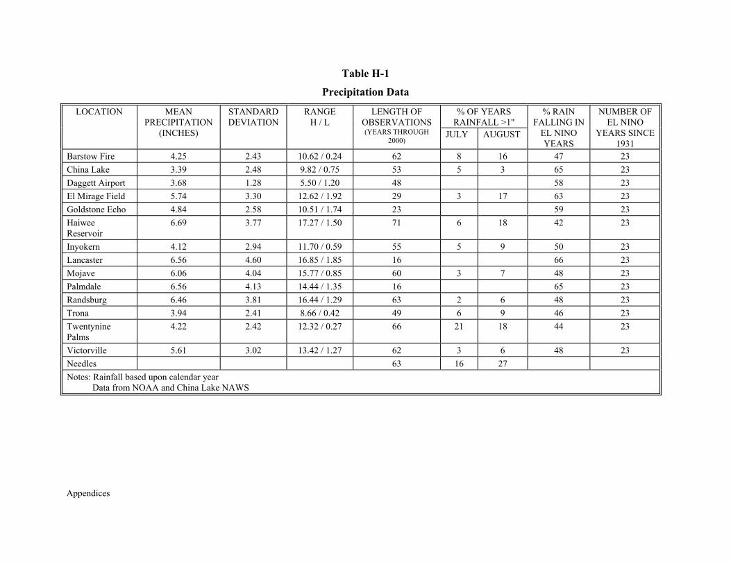
Appendices
Table H-1
Precipitation Data
% OF YEARS RAINFALL >1"
LOCATION
MEAN
PRECIPITATION (INCHES)
STANDARD DEVIATION
RANGE
H / L
LENGTH OF
OBSERVATIONS (YEARS THROUGH
2000) JULY
AUGUST
% RAIN
FALLING IN EL NINO YEARS
NUMBER OF
EL NINO YEARS SINCE
1931 Barstow Fire
4.25
2.43
10.62 / 0.24
62
8
16
47
23
China Lake
3.39
2.48
9.82 / 0.75
53 5
3
65
23
Daggett Airport
3.68
1.28
5.50 / 1.20
48
58
23
El Mirage Field
5.74
3.30
12.62 / 1.92
29 3
17
63
23
Goldstone Echo
4.84
2.58
10.51 / 1.74
23
59
23
Haiwee Reservoir
6.69
3.77
17.27 / 1.50
71
6
18
42
23
Inyokern
4.12
2.94
11.70 / 0.59
55
5
9
50
23
Lancaster
6.56
4.60
16.85 / 1.85
16
66
23
Mojave
6.06
4.04
15.77 / 0.85
60 3
7
48
23
Palmdale
6.56
4.13
14.44 / 1.35
16
65
23
Randsburg
6.46
3.81
16.44 / 1.29
63 2
6
48
23
Trona
3.94
2.41
8.66 / 0.42
49 6
9
46
23
Twentynine Palms
4.22
2.42
12.32 / 0.27
66
21
18
44
23
Victorville
5.61
3.02
13.42 / 1.27
62
3
6
48
23
Needles
63
16
27
Notes: Rainfall based upon calendar year Data from NOAA and China Lake NAWS

Appendices
Appendices
APPENDIX I
BEST MANAGEMENT PRACTICES FOR NEW CONSTRUCTION IN
TORTOISE HABITAT

Appendices

Appendices
APPENDIX I
BEST MANAGEMENT PRACTICES FOR NEW CONSTRUCTION IN
TORTOISE HABITAT I.1 BEST MANAGEMENT PRACTICES FOR DWMAs I.1.1 Awareness Program 1. The Implementation Team will develop and make available a standard education program, and maintain a list of Authorized Biologists and Environmental Monitors who can administer the program and implement the protective measures given below. 2. At a minimum, the awareness program shall emphasize the following information relative to the desert tortoise: (a) distribution on the job site; (b) general behavior and ecology; (c) sensitivity to human activities; (d) legal protection; (e) penalties for violating State or federal laws; (f) reporting requirements; and (g) project protective mitigation measures. The Authorized Biologist and/or Environmental Monitor shall work with the project proponent to ensure that all workers have received the awareness program and understand the various components. Interpretation shall be provided for non-English speaking construction workers. 3. All employees, subcontractors, and others who work on-site shall participate in a desert tortoise awareness program prior to initiation of field activities. The project proponent is responsible for ensuring that the awareness program is presented prior to conducting activities. Hard hat stickers to identify personnel who have attended the training and wallet-sized cards listing key BMPs are encouraged. 4. Educational materials produced by the West Mojave Implementation Team may be accompanied by a video, and the program administered by the Authorized Biologist or Environmental Monitor in a classroom setting, if available. In other cases, the program would be given in the field prior to initiation of construction activities, and shall include truck drivers, delivery personnel, and other project-related personnel occasionally entering the work site. I.1.2 Preconstruction Planning 5. Whenever possible, the project proponent shall work with the Implementation Team to plan for and conduct construction activities (particularly linear projects through Tortoise Survey Areas) when tortoises are least likely to be active, which generally occurs between November 15 and February 15.

Appendices
6. Where more than one site or alignment could satisfy the project proponent’s needs, it is suggested that a presence-absence survey be conducted on the alternative sites to determine which site or alignment will result in the fewest impacts to tortoises and occupied habitat during project development. I.1.3 Enforcement Capabilities 7. The Authorized Biologist shall serve as the field contact representative (FCR), and be responsible for implementing the following measures: (a) be responsible for overseeing compliance with protective stipulations for the desert tortoise; (b) coordinate compliance with the Lead Federal Agency; (c) have the authority to halt all activities that are in violation of the stipulations; and (d) maintain a copy of all appropriate stipulations (including pertinent BMPs) when work is being conducted at the site. 8. Monitors shall document all non-compliance activities. Repeated violations shall be resolved at the workplace between appropriate individuals. If problems persist, the Authorized Biologist or Environmental Monitor shall report infractions back to the Lead Federal Agency for public projects or Implementation Team for private projects within three to five days of the repeated violation. Such repeated violations, if not promptly rectified, may serve as the basis for stopping the project until the non-compliance issue is resolved. 9. If the project proponent fails to comply with any of the protective measures, the Lead Federal Agency shall suspend the pertinent authorization until such time that the project proponent is in compliance with those measures and conditions. I.1.4 On-site Minimization Measures I.1.4.1 Travel 10. Except when required by the project and explicitly stated in the project permit, cross-country vehicle use by project-related personnel shall be prohibited during work hours. 11. Except on paved roads with posted speed limits, vehicle speeds shall not exceed 20 miles per hour through desert tortoise habitat during travel associated with the authorized activity. I.1.4.2 Minimize Habitat Disturbance 12. To the extent possible, previously disturbed areas within the project site shall be used for stockpiling excavated materials, storing equipment, locating office trailers, parking vehicles, and other surface-disturbing activities. The Authorized Biologist or Environmental Monitor shall assist the project foreman in locating such areas to avoid desert tortoise mortality, minimize impacts to habitat, and ensure compliance with this measure and other pertinent regulatory documents (e.g., Streambed Alteration Agreement from CDFG). 13. The area of disturbance shall be confined to the smallest practical area, considering
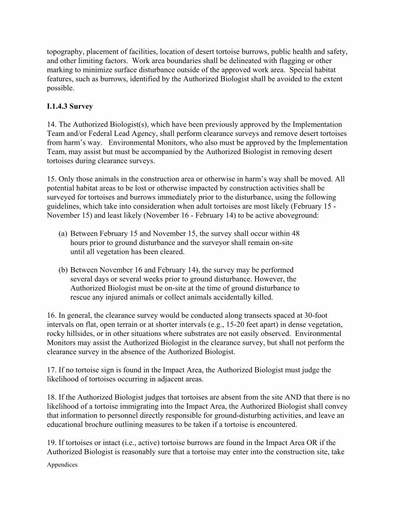
Appendices
topography, placement of facilities, location of desert tortoise burrows, public health and safety, and other limiting factors. Work area boundaries shall be delineated with flagging or other marking to minimize surface disturbance outside of the approved work area. Special habitat features, such as burrows, identified by the Authorized Biologist shall be avoided to the extent possible. I.1.4.3 Survey 14. The Authorized Biologist(s), which have been previously approved by the Implementation Team and/or Federal Lead Agency, shall perform clearance surveys and remove desert tortoises from harm’s way. Environmental Monitors, who also must be approved by the Implementation Team, may assist but must be accompanied by the Authorized Biologist in removing desert tortoises during clearance surveys. 15. Only those animals in the construction area or otherwise in harm’s way shall be moved. All potential habitat areas to be lost or otherwise impacted by construction activities shall be surveyed for tortoises and burrows immediately prior to the disturbance, using the following guidelines, which take into consideration when adult tortoises are most likely (February 15 - November 15) and least likely (November 16 - February 14) to be active aboveground:
(a) Between February 15 and November 15, the survey shall occur within 48 hours prior to ground disturbance and the surveyor shall remain on-site until all vegetation has been cleared.
(b) Between November 16 and February 14), the survey may be performed
several days or several weeks prior to ground disturbance. However, the Authorized Biologist must be on-site at the time of ground disturbance to rescue any injured animals or collect animals accidentally killed.
16. In general, the clearance survey would be conducted along transects spaced at 30-foot intervals on flat, open terrain or at shorter intervals (e.g., 15-20 feet apart) in dense vegetation, rocky hillsides, or in other situations where substrates are not easily observed. Environmental Monitors may assist the Authorized Biologist in the clearance survey, but shall not perform the clearance survey in the absence of the Authorized Biologist. 17. If no tortoise sign is found in the Impact Area, the Authorized Biologist must judge the likelihood of tortoises occurring in adjacent areas. 18. If the Authorized Biologist judges that tortoises are absent from the site AND that there is no likelihood of a tortoise immigrating into the Impact Area, the Authorized Biologist shall convey that information to personnel directly responsible for ground-disturbing activities, and leave an educational brochure outlining measures to be taken if a tortoise is encountered. 19. If tortoises or intact (i.e., active) tortoise burrows are found in the Impact Area OR if the Authorized Biologist is reasonably sure that a tortoise may enter into the construction site, take

Appendices
avoidance measures shall be implemented. Any tortoises within the Impact Area shall be removed and relocated by the Authorized Biologist as per guidelines given in Attachment I-1. Tortoises outside the Impact Area shall not be handled or otherwise disturbed. 20. All burrows in the Impact Area, including those not recently used, shall be excavated by the Authorized Biologist at the time of the survey. Eggs shall be relocated by the Authorized Biologist as they are found (see Desert Tortoise Council, 1999). 21. Once the initial tortoises are removed and burrows excavated, the site would then be surveyed an additional time to located any tortoises or burrows missed by the first survey. The site would then be considered clear and ground-disturbing activities may proceed. 22. The Authorized Biologist shall remain on-site until it is completely brushed. 23. Upon locating a recently dead or injured desert tortoise, the Authorized Biologist shall immediately notify the Lead Federal Agency (for federal projects) or Implementation Team (for non-federal projects). Where appropriate, it is recommended that tortoise remains be collected and stored as given in Dr. Kristin Berry’s June 2001 protocol for salvaging dead and sick tortoises. Written notification shall be made within five days of the finding to the Implementation Team and the Service’s Division of Law Enforcement in Torrance. The information provided shall include the date of the finding or incident (if known), location of the carcass or injured animal, a photograph, cause of death (if known), and other pertinent information. Injured animals shall be transported to a qualified veterinarian for treatment at the expense of the project proponent. If injured animals recover, the project proponent shall contact the Implementation Team for final disposition of the animal(s). 24. Authorized Biologists and Environmental Monitors are advised to follow the appropriate guidelines outlined in Guidelines for Handling Desert Tortoises during Construction Projects, Appendix 2 (Desert Tortoise Council 1999). I.1.4.4 Monitor and Construction Worker Responsibilities 25. The Authorized Biologist(s) shall be present during all activities where habitat is lost or substantially affected. Once the construction area has been cleared of all desert tortoises, an Environmental Monitor may be used instead of an Authorized Biologist. Environmental Monitors are only allowed to handle desert tortoises in emergency situations when the Authorized Biologist is not available. 26. Desert tortoises shall not be handled by construction workers. Monitors shall work cooperatively with construction personnel, and encourage all workers to inform them if a desert tortoise is found within or near project areas. All work in the vicinity of a desert tortoise that could injure or kill the animal shall cease and the desert tortoise shall be observed until it is moved from harm’s way by the biologist or, in an emergency, by the monitor. 27. Workers shall look for desert tortoises under vehicles and equipment before they are moved.
Appendices
If a desert tortoise is present, the worker shall wait for the desert tortoise to move from under the vehicle and out of harm’s way. Alternatively, the Authorized Biologist shall be contacted to remove and relocate the desert tortoise. 28. In general, there shall be one Authorized Biologist or Environmental Monitor assigned to each ground disturbing activity that may take tortoises (i.e., especially vegetation removal). Relatively mobile, often wide-spread construction activities (i.e., installing fiber optic cables and some water lines) will likely require multiple monitors, whereas many different stationary activities (i.e., drill rigs, gravel sifters) may either be fenced or observed by a single monitor. 29. Construction-related activities in desert tortoise habitat may be conducted after dark only in areas in which clearance surveys for desert tortoises have been conducted during daylight hours, as described in these BMPs. Areas in which work will occur after dark shall be clearly and specifically marked with reflective flagging or by some other means to indicate the boundaries within which night-time activities are to be limited. 30. All open holes shall be covered, fenced, OR inspected for trapped desert tortoises by an Authorized Biologist or Environmental Monitor at the beginning, middle, and end of each day. If desert tortoises are trapped, the Authorized Biologist or Environmental Monitor shall be notified immediately. Ramps shall be constructed at the ends of trenches, and, where feasible, at about 100-foot intervals along the trench to allow entrapped tortoises to escape. The desert tortoise shall be allowed to escape or shall be carefully removed and relocated by the biologist/monitor before work continues at that location. 31.All local, State, and federal ordinances, regulations, and laws governing the release of hazardous materials and wastes shall be implemented. Additionally, any and all reportable releases shall be reported to the Lead Federal Agency or Implementation Team (for Section 7 and Section 10(a)(1)(B) projects, respectively) within 24 hours of discovering the release. 32. Trash and food items shall be contained in closed containers and regularly removed to reduce the attractiveness or the area to opportunistic predators such as common ravens (Corvus corax), coyotes (Canis latrans), and feral dogs. 33. Pets shall be prohibited from the construction site. If guard dogs are to be used, the project proponent shall ensure that such animals do not adversely affect tortoises or other covered species. 34. Firearms, except as otherwise authorized, shall be prohibited from the construction site. I.1.4.5 Monitor Versus Fencing 35. In DWMAs, if construction lasts for more than a week OR occurs between February 15 and November 15 OR there is a reasonable likelihood that tortoises may wander onto the construction site, the Implementation Team shall require the project proponent to either (i) fence the site to preclude tortoises from the construction area (see Attachment I-2 for general
Appendices
guidelines) or (ii) employ an Authorized Biologist or Environmental Monitor to remain on-site until all activities likely to harm tortoises are completed. 36. In DWMAs, if construction lasts less than a week OR occurs between November 16 and February 14 OR there is little likelihood that tortoises may wander onto the construction site as determined by the Authorized Biologist, the project proponent is not required to fence the site or monitor. Instead, a tortoise placement hotline number shall be provided in case a tortoise enters the construction area, so that the tortoise may be rescued from harm’s way and placed into adjacent areas as otherwise stipulated (see Attachment I-1). I.1.5 Reporting 37. Authorized Biologists and Environmental Monitors shall maintain records of all desert tortoises and other covered species encountered during project activities, including the following information: (a) the locations (narrative and maps) and dates of observations; (b) general condition and health, including injuries and state of healing and whether animals voided their bladders; (c) locations from which and to which any animals are moved (UTM coordinates derived from a global positioning system - GPS - are preferable); and (d) diagnostic markings (i.e., identification numbers or marked lateral scutes). 38. A written status report shall be submitted to the Implementation Team every 30 days until which time the project is completed OR the potential to take tortoises no longer exists (i.e., if the site is fenced and the Authorized Biologist has already removed all tortoises from the fenced, impact area). 39. No later than 90 days after completion of construction or termination of activities, the Authorized Biologist, serving as the FCR, shall prepare a report for the Implementation Team. The report shall document (a) the effectiveness and practicality of the mitigation measures; (b) the number of desert tortoises excavated from burrows, moved from the site, and accidentally killed or injured; and (c) the specific information for each tortoise as described previously. The report may make recommendations to the Implementation Team and Lead Federal Agency, if appropriate, for modifying the stipulations to enhance protection of the desert tortoise or to make it more workable. The report shall provide an estimate of the actual acreage disturbed by various aspects of the operation. Attachment I-1. Guidelines for Relocating Tortoises During Authorized Construction Projects in All Occupied Tortoise Habitats
AREA
RECOMMENDED ACTIONS Desert Wildlife Management Area
Tortoises shall be moved from the immediate area of impact to adjacent suitable habitat (or burrow). In general, adult tortoises (>180 mm) shall be moved no further than 1,000 feet from the impact area; subadults (<180 mm) shall not be moved further than 300 feet. Fencing or monitoring may be required, as described in BMPs 35 and 36.
Incidental Take Area: Special Review Areas
(a) If only a small portion of a given site is to be developed then tortoises shall be moved to portions of the site that are not going to be developed. (b) Tortoises may be moved onto BLM lands if such lands are within (one-half mile of the
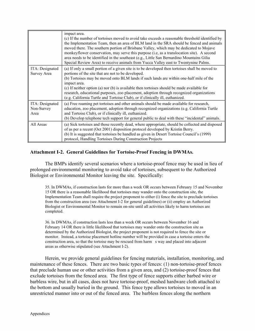
Appendices
impact area. (c) If the number of tortoises moved to avoid take exceeds a reasonable threshold identified by the Implementation Team, then an area of BLM land in the SRA should be fenced and animals moved there. The southern portion of Brisbane Valley, which may be dedicated to Mojave monkeyflower conservation, may serve this purpose (i.e, as a translocation site). A second area needs to be identified in the southeast (e.g., Little San Bernardino Mountains Gilia Special Review Area) to receive animals from Yucca Valley east to Twentynine Palms.
ITA: Designated Survey Area
(a) If only a small portion of a given site is to be developed then tortoises shall be moved to portions of the site that are not to be developed. (b) Tortoises may be moved onto BLM lands if such lands are within one-half mile of the impact area. (c) If neither option (a) nor (b) is available then tortoises should be made available for research, educational purposes, zoo placement, adoption through recognized organizations (e.g. California Turtle and Tortoise Club), or if clinically ill, euthanized.
ITA: Designated Non-Survey Area
(a) Free roaming pet tortoises and other animals should be made available for research, education, zoo placement, adoption through recognized organizations (e.g. California Turtle and Tortoise Club), or if clinically ill, euthanized. (b) Develop telephone tech support for general public to deal with these “incidental” animals.
All Areas (a) Sick tortoises and those recently dead, where appropriate, should be collected and disposed of as per a recent (Oct 2001) disposition protocol developed by Kristin Berry. (b) It is suggested that tortoises be handled as given in Desert Tortoise Council’s (1999) protocol, Handling Tortoises During Construction Projects
Attachment I-2. General Guidelines for Tortoise-Proof Fencing in DWMAs.
The BMPs identify several scenarios where a tortoise-proof fence may be used in lieu of prolonged environmental monitoring to avoid take of tortoises, subsequent to the Authorized Biologist or Environmental Monitor leaving the site. Specifically:
35. In DWMAs, if construction lasts for more than a week OR occurs between February 15 and November 15 OR there is a reasonable likelihood that tortoises may wander onto the construction site, the Implementation Team shall require the project proponent to either (i) fence the site to preclude tortoises from the construction area (see Attachment I-2 for general guidelines) or (ii) employ an Authorized Biologist or Environmental Monitor to remain on-site until all activities likely to harm tortoises are completed.
36. In DWMAs, if construction lasts less than a week OR occurs between November 16 and February 14 OR there is little likelihood that tortoises may wander onto the construction site as determined by the Authorized Biologist, the project proponent is not required to fence the site or monitor. Instead, a tortoise placement hotline number will be provided in case a tortoise enters the construction area, so that the tortoise may be rescued from harm�s way and placed into adjacent areas as otherwise stipulated (see Attachment I-2).
Herein, we provide general guidelines for fencing materials, installation, monitoring, and
maintenance of these fences. There are two basic types of fences: (1) non-tortoise-proof fences that preclude human use or other activities from a given area, and (2) tortoise-proof fences that exclude tortoises from the fenced area. The first type of fence supports either barbed wire or barbless wire, but in all cases, does not have tortoise-proof, meshed hardware cloth attached to the bottom and usually buried in the ground. This fence type allows tortoises to moved in an unrestricted manner into or out of the fenced area. The barbless fences along the northern
Appendices
boundary of the El Mirage Open Area, along the Mojave-Randsburg Road, and on many cattle allotments are examples. This memo concerns tortoise-proof fences, which have a hardware cloth component and are intended to preclude tortoises from a given area (i.e., usually an impact area at a construction or mine site).
In general, there are at least three types of tortoise-proof fences: (1) temporary fences to preclude tortoises from a given area (i.e., usually active construction sites) for a short amount of time (i.e., usually weeks or months, in some cases, days); (2) permanent fences to preclude tortoises from a given area and minimize human impacts to tortoises in perpetuity; and (3) special-condition fences, which are usually permanent, and tailored to meet specific needs. Guidelines for using each fence type are described below. The Implementation Team may modify these guidelines as new information becomes available or where the particular project type calls for modification of these guidelines. 1. Temporary Tortoise-Proof Fences.
1.a. Intended Function. This fence type is intended to preclude tortoises from an active construction site, where said activities (a) are likely to adversely affect tortoises; (b) are of short duration, usually a matter of weeks or months; and (c) fencing is less expensive and equally effective compared to having an environmental monitor remain on-site for a prolonged period of time. In this case, tortoises are known to occur in or adjacent to the impact area, which would be determined at the time of the clearance survey. This type of fence is best used on a fixed construction site [i.e., new or expanding mine area, residential development on a relatively small parcel (i.e., less than about 100 acres), etc.]. Pipelines and other long, linear projects are not well suited for temporary tortoise-proof fences, although fences have been effectively used during construction of pump houses, booster stations, stationary excavations, etc. along the right-of-way. In general, installing the temporary tortoise-proof fence is less expensive than employing an environmental monitor for the duration of the ground-disturbing activity.
1.b. Timing. The West Mojave Plan requires that all areas within Tortoise DWMAs and additional areas within a Tortoise Survey Area are to be surveyed for tortoises prior to ground disturbance. If during this clearance survey, the Authorized Biologist or Environmental Monitor (accompanied by the biologist) finds tortoise(s) on the site or in adjacent areas, a set of Best Management Practices, which may include fence installation, would be implemented to avoid take of tortoises. If a temporary tortoise-proof fence is to be erected, it should be placed around the perimeter of the area to be impacted, allowing sufficient room for construction activities to occur inside the fence without harm to construction personnel. The Authorized Biologist or Environmental Monitor would remain on-site and assist construction personnel or the fencing contractor in the placement of the fence to keep as many tortoise burrows as possible outside the fence. Once the fence is erected, the fenced area would be surveyed for tortoises and burrows, as described in the BMPs. All burrows would be excavated, and all tortoises and tortoise eggs would be moved out of harm’s way, outside the fenced area, as described in Attachment I-1 (Guidelines for Relocating Tortoises During Authorized Construction Projects in All Occupied Tortoise Habitats). Once the site is cleared of tortoises, the biologist or monitor need not remain on-site, so long as all construction activities are restricted to and contained within the temporary fence.
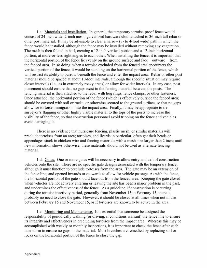
Appendices
1.c. Materials and Installation. In general, the temporary tortoise-proof fence would
consist of 24-inch wide, 2-inch mesh, galvanized hardware cloth attached to 36-inch tall rebar or other post material. It may be advisable to clear a narrow (3- to 4-foot wide) path in which the fence would be installed, although the fence may be installed without removing any vegetation. The mesh is then folded in half, creating a 12-inch vertical portion and a 12-inch horizontal portion, at more-or-less right angles to each other. When installing the fence, it is important that the horizontal portion of the fence lie evenly on the ground surface and face �outward� from the fenced area. In so doing, when a tortoise excluded from the fenced area encounters the vertical portion of the fence, it would be standing on the horizontal portion of the fence, which will restrict its ability to burrow beneath the fence and enter the impact area. Rebar or other post material should be spaced at about 10-foot intervals, although the specific situation may require closer intervals (i.e., as in extremely rocky areas) or allow for wider intervals. In any case, post placement should ensure that no gaps exist in the fencing material between the posts. The fencing material is then attached to the rebar with hog rings, fence clamps, or other fasteners. Once attached, the horizontal portion of the fence (which is effectively outside the fenced area) should be covered with soil or rocks, or otherwise secured to the ground surface, so that no gaps allow for tortoise immigration into the impact area. Finally, it may be appropriate to tie surveyor’s flagging or other highly visible material to the tops of the posts to increase the visibility of the fence, so that construction personnel avoid tripping on the fence and vehicles avoid damaging it.
There is no evidence that hurricane fencing, plastic mesh, or similar materials will preclude tortoises from an area; tortoises, and lizards in particular, often get their heads or appendages stuck in chicken wire and fencing materials with a mesh size larger than 2 inch; until new information shows otherwise, these materials should not be used as alternate fencing material.
1.d. Gates. One or more gates will be necessary to allow entry and exit of construction vehicles onto the site. There are no specific gate designs associated with the temporary fence, although it must function to preclude tortoises from the area. The gate may be an extension of the fence line, and opened inwards or outwards to allow for vehicle passage. As with the fence, the horizontal portion of the gate should face out from the fenced area. Keeping the gate closed when vehicles are not actively entering or leaving the site has been a major problem in the past, and undermines the effectiveness of the fence. As a guideline, if construction is occurring during the tortoise inactivity period, generally from November 15 to February 15, there is probably no need to close the gate. However, it should be closed at all times when not in use between February 15 and November 15, or if tortoises are known to be active in the area.
1.e. Monitoring and Maintenance. It is essential that someone be assigned the responsibility of periodically walking (or driving, if conditions warrant) the fence line to ensure its integrity and effectiveness in precluding tortoises from the impact area. Whereas this may be accomplished with weekly or monthly inspections, it is important to check the fence after each rain storm to ensure no gaps in the material. Most breaches are remedied by replacing soil or rocks on the horizontal portion of the fence to close the gap.
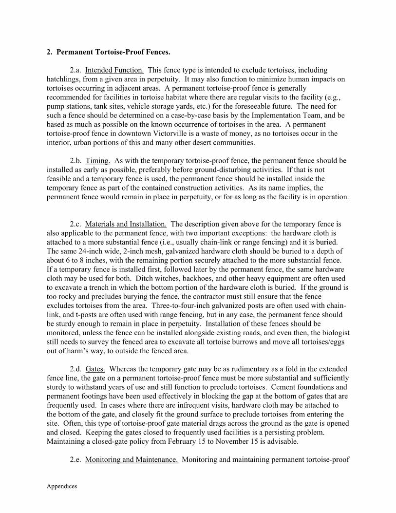
Appendices
2. Permanent Tortoise-Proof Fences.
2.a. Intended Function. This fence type is intended to exclude tortoises, including hatchlings, from a given area in perpetuity. It may also function to minimize human impacts on tortoises occurring in adjacent areas. A permanent tortoise-proof fence is generally recommended for facilities in tortoise habitat where there are regular visits to the facility (e.g., pump stations, tank sites, vehicle storage yards, etc.) for the foreseeable future. The need for such a fence should be determined on a case-by-case basis by the Implementation Team, and be based as much as possible on the known occurrence of tortoises in the area. A permanent tortoise-proof fence in downtown Victorville is a waste of money, as no tortoises occur in the interior, urban portions of this and many other desert communities.
2.b. Timing. As with the temporary tortoise-proof fence, the permanent fence should be installed as early as possible, preferably before ground-disturbing activities. If that is not feasible and a temporary fence is used, the permanent fence should be installed inside the temporary fence as part of the contained construction activities. As its name implies, the permanent fence would remain in place in perpetuity, or for as long as the facility is in operation.
2.c. Materials and Installation. The description given above for the temporary fence is also applicable to the permanent fence, with two important exceptions: the hardware cloth is attached to a more substantial fence (i.e., usually chain-link or range fencing) and it is buried. The same 24-inch wide, 2-inch mesh, galvanized hardware cloth should be buried to a depth of about 6 to 8 inches, with the remaining portion securely attached to the more substantial fence. If a temporary fence is installed first, followed later by the permanent fence, the same hardware cloth may be used for both. Ditch witches, backhoes, and other heavy equipment are often used to excavate a trench in which the bottom portion of the hardware cloth is buried. If the ground is too rocky and precludes burying the fence, the contractor must still ensure that the fence excludes tortoises from the area. Three-to-four-inch galvanized posts are often used with chain-link, and t-posts are often used with range fencing, but in any case, the permanent fence should be sturdy enough to remain in place in perpetuity. Installation of these fences should be monitored, unless the fence can be installed alongside existing roads, and even then, the biologist still needs to survey the fenced area to excavate all tortoise burrows and move all tortoises/eggs out of harm’s way, to outside the fenced area.
2.d. Gates. Whereas the temporary gate may be as rudimentary as a fold in the extended fence line, the gate on a permanent tortoise-proof fence must be more substantial and sufficiently sturdy to withstand years of use and still function to preclude tortoises. Cement foundations and permanent footings have been used effectively in blocking the gap at the bottom of gates that are frequently used. In cases where there are infrequent visits, hardware cloth may be attached to the bottom of the gate, and closely fit the ground surface to preclude tortoises from entering the site. Often, this type of tortoise-proof gate material drags across the ground as the gate is opened and closed. Keeping the gates closed to frequently used facilities is a persisting problem. Maintaining a closed-gate policy from February 15 to November 15 is advisable.
2.e. Monitoring and Maintenance. Monitoring and maintaining permanent tortoise-proof
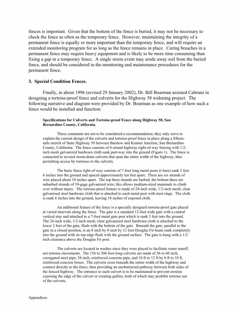
Appendices
fences is important. Given that the bottom of the fence is buried, it may not be necessary to check the fence as often as the temporary fence. However, maintaining the integrity of a permanent fence is equally or more important than the temporary fence, and will require an extended monitoring program for as long as the fence remains in place. Curing breaches in a permanent fence may require heavy equipment and is likely to be more time consuming than fixing a gap in a temporary fence. A single storm event may erode away soil from the buried fence, and should be considered in the monitoring and maintenance procedures for the permanent fence. 3. Special Condition Fences.
Finally, in about 1996 (revised 29 January 2002), Dr. Bill Boarman assisted Caltrans in designing a tortoise-proof fence and culverts for the Highway 58 widening project. The following narrative and diagram were provided by Dr. Boarman as one example of how such a fence would be installed and function:
Specifications for Culverts and Tortoise-proof Fence along Highway 58, San Bernardino County, California.
These comments are not to be considered a recommendation; they only serve to explain the current design of the culverts and tortoise-proof fence in place along a fifteen-mile stretch of State Highway 58 between Barstow and Kramer Junction, San Bernardino County, California. The fence consists of 6-strand highway right-of-way fencing with 1/2-inch mesh galvanized hardware cloth sunk part-way into the ground (Figure 1). The fence is connected to several storm-drain culverts that span the entire width of the highway, thus permitting access by tortoises to the culverts.
The basic fence right-of-way consists of 7-foot long metal posts (t-bars) sunk 2 feet 6 inches into the ground and spaced approximately ten feet apart. There are six strands of wire placed about 10 inches apart. The top three strands are barbed, the bottom three are unbarbed strands of 10-gage galvanized wire; this allows medium-sized mammals to climb over without injury. The tortoise-proof feature is made of 24-inch wide, 1/2-inch mesh, clear galvanized steel hardware cloth that is attached to each metal post with steel rings. The cloth is sunk 6 inches into the ground, leaving 18 inches of exposed cloth.
An additional feature of the fence is a specially designed tortoise-proof gate placed at varied intervals along the fence. The gate is a standard 12-foot wide gate with a central vertical stay and attached to a 7-foot metal gate post which is sunk 3 feet into the ground. The 24-inch wide, 1/2-inch mesh, clear galvanized steel hardware cloth is attached to the lower 2 feet of the gate, flush with the bottom of the gate. Beneath the gate, parallel to the gate in a closed position, is an 8 inch by 8 inch by 12 foot Douglas Fir beam sunk completely into the ground with its top edge flush with the ground surface. The gate is hung with a 1/2-inch clearance above the Douglas Fir post.
The culverts are located in washes since they were placed to facilitate water runoff, not tortoise movements. The 156 to 206 foot-long culverts are made of 36 to 60 inch, corrugated steel pipe, 54 inch, reinforced concrete pipe, and 10 ft to 12 ft by 6 ft to 10 ft, reinforced concrete boxes. The culverts cross beneath the entire width of the highway and connect directly to the fence, thus providing an unobstructed pathway between both sides of the fenced highway. The entrance to each culvert is to be maintained to prevent erosion exposing the edge of the culvert or creating gullies, both of which may prohibit tortoise use of the culverts.
Appendices
I.2 BEST MANAGEMENT PRACTICES FOR DESERT TORTOISE SURVEY AREAS (OUTSIDE DWMAs)
The measures given below comprise a subset of the BMPs developed for construction
projects in Tortoise DWMAs, and are modified as necessary for applicability to Incidental Take Areas outside DWMAs where focused desert tortoise surveys would be required (i.e., specifically within Tortoise Survey Areas).
Although DWMAs represent essential habitats required for the conservation and recovery of the desert tortoise, the California Department of Fish and Game (Department) and U.S. Fish and Wildlife Service (Service) require that the take of tortoises be minimized insofar as possible in all areas supporting tortoises, not just in DWMAs. The West Mojave Plan (Plan) has used the best available data to delineate areas where clearance surveys would (Tortoise Survey Area) and would not (Tortoise Non-Survey Areas) be required for projects covered by the Plan.
In the Tortoise Non-Survey Areas, a clearance survey would not be required, rather, at the time of discretionary permit issuance, the pertinent lead agency (i.e., mostly counties and cities) would distribute a brochure that, among other things, includes a hotline number to be called in the unlikely event a wild tortoise would be encountered.
The following BMPs are recommended for Tortoise Survey Areas: I.2.1 Surveys 1. The Implementation Team would maintain a list of Authorized Biologists who are qualified to perform desert tortoise clearance surveys. Environmental Monitors, who also must be approved by the Implementation Team, may assist the Authorized Biologist but are not authorized to perform clearance surveys by themselves. 2. The following guidelines are given to direct the timing of clearance surveys prior to ground-disturbing activities based on the assumption that most tortoises (with the exception of juveniles) are in hibernation from November 15 through February 15:
(a) Between February 15 and November 15, the clearance survey shall occur within 48 hours prior to ground disturbance.
(b) Between November 16 and February 14, the survey may be performed several days or several weeks prior to ground disturbance.
3. In general, the clearance survey shall include 100% of the area to be developed (Impact Area) and be conducted along transects spaced at 30-foot intervals on flat, open terrain or at shorter intervals (e.g., 15-20 feet apart) in dense vegetation, rocky hillsides, or in other situations where substrates are not easily observed.

Appendices
4. If no tortoise sign is found on the site, the Authorized Biologist shall judge the likelihood of tortoise occurrence in the adjacent area. 5. If the Authorized Biologist judges that tortoises are absent from the area AND would not be directly affected by construction activities (i.e., are not likely to immigrate onto the site), the Authorized Biologist shall convey that information to personnel directly responsible for ground-disturbing activities, and leave an educational brochure outlining measures to be taken if a tortoise is encountered. 6. If tortoises or intact (i.e., active) tortoise burrows are found in the Impact Area OR if the Authorized Biologist is reasonably sure that a tortoise may enter into the construction site, take avoidance measures shall be implemented. Any tortoises within the Impact Area shall be removed and relocated as per guidelines given in Attachment I-1. Tortoises outside the Impact Area shall not be handled or otherwise disturbed. 7. All burrows in the Impact Area, including those not recently used, shall be excavated at the time of the survey. Eggs shall be relocated as they are found (see Desert Tortoise Council, 1999). 8. Once the initial tortoises are removed and burrows excavated, the site shall then be surveyed an additional time to located any tortoises or burrows missed by the first survey. The site would then be considered clear, and ground-disturbing activities may proceed. 9. The Authorized Biologist shall remain on-site until it is completely brushed. 10. Upon locating a recently dead or injured desert tortoise, the Authorized Biologist shall immediately notify the Lead Federal Agency (for federal projects) or Implementation Team (for non-federal projects). Where appropriate, it is recommended that tortoise remains be collected and stored as given in Dr. Kristin Berry’s protocol for salvaging dead and sick tortoises. Written notification shall be made within five days of the finding to the Implementation Team and the Service’s Division of Law Enforcement in Torrance. The information provided shall include the date of the finding or incident (if known), location of the carcass or injured animal, a photograph, cause of death (if known), and other pertinent information. Injured animals shall be transported to a qualified veterinarian for treatment at the expense of the project proponent. If injured animals recover, the project proponent shall contact the Implementation Team for final disposition of the animals. 11. Authorized Biologists and Environmental Monitors are advised to follow the appropriate guidelines outlined in Guidelines for Handling Desert Tortoises during Construction Projects, Appendix 2 (Desert Tortoise Council 1994, revised 1999). I.2.2 Educational Brochure 12. The Implementation Team will develop and make available a standard education brochure, and maintain a list of Authorized Biologists and Environmental Monitors who are authorized to
Appendices
distribute the brochure. Among other things, this brochure shall outline steps to be taken if a $tortoises enters into the construction site once the Biologist/Monitor has left the site. I.2.3 Preconstruction Planning 13. Whenever possible, the project proponent shall work with the Implementation Team to plan for and conduct construction activities (particularly linear projects through Tortoise Survey Areas) when tortoises are least likely to be active, which generally occurs between November 15 and February 15. 14. Where more than one site or alignment could satisfy the project proponent’s needs, it is suggested that a presence-absence survey be conducted on the alternative sites to determine which site or alignment will result in the fewest impacts to tortoises and occupied habitat during project development. I.2.4 Reporting 15. Authorized Biologists and Environmental Monitors shall maintain records of all desert tortoises and other covered species encountered during project activities, including the following information: (a) the locations (narrative and maps) and dates of observations; (b) general condition and health, including injuries and state of healing and whether animals voided their bladders; (c) locations from which and to which any animals are moved (UTM coordinates derived from a global positioning system - GPS - are preferable); (d) diagnostic markings (i.e., identification numbers or marked lateral scutes); and (e) the amount of habitat lost (i.e., cleared of vegetation) to the activity. This report shall be submitted to the Implementation Team within 30 days of the Authorized Biologist leaving the site.
Appendices
APPENDIX K
STATISTICAL ANALYSES OF DESERT TORTOISE SURVEYS

Appendices
Statistical Analysis of BLM Desert Tortoise Surveys In Support of the West Mojave Management Plan
Report I: Exploratory and Initial Data Analysis
1 May 2002
by
Anthony J. Krzysik, Ph.D. 11 Highland Terrace Prescott, AZ 86305
2
Introduction This report represents the exploratory and initial data analysis of the BLM desert tortoise surveys and calibration plots that support the West Mojave Management Plan. Ed LaRue of BLM is the primary monitor of this analysis effort and Principal Investigator of the role of desert populations in the development of this plan. Kathy Buescher, Senior Wildlife Biologist at Chambers Group, Inc., is the subcontract manager. The data used for analysis came from Emily Cohen and Ric Williams in 2002. The data was provided in Excel format. The tortoise calibration plot data was provided by Emily on 13 February. Ric’s 1998 and 1999 data sets were provided 12 March, and were initially used for analyzing the tortoise survey data, because they contained UTM coordinates from BLM GIS tortoise distribution maps. After a great deal of exploratory and actual analysis, there appeared to be errors in the 1998 data set. Therefore, a close comparison was made of all individual transects for both the 1998 and 1999 data from Emily and Ric. A number of discrepancies were found between the pairs of data sets, particularly in the 1998 pair. Ed LaRue, Emily Cohen, and Ric Williams were provided with the detailed individual discrepancies between the 1998 and 1999 data files on 8 April. Everyone agreed that the two files should have been identical. Emily carefully corrected the 1998 data set and sent it to me 24 April. Ed LaRue has the original data field data sheets and noted that he will recheck the Excel data. The 1999 data set also requires further examination. Out of 1617 cases, 589 have Area codes, 980 have Areas that were coded as “unknown” and 48 had “blank” fields for Area. The 1999 data set was analyzed with 589 cases. Therefore, the 1998 and 1999 tortoise survey data that were analyzed were provided by Emily Cohen. The 2001 data set provided by Emily Cohen on 5 April was not analyzed because survey Areas were not identified. The “Transect Area” data field contained only “1s”. These initial data analyses were important in developing data analyses approaches and techniques, formatting the data, identifying problem areas in the original data, correcting minor errors in the data that analyses and data formatting revealed, and importantly, also generated some initial results. The Conclusions section discusses the results of the current analysis to provide guidance for the final data analysis phase.
Methods Final data analyses were conducted with the SPSS statistical package (SPSS 1999a). Three tortoise sign counts were used in the analysis: burrows, scats, and TCS. The variable burrow is the actual observed tortoise burrow count on individual surveyed transects and was available from the provided data matrix. The variable scat is the corrected tortoise scat count on individual surveyed transects, and was calculated from the data matrix as TCS – burrow. The variable TCS (Total Corrected Sign) is the total corrected burrow + scat count on individual surveyed transects and was available from the provided data matrix. Table 1 provides the variable abbreviations used for the Calibration Plot Areas. Tortoise sign require square root data transformation, because the data represent counts with many data cells being “0”. Counts follow a Poisson distribution where the mean equals the variance, and therefore the mean and variance cannot be independent, but vary identically.
3
All the sign data was transformed as x = (x+0.5)1/2, where x represents a tortoise sign variable (Sokal and Rohlf 1995). Bivariate parametric and nonparametric correlation analyses were performed on three data sets to assess the association of tortoises, burrows, scats, TCS, and carcasses on survey transects. The parametric test was the Pearson Product Moment Correlation Coefficient. Two nonparametric rank correlations were used: Spearman’s rho and Kendall’s tau. The three data set used were:
Calibration Plot Areas, 1998+1999+2001 1998 tortoise survey Areas 1999 tortoise survey Areas
Guided by the results of the correlation analyses, a Step-Wise Linear Regression model was developed to assess the relative importance of the three tortoise sign parameters to “predict” tortoise transect occurrences. Factorial Analysis of Variance (ANOVA) was used for the calibration plot surveys for comparing statistical significance of burrows, scats, and TCS among surveyors, years, and Areas. The 5 percent significance level (P < 0.05) was used based on experience and general acceptance in ecological research and field biology. Burrows, scats, and TCS were each used in separate analyses as dependent variables with years, Areas, and surveyors as “factors”, the independent variables. Tables 2 shows all the data cells available for Years – Areas – Surveyors analyses. Tables 3, 4, and 5 summarize the data of Table 2. Various combinations of years, Areas, surveyors, and variables were used in multiple analyses to minimize “unbalanced” ANOVA designs. Unbalanced design in these analyses refers to the situation when there are empty cells in the years x Areas x surveyors matrix (e.g., some surveyors were not present in some areas in some years, see Table 2). All analyses, unless specified otherwise, used Type III calculation of Sums of Squares, because this algorithm is generally recommended, it is invariant with respect to cell frequencies, and when there are no missing cells it is equivalent to Yates’ weighted-squares-of-means method (Milliken and Johnson 1984, Shaw and Mitchell-Olds 1993). Type IV calculation of Sums of Squares was used when the factorial design was unbalanced with respect to possessing empty cells among factor comparisons (Milliken and Johnson 1984, Shaw and Mitchell-Olds 1993). For example, in a three factor ANOVA (years-surveyors-Areas) when comparing three survey years all surveyors did not survey all three years in all the areas that were under investigation (e.g., there were empty cells in the factorial design). Levene’s test for equality of error variances was used for all analyses, and does not depend on the assumption of normality (Levene 1960). Bartlett’s test is often used to assess homogeneity, but its practical value has been questioned (Harris 1975), and this test is not very efficient and strongly affected by non-normality (Zar 1999). Levene’s test uses the average of absolute deviations instead of the mean square of deviations, making it less sensitive to skewed distributions (Snedecor and Cochran 1989). Levene’s test checks to see if error variances are homogeneous among the factors being compared in an ANOVA. Homogeneous variances are a parametric assumption in ANOVA. ANOVA is a parametric statistical procedure that technically requires parametric assumptions to be met: homogeneous error variances, normally distributed data, adequate sample sizes, and independence of sampling or experimental errors
4
(random sampling, independence of observations). Nevertheless and importantly, ANOVA is considered robust to departures from the first two of these assumptions, particularly when proper transformations are employed (Sokal and Rohlf 1995, Underwood 1997, Zar 1999). Additionally, SPSS algorithms are very robust to nonnormality (Morgan and Griego 1998). Many researchers believe that the routine use of nonparametric statistics avoids many issues of parametric assumptions, but these methods are equally affected by the last two critical assumptions – independence of sampling errors and the loss of statistical power with inadequate sample sizes (Krzysik 1998). The routine use of nonparametric analysis in ecological research is not recommended (Johnson 1995, Smith 1995, Stewart-Oaton 1995), but see Potvin and Roff (1993). The use of factorial ANOVA designs requires the use of Post Hoc multiple comparison tests to assess the statistical significance when there are more than two levels for any factor. Five Post Hoc multiple comparison tests were used in all factorial ANOVA analyses. The Bonferroni test, based on the Student’s t statistic, adjusts the significance level for multiple comparisons. This test has the widest range of applications, is conservative, and when there are few comparisons has high power (Zolman 1993, SPSS 1999b). Conservative tests were desirable in these analyses, because they minimize Type I error, the probability of rejecting a true null hypothesis (null hypothesis = no significance difference) (Krzysik 1998). In other words, reporting significance when the comparison was not statistically significant. When factor variances are heterogeneous, pooled estimates of variance cannot be used to calculate the standard error of the comparison (Day and Quinn 1989). The use of Post Hoc tests that specifically address this issue are recommended (Day and Quinn 1989, SPSS 1999b). Therefore, four additional Post Hoc tests were used for all factorial ANOVA comparisons that were made: Tamhane’s T2 – conservative pairwise comparison test based on a t test Dunnett’s T3 – pairwise comparison test based on the Studentized maximum modulus,
highly recommended (Fry 1993) Games-Howell – liberal pairwise comparisons test, highly recommended (Fry 1993) Dunnett’s C – pairwise comparisons test based on the Studentized range Although all five tests were examined for significance at the 0.05 level, only the results of the conservative Tamhane’s T2 test were reported. The results of all five Post Hoc tests were reasonably similar for all the factorial ANOVA analyses conducted in this study. This indicates that the data were reasonably behaved. As expected, the Games-Howell test was more liberal, while the Bonferroni test was frequently very liberal in contrast to the other four tests, particularly when Levene’s test showed significant departure from homogeneous residuals. One-Way Analysis of Variance was used to assess the statistical significance among the tortoise survey Areas. Analyses were done separately for 1998 and 1999. Analysis of the 2001 data was not conducted, because Area was not distinguished in the data matrix. A large number of cases in the 1999 data were removed from the data matrix, because the Area variable was either designated “unknown” or left as a blank field. Tamhane’s T2 and Games-Howell Post Hoc tests
5
were performed on all analyses to statistically established differences among the tortoise survey sites. The results of Tamhane’s T2 test were reported in the results.
Results Bivariate Correlation Analysis In all analyses, very similar results were obtained with Pearson’s Product Moment Correlation Coefficient (Parametric) and two Nonparametric methods Spearman’s rho and Kendall’s tau rank correlation. The values reported below are Pearson’s Correlation Coefficient. Tortoise Calibration Areas Year: 1998 + 1999 + 2001 All Areas (N=8) All Surveyors (N=13) N = 624 Burrows Scats TCS Carcasses Tortoises 0.39** 0.17** 0.26** -0.004 NS Burrows 0.35** 0.58** -0.002 NS Scats 0.96** 0.018 NS TCS 0.021 NS ** Highly Significant: P < 0.01 NS Not Significant: P > 0.05
6
Tortoise Survey Areas Year: 1998 All Areas (N=19) All Surveyors (N=7) N = 876 Burrows Scats TCS Carcasses Tortoises 0.29** 0.14** 0.23** -0.004 NS Burrows 0.43** 0.68** 0.13** Scats 0.95** 0.027 NS TCS 0.067* ** Highly Significant: P < 0.01 * Significant: P < 0.05 NS Not Significant: P > 0.05 Tortoise Survey Areas Year: 1999 All Areas (N=9) All Surveyors (N=4) N = 589 Burrows Scats TCS Carcasses Tortoises 0.36** 0.18** 0.25** 0.074 NS Burrows 0.35** 0.60** 0.15** Scats 0.95** 0.006 NS TCS 0.054 NS ** Highly Significant: P < 0.01 NS Not Significant: P > 0.05
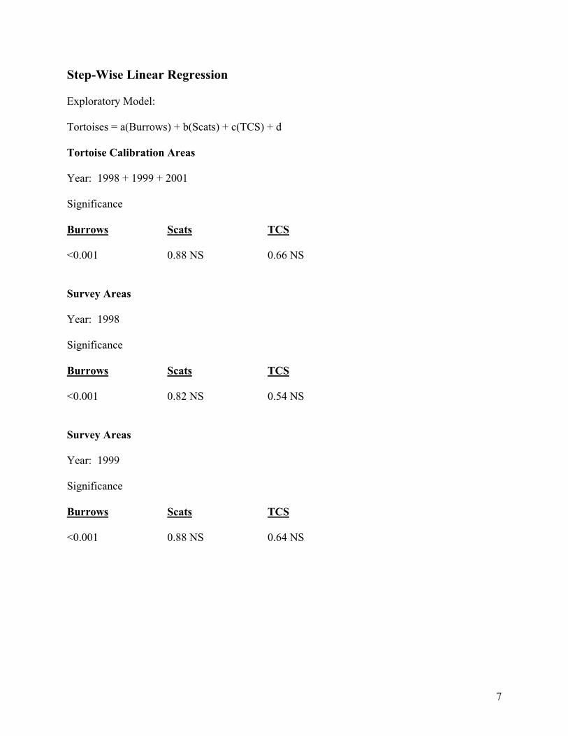
7
Step-Wise Linear Regression Exploratory Model: Tortoises = a(Burrows) + b(Scats) + c(TCS) + d Tortoise Calibration Areas Year: 1998 + 1999 + 2001 Significance Burrows Scats TCS <0.001 0.88 NS 0.66 NS Survey Areas Year: 1998 Significance Burrows Scats TCS <0.001 0.82 NS 0.54 NS Survey Areas Year: 1999 Significance Burrows Scats TCS <0.001 0.88 NS 0.64 NS
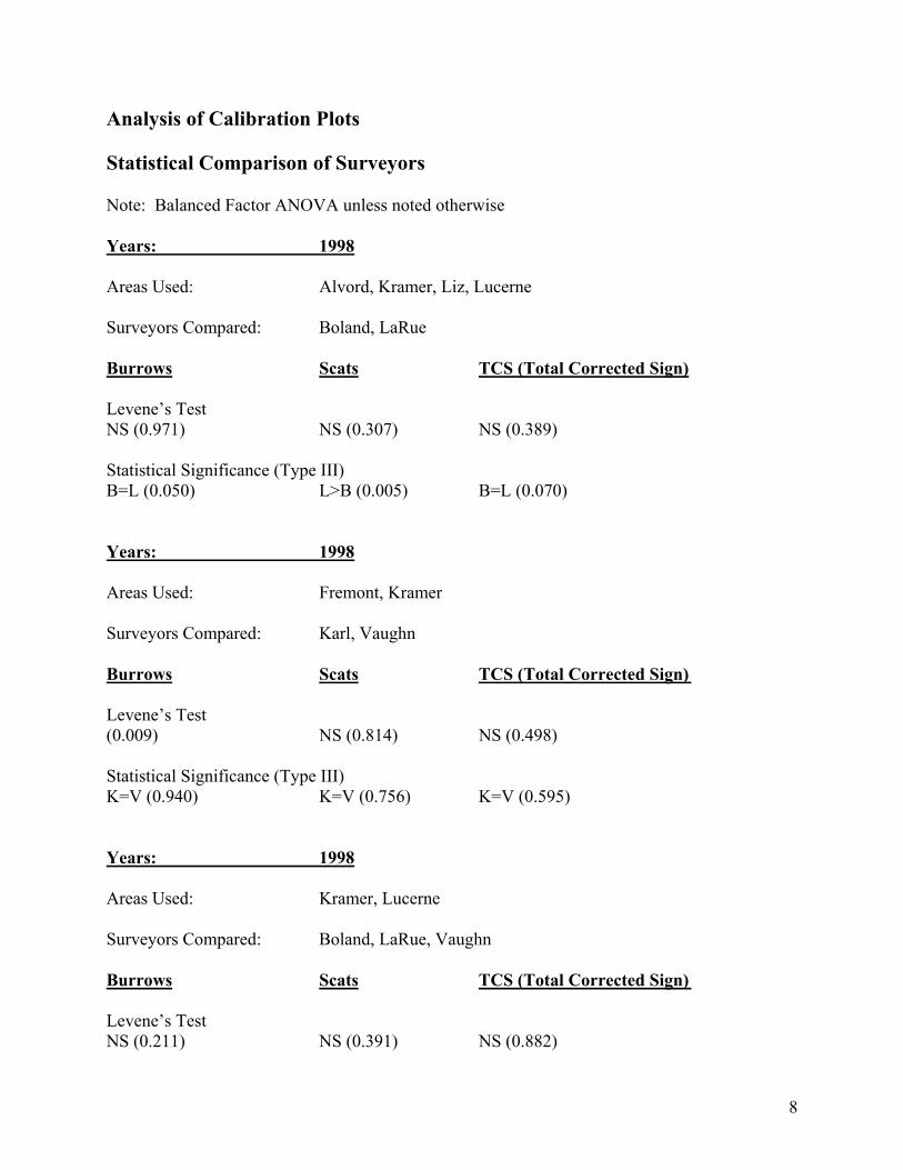
8
Analysis of Calibration Plots Statistical Comparison of Surveyors Note: Balanced Factor ANOVA unless noted otherwise Years: 1998 Areas Used: Alvord, Kramer, Liz, Lucerne Surveyors Compared: Boland, LaRue Burrows Scats TCS (Total Corrected Sign) Levene’s Test NS (0.971) NS (0.307) NS (0.389) Statistical Significance (Type III) B=L (0.050) L>B (0.005) B=L (0.070) Years: 1998 Areas Used: Fremont, Kramer Surveyors Compared: Karl, Vaughn Burrows Scats TCS (Total Corrected Sign) Levene’s Test (0.009) NS (0.814) NS (0.498) Statistical Significance (Type III) K=V (0.940) K=V (0.756) K=V (0.595) Years: 1998 Areas Used: Kramer, Lucerne Surveyors Compared: Boland, LaRue, Vaughn Burrows Scats TCS (Total Corrected Sign) Levene’s Test NS (0.211) NS (0.391) NS (0.882)
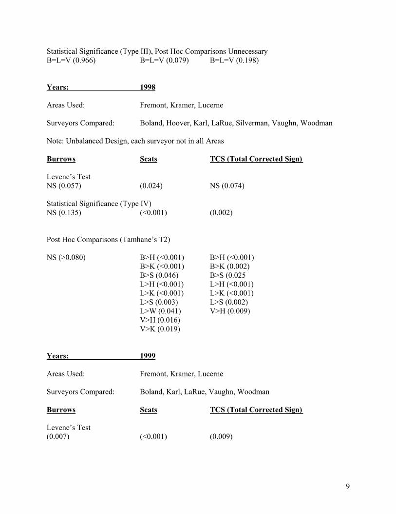
9
Statistical Significance (Type III), Post Hoc Comparisons Unnecessary B=L=V (0.966) B=L=V (0.079) B=L=V (0.198) Years: 1998 Areas Used: Fremont, Kramer, Lucerne Surveyors Compared: Boland, Hoover, Karl, LaRue, Silverman, Vaughn, Woodman Note: Unbalanced Design, each surveyor not in all Areas Burrows Scats TCS (Total Corrected Sign) Levene’s Test NS (0.057) (0.024) NS (0.074) Statistical Significance (Type IV) NS (0.135) (<0.001) (0.002) Post Hoc Comparisons (Tamhane’s T2) NS (>0.080) B>H (<0.001) B>H (<0.001) B>K (<0.001) B>K (0.002) B>S (0.046) B>S (0.025 L>H (<0.001) L>H (<0.001) L>K (<0.001) L>K (<0.001) L>S (0.003) L>S (0.002) L>W (0.041) V>H (0.009) V>H (0.016) V>K (0.019) Years: 1999 Areas Used: Fremont, Kramer, Lucerne Surveyors Compared: Boland, Karl, LaRue, Vaughn, Woodman Burrows Scats TCS (Total Corrected Sign) Levene’s Test (0.007) (<0.001) (0.009)
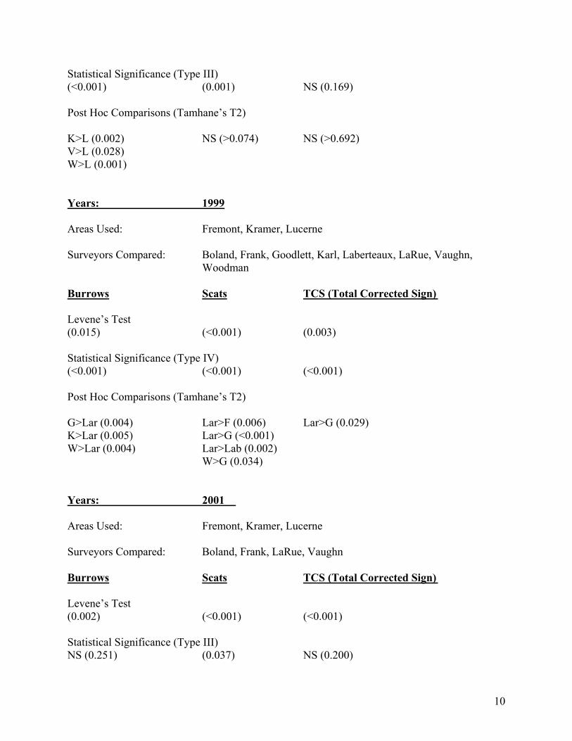
10
Statistical Significance (Type III) (<0.001) (0.001) NS (0.169) Post Hoc Comparisons (Tamhane’s T2) K>L (0.002) NS (>0.074) NS (>0.692) V>L (0.028) W>L (0.001) Years: 1999 Areas Used: Fremont, Kramer, Lucerne Surveyors Compared: Boland, Frank, Goodlett, Karl, Laberteaux, LaRue, Vaughn,
Woodman Burrows Scats TCS (Total Corrected Sign) Levene’s Test (0.015) (<0.001) (0.003) Statistical Significance (Type IV) (<0.001) (<0.001) (<0.001) Post Hoc Comparisons (Tamhane’s T2) G>Lar (0.004) Lar>F (0.006) Lar>G (0.029) K>Lar (0.005) Lar>G (<0.001) W>Lar (0.004) Lar>Lab (0.002) W>G (0.034) Years: 2001 Areas Used: Fremont, Kramer, Lucerne Surveyors Compared: Boland, Frank, LaRue, Vaughn Burrows Scats TCS (Total Corrected Sign) Levene’s Test (0.002) (<0.001) (<0.001) Statistical Significance (Type III) NS (0.251) (0.037) NS (0.200)
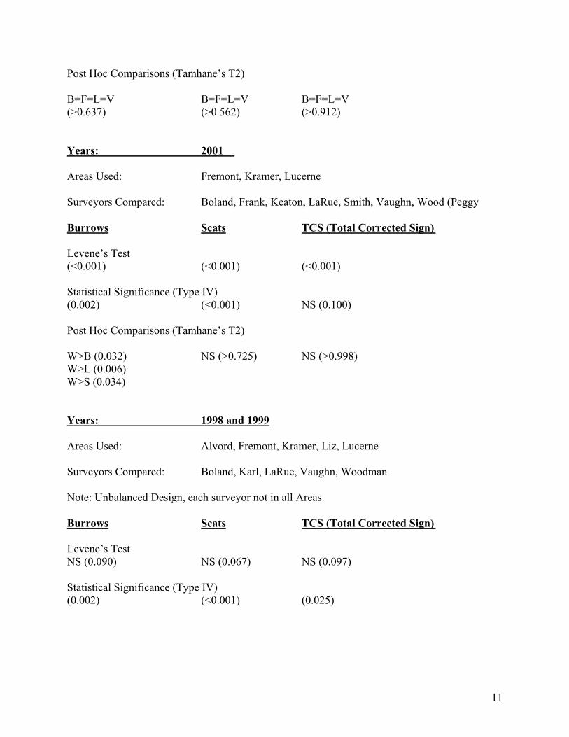
11
Post Hoc Comparisons (Tamhane’s T2) B=F=L=V B=F=L=V B=F=L=V (>0.637) (>0.562) (>0.912) Years: 2001 Areas Used: Fremont, Kramer, Lucerne Surveyors Compared: Boland, Frank, Keaton, LaRue, Smith, Vaughn, Wood (Peggy Burrows Scats TCS (Total Corrected Sign) Levene’s Test (<0.001) (<0.001) (<0.001) Statistical Significance (Type IV) (0.002) (<0.001) NS (0.100) Post Hoc Comparisons (Tamhane’s T2) W>B (0.032) NS (>0.725) NS (>0.998) W>L (0.006) W>S (0.034) Years: 1998 and 1999 Areas Used: Alvord, Fremont, Kramer, Liz, Lucerne Surveyors Compared: Boland, Karl, LaRue, Vaughn, Woodman Note: Unbalanced Design, each surveyor not in all Areas Burrows Scats TCS (Total Corrected Sign) Levene’s Test NS (0.090) NS (0.067) NS (0.097) Statistical Significance (Type IV) (0.002) (<0.001) (0.025)
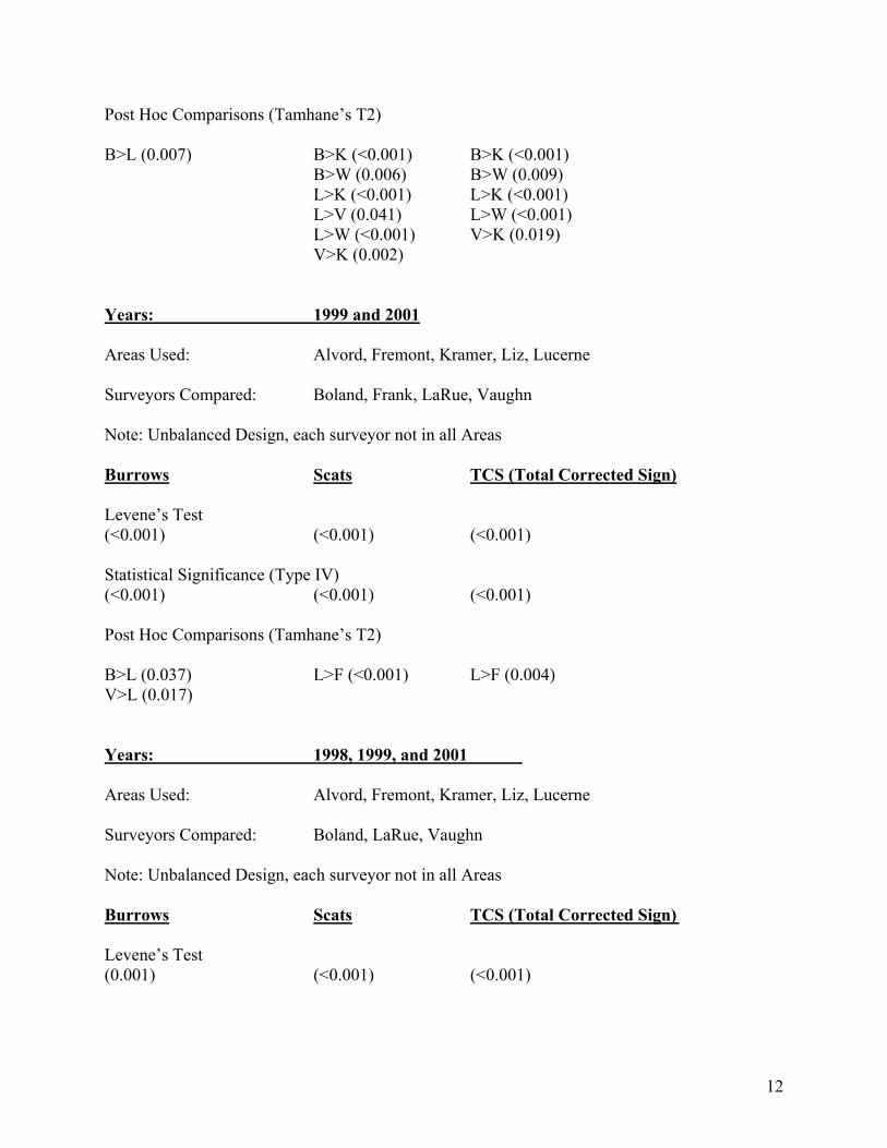
12
Post Hoc Comparisons (Tamhane’s T2) B>L (0.007) B>K (<0.001) B>K (<0.001) B>W (0.006) B>W (0.009) L>K (<0.001) L>K (<0.001) L>V (0.041) L>W (<0.001) L>W (<0.001) V>K (0.019) V>K (0.002) Years: 1999 and 2001 Areas Used: Alvord, Fremont, Kramer, Liz, Lucerne Surveyors Compared: Boland, Frank, LaRue, Vaughn Note: Unbalanced Design, each surveyor not in all Areas Burrows Scats TCS (Total Corrected Sign) Levene’s Test (<0.001) (<0.001) (<0.001) Statistical Significance (Type IV) (<0.001) (<0.001) (<0.001) Post Hoc Comparisons (Tamhane’s T2) B>L (0.037) L>F (<0.001) L>F (0.004) V>L (0.017) Years: 1998, 1999, and 2001 Areas Used: Alvord, Fremont, Kramer, Liz, Lucerne Surveyors Compared: Boland, LaRue, Vaughn Note: Unbalanced Design, each surveyor not in all Areas Burrows Scats TCS (Total Corrected Sign) Levene’s Test (0.001) (<0.001) (<0.001)
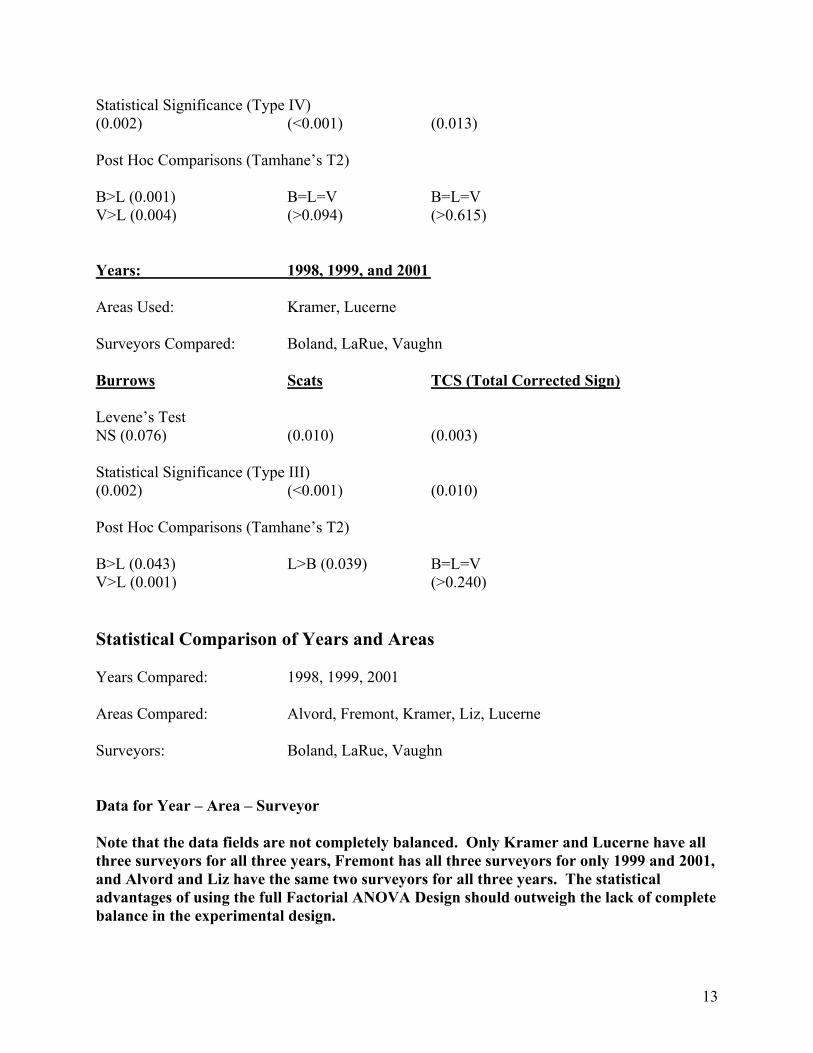
13
Statistical Significance (Type IV) (0.002) (<0.001) (0.013) Post Hoc Comparisons (Tamhane’s T2) B>L (0.001) B=L=V B=L=V V>L (0.004) (>0.094) (>0.615) Years: 1998, 1999, and 2001 Areas Used: Kramer, Lucerne Surveyors Compared: Boland, LaRue, Vaughn Burrows Scats TCS (Total Corrected Sign) Levene’s Test NS (0.076) (0.010) (0.003) Statistical Significance (Type III) (0.002) (<0.001) (0.010) Post Hoc Comparisons (Tamhane’s T2) B>L (0.043) L>B (0.039) B=L=V V>L (0.001) (>0.240) Statistical Comparison of Years and Areas Years Compared: 1998, 1999, 2001 Areas Compared: Alvord, Fremont, Kramer, Liz, Lucerne Surveyors: Boland, LaRue, Vaughn Data for Year – Area – Surveyor Note that the data fields are not completely balanced. Only Kramer and Lucerne have all three surveyors for all three years, Fremont has all three surveyors for only 1999 and 2001, and Alvord and Liz have the same two surveyors for all three years. The statistical advantages of using the full Factorial ANOVA Design should outweigh the lack of complete balance in the experimental design.
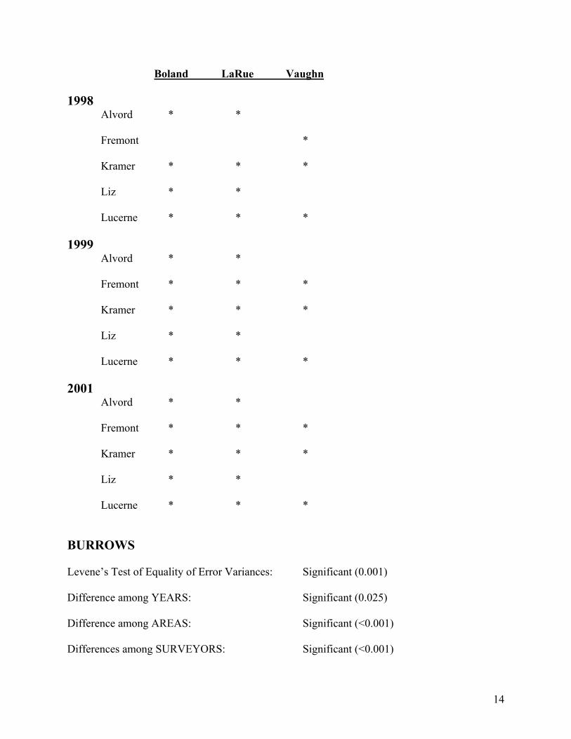
14
Boland LaRue Vaughn 1998 Alvord * *
Fremont *
Kramer * * * Liz * *
Lucerne * * *
1999 Alvord * * Fremont * * * Kramer * * * Liz * * Lucerne * * * 2001 Alvord * * Fremont * * * Kramer * * * Liz * * Lucerne * * * BURROWS Levene’s Test of Equality of Error Variances: Significant (0.001) Difference among YEARS: Significant (0.025) Difference among AREAS: Significant (<0.001) Differences among SURVEYORS: Significant (<0.001)
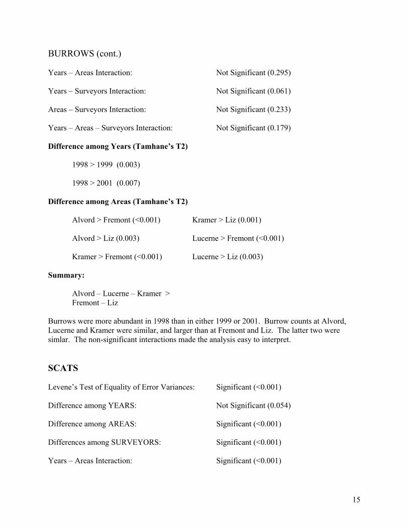
15
BURROWS (cont.) Years – Areas Interaction: Not Significant (0.295) Years – Surveyors Interaction: Not Significant (0.061) Areas – Surveyors Interaction: Not Significant (0.233) Years – Areas – Surveyors Interaction: Not Significant (0.179) Difference among Years (Tamhane’s T2) 1998 > 1999 (0.003) 1998 > 2001 (0.007) Difference among Areas (Tamhane’s T2) Alvord > Fremont (<0.001) Kramer > Liz (0.001) Alvord > Liz (0.003) Lucerne > Fremont (<0.001) Kramer > Fremont (<0.001) Lucerne > Liz (0.003) Summary: Alvord – Lucerne – Kramer > Fremont – Liz Burrows were more abundant in 1998 than in either 1999 or 2001. Burrow counts at Alvord, Lucerne and Kramer were similar, and larger than at Fremont and Liz. The latter two were simlar. The non-significant interactions made the analysis easy to interpret. SCATS Levene’s Test of Equality of Error Variances: Significant (<0.001) Difference among YEARS: Not Significant (0.054) Difference among AREAS: Significant (<0.001) Differences among SURVEYORS: Significant (<0.001) Years – Areas Interaction: Significant (<0.001)
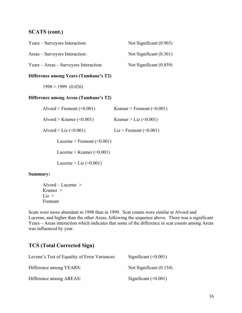
16
SCATS (cont.) Years – Surveyors Interaction: Not Significant (0.965) Areas – Surveyors Interaction: Not Significant (0.361) Years – Areas – Surveyors Interaction: Not Significant (0.859) Difference among Years (Tamhane’s T2) 1998 > 1999 (0.026) Difference among Areas (Tamhane’s T2)
Alvord > Fremont (<0.001) Kramer > Fremont (<0.001) Alvord > Kramer (<0.001) Kramer > Liz (<0.001) Alvord > Liz (<0.001) Liz > Fremont (<0.001) Lucerne > Fremont (<0.001) Lucerne > Kramer (<0.001) Lucerne > Liz (<0.001) Summary: Alvord – Lucerne > Kramer > Liz > Fremont Scats were more abundant in 1998 than in 1999. Scat counts were similar at Alvord and Lucerne, and higher than the other Areas, following the sequence above. There was a significant Years – Areas interaction which indicates that some of the difference in scat counts among Areas was influenced by year. TCS (Total Corrected Sign) Levene’s Test of Equality of Error Variances: Significant (<0.001) Difference among YEARS: Not Significant (0.154) Difference among AREAS: Significant (<0.001)
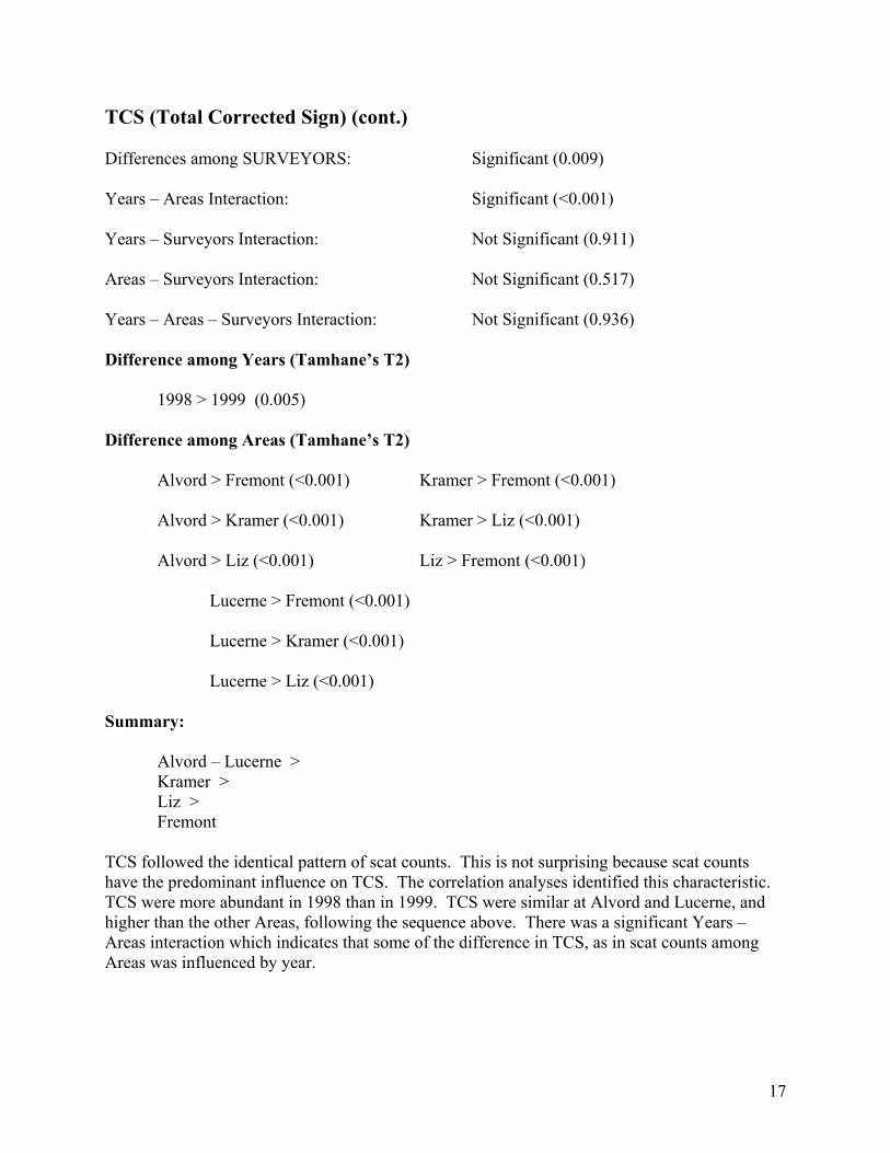
17
TCS (Total Corrected Sign) (cont.) Differences among SURVEYORS: Significant (0.009) Years – Areas Interaction: Significant (<0.001) Years – Surveyors Interaction: Not Significant (0.911) Areas – Surveyors Interaction: Not Significant (0.517) Years – Areas – Surveyors Interaction: Not Significant (0.936) Difference among Years (Tamhane’s T2) 1998 > 1999 (0.005) Difference among Areas (Tamhane’s T2)
Alvord > Fremont (<0.001) Kramer > Fremont (<0.001) Alvord > Kramer (<0.001) Kramer > Liz (<0.001) Alvord > Liz (<0.001) Liz > Fremont (<0.001) Lucerne > Fremont (<0.001) Lucerne > Kramer (<0.001) Lucerne > Liz (<0.001) Summary: Alvord – Lucerne > Kramer > Liz > Fremont TCS followed the identical pattern of scat counts. This is not surprising because scat counts have the predominant influence on TCS. The correlation analyses identified this characteristic. TCS were more abundant in 1998 than in 1999. TCS were similar at Alvord and Lucerne, and higher than the other Areas, following the sequence above. There was a significant Years – Areas interaction which indicates that some of the difference in TCS, as in scat counts among Areas was influenced by year.
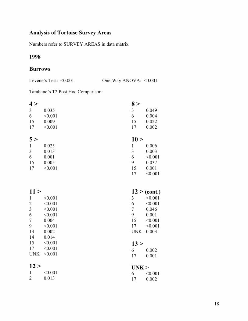
18
Analysis of Tortoise Survey Areas Numbers refer to SURVEY AREAS in data matrix 1998 Burrows Levene’s Test: <0.001 One-Way ANOVA: <0.001 Tamhane’s T2 Post Hoc Comparison: 4 > 3 0.035 6 <0.001 15 0.009 17 <0.001 5 > 1 0.025 3 0.013 6 0.001 15 0.005 17 <0.001
8 > 3 0.049 6 0.004 15 0.022 17 0.002 10 > 1 0.006 3 0.003 6 <0.001 9 0.037 15 0.001 17 <0.001
11 > 1 <0.001 2 <0.001 3 <0.001 6 <0.001 7 0.004 9 <0.001 13 0.002 14 0.014 15 <0.001 17 <0.001 UNK <0.001 12 > 1 <0.001 2 0.013
12 > (cont.) 3 <0.001 6 <0.001 7 0.046 9 0.001 15 <0.001 17 <0.001 UNK 0.003 13 > 6 0.002 17 0.001
UNK > 6 <0.001 17 0.002

Scats Levene’s Test: <0.001 One-Way ANOVA: <0.001 Tamhane’s T2 Post Hoc Comparison: 1 > 6 <0.001 7 0.004 9 0.009 17 0.009 19 0.020 4 > 1 0.008 2 <0.001 3 <0.001 4 <0.001 5 <0.001 6 <0.001 7 <0.001 8 <0.001 9 <0.001 12 0.005 15 <0.001 17 <0.001 19 <0.001 UNK <0.001
10 > 2 0.003 5 0.021 6 <0.001 7 <0.001 8 0.025 9 <0.001 15 <0.001 17 <0.001 19 <0.001 UNK <0.001 11 > 1 <0.001 2 <0.001 3 <0.001 5 <0.001 6 <0.001 7 <0.001 8 <0.001 9 <0.001 10 0.002 12 <0.001 14 0.001 15 <0.001 17 <0.001 19 <0.001 UNK <0.001
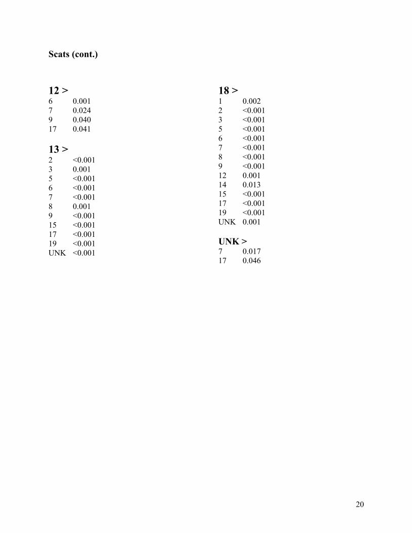
20
Scats (cont.) 12 > 6 0.001 7 0.024 9 0.040 17 0.041 13 > 2 <0.001 3 0.001 5 <0.001 6 <0.001 7 <0.001 8 0.001 9 <0.001 15 <0.001 17 <0.001 19 <0.001 UNK <0.001
18 > 1 0.002 2 <0.001 3 <0.001 5 <0.001 6 <0.001 7 <0.001 8 <0.001 9 <0.001 12 0.001 14 0.013 15 <0.001 17 <0.001 19 <0.001 UNK 0.001 UNK > 7 0.017 17 0.046

21
TCS Levene’s Test: <0.001 One-Way ANOVA: <0.001 Tamhane’s T2 Post Hoc Comparison: 1 > 6 <0.001 17 0.003 4 > 1 0.001 2 <0.001 3 <0.001 5 0.006 6 <0.001 7 <0.001 8 0.003 9 <0.001 15 <0.001 17 <0.001 19 <0.001 UNK <0.001 5 > 6 0.007 8 > 6 <0.001 7 0.036 9 0.010 15 0.017 17 <0.001
10 > 2 0.001 3 0.002 6 <0.001 7 <0.001 9 <0.001 15 <0.001 17 <0.001 19 <0.001 11 > 1 <0.001 2 <0.001 3 <0.001 5 <0.001 6 <0.001 7 <0.001 8 <0.001 9 <0.001 10 0.001 12 <0.001 13 0.002 14 <0.001 15 <0.001 17 <0.001 19 <0.001 UNK <0.001
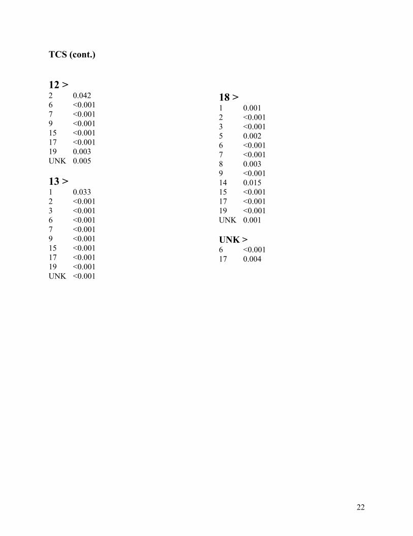
22
TCS (cont.) 12 > 2 0.042 6 <0.001 7 <0.001 9 <0.001 15 <0.001 17 <0.001 19 0.003 UNK 0.005 13 > 1 0.033 2 <0.001 3 <0.001 6 <0.001 7 <0.001 9 <0.001 15 <0.001 17 <0.001 19 <0.001 UNK <0.001
18 > 1 0.001 2 <0.001 3 <0.001 5 0.002 6 <0.001 7 <0.001 8 0.003 9 <0.001 14 0.015 15 <0.001 17 <0.001 19 <0.001 UNK 0.001 UNK > 6 <0.001 17 0.004

23
Tortoises Levene’s Test: <0.001 One-Way ANOVA: 0.033 Tamhane’s T2 Post Hoc Comparison: UNK > 7 <0.001 8 <0.001 Carcasses Levene’s Test: <0.001 One-Way ANOVA: <0.001 Tamhane’s T2 Post Hoc Comparison: 6 > 17 0.001 8 > 17 0.028 11 > 17 0.010 19 > 1 0.042 3 0.031 17 0.005 UNK > 17 <0.001

24
1999 Burrows Levene’s Test: <0.001 One-Way ANOVA: <0.001 Tamhane’s T2 Post Hoc Comparison: 1 > 5 0.009 9 0.002 10 <0.001
7 > 9 0.011 10 0.008
Scats Levene’s Test: <0.001 One-Way ANOVA: <0.001 Tamhane’s T2 Post Hoc Comparison: 1 > 4 <0.001 5 <0.001 7 <0.001 9 <0.001 10 <0.001 12 <0.001 5 > 4 0.001 7 0.002 9 <0.001 6 >
8 > 4 <0.001 5 0.024 7 <0.001 9 <0.001 10 > 4 0.012 9 <0.001 12 > 9 0.003
4 0.013 7 0.023 9 0.010
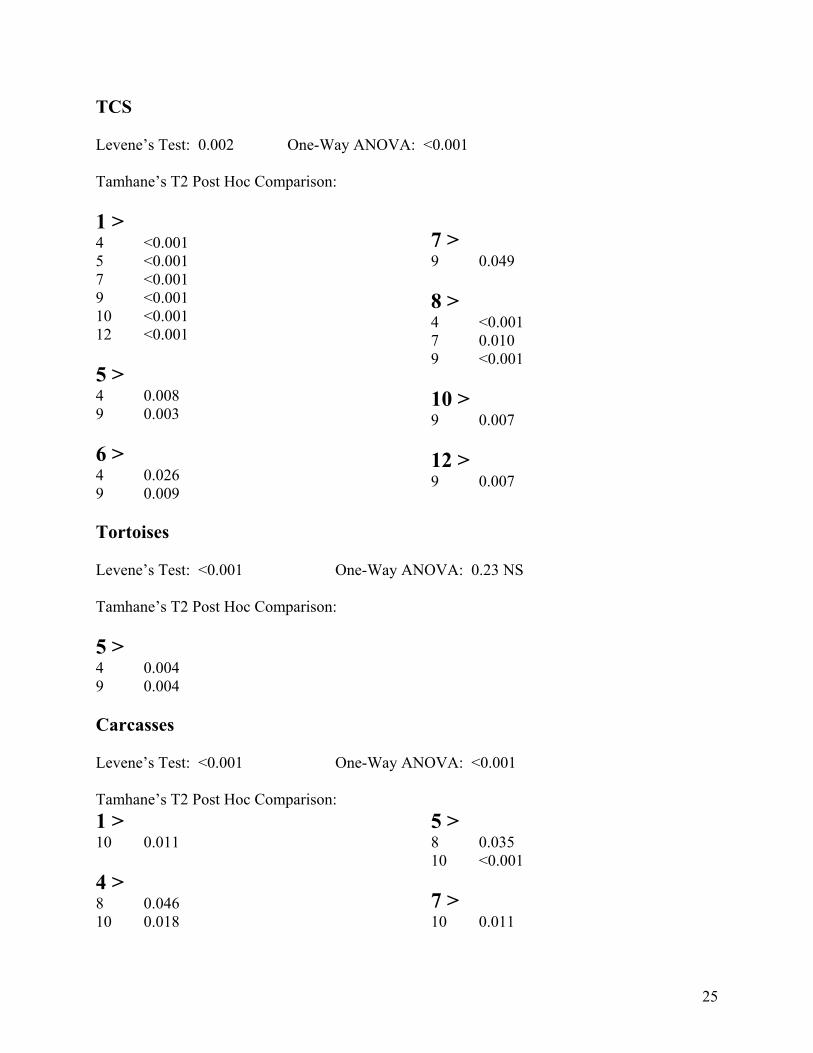
25
TCS Levene’s Test: 0.002 One-Way ANOVA: <0.001 Tamhane’s T2 Post Hoc Comparison: 1 > 4 <0.001 5 <0.001 7 <0.001 9 <0.001 10 <0.001 12 <0.001 5 > 4 0.008 9 0.003 6 > 4 0.026 9 0.009
7 > 9 0.049 8 > 4 <0.001 7 0.010 9 <0.001 10 > 9 0.007 12 > 9 0.007
Tortoises Levene’s Test: <0.001 One-Way ANOVA: 0.23 NS Tamhane’s T2 Post Hoc Comparison: 5 > 4 0.004 9 0.004 Carcasses Levene’s Test: <0.001 One-Way ANOVA: <0.001 Tamhane’s T2 Post Hoc Comparison: 1 > 10 0.011 4 > 8 0.046 10 0.018
5 > 8 0.035 10 <0.001 7 > 10 0.011
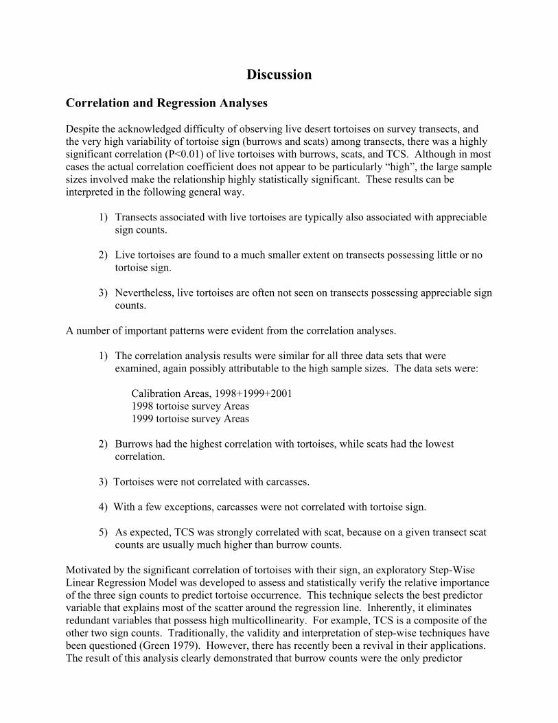
Discussion Correlation and Regression Analyses Despite the acknowledged difficulty of observing live desert tortoises on survey transects, and the very high variability of tortoise sign (burrows and scats) among transects, there was a highly significant correlation (P<0.01) of live tortoises with burrows, scats, and TCS. Although in most cases the actual correlation coefficient does not appear to be particularly “high”, the large sample sizes involved make the relationship highly statistically significant. These results can be interpreted in the following general way.
1) Transects associated with live tortoises are typically also associated with appreciable sign counts.
2) Live tortoises are found to a much smaller extent on transects possessing little or no
tortoise sign. 3) Nevertheless, live tortoises are often not seen on transects possessing appreciable sign
counts. A number of important patterns were evident from the correlation analyses.
1) The correlation analysis results were similar for all three data sets that were examined, again possibly attributable to the high sample sizes. The data sets were:
Calibration Areas, 1998+1999+2001 1998 tortoise survey Areas 1999 tortoise survey Areas
2) Burrows had the highest correlation with tortoises, while scats had the lowest
correlation. 3) Tortoises were not correlated with carcasses. 4) With a few exceptions, carcasses were not correlated with tortoise sign.
5) As expected, TCS was strongly correlated with scat, because on a given transect scat counts are usually much higher than burrow counts.
Motivated by the significant correlation of tortoises with their sign, an exploratory Step-Wise Linear Regression Model was developed to assess and statistically verify the relative importance of the three sign counts to predict tortoise occurrence. This technique selects the best predictor variable that explains most of the scatter around the regression line. Inherently, it eliminates redundant variables that possess high multicollinearity. For example, TCS is a composite of the other two sign counts. Traditionally, the validity and interpretation of step-wise techniques have been questioned (Green 1979). However, there has recently been a revival in their applications. The result of this analysis clearly demonstrated that burrow counts were the only predictor
27
variable necessary to explain the variability of tortoises on transects. Statistically, scats and TCS did not contribute significant information to the regression. Comparison of Surveyors on Calibration Plots 1998 Surveyors possessed statistically similar sign counts for burrows, scats, and TCS when comparisons were made among balanced data sets. The following contrasts were similar: Bolan – LaRue Karl – Vaughn Bolan – LaRue – Vaughn When all surveyors were compared together there was no difference among burrow counts, but Bolan, LaRue, and Vaughn, possessed higher scat counts than Hoover, Karl, and Silverman. However, in this analysis an unbalanced data set was used (not all surveyors were at all Areas), so this result should be interpreted with caution. 1999 In the 1999 calibration surveys there was a tendency for LaRue to have lower burrow counts on transects, but higher scat counts than some of the other surveyors. Scat are more difficult to locate than burrows, not only because they are smaller, but importantly, their detection is related to habitat parameters. Therefore, a persistent and focused search image is mandatory. Habitat characteristics that appreciably affect scat detection include: color and texture of substrate (e.g., light-colored sands versus black volcanic basalt rocks), ground and shrub cover, topography, and sun angle (Krzysik and Woodman 1991). While burrows are much easier to detect, there are nevertheless problems associated with their counts. Non-tortoise burrows (e.g., kit fox, coyote, badger) or even predator diggings could be mistaken for tortoise burrows. Additionally, it is important to classify burrow condition, and decide before actual surveys if burrows in poor condition or collapsed should be counted. In the case of burrows, these factors may influence survey counts more than actual detections. Surveyors were more consistent with TCS counts, because they tended to “average” the variability among individual burrow and scat counts. For example, LaRue’s lower burrow counts were “balanced” by his higher scat counts. 2001 Seven surveyors demonstrated agreement and were consistent in all sign counts: burrows, scats, and TCS, with the single exception of Wood (Peggy) having higher burrow counts. 1998 – 1999 Five surveyors possessed similar burrow counts, but LaRue was less than Bolan. Similar to 1999, LaRue tended to have higher scat counts. On the other hand, Karl and Woodman had

28
lower scat counts than some of the other surveyors. However, the data set was unbalanced, and the results should be interpreted with caution. 1999 – 2001 The four surveyors have only some differences in sign count. LaRue had lower burrow counts than Bolan and Vaughn, but higher scat counts than Frank. This data set is not balanced. 1998 – 1999 – 2001 This analysis combined all three years, and there were three surveyors: Bolan, LaRue, and Vaughn. Scat counts were very similar, but LaRue’s counts were higher than Bolan (barely significant, P=0.04). LaRue had lower burrow counts than the other two surveyors. TCS counts were statistically similar for all three surveyors. Comparison of Years and Areas on Calibration Plots Burrows were more abundant in 1998 than in either 1999 or 2001. Burrow counts at Alvord, Lucerne and Kramer were similar, and larger than at Fremont and Liz. The latter two were simlar. The non-significant interactions made the analysis easy to interpret. Scats were more abundant in 1998 than in 1999. Scat counts were similar at Alvord and Lucerne, and higher than the other Areas according to the following sequence: Alvord = Lucerne >Kramer > Liz > Fremont. There was a significant Years – Areas interaction, indicating that some of the difference in scat counts among Areas was influenced by year. TCS followed the identical pattern as scat counts. TCS is predominantly determined by scat counts as determined by the correlation analyses. Comparison of Tortoise Survey Areas Statistical analyses were conducted separately for 1998 and 1999 to avoid confounding effects among years, and it was not know if the numbers that identified specific “Survey Areas” were used consistently between 1998 and 1999. 1998 There were 19 Areas surveyed in 1998. It was not known if the Area designated as “unknown” consisted of one or more Areas. In the analysis it was treated as a single Area. Areas 11 and 12 had the highest burrow counts, followed by Areas 10 then 5, then 4 and 8 which were similar. Areas 6, 15 and 17, especially 6 and 17 had the lowest burrow counts. The pattern of the scat counts were somewhat different than the burrow counts, and Areas were more separated statistically. At this point in the analysis it is not known if this is a sensitive measure for Area separation or if the scat merely represent extraneous “noise” in the system. Areas 11, 4, 18, 13 and 10 had the highest scat counts. Areas 11and 10 therefore, closely parallel
29
the results of the burrow counts. However, unlike burrow counts, Area 12 had a much lower scat count ranking, and was only higher than 4 other sites. Areas 6 and 17, had low scat counts, paralleling their lower burrow counts. Area 1 had a higher ranking with scat counts than burrow counts. Area 11 with its high counts of both burrows and scats dominated all other sites in TCS. Areas 18 and 4 with high scat counts were the next highest in TCS. The next highest TCS Areas were 13, 10, and 12. Area 13 had high scat counts, Area 12 had high burrow counts, while Area10 had both. Areas 6 and 17, on the basis of low burrow and scat counts had the lowest TCS. The statistical significance of live tortoise and carcasses among Areas is very difficult to assess because of very small sample sizes. Interestingly, the only significant comparison with tortoises was that the “unknown” Area was higher than Areas 7 and 8. Possibly no tortoises were seen in these Areas. All three of these Areas were neither among the highest nor the lowest in sign count. Small sample sizes make interpretation tenuous. Area 17 demonstrated an unusually low carcass count. This Area was also among the lowest in both burrow and scat counts. This data suggests that the low carcass counts are paralleling a low density of tortoises. 1999 There were 9 Areas surveyed in 1999. The “unknown” category included many data cases, and therefore, may have consisted of several individual survey Areas. Additionally, a number of cases lacked an Area designation. All these cases were not included in the analysis. Areas 1 and 7 had more burrow counts than Areas 9 and 10. Area 1 also had more burrow counts than Area 5. Scat counts and TCS paralleled each other closely and statistically separated the nine Areas to a much greater extent than burrow counts. As in the case of the 1998 data, at this point in the analysis it is not known if this is a sensitive measure for Area separation or if the scat merely represent extraneous “noise” in the system. Area 1 also had the highest scat/TCS counts, but scat counts were not particularly high at Area 7. Area 9 demonstrated particularly lower scat/TCS counts that all the other Areas. Tortoises were higher at Area 5 than at Areas 4 and 9. Area 5 was not particularly high in sign count, but did have significantly higher scat/TCS than 4 and 9, but not burrow counts. Small sample sizes make interpretation tenuous. Area 10 and to a smaller degree Area 8 showed lower carcass counts. Although Area 10 also possessed low burrow counts, Areas 10 and 8 it did not have particularly reduced scat/TCS. Small sample sizes make interpretation tenuous. Desert Tortoises and Their Sign Desert tortoises should be closely associated with their sign – burrows and scats. Desert tortoises possess relatively small home ranges even in highly productive years (averaging < 8 ha), and this

30
home range dramatically decreases even further in a drought year (averaging < 3 ha) (Duda et al. 1999). Within their home range they build burrows, using 2-11/tortoise in a productive and 1-6 in a drought year (Duda et al. 1999) and deposit scats at a rate that is at least an order of magnitude greater than their burrow numbers (Krzysik, in review). Based on their dedication to small home ranges, and because tortoises spend a major portion of their lives in burrows, particularly in drought years and bad weather (Duda and Krzysik 1998), it is intuitive that tortoise sign represents a surrogate for actual live tortoises. Traditional desert tortoise surveys have summed burrow counts and “independent” scat counts to produce TCS, total corrected sign.
Conclusions The data presented here and other evidence suggests that tortoise burrows appear to be a better surrogate for comparisons of tortoise distribution and relative abundance patterns than either scats or TCS. TCS was strongly correlated with scat counts, and essentially did not provide additional statistical information. However, TCS was useful when comparing and contrasting surveyors, because at least in some cases it tended to “average” individual surveyor’s variability in burrow and scat counts. The data presented here demonstrate that surveyors are more similar to each other in burrow counts than they are in scat counts. The data also show that scat counts are much more variable than burrow counts, both within and between specific statistical comparisons. Importantly, burrow counts along the standard triangular tortoise survey transects (10 yards wide) accurately represent actual burrow density estimates, because the effective survey width using Distance Sampling surveys is equal to 4.5 m on a side (Krzysik, in review). Effective survey width for scats is approximately 1 m on a side. Therefore, burrow counts on 10 yard wide transects directly represent burrow density, while scat counts are relative numbers at best, and cannot be used as density estimates. Effective survey width is equal to half the width of survey transects when all survey objects are detected (Buckland et al. 1993). As a general statement, experienced surveyors are reasonably similar in their tortoise sign counts along transects. Individual exceptions can be found for specific years, Areas, inexperienced surveyors, and other circumstances, but the overall variability of sign counts both within and between comparisons may override innate differences among individuals for object detection. Training sessions are recommended to standardize the correct identification of tortoise burrows and the classification of their “condition”. The counting of tortoise burrows that are collapsed or in poor condition should be standardized among all surveyors before actualsurveys are conducted. The next phase of this project should include the following tasks by our team.
Ed LaRue and I need to get together to spatially identify the specific survey Areas coded in all the data sets. We need to associate UTM coordinates with individual survey transects. Much of this is already accomplished, but requires checking for consistency and accuracy. Survey Areas require further delineation in the 1999 and 2001 data sets. All other potential analyses of the current data will be discussed with Ed LaRue.
31
All data sets should be rechecked for field data accuracy. Should all the data or only random spot-checking be done?
Distance Sampling data will be analyzed (not yet available) (AJK). 2002 data will be analyzed (not yet available) (AJK).
References Buckland, S.T., D.R. Anderson, K.P. Burnham, and J.L. Laake. 1993. Distance Sampling: Estimating Abundances of Biological Populations. Chapman and Hall, New York, NY. 446pp. Day, R.W., and G.P. Quinn. 1989. Comparisons of treatments after an analysis of variance in ecology. Ecological Monographs 59:433-463. Duda, J.J., and A.J. Krzysik. 1998. Radiotelemetry study of a desert tortoise population: Sand Hill Training Area, Marine Corps Air Ground Combat Center, Twentynine Palms, California. U.S. Army Corps of Engineers, USACERL Technical Report 98/39. 75pp. Duda, J.J., A.J. Krzysik, and J.E. Freilich. 1999. Effects of drought on desert tortoise movement and activity. Journal of Wildlife Management 63:1181-1192. Fry, J.C. 1993. One-way analysis of variance. Pages 3-39 in Biological Data Analysis: A Practical Approach, J.C. Fry, ed. Oxford University Press, New York, NY. 418pp. Green, R.H. 1979. Sampling Design and Statistical Methods for Environmental Biologists. John Wiley & Sons, New York, NY. 257pp. Harris, R.J. 1975. A Primer of Multivariate Statistics. Academic Press, New York, NY. 332pp. Johnson, D.H. 1995. Statistical sirens: The allure of nonparametrics. Ecology 76:1998-2000. Krzysik, A.J. 1998. Ecological design and analysis: Principles and issues in environmental monitoring. Pages 385-403 in Status and Conservation of Midwestern Amphibians, M.J. Lannoo, ed. University of Iowa Press, Iowa City, IA. 507pp. Krzysik, A.J. A landscape sampling protocol for estimating distribution and density patterns of desert tortoises at multiple spatial scales. Invited Paper. In Review, ΑChelonian Conservation and Biology≅. Krzysik, A.J., and A.P. Woodman. 1991. Six years of Army training activities and the desert tortoise. The Desert Tortoise Council Symposia 1987-1991:337-368. Levene, H. 1960. Robust tests for equality of variance. Pages 278-292 in Contributions to Probability and Statistics, I. Olkin, ed. Stanford University Press, Palo Alto, CA.
32
Milliken, G.A., and D.E. Johnson. 1984. Analysis of Messy Data. Volume I: Designed Experiments. Wadsworth, Belmont, CA. 473pp. Morgan, G.A., and O.V. Griego. 1998. Easy Use and Interpretation of SPSS for Windows: Answering Research Questions with Statistics. Lawrence Erlbaum, Mahwah, NJ. 276pp. Potvin, C., and D.A. Roff. 1993. Distribution-free and robust statistical methods: Viable alternatives to parametric statistics. Ecology 74:1617-1628. Shaw, R.G., and T. Mitchell-Olds. 1993. ANOVA for unbalanced data: An overview. Ecology 74:1638-1645. Smith, S.M. 1995. Distribution-free and robust statistical methods: Viable alternatives to parametric statistics? Ecology 76:1997-1998. Snedecor, G.W., and W.G. Cochran. 1989. Statistical Methods, 8th ed. Iowa State University Press, Ames, IA. 503pp. Sokal, R.R, and F.J. Rohlf. 1995. Biometry, 3rd ed. W.H. Freeman, New York, NY. 887pp. SPSSa. 1999. SPSS analysis software package. Version 9.0.1 SPSS, Inc., Chicago, IL. SPSSb. 1999. SPSS User’s Guide, Version 9.0. SPSS, Inc., Chicago, IL. 740pp. Stewart-Oaten, A. 1995. Rules and judgments in statistics: Three examples. Ecology 76:2001-2009. Underwood, A.J. 1997. Experiments in Ecology. Cambridge University Press, New York, NY. 504pp. Zar, J.H. 1999. Biostatistical Analysis, 4th ed. Prentice Hall, Upper Saddle River, NJ. 663pp. Zolman, J.F. 1993. Biostatistics: Experimental Design and Statistical Inference. Oxford University Press, New York, NY. 343pp.
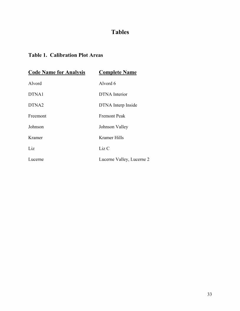
33
Tables Table 1. Calibration Plot Areas Code Name for Analysis Complete Name Alvord Alvord 6 DTNA1 DTNA Interior DTNA2 DTNA Interp Inside Freemont Fremont Peak Johnson Johnson Valley Kramer Kramer Hills Liz Liz C Lucerne Lucerne Valley, Lucerne 2
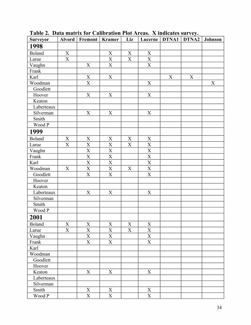
34
Table 2. Data matrix for Calibration Plot Areas. X indicates survey. Surveyor Alvord Fremont Kramer Liz Lucerne DTNA1 DTNA2 Johnson1998 Boland X X X X Larue X X X X Vaughn X X X Frank Karl X X X X Woodman X X X Goodlett Hoover X X X Keaton Laberteaux Silverman X X X Smith Wood P 1999 Boland X X X X X Larue X X X X X Vaughn X X X Frank X X X Karl X X X Woodman X X X X X Goodlett X X X Hoover Keaton Laberteaux X X X Silverman Smith Wood P 2001 Boland X X X X X Larue X X X X X Vaughn X X X Frank X X X Karl Woodman Goodlett Hoover Keaton X X X Laberteaux Silverman Smith X X X Wood P X X X
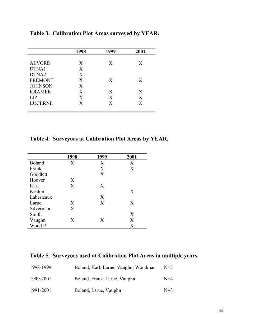
35
Table 3. Calibration Plot Areas surveyed by YEAR. 1998 1999 2001 ALVORD
X
X
X
DTNA1 X DTNA2 X FREMONT X X X JOHNSON X KRAMER X X X LIZ X X X LUCERNE X X X Table 4. Surveyors at Calibration Plot Areas by YEAR. 1998 1999 2001 Boland X X X Frank X X Goodlett X Hoover X Karl X X Keaton X Laberteaux X Larue X X X Silverman X Smith X Vaughn X X X Wood P X Table 5. Surveyors used at Calibration Plot Areas in multiple years. 1998-1999 Boland, Karl, Larue, Vaughn, Woodman N=5 1999-2001 Boland, Frank, Larue, Vaughn N=4 1991-2001 Boland, Larue, Vaughn N=3
Statistical Analysis of BLM Desert Tortoise Surveys In Support of the West Mojave Management Plan
Report II: Statistical Comparison of DWMAs (1999 & 2001)
19 June 2002
by
Anthony J. Krzysik, Ph.D. 11 Highland Terrace Prescott, AZ 86305
2
Introduction This report represents the Analysis of Variance (ANOVA), Correlation Analysis, and Stepwise Linear Regression Analysis of the 1999 and 2001 data sets based on BLM’s “Desert Wildlife Management Areas” (DWMAs). These data and analysis support the West Mojave Management Plan. Ed LaRue of BLM is the primary monitor of this analysis effort and Principal Investigator of the role of desert populations in the development of this plan. Kathy Buescher, Senior Wildlife Biologist at Chambers Group, Inc., is the subcontract manager. The data used for these specific analyses were developed by Ric Williams and Hubert Switalski, AMEC Earth and Environmental, Inc. and sent to me 14 June for statistical analyses. These data sets originally were sent to me by Emily Cohen, and I edited and modified them for statistical analysis. However, the tortoise transect data lacked association with DWMAs, or any other specific landscape areas of management interest, although UTM coordinates were present. I sent these data to Ric and Hubert and they developed the variable “NAME” which represented specific DWMAs. The new data sets associated individual transect data with landscape specific DWMAs (Table 1). The 1998 data set will be similarly associated with DWMAs in July. DWMA Data Years Fremont – Kramer 1999, 2001 Ord – Rodman 1999, 2001 Pinto Mountain 1999 Superior – Cronese 1999, 2001 Table 1. DWMAs and YEARS compared in this report.
Methods Data analyses were conducted with the SPSS statistical package (SPSS 1999a). Four tortoise sign counts were used in the analysis: burrows, scats, TCS, and carcasses. The variable burrow is the actual observed tortoise burrow count on individual surveyed transects and was available from the data matrix. The variable scat is the corrected tortoise scat count on individual surveyed transects, and was calculated from the data matrix as TCS – burrow. Raw scat counts require to be “corrected” because some scats are found in clumps, which are treated as a “single count”. The variable TCS (Total Corrected Sign) is the total burrow + corrected scat count on individual surveyed transects and was available from the data matrix. The variable carcass is the observation of tortoise shells (carapace/plastron) or skeletal remains on the transect. Survey transects were further classified by two variables based on their TCS values (Table 2).
3
Classification A: Designation TCS Low < 7 High > 6 Classification B: Designation TCS 1 0-1 2 2-3 3 4-6 4 7-9 5 > 9 Table 2. Classification of survey transects based on TCS values. Tortoise sign require square root data transformation, because the data represent counts with many data cells being “0”. Counts follow a Poisson distribution where the mean equals the variance, and therefore the mean and variance cannot be independent, but vary identically. All the sign data was transformed as x = (x+0.5)1/2, where x represents a tortoise sign variable (Sokal and Rohlf 1995). Bivariate parametric and nonparametric correlation analyses were performed on the data sets to assess the association of live tortoises with: burrows, scats, TCS, and carcasses on survey transects. The parametric test was the Pearson Product Moment Correlation Coefficient. Two nonparametric rank correlations were used: Spearman’s rho and Kendall’s tau. Guided by the results of the correlation analyses, a Stepwise Linear Regression model was developed to assess the relative importance of burrows, scats, and TCS to “predict” tortoise transect occurrences. Factorial Analysis of Variance (ANOVA) was used to contrast years and DWMAs with respect to burrows, scats, TCS, live tortoises, and carcasses. Three major ANOVAs were performed to compare DWMAs:
1) The complete Factorial Analysis, using Years and DWMAs as factors 2) Analyzing Years separately 3) Analyzing High and Low TCS Classes separately
Low TCS transects possessed 0 to 6 TCS High TCS transects possessed > 6 TCS
The 5 percent significance level (P < 0.05) was used based on experience and general acceptance in ecological research and field biology. Burrows, scats, TCS, tortoises, and carcasses were each used in separate analyses as dependent variables with year and DWMAs as “factors”, the independent variables. The data sets are considered “unbalanced” in the complete ANOVA design, because empty cells are present in the years x DWMAs matrix (e.g., Pinto Mountain was not surveyed in 2001). The complete Factorial ANOVA analyses used Type IV calculation of Sums of Squares, because this algorithm is generally recommended for data possessing empty
4
cells among factor comparisons (Milliken and Johnson 1984, Shaw and Mitchell-Olds 1993). The ANOVAs analyzing years and TCS classes separately used Type III calculation of Sums of Squares, because this algorithm is generally recommended, it is invariant with respect to cell frequencies, and when there are no missing cells it is equivalent to Yates’ weighted-squares-of-means method (Milliken and Johnson 1984, Shaw and Mitchell-Olds 1993). Levene’s Test for equality of error variances was used for all analyses, and does not depend on the assumption of normality (Levene 1960). Bartlett’s test is often used to assess homogeneity, but its practical value has been questioned (Harris 1975), and this test is not very efficient and strongly affected by non-normality (Zar 1999). Levene’s Test uses the average of absolute deviations instead of the mean square of deviations, making it less sensitive to skewed distributions (Snedecor and Cochran 1989). Levene’s Test checks to see if error variances are homogeneous among the factors being compared in an ANOVA. Homogeneous variances are a parametric assumption in ANOVA. ANOVA is a parametric statistical procedure that technically requires parametric assumptions to be met: homogeneous error variances, normally distributed data, adequate sample sizes, and independence of sampling or experimental errors (random sampling, independence of observations). Nevertheless and importantly, ANOVA is considered robust to departures from the first two of these assumptions, particularly when proper transformations are employed (Sokal and Rohlf 1995, Underwood 1997, Zar 1999). Additionally, SPSS algorithms are very robust to nonnormality (Morgan and Griego 1998). Many researchers believe that the routine use of nonparametric statistics avoids many issues of parametric assumptions, but these methods are equally affected by the last two critical assumptions – independence of sampling errors and the loss of statistical power with inadequate sample sizes (Krzysik 1998). The routine use of nonparametric analysis in ecological research is not recommended (Johnson 1995, Smith 1995, Stewart-Oaton 1995), but see Potvin and Roff (1993). The use of factorial ANOVA designs requires the use of Post Hoc multiple comparison tests to assess statistical significance when there are more than two levels for any factor. Five Post Hoc multiple comparison tests were used in all factorial ANOVA analyses. The Bonferroni test, based on the Student’s t statistic, adjusts the significance level for multiple comparisons. This test has the widest range of applications, is conservative, and when there are few comparisons has high power (Zolman 1993, SPSS 1999b). Conservative tests were desirable in these analyses, because they minimize Type I error, the probability of rejecting a true null hypothesis (null hypothesis = no significance difference) (Krzysik 1998). In other words, reporting significance when the comparison was not statistically significant. When factor variances are heterogeneous (i.e., Levene’s Test is significant), pooled estimates of variance cannot be used to calculate the standard error of the comparison (Day and Quinn 1989). The use of Post Hoc tests that specifically address this issue are recommended (Day and Quinn 1989, SPSS 1999b). Therefore, four additional Post Hoc tests were used for all factorial ANOVA comparisons that were made: Tamhane’s T2 – conservative pairwise comparison test based on a t test Dunnett’s T3 – pairwise comparison test based on the Studentized maximum modulus,
highly recommended (Fry 1993) Games-Howell – liberal pairwise comparisons test, highly recommended (Fry 1993)
5
Dunnett’s C – pairwise comparisons test based on the Studentized range Although all five tests were examined for significance at the 0.05 level, only the results of the conservative Tamhane’s T2 test were reported. The results of all five Post Hoc tests were essentially similar for all the factorial ANOVA analyses conducted in this study. This indicates that the data were reasonably behaved. As expected, the Games-Howell test was more liberal, while the Bonferroni test was frequently very liberal in contrast to the other four tests, particularly when Levene’s Test showed significant departure from homogeneous residuals.
Results Bivariate Correlation Analysis In all analyses, very similar results were obtained with Pearson’s Product Moment Correlation Coefficient (Parametric) and the two Nonparametric rank correlations: Spearman’s rho and Kendall’s tau. The values reported in Table 3 are Pearson’s Correlation Coefficient with the two-tailed analysis. This analysis is more conservative than the one-tailed analysis, and therefore, minimizes Type I error. All DWMAs were used in the analysis. Tortoise vs
Burrows Scats TCS Carcasses N
All
0.37** 0.20** 0.29** 0.045 1351
1999 0.35** 0.16** 0.26** 0.030 962 2001 0.44** 0.29** 0.38** 0.088 389 Low TCS 0.27** 0.95** 0.22** 0.024 1197 High TCS 0.38** -0.11 0.062 0.058 154 0-1 TCS 0.13** 0.020 0.12** -0.029 750 2-3 TCS 0.24** -0.20** 0.12* -0.036 277 4-6 TCS 0.16* -0.11 0.020 0.076 170 7-9 TCS 0.34** -0.31** -0.14 0.16 88 >9 TCS 0.45** -0.063 0.16 -0.085 66 Table 3. Pearson’s Product Moment Correlation Coefficient of LIVE TORTOISES with four tortoise sign parameters: burrows, scats, TCS, and carcasses. N is the sample size.
* indicates statistical significance (P < 0.05) ** indicates high statistical significance (P < 0.01)
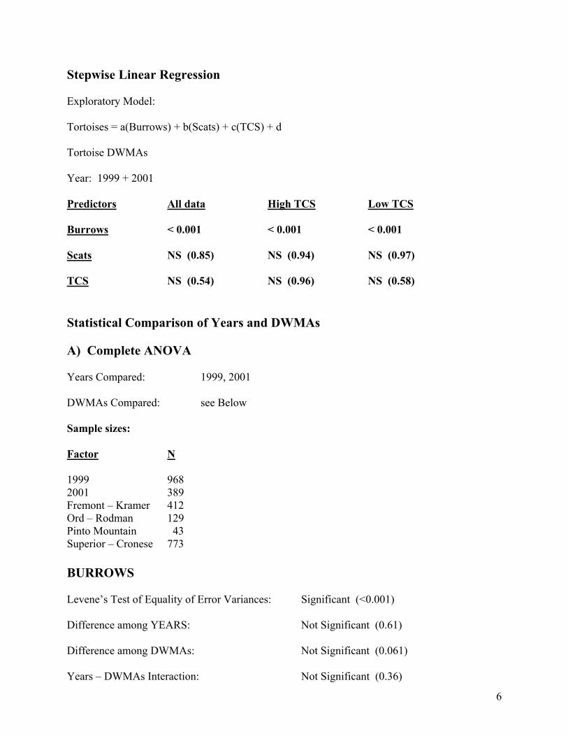
6
Stepwise Linear Regression Exploratory Model: Tortoises = a(Burrows) + b(Scats) + c(TCS) + d Tortoise DWMAs Year: 1999 + 2001 Predictors All data High TCS Low TCS Burrows < 0.001 < 0.001 < 0.001 Scats NS (0.85) NS (0.94) NS (0.97) TCS NS (0.54) NS (0.96) NS (0.58) Statistical Comparison of Years and DWMAs A) Complete ANOVA Years Compared: 1999, 2001 DWMAs Compared: see Below Sample sizes: Factor N 1999 968 2001 389 Fremont – Kramer 412 Ord – Rodman 129 Pinto Mountain 43 Superior – Cronese 773 BURROWS Levene’s Test of Equality of Error Variances: Significant (<0.001) Difference among YEARS: Not Significant (0.61) Difference among DWMAs: Not Significant (0.061) Years – DWMAs Interaction: Not Significant (0.36)
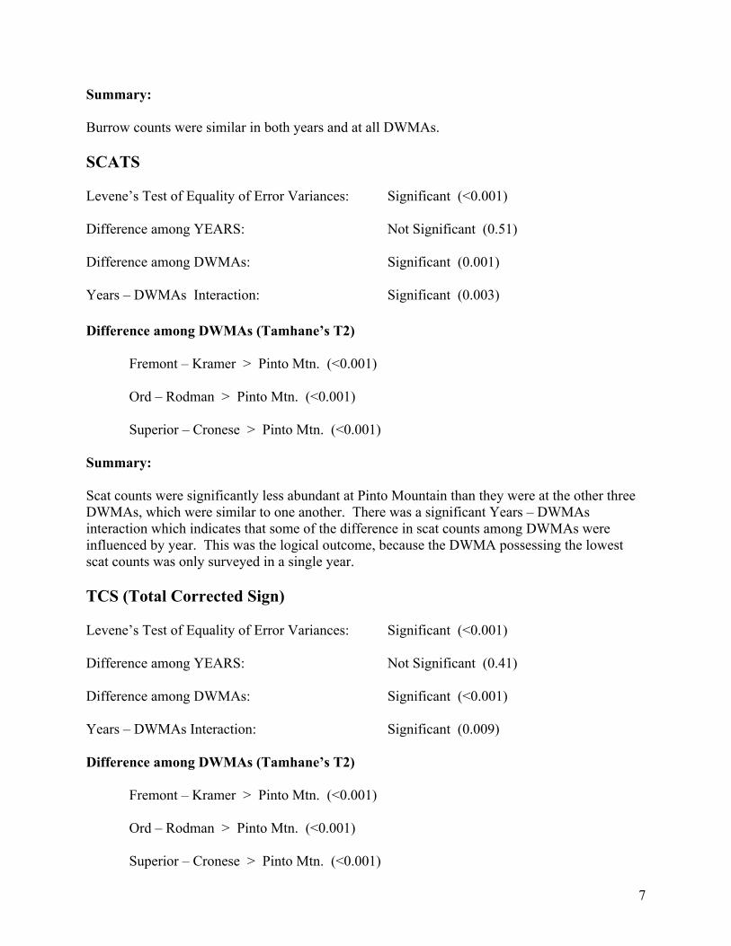
7
Summary: Burrow counts were similar in both years and at all DWMAs. SCATS Levene’s Test of Equality of Error Variances: Significant (<0.001) Difference among YEARS: Not Significant (0.51) Difference among DWMAs: Significant (0.001) Years – DWMAs Interaction: Significant (0.003) Difference among DWMAs (Tamhane’s T2)
Fremont – Kramer > Pinto Mtn. (<0.001) Ord – Rodman > Pinto Mtn. (<0.001) Superior – Cronese > Pinto Mtn. (<0.001) Summary: Scat counts were significantly less abundant at Pinto Mountain than they were at the other three DWMAs, which were similar to one another. There was a significant Years – DWMAs interaction which indicates that some of the difference in scat counts among DWMAs were influenced by year. This was the logical outcome, because the DWMA possessing the lowest scat counts was only surveyed in a single year. TCS (Total Corrected Sign) Levene’s Test of Equality of Error Variances: Significant (<0.001) Difference among YEARS: Not Significant (0.41) Difference among DWMAs: Significant (<0.001) Years – DWMAs Interaction: Significant (0.009) Difference among DWMAs (Tamhane’s T2)
Fremont – Kramer > Pinto Mtn. (<0.001) Ord – Rodman > Pinto Mtn. (<0.001) Superior – Cronese > Pinto Mtn. (<0.001)
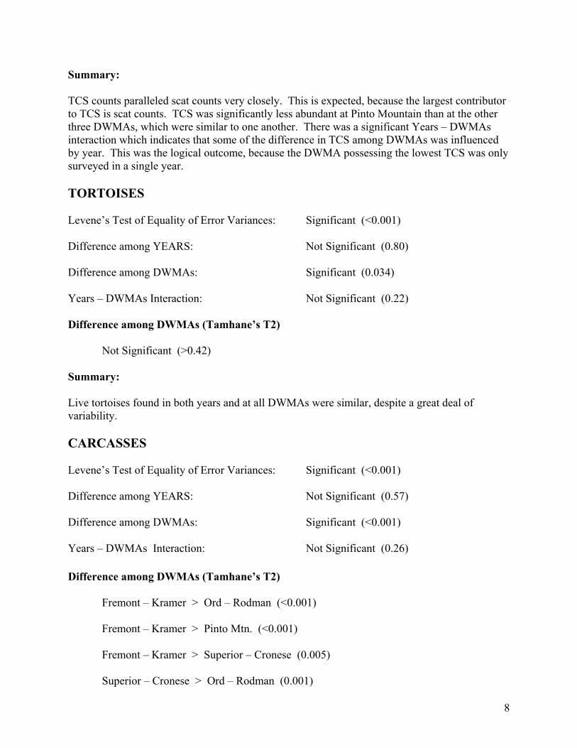
8
Summary: TCS counts paralleled scat counts very closely. This is expected, because the largest contributor to TCS is scat counts. TCS was significantly less abundant at Pinto Mountain than at the other three DWMAs, which were similar to one another. There was a significant Years – DWMAs interaction which indicates that some of the difference in TCS among DWMAs was influenced by year. This was the logical outcome, because the DWMA possessing the lowest TCS was only surveyed in a single year. TORTOISES Levene’s Test of Equality of Error Variances: Significant (<0.001) Difference among YEARS: Not Significant (0.80) Difference among DWMAs: Significant (0.034) Years – DWMAs Interaction: Not Significant (0.22) Difference among DWMAs (Tamhane’s T2) Not Significant (>0.42) Summary: Live tortoises found in both years and at all DWMAs were similar, despite a great deal of variability. CARCASSES Levene’s Test of Equality of Error Variances: Significant (<0.001) Difference among YEARS: Not Significant (0.57) Difference among DWMAs: Significant (<0.001) Years – DWMAs Interaction: Not Significant (0.26) Difference among DWMAs (Tamhane’s T2) Fremont – Kramer > Ord – Rodman (<0.001)
Fremont – Kramer > Pinto Mtn. (<0.001)
Fremont – Kramer > Superior – Cronese (0.005) Superior – Cronese > Ord – Rodman (0.001)
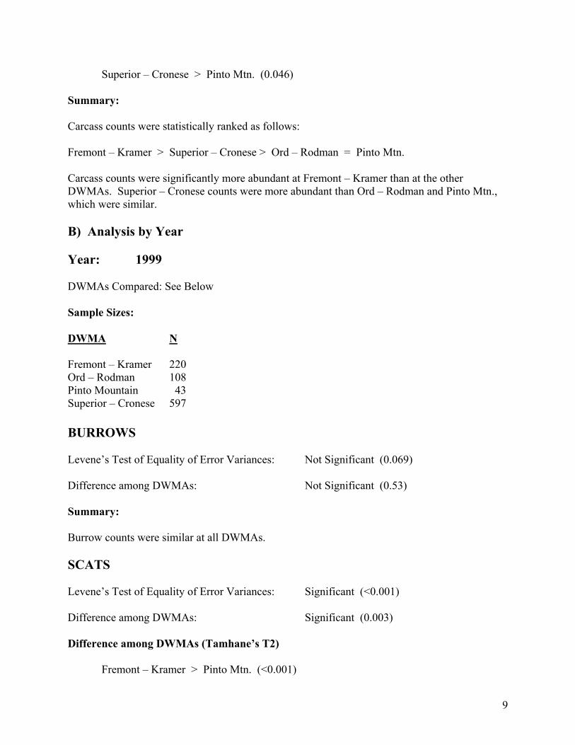
9
Superior – Cronese > Pinto Mtn. (0.046) Summary: Carcass counts were statistically ranked as follows: Fremont – Kramer > Superior – Cronese > Ord – Rodman = Pinto Mtn. Carcass counts were significantly more abundant at Fremont – Kramer than at the other DWMAs. Superior – Cronese counts were more abundant than Ord – Rodman and Pinto Mtn., which were similar. B) Analysis by Year Year: 1999 DWMAs Compared: See Below Sample Sizes: DWMA N Fremont – Kramer 220 Ord – Rodman 108 Pinto Mountain 43 Superior – Cronese 597 BURROWS Levene’s Test of Equality of Error Variances: Not Significant (0.069) Difference among DWMAs: Not Significant (0.53) Summary: Burrow counts were similar at all DWMAs. SCATS Levene’s Test of Equality of Error Variances: Significant (<0.001) Difference among DWMAs: Significant (0.003) Difference among DWMAs (Tamhane’s T2)
Fremont – Kramer > Pinto Mtn. (<0.001)
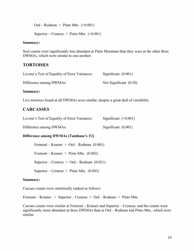
10
Ord – Rodman > Pinto Mtn. (<0.001) Superior – Cronese > Pinto Mtn. (<0.001) Summary: Scat counts were significantly less abundant at Pinto Mountain than they were at the other three DWMAs, which were similar to one another. TORTOISES Levene’s Test of Equality of Error Variances: Significant (0.001) Difference among DWMAs: Not Significant (0.20) Summary: Live tortoises found at all DWMAs were similar, despite a great deal of variability. CARCASSES Levene’s Test of Equality of Error Variances: Significant (<0.001) Difference among DWMAs: Significant (0.001) Difference among DWMAs (Tamhane’s T2) Fremont – Kramer > Ord – Rodman (0.001)
Fremont – Kramer > Pinto Mtn. (0.002) Superior – Cronese > Ord – Rodman (0.021) Superior – Cronese > Pinto Mtn. (0.043) Summary: Carcass counts were statistically ranked as follows: Fremont – Kramer = Superior – Cronese > Ord – Rodman = Pinto Mtn. Carcass counts were similar at Fremont – Kramer and Superior – Cronese, and the counts were significantly more abundant at these DWMAs than at Ord – Rodman and Pinto Mtn., which were similar.
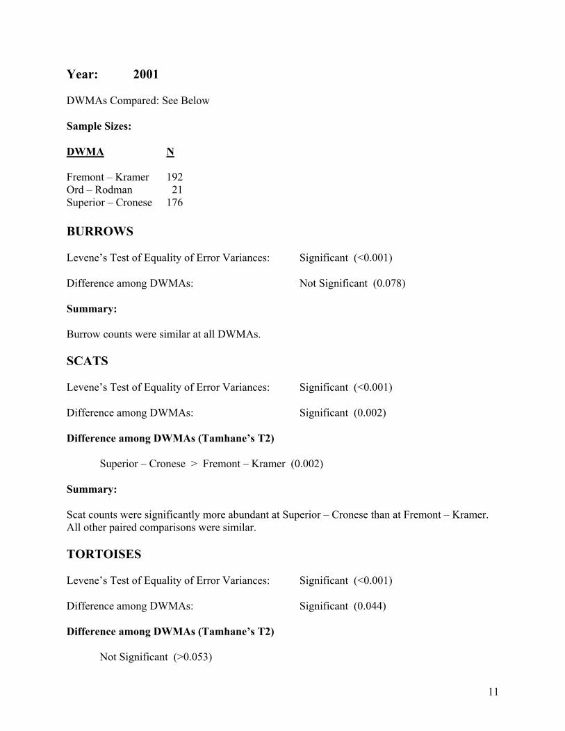
11
Year: 2001 DWMAs Compared: See Below Sample Sizes: DWMA N Fremont – Kramer 192 Ord – Rodman 21 Superior – Cronese 176 BURROWS Levene’s Test of Equality of Error Variances: Significant (<0.001) Difference among DWMAs: Not Significant (0.078) Summary: Burrow counts were similar at all DWMAs. SCATS Levene’s Test of Equality of Error Variances: Significant (<0.001) Difference among DWMAs: Significant (0.002) Difference among DWMAs (Tamhane’s T2) Superior – Cronese > Fremont – Kramer (0.002) Summary: Scat counts were significantly more abundant at Superior – Cronese than at Fremont – Kramer. All other paired comparisons were similar. TORTOISES Levene’s Test of Equality of Error Variances: Significant (<0.001) Difference among DWMAs: Significant (0.044) Difference among DWMAs (Tamhane’s T2) Not Significant (>0.053)
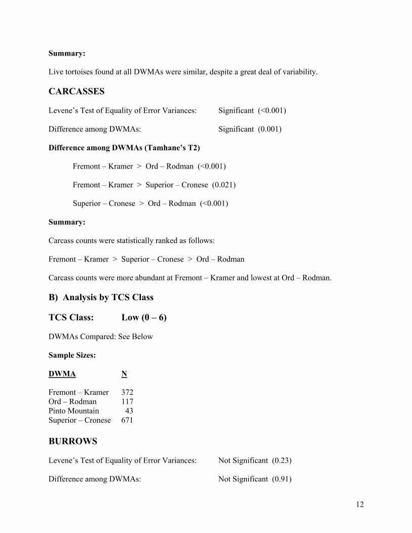
12
Summary: Live tortoises found at all DWMAs were similar, despite a great deal of variability. CARCASSES Levene’s Test of Equality of Error Variances: Significant (<0.001) Difference among DWMAs: Significant (0.001) Difference among DWMAs (Tamhane’s T2) Fremont – Kramer > Ord – Rodman (<0.001)
Fremont – Kramer > Superior – Cronese (0.021) Superior – Cronese > Ord – Rodman (<0.001) Summary: Carcass counts were statistically ranked as follows: Fremont – Kramer > Superior – Cronese > Ord – Rodman Carcass counts were more abundant at Fremont – Kramer and lowest at Ord – Rodman. B) Analysis by TCS Class TCS Class: Low (0 – 6) DWMAs Compared: See Below Sample Sizes: DWMA N Fremont – Kramer 372 Ord – Rodman 117 Pinto Mountain 43 Superior – Cronese 671 BURROWS Levene’s Test of Equality of Error Variances: Not Significant (0.23) Difference among DWMAs: Not Significant (0.91)
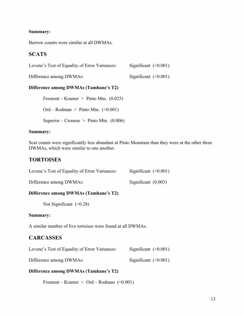
13
Summary: Burrow counts were similar at all DWMAs. SCATS Levene’s Test of Equality of Error Variances: Significant (<0.001) Difference among DWMAs: Significant (<0.001) Difference among DWMAs (Tamhane’s T2)
Fremont – Kramer > Pinto Mtn. (0.025) Ord – Rodman > Pinto Mtn. (<0.001) Superior – Cronese > Pinto Mtn. (0.006) Summary: Scat counts were significantly less abundant at Pinto Mountain than they were at the other three DWMAs, which were similar to one another. TORTOISES Levene’s Test of Equality of Error Variances: Significant (<0.001) Difference among DWMAs: Significant (0.003) Difference among DWMAs (Tamhane’s T2) Not Significant (>0.28) Summary: A similar number of live tortoises were found at all DWMAs. CARCASSES Levene’s Test of Equality of Error Variances: Significant (<0.001) Difference among DWMAs: Significant (<0.001) Difference among DWMAs (Tamhane’s T2) Fremont – Kramer > Ord – Rodman (<0.001)
14
Fremont – Kramer > Pinto Mtn. (<0.001) Superior – Cronese > Ord – Rodman (0.001) Summary: Carcass counts were statistically ranked as follows: Fremont – Kramer = Superior – Cronese > Ord – Rodman Fremont – Kramer > Pinto Mtn = Ord - Rodman Carcass counts were similar at and significantly more abundant at Fremont – Kramer and Superior – Cronese than at Ord – Rodman and Pinto Mtn., which were similar. TCS Class: High (> 6) DWMAs Compared: See Below Sample Sizes: DWMA N Fremont – Kramer 40 Ord – Rodman 12 Superior – Cronese 102 BURROWS Levene’s Test of Equality of Error Variances: Not Significant (0.61) Difference among DWMAs: Significant (0.018) Difference among DWMAs (Tamhane’s T2) Superior – Cronese > Fremont – Kramer (0.023) Summary: Burrow counts were greater at Superior – Cronese than at Fremont – Kramer. All other contrasts were similar. SCATS Levene’s Test of Equality of Error Variances: Not Significant (0.23) Difference among DWMAs: Not Significant (0.55)
15
Summary: Scat counts were similar at all DWMAs. TORTOISES Levene’s Test of Equality of Error Variances: Not Significant (0.14) Difference among DWMAs: Not Significant (0.63) A similar number of live tortoises were found at all DWMAs. CARCASSES Levene’s Test of Equality of Error Variances: Not Significant (0.36) Difference among DWMAs: Not Significant (0.94 Summary: A similar number of carcasses were found at all DWMAs.
Discussion Desert Tortoises and Their Sign Desert tortoises should be closely associated with their sign – burrows and scats. Desert tortoises possess relatively small home ranges even in highly productive years (averaging < 8 ha), and this home range dramatically decreases even further in a drought year (averaging < 3 ha) (Duda et al. 1999). Within their home range they build burrows, using 2-11/tortoise in a productive and 1-6 in a drought year (Duda et al. 1999) and deposit scats at a rate that is at least an order of magnitude greater than their burrow numbers (Krzysik, in review). Based on their dedication to small home ranges, and because tortoises spend a major portion of their lives in burrows, particularly in drought years and bad weather (Duda and Krzysik 1998), it is intuitive that tortoise sign represents a surrogate for actual live tortoises. Traditional desert tortoise surveys have summed burrow counts and “independent” scat counts to produce TCS, total corrected sign. Correlation and Stepwise Regression Analyses Despite the acknowledged difficulty of observing live desert tortoises on survey transects, and the very high variability of tortoise sign (burrows and scats) among transects, there was a highly significant correlation (P<0.01) of live tortoises with burrows, scats, and TCS for the total DWMA data set and in each of the two years (Table 3). However, when the data were classified by the abundance of TCS, the results of the correlation analysis became interesting (Table 3). On transects with high (>6) TCS, only burrows were significantly correlated with live tortoises. When the TCS counts were further delineated into five classes (Table 3), burrows consistently
16
for all five classes were significantly correlated with tortoise counts, while scat counts and TCS were inconsistent and unreliable. TCS were only correlated with tortoises at the two lowest TCS classes, undoubtedly reflecting the large sample sizes in these classes, and the positive influence of burrows being included with TCS. Scat counts were very unreliable, and even demonstrated NEGATIVE significant correlations with tortoises with TCS classes of 2-3 and 7-9. These results are very critical and interesting, because the majority of transects in any tortoise survey data set contain low sign counts, and high sample sizes may mask interesting details among gradients of sign densities. As demonstrated in the ANOVA analyses, scat counts being more abundant than burrows dominate TCS, and parallel results are achieved with these two variables. However, in the correlation analysis inconsistent scat correlations across the TCS gradient, resulted in inconsistent TCS correlations. These data provide compelling evidence that burrows are a more consistent and reliable surrogate for tortoise counts than scats or the combination of burrows + scats (TCS). The current analysis extends and reinforces the similar conclusions reached in the last report (Krzysik 2002). Additional transect data, as well as, additional analyses are required and will be conducted for the next report to further elucidate this interesting pattern. Carcass counts were not correlated with transect live tortoise counts. A priori, everything else being equal, one would expect that DWMAs with higher tortoises densities would also possess higher carcass densities (a significant positive correlation), assuming mortality rates are similar. DWMAs that suffered higher tortoise mortality should show a negative correlation between live tortoises and carcasses. The carcass data suggest that BOTH tortoise densities and tortoise mortality rates are similar at the DWMAs. Motivated by the significant correlation of tortoises with their sign, an exploratory Stepwise Linear Regression Model was developed to assess and statistically verify the relative importance of the three sign counts to predict tortoise occurrence. This technique selects the best predictor variable that explains most of the scatter around the regression line. Inherently, it eliminates redundant variables that possess high multicollinearity. For example, TCS is a composite of the other two sign counts. Traditionally, the validity and interpretation of stepwise techniques have been questioned (Green 1979). However, there has recently been a revival in their applications. The result of this analysis clearly demonstrated that burrow counts were the only predictor variable necessary to explain the variability of tortoises on transects. Statistically, scats and TCS did not contribute significant information to the regression. As in the correlation analysis, Stepwise Linear Regression reinforces the validity in using burrow counts as a surrogate for tortoise counts. The data presented here and other evidence suggest that tortoise burrows appear to be a better surrogate for comparisons of tortoise distribution and relative abundance patterns than either scats or TCS. TCS was strongly correlated with scat counts, and essentially did not provide additional statistical information. The data also show that scat counts are much more variable than burrow counts, both within and between specific statistical comparisons. Importantly, burrow counts along the standard triangular tortoise survey transects (10 yards wide) accurately represent actual burrow density estimates, because the effective survey width using Distance Sampling surveys is equal to 4.5 m on a side (Krzysik, in review). Effective survey width for scats is approximately 1 m on a side. Therefore, burrow counts on 10 yard wide transects directly represent burrow density, while scat counts are relative numbers at best, and cannot be
17
used as density estimates. Effective survey width is equal to half the width of survey transects when all survey objects are detected (Buckland et al. 1993). Analysis of Variance Burrow counts (densities) were similar at all DWMAs and for both 1999 and 2001. Interestingly, when only high (>6) TCS transects were analyzed, Superior – Cronese had higher burrow counts than Fremont – Kramer. Pinto Mtn. did not have any high TCS transects. Scat and TCS counts produced similar results in ANOVA, because TCS is usually dominated by scat counts. Therefore, scat counts were used for all analyses, with the exception of the complete Factorial ANOVA where TCS was also used. Pinto Mtn. had lower scat counts than the other DWMAs in 1999, and when considering only Low TCS transects. Pinto Mtn. was not represented in 2001 nor in high TCS transects. In 2001, Superior – Cronese had higher scat counts than Fremont – Kramer. However, when high TCS transects were analyzed all DWMAs had similar scat counts. Live tortoise counts were similar at all DWMAs, for both 1999 and 2001, and for both low and high TCS transects. However, statistical interpretation can be quite tenuous, because of the high variability and low sample sizes associated with finding tortoises on survey transects. Carcass counts were highest at Fremont – Cramer and Superior – Cronese. Depending on the specific comparisons, these two DWMAs were either similar or the former had higher carcass counts than the latter. Ord – Rodman and Pinto Mtn. had lower carcass counts than the two above DWMAs, and they were similar to each other. Based on the available data and sample sizes, the four DWMAs appear to be similar to one another in their tortoise and sign counts, and therefore, of similar value as desert tortoise conservation areas. Although there were some statistical differences with specific comparisons of scat and carcass counts, these parameters may not be important in elucidating actual tortoise densities. Although the analyses could not demonstrate statistical differences among DWMAs with respect to live tortoise counts, the high variability and small sample sizes makes interpretation tenuous. An interesting outcome of the ANOVA analyses was that burrow counts (i.e., densities) were higher at Superior – Cronese than at Fremont – Kramer for the high TCS transects. This suggests that either Superior – Cronese tortoises possess a higher burrow/tortoise ratio, or tortoises are more abundant at this DWMA. Further analyses are being planned and will be conducted to explore and further elucidate the patterns identified in this report.

18
References Buckland, S.T., D.R. Anderson, K.P. Burnham, and J.L. Laake. 1993. Distance Sampling: Estimating Abundances of Biological Populations. Chapman and Hall, New York, NY. 446pp. Day, R.W., and G.P. Quinn. 1989. Comparisons of treatments after an analysis of variance in ecology. Ecological Monographs 59:433-463. Duda, J.J., and A.J. Krzysik. 1998. Radiotelemetry study of a desert tortoise population: Sand Hill Training Area, Marine Corps Air Ground Combat Center, Twentynine Palms, California. U.S. Army Corps of Engineers, USACERL Technical Report 98/39. 75pp. Duda, J.J., A.J. Krzysik, and J.E. Freilich. 1999. Effects of drought on desert tortoise movement and activity. Journal of Wildlife Management 63:1181-1192. Fry, J.C. 1993. One-way analysis of variance. Pages 3-39 in Biological Data Analysis: A Practical Approach, J.C. Fry, ed. Oxford University Press, New York, NY. 418pp. Green, R.H. 1979. Sampling Design and Statistical Methods for Environmental Biologists. John Wiley & Sons, New York, NY. 257pp. Harris, R.J. 1975. A Primer of Multivariate Statistics. Academic Press, New York, NY. 332pp. Johnson, D.H. 1995. Statistical sirens: The allure of nonparametrics. Ecology 76:1998-2000. Krzysik, A.J. 1998. Ecological design and analysis: Principles and issues in environmental monitoring. Pages 385-403 in Status and Conservation of Midwestern Amphibians, M.J. Lannoo, ed. University of Iowa Press, Iowa City, IA. 507pp. Krzysik, A.J. 2002. Statistical analysis of BLM desert tortoise surveys in support of the West Mojave Management Plan. Report I: Exploratory and initial data analysis. 1 May 2002. 35pp. Krzysik, A.J. A landscape sampling protocol for estimating distribution and density patterns of desert tortoises at multiple spatial scales. Invited Paper. In Review, ΑChelonian Conservation and Biology≅. Levene, H. 1960. Robust tests for equality of variance. Pages 278-292 in Contributions to Probability and Statistics, I. Olkin, ed. Stanford University Press, Palo Alto, CA. Milliken, G.A., and D.E. Johnson. 1984. Analysis of Messy Data. Volume I: Designed Experiments. Wadsworth, Belmont, CA. 473pp. Morgan, G.A., and O.V. Griego. 1998. Easy Use and Interpretation of SPSS for Windows: Answering Research Questions with Statistics. Lawrence Erlbaum, Mahwah, NJ. 276pp. Potvin, C., and D.A. Roff. 1993. Distribution-free and robust statistical methods: Viable alternatives to parametric statistics. Ecology 74:1617-1628.
19
Shaw, R.G., and T. Mitchell-Olds. 1993. ANOVA for unbalanced data: An overview. Ecology 74:1638-1645. Smith, S.M. 1995. Distribution-free and robust statistical methods: Viable alternatives to parametric statistics? Ecology 76:1997-1998. Snedecor, G.W., and W.G. Cochran. 1989. Statistical Methods, 8th ed. Iowa State University Press, Ames, IA. 503pp. Sokal, R.R, and F.J. Rohlf. 1995. Biometry, 3rd ed. W.H. Freeman, New York, NY. 887pp. SPSSa. 1999. SPSS analysis software package. Version 9.0.1 SPSS, Inc., Chicago, IL. SPSSb. 1999. SPSS User’s Guide, Version 9.0. SPSS, Inc., Chicago, IL. 740pp. Stewart-Oaten, A. 1995. Rules and judgments in statistics: Three examples. Ecology 76:2001-2009. Underwood, A.J. 1997. Experiments in Ecology. Cambridge University Press, New York, NY. 504pp. Zar, J.H. 1999. Biostatistical Analysis, 4th ed. Prentice Hall, Upper Saddle River, NJ. 663pp. Zolman, J.F. 1993. Biostatistics: Experimental Design and Statistical Inference. Oxford University Press, New York, NY. 343pp.
Statistical Analysis of BLM Desert Tortoise Surveys In Support of the West Mojave Management Plan
Report III:
Desert Tortoises at DWMAs and Association of Tortoise Encounters
and Sign Counts On Transects
5 September 2002
by
Anthony J. Krzysik, Ph.D. 11 Highland Terrace Prescott, AZ 86305
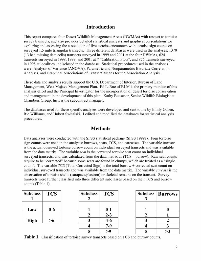
2
Introduction This report compares four Desert Wildlife Management Areas (DWMAs) with respect to tortoise survey transects, and also provides detailed statistical analyses and graphical presentations for exploring and assessing the association of live tortoise encounters with tortoise sign counts on surveyed 1.5 mile triangular transects. Three different databases were used in the analyses: 1370 (13 had missing data cells) transects surveyed in 1999 and 2001 at the four DWMAs, 624 transects surveyed in 1998, 1999, and 2001 at 7 “Calibration Plots”, and 876 transects surveyed in 1998 at localities undisclosed in the database. Statistical procedures used in the analyses were: Analysis of Variance (ANOVA), Parametric and Nonparametric Bivariate Correlation Analyses, and Graphical Associations of Transect Means for the Association Analysis. These data and analysis results support the U.S. Department of Interior, Bureau of Land Management, West Mojave Management Plan. Ed LaRue of BLM is the primary monitor of this analysis effort and the Principal Investigator for the incorporation of desert tortoise conservation and management in the development of this plan. Kathy Buescher, Senior Wildlife Biologist at Chambers Group, Inc., is the subcontract manager. The databases used for these specific analyses were developed and sent to me by Emily Cohen, Ric Williams, and Hubert Switalski. I edited and modified the databases for statistical analysis procedures.
Methods Data analyses were conducted with the SPSS statistical package (SPSS 1999a). Four tortoise sign counts were used in the analysis: burrows, scats, TCS, and carcasses. The variable burrow is the actual observed tortoise burrow count on individual surveyed transects and was available from the data matrix. The variable scat is the corrected tortoise scat count on individual surveyed transects, and was calculated from the data matrix as (TCS – burrow). Raw scat counts require to be “corrected” because some scats are found in clumps, which are treated as a “single count”. The variable TCS (Total Corrected Sign) is the total burrow + corrected scat count on individual surveyed transects and was available from the data matrix. The variable carcass is the observation of tortoise shells (carapace/plastron) or skeletal remains on the transect. Survey transects were further classified into three different subclasses based on their TCS and burrow counts (Table 1). Subclass
1 TCS Subclass
2 TCS Subclass
3 Burrows
Low 0-6 1 0-1 1 0
2 2-3 2 1 High >6 3 4-6 3 2
4 7-9 4 3 5 >9 5 >3
Table 1. Classification of tortoise survey transects based on TCS and burrow counts.
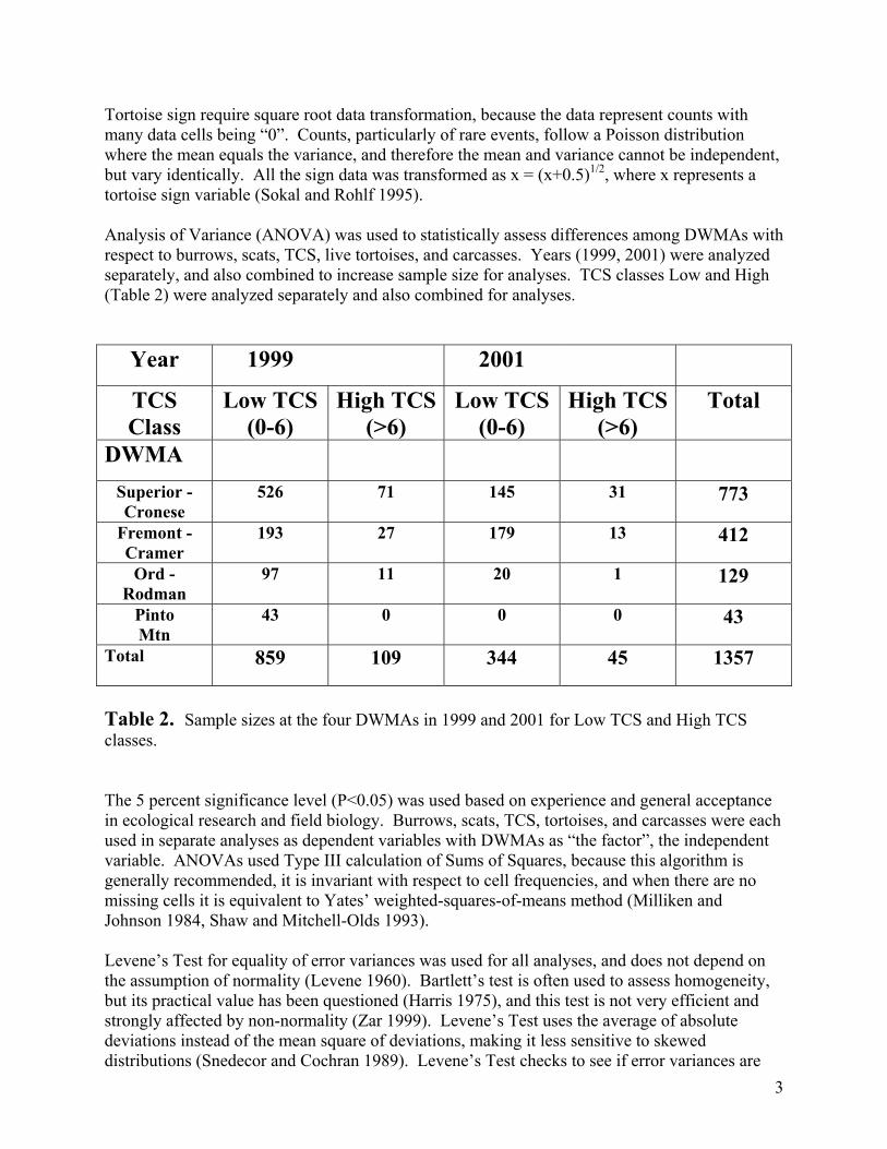
3
Tortoise sign require square root data transformation, because the data represent counts with many data cells being “0”. Counts, particularly of rare events, follow a Poisson distribution where the mean equals the variance, and therefore the mean and variance cannot be independent, but vary identically. All the sign data was transformed as x = (x+0.5)1/2, where x represents a tortoise sign variable (Sokal and Rohlf 1995). Analysis of Variance (ANOVA) was used to statistically assess differences among DWMAs with respect to burrows, scats, TCS, live tortoises, and carcasses. Years (1999, 2001) were analyzed separately, and also combined to increase sample size for analyses. TCS classes Low and High (Table 2) were analyzed separately and also combined for analyses.
Year 1999 2001
TCS Class
Low TCS (0-6)
High TCS (>6)
Low TCS(0-6)
High TCS (>6)
Total
DWMA
Superior - Cronese
526 71 145 31 773
Fremont - Cramer
193 27 179 13 412
Ord - Rodman
97 11 20 1 129
Pinto Mtn
43 0 0 0 43
Total 859 109 344 45 1357
Table 2. Sample sizes at the four DWMAs in 1999 and 2001 for Low TCS and High TCS classes. The 5 percent significance level (P<0.05) was used based on experience and general acceptance in ecological research and field biology. Burrows, scats, TCS, tortoises, and carcasses were each used in separate analyses as dependent variables with DWMAs as “the factor”, the independent variable. ANOVAs used Type III calculation of Sums of Squares, because this algorithm is generally recommended, it is invariant with respect to cell frequencies, and when there are no missing cells it is equivalent to Yates’ weighted-squares-of-means method (Milliken and Johnson 1984, Shaw and Mitchell-Olds 1993). Levene’s Test for equality of error variances was used for all analyses, and does not depend on the assumption of normality (Levene 1960). Bartlett’s test is often used to assess homogeneity, but its practical value has been questioned (Harris 1975), and this test is not very efficient and strongly affected by non-normality (Zar 1999). Levene’s Test uses the average of absolute deviations instead of the mean square of deviations, making it less sensitive to skewed distributions (Snedecor and Cochran 1989). Levene’s Test checks to see if error variances are
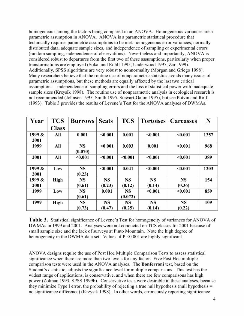
4
homogeneous among the factors being compared in an ANOVA. Homogeneous variances are a parametric assumption in ANOVA. ANOVA is a parametric statistical procedure that technically requires parametric assumptions to be met: homogeneous error variances, normally distributed data, adequate sample sizes, and independence of sampling or experimental errors (random sampling, independence of observations). Nevertheless and importantly, ANOVA is considered robust to departures from the first two of these assumptions, particularly when proper transformations are employed (Sokal and Rohlf 1995, Underwood 1997, Zar 1999). Additionally, SPSS algorithms are very robust to nonnormality (Morgan and Griego 1998). Many researchers believe that the routine use of nonparametric statistics avoids many issues of parametric assumptions, but these methods are equally affected by the last two critical assumptions – independence of sampling errors and the loss of statistical power with inadequate sample sizes (Krzysik 1998). The routine use of nonparametric analysis in ecological research is not recommended (Johnson 1995, Smith 1995, Stewart-Oaton 1995), but see Potvin and Roff (1993). Table 3 provides the results of Levene’s Test for the ANOVA analyses of DWMAs. Year TCS
Class Burrows Scats TCS Tortoises Carcasses N
1999 & 2001
All 0.001 <0.001 0.001 <0.001 <0.001 1357
1999 All NS (0.070)
<0.001 0.003 0.001 <0.001 968
2001 All <0.001 <0.001 <0.001 <0.001 <0.001 389
1999 & 2001
Low NS (0.23)
<0.001 0.041 <0.001 <0.001 1203
1999 & 2001
High NS (0.61)
NS (0.23)
NS (0.12)
NS (0.14)
NS (0.36)
154
1999 Low NS (0.61)
0.001 NS (0.072)
<0.001 <0.001 859
1999 High NS (0.73)
NS (0.47)
NS (0.25)
NS (0.14)
NS (0.22)
109
Table 3. Statistical significance of Levene’s Test for homogeneity of variances for ANOVA of DWMAs in 1999 and 2001. Analyses were not conducted on TCS classes for 2001 because of small sample size and the lack of surveys at Pinto Mountain. Note the high degree of heterogeneity in the DWMA data set. Values of P <0.001 are highly significant. ANOVA designs require the use of Post Hoc Multiple Comparison Tests to assess statistical significance when there are more than two levels for any factor. Five Post Hoc multiple comparison tests were used in the ANOVA analyses. The Bonferroni test, based on the Student’s t statistic, adjusts the significance level for multiple comparisons. This test has the widest range of applications, is conservative, and when there are few comparisons has high power (Zolman 1993, SPSS 1999b). Conservative tests were desirable in these analyses, because they minimize Type I error, the probability of rejecting a true null hypothesis (null hypothesis = no significance difference) (Krzysik 1998). In other words, erroneously reporting significance
5
when the comparison was not statistically significant. Importantly, when factor variances are heterogeneous (i.e., Levene’s Test is significant), pooled estimates of variance cannot be used to calculate the standard error of the comparison (Day and Quinn 1989). The use of Post Hoc tests that specifically address variance heterogeneity are recommended (Day and Quinn 1989, SPSS 1999b). Therefore, the high degree of data heterogeneity (Table 3), motivated the use of four additional Post Hoc tests that fit this criteria. Tamhane’s T2 – conservative pairwise comparison test based on a t test Dunnett’s T3 – pairwise comparison test based on the Studentized maximum modulus,
highly recommended (Fry 1993) Games-Howell – liberal pairwise comparisons test, highly recommended (Fry 1993) Dunnett’s C – pairwise comparisons test based on the Studentized range Although all five tests were examined for significance at the 0.05 level, only the results of the conservative Tamhane’s T2 test were reported. The results of all five Post Hoc tests were usually similar for all the factorial ANOVA analyses conducted in this study. This indicates that the data were reasonably behaved. As expected, the Games-Howell test was more liberal, while the Bonferroni test was frequently very liberal in contrast to the other four tests, particularly when Levene’s Test showed significant departure from homogeneous residuals. Bivariate parametric and nonparametric correlation analyses were performed on the three data sets (DWMAs, Calibration Plots, 1998 Data) to assess the association of live tortoises with: burrows, scats, TCS, and carcasses on survey transects. The parametric test was the Pearson Product Moment Correlation Coefficient. Two nonparametric rank correlations were used: Spearman’s rho and Kendall’s tau, and these gave results similar to the parametric test. The values reported in Tables 5, 6, 7, and 8 are Pearson’s Correlation Coefficient with the two-tailed analysis. The two-tailed analysis is more conservative than the one-tailed, and therefore, minimizes Type I error. Graphical presentations are provided to visually assess the association of live tortoise encounters with tortoise sign on survey transects. The data used was based on transect means of tortoises, burrows, and scats assessed at the three subclasses shown in Table 1. Burrow and scat transect means were multiplied by “10” and tortoise means by “100” for the purpose of convenient scaling of the graphics. Association of metrics through graphical visualizations represents an important tool for conveying information to the reader that may be difficult to track statistically (Tufte 1983, Harris 1999).
Results Statistical Comparison of Desert Wildlife Management Areas (DWMAs) Analysis of Variance (ANOVA) of transformed data was used to compare four DWMAs (Superior – Cronese, Fremont – Kramer, Ord – Rodman, and Pinto Mountain). Data were collected in 1999 and 2001 on standardized 1.5 mile triangular transects. The Pinto Mountain
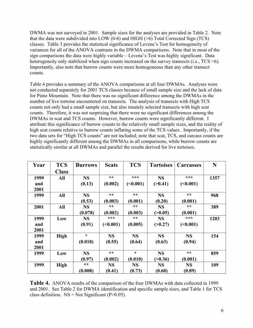
6
DWMA was not surveyed in 2001. Sample sizes for the analyses are provided in Table 2. Note that the data were subdivided into LOW (0-6) and HIGH (>6) Total Corrected Sign (TCS) classes. Table 3 provides the statistical significance of Levene’s Test for homogeneity of variances for all of the ANOVA contrasts in the DWMA comparisons. Note that in most of the sign comparisons the data were highly variable – Levene’s Test was highly significant. Data heterogeneity only stabilized when sign counts increased on the survey transects (i.e., TCS >6). Importantly, also note that burrow counts were more homogeneous than any other transect counts. Table 4 provides a summary of the ANOVA comparisons at all four DWMAs. Analyses were not conducted separately for 2001 TCS classes because of small sample size and the lack of data for Pinto Mountain. Note that there was no significant difference among the DWMAs in the number of live tortoise encountered on transects. The analysis of transects with High TCS counts not only had a small sample size, but also innately selected transects with high scat counts. Therefore, it was not surprising that there were no significant differences among the DWMAs in scat and TCS counts. However, burrow counts were significantly different. I attribute this significance of burrow counts to the relatively small sample sizes, and the reality of high scat counts relative to burrow counts inflating some of the TCS values. Importantly, if the two data sets for “High TCS counts” are not included; note that scat, TCS, and carcass counts are highly significantly different among the DWMAs in all comparisons, while burrow counts are statistically similar at all DWMAs and parallel the results derived for live tortoises.
Year TCS Class
Burrows Scats TCS Tortoises Carcasses N
1999 and 2001
All NS (0.13)
** (0.002)
*** (<0.001)
NS (>0.41)
*** (<0.001)
1357
1999 All NS (0.53)
** (0.003)
** (0.001)
NS (0.20)
** (0.001)
968
2001 All NS (0.078)
** (0.002)
** (0.003)
NS (>0.05)
** (0.001)
389
1999 and 2001
Low NS (0.91)
*** (<0.001)
** (0.005)
NS (>0.27)
*** (<0.001)
1203
1999 and 2001
High * (0.018)
NS (0.55)
NS (0.64)
NS (0.63)
NS (0.94)
154
1999 Low NS (0.97)
** (0.002)
* (0.010)
NS (>0.36)
** (0.001)
859
1999 High ** (0.008)
NS (0.41)
NS (0.73)
NS (0.60)
NS (0.89)
109
Table 4. ANOVA results of the comparison of the four DWMAs with data collected in 1999 and 2001. See Table 2 for DWMA identification and specific sample sizes, and Table 1 for TCS class definition. NS = Not Significant (P>0.05).
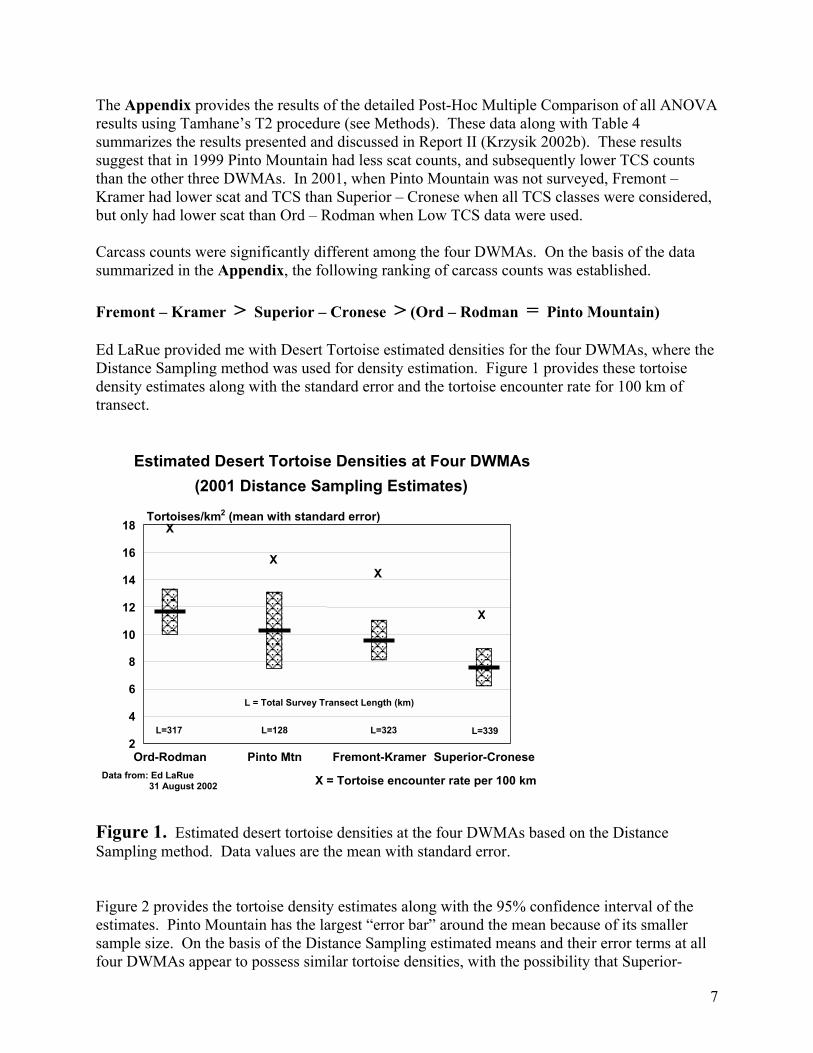
7
The Appendix provides the results of the detailed Post-Hoc Multiple Comparison of all ANOVA results using Tamhane’s T2 procedure (see Methods). These data along with Table 4 summarizes the results presented and discussed in Report II (Krzysik 2002b). These results suggest that in 1999 Pinto Mountain had less scat counts, and subsequently lower TCS counts than the other three DWMAs. In 2001, when Pinto Mountain was not surveyed, Fremont – Kramer had lower scat and TCS than Superior – Cronese when all TCS classes were considered, but only had lower scat than Ord – Rodman when Low TCS data were used. Carcass counts were significantly different among the four DWMAs. On the basis of the data summarized in the Appendix, the following ranking of carcass counts was established. Fremont – Kramer > Superior – Cronese > (Ord – Rodman = Pinto Mountain) Ed LaRue provided me with Desert Tortoise estimated densities for the four DWMAs, where the Distance Sampling method was used for density estimation. Figure 1 provides these tortoise density estimates along with the standard error and the tortoise encounter rate for 100 km of transect.
Figure 1. Estimated desert tortoise densities at the four DWMAs based on the Distance Sampling method. Data values are the mean with standard error. Figure 2 provides the tortoise density estimates along with the 95% confidence interval of the estimates. Pinto Mountain has the largest “error bar” around the mean because of its smaller sample size. On the basis of the Distance Sampling estimated means and their error terms at all four DWMAs appear to possess similar tortoise densities, with the possibility that Superior-
Estimated Desert Tortoise Densities at Four DWMAs (2001 Distance Sampling Estimates)
Ord-Rodman Pinto Mtn Fremont-Kramer Superior-Cronese2
4
6
8
10
12
14
16
18
X X
X
X
X = Tortoise encounter rate per 100 km
Tortoises/km 2 (mean with standard error)
Data from: Ed LaRue 31 August 2002
L=317 L=128 L=339L=323
L = Total Survey Transect Length (km)
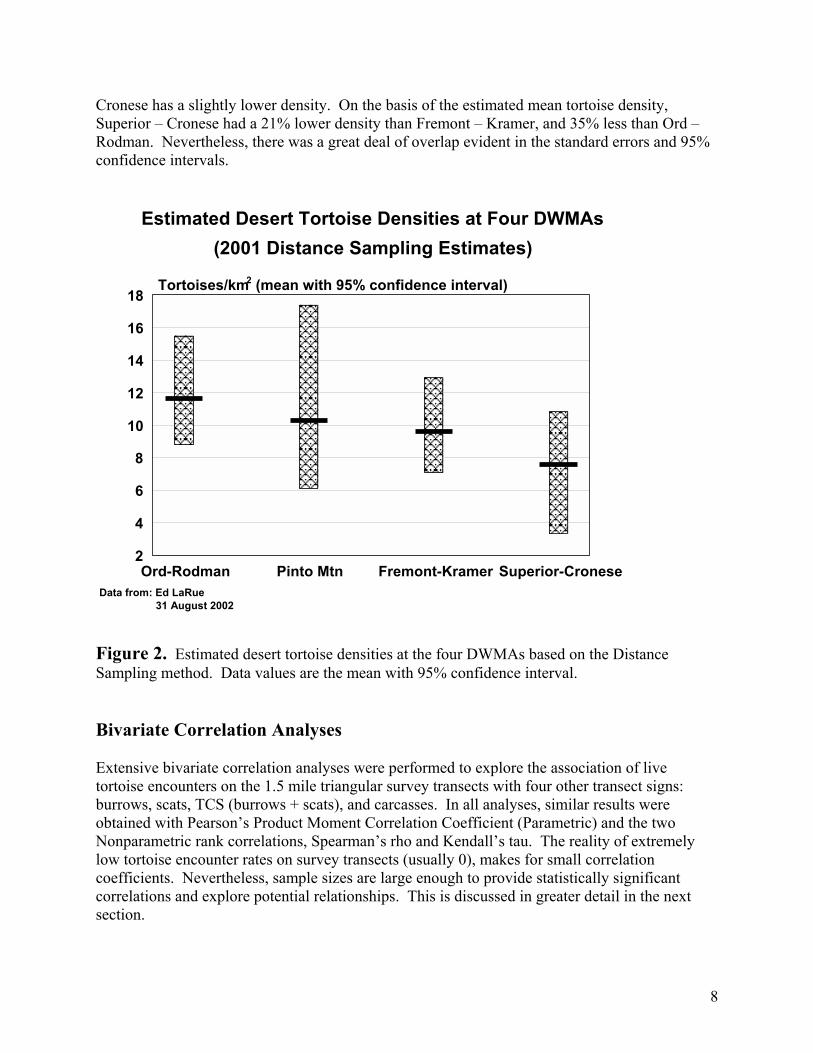
8
Cronese has a slightly lower density. On the basis of the estimated mean tortoise density, Superior – Cronese had a 21% lower density than Fremont – Kramer, and 35% less than Ord – Rodman. Nevertheless, there was a great deal of overlap evident in the standard errors and 95% confidence intervals.
Figure 2. Estimated desert tortoise densities at the four DWMAs based on the Distance Sampling method. Data values are the mean with 95% confidence interval. Bivariate Correlation Analyses Extensive bivariate correlation analyses were performed to explore the association of live tortoise encounters on the 1.5 mile triangular survey transects with four other transect signs: burrows, scats, TCS (burrows + scats), and carcasses. In all analyses, similar results were obtained with Pearson’s Product Moment Correlation Coefficient (Parametric) and the two Nonparametric rank correlations, Spearman’s rho and Kendall’s tau. The reality of extremely low tortoise encounter rates on survey transects (usually 0), makes for small correlation coefficients. Nevertheless, sample sizes are large enough to provide statistically significant correlations and explore potential relationships. This is discussed in greater detail in the next section.
Estimated Desert Tortoise Densities at Four DWMAs (2001 Distance Sampling Estimates)
Ord-Rodman Pinto Mtn Fremont-Kramer Superior-Cronese 2
4
6
8
10
12
14
16
18 Tortoises/km 2 (mean with 95% confidence interval)
Data from: Ed LaRue 31 August 2002
9
Table 5 provides the bivariate correlations of live tortoise encounters with burrow, scat, TCS, and carcass counts on individual transects at the four DWMAs. This table was also provided in Report II (Krzysik 2002b, Table 3). Sites: DWMAs Year: 1999 and 2001 Tortoise vs
Burrows Scats TCS Carcasses N
All
0.37** 0.20** 0.29** 0.045 1351
1999 0.35** 0.16** 0.26** 0.030 962 2001 0.44** 0.29** 0.38** 0.088 389 Low TCS 0.27** 0.95** 0.22** 0.024 1197 High TCS 0.38** -0.11 0.062 0.058 154 0-1 TCS 0.13** 0.020 0.12** -0.029 750 2-3 TCS 0.24** -0.20** 0.12* -0.036 277 4-6 TCS 0.16* -0.11 0.020 0.076 170 7-9 TCS 0.34** -0.31** -0.14 0.16 88 >9 TCS 0.45** -0.063 0.16 -0.085 66 Table 5. Pearson’s Product Moment Correlation Coefficient of LIVE TORTOISES with four tortoise sign parameters: burrows, scats, TCS, and carcasses. N is the sample size.
* indicates statistical significance (P<0.05) ** indicates high statistical significance (P<0.01)
10
Table 6 provides the bivariate correlations of live tortoise encounters with burrow, scat, TCS, and carcass counts on individual transects at the Calibration Plots. Sites: Calibration Plots Year: 1998, 1999, 2001 Tortoise vs
Burrows Scats TCS Carcasses N
All
0.39** 0.17** 0.26** -0.004 624
1998 0.26** 0.020 0.099 0.11 180 1999 0.45** 0.22** 0.33** -0.043 282 2001 0.43** 0.25** 0.33** -0.074 162 Low TCS 0.24** 0.024 0.14** -0.057 388 High TCS 0.40** -0.005 0.18** 0.018 236 0-1 TCS 0.076 -0.071 0.001 -0.022 149 2-3 TCS 0.16 -0.21* -0.084 -0.079 108 4-6 TCS 0.22* -0.24** -0.070 -0.075 131 7-9 TCS 0.40** -0.41** 0.022 0.18 93 >9 TCS 0.39** -0.004 0.19* -0.11 143 Table 6. Pearson’s Product Moment Correlation Coefficient of LIVE TORTOISES with four tortoise sign parameters: burrows, scats, TCS, and carcasses. N is the sample size.
* indicates statistical significance (P<0.05) ** indicates high statistical significance (P<0.01)
Sample sizes at Calibration Plots are as follows:
Plot Number of Transects
Lucerne 186 Kramer 180 Fremont 156 Alvord 42 Liz 42 DTNA 12 Johnson 6
11
Table 7 provides the bivariate correlations of live tortoise encounters with burrow, scat, TCS, and carcass counts on individual transects for surveys conducted in 1998. Sites: Unknown Year: 1998 Tortoise vs
Burrows Scats TCS Carcasses N
All
0.29** 0.14** 0.23** -0.004 876
Low TCS 0.28** 0.089* 0.22** 0.029 662 High TCS 0.21** -0.007 0.12 -0.084 214 0-1 TCS 0.13* -0.052 0.055 -0.038 308 2-3 TCS 0.15* -0.081 0.11 0.013 192 4-6 TCS 0.22** -0.27** -0.13 -0.014 162 7-9 TCS 0.11 -0.058 0.11 -0.17 93 >9 TCS 0.27** -0.032 0.14 -0.020 121 Table 7. Pearson’s Product Moment Correlation Coefficient of LIVE TORTOISES with four tortoise sign parameters: burrows, scats, TCS, and carcasses. N is the sample size.
* indicates statistical significance (P<0.05) ** indicates high statistical significance (P<0.01)
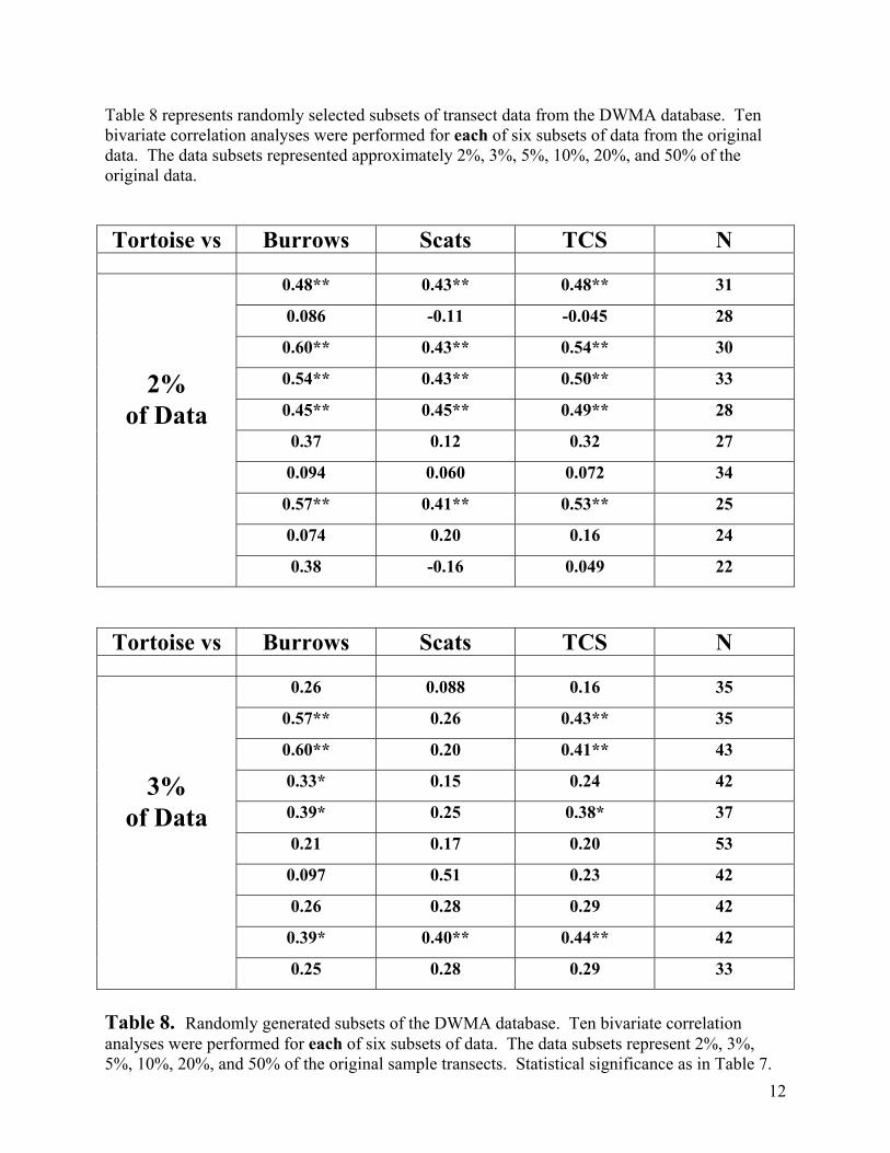
12
Table 8 represents randomly selected subsets of transect data from the DWMA database. Ten bivariate correlation analyses were performed for each of six subsets of data from the original data. The data subsets represented approximately 2%, 3%, 5%, 10%, 20%, and 50% of the original data. Tortoise vs Burrows Scats TCS N
0.48** 0.43** 0.48** 31
0.086 -0.11 -0.045 28
0.60** 0.43** 0.54** 30
2% 0.54** 0.43** 0.50** 33
of Data 0.45** 0.45** 0.49** 28
0.37 0.12 0.32 27
0.094 0.060 0.072 34
0.57** 0.41** 0.53** 25
0.074 0.20 0.16 24
0.38 -0.16 0.049 22
Tortoise vs Burrows Scats TCS N
0.26 0.088 0.16 35
0.57** 0.26 0.43** 35
0.60** 0.20 0.41** 43
3% 0.33* 0.15 0.24 42
of Data 0.39* 0.25 0.38* 37
0.21 0.17 0.20 53
0.097 0.51 0.23 42
0.26 0.28 0.29 42
0.39* 0.40** 0.44** 42
0.25 0.28 0.29 33
Table 8. Randomly generated subsets of the DWMA database. Ten bivariate correlation analyses were performed for each of six subsets of data. The data subsets represent 2%, 3%, 5%, 10%, 20%, and 50% of the original sample transects. Statistical significance as in Table 7.
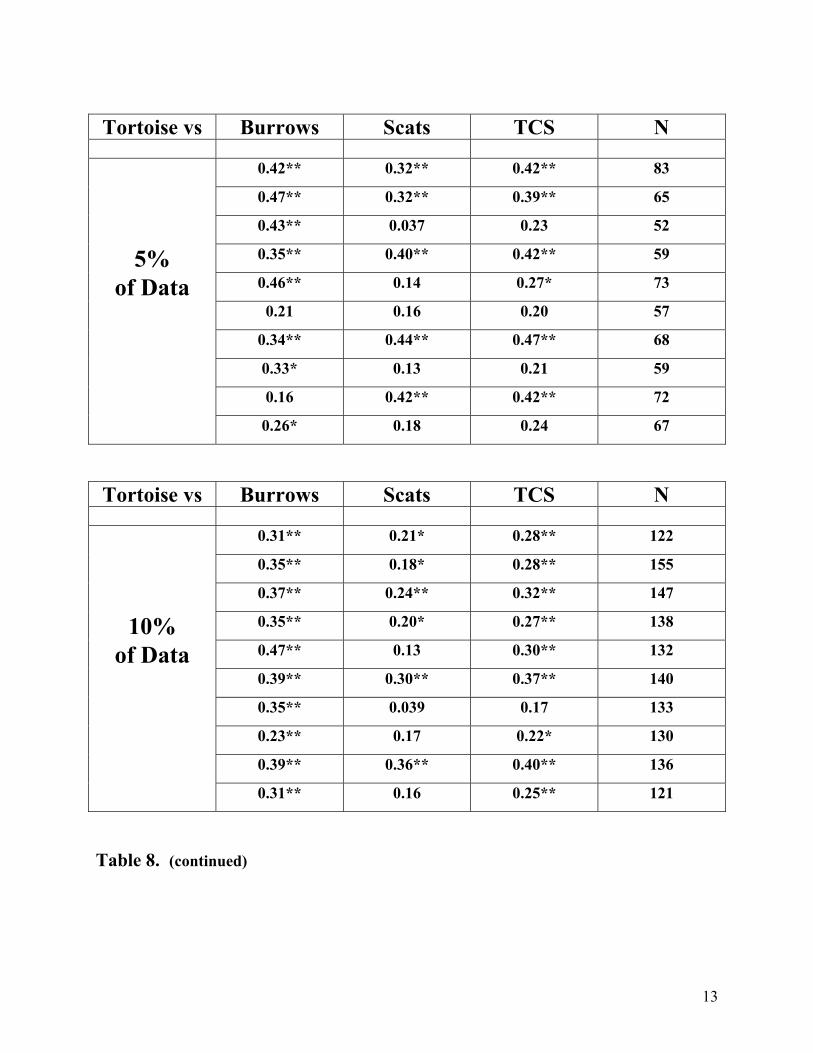
13
Tortoise vs Burrows Scats TCS N
0.42** 0.32** 0.42** 83
0.47** 0.32** 0.39** 65
0.43** 0.037 0.23 52
5% 0.35** 0.40** 0.42** 59
of Data 0.46** 0.14 0.27* 73
0.21 0.16 0.20 57
0.34** 0.44** 0.47** 68
0.33* 0.13 0.21 59
0.16 0.42** 0.42** 72
0.26* 0.18 0.24 67
Tortoise vs Burrows Scats TCS N
0.31** 0.21* 0.28** 122
0.35** 0.18* 0.28** 155
0.37** 0.24** 0.32** 147
10% 0.35** 0.20* 0.27** 138
of Data 0.47** 0.13 0.30** 132
0.39** 0.30** 0.37** 140
0.35** 0.039 0.17 133
0.23** 0.17 0.22* 130
0.39** 0.36** 0.40** 136
0.31** 0.16 0.25** 121
Table 8. (continued)
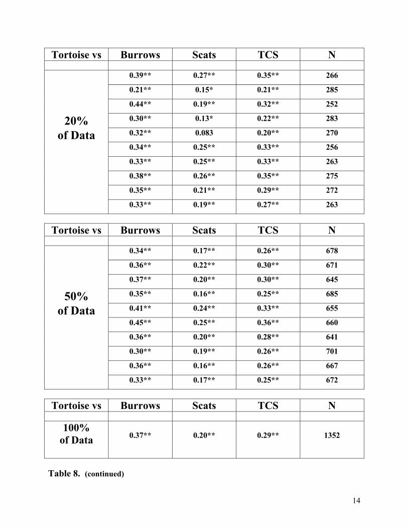
14
Tortoise vs Burrows Scats TCS N
0.39** 0.27** 0.35** 266
0.21** 0.15* 0.21** 285
0.44** 0.19** 0.32** 252
20% 0.30** 0.13* 0.22** 283
of Data 0.32** 0.083 0.20** 270
0.34** 0.25** 0.33** 256
0.33** 0.25** 0.33** 263
0.38** 0.26** 0.35** 275
0.35** 0.21** 0.29** 272
0.33** 0.19** 0.27** 263
Tortoise vs Burrows Scats TCS N
0.34** 0.17** 0.26** 678
0.36** 0.22** 0.30** 671
0.37** 0.20** 0.30** 645
50% 0.35** 0.16** 0.25** 685
of Data 0.41** 0.24** 0.33** 655
0.45** 0.25** 0.36** 660
0.36** 0.20** 0.28** 641
0.30** 0.19** 0.26** 701
0.36** 0.16** 0.26** 667
0.33** 0.17** 0.25** 672
Tortoise vs Burrows Scats TCS N
100%
of Data
0.37**
0.20**
0.29**
1352
Table 8. (continued)
15
Examination of the three data sets (Tables 5, 6, 7) reveals that tortoise encounters on transects are typically strongly correlated with burrow counts. Only 3 of 29 analyses do not possess a significant correlation, and two of these are on transects that had fewer than four TCS. On the other hand, 14 of 29 for scats and 15 of 29 for TCS do not show significant correlations. In all three data sets, when all transects were analyzed and the largest sample size was available, tortoise encounters were strongly correlated with any measure of sign count: burrows, scats, or TCS. Carcasses never had a significant correlation with live tortoise encounters on transects (0 for 29). It was of interest to explore the effects of smaller sample sizes on the correlation of tortoise encounters with transect sign counts (Table 8), and the results were surprising. Note that sample sizes with approximately 20% of the original number of transects gave comparable results to the complete data set – burrows, scats, and TCS were all strongly correlated with tortoise counts. At 10% of the original data, burrows still maintained their strong correlation with tortoises, but TCS and especially scats were losing statistical significance. The number of significant correlation coefficients decreased as sample size decreased. Surprisingly, even at 2% of the original data half of the 10 analysis runs showed highly significant correlations of tortoises and their sign, including burrows, scats, and TCS! Graphical Representations of Desert Tortoises and Their Sign at the Four DWMAs, Calibration Plots, and 1998 Surveys Live tortoises found on transects were significantly correlated with burrows, scats, and TCS, but especially with burrows (Tables 5, 6, 7, 8). Correlations were commonly significant at the P<0.01 level. Nevertheless, the actual bivariate correlation coefficients were not particularly high, typically possessing values of 0.2 to 0.5. Correlations of this magnitude can be very highly significant when sample sizes are high. The reason for this is directly due to the reality that tortoise encounter rates on transects are very rare. Even in areas of the Mojave Desert that were known to possess “optimal” habitat and therefore tortoise densities, such as DWMAs and Calibration Plots, transect encounter rates were very low. Table 9 gives tortoise encounter rates along 2852 transects surveyed in the four DWMAs, Calibration Plots, and in the 1998 database. Note that more than three live tortoises were never encountered on a single transect, and three tortoises were only encountered a single time (0.035 percent), despite the total sample size of 2852 transects. This translates to 4278 miles (6883 km) of search transects. Tortoises were not encountered in 91 percent of the surveyed transects, a single tortoise was found on only seven percent, while two tortoises were only encountered one percent of the time. The rarity of tortoise encounters on survey transects is well know among tortoise surveyors, and these results were not surprising. These results motivated the analysis and graphical representations presented in this section.
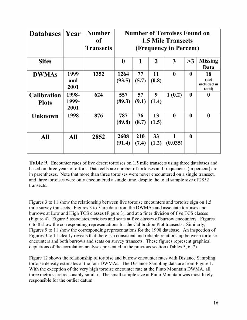
16
Databases Year Number of
Transects
Number of Tortoises Found on 1.5 Mile Transects
(Frequency in Percent)
Sites 0 1 2 3 >3 MissingData
DWMAs 1999 and 2001
1352 1264 (93.5)
77 (5.7)
11 (0.8)
0 0 18 (not
included in total)
Calibration Plots
1998-1999-2001
624 557 (89.3)
57 (9.1)
9 (1.4)
1 (0.2) 0 0
Unknown
1998 876 787 (89.8)
76 (8.7)
13 (1.5)
0 0 0
All All 2852 2608 (91.4)
210 (7.4)
33 (1.2)
1 (0.035)
0
Table 9. Encounter rates of live desert tortoises on 1.5 mile transects using three databases and based on three years of effort. Data cells are number of tortoises and frequencies (in percent) are in parentheses. Note that more than three tortoises were never encountered on a single transect, and three tortoises were only encountered a single time, despite the total sample size of 2852 transects. Figures 3 to 11 show the relationship between live tortoise encounters and tortoise sign on 1.5 mile survey transects. Figures 3 to 5 are data from the DWMAs and associate tortoises and burrows at Low and High TCS classes (Figure 3), and at a finer division of five TCS classes (Figure 4). Figure 5 associates tortoises and scats at five classes of burrow encounters. Figures 6 to 8 show the corresponding representations for the Calibration Plot transects. Similarly, Figures 9 to 11 show the corresponding representations for the 1998 database. An inspection of Figures 3 to 11 clearly reveals that there is a consistent and reliable relationship between tortoise encounters and both burrows and scats on survey transects. These figures represent graphical depictions of the correlation analyses presented in the previous section (Tables 5, 6, 7). Figure 12 shows the relationship of tortoise and burrow encounter rates with Distance Sampling tortoise density estimates at the four DWMAs. The Distance Sampling data are from Figure 1. With the exception of the very high tortoise encounter rate at the Pinto Mountain DWMA, all three metrics are reasonably similar. The small sample size at Pinto Mountain was most likely responsible for the outlier datum.
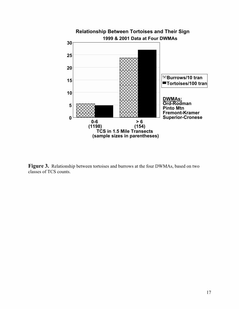
17
Figure 3. Relationship between tortoises and burrows at the four DWMAs, based on two classes of TCS counts.
Relationship Between Tortoises and Their Sign 1999 & 2001 Data at Four DWMAs
0
5
10
15
20
25
30
Burrows/10 tranTortoises/100 tran
TCS in 1.5 Mile Transects(sample sizes in parentheses)
DWMAs: Ord-Rodman Pinto Mtn Fremont-KramerSuperior-Cronese
> 6(154)
0-6(1198)

18
Figure 4. Relationship between tortoises and burrows at the four DWMAs, based on five classes of TCS counts.
Relationship Between Tortoises and Their Sign 1999 & 2001 Data at Four DWMAs
2-3 4-6 7-90
5
10
15
20
25
30
Burrows/10 tran Tortoises/100 tran
(750) (278) (170) (88) (66)
TCS in 1.5 Mile Transects(sample sizes in parentheses)
DWMAs:Ord-Rodman Pinto MtnFremont-Kramer Superior-Cronese
> 90-1
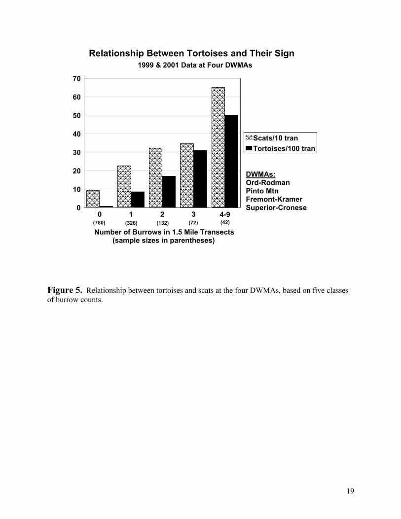
19
Figure 5. Relationship between tortoises and scats at the four DWMAs, based on five classes of burrow counts.
Relationship Between Tortoises and Their Sign 1999 & 2001 Data at Four DWMAs
0 1 2 3 4-90
10
20
30
40
50
60
70
Scats/10 tran Tortoises/100 tran
(780) (326) (132) (72) (42)
Number of Burrows in 1.5 Mile Transects(sample sizes in parentheses)
DWMAs:Ord-Rodman Pinto MtnFremont-Kramer Superior-Cronese
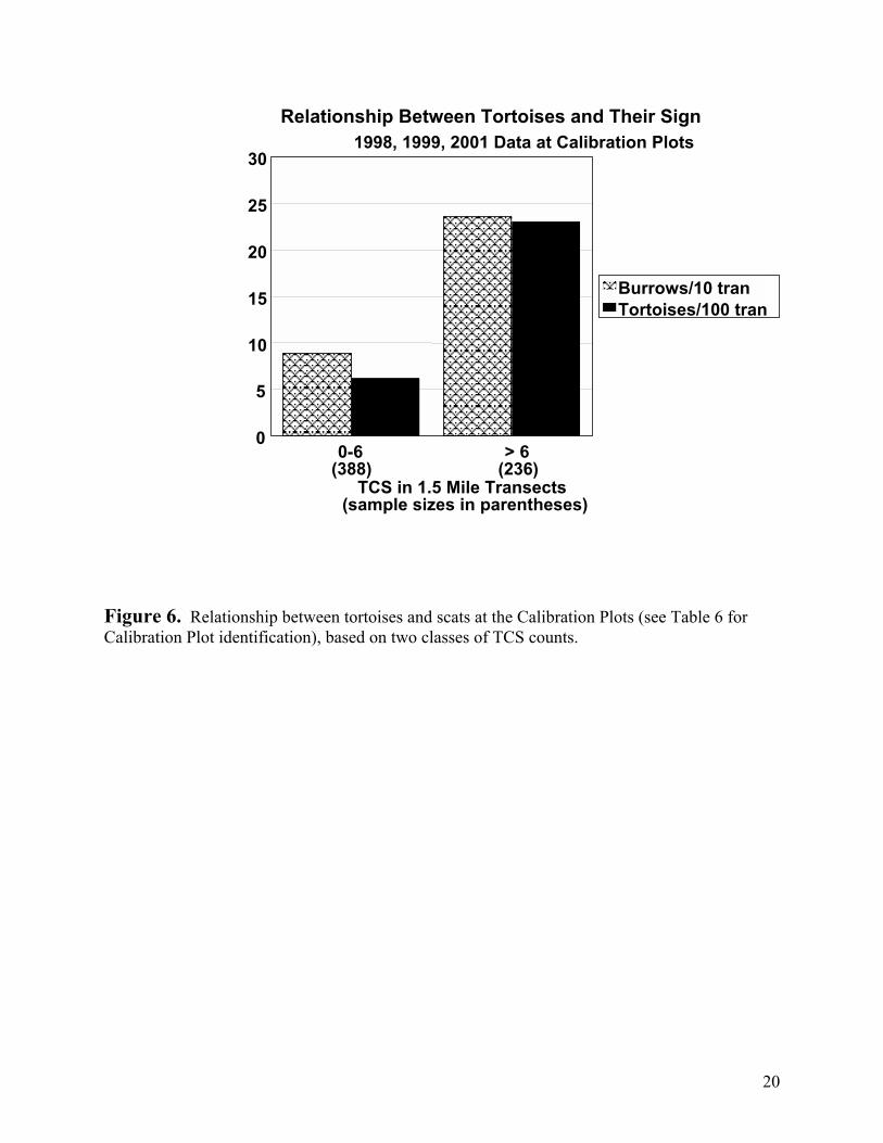
20
Figure 6. Relationship between tortoises and scats at the Calibration Plots (see Table 6 for Calibration Plot identification), based on two classes of TCS counts.
Relationship Between Tortoises and Their Sign 1998, 1999, 2001 Data at Calibration Plots
0
5
10
15
20
25
30
Burrows/10 tranTortoises/100 tran
TCS in 1.5 Mile Transects(sample sizes in parentheses)
> 6(236)
0-6(388)
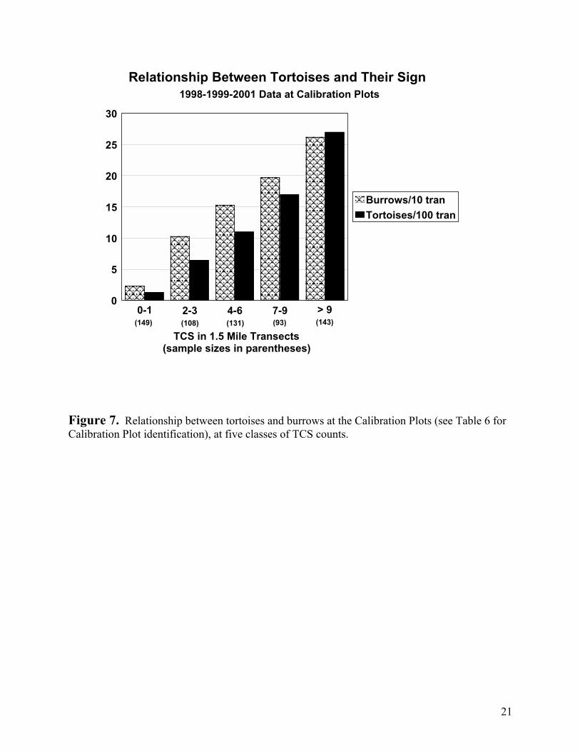
21
Figure 7. Relationship between tortoises and burrows at the Calibration Plots (see Table 6 for Calibration Plot identification), at five classes of TCS counts.
Relationship Between Tortoises and Their Sign 1998-1999-2001 Data at Calibration Plots
2-3 4-6 7-90
5
10
15
20
25
30
Burrows/10 tran Tortoises/100 tran
(149) (108) (131) (93) (143)
TCS in 1.5 Mile Transects(sample sizes in parentheses)
> 90-1
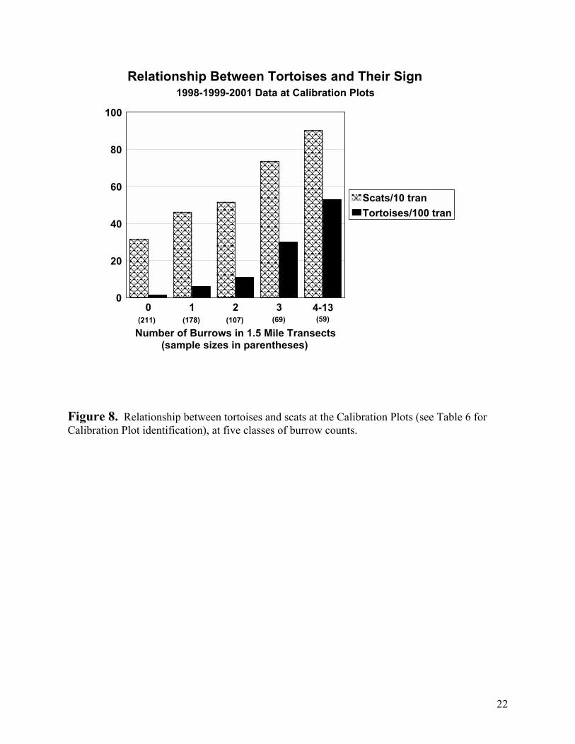
22
Figure 8. Relationship between tortoises and scats at the Calibration Plots (see Table 6 for Calibration Plot identification), at five classes of burrow counts.
Relationship Between Tortoises and Their Sign 1998-1999-2001 Data at Calibration Plots
0 1 2 3 4-130
20
40
60
80
100
Scats/10 tran Tortoises/100 tran
(211) (178) (107) (69) (59)
Number of Burrows in 1.5 Mile Transects(sample sizes in parentheses)
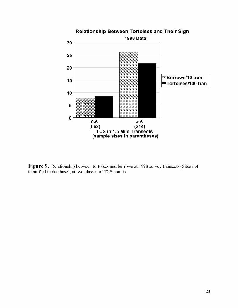
23
Figure 9. Relationship between tortoises and burrows at 1998 survey transects (Sites not identified in database), at two classes of TCS counts.
Relationship Between Tortoises and Their Sign 1998 Data
0
5
10
15
20
25
30
Burrows/10 tranTortoises/100 tran
TCS in 1.5 Mile Transects(sample sizes in parentheses)
> 6(214)
0-6(662)
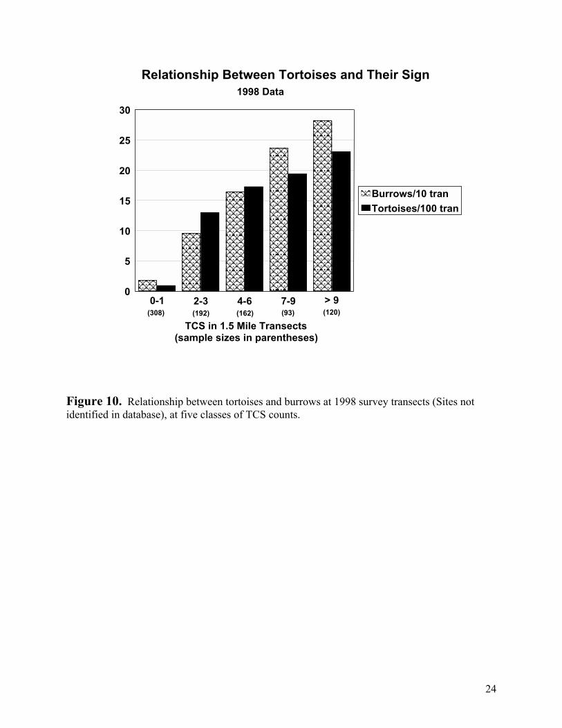
24
Figure 10. Relationship between tortoises and burrows at 1998 survey transects (Sites not identified in database), at five classes of TCS counts.
Relationship Between Tortoises and Their Sign 1998 Data
2-3 4-6 7-90
5
10
15
20
25
30
Burrows/10 tran Tortoises/100 tran
(308) (192) (162) (93) (120)
TCS in 1.5 Mile Transects(sample sizes in parentheses)
> 90-1
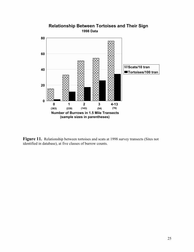
25
Figure 11. Relationship between tortoises and scats at 1998 survey transects (Sites not identified in database), at five classes of burrow counts.
Relationship Between Tortoises and Their Sign 1998 Data
0 1 2 3 4-130
20
40
60
80
Scats/10 tran Tortoises/100 tran
(363) (239) (143) (54) (76)
Number of Burrows in 1.5 Mile Transects(sample sizes in parentheses)
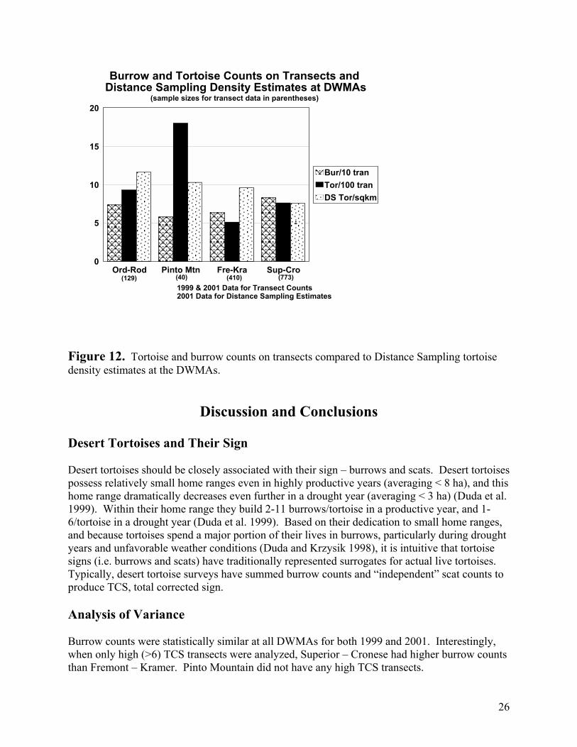
26
Figure 12. Tortoise and burrow counts on transects compared to Distance Sampling tortoise density estimates at the DWMAs.
Discussion and Conclusions Desert Tortoises and Their Sign Desert tortoises should be closely associated with their sign – burrows and scats. Desert tortoises possess relatively small home ranges even in highly productive years (averaging < 8 ha), and this home range dramatically decreases even further in a drought year (averaging < 3 ha) (Duda et al. 1999). Within their home range they build 2-11 burrows/tortoise in a productive year, and 1-6/tortoise in a drought year (Duda et al. 1999). Based on their dedication to small home ranges, and because tortoises spend a major portion of their lives in burrows, particularly during drought years and unfavorable weather conditions (Duda and Krzysik 1998), it is intuitive that tortoise signs (i.e. burrows and scats) have traditionally represented surrogates for actual live tortoises. Typically, desert tortoise surveys have summed burrow counts and “independent” scat counts to produce TCS, total corrected sign. Analysis of Variance Burrow counts were statistically similar at all DWMAs for both 1999 and 2001. Interestingly, when only high (>6) TCS transects were analyzed, Superior – Cronese had higher burrow counts than Fremont – Kramer. Pinto Mountain did not have any high TCS transects.
Burrow and Tortoise Counts on Transects and Distance Sampling Density Estimates at DWMAs
Ord-Rod Pinto Mtn Fre-Kra Sup-Cro0
5
10
15
20
Bur/10 tranTor/100 tranDS Tor/sqkm
(129) (40) (410) (773)
.
2001 Data for Distance Sampling Estimates1999 & 2001 Data for Transect Counts
(sample sizes for transect data in parentheses)
27
Scat and TCS counts produced similar results in ANOVA, because TCS is usually dominated by scat counts (Krzysik, data on file). Pinto Mountain had lower scat counts than the other DWMAs in 1999, and when considering only Low TCS transects. Pinto Mountain was not represented in 2001 nor in high TCS transects. In 2001, Superior – Cronese had higher scat counts than Fremont – Kramer. However, when high TCS transects were analyzed all DWMAs had similar scat counts. Detailed analysis results for both scats and TCS are presented in the Appendix. Live tortoise counts were statistically similar at all DWMAs, for both 1999 and 2001, and for both low and high TCS transects. However, statistical interpretation can be quite tenuous, because of the high variability and low sample sizes associated with finding tortoises on survey transects. Carcass counts were highest at Fremont – Cramer and Superior – Cronese. The following ranking of carcass counts were established by statistical significance: Fremont – Cramer > Superior – Cronese > (Ord – Rodman = Pinto Mountain) Ord – Rodman and Pinto Mountain had the highest Distance Sampling estimated tortoise densities. However, the ANOVA results of live tortoise and burrow encounters on surveys, and the significant overlap in standard error and 95% confidence intervals for the Distance Sampling estimates (Figures 1 and 2), strongly suggests that tortoise densities were similar at the four DWMAs. Correlation Analyses Despite the acknowledged difficulty of observing live desert tortoises on survey transects (Table 9), and the very high variability of tortoise sign (burrows and scats) among transects, there was a highly significant correlation (P<0.01) of live tortoises with burrows, scats, and TCS for all three databases (DWMAs, Calibration Plots, and the 1998 data set), see respectively, Tables 5, 6, and 7. When the data were further classified by the abundance of TCS counts (both into two and five classes), the results of the correlation analysis clearly showed that only burrows consistently provided a highly significant correlation with tortoise counts. Scat and TCS counts were inconsistently and unreliably correlated with live tortoises. Scat counts would occasionally produce significant negative correlations with tortoise counts, and this was observed in all three data sets. The effect of sample sizes on analyses results were explored by randomly sampling 2, 3, 5, 10, 20, and 50 percent of the original data, and then conducting ten correlation analyses on each of the derived data sets. The motivation was to directly assess the relative effects that smaller sample sizes had on statistical significance and the original bivariate correlation analyses results. Once again, even with smaller sample sizes, burrows were more consistent and reliable correlates of tortoise counts than scats or TCS. The surprising result of this exercise was that analyses results were not as sensitive to sample sizes as first anticipated. Burrow counts produced highly significant and reliable correlations with tortoise counts when only 10 percent of the original data was used in the analyses (Table 8). These results provide compelling evidence that burrows are a more consistent and reliable surrogate for tortoise counts than scats
28
or the combination of burrows + scats (TCS). The current analysis extends and reinforces the similar conclusions reached in the first two reports (Krzysik 2002a, 2002b). Additionally, Stepwise Linear Regression demonstrated that burrow counts were the only predictor variable necessary to explain the variability of tortoises on transects, and neither scat nor TCS counts contributed significant information to the regression (Krzysik 2002b). Carcass counts were not correlated with transect live tortoise counts. A priori, everything else being equal, one would expect that DWMAs with higher tortoises densities would also possess higher carcass densities (a significant positive correlation), assuming mortality rates are similar. DWMAs that suffered higher tortoise mortality should show a negative correlation between live tortoises and carcasses. The carcass correlation data suggest that BOTH tortoise densities and tortoise mortality rates are similar at the DWMAs. However, the ANOVA data suggest that carcass counts were higher at both Fremont – Cramer and Superior – Cronese. Graphical Representations of Desert Tortoises and Their Sign An inspection of Figures 3 through 11 clearly reveals a persistent pattern of the consistent relationship between tortoise transect encounters and both burrow and scat counts on surveyed transects, and directly reflects the quantitative results of the bivariate correlation analysis (Tables 5, 6, and 7). There is a striking similarity in this pattern when one compares the three different databases. Figures 3, 6, and 9 demonstrate the close relationship between tortoises and burrows when transects are divided into Low and High TCS counts. Simply put, transects with high TCS counts also had higher burrow counts and were much more likely to encounter a live tortoise. The converse was noted for Low TCS count transects. This is not merely attributed to burrow counts influencing TCS, because TCS is primarily influenced by scat counts (Krzysik, on file data analysis). Therefore, transects with high scat counts, also possessed high burrow counts, and a greater likelihood of encountering the rare event of finding a tortoise. Figures 4, 7, and 10 demonstrate a similar comparison when the TCS counts are more finely classified into five TCS classes. In all three databases, a similar and consistent pattern emerges. Tortoise and burrow encounters are extremely rare on transects that possess either single or no TCS counts. When TCS counts increased, burrow and tortoise encounters BOTH increased in a comparable and parallel pattern. The increase in burrows and tortoises followed a particularly “linear pattern” at the Calibration Plots (Figure 7) and with the 1998 data (Figure 10). The DWMA sites almost depict a trimodal distribution with 0-1, 2-6, and >6 TCS counts (Figure 4). Figures 7 and 10 could also be “forced” into a trimodal distribution of TCS classes. Figures 5, 8, and 10 associate tortoise and scat encounters based on transects classified by burrow counts. Similarly, as in the previous two comparisons, the persistent pattern is retained. Transects where burrows were not observed possessed the lowest scat counts and tortoise encounters were very rare. As burrow counts on transects increased, so did the likelihood of encountering tortoises and observing higher scat counts. Two important insights were obtained from these last three figures. Even when burrows were not encountered on a transect, significant scat counts could be recorded. Also note that the increasing scat count histograms in these figures are “flatter” than the tortoise or burrow histograms in any of the nine figures discussed. I interpret these observations to suggest that scat counts are not as reliable as burrows in relating to tortoise counts. This is due to scats higher variability, both in space and in time, and in observer detection.
29
References Day, R.W., and G.P. Quinn. 1989. Comparisons of treatments after an analysis of variance in ecology. Ecological Monographs 59:433-463. Duda, J.J., and A.J. Krzysik. 1998. Radiotelemetry study of a desert tortoise population: Sand Hill Training Area, Marine Corps Air Ground Combat Center, Twentynine Palms, California. U.S. Army Corps of Engineers, USACERL Technical Report 98/39. 75pp. Duda, J.J., A.J. Krzysik, and J.E. Freilich. 1999. Effects of drought on desert tortoise movement and activity. Journal of Wildlife Management 63:1181-1192. Fry, J.C. 1993. One-way analysis of variance. Pages 3-39 in Biological Data Analysis: A Practical Approach, J.C. Fry, ed. Oxford University Press, New York, NY. 418pp. Harris, R.J. 1975. A Primer of Multivariate Statistics. Academic Press, New York, NY. 332pp. Harris, R.L. 1999. Information Graphics: A Comprehensive Illustrated Reference. Oxford University Press, NY. 448pp. Johnson, D.H. 1995. Statistical sirens: The allure of nonparametrics. Ecology 76:1998-2000. Krzysik, A.J. 1998. Ecological design and analysis: Principles and issues in environmental monitoring. Pages 385-403 in Status and Conservation of Midwestern Amphibians, M.J. Lannoo, ed. University of Iowa Press, Iowa City, IA. 507pp. Krzysik, A.J. 2002a. Statistical analysis of BLM desert tortoise surveys in support of the West Mojave Management Plan. Report I: Exploratory and initial data analysis. 1 May 2002. 35pp. Krzysik, A.J. 2002b. Statistical analysis of BLM desert tortoise surveys in support of the West Mojave Management Plan. Report II: Statistical comparison of DWMAs (1999 & 2001). 19 June 2002. 19pp. Levene, H. 1960. Robust tests for equality of variance. Pages 278-292 in Contributions to Probability and Statistics, I. Olkin, ed. Stanford University Press, Palo Alto, CA. Milliken, G.A., and D.E. Johnson. 1984. Analysis of Messy Data. Volume I: Designed Experiments. Wadsworth, Belmont, CA. 473pp. Morgan, G.A., and O.V. Griego. 1998. Easy Use and Interpretation of SPSS for Windows: Answering Research Questions with Statistics. Lawrence Erlbaum, Mahwah, NJ. 276pp. Potvin, C., and D.A. Roff. 1993. Distribution-free and robust statistical methods: Viable alternatives to parametric statistics. Ecology 74:1617-1628. Shaw, R.G., and T. Mitchell-Olds. 1993. ANOVA for unbalanced data: An overview. Ecology 74:1638-1645.
30
Smith, S.M. 1995. Distribution-free and robust statistical methods: Viable alternatives to parametric statistics? Ecology 76:1997-1998. Snedecor, G.W., and W.G. Cochran. 1989. Statistical Methods, 8th ed. Iowa State University Press, Ames, IA. 503pp. Sokal, R.R, and F.J. Rohlf. 1995. Biometry, 3rd ed. W.H. Freeman, New York, NY. 887pp. SPSSa. 1999. SPSS analysis software package. Version 9.0.1 SPSS, Inc., Chicago, IL. SPSSb. 1999. SPSS User’s Guide, Version 9.0. SPSS, Inc., Chicago, IL. 740pp. Stewart-Oaten, A. 1995. Rules and judgments in statistics: Three examples. Ecology 76:2001-2009. Tufte, E.R. 1983. The Visual Display of Quantitative Information. Graphics Press, Cheshire, CN. 197pp. Underwood, A.J. 1997. Experiments in Ecology. Cambridge University Press, New York, NY. 504pp. Zar, J.H. 1999. Biostatistical Analysis, 4th ed. Prentice Hall, Upper Saddle River, NJ. 663pp. Zolman, J.F. 1993. Biostatistics: Experimental Design and Statistical Inference. Oxford University Press, New York, NY. 343pp.
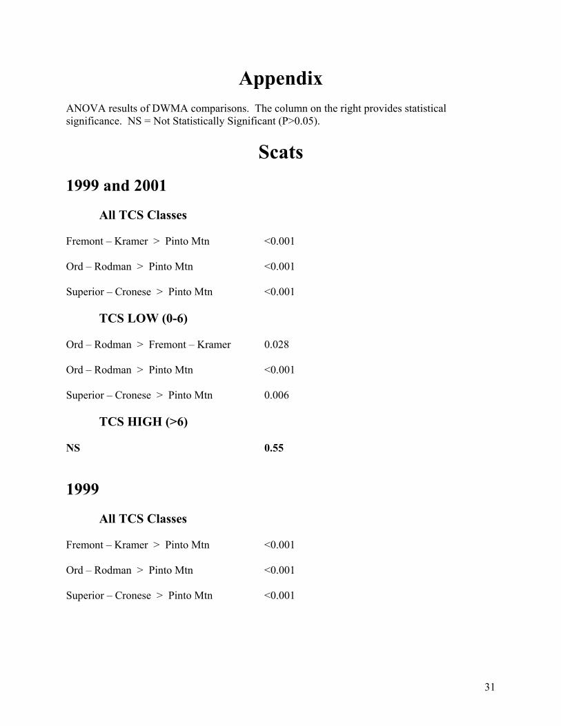
31
Appendix ANOVA results of DWMA comparisons. The column on the right provides statistical significance. NS = Not Statistically Significant (P>0.05).
Scats 1999 and 2001 All TCS Classes Fremont – Kramer > Pinto Mtn <0.001 Ord – Rodman > Pinto Mtn <0.001 Superior – Cronese > Pinto Mtn <0.001 TCS LOW (0-6) Ord – Rodman > Fremont – Kramer 0.028 Ord – Rodman > Pinto Mtn <0.001 Superior – Cronese > Pinto Mtn 0.006
TCS HIGH (>6) NS 0.55 1999 All TCS Classes Fremont – Kramer > Pinto Mtn <0.001 Ord – Rodman > Pinto Mtn <0.001 Superior – Cronese > Pinto Mtn <0.001
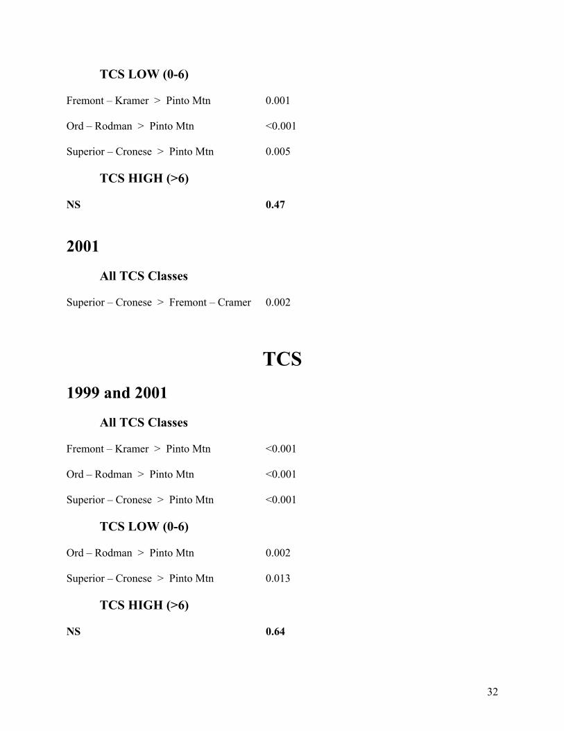
32
TCS LOW (0-6) Fremont – Kramer > Pinto Mtn 0.001 Ord – Rodman > Pinto Mtn <0.001 Superior – Cronese > Pinto Mtn 0.005 TCS HIGH (>6) NS 0.47 2001 All TCS Classes Superior – Cronese > Fremont – Cramer 0.002
TCS 1999 and 2001 All TCS Classes Fremont – Kramer > Pinto Mtn <0.001 Ord – Rodman > Pinto Mtn <0.001 Superior – Cronese > Pinto Mtn <0.001 TCS LOW (0-6) Ord – Rodman > Pinto Mtn 0.002 Superior – Cronese > Pinto Mtn 0.013
TCS HIGH (>6) NS 0.64
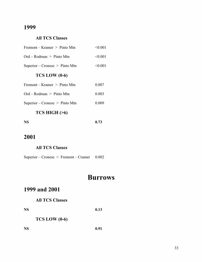
33
1999 All TCS Classes Fremont – Kramer > Pinto Mtn <0.001 Ord – Rodman > Pinto Mtn <0.001 Superior – Cronese > Pinto Mtn <0.001 TCS LOW (0-6) Fremont – Kramer > Pinto Mtn 0.007 Ord – Rodman > Pinto Mtn 0.003 Superior – Cronese > Pinto Mtn 0.009 TCS HIGH (>6) NS 0.73 2001 All TCS Classes Superior – Cronese > Fremont – Cramer 0.002
Burrows 1999 and 2001 All TCS Classes NS 0.13 TCS LOW (0-6) NS 0.91
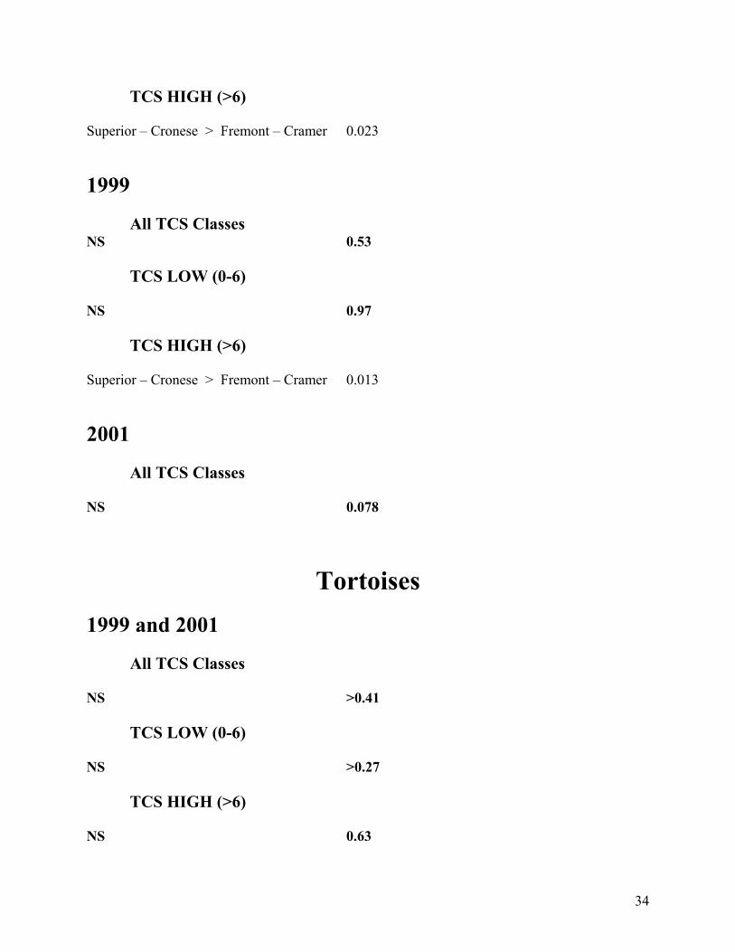
34
TCS HIGH (>6) Superior – Cronese > Fremont – Cramer 0.023 1999 All TCS Classes NS 0.53 TCS LOW (0-6) NS 0.97 TCS HIGH (>6) Superior – Cronese > Fremont – Cramer 0.013 2001 All TCS Classes NS 0.078
Tortoises 1999 and 2001 All TCS Classes NS >0.41 TCS LOW (0-6) NS >0.27
TCS HIGH (>6) NS 0.63
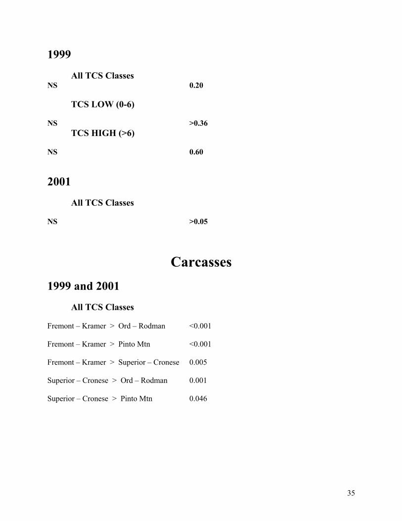
35
1999 All TCS Classes NS 0.20 TCS LOW (0-6) NS >0.36 TCS HIGH (>6) NS 0.60 2001 All TCS Classes NS >0.05
Carcasses 1999 and 2001 All TCS Classes Fremont – Kramer > Ord – Rodman <0.001 Fremont – Kramer > Pinto Mtn <0.001 Fremont – Kramer > Superior – Cronese 0.005 Superior – Cronese > Ord – Rodman 0.001 Superior – Cronese > Pinto Mtn 0.046
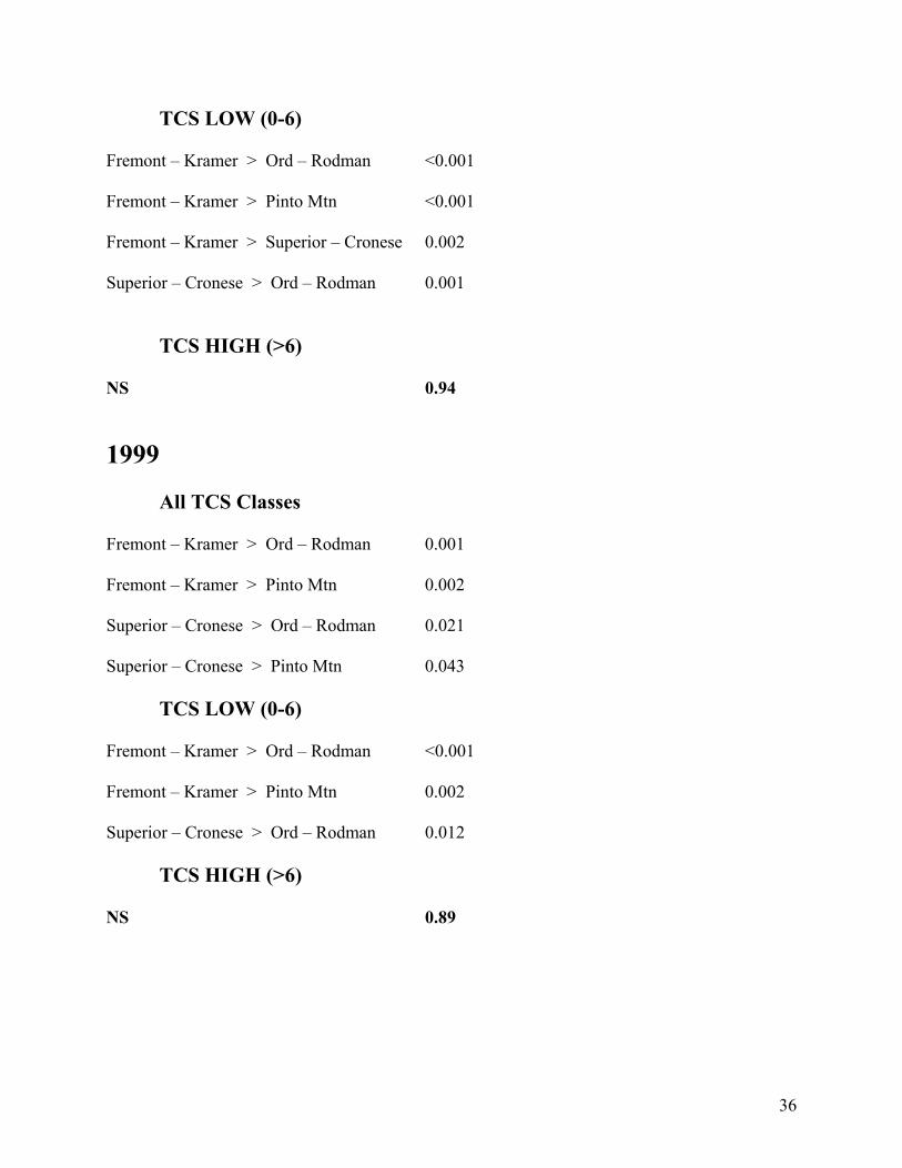
36
TCS LOW (0-6) Fremont – Kramer > Ord – Rodman <0.001 Fremont – Kramer > Pinto Mtn <0.001 Fremont – Kramer > Superior – Cronese 0.002 Superior – Cronese > Ord – Rodman 0.001
TCS HIGH (>6) NS 0.94 1999 All TCS Classes Fremont – Kramer > Ord – Rodman 0.001 Fremont – Kramer > Pinto Mtn 0.002 Superior – Cronese > Ord – Rodman 0.021 Superior – Cronese > Pinto Mtn 0.043 TCS LOW (0-6) Fremont – Kramer > Ord – Rodman <0.001 Fremont – Kramer > Pinto Mtn 0.002 Superior – Cronese > Ord – Rodman 0.012 TCS HIGH (>6) NS 0.89

37
2001 All TCS Classes Fremont – Kramer > Ord – Rodman <0.001 Fremont – Kramer > Superior - Cronese 0.021 Superior – Cronese > Ord – Rodman <0.001

Appendices

Appendices
APPENDIX L
MISCELLANEOUS TORTOISE
BACKGROUND DATA

Appendices
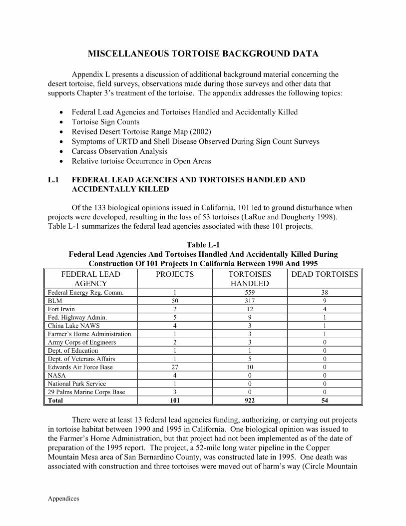
Appendices
MISCELLANEOUS TORTOISE BACKGROUND DATA Appendix L presents a discussion of additional background material concerning the desert tortoise, field surveys, observations made during those surveys and other data that supports Chapter 3’s treatment of the tortoise. The appendix addresses the following topics:
• Federal Lead Agencies and Tortoises Handled and Accidentally Killed • Tortoise Sign Counts • Revised Desert Tortoise Range Map (2002) • Symptoms of URTD and Shell Disease Observed During Sign Count Surveys • Carcass Observation Analysis • Relative tortoise Occurrence in Open Areas
L.1 FEDERAL LEAD AGENCIES AND TORTOISES HANDLED AND
ACCIDENTALLY KILLED
Of the 133 biological opinions issued in California, 101 led to ground disturbance when projects were developed, resulting in the loss of 53 tortoises (LaRue and Dougherty 1998). Table L-1 summarizes the federal lead agencies associated with these 101 projects.
Table L-1 Federal Lead Agencies And Tortoises Handled And Accidentally Killed During
Construction Of 101 Projects In California Between 1990 And 1995 FEDERAL LEAD
AGENCY PROJECTS TORTOISES
HANDLED DEAD TORTOISES
Federal Energy Reg. Comm. 1 559 38 BLM 50 317 9 Fort Irwin 2 12 4 Fed. Highway Admin. 5 9 1 China Lake NAWS 4 3 1 Farmer’s Home Administration 1 3 1 Army Corps of Engineers 2 3 0 Dept. of Education 1 1 0 Dept. of Veterans Affairs 1 5 0 Edwards Air Force Base 27 10 0 NASA 4 0 0 National Park Service 1 0 0 29 Palms Marine Corps Base 3 0 0 Total 101 922 54
There were at least 13 federal lead agencies funding, authorizing, or carrying out projects in tortoise habitat between 1990 and 1995 in California. One biological opinion was issued to the Farmer’s Home Administration, but that project had not been implemented as of the date of preparation of the 1995 report. The project, a 52-mile long water pipeline in the Copper Mountain Mesa area of San Bernardino County, was constructed late in 1995. One death was associated with construction and three tortoises were moved out of harm’s way (Circle Mountain
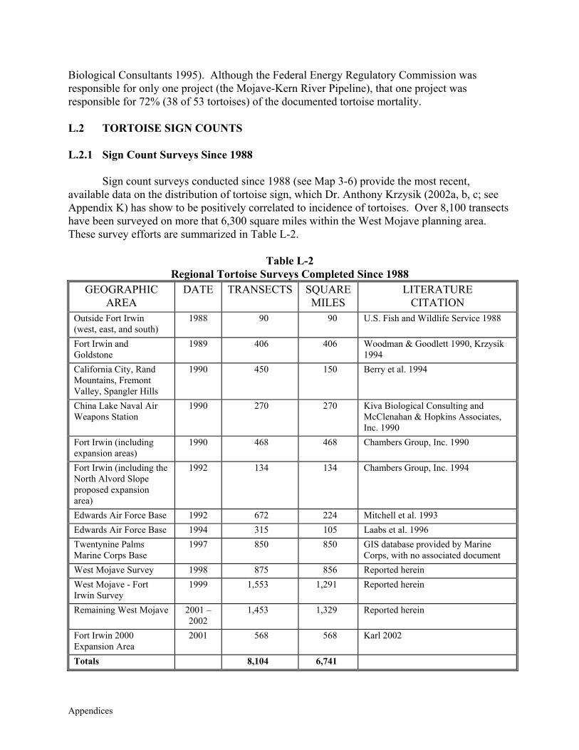
Appendices
Biological Consultants 1995). Although the Federal Energy Regulatory Commission was responsible for only one project (the Mojave-Kern River Pipeline), that one project was responsible for 72% (38 of 53 tortoises) of the documented tortoise mortality. L.2 TORTOISE SIGN COUNTS L.2.1 Sign Count Surveys Since 1988
Sign count surveys conducted since 1988 (see Map 3-6) provide the most recent, available data on the distribution of tortoise sign, which Dr. Anthony Krzysik (2002a, b, c; see Appendix K) has show to be positively correlated to incidence of tortoises. Over 8,100 transects have been surveyed on more that 6,300 square miles within the West Mojave planning area. These survey efforts are summarized in Table L-2.
Table L-2
Regional Tortoise Surveys Completed Since 1988 GEOGRAPHIC
AREA DATE TRANSECTS SQUARE
MILES LITERATURE
CITATION Outside Fort Irwin (west, east, and south)
1988 90 90 U.S. Fish and Wildlife Service 1988
Fort Irwin and Goldstone
1989 406 406 Woodman & Goodlett 1990, Krzysik 1994
California City, Rand Mountains, Fremont Valley, Spangler Hills
1990 450 150 Berry et al. 1994
China Lake Naval Air Weapons Station
1990 270 270 Kiva Biological Consulting and McClenahan & Hopkins Associates, Inc. 1990
Fort Irwin (including expansion areas)
1990 468 468 Chambers Group, Inc. 1990
Fort Irwin (including the North Alvord Slope proposed expansion area)
1992 134 134 Chambers Group, Inc. 1994
Edwards Air Force Base 1992 672 224 Mitchell et al. 1993 Edwards Air Force Base 1994 315 105 Laabs et al. 1996 Twentynine Palms Marine Corps Base
1997 850 850 GIS database provided by Marine Corps, with no associated document
West Mojave Survey 1998 875 856 Reported herein West Mojave - Fort Irwin Survey
1999 1,553 1,291 Reported herein
Remaining West Mojave 2001 – 2002
1,453 1,329 Reported herein
Fort Irwin 2000 Expansion Area
2001 568 568 Karl 2002
Totals 8,104 6,741
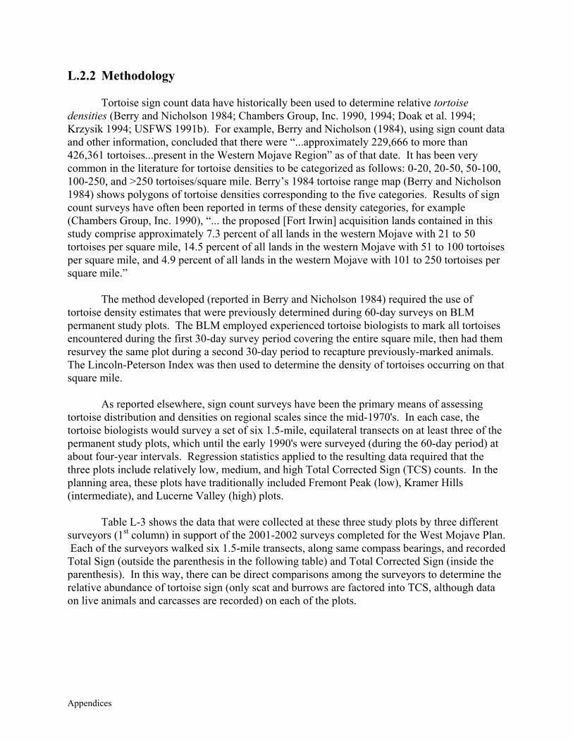
Appendices
L.2.2 Methodology
Tortoise sign count data have historically been used to determine relative tortoise densities (Berry and Nicholson 1984; Chambers Group, Inc. 1990, 1994; Doak et al. 1994; Krzysik 1994; USFWS 1991b). For example, Berry and Nicholson (1984), using sign count data and other information, concluded that there were “...approximately 229,666 to more than 426,361 tortoises...present in the Western Mojave Region” as of that date. It has been very common in the literature for tortoise densities to be categorized as follows: 0-20, 20-50, 50-100, 100-250, and >250 tortoises/square mile. Berry’s 1984 tortoise range map (Berry and Nicholson 1984) shows polygons of tortoise densities corresponding to the five categories. Results of sign count surveys have often been reported in terms of these density categories, for example (Chambers Group, Inc. 1990), “... the proposed [Fort Irwin] acquisition lands contained in this study comprise approximately 7.3 percent of all lands in the western Mojave with 21 to 50 tortoises per square mile, 14.5 percent of all lands in the western Mojave with 51 to 100 tortoises per square mile, and 4.9 percent of all lands in the western Mojave with 101 to 250 tortoises per square mile.”
The method developed (reported in Berry and Nicholson 1984) required the use of tortoise density estimates that were previously determined during 60-day surveys on BLM permanent study plots. The BLM employed experienced tortoise biologists to mark all tortoises encountered during the first 30-day survey period covering the entire square mile, then had them resurvey the same plot during a second 30-day period to recapture previously-marked animals. The Lincoln-Peterson Index was then used to determine the density of tortoises occurring on that square mile.
As reported elsewhere, sign count surveys have been the primary means of assessing tortoise distribution and densities on regional scales since the mid-1970's. In each case, the tortoise biologists would survey a set of six 1.5-mile, equilateral transects on at least three of the permanent study plots, which until the early 1990's were surveyed (during the 60-day period) at about four-year intervals. Regression statistics applied to the resulting data required that the three plots include relatively low, medium, and high Total Corrected Sign (TCS) counts. In the planning area, these plots have traditionally included Fremont Peak (low), Kramer Hills (intermediate), and Lucerne Valley (high) plots.
Table L-3 shows the data that were collected at these three study plots by three different surveyors (1st column) in support of the 2001-2002 surveys completed for the West Mojave Plan. Each of the surveyors walked six 1.5-mile transects, along same compass bearings, and recorded Total Sign (outside the parenthesis in the following table) and Total Corrected Sign (inside the parenthesis). In this way, there can be direct comparisons among the surveyors to determine the relative abundance of tortoise sign (only scat and burrows are factored into TCS, although data on live animals and carcasses are recorded) on each of the plots.
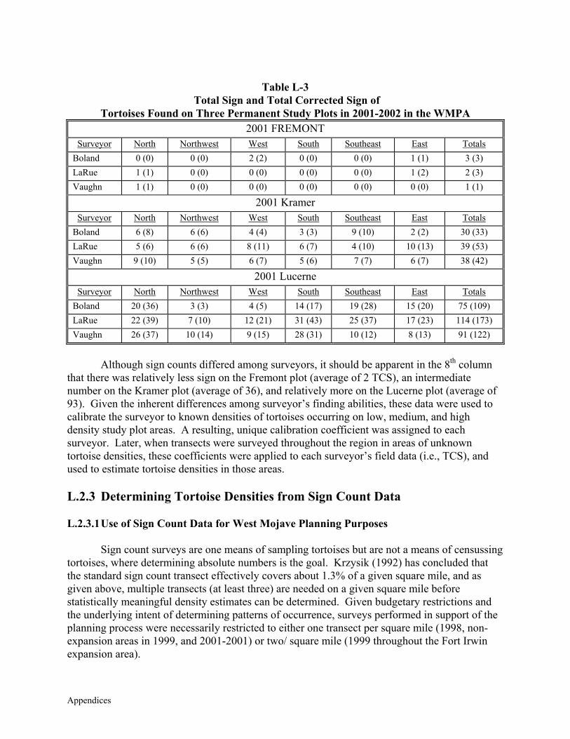
Appendices
Table L-3
Total Sign and Total Corrected Sign of Tortoises Found on Three Permanent Study Plots in 2001-2002 in the WMPA
2001 FREMONT Surveyor North Northwest West South Southeast East Totals
Boland 0 (0) 0 (0) 2 (2) 0 (0) 0 (0) 1 (1) 3 (3) LaRue 1 (1) 0 (0) 0 (0) 0 (0) 0 (0) 1 (2) 2 (3) Vaughn 1 (1) 0 (0) 0 (0) 0 (0) 0 (0) 0 (0) 1 (1)
2001 Kramer Surveyor North Northwest West South Southeast East Totals
Boland 6 (8) 6 (6) 4 (4) 3 (3) 9 (10) 2 (2) 30 (33) LaRue 5 (6) 6 (6) 8 (11) 6 (7) 4 (10) 10 (13) 39 (53) Vaughn 9 (10) 5 (5) 6 (7) 5 (6) 7 (7) 6 (7) 38 (42)
2001 Lucerne Surveyor North Northwest West South Southeast East Totals
Boland 20 (36) 3 (3) 4 (5) 14 (17) 19 (28) 15 (20) 75 (109) LaRue 22 (39) 7 (10) 12 (21) 31 (43) 25 (37) 17 (23) 114 (173) Vaughn 26 (37) 10 (14) 9 (15) 28 (31) 10 (12) 8 (13) 91 (122)
Although sign counts differed among surveyors, it should be apparent in the 8th column
that there was relatively less sign on the Fremont plot (average of 2 TCS), an intermediate number on the Kramer plot (average of 36), and relatively more on the Lucerne plot (average of 93). Given the inherent differences among surveyor’s finding abilities, these data were used to calibrate the surveyor to known densities of tortoises occurring on low, medium, and high density study plot areas. A resulting, unique calibration coefficient was assigned to each surveyor. Later, when transects were surveyed throughout the region in areas of unknown tortoise densities, these coefficients were applied to each surveyor’s field data (i.e., TCS), and used to estimate tortoise densities in those areas. L.2.3 Determining Tortoise Densities from Sign Count Data L.2.3.1 Use of Sign Count Data for West Mojave Planning Purposes
Sign count surveys are one means of sampling tortoises but are not a means of censussing tortoises, where determining absolute numbers is the goal. Krzysik (1992) has concluded that the standard sign count transect effectively covers about 1.3% of a given square mile, and as given above, multiple transects (at least three) are needed on a given square mile before statistically meaningful density estimates can be determined. Given budgetary restrictions and the underlying intent of determining patterns of occurrence, surveys performed in support of the planning process were necessarily restricted to either one transect per square mile (1998, non-expansion areas in 1999, and 2001-2001) or two/ square mile (1999 throughout the Fort Irwin expansion area).
Appendices
The planning team decided, early on, to avoid using sign count data from these surveys to
estimate tortoise densities. Instead, the data have been used to depict relative “patterns of occurrence” for tortoises throughout the planning area (West Mojave Plan Team 1999). Similarly, above-average and below-average sign counts have been used as relative measures of tortoise occurrence when deciding where protective measures are most effectively applied. Such an approach avoids valid criticisms associated with estimating tortoise densities, but does not provide a clear, understandable means of determining the relationship between higher versus lower sign counts and tortoise occurrence.
There is support in the literature for using the approach adopted by the planning team: “data are more valuable for determining the geographic distribution of tortoises” (National Ecology Research Center 1990); and, “It is important to obtain many positive and negative locality records because they best describe a species’ patterns of occurrence or absence: areas with high frequency of records may indicate preferred habitats and corridors between populations, and areas with an absence of tortoises may be unsuitable habitat or barriers to gene flow...Although total sign on transects is used to estimate the density of tortoises..., we mostly used these data to document the presence or absence of tortoises” (Bury et al. 1994). Finally, Krzysik (1996) wrote that although “...the use of surrogate measures to assess or monitor wildlife populations has universally been criticized on issues of relevancy, accuracy, or precision ... statistical modeling revealed that both burrow and scat counts were strongly positively correlated with the occurrence of tortoises on survey transects.” L.2.3.2 2002 Analyses of 1998 Through 2002 Sign Count Data
Dr. Anthony Krzysik is a statistician who has worked with tortoise sign count data since 1983 (Woodman et al. 1984), and has recently performed comparative analyses among different tortoise survey techniques for the USFWS. During 2002, he was contracted by the planning team to help analyze sign count data collected since 1998. He has provided three summary reports outlining his preliminary findings. In the second report, Krzysik’s emphasis (bold font) is maintained to show the points that he originally emphasized. The major findings of these three reports are given below; the reports are reprinted in their entirety in Appendix K. Krzysik, A. J. 1 May 2002. Statistical Analysis of BLM Desert Tortoise Surveys In Support of the West Mojave Management Plan: Report I: Exploratory and Initial Data Analysis (1998, 1999, and 2001 Calibration Data).
• Despite the acknowledged difficulty of observing live desert tortoises on survey transects, and the very high variability of tortoise sign (burrows and scats) among transects, there was a highly significant correlation (P<0.01) of live tortoises with burrows, scats, and TCS. Although in most cases the actual correlation coefficient does not appear to be particularly high, the large sample sizes involved make the relationship highly statistically significant. These results can be interpreted in the following general ways: (a) Transects associated with live tortoises are typically also associated with appreciable sign counts; and (b) Live tortoises are found to a much smaller extent on transects possessing little or no tortoise sign.
Appendices
• A number of important patterns were evident from the correlation analyses: (a) The
correlation analysis results were similar for all three data sets that were examined (i.e., Calibration Areas, 1998+1999+2001, 1998 tortoise survey areas, and 1999 tortoise survey areas), again possibly attributable to the high sample sizes; (b) Burrows had the highest correlation with tortoises, while scats had the lowest correlation; (c) Tortoises were not correlated with carcasses; (d) With a few exceptions, carcasses were not correlated with tortoise sign; and (e) As expected, TCS was strongly correlated with scat, because on a given transect, scat counts are usually much higher than burrow counts.
• The result of this analysis [Step-Wise Linear Regression Model] clearly demonstrated
that burrow counts were the only predictor variable necessary to explain the variability of tortoises on transects. Statistically, scats and TCS did not contribute significant information to the regression.
• Desert tortoises should be closely associated with their sign (i.e., burrows and scats).
Based on their dedication to small home ranges, and because tortoises spend a major portion of their lives in burrows, particularly in drought years and bad weather (Duda and Krzysik 1998), it is intuitive that tortoise sign represents a surrogate for actual live tortoises.
Krzysik, A. J. 19 June 2002. Statistical Analysis of BLM Desert Tortoise Surveys In Support of the West Mojave Management Plan, Report II: Statistical Comparison of DWMAs (1999 & 2001).
• Despite the acknowledged difficulty of observing live desert tortoises on survey transects, and the very high variability of tortoise sign (burrows and scats) among transects, there was a highly significant correlation (P<0.01) of live tortoises with burrows, scats, and TCS for the total DWMA data set and in each of the two years [1998 and 1999].
• However, when the data were classified by the abundance of TCS, the results of the
correlation analysis became interesting. On transects with high (>6) TCS, only burrows were significantly correlated with live tortoises. When the TCS counts were further delineated into five classes, burrows consistently for all five classes were significantly correlated with tortoise counts, while scat counts and TCS were inconsistent and unreliable.
• Scat counts were very unreliable, and even demonstrated NEGATIVE significant
correlations with tortoises with TCS classes of 2-3 and 7-9. These results are very critical and interesting, because the majority of transects in any tortoise survey data set contain low sign counts, and high sample sizes may mask interesting details among gradients of sign densities.
• Carcass counts were not correlated with transect live tortoise counts. A priori, everything
Appendices
else being equal, one would expect that DWMAs with higher tortoises densities would also possess higher carcass densities (a significant positive correlation), assuming mortality rates are similar. DWMAs that suffered higher tortoise mortality should show a negative correlation between live tortoises and carcasses. The carcass data suggest that BOTH tortoise densities and tortoise mortality rates are similar in the four DWMAs analyzed.
• The result of this analysis [Stepwise Linear Regression Model] clearly demonstrated that
burrow counts were the only predictor variable necessary to explain the variability of tortoises on transects. Statistically, scats and TCS did not contribute significant information to the regression. As in the correlation analysis, Stepwise Linear Regression reinforces the validity in using burrow counts as a surrogate for tortoise counts.
• The data presented here and other evidence suggest that tortoise burrows appear to be a
better surrogate for comparisons of tortoise distribution and relative abundance patterns than either scats or TCS.
• Burrow counts (densities) were similar in all DWMAs and for both 1999 and 2001.
Interestingly, when only high (>6) TCS transects were analyzed, Superior - Cronese had higher burrow counts than Fremont - Kramer. Pinto Mountain did not have any high TCS transects.
• Pinto Mountain had lower scat counts than the other DWMAs in 1999, and when
considering only Low TCS transects. Pinto Mountain was not represented in 2001 nor in high TCS transects. In 2001, Superior - Cronese had higher scat counts than Fremont - Kramer. However, when high TCS transects were analyzed, all DWMAs had similar scat counts.
• Live tortoise counts were similar at all DWMAs, for both 1999 and 2001, and for both
low and high TCS transects. However, statistical interpretation can be quite tenuous, because of the high variability and low sample sizes associated with finding tortoises on survey transects.
• Carcass counts were highest at Fremont - Kramer and Superior - Cronese. Depending on
the specific comparisons, these two DWMAs were either similar or the former had higher carcass counts than the latter. Ord - Rodman and Pinto Mountain had lower carcass counts than the two above DWMAs, and they were similar to each other.
• Based on the available data and sample sizes, the four DWMAs appear to be similar to
one another in their tortoise and sign counts, and therefore, of similar value as desert tortoise conservation areas. Although there were some statistical differences with specific comparisons of scat and carcass counts, these parameters may not be important in elucidating actual tortoise densities.
• An interesting outcome of the ANOVA analyses was that burrow counts (i.e., densities)
Appendices
were higher at Superior - Cronese than at Fremont - Kramer for the high TCS transects. This suggests that either Superior - Cronese tortoises possess a higher burrow/tortoise ratio, or tortoises are more abundant at this DWMA.
Of the many conclusions given above, for this discussion, Krzysik’s findings that tortoise
sign counts are a relatively good estimator of tortoise abundance is considered sufficient evidence to (a) continue to use above-average sign counts as an indicator of relatively high tortoise abundance and (b) the data are useful in determining relative tortoise occurrence, even though they are not being used as a means to estimate tortoise densities. L.3 REVISED DESERT TORTOISE RANGE MAP
Survey data were used to produce an updated range map of current tortoise distribution (See Map 3-9). The 1984 range map identified approximately 11,255 mi2 (7,203,107 acres) of tortoise habitat, whereas 11,134 mi2 (7,125,842 acres) are identified in the 2002 Tortoise Range Map, which represents a reduction of about 121 mi2. Each of these figures over-estimates occupied tortoise habitat, as dry lake playas, elevations above about 4,500 feet, and other marginal or unsuitable habitats are included within both range lines. They do not imply anything about the relative densities occurring in the older and more recent ranges. Map 3-9 depicts three regions within the 2002 tortoise range: reduction areas, expansion areas, and areas requiring more surveys.
Map 3-9 depicts three regions within the 2002 tortoise range: reduction areas, expansion
areas, and areas requiring more surveys. The range reduction areas occur to the south and southwest, where presence-absence data suggest tortoises have been extirpated from about 1,092 mi2 between Lucerne Valley and the Antelope Valley. Not all extirpations are recent. There are no available data to suggest that the southern and western portions of Antelope Valley supported tortoises when they were included in the 1984 range map. However, 1995 aerial photography clearly shows that most of the area is active or fallow agriculture, and therefore not suitable habitat. This does not represent a range reduction since 1984, but does provide a relatively accurate picture of historically occupied habitats that are no longer occupied.
The range expansion area is primarily to the north on Fort Irwin, China Lake, and on
BLM-managed lands to the west and northwest. These are not new regions that have become occupied since 1984; they were likely occupied then as well. Data collected in the 1970’s, 1988 on China Lake, and in 1999 up to Rose Valley along Highway 395 clearly show that some evidence of tortoise has been found north of the 1984 range line. In 2002, tortoise biologists (i.e., Peter Woodman, Dave Silverman, and Denise LaBerteaux) and land managers (i.e., Mickey Quillman of Fort Irwin, Tom Campbell of China Lake, and Bob Parker of Ridgecrest, BLM) were shown maps with available sign count data, 1984 range line, 20% slopes, and various other GIS coverages. Each provided comments that helped LaRue refine the northern boundary.
The areas needing more survey occur north of Rose Valley in Inyo County, north of Highway 138 in the Antelope Valley of Kern County, and in the vicinity of Pioneertown, north-northwest of Yucca Valley in San Bernardino County. As the name implies, there is some potential for tortoises to occur in these areas, but more focused surveys are needed before a relatively accurate range line can be delineated.
Appendices
Alternative A’s No Survey Areas within the 2002 range line are recently or historically
occupied areas that apparently no longer support tortoises, based on the best available data. Presence-absence survey data, digitized structures from 1995 aerials, and personal knowledge (LaRue, pers. comm.) were the primary sources of information used to delineate these areas, particularly to the south. Agricultural fields were excluded, which affected substantial regions around Barstow, Hinkley, and the region bounded by Interstates 15 and 40, east to Troy Dry Lake. Non-vegetated portions of playas, delineated from 1995 aerial photography, are included in this designation.
Alternative A’s Survey Areas occur both inside and outside proposed DWMAs. In most
cases, sign count data were used inside DWMAs and other regions (i.e., BLM open areas, public lands in the ITA, etc.), and presence-absence data were used for urbanizing areas and less developed regions in all four counties. Areas needing more survey are included, but there is no evidence that tortoises occur. Otherwise, there is an assumption that tortoises may be found throughout designated Survey Areas. L.4 SYMPTOMS OF URTD AND SHELL DISEASE OBSERVED DURING SIGN
COUNT SURVEYS
During sign count surveys in the fall and winter of 1998 through 2002, disease symptoms were observed in 7 of the 275 (2.5%) tortoises inspected. During distance sampling surveys in the spring of 2001 and 2002 in the Fremont-Kramer and Superior-Cronese DWMAs, 6 of the 216 (2.8%) tortoises inspected showed clinical evidence of disease. These very similar, independently derived results (i.e., 2.5% versus 2.8% of the tortoises observed) are summarized in Table L-4.
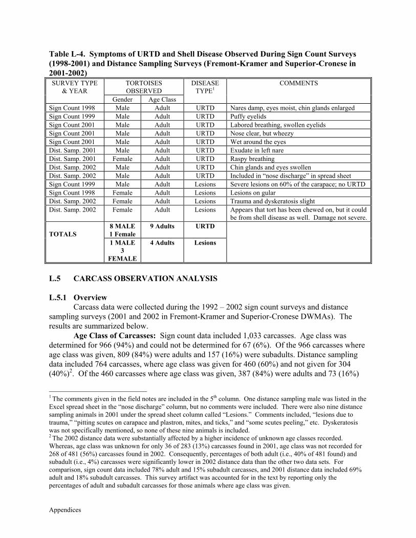
Appendices
Table L-4. Symptoms of URTD and Shell Disease Observed During Sign Count Surveys (1998-2001) and Distance Sampling Surveys (Fremont-Kramer and Superior-Cronese in 2001-2002)
TORTOISES OBSERVED
SURVEY TYPE & YEAR
Gender Age Class
DISEASE TYPE1
COMMENTS
Sign Count 1998 Male Adult URTD Nares damp, eyes moist, chin glands enlarged Sign Count 1999 Male Adult URTD Puffy eyelids Sign Count 2001 Male Adult URTD Labored breathing, swollen eyelids Sign Count 2001 Male Adult URTD Nose clear, but wheezy Sign Count 2001 Male Adult URTD Wet around the eyes Dist. Samp. 2001 Male Adult URTD Exudate in left nare Dist. Samp. 2001 Female Adult URTD Raspy breathing Dist. Samp. 2002 Male Adult URTD Chin glands and eyes swollen Dist. Samp. 2002 Male Adult URTD Included in “nose discharge” in spread sheet Sign Count 1999 Male Adult Lesions Severe lesions on 60% of the carapace; no URTD Sign Count 1998 Female Adult Lesions Lesions on gular Dist. Samp. 2002 Female Adult Lesions Trauma and dyskeratosis slight Dist. Samp. 2002 Female Adult Lesions Appears that tort has been chewed on, but it could
be from shell disease as well. Damage not severe. 8 MALE 1 Female
9 Adults URTD TOTALS
1 MALE 3
FEMALE
4 Adults Lesions
L.5 CARCASS OBSERVATION ANALYSIS L.5.1 Overview
Carcass data were collected during the 1992 – 2002 sign count surveys and distance sampling surveys (2001 and 2002 in Fremont-Kramer and Superior-Cronese DWMAs). The results are summarized below.
Age Class of Carcasses: Sign count data included 1,033 carcasses. Age class was determined for 966 (94%) and could not be determined for 67 (6%). Of the 966 carcasses where age class was given, 809 (84%) were adults and 157 (16%) were subadults. Distance sampling data included 764 carcasses, where age class was given for 460 (60%) and not given for 304 (40%)2. Of the 460 carcasses where age class was given, 387 (84%) were adults and 73 (16%)
1 The comments given in the field notes are included in the 5th column. One distance sampling male was listed in the Excel spread sheet in the “nose discharge” column, but no comments were included. There were also nine distance sampling animals in 2001 under the spread sheet column called “Lesions.” Comments included, “lesions due to trauma,” “pitting scutes on carapace and plastron, mites, and ticks,” and “some scutes peeling,” etc. Dyskeratosis was not specifically mentioned, so none of these nine animals is included. 2 The 2002 distance data were substantially affected by a higher incidence of unknown age classes recorded. Whereas, age class was unknown for only 36 of 283 (13%) carcasses found in 2001, age class was not recorded for 268 of 481 (56%) carcasses found in 2002. Consequently, percentages of both adult (i.e., 40% of 481 found) and subadult (i.e., 4%) carcasses were significantly lower in 2002 distance data than the other two data sets. For comparison, sign count data included 78% adult and 15% subadult carcasses, and 2001 distance data included 69% adult and 18% subadult carcasses. This survey artifact was accounted for in the text by reporting only the percentages of adult and subadult carcasses for those animals where age class was given.
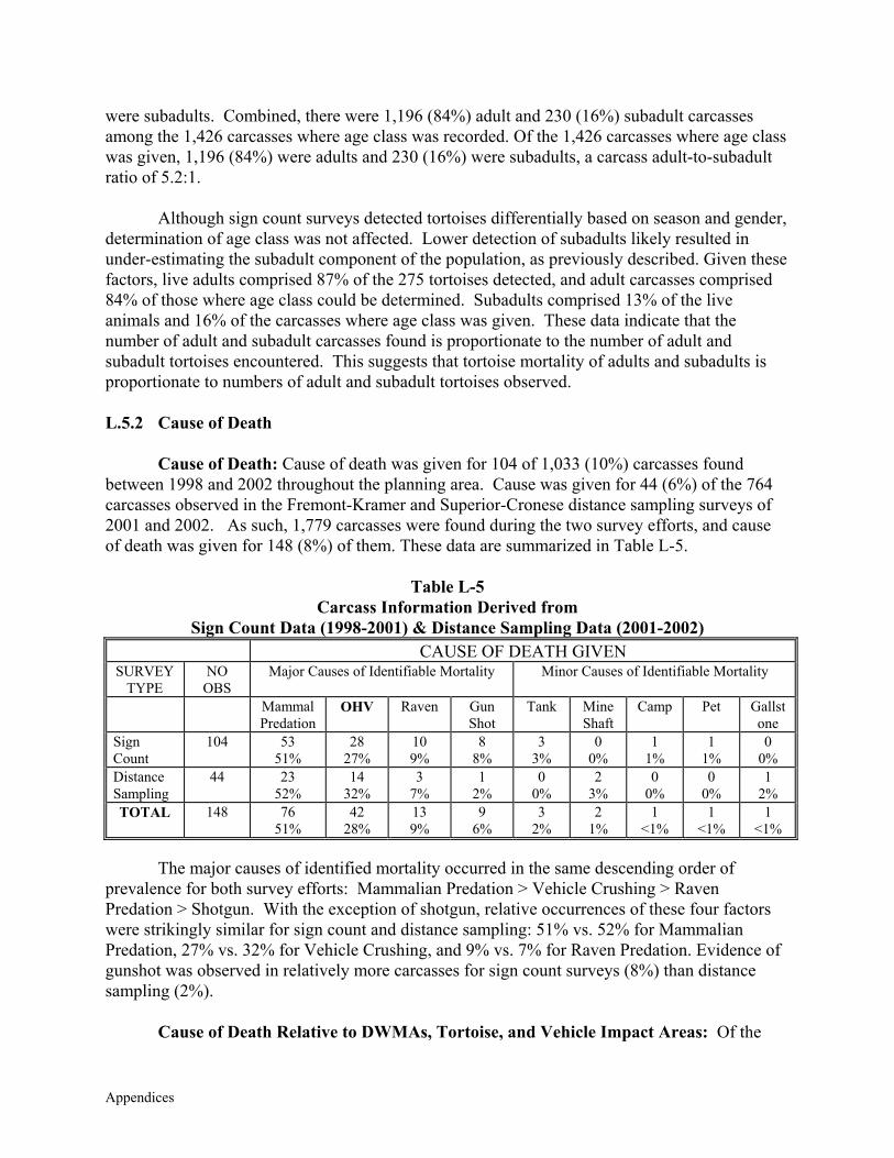
Appendices
were subadults. Combined, there were 1,196 (84%) adult and 230 (16%) subadult carcasses among the 1,426 carcasses where age class was recorded. Of the 1,426 carcasses where age class was given, 1,196 (84%) were adults and 230 (16%) were subadults, a carcass adult-to-subadult ratio of 5.2:1. Although sign count surveys detected tortoises differentially based on season and gender, determination of age class was not affected. Lower detection of subadults likely resulted in under-estimating the subadult component of the population, as previously described. Given these factors, live adults comprised 87% of the 275 tortoises detected, and adult carcasses comprised 84% of those where age class could be determined. Subadults comprised 13% of the live animals and 16% of the carcasses where age class was given. These data indicate that the number of adult and subadult carcasses found is proportionate to the number of adult and subadult tortoises encountered. This suggests that tortoise mortality of adults and subadults is proportionate to numbers of adult and subadult tortoises observed. L.5.2 Cause of Death
Cause of Death: Cause of death was given for 104 of 1,033 (10%) carcasses found between 1998 and 2002 throughout the planning area. Cause was given for 44 (6%) of the 764 carcasses observed in the Fremont-Kramer and Superior-Cronese distance sampling surveys of 2001 and 2002. As such, 1,779 carcasses were found during the two survey efforts, and cause of death was given for 148 (8%) of them. These data are summarized in Table L-5.
Table L-5 Carcass Information Derived from
Sign Count Data (1998-2001) & Distance Sampling Data (2001-2002) CAUSE OF DEATH GIVEN
SURVEY TYPE
NO OBS
Major Causes of Identifiable Mortality Minor Causes of Identifiable Mortality
Mammal Predation
OHV Raven Gun Shot
Tank Mine Shaft
Camp Pet Gallstone
Sign Count
104 53 51%
28 27%
10 9%
8 8%
3 3%
0 0%
1 1%
1 1%
0 0%
Distance Sampling
44 23 52%
14 32%
3 7%
1 2%
0 0%
2 3%
0 0%
0 0%
1 2%
TOTAL 148 76 51%
42 28%
13 9%
9 6%
3 2%
2 1%
1 <1%
1 <1%
1 <1%
The major causes of identified mortality occurred in the same descending order of
prevalence for both survey efforts: Mammalian Predation > Vehicle Crushing > Raven Predation > Shotgun. With the exception of shotgun, relative occurrences of these four factors were strikingly similar for sign count and distance sampling: 51% vs. 52% for Mammalian Predation, 27% vs. 32% for Vehicle Crushing, and 9% vs. 7% for Raven Predation. Evidence of gunshot was observed in relatively more carcasses for sign count surveys (8%) than distance sampling (2%).
Cause of Death Relative to DWMAs, Tortoise, and Vehicle Impact Areas: Of the
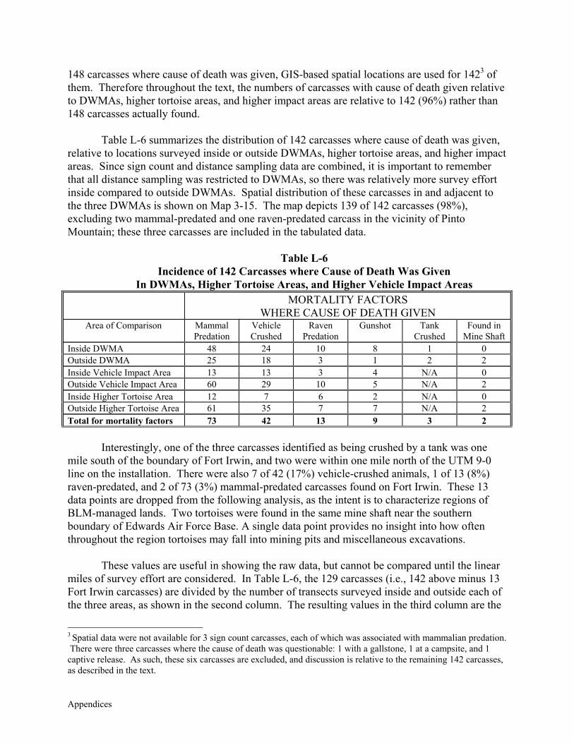
Appendices
148 carcasses where cause of death was given, GIS-based spatial locations are used for 1423 of them. Therefore throughout the text, the numbers of carcasses with cause of death given relative to DWMAs, higher tortoise areas, and higher impact areas are relative to 142 (96%) rather than 148 carcasses actually found.
Table L-6 summarizes the distribution of 142 carcasses where cause of death was given,
relative to locations surveyed inside or outside DWMAs, higher tortoise areas, and higher impact areas. Since sign count and distance sampling data are combined, it is important to remember that all distance sampling was restricted to DWMAs, so there was relatively more survey effort inside compared to outside DWMAs. Spatial distribution of these carcasses in and adjacent to the three DWMAs is shown on Map 3-15. The map depicts 139 of 142 carcasses (98%), excluding two mammal-predated and one raven-predated carcass in the vicinity of Pinto Mountain; these three carcasses are included in the tabulated data.
Table L-6
Incidence of 142 Carcasses where Cause of Death Was Given In DWMAs, Higher Tortoise Areas, and Higher Vehicle Impact Areas
MORTALITY FACTORS WHERE CAUSE OF DEATH GIVEN
Area of Comparison Mammal Predation
Vehicle Crushed
Raven Predation
Gunshot
Tank Crushed
Found in Mine Shaft
Inside DWMA 48 24 10 8 1 0 Outside DWMA 25 18 3 1 2 2 Inside Vehicle Impact Area 13 13 3 4 N/A 0 Outside Vehicle Impact Area 60 29 10 5 N/A 2 Inside Higher Tortoise Area 12 7 6 2 N/A 0 Outside Higher Tortoise Area 61 35 7 7 N/A 2 Total for mortality factors 73 42 13 9 3 2
Interestingly, one of the three carcasses identified as being crushed by a tank was one
mile south of the boundary of Fort Irwin, and two were within one mile north of the UTM 9-0 line on the installation. There were also 7 of 42 (17%) vehicle-crushed animals, 1 of 13 (8%) raven-predated, and 2 of 73 (3%) mammal-predated carcasses found on Fort Irwin. These 13 data points are dropped from the following analysis, as the intent is to characterize regions of BLM-managed lands. Two tortoises were found in the same mine shaft near the southern boundary of Edwards Air Force Base. A single data point provides no insight into how often throughout the region tortoises may fall into mining pits and miscellaneous excavations.
These values are useful in showing the raw data, but cannot be compared until the linear
miles of survey effort are considered. In Table L-6, the 129 carcasses (i.e., 142 above minus 13 Fort Irwin carcasses) are divided by the number of transects surveyed inside and outside each of the three areas, as shown in the second column. The resulting values in the third column are the
3 Spatial data were not available for 3 sign count carcasses, each of which was associated with mammalian predation. There were three carcasses where the cause of death was questionable: 1 with a gallstone, 1 at a campsite, and 1 captive release. As such, these six carcasses are excluded, and discussion is relative to the remaining 142 carcasses, as described in the text.
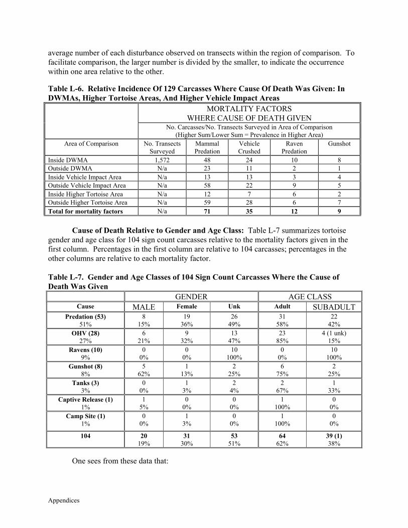
Appendices
average number of each disturbance observed on transects within the region of comparison. To facilitate comparison, the larger number is divided by the smaller, to indicate the occurrence within one area relative to the other.
Table L-6. Relative Incidence Of 129 Carcasses Where Cause Of Death Was Given: In DWMAs, Higher Tortoise Areas, And Higher Vehicle Impact Areas
MORTALITY FACTORS WHERE CAUSE OF DEATH GIVEN
No. Carcasses/No. Transects Surveyed in Area of Comparison (Higher Sum/Lower Sum = Prevalence in Higher Area)
Area of Comparison No. Transects Surveyed
Mammal Predation
Vehicle Crushed
Raven Predation
Gunshot
Inside DWMA 1,572 48 24 10 8 Outside DWMA N/a 23 11 2 1 Inside Vehicle Impact Area N/a 13 13 3 4 Outside Vehicle Impact Area N/a 58 22 9 5 Inside Higher Tortoise Area N/a 12 7 6 2 Outside Higher Tortoise Area N/a 59 28 6 7 Total for mortality factors N/a 71 35 12 9
Cause of Death Relative to Gender and Age Class: Table L-7 summarizes tortoise gender and age class for 104 sign count carcasses relative to the mortality factors given in the first column. Percentages in the first column are relative to 104 carcasses; percentages in the other columns are relative to each mortality factor.
Table L-7. Gender and Age Classes of 104 Sign Count Carcasses Where the Cause of Death Was Given
GENDER AGE CLASS Cause MALE Female Unk Adult SUBADULT
Predation (53) 51%
8 15%
19 36%
26 49%
31 58%
22 42%
OHV (28) 27%
6 21%
9 32%
13 47%
23 85%
4 (1 unk) 15%
Ravens (10) 9%
0 0%
0 0%
10 100%
0 0%
10 100%
Gunshot (8) 8%
5 62%
1 13%
2 25%
6 75%
2 25%
Tanks (3) 3%
0 0%
1 3%
2 4%
2 67%
1 33%
Captive Release (1) 1%
1 5%
0 0%
0 0%
1 100%
0 0%
Camp Site (1) 1%
0 0%
1 3%
0 0%
1 100%
0 0%
104 20 19%
31 30%
53 51%
64 62%
39 (1) 38%
One sees from these data that:
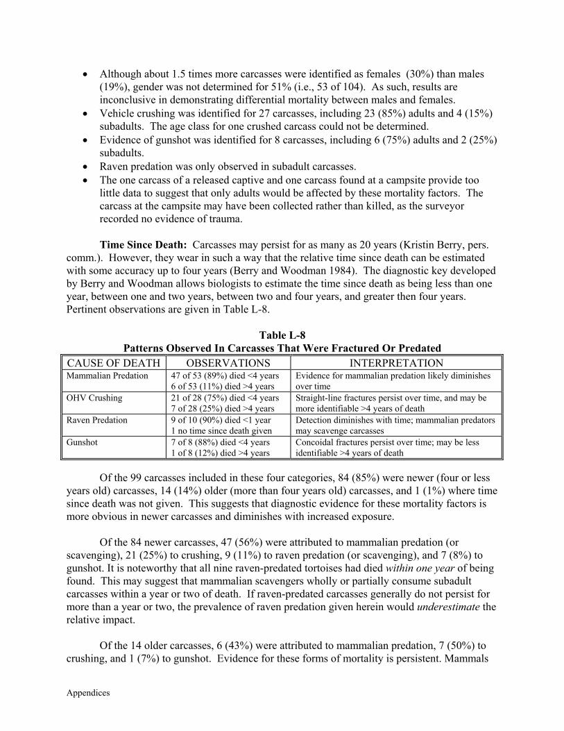
Appendices
• Although about 1.5 times more carcasses were identified as females (30%) than males (19%), gender was not determined for 51% (i.e., 53 of 104). As such, results are inconclusive in demonstrating differential mortality between males and females.
• Vehicle crushing was identified for 27 carcasses, including 23 (85%) adults and 4 (15%) subadults. The age class for one crushed carcass could not be determined.
• Evidence of gunshot was identified for 8 carcasses, including 6 (75%) adults and 2 (25%) subadults.
• Raven predation was only observed in subadult carcasses. • The one carcass of a released captive and one carcass found at a campsite provide too
little data to suggest that only adults would be affected by these mortality factors. The carcass at the campsite may have been collected rather than killed, as the surveyor recorded no evidence of trauma.
Time Since Death: Carcasses may persist for as many as 20 years (Kristin Berry, pers.
comm.). However, they wear in such a way that the relative time since death can be estimated with some accuracy up to four years (Berry and Woodman 1984). The diagnostic key developed by Berry and Woodman allows biologists to estimate the time since death as being less than one year, between one and two years, between two and four years, and greater then four years. Pertinent observations are given in Table L-8.
Table L-8
Patterns Observed In Carcasses That Were Fractured Or Predated CAUSE OF DEATH OBSERVATIONS INTERPRETATION Mammalian Predation 47 of 53 (89%) died <4 years
6 of 53 (11%) died >4 years Evidence for mammalian predation likely diminishes over time
OHV Crushing 21 of 28 (75%) died <4 years 7 of 28 (25%) died >4 years
Straight-line fractures persist over time, and may be more identifiable >4 years of death
Raven Predation 9 of 10 (90%) died <1 year 1 no time since death given
Detection diminishes with time; mammalian predators may scavenge carcasses
Gunshot 7 of 8 (88%) died <4 years 1 of 8 (12%) died >4 years
Concoidal fractures persist over time; may be less identifiable >4 years of death
Of the 99 carcasses included in these four categories, 84 (85%) were newer (four or less
years old) carcasses, 14 (14%) older (more than four years old) carcasses, and 1 (1%) where time since death was not given. This suggests that diagnostic evidence for these mortality factors is more obvious in newer carcasses and diminishes with increased exposure.
Of the 84 newer carcasses, 47 (56%) were attributed to mammalian predation (or
scavenging), 21 (25%) to crushing, 9 (11%) to raven predation (or scavenging), and 7 (8%) to gunshot. It is noteworthy that all nine raven-predated tortoises had died within one year of being found. This may suggest that mammalian scavengers wholly or partially consume subadult carcasses within a year or two of death. If raven-predated carcasses generally do not persist for more than a year or two, the prevalence of raven predation given herein would underestimate the relative impact.
Of the 14 older carcasses, 6 (43%) were attributed to mammalian predation, 7 (50%) to
crushing, and 1 (7%) to gunshot. Evidence for these forms of mortality is persistent. Mammals
Appendices
often leave chew marks on the carcasses, or if freshly eaten, footprints may be seen in the soil around the carcass.
Both vehicle crushing and gunshot wounds result in shell fractures. Such fractures are
the most persistent, although they would not be observable on extremely old carcasses, which may resemble a pile of chalk. This persistence is suggested by the relatively high percentage of older carcasses that were crushed (25%) compared to other categories (i.e., gunshot was next highest at 12%). However, between the two, concoidal gunshot fractures are much more difficult to see than are straight-line fractures associated with crushing.
Limitations Interpreting Carcass Data: One must be very careful interpreting and reporting these data for the following reasons. Primarily, the cause of death was not given for 1,636 carcasses, or about 92% of the 1,797 carcasses found. It is important that identified mortality factors are only relative to a small proportion of carcasses observed during each survey effort. Cause of death was given for 10% of the sign count carcasses, 6% of the distance sampling carcasses, and only 8% of carcasses observed during both survey efforts. One correct conclusion would be, “27% of identified tortoise mortality [i.e., 148 of 1,797 (8%) carcasses found] was attributed to vehicle crushing;” it would be incorrect and misleading to conclude,“27% of tortoise mortality was attributed to vehicle crushing.”
Limitations Interpreting Mammalian Predation: The relative occurrence of
mammalian predation reflected in these data is likely overestimated for the following reasons. Carcasses were mostly identified as being predated, rather than scavenged. Evidence such as teeth marks on marginal scutes, chewed-off gular horns, etc. was most often interpreted as predation, when in fact scavenging leaves behind the same or similar marks. The data indicate that mammalian predation was mostly observed in fresher carcasses. Fresher carcasses are far more likely to be scavenged than older ones.
Limitations Interpreting Vehicle Crushing: These data may result in over-estimates of
current impacts, but would be more indicative of the spatial location, relative to other factors. The data suggest that carcasses are relatively long lasting (i.e., compared to raven-predated carcasses, and some evidence of mammal predation). If they persist for 20 years, as suggested, older and new carcasses would accumulate and tend to over-estimate the current impacts. The cumulative information is important to show where such impacts have occurred for up to 20 years, and still occur. It is likely more reflective of impact distribution than any of the other mortality data.
If undisturbed, a tortoise carcass will naturally fall apart within a year or two. Bones
separate at natural divisions called “sutures,” which is particularly true for bone plates in the carapace (top) and plastron (bottom) of the tortoise shell. Trauma to living and dead tortoises results in readily identifiable shell fractures and fragments. Fragments will often adhere together when a living animal is crushed, but not always. Even very small fragments often have straight-line edges that are readily differentiated from the small, jagged edges of bone that has fallen apart naturally. In general, these and other diagnostic characteristics significantly minimize surveyor subjectivity. Vehicles are the most likely objects in the desert to crush tortoises,
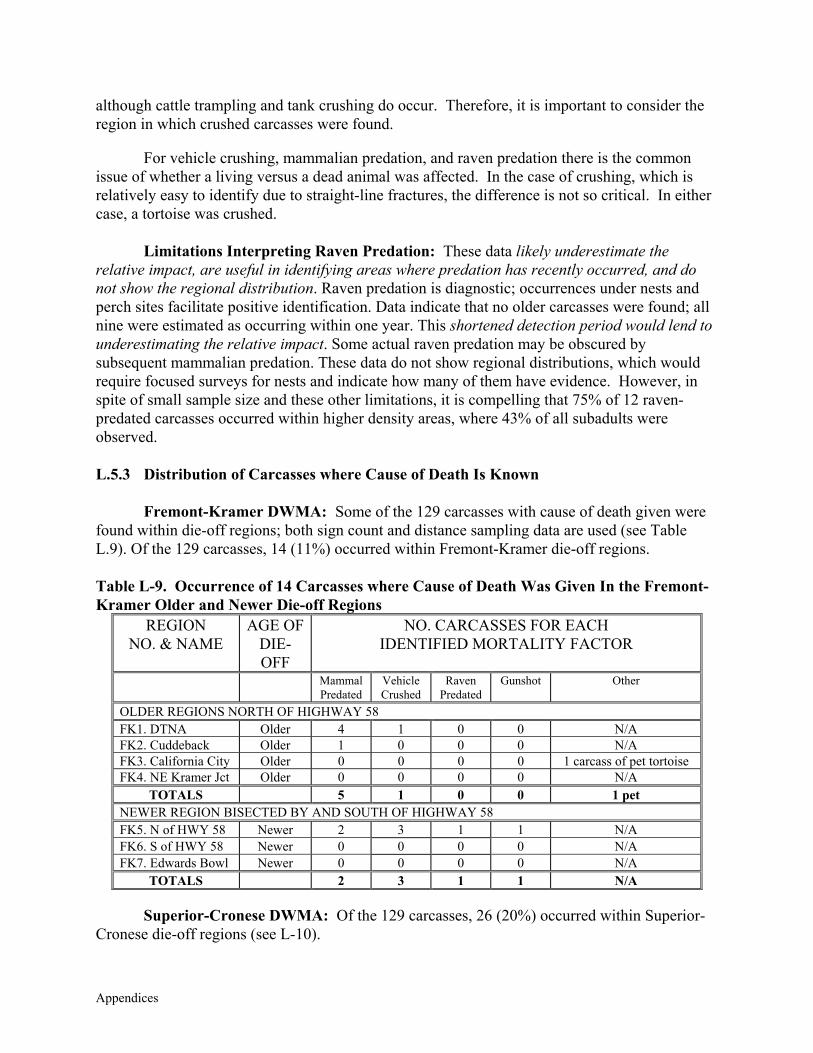
Appendices
although cattle trampling and tank crushing do occur. Therefore, it is important to consider the region in which crushed carcasses were found.
For vehicle crushing, mammalian predation, and raven predation there is the common
issue of whether a living versus a dead animal was affected. In the case of crushing, which is relatively easy to identify due to straight-line fractures, the difference is not so critical. In either case, a tortoise was crushed.
Limitations Interpreting Raven Predation: These data likely underestimate the
relative impact, are useful in identifying areas where predation has recently occurred, and do not show the regional distribution. Raven predation is diagnostic; occurrences under nests and perch sites facilitate positive identification. Data indicate that no older carcasses were found; all nine were estimated as occurring within one year. This shortened detection period would lend to underestimating the relative impact. Some actual raven predation may be obscured by subsequent mammalian predation. These data do not show regional distributions, which would require focused surveys for nests and indicate how many of them have evidence. However, in spite of small sample size and these other limitations, it is compelling that 75% of 12 raven-predated carcasses occurred within higher density areas, where 43% of all subadults were observed. L.5.3 Distribution of Carcasses where Cause of Death Is Known Fremont-Kramer DWMA: Some of the 129 carcasses with cause of death given were found within die-off regions; both sign count and distance sampling data are used (see Table L.9). Of the 129 carcasses, 14 (11%) occurred within Fremont-Kramer die-off regions. Table L-9. Occurrence of 14 Carcasses where Cause of Death Was Given In the Fremont-Kramer Older and Newer Die-off Regions
REGION NO. & NAME
AGE OF DIE-OFF
NO. CARCASSES FOR EACH IDENTIFIED MORTALITY FACTOR
Mammal Predated
Vehicle Crushed
Raven Predated
Gunshot
Other
OLDER REGIONS NORTH OF HIGHWAY 58 FK1. DTNA Older 4 1 0 0 N/A FK2. Cuddeback Older 1 0 0 0 N/A FK3. California City Older 0 0 0 0 1 carcass of pet tortoise FK4. NE Kramer Jct Older 0 0 0 0 N/A
TOTALS 5 1 0 0 1 pet NEWER REGION BISECTED BY AND SOUTH OF HIGHWAY 58 FK5. N of HWY 58 Newer 2 3 1 1 N/A FK6. S of HWY 58 Newer 0 0 0 0 N/A FK7. Edwards Bowl Newer 0 0 0 0 N/A
TOTALS 2 3 1 1 N/A Superior-Cronese DWMA: Of the 129 carcasses, 26 (20%) occurred within Superior-Cronese die-off regions (see L-10).
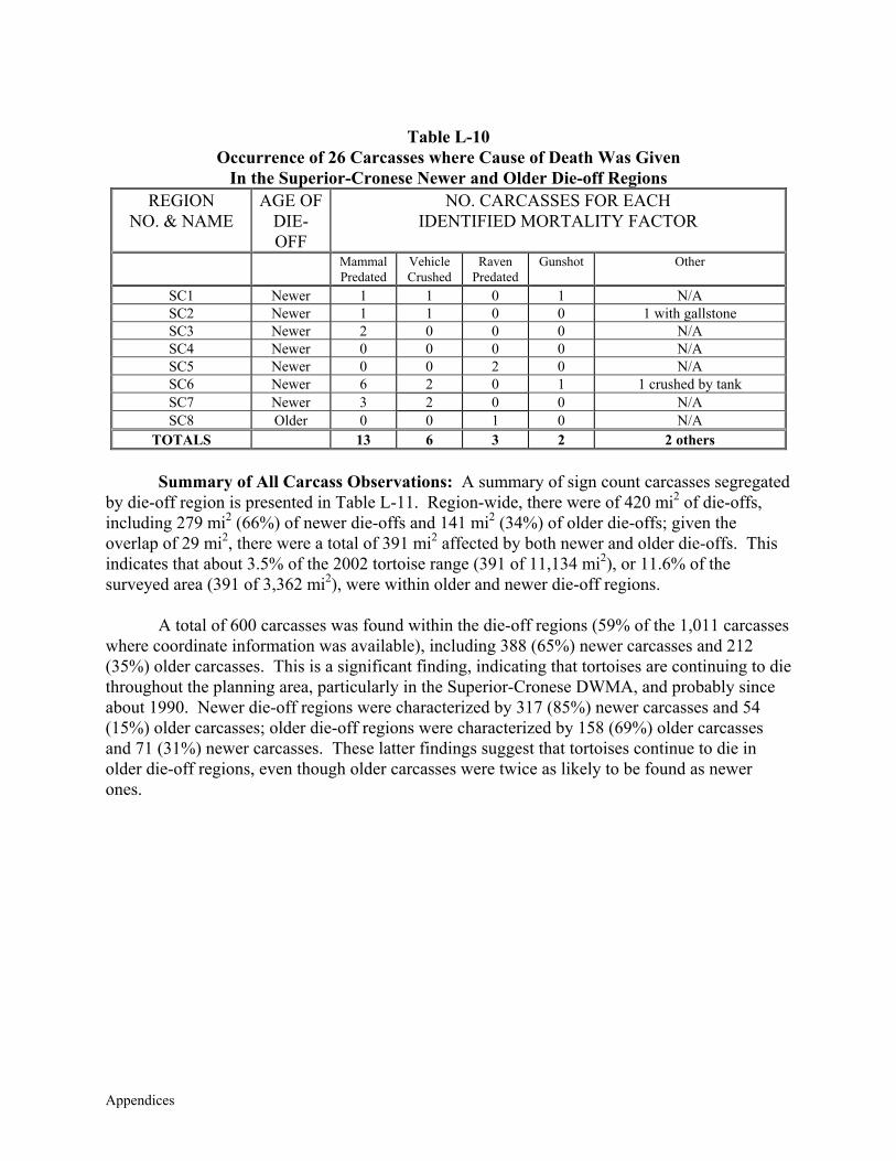
Appendices
Table L-10
Occurrence of 26 Carcasses where Cause of Death Was Given In the Superior-Cronese Newer and Older Die-off Regions
REGION NO. & NAME
AGE OF DIE-OFF
NO. CARCASSES FOR EACH IDENTIFIED MORTALITY FACTOR
Mammal Predated
Vehicle Crushed
Raven Predated
Gunshot
Other
SC1 Newer 1 1 0 1 N/A SC2 Newer 1 1 0 0 1 with gallstone SC3 Newer 2 0 0 0 N/A SC4 Newer 0 0 0 0 N/A SC5 Newer 0 0 2 0 N/A SC6 Newer 6 2 0 1 1 crushed by tank SC7 Newer 3 2 0 0 N/A SC8 Older 0 0 1 0 N/A
TOTALS 13 6 3 2 2 others Summary of All Carcass Observations: A summary of sign count carcasses segregated by die-off region is presented in Table L-11. Region-wide, there were of 420 mi2 of die-offs, including 279 mi2 (66%) of newer die-offs and 141 mi2 (34%) of older die-offs; given the overlap of 29 mi2, there were a total of 391 mi2 affected by both newer and older die-offs. This indicates that about 3.5% of the 2002 tortoise range (391 of 11,134 mi2), or 11.6% of the surveyed area (391 of 3,362 mi2), were within older and newer die-off regions. A total of 600 carcasses was found within the die-off regions (59% of the 1,011 carcasses where coordinate information was available), including 388 (65%) newer carcasses and 212 (35%) older carcasses. This is a significant finding, indicating that tortoises are continuing to die throughout the planning area, particularly in the Superior-Cronese DWMA, and probably since about 1990. Newer die-off regions were characterized by 317 (85%) newer carcasses and 54 (15%) older carcasses; older die-off regions were characterized by 158 (69%) older carcasses and 71 (31%) newer carcasses. These latter findings suggest that tortoises continue to die in older die-off regions, even though older carcasses were twice as likely to be found as newer ones.
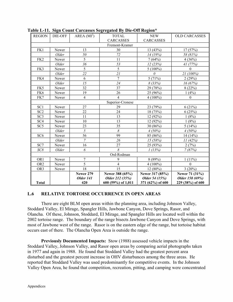
Appendices
Table L-11. Sign Count Carcasses Segregated By Die-Off Region* REGION DIE-OFF AREA (MI2) TOTAL
CARCASSES NEW
CARCASSES OLD CARCASSES
Fremont-Kramer FK1 Newer 13 30 13 (43%) 17 (57%)
Older 50 72 14 (19%) 58 (81%) FK2 Newer 5 11 7 (64%) 4 (36%)
Older 36 53 12 (23%) 41 (77%) FK3 Newer 5 5 5 (100%) 0
Older 22 21 0 21 (100%) FK4 Newer 6 7 5 (71%) 2 (29%)
Older 15 24 8 (33%) 16 (67%) FK5 Newer 32 37 29 (78%) 8 (22%) FK6 Newer 19 26 25 (96%) 1 (4%) FK7 Newer 4 4 4 (100%) 0
Superior-Cronese SC1 Newer 27 29 23 (79%) 6 (21%) SC2 Newer 22 24 18 (75%) 6 (25%) SC3 Newer 11 13 12 (92%) 1 (8%) SC4 Newer 10 13 12 (92%) 1 (8%) SC5 Newer 23 35 30 (86%) 5 (14%)
Older 5 8 4 (50%) 4 (50%) SC6 Newer 56 99 85 (86%) 14 (14%)
Older 7 26 15 (58%) 11 (42%) SC7 Newer 16 27 25 (93%) 2 (7%) SC8 Older 6 8 1 (13%) 7 (87%)
Ord-Rodman OR1 Newer 7 9 8 (89%) 1 (11%) OR2 Newer 5 4 4 (100%) 0 OR3 Newer 18 15 12 (80%) 3 (20%)
Total
Newer 279 Older 141
420
Newer 388 (65%) Older 212 (35%)
600 (59%) of 1,011
Newer 317 (85%) Older 54 (15%)
371 (62%) of 600
Newer 71 (31%) Older 158 (69%) 229 (38%) of 600
L.6 RELATIVE TORTOISE OCCURRENCE IN OPEN AREAS
There are eight BLM open areas within the planning area, including Johnson Valley, Stoddard Valley, El Mirage, Spangler Hills, Jawbone Canyon, Dove Springs, Rasor, and Olancha. Of these, Johnson, Stoddard, El Mirage, and Spangler Hills are located well within the 2002 tortoise range. The boundary of the range bisects Jawbone Canyon and Dove Springs, with most of Jawbone west of the range. Rasor is on the eastern edge of the range, but tortoise habitat occurs east of there. The Olancha Open Area is outside the range.
Previously Documented Impacts: Stow (1988) assessed vehicle impacts in the Stoddard Valley, Johnson Valley, and Rasor open areas by comparing aerial photographs taken in 1977 and again in 1988. He found that Stoddard Valley had the greatest percent area disturbed and the greatest percent increase in OHV disturbances among the three areas. He reported that Stoddard Valley was used predominantly for competitive events. In the Johnson Valley Open Area, he found that competition, recreation, pitting, and camping were concentrated
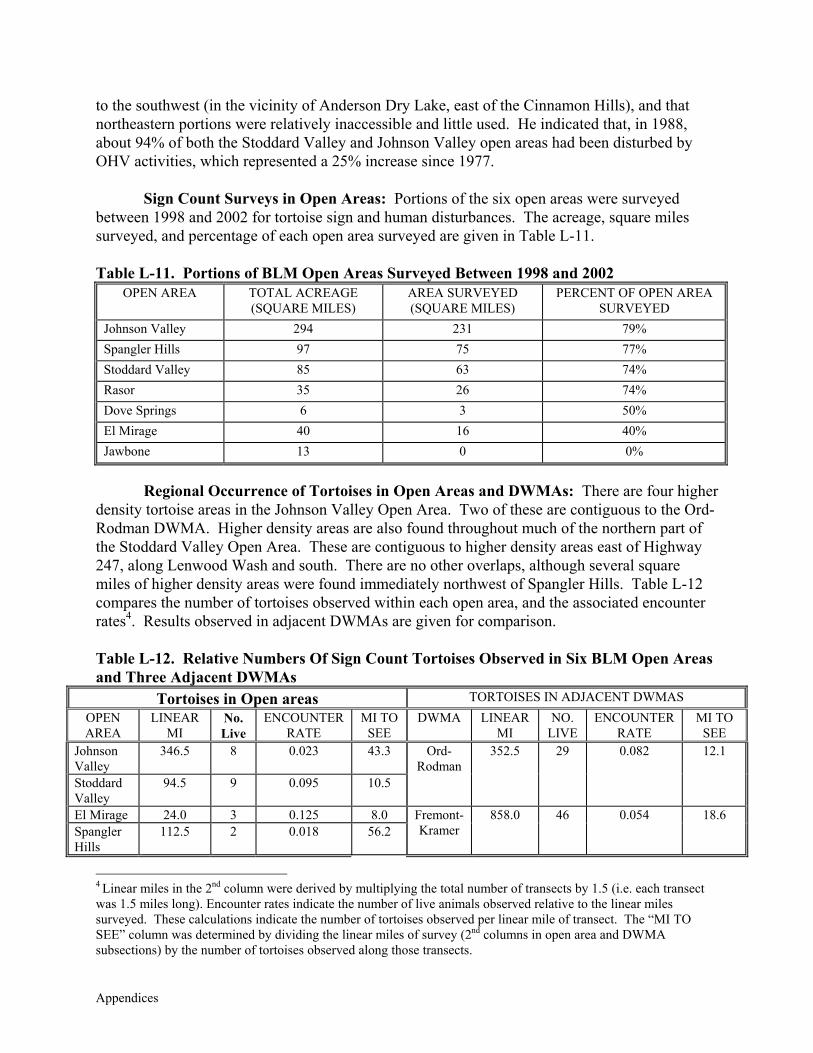
Appendices
to the southwest (in the vicinity of Anderson Dry Lake, east of the Cinnamon Hills), and that northeastern portions were relatively inaccessible and little used. He indicated that, in 1988, about 94% of both the Stoddard Valley and Johnson Valley open areas had been disturbed by OHV activities, which represented a 25% increase since 1977.
Sign Count Surveys in Open Areas: Portions of the six open areas were surveyed
between 1998 and 2002 for tortoise sign and human disturbances. The acreage, square miles surveyed, and percentage of each open area surveyed are given in Table L-11. Table L-11. Portions of BLM Open Areas Surveyed Between 1998 and 2002
OPEN AREA TOTAL ACREAGE (SQUARE MILES)
AREA SURVEYED (SQUARE MILES)
PERCENT OF OPEN AREA SURVEYED
Johnson Valley 294 231 79% Spangler Hills 97 75 77% Stoddard Valley 85 63 74% Rasor 35 26 74% Dove Springs 6 3 50% El Mirage 40 16 40% Jawbone 13 0 0%
Regional Occurrence of Tortoises in Open Areas and DWMAs: There are four higher density tortoise areas in the Johnson Valley Open Area. Two of these are contiguous to the Ord-Rodman DWMA. Higher density areas are also found throughout much of the northern part of the Stoddard Valley Open Area. These are contiguous to higher density areas east of Highway 247, along Lenwood Wash and south. There are no other overlaps, although several square miles of higher density areas were found immediately northwest of Spangler Hills. Table L-12 compares the number of tortoises observed within each open area, and the associated encounter rates4. Results observed in adjacent DWMAs are given for comparison. Table L-12. Relative Numbers Of Sign Count Tortoises Observed in Six BLM Open Areas and Three Adjacent DWMAs
Tortoises in Open areas TORTOISES IN ADJACENT DWMAS OPEN AREA
LINEAR MI
No. Live
ENCOUNTER RATE
MI TO SEE
DWMA LINEAR MI
NO. LIVE
ENCOUNTER RATE
MI TO SEE
Johnson Valley
346.5 8 0.023 43.3
Stoddard Valley
94.5 9 0.095 10.5
Ord-Rodman
352.5 29 0.082 12.1
El Mirage 24.0 3 0.125 8.0 Spangler Hills
112.5 2 0.018 56.2 Fremont-Kramer
858.0 46 0.054 18.6
4 Linear miles in the 2nd column were derived by multiplying the total number of transects by 1.5 (i.e. each transect was 1.5 miles long). Encounter rates indicate the number of live animals observed relative to the linear miles surveyed. These calculations indicate the number of tortoises observed per linear mile of transect. The “MI TO SEE” column was determined by dividing the linear miles of survey (2nd columns in open area and DWMA subsections) by the number of tortoises observed along those transects.
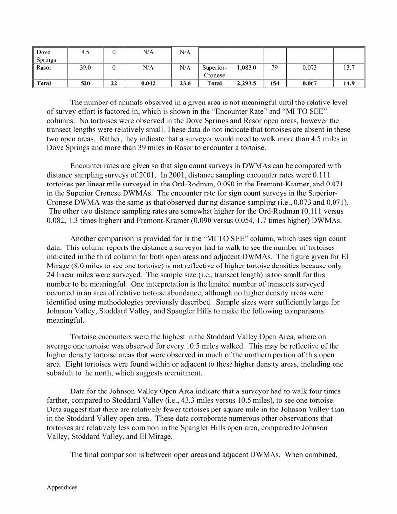
Appendices
Dove Springs
4.5 0 N/A N/A
Rasor 39.0 0 N/A N/A Superior-Cronese
1,083.0 79 0.073 13.7
Total 520 22 0.042 23.6 Total 2,293.5 154 0.067 14.9
The number of animals observed in a given area is not meaningful until the relative level of survey effort is factored in, which is shown in the “Encounter Rate” and “MI TO SEE” columns. No tortoises were observed in the Dove Springs and Rasor open areas, however the transect lengths were relatively small. These data do not indicate that tortoises are absent in these two open areas. Rather, they indicate that a surveyor would need to walk more than 4.5 miles in Dove Springs and more than 39 miles in Rasor to encounter a tortoise.
Encounter rates are given so that sign count surveys in DWMAs can be compared with
distance sampling surveys of 2001. In 2001, distance sampling encounter rates were 0.111 tortoises per linear mile surveyed in the Ord-Rodman, 0.090 in the Fremont-Kramer, and 0.071 in the Superior Cronese DWMAs. The encounter rate for sign count surveys in the Superior-Cronese DWMA was the same as that observed during distance sampling (i.e., 0.073 and 0.071). The other two distance sampling rates are somewhat higher for the Ord-Rodman (0.111 versus 0.082, 1.3 times higher) and Fremont-Kramer (0.090 versus 0.054, 1.7 times higher) DWMAs.
Another comparison is provided for in the “MI TO SEE” column, which uses sign count
data. This column reports the distance a surveyor had to walk to see the number of tortoises indicated in the third column for both open areas and adjacent DWMAs. The figure given for El Mirage (8.0 miles to see one tortoise) is not reflective of higher tortoise densities because only 24 linear miles were surveyed. The sample size (i.e., transect length) is too small for this number to be meaningful. One interpretation is the limited number of transects surveyed occurred in an area of relative tortoise abundance, although no higher density areas were identified using methodologies previously described. Sample sizes were sufficiently large for Johnson Valley, Stoddard Valley, and Spangler Hills to make the following comparisons meaningful.
Tortoise encounters were the highest in the Stoddard Valley Open Area, where on
average one tortoise was observed for every 10.5 miles walked. This may be reflective of the higher density tortoise areas that were observed in much of the northern portion of this open area. Eight tortoises were found within or adjacent to these higher density areas, including one subadult to the north, which suggests recruitment.
Data for the Johnson Valley Open Area indicate that a surveyor had to walk four times
farther, compared to Stoddard Valley (i.e., 43.3 miles versus 10.5 miles), to see one tortoise. Data suggest that there are relatively fewer tortoises per square mile in the Johnson Valley than in the Stoddard Valley open area. These data corroborate numerous other observations that tortoises are relatively less common in the Spangler Hills open area, compared to Johnson Valley, Stoddard Valley, and El Mirage.
The final comparison is between open areas and adjacent DWMAs. When combined,
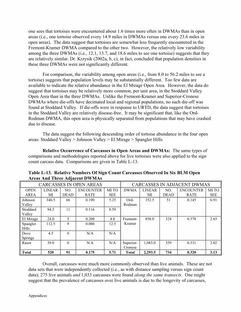
Appendices
one sees that tortoises were encountered about 1.6 times more often in DWMAs than in open areas (i.e., one tortoise observed every 14.9 miles in DWMAs versus one every 23.6 miles in open areas). The data suggest that tortoises are somewhat less frequently encountered in the Fremont-Kramer DWMA compared to the other two. However, the relatively low variability among the three DWMAs (i.e., 12.1, 13.7, and 18.6 miles to see one tortoise) suggests that they are relatively similar. Dr. Krzysik (2002a, b, c), in fact, concluded that population densities in these three DWMAs were not significantly different.
For comparison, the variability among open areas (i.e., from 8.0 to 56.2 miles to see a
tortoise) suggests that population levels may be substantially different. Too few data are available to indicate the relative abundance in the El Mirage Open Area. However, the data do suggest that tortoises may be relatively more common, per unit area, in the Stoddard Valley Open Area than in the three DWMAs. Unlike the Fremont-Kramer and Superior-Cronese DWMAs where die-offs have decimated local and regional populations, no such die-off was found at Stoddard Valley. If die-offs were in response to URTD, the data suggest that tortoises in the Stoddard Valley are relatively disease-free. It may be significant that, like the Ord-Rodman DWMA, this open area is physically separated from populations that may have crashed due to disease.
The data suggest the following descending order of tortoise abundance in the four open
areas: Stoddard Valley > Johnson Valley > El Mirage > Spangler Hills. Relative Occurrence of Carcasses in Open Areas and DWMAs: The same types of
comparisons and methodologies reported above for live tortoises were also applied to the sign count carcass data. Comparisons are given in Table L-13.
Table L-13. Relative Numbers Of Sign Count Carcasses Observed In Six BLM Open Areas And Three Adjacent DWMAs
CARCASSES IN OPEN AREAS CARCASSES IN ADJACENT DWMAS OPEN AREA
LINEAR MI
NO. DEAD
ENCOUNTER RATE
MI TO SEE
DWMA LINEAR MI
NO. DEAD
ENCOUNTER RATE
MI TO SEE
Johnson Valley
346.5 66 0.190 5.25
Stoddard Valley
94.5 11 0.116 8.59
Ord-Rodman
352.5 51 0.145 6.91
El Mirage 24.0 5 0.208 4.8 Spangler Hills
112.5 9 0.080 12.5
Dove Springs
4.5 0 N/A N/A
Fremont-Kramer
858.0 324 0.378 2.65
Rasor 39.0 0 N/A N/A Superior-Cronese
1,083.0 359 0.331 3.02
Total 520 91 0.175 5.71 Total 2,293.5 734 0.320 3.13
Overall, carcasses were much more commonly observed than live animals. These are not data sets that were independently collected (i.e., as with distance sampling versus sign count data); 275 live animals and 1,033 carcasses were found along the same transects. One might suggest that the prevalence of carcasses over live animals is due to the longevity of carcasses,

Appendices
which may persist up to 20 years. However, tortoises are also long-lived animals, with individuals that are known to live for more than 20 years in the wild5.
There were 91 carcasses found in open areas and 734 found in DWMAs. When the
relative survey effort is considered, there were about two times as many (i.e., 1.82) carcasses found in DWMAs as in open areas. For comparison, surveyors walked an average of 5.7 miles in an open area to find one carcass, compared to 3.1 miles in the three DWMAs. This may be due to catastrophic die-offs in DWMAs, which have not been observed in open areas.
Among open areas, the data indicate that there are relatively more carcasses found in the
Johnson Valley, followed by Stoddard Valley, and Spangler Hills. Not enough linear miles of transects were surveyed in El Mirage for it to be compared among these three, where sample sizes were relatively large.
There is an inverse relationship between the number of tortoises and carcasses observed
in DWMAs. Tortoises were more often encountered in the Ord-Rodman (i.e., one tortoise for every 12.1 miles of survey), followed by Superior-Cronese (i.e., one per 13.7 miles), and Fremont-Kramer (i.e., one per 18.6 miles). An opposite pattern was observed for carcasses: one carcass encountered per 2.65 miles in Fremont-Kramer, one per 3.02 miles in Superior-Cronese, and one per 6.91 miles in Ord-Rodman. This suggests that tortoises were most likely to be encountered in a DWMA where fewer carcasses were found. The converse conclusion is that fewer tortoises were found where there were more carcasses.
Although this may seem like a trivial point, it is not. It is entirely likely that carcasses
may be more common in places where live animals are more common. Relatively more carcasses were seen in the western part of Johnson Valley Open Area, in the northwest part of the Ord-Rodman DWMA, and in the Water Valley/Mud Hills area. However, each of them was associated with a higher density tortoise area; carcasses were relatively less common than in identified die-off regions.
Table L-14 shows an inverse relationship between tortoise and carcass encounters
between Stoddard Valley and three DWMAs, a relationship not observed in Johnson Valley.
5 Boarman (pers. comm.) found one report of a pet tortoise that was more than 60 years old. There is at least one animal marked at one of the DTNA study plots in 1979 that was still alive in 2002 (M. Connor, pers. comm.). He did not indicate if it was an adult in 1979, but this animal is at least 23 years old. Except for anecdotal accounts, there are no data to indicate the average longevity of tortoises at the population level. It is reasonable to assume that many adult tortoises live substantially longer in the wild than 20 years.
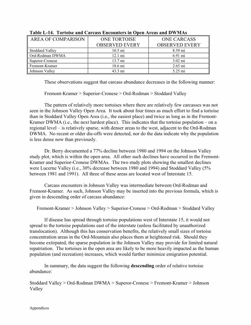
Appendices
Table L-14. Tortoise and Carcass Encounters in Open Areas and DWMAs AREA OF COMPARISON ONE TORTOISE
OBSERVED EVERY ONE CARCASS
OBSERVED EVERY Stoddard Valley 10.5 mi 8.59 mi Ord-Rodman DWMA 12.1 mi 6.91 mi Superor-Cronese 13.7 mi 3.02 mi Fremont-Kramer 18.6 mi 2.65 mi Johnson Valley 43.3 mi 5.25 mi
These observations suggest that carcass abundance decreases in the following manner: Fremont-Kramer > Superior-Cronese > Ord-Rodman > Stoddard Valley The pattern of relatively more tortoises where there are relatively few carcasses was not
seen in the Johnson Valley Open Area. It took about four times as much effort to find a tortoise than in Stoddard Valley Open Area (i.e., the easiest place) and twice as long as in the Fremont-Kramer DWMA (i.e., the next hardest place). This indicates that the tortoise population – on a regional level – is relatively sparse, with denser areas to the west, adjacent to the Ord-Rodman DWMA. No recent or older die-offs were detected, nor do the data indicate why the population is less dense now than previously.
Dr. Berry documented a 77% decline between 1980 and 1994 on the Johnson Valley
study plot, which is within the open area. All other such declines have occurred in the Fremont-Kramer and Superior-Cronese DWMAs. The two study plots showing the smallest declines were Lucerne Valley (i.e., 30% decrease between 1980 and 1994) and Stoddard Valley (5% between 1981 and 1991). All three of these areas are located west of Interstate 15.
Carcass encounters in Johnson Valley was intermediate between Ord-Rodman and
Fremont-Kramer. As such, Johnson Valley may be inserted into the previous formula, which is given in descending order of carcass abundance:
Fremont-Kramer > Johnson Valley > Superior-Cronese > Ord-Rodman > Stoddard Valley
If disease has spread through tortoise populations west of Interstate 15, it would not
spread to the tortoise populations east of the interstate (unless facilitated by unauthorized translocation). Although this has conservation benefits, the relatively small sizes of tortoise concentration areas in the Ord-Mountain also places them at heightened risk. Should they become extirpated, the sparse population in the Johnson Valley may provide for limited natural repatriation. The tortoises in the open area are likely to be more heavily impacted as the human population (and recreation) increases, which would further minimize emigration potential.
In summary, the data suggest the following descending order of relative tortoise
abundance:
Stoddard Valley > Ord-Rodman DWMA > Superor-Cronese > Fremont-Kramer > Johnson Valley
Appendices
Compared to the following ascending order of relative carcass abundance:
Stoddard Valley < Ord-Rodman < Superior-Cronese < Johnson Valley < Fremont-Kramer
These relationships become much more significant when one considers the relative area within each of these regions that was surveyed, and therefore reflective of the above comparisons.
Local Occurrence of Tortoises in the Fremont-Kramer DWMA: These comparisons
are on a regional level, and suggest that outside the Johnson Valley Open Area, the most difficult place to find tortoises is in the Fremont-Kramer. However, the population within that DWMA is not homogenous in terms of tortoise distribution. Both current data and older data support the conclusion that there have been significant population declines in the northern and northwestern portions of the Fremont-Kramer DWMA.
For these reasons, comparisons similar to those given above for the five larger regions
are given in Table L-15 areas north and south of Highway 58 in the Fremont-Kramer DWMA.
Table L-15 Relative Numbers of Tortoises and Carcasses
Observed in the Fremont-Kramer DWMA North and South of Highway 58
TORTOISE DATA CARCASS DATA AREA LINE
AR MI
NO. DEAD
ENCOUNTER RATE
MI TO SEE
AREA LINEAR MI
NO. DEAD
ENCOUNTER RATE
MI TO SEE
North North South South Total Total
Characteristics of Vehicle Impact Areas: The types and intensity of impacts associated with each region are listed in Tables L-16, L-17 and l-18 and discussed below. Recreational Impact Regions – BLM Open Areas: Open areas compared in the following table include Dove Springs/Jawbone Canyon (combined), Johnson Valley, Stoddard Valley, Spangler Hills, and El Mitage.. There are five columns for each of the seven types of disturbance data collected on sign count surveys, 1998-2002; where there are only four columns, the total mi2 to the left applies. Data include (1) “Total mi2,” which are all square miles surveyed within the impact region. (2) “Mi2 Obs., which is the subset of square miles wherein the given disturbance was observed. (3) “Sum,” is the total number of disturbances observed. (4) “Average” is the Sum/Mi2 Obs. (5) “Range” indicates the lowest and highest value for a given disturbance. Except where “0” is entered, the lower range limit is always 1, since there must be at least one observation for the transect to be included. For example, in Johnson Valley, there were 296 mi2 surveyed, with a sum of 49,394 vehicle cross-country tracks, occurring on 296 mi2, for an average of 180 tracks/ mi2, ranging from as few as 1 track up to 1,625. As in other places, numbers of square miles equates to the number of transects surveyed.
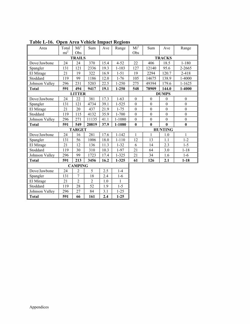
Appendices
Table L-16. Open Area Vehicle Impact Regions
Area Total mi2
Mi2 Obs
Sum Ave Range Mi2 Obs
Sum Ave Range
TRAILS TRACKS Dove/Jawbone 24 24 370 15.4 4-52 22 406 18.5 1-180 Spangler 131 121 2336 19.3 1-103 127 12140 95.6 2-2665 El Mirage 21 19 322 16.9 1-51 19 2294 120.7 2-418 Stoddard 119 99 1186 12.0 1-76 105 14675 138.9 1-4000 Johnson Valley 296 231 5203 22.5 1-250 275 49394 179.6 1-1625 Total 591 494 9417 19.1 1-250 548 78909 144.0 1-4000
LITTER DUMPS Dove/Jawbone 24 22 381 17.3 1-63 0 0 0 0 Spangler 131 121 4734 39.1 1-525 0 0 0 0 El Mirage 21 20 437 21.9 1-75 0 0 0 0 Stoddard 119 115 4132 35.9 1-700 0 0 0 0 Johnson Valley 296 271 11135 41.1 1-1080 0 0 0 0 Total 591 549 20819 37.9 1-1080 0 0 0 0
TARGET HUNTING Dove/Jawbone 24 16 281 17.6 1-142 1 1 1.0 1 Spangler 131 56 1006 18.0 1-110 12 13 1.1 1-2 El Mirage 21 12 136 11.3 1-32 6 14 2.3 1-5 Stoddard 119 30 310 10.3 1-97 21 64 3.0 1-18 Johnson Valley 296 99 1723 17.4 1-325 21 34 1.6 1-6 Total 591 213 3456 16.2 1-325 61 126 2.1 1-18
CAMPING Dove/Jawbone 24 2 5 2.5 1-4 Spangler 131 7 18 2.4 1-6 El Mirage 21 2 2 1.0 1 Stoddard 119 28 52 1.9 1-5 Johnson Valley 296 27 84 3.1 1-25 Total 591 66 161 2.4 1-25
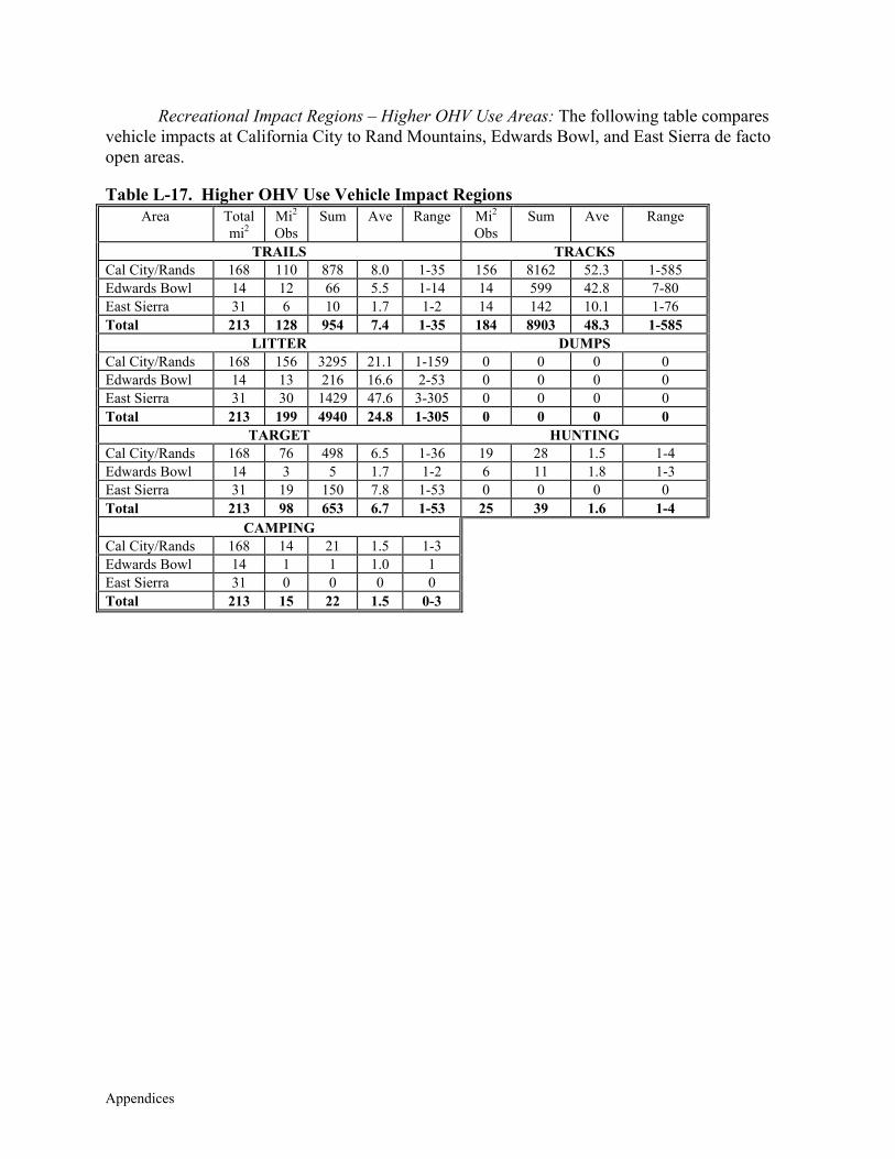
Appendices
Recreational Impact Regions – Higher OHV Use Areas: The following table compares vehicle impacts at California City to Rand Mountains, Edwards Bowl, and East Sierra de facto open areas.
Table L-17. Higher OHV Use Vehicle Impact Regions
Area Total mi2
Mi2 Obs
Sum Ave Range Mi2 Obs
Sum Ave Range
TRAILS TRACKS Cal City/Rands 168 110 878 8.0 1-35 156 8162 52.3 1-585 Edwards Bowl 14 12 66 5.5 1-14 14 599 42.8 7-80 East Sierra 31 6 10 1.7 1-2 14 142 10.1 1-76 Total 213 128 954 7.4 1-35 184 8903 48.3 1-585
LITTER DUMPS Cal City/Rands 168 156 3295 21.1 1-159 0 0 0 0 Edwards Bowl 14 13 216 16.6 2-53 0 0 0 0 East Sierra 31 30 1429 47.6 3-305 0 0 0 0 Total 213 199 4940 24.8 1-305 0 0 0 0
TARGET HUNTING Cal City/Rands 168 76 498 6.5 1-36 19 28 1.5 1-4 Edwards Bowl 14 3 5 1.7 1-2 6 11 1.8 1-3 East Sierra 31 19 150 7.8 1-53 0 0 0 0 Total 213 98 653 6.7 1-53 25 39 1.6 1-4
CAMPING Cal City/Rands 168 14 21 1.5 1-3 Edwards Bowl 14 1 1 1.0 1 East Sierra 31 0 0 0 0 Total 213 15 22 1.5 0-3
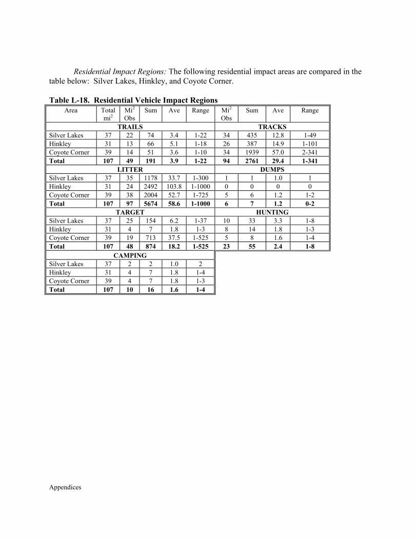
Appendices
Residential Impact Regions: The following residential impact areas are compared in the
table below: Silver Lakes, Hinkley, and Coyote Corner. Table L-18. Residential Vehicle Impact Regions
Area Total mi2
Mi2 Obs
Sum Ave Range Mi2 Obs
Sum Ave Range
TRAILS TRACKS Silver Lakes 37 22 74 3.4 1-22 34 435 12.8 1-49 Hinkley 31 13 66 5.1 1-18 26 387 14.9 1-101 Coyote Corner 39 14 51 3.6 1-10 34 1939 57.0 2-341 Total 107 49 191 3.9 1-22 94 2761 29.4 1-341
LITTER DUMPS Silver Lakes 37 35 1178 33.7 1-300 1 1 1.0 1 Hinkley 31 24 2492 103.8 1-1000 0 0 0 0 Coyote Corner 39 38 2004 52.7 1-725 5 6 1.2 1-2 Total 107 97 5674 58.6 1-1000 6 7 1.2 0-2
TARGET HUNTING Silver Lakes 37 25 154 6.2 1-37 10 33 3.3 1-8 Hinkley 31 4 7 1.8 1-3 8 14 1.8 1-3 Coyote Corner 39 19 713 37.5 1-525 5 8 1.6 1-4 Total 107 48 874 18.2 1-525 23 55 2.4 1-8
CAMPING Silver Lakes 37 2 2 1.0 2 Hinkley 31 4 7 1.8 1-4 Coyote Corner 39 4 7 1.8 1-3 Total 107 10 16 1.6 1-4

Appendices
Appendices
APPENDIX M
MOJAVE GROUND SQUIRREL BACKGROUND DATA

Appendices
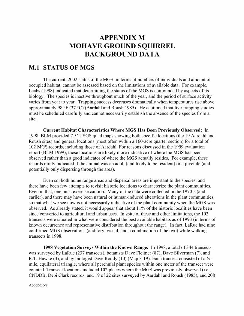
Appendices
APPENDIX M MOHAVE GROUND SQUIRREL
BACKGROUND DATA M.1 STATUS OF MGS
The current, 2002 status of the MGS, in terms of numbers of individuals and amount of occupied habitat, cannot be assessed based on the limitations of available data. For example, Laabs (1998) indicated that determining the status of the MGS is confounded by aspects of its biology. The species is inactive throughout much of the year, and the period of surface activity varies from year to year. Trapping success decreases dramatically when temperatures rise above approximately 98 °F (37 °C) (Aardahl and Roush 1985). He cautioned that live-trapping studies must be scheduled carefully and cannot necessarily establish the absence of the species from a site.
Current Habitat Characteristics Where MGS Has Been Previously Observed: In
1998, BLM provided 7.5’ USGS quad maps showing both specific locations (the 19 Aardahl and Roush sites) and general locations (most often within a 160-acre quarter section) for a total of 102 MGS records, including those of Aardahl. For reasons discussed in the 1999 evaluation report (BLM 1999), these locations are likely more indicative of where the MGS has been observed rather than a good indicator of where the MGS actually resides. For example, these records rarely indicated if the animal was an adult (and likely to be resident) or a juvenile (and potentially only dispersing through the area).
Even so, both home range areas and dispersal areas are important to the species, and there have been few attempts to revisit historic locations to characterize the plant communities. Even in that, one must exercise caution. Many of the data were collected in the 1970’s (and earlier), and there may have been natural or human-induced alterations in the plant communities, so that what we see now is not necessarily indicative of the plant community when the MGS was observed. As already stated, it would appear that about 11% of the historic localities have been since converted to agricultural and urban uses. In spite of these and other limitations, the 102 transects were situated in what were considered the best available habitats as of 1993 (in terms of known occurrence and representative distribution throughout the range). In fact, LaRue had nine confirmed MGS observations (auditory, visual, and a combination of the two) while walking transects in 1998.
1998 Vegetation Surveys Within the Known Range: In 1998, a total of 344 transects was surveyed by LaRue (237 transects), botanists Dave Fleitner (87), Dave Silverman (7), and R.T. Hawke (3), and by biologist Dave Roddy (10) (Map 3-19). Each transect consisted of a ¾-mile, equilateral triangle, where all perennial plant species within one meter of the transect were counted. Transect locations included 102 places where the MGS was previously observed (i.e., CNDDB, Debi Clark records, and 19 of 22 sites surveyed by Aardahl and Roush (1985), and 208
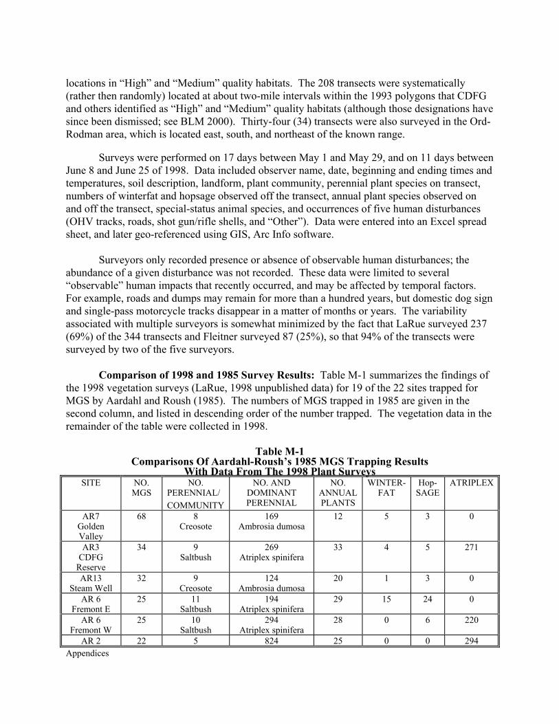
Appendices
locations in “High” and “Medium” quality habitats. The 208 transects were systematically (rather then randomly) located at about two-mile intervals within the 1993 polygons that CDFG and others identified as “High” and “Medium” quality habitats (although those designations have since been dismissed; see BLM 2000). Thirty-four (34) transects were also surveyed in the Ord-Rodman area, which is located east, south, and northeast of the known range.
Surveys were performed on 17 days between May 1 and May 29, and on 11 days between June 8 and June 25 of 1998. Data included observer name, date, beginning and ending times and temperatures, soil description, landform, plant community, perennial plant species on transect, numbers of winterfat and hopsage observed off the transect, annual plant species observed on and off the transect, special-status animal species, and occurrences of five human disturbances (OHV tracks, roads, shot gun/rifle shells, and “Other”). Data were entered into an Excel spread sheet, and later geo-referenced using GIS, Arc Info software.
Surveyors only recorded presence or absence of observable human disturbances; the abundance of a given disturbance was not recorded. These data were limited to several “observable” human impacts that recently occurred, and may be affected by temporal factors. For example, roads and dumps may remain for more than a hundred years, but domestic dog sign and single-pass motorcycle tracks disappear in a matter of months or years. The variability associated with multiple surveyors is somewhat minimized by the fact that LaRue surveyed 237 (69%) of the 344 transects and Fleitner surveyed 87 (25%), so that 94% of the transects were surveyed by two of the five surveyors.
Comparison of 1998 and 1985 Survey Results: Table M-1 summarizes the findings of the 1998 vegetation surveys (LaRue, 1998 unpublished data) for 19 of the 22 sites trapped for MGS by Aardahl and Roush (1985). The numbers of MGS trapped in 1985 are given in the second column, and listed in descending order of the number trapped. The vegetation data in the remainder of the table were collected in 1998.
Table M-1
Comparisons Of Aardahl-Roush’s 1985 MGS Trapping Results With Data From The 1998 Plant Surveys
SITE NO. MGS
NO. PERENNIAL/ COMMUNITY
NO. AND DOMINANT PERENNIAL
NO. ANNUAL PLANTS
WINTER- FAT
Hop- SAGE
ATRIPLEX
AR7 Golden Valley
68 8 Creosote
169 Ambrosia dumosa
12 5 3 0
AR3 CDFG
Reserve
34 9 Saltbush
269 Atriplex spinifera
33 4 5 271
AR13 Steam Well
32 9 Creosote
124 Ambrosia dumosa
20 1 3 0
AR 6 Fremont E
25 11 Saltbush
194 Atriplex spinifera
29 15 24 0
AR 6 Fremont W
25 10 Saltbush
294 Atriplex spinifera
28 0 6 220
AR 2 22 5 824 25 0 0 294
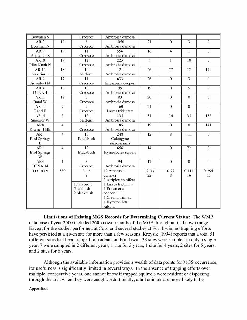
Appendices
Bowman S Creosote Ambrosia dumosa AR 2
Bowman N 19 8
Creosote 1056
Ambrosia dumosa 21 0 3 0
AR 9 Aqueduct S
19 11 Creosote
556 Ambrosia dumosa
16 4 1 0
AR10 Pilot Knob N
19 12 Creosote
225 Ambrosia dumosa
? 1 18 0
AR 14 Superior E
18 10 Saltbush
121 Ambrosia dumosa
26 77 12 179
AR 9 Aqueduct N
17 11 Creosote
633 Ericameria cooperi
26 0 3 0
AR 4 DTNA 4
15 10 Creosote
99 Ambrosia dumosa
19 0 5 0
AR11 Rand W
12 5 Creosote
83 Ambrosia dumosa
20 0 0 0
AR11 Rand E
7 9 Creosote
160 Larrea tridentata
21 0 0 0
AR14 Superior W
5 12 Saltbush
235 Ambrosia dumosa
31 36 35 135
AR8 Kramer Hills
4 9 Creosote
185 Ambrosia dumosa
19 0 0 141
AR1 Bird Springs
E
4 10 Blackbush
248 Coleogyne
ramosissima
12 8 111 0
AR1 Bird Springs
W
4 12 Blackbush
656 Hymenoclea salsola
14 0 72 0
AR4 DTNA 14
1 3 Creosote
94 Ambrosia dumosa
17 0 0 0
3-12 9
TOTALS 350
12 creosote 5 saltbush 2 blackbush
12 Ambrosia dumosa 3 Atriplex spinifera 1 Larrea tridentata 1 Ericameria cooperi 1 C. ramosissima 1 Hymenoclea salsola
12-33 22
0-77 8
0-111 16
0-294 65
Limitations of Existing MGS Records for Determining Current Status: The WMP
data base of year 2000 included 260 known records of the MGS throughout its known range. Except for the studies performed at Coso and several studies at Fort Irwin, no trapping efforts have persisted at a given site for more than a few seasons. Krzysik (1994) reports that a total 51 different sites had been trapped for rodents on Fort Irwin: 38 sites were sampled in only a single year, 7 were sampled in 2 different years, 1 site for 3 years, 1 site for 4 years, 2 sites for 5 years, and 2 sites for 6 years.
Although the available information provides a wealth of data points for MGS occurrence, itσ usefulness is significantly limited in several ways. In the absence of trapping efforts over multiple, consecutive years, one cannot know if trapped squirrels were resident or dispersing through the area when they were caught. Additionally, adult animals are more likely to be
Appendices
resident than juveniles, but most of the records do not indicate the ages of captured squirrels. (Laabs 1998)
The absence of data points does not indicate absence of the MGS, but likely indicates that focused studies were not performed in those areas. For example, many MGS records are associated with roadways, where MGS may be occasionally observed from a vehicle, found crushed, or observed during surveys of proposed utility right of ways adjacent and parallel to the road. Many MGS records are clustered in areas where extensive surveys have been performed, leaving a false impression of relative abundance. Such focused trapping efforts have occurred at Edwards AFB (Laabs et al. 1994), the Indian Wells Valley (Rempel and Clark 1990), the Coso region (Leitner’s study sites), and on the Coolgardie Mesa, where Tom and Debi Clark made many observations.
Brooks and Matchett (2001) reported that the MGS had been detected at 264 sites between 1886 and 2000. Maps showing the distribution of these historic records collected over a 114 year period do not represent the current status of the MGS. However, they are useful in depicting the historically occupied range. These data allowed us, for example, to determine how much of the known range is now occupied by urban and agricultural development.
Plant Community Surveys: In 1992, biologists Debi Clark and Tom Clark, and botanist
Denise LaBerteaux, mapped vegetation communities over approximately 90% of the WMPA. Following an unspecified amount of field reconnaissance, they plotted vegetation communities on 7.5’ and 15’ USGS quad maps, then further refined community boundaries using 1:24,000 aerial photography, dated 1989 (Source memorandum from Debi Clark to Larry Foreman, dated 15 May 1996). These data were later digitized and provided as a GIS (Arc Info) coverage. They mapped 42 different plant communities as occurring in the WMPA.
M.2 PREVALENCE AND DISTRIBUTION OF THREATS
Human Disturbances Observed During 1998 Vegetation Studies: During the 1998 Survey, biologists collected information on human disturbances observed along each transect, including those located near previous MGS reports (102 transects) and those located in high and medium quality habitats (208 transects). Table M-2 displays the prevalence of disturbance types found along these transects6.
Table M-2
6 "OHV” refers to cross-country vehicle tracks, which were created by trucks, motorcycles, and all-terrain vehicles. “Road” includes trails, and usually included routes passable by trucks. Sheep, cow, and dog sign was usually feces. “Guns” does not differentiate between legal activities (e.g., hunting, regulated target practice, etc.) and illegal ones (e.g., shooting glass and articles at dump sites). “Dumps” generally required a vehicle to off-load the materials, so does not include litter. “Mines” may have included pits and adits, exploratory excavations, borrow pits, etc. “Ord.” refers to military ordnance, which typically included spent cartridges and clips from aircraft. Two transects occurred in areas previously burned.
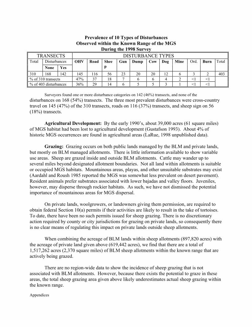
Appendices
Prevalence of 10 Types of Disturbances Observed within the Known Range of the MGS
During the 1998 Survey TRANSECTS DISTURBANCE TYPES
Disturbances Total None Yes
OHV Road Sheep
Gun Dump Cow Dog Mine Ord. Burn
Total
310 168 142 145 116 56 23 20 20 12 6 3 2 403 % of 310 transects 47% 37 18 7 6 6 4 2 <1 <1 % of 403 disturbances 36% 29 14 6 5 5 3 1 <1 <1
Surveyors found one or more disturbance categories on 142 (46%) transects, and none of the
disturbances on 168 (54%) transects. The three most prevalent disturbances were cross-country travel on 145 (47%) of the 310 transects, roads on 116 (37%) transects, and sheep sign on 56 (18%) transects.
Agricultural Development: By the early 1990’s, about 39,000 acres (61 square miles) of MGS habitat had been lost to agricultural development (Gustafson 1993). About 4% of historic MGS occurrences are found in agricultural areas (LaRue, 1998 unpublished data).
Grazing: Grazing occurs on both public lands managed by the BLM and private lands, but mostly on BLM managed allotments. There is little information available to show variable use areas. Sheep are grazed inside and outside BLM allotments. Cattle may wander up to several miles beyond designated allotment boundaries. Not all land within allotments is suitable or occupied MGS habitats. Mountainous areas, playas, and other unsuitable substrates may exist (Aardahl and Roush 1985 reported the MGS was somewhat less prevalent on desert pavement). Resident animals prefer substrates associated with lower bajadas and valley floors. Juveniles, however, may disperse through rockier habitats. As such, we have not dismissed the potential importance of mountainous areas for MGS dispersal.
On private lands, woolgrowers, or landowners giving them permission, are required to obtain federal Section 10(a) permits if their activities are likely to result in the take of tortoises. To date, there have been no such permits issued for sheep grazing. There is no discretionary action required by county or city jurisdictions for grazing on private lands, so consequently there is no clear means of regulating this impact on private lands outside sheep allotments.
When combining the acreage of BLM lands within sheep allotments (897,820 acres) with
the acreage of private land given above (619,442 acres), we find that there are a total of 1,517,262 acres (2,370 square miles) of BLM sheep allotments within the known range that are actively being grazed.
There are no region-wide data to show the incidence of sheep grazing that is not associated with BLM allotments. However, because there exists the potential to graze in these areas, the total sheep grazing area given above likely underestimates actual sheep grazing within the known range.

Appendices
Hybridization Between Round-tailed Ground Squirrels and the MGS: As shown in
Map 3-17, the contact line between ranges of the MGS and round-tailed ground squirrel runs between Fort Irwin and Victorville along the Mojave River. Thus far, the only occurrences of hybrid (Wessman 1977) and suspected hybrid (Krzysik 1994; LaRue, 1997 pers. obs.) ground squirrels have been in the areas of Fort Irwin and Helendale. Gustafson (1993) reported that hybridization likely occurred in these areas due to ecological and behavioral changes in one or the other species that resulted from agricultural disturbances in the Helendale area and military maneuvers at Fort Irwin.
Dr. Recht (2001 pers. comm.) has recently trapped the round-tailed ground squirrel in the Superior Valley, 10 or more miles inside the known range of the MGS. This suggests that there is potential for hybridization to occur well into the known range, and not just along the edges.
No information was found on the dispersal abilities of round-tailed ground squirrels. If it is similar to that of the MGS, juvenile round-tails could to travel from one to several miles into the MGS range, assuming substrate conditions and other factors are favorable.
Military Maneuvers: The prevalence of MGS on a given installation is dependent on
the occurrence of installations within the known range, naturally unsuitable habitats, types of military maneuvers, impacts associated with support facilities (e.g., cantonment areas, logistical areas), and other factors.
Extensive areas on south-central and southwestern Edwards AFB are comprised of small,
clay-pan playas may constitute suitable habitats, but extensive trapping surveys conducted in 1994 failed to trap any animals throughout the large region (Laabs et al. 1994). Unlike Edwards, both China Lake and Fort Irwin have extensive mountainous areas (greater than 20% slope) that are not likely suitable for resident MGS, although there is some potential for dispersing juveniles to use the lower slopes of such areas.
Military maneuvers and their observable impacts vary dramatically between Fort Irwin
(severe impacts) and either Edwards or China Lake (localized impacts). Edwards has cantonment areas west of Rogers Dry Lake, and logistical support facilities occur west of Rogers and east of the northern end (Leuhman Ridge facilities) that have been resulted in MGS habitat loss. China Lake has no cantonment area (Ridgecrest serves that function), and support facilities have resulted in minimal impacts to either the northern or southern ranges. Given that both installations practice air-to-ground maneuvers, with limited day-to-day ground disturbance, most of the habitats are still intact and potentially occupied.
Fort Irwin entertains 10 training rotations each year, where numerous mechanized vehicles and ground troops create new ground disturbances during each exercise (albeit in previously degraded areas). At Fort Irwin, Gustafson (1993) reported that military training had affected approximately 130,000 acres (203 square miles) in the known range. Most of the impacts are limited to areas below about 20% slope (LaRue and Boarman, in prep.), which
Appendices
coincides with the substrates most preferred by the MGS, where about 90% of 102 MGS records have occurred (LaRue, 1998 unpublished data). Krzysik (1991) noted heavy shrub losses from the main maneuver corridors at Fort Irwin. Many of the impacts identified for cross-country OHV use also pertain to impacts at Fort Irwin, except that impacts at Fort Irwin are far more intense.
Off-Highway Vehicles: Off highway vehicle impacts are concentrated in (a) BLM-designated vehicle open areas, (b) lands adjacent to open areas, and (c) heavy use areas that are not necessarily associated with either of the first two.
There is anecdotal evidence that the MGS may be killed on both paved and dirt roads, although it has been suggested that they are too quick for this to happen. For example, during tortoise surveys conducted near Water Valley, northwest of Barstow, in 1998, LaRue crushed a juvenile male MGS on a dirt road as it attempted to cross in front of his truck. In 1997, LaRue observed a juvenile male (likely a hybrid) as it was crushed on National Trails Highway, several miles north of Helendale. One of the nine MGS observed in 1998 (LaRue, unpublished data) darted into burrows that were located in the berms of a dirt road. The juvenile female was observed for about 20 minutes eating cryptantha alongside the road, and later using two different burrows located in berms on opposite sides of the road. Recht (1977) also observed MGS feeding on Russian thistle that was congregated along shoulders of roads in northeastern Los Angeles County.
Goodlett and Goodlett (1993) have shown, in the Rand Mountains, that the heaviest vehicle impacts occur immediately adjacent to both open and closed routes. It is plausible, then, that individual MGS using resources adjacent to roads are more likely to be in harm’s way than those animals occurring in roadless areas. It is also plausible that juvenile MGS, which are most likely to travel longer distances than adults, are somewhat more susceptible to vehicle impacts than adults. Although adults may still be susceptible to vehicle impacts within their somewhat-fixed home ranges, dispersing juveniles are likely to encounter more roads than an adult living within a fixed region.
The potential to crush squirrels likely increases as the prevalence and use of roads increases in a given region. Given the relatively higher incidence of cross-country travel in open areas (1998-2001 WMP data), vehicle impacts are more likely to occur in open areas and other places with similar densities of cross-country tracks, depending on resident and dispersing populations of the MGS. Gustafson (1993) reported that four BLM open areas “…occupy over 103,000 acres [161 square miles] within the range of the squirrel, although not all of the habitat in that acreage has been destroyed.”
Data collected within the known range during tortoise surveys (1998, 1999, and 2001)
show that vehicle impacts are heaviest inside and adjacent to designated open areas. This is not surprising, in that these areas are designated for vehicle recreation both on and off roads.
Two of the 23 sites trapped for the MGS in 2002 included the El Mirage and Spangler
Appendices
Hills open areas (Leitner, pers. comm. 2002). However, the absence of squirrels cannot be attributed to vehicle use in those two areas. El Mirage is located south of Highway 58, where no MGS were captured on eight of the nine trapping grids, including the one in the open area. Nor were any of the high concentrations of winterfat and hopsage identified in 1998 (LaRue, unpublished data) associated with either open area.
Data show that there is a “spill-over” effect from the open areas, where relatively higher incidences of vehicle impacts were found in adjacent areas, compared to non-adjacent lands. The prevalence of cross-country vehicle tracks north of El Mirage Open Area will probably be reduced due to boundary fencing installed in the late 1990’s. Other areas, adjacent to Jawbone and Spangler Hills, remain susceptible to open area-related impacts as no fences have been installed.
Vehicle-based impacts may be prevalent in areas that are not adjacent to open areas. Within the MGS conservation area, these areas include lands within the Rand Mountains, west of Silver Lakes, within Kramer Hills, north of Hinkley, and southwest of Fort Irwin. Smaller areas also exist east and northeast of Fremont Peak, Fremont Valley, Iron Mountains north of Silver Lakes, Superior Valley (one 4-mile region), and southeast of Harper Lake. Urban Development: The MGS has been reported near urban and in rural sites outside the MGS conservation area south of Highway 138, near Pinyon Hills, and a second occurred near an aerospace industrial complex located adjacent to Palmdale (Becky Jones, pers. comm. 2002). In the first case, the site and adjacent lands are comprised of extensive tracts of undeveloped lands and those with relatively light rural development. At the second site, there are about five to six contiguous square miles of relatively undeveloped land, but the entire area is surrounded by urban and agricultural development.
The MGS has also been observed in residential backyards in Inyokern (Peter Woodman, 2000 pers. com.), and may be seen foraging on the golf course at China Lake (Tom Campbell, pers. comm.). In 1991, Laabs (Tierra Madre Consultants, Inc. 1991) tentatively identified an MGS burrow in the edge of an agricultural field in northeastern Lancaster. One squirrel was recently trapped at the proposed Hundai facility south of California City, where the consultant had identified habitats as being marginal (Michael Connor, pers. comm. 2002). In these latter cases, the sightings are adjacent to extensive areas of undeveloped lands.
Given these observations, the only certain areas of MGS extirpation within the range are those that have been physically developed. Such areas include, but are not limited to, paved roads and parking lots; residential, commercial, and industrial sites occupied by buildings, graded areas, and other areas where vegetation has been mechanically removed; solar facilities at Kramer Junction and Harper Lake; and large mined areas (U.S. Borax, Rand Mining Company, portions of the Shadow Mountains located east of Edwards AFB). Degraded habitats typify lands adjacent to cities and unincorporated communities. Site-specific data exist in consultant reports, which for the most part are inaccessible.
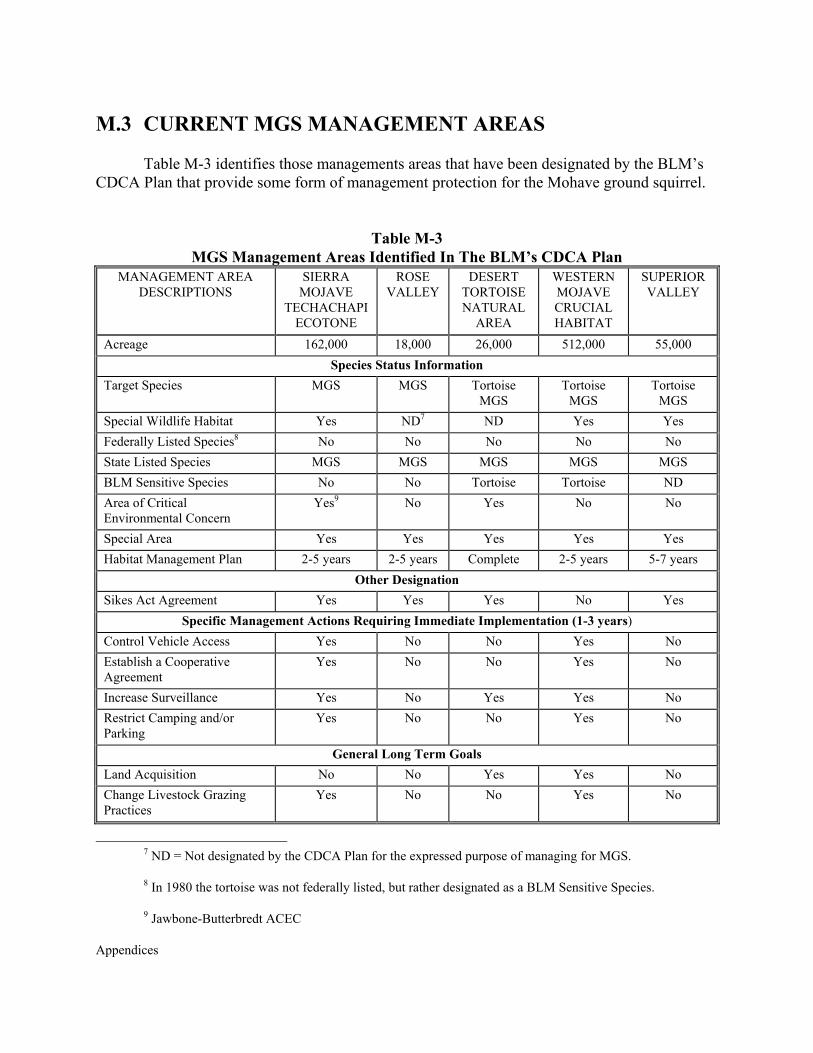
Appendices
M.3 CURRENT MGS MANAGEMENT AREAS Table M-3 identifies those managements areas that have been designated by the BLM’s CDCA Plan that provide some form of management protection for the Mohave ground squirrel.
Table M-3 MGS Management Areas Identified In The BLM’s CDCA Plan
MANAGEMENT AREA DESCRIPTIONS
SIERRA MOJAVE
TECHACHAPI ECOTONE
ROSE VALLEY
DESERT TORTOISE NATURAL
AREA
WESTERN MOJAVE CRUCIAL HABITAT
SUPERIOR VALLEY
Acreage 162,000 18,000 26,000 512,000 55,000 Species Status Information
Target Species MGS MGS Tortoise MGS
Tortoise MGS
Tortoise MGS
Special Wildlife Habitat Yes ND7 ND Yes Yes Federally Listed Species8 No No No No No State Listed Species MGS MGS MGS MGS MGS BLM Sensitive Species No No Tortoise Tortoise ND Area of Critical Environmental Concern
Yes9 No Yes No No
Special Area Yes Yes Yes Yes Yes Habitat Management Plan 2-5 years 2-5 years Complete 2-5 years 5-7 years
Other Designation Sikes Act Agreement Yes Yes Yes No Yes
Specific Management Actions Requiring Immediate Implementation (1-3 years) Control Vehicle Access Yes No No Yes No Establish a Cooperative Agreement
Yes No No Yes No
Increase Surveillance Yes No Yes Yes No Restrict Camping and/or Parking
Yes No No Yes No
General Long Term Goals Land Acquisition No No Yes Yes No Change Livestock Grazing Practices
Yes No No Yes No
7 ND = Not designated by the CDCA Plan for the expressed purpose of managing for MGS.
8 In 1980 the tortoise was not federally listed, but rather designated as a BLM Sensitive Species.
9 Jawbone-Butterbredt ACEC
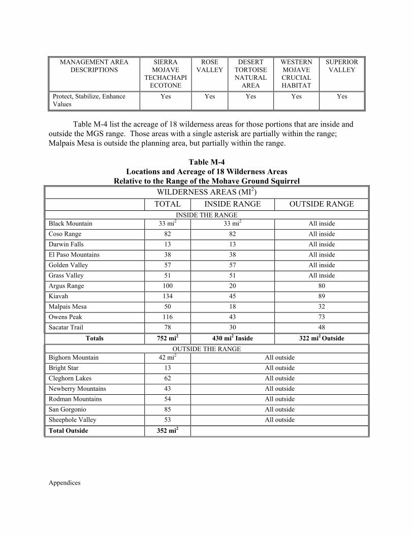
Appendices
MANAGEMENT AREA DESCRIPTIONS
SIERRA MOJAVE
TECHACHAPI ECOTONE
ROSE VALLEY
DESERT TORTOISE NATURAL
AREA
WESTERN MOJAVE CRUCIAL HABITAT
SUPERIOR VALLEY
Protect, Stabilize, Enhance Values
Yes Yes Yes Yes Yes
Table M-4 list the acreage of 18 wilderness areas for those portions that are inside and
outside the MGS range. Those areas with a single asterisk are partially within the range; Malpais Mesa is outside the planning area, but partially within the range.
Table M-4
Locations and Acreage of 18 Wilderness Areas Relative to the Range of the Mohave Ground Squirrel
WILDERNESS AREAS (MI2) TOTAL INSIDE RANGE OUTSIDE RANGE
INSIDE THE RANGE Black Mountain 33 mi2 33 mi2 All inside Coso Range 82 82 All inside Darwin Falls 13 13 All inside El Paso Mountains 38 38 All inside Golden Valley 57 57 All inside Grass Valley 51 51 All inside Argus Range 100 20 80 Kiavah 134 45 89 Malpais Mesa 50 18 32 Owens Peak 116 43 73 Sacatar Trail 78 30 48
Totals 752 mi2 430 mi2 Inside 322 mi2 Outside OUTSIDE THE RANGE
Bighorn Mountain 42 mi2 All outside Bright Star 13 All outside Cleghorn Lakes 62 All outside Newberry Mountains 43 All outside Rodman Mountains 54 All outside San Gorgonio 85 All outside Sheephole Valley 53 All outside Total Outside 352 mi2
Appendices
APPENDIX O
LIVESTOCK GRAZING

Appendices
Appendices
APPENDIX O LIVESTOCK GRAZING
O.1 SHEEP GRAZING PERMITS AND LEASES
Antelope Valley: This is an ephemeral allotment consisting of 7,871 acres comprised of 510 acres of private land and 7,361 acres of public lands. The allotment has 1,048 acres of non-critical desert tortoise habitat. In years of adequate ephemeral forage production, sheep grazing is authorized. Ephemeral forage is found on large flats. Water is hauled to temporary locations and can be moved as sheep are herded through the allotment.
Bissell: This is an ephemeral allotment consisting of 48,889 acres comprised of 43,293
acres of private land and 5,596 acres of public lands. This allotment has 5,596 acres of non-critical desert tortoise habitat. In years of adequate ephemeral forage production, sheep grazing is authorized. Ephemeral forage is found on large flats. Water is hauled to temporary locations and can be moved as sheep are herded through the allotment.
Boron: This is an ephemeral allotment consisting of 82,892 acres comprised of 72,024 acres of private land and 10,868 acres of public lands. This allotment has 10, 868 acres of non-critical desert tortoise habitat. In years of adequate ephemeral forage production, sheep grazing is authorized. Ephemeral forage is found on large flats. Water is hauled to temporary locations and can be moved as sheep are herded through the allotment.
Buckhorn Canyon: This is an ephemeral allotment consisting of 27,053 acres comprised of 14,689 acres of private land, and 12,364 acres of public land. Most of this allotment is within designated critical habitat for the desert tortoise, and has not been grazed by sheep since 1987. In years of adequate ephemeral forage production, sheep grazing is authorized in non-critical habitat, however due to the lack of contiguous public land outside of critical habitat it is unlikely that future sheep grazing would occur.
Cantil Common: This is an ephemeral allotment consisting of 555,421 acres comprised of 236,472 acres of private land and 318,949 acres of public lands. This allotment has 240,913 acres of non-critical desert tortoise habitat, and 78,035 acres of desert tortoise critical habitat. In years of adequate ephemeral forage production, sheep grazing is authorized in non-critical habitat. Ephemeral forage is found on large flats. Water is hauled to temporary locations and can be moved as sheep are herded through the allotment.
Goldstone: This is an ephemeral allotment consisting of 11,061 acres of public lands. This allotment has 11,061 acres of critical desert tortoise habitat. This allotment is currently an inactive, vacant ephemeral sheep allotment and has not been grazed by sheep since 1987. The 1991 Biological Opinion and extensions disallowed ephemeral sheep grazing in critical desert tortoise habitat. The entire allotment is on lands transferred by Congress to the Department of the Army in December 2001 (within the Fort Irwin expansion area).
Appendices
Gravel Hills: This is an ephemeral allotment consisting of 230,165 acres comprised of
94,621 acres of private land and 135,544 acres of public lands. This allotment has 0 acres of non-critical desert tortoise habitat and 135,544 acres of critical desert tortoise habitat. This allotment is currently inactive and has not been grazed by sheep since 1988. The 1991 biological opinion and extensions disallowed ephemeral sheep grazing in critical desert tortoise habitat.
Hansen Common: The CDCA Plan authorizes both cattle grazing and sheep grazing
and/or trailing on the stock driveway. In areas of the allotment where ephemeral sheep grazing is authorized, ephemeral cattle grazing is not authorized. Sheep grazing occurs on this allotment during ephemeral years only. (See also discussion below for cattle allotments.)
Johnson Valley: This is an ephemeral allotment consisting of 118,320 acres comprised of 9,134 acres of private land and 109,186 acres of public lands. This allotment has 118,320 acres of non-critical desert tortoise habitat and 0 acres of critical desert tortoise habitat. In years of adequate ephemeral forage production, sheep grazing is authorized. Ephemeral forage is found on large flats. Water is hauled to temporary locations and can be moved as sheep are herded through the allotment. This allotment is currently inactive, vacant, and has not been grazed by sheep since 1992.
Lava Mountains: This is an ephemeral allotment consisting of 20,902 acres of public lands. This allotment has 18,757 acres of non-critical and 2,145 acres of critical desert tortoise habitat. In years of adequate ephemeral forage production, sheep grazing is authorized in both non-critical and a small portion of critical habitat. Ephemeral forage is found on large flats. Water is hauled to temporary locations and can be moved as sheep are herded through the allotment.
Monolith Cantil: This is an ephemeral allotment consisting of 47,553 acres comprised of 9,782 acres of private land and 37,771 acres of public lands. This allotment has 7,939 acres of non-critical and 29,846 acres of critical desert tortoise habitat. In years of adequate ephemeral forage production, sheep grazing is authorized in non-critical habitat. Ephemeral forage is found on large flats. Water is hauled to temporary locations and can be moved as sheep are herded through the allotment.
Rudnick Common: The CDCA Plan authorizes both cattle grazing and sheep grazing and/or trailing on the stock driveway. In areas of the allotment where ephemeral sheep grazing is authorized, ephemeral cattle grazing is not authorized. Sheep grazing occurs on this allotment during ephemeral years only. (See discussion below regarding cattle allotments.)
Shadow Mountain: This is an ephemeral allotment consisting of 121,677 acres comprised of 69,419 acres of private land and 52,258 acres of public lands. This allotment has 86,664 acres of non-critical desert tortoise habitat and 35,013 acres of critical desert tortoise habitat. In years of adequate ephemeral forage production, sheep grazing is authorized in non-critical habitat. Ephemeral forage is found on large flats. Water is hauled to temporary locations

Appendices
and can be moved as sheep are herded through the allotment.
Spangler Hills: This is an ephemeral allotment consisting of 69,141 acres comprised of 11,446 acres of private land and 57,695 acres of public lands. This allotment has 54,143 acres of non-critical desert tortoise habitat. In years of adequate ephemeral forage production, sheep grazing is authorized. Ephemeral forage is found on large flats. Water is hauled to temporary locations and can be moved as sheep are herded through the allotment.
Stoddard Mountain: This is an ephemeral allotment consisting of 312,045 acres comprised of 121,859 acres of private land and 190,186 acres of public lands divided into three use areas. This allotment has 126,202 acres of non-critical desert tortoise habitat and 112,772 acres of critical desert tortoise habitat. The West Stoddard Use Area is entirely within critical habitat and sheep grazing is not authorized. In years of adequate ephemeral forage production, sheep grazing is authorized in non-critical habitat located in the Middle and East Use Areas. Ephemeral forage is found on large flats and foothills. Water is hauled to temporary locations and can be moved as sheep are herded through the allotment.
Superior Valley: This is an ephemeral allotment consisting of 236, 316 acres comprised of 67,116 acres of private land and 169,200 acres of public lands. This allotment has 0 acres of non-critical desert tortoise habitat and 169,200 acres of critical desert tortoise habitat. This allotment is currently an inactive and has not been grazed by sheep since 1988. The 1991 biological opinion and extensions disallowed ephemeral sheep grazing in critical desert tortoise habitat. In December 2001, Congress transferred about one third of the allotment to the Department of the Army as part of the Fort Irwin expansion.
Tunawee Common: The CDCA Plan authorizes both cattle grazing and sheep grazing and/or trailing on the stock driveway. In areas of the allotment where ephemeral sheep grazing is authorized, ephemeral cattle grazing is not authorized. Sheep grazing occurs on this allotment during ephemeral years only. (See discussion below regarding cattle grazing allotments.)
Warren: This is a perennial allotment consisting of 556 acres of public land. The season of use is February 15 through May 31. The grazing that occurs on this allotment consists mostly of drift from the surrounding private land around the allotment.
Appendices
O.2 CATTLE GRAZING PERMITS AND LEASES
Cady Mountain: The Cady Mountain Allotment is located between I-15 and I-40 in the western Mojave Desert and the allotment comprises 231,897 acres. The period for grazing is yearlong. The Mojave River runs through the extreme northern portion of the allotment and contains extensive areas of riparian habitat. The majority of grazing use occurs in the western and central portions of the allotment in association with the active wells, and in the Afton Canyon area. The allotment is within 160,104 acres of desert tortoise non-critical habitat. An AMP was approved for this allotment in 1983, and a Rangeland Health Assessment was completed in 2000.
Cronese Lake: The Cronese Lake Allotment is located approximately 30 miles northeast of Barstow and just north of I-15. The season of use is yearlong. Water is supplied by one well on public land. Approximately 55 percent of the allotment is within critical habitat for the desert tortoise. This allotment has an AMP approved in 1983. A Rangeland Health Assessment was completed for this allotment in 2000.
Darwin: The Darwin allotment is entirely located inside the Lacey-Cactus-McCloud Allotment. It is classified as a horse allotment. The allotment has been vacant since 1993, and it is unlikely that it will be grazed again.
Double Mountain: This allotment has not been grazed since 1990, and has been vacant since 1992. It is unlikely that this allotment will be grazed again. It is bordered on all sides by private land.
Hansen Common: The Hansen Common Allotment consists of 72,102 acres comprised of 37,254 private land and 34,848 acres of BLM lands. Approximately 3,549 acres of the allotment is non-critical habitat for desert tortoise. This allotment does not have a grazing system based on pasture rotation. Most grazing occurs on private land with cattle drifting onto BLM land at various periods, depending on available forage and water. Cattle use is authorized on BLM land for 10 months. Ephemeral forage on this allotment is located in areas typically grazed by sheep rather than cattle when adequate ephemeral forage production occurs.
Harper Lake: The Harper Lake Allotment is located 15 miles northwest of Barstow. Cattle use occurs all yearlong. Approximately 65 percent (21,194 acres) of this allotment is within desert tortoise critical habitat and in the northern pasture while the remaining 35 percent (5,120 acres) of desert tortoise non-critical habitat is located in the southern pasture. In the past, there has been a lack of developed water and boundary fencing in the northern pasture resulting in cattle drift off the allotment. The recent development of stock water on private land in the northern pasture has more evenly distributed grazing use. Until development of water in the northern pasture, past grazing use has been confined to the southern pasture. An AMP was approved for this allotment in 1984, and a Rangeland Health Assessment was completed in 1999.
Lacey-Cactus-McCloud: The Lacey-Cactus-McCloud allotment consists of 421,791
Appendices
acres, comprised of 2,375 acres of private land, 257,696 acres of Military land, and 7,644 acres of State land, and 158,532 acres of public land. The Lacey-Cactus-McCloud allotment utilizes a rotational grazing system comprised of pastures that utilize fences and topographic barriers as boundaries. Several of the pastures located on the China Lake NAWS have been closed to grazing for many years. In addition, China Lake NAWS canceled grazing use on their portion of the allotment in June 2000. There is approximately 18,025 acres of non-critical habitat for desert habitat.
Oak Creek: The Oak Creek allotment has been vacant for more than ten years, and it is unlikely that it will be used again.
Olancha Common: The Olancha Common Allotment consists of 15,877 acres comprised of 1,410 acres of private land and 391 acres of State land, 18 acres of United States Forest Service (USFS) land and 13,900 acres of public land. The allotment utilizes a two pasture rotational grazing system.
Ord Mountain: The Ord Mountain Allotment is located south of I-40, approximately 8 miles southeast of Barstow. The season of use is yearlong. The allotment is 154,848 acres in size of which 102,141 acres is in desert tortoise critical habitat and 34,047 acres is in desert tortoise non-critical habitat. A small number of domestic horses are authorized to graze this allotment. Most of the grazing use on public land occurs in the western portion of the allotment where most of the developed water is located. An AMP was approved for this allotment in 1985, and a Rangeland Health Assessment was completed in 1999.
Pilot Knob: The Pilot Knob Allotment consists of 45,498 acres comprised of 1,720 acres of private land, 146 acres of State land, 4,727acres of military land, and 38,906 acres of public land. The allotment has been in non-use since 1996. It is unlikely that it will be grazed again.
Rattlesnake Canyon: The Rattlesnake Canyon Allotment is located at the base of and within the Bighorn Mountain Range. The season for cattle use is yearlong. The allotment is topographically divided into the desert pasture, Rattlesnake Canyon, and the mountain pasture. Pasture use is primarily seasonal, with most of the grazing use in the winter and spring occurs in the desert pasture while summer and fall grazing use occurs in the mountain pasture. Rattlesnake Canyon is primarily used to trail cattle between the desert and mountain pastures. The desert pasture has 12,800 acres of desert tortoise non-critical habitat, where desert tortoise densities are probably low. Rattlesnake Canyon within the allotment is a wide, five-mile long canyon with steep walls and a rocky to sandy bottom. The canyon stretches from the desert floor and rises in elevation to over 5,500 feet. Several populations of Parish’s daisy have been identified within the allotment boundaries. This allotment has no approved AMP. A Rangeland Health Assessment was completed for this allotment in 1999.
Round Mountain: The Round Mountain Allotment is located on the north face of the San Bernardino Mountains, approximately 30 miles south of Barstow. There are 15,565 acres of public land and 2,525 acres of private land within the allotment. There are no known listed
Appendices
species on this allotment. There has been no grazing on this allotment since 1998 due a wildfire in 1999. The stocking rate for this allotment has averaged 100 head. This allotment has no approved AMP, nor has a Rangeland Health Assessment been completed.
Rudnick Common: The Rudnick Common allotment consists of 236,184 acres,
comprised of 86,030 acres of private land and 150,154 acres of public land. There is 62,503 acres of non-critical habitat for desert tortoise. There are two lessees in the Rudnick Common Allotment. One lessee grazes only in the Cane Canyon and Pinyon Well pastures. These pastures have no desert tortoise habitat and the lessee is not affected by the proposed action or alternatives. The second lessee grazes in the rest of the allotment, which has 62,503 acres of non-critical habitat for desert tortoise. This allotment utilizes a rotational grazing system comprised of pastures that utilize fences and topographic barriers as boundaries. Choice, timing, and duration of use for each pasture are dependent on several factors including plant phenology, climatic conditions, and past use.
Tunawee Common: The Tunawee Common allotment consists of 55,931 acres comprised of 4,202 private land and 51,729 acres of public land. Approximately 1,800 acres of the allotment is non-critical habitat for desert tortoise. Cattle have not grazed the allotment since 1993. From 1994 to the present, sheep have grazed the allotment.
Walker Pass: The Walker Pass Common Allotment consists of 96,974 acres, comprised of 8,816 acres of private land and 88,158 acres of public land. Approximately 32,058 acres of the allotment is non-critical habitat for desert tortoise. Three lessees graze cattle on the Walker Pass Common Allotment. The lessees can graze on the allotment for an eight-month period. The southern use area consists of 14,791 acres, comprised of 847 acres of private land and 13,941 acres of BLM land. There is 6,865 acres of non-critical habitat for desert tortoise. The lessee of the southern use area (lessee 1) uses water availability to promote proper distribution and movement of cattle in the use area. Lessee 1 typically removes cattle from the allotment by February 28.
The middle use area consists of 48,163 acres, comprised of 5,626 acres of private land, 47 acres of state land, and 42,702 acres of public land. There is 6,387 acres of non-critical habitat for desert tortoise. The lessee of the middle use area (lessee 2) uses fences, and topographic features to distribute cattle in this use area. Lessee 2 typically removes cattle from the allotment around June 30. When ephemeral forage is sufficient the lessee typically make use of the eastern portion of the allotment where the ephemeral forage is most productive.
The northern use area consists of 33,635 acres, comprised of 950 acres of private land, 385 acres of state land, and 32,300 acres of public land. There is 15,885 acres of non-critical habitat for desert tortoise. The lessee of the northern use area (lessee 3) typically removes cattle from the allotment around June 30. When ephemeral forage is sufficient the lessee typically make use of the eastern portion of the allotment where the ephemeral forage is most productive.
Whitewater Canyon: This allotment is discussed in detail in the Coachella Valley
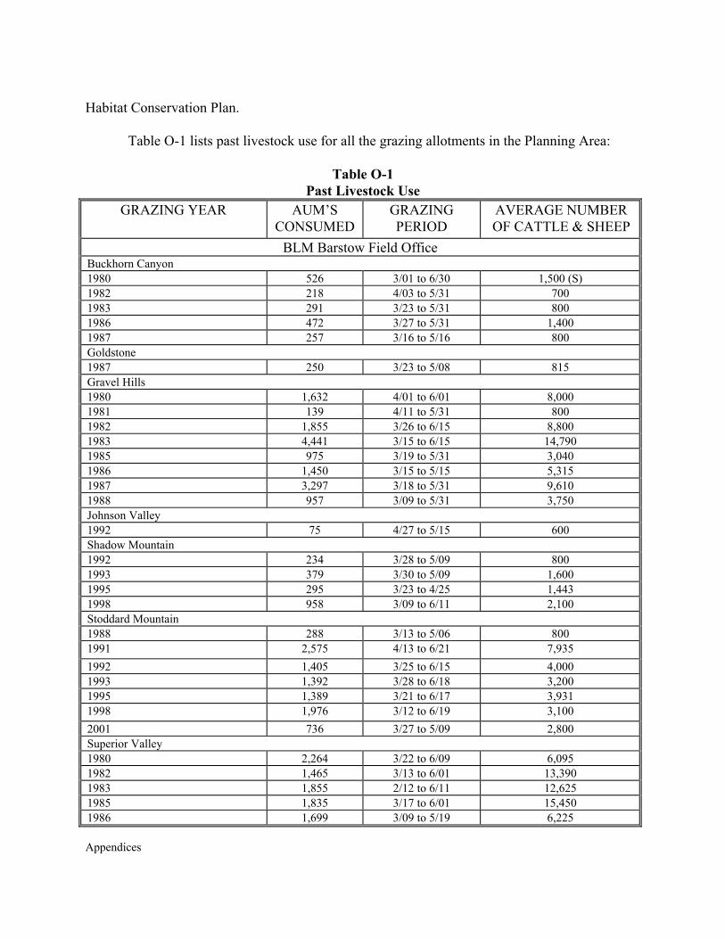
Appendices
Habitat Conservation Plan.
Table O-1 lists past livestock use for all the grazing allotments in the Planning Area:
Table O-1 Past Livestock Use
GRAZING YEAR AUM’S CONSUMED
GRAZING PERIOD
AVERAGE NUMBER OF CATTLE & SHEEP
BLM Barstow Field Office Buckhorn Canyon 1980 526 3/01 to 6/30 1,500 (S) 1982 218 4/03 to 5/31 700 1983 291 3/23 to 5/31 800 1986 472 3/27 to 5/31 1,400 1987 257 3/16 to 5/16 800 Goldstone 1987 250 3/23 to 5/08 815 Gravel Hills 1980 1,632 4/01 to 6/01 8,000 1981 139 4/11 to 5/31 800 1982 1,855 3/26 to 6/15 8,800 1983 4,441 3/15 to 6/15 14,790 1985 975 3/19 to 5/31 3,040 1986 1,450 3/15 to 5/15 5,315 1987 3,297 3/18 to 5/31 9,610 1988 957 3/09 to 5/31 3,750 Johnson Valley 1992 75 4/27 to 5/15 600 Shadow Mountain 1992 234 3/28 to 5/09 800 1993 379 3/30 to 5/09 1,600 1995 295 3/23 to 4/25 1,443 1998 958 3/09 to 6/11 2,100 Stoddard Mountain 1988 288 3/13 to 5/06 800 1991 2,575 4/13 to 6/21 7,935 1992 1,405 3/25 to 6/15 4,000 1993 1,392 3/28 to 6/18 3,200 1995 1,389 3/21 to 6/17 3,931 1998 1,976 3/12 to 6/19 3,100 2001 736 3/27 to 5/09 2,800 Superior Valley 1980 2,264 3/22 to 6/09 6,095 1982 1,465 3/13 to 6/01 13,390 1983 1,855 2/12 to 6/11 12,625 1985 1,835 3/17 to 6/01 15,450 1986 1,699 3/09 to 5/19 6,225
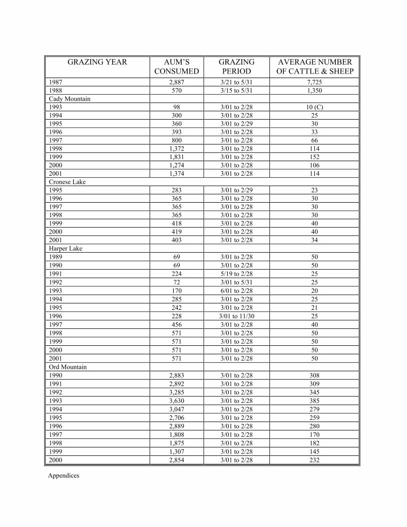
Appendices
GRAZING YEAR AUM’S CONSUMED
GRAZING PERIOD
AVERAGE NUMBER OF CATTLE & SHEEP
1987 2,887 3/21 to 5/31 7,725 1988 570 3/15 to 5/31 1,350 Cady Mountain 1993 98 3/01 to 2/28 10 (C) 1994 300 3/01 to 2/28 25 1995 360 3/01 to 2/29 30 1996 393 3/01 to 2/28 33 1997 800 3/01 to 2/28 66 1998 1,372 3/01 to 2/28 114 1999 1,831 3/01 to 2/28 152 2000 1,274 3/01 to 2/28 106 2001 1,374 3/01 to 2/28 114 Cronese Lake 1995 283 3/01 to 2/29 23 1996 365 3/01 to 2/28 30 1997 365 3/01 to 2/28 30 1998 365 3/01 to 2/28 30 1999 418 3/01 to 2/28 40 2000 419 3/01 to 2/28 40 2001 403 3/01 to 2/28 34 Harper Lake
1989
69
3/01 to 2/28
50 1990
69
3/01 to 2/28
50
1991
224
5/19 to 2/28
25 1992
72
3/01 to 5/31
25
1993
170
6/01 to 2/28
20 1994
285
3/01 to 2/28
25
1995
242
3/01 to 2/28
21 1996
228
3/01 to 11/30
25
1997
456
3/01 to 2/28
40 1998
571
3/01 to 2/28
50
1999
571
3/01 to 2/28
50 2000
571
3/01 to 2/28
50
2001
571
3/01 to 2/28
50 Ord Mountain
1990
2,883
3/01 to 2/28
308 1991
2,892
3/01 to 2/28
309
1992
3,285
3/01 to 2/28
345 1993
3,630
3/01 to 2/28
385
1994
3,047
3/01 to 2/28
279 1995
2,706
3/01 to 2/28
259
1996
2,889
3/01 to 2/28
280 1997
1,808
3/01 to 2/28
170
1998
1,875
3/01 to 2/28
182 1999
1,307
3/01 to 2/28
145
2000
2,854
3/01 to 2/28
232
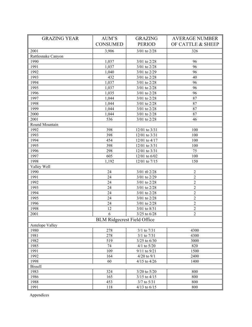
Appendices
GRAZING YEAR AUM’S CONSUMED
GRAZING PERIOD
AVERAGE NUMBER OF CATTLE & SHEEP
2001 3,906 3/01 to 2/28 326 Rattlesnake Canyon
1990
1,037
3/01 to 2/28
96 1991
1,037
3/01 to 2/28
96
1992
1,040
3/01 to 2/29
96 1993
432
3/01 to 2/28
40
1994
1,037
3/01 to 2/28
96 1995
1,037
3/01 to 2/28
96
1996
1,035
3/01 to 2/28
96 1997
1,044
3/01 to 2/28
87
1998
1,044
3/01 to 2/28
87 1999
1,044
3/01 to 2/28
87
2000
1,044
3/01 to 2/28
87 2001
536
3/01 to 2/28
46
Round Mountain
1992
398
12/01 to 3/31
100
1993
398
12/01 to 3/31
100 1994
454
12/01 to 4/17
100
1995
398
12/01 to 3/31
100 1996
298
12/01 to 3/31
75
1997
605
12/01 to 6/02
100 1998
1,192
12/01 to 7/15
150
Valley Well
1990
24
3/01 t0 2/28
2
1991
24
3/01 to 2/29
2 1992
24
3/01 to 2/28
2
1993
24
3/01 to 2/28
2 1994
24
3/01 to 2/28
2
1995
24
3/01 to 2/28
2 1996
24
3/01 to 2/28
2
1998
12
3/01 to 8/31
2 2001
6
3/25 to 6/28
2
BLM Ridgecrest Field Office Antelope Valley 1980 278 3/1 to 7/31 4300 1981 278 3/1 to 7/31 4300 1982 519 3/25 to 6/30 3000 1985 74 4/1 to 5/20 820 1991 109 9/11 to 9/21 1500 1992 164 4/20 to 9/1 2400 1998 60 4/15 to 4/26 1400 Bissell 1983 324 3/20 to 5/20 800 1986 165 3/15 to 4/15 800 1988 453 3/7 to 5/31 800 1991 118 4/13 to 6/15 800
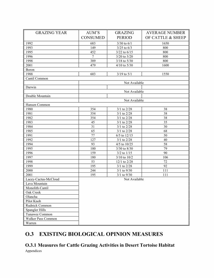
Appendices
GRAZING YEAR AUM’S CONSUMED
GRAZING PERIOD
AVERAGE NUMBER OF CATTLE & SHEEP
1992 683 3/30 to 6/1 1650 1993 149 3/25 to 6/3 800 1995 452 3/22 to 6/15 800 1996 7 3/20 to 5/20 800 1998 389 3/18 to 5/30 800 2001 479 4/10 to 5/30 1600 Boron 1988 603 3/19 to 5/1 1550 Cantil Common Not Available Darwin Not Available Double Mountain Not Available Hansen Common 1980 354 3/1 to 2/28 38 1981 354 3/1 to 2/28 38 1982 354 3/1 to 2/28 38 1983 45 3/1 to 2/28 35 1984 31 3/1 to 2/28 30 1985 65 3/1 to 2/28 68 1991 77 6/5 to 12/15 50 1992 127 3/1 to 2/28 40 1994 93 4/5 to 10/25 58 1995 100 3/30 to 8/30 79 1996 159 3/2 to 1/15 90 1997 180 3/10 to 10/2 106 1998 53 12/1 to 2/28 72 1999 195 3/1 to 2/28 92 2000 244 3/1 to 9/30 111 2001 195 3/1 to 9/30 111 Lacey-Cactus-McCloud Lava Mountain Monolith-Cantil Oak Creek Olancha Pilot Knob Rudnick Common Spangler Hills Tunawee Common Walker Pass Common Warren
Not Available
O.3 EXISTING BIOLOGICAL OPINION MEASURES O.3.1 Measures for Cattle Grazing Activities in Desert Tortoise Habitat
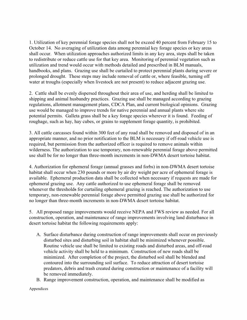
Appendices
1. Utilization of key perennial forage species shall not be exceed 40 percent from February 15 to October 14. No averaging of utilization data among perennial key forage species or key areas shall occur. When utilization approaches authorized limits in any key area, steps shall be taken to redistribute or reduce cattle use for that key area. Monitoring of perennial vegetation such as utilization and trend would occur with methods detailed and prescribed in BLM manuals, handbooks, and plans. Grazing use shall be curtailed to protect perennial plants during severe or prolonged drought. These steps may include removal of cattle or, where feasible, turning off water at troughs (especially when livestock are not present) to reduce adjacent grazing use. 2. Cattle shall be evenly dispersed throughout their area of use, and herding shall be limited to shipping and animal husbandry practices. Grazing use shall be managed according to grazing regulations, allotment management plans, CDCA Plan, and current biological opinions. Grazing use would be managed to improve trends for native perennial and annual plants where site potential permits. Galleta grass shall be a key forage species wherever it is found. Feeding of roughage, such as hay, hay cubes, or grains to supplement forage quantity, is prohibited. 3. All cattle carcasses found within 300 feet of any road shall be removed and disposed of in an appropriate manner, and no prior notification to the BLM is necessary if off-road vehicle use is required, but permission from the authorized officer is required to remove animals within wilderness. The authorization to use temporary, non-renewable perennial forage above permitted use shall be for no longer than three-month increments in non-DWMA desert tortoise habitat. 4. Authorization for ephemeral forage (annual grasses and forbs) in non-DWMA desert tortoise habitat shall occur when 230 pounds or more by air dry weight per acre of ephemeral forage is available. Ephemeral production data shall be collected when necessary if requests are made for ephemeral grazing use. Any cattle authorized to use ephemeral forage shall be removed whenever the thresholds for curtailing ephemeral grazing is reached. The authorization to use temporary, non-renewable perennial forage above permitted grazing use shall be authorized for no longer than three-month increments in non-DWMA desert tortoise habitat. 5. All proposed range improvements would receive NEPA and FWS review as needed. For all construction, operation, and maintenance of range improvements involving land disturbance in desert tortoise habitat the following requirements apply:
A. Surface disturbance during construction of range improvements shall occur on previously disturbed sites and disturbing soil in habitat shall be minimized whenever possible. Routine vehicle use shall be limited to existing roads and disturbed areas, and off-road vehicle activity shall be held to a minimum. Construction of new roads shall be minimized. After completion of the project, the disturbed soil shall be blended and contoured into the surrounding soil surface. To reduce attraction of desert tortoise predators, debris and trash created during construction or maintenance of a facility will be removed immediately.
B. Range improvement construction, operation, and maintenance shall be modified as
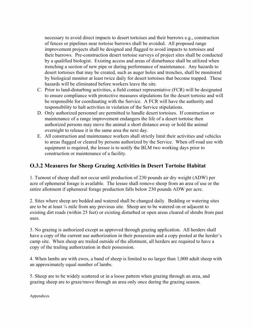
Appendices
necessary to avoid direct impacts to desert tortoises and their burrows e.g., construction of fences or pipelines near tortoise burrows shall be avoided. All proposed range improvement projects shall be designed and flagged to avoid impacts to tortoises and their burrows. Pre-construction desert tortoise surveys of project sites shall be conducted by a qualified biologist. Existing access and areas of disturbance shall be utilized when trenching a section of new pipe or during performance of maintenance. Any hazards to desert tortoises that may be created, such as auger holes and trenches, shall be monitored by biological monitor at least twice daily for desert tortoises that become trapped. These hazards will be eliminated before workers leave the site.
C. Prior to land-disturbing activities, a field contact representative (FCR) will be designated to ensure compliance with protective measures stipulations for the desert tortoise and will be responsible for coordinating with the Service. A FCR will have the authority and responsibility to halt activities in violation of the Service stipulations.
D. Only authorized personnel are permitted to handle desert tortoises. If construction or maintenance of a range improvement endangers the life of a desert tortoise then authorized persons may move the animal a short distance away or hold the animal overnight to release it in the same area the next day.
E. All construction and maintenance workers shall strictly limit their activities and vehicles to areas flagged or cleared by persons authorized by the Service. When off-road use with equipment is required, the lessee is to notify the BLM two working days prior to construction or maintenance of a facility.
O.3.2 Measures for Sheep Grazing Activities in Desert Tortoise Habitat 1. Turnout of sheep shall not occur until production of 230 pounds air dry weight (ADW) per acre of ephemeral forage is available. The lessee shall remove sheep from an area of use or the entire allotment if ephemeral forage production falls below 230 pounds ADW per acre. 2. Sites where sheep are bedded and watered shall be changed daily. Bedding or watering sites are to be at least ¼ mile from any previous site. Sheep are to be watered on or adjacent to existing dirt roads (within 25 feet) or existing disturbed or open areas cleared of shrubs from past uses. 3. No grazing is authorized except as approved through grazing application. All herders shall have a copy of the current use authorization in their possession and a copy posted at the herder’s camp site. When sheep are trailed outside of the allotment, all herders are required to have a copy of the trailing authorization in their possession. 4. When lambs are with ewes, a band of sheep is limited to no larger than 1,000 adult sheep with an approximately equal number of lambs. 5. Sheep are to be widely scattered or in a loose pattern when grazing through an area, and grazing sheep are to graze/move through an area only once during the grazing season.
Appendices
6. Stopping and parking of vehicles, and vehicular camping along routes of travel, is limited to within 50 feet of all routes, except in OHV open areas, in multiple-use Class “L” and ”M” as described in the California Desert Conservation Area Plan. 7. A herder’s camp site or camp trailer shall not remain in the same location for more than seven days. Establishment of a camp shall be at least one mile from any previous camp location. To eliminate or reduce scavenging of trash by desert tortoise predators, trash and garbage shall be removed from each camp site each day and no trash or garbage shall be buried at the camp site. All sheep carcasses within 300 feet of a road would be removed and disposed of in an appropriate manner as soon as discovered and/or livestock operator is notified. Cross-country vehicle travel to gather sheep carcass(es) must have prior approval from the BLM except in designated Open Areas for OHV use. 8. Within 15 days of the close of the authorized grazing period, the lessee shall submit to the field office a BLM-supplied map to delineate areas of daily grazing use within the allotment.

Appendices

Appendices
APPENDIX P
MINERALS

Appendices
Appendices
APPENDIX P MINERALS
P.1 IMPORTANCE OF MINERAL DEVELOPMENT TO
SOUTHERN CALIFORNIA
Both the current and past history of mining within the California Desert provide ample evidence of its importance as a source of mineral resources that are necessary for the State and national needs along with its contribution to the world market as well. Several factors indicate that this area will play a much more important role than it has in the past in supplying mineral resources for future needs which include: the need to replenish diminishing reserves currently being depleted; the necessity to find nearby sources of low-value mineral resources to supply local industry; a necessity to provide the mineral resources required for an expanding local and national population; the need to identify raw material sources that will satisfy the increasingly stringent specifications which industry demands; and to meet the new demands imposed by technological changes which are rapidly occurring. (Davis, J.F. & Anderson, T.P., 1980, "Mineral Resources of the California Desert-An Overview" in Geology and Mineral Wealth of the California Desert, Sough Coast Geological Society, p. 122-127).
Many of the desert's mineral commodities, such as cement and gypsum, are needed in the local California economy, especially in the greater Los Angeles and southern California area. Boron and rare earth elements produced from the desert are considered "world class" deposits. Other important commodities are zeolites and specialty clays used in sewer filtration systems, chemical refining, ceramics, drill mud, and specialized chemical research.
In recent years, there has been a dramatic increase in gold exploration and production
from the desert area. Annual production has accelerated immensely from 5,000 ounces of gold in 1980 to 400,000 ounces by 1990. At 1990 gold prices ($385 per ounce) the gross value of this production is $154 million per year. This compares with a value of $396 million for the state.
Sand and gravel, cement and other mineral commodities used for construction materials are the very foundation of our standard of living. The demand for industrial minerals, particularly sand and gravel, from the California Desert is tremendous because of the needs of over 18 million people in southern California. The metropolitan areas of southern California recently experienced a growth rate estimated at 10 percent and, as the sand and gravel deposits in urban areas are depleted, BLM expects a large increase in demand for the desert's undeveloped resources. During fiscal year 1990 alone, sales contracts and free-use permits for nearly 60 million tons of mineral materials with an estimated royalty value to the U.S. of $29 million were processed by BLM from public lands in the California Desert District. (Free-use permits are granted to nonprofit organizations and certain government agencies without charge.)
The desert's mineral commodities support local industries that employ thousands of people in southern California, generate millions of dollars in wages and taxes, and support other
Appendices
industries, e.g. construction, agriculture, and chemical plants. According to the California Department of Economic Development, in 1989 there were 41,600 persons employed in mining jobs within the state, of which an estimated 20,000+ were in the five county area comprising the CDCA. These figures do not include those jobs that provide support services to the mining industry, nor those jobs which provide support services to employees of the mining industry, or jobs that result from manufacturing or fabrication of product refined from minerals. As with any industry, mining supports an economic base broader than just the individuals that it employs. There are both direct and indirect effects.
In late 1987, Dr. Shirley C. Anderson of California State University, School of Business Administration & Economics, conducted a study ("Mineral Resources of the California Desert and Their Significance to California's Economy" in Compendium, The California Desert Mineral Symposium, 1989, BLM, p. 7-46) to determine the actual economic impact of the then $1.3 billion mineral industry of the CDCA. In her study, Dr. Anderson solicited information from mineral producers. This data was then statistically analyzed by the Regional Science Research Institute of Rhode Island with a computer based input-output model to determine the total economic impacts of mining across 82 sectors of the local economy. Mineral receipts pay for products and services provided to the mining industry. These sales create jobs and the need for other products and services. Wages paid to miners are in turn spent on other goods and services that create additional jobs. Manufactures that use minerals produced from the CDCA provide jobs and need still other products and services from other businesses.
Assuming that the `multiplier' is accurate for 1989, the mining industry operating within the CDCA produced an estimated $1.75 billion worth of mineral commodities contributing to a net benefit of $3.09 billion to the southern California economy. These figures are based upon production values reported by the U.S. Bureau Of Mines. In the last official estimate (1986), the U.S. Bureau of Economic Analysis determined a direct contribution of $5.93 billion from mining to the $533.8 billion Gross State Product for California.
According to the late U.S. Bureau of Mines, California has ranked first in the Nation in
the production of non-fuel mineral resources since 1989. In 1986, approximately $1.1 billion of the $2.3 billion California non-fuel mineral commodities came from production within the California Desert. Over 65 mineral commodities are known to occur in the desert, some of which are vitally important in national and international markets. According to the late Bureau of Mines, these include 100 percent of nation's borates, about 97 percent of the domestic rare earth metals, 15 percent of the talc, 10 percent of the gypsum, and 6 percent of the metallic minerals.
California also leads the nation in the production of geothermal energy. Production at
Coso benefits the NWC by offsetting the need to produce energy using fossil fuels, thereby decreasing noxious emissions and “greenhouse gases.”

Appendices
P.2 PUBLIC LANDS MINERAL PROGRAM MANAGEMENT
Federal laws and regulations allow access and development of minerals on public lands managed by the United States. In the planning area, approximately 160 exploration and mining plans of operation are active. Activity under these authorizations is limited to approximately 25 mining operations and one to two significant exploration operations at any one time.
Locatable Minerals: In the CDCA, minerals are disposed from public lands under federal laws, and guided by regulations promulgated pursuant to those laws. In the planning area, most exploration and development activity on public lands, and associated with occupation and use of the surface resources are guided and authorized under the General Mining Law of 1872 (30 U.S.C. 22 et seq). This law allows prospecting and development of valuable mineral deposits through a location/appropriation system. The law allows use of surface resources, qualified by compliance with appropriate Federal and state laws and rules. Regulations developed pursuant to FLPMA and contained in Title 43, Code of Federal Regulations (CFR) Subparts 3802 and 3809, guide the Bureau in managing surface operations under the mining laws for purposes of preventing undue or unnecessary degradation to public land.
Introduction and definitions: Earth-disturbing operations authorized by the Mining Law of 1872 are managed under the “Surface Management” regulations of Title 43, Subpart 3809 of the Code of Federal Regulations (43 CFR 3809). In essence, these regulations distinguish 3 levels or categories of operation. These include:
• (1) Casual use operations are those activities having no or negligible effect on public resources, such as mineral-collecting or small-scale placer operations. “Casual use” operations do not require notification to, or approval from the BLM.
• (2) Notice-level operations are those surface-disturbing exploration activities, disturbing
5 acres or less, which require prior notification to the BLM, but do not require BLM approval. A Notice is not a federal undertaking for purposes of NEPA review. The liability for compliance with these Acts rests with the party that submits the Notice.
• (3) An approved Plan of Operations is required for mining operations and those activities
that do not meet the requirements for casual use or notice level operation. The BLM’s approval of such Plans is subject to FESA, the Archaeological Protection Act, and other pertinent federal laws. All operators are required to conduct activities to prevent unnecessary or undue degradation to public lands or resources, and must perform reclamation, whatever the size of their operation. A financial guarantee (a reclamation bond) is required for any operation greater than casual use to ensure that reclamation has been completed (43 CFR 3809.500).
The 1980 CDCA plan and subsequent amendments were developed under the surface
management regulations effective January 1, 1981. On January 20, 2001 (amended in October 2001), the surface management regulations were amended to improve, clarify, and better
Appendices
organize the regulations. The West Mojave plan is being developed under the amended regulations.
Casual use activities commonly occur on all BLM-administered public lands within the planning area. However, the surface management regulations specify that a prior-approved plan of operations (not merely a Notice) is required for any activity greater than casual use that removes more than 1,000 tons of presumed ore for testing, disturbs over five acres of public lands, or is within any of the following:
• Lands classified as Multiple Use Classes C or L under the CDCA Plan;
• Areas of Critical Environmental Concern;
• Lands known to contain Federally proposed or listed threatened or endangered species or their proposed or designated critical habitat, unless BLM allows for other action under a formal land-use plan or endangered species recovery plan;
• National Wilderness Preservation System lands;
• Lands designated “closed” to off-road vehicle use per 43 CFR 8340.0-5; and,
• National Monuments or National Conservation Areas.
All Notices filed with the BLM prior to January 20, 2001, expire on January 20, 2003.
Any operator can renew his/her operation at that point, but any renewal must now be subject to the current regulations. This renewal includes a reclamation bond (the BLM did not bond Notices prior to January 20, 2001). The current regulations also state that the BLM may no longer accept Notices in areas identified by USFWS as critical tortoise habitat (43 CFR 3809.11), unless or until a land-use plan specifically allows it. Under part 3809.332, a notice filed after January 20, 2001 remains in effect for 2 years unless extended under part 3809.333.
Currently, several notice-level operations still exist in the Multiple Use Class M portions of the planning area already designated as critical tortoise habitat (such as Fremont-Kramer). After January 2003 these operators must either submit a Plan of Operations for BLM approval to continue operations, or complete and reclaim their operation(s).
Leasable Minerals: Oil and gas, coal, sodium and potassium minerals, phosphate,
asphalt, and geothermal resources located on public land were made subject to permit and lease under the Mineral Leasing Act of 1920 (30 U.S.C. 181 et seq) and the Geothermal Steam Act of 1970 (30 U.S.C. 1001 et seq). Exploration and development is guided by approved operating plans under the direction of regulations at 43 CFR 3100 to 3500. Most of the exploration and development of leasable minerals in the CDCA are within dry lake basins for solid leasable minerals, and geothermal development in steam fields in the northwestern China Lake area. BLM field offices review applications for mineral leases and if issuance will not cause

Appendices
unnecessary or undue degradation, recommendations to lease are made to the BLM’s California State Office for issuance. A lessee must submit a notice or application to the appropriate field manager prior to conducting operations on the ground. BLM staff analyzes the proposed action and prepares an environmental document as required by NEPA. Approvals consider impacts to endangered species, cultural resources, and other public land resources. Other environmental issues are considered as appropriate. The field manager includes reclamation and mitigation measures in his/her approval of the proposed action.
The Geothermal Steam Act of 1970, as amended, (84 Stat, 1566; 30 U.S.C. 1001-1025) provides the Secretary of the Interior with the authority to lease public lands and other federal lands, for geothermal exploration and development. This authority has been delegated to the Bureau of land Management. Geothermal leases are issued through competitive bidding for federal lands within a Known Geothermal Resource Area (KGRA), or noncompetitively for federal lands outside of a KGRA. Two KGRA areas are identified within the plan boundaries, both of which are in Inyo County - one at Coso, and the other at Randsburg. Energy production from geothermal resources is currently taking place in the Coso area where approximately 240 MW are currently online.
Wilderness or wilderness study areas are withdrawn from leasing. No current leases exist in any wilderness in the planning area. If any public lands were already leased at the time of inclusion, such leases would be accorded valid existing rights, as appropriate. Mineral leases can be issued in lands classified as L, M and I by the CDCA Plans, or for unclassified lands.
Mineral Material Disposals (Sales or Permits for Construction Material): Common mineral materials on public lands, such as sand and gravel, clays, cinders, pumice, and building stone, are disposed of by BLM by contract or permit under the authority of the Materials Act of 1947, as amended (30 U.S.C. 701 et seq). Activities are guided by the regulations at 43 CFR 3600, and include requirements for authorization of exploration and approval of mining plans of operation. Activities are conducted to prevent undue or unnecessary degradation. Contracts or permits can only be issued if the disposal is in the public interest and the net benefits of disposal outweigh the net aggregate damage from activity, as examined through NEPA review and directed by regulation. In the CDCA, about one current operation out of eight is over 10 acres in size. These operations are most likely to occur in habitat areas. Because the value of the deposit is related to proximity to market demand, many areas where these deposits occur have or are being disturbed by other activity (e.g., existing roads, residential or commercial development).
A BLM Field Manager may dispose of mineral materials upon receipt of a written request, or upon his/her own initiative. Sale Contracts, Free Use Permits (to public agencies or non-profit organizations) and Community Pits (for small sales to the general public) are the means by which such disposals are accomplished. A written request includes a mining plan that describes how the material will be removed and how the site will be reclaimed.
After a request is received, BLM staff prepares a NEPA document. All such actions are
subject to FESA, the Archaeological Protection Act, and pertinent environmental laws.
Appendices
Reclamation and bonding may be required as conditions of the contract or permit. Mineral material disposals are discretionary. That is, the field manager has discretion to decide whether a sale or permit serves the public good. All such sales or permits are subject to the pertinent BLM land use plan (43 CFR 3601.11).
No mineral material disposals are allowed in wilderness or wilderness study areas. The CDCA Plan allows disposal of mineral materials from lands outside wilderness area, subject to federal regulations. Disposals may be permitted from ACECs if the ACEC land management plan does not prohibit it. P.3 PRIVATE LAND OPERATIONS
Private land development, whether stand alone or in conjunction with public land authorizations, are developed through permits issued by the state lead agency, usually the county, as authorized by the Surface Mining and Reclamation Act (SMARA) of 1975 (California Public Resources Code, Chapter 4, Division 2nd, Section 2710). Where combined private and public land operations are proposed, the BLM may coordinate review of the operation with the state lead agency under an existing 1992 Memorandum of Understanding (MOU), or by a site specific MOU or agreement. Under SMARA the threshold for filing a Reclamation Plan (for operations on federal lands) or a Site Approval (for private land) is 1,000 cubic yards of removal or disturbance over one acre. In most cases the county is the lead agency. However, if the activity is within city limits, the city becomes the lead agency. P.4 COOLGARDIE MESA MINING CLUBS
Members of at least four recreational prospecting and mining clubs frequent the area,
with most activity conducted on weekends in the late spring and fall when the weather is not overly hot and the soil is fairly dry. The larger clubs may have a membership of 400 families. On an average day during the dry-washing season the number of club members at the site may vary from three to thirty persons. Activity includes the use of both battery and gasoline-powered dry washers. Air from a bellows powered by a hand crank or small motor blows the lighter material up, leaving gold trapped on the board’s ridges. Occasionally, someone will recirculate water in a large tub for operating a wet sluice operation.
Club members refer to themselves as “small-scale miners” and seek an escape from the city to a desert environment where they can pursue their hobby of gold prospecting and recovery. The activity brings with it the opportunity to make a little money, sometimes more than a little. The recovered gold varies from “dust” or “colors” to nuggets generally up to the size of a match-head. It has been reported that the small-scale miners find up to a quarter of an ounce of gold per day. Recovery is believed to be about 50 percent, which explains why there is still some gold left after over a hundred years of activity. Most of these individuals are operating under casual use and may continue to do so as long as they reclaim their hand-dug pits and the cumulative disturbance does not cause more than “negligible” disturbance. Club members police themselves so as to not to cause unnecessary or undue degradation. One person lives at the site

Appendices
in a trailer and is operating under a plan of operations. Another operator at Williams Well, to the northeast and outside of the proposed conservation area, uses a backhoe and is also under a plan of operations.

Appendices

Appendices
APPENDIX Q
UTILITIES: EXISTING BIOLOGICAL OPINIONS

Appendices
Appendices
UTILITIES: EXISTING BIOLOGICAL OPINIONS Q.1 PIPELINES U.S. Fish and Wildlife Service. 1995. Biological opinion for on-going maintenance activities on
Four Corners Pipeline Company’s crude oil pipelines in California (2880/6840 CA-060.27 (CA-932)) (1-8-94-F-27). Memorandum from Acting Field Supervisor, Ecological Services - Ventura Field Office, Ventura, CA to State Director, Bureau of Land Management, Sacramento, CA.
Incidental Take: (a) Two (2) desert tortoises per year in the form of direct mortality or
injury through accidental death or injury during pipeline maintenance and repair activities, including use of access roads.
Terms and Conditions:
• Class I - Regular operation and maintenance with no habitat disturbance. (a) Reporting foreseeable projects at beginning of each year. (b) Education program. (c) Use only existing rights of travel. (d) Speed limit of 10 mph. (e) Check under vehicles. (f) Litter free work place. (g) No firearms. (h) Remove equipment at end of activity. (i) Alert supervisor and/or biologist to any tortoise sign; personnel not to handle tortoises.
• Class II - Activities resulting in minimal surface disturbance. (a) Designate Field
Contact Representative. (b) Confine activities to ROW. (c) Survey areas for tortoises ahead of maintenance activities. (d) Hire biologist if take is possible. (e) Maintain biologist with each maintenance crew where tortoises may be affected; biologist maintains records; follows protocols. (f) Expanded work areas need pre-activity surveys. (g) Personnel report all tortoise sightings to biologist. (h) Avoid tortoise entrapment in pits and other excavations. (i) Cap pipes to prevent tortoise entry. (j) Report dead or injured tortoises. (k) Complete restoration to �...assist in the re-establishment of original native plant communities within the disturbed ROW.� (l) Avoid creating new raven nesting sites; secure salvage permits if nest found.
• Class III - Activities that result in major surface disturbance. (a) Prior authorization
before expanding the ROW. (b) Reporting.
• Class IV - Activities that extend outside existing ROWS. (a) Require independent review by BLM; new construction beyond scope of BO. (b) Measures for emergency spills, including reporting. (c) BLM suspends ROW permit if terms and conditions not implemented.
U.S. Fish and Wildlife Service. 1993. Biological opinion for the construction and maintenance
Appendices
of an underground crude oil pipeline extending from the Western Mojave Desert to the Los Angeles basin, San Bernardino and Los Angeles counties, California (6840/2880 CDD-00-F-93-6 (CA-060.27)) (1-8-93-F-9). Memorandum from Field Supervisor, Ecological Services - Ventura Field Office, Ventura, CA to State Director, Bureau of Land Management, Sacramento, CA.
Incidental Take: (a) Eight (8) desert tortoises in the form of direct mortality or injury
through accidental death or injury during pipeline maintenance and repair activities, including use of access roads. (b) An unknown number of desert tortoises in the form of harassment through the excavation of active burrows or the moving of desert tortoises out of harm�s way during construction activities. (c) Two (2) desert tortoises per year in the form of direct mortality or injury through accidental death or injury during pipeline maintenance activities, including use of access roads. (d) Four (4) desert tortoises per year in the form of harassment through the excavation of active burrows or the moving of desert tortoises out of harm�s way during maintenance activities.
Terms and Conditions: (a) Provide authorized biologist; authority to halt activities. (b) Maintain litter free workplace. (c) No firearms. (c) Check under vehicles for tortoises. (d) Pre-activity surveys within 48 hours; unavoidable burrows excavated and tortoises moved out of harm�s way. (e) 50-foot buffer from tortoise burrows outside the ROW; erect temporary tortoise-proof fence, removed at the end of the activity. (f) Education program. (g) Stake boundaries and restrict activities to that area. (h) Minimize unauthorized personnel by using fences or gates. (i) Clear minimum ROW width possible. (j) Stockpile soils and brush for revegetation; salvage spoil materials separately. (j) Biological guidance on handling tortoises. (k) Proper disposal of dead or injured tortoises. (l) Insofar as possible, restrict construction and maintenance activities to between October 15 and February 28. (m) Speed limit of 20 mph. (n) Avoid entrapping tortoises in excavations. (o) Revegetate all disturbed desert tortoise habitat to pre-disturbance conditions, implementing site-specific revegetation plans approved by the USFWS, BLM, and CDFG. Subject to the owners approval, a site-specific revegetation plan shall also be used on private lands. (p) Guidelines for seeding; only native species used. (q) Biologist present during revegetation activities. (r) Reporting. U.S. Fish and Wildlife Service. 1993. Biological opinion for the maintenance of a right-of-way
for an underground gas transmission pipeline in the Eastern Mojave Desert, San Bernardino County, California (6840/2880 CDD-00-F-93-02 (CA-060.27)) (1-8-93-F-9). Memorandum from Field Supervisor, Ecological Services - Ventura Field Office, Ventura, CA to State Director, Bureau of Land Management, Sacramento, CA.
Incidental Take: (a) One (1) desert tortoise in the form of direct mortality or injury
through accidental death or injury during line maintenance activities, including use of access roads. (b) An unknown number of desert tortoises in the form of harassment through the excavation of active burrows or the moving of desert tortoises out of the project area.
Terms and Conditions: (a) Biologists performs pre-activity survey; present during all
Appendices
ground disturbing activities. (b) Place water bars so as to avoid impacts to tortoises. (c) Guidance for handling tortoises. (d) Speed limit of 20 mph, and restrict travel to existing roads. (e) Litter free workplace. (f) No surface disturbance outside ROW; storage and parking restricted to ROW. (g) Fill for washouts obtained from appropriate offsite location. (h) Education program. (i) Check under vehicle. (j) No firearms or pets. (k) Procedures for reporting tortoise mortality. (l) Biologist maintains records of tortoises; authority to halt activities; close-out report. (m) BLM revoke Southern California Gas Company�s ROW permit if terms and conditions not being implemented.
U.S. Fish and Wildlife Service. 1992. Biological opinion for the maintenance of an
underground gas transmission pipeline in the Eastern Mojave Desert, San Bernardino County, California (6840/2880 CDD-00-F-93-01 (CA-060.27)) (1-8-93-F-6). Memorandum from Acting Field Supervisor, Ecological Services - Ventura Field Office, Ventura, CA to State Director, Bureau of Land Management, Sacramento, CA.
Incidental Take: (a) Two (2) desert tortoises per year in the form of direct mortality or
injury through accidental death or injury during line maintenance activities on all three segments, including use of access roads. (b) Four (4) desert tortoises in the form of harassment through the excavation of active burrows or the moving of desert tortoises out of the project area.
Terms and Conditions: During pipeline maintenance the following measures shall be implemented to minimize disturbance to native habitats and the desert tortoise: (a) Flag and stay with ROW. (b) Stockpile in disturbed areas. (c) Erect temporary fencing or gates to minimize unauthorized use. (d) Vehicle travel restricted to existing routes. (e) Litter free workplace. (f) Speed limit of 20 mph. (g) Avoid entrapment. (h) No firearms. (i) No pets. (j) Check under vehicles. (k) Report sightings to biologist. (l) Pre-activity surveys; biologist present at all times take may occur; maintain records; personnel do not handle tortoises; minimum of one biologist per maintenance activity; handling guidelines; authority to halt project. (m) Education program. (n) Off-site compensation for lost habitat. (o) Post project assessment. U.S. Fish and Wildlife Service. 1991. Biological opinion for the repair of a natural gas
pipeline, Edwards Air Force Base, California (XAE) (1-6-91-F-26). Memorandum from Field Supervisor, Southern California Field Station, Laguna Niguel, CA to Gregory Spencer, P.E., Ames Research Center, Dryden Flight Research Facility, Edwards, CA.
Incidental Take: (a) One (1) desert tortoise in the form of direct mortality through
accidental death during construction. (b) Ten (10) desert tortoises in the form of harassment through the excavation of burrows occupied by desert tortoises and the removal of desert tortoises found above ground in the project area during construction activities. (c) Approximately 1.5 acres of desert tortoise habitat will be permanently or temporarily disturbed.
Terms and Conditions: (a) Authorized biologists can handle tortoises only. (b) Preconstruction and construction activities monitored. (c) Avoid entrapment. (d) 10 mph speed limit. (e) Stake boundary, restrict impacts to ROW. (f) Education program. (g) Construction

Appendices
restricted to between October and February. (h) Litter free workplace. (i) Escape ramps in trenches every 150 meters apart. (j) Revegetate pipeline ROW. (k) Preconstruction surveys. (l) Guidance for burrow avoidance and excavation, and tortoise handling. (m) No construction between dusk and dawn in native vegetation. Q.2 ELECTRICAL TRANSMISSION LINES U.S. Fish and Wildlife Service. 1994. Biological opinion for minor electrical utility actions in
Imperial, Kern, Los Angeles, Riverside, and San Bernardino counties, California (6840 CA-063.50) (1-8-94-F-53). Memorandum from Acting Field Supervisor, Ecological Services - Ventura Field Office, Ventura, CA to State Director, Bureau of Land Management, Sacramento, CA.
Incidental Take: (a) Two (2) desert tortoises per year in the form of direct mortality or
injury resulting from maintenance and construction activities. (b) Twenty (20) desert tortoise per year in the form of harassment through moving desert tortoises from harm�s way during construction and maintenance activities.
Terms and Conditions: (a) Designate FCR. (b) Education program. (c) Authorized biologists handle tortoises, only. (d) Survey and monitor all construction activities. (e) Guidance for handling tortoises, marking them, and recording data. (f) Stockpile in existing disturbed areas. (g) Existing routes of travel. (h) Check under vehicles. (i) No firearms or pets. (j) Litter free workplace. (k) Salvage permits for removing raven nests. (l) Annual reporting. (m) Habitat disturbance is limited to no more than five acres per year. U.S. Fish and Wildlife Service. 1991. Biological opinion for the proposed Meade/McCullough-
Victorville/Adelanto transmission line (CA-932.5) (1-6-90-F-46). Memorandum from Field Supervisor, Southern California Field Station, Laguna Niguel, CA to State Director, Bureau of Land Management, Sacramento, CA.
Incidental Take: (a) Five (5) tortoises in the form of direct mortality through accidental
death during construction. (b) One hundred (100) tortoises in the form of harassment through the excavation of active burrows or through the removal of tortoises found above ground in the construction area during construction activities [Note: This 100-animal harassment level was exceeded, and the BO amended to allow for more animals to be handled.]. (c) Approximately 1,100 acres of habitat. (d) Five (5) tortoises in the form of direct mortality through accidental death by crushing during routine inspection and emergency situations for the life of the project.
Terms and Conditions: (a) Suspend ROW grant if terms and conditions not followed. (b) Designate FCR. (c) Biological monitoring; avoid entrapment. (d) No permanent widening or upgrading of existing access roads will be undertaken in areas of biological concern. (e) New access roads follow landform contours. (f) Close all access roads not needed for maintenance.
Appendices
(g) Place towers to minimize ground disturbance. (h) Education program. (i) Preconstruction surveys; handling guidelines; tortoise relocation and burrow excavation; personnel report sightings. (j) Park in previously disturbed areas. (k) Existing routes. (l) Blade only where necessary. (m) Litter free workplace. (n) No firearms. (o) 25 mph speed limit. (p) Close-out report. (q) 1,603 acres in California (Category I or II habitats) and 274 acres in Nevada. (r) Construct tortoise-proof fence around substation. (s) Pay $63,224.40 in compensation funds to Clark County, prior to initiating construction. Fish and Wildlife Service. 1991. Biological opinion for the proposed Kramer-Victor 220 kV
transmission line project by Southern California Edison, San Bernardino County, California (CART 310 2800 (CA-068.23)) (1-6-91-F-8). Memorandum from Field Supervisor, Southern California Field Station, Laguna Niguel, CA to State Director, Bureau of Land Management, Sacramento, CA.
Incidental Take: (a) One (1) tortoise in the form of direct mortality through accidental
death during construction of the transmission line. (b) Ten (10) tortoises in the form of harassment through the excavation of active burrows or through the removal of tortoises found above ground within the right-of-way during construction activities for the transmission line. (c) Five (5) tortoises in the form of direct mortality through collisions with vehicles during routine maintenance activities for the life of the project (30 years). (d) Approximately 111 acres of habitat (107 acres of temporary impact and 4 acres permanent).
Terms and Conditions: (a) Suspension of permit if conditions not implemented. (b) Biological preconstruction surveys and monitoring. (c) No tower placement or permanent widening of existing access roads in areas with biological concerns. (d) Follow landform contours for new access roads. (e) Minimize impacts. (f) Education program. (g) Designate FCR. (h) Handling and excavation guidelines. (i) Park in previously disturbed areas. (j) Flag designated areas, restrict activities to flagged areas. (k) Construct routes of travel without blading to promote resprouting of native shrubs. (l) 25 mph speed limit. (m) Monitoring plan to evaluate raven use along Highway 395. (n) Close-out report. (o) Compensation for 107 acres temporary and 4 acres permanent impacts. (p) Develop road closure plan. (q) No firearms or dogs. Q.3 FIBER OPTIC CABLES U.S. Fish and Wildlife Service. 1993. Biological opinion for an American Telephone and
Telegraph Victorville to Bakersfield fiber optic cable line (1-8-93-F-12). Memorandum from Field Supervisor, Ecological Services - Ventura Field Office, Ventura, CA to State Director, Bureau of Land Management, Sacramento, CA.
Incidental Take: (a) Four desert tortoises in the form of direct mortality resulting from
project construction, operation, and maintenance.
Terms and Conditions: (a) Stockpile in disturbed areas. (b) Confine impact to smallest
Appendices
practical area, flag boundaries, restrict activities. (c) Existing routes of travel. (d) Litter free workplace. (e) Avoid post-construction erosion. (f) No domestic dogs, unless restrained. (g) Stabilize soils. (h) No firearms. (i) Escape ramps in trenches at intervals of no more than a quarter mile. (j) Education program. (k) Minimize blading to promote resprouting; revegetate all impact areas off of roads. (l) Designate FCR. (m) Authorize handling only. (n) Monitors with each construction crew; maintain records. (o) Remove flagging and other markers upon completion. (p) Post-construction report. (q) On-site inspection by regulatory agencies, if requested by the USFWS. (r) Preconstruction surveys; avoid burrows; handling guidelines; records and data. (s) Check under vehicles. (t) Acquire compensation lands (281.4 acres) in BLM Category I Habitat. U.S. Fish and Wildlife Service. 1991. Biological opinion for the proposed Contel fiber optics
line from Bishop to Inyokern, California (6840 (CA-063.50)) (1-6-91-F-13). Memorandum from Field Supervisor, Southern California Field Station, Laguna Niguel, CA to State Director, Bureau of Land Management, Sacramento, CA.
Incidental Take: (a) One (1) desert tortoise in the form of direct mortality through
accidental death during installation of the fiber optic cable. (b) Five (5) desert tortoises in the form of harassment through the removal of desert tortoises found above ground within the right-of-way during installation activities for the fiber optic cable. (c) One (1) desert tortoise in the form of excavation of its burrow in the event it cannot be avoided during construction. (d) One (1) desert tortoise in the form of direct mortality through collision with a vehicle during routine maintenance activities for the life of the project. (e) Approximately 16 acres of habitat lost.
Terms and Conditions: (a) BLM suspends ROW permit if terms and conditions not followed. (b) Construction monitored by biologist. (c) Confine vehicles and equipment to previously disturbed areas. (d) Bury cable in center of unpaved roads and along bare shoulders of paved roads. (e) Will be patrolled periodically to repair eroded areas. (f) Preconstruction surveys. (g) Education program. (h) Designate FCR. (i) Avoid entrapment. (j) Tortoise handling guidelines; burrow excavation. (k) Park in disturbed areas. (l) Existing routes of travel. (m) Litter free workplace. (n) 20 mph speed limit. (o) Avoid tortoises and burrows during maintenance; surveys prior to maintenance and repair activities by biologist. (o) Close-out report.
Appendices
APPENDIX R
MOTORIZED VEHICLE ACCESS ROUTE DESIGNATION

Appendices
Appendices
APPENDIX R MOTORIZED VEHICLE ACCESS
ROUTE DESIGNATION
R.1 DATA MANAGEMENT
In order to establish a record of each recommendation that was reached during the off road vehicle designation process, a system to track the process was developed. This system employed several steps, which are listed below:
• Each route was tracked by assigning to it a specific alphanumeric code. This code employed a standardized numbering convention that included one or two letters followed by 4 digits. The letters would represent the first letter of the sub region (e.g. Middle Knob = MK, Superior = S). The four digits that followed were broken down into the first digit represent the MAZ in which the route either began or ended, followed by next three digits that actually represented the route number in that MAZ.
• As each route was evaluated for designation, an electronic record with a number
of variables specific to that route was established. The variables included information such as the following:
o UTM coordinates indicating the approximate location of the route o The Decision Tree code denoting recommended designation, which would
indicate the “leg” or “branch” of the Decision Tree which was followed in arriving at the decision.
o A short note on the reason(s) for the final decision o The final recommendation of open or closed o The date o The persons responsible for the final recommendation
• These electronic records were entered utilizing ACCESS software, which
established a database that allowed the recommended designations to be collectively integrated or joined with the existing route inventory GIS database. This “joining” of the two databases then allowed for the production of maps that integrated the recommended decisions with the route inventory.
Appendices
R.2 OFF ROAD VEHICLE DESIGNATION SUBREGIONS One of the first steps in the off road vehicle designation process for the West Mojave was the identification of 20 “subregions” (see also Tables 2-20 and 2-21), which were geographic subdivisions of lands outside of wilderness areas, open areas and ACECs. With the exception of certain BLM Class M lands in Inyo County and in and around the Cady Mountains, and scattered parcels elsewhere, all public lands for which route designations have been recommended are within one of the subregions. The subregions, therefore, constitute the “building block” of the motorized vehicle access network. The following discussion provides a general overview of each subregion, and describes the recreational values present in each. R.2.1 Bighorn Subregion
General description: The Bighorn subregion consists of public and private lands found to the southwest of State Highway 247 as it makes a wide arc roughly between its intersection with Camp Rock Road and the community of Yucca Valley, California. The subregion is composed mainly of BLM-managed public lands, with private lands and the San Bernardino National Forest to the west, and primarily private lands to the south. The Bighorn Mountains Wilderness is located within and to the west of the subregion.
The rugged Bighorn Mountains are the eastern foothills of the San Bernardino Mountains. Visitors can experience the rare ecological transition that occurs here, going from yucca and Joshua trees on the desert floor to stands of Jeffrey pine at higher elevations. Mule deer, mountain lions, bobcats, and golden eagles are prominent wildlife of the area. Resident and migratory birds rest along Rattlesnake Canyon Creek, which flows through the wilderness and northward to Johnson Valley. Elevations within the Bighorn subregion range from 3,100 to 6,600 feet.
Recreation Activities/Resource Uses Overview: Primary recreation activities and resource uses occurring in the subregion are cattle grazing, powerline and pipeline rights-of-way, communication sites, wildlife habitat, mining and recreational mining, hunting, and off-highway vehicle use restricted to open routes of travel. The area is a popular destination for National Forest-related recreation to the west, and has been an historical off-highway vehicle destination on the south side.
The designated routes provide for vehicle access to the following subregion features: Rattlesnake Canyon and the San Bernardino National Forest, to the south and east. In addition, the designated routes provide for access to the boundary of the Bighorn Mountains wilderness. Vehicles are not permitted in wilderness, but hiking, camping, and horseback riding are encouraged. R.2.2 Coyote Subregion
Appendices
General Description: The Coyote subregion, located approximately 20 miles northeast of Barstow, California, is defined by the Fort Irwin Military Reservation (National Training Center) on the north, Interstate-15 on the south, the Calico Mountains on the southwest, and the Soda Mountains Wilderness Study Area (WSA) on the east. The extensions of this subregion consist primarily of public lands on either side of the Soda Mountains WSA.
Coyote Dry Lake, Alvord Mountain, and a portion of the Calico Mountains are found within the subregion. Elevations range from 1,700 to 3,600 feet. The Calico Early Man Site is found at the south end of the subregion. This National Register Property was designated as an ACEC by the 1980 CDCA Plan. A management plan was prepared in 1984. The plan designated a network of vehicle access routes, a network designed to protect the evidence of ancient human occupation. This ACEC is located within the Superior-Cronese tortoise DWMA
Recreation Activities/Resource Uses Overview: Primary recreation activities and resource uses occurring in the area are powerline and pipeline rights-of-way, wildlife habitat, cattle grazing, recreational mining, rockhounding, hiking, upland gamebird hunting, and off-highway vehicle use restricted to open routes of travel. The recommended route network provides vehicle access for all of these, as well as for access to each block of non-federal land within the area. R.2.3 East Sierra Subregion
General Description: The East Sierra subregion, located approximately 10 miles west
of Ridgecrest, is defined by Highway 14 on the east; Highway 178 on the south; the Bakersfield BLM Field Office and Sequoia National Forest boundaries on the west; and the Class L and Class M boundary in the Coso Junction and Rose Valley area on the north. The Owens Peak and Sacatar Trail wilderness areas (49,009 and 33,132 acres) are located within this sub-region. All or parts of three ACECs are found within the East Sierra subregion: Fossil Falls, Sand Canyon and Last Chance Canyon. Route designation for Fossil Falls and Sand Canyon was designated by their management plans and is not changed by the West Mojave Plan. For the Last Chance Canyon ACEC, Alternative A would adopt the 1985-87 route designations, except for the east access to Mesa Springs, which was recommended for closure by the 1982 ACEC management plan. This network would be effective on an interim basis, until the completion of a collaborative and community-based program to develop a revised motorized vehicle access network for the El Paso Mountains, including all of the Last Chance Canyon ACEC outside wilderness. Participants in this effort would include the City of Ridgecrest, Kern County, BLM and interested stakeholders. When completed, the revised network for the El Paso Mountains would be incorporated into the CDCA and West Mojave Plans through an amendment.
The region consists primarily of the eastern face of the southern Sierra Nevada. Elevations range from 2,400 feet along Highway 14 to 8,453 feet above sea level on top of Owens Peak. The mountainous terrain has deep, winding, open and expansive canyons, many of
Appendices
which contain springs with extensive riparian vegetation. This area is a transition zone between the Great Basin, Mojave Desert and Sierra Nevada ecoregions. Vegetation varies considerably with a creosote bush scrub and Joshua tree woodland community on the bajadas, and cottonwood and willow riparian vegetation in the canyons at lower elevations. Above 5,000 feet, the canyons and ridges are dominated by pinyon-juniper woodland with sagebrush and grey pine.
Recreation Activities/Resource Uses Overview: Primary recreation activities and
resource uses occurring in the area are: domestic sheep and cattle grazing, mineral exploration, utility and aqueduct corridor maintenance, communication site maintenance, recreational vehicle touring/sightseeing, dispersed hiking and camping, rock climbing, upland gamebird and deer hunting, bird watching, wildflower viewing, rock hounding, mountain biking and equestrian use. Much of this sub-region is designated as wilderness.
Biological values of special concern include habitat for desert tortoises, bats, Mohave ground squirrels, special status plants, and raptors (both nesting and foraging areas). The area has a number of special habitats (extensive riparian corridors and desert washes and springs). Cultural resources are significant in the area, especially in the canyon bottoms.
The proposed route designations provide for vehicle access to the following features: Owens Peak Wilderness, Sacatar Trail Wilderness, Short Canyon, Sand Canyon, Ninemile Canyon, the LADWP Aqueduct, No Name Canyon, and Indian Wells Canyon. They also provide for vehicle access to dispersed camping throughout the Eastern Sierra. The designations provide access to hiking trailhead opportunities along the boundary of the Owens Peak and Sacatar Trail Wildernesses, Short Canyon, Sand Canyon and No Name Canyon. The designations provide access to staging areas for mountain bike and equestrian recreation throughout the subregion.
The proposed designations provide for vehicle access to and through the subregion’s prime chukar, Gambel’s quail, and deer hunting areas. Vehicle access to popular rock hounding sites and historic Depression-Era mining sites in Indian Wells Canyon are provided. Also, vehicle access for livestock operations is provided.
The proposed designations provide for vehicle access to every known active mineral exploration area, and provide access along each authorized utility and aqueduct corridor within the area. Vehicle access to all authorized communication sites are also provided for. R.2.4 El Mirage Subregion
General Description: The El Mirage subregion, located northwest of the community of
Adelanto and due north of BLM’s El Mirage Off-Highway Vehicle Area is defined by Edwards Air Force Base to the north and west, State Highway 395 to the east, and the El Mirage Off-Highway Vehicle Area immediately to the south. The western boundary is not well defined, consisting of private and Federal lands. The subregion is located in both Los Angeles and San Bernardino Counties.
Appendices
The Shadow Mountains, in the southwestern corner, trend northwest-to-southeasterly,
and have a maximum elevation of 3,996 feet. The greater area is characterized by bajadas, dry lakebeds, washes, rugged hills, and desert mountains. Vegetation consists of three basic types, creosote bush scrub, saltbush scrub and alkali sink scrub, all of which are typical of the western Mojave Desert. Creosote bush scrub is by far the dominant vegetative type.
Recreation Activities/Resource Uses Overview: Primary recreation activities and resource uses occurring in the area are powerline and pipeline rights-of-way, rockhounding, cattle grazing, recreational mining, upland gamebird hunting, hiking and camping, wildlife habitat, and off-highway vehicle use restricted to open routes of travel.
Particular designated routes provide access to various blocks of non-federal land within the area. R.2.5 El Paso Subregion
General Description: The El Paso subregion, located approximately 10 miles southwest of Ridgecrest, is defined by the El Paso Mountains wilderness area and “old” U. S. 395 to Inyokern on the north, U.S. Highway 395 on the east, the Garlock Road and Red Rock Canyon State Park on the south, and Highway 14 on the west. The subregion is 83,474 acres in size, with 92% federal land (76,998 acres) managed by the BLM and 8% private and state land (6,475 acres). Numerous landowners own the private lands. The El Paso Mountains wilderness is surrounded by this subregion on three sides.
The region consists of prominent volcanic peaks (El Paso Mountains), broad valleys, rolling foothills, badlands, sloping bajadas, braided washes, and narrow canyons. Elevations range from 2,000 feet on the southern boundary to 5,244 feet above sea level on top of Black Mountain. Creosote bush scrub and saltbush acrub are the predominant plant communities in the lowlands, with numerous desert washes, remnant stands of native perennial bunchgrasses on the mountain tops, scattered Joshua tree woodland, and small riparian plant communities at a few of the widely spaced springs.
The El Paso Mountains contain three West Mojave endemic plants: Red Rock poppy,
Red Rock tarplant and Charlotte’s phacelia. They are well known as a raptor nesting area and support abundant populations of upland game birds.
Recreation Activities/Resource Uses Overview: Primary resource uses occurring in this subregion are: domestic sheep grazing, mineral exploration, utility corridor maintenance, communication site maintenance, and various recreational activities. The BLM’s CDCA Plan identified four sites within the subregion with excellent potential for interpretation and education: Burro Schmidt’s Tunnel; the El Paso Mountains; the Garlock Fault; and the Goler Grabben.
Appendices
In particular, the El Paso Mountains are heavily used for a variety of recreational activities. The area contains excellent opportunities for upland game bird hunting (chukar and Gambel’s quail) and rock and mineral collecting. Other activities include recreational vehicle touring/sightseeing, dispersed hiking and camping, mountain biking, and equestrian recreation. The subregion is also used for commercial 4-wheel drive and dual sport motorcycle tours and competitive equestrian endurance rides.
R.2.6 Fremont Subregion
General Description: The Fremont subregion is located approximately 30 miles northwest of Barstow, California. U.S. Highway 395 provides access to the Fremont subregion from the west, and State Highway 58 from the south. Several public roads are located within the subregion including Harper Lake Road, Santa Fe Avenue, and Lockhart Road. The Grass Valley Wilderness and the Red Mountain subregion (within BLM’s Ridgecrest Resource Area) bound the subregion to the north, State Highway 58 to the south, the Black Mountain Wilderness and Superior subregion to the east, and U.S. Highway 395 to the west. The Fremont subregion encompasses a total of approximately 222,750 acres, which includes 52% (116,274 acres) Federal land managed by the BLM, and 47% (105,494 acres) private and State land.
The southern portion of the Fremont subregion includes Water Valley, a relatively large, open and flat area with scattered low rolling hills. This area also includes about half of Harper Dry Lake, which is the lowest point of the subregion at 2,018 feet. A portion of Harper Lake is within a BLM Area of Critical Environmental Concern (ACEC), in support of the birds and wildlife in that area. Vegetation in the Water Valley consists mainly of creosote bush scrub and saltbush scrub, and some scattered Joshua trees. A large number of unimproved roads cross the valley along with public infrastructure facilities that include high voltage transmission lines, wood pole power lines, and telephone lines. In addition, the valley includes intermixed grazing and ranching lands with associated fences and structures.
The northwest portion of the subregion includes primarily flat terrain, undulating slightly with some prominent rocky buttes. Vegetation is limited to creosote bush scrub, typical of that found throughout the Western Mojave. U.S. Highway 395 bounds this area to the west, and Fremont Peak to the east. Fremont Peak is located within the northern portion of the subregion, and rises abruptly to 4,584 feet above the flat valley surrounding it. The creosote bush scrub community in this area is limited to the bajada and foothills, extending only about one-third of the way to the top of Fremont Peak. The higher elevations of Fremont Peak are rocky hillsides with widely scattered plants of the Mojave mixed woody scrub community. Old mines and OHV tracks are located throughout the Fremont Peak area.
East of Fremont Peak, the northern portion of the subregion includes the Gravel Hills. This topographically varied area consists of low rolling mountains with vegetation limited to typical low desert shrubs found throughout the West Mojave. The far northeast portion of the subregion borders the Black Mountain Wilderness Area, and includes a portion of the Black Mountain ACEC, established for the protection of sensitive cultural resources. The foothills
Appendices
surrounding Black Mountain provide varying topography and areas of sharp relief. The Barstow woolly sunflower ACEC is located within the Fremont subregion. This ACEC protects a rare West Mojave endemic plant which is found on shallow soils throughout the subregion.
Recreation Activities/Resource Uses Overview: Primary resource uses occurring in the subregion include cattle grazing, power line and pipeline rights-of-way, wildlife habitat, mining and recreational mining, hunting, and off-highway vehicle use restricted to open routes of travel.
The Fremont subregion includes all or portions of four grazing allotments. These include
the following:
· Gravel Hills Allotment (ephemeral designation) · Harper Dry Lake Allotment (ephemeral/perennial designation) · Superior Valley Allotment (ephemeral designation) · Monolith Cantil Allotment (ephemeral designation)
Mineral resources in the subregion include leaseable economic mineral resources (energy, geothermal, oil and gas), primarily at the southeast portion. Small areas in the northern portion of the subregion have the potential for locatable energy and other strategic mineral resources. Limited areas of known high and very high cultural resource sensitivity occur within the western portion of the subregion. These mostly represent the remains of mining activity and historic travel. The prehistoric remains include a wide range of site types. Areas within the eastern portion of the subregion include known locations of high and very high cultural resource sensitivity/significance, located primarily within the Black Mountain ACEC (established for the protection of prehistoric and Native American resources). The extremely high diversity of site types in this area range from complex to simple, as well as a number of sites listed within a National Register District. Many of the sensitive resources in this area represent historic activities, mostly mining and travel. The prehistoric resources represent habitation, extractive activities, and lakeside adaptations. The suggested vehicle route network provides recreational OHV enthusiasts access to popular OHV areas at Cuddeback Lake and the Fremont Valley, and also maintains a substantial portion of the dual-sport network that runs throughout the subregion. The suggested routes also provide motorized access for rockhounding, recreational mining, equestrian recreation, recreational vehicle touring/sightseeing, and game bird hunting. R.2.7 Granite Subregion
General Description: The Granite subregion, is defined by State Highway 247 on the east, the Stoddard Valley Off-Highway Vehicle Area on the north, private lands on the west, and
Appendices
private lands on the south. The Granite Mountains, Sidewinder Mountain, North Lucerne Valley, and Stoddard Ridge are all found within this subregion. Elevations range from 3,000 feet to 4,900 feet.
Recreation Activities/Resource Uses Overview: Primary recreation activities and resource uses occurring in the area are cattle and sheep grazing, powerline and pipeline rights-of-way, rockhounding, communication sites, hiking, camping, wildlife habitat, mining and recreational mining, hunting, and off-highway vehicle use restricted to open routes of travel.
Some designated routes provide access to many blocks of non-federal land within the area. R.2.8 Juniper Subregion
General Description: The Juniper subregion, located east of Hesperia and south of Apple Valley, is defined by a large block of BLM-managed public lands with the San Bernardino National Forest on the south and private lands on the east, west, and the north. Juniper Flats is a diverse landscape of mountains, canyons, impressive boulder fields and washes. Elevations range from 3,000 feet to 6,000 feet.
Within the subregion is an ACEC for the Juniper Flats Cultural Area. The ACEC contains springs and riparian habitat in a dense stand of junipers and was an important Native American habitation and special use site. The Willow fire in 2000 burned over the entire region, leading to a temporary closure of the ACEC until vegetative recovery had begun. This closure has expired.
Recreation Activities/Resource Uses Overview: Primary recreation activities and resource uses occurring in the area are cattle grazing, powerline and pipeline rights-of-way, equestrian riding, wildlife habitat, recreational mining, hiking, hunting, and off-highway vehicle use restricted to open routes of travel. Within Juniper Flats ACEC, open recreational travel routes are posted with markers installed at intervals. Off-highway vehicle touring is appropriate here. Several routes in the Juniper subregion have been closed to vehicle travel to protect riparian habitat and cultural sites.
There are equestrian riding opportunities in the subregion as well as hiking opportunities. Equestrian use is extensive, though staging areas and parking areas for horse trailers are limited. The washes provide good hiking trails for experiencing natural conditions and for bird watching. A BLM-contracted bird survey in 2001 detected 61 species in Grapevine Canyon and 73 species in Arrastre Canyon. Mountain and California quail were abundant breeding gamebirds, and the canyons were used extensively by neotropical migrants. Tracks were seen of mountain lions in upper Arrastre Canyon, and badger, deer and bobcat were observed in the two canyons. Several species of reptiles were also observed (Laymon, 2001). The Juniper subregion also provides habitat for the San Diego horned lizard and the gray vireo, two unlisted species proposed for
Appendices
protection in the West Mojave Plan.
Visitors can camp at Bowen Ranch, a private facility, and at locations throughout the National Forest to the south. Many visitors access Deep Creek Hot Springs in the National Forest from the Juniper Flats area. Equestrians access other areas of the National Forest from Grapevine Canyon and utilize a network of trails near Arrastre Canyon and Round Mountain. Route designations for the Juniper subregion were revised from the draft EIR/S as a result of public comment. The recommended network adopts and modifies designations done in 1988 for the Juniper Flats ACEC and in 1985 and 1987 for the entire Barstow Resource Area. It also incorporates the on-the-ground inventory performed in 2003. The resulting network is intended to provide additional protection for the riparian area in Arrastre Canyon, elimination of noise and nuisance around the Milpas Highlands community and increased single track loop routes which can connect to the Forest Service system routes.
R.2.9 Kramer Subregion
General Description: The Kramer subregion is located south of State Highway 58, between the cities of Hinkley and Kramer Junction. State Highway 58 and Edwards Air Force Base bound the subregion on the north, State Highway 395 on the west, and private lands to the east and south. The Kramer subregion encompasses a total of approximately 133,129 acres, which consists of 84,020 acres (63 percent) federal land managed by the BLM, and 49,109 acres (37 percent) private and State land.
The Kramer subregion is largely an area of alluvial soils and low rolling hills incised by braided, seasonal washes draining toward the Mojave River. Elevations range from 2,273 feet to 3,021 feet. The Kramer Hills, Iron Mountain, and Buckthorn Wash are found within the subregion. The Kramer Hills provide the most topographically varied portion of the subregion, and consist of low-lying, rolling hills composed of a complex of sedimentary and volcanic rocks. Iron Mountain, located in the northeastern portion of the subregion, also provides prominent areas of topographic relief. Most of the subregion is covered with creosote bush scrub and saltbush scrub plant communities. Joshua trees are scattered throughout the Kramer Hills and upper washes, in association with creosote and cholla.
State Highway 58 on the north and U.S. Highway 395 on the west provide access to the
subregion. Several public roads are located within the subregion including Shadow Mountain Road, Harper Lake Road, and Helendale Road.
Recreation Activities/Resource Uses Overview: Current land uses include routes for
several power lines and gas pipelines, as well as scattered homesteads. Recreational uses within the subregion include primarily OHV activity, and rockhounding in the Kramer Hills. Primary recreation activities and other resource uses occurring in the subregion are power line and pipeline rights-of-way, wildlife habitat, mining, hunting, and off-highway vehicle use restricted to open routes of travel.

Appendices
The Kramer subregion includes portions of two grazing allotments. The majority of the
subregion falls within the Stoddard Mountain grazing allotment. The southernmost portion of the subregion includes a small portion of the Buckhorn Canyon Allotment.
Mineral resources within the subregion are located primarily within Iron Mountain and the Kramer Hills. Gold has been produced at the Kramer Hills, which also includes occurrences of uranium, magnesite and feldspar. Considerable exploration of uranium occurred in the Kramer Hills during the 1970s. At Iron Mountain, limestone, marl, quartzite, and asbestos have been produced. In addition, there are occurrences of clay, copper, and mica in this area. The U.S. Geological Survey has classified the subregion as prospectively valuable for sodium, potassium, oil, and gas. Mining and homestead sites established in the late 19th and early 20th century exist in the area, some of which may have historical significance.
The suggested route network provides for vehicle access to the Kramer Hills, Iron
Mountain, and other areas located throughout the Kramer subregion; provides access to sites appropriate to recreational target shooting; provides opportunities for general dispersed camping and back country touring; provides access through each of the primary upland gamebird hunting areas; provides access to popular rockhounding locations; provides access to known areas important for recreational mining; provides motorized access facilitating mountain bike recreation throughout the subregion; maintains vehicle access for a variety of terrain, a variety of trip lengths and access to remote areas for the equestrian community; provides the recreational OHV enthusiasts a variety of opportunities from which to choose, and it maintains a substantial portion of the dual-sport network (for on-street/off-street motorcycles) which runs throughout the subregion.
R.2.10 Middle Knob Subregion
General Description: The Middle Knob Subregion, located approximately 40 miles southwest of Ridgecrest, is defined by Highway 14 on the east; Highway 58 on the south; the CDCA boundary on the west; and the Jawbone Butterbredt ACEC on the north. Numerous landowners own the private lands.
Recreation Activities/Resource Uses Overview: Primary recreation activities and
resource uses occurring in the subregion are recreational vehicle touring/sightseeing (such as in the proposed Middle Knob ACEC), camping and hiking (such as within the proposed Middle Knob ACEC and the Pacific Crest National Scenic Trail), hunting, domestic sheep and cattle grazing, utility corridor maintenance, communication site maintenance, wind energy, and mineral exploration.
In addition, the subregion has a variety of special habitats (pavement plains, vernal pool, springs and grey pine woodland) and artificial waters (small game guzzlers). Biological values of special concern include habitat for desert tortoises, Mohave ground squirrels, raptors (nesting and foraging areas), and special status plants. Further, cultural resources are significant in the
Appendices
subregion. R.2.11 Morongo Subregion
General Description: The Morongo Subregion is located east of Highway 62 and west
of Joshua Tree National Park. Much of the subregion is located in the Little San Bernardino Mountains. Elevations in the area range from 1700 feet on the canyon floor to 5000 feet at the ridge tops.
The area is noted as a breeding location for many riparian birds, the site of the endangered triple-ribbed milkvetch, and a critical watering area for bighorn sheep and mule deer that live in the region.
The subregion has a desert climate with hot, dry summers and moderate winters. Rainfall is scarce, with an average annual total of only 8 inches. Big Morongo Creek emerges from the mountains northwest of Morongo Valley and flows intermittently on the surface of the creek bed. The water percolates quickly into sandy soils as it crosses the Morongo Basin, but as it enters Big Morongo Canyon it encounters alternating layers of sandy and cemented rock. The harder layers bring the water to the surface in a series of perennial springs, whose waters disappear into the sandy layers farther downstream. Within the Subregion are some of the oldest rocks in the state of California, dated at almost two billion years. They consist of former granitic rocks that have been altered by heat and pressure to form gneisses and schists.
Recreation Activities/Resource Uses Overview: Within the subregion there exists habitat qualities which have earned much of the area both national and international reputation among bird watchers. Big Morongo Canyon is a desert oasis with perennial surface water in springs and streams that support an extensive willow and cottonwood forest.
Big Morongo Canyon ACEC, located within the subregion, is a 28,274 acre wildlife refuge and National Watchable Wildlife Site. Preserve programs and displays seek to provide educational opportunities for children, youth, and adults to further their understanding of desert and marsh ecosystems, and the function and importance of a preserve on local, regional, and global levels. Numerous trails, including boardwalk trails through the marsh and stream habitats, meander through the Preserve, which is managed by the BLM. R.2.12 Newberry-Rodman Subregion
General description: The Newberry/Rodman subregion, located just south of Newberry Springs, California, is defined by Interstate-40 on the north, the Twentynine Palms Marine Corps Base and the Johnson Valley Off-Highway Vehicle Area on the south, and Camp Rock Road on the west. The subregion is 81,585 acres in size, with 73.6% Federal land (60,012 acres) managed by the BLM and 26.3% private and State land (21,481 acres). Catellus Development Corporation is the primary private landowner.
Appendices
The general region consists of two small rugged mountain ranges and the surrounding foothills, valleys, sloping alluvial fans, washes, lava flows, and canyons. The entire area shows evidence of volcanic geologic activity, which provides for dramatic views. Elevations range from 1,800 feet to 5,100 feet in the Newberry Mountains. Creosote bush scrub is the predominant plant community in the lower elevations, with a desert willow-dominated plant community found in the dry desert washes, and remnant stands of perennial bunchgrasses in the higher elevations. Joshua tree woodland and small, riparian plant communities may also be found here in select locations. Many raptor nesting sites are found in the region. Kane Wash, which runs in a southwesterly to northeasterly direction, bisects the subregion, separating the Newberry Mountains wilderness and the Rodman Mountains wilderness. Access to this subregion is from Interstate-40, a power line road to the southeast, and Camp Rock Road on the west side.
A wide diversity of cultural site types are found here, some of which are associated with a National Register District. The Serrano tribe lived in the region, resulting in rock art and other cultural sites. Parts of the Rodman Mountains are designated as an ACEC to protect cultural resources. Most of this area is within the Rodman Mountains Wilderness. In addition to the desert tortoise, the prairie falcon and the golden eagle are found in the subregion, and the area is a potential reintroduction area for bighorn sheep. The Ord Mountain grazing allotment is located in the subregion. Much of the area is highly scenic in character, and both hiking/backpacking and upland gamebird hunting opportunities are plentiful.
Recreation Activities/Resource Uses Overview: Primary recreation activities and other resource uses occurring in the subregion are cattle grazing, mineral exploration/production, utility corridor maintenance (2 major utility corridors), communication site maintenance, recreational vehicle touring/sightseeing, dispersed hiking and camping, equestrian recreation, upland gamebird hunting, and rockhounding.
The Ord grazing allotment is located within this subregion. This allotment consists of 154,848 acres, of which 14,820 are private.
In regards to mineral values in the subregion, construction materials (crushed rock, sand and gravel) are being produced from the northwest area of the Newberry Mountains (Cal West Quarry). There has been production of placer gold at the Camp Rock mine. Cinders have and are being produced from Pipkin cinder cone (Malpais Crater) in the south-central part of the subregion. Borates (Fort Cady Minerals) and specialty clays (Rheox) are being produced in the eastern part of the subregion. BLM classified the western portion of the subregion as having a moderate to high potential for the occurrence of copper, silver, lead, tungsten and gold based on past exploration and production. The eastern portion of the subregion has a high potential for borate minerals and clay deposits.
A utility corridor runs along the northern boundary of the subregion, while another utility corridor crosses from north to south.
Appendices
Excellent hiking/backpacking and upland game hunting opportunities exist in the Newberry and Rodman Mountains. There are three highly rated interpretive sites within the subregion, the Newberry Mountain Caves, Pipkin Cinder Cone, and the Rodman Mountain petroglyphs. Other federal plans relating to this subregion include the Johnson Valley Off-Highway Vehicle Area Management Plan.
The suggested route network provides for vehicle access for these resource uses and recreational activities. Further, they provide access to each block of non-federal land within the subregion. R.2.13 North Searles Subregion
General Description: The North Searles subregion, is located approximately 28 miles northeast of Ridgecrest, immediately north of Pioneer Point and the community of Trona. Slate Range Crossing on the north, the crest of the Slate Range on the east, the Inyo-San Bernardino County line on the south, and the China Lake Naval Air Weapons Station (NAWS) boundary on the west define the subregion. Numerous landowners own the private lands. The Great Falls Basin ACEC, Argus Mountains wilderness and the Great Falls Basin Wilderness Study Area are surrounded by this subregion on three sides.
The general region consists of the upper part of Searles Valley, part of the ancient lakebed above Searles Lake. It is encircled by two prominent mountain ranges on the west, and east and north - the Argus and Slate ranges, respectively. The area is made up almost entirely of gravel, sand, and silt lakebed sediments. Elevations start as low as 1600 feet on the southern Inyo-San Bernardino County boundary, climbing to more than 5300 feet above sea level to the west in the Argus Range and to 4950 feet above sea level in the east along the crest of the Slate Range. Due to its location along the highway to Death Valley National Park (Highway 178) and close proximity to the community of Trona, visitation is generally high throughout the year, especially in the cooler months. Mojave saltbush and creosote bush scrub are the predominant plant communities in the lowlands, with rabbitbrush dominating communities in the washes. Joshua trees are found in sparse stands at a few locations at upper elevations in the Argus and Slate ranges. Small riparian communities exist at isolated seeps and springs throughout the Argus Range. These communities, made up mostly of willow and baccharis, comprise the sole critical habitat for a threatened species, the Inyo California towhee. This is a subspecies of towhee endemic only to the southern Argus Range. The many small seeps and springs also attract upland game hunters, as well as more casual visitors from the surrounding local area.
In the fall of 1999, the BLM initiated a series of yearly cleanups of a popular party place at the base of the falls in Great Falls Basin with volunteers from several Trona community service organizations and local businesses. Volunteers picked up trash, sifted for glass, dispersed fire rings, sandblasted graffiti, rehabilitated hill climbs, and donated more than $20,000 worth of boulders, heavy equipment and equipment operators to block off further vehicle trespass to Austin Springs, the base of the falls, and to various unauthorized hill climbs in the immediate vicinity. To date, the project has been very successful in implementing the
Appendices
many provisions of the ACEC plan for the area. Vehicle access also has been restricted at several other springs in the area, notably North Ruth, Nadeau, and Christmas to prevent overnight camping within 200 yards of a wildlife watering source per California State Fish and Game regulations (California Administrative Code 730(6)(b)). Fence exclosures have been built around other springs in the area to protect towhee critical habitat from damage by wild burros. The subregion contains the Indian Joe Canyon Ecological Reserve, a Department of Fish and Game property protecting significant riparian habitat.
Access to this subregion is from Highway 178 and its extension, the Trona-Wildrose road.
Recreation Activities/Resource Uses Overview: Casual OHV recreational use involving dune buggies, quads, and motorcycles takes place within the subregion. The majority of these users are local residents. They come from Trona and the associated communities of West End, Argus, and Pioneer Point, or from Homewood Canyon. Gem and mineral collecting also occurs throughout the Argus and Slate Ranges. In October, the Searles Valley Gem and Mineral Society puts on a Gem and Mineral Show. The subregion is also used for interpretative museum and commercial 4-wheel drive, dual sport motorcycle and equestrian tours, as well as for equestrian competitive endurance rides.
Numerous dispersed camping opportunities exist along the route network. Vehicles are generally permitted to pull off within 300 feet of any route in the area to make camp with one exception. California State Fish and Game Code regulations specifically prohibit overnight camping within 200 yards of a wildlife-watering source. While some staging areas off of Highway 178 exist, most off road vehicle enthusiasts stage from their own homes in the adjacent communities of West End, Argus, Trona, Pioneer Point, and Homewood Canyon. There are many unmaintained dirt roads that directly connect these communities to the route system in the area. For these users, there is no need to go on pavement except to cross the Trona-Wildrose road occasionally to access routes on the opposite (east) side of Highway 178. Virtually all trails in this subregion are full-size 4x4 as opposed to single-track routes. Many of these trails offer challenges requiring strong 4x4 driving skills, particularly in rocky and mountainous stretches of the Slate and Argus Ranges.
Other uses occurring within the subregion are birdwatching, climbing, equestrian rides, hiking, target shooting, hunting, and rockhounding. The Kerncrest Audubon Society participates in regular bird censuses of Indian Joe Canyon and the Great Falls Basin is popular with backpackers, including the Sierra Club and Desert Survivors.
R.2.14 Ord Subregion
General Description: The Ord subregion, located southeast of Barstow, California, is defined by State Highway 247 on the west, the U.S. Marine Corps Firing Range on the north, Camp Rock Road on the east, and greater Lucerne Valley on the south. The Newberry
Appendices
Mountains Wilderness lies immediately to the northeast, the Johnson Valley and Stoddard Valley Off-Highway Vehicle Areas to the southeast and northwest respectively, and private land of Lucerne Valley to the south.
Apart from the portion north of Power Line Road and a small portion to the south, the subregion consists of the BLM’s Ord Mountain Route Designation Pilot Planning Unit. The Planning Unit consists of approximately 126,000 acres, located between the Stoddard Valley and Johnson Valley Off-Highway Vehicle Areas. As such, it is a popular connector between the two. In early 1995, the Ord Mountain Pilot Project was initiated as an opportunity to conduct OHV route planning and vehicle access planning for the West Mojave Plan.
The subregion includes three important desert peaks in close proximity to one another, Ord Mountain, East Ord Mountain, and West Ord Mountain; as well as Daggett Ridge and portions of East Stoddard Valley and North Lucerne Valley. Elevations in the area range from 2,500 feet to 6,309 feet above sea level.
The Ord Mountain area consists of valleys, rolling and jagged hills, sloping bajadas, braided washes, and barren playas. The creosote brush scrub plant community is the dominant vegetative assemblage found within the subregion. Plant species within this community include creosotebush, burrobush, Mormon tea, allscale saltbush, golden cholla, and beavertail cactus. A BLM sensitive species, the Mojave monkeyflower, is found here.
Reptile fauna found in the area include desert tortoise, desert banded gecko, desert horned lizard, rosy boa, and Mojave rattlesnake. Notable avian species include golden eagle, prairie falcon, roadrunner, burrowing owl, and loggerhead shrike. Mammalian fauna include desert woodrat, antelope ground squirrel, black-tailed jackrabbit, kit fox, and coyote.
Recreation Activities/Resource Uses Overview: Primary recreation activities and resource uses occurring in the area are cattle grazing, powerline and pipeline rights-of-way, rockhounding, rock climbing, communication sites, camping, hiking, wildlife habitat, mining and recreational mining, hunting, and off-highway vehicle use restricted to open routes of travel.
The Ord Planning Unit consists of a precise vehicle network, restricting access to only essential routes of travel; all other historical routes are either closed or are limited to access by certain individuals for specific reasons, such as maintenance crews and ranch operators.
The recommended route network provides for vehicle access to the following features. Stoddard Valley Off-Highway Vehicle Area, to the west, and Johnson Valley Off-Highway Vehicle Area, to the southeast. In addition to these, the historic Ord Mountain Road and the Daggett Wash Road are accessible by four-wheel-drive vehicles and motorcycles. Mining operators used these two historic roads to haul their ore to the railhead in Daggett, California. Hercules Rock, on the south of the subregion, is a popular destination for rock climbers.
In addition, the network provides for access to the boundary of the Newberry Mountains

Appendices
wilderness, to the east; vehicular travel is not permitted within wilderness, but hiking, camping, and horseback riding are encouraged.
Many visitors to this area take advantage of the many hunting opportunities for small game birds found here. Hunting is enhanced in the region by a variety of water sources to be found here, including springs and guzzlers.
The recommended route network also provides access to various blocks of non-federal land within the area. R.2.15 Pinto Subregion
General Description: The Pinto Mountain subregion, located immediately southeast of Twentynine Palms and north of Joshua Tree National Park, is defined by State Highway 62 to the north, and Joshua Tree National Park, to the east, west, and south.
The smaller, north-south-trending Twentynine Palms Mountains are located in the western portion of the region and the larger, east-west-trending Pinto Mountains cover its southern half. Historic mines associated with the Old Dale Mining District cover the eastern half of the area. Sand dunes are found to the northeast of the subregion, the greater part of which is within the Sheephole Valley Wilderness. The Bullion Mountains are located directly to the north.
Most of the area is dominated by steep but generally routed hills, vegetated with the creosote bush scrub community. Vegetation becomes more diverse in the washes, consisting of smoke tree, catclaw and desert willow. Stands of Mojave yucca exist within many of the interior valleys. Elevations range from 1,300 to 4,500 feet.
Recreation Activities/Resource Uses Overview: Primary recreation activities and resource uses occurring in the area are cattle grazing, powerline and pipeline rights-of-way, wildlife habitat, rockhounding, mining and recreational mining, hunting, and off-highway vehicle use restricted to open routes of travel.
Some of the designated routes provide access to each block of non-federal land within the area. R.2.16 Red Mountain Subregion
General Description: The Red Mountain subregion, located approximately 20 miles southeast of Ridgecrest, is defined by U.S. Highway 395 and the Kern County line on the west; the Spangler Hills Off-Highway Vehicle Management Area on the north; the China Lake Naval Air Weapons Station B Range on the east; and the Barstow Field Office management boundary on the south. 120,199 acres in size, the area is 82% (98,043 acres) Federal land managed by the BLM and 18% (22,156 acres) private and State land. Numerous landowners own the private lands. The subregion borders the Golden Valley and Grass Valley wilderness areas.
Appendices
Elevations in the subregion range from 2,568 feet on the Cuddeback Playa to 5,260 feet
on Red Mountain. Creosote bush and Mojave saltbush are the predominant plant communities in the lowlands, with cheesebush-dominated plant communities found in the washes, remnant stands of native perennial bunch grasses on the mountaintops and scattered Joshua tree woodland.
Recreation Activities/Resource Uses Overview: The subregion is used for commercial 4-wheel drive and dual sport motorcycle tours and competitive equestrian endurance rides. Further, additional activities in the subregion include commercial filming, mineral exploration, utility corridor maintenance, recreational vehicle touring/sightseeing, dispersed hiking and camping, and upland game bird hunting.
Superior Valley, Monolith Cantil, Lava Mountains, and Pilot Knob are grazing allotments located within the subregion. The first three are ephemeral sheep allotments, and the Pilot Knob Allotment is an ephemeral cattle allotment, which is currently leased to the Desert Tortoise Preserve Committee. Sheep grazing is not currently allowed in the majority of tortoise critical habitat.
The BLM’s mineral resource potential classification shows a moderate potential for the occurrence of placer gold deposits in the Randsburg and Atolia mining districts. A high potential for lode and placer gold occurs immediately outside the south boundary of the subregion. There are no active mining operations in the Red Mountain Subregion based on reports from the California Division of Mines and Geology filed under the California Surface Mining and Reclamation Act of 1975 (SMARA). BLM records show, as of March 2001, there are eight lode-mining claims north and west of Randsburg, and two lode claims located on some older workings on a small hill west of the Black Hills.
There are approximately 246 placer mining claims in the subregion. The placer claims are clustered in the center of the subregion, with dense clusters in the Atolia mining district and at the Summit Diggings area south of the Summit Range. Small clusters of placer claims are also located in the center of the subregion near Blackhawk Well. Most of the placer mining claims are association placers, each aggregating about 160 acres. As of March 2001, there were five plans of operation and eleven notice level operations authorized by BLM in the subregion pursuant to 43 CFR 3809. Most were approved for small placer operations in the Summit Diggings area or assessment work in the remaining area of the subregion.
A utility corridor crosses the western portion of the subregion, running parallel to Highway 395. The corridor contains existing facilities.
Various opportunities for outdoor recreation are present in the subregion. Some of the best upland game bird hunting in the eastern Kern and San Bernardino Counties is available in the Lava Mountains, Red Mountain and Blackwater Well areas. During years when winter rainfall is suitable, seasonal wildflower displays are exceptional in the Golden Valley and Grass
Appendices
Valley areas. Red Mountain Spring (formerly called Squaw Spring) and Steam Well are two cultural heritage sites in the subregion. Both of these sites contain rock art. A route proposed for the California Statewide Discovery Trail crosses from south to north.
Other recreational opportunities and experiences available in the Red Mountain subregion include dispersed camping; four wheel drive and motorcycle touring; target shooting; rock hounding; hiking in the Golden Valley wilderness and climbing Red Mountain; mountain biking and equestrian recreation; and land sailing on Cuddeback Dry Lake. Several outfitters also use the area for recreational activities operated under recreation use permits including equestrian endurance rides, dual sport events and jeep tours.
Commercial filming in the subregion occurs primarily on \Cuddeback Dry Lake where an average of 15 permits a year is issued for advertising and motion picture projects. R.2.17 Ridgecrest Subregion
General description: The Ridgecrest subregion, located south and east of the city of
Ridgecrest, is defined by U.S. Highway 395 and the boundary of the Spangler Hills Open Area on the south; the city of Ridgecrest and the China Lake Naval Air Weapons Station on the north and west; and BLM Route RM 138 on the east. 22,465 acres in size, the area is 94% (21,115 acres) Federal land managed by the BLM and 6% (1,350 acres) private land. Numerous landowners own the private lands.
The general region consists of the rolling Rademacher and Spangler Hills. Sloping bajadas, braided washes, and narrow canyons characterize the general topography. Elevations range from 1,900 feet at the northeastern point of the subregion, to over 3,400 feet above sea level in the hills directly south of the City of Ridgecrest in the western portion of the subregion. Creosote bush scrub is the predominant plant community in the subregion, with cheesebush-dominated plant communities found in the washes, remnant stands of native perennial bunch grasses on the mountain tops and scattered Joshua trees.
Recreation Activities/Resource Uses Overview: The subregion contains two livestock grazing allotments. The Spangler Hills Allotment is located in the eastern-most portion of the subregion. This allotment is identified by the 1980 Desert Plan as an ephemeral allotment requiring a minimum of 200 pounds of dry vegetation per acre before the livestock are turned out to graze. The Cantil Common Allotment, an ephemeral grazing allotment, covers the remainder of the subregion. Sheep grazing occurs in the area in the spring when the annual vegetation meets the minimum requirements. The northern portion of the subregion contains a portion of the Centennial Wild Horse and Burro Herd Management Area.
The BLM’s Mineral Resource Potential Classification identifies most of the subregion as having a moderate potential for the occurrence of placer and lode gold deposits, with a high potential for placer, principally hydrothermal lode gold deposits, identified in the western area of the subregion (Rademacher Mining District). In addition, there is a high potential for
Appendices
construction aggregates (sand and gravel) in the western portion of the subregion, with aggregates mined at the Bowman and Inyokern pits outside the western boundary. There are no active mining operations in the subregion filed under the California Surface Mining and Reclamation Act of 1975 (SMARA), based on reports from the California Division of Mines and Geology. Some interest has been expressed in the far western portion of the subregion as evidenced through mining claim locations. BLM records show, as of March 2001, that there are six lode-mining claims and six placer mining claims in this portion of the subregion in the Rademacher Hills. There is one plan of operation and one pending (April 2001) notice level operation in the Rademacher Hills area of the subregion filed pursuant to the regulations at 43 CFR 3809. There are no aggregate resources being developed within the subregion, and the subregion is not valuable, prospectively or otherwise, for Leasing Act minerals.
A utility corridor crosses the northern portion of the subregion, in an east/west direction. This corridor contains existing facilities.
The Ridgecrest Subregion supports a wide variety of recreation opportunities and experiences including, but not limited to, four wheel drive and motorcycle touring, hunting and target shooting, paintball, stargazing, photography, exploring mining sites, social gatherings, rockhounding, hiking and running, limited dispersed camping, mountain biking and equestrian recreation.
The most prominent recreation feature in the subregion is the Rademacher Hills, located south of the City of Ridgecrest. The Rademacher Hills offer a 12.5-mile network of trails open to hiking, jogging, horseback riding and mountain biking. This area forms the backdrop for the City of Ridgecrest and provides an urban-public land interface that is fast becoming a popular recreation site for local residents. Motorized trails through the Rademacher Hills provide access from the City of Ridgecrest to the 57,000 acre Spangler Hills OHV Area. A link to the Statewide Motorized Discovery Trail is proposed to connect the trail to the City of Ridgecrest through the Rademacher Hills.
The subregion is also used by a variety of recreation permit holders who use the public lands for mountain bike races, ultra-marathon running events, high school cross country running competitions, equestrian trail rides and endurance events, dual sport motorcycle tours, jeep tours, and other activities.
The area is used for commercial 4-wheel drive and dual sport motorcycle tours and competitive equestrian endurance and mountain bike events. R.2.18 Sleeping Beauty Subregion
General Description: The Sleeping Beauty subregion, located approximately 3 miles west of Ludlow, California, is defined by Interstate-40 on the south by the northern edge of the public land Multiple Use Class L (limited) boundary on the north
Appendices
The northern half of the subregion includes Sleeping Beauty Mountain, a part of the southern Cady Mountains. The southern half is a large, sweeping bajada sloping southward to Interstate 40. The larger washes draining the southern Cady Mountains support disjunctr occurrences of white-margined beardtongue, a rare plant. Elevations within the subregion range from 1,300 to 3,980 feet. Access to this subregion is generally from Interstate 40, via Lavic off-ramp.
Recreation Activities/Resource Uses Overview: Primary recreation activities and resource uses occurring in this subregion are cattle grazing, power line and pipeline rights-of-way, wildlife habitat, hiking and camping, recreational prospecting and mining, vehicle touring, utility corridor maintenance, and mineral exploration. R.2.19 South Searles Subregion
General Description: The South Searles subregion, is located approximately 8 miles northeast of Ridgecrest, immediately north of Randsburg Wash Road and the Spangler Hills Open Area. Randsburg Wash Road defines the subregion on the south, the China Lake Naval Air Weapons Station (NAWS) boundaries on both its east and west sides, and by the Inyo-Kern County line on the north. Numerous landowners own the private lands. The Trona Pinnacles National Natural Landmark and ACEC is surrounded by the subregion on all four sides.
The general region consists of the lower part of Searles Valley surrounding Searles Lake It is encircled by two prominent mountain ranges, the Argus and Slates, on the west and east, and by the Spangler Hills on the south. The area abuts the upper half of Searles Valley above Searles Lake to the north - an area covered by the North Searles Subregion. The area is made up almost entirely of gravel to sandy to silty lakebed sediments. Elevations within this subregion are generally quite low, keeping to within 1600-2500 feet on the valley floor, to more than 2800 feet at selected high points in the Argus Range. Visitation is generally high, particularly in cooler, winter months, due to the presence of the Trona Pinnacles, and the subregion’s general location along a highway to Death Valley National Park (Highway 178) and close proximity to the communities of Trona and Ridgecrest. Mojave saltbush and creosote bush scrub are the predominant plant communities on the valley floor, with rabbitbrush dominating plant communities in upper elevation washes.
Access to this subregion is primarily from Highway 178 and its Trona-Wildrose extension. The subregion can also be accessed from the Randsburg-Wash road, north of the Spangler Hills Open Area.
Recreation Activities/Resource Uses Overview: In general, the area absorbs a lot of casual OHV recreational use involving dune buggies, quads, and motorcycles. Most of these users are local residents. They come from Trona and the associated communities of West End, Argus, and Pioneer Point, or from Homewood Canyon. Some gem and mineral collecting also occurs, primarily in the foothills of the Argus Range on the western edge of the subregion. In October, the Searles Valley Gem and Mineral Society put on a Gem and Mineral Show. The
Appendices
subregion is also used for interpretative museum and commercial 4-wheel drive, dual sport motorcycle and equestrian tours.
Vehicles are permitted to pull off within 300 feet of a route to make camp in the subregion, except in the vicinity of the Pinnacles where visitors are asked to camp only in already impacted sites. Laws and regulations prohibit camping or staying within 200 yards of waters, which includes the natural seeps and springs in the Argus Range. Currently, all access routes on public land in this subregion comply with applicable law.
Most trails in the subregion are full-size 4x4 as opposed to quad or single-track routes, which exist only in the extreme southwestern corner of the subregion. While some staging areas off of Highway 178 exist, most off-road vehicle enthusiasts probably stage from campsites within the Trona Pinnacles or from various campsites within the Spangler Open Area just outside the subregion. Local people most likely enter this area directly from their homes in West End, South Trona, and Argus. For access to good riding areas, they must cross highway 178, traveling approximately 7 miles south of town to reach the Pinnacles or more than 12 miles to reach the Spangler Open Area.
The area offers very few opportunities for backcountry touring and sightseeing outside of the Trona Pinnacles National Natural Landmark. Climbers have not been observed in great numbers within the subregion. Equestrian use is tied to spring sources or in the case of organized, commercial and/or competitive events to regular vehicle routes for staging the necessary water and periodic veterinarian checks. Most people who hike in the area are locals who are simply exploring their own backyards.
Access to hunting areas is limited within the subregion. Hunting thus requires a good deal of hiking in the subregion. Hunters are known to pursue chukar over steep rocky terrain for long distances. Chukar and California quail are the primary targets although jackrabbits and mourning dove are hunted as well.
Non-motorized trails for mountain bikers do not exist in the area. However, mountain biking is popular along Highway 178 and with campers at the Pinnacles.
Rockhounding occurs throughout the area, in specific localities, mostly in the foothills of the Argus and Slate Ranges. During October’s Gem and Mineral Show, the Searles Valley Gem and Mineral Society offers information about and several tours to various collecting and other sites of local interest in the valley.
Target shooting occurs throughout the area and is generally permitted wherever the terrain offers a safe backstop. However, the ACEC Plan for The Trona Pinnacles specifically prohibits target shooting anywhere within the vicinity of the National Landmark.
R.2.20 Superior Subregion
Appendices
General Description: The Superior subregion, located north of Barstow, is bounded by Fort Irwin (National Training Center) and China Lake Naval Weapons Center on the north, the Fremont subregion and Black Mountain Wilderness on the west, and private lands and Interstate-15 on the south. The subregion is 271,528 acres in size, with 192,877 acres (72 percent) of Federal land managed by the BLM, and approximately 77,359 acres (28 percent) either private or State owned land. The major private landowner is the Catellus Development Corporation.
The Superior subregion encompasses numerous features that include Mount General, the Waterman Hills, Mud Hills, Fossil Canyon, Owl Canyon, and the Inscription Canyon area, known for its great quantity of rock art. The northern portion of the Superior subregion includes the Superior Valley, an area characterized by low-lying, flat open areas containing two dry lakes: an unnamed, small dry lake at the western edge and the larger Superior Dry Lake at the eastern boundary. The central portion of the subregion includes the Black Mountain Lava Flows, Lane Mountain, and the Paradise Range.
The Rainbow Basin, located in the south-central portion of the subregion, is an ACEC and is not included in the Superior subregion. Access to areas within the Rainbow Basin (which include the Mud Hills, Fossil Canyon, Owl Canyon campground, and the Rainbow Basin National Natural Landmark) is obtained via the Superior subregion. The southern portion of the subregion encompasses Mud-Water Valley, Waterman Hills, and outlying areas of Barstow. Elevations range from approximately 2000 feet in the southeast to 4,522 feet at the peak of Lane Mountain in the central-eastern portion of the subregion.
Vegetation in the northern portion of the subregion is similar to other areas in the West Mojave. In the Lane Mountain area, vegetation consists of creosote/mixed desert scrub association with scattered Joshua Trees and golden cholla. The Paradise Range in the northeast include a series of volcanic, rocky hills that exhibit little vegetation on the slopes, with the exception of scattered creosote. Vegetation is similarly sparse within the Black Mountain Lava Flows at the central portion of the subregion. The vegetative cover in the southern portion of the subregion generally is sparse, and includes occasional Joshua Trees.
The Superior subregion is criss-crossed by a number of roads, mainly unimproved. Access from population centers to the Superior Valley in the north is provided via Copper City Road, an improved road via Fort Irwin Road, and a paved highway. Due to these access routes, the Superior Valley is easily reached, as demonstrated by the noticeable presence of recreational visitors in this portion of the subregion. Access to the subregion from the south is obtained from Interstate 15, State Route 58, and Irwin Road.
Recreation Activities/Resource Uses Overview: Primary recreation activities and other resource uses occurring in the subregion are rockhounding, camping, picnicking, powerline and pipeline rights-of-way, mining and recreational mining, hunting, and off-highway vehicle use.
Excellent opportunities for both hiking and backpacking exist in the Black Mountains,
Appendices
Opal Mountains, and Calico Mountains. Major activities include camping, rockhounding, hunting, and motorcycle free play. The hard, smooth surfaces of two dry lakes in the Superior Valley provide excellent conditions for land sailing. The OHV community also utilizes this portion of the subregion, although the flat terrain is less than ideal for their activities.
The suggested vehicle route network provides the recreational OHV enthusiast an expansive variety of opportunities from which to choose. Routes vary from long, flat graded utility corridor routes or the flats of Superior Valley; technical jeep routes in the Calico Mountains; technical single-track motorcycle routes in the Mud Hills; lengthy remote touring routes around the Black Mountain wilderness or through the Grass Valley wilderness corridor; short quickly accessible routes into the Mitchell Range or Waterman Hills; and those that provide a loop opportunity to those that are "dead-ends".
Additionally, the suggested route network provides access to a variety of destinations ranging from historic mining sites (e.g. Calico Mountains), prehistoric cultural zones (e.g. Inscription Canyon), upland springs (e.g. Sweet Water Spring), geologically unusual areas (e.g. Rainbow Basin), rock-hounding areas (e.g. Opal Mountain), recreational mining (e.g. Coolgardie area); and mountain bike recreation throughout the subregion. R.3 ROUTE DESIGNATION MAPS Maps of the route network can be found on the attached compact disk (CD Rom). Maps are full color, 1:24,000 scale USGS topographic quads; where applicable, the route number is attached for easy cross-referencing to the tables presented in Section R.5. Maps can be viewed using the Adobe reader on your home or local library computer. You will find that this will enable you to view any section of the route network at a variety of scales, and to print your own maps from the attached files. Subregion and motorized access zone boundaries are indicated. There are two complete sets of maps on the CD Rom, each consisting of approximately 90 quads. One set is for the Proposed Action (Alternative A) and the other set is for the No Action alternative (Alternative G). Each set presents a complete set of quads for all of the public lands within the western Mojave Desert. Maps are numbered sequentially. Thus, proposed action map 25 can be found in the file labeled “FEIS_pr_25.pdf”, while No Action Alternative map 44 can be found in the file labeled “6.30.03_44.pdf”.
Please note that two index maps are provided. Each index map presents a map of the western Mojave Desert, together with the location of each numerically labeled quad map. The proposed action index map is labeled “FEIS_pr_index_map.pdf”, while the No Action Alternative index map is labeled “6.30.03_index_map.pdf”. Also note that a composite map for the proposed Juniper subregion is provided, labeled “FEIS_pr_juniper.pdf”. R.4 DECISION TREE The route designation decision tree is presented on the next page, followed by tables
Appendices
showing changes from the draft West Mojave Plan and EIR/S. R.5 ROUTE DESIGNATION TABLES The tables presented on the following pages address each of the changes made in the route network from the draft West Mojave Plan and EIR/S. The most extensive changes were made in the Juniper subregion. The tables identify, for each route, the following:
• The route subregion, • The route number, • The original decision tree code (when the decision tree process was applied to a
particular route, and the decision branch followed to its end, a distinctive code was assigned to that end point, allowing the documentation of the thought process that led to the final recommendation.) (some of these designations were changed in response to comments received on the draft West Mojave Plan and EIR/S),
• Whether the route is recommended as open or closed, and • Reasons for the open or closed recommendation.
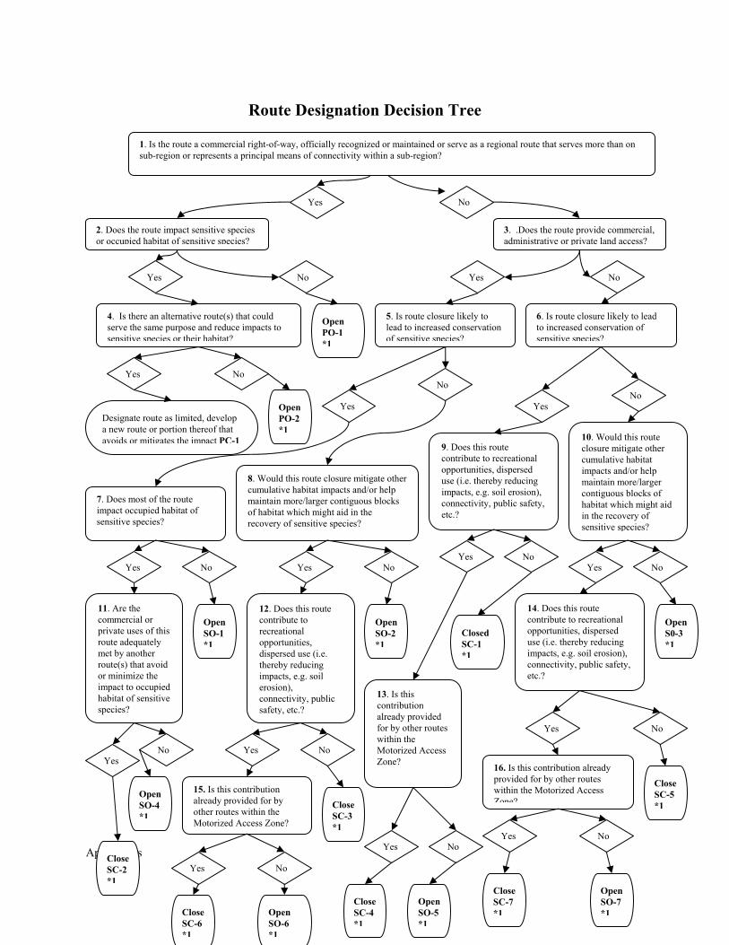
Appendices
Route Designation Decision Tree
Yes No
2. Does the route impact sensitive species or occupied habitat of sensitive species?
3. .Does the route provide commercial, administrative or private land access?
Yes No Yes No
4. Is there an alternative route(s) that could serve the same purpose and reduce impacts to sensitive species or their habitat?
Open PO-1 *1
Yes No
Designate route as limited, develop a new route or portion thereof that avoids or mitigates the impact PC-1
OpenPO-2*1
5. Is route closure likely to lead to increased conservation of sensitive species?
6. Is route closure likely to lead to increased conservation of sensitive species?
Yes
No
Yes No
9. Does this route contribute to recreational opportunities, dispersed use (i.e. thereby reducing impacts, e.g. soil erosion), connectivity, public safety, etc.?
7. Does most of the route impact occupied habitat of sensitive species?
8. Would this route closure mitigate other cumulative habitat impacts and/or help maintain more/larger contiguous blocks of habitat which might aid in the recovery of sensitive species?
10. Would this route closure mitigate other cumulative habitat impacts and/or help maintain more/larger contiguous blocks of habitat which might aid in the recovery of sensitive species?
Yes No Yes No Yes No
Yes No
11. Are the commercial or private uses of this route adequately met by another route(s) that avoid or minimize the impact to occupied habitat of sensitive species?
Open SO-1 *1
12. Does this route contribute to recreational opportunities, dispersed use (i.e. thereby reducing impacts, e.g. soil erosion), connectivity, public safety, etc.?
OpenSO-2*1
13. Is this contribution already provided for by other routes within the Motorized Access Zone?
Closed SC-1 *1
14. Does this route contribute to recreational opportunities, dispersed use (i.e. thereby reducing impacts, e.g. soil erosion), connectivity, public safety, etc.?
Yes No Yes No
Yes No
Yes No
Close SC-2 *1
Open SO-4 *1
CloseSC-3 *1
CloseSC-4 *1
CloseSC-5 *1
OpenSO-5*1
15. Is this contribution already provided for by other routes within the Motorized Access Zone?
16. Is this contribution already provided for by other routes within the Motorized Access Zone?
Yes No
Yes No
Close SC-6 *1
Open SO-6 *1
Close SC-7 *1
OpenSO-7*1
OpenS0-3 *1
1. Is the route a commercial right-of-way, officially recognized or maintained or serve as a regional route that serves more than on sub-region or represents a principal means of connectivity within a sub-region?
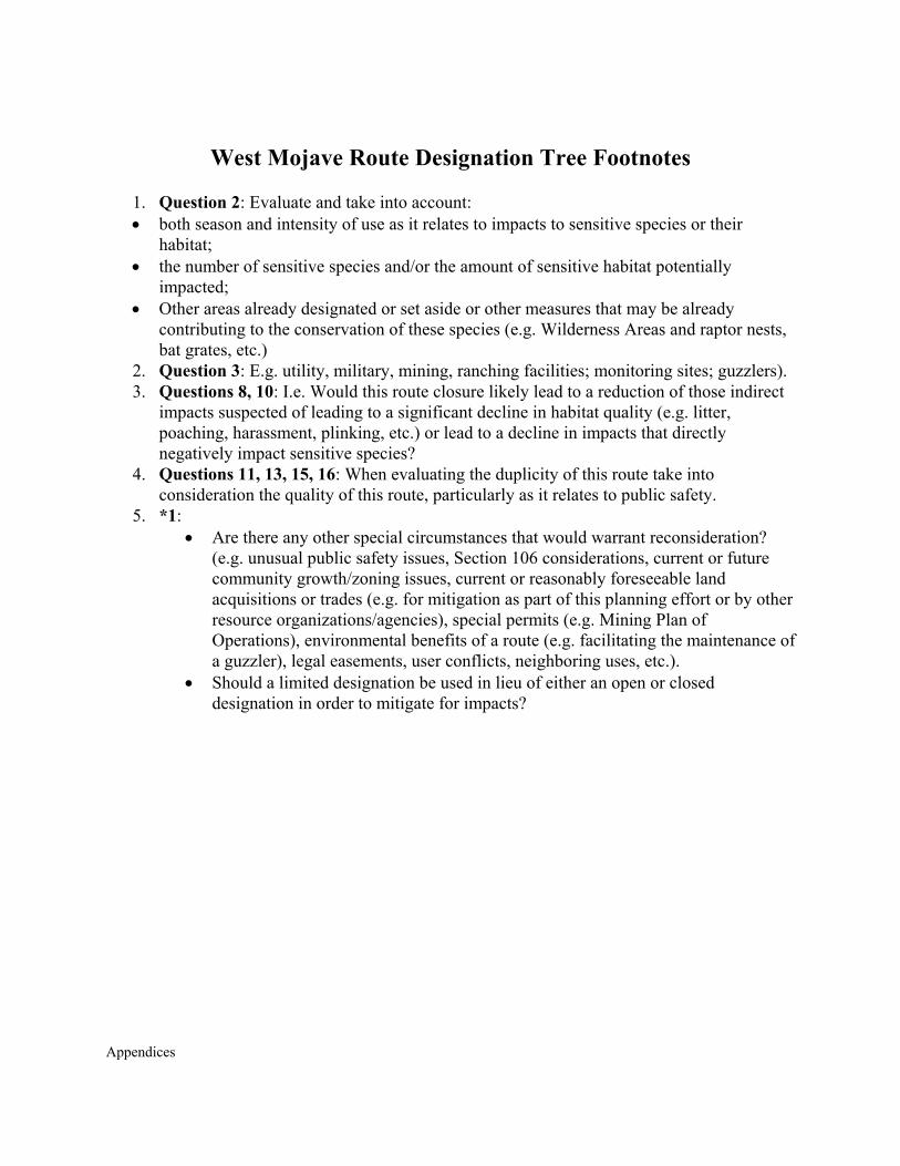
Appendices
West Mojave Route Designation Tree Footnotes
1. Question 2: Evaluate and take into account: • both season and intensity of use as it relates to impacts to sensitive species or their
habitat; • the number of sensitive species and/or the amount of sensitive habitat potentially
impacted; • Other areas already designated or set aside or other measures that may be already
contributing to the conservation of these species (e.g. Wilderness Areas and raptor nests, bat grates, etc.)
2. Question 3: E.g. utility, military, mining, ranching facilities; monitoring sites; guzzlers). 3. Questions 8, 10: I.e. Would this route closure likely lead to a reduction of those indirect
impacts suspected of leading to a significant decline in habitat quality (e.g. litter, poaching, harassment, plinking, etc.) or lead to a decline in impacts that directly negatively impact sensitive species?
4. Questions 11, 13, 15, 16: When evaluating the duplicity of this route take into consideration the quality of this route, particularly as it relates to public safety.
5. *1: • Are there any other special circumstances that would warrant reconsideration?
(e.g. unusual public safety issues, Section 106 considerations, current or future community growth/zoning issues, current or reasonably foreseeable land acquisitions or trades (e.g. for mitigation as part of this planning effort or by other resource organizations/agencies), special permits (e.g. Mining Plan of Operations), environmental benefits of a route (e.g. facilitating the maintenance of a guzzler), legal easements, user conflicts, neighboring uses, etc.).
• Should a limited designation be used in lieu of either an open or closed designation in order to mitigate for impacts?
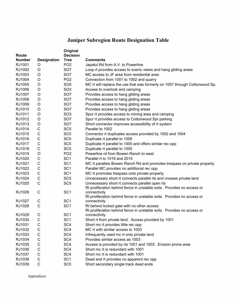
Appendices
Juniper Subregion Route Designation Table
Route Number Designation
Original Decision Tree Comments
RJ1001 O PO2 Japatul Rd from A.V. to Powerline RJ1002 O SO7 Loop rt provides access to scenic views and hang gliding areas RJ1003 O SO7 MC access to JF area from residential area RJ1004 O PO2 Connection from 1001 to 1002 and quarry RJ1005 O SO5 MC rt will replace the use that was formerly on 1057 through Cottonwood Sp. RJ1006 O SO3 Access to overlook and camping RJ1007 O SO7 Provides access to hang gliding areas RJ1008 O SO7 Provides access to hang gliding areas RJ1009 O SO7 Provides access to hang gliding areas RJ1010 O SO7 Provides access to hang gliding areas RJ1011 O SO3 Spur rt provides access to mining area and camping RJ1012 O SO7 Spur rt provides access to Cottonwood Spr parking RJ1013 O SO7 Short connector improves accessibility of rt system RJ1014 C SC5 Parallel to 1002 RJ1015 C SC5 Connector rt duplicates access provided by 1002 and 1004 RJ1016 C SC5 Duplicate rt parallel to 1006 RJ1017 C SC5 Duplicate rt parallel to 1005 and offers similar rec opp RJ1018 C SC5 Duplicate rt parallel to 1005 RJ1019 O PO2 Powerline rd from Bowen Ranch to west RJ1020 C SC1 Parallel rt to 1019 and 2010 RJ1021 C SC1 MC rt parallels Bowen Ranch Rd and promotes trespass on private property RJ1022 C SC1 Parallel MC provides no additional rec opp RJ1023 C SC1 MC rt promotes trespass onto private property RJ1024 C SC5 Unnecessary short rt connects parallel rts and crosses private land RJ1025 C SC5 Unnecessary short rt connects parallel open rts
RJ1026 C SC1 Rt proliferation behind fence in unstable soils. Provides no access or connectivity
RJ1027 C SC1 Rt proliferation behind fence in unstable soils. Provides no access or connectivity
RJ1028 C SC1 Rt behind locked gate with no other access
RJ1029 C SC1 Rt proliferation behind fence in unstable soils. Provides no access or connectivity
RJ1030 C SC1 Short rt from private land. Access provided by 1001 RJ1031 C SC4 Short mc rt provides little rec opp RJ1032 C SC4 MC rt with similar access to 1003 RJ1033 C SC4 Infrequently used mc rt onto private land RJ1034 C SC4 Provides similar access as 1003 RJ1035 C SC4 Access is provided by rts 1001 and 1003. Erosion prone area RJ1036 C SC4 Short mc rt is redundant with 1001 RJ1037 C SC4 Short mc rt is redundant with 1001 RJ1038 C SC1 Dead end rt provides no apparent rec opp RJ1039 C SC5 Short secondary single track dead ends
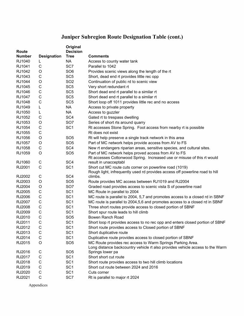
Appendices
Juniper Subregion Route Designation Table (cont.)
Route Number Designation
Original Decision Tree Comments
RJ1040 L NA Access to county water tank RJ1041 C SC7 Parallel to 1042 RJ1042 O SO6 Provides scenic views along the length of the rt RJ1043 C SC5 Short, dead end rt provides little rec opp RJ1044 O SO2 Continuation of public rd to scenic view RJ1045 C SC5 Very short redundant rt RJ1046 C SC5 Short dead end rt parallel to a similar rt RJ1047 C SC5 Short dead end rt parallel to a similar rt RJ1048 C SC5 Short loop off 1011 provides little rec and no access RJ1049 L NA Access to private property RJ1050 L NA Access to guzzler RJ1052 C SC4 Gated rt to trespass dwelling RJ1053 O SO7 Series of short rts around quarry RJ1054 C SC1 Rt accesses Stone Spring. Foot access from nearby rt is possible RJ1055 C Rt does not exist RJ1056 O SO5 Rt will help preserve a single track network in this area RJ1057 O SO5 Part of MC network helps provide access from AV to FS RJ1058 C SC4 New rt endangers riparian areas, sensitive species, and cultural sites. RJ1059 O SO5 Part of MC network helps proved access from AV to FS
RJ1060 C SC4 Rt accesses Cottonwood Spring. Increased use or misuse of this rt would result in unacceptabl
RJ2001 C SC1 Short cut MC route cuts corner on powerline road (1019)
RJ2002 C SC4 Rough light, infrequently used rd provides access off powerline road to hill climbs.
RJ2003 O SO5 Route provides MC access between RJ1019 and RJ2004 RJ2004 O SO7 Graded road provides access to scenic vista S of powerline road RJ2005 C SC1 MC Route in parallel to 2004 RJ2006 C SC1 MC route is parallel to 2004, 5,7 and promotes access to a closed rd in SBNF RJ2007 C SC1 MC route is parallel to 2004,5,6 and promotes access to a closed rd in SBNF RJ2008 C SC1 Three short routes provide access to closed portion of SBNF RJ2009 C SC1 Short spur route leads to hill climb RJ2010 C SO5 Bowen Ranch Road RJ2011 C SC1 Short loop rt provides access to no rec opp and enters closed portion of SBNF RJ2012 C SC1 Short route provides access to Closed portion of SBNF RJ2013 C SC1 Short duplicative route RJ2014 C SC1 Duplicative route provides access to closed portion of SBNF RJ2015 O SO5 MC Route provides rec access to Warm Springs Parking Area.
RJ2016 C SO5 Long distance backcountry vehicle rt also provides vehicle access to the Warm Springs lower pa
RJ2017 C SC1 Short short cut route RJ2018 C SC1 Short route provides access to two hill climb locations RJ2019 C SC1 Short cut route between 2024 and 2016 RJ2020 C SC1 Cuts corner RJ2021 C SC7 Rt is parallel to major rt 2024
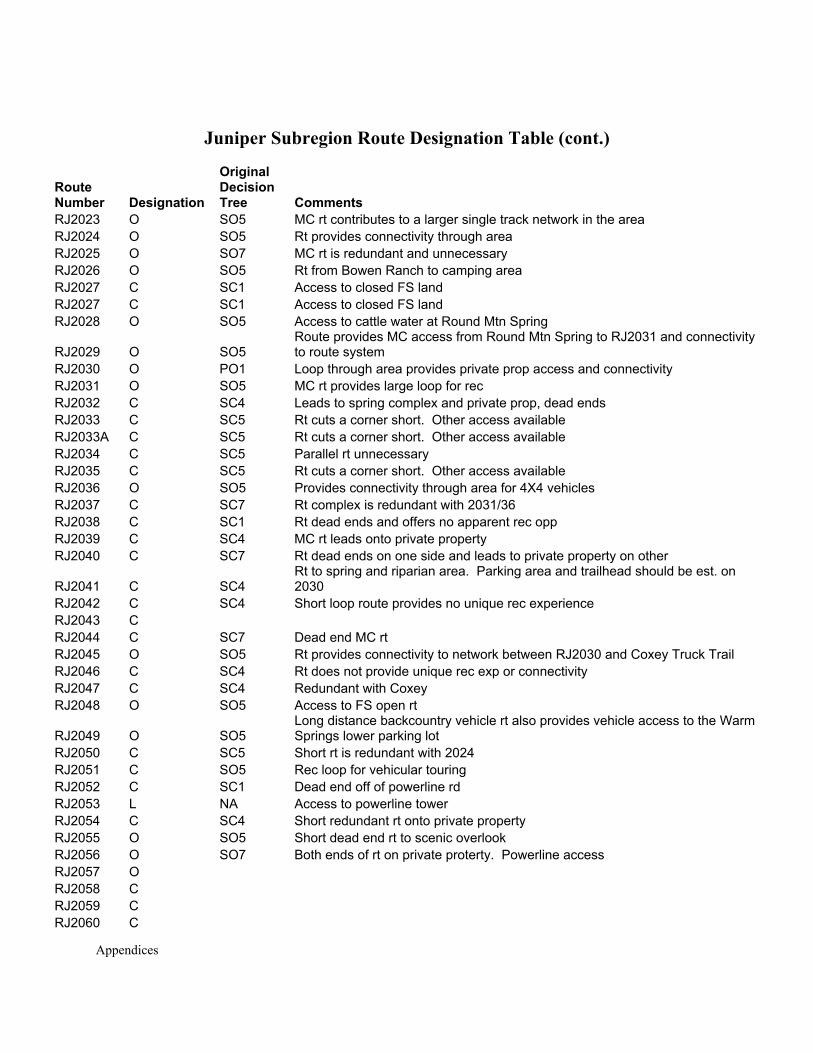
Appendices
Juniper Subregion Route Designation Table (cont.)
Route Number Designation
Original Decision Tree Comments
RJ2023 O SO5 MC rt contributes to a larger single track network in the area RJ2024 O SO5 Rt provides connectivity through area RJ2025 O SO7 MC rt is redundant and unnecessary RJ2026 O SO5 Rt from Bowen Ranch to camping area RJ2027 C SC1 Access to closed FS land RJ2027 C SC1 Access to closed FS land RJ2028 O SO5 Access to cattle water at Round Mtn Spring
RJ2029 O SO5 Route provides MC access from Round Mtn Spring to RJ2031 and connectivity to route system
RJ2030 O PO1 Loop through area provides private prop access and connectivity RJ2031 O SO5 MC rt provides large loop for rec RJ2032 C SC4 Leads to spring complex and private prop, dead ends RJ2033 C SC5 Rt cuts a corner short. Other access available RJ2033A C SC5 Rt cuts a corner short. Other access available RJ2034 C SC5 Parallel rt unnecessary RJ2035 C SC5 Rt cuts a corner short. Other access available RJ2036 O SO5 Provides connectivity through area for 4X4 vehicles RJ2037 C SC7 Rt complex is redundant with 2031/36 RJ2038 C SC1 Rt dead ends and offers no apparent rec opp RJ2039 C SC4 MC rt leads onto private property RJ2040 C SC7 Rt dead ends on one side and leads to private property on other
RJ2041 C SC4 Rt to spring and riparian area. Parking area and trailhead should be est. on 2030
RJ2042 C SC4 Short loop route provides no unique rec experience RJ2043 C RJ2044 C SC7 Dead end MC rt RJ2045 O SO5 Rt provides connectivity to network between RJ2030 and Coxey Truck Trail RJ2046 C SC4 Rt does not provide unique rec exp or connectivity RJ2047 C SC4 Redundant with Coxey RJ2048 O SO5 Access to FS open rt
RJ2049 O SO5 Long distance backcountry vehicle rt also provides vehicle access to the Warm Springs lower parking lot
RJ2050 C SC5 Short rt is redundant with 2024 RJ2051 C SO5 Rec loop for vehicular touring RJ2052 C SC1 Dead end off of powerline rd RJ2053 L NA Access to powerline tower RJ2054 C SC4 Short redundant rt onto private property RJ2055 O SO5 Short dead end rt to scenic overlook RJ2056 O SO7 Both ends of rt on private proterty. Powerline access RJ2057 O RJ2058 C RJ2059 C RJ2060 C
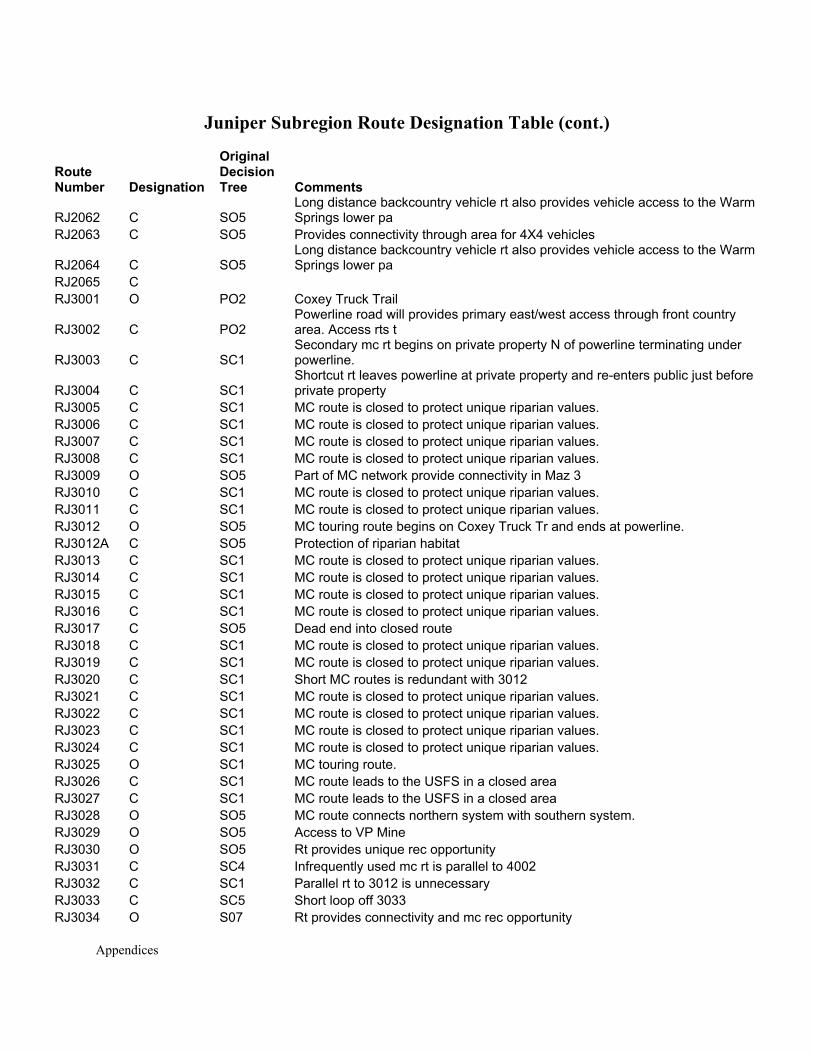
Appendices
Juniper Subregion Route Designation Table (cont.)
Route Number Designation
Original Decision Tree Comments
RJ2062 C SO5 Long distance backcountry vehicle rt also provides vehicle access to the Warm Springs lower pa
RJ2063 C SO5 Provides connectivity through area for 4X4 vehicles
RJ2064 C SO5 Long distance backcountry vehicle rt also provides vehicle access to the Warm Springs lower pa
RJ2065 C RJ3001 O PO2 Coxey Truck Trail
RJ3002 C PO2 Powerline road will provides primary east/west access through front country area. Access rts t
RJ3003 C SC1 Secondary mc rt begins on private property N of powerline terminating under powerline.
RJ3004 C SC1 Shortcut rt leaves powerline at private property and re-enters public just before private property
RJ3005 C SC1 MC route is closed to protect unique riparian values. RJ3006 C SC1 MC route is closed to protect unique riparian values. RJ3007 C SC1 MC route is closed to protect unique riparian values. RJ3008 C SC1 MC route is closed to protect unique riparian values. RJ3009 O SO5 Part of MC network provide connectivity in Maz 3 RJ3010 C SC1 MC route is closed to protect unique riparian values. RJ3011 C SC1 MC route is closed to protect unique riparian values. RJ3012 O SO5 MC touring route begins on Coxey Truck Tr and ends at powerline. RJ3012A C SO5 Protection of riparian habitat RJ3013 C SC1 MC route is closed to protect unique riparian values. RJ3014 C SC1 MC route is closed to protect unique riparian values. RJ3015 C SC1 MC route is closed to protect unique riparian values. RJ3016 C SC1 MC route is closed to protect unique riparian values. RJ3017 C SO5 Dead end into closed route RJ3018 C SC1 MC route is closed to protect unique riparian values. RJ3019 C SC1 MC route is closed to protect unique riparian values. RJ3020 C SC1 Short MC routes is redundant with 3012 RJ3021 C SC1 MC route is closed to protect unique riparian values. RJ3022 C SC1 MC route is closed to protect unique riparian values. RJ3023 C SC1 MC route is closed to protect unique riparian values. RJ3024 C SC1 MC route is closed to protect unique riparian values. RJ3025 O SC1 MC touring route. RJ3026 C SC1 MC route leads to the USFS in a closed area RJ3027 C SC1 MC route leads to the USFS in a closed area RJ3028 O SO5 MC route connects northern system with southern system. RJ3029 O SO5 Access to VP Mine RJ3030 O SO5 Rt provides unique rec opportunity RJ3031 C SC4 Infrequently used mc rt is parallel to 4002 RJ3032 C SC1 Parallel rt to 3012 is unnecessary RJ3033 C SC5 Short loop off 3033 RJ3034 O S07 Rt provides connectivity and mc rec opportunity
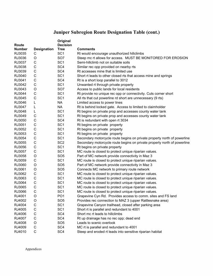
Appendices
Juniper Subregion Route Designation Table (cont.)
Route Number Designation
Original Decision Tree Comments
RJ3035 C SC1 Rt would encourage unauthorized hillclimbs RJ3036 O SO7 Steep mc rt allows for access. MUST BE MONITORED FOR EROSION RJ3037 C SC1 Semi-hillclimb not on suitable soils RJ3038 C SC4 Similar rec opp provided on nearby rts RJ3039 C SC4 Rt accesses mine that is limited use RJ3040 C SC1 Short rt leads to other closed rts that access mine and springs RJ3041 C SC4 Rt is a short loop parallel to 3012 RJ3042 C SC1 Unwanted rt through private property RJ3043 O SO7 Access to public lands for local residents RJ3044 C SC1 Rt provide no unique rec opp or connectivity. Cuts corner short RJ3045 C SC1 All rts that cut powerline rd short are unnecessary (9 rts) RJ3046 L NA Limited access to power lines RJ3047 L NA Rt is behind locked gate. Access to limited to claimholder RJ3048 L SC1 Rt begins on private prop and accesses county water tank RJ3049 C SC1 Rt begins on private prop and accesses county water tank RJ3050 C SC4 Rt is redundant with open rt 3034 RJ3051 C SC1 Rt begins on private property RJ3052 C SC1 Rt begins on private property RJ3053 C SC1 Rt begins on private property RJ3054 C SC1 Secondary motorcycle route begins on private property north of powerline RJ3055 C SC2 Secondary motorcycle route begins on private property north of powerline RJ3056 C SC1 Rt begins on private property RJ3057 C SC1 MC route is closed to protect unique riparian values. RJ3058 O SO5 Part of MC network provide connectivity in Maz 3 RJ3059 C SC1 MC route is closed to protect unique riparian values. RJ3060 O SO5 Part of MC network provide connectivity in Maz 3 RJ3061 O SO5 Connects MC network to primary route network RJ3062 C SC1 MC route is closed to protect unique riparian values. RJ3063 C SC1 MC route is closed to protect unique riparian values. RJ3064 C SC1 MC route is closed to protect unique riparian values. RJ3065 C SC1 MC route is closed to protect unique riparian values. RJ3066 C SC1 MC route is closed to protect unique riparian values. RJ4001 O PO1 Grapevine Cyn Rd. Provides access to comm. sites and FS land RJ4002 O SO5 Provides rec connection to MAZ 3 (upper Rattlesnake area) RJ4004 C SC1 Grapevine Canyon trailhead, closed after parking area RJ4005 C SC1 Short rt is parallel and redundant to 4001 RJ4006 C SC4 Short mc rt leads to hillclimbs RJ4007 C SC4 Rt up drainage has no rec opp; dead end RJ4008 O SO5 Leads to scenic overlook RJ4009 C SC4 MC rt is parallel and redundant to 4001 RJ4010 C SC4 Steep and eroded rt leads into sensitive riparian habitat
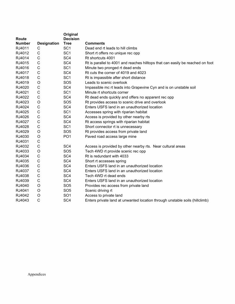
Appendices
Route Number Designation
Original Decision Tree Comments
RJ4011 C SC1 Dead end rt leads to hill climbs RJ4012 C SC1 Short rt offers no unique rec opp RJ4014 C SC4 Rt shortcuts 4001 RJ4015 C SC4 Rt is parallel to 4001 and reaches hilltops that can easily be reached on foot RJ4016 C SC1 Minute two pronged rt dead ends RJ4017 C SC4 Rt cuts the corner of 4019 and 4023 RJ4018 C SC1 Rt is impassible after short distance RJ4019 O SO5 Leads to scenic overlook RJ4020 C SC4 Impassible mc rt leads into Grapevine Cyn and is on unstable soil RJ4021 C SC1 Minute rt shortcuts corner RJ4022 C SC4 Rt dead ends quickly and offers no apparent rec opp RJ4023 O SO5 Rt provides access to scenic drive and overlook RJ4024 C SC4 Enters USFS land in an unauthorized location RJ4025 C SC1 Accesses spring with riparian habitat RJ4026 C SC4 Access is provided by other nearby rts RJ4027 C SC4 Rt access springs with riparian habitat RJ4028 C SC1 Short connector rt is unnecessary RJ4029 O SO5 Rt provides access from private land RJ4030 O PO1 Paved road access large mine RJ4031 C RJ4032 C SC4 Access is provided by other nearby rts. Near cultural areas RJ4033 O SO5 Tech 4WD rt provide scenic rec opp RJ4034 C SC4 Rt is redundant with 4033 RJ4035 C SC4 Short rt accesses spring RJ4036 C SC4 Enters USFS land in an unauthorized location RJ4037 C SC4 Enters USFS land in an unauthorized location RJ4038 C SC4 Tech 4WD rt dead ends RJ4039 C SC4 Enters USFS land in an unauthorized location RJ4040 O SO5 Provides rec access from private land RJ4041 O SO5 Scenic driving rt RJ4042 O SO1 Access to private land RJ4043 C SC4 Enters private land at unwanted location through unstable soils (hillclimb)
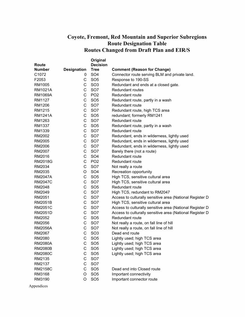
Appendices
Coyote, Fremont, Red Mountain and Superior Subregions Route Designation Table
Routes Changed from Draft Plan and EIR/S
Route Number Designation
Original Decision Tree Comment (Reason for Change)
C1072 0 SO4 Connector route serving BLM and private land. F2053 C SO5 Response to 190-SS RM1005 C SO3 Redundant and ends at a closed gate. RM1021A C SO7 Redundant routes RM1069A C PO2 Redundant route RM1127 C SO5 Redundant route, partly in a wash RM1206 C SO7 Redundant route RM1215 C SO7 Redundant route, high TCS area RM1241A C SO5 redundant; formerly RM1241 RM1263 C SO7 Redundant route RM1337 C SO5 Redundant route, partly in a wash RM1339 C SO7 Redundant route RM2002 C SO7 Redundant, ends in wilderness, lightly used RM2005 C SO7 Redundant, ends in wilderness, lightly used RM2006 C SO7 Redundant, ends in wilderness, lightly used RM2007 C SO7 Barely there (not a route) RM2016 C SO4 Redundant route RM2018G C PO2 Redundant route RM2034 C SO7 Not really a route RM2035 O SO4 Recreation opportunity RM2047A C SO5 High TCS, sensitive cultural area RM2047C C SO7 High TCS, sensitive cultural area RM2048 C SO5 Redundant route RM2049 C SO7 High TCS, redundant to RM2047 RM2051 C SO7 Access to culturally sensitive area (National Register D RM2051B C SO7 High TCS, sensitive cultural area RM2051C C SO7 Access to culturally sensitive area (National Register D RM2051D C SO7 Access to culturally sensitive area (National Register D RM2052 C SO5 Redundant route RM2056 C SO7 Not really a route, on fall line of hill RM2056A C SO7 Not really a route, on fall line of hill RM2067 C SO3 Dead end route RM2080 C SO5 Lightly used; high TCS area RM2080A C SO5 Lightly used; high TCS area RM2080B C SO5 Lightly used; high TCS area RM2080C C SO5 Lightly used; high TCS area RM2135 C SO7 RM2137 C SO7 RM2158C C SO5 Dead end into Closed route RM3168 O SO5 Important connectivity RM3190 O SO5 Important connector route
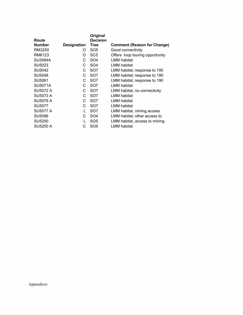
Appendices
Route Number Designation
Original Decision Tree Comment (Reason for Change)
RM3250 O SO5 Good connectivity RM6123 O SC5 Offers loop touring opportunity SU3084A C SO4 LMM habitat SU5023 C SO4 LMM habitat SU5042 C SO7 LMM habitat; response to 190 SU5048 C SO7 LMM habitat; response to 190 SU5061 C SO7 LMM habitat; response to 190 SU5071A C SO7 LMM habitat SU5072 A C SO7 LMM habitat, no connectivity SU5073 A C SO7 LMM habitat SU5076 A C SO7 LMM habitat SU5077 C SO7 LMM habitat SU5077 A L SO7 LMM habitat, mining access SU5096 C SO4 LMM habitat; other access to SU5200 L SO5 LMM habitat, access to mining SU5200 A C SO5 LMM habitat
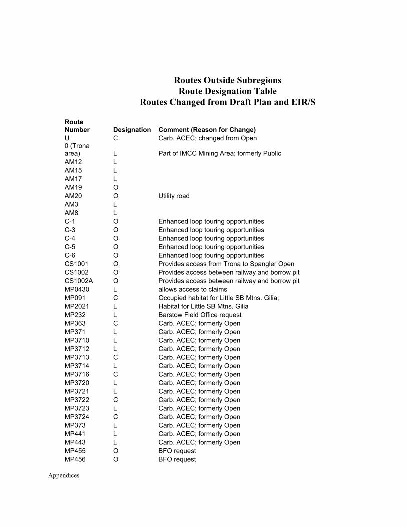
Appendices
Routes Outside Subregions Route Designation Table
Routes Changed from Draft Plan and EIR/S
Route Number Designation Comment (Reason for Change) U C Carb. ACEC; changed from Open 0 (Trona area) L Part of IMCC Mining Area; formerly Public AM12 L AM15 L AM17 L AM19 O AM20 O Utility road AM3 L AM8 L C-1 O Enhanced loop touring opportunities C-3 O Enhanced loop touring opportunities C-4 O Enhanced loop touring opportunities C-5 O Enhanced loop touring opportunities C-6 O Enhanced loop touring opportunities CS1001 O Provides access from Trona to Spangler Open CS1002 O Provides access between railway and borrow pit CS1002A O Provides access between railway and borrow pit MP0430 L allows access to claims MP091 C Occupied habitat for Little SB Mtns. Gilia; MP2021 L Habitat for Little SB Mtns. Gilia MP232 L Barstow Field Office request MP363 C Carb. ACEC; formerly Open MP371 L Carb. ACEC; formerly Open MP3710 L Carb. ACEC; formerly Open MP3712 L Carb. ACEC; formerly Open MP3713 C Carb. ACEC; formerly Open MP3714 L Carb. ACEC; formerly Open MP3716 C Carb. ACEC; formerly Open MP3720 L Carb. ACEC; formerly Open MP3721 L Carb. ACEC; formerly Open MP3722 C Carb. ACEC; formerly Open MP3723 L Carb. ACEC; formerly Open MP3724 C Carb. ACEC; formerly Open MP373 L Carb. ACEC; formerly Open MP441 L Carb. ACEC; formerly Open MP443 L Carb. ACEC; formerly Open MP455 O BFO request MP456 O BFO request
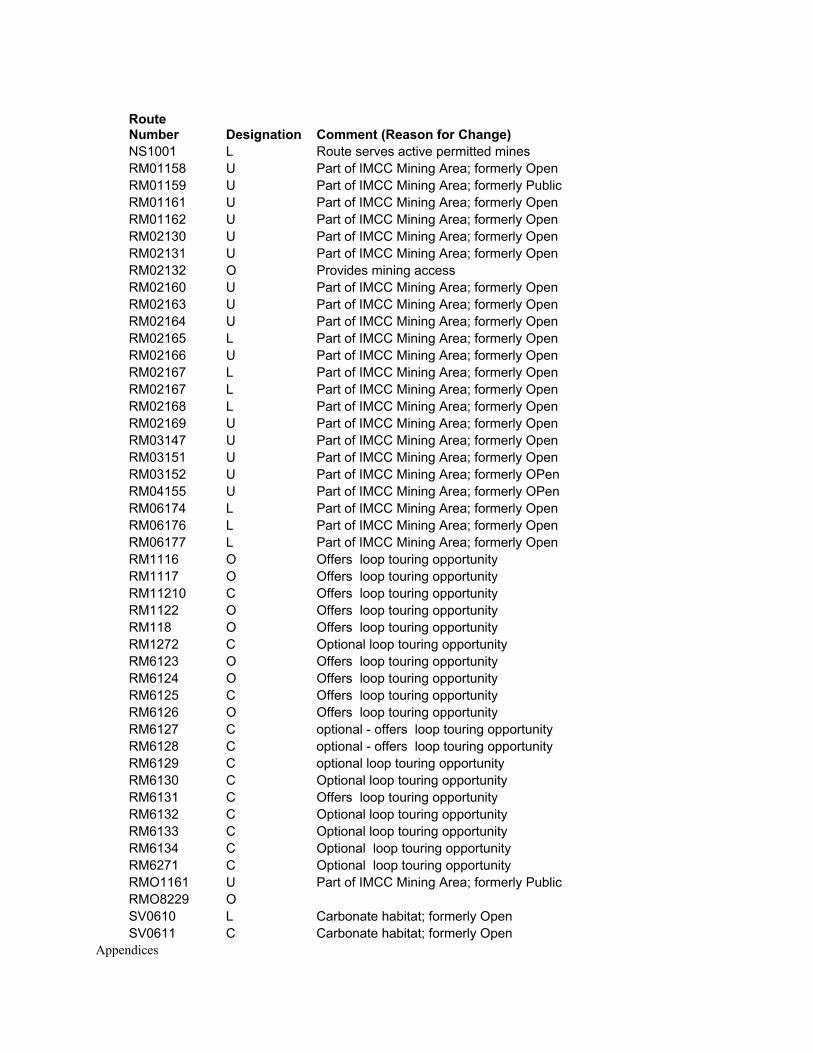
Appendices
Route Number Designation Comment (Reason for Change) NS1001 L Route serves active permitted mines RM01158 U Part of IMCC Mining Area; formerly Open RM01159 U Part of IMCC Mining Area; formerly Public RM01161 U Part of IMCC Mining Area; formerly Open RM01162 U Part of IMCC Mining Area; formerly Open RM02130 U Part of IMCC Mining Area; formerly Open RM02131 U Part of IMCC Mining Area; formerly Open RM02132 O Provides mining access RM02160 U Part of IMCC Mining Area; formerly Open RM02163 U Part of IMCC Mining Area; formerly Open RM02164 U Part of IMCC Mining Area; formerly Open RM02165 L Part of IMCC Mining Area; formerly Open RM02166 U Part of IMCC Mining Area; formerly Open RM02167 L Part of IMCC Mining Area; formerly Open RM02167 L Part of IMCC Mining Area; formerly Open RM02168 L Part of IMCC Mining Area; formerly Open RM02169 U Part of IMCC Mining Area; formerly Open RM03147 U Part of IMCC Mining Area; formerly Open RM03151 U Part of IMCC Mining Area; formerly Open RM03152 U Part of IMCC Mining Area; formerly OPen RM04155 U Part of IMCC Mining Area; formerly OPen RM06174 L Part of IMCC Mining Area; formerly Open RM06176 L Part of IMCC Mining Area; formerly Open RM06177 L Part of IMCC Mining Area; formerly Open RM1116 O Offers loop touring opportunity RM1117 O Offers loop touring opportunity RM11210 C Offers loop touring opportunity RM1122 O Offers loop touring opportunity RM118 O Offers loop touring opportunity RM1272 C Optional loop touring opportunity RM6123 O Offers loop touring opportunity RM6124 O Offers loop touring opportunity RM6125 C Offers loop touring opportunity RM6126 O Offers loop touring opportunity RM6127 C optional - offers loop touring opportunity RM6128 C optional - offers loop touring opportunity RM6129 C optional loop touring opportunity RM6130 C Optional loop touring opportunity RM6131 C Offers loop touring opportunity RM6132 C Optional loop touring opportunity RM6133 C Optional loop touring opportunity RM6134 C Optional loop touring opportunity RM6271 C Optional loop touring opportunity RMO1161 U Part of IMCC Mining Area; formerly Public RMO8229 O SV0610 L Carbonate habitat; formerly Open SV0611 C Carbonate habitat; formerly Open
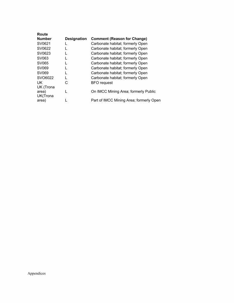
Appendices
Route Number Designation Comment (Reason for Change) SV0621 L Carbonate habitat; formerly Open SV0622 L Carbonate habitat; formerly Open SV0623 L Carbonate habitat; formerly Open SV063 L Carbonate habitat; formerly Open SV065 L Carbonate habitat; formerly Open SV069 L Carbonate habitat; formerly Open SV069 L Carbonate habitat; formerly Open SVO6022 L Carbonate habitat; formerly Open UK C BFO request UK (Trona area) L On IMCC Mining Area; formerly Public UK(Trona area) L Part of IMCC Mining Area; formerly Open

Appendices
Appendices
APPENDIX S
CARBONATE HABITAT RECLAMATION AND REVEGETATION STANDARDS
The Carbonate Habitat Management Strategy is Provided on the CD Included with
the Proposed West Mojave Plan and Final EIR/S

Appendices
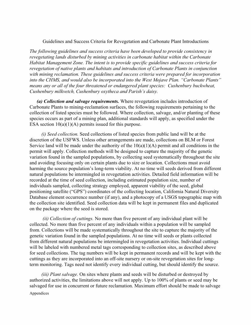
Appendices
Guidelines and Success Criteria for Revegetation and Carbonate Plant Introductions
The following guidelines and success criteria have been developed to provide consistency in revegetating lands disturbed by mining activities in carbonate habitat within the Carbonate Habitat Management Zone. The intent is to provide specific guidelines and success criteria for revegetation of native plants and habitats and introduction of Carbonate Plants in conjunction with mining reclamation. These guidelines and success criteria were prepared for incorporation into the CHMS, and would also be incorporated into the West Mojave Plan. “Carbonate Plants” means any or all of the four threatened or endangered plant species: Cushenbury buckwheat, Cushenbury milkvetch, Cushenbury oxytheca and Parish’s daisy.
(a) Collection and salvage requirements. Where revegetation includes introduction of Carbonate Plants to mining-reclamation surfaces, the following requirements pertaining to the collection of listed species must be followed. Where collection, salvage, and/or planting of these species occurs as part of a mining plan, additional standards will apply, as specified under the ESA section 10(a)(1)(A) permits issued for this purpose.
(i) Seed collection. Seed collections of listed species from public land will be at the discretion of the USFWS. Unless other arrangements are made, collections on BLM or Forest Service land will be made under the authority of the 10(a)(1)(A) permit and all conditions in the permit will apply. Collection methods will be designed to capture the majority of the genetic variation found in the sampled populations, by collecting seed systematically throughout the site and avoiding focusing only on certain plants due to size or location. Collections must avoid harming the source population’s long-term viability. At no time will seeds derived from different natural populations be intermingled in revegetation activities. Detailed field information will be recorded at the time of seed collection, including estimated population size, number of individuals sampled, collecting strategy employed, apparent viability of the seed, global positioning satellite (“GPS”) coordinates of the collecting location, California Natural Diversity Database element occurrence number (if any), and a photocopy of a USGS topographic map with the collection site identified. Seed collection data will be kept in permanent files and duplicated on the package where the seed is stored.
(ii) Collection of cuttings. No more than five percent of any individual plant will be collected. No more than five percent of any individuals within a population will be sampled from. Collections will be made systematically throughout the site to capture the majority of the genetic variation found in the sampled populations. At no time will seeds or plants collected from different natural populations be intermingled in revegetation activities. Individual cuttings will be labeled with numbered metal tags corresponding to collection sites, as described above for seed collections. The tag numbers will be kept in permanent records and will be kept with the cuttings as they are incorporated into an off-site nursery or on-site revegetation sites for long-term monitoring. Tags need not identify every individual cutting, but should identify the source.
(iii) Plant salvage. On sites where plants and seeds will be disturbed or destroyed by authorized activities, the limitations above will not apply. Up to 100% of plants or seed may be salvaged for use in concurrent or future reclamation. Maximum effort should be made to salvage

Appendices
listed carbonate plants from sites where mining or other disturbance is approved, and initial clearing and soil removal should be scheduled to allow for seed salvage at the end of at least one growing season.
(iv) Plant and seed return. Plants and seeds will be returned to the same general vegetation zone where they were collected (e.g. blackbush scrub), within no more than 1000 ft. elevation and 5 miles of the collection site, in order to ensure gene pool and ecotype integrity. Where individual plants are introduced onto a reclamation site (e.g., salvaged plants, or plants grown from seed or cuttings off-site), they will be labeled with metal tags for future growth and survival monitoring. The tag numbers will be kept in permanent records. Tag numbers need not identify every individual plant, but will identify their original source and the year they are planted. Where seed is introduced onto a reclamation site, the amount (weight) and seed collection data (above) will be kept in similar records.
(v) Documentation. Methods of Carbonate Plant introduction and progress of the introduction effort must be monitored and reported to the BLM, Forest Service or County in accordance with the monitoring requirements of Section (c), below. Operators are encouraged to enhance the introduction sites (e.g. irrigation, fertilization, weeding, supplemental planting, or seeding; collectively, “manipulation”) during the first few years after planting. As provided in Section (b) below, however, revegetation success criteria will not be deemed to have been met until the end of a minimum 3-year period without manipulation.
(b) Carbonate Plant success criteria. At the end of a minimum 3-year period without manipulation, the introduced Carbonate Plants occurrences must be documented to show:
(i) Successful reproduction, indicated by seed production, seedling establishment, and survival of seedlings to reproductive state so that the total number of living and reproductively mature plants is at least two times the number originally planted;
(ii) A demographic pattern over the minimum 3-year period in which recruitment to reproductive maturity is greater than or equal to mortality, indicating a stable or growing population;
(iii) Expansion of the introduction area, indicated by the presence of progeny of the introduced plants at least 10 meters beyond the bounds of the original seeded or planted area;
(iv) Within the introduction area, density (plants/acre) of the Carbonate Plants no less than one standard deviation below the mean density of the same species in natural populations, as documented in BLM, Forest Service or County data; and
(v) Demonstration of least one quantitative measure of ecosystem function; applicable measures include, but are not limited to, soil respiration, mycorrhizal hyphal mass in soil, glomilin assays, pollinator visitation, and wildlife utilization.
(c) Monitoring. The following monitoring and associated documentation are required annually to determine successful introduction of Carbonate Plants. Introduction sites will also be subject to the revegetation monitoring described in Section (e)(iv) below. Under this Section, for
Appendices
the first 3 years following planting, introduction sites shall be monitored at least annually to document survivorship and reproduction. After the initial 3-year period, qualitative monitoring and reporting will be done on 3-year intervals.
(i) Marking: Parish’s daisy and Cushenbury buckwheat. These are perennial plants, woody at their bases, and therefore capable of being tagged. Each monitoring cycle, each new plant will be tagged and numbered to indicate the year it was detected. Each previously-existing plant will be examined, and its tag number (if present) and condition will be recorded using the following categories:
(A) Healthy/reproductive (i.e., flower or seed);
(B) Healthy/non-reproductive;
(C) Living but evidently unhealthy;
(D) Dead; or
(E) Missing.
After the first monitoring cycle, new plants (not previously tagged) will be considered “progeny” of the plants initially introduced onto the site. Plants will not be tagged if they are too small to physically support the tags or if tagging is likely to damage them. Plants will be considered “established” when they are large enough to tag.
(ii) Marking: Cushenbury milk vetch and Cushenbury oxytheca. These species cannot be tagged due to their life histories. Instead, areas of occupied habitat will be identified using GPS and markers on the ground to define polygons containing a specified number of individual Carbonate Plants. For these species, parents and progeny will not be distinguished, and demographics will be inferred by total counts of individuals within the defined polygons.
(iii) Mapping, all four species. The bounds of occupied habitat will be marked with colored flagging and recorded with a GPS unit. These data will be collected and recorded following the SBNF data and mapping standards. During the monitoring period or later in the year, as appropriate, a small sample of seed from introduced plants on the site will be collected and examined for apparent viability (“fill”).
(e) Reporting. Following each monitoring period, a report will be prepared to include data tables of all plants examined, GPS coordinates of the occupied habitat’s boundaries, representative photographs of the overall site and selected individual plants, and (after 6 years) demographic analysis of the occurrence. The demographic analysis shall consist of (i) assembly and graphing of monitoring data to show survivorship rates of plants initially introduced onto the site and their progeny; (ii) calculation of the estimated half-life for each cohort; and (iii) calculation and comparison of recruitment rates and death rates.
In addition to the formal monitoring and reporting described here, introduction sites should be qualitatively monitored at least annually. Qualitative monitoring should document general
Appendices
survival and reproductive success of the Carbonate Plants and should document potential problems, such as erosion, excessive herbivory, or damaged irrigation systems.
(d) Reclamation guidelines. The following revegetation guidelines are in addition to, or more specific than, the revegetation requirements of the Plan of Operations or Reclamation Plan.
The specific objectives of revegetation as addressed here are to approximate the target vegetation (defined below) as closely as practicable and to promote the reintroduction of listed plant species to reclaimed sites (where applicable). Because revegetation practice continues to evolve, practitioners should remain current with the literature and advances in the field. They also should contact BLM, the Forest Service or County for recommendations on revegetation practice.
(i) Target vegetation. The “target vegetation” for each revegetation site will be selected based on existing reference data for the appropriate vegetation zone or site-specific sampling (collectively, the “Baseline Data”), at the agreement of the applicant and the applicable permitting jurisdiction. Reference data within the carbonate habitat management zone were derived from plot-based vegetation sampling taken across more than 600 plots between 1990 and 1998. Future sampling may result in an update and revision to these data. These data will be made available upon request by the Mountaintop District Botanist on the SBNF.
(ii) Soil inventory. Soil resources (all available topsoil or “growth medium”) will be inventoried for volume and reclamation suitability during the planning stages, and soils inventory results will be included in the revegetation plan. To avoid the need for extended soil stockpiling, the use of soil salvaged from a new quarry site for reclamation of another (closed) quarry or waste dump will be encouraged.
(iii) Success criteria. All reclamation plans will be required to meet the success criteria required under the Plan of Operations or Reclamation Plan and provide documentation. The following additional criteria must be met to meet the standards of the West Mojave Plan for the carbonate habitat management zone. Success thresholds for quantitative measures (B)—(E) will be based on the Baseline Data for each site.
(A) Reclamation. Meet or exceed all reclamation requirements under the mining and reclamation plan for the site and under the applicable reclamation regulations, and maintain the mining operation in full compliance with the mining plan.
(B) Cover. Achieve a mean native vegetation cover percentage of at least 50% of the mean native cover value specified in the Baseline Data.
(C) Density. Achieve a mean density of each of three climax/dominant species for that vegetation zone that is at least 50% of the specified mean densities for those species in the Baseline Data.
(D) Richness. Achieve a mean species richness (average species count per 0.1 acre sample plot or other unit area as applicable, depending on sample methods) that is at least 50% that of the value specified in the Baseline Data.
Appendices
(E) Non-native species cover. Non-native species cover will be no more than (3× its cover in the Baseline Data, and annual monitoring data will show a downward trend, documented by a declining regression coefficient (negative b value) over the monitoring period.
(F) Aggressive/invasive weeds. On the date of approval by the applicable jurisdiction, no species identified on the SBNF list of highly invasive exotic species (below), will occur within the revegetated site. These species must be documented and removed upon detection, and the reports required in Section (f)(iv)(B) below must document any removal and confirm that all these species are absent from the site. Such removal may be performed at any time without being regarded as manipulation that is otherwise prohibited during certain periods. The list of particularly aggressive or invasive non-native weeds will be prepared and maintained by the SBNF in cooperation with BLM, the County and appropriate stakeholders, including the mining industry. It will be limited to non-native species which show the potential to spread rapidly and will exclude native vegetation in some or all habitats of the carbonate habitat management zone, but which have not yet become broadly established within the zone. Thus, tamarisk (Tamarix spp.), castor bean (Ricinus communis), giant reed (Arundo donax), and Spanish broom (Spartium junceum) would be appropriate for inclusion on the list. Brome grasses (Bromus spp.), weedy mustards (Brassica spp., Sisymbrium spp., Hirschfeldia incana), and Russian thistle (or tumbleweed, Salsola spp.) would not be appropriate.
In applying the foregoing criteria, only the habitat patches that meet the criteria shall be regarded as revegetated. The operator’s final monitoring report will provide quantitative data that will determine whether or not the foregoing success criteria have been met. The final monitoring data will generally be submitted ten years following initiation of revegetation, though an operator may choose to finalize the work earlier or later, depending on individual circumstances. Regardless of the date of final monitoring, the revegetated site shall not be subject to manipulation (subject to the exception specified under criterion (F)) during a minimum three years prior to the final data collection.
(iv) Monitoring and revegetation reporting requirements. Each mining reclamation plan must include a revegetation plan. This plan will specify target vegetation, reference data, acres that will undergo active revegetation, and a revegetation schedule. To document progress under the revegetation plan, annual monitoring and periodic reporting will be required. Phased plans may compile these reports into a combined report where an area covered under a single mine plan has revegetation ongoing at different stages.
(A) Annual monitoring. Operators will monitor revegetation sites annually, making each of the following observations and measures, which will be recorded and provided to the applicable permitting jurisdiction in periodic monitoring reports (see subsection (B) below):
(1) Survival of container plantings (where applicable);
(2) Germination of seeded species, noting distribution and abundance;
(3) List of native “volunteer” species, noting distribution and abundance;
Appendices
(4) Measurements of vegetation cover, target species density, total species richness (list), and wildlife observations;
(5) Signs of erosion/soil loss;
(6) List of non-native species, with descriptions of abundance, distribution, and measures to control/eradicate; and
(7) Recommendations for any other needed remedial action (e.g., repairs to irrigation system, re-seeding, erosion control, or other).
(B) Reporting. On large revegetation sites, quantitative data collected and presented in the “threshold” and final monitoring reports must be randomly sampled with sufficient replication to analyze and document the data with 90% confidence intervals about the mean values, and with a maximum confidence interval width of 20% of the mean value. For smaller sites, an alternate sampling protocol may be used so that the total sampling area is at least 50% of the area revegetated.
The following three reports, to be submitted to the BLM or County, with a copy provided to the Forest Service, are required to document the monitoring and status of revegetation:
(1) Initial report. This report shall include: (aa) detailed site plan, (bb) planting palette, (cc) propagule (seed, cutting, and container plant) inventory, and (dd) soil inventory (where applicable). This report must be prepared and submitted within one year of initiating revegetation.
(2) Final minus 3 report. This report shall be made at the initiation of the final 3-year no-manipulation period and shall mark the initiation of that period. This report shall summarize the monitoring data that is collected annually. It must include status of revegetation and qualitative and quantitative measures each success criterion, and it must specify any remediation prescribed. It shall also include a propagule and soil inventory update. This report is generally prepared during year 7, although may be earlier or later, depending on individual circumstances. If the operator prefers to delay initiating the 3-year period without manipulation beyond year 7 of the revegetation effort, then a substitute “Year 7" report should be submitted, to include the contents described above and an explanation of the operator’s plans for remediation and eventual completion of the revegetation.
(3) Final report. This report shall be prepared and submitted with the application for bond release. It shall have the same format and content requirements as the “final minus 3 report” described in subsection (2) above. Regardless of the date of final monitoring, the revegetated site shall have had no manipulation during a minimum three years prior to the final data collection (subject to the exception specified under subsection (iii)(F) above for weed control). This report shall document the extent to which the revegetation is successful and shall be used, along with field checks, by the applicable permitting jurisdiction to determine whether or not the success criteria set forth in subsection (iii) above have been met.
Appendices
(e) Authorized loss of revegetated areas. Upon issuance of a favorable CHMS Biological Opinion, losses of Carbonate Plants within the management zone where Carbonate Plants have been introduced by operators or claimholders shall be authorized under the terms and conditions described below. The authorization provided pursuant to this Section provides relief only from the provisions of the ESA and does not relieve an owner or claim holder from any requirements of the reclamation regulations with respect to reclaimed or revegetated areas. This authorization also does not relieve the applicant from NEPA, CEQA, or other environmental review of any proposed new land use.
(i) Conditions to authorized loss. Occupied habitat that occurs as a result of revegetation efforts on reclaimed land within the management zone may be taken as necessary to carry out mining activities without any compensation requirement if the following conditions are met:
(A) The introduction effort, including a precise description of the location, has been reported to the applicable permitting jurisdiction in advance of the introduction work itself.
(B) The introduction effort proposed to be lost has complied with all of the seed collection and salvage requirements described in Section (a) above.
(C) The introduction site to be lost must not be the only remaining living material salvaged (as seed, cuttings, or whole plants) from an occurrence lost to previous land use changes unless a second salvage effort (from the introduced occurrence proposed to be lost) has been approved by the applicable permitting jurisdiction. Where operators salvage plant material from sites to be developed as quarries, waste areas, or other facilities, they should carefully plan the locations where these salvaged materials are introduced.
(ii) Coverage provided When all of the conditions set forth in subsection (i) above are satisfied, the following coverage under the CHMS Biological Opinion shall apply:
(A) Any future impacts or proposed impacts to the Carbonate Plants occurring as a consequence of introductions carried out in compliance with this Section (f) will not be subject to review or enforcement action under the ESA and will not be subject to any compensation requirement.
(B) Collection of seed from living plants for purposes of revegetation activities will be permitted on public or private land, in compliance with USFWS permits, as applicable.
(C) All occurrences of Carbonate Plants discovered within a revegetation site shall be treated as resulting from the introduction.

Appendices
Appendices
APPENDIX T
RECREATION
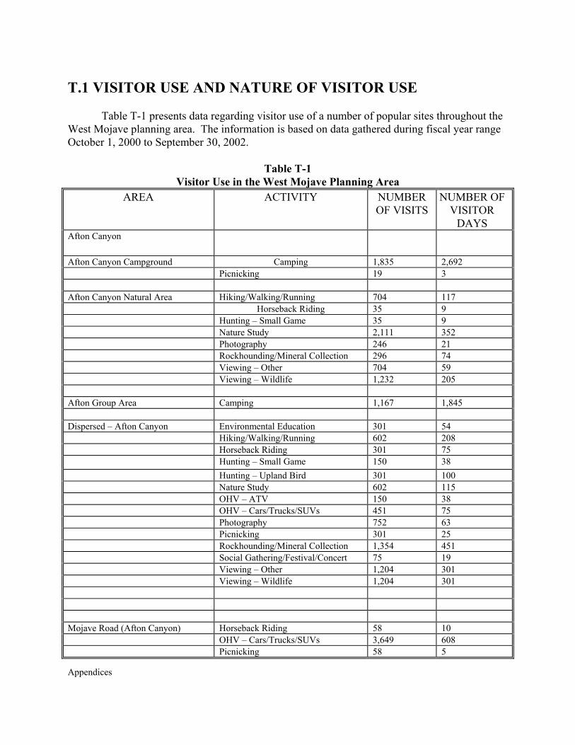
Appendices
T.1 VISITOR USE AND NATURE OF VISITOR USE Table T-1 presents data regarding visitor use of a number of popular sites throughout the
West Mojave planning area. The information is based on data gathered during fiscal year range October 1, 2000 to September 30, 2002.
Table T-1 Visitor Use in the West Mojave Planning Area
AREA ACTIVITY NUMBER OF VISITS
NUMBER OF VISITOR
DAYS Afton Canyon
Afton Canyon Campground Camping 1,835 2,692 Picnicking 19 3 Afton Canyon Natural Area Hiking/Walking/Running 704 117 Horseback Riding 35 9 Hunting – Small Game 35 9 Nature Study 2,111 352 Photography 246 21 Rockhounding/Mineral Collection 296 74 Viewing – Other 704 59
Viewing – Wildlife 1,232 205
Afton Group Area Camping 1,167 1,845 Dispersed – Afton Canyon Environmental Education 301 54 Hiking/Walking/Running 602 208
Horseback Riding 301 75 Hunting – Small Game 150 38 Hunting – Upland Bird 301 100 Nature Study 602 115 OHV – ATV 150 38
OHV – Cars/Trucks/SUVs 451 75 Photography 752 63 Picnicking 301 25 Rockhounding/Mineral Collection 1,354 451 Social Gathering/Festival/Concert 75 19 Viewing – Other 1,204 301 Viewing – Wildlife 1,204 301
Mojave Road (Afton Canyon) Horseback Riding 58 10 OHV – Cars/Trucks/SUVs 3,649 608 Picnicking 58 5
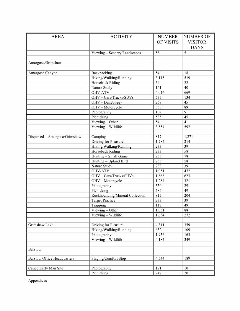
Appendices
AREA ACTIVITY NUMBER OF VISITS
NUMBER OF VISITOR
DAYS Viewing – Scenery/Landscapes 58 5 Amargosa/Grimshaw
Amargosa Canyon Backpacking 54 18 Hiking/Walking/Running 3,115 519 Horseback Riding 54 22 Nature Study 161 40 OHV-ATV 4,016 669 OHV – Cars/Trucks/SUVs 535 134 OHV – Dunebuggy 268 45 OHV – Motorcycle 535 89 Photography 107 9 Picnicking 535 45 Viewing – Other 54 4 Viewing – Wildlife 3,554 592 Dispersed – Amargosa/Grimshaw Camping 817 1,271 Driving for Pleasure 1,284 214 Hiking/Walking/Running 233 39 Horseback Riding 233 58 Hunting – Small Game 233 78 Hunting – Upland Bird 233 58 Nature Study 233 39 OHV-ATV 1,051 472 OHV – Cars/Trucks/SUVs 1,868 623 OHV – Motorcycle 1,284 321 Photography 350 29 Picnicking 584 49 Rockhounding/Mineral Collection 817 204 Target Practice 233 39 Trapping 117 49 Viewing – Other 1,051 88 Viewing – Wildlife 1,634 272 Grimshaw Lake Driving for Pleasure 4,311 359 Hiking/Walking/Running 652 109 Photography 1,956 163 Viewing – Wildlife 4,185 349 Barstow
Barstow Office Headquarters Staging/Comfort Stop 4,544 189 Calico Early Man Site Photography 121 10 Picnicking 242 20
Appendices
AREA ACTIVITY NUMBER OF VISITS
NUMBER OF VISITOR
DAYS Viewing – Cultural Sites 4,028 336 Viewing – Interpretive Exhibit 4,028 336 Dispersed - Barstow Bicycling – Mountain 21,145 7,048 Camping 179,822 285,097 Climbing – Mountain/Rock 102 201 Driving for Pleasure 74,008 12,335 Hiking/Walking/Running 52,863 8,810 Horseback Riding 10,573 3,120 Hunting – Small Game 40,306 10,076 Hunting – Upland Bird 48,015 16,005 Interpretive Programs 155 6 Model Airplane/Rocket 325 158 Nature Study 24,018 3,437 OHV – ATV 42,290 10,573 OHV – Cars/Trucks/SUVs 339,242 112,834 OHV – Motorcycle 95,833 33,079 Other Motor Land Sport/Event 147 104 Pack Trips 10 25 Photography 53,379 4,689 Picnicking 75,728 6,403 Rockhounding/Mineral Collection 39,437 9,859 Social Gathering/Festival/Concert 15,177 5,092 Spectator Sport 698 457 Staging/Comfort Stop 4 0 Target Practice 74,008 12,335 Trapping 10,573 1,762 Viewing – Other 21,145 5,286 Viewing – Scenery/Landscapes 750 33 Viewing – Wildflowers 71 3 Viewing – Wildlife 63,445 21,146 Viewing – Interpretive Exhibit 10,573 441 Juniper Flats Camping 537 860 Hiking/Walking/Running 537 90 Horseback Riding 753 188 Hunting – Small Game 403 101 Hunting – Upland Bird 403 101 Nature Study 343 41 OHV – ATV 269 45 OHV – Cars/Trucks/SUVs 940 235 OHV – Motorcycle 1,350 225 Photography 269 22 Picnicking 3,089 257 Viewing – Cultural Sites 1,209 101 Viewing – Other 1,746 145
Appendices
AREA ACTIVITY NUMBER OF VISITS
NUMBER OF VISITOR
DAYS Viewing – Wildlife 2,552 213 Lucerne Dry Lake OHV – Cars/Trucks/SUVs 259 11 Picnicking 259 22 Social Gathering/Festival/Concert 259 43 Specialized Sport/Event (Non-Motor) 356 269 Spectator Sport 176 88 Viewing – Scenery/Landscapes 52 2 Mojave Road (Barstow) OHV – Cars/Trucks/SUVs 1,593 266 Desert Discovery Center
Desert Discovery Center Environmental Education 1,099 165 Nature Study 1,648 69 Photography 476 20 Viewing – Wildlife 951 40 Viewing – Interpretive Exhibit 9,323 539 Dispersed – Desert Discovery Center Viewing – Other 22 2 Dumont Dunes
Dispersed – Dumont Dunes Camping 183,808 375,405 OHV – ATV 141,402 94,273 OHV – Cars/Trucks/SUVs 32,590 12,068 OHV – Dunebuggy 34,338 20,031 OHV – Motorcycle 19,516 4,879 Photography 30,537 2,546 Picnicking 10,935 947 Racing – OHV Cars/Trucks/Buggies 105 67 Rockhounding/Mineral Collection 16,159 4,040 Sand Boarding 20 17 Social Gathering/Festival/Concert 835 888 Spectator Sport 4,636 3,203 Staging/Comfort Stop 213 18 Viewing – Other 213 18 Viewing – Scenery/Landscapes 325 27 Viewing – Interpretive Exhibit 30,299 2,525 Salt Creek Hills ACEC Nature Study 2,039 170 Photography 1,223 102 Picnicking 815 68 Staging/Comfort Stop 5,485 114 Viewing – Cultural Sites 4,892 408
Appendices
AREA ACTIVITY NUMBER OF VISITS
NUMBER OF VISITOR
DAYS Viewing – Wildlife 4,892 612 Viewing – Interpretive Exhibit 3,150 131 El Mirage
Dispersed – El Mirage Camping 173,850 272,022 Driving for Pleasure 23,909 3,985 Hang-Gliding/Parasailing 4,782 1,002 Hiking/Walking/Running 2,391 398 Horseback Riding 2,391 797 Land/Sand Sailing 11,955 3,985 Model Airplane/Rocket 3,551 592 OHV – ATV 88,464 22,116 OHV – Cars/Trucks/SUVs 27,985 7,756 OHV – Dunebuggy 4,782 1,594 OHV – Motorcycle 96,725 32,343 Other Motor Land Sport/Event 367 349 Photography 7,294 1,688 Picnicking 132,414 11,512 Racing – Auto Track 3,449 2,485 Racing – Motorcycle 370 185 Social Gathering/Festival/Concert 7,327 3,535 Specialized Sport/Event (Non-Motor) 38,007 13,026 Spectator Sport 8,729 11,577 Viewing – Scenery/Landscapes 2,930 122 Viewing – Wildflowers 132 6 Rasor
Dispersed – Rasor Camping 18,690 27,378 Hunting – Small Game 652 163 Hunting – Upland Bird 435 109 OHV – ATV 14,132 6,142 OHV – Cars/Trucks/ SUVs 3,113 1,184 OHV – Motorcycle 1,739 756 Photography 51 34 Picnicking 319 53 Social Gathering/Festival/Concert 544 272 Mojave Road (Rasor) OHV – Cars/Trucks/SUVs 1,593 266 Stoddard/Johnson
Anderson Dry Lake Camping 3,927 5,707 OHV-ATV 1,704 529 OHV – Cars/Trucks/SUVs 7,731 3,663 OHV – Motorcycle 8,856 4,258
Appendices
AREA ACTIVITY NUMBER OF VISITS
NUMBER OF VISITOR
DAYS Photography 945 91 Picnicking 3,343 413 Racing – OHV Cars/Trucks/Buggies 151 65 Social Gathering/Festival/Concert 2,645 1,492 Viewing – Scenery/Landscapes 410 17 Viewing – Wildflowers 65 3 Cougar Buttes Camping 3,500 5,096 OHV – ATV 455 214 OHV – Cars/Trucks/SUVs 2,055 167 OHV – Motorcycle 4,294 2,163 Other Motor Land Sport/Event 127 63 Photography 1,010 270 Picnicking 4,445 2,131 Racing – Motorcycle 913 1,125 Social Gathering/Festival/Concert 3,667 2,671 Spectator Sport 1,499 1,548 Viewing – Scenery/Landscapes 950 51 Dispersed – Stoddard/Johnson Camping 82,850 134,057 Driving for Pleasure 14,717 2,555 Hiking/Walking/Running 6,764 841 Horseback Riding 3,874 1,291 Hunting – Small Game 2,236 559 Hunting – Upland Bird 2,236 745 Nature Study 2236 373 OHV – ATV 34,468 19,992 OHV – Cars/Trucks/SUVs 53,760 30,469 OHV - Motorcycle 38,664 22,069 Other Motor Land Sport/Event 1,434 717 Photography 6,964 1,393 Picnicking 40,535 4,396 Racing – Auto Track 493 329 Racing – Motorcycle 2,953 1,528 Racing – OHV Cars/Trucks/Buggies 318 153 Re-enactment Events/Tours 135 168 Rock Crawling – 4WD 399 532 Rockhounding/Mineral Collection 6,708 2,385 Social Gathering/Festival/Concert 25,126 14,251 Spectator Sport 16686 11,700 Staging/Comfort Stop 184 63 Target Practice 6,708 1,118 Viewing – Other 12,374 3,094 Viewing – Scenery/Landscapes 8,549 453 Viewing – Wildflowers 407 21 Viewing – Wildlife 15,207 5,069
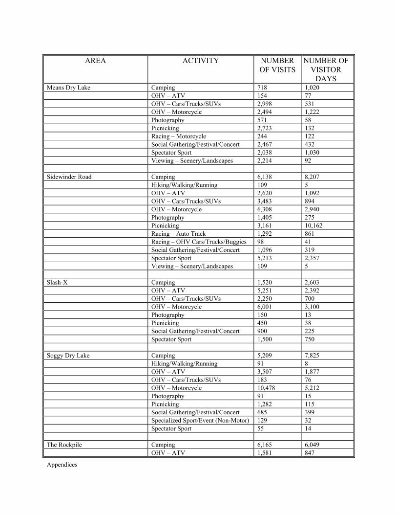
Appendices
AREA ACTIVITY NUMBER OF VISITS
NUMBER OF VISITOR
DAYS Means Dry Lake Camping 718 1,020 OHV – ATV 154 77 OHV – Cars/Trucks/SUVs 2,998 531 OHV – Motorcycle 2,494 1,222 Photography 571 58 Picnicking 2,723 132 Racing – Motorcycle 244 122 Social Gathering/Festival/Concert 2,467 432 Spectator Sport 2,038 1,030 Viewing – Scenery/Landscapes 2,214 92 Sidewinder Road Camping 6,138 8,207 Hiking/Walking/Running 109 5 OHV – ATV 2,620 1,092 OHV – Cars/Trucks/SUVs 3,483 894 OHV – Motorcycle 6,308 2,940 Photography 1,405 275 Picnicking 3,161 10,162 Racing – Auto Track 1,292 861 Racing – OHV Cars/Trucks/Buggies 98 41 Social Gathering/Festival/Concert 1,096 319 Spectator Sport 5,213 2,357 Viewing – Scenery/Landscapes 109 5 Slash-X Camping 1,520 2,603 OHV – ATV 5,251 2,392 OHV – Cars/Trucks/SUVs 2,250 700 OHV – Motorcycle 6,001 3,100 Photography 150 13 Picnicking 450 38 Social Gathering/Festival/Concert 900 225 Spectator Sport 1,500 750 Soggy Dry Lake Camping 5,209 7,825 Hiking/Walking/Running 91 8 OHV – ATV 3,507 1,877 OHV – Cars/Trucks/SUVs 183 76 OHV – Motorcycle 10,478 5,212 Photography 91 15 Picnicking 1,282 115 Social Gathering/Festival/Concert 685 399 Specialized Sport/Event (Non-Motor) 129 32 Spectator Sport 55 14 The Rockpile Camping 6,165 6,049 OHV – ATV 1,581 847
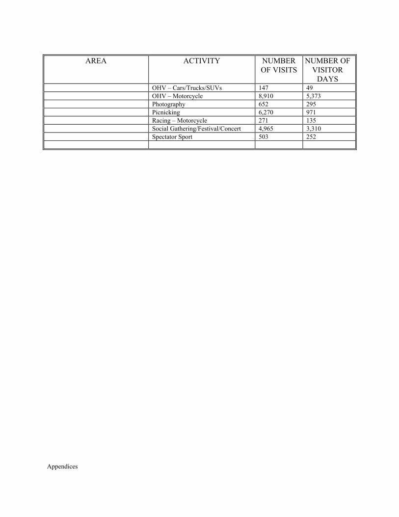
Appendices
AREA ACTIVITY NUMBER OF VISITS
NUMBER OF VISITOR
DAYS OHV – Cars/Trucks/SUVs 147 49 OHV – Motorcycle 8,910 5,373 Photography 652 295 Picnicking 6,270 971 Racing – Motorcycle 271 135 Social Gathering/Festival/Concert 4,965 3,310 Spectator Sport 503 252
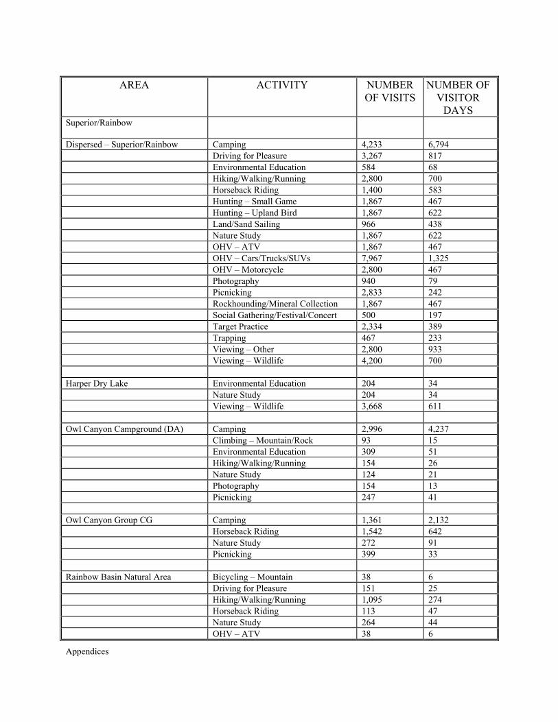
Appendices
AREA ACTIVITY NUMBER OF VISITS
NUMBER OF VISITOR
DAYS Superior/Rainbow
Dispersed – Superior/Rainbow Camping 4,233 6,794 Driving for Pleasure 3,267 817 Environmental Education 584 68 Hiking/Walking/Running 2,800 700 Horseback Riding 1,400 583 Hunting – Small Game 1,867 467 Hunting – Upland Bird 1,867 622 Land/Sand Sailing 966 438 Nature Study 1,867 622 OHV – ATV 1,867 467 OHV – Cars/Trucks/SUVs 7,967 1,325 OHV – Motorcycle 2,800 467 Photography 940 79 Picnicking 2,833 242 Rockhounding/Mineral Collection 1,867 467 Social Gathering/Festival/Concert 500 197 Target Practice 2,334 389 Trapping 467 233 Viewing – Other 2,800 933 Viewing – Wildlife 4,200 700 Harper Dry Lake Environmental Education 204 34 Nature Study 204 34 Viewing – Wildlife 3,668 611 Owl Canyon Campground (DA) Camping 2,996 4,237 Climbing – Mountain/Rock 93 15 Environmental Education 309 51 Hiking/Walking/Running 154 26 Nature Study 124 21 Photography 154 13 Picnicking 247 41 Owl Canyon Group CG Camping 1,361 2,132 Horseback Riding 1,542 642 Nature Study 272 91 Picnicking 399 33 Rainbow Basin Natural Area Bicycling – Mountain 38 6 Driving for Pleasure 151 25 Hiking/Walking/Running 1,095 274 Horseback Riding 113 47 Nature Study 264 44 OHV – ATV 38 6
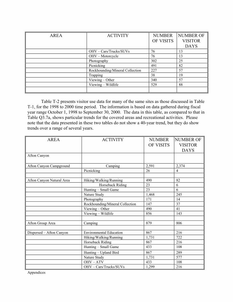
Appendices
AREA ACTIVITY NUMBER OF VISITS
NUMBER OF VISITOR
DAYS OHV – Cars/Trucks/SUVs 76 13 OHV – Motorcycle 76 13 Photography 302 25 Picnicking 491 82 Rockhounding/Mineral Collection 227 57 Trapping 38 19 Viewing – Other 340 57 Viewing – Wildlife 529 88
Table T-2 presents visitor use data for many of the same sites as those discussed in Table T-1, for the 1998 to 2000 time period. The information is based on data gathered during fiscal year range October 1, 1998 to September 30, 2000. The data in this table, as compared to that in Table Q3.7a, shows particular trends for the covered areas and recreational activities. Please note that the data presented in these two tables do not show a 40-year trend, but they do show trends over a range of several years.
AREA ACTIVITY NUMBER OF VISITS
NUMBER OF VISITOR
DAYS Afton Canyon
Afton Canyon Campground Camping 2,591 2,374 Picnicking 26 4 Afton Canyon Natural Area Hiking/Walking/Running 490 82 Horseback Riding 23 6 Hunting – Small Game 23 6 Nature Study 1,468 245 Photography 171 14 Rockhounding/Mineral Collection 147 37 Viewing – Other 490 41
Viewing – Wildlife 856 143
Afton Group Area Camping 879 806 Dispersed – Afton Canyon Environmental Education 867 216 Hiking/Walking/Running 1,731 722
Horseback Riding 867 216 Hunting – Small Game 433 108 Hunting – Upland Bird 867 289 Nature Study 1,731 577 OHV – ATV 433 108
OHV – Cars/Trucks/SUVs 1,299 216
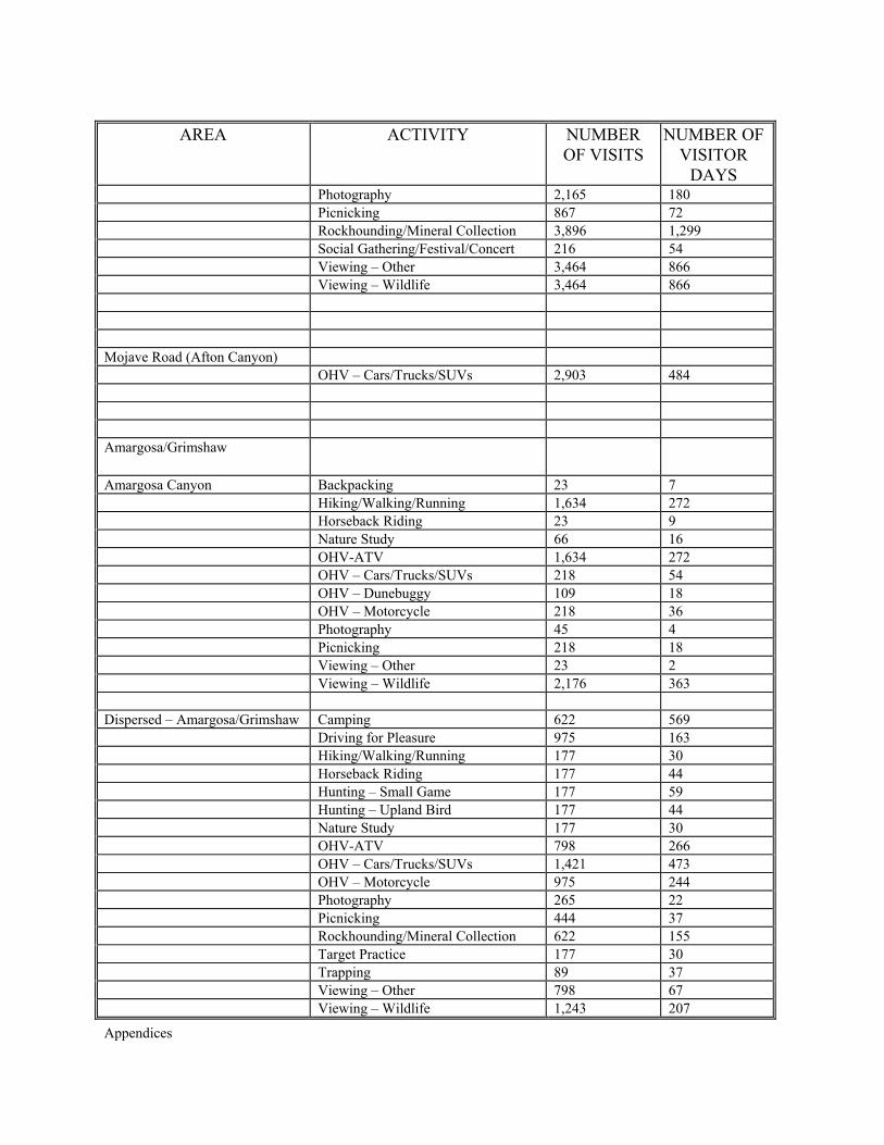
Appendices
AREA ACTIVITY NUMBER OF VISITS
NUMBER OF VISITOR
DAYS Photography 2,165 180 Picnicking 867 72 Rockhounding/Mineral Collection 3,896 1,299 Social Gathering/Festival/Concert 216 54 Viewing – Other 3,464 866 Viewing – Wildlife 3,464 866
Mojave Road (Afton Canyon) OHV – Cars/Trucks/SUVs 2,903 484 Amargosa/Grimshaw
Amargosa Canyon Backpacking 23 7 Hiking/Walking/Running 1,634 272 Horseback Riding 23 9 Nature Study 66 16 OHV-ATV 1,634 272 OHV – Cars/Trucks/SUVs 218 54 OHV – Dunebuggy 109 18 OHV – Motorcycle 218 36 Photography 45 4 Picnicking 218 18 Viewing – Other 23 2 Viewing – Wildlife 2,176 363 Dispersed – Amargosa/Grimshaw Camping 622 569 Driving for Pleasure 975 163 Hiking/Walking/Running 177 30 Horseback Riding 177 44 Hunting – Small Game 177 59 Hunting – Upland Bird 177 44 Nature Study 177 30 OHV-ATV 798 266 OHV – Cars/Trucks/SUVs 1,421 473 OHV – Motorcycle 975 244 Photography 265 22 Picnicking 444 37 Rockhounding/Mineral Collection 622 155 Target Practice 177 30 Trapping 89 37 Viewing – Other 798 67 Viewing – Wildlife 1,243 207
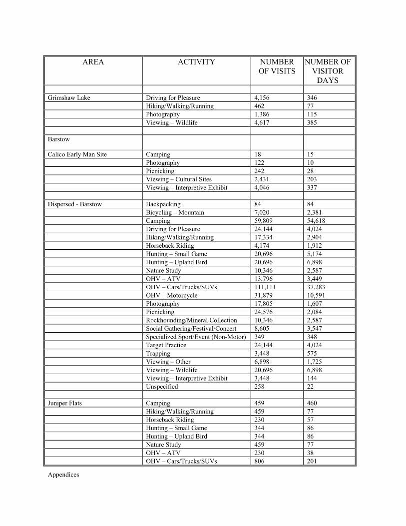
Appendices
AREA ACTIVITY NUMBER OF VISITS
NUMBER OF VISITOR
DAYS Grimshaw Lake Driving for Pleasure 4,156 346 Hiking/Walking/Running 462 77 Photography 1,386 115 Viewing – Wildlife 4,617 385 Barstow
Calico Early Man Site Camping 18 15 Photography 122 10 Picnicking 242 28 Viewing – Cultural Sites 2,431 203 Viewing – Interpretive Exhibit 4,046 337 Dispersed - Barstow Backpacking 84 84 Bicycling – Mountain 7,020 2,381 Camping 59,809 54,618 Driving for Pleasure 24,144 4,024 Hiking/Walking/Running 17,334 2,904 Horseback Riding 4,174 1,912 Hunting – Small Game 20,696 5,174 Hunting – Upland Bird 20,696 6,898 Nature Study 10,346 2,587 OHV – ATV 13,796 3,449 OHV – Cars/Trucks/SUVs 111,111 37,283 OHV – Motorcycle 31,879 10,591 Photography 17,805 1,607 Picnicking 24,576 2,084 Rockhounding/Mineral Collection 10,346 2,587 Social Gathering/Festival/Concert 8,605 3,547 Specialized Sport/Event (Non-Motor) 349 348 Target Practice 24,144 4,024 Trapping 3,448 575 Viewing – Other 6,898 1,725 Viewing – Wildlife 20,696 6,898 Viewing – Interpretive Exhibit 3,448 144 Unspecified 258 22 Juniper Flats Camping 459 460 Hiking/Walking/Running 459 77 Horseback Riding 230 57 Hunting – Small Game 344 86 Hunting – Upland Bird 344 86 Nature Study 459 77 OHV – ATV 230 38 OHV – Cars/Trucks/SUVs 806 201
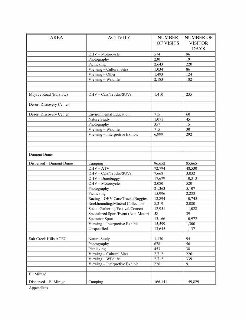
Appendices
AREA ACTIVITY NUMBER OF VISITS
NUMBER OF VISITOR
DAYS OHV – Motorcycle 574 96 Photography 230 19 Picnicking 2,643 220 Viewing – Cultural Sites 1,034 86 Viewing – Other 1,493 124 Viewing – Wildlife 2,183 182 Mojave Road (Barstow) OHV – Cars/Trucks/SUVs 1,410 235 Desert Discovery Center
Desert Discovery Center Environmental Education 715 60 Nature Study 1,071 45 Photography 357 15 Viewing – Wildlife 715 30 Viewing – Interpretive Exhibit 6,999 292 Dumont Dunes
Dispersed – Dumont Dunes Camping 96,652 85,665 OHV – ATV 72,794 48,530 OHV – Cars/Trucks/SUVs 7,668 3,032 OHV – Dunebuggy 17,679 10,313 OHV – Motorcycle 2,080 520 Photography 21,363 5,107 Picnicking 15,996 2,233 Racing – OHV Cars/Trucks/Buggies 12,894 10,745 Rockhounding/Mineral Collection 8,319 2,080 Social Gathering/Festival/Concert 12,951 11,028 Specialized Sport/Event (Non-Motor) 58 39 Spectator Sport 13,166 10,972 Viewing – Interpretive Exhibit 15,599 1,300 Unspecified 13,645 1,137 Salt Creek Hills ACEC Nature Study 1,130 94 Photography 678 56 Picnicking 453 38 Viewing – Cultural Sites 2,712 226 Viewing – Wildlife 2,712 339 Viewing – Interpretive Exhibit 226 9 El Mirage
Dispersed – El Mirage Camping 166,141 149,829
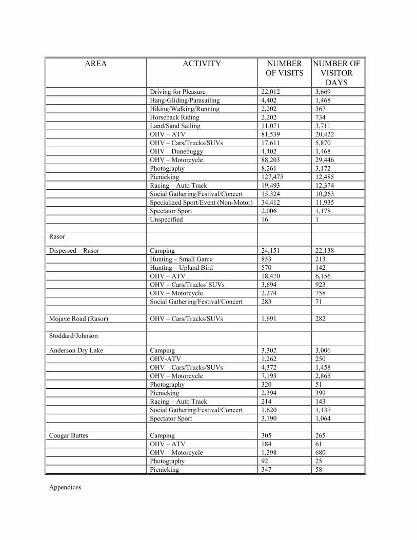
Appendices
AREA ACTIVITY NUMBER OF VISITS
NUMBER OF VISITOR
DAYS Driving for Pleasure 22,012 3,669 Hang-Gliding/Parasailing 4,402 1,468 Hiking/Walking/Running 2,202 367 Horseback Riding 2,202 734 Land/Sand Sailing 11,071 3,711 OHV – ATV 81,539 20,422 OHV – Cars/Trucks/SUVs 17,611 5,870 OHV – Dunebuggy 4,402 1,468 OHV – Motorcycle 88,203 29,446 Photography 8,261 3,172 Picnicking 127,475 12,485 Racing – Auto Track 19,493 12,374 Social Gathering/Festival/Concert 15,324 10,263 Specialized Sport/Event (Non-Motor) 34,412 11,935 Spectator Sport 2,006 1,178 Unspecified 16 1 Rasor
Dispersed – Rasor Camping 24,151 22,138 Hunting – Small Game 853 213 Hunting – Upland Bird 570 142 OHV – ATV 18,470 6,156 OHV – Cars/Trucks/ SUVs 3,694 923 OHV – Motorcycle 2,274 758 Social Gathering/Festival/Concert 283 71 Mojave Road (Rasor) OHV – Cars/Trucks/SUVs 1,691 282 Stoddard/Johnson
Anderson Dry Lake Camping 3,302 3,006 OHV-ATV 1,262 250 OHV – Cars/Trucks/SUVs 4,372 1,458 OHV – Motorcycle 7,193 2,865 Photography 320 51 Picnicking 2,394 399 Racing – Auto Track 214 143 Social Gathering/Festival/Concert 1,620 1,137 Spectator Sport 3,190 1,064 Cougar Buttes Camping 305 265 OHV – ATV 184 61 OHV – Motorcycle 1,298 680 Photography 92 25 Picnicking 347 58
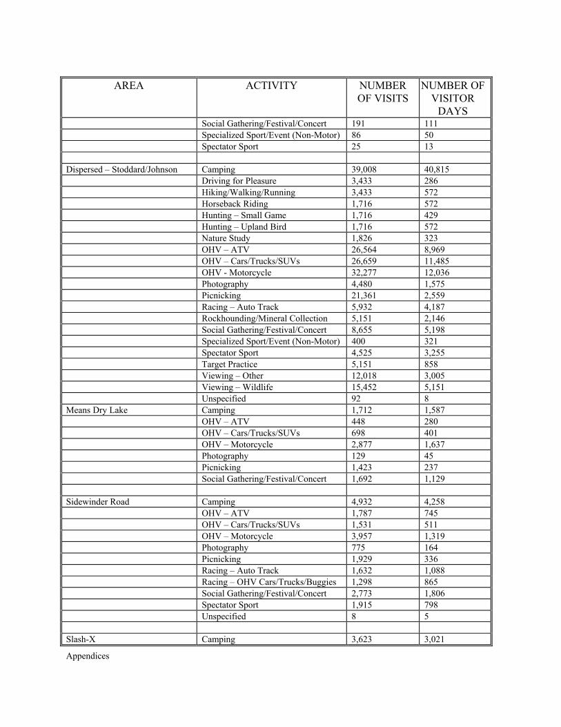
Appendices
AREA ACTIVITY NUMBER OF VISITS
NUMBER OF VISITOR
DAYS Social Gathering/Festival/Concert 191 111 Specialized Sport/Event (Non-Motor) 86 50 Spectator Sport 25 13 Dispersed – Stoddard/Johnson Camping 39,008 40,815 Driving for Pleasure 3,433 286 Hiking/Walking/Running 3,433 572 Horseback Riding 1,716 572 Hunting – Small Game 1,716 429 Hunting – Upland Bird 1,716 572 Nature Study 1,826 323 OHV – ATV 26,564 8,969 OHV – Cars/Trucks/SUVs 26,659 11,485 OHV - Motorcycle 32,277 12,036 Photography 4,480 1,575 Picnicking 21,361 2,559 Racing – Auto Track 5,932 4,187 Rockhounding/Mineral Collection 5,151 2,146 Social Gathering/Festival/Concert 8,655 5,198 Specialized Sport/Event (Non-Motor) 400 321 Spectator Sport 4,525 3,255 Target Practice 5,151 858 Viewing – Other 12,018 3,005 Viewing – Wildlife 15,452 5,151 Unspecified 92 8 Means Dry Lake Camping 1,712 1,587 OHV – ATV 448 280 OHV – Cars/Trucks/SUVs 698 401 OHV – Motorcycle 2,877 1,637 Photography 129 45 Picnicking 1,423 237 Social Gathering/Festival/Concert 1,692 1,129 Sidewinder Road Camping 4,932 4,258 OHV – ATV 1,787 745 OHV – Cars/Trucks/SUVs 1,531 511 OHV – Motorcycle 3,957 1,319 Photography 775 164 Picnicking 1,929 336 Racing – Auto Track 1,632 1,088 Racing – OHV Cars/Trucks/Buggies 1,298 865 Social Gathering/Festival/Concert 2,773 1,806 Spectator Sport 1,915 798 Unspecified 8 5 Slash-X Camping 3,623 3,021
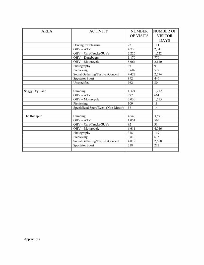
Appendices
AREA ACTIVITY NUMBER OF VISITS
NUMBER OF VISITOR
DAYS Driving for Pleasure 221 111 OHV – ATV 4,730 2,041 OHV – Cars/Trucks/SUVs 3,226 1,522 OHV – Dunebuggy 1,170 779 OHV – Motorcycle 5,064 2,120 Photography 93 9 Picnicking 3,607 579 Social Gathering/Festival/Concert 4,422 2,574 Spectator Sport 892 446 Unspecified 962 80 Soggy Dry Lake Camping 1,324 1,212 OHV – ATV 992 661 OHV – Motorcycle 3,030 1,515 Picnicking 109 18 Specialized Sport/Event (Non-Motor) 56 14 The Rockpile Camping 4,540 3,591 OHV – ATV 1,051 565 OHV – Cars/Trucks/SUVs 92 31 OHV – Motorcycle 6,611 4,046 Photography 338 119 Picnicking 3,810 635 Social Gathering/Festival/Concert 4,019 2,568 Spectator Sport 318 212
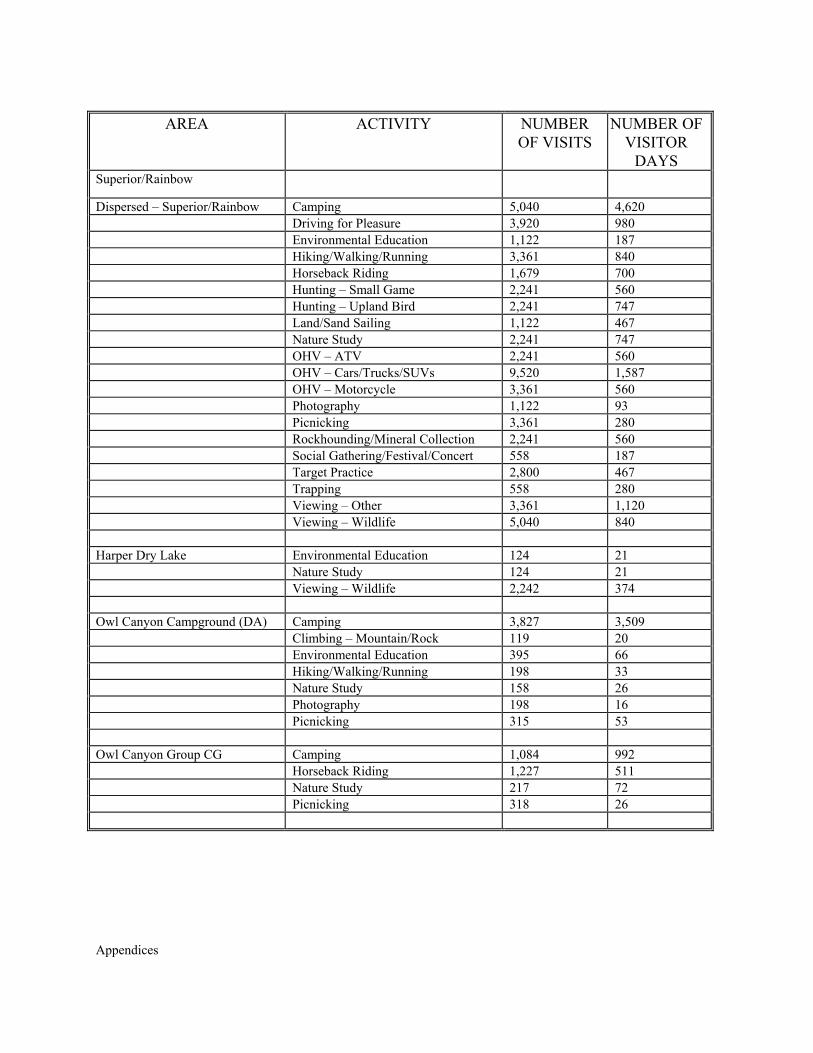
Appendices
AREA ACTIVITY NUMBER OF VISITS
NUMBER OF VISITOR
DAYS Superior/Rainbow
Dispersed – Superior/Rainbow Camping 5,040 4,620 Driving for Pleasure 3,920 980 Environmental Education 1,122 187 Hiking/Walking/Running 3,361 840 Horseback Riding 1,679 700 Hunting – Small Game 2,241 560 Hunting – Upland Bird 2,241 747 Land/Sand Sailing 1,122 467 Nature Study 2,241 747 OHV – ATV 2,241 560 OHV – Cars/Trucks/SUVs 9,520 1,587 OHV – Motorcycle 3,361 560 Photography 1,122 93 Picnicking 3,361 280 Rockhounding/Mineral Collection 2,241 560 Social Gathering/Festival/Concert 558 187 Target Practice 2,800 467 Trapping 558 280 Viewing – Other 3,361 1,120 Viewing – Wildlife 5,040 840 Harper Dry Lake Environmental Education 124 21 Nature Study 124 21 Viewing – Wildlife 2,242 374 Owl Canyon Campground (DA) Camping 3,827 3,509 Climbing – Mountain/Rock 119 20 Environmental Education 395 66 Hiking/Walking/Running 198 33 Nature Study 158 26 Photography 198 16 Picnicking 315 53 Owl Canyon Group CG Camping 1,084 992 Horseback Riding 1,227 511 Nature Study 217 72 Picnicking 318 26
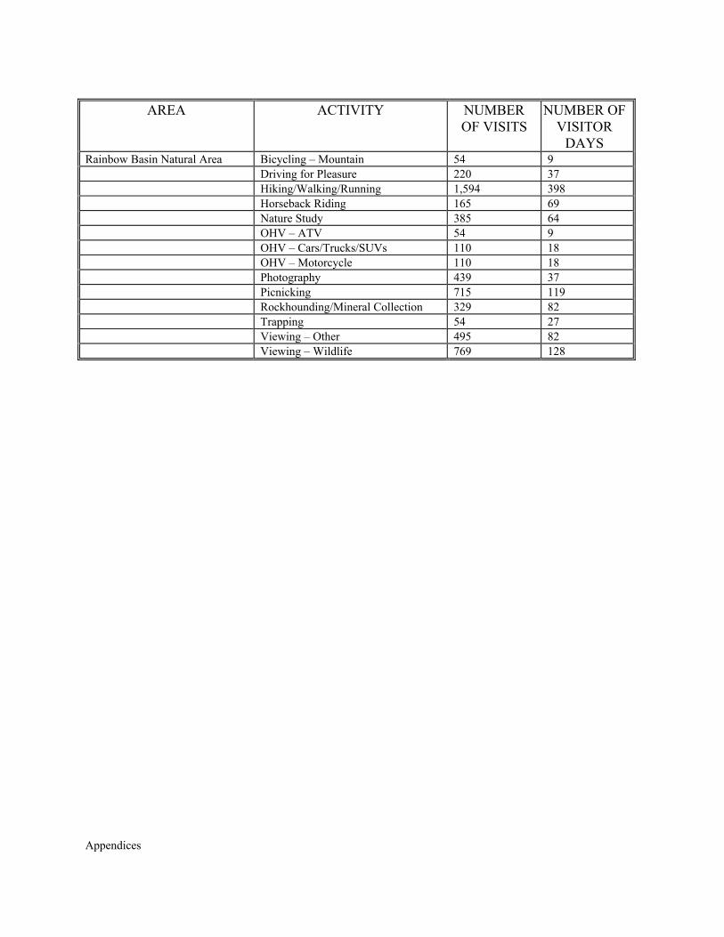
Appendices
AREA ACTIVITY NUMBER OF VISITS
NUMBER OF VISITOR
DAYS Rainbow Basin Natural Area Bicycling – Mountain 54 9 Driving for Pleasure 220 37 Hiking/Walking/Running 1,594 398 Horseback Riding 165 69 Nature Study 385 64 OHV – ATV 54 9 OHV – Cars/Trucks/SUVs 110 18 OHV – Motorcycle 110 18 Photography 439 37 Picnicking 715 119 Rockhounding/Mineral Collection 329 82 Trapping 54 27 Viewing – Other 495 82 Viewing – Wildlife 769 128

Appendices

Appendices
APPENDIX U
CULTURAL RESOURCES

Appendices
Appendices
APPENDIX U CULTURAL RESOURCES
The Barstow Field Office area includes nine subregions for route designation. Table U-1
lists the cultural resources potentially affected by proposed open routes.
Table U-1 BLM Barstow Field Office
Cultural Resource Data QUADRANGLE ROUTE CULTURAL RESOURCES POTENTIALLY
IMPACTED Adobe Mt. No recorded cultural resources impacted. Alvord Mt. East C1083, C3040, C3045
C3045 C3024, C3032, C3030 C3008, C3032, C3066 C3115 C3155 AF232
SBR4272H road SBR2223 lithic reduction, SBR7694H power transmission line SBR2223 lithic reduction CHL577/SBR4411H Mormon Trail SBR7694H power transmission line SBR3175/H lithic reduction SBR3695 lithic scatter
Alvord Mt. West C1077 C2001 C2005, C1116 C1029 C1063, C1064, C2010 C1072 C2034, C1002 C3047, C3046, C2001, C3045, C1002, UK
SBR6493H mining PSBR45H road SBR884 lithic reduction SBR871 lithic reduction SBR848 lithic reduction SBR6435, SBR6436 lithic reduction, SBR6438 camp SBR893 lithic reduction SBR853 camp, SBR7694H power transmission line
Ash Hill No recorded cultural resources impacted. Astley Rancho No recorded cultural resources impacted. Apple Valley North No recorded cultural resources impacted. Bagdad SW No data Barstow No recorded cultural resources impacted. Barstow SE SV275 SBR562, SBR3184, SBR3617 Big Bear City T3N R2E Section 21 SBR4038 Terrace Springs Bighorn Canyon T3N R4E Section 27
T3N R4E Section 23 T3N R4E Section 26
SBR560 camp, SBR7075 pottery scatter SBR7074 rock art/food processing SBR135 rock art
Bird Spring F3003 SBR518, SBR5658, SBR2579, SBR5673, SBR5670, SBR2577, SBR5672, SBR2748, SBR2749, SBR2750 rock art sites
Bitter Spring C2001 C3156 AF331
IA2042-3 lithic, NRHP-E-SBR7694H power transmission line, SBR3138 lithic reduction, SBR2162 lithic quarry/habitation SBR434 lithic quarry SBR2162 lithic quarry/habitation, SBR6503 lithic quarry/stone circle
Blackwater Well No recorded cultural resources impacted.
Appendices
QUADRANGLE ROUTE CULTURAL RESOURCES POTENTIALLY IMPACTED
Boron NE F4002 PSBR-39H power transmission line, NRHP-E-SBR4347/H lithic scatter/town site
Bristol Lake SW No recorded cultural resources impacted. Broadwell Lake AF1512
AF327 AF152 AF0710, AF077, AF055 MH731
SBR170 village SBR2340H RR, SBR6404H road SBR2340H Road, IA1783-17, 18, 19 SBR6404H Road SBR2340H RR
Buttes, The F5002 P2083-1 lithic reduction site Cave Mt. AF313
AF326 AF2511 AF311
SBR7400 food processing SBR3033H/CHL963 Mojave Rd. SBR3534 lithic reduction PSBR52 trail
Clarks Pass No recorded cultural resources impacted. Cleghorn Lakes No recorded cultural resources impacted. Cougar Buttes No recorded cultural resources impacted. Coyote Lake Coyote Lake (cont.)
C2004 C2005 C2002 C1042
SBR2170, SBR2165 lithic reduction SBR2172 lithic reduction SBR7420H structure SBR7185, SBR2167 rock shelters
Cronese Lakes AF331 SBR248 pottery scatter, SBR2160 food processing, SBR5558H ranching, SBR2157 habitation/cremation
Crucero Hills AF271 AF2421 AF327 AF325 UK
SBR1910H RR PSBR2033-2 habitation SBR 2340H RR, SBR143 prehistoric village SBR3033H/CHL963 Mojave Rd. SBR143 village
Dale Lake MP252 MP351, MP352, MP354, MP355, MP356, MP357, MP359, MP3510
SBR1809 lithic reduction CHL985 Desert Training Center – CA-AZ Maneuvering Area
Dunn AF232 C3032 C3079 C3032, C3008 AF232 AF192 C4002
SBR1910H RR, SBR3033/H/CHL963 Mojave Road, IA2043-2H glass bottle, SBR84/H structure, SBR2152/H cemetery NRHP-E-PSBR38H Hoover Dam to LA transmission lines SBR434 lithic quarry SBR4714 lithic scatter, SBR3608 lithic reduction SBR2152/H camp site SBR2150 lithic quarry, SBR3588 lithic scatter SBR4707 trail Various pending trails, habitation, lithics
E of Langford Well No recorded cultural resources impacted. East of Valley Mt. MP258 SBR5181 fire hearth Fairview Valley T5N R2W Section 14
T5N R2W Section 4/9 T5N R2W Section 4 T5N R2W Section 4 & T6N R2W Section 33
SBR3401 homestead SBR6971, SBR6972 lithic reduction SBR6973 lithic scatter SBR2135 lithic reduction
Appendices
QUADRANGLE ROUTE CULTURAL RESOURCES POTENTIALLY IMPACTED
Fawnskin No data. Freemont Peak F3002
F4196 F4095, F4102
IA2082-2 lithic P2092-2 P2082-1
Goat Mountain No recorded cultural resources impacted. No routes shown on map.
Grandview Mine T6N R2E Section 7 SBR1569 rockshelter Harvard Hill C2001, C2035, C3008,
C3046 C3008 C3002, C3004 C2002 C3008 C2001, C2035, C2036
NRHP-E-SBr7694H power transmission line P1802-9 lithic reduction SBR223 lithic reduction SBR7419 lithic scatter, SBR7418 lithic reduction SBR2821 lithic reduction SBR2100, SBR3168 lithic quarry
Helendale SV215 0 (off SV214)
IA1581-1 flaked tool P1581-1H mining site
Hidden Valley East AF122 SBR6289 fire hearth Hidden Valley West AF122
AF325 P1792-9H mining SBR3033H/CHL963 Mojave Rd.
Hinkley No recorded cultural resources impacted. Hodge Hodge (continued)
SV266 SV266, SV261 SV261 SV275 CO34 EF2663 CO34
SBR7374, SBR7306 trails, SBR8081 SBR8311 Stone Circle PSBR63H communication line, SBR9361H Road PSBR63H communication line NRHP-E-OHP3926 National Old Trails Highway, SBR2910H road PSBR62H power transmission line, SBR2910H SBR3033H/CHL963 Mojave Road, SBR719 lithic scatter
Humbug Mt. No recorded cultural resources impacted. Jackrabbit Hill No recorded cultural resources impacted. Joshua Tree South No recorded cultural resources impacted. Kramer Hills K2107
F2230, F1002, F1002A SBR5357 lithic quarry/camp NRHP-E-SBR6693H AT&F RR
Kramer Junction No recorded cultural resources impacted. Landers T3N R5E Section 30
T3N R5E Section 29 SBR1604/H mining/prehistoric village IA1293-1 ground stone
Lane Mt. SU5096, SU5004, SU5005, SU5061, SU5089, SU5081SU5005 SU5004
NRHP-E-[80-5] Goldstone Historic Mining District SBR6430 lithic scatter; SBR6434, SBR6432, SBR6433 food processing; SBR6431 camp SBR6490H mining
Langford Well No data. Lavic Lake T7N R6E Section 2, 10, 11
T7N R6E Section 1 T8N R6E Section 36 T8N R6E Section 35/36 T8N R6E Section 31
SBR420/H mining/lithic quarry SBR2328/H lithic quarry/historic camp SBR2328/H NRHP-E-CHP3926/SBR2910H National Old Trails Highway SBR5801, SBR5798 lithic scatter; SBR5800 lithic reduction
Appendices
QUADRANGLE ROUTE CULTURAL RESOURCES POTENTIALLY IMPACTED
T7N R7E Section 4 SBR4165H RR & cemetery Lead Mt. SW No recorded cultural resources impacted. Lockhart EF454, F3036, F1045B,
DF461, F4003, EF373, F1036, C283, F3003 F3028 F2007
SBR193 habitation including multiple rock art sites. SBR27H structure SBR3502 lithic scatter
Lucerne Valley No recorded cultural resources impacted. Ludlow T8N R8E Section 32
T7N R8E Section 5 Section 5/8 Section 17 Section 20 Section 19 Section 28 T8N R7E Section 26, 27, 28, 33, 34, 35 T7N R7E Section 10
SBR6404H road, IA1532-2 flaked lithic P1532-3H military site P1532-2H Ludlow town site P1532-1H railroad SBR6530H RR, SBR6529H mining SBR5802 lithic scatter SBR3594H town site (Ragtown) SBR2792 lithic quarry & rock shelters SBR3496 lithic scatter, IA1532-1 flaked lithic
Ludlow SE No recorded cultural resources impacted. Manix SBR3033H/CHL963 Mojave Rd.
NRHP-E-PSBR38H power transmission line Melville Lake No recorded cultural resources impacted. No routes plotted on
map. Minneola NR1001B, NR1001C SBR7694H Boulder Transmission Lines 1, 2, 3 & structure;
SBR3169 lithic reduction Morgans' Well No recorded cultural resources impacted. Morongo Valley MP071, MP075 SBR2212, SBR2372 Mud Hills Mud Hills (continued)
SU3084 C111 SU3024, SU3010, SU1433, SU3003, SU3004, SU3070, SU3067, SU3025, SU3066, SU3068, SU3013, SU3016, SU3065, SU3017, SU3029, SU3019, SU3022, SU3020 SU3030, SU3033, SU3031, SU3058A, SU3038, SU3079, SU3070, SU3012, SU3073
SBR3136 lithic scatter SBR8001H airplane crash site NRHP-E-[80-5] Goldstone Historic Mining District
Nebo SU4031 CO53 CO63 CO613 CO614 CO615 CO616 SU1217
SBR4677H camp SBR4085H RR SBR4100H mining SBR4099H mining P36-061555, IA1812-6 SBR4087H water storage SBR4082H town site, SBR4109 lithic reduction, SBR4084H telegraph line SBR4848, SBR4847, SBR4846/H, SBR4845, SBR4844,
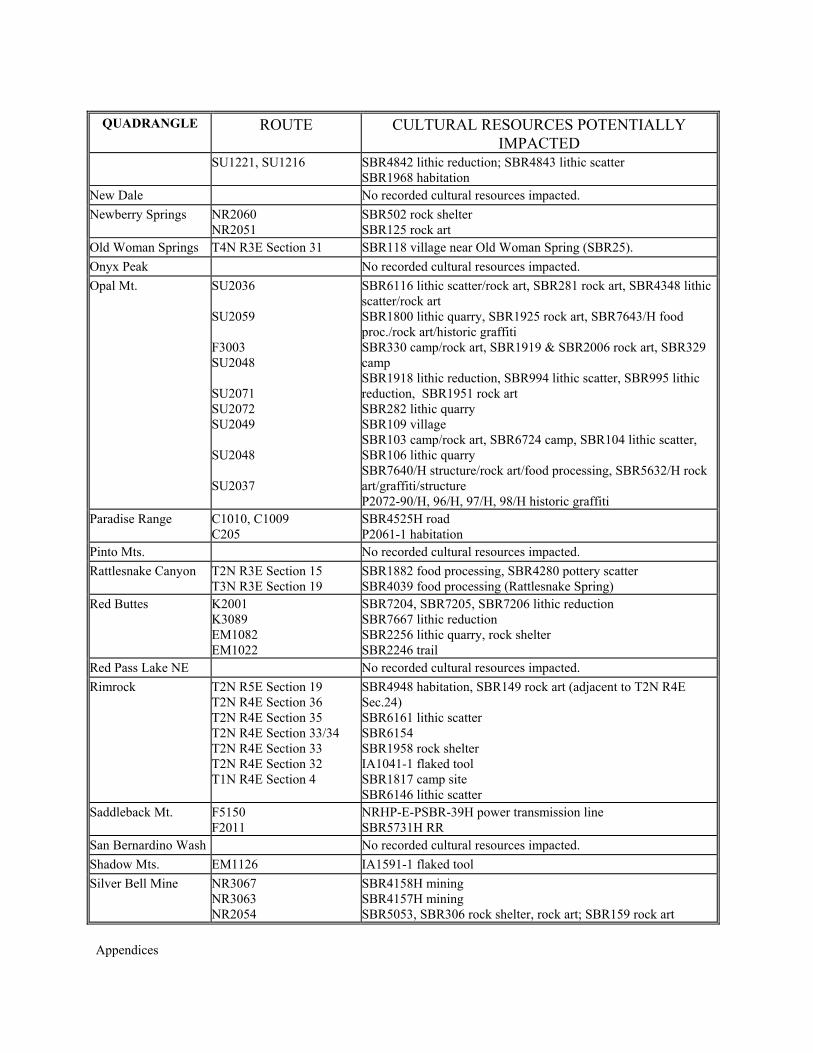
Appendices
QUADRANGLE ROUTE CULTURAL RESOURCES POTENTIALLY IMPACTED
SU1221, SU1216 SBR4842 lithic reduction; SBR4843 lithic scatter SBR1968 habitation
New Dale No recorded cultural resources impacted. Newberry Springs NR2060
NR2051 SBR502 rock shelter SBR125 rock art
Old Woman Springs T4N R3E Section 31 SBR118 village near Old Woman Spring (SBR25). Onyx Peak No recorded cultural resources impacted. Opal Mt. SU2036
SU2059 F3003 SU2048 SU2071 SU2072 SU2049 SU2048 SU2037
SBR6116 lithic scatter/rock art, SBR281 rock art, SBR4348 lithic scatter/rock art SBR1800 lithic quarry, SBR1925 rock art, SBR7643/H food proc./rock art/historic graffiti SBR330 camp/rock art, SBR1919 & SBR2006 rock art, SBR329 camp SBR1918 lithic reduction, SBR994 lithic scatter, SBR995 lithic reduction, SBR1951 rock art SBR282 lithic quarry SBR109 village SBR103 camp/rock art, SBR6724 camp, SBR104 lithic scatter, SBR106 lithic quarry SBR7640/H structure/rock art/food processing, SBR5632/H rock art/graffiti/structure P2072-90/H, 96/H, 97/H, 98/H historic graffiti
Paradise Range C1010, C1009 C205
SBR4525H road P2061-1 habitation
Pinto Mts. No recorded cultural resources impacted. Rattlesnake Canyon T2N R3E Section 15
T3N R3E Section 19 SBR1882 food processing, SBR4280 pottery scatter SBR4039 food processing (Rattlesnake Spring)
Red Buttes K2001 K3089 EM1082 EM1022
SBR7204, SBR7205, SBR7206 lithic reduction SBR7667 lithic reduction SBR2256 lithic quarry, rock shelter SBR2246 trail
Red Pass Lake NE No recorded cultural resources impacted. Rimrock T2N R5E Section 19
T2N R4E Section 36 T2N R4E Section 35 T2N R4E Section 33/34 T2N R4E Section 33 T2N R4E Section 32 T1N R4E Section 4
SBR4948 habitation, SBR149 rock art (adjacent to T2N R4E Sec.24) SBR6161 lithic scatter SBR6154 SBR1958 rock shelter IA1041-1 flaked tool SBR1817 camp site SBR6146 lithic scatter
Saddleback Mt. F5150 F2011
NRHP-E-PSBR-39H power transmission line SBR5731H RR
San Bernardino Wash No recorded cultural resources impacted. Shadow Mts. EM1126 IA1591-1 flaked tool Silver Bell Mine NR3067
NR3063 NR2054
SBR4158H mining SBR4157H mining SBR5053, SBR306 rock shelter, rock art; SBR159 rock art
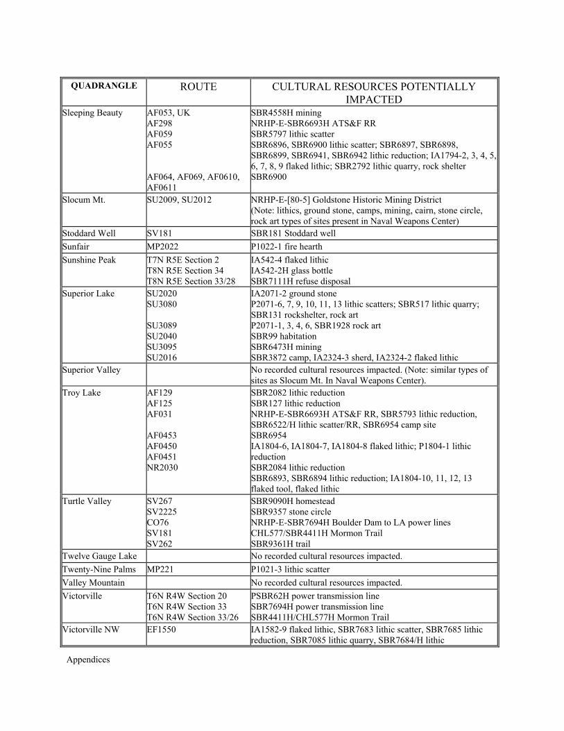
Appendices
QUADRANGLE ROUTE CULTURAL RESOURCES POTENTIALLY IMPACTED
Sleeping Beauty AF053, UK AF298 AF059 AF055 AF064, AF069, AF0610, AF0611
SBR4558H mining NRHP-E-SBR6693H ATS&F RR SBR5797 lithic scatter SBR6896, SBR6900 lithic scatter; SBR6897, SBR6898, SBR6899, SBR6941, SBR6942 lithic reduction; IA1794-2, 3, 4, 5, 6, 7, 8, 9 flaked lithic; SBR2792 lithic quarry, rock shelter SBR6900
Slocum Mt. SU2009, SU2012 NRHP-E-[80-5] Goldstone Historic Mining District (Note: lithics, ground stone, camps, mining, cairn, stone circle, rock art types of sites present in Naval Weapons Center)
Stoddard Well SV181 SBR181 Stoddard well Sunfair MP2022 P1022-1 fire hearth Sunshine Peak T7N R5E Section 2
T8N R5E Section 34 T8N R5E Section 33/28
IA542-4 flaked lithic IA542-2H glass bottle SBR7111H refuse disposal
Superior Lake SU2020 SU3080 SU3089 SU2040 SU3095 SU2016
IA2071-2 ground stone P2071-6, 7, 9, 10, 11, 13 lithic scatters; SBR517 lithic quarry; SBR131 rockshelter, rock art P2071-1, 3, 4, 6, SBR1928 rock art SBR99 habitation SBR6473H mining SBR3872 camp, IA2324-3 sherd, IA2324-2 flaked lithic
Superior Valley No recorded cultural resources impacted. (Note: similar types of sites as Slocum Mt. In Naval Weapons Center).
Troy Lake AF129 AF125 AF031 AF0453 AF0450 AF0451 NR2030
SBR2082 lithic reduction SBR127 lithic reduction NRHP-E-SBR6693H ATS&F RR, SBR5793 lithic reduction, SBR6522/H lithic scatter/RR, SBR6954 camp site SBR6954 IA1804-6, IA1804-7, IA1804-8 flaked lithic; P1804-1 lithic reduction SBR2084 lithic reduction SBR6893, SBR6894 lithic reduction; IA1804-10, 11, 12, 13 flaked tool, flaked lithic
Turtle Valley SV267 SV2225 CO76 SV181 SV262
SBR9090H homestead SBR9357 stone circle NRHP-E-SBR7694H Boulder Dam to LA power lines CHL577/SBR4411H Mormon Trail SBR9361H trail
Twelve Gauge Lake No recorded cultural resources impacted. Twenty-Nine Palms MP221 P1021-3 lithic scatter Valley Mountain No recorded cultural resources impacted. Victorville T6N R4W Section 20
T6N R4W Section 33 T6N R4W Section 33/26
PSBR62H power transmission line SBR7694H power transmission line SBR4411H/CHL577H Mormon Trail
Victorville NW EF1550
IA1582-9 flaked lithic, SBR7683 lithic scatter, SBR7685 lithic reduction, SBR7085 lithic quarry, SBR7684/H lithic
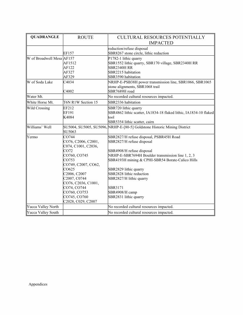
Appendices
QUADRANGLE ROUTE CULTURAL RESOURCES POTENTIALLY IMPACTED
EF157
reduction/refuse disposal SBR8267 stone circle, lithic reduction
W of Broadwell Mesa
AF157 AF1512 AF122 AF327 AF329
P1782-1 lithic quarry SBR1552 lithic quarry, SBR170 village, SBR2340H RR SBR2340H RR SBR2215 habitation SBR3590 habitation
W of Soda Lake C4034 C4002
NRHP-E-PSB38H power transmission line, SBR1066, SBR1065 stone alignments, SBR1068 trail SBR7689H road
Water Mt. No recorded cultural resources impacted. White Horse Mt. T6N R1W Section 15 SBR2336 habitation Wild Crossing EF212
EF191 K4084
SBR720 lithic quarry SBR4862 lithic scatter, IA1834-18 flaked lithic, IA1834-10 flaked tool SBR5354 lithic scatter, cairn
Williams’ Well SU5004, SU5005, SU5096, SU5063
NRHP-E-[80-5] Goldstone Historic Mining District
Yermo CO744 CO76, C2006, C2001, C074, C1001, C2036, CO72 CO760, CO745 CO753 CO749, C2007, CO62, CO625 C2006, C2007 C2007, C0744 CO76, C2036, C1001, CO74, CO744 CO760, CO753 CO745, CO760 C2028, C029, C2007
SBR2827/H refuse disposal, PSBR45H Road SBR2827/H refuse disposal SBR4908/H refuse disposal NRHP-E-SBR7694H Boulder transmission line 1, 2, 3 SBR4193H mining & CPHI-SBR54 Borate-Calico Hills SBR2829 lithic quarry SBR2828 lithic reduction SBR2827/H lithic quarry SBR3171 SBR4908/H camp SBR2831 lithic quarry
Yucca Valley North No recorded cultural resources impacted. Yucca Valley South No recorded cultural resources impacted.

Appendices

Appendices
APPENDIX V
CEQA SCOPING COMMENTS

Appendices
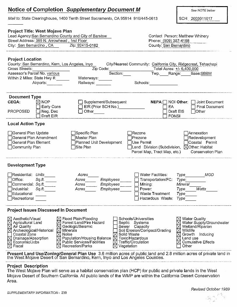


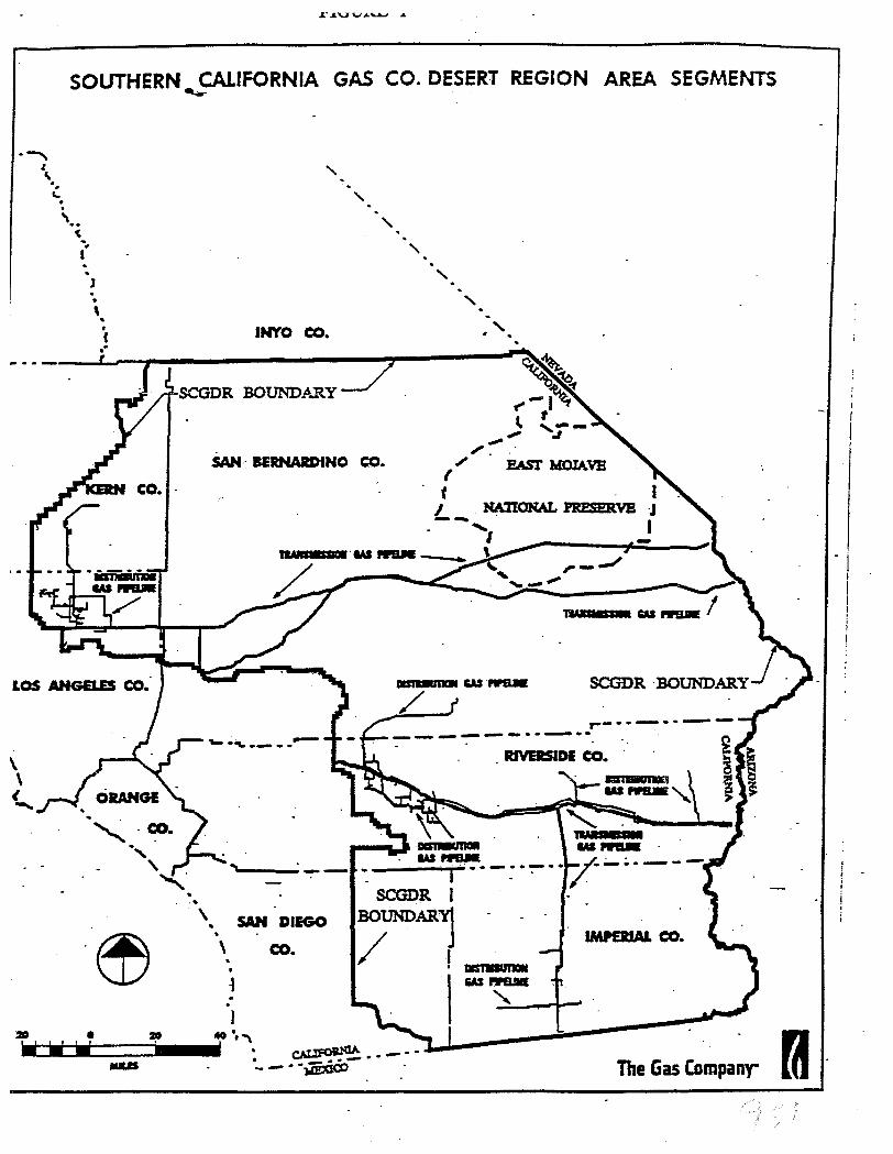
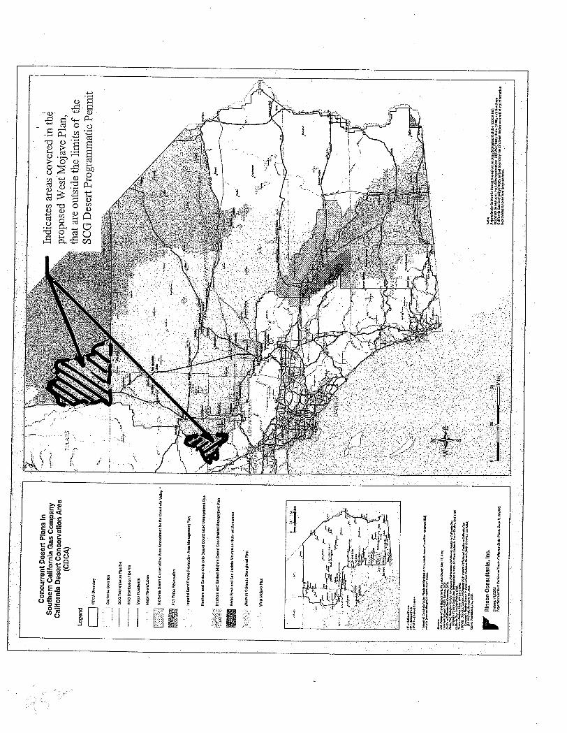
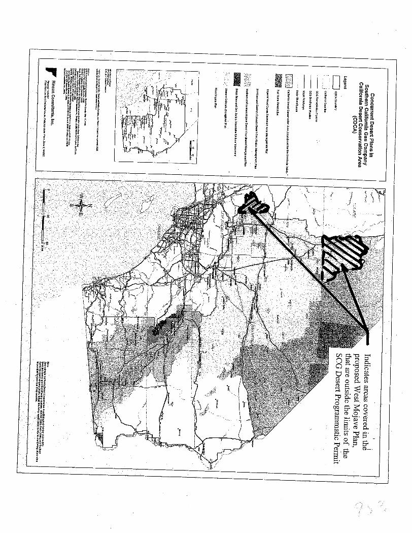
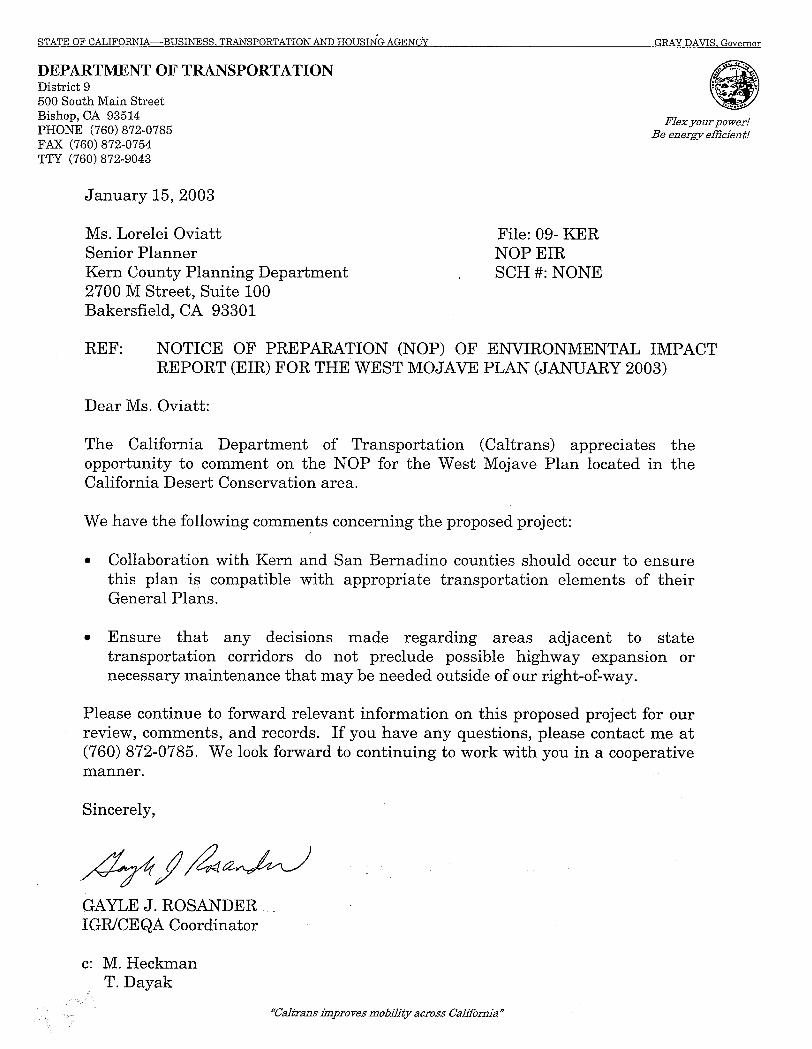
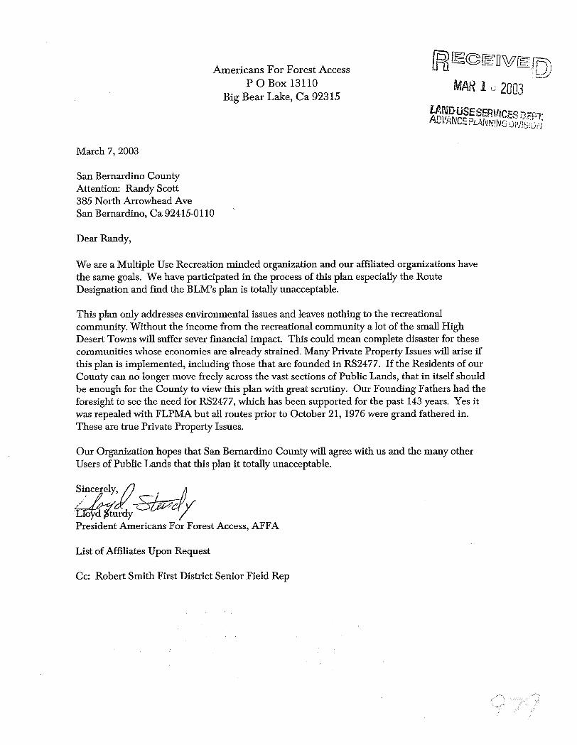
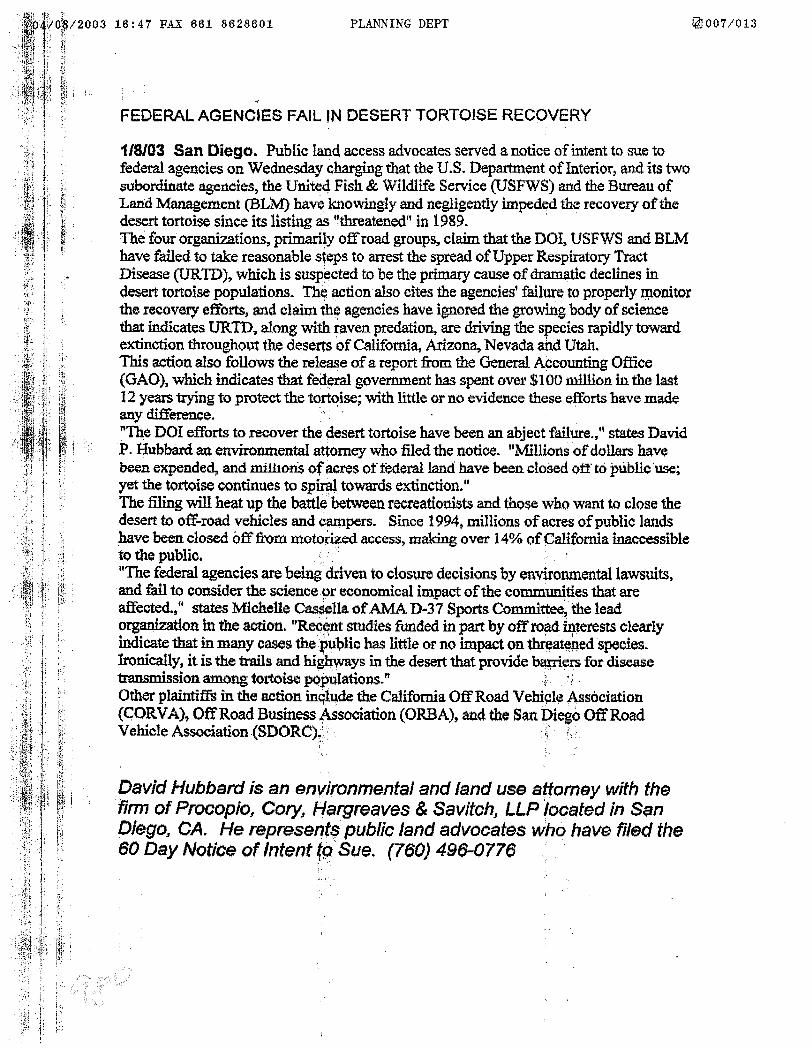
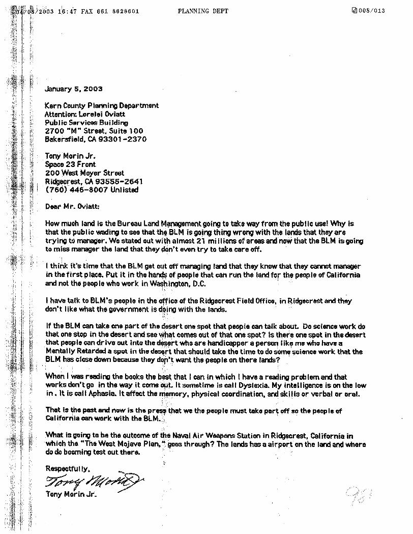
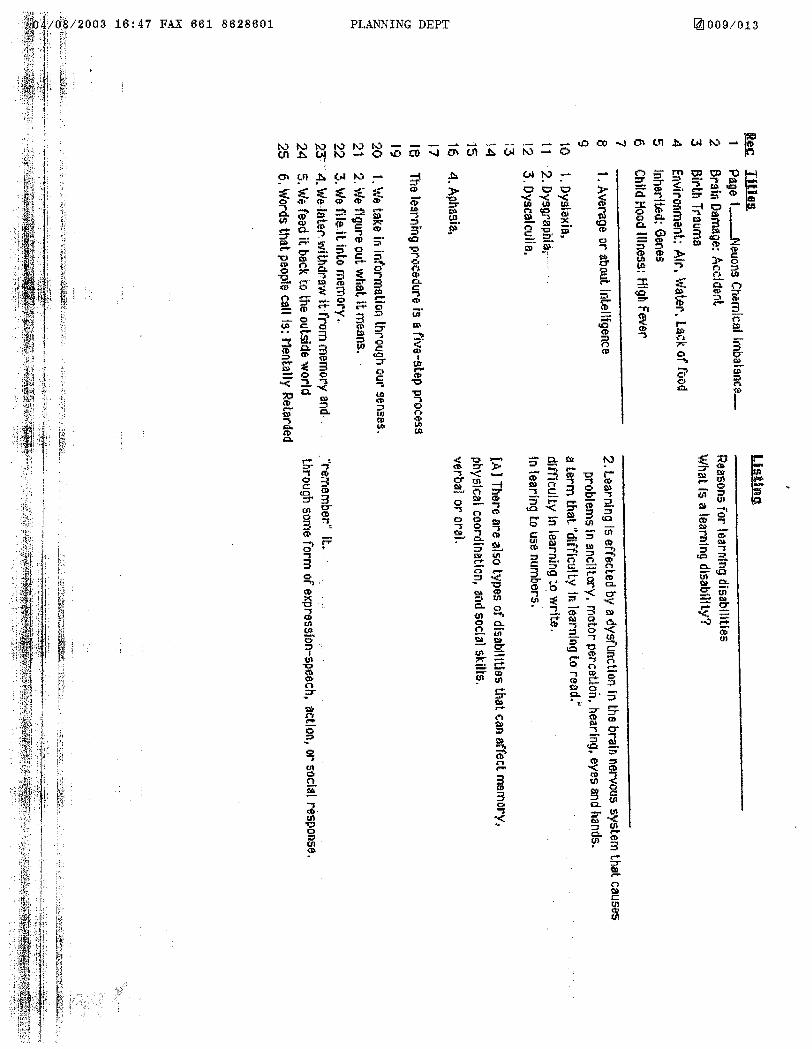


Appendices
APPENDIX W
CALTRANS MAINTENANCE ACTIVITIES

Appendices

Appendices
APPENDIX W
CALTRANS MAINTENANCE ACITIVITIES W.1 PUBLICLY MAINTAINED ROADS
Some of the existing county maintained unpaved roads may be paved within the existing
roadbed as future traffic, safety and/or environmental conditions warrant. In addition, safety improvements to other publicly maintained existing roadways within Public/Quasi-Public Lands are covered activities. Guidelines are provided below that would minimize and avoid impacts to sensitive species and habitats occurring adjacent to the existing roadway.
Necessary operation and maintenance activities conducted for safety purposes would be permitted within Public/Quasi-Public Lands. These activities include, but are not limited to, the following:
• Signage - The installation and maintenance of signs to control traffic for the purposes of regulation, warning or guidance.
• Traffic Control Devices - The installation and maintenance of official traffic control
devices, including, but not limited to, signing, street lights, striping, pavement markings, flashing beacons, and traffic signals in order to control, regulate, and provide guidance to traffic movements and to clearly identify potentially hazardous conditions.
• Guardrails and Fences - The installation, replacement and maintenance of guardrails
and fences solely for vehicle and pedestrian safety.
• Pavement Repairs - Pothole repair, chip seal, skin patching, slurry sealing, and resurfacing of roadways performed for the purpose of reducing roadway hazards and maintaining the useful life of the road.
• Accident Response - The removal and clearance of debris and spills related to traffic
accidents, including the repair and/or restoration of any damaged roadway facilities.
• Tree Trimming - Routine tree and shrub trimming within the road rights-of-way to improve sight distance and eliminate potential traffic hazards.
• Natural Disaster Damage/Restoration of Emergency Access - Clearance of debris, and
other natural material from roadways that results from natural disasters such as flooding, earthquake, and fire. Such actions necessary for public safety, especially in providing vehicular movement during emergency operations.
Appendices
• Storm Damage - Clearance of mud and debris accumulated on the roadway due to a storm event. Road crews will complete these projects as soon as possible following the end of a storm event, and may use the excess mud, dirt, and rock on the roadway as fill material.
• Weed Control - Control of vegetation within road rights-of-way (including graded
shoulder areas and open or closed channels) by means of mowing, discing, hand labor, or herbicide application in order to control weed populations and eliminate sight distance problems, roadway hazards, prevent fires, and provide proper drainage. This includes the control of weeds and grasses in revegetated mitigation areas and landscaped areas in order to allow plant establishment by the methods outlined above.
• Grading Shoulders - Shoulder grading up to 12 feet from the edge of paved or unpaved
roadways in order to reduce accident potential and improve safety. Additional fill material may be needed to restore the original grade at the edge of the pavement; such material may consist of dirt, gravel, decomposed granite, or rip rap.
• Grading Existing Dirt Roadways - Grading of existing County-maintained dirt
roadways in order to reduce accident potential and improve safety.
• Dust Stabilization - The placement of dust stabilizers on the soil including, but not limited to, magnesium chloride, permazion, penetration and gravel, in order to prevent erosion, provide dust control and improve site distance when traffic visibility is reduced due to dust clouds.
• Culverts/Drop Structures - Construction, replacement, and cleaning out of
culverts/drop structures in areas where flooding hazards may arise. This includes the clearing of brush, sand, sediment, debris, and other obstructions to flow.
• Curbs/Gutters/Sidewalks - Construction, replacement and repair of curbs, gutters and
sidewalks as necessary in order to reduce vehicular and pedestrian accident potential, improve safety and prevent storm damage.
• Roadway Widening - Minor widening of an existing roadway that does not add through
travel lanes, but may add turn lanes at intersections or paved shoulders as necessary for safety reasons.
• Berms - Construction of berms within the road right-of-way as part of a resurfacing
project to control drainage.
• Roadway Resurfacing - Grinding the pavement surface, paving, and grading of dirt shoulders, including chipseals, slurry seals, micro and macro paving.
Appendices
• Ditch Clearing -Clearing of ditches and stabilization of the banks of drainage courses along roadways.
• Landscape Maintenance - Maintenance and repair of irrigation systems, landscape
plantings, and associated facilities.
• Bridge Maintenance - Removal of vegetation, debris, sand, silt, sediment, and other obstructions to flow.
• Roadway Reconstruction - Removing existing paving to regrade, base and pave an
existing roadway.
• Roadside Maintenance - Litter and debris removal, sign lighting, mechanical sweeping of shoulders and/or centerline, and graffiti removal.
• Best Management Practices - To meet NPDES permit work, includes but limited to;
drainage Inspection, roadside stabilization, erosion control, illicit connections, illegal discharges, water quality structural treatments and ground water treatment facilities.
• Traffic Control Devices - (needs to include) pavement markers, roadside markers and
vehicle energy attenuators.
• Snow and Ice Control - Snow removal, drift prevention, ice control, installation and maintenance of snow fences, snow pole installation, repair and removal, maintenance and control of tire chain installation points.
W.2 Guidelines for Safety Improvements for Existing Roadways Within Public/Quasi-
Public Lands: Maintenance and operation activities conducted for safety purposes, as described above, are subject to following guidelines.
• Timing of construction activities shall consider seasonal requirements for breeding birds and migratory non-resident species. Habitat clearing shall be avoided during species active breeding season defined as March 1 to June 30.
• Silt fencing or other sediment trapping materials shall be installed to minimize the
transport of sediments off-site. Sediment and erosion control measures shall be implemented until such time soils are determined to be successfully stabilized.
• The footprint of disturbance shall be minimized to the maximum extent feasible. Access
to sites shall occur on pre-existing access routes.

Appendices
• Equipment storage, fueling and staging areas shall be sited within existing ROW or on non-sensitive upland habitat types with minimal risk of direct discharge into riparian areas or other sensitive habitat types.
• Exotic species removed during safety improvements shall be taken off-site to prevent
sprouting or regrowth.
• Construction, maintenance and operation activities may be restricted within and adjacent to wetlands, vernal pools, restoration areas and sensitive wildlife habitat (e.g., during the breeding season) at the discretion of the Reserve manager.
• Fencing or other barriers shall be used to restrict access to sensitive areas during
construction, operation and maintenance activities.
• Vegetation removed from the site shall not be stockpiled in any channel, streambed, lake or on the banks. Spoil sites shall not be located within-a channel, basin, stream, or lake where spoil or debris can be washed back into the channel or basin or a stream/lake, or where it will cover aquatic or riparian vegetation.
• The selection and application of (herbicides and rodenticides) shall comply with all
applicable local, State and Federal permitting or licensing requirements or regulations.
• All debris, bark, slash, sawdust, rubbish, silt, cement, concrete, or washings thereof, asphalt, paint, or other coating material, oil or other petroleum products, or any other substances resulting from project-related activities which could be hazardous to aquatic life or waters of the State, shall be prevented from contaminating the soil and/or entering the waters of the State. None of these materials shall be allowed to enter into or be placed within or where they may enter or be washed by rainfall or runoff into waters of the State. When operations are completed, any excess materials or debris shall be removed from the work area. No rubbish shall be deposited within 150 feet of the high water mark of any channel, basin, stream or lake.
Appendices
APPENDIX X
BIOLOGICAL TRANSITION AREAS DROPPED FROM FURTHER
CONSIDERATION

Appendices
Appendices
APPENDIX X
BIOLOGICAL TRANSITION AREAS DROPPED FROM FURTHER CONSIDERATION
X.1 Background
In the very earliest planning stages, the biological evaluation team (Bureau of Land Management 1999) identified three different tortoise management areas: Desert Wildlife Management Areas (DWMAs) for tortoise conservation, Incidental Take Areas (ITAs) for authorized development, and Managed Use Areas for remaining lands. Following the September 1999 publication of the Biological Evaluation during public meetings, the Managed Use Area concept was dropped in favor of Biological Transition Areas, or “BTAs.”
During these meetings, various BTA boundaries were discussed. Two original BTAs
were subsequently merged into respective DWMAs: north of Silver Lakes into the Fremont-Kramer DWMA and south of Highway 62 into the Pinto Mountain DWMA.
During the public review of the Draft EIR/S, both the BLM and the counties expressed
concern that the BTA concept was highly complex, would be very difficult to implement and offered little in the way of additional conservation for desert tortoises. As result of the concerns expressed, the West Mojave Team re-evaluated each BTA on an individual basis to determine the values that each area was anticipated to provide. Those areas with important conservation values were added to the adjacent tortoise DWMA, while those areas that were judged to have minimal contribution to the overall conservation design were deleted.
The 11 BTAs designated for the desert tortoise were depicted in Map 2-1 of the Draft
EIR/S (foldout map in Volume 1). Table X-1 presents an overview of these 11 areas, including the county in which the BTA is located, and the acres of public and private lands included within the BTA. There was no differentiation between State-owned lands and other private ownership. Percentages following BLM acreage are relative to the total size of the associated BTA. Public lands accounted for 34% of the total, while 66% of the BTAs were in private ownership. Most of the private land BTA acreage (i.e., 59,223 of 79,664 acres, or 74%) was found in San Bernardino County. BLM lands accounted for as little as 5% of the BTA in the Edwards Bowl area and as high as 72% in the area between Highway 395 and the Kern County line.
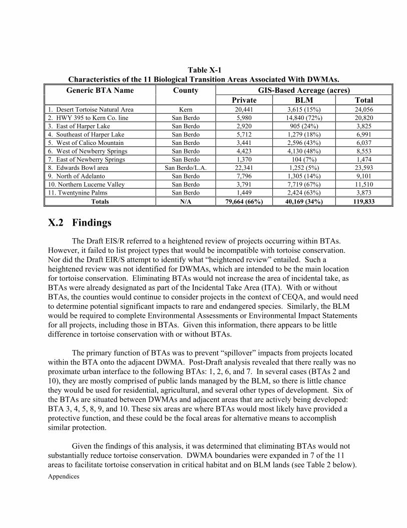
Appendices
Table X-1
Characteristics of the 11 Biological Transition Areas Associated With DWMAs. GIS-Based Acreage (acres) Generic BTA Name County
Private BLM Total 1. Desert Tortoise Natural Area Kern 20,441 3,615 (15%) 24,056 2. HWY 395 to Kern Co. line San Berdo 5,980 14,840 (72%) 20,820 3. East of Harper Lake San Berdo 2,920 905 (24%) 3,825 4. Southeast of Harper Lake San Berdo 5,712 1,279 (18%) 6,991 5. West of Calico Mountain San Berdo 3,441 2,596 (43%) 6,037 6. West of Newberry Springs San Berdo 4,423 4,130 (48%) 8,553 7. East of Newberry Springs San Berdo 1,370 104 (7%) 1,474 8. Edwards Bowl area San Berdo/L.A. 22,341 1,252 (5%) 23,593 9. North of Adelanto San Berdo 7,796 1,305 (14%) 9,101 10. Northern Lucerne Valley San Berdo 3,791 7,719 (67%) 11,510 11. Twentynine Palms San Berdo 1,449 2,424 (63%) 3,873
Totals N/A 79,664 (66%) 40,169 (34%) 119,833
X.2 Findings
The Draft EIS/R referred to a heightened review of projects occurring within BTAs. However, it failed to list project types that would be incompatible with tortoise conservation. Nor did the Draft EIR/S attempt to identify what “heightened review” entailed. Such a heightened review was not identified for DWMAs, which are intended to be the main location for tortoise conservation. Eliminating BTAs would not increase the area of incidental take, as BTAs were already designated as part of the Incidental Take Area (ITA). With or without BTAs, the counties would continue to consider projects in the context of CEQA, and would need to determine potential significant impacts to rare and endangered species. Similarly, the BLM would be required to complete Environmental Assessments or Environmental Impact Statements for all projects, including those in BTAs. Given this information, there appears to be little difference in tortoise conservation with or without BTAs.
The primary function of BTAs was to prevent “spillover” impacts from projects located
within the BTA onto the adjacent DWMA. Post-Draft analysis revealed that there really was no proximate urban interface to the following BTAs: 1, 2, 6, and 7. In several cases (BTAs 2 and 10), they are mostly comprised of public lands managed by the BLM, so there is little chance they would be used for residential, agricultural, and several other types of development. Six of the BTAs are situated between DWMAs and adjacent areas that are actively being developed: BTA 3, 4, 5, 8, 9, and 10. These six areas are where BTAs would most likely have provided a protective function, and these could be the focal areas for alternative means to accomplish similar protection.
Given the findings of this analysis, it was determined that eliminating BTAs would not
substantially reduce tortoise conservation. DWMA boundaries were expanded in 7 of the 11 areas to facilitate tortoise conservation in critical habitat and on BLM lands (see Table 2 below).
Appendices
Additional protective measures were identified for potential application in 6 of the 11 areas (see Table X-2 and point 13 at the end of this appendix).
Many of the considerations given above also apply to Mohave ground squirrel
conservation. Some of the impacts associated with urbanizing areas are expected to affect tortoises but there is no evidence they would affect Mohave ground squirrels. For example, tortoises in adjacent areas are often affected by the following threats, for which there is no available information showing a similar threat to Mohave ground squirrels. Increased dumping, feral dogs, common ravens, pet collection, vandalism, poaching, etc. are examples of threats to tortoises that are not known to affect Mohave ground squirrels. Given this and the above information, it was determined that elimination of BTAs associated with the Mohave Ground Squirrel Conservation Area would not significantly detract from conservation for that species. BTAs adjacent to the MGS CA were eliminated without modifying the conservation area.
X.3 Recommendations for BTAs Adjacent to DWMAs
Given biological and political constraints, the Final EIR/S reflects two basic changes to
the conservation strategy in response to eliminating tortoise BTAs adjacent to DWMAs. The modifications are intended to replace the function of BTAs by protecting DWMAs from adjacent impacts. The two changes included (1) modifying DWMA boundaries where appropriate and (2) identifying other protective measures for specified DWMAs to minimize impacts from adjacent Incidental Take Areas. Table X-2 summarizes the changes that were made. The rationales for the changes are described following the table.
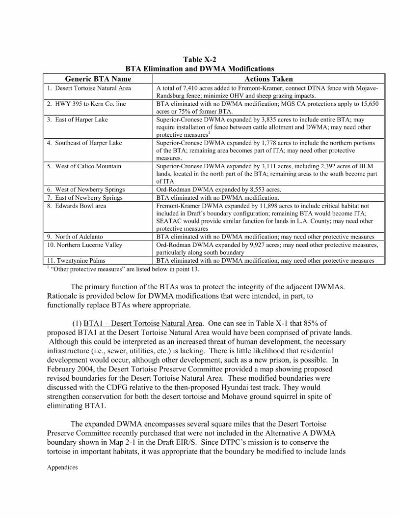
Appendices
Table X-2 BTA Elimination and DWMA Modifications
Generic BTA Name Actions Taken 1. Desert Tortoise Natural Area A total of 7,410 acres added to Fremont-Kramer; connect DTNA fence with Mojave-
Randsburg fence; minimize OHV and sheep grazing impacts. 2. HWY 395 to Kern Co. line BTA eliminated with no DWMA modification; MGS CA protections apply to 15,650
acres or 75% of former BTA. 3. East of Harper Lake Superior-Cronese DWMA expanded by 3,835 acres to include entire BTA; may
require installation of fence between cattle allotment and DWMA; may need other protective measures1
4. Southeast of Harper Lake Superior-Cronese DWMA expanded by 1,778 acres to include the northern portions of the BTA; remaining area becomes part of ITA; may need other protective measures.
5. West of Calico Mountain Superior-Cronese DWMA expanded by 3,111 acres, including 2,392 acres of BLM lands, located in the north part of the BTA; remaining areas to the south become part of ITA
6. West of Newberry Springs Ord-Rodman DWMA expanded by 8,553 acres. 7. East of Newberry Springs BTA eliminated with no DWMA modification. 8. Edwards Bowl area Fremont-Kramer DWMA expanded by 11,898 acres to include critical habitat not
included in Draft’s boundary configuration; remaining BTA would become ITA; SEATAC would provide similar function for lands in L.A. County; may need other protective measures
9. North of Adelanto BTA eliminated with no DWMA modification; may need other protective measures 10. Northern Lucerne Valley Ord-Rodman DWMA expanded by 9,927 acres; may need other protective measures,
particularly along south boundary 11. Twentynine Palms BTA eliminated with no DWMA modification; may need other protective measures 1 “Other protective measures” are listed below in point 13.
The primary function of the BTAs was to protect the integrity of the adjacent DWMAs. Rationale is provided below for DWMA modifications that were intended, in part, to functionally replace BTAs where appropriate.
(1) BTA1 – Desert Tortoise Natural Area. One can see in Table X-1 that 85% of
proposed BTA1 at the Desert Tortoise Natural Area would have been comprised of private lands. Although this could be interpreted as an increased threat of human development, the necessary infrastructure (i.e., sewer, utilities, etc.) is lacking. There is little likelihood that residential development would occur, although other development, such as a new prison, is possible. In February 2004, the Desert Tortoise Preserve Committee provided a map showing proposed revised boundaries for the Desert Tortoise Natural Area. These modified boundaries were discussed with the CDFG relative to the then-proposed Hyundai test track. They would strengthen conservation for both the desert tortoise and Mohave ground squirrel in spite of eliminating BTA1.
The expanded DWMA encompasses several square miles that the Desert Tortoise
Preserve Committee recently purchased that were not included in the Alternative A DWMA boundary shown in Map 2-1 in the Draft EIR/S. Since DTPC’s mission is to conserve the tortoise in important habitats, it was appropriate that the boundary be modified to include lands
Appendices
they already own, and others that are identified for eventual acquisition and conservation. The northwestern part of the Fremont-Kramer DWMA is located north of Highway 58 and west of Highway 395. It is bounded to the south by hundreds of square miles of private land in California City and Kern County. Relatively mountainous areas with some good remaining populations (i.e., Little Dixie Wash, Indian Wells Valley, etc.) are still found to the north. This is a very important area in terms of managing OHV use and sheep grazing, much of which occurs in an unregulated manner on private lands. The new configuration helps “thicken” the conservation area at its most narrow point, between Koehn Lake and the east-central boundary of the Desert Tortoise Natural Area. The realignment along the Mojave-Randsburg Road makes for a more defensible boundary than the one proposed in the Draft EIR/S. Perimeter fences already exist around the Desert Tortoise Natural Area and along the Mojave-Randsburg Road that would facilitate DWMA management of this important area. The perimeter fence around the natural area already functions, in part, as a BTA by minimizing OHV and sheep grazing impacts, which are prevalent in adjacent areas. For these reasons, modifying the DWMA boundaries as shown in Map 2-1 is considered to provide relatively more conservation value than would have been provided by designating the BTA.
(2) BTA2 – Highway 395 West to Kern County Line. About 72% of this area is managed
by the BLM, so there is somewhat less a threat of residential development. When conditions permit, woolgrowers use this area extensively. Its inclusion in the Fremont-Kramer DWMA would necessarily mean eliminating sheep grazing from this 21,820-acre (+/- 31-mi2) area. The area was identified as being available for sheep grazing when grazing was effectively eliminated from the east side of Highway 395 in the early 1990’s. It would require a fence along the county line to restrict sheep grazing from this area if it were managed as a DWMA. The current proposal is to fence Highway 395 to minimize vehicle impacts to tortoises. This would effectively create a fragmented block of habitat on the west side of Highway 395. The northern 15,650 acres (i.e., 75% of former BTA2) would be designated as part of the Mohave Ground Squirrel Conservation Area under the Proposed Action. Management prescriptions in the MGSCA would protect these habitats in the absence of the BTA designation. The BTA was dropped without modifying the adjacent DWMA.
(3) BTA3 – Harper Lake. West Mojave Plan records indicate that there are few
structures in the eastern part of the BTA, proximate to Hinkley. The 940 acres of BLM land occur on the western portions of the BTA. In its comment letter, CDFG recommended that the DWMA be expanded in this area to ensure good connectivity among conservation lands to the east and west. The Harper Lake cattle allotment is immediately west of this area. There is no allotment fence along the western boundary to preclude cattle from entering the expanded DWMA. Tortoise surveys would be performed for future development, including single-family residences, and heightened Best Management Practices would apply. Impacts would be included in the BLM’s and county’s 1% Allowable Ground Disturbance. Thickening the narrow band of conserved habitat in this area is considered important to tortoise conservation. The Superior-Cronese DWMA boundary has been changed to include all of BTA3.
(4) BTA4 – Southeast of Harper Lake. For the reasons given above in BTA3, the change
Appendices
was made to include the northern three miles of BTA4 within the Superior-Cronese DWMA to thicken the conservation land bridge southeast of Harper Lake. This habitat connector may be important to conservation of the MGS, particularly if the dry lake is an impediment to dispersal along a north-south axis. Inclusion of these two former BTAs into the Superior-Cronese DWMA would expand the DWMA, and the MGS CA, by 5,613 acres.
(5) BTA5 – West of Calico Mountain. There is no imminent urban threat from the west
that would justify the configuration of BTA5. BLM currently manages approximately 2,400 acres in the northern portion of this BTA, with the remaining southern portion in private ownership. The change was made to expand the Superior-Cronese DWMA into the northern portion of the BTA, which includes 2,392 acres of BLM land and 719 acres of private land. Remaining areas to the south would be managed as an ITA and remain within the designated tortoise Survey Area.
(6) BTA6 – West of Newberry Springs. The 8,553 acres comprising BTA6, half of which
is composed of public lands, is not directly threatened by a proximate urban interface. Tortoises are more likely to be affected by mining than other forms of development. The modification is intended, in part, to enlarge the DWMA, which at 388 square miles is still about 600 square miles smaller than what the recovery plan recommended. The importance of the Ord-Rodman DWMA cannot be over-emphasized, particularly if disease is responsible for decimating populations in the Fremont-Kramer and/or Superior-Cronese DWMAs. The change was made to include the 8,553 acres in the northern portion of the Ord-Rodman DWMA.
(7) BTA7 – East of Newberry Springs. Only 104 acres of this relatively small area are
managed by the BLM. Most of the local residential development and all of the agricultural development occur north of Interstate 40. Since BTA8 is directly adjacent to I-40, it has already been somewhat degraded and is within an area of likely human development. It is recommended that this 1,474-acre area would not be included within the Ord-Rodman DWMA; rather, it would be retained within the ITA.
(8) BTA8 – Edwards Bowl Area. As given in Table 1, this was the second largest
proposed BTA (23,593 acres compared to 24,056 acres in BTA1). There are approximately 12,000 acres of critical habitat in the area that were not included in the southern part of the Fremont-Kramer DWMA. Several public comments, particularly from tortoise interest groups, questioned the decision to exclude any critical habitat from proposed DWMAs. The jurisdictional protection that would have been provided by BTA management would be replaced by including all tortoise critical habitat in the area within the Fremont-Kramer DWMA. This entailed expanding the southern part of the Fremont-Kramer DWMA by 11,898 square miles. Although the BTA to the west of critical habitat would be abandoned, some of this area is included within the MGS CA, which would call for somewhat more restrictive management than under BTA management. Most of the BTA located within Los Angeles County would remain within a Significant Ecological Area (SEA), which would already require heightened review of environmental impacts by the Significant Ecological Area Technical Advisory Committee (SEATAC).
(9) BTA9 – North of Adelanto. This 9,100-acre area is comprised of about 86% private
Appendices
lands, with the remaining BLM lands occurring in an unconsolidated pattern. Given the near-absence of public lands, this former BTA was not included within the DWMA. As given below in point 13, it would be appropriate to implement some or all of the protective measures described to functionally replace the BTA.
(10) BTA10 – North Lucerne Valley. Given the prevalence of BLM land and the
apparent development threats from the south, all of BTA10 located west of Camp Rock Road has been included in the Ord-Rodman DWMA. Areas east of Camp Rock Road are within the Johnson Valley Open Area and would not be included within the DWMA. The southern boundary corresponds with an east-west road that provides an easily recognizable, defensible boundary. This change entailed adding 9,927 acres to the southern portion of the Ord-Rodman DWMA. Given the additions of BTA6 to the north and BTA10 to the south, the Ord-Rodman has been increased by approximately 29 square miles, for a total of about 417 square miles.
(11) BTA11 – Twentynine Palms. There were 2,424 acres of BLM land (63%) within this
3,873-acre BTA. In very early planning, these six square miles were first included in the proposed Pinto Mountain DWMA. Then it was found that this area is within the corporate boundary of the City of Twentynine Palms. The Biological Evaluation (Bureau of land Management 1999) stated that most areas within city limits would be designated as Incidental Take Areas. Given intended human growth within such areas, DWMAs were designed, in part, to avoid cities. As such, BTA11 was dropped with no expansion of the Pinto Mountain DWMA.
Other Protective Measures. Former BTAs 3, 4, 8, 9, 10, and 11 were the most likely to
function as intended because of the proximate human development in adjacent Incidental Take Areas. In the absence of BTAs, the following measures are intended to help alleviate indirect impacts of adjacent human development on tortoises and habitat in proximate DWMAs. These measures include (a) Increase signing and/or fencing along boundary so adjacent residents are aware of the conservation area. (b) On BLM lands within the DWMAs, increase law enforcement or other BLM presence in the area to minimize illegal activities such as dumping, shooting, and cross-country vehicle use on public lands outside designated open areas. (c) Specifically consider and discuss DWMAs associated with these six areas when formulating the Feral Dog Management Plan. (d) Depending on monitoring results, there may need to be subsequent conservation (adaptive) management along the DWMA boundary to minimize impacts from authorized development in adjacent Incidental Take Areas.

Appendices
Appendices
APPENDIX Y
SPECIES ADDRESSED BY THE PLAN

Appendices

Appendices
APPENDIX Y
SPECIES ADDRESSED BY THE PLAN
Proposed Covered Species – 49 Reptiles - 4 Desert tortoise (Gopherus agassizii) Threatened Mojave fringe-toed lizard (Uma notata) San Diego horned lizard (Phrynosoma coronatum blainvillei) Southwestern pond turtle (Clemmys marmorata pallida) Birds – 16 Raptors Burrowing owl (Athene cunicularia) Ferruginous hawk (Buteo regalis) Long-eared owl (Asio otus) Prairie falcon (Falco mexicanus) Riparian guild Brown-crested flycatcher (Myiarchus tyrannulus) Least Bell’s vireo (Vireo bellii pusillus) Endangered Southwestern willow flycatcher (Empidonax traillii extimus) Endangered Summer tanager (Piranga rubra) Vermilion flycatcher (Pyrocephalus rubinus) Yellow-breasted chat (Icteria virens) Yellow warbler (Dendroica petechia brewsteri) Western yellow-billed cuckoo (Coccyzus americanus) Federal Candidate, State Endangered Other birds Gray vireo (Vireo vicinior) Inyo California towhee (Pipilo crissalis eremophilus) Threatened, Endemic LeConte’s thrasher (Toxostoma lecontei) Western snowy plover (Charadrius alexandrinus) Mammals - 5 California leaf-nosed bat (Macrotus californicus) Mohave ground squirrel (Spermophilus mohavensis) State threatened, Endemic *Mojave River vole (Microtus californicus mohavensis) Endemic Townsend’s big-eared bat (Corynorhinus townsendii) Yellow-eared pocket mouse (Perognathus xanthonotus) Endemic
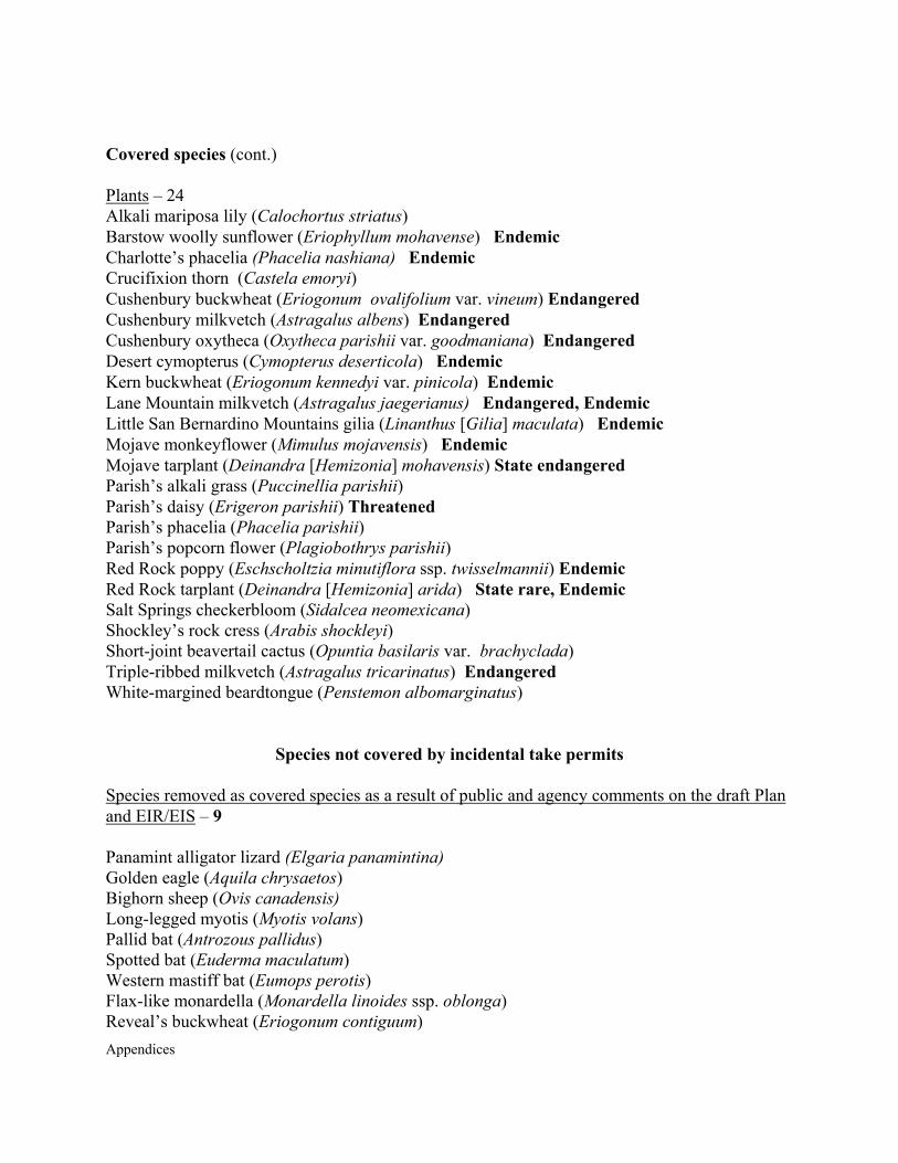
Appendices
Covered species (cont.) Plants – 24 Alkali mariposa lily (Calochortus striatus) Barstow woolly sunflower (Eriophyllum mohavense) Endemic Charlotte’s phacelia (Phacelia nashiana) Endemic Crucifixion thorn (Castela emoryi) Cushenbury buckwheat (Eriogonum ovalifolium var. vineum) Endangered Cushenbury milkvetch (Astragalus albens) Endangered Cushenbury oxytheca (Oxytheca parishii var. goodmaniana) Endangered Desert cymopterus (Cymopterus deserticola) Endemic Kern buckwheat (Eriogonum kennedyi var. pinicola) Endemic Lane Mountain milkvetch (Astragalus jaegerianus) Endangered, Endemic Little San Bernardino Mountains gilia (Linanthus [Gilia] maculata) Endemic Mojave monkeyflower (Mimulus mojavensis) Endemic Mojave tarplant (Deinandra [Hemizonia] mohavensis) State endangered Parish’s alkali grass (Puccinellia parishii) Parish’s daisy (Erigeron parishii) Threatened Parish’s phacelia (Phacelia parishii) Parish’s popcorn flower (Plagiobothrys parishii) Red Rock poppy (Eschscholtzia minutiflora ssp. twisselmannii) Endemic Red Rock tarplant (Deinandra [Hemizonia] arida) State rare, Endemic Salt Springs checkerbloom (Sidalcea neomexicana) Shockley’s rock cress (Arabis shockleyi) Short-joint beavertail cactus (Opuntia basilaris var. brachyclada) Triple-ribbed milkvetch (Astragalus tricarinatus) Endangered White-margined beardtongue (Penstemon albomarginatus)
Species not covered by incidental take permits
Species removed as covered species as a result of public and agency comments on the draft Plan and EIR/EIS – 9 Panamint alligator lizard (Elgaria panamintina) Golden eagle (Aquila chrysaetos) Bighorn sheep (Ovis canadensis) Long-legged myotis (Myotis volans) Pallid bat (Antrozous pallidus) Spotted bat (Euderma maculatum) Western mastiff bat (Eumops perotis) Flax-like monardella (Monardella linoides ssp. oblonga) Reveal’s buckwheat (Eriogonum contiguum)
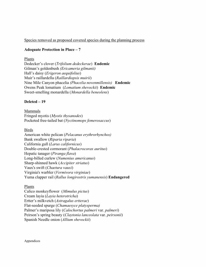
Appendices
Species removed as proposed covered species during the planning process Adequate Protection in Place – 7 Plants Dedecker’s clover (Trifolium dedeckerae) Endemic Gilman’s goldenbush (Ericameria gilmanii) Hall’s daisy (Erigeron aequifolius) Muir’s raillardella (Raillardiopsis muirii) Nine Mile Canyon phacelia (Phacelia novenmillensis) Endemic Owens Peak lomatium (Lomatium shevockii) Endemic Sweet-smelling monardella (Monardella beneolens) Deleted – 19 Mammals Fringed myotis (Myotis thysanodes) Pocketed free-tailed bat (Nyctinomops femerosaccus) Birds American white pelican (Pelacanus erythrorhynchos) Bank swallow (Riparia riparia) California gull (Larus californicus) Double-crested cormorant (Phalacrocorax auritus) Hepatic tanager (Piranga flava) Long-billed curlew (Numenius americanus) Sharp-shinned hawk (Accipiter striatus) Vaux's swift (Chaetura vauxi) Virginia's warbler (Vermivora virginiae) Yuma clapper rail (Rallus longirostris yumanensis) Endangered Plants Calico monkeyflower (Mimulus pictus) Cream layia (Layia heterotricha) Ertter’s milkvetch (Astragalus ertterae) Flat-seeded spurge (Chamaesyce platysperma) Palmer’s mariposa lily (Calochortus palmeri var. palmeri) Peirson’s spring beauty (Claytonia lanceolata var. peirsonii) Spanish Needle onion (Allium shevockii)

Appendices
Dropped - 39 Insufficient information - 21 Amphibians Tehachapi slender salamander (Batrachoseps stebbinsi) State Threatened Mammals Argus Mountains kangaroo rat (Dipodomys panamintinus argusensus) Endemic Tehachapi pocket mouse (Perognathus alticola inexpectatus) Birds Bendire’s thrasher (Toxostoma bendirei) Lucy’s warbler (Vermivora luciae) Tricolored blackbird (Agelaius tricolor) Plants Coulter’s goldfields (Lasthenia glabrata ssp. coulteri) Death Valley roundleaf phacelia (Phacelia mustelina) Golden violet (Viola aurea) Inyo hulsea (Hulsea vestita ssp. inyoensis) Jackass clover (Wizlizenia refracta ssp. refracta) Lancaster milkvetch (Astragalus preussii var. laxiflorus) Mojave milkvetch (Astragalus mojavensis var. hemigyrus) Piute Mountains jewelflower (Streptanthus cordatus var. piutensis) Ripley's cymopterus (Cymopterus ripleyi) Ripley’s gilia (Gilia ripleyi) Robinson’s peppergrass (Lepidium virginicum var. robinsonii) Robison’s monardella (Monardella robisonii) Endemic Sagebrush loeflingea (Loeflingea squarrosa var. artemisiarum) Small-flowered androstephium (Androstephium breviforum) Southern scullcap (Scutellaria bolanderi ssp. austromontana) Too common - 8 Birds Cooper’s hawk (Accipiter cooperii) Loggerhead shrike (Lanius ludovicianus) Plants Foxtail cactus (Coryphantha alversonii [Escobaria vivipara var. alversonii]) Sand linanthus (Linanthus arenicola) Kern County evening primrose (Camissonia kernensis ssp. kernensis)
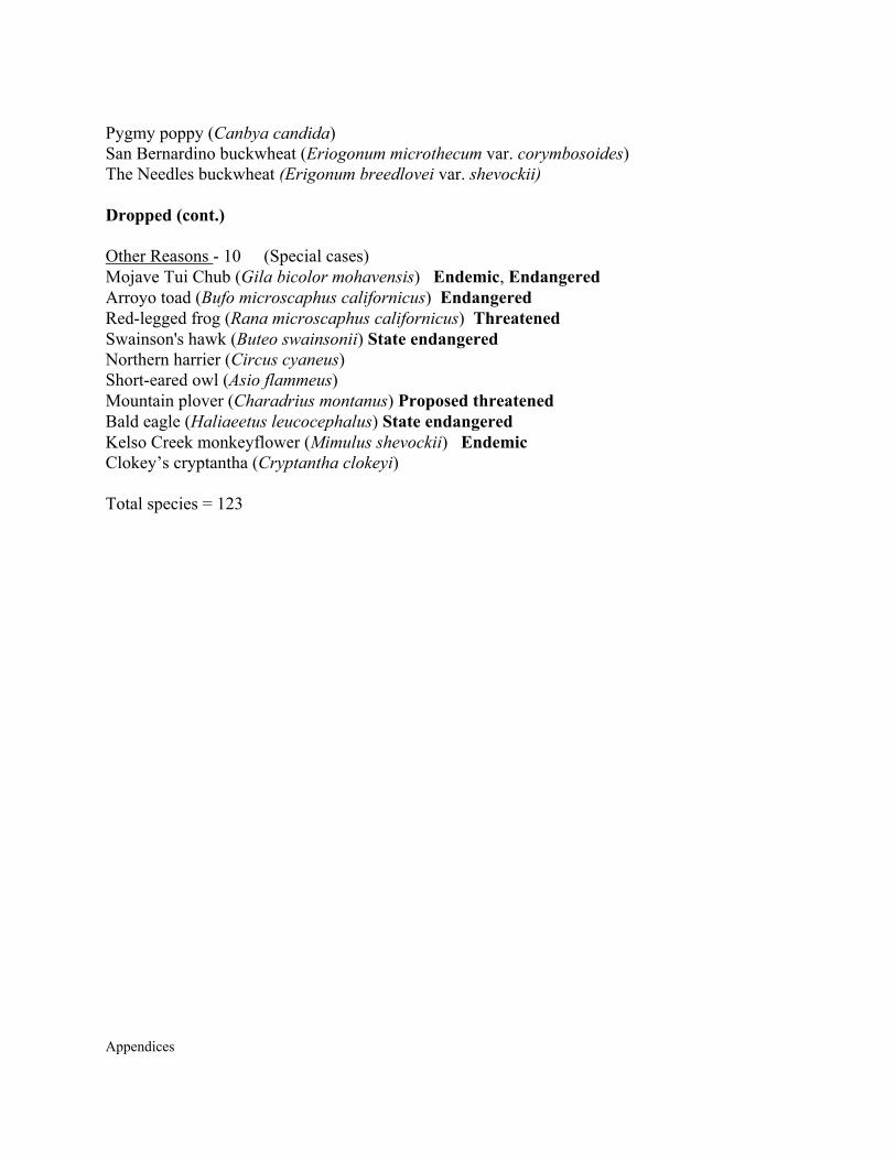
Appendices
Pygmy poppy (Canbya candida) San Bernardino buckwheat (Eriogonum microthecum var. corymbosoides) The Needles buckwheat (Erigonum breedlovei var. shevockii) Dropped (cont.) Other Reasons - 10 (Special cases) Mojave Tui Chub (Gila bicolor mohavensis) Endemic, Endangered Arroyo toad (Bufo microscaphus californicus) Endangered Red-legged frog (Rana microscaphus californicus) Threatened Swainson's hawk (Buteo swainsonii) State endangered Northern harrier (Circus cyaneus) Short-eared owl (Asio flammeus) Mountain plover (Charadrius montanus) Proposed threatened Bald eagle (Haliaeetus leucocephalus) State endangered Kelso Creek monkeyflower (Mimulus shevockii) Endemic Clokey’s cryptantha (Cryptantha clokeyi) Total species = 123
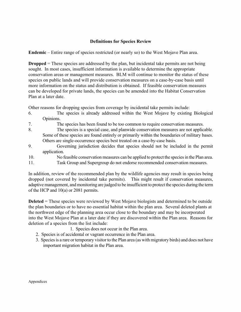
Appendices
Definitions for Species Review
Endemic – Entire range of species restricted (or nearly so) to the West Mojave Plan area. Dropped = These species are addressed by the plan, but incidental take permits are not being sought. In most cases, insufficient information is available to determine the appropriate conservation areas or management measures. BLM will continue to monitor the status of these species on public lands and will provide conservation measures on a case-by-case basis until more information on the status and distribution is obtained. If feasible conservation measures can be developed for private lands, the species can be amended into the Habitat Conservation Plan at a later date. Other reasons for dropping species from coverage by incidental take permits include: 6. The species is already addressed within the West Mojave by existing Biological
Opinions. 7. The species has been found to be too common to require conservation measures. 8. The species is a special case, and planwide conservation measures are not applicable.
Some of these species are found entirely or primarily within the boundaries of military bases. Others are single-occurrence species best treated on a case-by-case basis.
9. Governing jurisdiction decides that species should not be included in the permit application.
10. No feasible conservation measures can be applied to protect the species in the Plan area. 11. Task Group and Supergroup do not endorse recommended conservation measures. In addition, review of the recommended plan by the wildlife agencies may result in species being dropped (not covered by incidental take permits). This might result if conservation measures, adaptive management, and monitoring are judged to be insufficient to protect the species during the term of the HCP and 10(a) or 2081 permits. Deleted = These species were reviewed by West Mojave biologists and determined to be outside the plan boundaries or to have no essential habitat within the plan area. Several deleted plants at the northwest edge of the planning area occur close to the boundary and may be incorporated into the West Mojave Plan at a later date if they are discovered within the Plan area. Reasons for deletion of a species from the list include:
1. Species does not occur in the Plan area. 2. Species is of accidental or vagrant occurrence in the Plan area. 3. Species is a rare or temporary visitor to the Plan area (as with migratory birds) and does not have
important migration habitat in the Plan area.


UNITED STATESDEPARTMENT OF THE INTERIORBUREAU OF LAND MANAGEMENT
California Desert District22835 Calle San Juan De Los Lagos
Moreno Valley, CA 92553
OFFICAL BUSINESSPENALTY FOR PRIVATE USE $300
PRIORITY MAILPostage and Fees Paid
Bureau of Land ManagementPermit No. G-76
Subscribe to Newsbytes aFREE Weekly Email Newsletter.
www.ca.blm.gov