Embed Size (px)
Citation preview

J U N E 2 0 2 0
Final Report – Part A: Key findings
West Gippsland Catchment Management Authority
5/16 Gilbert Street, Torquay Victoria 3228
PO Box 620, Torquay Victoria 3228
rmcg.com.au — ABN 73 613 135 247 — RM Consulting Group Pty Ltd
Victoria — Tasmania — ACT — NSW
West Gippsland Regional Catchment Strategy Review and Preparation for Renewal

R E V I E W A N D P R E P A R A T I O N F O R R E N E W A L
Table of Contents
Acknowledgement i
Report summary ii
1 Introduction 1 1.1 KEY OBJECTIVES 1 1.2 REGIONAL CATCHMENT STRATEGY GUIDELINES 1 1.3 REPORT SCOPE 3
2 Background 4 2.1 THE REGION 4 2.2 VISION 5 2.3 SOCIO-ECONOMIC PROFILE 5 2.4 CATCHMENT DRIVERS AND EMERGING ISSUES 6 2.5 THEME BASED REVIEWS 18
3 Water 19 3.1 INTRODUCTION 19 3.2 ASSESSMENT OF CURRENT CONDITION 20 3.3 DESCRIPTION OF MAJOR THREATS AND TRENDS 23 3.4 FUTURE DRIVERS AND EMERGING ISSUES 24
4 Land 28 4.1 INTRODUCTION 28 4.2 ASSESSMENT OF CURRENT CONDITION 29 4.3 DESCRIPTION OF MAJOR THREATS AND TRENDS 30 4.4 FUTURE DRIVERS AND EMERGING ISSUES 32
5 Biodiversity 35 5.1 INTRODUCTION 35 5.2 ASSESSMENT OF CURRENT CONDITION 36 5.3 DESCRIPTION OF MAJOR THREATS AND TRENDS 37 5.4 FUTURE DRIVERS AND EMERGING ISSUES 38
6 Coasts and marine environment 41 6.1 INTRODUCTION 41 6.2 ASSESSMENT OF CURRENT CONDITION 42 6.3 DESCRIPTION OF MAJOR THREATS AND TRENDS 44 6.4 FUTURE DRIVERS AND EMERGING ISSUES 45

R E V I E W A N D P R E P A R A T I O N F O R R E N E W A L
7 Community 48 7.1 INTRODUCTION 48 7.2 ASSESSMENT OF CURRENT CONDITION 49 7.3 DESCRIPTION OF MAJOR THREATS AND TRENDS 51 7.4 FUTURE DRIVERS AND EMERGING ISSUES 51
References 54
Appendix 1: Key themes and drivers 56

R E V I E W A N D P R E P A R A T I O N F O R R E N E W A L i
Acknowledgement The authors of this report acknowledge the Traditional Owners of Country throughout Australia and recognise their continuing connection to land, waters and community. We pay our respects to elders both past and present.
We particularly acknowledge and pay our respects to the Traditional Land Owners and other indigenous people within the West Gippsland catchment area: the Gunaikurnai, the Bunurong and Boon Wurrung, and the Wurundjeri people. We also recognise the contribution of Aboriginal and Torres Strait Islander people and organisations in land and natural resource management.
The authors of this report would also like to thank the RCS Steering Committee and the following organisations and staff who contributed to this report through their participation in the four stakeholder workshops and/ or review of the workshop discussion paper and draft report:
§ Agriculture Victoria, Neville Fernando § Bass Coast Shire, Phillip Pritchard § Baw Baw Shire, David Hair § Department of Environment Land Water and Planning (DELWP), Ryan Incoll § Environment Protection Authority, Stacey Clark § Gippsland Water, Debbie Archer § Gunaikurnai Land and Waters Aboriginal Corporation (GLaWAC), Daniel Miller and Lisa Hocking § Bunurong Land Council Aboriginal Corporation (BLCAC), Rohan Henry § Landcare - West Gippsland, Kathleen Brack and Sam Shannon § Latrobe City, Daniel Kelabora, Kevan Delaney and Les Hilton § Parks Victoria, Kerri Villier, Dan Brown § South Gippsland Shire, Vera Fordyce § South Gippsland Water, Kerry Matthews § Southern Rural Water, Ryan Wilson § Trust for Nature, John Hick § Wellington Shire, Andrew Wolstenholme § West Gippsland CMA, Adam Dunn, Belinda Brennan, Dan Garlick, Eleisha Keogh, Shelley McGuinness
and Martin Fuller.

R E V I E W A N D P R E P A R A T I O N F O R R E N E W A L i i
Report summary This report has been prepared for the West Gippsland Catchment Management Authority (CMA) for stage 1 of the renewal and update of the West Gippsland Regional Catchment Strategy (RCS).
It provides a broad review of the existing RCS, particularly the condition of land, water, biodiversity, coasts and marine, and community, as well as key current and emerging regional drivers and trends impacting the region, based around:
§ Climate change § Population and demographic trends § Land use change § Industry outlook § Operating environment.
What we have found through this review is that West Gippsland is a complex region, with a diverse array of high value environments and landscapes, from rare alpine peatland ecosystems to complex coastal wetland and estuarine systems that are internationally recognised for their waterbird habitat values. These natural landscapes hold special significance for the region’s Traditional Owners, the Gunaikurnai, the Bunurong and Boon Wurrung, and the Wurundjeri people, and their aspirations will play an increasing role in how these landscapes are managed into the future.
Whilst set amongst a backdrop of continued long-term ecological decline, not unique to the region, many areas of the catchment are still in good condition. Despite a range of current and emerging threats, large areas are demonstrating ecosystem resilience. This has been helped in part through the range of coordinated regional NRM programs aimed at protection and restoration, supported through the last RCS. Notable examples include:
§ the stabilisation in the extent of sea grass communities at Corner Inlet § the reduction in Spartina from coastal salt marsh communities § the extensive removal of willows from upstream catchments § the recovery and delivery of water for the environment § removal of major barriers to fish movement (such as the Thomson Fishway) § the protection of the Alpine peatlands ecological community, particularly on the Baw Baw plateau § protecting remnants of the critically endangered Red Gum Grassy Woodlands ecological community on
the Gippsland Plain.
We have also found the region is currently going through major change from a range of influences. This change is creating uncertainty for regional communities and presents significant challenges for future planning. The major influences include:
§ population growth and changing demographics, particularly in coastal areas and from Melbourne’s continued urban growth
§ the continuing effects of climate change, particularly on sea level rise, water availability and the frequency and severity of major climatic events (droughts, fire and flood)
§ large scale industry transitions centred around mine closures in the Latrobe Valley and a move to renewable energy sources, land use change with smaller land holdings and growth in more intensive agriculture and a shift from harvesting native forests to plantations.

R E V I E W A N D P R E P A R A T I O N F O R R E N E W A L i i i
Population growth
The population in the West Gippsland catchment is expected to increase by 20% by 2036. Whilst this rate may be smaller than other regional areas neighbouring Melbourne, such as Ballarat and Geelong, this growth will continue to put pressure on the region’s natural assets. This is particularly the case in the western edge of the region, which is influenced by Melbourne’s peri-urban fringe (with Warragul predicted to grow by 66% by 2036) and in coastal areas (with Wonthaggi predicted to grow by 43% during the same period).
A growing population will also put more pressure on the use of the catchment’s waterways, coastlines, national parks and other public open spaces. Increasing low-density greenfield development will also put additional stress on the region’s riverine corridors and coastal environments. Protection and conservation of the region’s natural landscapes is therefore paramount in order to prepare the catchment for this added pressure.
Climate change
The changing climate presents some significant challenges for the long-term management of the region. Declining rainfall, higher temperatures and longer (and more frequent) droughts are predicted, as well as more frequent and severe storm events and bushfires. There has been significant progress to secure water for the environment over recent decades with the establishment of an environmental water reserve, and specific environmental water entitlements for the region’s rivers. However, these actions have aimed to protect current environmental values based on historic climate patterns. As the region experiences further effects of climate change, the current arrangements may not be sufficient to sustain the long-term health of these waterways.
Expected sea level rise is also an emerging threat that could pose particular threats to the region’s low-lying vegetation communities, including important areas of coastal saltmarsh. Rising sea levels and increased coastal inundation and erosion will present major future planning challenges for coastal communities and for the continued protection of the region’s two Ramsar sites, the Gippsland Lakes and Corner Inlet.
Land use change and industry transition
Private land used for farming makes up a large proportion of land use in the region. The scale, nature and intensity of farming in the catchment is also changing. Some farmers are changing their practices and expanding their operations to remain competitive in domestic and export markets, and to achieve sustainable returns on investment. This includes increasingly intensive operations, such as growth in horticultural production on land previously used for dairy farming. At the same time in some parts of the region there is an increasing trend to smaller holdings, as farms are subdivided to create lifestyle properties.
Recent studies demonstrate many land managers in the catchment are aware of the value of protecting and enhancing natural resources, and the benefits that some practices can provide both in lifting farm productivity and contributing to broader catchment health, such as revegetation, and weed and pest animal control. Key agencies, industry groups and community groups, (such as Landcare), are partnering to assist land managers to adopt and implement improved land management in the region. This is being supported by better coordination of effort and investment; ongoing research and improved sharing of knowledge and information, including that held by landholders; and innovative incentive programs that engage new participants.
The other major changes include the closure of the Hazelwood mine and power plant, and the potential closure of the Yallourn coal-fired power station in 2032 and Loy Yang in 2048. This transition is expected to have a large impact on the local economy affecting local jobs and businesses in the Latrobe Valley. The other is the Government’s transition from native forest timber harvesting to plantation, with the 2019 announcement that logging in native forests would be phased out by 2030, and the immediate cessation of logging of old growth forests.

R E V I E W A N D P R E P A R A T I O N F O R R E N E W A L i v
A region in transition
Since the development of the last RCS, there have been of a number of major events and significant changes to the operating environment (including legislative reform, new plans and strategies) that will have an impact on the management of the catchment into the future. The following timeline captures these major changes.
A REGION IN TRANSITION (2013-2020)
West Gippsland RCS (2013-19) launched
2013
GLaWAC and West Gippsland CMA MoU signed Caring for Our Country (over 5 years) Trust for Nature State-wide Conservation Plan Victorian Waterway Management Strategy
West Gippsland Waterway Strategy (2014-22) Victorian Coastal Strategy 2014
Hazlewood mine fire
Gunaikurnai Whole-of Country Plan
2015
Lower Latrobe meander reinstatement Threatened Species Strategy 2015
Significant flooding in Avon River
2016
Water for Victoria Our Catchments Our Communities Environmental Contribution Tranche 4 Victorian Auditor-General’s Report (VAGO) - Ramsar Wetlands West Gippsland NRM Climate Change Strategy
Return of 8 billion litres to the Thomson River Hazelwood coal mine closes
2017 Victoria's Climate Change Adaptation Plan Agriculture Victoria Strategy Protecting Victoria’s Environment Biodiversity 2037
Wellington and East Gippsland Shires in drought Lake Wellington Land and Water Management Plan West Gippsland Floodplain Management Strategy
2018
Rural Drainage Strategy National Landcare Program - Regional Land Partnership (over 5 years) Climate Change Act
Marine and Coastal Act
Black Summer bushfires
2019
Thomson River Fishway installed BLCAC and West Gippsland CMA MoU signed Phase out of native forest harvesting by 2030 Water Act Amendment Act
Australia's Strategy for Nature 2019-2030 Gippsland Integrated Water Management Strategic Directions Statement
Environmental Contribution Tranche 5 (four years) Long-term Water Resource Assessment for Southern Victoria (LTWRA) Marine and Coastal Policy
2020
COVID-19 Pandemic

R E V I E W A N D P R E P A R A T I O N F O R R E N E W A L 1
1 Introduction This report has been prepared for the West Gippsland Catchment Management Authority (CMA) for stage 1 of the renewal and update of the West Gippsland Regional Catchment Strategy (RCS).
It provides a broad review of the existing RCS, particularly the major themes (land, water, biodiversity, coasts and marine, and community). As part of the preparation of this report, current and future trends and opportunities were tested with the West Gippsland CMA Board and key regional stakeholders through a series of online workshops.
This report forms the first stage of a three-step process to develop West Gippsland’s fourth regional catchment strategy (RCS 4) and has been timed to inform and provide the foundations for stage 2, the development of RCS 4 – due for completion and Ministerial sign-off by July 2021 (refer Figure 1-1 below).
1 . 1 K E Y O B J E C T I V E S
RMCG was engaged by West Gippsland CMA to deliver a project that examined the drivers and emerging issues related to the major themes of the RCS. The objectives of the project were to:
§ Review and update information from the last 2013-19 RCS (RCS 3) § Integrate new strategies, plans and learnings into an updated regional focus § Identify current and future trends § Identify opportunities for future areas of NRM focus § Test current and future trends and opportunities with the Board and key regional stakeholders.
This report is the key product of the project.
December 2019 July 2020 July 2021 Figure 1-1: Review and RCS Renewal Stages
1 . 2 R E G I O N A L C A T C H M E N T S T R A T E G Y G U I D E L I N E S
The RCS is the primary integrated planning framework for land, water and biodiversity in each of the ten CMA regions of Victoria. The Catchment and Land Protection Act 1994 (CaLP Act) in s.12(1)(a) stipulates that each CMA must prepare an RCS for its region and to co-ordinate and monitor its implementation; as well as details as to the contents of an RCS.
State-wide guidelines have been developed by the Victorian Catchment Management Council (VCMC) to assist the CMAs in preparing the next suite of Regional Catchment Strategies (2021-2027), the fourth since 1997. The VCMC guidelines provide a minimum set of requirements, aligned with the requirements in the CaLP Act. Each RCS is intended to be an overarching succinct and high-level strategy, with reference to more
Stage 1Review and
preparation for renewal
Stage 2RCS 4 development
Stage 3Final draft, public
consultation and final Ministerial sign off

R E V I E W A N D P R E P A R A T I O N F O R R E N E W A L 2
comprehensive, targeted and detailed supporting information found elsewhere, including regional sub-strategies and action plans. Each successive RCS builds on the previous strategies, evolving over time.
A key focus of the latest guidelines is to provide greater consistency across Victoria for key areas of the next round of strategies. The VCMC states that their guidelines ‘are intended to generate significant improvements
for Integrated Catchment Management (ICM) including:
§ Consistent presentation of all ten RCSs to form a coordinated set of ICM strategies covering the whole
state
§ RCSs continuing to be regional-scale strategies developed collaboratively with Victoria’s communities,
enabling effective local delivery of Government programs, all designed to improve catchment health
§ Improving the accessibility of the RCSs, enhancing communication, engagement and awareness in
Victoria’s communities about catchment issues and opportunities
§ Supporting ease-of-use of RCSs for all stakeholders, particularly state-wide and multi-region
organisations that bridge multiple CMA regions
§ Providing the ability to aggregate appropriate information from RCSs to enable a state-wide or multi-region view of a set of common overall outcomes and indicators Providing a consistent outcomes
framework across all regions
§ An opportunity to promote and support Government policy and targets including consistency in
demonstrating how the local-scale and regional-scale strategies and actions outlined in the ten RCSs
contribute to state-wide outcomes and targets
§ Aligning with Traditional Owners and their ongoing connection to Country, acknowledging the importance
of Indigenous Whole of Country Plans and Joint Management Plans
§ Providing the basis for the Natural Resources Management plans required under Australian Government
programs such as the National Landcare Program
§ Recognising and aligning, where possible, with progress in the Environmental Accounts Framework
under development nationally
§ Providing a clear rationale for securing funding resources from regional partners, Australian Government,
private sector and philanthropic organisations for the ICM priorities of Victoria
§ Aligning the RCSs to the United Nations Sustainable Development Goals.’
K E Y G U I D I N G P R I N C I P L E S
The RCS Guidelines finalised in December 2019 provide the following guiding principles for the development of each strategy:
§ Integrated catchment management (ICM) approach § Regional ownership, embracing the regional delivery model, including co-delivery from committed
partners § Place-based systems approach, at regional and local levels § Built on strong community engagement and stakeholder partnerships § Regard for Aboriginal cultural values and traditional ecological knowledge § Triple bottom line approach, including consideration of socio-cultural, economic, and environmental
factors § Evidence-based, supported by science and defendable data § Flexibility to adopt new technologies and new information as they arise.

R E V I E W A N D P R E P A R A T I O N F O R R E N E W A L 3
K E Y T H E M E S
In line with the Our Catchments Our Communities Integrated Catchment Management Strategy (2016), the five major themes in the RCS Guidelines are:
§ Water § Land § Biodiversity § Coasts and Marine § Community.
These themes largely align with the way governments and other investors plan and roll out their investment programs. It is recognised, however, that in practice these themes are often inter-connected.
Figure 1-2: RCS Themes and ICM (Source: VCMC Regional Catchment Strategy Guidelines 2019)
As detailed above, the report presented here will provide the foundations for the development of West Gippsland’s RCS 4. To do this, this report examines each of the five themes in detail (refer Sections 3 to 7).
1 . 3 R E P O R T S C O P E
This report focuses on Stage 1 of the RCS process, the review and preparation for renewal phase. It does not involve the development of the RCS itself (refer Figure 1-2 above).
Accordingly, the focus of this report is a review of the current state of the catchment, the key regional drivers that have emerged since the last RCS in 2013 and the key issues that are likely to emerge into the future. This includes a raft of new state and regional policies, plans and strategies that have also been developed since the last RCS. Among them are Water for Victoria, Biodiversity 2037 and the regional NRM Climate Change Strategies. Some of the directions within these plans and policies are being integrated into the current RCS implementation, whereas others will be incorporated into the renewed RCS.
A summary of the key drivers that have been considered is captured in detail in Section 2. They are also considered for each of the themes in Sections 3 to 7.

R E V I E W A N D P R E P A R A T I O N F O R R E N E W A L 4
2 Background
2 . 1 T H E R E G I O N
The West Gippsland CMA region (Figure 2-1) extends across west, south and central Gippsland, from Warragul and San Remo in the west to the Gippsland Lakes in the east, and from the Great Dividing Range in the north to Wilsons Promontory in the south. The region extends into marine waters out to three nautical miles, which marks the State of Victoria’s jurisdictional limit. It covers an area of 19,639 square kilometres (including the marine environment) and accounts for almost eight percent of Victoria’s total land area.
Figure 2-1: West Gippsland CMA region

R E V I E W A N D P R E P A R A T I O N F O R R E N E W A L 5
Table 2-1: The region at a glance
THE REGION AT A GLANCE
Total land area 17,685 km2.
Population 200,000 approx.
Tenure 46% Public land and 54% Private land.
River Basins Latrobe, Thomson and South Gippsland.
Traditional custodians Gunaikurnai, Bunurong and Boon Wurrung and Wurundjeri people
Largest contributors to the regional economy
Construction, mining, manufacturing, forestry, agriculture, fishing, food-related and utilities sectors1
Largest employment sectors Healthcare, social assistance and retail trade2
Wetlands of international importance Gippsland Lakes and Corner Inlet Ramsar Sites.
The region provides ▪ 23% of Australia’s milk production ▪ most of Victoria’s electricity and gas (offshore) ▪ about 60% of Melbourne’s water.
2 . 2 V I S I O N
The current catchment vison in RCS 3 is ‘Catchment health - Gippsland’s wealth’.
2 . 3 S O C I O - E C O N O M I C P R O F I L E
The following summary provides an overview of the socio-economic profile for the West Gippsland region. This summary has been compiled from recent assessments34 and Australian Bureau of Statistics (ABS) data to provide a snapshot of the prevailing socio-economic conditions occurring in the region.
Economic profile summary
The broader Gippsland Region has an estimated Gross Regional Product of $15.8 billion, underpinned by energy generation, agriculture, forestry and tourism, as well as manufacturing5.
The regional economy of West Gippsland is highly concentrated around agriculture and state electricity supply, the latter being situated in the Latrobe Valley around the cities of Moe, Morwell and Traralgon. Agriculture and associated industries continue to be important exports for this region, and together with energy, mining and construction account for approximately 41% of Gross Regional Product (GRP). Recent GRP figures for the region include: agriculture (14%), energy (9%), mining (8%), construction (10%), manufacturing (10%) and health care (8%). There is evidence of the growth of service-based industries, however, it is lower than in Victoria as a whole.
The West Gippsland region has a lower Gross Regional Product (GRP) per capita than the Victorian average, and GRP per capita has declined in the last ten years in comparison to Victoria as a whole, which has witnessed sustained growth in economic output. The low relative output has been attributed in part to lower
1 DTPLI (2014b). 2 Ibid. 3 Ibid. 4 Aither (2019). 5 RDV (2020) https://www.rdv.vic.gov.au/regional-partnerships/gippsland

R E V I E W A N D P R E P A R A T I O N F O R R E N E W A L 6
labour productivity, lower participation rates and an ageing population. Output in this region is also impacted by workers living in the region and commuting to Melbourne, resulting in their economic output being attributed to other regions.
Capital investment in the Gippsland region is below the Victorian average, with the exception of the Bass Coast Local Government Area (LGA), which is forecast to experience strong population growth under the influence of Melbourne’s peri-urban growth. Non-residential construction is highest in the Wellington LGA. The lowest rates of capital investment are seen in Latrobe and South Gippsland LGAs, which also have lower rates of population growth.
A major long-term industry transition is also underway in the Latrobe Valley with the closure of the Hazelwood mine and power plant, and the potential closure of the Yallourn coal-fired power station in 2032 and Loy Yang in 2048. This transition is expected to have a large impact on the local economy affecting local jobs and businesses. In recognition of this impact, the Victorian government created the Latrobe Valley Authority to partner with the community and businesses to deliver strategic actions that improve outcomes for the regional economy. A major focus of this transition will be the delivery of the Latrobe Valley Regional Rehabilitation Strategy to guide rehabilitation of the Latrobe Valley coal mine voids and surrounding areas.
Social profile summary
There is severe disadvantage in Latrobe LGA, while other LGAs in the region range from moderate to average levels of relative disadvantage. Levels of disadvantage (outside of Latrobe LGA) are generally consistent to comparable LGAs in other regions (e.g. rural LGAs, or LGAs in peri-urban Melbourne).
The West Gippsland CMA region is expected to experience population growth of approximately 20% by 2036, particularly the western part of the region with its proximity to the peri urban fringe of Melbourne. However, the population is also expected to continue to age and decline in most rural areas of the catchment. This is being accompanied by a continuing shift of services into the larger regional centres.
Population health is slightly worse in the region than the state average. Life expectancy is generally lower (particularly for males) than for Victoria as a whole, and there are generally higher rates of obesity. However, access to health services, General Practitioners, and utilisation of hospital services are all relatively similar or better than the Victorian average.
When considering wellbeing across the region, results are similar to, or slightly above, the Victorian average. This is aligned with typically higher rates of wellbeing reported by regional populations. The exception is Latrobe LGA, which has reported wellbeing below the state average.
2 . 4 C A T C H M E N T D R I V E R S A N D E M E R G I N G I S S U E S
The following are a list of the identified key drivers and emerging issues relevant to the long-term health of the catchment. § Climate change § Population and demographic trends § Land use change § Industry outlook § Operating environment.
Whilst not covered in detail here, the impact of the current Coronavirus (COVID-19) pandemic is likely to have short to medium term effects on visitation, tourism and local businesses in the region, as well as long-term changes to how communities work, commute and communicate. The full extent of these emerging longer-term changes will only become evident over time but should be considered as part of the planning for the next RCS.

R E V I E W A N D P R E P A R A T I O N F O R R E N E W A L 7
C L I M A T E C H A N G E
As outlined in the West Gippsland Regional NRM Climate Change Strategy6, climate change is expected to present an ongoing challenge to the health and management of the region’s natural assets.
The latest climate projections from the Bureau of Meteorology and CSIRO show that in the future, West Gippsland will be subject to a warmer, drier and more variable climate. A brief summary of the specific climate change projections for West Gippsland is provided in Table 2-1 below.
Table 2-1: Climate Projections for the West Gippsland Region7
CLIMATE PROJECTIONS FOR THE WEST GIPPSLAND REGION
Temperature Average temperatures are predicted to increase across all seasons.
More very hot days and longer duration of warm spells.
Rainfall Less rainfall, particularly in winter and spring.
More frequent and intense heavy rainfall events.
Drought Increased frequency and duration of extreme droughts.
Snow Continued decline in snowfall and maximum snow depth.
Wind Higher wind speeds during the cooler months (July to October).
Fewer but more intense east coast lows.
Fire Harsher fire weather and longer fire seasons.
Sea level Higher sea levels and more frequent sea level extreme events (including storm surge).
Ocean Warmer and more acidic oceans.
The Millennium Drought (1997-2009) saw a shift in the seasonality of rainfall, with big decreases in autumn rainfall occurring and catchments drier at the beginning of winter, leading to less run-off from winter and spring rainfall. Long-term reductions in rainfall and increased temperatures are also expected to result in drier catchments, impacting both surface and ground water availability. Climate change is also expected to cause:
§ Increased frequency of higher intensity rainfall events resulting in greater flooding, waterway bed and bank erosion and introduction of sediments, pollutants and nutrients into waterways
§ Lower base flows in rivers and higher temperatures which, when combined with elevated nutrient levels, impact the occurrence of algal blooms in rivers and creeks
§ Reduced connectedness of waterways (due to low flows) reducing opportunities for movement and dispersal of plants and animals.
The expected increase in the frequency and extent of coastal inundation, erosion and flooding as a result of sea level rise, storm surge, tides and rainfall will impact the health of estuaries and coastal habitats, as well as agriculture through inundation and salinisation.
The Victorian Government’s recent Long-term Water Resource Assessment (LTWRA)8 has found long-term surface water availability across southern Victoria has declined by up to 21 per cent compared to when it was last estimated for the sustainable water strategies in the mid 2000’s. The main cause of declines in surface
6 WGCMA (2016b). 7 Ibid. 8 DELWP (2020).
R E V I E W A N D P R E P A R A T I O N F O R R E N E W A L 8
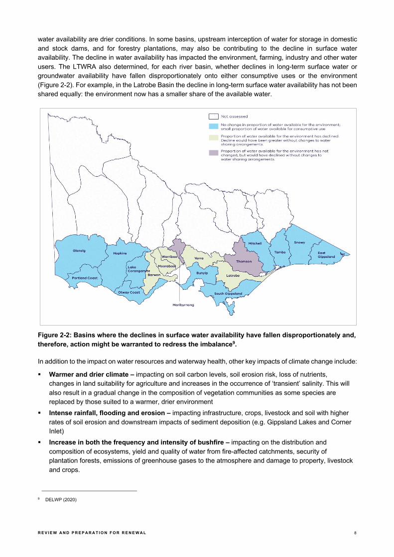
water availability are drier conditions. In some basins, upstream interception of water for storage in domestic and stock dams, and for forestry plantations, may also be contributing to the decline in surface water availability. The decline in water availability has impacted the environment, farming, industry and other water users. The LTWRA also determined, for each river basin, whether declines in long-term surface water or groundwater availability have fallen disproportionately onto either consumptive uses or the environment (Figure 2-2). For example, in the Latrobe Basin the decline in long-term surface water availability has not been shared equally: the environment now has a smaller share of the available water.
Figure 2-2: Basins where the declines in surface water availability have fallen disproportionately and, therefore, action might be warranted to redress the imbalance9.
In addition to the impact on water resources and waterway health, other key impacts of climate change include:
§ Warmer and drier climate – impacting on soil carbon levels, soil erosion risk, loss of nutrients, changes in land suitability for agriculture and increases in the occurrence of ‘transient’ salinity. This will also result in a gradual change in the composition of vegetation communities as some species are replaced by those suited to a warmer, drier environment
§ Intense rainfall, flooding and erosion – impacting infrastructure, crops, livestock and soil with higher rates of soil erosion and downstream impacts of sediment deposition (e.g. Gippsland Lakes and Corner Inlet)
§ Increase in both the frequency and intensity of bushfire – impacting on the distribution and composition of ecosystems, yield and quality of water from fire-affected catchments, security of plantation forests, emissions of greenhouse gases to the atmosphere and damage to property, livestock and crops.
9 DELWP (2020)

R E V I E W A N D P R E P A R A T I O N F O R R E N E W A L 9
The fire map below (Figure 2-3) shows the areas that were burned by large fires in 2007, 2009, 2013 and 2019. This continues a trend of a marked reduction in the intervals between large-scale bushfires in the catchment since the early 2000s. Recent research10 confirms that intervals between successive fires are important as trees need sufficient time to recover their regenerative capacity. This is particularly the case for eucalypts like alpine ash (Eucalyptus delegatensis) that only begin to produce seeds around 20 years after fire. This means that fire intervals need to be greater than 20 years before alpine ash will have sufficient seeds for successful regeneration (after the next fire).
Figure 2-3: Large parts of the catchment have been repeatedly burned in recent decades11.
P O P U L A T I O N A N D D E M O G R A P H I C T R E N D S
The majority of regional centres and towns in West Gippsland have experienced population growth over the last 35 years. Growth has been particularly strong on the fringe of Melbourne and in coastal areas, with the coastal town of Inverloch increasing in population by over 200 per cent. Warragul, Korumburra and Wonthaggi have been identified as key peri-urban growth locations and each have experienced growth of 50-90 percent since 1981. Some towns in the region have experienced population decreases. These towns include Moe-Newborough, Morwell, Churchill, Yarram and Yallourn North.
The estimated population for the West Gippsland region for 2016 was 189,535 people. By 2036 this is expected to grow by 20% to 225,000 people12.
10 https://pursuit.unimelb.edu.au/articles/why-australia-s-severe-bushfires-may-be-bad-news-for-tree-regeneration (2020) 11 Fire boundary data from https://www.data.vic.gov.au (accessed 24/5/2020) 12 Victoria in Future (2019).

R E V I E W A N D P R E P A R A T I O N F O R R E N E W A L 1 0
Figure 2-4: Projected population growth for West Gippsland13
Table 2-2 shows the population projections by subsets of West Gippsland LGAs, with Drouin, Warragul and Wonthaggi expected to experience the highest population increases over the next 20 years.
Table 2-2: Population projections by Local Government Area for West Gippsland14
L ocal Government Areas
V IC TO R IA IN FU TU R E S M A L L A R E A S (V IFS A )15
Y E A R % IN C R E A S E
2 016 -36 2016 2021 2026 2031 2036
Baw Baw Neerim-Trafalgar 13,700 14,370 15,080 15,920 16,670 21.68%
Bass Coast Wonthaggi 22,780 25,450 27,910 30,450 32,660 43.37%
Drouin-Warragul (30%) 10,688 12,471 14,216 16,036 17,763 66.20%
Latrobe Churchill 11,570 11,680 11,870 12,070 12,250 5.88%
Glengarry North-Tyers 4,830 4,870 4,940 5,010 5,080 5.18%
Moe 16,830 16,880 17,100 17,370 17,650 4.87%
Morwell 14,030 14,100 14,230 14,380 14,560 3.78%
Traralgon 27,360 28,910 30,440 32,070 33,650 22.99%
South Gippsland Leongatha 11,230 11,660 12,210 12,780 13,310 18.52%
Promontory 8,940 9,170 9,370 9,560 9,730 8.84%
Korumburra (30%) 2,688 2,832 2,976 3,120 3,270 21.65%
Wellington Heyfield-Maffra 14,110 14,610 15,100 15,660 16,150 14.46%
Rosedale 9,150 9,440 9,720 10,030 10,320 12.79%
Sale 14,890 15,330 15,830 16,400 16,910 13.57%
Yarram 5,370 5,460 5,530 5,600 5,570 3.72%
TOTAL 188,166 197,233 206,522 216,456 225,543 19.86%
Migration is the key driver of demographic and population change in the West Gippsland region. There has been high net in-migration to the western edge of the region which is influenced by Melbourne’s peri-urban fringe and net out-migration in and around the Latrobe LGA. Other significant demographic trends that are occurring are:
13 Victoria in Future (2019) 14 Ibid. 15 VIFSAs are based on ABS Statistical Areas Level 2.
160,000
170,000
180,000
190,000
200,000
210,000
220,000
230,000
2016 2021 2026 2031 2036

R E V I E W A N D P R E P A R A T I O N F O R R E N E W A L 1 1
§ Whilst not as pronounced as Victoria as a whole, the West Gippsland population is projected to age over the next 30 years. This has significant implications for housing preferences with 84% of future household growth (for the whole of Gippsland) being from households with one person or couples without children
§ The SEIFA IRSAD16 indicator of relative advantage and relative disadvantage shows that LGAs within the West Gippsland region demonstrate highly varied rates of disadvantage:
- The Latrobe LGA is the seventh most disadvantaged LGA in Victoria. Disadvantage is concentrated in Moe, Morwell and to a lesser extent Traralgon
- Across rural farming areas of South Gippsland and Wellington LGAs, there is a pattern of higher relative advantage in farmlands, and higher relative disadvantage concentrated in rural towns. This difference may be due to the gradual economic decoupling of small rural towns and the surrounding farm businesses.
Key impacts from population and demographic trends include:
§ Increasing domestic and stock water use – growing populations, rural subdivisions and fluctuating water availability are increasing the demand for domestic and stock water
§ Development on land with high agriculture and/or conservation value – further pressure on land with high agricultural and/or conservation values as a result of urban development and subdivision for rural lifestyle blocks on agricultural land
§ Increases in pollution and waste – growing populations will contribute to increased levels of pollution and waste
§ Nature-based tourism – larger populations will result in increased visitation and associated impacts on nature-based tourism sites in the region including coastal areas, rivers and creeks, national parks and reserves.
16 ABS (2020) Socio-Economic Indexes for Areas (SEIFA), Index of Relative Socio-economic Advantage and Disadvantage (IRSAD).

R E V I E W A N D P R E P A R A T I O N F O R R E N E W A L 1 2
L A N D - U S E C H A N G E
Land use across the Gippsland region is highly variable (refer Figure 2-5 below). Some parts of the region are highly modified from their pre-European settlement state and support agricultural, industrial and residential uses. Other areas are less disturbed, with large amounts of native forest, used for both conservation and timber harvesting. A large proportion of land in the Gippsland region is publicly owned, and this makes up a considerable proportion of Victoria’s total public land.
Figure 2-5: Land use in West Gippsland CMA region (Australian property classification codes)17
Some areas of the region remain under development pressure. This often leads to farmland being converted to residential and rural residential uses, and also small lifestyle properties. This pattern is particularly apparent in coastal areas and on the western edge of the region. The change in total area of land used for agriculture in the region is consistent with this pattern (Figure 2-6). Between 2011 and 2016 the area of land used for agriculture decreased by around 20 per cent, around 130,000 hectares, which continues a decades long pattern. A significant portion of this change is likely to be commercial farms being converted to smaller lifestyle properties.
Over that same time, the number of livestock farms also decreased but not at the same rate. In fact, the number of farms with meat cattle only decreased by four per cent over that same time (Figure 2-7). This could reflect two simultaneous drivers – economic efficiency driving properties to increase in size to remain commercially viable, along with fragmentation of commercial farms into smaller properties that do not meet the threshold to be considered farms under the ABS agricultural census.
17 Victorian Land Use Information System (2014/15).

R E V I E W A N D P R E P A R A T I O N F O R R E N E W A L 1 3
Other land use changes that are observable in the region include:
§ Plantation forestry on lower productivity agricultural land (e.g. in Perry River catchment) § Increased intensification of agriculture systems – including growth in horticultural production, particularly
in the MID irrigation area § Urban expansion and continued fragmentation of commercial farms into smaller lifestyle properties.
Figure 2-6: Change in area of holdings in West Gippsland CMA region18
Figure 2-7: Changes in the number of agricultural businesses, 2011 to 2018, West Gippsland CMA region19
18 ABS agricultural census data 19 Ibid.
-
500
1,000
1,500
2,000
2,500
3,000
3,500
4,000
2010-11 2015-16 2017-18
Number of agricultural businesses Number of ag businesses with cattle
Number of dairy farms Number of ag businesses with meat cattle
R E V I E W A N D P R E P A R A T I O N F O R R E N E W A L 1 4
I N D U S T R Y O U T L O O K
The region supports a number of major industries and related strategic assets20 including major water supply dams and the Wonthaggi desalination plant, wind farms and significant brown coal deposits and major power stations in the Latrobe Valley. It also supports a major forestry sector, and large areas of productive agriculture including dairy, beef and horticulture centred around the Macalister Irrigation District.
Agriculture
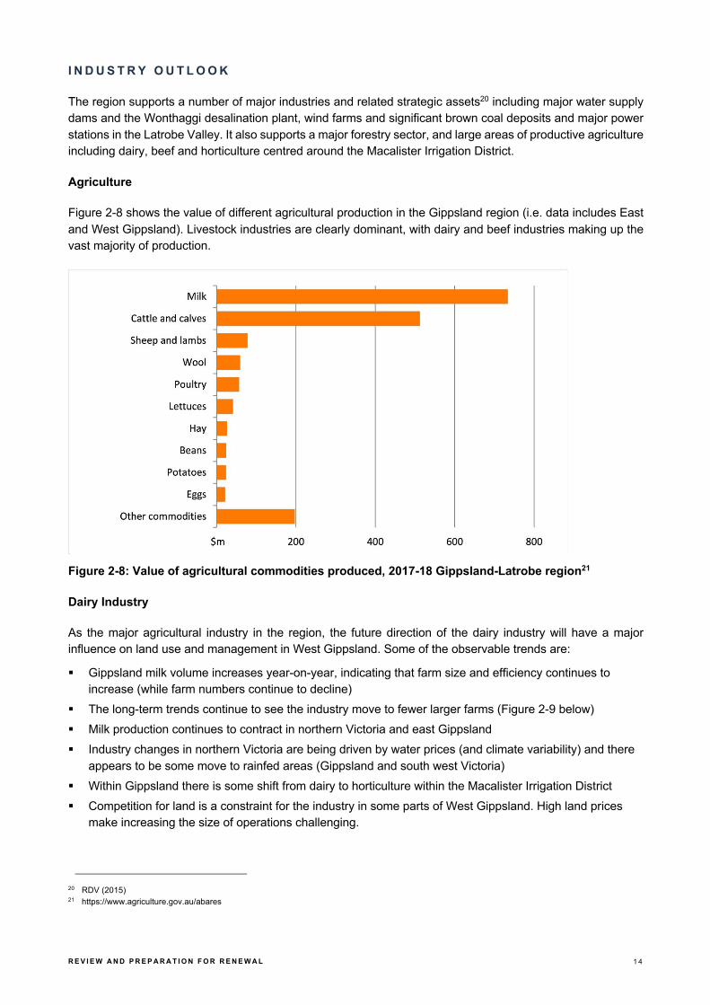
Figure 2-8 shows the value of different agricultural production in the Gippsland region (i.e. data includes East and West Gippsland). Livestock industries are clearly dominant, with dairy and beef industries making up the vast majority of production.
Figure 2-8: Value of agricultural commodities produced, 2017-18 Gippsland-Latrobe region21
Dairy Industry
As the major agricultural industry in the region, the future direction of the dairy industry will have a major influence on land use and management in West Gippsland. Some of the observable trends are:
§ Gippsland milk volume increases year-on-year, indicating that farm size and efficiency continues to increase (while farm numbers continue to decline)
§ The long-term trends continue to see the industry move to fewer larger farms (Figure 2-9 below) § Milk production continues to contract in northern Victoria and east Gippsland § Industry changes in northern Victoria are being driven by water prices (and climate variability) and there
appears to be some move to rainfed areas (Gippsland and south west Victoria) § Within Gippsland there is some shift from dairy to horticulture within the Macalister Irrigation District § Competition for land is a constraint for the industry in some parts of West Gippsland. High land prices
make increasing the size of operations challenging.
20 RDV (2015) 21 https://www.agriculture.gov.au/abares

R E V I E W A N D P R E P A R A T I O N F O R R E N E W A L 1 5
Figure 2-9: Distribution of farms by estimated value of agricultural operations, Latrobe-Gippsland region, 2017–1822
Forestry
The region has a significant forestry industry with native forest and softwood plantations supporting an important timber, pulp and paper manufacturing sector. However, with the Government’s 2019 announcement that logging in native forests would be phased out by 2030, and the immediate cessation of logging of old growth forests, Gippsland’s timber industry is in the midst of a major transition from native forest timber harvesting to plantation. In 2016 there were about 2.7 million hectares of native forests in the Latrobe - Gippsland region. The majority of these native forests were multiple use public land, available for timber production (1,468,400 hectares), while 933,900 hectares were in conservation reserves and 232,300 hectares were privately managed.
Nearly one quarter of Victoria’s plantation estate is located in the broader Gippsland area23. In 2014–15, the most recent year for which regional data are available, the total plantation area in the Latrobe - Gippsland region was about 97,600 hectares, about one third of which is hardwood (Tasmanian blue gum (Eucalyptus
globulus) and shining gum (Eucalyptus nitens)). The main softwood plantation species in Victoria is radiata pine (Pinus radiata). The differences in area of plantations and native forest are an indication of the magnitude of the transition required for this industry.
Energy
The region also continues to be a major energy producer, through both coal and natural gas. However, the presence of the electricity transmission infrastructure in the region appears to be an important driver for development of renewable energy – solar, wind and geothermal.
Other industries and trends
§ Mineral sands mining is being explored for the Glenaladale area immediately to the east of the region § Interest in onshore gas exploration remains, though subject to policy restrictions § Extractive industries are growing with demand from construction, particularly infrastructure projects in
Melbourne and surrounds.
22 https://www.agriculture.gov.au/abares 23 DTPLI (2014a)

R E V I E W A N D P R E P A R A T I O N F O R R E N E W A L 1 6
O P E R A T I N G E N V I R O N M E N T
Since the development of the last RCS, there have been significant changes to the regional operating environment (including legislative reform, new plans and strategies and shifts in funding) that will have an impact on the management of the catchment into the future. A summary is provided here with further detail outlined for each of the themes in Sections 3 to 7.
Legislative reform
There have been numerous legislative reviews in recent years, and while most are unlikely to have a significant impact on the current RCS, some of these inquiries may have implications for the renewed RCS. These include:
§ EPA inquiry and Environment Protection Amendment Act 2018 § Marine and coastal reforms (including Marine and Coastal Act 2018 and Marine and Coastal Policy) § Flora and Fauna Guarantee Amendment Act 2019 § Water Act Amendment Act 2019.
These are summarised briefly below:
§ Environment Protection Amendment Act 2018
- introduces a General Environmental Duty, which requires anyone conducting an activity that poses risks of harm to human health and the environment to understand and minimise those risks, so far as is reasonably practicable.
§ Flora and Fauna Guarantee Amendment Act 2019
- provides a modern and strengthened framework for the protection of Victoria’s biodiversity
- introduces principles to guide the implementation of the Flora and Fauna Guarantee Act, including consideration of the rights and interests of Traditional Owners and the impacts of climate change
- requires consideration of biodiversity across government to ensure decisions and policies are made with proper consideration of the potential impacts on biodiversity
- clarifies existing powers to determine critical habitat and improves their protection by encouraging cooperative management
- modernises the Flora and Fauna Guarantee Act’s enforcement framework including stronger penalties.
§ New Marine and Coastal Act and Policy:
- provides a greater focus on the marine environment
- ensures greater recognition and respect for the aspirations of Traditional Owners
- embeds climate change in all aspects of future planning
- provides guidance on new roles and responsibilities.
§ Water and Catchment Legislation Amendment Act 2019:
- ensures greater recognition and involvement of Traditional Owners and Aboriginal Victorians in the management and planning of waterways and catchments
- provides greater consideration of the recreational values of water and waterways for communities

R E V I E W A N D P R E P A R A T I O N F O R R E N E W A L 1 7
- provides clearer planning for future challenges, such as climate change, population growth and changing demands for water, with a greater focus on compliance and assurance along with transparency and justification.
New plans and strategies
A range of key state and regional plans and strategies have also been developed since the last RCS. They include:
- Agriculture Victoria Strategy (2017).
- Water for Victoria – Water Plan (2016)
- Victorian Waterway Management Strategy (2013)
- Protecting Victoria's Environment - Biodiversity 2037 (2017)
- Our Catchments Our Communities (2016-19)
- Victoria's Climate Change Adaptation Plan (2017-2020)
- West Gippsland Waterway Strategy (2014-2022)
- West Gippsland Regional NRM Climate Change Strategy (2016)
- West Gippsland Floodplain Strategy (2018-2027).
A number of the actions within these strategies have been integrated into the current RCS implementation program, and they will also be relevant to the renewed RCS.
Likewise, the development of RCS4 will require alignment and policy integration with a number of new strategies and plans to be developed over the next two years (e.g. new Central and Gippsland Sustainable Water Strategy and new Marine and Coastal Strategy).
Funding environment
Since the last RCS, the traditional funding environment has changed with longer but more certain funding cycles, and a shift to a more targeted approach to delivering and demonstrating investment outcomes. Further details are provided below for the main Australian and Victorian Government funding programs.
Under these arrangements, the next RCS will be critical for future funding rounds by ensuring the currency of regional NRM priorities.
§ Australian Government (Regional Land Partnerships (RLP) Program under the National Landcare Program (NLP) phase II)
- A focus on national priorities – EPBC listed species and communities, national and international obligations (e.g. Ramsar, World Heritage)
- Purchasing model – multi-year (up to five years) competitive funding, with high levels of accountability, and reporting on specific outcomes
- Shift away from regional autonomy to centralised approaches
§ Victorian Government
- Renewed focus on demonstrating and communicating long-term outcomes and impact (in line with Water for Victoria)
- Change from an annual to four yearly funding cycle for Victorian Government investment (Environmental Contribution (EC) levy) in line with NLP - providing greater funding certainty.

R E V I E W A N D P R E P A R A T I O N F O R R E N E W A L 1 8
2 . 5 T H E M E B A S E D R E V I E W S
As detailed above, a review report has been developed for each of the following themes:
§ Water: waterways (including rivers, estuaries and wetlands), surface water and groundwater § Land: land-use, groundcover and agricultural productivity § Biodiversity: habitat, native vegetation and native animals § Coasts and marine environment § Community: Traditional Owners and Aboriginal Victorians, and communities involved in integrated
catchment management.
These themes are the focus of the following five sections (2 to 7) of this report, which have been structured as follows:
§ Introduction § Assessment of current condition § Description of major threats and trends § Future drivers and emerging issues.

R E V I E W A N D P R E P A R A T I O N F O R R E N E W A L 1 9
3 Water
3 . 1 I N T R O D U C T I O N
There are three key sub-themes under the water theme: § Waterways (rivers and streams; estuaries and wetlands) § Surface water resources § Groundwater.
W A T E R W A Y S
Rivers and streams
The region’s major waterways include the Thomson, Latrobe, Macalister, Avon, Perry, Powlett, Tarwin and Tarra Rivers. All of these waterways flow to the Victorian coast, discharging through the Gippsland Lakes, Corner Inlet or directly into Bass Strait and the Southern Ocean. The region’s rivers support a range of environmental, social, recreational and cultural values and provide water for towns, industry and food production.
Estuaries
The region’s estuaries, which are also an important component of the Coasts and Marine Theme (refer Section 6) are an important link between the ocean and land, where fresh water from rivers and streams mixes with salty marine waters. Estuaries are dependent on both of these water sources to provide a diverse and healthy environment. The estuaries in the West Gippsland catchment area range from near natural to highly modified, and include: § Bourne Creek, Powlett River, Wreck Creek § Ayr Creek, Screw Creek, Anderson Inlet § Darby River, Tidal River and estuaries of Corner Inlet and the east side of Wilsons Promontory § Merriman Creek § Estuarine reaches of rivers that enter into Lake Wellington.

R E V I E W A N D P R E P A R A T I O N F O R R E N E W A L 2 0
Wetlands
The region’s wetlands include individual wetlands, wetland complexes, and their associated floodplain ecosystems.
Corner Inlet and the Gippsland Lakes are wetlands of international importance under the Ramsar convention and are critical habitats for many vulnerable and threatened species, including migratory birds species listed under the Japan-Australia Migratory Bird Agreement (JAMBA), China Australia Migratory Bird Agreement (CAMBA) and Republic of Korea-Australia Migratory Bird Agreement (ROKAMBA).
G R O U N D W A T E R A N D A Q U I F E R S
The West Gippsland region is a rich source of groundwater, suitable for livestock, domestic, garden and industrial use. In some areas, particularly along the Ninety Mile Beach coast and Gippsland Plains the high yielding aquifers are important sources of water for irrigation and town water supply, including major city centres like Sale in the east24. Groundwater also contributes to the environmental values of some ecosystems. These are known as groundwater dependent ecosystems (GDEs) and can include waterways, wetlands, estuaries and vegetation.
S U R F A C E W A T E R R E S O U R C E S
The West Gippsland region has valuable surface water resources for environmental, agricultural, industrial, urban and potable water supply purposes. The region has 24 of Victoria’s 134 declared water supply catchments, which supply water for both stock and domestic purposes and are protected under the CaLP Act. The region incorporates three major river basins: the Thomson, Latrobe and South Gippsland Basins. The Thomson Basin (incorporating the Avon, Thomson and Macalister Rivers) and the Latrobe Basin both drain the southern fall of the Great Dividing Range and the northern slopes of the Strzelecki Ranges into Lake Wellington. The South Gippsland Basin’s ten rivers and streams drain the southern slopes of the Strzelecki Ranges to the coast between San Remo in the west and Loch Sport in the east.
3 . 2 A S S E S S M E N T O F C U R R E N T C O N D I T I O N
W A T E R W A Y S
Rivers and streams
Figure 3-1: Index of Stream Condition 2010 Summary for the West Gippsland Region
24 WGCMA (2013).

R E V I E W A N D P R E P A R A T I O N F O R R E N E W A L 2 1
Figure 3-2: Index of Stream Condition 2010 results by reach for the West Gippsland region25.
According to the last Index of Stream Condition benchmark conducted in 2010, 34% of stream reaches assessed were in ‘excellent’ or ‘good’ condition, mostly located in the Thomson and Latrobe Basins. The majority of stream reaches assessed in the region were in ‘moderate’ condition.
Basin streamflow was above the long-term average from 2010-11 to 2011-12, and close to or slightly below the long-term average from 2012-13 to 2014-15.
25 DEPI (2013).

R E V I E W A N D P R E P A R A T I O N F O R R E N E W A L 2 2
Wetlands
The Index of Wetland Condition (IWC) was developed to assess the condition of Victoria’s wetlands. Seventy-two wetlands in the West Gippsland region were assessed between 2009 and 2013 using the IWC, 26 of these were part of a state-wide assessment of wetland condition and the remainder were completed to inform the selection and or monitoring for onground works26. Of the sites assessed, the majority were in moderate to good condition (18 and 29 respectively), 12 were in excellent condition and 15 were in poor to very poor condition.
Estuaries
As also detailed in Section 6, DELWP has developed a condition assessment method for estuaries called the Index of Estuary Condition (IEC). The IEC is being applied to estuaries throughout Victoria to document their current condition and establish a baseline for future monitoring.27
G R O U N D W A T E R
Groundwater in Gippsland is contained in layers of sedimentary sand, gravel, clay, limestone and coal, and in fractured rock. Groundwater levels are generally stable but some areas are declining. Management of groundwater needs to take into account the amount of water that enters and is lost from the aquifer each year and how much water is stored in the aquifer. The process of water entering the ground to become groundwater is called recharge. The volume of recharge and how fast it enters groundwater depends on climate, aquifer depth, the types of plants that use water from the soil and the types of soil and rock through which the water must pass28.
S U R F A C E W A T E R R E S O U R C E S
About 92 per cent of the water extracted for towns, industry and agriculture in Gippsland is sourced from waterways, with about 8 per cent sourced from groundwater and a very small proportion drawn from alternative sources such as stormwater and recycled wastewater.29
Table 3-1 shows results of the Victorian Government’s recent Long-term Water Resource Assessment (LTWRA)30 for river basins in West Gippsland. It found that long-term surface water availability has declined in the region (5-12%) compared to when it was last estimated for the sustainable water strategies in the mid 2000’s. The main cause of these declines are drier conditions. In some basins, upstream interception of water for storage in domestic and stock dams, and for forestry plantations, may also be contributing to the decline in surface water availability. This decline has impacted the environment, farming, industry and other water users. The LTWRA also determined, for each river basin in the region, whether declines in long-term surface water or groundwater availability have fallen disproportionately onto either consumptive uses or the environment. For example, in the Latrobe Basin the decline in long-term surface water availability has not been shared equally: the environment now has a 3% smaller share of the available water.
26 WGCMA (2014b). 27 https://www.water.vic.gov.au/waterways-and-catchments/rivers-estuaries-and-waterways/estuaries?_ga=2.108352135.401812174.1589329315-
55781662.1589329315. 28 Ibid. 29 DSE (2011). 30 DELWP (2020).

R E V I E W A N D P R E P A R A T I O N F O R R E N E W A L 2 3
Table 3-1: Long-term Water Resource Assessment results by river basin31
LATROBE RIVER THOMSON RIVER SOUTH GIPPSLAND
Total water available (GL/yr)
829.8 Total water available (GL/yr)
914.1 Total water available (GL/yr)
661.6
Consumptive share
24% Consumptive share
39% Consumptive share
3%
Environment's share
76% Environment's share
61% Environment's share
97%
Decline in available water
5% Decline in available water
12% Decline in available water
12%
Change in consumptive share
3% Change in consumptive share
0% Change in consumptive share
0%
Change in environment share
-3% Change in environment share
0% Change in environment share
0%
Effect on consumptive share
Increase from 21% (3% change)
Effect on consumptive share
No Change Effect on consumptive share
No Change
Effect on environment share
Decrease from 79% (3% change)
Effect on environment share
No Change Effect on environment share
No Change
3 . 3 D E S C R I P T I O N O F M A J O R T H R E A T S A N D T R E N D S
As detailed from the Index of Stream Condition (ISC) results, many waterways in the region are in good to excellent condition, however some parts of the region are starting from a poor baseline – both in terms of condition of the waterway and how it is currently managed. The region’s waterways and catchments have been impacted by past land use and river management practices, including clearing of riparian vegetation, regulation of rivers and extraction of water, the introduction of invasive species, nutrient pollution and sedimentation. Sustainable water resource use is also under pressure, with increasing demands for irrigation and the need to support urban consumption.32
The Millennium Drought (1997-2009) saw a shift in the seasonality of rainfall, with big decreases in autumn rainfall leaving catchments drier at the beginning of winter, which led to less run-off from winter and spring rainfall. Climate change is also expected to continue to drive long-term reductions in rainfall and increased temperatures, which means this pattern from the Millennium Drought will be repeated. These drier catchments will impact both surface and groundwater availability.
31 DELWP (2020). 32 VCMC (2017).

R E V I E W A N D P R E P A R A T I O N F O R R E N E W A L 2 4
3 . 4 F U T U R E D R I V E R S A N D E M E R G I N G I S S U E S
There are a number of key drivers, emerging challenges and opportunities that will shape the health of the region’s waterways and water resources. These are summarised as follows:
Changes since the last RCS
§ The region has experienced variable climatic conditions over recent years, with periods of drought and below average inflows (particularly in the eastern parts of the region)
§ There have been a number of fires across the region during recent fire seasons, including large fires in the upper catchments of the Wellington and Macalister Rivers, though the region was largely spared the impacts of the recent ‘Black Summer’ bushfires (refer Figure 3-3)
§ Successful delivery of environmental flow releases with monitoring data (e.g. Victorian Environmental Flows Monitoring and Assessment Program – VEFMAP) showing evidence of increased native fish migration and spawning (e.g. Australian grayling)
§ Secure four-year investment in waterway health through the fourth tranche of the Victorian Government’s EC funding program
§ Effective coordination arrangements in place for management of the Gippsland Lakes through the Gippsland Lakes Coordinating Committee.
Figure 3-3 Bushfires in the West Gippsland CMA region (2014-20)
R E V I E W A N D P R E P A R A T I O N F O R R E N E W A L 2 5
Future drivers and emerging issues
Climate change is expected to have an increasing impact on the region’s waterways and water resources:
§ Reduced rainfall and increased temperatures will result in drier catchments impacting both surface and groundwater availability
§ Increased frequency of higher intensity rainfall events impacting flooding events, bed and bank erosion and introduction of sediments, pollutants and nutrients from adjacent catchments
§ Increased risk of channel change and debris flow from more intense storm events with impacts on infrastructure
§ Lower base flows in rivers and higher temperatures combined with elevated nutrient levels can increase the occurrence of algal blooms in rivers and creeks
§ A reduction in the frequency and duration of high flows and inundation of waterways impacting plant and animal communities that require a frequency (or permanent) inundation for survival
§ Reduced connectedness (due to low flows) of waterways decreasing opportunities for movement and dispersal of aquatic plants and animals (including of migration of native fish species)
§ Reduction in the frequency and duration of inundation events and increase in the duration of dry periods for all inland wetlands, resulting in a decrease in the number and area of permanent and seasonal wetlands and increase in the number and area of intermittent wetlands
§ Added focus on the importance, availability, quality and protection of drought refuge - to ensure greater resilience to more frequent drought and dry conditions.
Other emerging management issues include:
§ Increasing population growth – households and industry in the region’s towns and cities will require more water
§ Increased development along river corridors in the region’s growth areas will require improved strategic and integrated planning including integrated water management
§ Greater community connection to the environment (and waterways) with a population that increasingly values the protection of natural areas, amenity and open space
§ Changing industrial water needs – reductions in the volume of water required by power generators § Water to produce future food and fibre needs – efficiency of water delivery and use and infrastructure to
trade and move water outside of existing irrigation districts § Increasing domestic and stock water use – growing populations, rural subdivisions and fluctuating water
availability are increasing the demand for domestic and stock water § Land use change – any shift from pasture to plantations or crops, or the reintroduction of native vegetation
can affect the water balance of a catchment by intercepting water that would otherwise become part of the surface or groundwater resources
§ Declining groundwater levels in the Latrobe Group aquifer – due to offshore oil and gas extraction, reduction in rainfall and irrigation use impacting farmers in the Yarram area by reducing their access to groundwater and increasing costs
§ Emerging groundwater and mining technologies – placing further pressure on groundwater resources in terms of water availability and aquifer condition. These include extraction of methane and petroleum products from in-ground coal, carbon capture and storage, geothermal operations and further development of mine dewatering for coal-based initiatives
§ Bushfires – directly affecting water quality by washing solids (ash, charcoal and soil) and dissolved materials (nutrients and organic matter) into waterways and reservoirs. Bushfire can also impact future water yield
§ Point source pollution – from industrial outfalls, ineffective septic tanks, poorly constructed bores or leaking fuel tanks in service stations
R E V I E W A N D P R E P A R A T I O N F O R R E N E W A L 2 6
§ Agricultural run-off and streamside grazing – mobilisation of pesticides and fertilisers after heavy rain or irrigation reduce water quality and increase the risk of algal blooms; stock access to waterways increases erosion and reduces water quality
§ Land salinisation – irrigation induced and dryland salinity requires continued management to reduce impacts on waterway health, land productivity and infrastructure
§ Saltwater intrusion – excessive extraction of fresh groundwater from aquifers close to salty groundwater systems can cause saltwater intrusion. This can cause groundwater to become too salty for drinking, irrigation and other purposes as well as degrading environmental values
§ Acid sulfate soils – may become issues as some wetlands become increasingly dry, with limited options for rehabilitation
§ The planned long-term staged closure of the Latrobe Valley coal mines and demands for water associated with rehabilitation of the mine sites
§ Irrigation improvements – ensuring investment in on-farm water savings contribute to more water for the environment
§ Increases in area irrigated (outside of irrigation districts) could impact on environment/ water usage, as well as greater use of herbicides/ pesticides and impacts on water quality
§ Engagement with the forest industry to manage nutrient and sediment impacts on waterways.
Operating environment
This section summarises key current and emerging policy drivers and the consequent focus areas to be considered in preparation for the next RCS.
Table 3-2: Summary of key current and emerging policy drivers
OPERATING CONTEXT FOCUS AREA FOR NEXT RCS
Water for Victoria (2016) Alignment with key actions, including: ▪ Embedding climate change considerations in all
operational decisions ▪ Managing waterways for shared benefits – social,
cultural, economic and environmental ▪ Supporting community partnerships and citizen
science ▪ Implementing the Angler Riparian Partnerships
Program to deliver riparian improvement works in areas of local priority for anglers
▪ Improving the recording of progress and how the information is reported back to communities (implementing new Rivers 2040 framework)
▪ Recognising and managing for Aboriginal values ▪ Recognising recreational values of water.
Victorian Waterway Management Strategy (VWMS) (2013)
West Gippsland Waterway Strategy (2014-22)
Ensure updated RCS targets align with VWMS and West Gippsland Waterway Strategy.
Long-term Water Resource Assessment for Southern Victoria (LTWRA) (2020)
Consider LTWRA findings and alignment with:
▪ New Central Region and Gippsland Sustainable Water Strategy (currently underway).

R E V I E W A N D P R E P A R A T I O N F O R R E N E W A L 2 7
OPERATING CONTEXT FOCUS AREA FOR NEXT RCS
Climate Change Act 2018.
Victoria's Climate Change Adaptation Plan (2017-20)
West Gippsland NRM Climate Change Strategy (2016)
Alignment with the Act and plans.
Incorporate NRM Climate Change Strategy actions where relevant, along with the latest climate change information available.
State Environmental Protection Policy (SEPP) (Waters).
Alignment to the SEPP (Waters): ▪ ensures that Victoria has a contemporary statutory
policy for the protection and management of surface water and groundwater in Victoria
▪ identifies uses and environmental values to be protected
▪ levels of environmental quality required for their protection
▪ rules and obligations to ensure management actions are taken to protect water quality.
Integrated Water Management Framework for Victoria.
Gippsland Integrated Water Management (IWM) Strategic Directions Statement (SDS) (2019)
Alignment to framework objectives, which aim to: ▪ help government, the water sector and the
community work together to better plan, manage and deliver water to support liveable and resilient cities and towns.
Alignment to the SDS strategic outcomes: ▪ Safe secure and affordable supplies that are fit for
purpose ▪ Effective and affordable wastewater systems ▪ Understand and manage flood regimes to sustain
natural systems while minimising adverse impacts ▪ Healthy and valued waterways, wetlands, lakes,
coastal environments and groundwater systems ▪ Healthy and valued agricultural, rural and urban
landscapes ▪ Community values reflected in place-based
planning ▪ Recognise opportunities to enhance jobs, economic
growth and innovation.
Victorian Auditor-General’s Report (VAGO) - Meeting Obligations to Protect Ramsar Wetlands (2016)
Adoption of the VAGO recommendations and the DELWP response, including: ▪ Continued coordination for management,
monitoring and reporting for the Corner Inlet Ramsar site.
Support to the East Gippsland CMA in the coordination of management of the Gippsland Lakes Ramsar site.
Sustainable Development Goals (SDG) under 2030 Agenda for Sustainable Development.
Alignment of RCS outcomes for waterways and water resources to SDG Goals.

R E V I E W A N D P R E P A R A T I O N F O R R E N E W A L 2 8
4 Land
4 . 1 I N T R O D U C T I O N
The West Gippsland region features a variety of soil types that reflect different parent material, topography, climate, organic activity and age (e.g. degree of weathering). In general terms, most of the region’s soils are moderately well structured and support a range of agricultural enterprises and natural ecosystems. The eastern highlands, Strzelecki Ranges and the western half of the region receive high rainfall. The elevated areas (the highlands and Strzelecki Ranges) support large contiguous areas native forest vegetation. The plains in the east are in the rain shadow of the highlands, so the native vegetation in this lower rainfall area consists of woodland, grassy woodland, heathland and riparian complexes in low-lying areas33. The western and southern parts of the region are some of the most productive agricultural areas in the state due to the combination of reliable rainfall and fertile soils.
The region’s land and natural resources underpin the West Gippsland economy. The agriculture, brown coal reserves (in the Latrobe Valley) and off-shore oil and gas reserves represent a major contribution to Victoria’s economy. The vast majority of Victoria’s electricity is generated from brown coal in the Latrobe Valley. Most of the main industries in the region have a direct connection to land - energy production (electricity, oil and gas); supply of potable and irrigation water; food product manufacturing and processing; agriculture and forestry; construction and residential building.
Areas to the north, within the eastern Strzeleckis Ranges and at Wilsons Promontory are less disturbed, with large amounts of land publicly owned and valued for its natural features.
33 WGCMA (2013).

R E V I E W A N D P R E P A R A T I O N F O R R E N E W A L 2 9
Some areas of the region remain under development pressure with land potentially changing towards use for both urban and rural residential development. For example, in Bass Coast, South Gippsland and Baw Baw local government areas, there is considerable competition for land between rural residential development, urban expansion (including the expansion of Melbourne’s peri-urban fringe) and agriculture.
4 . 2 A S S E S S M E N T O F C U R R E N T C O N D I T I O N
This section summarises the current condition of land resources in the West Gippsland region drawing from the Victorian Catchment Condition and Management Report (VCMC, 2017), Victorian State of the Environment Report (CES, 2018) and West Gippsland CMA Annual Report (2018-19).
Soil health
Figure 4-1: Percentage of Exposed Soil in West Gippsland34
The West Gippsland region has had low risk of widespread erosion from bare soils in dryland production areas over the last nine years. However, erosion risk is present in parts of the catchment with steep slopes and approximately 24% of private land was modelled as being at high or very high risk of gully and tunnel erosion35.
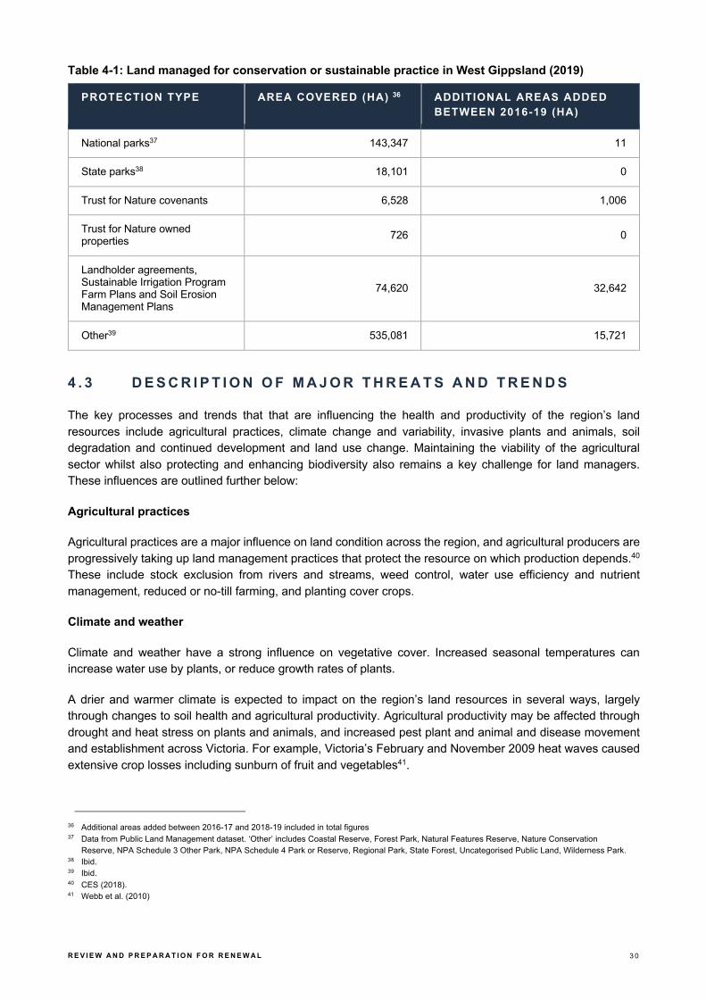
Land managed for conservation
A large proportion of land in the West Gippsland region is publicly owned, and managed for conservation and timber production. There are also large areas under Trust for Nature covenants and an increasing area of land under management agreements or sustainable land improvement programs (refer Table 4-1 below).
34 Annual mean percentage of soil unprotected by living vegetation or litter, derived from CSIRO mapping based on NASA MODIS imagery by the
OzWALD model-data fusion system. Source: Van Dijk, Albert. I.J.M., Summers, David (2016) Australia’s Environment Explorer, The Australian National University (http://www.ausenv. online) DOI: 10.4225/41/5934faf27397b.
35 VCMC (2017).
R E V I E W A N D P R E P A R A T I O N F O R R E N E W A L 3 0
Table 4-1: Land managed for conservation or sustainable practice in West Gippsland (2019)
PROTECTION TYPE AREA COVERED (HA) 36 ADDITIONAL AREAS ADDED BETWEEN 2016-19 (HA)
National parks37 143,347 11
State parks38 18,101 0
Trust for Nature covenants 6,528 1,006
Trust for Nature owned properties 726 0
Landholder agreements, Sustainable Irrigation Program Farm Plans and Soil Erosion Management Plans
74,620 32,642
Other39 535,081 15,721
4 . 3 D E S C R I P T I O N O F M A J O R T H R E A T S A N D T R E N D S
The key processes and trends that that are influencing the health and productivity of the region’s land resources include agricultural practices, climate change and variability, invasive plants and animals, soil degradation and continued development and land use change. Maintaining the viability of the agricultural sector whilst also protecting and enhancing biodiversity also remains a key challenge for land managers. These influences are outlined further below:
Agricultural practices
Agricultural practices are a major influence on land condition across the region, and agricultural producers are progressively taking up land management practices that protect the resource on which production depends.40 These include stock exclusion from rivers and streams, weed control, water use efficiency and nutrient management, reduced or no-till farming, and planting cover crops.
Climate and weather
Climate and weather have a strong influence on vegetative cover. Increased seasonal temperatures can increase water use by plants, or reduce growth rates of plants.
A drier and warmer climate is expected to impact on the region’s land resources in several ways, largely through changes to soil health and agricultural productivity. Agricultural productivity may be affected through drought and heat stress on plants and animals, and increased pest plant and animal and disease movement and establishment across Victoria. For example, Victoria’s February and November 2009 heat waves caused extensive crop losses including sunburn of fruit and vegetables41.
36 Additional areas added between 2016-17 and 2018-19 included in total figures 37 Data from Public Land Management dataset. ‘Other’ includes Coastal Reserve, Forest Park, Natural Features Reserve, Nature Conservation
Reserve, NPA Schedule 3 Other Park, NPA Schedule 4 Park or Reserve, Regional Park, State Forest, Uncategorised Public Land, Wilderness Park. 38 Ibid. 39 Ibid. 40 CES (2018). 41 Webb et al. (2010)

R E V I E W A N D P R E P A R A T I O N F O R R E N E W A L 3 1
An increased incidence of fire may lead to the destruction of native vegetation and habitat, loss of crops and livestock, smoke taint for wine producers (as experienced during Victoria’s ‘Black Summer’ bushfires), and lost productivity due to the preventative actions required on high-fire risk days. The scale and intensity of the ‘Black Summer’ fires may also result in changes to fuel management practices, particularly fuel reduction burning. Following all major fire events there is pressure for greater fuel reduction burning. Recent research is showing that this type of action is effective but only in relatively close proximity to the assets being protected. This combination of community pressure and growing understanding may see burns being more targeted.
Soil degradation
The condition of the region’s soil and land is threatened by a range of processes including landslides, various types of erosion, soil structure decline, acidification and salinity. Erosion is a challenge in the steep slopes in the Strzeleckis and alpine areas. Approximately 24% (135,000ha) of private land has been assessed as being at high or very high risk of gully and tunnel erosion. Tunnel erosion is a hazard historically associated with vegetation clearing on steep slopes in areas such as the Strzelecki Ranges. Sheet, rill and bank erosion are other potentially threatening processes. Soils generally have a low susceptibility to wind erosion except for a few localised high-risk areas around Waratah Bay, the upper Powlett River, Nine Mile Creek, Screw Creek and Pound Creek. Corner Inlet, west Strzelecki and north Strzelecki priority management areas are at most risk of all types of erosion.
Naturally occurring (primary) salinity is present within the catchment. Induced salinity (secondary salinisation) occurs in some areas because of human activities. These activities have modified the landscape and the natural process, influencing the salt distribution. Potential causes of salinity include land clearing, irrigation and seawater intrusions to low lying tidal floodplains. Significant areas of land at high salinity risk (with water tables less than two metres) occur in areas outside the Macalister Irrigation District, particularly in low lying coastal areas of South Gippsland that are predominantly used for dryland grazing. In these areas management interventions such as revegetation and the use of perennial pastures assist in preventing salt from rising to the surface and reduce the risk of saline discharge.
Invasive plants and animals
Invasive plants continue to be a threatening process to land health including ragwort, gorse, blackberry, serrated tussock and African lovegrass. Similarly, foxes, rabbits and deer are the predominant invasive animal species found across the region.42
Invasive plants and animals continue to be the highest profile land management issue for the broader community. There have been no official changes to the listed pest species of animals or plants in recent years although there are some species that appear to be becoming more widespread and or abundant. The most prominent of these is deer, with hog and sambar deer becoming more common in West Gippsland. Deer management is a growing focus for the state government, mainly due to the impact on native vegetation and habitat.
The suitability of the region for these invasive species, particularly weeds, will alter with climate change. Changes in climate will impact on weeds in two main ways, firstly the range of weed species present in the West Gippsland region will change, and secondly the invasiveness of weed species will change favouring some species over others. There are no specific reports identifying particular weeds as becoming more abundant, but this is likely to occur over time.
42 WGCMA (2019).

R E V I E W A N D P R E P A R A T I O N F O R R E N E W A L 3 2
4 . 4 F U T U R E D R I V E R S A N D E M E R G I N G I S S U E S
There are a number of key drivers, emerging challenges and opportunities that will shape future land use and regional agricultural productivity. These are summarised as follows:
Changes since the last RCS
§ The region has experienced variable climatic conditions over recent years, with periods of drought and several fires across the region during the summer fire seasons
§ There have been no significant changes in public land tenure through the designation of new parks or reserves
§ There has been an increase in land area covered by landholder agreements and management plans, and land under formal covenants
§ A range or programs have been delivered aimed at landholder engagement in sustainable agriculture such as GrazFert, Fert$mart, Healthy Soils and the Sustainable Irrigation Program
§ There has been pressure on the dairy sector due to market fluctuation, which may affect some landholder’s capacity to engage in environmental restoration activities
§ There is abundant anecdotal evidence of pest animals (particularly deer) increasing their population and range across the region
§ Improved land management practices in upper catchments aimed at stabilising sediment movement are continuing to reduce impacts on downstream natural assets (such as seagrass communities in Corner Inlet)
§ There has been a continuing trend of changes in land use toward larger scale agricultural operations including horticulture (increased soil exposure) and urban expansion (with increased runoff).
Future drivers and emerging issues
Climate change is expected to have an increasing impact on the region’s land resources and land uses: § Warmer and drier climate impacting on soil carbon levels, groundcover and therefore soil erosion risk,
loss of nutrients, changes in land suitability for agriculture and increases in the occurrence of ‘transient’ salinity
§ Increase in fire frequency and intensity will affect groundcover and soil stability and, therefore, increase the risk of water erosion and loss of soil nutrients and carbon
§ Aboriginal cultural values - cultural values such as artefacts, scar trees, shell middens or burial sites may be exposed, damaged or lost as the result of climate change impacts (i.e. fire, flood, coastal erosion and shoreline retreat).
Other emerging management issues include:
§ Agriculture and forestry
- The phasing out of native forest logging in Victoria by 2030, and the immediate cessation of logging of old growth forests under 2019 Victorian Forestry Plan.
- An increase in plantation timber production
- The challenges in measuring and reporting on the health of land resources
- A general increase in the intensification in agriculture systems across the region, with some transition from displaced horticulture in Melbourne’s urban growth zones
- A decrease in agricultural production in the coastal zone due to land competition from urban development

R E V I E W A N D P R E P A R A T I O N F O R R E N E W A L 3 3
- A shift from dairy to horticulture within the Macalister Irrigation District (MID) – with corresponding changes in intensity, and chemical use
- An increase in centre-pivot irrigation and more dams in the landscape – both within and outside the MID. Whilst government supported system modernisation and water use efficiency has been adopted, it hasn’t necessarily translated into decreased water use
- Other intensive animal industries are (e.g. broiler farms) are also increasing in the region
- Conversion of former blue gum plantations to agricultural land (e.g. in Perry River catchment)
- An increase in absentee and hobby farmers
- An increase in farm aggregation with much larger single ownership and company/corporate (including international and interstate) ownership of land holdings.
§ Urban expansion and population growth
- Population increases are outstripping predictions, particularly in local government areas closer to Melbourne and within coastal areas
- Smaller lot subdivisions are occurring on the Bunurong Coast and around the Western end of the region around Warragul
- There may be additional pressure for infrastructure development in coastal areas and other natural areas to create more attractive tourism destinations
- Ensuring that environmental implications are considered in regional land-use decision making. § Industry changes
- Planned brown coal power station closures (Hazelwood, Yallourn and Loy Yang) within the Latrobe Valley with opportunities for increased water availability (for mine rehabilitation, waterway restoration or consumption use (irrigated agriculture other industry))
- Change in community expectations and pressures - coal power industry decline is likely to lead to greater pressures to generate economic stimulus through alternative industries (e.g. more renewable energy projects (e.g. large wind farms i.e. Bald Hills wind farm or solar farms) or other extractive industries to employ displaced workers
- Onshore gas exploration
- A push for an increase in extractive industries (e.g. to supply the construction industry).
Operating environment
This section summarises key current and emerging policy drivers and the consequent focus areas to be considered in preparation for the next RCS.
Table 4-2: Summary of key current and emerging policy drivers
OPERATING CONTEXT FOCUS AREA FOR NEXT RCS
Agriculture Victoria Strategy (2017). Alignment with state strategy, including: ▪ Supporting industry resilience – ‘building capabilities and
capacity to manage risks and challenges such as social licence and climate change’
▪ Improving sustainability and environmental protection through ecosystem services and on farm practice.
National Landcare Program. There is no state-wide land or soil management strategy for Victoria. There are however programs that have been established to address aspects of land and soil management, including the National Landcare Program, as well as variety of regional and local activities. This includes actions by

R E V I E W A N D P R E P A R A T I O N F O R R E N E W A L 3 4
individual landholders who recognise the impacts of land degradation and declining soil health on agricultural productivity and environmental condition.43
Alignment and recognition of these programs should be strengthened in the next RCS.
Lake Wellington Land and Water Management (LWMP) Plan (2018)
Alignment with LWMP priority actions.
Victorian Floodplain Management Strategy (2016).
West Gippsland Floodplain Management Strategy (2018-27)
Alignment with state and regional strategy flood mitigation actions.
State and regional strategy help to coordinate agencies and communities to minimise flood risks. Flood mitigation actions have been identified for each local government area.
Rural Drainage Strategy (2018). Alignment with state actions (e.g. Moe River Flats – transition to contemporary drainage arrangements).
Our Catchments Our Communities (OCOC) (2016-19).
Alignment to OCOC in RCS development, including: ▪ Better connections between state, regional and local
planning: - Ensure alignment between state, regional and local
plans that impact on land, water biodiversity and Regional Catchment Strategies
- Incorporate key improvements for integrated catchment management in the next round of Regional Catchment Strategies
▪ Includes greater alignment with strategic land use planning and local government planning schemes.
43 VCMC (2017).

R E V I E W A N D P R E P A R A T I O N F O R R E N E W A L 3 5
5 Biodiversity
5 . 1 I N T R O D U C T I O N
Large areas of high biodiversity value are found within the region, many of which are located within formal parks and conservation reserves on public land. Native forests, coastal and wetland environments, along with extensive riparian zones provide important habitat and corridors for a range of flora and fauna species.
The West Gippsland region has a diverse range of ecosystems, with six of Victoria’s 22 terrestrial bioregions represented in the region, including all of the Wilsons Promontory bioregion and most of the Strzelecki Ranges bioregion. The Gippsland Plain bioregion is the most extensive bioregion, and has been heavily impacted by historic clearing for agriculture, industry and settlement. The Highlands Southern Fall bioregion is the second most extensive and is mostly within public land in state forests and parks.
Four of the five Victorian marine bioregions are also represented in the West Gippsland region including: Central Victoria (San Remo to Cape Liptrap); Flinders (Wilsons Promontory to the western extent of the Ninety Mile Beach); Twofold Shelf (from the western extent of Ninety Mile Beach eastwards); and Victorian embayments (bays, inlets and estuaries).
While the region is home to diverse terrestrial, marine and aquatic flora and fauna species, many of these are threatened. Over 105 fauna and flora species listed under the Environment Protection and Biodiversity
Conservation Act 1999 (EPBC Act) and 193 of Victoria’s threatened species formally listed under the Flora
and Fauna Guarantee Act 1988 (FFG Act) have been recorded in the region. There is also a high representation of endangered, rare and vulnerable ecological vegetation classes (EVC) across the region.

R E V I E W A N D P R E P A R A T I O N F O R R E N E W A L 3 6
5 . 2 A S S E S S M E N T O F C U R R E N T C O N D I T I O N
This section summarises the current condition of biodiversity and ecological communities in the West Gippsland region based on the Victorian Catchment Condition and Management Report (VCMC 2017), the Victorian State of the Environment Report (CES, 2018) and West Gippsland CMA Annual Report (2018-19).
Approximately 48% of pre-1750 native vegetation cover remains, much of which is located on public land in the upper catchment areas, with very good native vegetation cover. Whereas native vegetation extent is classified as poor to moderate in the lower reaches of the catchments. Of these areas native vegetation is fragmented and or degraded, since it is generally located on land that had been historically cleared for agriculture, settlement and industry.
Habitat hectare assessments indicate native vegetation site conditions range from very poor to good. Sites in poorer condition are generally closer to towns (such as Wonthaggi, Leongatha and Stratford) and within areas of intense agricultural production.
The West Gippsland CMA assessed native vegetation extent as poor to moderate in the catchment’s lower reaches. This is mainly a result of conversion of private land for agriculture, and the associated fragmentation of remnant vegetation. Challenges impacting the condition of biodiversity within the region include fragmentation and lack of connectivity of remnant vegetation, reduced extent and condition of flora and fauna communities, competition from invasive species, urban development and climate change.
Research conducted by the Australian National University indicates that the percentage of tree cover across the region has remained relatively stable between 2002 and 2017 (averaging around 54.5% cover) – refer Figure 5-1 below.
Figure 5-1: Percentage of Tree Cover in West Gippsland44
44 Per cent of area classified as forest at 25 metre resolution mapping using Landsat imagery following the NCAS classification. Source: Van Dijk, Albert.
I.J.M., Summers, David (2016) Australia’s Environment Explorer, The Australian National University (http://www.ausenv.online) DOI: 10.4225/41/5934faf27397b.

R E V I E W A N D P R E P A R A T I O N F O R R E N E W A L 3 7
5 . 3 D E S C R I P T I O N O F M A J O R T H R E A T S A N D T R E N D S
The major processes and trends that are influencing the health of the region’s biodiversity include climate change, invasive plants and animals, and development and land use change leading to habitat fragmentation. These are outlined further below:
Climate change
The potential impacts of higher temperatures on plants and animals include changes in the timing of life cycle events, as well as changes in distribution. For example, temperature sensitive plants and animals (such as those in Victoria’s alpine areas) are generally expected to move to higher latitudes and altitudes in response to increasing temperatures. Plants and animals with highly specific habitat requirements, limited dispersal ability or those in fragmented habitats may find this difficult, leading to more local extinctions.
As the climate becomes less suitable for existing vegetation communities, it is likely that there will be a gradual change in species composition and dominance as some species and communities are replaced by others, leading to a shift in the floristics and structure of the community.
Pest plants and animals
Pest plants and animals are a major problem for Victoria’s biodiversity, as they compete with native species for resources, prey on native fauna, cause erosion and other physical disturbances, and can affect the functioning of ecosystems. Established pest animals in the region include foxes, hares, pigs, wild dogs, and rabbits.
Deer are an increasing problem and are being seen in parts of the state where they have not been seen before. Recent observations have been made of Sambar deer in Wilsons Promontory National Park, where they were thought not to be present. Deer are declared as ‘game’ rather than ‘pests’, and four deer species found in the region are legal to hunt. The impacts of deer on the environment include damage and destruction of native vegetation and regeneration, increased revegetation costs, as well as damage to orchards, vegetable gardens, pastures, and fencing. They can also cause erosion and concentration of nutrients (and can be a road safety hazard).
Land use change
A long-term history of land clearing has led to removal of over 50% of Victoria’s native vegetation. While large contiguous tracts of high-quality native vegetation are conserved in the state’s parks and forests, a proportion is in fragmented landscapes – largely on private land. As reported previously (VCMC, 2012) the losses from clearing on private land are thought to exceed the gains from revegetation and regeneration. This is a particularly relevant pattern for West Gippsland. The Gippsland Plains grassy woodland vegetation community has been extensively cleared for agriculture so is listed nationally as critically endangered. Similarly, coastal vegetation communities have also been extensively cleared, so the remnants of these communities are among the most important areas of native vegetation in the region.
While there is significant revegetation and remnant protection work occurring throughout the region, fragmentation remains a significant threat to the overall condition of biodiversity45.
45 WGCMA (2016a)

R E V I E W A N D P R E P A R A T I O N F O R R E N E W A L 3 8
5 . 4 F U T U R E D R I V E R S A N D E M E R G I N G I S S U E S
There are a number of key drivers, emerging challenges and opportunities that will shape the future health of the region’s biodiversity and ecological communities. These are summarised as follows:
Changes since the last RCS
§ Small gains in native vegetation extent have been made through revegetation and vegetation protection programs, however, periods of dry conditions have impacted the establishment of riparian vegetation
§ Significant work has been undertaken to identify the strategically important areas for private land conservation at the landscape scale
§ A successful environmental flows program has been rolled out in the Thomson River catchment targeting the migration and spawning of EPBC listed Australian grayling (Prototroctes maraena). This was supported by the completion in 2019 of the Thomson River Fishway, which has unlocked extensive reaches of the upper Thomson and Aberfeldy rivers to endangered native fish for the first time in a century
§ A range of landscape-scale stewardship programs have been initiated focused on the Bunurong Coast, Corner Inlet, Red Gum Grassy Woodland and Alpine peatland communities throughout the past five years
§ Regional biodiversity planning undertaken in line with Biodiversity Response Planning (through the rollout of Biodiversity 2037) and the Regional Land Partnerships program (through the National Landcare Program). This has included a renewed approach to the protection of Alpine peatlands in fire planning
§ Drought conditions have impacted the eastern part of the region in recent years, and several smaller summer bushfires have impacted public and private land across the region. However, the region was largely spared the impacts from the extensive ‘Black Summer’ bushfires
§ There have been anecdotal reports of deer increasing in numbers and range.
Future drivers and emerging issues
Climate change is expected to have an increasing impact on the region’s natural environments and the health and function of terrestrial ecosystems:
§ Native vegetation
- Extended dry periods and drought with reduced rainfall and increased temperatures will impact on the availability of soil moisture and water availability for surface and groundwater systems. This will result in a change in the composition of vegetation communities as some species are replaced by those suited to warmer, drier environments
- Grasslands species composition may be affected by elevated carbon dioxide and changes to soil moisture. An increase in the density of tree and shrub species in favour of grassland species is already occurring
- Tropical invasive species are expanding their range, impacting on the condition of native vegetation communities
- Increased frequency and intensity of bushfires will impact on long-lived species and may lead to significant long-term changes to some vegetation communities.
§ Native fauna
- Climate change amplifying existing threatening processes including habitat fragmentation and loss of habitat quality, poor water quality, altered hydrological regimes increasing barriers to fish passage, competition from invasive plants and animals and altered fire regimes. Future declines or losses of local populations and species extinctions are a possible result.

R E V I E W A N D P R E P A R A T I O N F O R R E N E W A L 3 9
Other emerging management issues include:
§ Ongoing impacts to native vegetation and ecosystems due to land use change from residential, infrastructure and resource developments
§ Continued decline in the number of paddock trees § Extensive dieback of Banksia woodland observed across the Gippsland Plains § Increasing populations of pest animals within public land (deer, feral cats and pigs) § Appearance of new weed sites (including new and emerging weeds) along transportation routes and at
visitor sites in the alps. Especially brooms (English, Cape and flax-leaf), ox-eye daisy and greater lotus. This appears to be due to increases in visitor movements or assisted by the effects of climate change
§ Greater presence of grey sallow willow than previously recorded in upper river reaches in alpine areas § Further decline in specific species or species habitat (e.g. frog populations, wader bird species in South
Gippsland) § Continuing the increase in land stewardship and normalisation of biodiversity in the landscape.
Operating environment
This section summarises key current and emerging policy drivers and the consequent focus areas to be considered in preparation for the next RCS.
Table 5-1: Summary of key current and emerging policy drivers
OPERATING CONTEXT FOCUS AREA FOR NEXT RCS
Protecting Victoria’s Environment Biodiversity 2037 (2017)
Alignment with Biodiversity 2037, including: ▪ Biodiversity response planning ▪ Investing together to protect the environment ▪ Linking society and the economy to the environment ▪ Working with Traditional Owners and Aboriginal
Victorians ▪ Better protection and management of regional
biodiversity.
Consider how any biodiversity actions or targets may be integrated into the next RCS.
Climate Change Act 2018.
Victoria's Climate Change Adaptation Plan (2017-20)
West Gippsland NRM Climate Change Strategy (2016)
Alignment with the Act and plans, including: ▪ Incorporate NRM Climate Change Strategy actions
where relevant, along with latest climate change information available.
Trust for Nature State-wide Conservation Plan (2013). Alignment with the existing plan, and input to the renewed plan.
Key source to inform priorities for conservation on private land.
Our Catchments, Our Communities (2016-19) Alignment to OCOC in RCS development, including: ▪ Better connections between state, regional and local
planning - Ensure alignment between state, regional and local
plans that impact on land, water biodiversity and Regional Catchment Strategies.
- Incorporate key improvements for integrated catchment management in the next round of Regional Catchment Strategies.
Includes greater alignment with strategic land use planning and local government planning schemes.

R E V I E W A N D P R E P A R A T I O N F O R R E N E W A L 4 0
Victorian Auditor-General’s Report (VAGO) - Meeting Obligations to Protect Ramsar Wetlands (2016).
Adoption of the VAGO recommendations and the DELWP response, including: ▪ Continued coordination for management, monitoring and
reporting for the Corner Inlet Ramsar site ▪ Support to the East Gippsland CMA in the coordination
of management of the Gippsland Lakes Ramsar site.
Australia's Strategy for Nature 2019-2030 Alignment with the strategy’s three linked national goals: ▪ Connecting all Australians with nature ▪ Caring for nature in all its diversity ▪ Sharing and building knowledge
Threatened Species Strategy 2015
Threatened Species Prospectus 2017
Alignment with key Australian Government policy for the protection of the region’s Australian listed threatened species and communities.
Sustainable Development Goals (SDG) under 2030 Agenda for Sustainable Development.
Alignment of RCS outcomes for biodiversity assets to SDG Goals.

R E V I E W A N D P R E P A R A T I O N F O R R E N E W A L 4 1
6 Coasts and marine environment
6 . 1 I N T R O D U C T I O N
West Gippsland’s marine and coastal environment extends from San Remo in the west to opposite Lakes Entrance in the east. It includes the Ramsar-listed wetlands of Corner Inlet and Nooramunga and the Gippsland Lakes, a number of marine protected areas and over 20 estuaries.
The Victorian Catchment Management Council46 notes the extent of the coastal zone as being the strip of land within five km of the coast and the marine area to the limit of state waters (three nautical miles from shore).
There are a range of coastal and marine assets in the Gippsland region that support important economic, cultural, environmental and recreation values47. In addition to important ecosystem services, the region’s coastal and marine areas are also valuable recreational, commercial and tourism resources offering opportunities for economic development. There are also significant natural resources associated with the marine environment, including Bass Strait energy resources which are a key to the region’s economic future. The region also provides major recreational fishing opportunities and commercial fishing in Corner Inlet.
The majority of coastal and marine assets in the region occur on public land.
Coastal environmental features such as estuaries (refer also to Section 3), bays and inlets provide habitat and breeding grounds for native plant and animal species. Ecosystems such as saltmarshes, mangroves and wetlands found along the coast also provide important habitat. As highlighted above, the majority of the coast in the West Gippsland region is on public land, with a limited amount in private ownership. The width and type of the public land varies greatly, with large national parks in some areas (such as Wilsons Promontory) and narrow foreshore reserves adjoining some towns.
46 VCMC (2017). 47 DTPLI (2014b).

R E V I E W A N D P R E P A R A T I O N F O R R E N E W A L 4 2
Significant marine ecosystems occur along the West Gippsland coast, including some listed under the Environment Protection and Biodiversity Conservation Act 1999, such as the Giant Kelp Marine Forests of South-east Australia. Others are protected in marine national parks.
The region has several coastal and marine parks that provide high levels of protection for over 56,000 ha (refer Table 6-1 below).
Table 6-1: Coastal and Marine Protected Areas in the West Gippsland Region
PROTECTED AREA SIZE
Corner Inlet Marine and Coastal Park 18,000 ha
Nooramunga Marine and Coastal Park 15,000 ha
Wilsons Promontory Marine National Park 15,555 ha
Shallow Inlet Marine and Coastal Park 1,971 ha
Bunurong Marine National Park 2,050 ha
Bunurong Marine Park 1,259 ha
Ninety Mile Beach Marine National Park 2,650 ha
The Victorian Marine and Coastal Council (VMCC) oversees coastal planning issues for the West Gippsland coastal region. It also undertakes activities to investigate and protect the marine assets adjacent to the coast.
Knowledge of the marine environment, and in particular threats to the marine environment from terrestrial land uses is a policy area that is still developing. Developments in this field will inform future strategic planning for marine and coastal environments under the next RCS.
6 . 2 A S S E S S M E N T O F C U R R E N T C O N D I T I O N
This section summarises the current condition of coastal and marine environments in the West Gippsland region drawing from Victorian Catchment Condition and Management Report (VCMC 2017), the Victorian State of the Environment Report (CES, 2018) and West Gippsland CMA Annual Report (2018-19).
In respect to the health of coastal ecological communities, there are sections of coastline with low retention of coastal marsh, primarily due to conversion to pasture, refer Figure 6-148.
48 VCMC (2017).

R E V I E W A N D P R E P A R A T I O N F O R R E N E W A L 4 3
Figure 6-1: Estimated total retention (%) of mangroves and other coastal marsh from pre-1750 to ~200849
While most of the region’s 623km of coastline is protected by a thin strip of coastal reserve, there are significant marine reserves, and a large area of coastline protected within Wilsons Promontory National Park. There are still significant stretches of coast where agriculture and urban development are within close proximity to the coastal strip and to important lakes and estuaries within the region. This proximity has different effects on different parts of the coastal environment. The following table also outlines some of the key marine and coastal condition indicators and their trends.
Table 6-2: Select marine and coastal condition indicators as reported in 201850
INDICATOR STATUS TREND DATA QUALITY
Saltmarsh extent Good No data Poor
Seagrass condition at Corner Inlet and in the Gippsland Lakes
Fair Stable to declining.51
Fair
Mangrove extent at Corner Inlet and the Nooramunga Marine & Coastal Park
Fair No data Good
Migratory shorebirds at Corner Inlet Fair Declining Fair
Marine and coastal birds at Gippsland Lakes
Fair Trend depends on species
Good
Piscivorous (fish-eating) birds at Corner Inlet
Good Improving Good
In addition to identifying the need for more robust marine and coastal condition indicators, DELWP has also developed a condition assessment method for estuaries called the Index of Estuary Condition (IEC). The IEC is being applied to estuaries throughout Victoria to document their current condition and establish a baseline for future monitoring.52
49 VCMC (2017). 50 CES (2018). 51 Note recent Corner Inlet sea grass extent mapping (Ford 2018) shows stabilised extents and a slight increase in overall seagrass cover. 52 https://www.water.vic.gov.au/waterways-and-catchments/rivers-estuaries-and-waterways/estuaries?_ga=2.108352135.401812174.1589329315-
55781662.1589329315

R E V I E W A N D P R E P A R A T I O N F O R R E N E W A L 4 4
6 . 3 D E S C R I P T I O N O F M A J O R T H R E A T S A N D T R E N D S
The key threatening processes and trends impacting the health of coastal and marine environments include coastal inundation, erosion, invasive plants (such as Spartina), and urban development. These are outlined further below:
Climate change and sea level rise
Gippsland’s coasts are expected to be impacted the effects of sea level rise caused by climate change. Sea levels are expected to rise by greater than 0.8 metres by 2100. The frequency and intensity of storm surges are also expected to increase in response to the changing climate. These impacts are expected to affect low-lying towns in the region, such as Inverloch, as well as a range of vulnerable coastal and marine ecosystems.
Nutrient and sediment runoff from catchments
Agricultural uses influence water quality by causing nutrient and sediment pollution that threatens estuaries and coastal ecosystems. For example, in Corner Inlet there are strong connections between catchment nutrients and sediments, algal blooms, reduced light penetration and seagrass decline, which in turn impacts the inlet’s commercial and recreational fisheries.
Invasive marine and coastal species
Marine and coastal pests include non-native plants and animals that have been introduced into Victoria’s marine environment. In many cases their reproduction and spread have negative impacts on ecosystem functioning and the amenity of the environment. Significant marine and coastal pests in and around West Gippsland’s coastal waters include Japanese Kelp (Undaria pinnatifida) detected at Port Welshpool, and Pacific oyster (Crassotrea gigas), the European green shore crab (Carcinus maenas), and the Asian date mussel (Musculista senhousia) detected in the Gippsland Lakes. Cordgrass (Spartina anglica and Spartina x
townsendii sp.) is also of major concern in the coastal habitats of Corner Inlet and has been the subject of a targeted control program and a Spartina Management Plan.
Population growth and urbanisation
Population growth and subsequent development has also been identified as a key threat to the health of the region’s coastal environments. For example, in Bass Coast Shire the population increased by 11% between 2011 and 2016. The region’s coastline also attracts significant numbers of tourists. Growing numbers of domestic and international visitors will place further stress on marine and coastal environments, building pressure to increase access with new roads, car parks and other visitor management and attractions infrastructure.
Continuing demand for urban expansion along the coast places pressure on coastal habitats that are not protected within formal parks and reserves.
The management and development of coastal land is also recognised as a key influence on the condition of the coast. These impacts include increased stormwater runoff from increased area of impervious surfaces, erosion, litter, nutrient and sediment pollution, and disturbance of nesting wildlife53.
53 VCMC (2017).

R E V I E W A N D P R E P A R A T I O N F O R R E N E W A L 4 5
6 . 4 F U T U R E D R I V E R S A N D E M E R G I N G I S S U E S
There are a number of key drivers, emerging challenges and opportunities that will shape the future health of the region’s coastal and marine environments. These are summarised as follows:
Changes since the last RCS
§ There have been no major fire or flood events impacting the coastal zone § An increase in coastal erosion has been observed during the last three years:
- The shifting coastline at Inverloch has been experiencing significant erosion, impacting on public access, amenity, and built assets
- There has also been a localised coastal erosion events in areas such as Cape Paterson and Walkerville
§ There have been no significant changes in public land tenure through the designation of new parks or reserves
§ There has been continuing urban expansion in coastal areas, with the associated impacts on stormwater, erosion, sediment and nutrient pollution
§ A range or programs have been initiated aimed at protecting and enhancing the coast and marine environments such as Corner Inlet Connections, Lake Wellington Integrated NRM Project and Spartina control program, with associated monitoring showing positive results
§ Improved estuary closure management has been undertaken with key stakeholders and the community, resulting in no coastal urban inundation
§ A program of targeted monitoring and management of pest plants and animals has been undertaken in coastal and marine environments focused on Spartina, foxes, sea-urchins and Northern Pacific Sea-stars.
Future drivers and emerging issues
Climate change is expected to have an increasing impact on coastal processes and environments and will influence the health and function of coastal ecosystems:
§ Coastal inundation, coastal erosion and flooding are expected to be exacerbated by sea level rise and storm surges, as well as increases in wind speed, storm intensity and frequency and changes in rainfall patterns
§ In estuaries and freshwater coastal wetlands, salinity regimes are expected to change due to reduced freshwater inflows and more intense storms
§ Increased estuary closures are expected as result of declining stream flows and sea level rise, which is expected to increase the risk of fish death events
§ Changed land-uses are expected, including an increasing loss of public land to sea level rise and coastal erosion
§ Agriculture and urban areas are also expected to be impacted through inundation, erosion and salinisation
§ Migration of coastal habitats is expected, such as dune systems and saltmarsh communities, with some into private land.
Other emerging management issues include:
§ Management of seawalls - which offer an opportunity to manage coastal erosion and inundation in high risk areas, but present challenges to the migration of coastal habitats

R E V I E W A N D P R E P A R A T I O N F O R R E N E W A L 4 6
§ Accommodating new and emerging industries within the coastal and marine environment, such as oil and gas exploration
§ Adapting to the impacts of population growth and ensuring effective community engagement in the ecologically sustainable management of coastal and nearshore environments
- Coastal environments will experience some of the greatest impacts from population growth but present an important opportunity to engage new communities in coastal protection
- People value the coast quite highly – with strong community connection to coast and impacts § Improving and simplifying coastal management governance and oversight – refer to the table below on
the operating environment § Identifying and filling any critical gaps in the marine and coastal conservation estate § Improving data collection and monitoring processes for marine and coastal ecosystems in the region:
- broadening monitoring, from species to ecosystems
- aligning the research priorities of agencies, academic institutions and citizen scientists with the needs of marine and coastal management
- expanding historical ecological baselines for marine and coastal assets (e.g. such as sea grass mapping in Corner Inlet)
- monitoring the loss of coastal public land (e.g. foreshore reserves), and associated changes to coastal and marine habitats from erosion and sea level rise.
Operating environment
This section summarises key current and emerging policy drivers and the consequent focus areas to be considered in preparation for the next RCS.
Table 6-3: Summary of key current and emerging policy drivers
OPERATING CONTEXT FOCUS AREA FOR NEXT RCS
Victorian Coastal Strategy (VCS) (2014). Alignment with the VCS, including: ▪ The VCS vision and framework for managing the coast ▪ The five key coastal issues that need careful attention,
namely population growth, a changing climate, coastal land and infrastructure, valuing the natural environment, and marine planning
▪ Exploring new MERI approaches measuring and reporting on the condition and value of coastal and marine assets over time (e.g. environmental accounting or index of coastal condition).
Support alignment with the new Marine and Coastal Strategy planned to be developed in 2020.
Marine and Coastal Act 2018.
Marine and Coastal Policy (2020).
Alignment with the Act and policy, including: ▪ A greater focus on the marine environment ▪ Recognition and respect for the aspirations of Traditional
Owners ▪ Embedding climate change adaptation in all aspects of
future coastal and marine planning and management ▪ A new partnership approach for planning for significant
regional issues impacting the marine and coastal environment
▪ Consistent application of ecosystem-based management

R E V I E W A N D P R E P A R A T I O N F O R R E N E W A L 4 7
OPERATING CONTEXT FOCUS AREA FOR NEXT RCS
▪ Use of new tools to address regional issues, such as coastal hazard assessments, adaptation plans or other regional plans
▪ The importance of the ongoing public ownership of marine and coastal Crown land for the benefit of all Victorians
▪ The importance of sustainable use and development of the marine and coastal environment for people, groups, communities, industries and the Victorian economy
▪ A new marine spatial planning framework for integrated and coordinated planning and management of the marine environment.
Victorian Auditor-General’s Report (VAGO) - Meeting Obligations to Protect Ramsar Wetlands (2016).
Adoption of the VAGO recommendations and the DELWP response, including: ▪ Continued coordination of the management, monitoring
and reporting for the Corner Inlet Ramsar site ▪ Support to the East Gippsland CMA in the coordination
of management of the Gippsland Lakes Ramsar site.
Sustainable Development Goals (SDG) under 2030 Agenda for Sustainable Development.
Alignment of RCS outcomes for coastal and marine assets to SDG Goals.

R E V I E W A N D P R E P A R A T I O N F O R R E N E W A L 4 8
7 Community
Figure 7-1: Landholders learning from Traditional Owners about protecting cultural heritage on the eve of National Close the Gap Day 202054
7 . 1 I N T R O D U C T I O N
This community theme includes both community groups and people as individuals, as well as the region’s Traditional Owners and Aboriginal Victorians.
Numerous community groups with an interest in the natural environment operate within the region (e.g. Landcare groups and networks, Coastcare, Conservation Societies, Conservation Management Networks and Committees of Management).55 A network of Waterwatch and EstuaryWatch volunteers also provide a vital role in citizen science by regularly monitoring sites throughout the region and collecting ongoing water quality data about the health of West Gippsland’s waterways.
Community groups, along with regional businesses, corporate and philanthropic organisations and individuals, make important contributions to the region’s environment through financial investment, business practices and volunteering.
Whilst an aging population may be impacting participation in many volunteer groups, opportunities exist to engage both younger people and the region’s new landholders and residents in volunteer activities. The communities of Gippsland have proven themselves to be resilient and continue to have a positive outlook despite the major environmental and economic challenges confronting the region in recent years, such as bushfires, floods and the recent COVID-19 pandemic.
54 WGCMA (2020) https://twitter.com/westgippscma 55 WGCMA (2013).

R E V I E W A N D P R E P A R A T I O N F O R R E N E W A L 4 9
The region’s Traditional Owners (the Gunaikurnai People, and the Bunurong People, Boon Wurrung People and Wurundjeri People of the South-Eastern Kulin Nation) and Aboriginal Victorians are also playing a more active role in the management of the region’s natural resources, which includes sharing cultural knowledge and practices.
There are four Traditional Owner groups in the West Gippsland region - Gunaikurnai Land and Waters Aboriginal Cooperation (GLaWAC), Boon Wurrung Foundation, Bunurong Land Council Aboriginal Corporation (BLCAC), and Wurundjeri Tribal Council. Both GLaWAC and BLCAC are Registered Aboriginal Parties (RAPs) in the region, covering approximately 80% and 7.5% of the West Gippsland region respectively.
At the start of the decade, West Gippsland CMA set out to fundamentally change its approach to working with Traditional Owners. The first Memorandum of Understanding with the Gunaikurnai Land and Waters Aboriginal Corporation (GLaWAC) was signed in 2013. With funding from the Australian Government’s National Landcare Program (NLP), West Gippsland CMA also embarked on an ambitious campaign to further develop partnerships with and provide support for Traditional Owner groups.
In 2017, Victorian CMAs developed both an Aboriginal Participation Guideline and Implementation Plan to support greater involvement of Traditional Owners in NRM.
West Gippsland CMA has an Aboriginal Partnership Policy and set of procedures in place. The objective of both the policy and procedures are to set the framework for West Gippsland CMA staff to understand and address Aboriginal interests in relation to all activities they undertake.
Through consultation with Traditional Owner groups and the Aboriginal community residing within the catchment, commitments have been made to ensure that West Gippsland CMA meets its goal of developing and maintaining sound working relationships with Aboriginal people and organisations. This commitment is based on mutual trust, respect and understanding, in all areas of Natural Resource Management in West Gippsland. This genuine approach to engagement has involved Traditional Owners across all levels of the organisation and throughout strategy, planning and delivery of activities.
The NLP Indigenous Partnership and Participation Project 2015 - 2018 has also generated significant tangible and intangible benefits for all the organisations involved, and the Regional Land Partnerships Program – Core services will continue to build on the successes of the previous project.
The West Gippsland CMA has also developed a program logic to guide the Indigenous Participation Plan, which will form the basis of the delivery and evaluation of the program.
7 . 2 A S S E S S M E N T O F C U R R E N T C O N D I T I O N
This section summarises the current health and viability of the region’s communities drawing from the Victorian Catchment Condition and Management Report (VCMC 2017) and West Gippsland Annual Report (2018-19).
West Gippsland Landcare
Landcare is a major NRM player in West Gippsland through five robust, sophisticated and well-run Landcare networks that operate across the region. Landcare is a vital driver of NRM activity in the region, working directly with private landholders and government agencies to address a wide range of NRM issues. Landcare group health has shown some variation year to year but overall the trajectory between 2012-13 and 2018-19 has been positive (Figure 7-2).

R E V I E W A N D P R E P A R A T I O N F O R R E N E W A L 5 0
Figure 7-2: Average Landcare Group Health Score between 2012-1956
Increasing community participation in NRM
Figure 7-3 shows community participation over four years, across the four categories. The patterns show that participation has either increased or at least remained steady year on year. The lowest numbers are in the skills and training, the most intensive of the activities, but even these show consistent interest year on year. The overall pattern is significant since it shows the community remains engaged and interested in NRM.
Figure 7-3: Community participation in NRM between 2015-19
56 West Gippsland CMA (2019)
0
500
1000
1500
2000
2500
3000
3500
2015-16 2016-17 2017-18 2018-19
Community participation
Contributing to on-ground works
Attending skills and training events
Taking part in awareness raising activities
Working as collaborators in planning and decision making

R E V I E W A N D P R E P A R A T I O N F O R R E N E W A L 5 1
Other observations include: § Decreasing number of people participating in formalised conservation groups (e.g. Landcare)
- Increase in individual landholders voluntarily self-funding conservation work (e.g. urban, tree changers, hobby farmers)
§ Partnerships with Traditional Owners
- Memorandum of Understanding (MoU) re-signed between the CMA and the Gunaikurnai Land and Waters Aboriginal Corporation (GLaWAC) in April 2019
- MoU signed in May 2019 between the CMA and the Bunurong Land Council Aboriginal Corporation (BLCAC)
- An increase in work ‘On Country’ throughout the region § Partnerships with agencies
- Improved regional partnerships among agencies in the West Gippsland region and increased willingness to work collaboratively on NRM programs and projects. This is formalised through the Regional Catchment Partnership Agreement
§ Shifting community attitudes to the environment
- Environmental value is being recognised and there is an increased acceptance of and support for work being undertaken by NRM agencies
- Slowly starting to raise the bar as to what is achievable (e.g. riparian buffer widths increasing)
- Landholders are becoming increasingly aware of the importance of soil health. Soil experts conduct industry workshops and field days throughout the region which are extremely well attended.
7 . 3 D E S C R I P T I O N O F M A J O R T H R E A T S A N D T R E N D S
Some of the challenges to community engagement and participation include changing demographics (an ageing farming population and in-flux of sea- and tree-changers), changing land use (increasing urban development and smaller lots on agricultural land), challenging commodity prices and a changing climate.
Despite these challenges, local communities and groups throughout Gippsland are actively working together to enhance, restore and protect the environment. Landcare has affirmed itself as a major NRM service deliverer through five robust, sophisticated and well-run Landcare networks that operate at a landscape scale. They remain a vital driver of NRM activity, working directly with private landholders and government agencies to address a wide range of NRM issues.
7 . 4 F U T U R E D R I V E R S A N D E M E R G I N G I S S U E S
There are a number of key drivers, emerging challenges and opportunities that will shape community engagement, aspirations and participation in managing the health of the catchment. These are summarised as follows:
Changes since the last RCS
1. Improved regional partnerships among agencies demonstrated by the recent signing of the Regional Catchment Partnership Agreements
2. Generally, a positive increase in average Landcare group health scores year on year, with a slight increase in the percentage of Landcare groups categorised as ‘Rolling along smoothly’ and a slight decrease in those categorised as ‘Just hanging on’
3. Increased participation rates in West Gippsland CMA based activities and events 4. Expanded cultural Heritage training and positive partnerships in place with Traditional Owner groups. 5. Registered Aboriginal Party status granted to Bunurong Land Council Aboriginal Corporation in 2017.
R E V I E W A N D P R E P A R A T I O N F O R R E N E W A L 5 2
Future drivers and emerging issues
1. The importance of connecting people to nature, and to harness that connection to increase engagement and participation
2. Recognising the population and demographics shifts with people migrating for lifestyle reasons to coastal environments and western parts of the region close to Melbourne:
- new cohort of people that are conservation minded
- increasingly important groups to target for engagement in NRM and catchment management activities
- opportunity to increase environmental awareness and ‘soften’ their interaction with nature
- opportunity to engage new landholders early – so they are brought along for the journey 3. Recognising the continuing role played by regional Landcare and community volunteer groups, and
their desire to operate more independently of agencies 4. Individuals are stepping up to privately finance work – an important opportunity to fill in the gaps for
funding works 5. Citizen science and science in schools are an emerging opportunity to engage community members
and children in environmental awareness and stewardship 6. Recent project feedback from staff57 has pointed to positive community attitudes on the environment
and to raising the bar in what is achievable (e.g. riparian buffer widths increasing). However, there is still a need to better demonstrate and communicate outcomes to counter the negative perceptions on progress
7. Recent research conducted for the Victorian Environmental Water Holder58 on community attitudes to understanding and valuing water for the environment point to opportunities on how to better raise awareness and target key segments in the community
8. Increased willingness of NRM agencies to work together on collaborative NRM programs and projects as demonstrated through the Gippsland Environmental Agencies (GEA) forum:
- the GEA is gathering momentum and allowing improved and more consistent agency connection to community
- will provide an important connection in developing the next RCS. 9. Traditional Owner self-determination, and a need to ensure Traditional Owners are at the planning table
from the very beginning of the RCS renewal process, with their values and needs given due attention 10. Identified improve engagement with local government at a range of levels (from Councillors to staff) to
support and harness their knowledge of NRM projects, strategies and plans as well as their strategic environmental regulation role through planning schemes
- This is evident in a trend observed with new landholders and illegal clearing, and the opportunity to engage earlier and raise awareness to make a positive difference.
57 RMCG (2019) 58 Orima (2017).

R E V I E W A N D P R E P A R A T I O N F O R R E N E W A L 5 3
Operating environment
This section summarises key current and emerging policy drivers and the consequent focus areas to be considered in preparation for the next RCS.
Table 7-1: Key current and emerging policy drivers
OPERATING CONTEXT FOCUS AREA FOR NEXT RCS
Protecting Victoria’s Environment Biodiversity 2037 (2017)
Alignment with key goals and 2037 targets, including: ▪ All Victorians connecting with nature ▪ Five million Victorians acting to protect the natural environment.
Priorities: ▪ Working with Traditional Owners and Aboriginal Victorians. ▪ Linking our society and economy to the environment.
Water for Victoria (2016) Alignment with key actions, including: ▪ Supporting community partnerships and citizen science ▪ Implementing the Angler Riparian Partnerships Program to deliver
riparian improvement works in areas of local priority for anglers ▪ Improving the recording of progress and how the information is reported
back to communities (implementing new Rivers 2040 framework) ▪ Recognising and managing for Aboriginal values ▪ Recognising recreational values of water.
Gunaikurnai Whole-of Country Plan (2015)
Alignment with the key principles: ▪ Cultural obligations ▪ Everything being connected ▪ Seeking collective benefits ▪ The right to be on Country ▪ Sustainable use ▪ Looking at what was there before ▪ Every bit matters ▪ Not waiting until it gone ▪ Traditional knowledge is valuable.
Our Catchments, Our Communities (OCOC) (2016-19)
Alignment to OCOC goals in RCS development, specifically: ▪ Effective community engagement in catchment management ▪ Better connections between state, regional and local planning ▪ Clearer roles, strengthened accountability and coordination ▪ Strengthened implementation of Regional Catchment Strategies ▪ Improved monitoring, evaluation and reporting
Includes greater alignment with strategic land use planning and local government planning schemes.
R E V I E W A N D P R E P A R A T I O N F O R R E N E W A L 5 4
References § Aither (2019). Gippsland Regional Profile; An analysis of regional strengths and challenges, A report
prepared for Infrastructure Victoria, Aither, Melbourne, Victoria.
§ CES (2018). Interim Victorian State of the Environment Report 2018, Commissioner for Environmental Sustainability Victoria, Melbourne, Victoria.
§ DELWP (2019). Victoria in Future 2019, Population Projections 2016 to 2056, Department of Environment, Land Water and Planning, Melbourne, Victoria.
§ DELWP (2020). Long Term Water Resource Assessment for Southern Victoria, Department of Environment, Land Water and Planning, Melbourne, Victoria.
§ DEPI (2013). Index of Stream Condition The Third Benchmark of Victorian River Condition ISC3,
Department of Environment and Primary Industries, Melbourne, Victoria.
§ DSE (2011). Gippsland Region Sustainable Water Strategy, Department of Sustainability and Environment, Melbourne, Victoria.
§ DTPLI (2014a). Gippsland Regional Growth Plan, Department of Transport, Planning and Local Infrastructure, Melbourne, Victoria.
§ DTPLI (2014b). Regional Growth Plan Background Report, Department of Transport, Planning and Local Infrastructure, Melbourne, Victoria.
§ GLaWAC (2015). Gunaikurnai Whole-of Country Plan, Gunaikurnai Land and Waters Aboriginal Corporation, Bairnsdale, Victoria.
§ Orima (2017). Social market research into public knowledge and attitudes on environmental water,
Report to the Victorian Envionmental Water Holder, Orima Research, Melbourne.
§ RDV (2015). Gippsland Regional Plan 2015-2020, Regional Development Victoria, Melbourne, Victoria.
§ RMCG (2019). Regional Waterway Strategy (RWS) Review (EC4 Projects, RWS Implementation Plan
& RWS MERI Plan Review), Report to the West Gippsland CMA, RMCG, Torquay, Victoria.
§ VCMC (2017). Catchment Condition and Management Report 2019, Victorian Catchment Management Council, East Melbourne, Victoria.
§ VCMC (2019). Regional Catchment Strategy Guidelines 2019, Victorian Catchment Management Council, East Melbourne, Victoria.
§ Webb L, Dunn G, Barlow EWR (2010) Winegrapes. In: Adapting agriculture to climate change:
Preparing Australian agriculture, forestry and fisheries for the future. (eds Stokes CJ, Howden SM), pp. 101-118. CSIRO Publishing, Melbourne.
§ WGCMA (2013). West Gippsland Regional Catchment Strategy 20134-2019. West Gippsland Catchment Management Authority, Traralgon, Victoria.
§ WGCMA (2014a). Annual Report 2013-14. West Gippsland Catchment Management Authority, Traralgon, Victoria.

R E V I E W A N D P R E P A R A T I O N F O R R E N E W A L 5 5
§ WGCMA (2014b). West Gippsland Waterway Strategy 2014-2022. West Gippsland Catchment Management Authority, Traralgon, Victoria.
§ WGCMA (2016a). West Gippsland Regional Catchment Strategy 2013-2019 – Mid-term review report to
the Victorian Catchment Management Council, West Gippsland Catchment Management Authority, Traralgon, Victoria.
§ WGCMA (2016b). West Gippsland Regional NRM Climate Change Strategy. West Gippsland Catchment Management Authority, Traralgon, Victoria.
§ WGCMA (2016c). West Gippsland Waterway Strategy Implementation Plan. West Gippsland Catchment Management Authority, Traralgon, Victoria.
§ WGCMA (2018a). Lake Wellington Land and Water Management Plan 2018-2028, West Gippsland Catchment Management Authority, Traralgon, Victoria.
§ WGCMA (2018b). West Gippsland Floodplain Strategy 2018-2027, West Gippsland Catchment Management Authority, Traralgon, Victoria.
§ WGCMA (2018c). West Gippsland Waterway Strategy 2014-2022 - Interim Review Report. West Gippsland Catchment Management Authority, Traralgon, Victoria.
§ WGCMA (2019). Annual Report 2018-19. West Gippsland Catchment Management Authority, Traralgon, Victoria.

R E V I E W A N D P R E P A R A T I O N F O R R E N E W A L 5 6
Appendix 1: Key themes and drivers The following table summarises the five RCS themes and their links to key catchment drivers.

R E V I E W A N D P R E P A R A T I O N F O R R E N E W A L 5 7
Table A-1: Key themes and catchment drivers
KEY THEME KEY DRIVERS
CLIMATE CHANGE POPULATION AND DEMOGRAPHICS TRENDS
LAND-USE CHANGE INDUSTRY OUTLOOK OPERATING ENVIRONMENT
Water ▪ Intense rainfall and flooding and erosion
▪ Decline in overall average rainfall impacting flow regimes across the year.
▪ Households and industry in the region’s towns and cities will require more water
▪ Growing populations, rural subdivisions and fluctuating water availability are increasing the demand for domestic and stock water.
▪ Shift from pasture to plantations or crops or the reintroduction of native vegetation can affect the water balance of a catchment by intercepting water that would otherwise become part of the surface or groundwater resources.
▪ Reductions in the volume of water required by power generators.
▪ Water and Catchment Legislation Amendment Act 2019: - greater consideration of the recreational values of water and waterways for
communities - greater recognition and involvement of Traditional Owners and Aboriginal
Victorians in the management and planning of waterways and catchments - clearer planning for future challenges such as climate change, population
growth and changing demands for water ▪ Funding environment:
- annual to four yearly funding cycle for Victorian Government investment (EC) maintained
- greater funding certainty to enable stakeholders to implement many of the RCS strategic actions
- a tightening of focus on demonstrating outcomes from funding (both NLP and EC).
Land ▪ Increase in both the frequency and intensity of bushfire
▪ Change in the range of weed species present in the region and their invasiveness.
▪ Population increases are outstripping predictions in local government areas closer to Melbourne
▪ An increase in absentee and hobby farmers
▪ An increase in farm aggregation with much larger single ownership and company/corporate (including international and interstate) ownership of land holdings.
▪ Continuing trend of changes in land use toward larger scale agricultural operations including horticulture (increased soil exposure) and urban expansion (with increased runoff)
▪ A shift from dairy to horticulture within the Macalister Irrigation District (MID) – with corresponding increases in intensity, and chemical use.
▪ A general increase in the intensification in agriculture systems across the region
▪ Planned brown coal power station closures (Hazelwood, Yallourn and Loy Yang) within the Latrobe Valley
▪ More renewable energy projects (e.g. large wind or solar farms)
▪ Potential sand mining in the region and onshore gas exploration
▪ An increase in extractive industries (to supply the construction industry).
▪ Agriculture Victoria Strategy: - supporting industry resilience – ‘building capabilities and capacity to
manage risks and challenges such as social licence and climate change’ - improving sustainability and environmental protection through considering
ecosystem services and on farm practice ▪ There is no state-wide land or soil management strategy for Victoria, however:
- programs have been established to address aspects of land and soil management, including the National Landcare Program.
Biodiversity ▪ Increase in both the frequency and intensity of bushfire
▪ Change in the range of weed species present in the region and their invasiveness.
▪ Growing community awareness of biodiversity and connection to nature.
▪ A large proportion of land in the West Gippsland region is publicly owned, and managed for conservation. There are also large areas under Trust for Nature covenants and an increasing area of under land management agreements
▪ While significant revegetation and remnant protection work is occurring throughout the region, fragmentation remains a significant threat to the overall condition of biodiversity.
▪ Greater recognition by industry to protect and enhance biodiversity outcomes, by avoiding, minimising or offsetting impacts.
▪ Biodiversity 2037: - Focus on biodiversity response planning - Investing together to protect the environment - Linking society and the economy to the environment - Working with Traditional Owners and Aboriginal Victorians - Better protection and management of regional biodiversity.
Marine and coasts
▪ Increase in frequency and extent of coastal inundation, erosion and flooding as a result of sea level rise, storm surge, tides and rainfall
▪ Impact on coastal habitats, agriculture and peri urban areas through inundation and salinisation.
▪ Population increases are outstripping predictions in coastal areas
▪ Additional pressure for infrastructure development in coastal areas to create more attractive tourism destinations
▪ Smaller lot subdivisions are occurring on the Bunurong Coast.
▪ Continuing urban expansion in coastal areas, and the associated impacts on stormwater, erosion, sediment and nutrient pollution
▪ A decrease in agricultural production in the coastal zone due to land competition.
▪ Increasing tourism ▪ New and emerging industries within
the coastal and marine environment, such as oil and gas exploration.
▪ Marine and Coastal Act Policy: - a greater focus on the marine environment - recognising and respecting the aspirations of Traditional Owners - clearer guidance on roles and responsibilities.
Community ▪ Transition to new renewable industries and changed land uses
▪ Growing community awareness of climate change impacts and interest and participation in climate change adaptation.
▪ Population and demographics shifts with people migrating for lifestyle regions to coastal environments and western parts of the region close to Melbourne: - new cohort of people that are
conservation minded - opportunity to increase
environmental awareness and ‘soften’ their interaction with nature.
▪ Recognition for better connections between state, regional and local planning.
▪ Employment transition to new industries and changed landuse.
▪ Biodiversity 2037, key goals, 2037 targets, and priorities: - all Victorians connecting with nature - five million Victorians acting to protect the natural environment - working with Traditional Owners and Aboriginal Victorians
▪ Our Catchments Our Communities: - effective community engagement in catchment management - better connections between state, regional and local planning.

R E V I E W A N D P R E P A R A T I O N F O R R E N E W A L 5 8
This report has been prepared by:
RM Consulting Group Pty Ltd trading as RMCG
5/16 Gilbert Street, Torquay Victoria 3228
PO Box 620, Torquay Victoria 3228
(03) 5261 6105 — rmcg.com.au — ABN 73 613 135 247
Offices in in Victoria, Tasmania, ACT and NSW
Key RMCG contact
Trent Wallis
0400 540 706 — [email protected]
Document review and authorisation
Project Number: #0708
Doc Version
Final/Draft Date Author Project Director review
BST QA review
Release approved by
Issued to
1.0 Draft 18/05/2020 T. Wallis S. Annett J. Belz S. Annett Belinda Brennan
WGCMA
1.1 Final 25/05/2020 T. Wallis S. Annett S. Annett Belinda Brennan
WGCMA
1.2(A) Final Report:
Part A: Key findings
17/06/2020 T. Wallis S. Annett S. Annett Belinda Brennan
WGCMA