Embed Size (px)
Citation preview
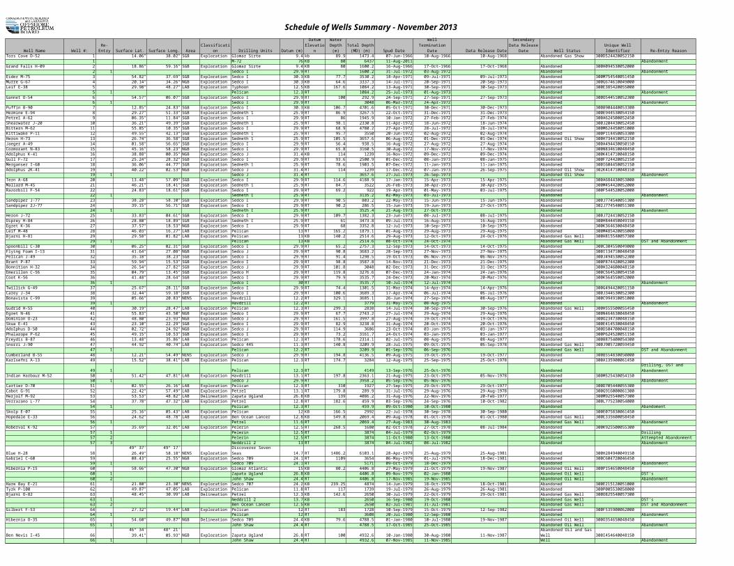
Schedule of Wells Summary - November 2013
Well Name Well #: Surface Lat. Surface Long. Area Classification Drilling Units Datum (m) Spud Date Data Release Date Well Status Unique Well Identifier Re-Entry ReasonTors Cove D-52 1 44° 11' 14.06" 52° 23' 38.02" SGB Exploration Glomar Sirte 9.4 kb 89.9 1473.4 07-Jun-1966 10-Aug-1966 10-Aug-1968 Abandoned Gas Show 300D524420052150
1 M-72 76 KB 80 6437 11-Aug-2011 AbandonmentGrand Falls H-09 2 45° 28' 18.86" 51° 59' 59.16" SGB Exploration Glomar Sirte 9.4 KB 80 1600.2 16-Aug-1966 17-Oct-1966 17-Oct-1968 Abandoned 300H094530052000
2 1 Sedco I 29.9 RT 1600.2 31-Jul-1972 03-Aug-1972 Abandoned AbandonmentEider M-75 3 45° 34' 54.82" 51° 56' 37.69" SGB Exploration Sedco I 30.3 KB 77.7 3530.2 18-Apr-1971 09-Jul-1971 09-Jul-1973 Abandoned 300M754540051450Murre G-67 4 46° 06' 20.14" 49° 09' 34.26" NGB Exploration Sedco I 30.3 KB 64.6 3337.3 14-Jul-1971 20-Sep-1971 20-Sep-1973 Abandoned 300G674610049000Leif E-38 5 54° 17' 29.98" 55° 05' 48.27" LAB Exploration Typhoon 12.5 KB 167.6 1084.2 13-Aug-1971 30-Sep-1971 30-Sep-1973 Abandoned 300E385420055000
5 1 Pelican 12.3 RT 1084.2 25-Jul-1973 01-Aug-1973 Abandoned AbandonmentGannet O-54 6 45° 03' 54.57" 52° 38' 06.07" SGB Exploration Sedco I 29.9 RT 100 292.9 24-Sep-1971 27-Sep-1971 27-Sep-1973 Abandoned 300O544510052300
6 1 Sedco I 29.9 RT 3048 06-Mar-1972 24-Apr-1972 Abandoned Drilling and AbandonmentPuffin B-90 7 44° 39' 12.85" 53° 42' 24.83" SGB Exploration Sedco I 30.3 KB 106.7 4701.6 05-Oct-1971 30-Dec-1971 30-Dec-1973 Abandoned 300B904440053300Hermine E-94 8 45° 23' 29.27" 54° 29' 51.33" SGB Exploration Sedneth 1 25.9 RT 86.9 3267.5 22-Oct-1971 31-Dec-1971 31-Dec-1973 Abandoned 300E944530054150Petrel A-62 9 44° 51' 06.35" 52° 54' 11.84" SGB Exploration Sedco I 29.9 RT 86 1945.9 10-Jan-1972 27-Feb-1972 27-Feb-1974 Abandoned 300A624500052450Shearwater J-20 10 44° 29' 36.21" 52° 46' 49.39" SGB Exploration Sedneth 1 25.9 RT 98.1 2330.8 11-Apr-1972 18-Jun-1972 18-Jun-1974 Abandoned 300J204430052450Bittern M-62 11 44° 41' 55.85" 51° 10' 10.35" SGB Exploration Sedco I 29.9 RT 68.9 4780.2 27-Apr-1972 28-Jul-1972 28-Jul-1974 Abandoned 300M624450051000Kittiwake P-11 12 44° 40' 49.55" 53° 31' 42.13" SGB Exploration Sedneth 1 25.9 RT 95.7 3550 20-Jun-1972 02-Aug-1972 02-Aug-1974 Abandoned 300P114450053300Heron H-73 13 44° 02' 26.74" 52° 25' 36.58" SGB Exploration Sedneth 1 25.9 RT 105.5 3657.6 06-Aug-1972 01-Dec-1972 01-Dec-1974 Abandoned Oil Show 300H734410052150Jaeger A-49 14 44° 28' 01.58" 50° 20' 56.65" SGB Exploration Sedco I 29.9 RT 56.4 938.5 16-Aug-1972 27-Aug-1972 27-Aug-1974 Abandoned 300A494430050150Cormorant N-83 15 46° 02' 45.16" 48° 57' 58.23" NGB Exploration Sedco I 29.9 RT 65.8 3160.5 30-Aug-1972 17-Nov-1972 17-Nov-1974 Abandoned 300N834610048450Adolphus K-41 16 47° 00' 38.88" 48° 22' 00.35" NGB Exploration Sedco J 31.4 KB 114 1239 16-Nov-1972 09-Dec-1972 09-Dec-1974 Abandoned 300K414710048150Gull F-72 17 44° 11' 25.24" 52° 26' 28.32" SGB Exploration Sedco I 29.9 RT 93.6 2500.9 01-Dec-1972 08-Jan-1973 08-Jan-1975 Abandoned 300F724420052150Merganser I-60 18 44° 49' 36.06" 52° 22' 44.77" SGB Exploration Sedneth 1 25.9 RT 78.6 1903.5 07-Dec-1972 11-Jan-1973 11-Jan-1975 Abandoned 300I604450052150Adolphus 2K-41 19 47° 00' 40.22" 48° 22' 02.53" NGB Exploration Sedco J 31.4 RT 114 1239 17-Dec-1972 07-Jan-1973 26-Sep-1975 Abandoned Oil Show 302K414710048150
19 1 Sedco J 31.4 RT 3657.6 27-Jul-1973 26-Sep-1973 Abandoned Oil Show Drilling and AbandonmentTern A-68 20 44° 27' 13.48" 53° 08' 57.09" SGB Exploration Sedco I 29.9 RT 114.6 4188.9 17-Jan-1973 15-Apr-1973 15-Apr-1975 Abandoned 300A684430053000Mallard M-45 21 44° 14' 46.21" 52° 07' 18.41" SGB Exploration Sedneth 1 25.9 RT 84.7 3522 26-Feb-1973 30-Apr-1973 30-Apr-1975 Abandoned 300M454420052000Razorbill F-54 22 45° 13' 24.83" 52° 08' 18.61" SGB Exploration Sedco I 29.9 RT 69.2 922 19-Apr-1973 01-May-1973 03-Jul-1975 Abandoned 300F544520052000
22 1 Sedneth I 25.9 RT 3135.2 02-May-1973 03-Jul-1973 Abandoned Drilling and AbandonmentSandpiper J-77 23 45° 36' 38.28" 51° 40' 58.10" SGB Exploration Sedco I 29.9 RT 90.5 803.2 22-May-1973 15-Jun-1973 15-Jun-1975 Abandoned 300J774540051300Sandpiper 2J-77 24 45° 36' 39.15" 51° 40' 56.71" SGB Exploration Sedco I 29.9 RT 90.2 286.5 15-Jun-1973 19-Jun-1973 27-Oct-1975 Abandoned 302J774540051300
24 1 Sedneth I 25.9 RT 3525.4 21-Aug-1973 27-Oct-1973 Abandoned Drilling and AbandonmentHeron J-72 25 44° 01' 33.83" 52° 26' 04.61" SGB Exploration Sedco I 29.9 RT 109.7 1382.3 23-Jun-1973 08-Jul-1973 08-Jul-1975 Abandoned 300J724410052150Osprey H-84 26 44° 43' 28.80" 49° 27' 18.89" SGB Exploration Sedneth I 25.9 RT 61 3473.8 09-Jul-1973 16-Aug-1973 16-Aug-1975 Abandoned 300H844450049150Egret K-36 27 46° 25' 37.57" 48° 50' 18.53" NGB Exploration Sedco I 29.9 RT 68 3352.8 12-Jul-1973 10-Sep-1973 10-Sep-1975 Abandoned 300K364630048450Leif M-48 28 54° 17' 46.03" 55° 07' 16.27" LAB Exploration Pelican 13 RT 165.2 1879.1 01-Aug-1973 29-Aug-1973 29-Aug-1975 Abandoned 300M485420055000Bjarni H-81 29 55° 30' 29.58" 57° 42' 01.82" LAB Exploration Pelican 13 KB 140.2 2514.6 29-Aug-1973 12-Oct-1973 24-Oct-1976 Abandoned Gas Well 300H815540057300
29 1 Pelican 13 KB 2514.6 08-Oct-1974 24-Oct-1974 Abandoned Gas Well DST and AbandonmentSpoonbill C-30 30 45° 49' 06.25" 49° 04' 02.31" SGB Exploration Sedco I 29.9 RT 65.2 2757.3 12-Sep-1973 14-Oct-1973 14-Oct-1975 Abandoned 300C304550049000Flying Foam I-13 31 47° 02' 41.64" 48° 46' 27.08" NGB Exploration Sedco J 29.9 RT 90.8 3683.2 28-Sep-1973 27-Nov-1973 27-Nov-1975 Abandoned 300I134710048450Pelican J-49 32 45° 28' 35.18" 52° 36' 38.23" SGB Exploration Sedco I 29.9 RT 91.4 1298.5 19-Oct-1973 06-Nov-1973 06-Nov-1975 Abandoned 300J494530052300Brant P-87 33 44° 16' 59.94" 52° 42' 15.53" SGB Exploration Sedco I 29.9 RT 98.8 3587.8 14-Nov-1973 21-Dec-1973 21-Dec-1975 Abandoned 300P874420052300Bonnition H-32 34 45° 51' 26.54" 48° 19' 27.82" SGB Exploration Sedco J 29.9 RT 101.8 3048 02-Dec-1973 31-Dec-1973 31-Dec-1975 Abandoned 300H324600048150Emerillon C-56 35 45° 15' 04.79" 54° 23' 13.45" SGB Exploration Sedco H 29.9 RT 119.8 3276.6 07-Dec-1973 24-Jan-1974 24-Jan-1976 Abandoned 300C564520054150Coot K-56 36 45° 45' 41.48" 52° 08' 28.64" SGB Exploration Sedco I 29.9 RT 79.9 3535.7 24-Dec-1973 20-Mar-1974 20-Mar-1976 Abandoned 300K564550052000
36 1 Sedco I 30 RT 3535.7 10-Jul-1974 12-Jul-1974 Abandoned AbandonmentTwillick G-49 37 44° 18' 25.67" 51° 21' 28.11" SGB Exploration Sedco I 29.9 RT 74.4 1301.5 31-Mar-1974 14-Apr-1974 14-Apr-1976 Abandoned 300G494420051150Carey J-34 38 45° 23' 32.44" 52° 34' 59.18" SGB Exploration Sedco I 29.9 RT 100.6 3689.3 17-Apr-1974 06-Jul-1974 06-Jul-1976 Abandoned 300J344530052300Bonavista C-99 39 49° 08' 05.66" 51° 14' 20.83" NENS Exploration Havdrill 12.2 RT 329.1 3685.1 26-Jun-1974 27-Sep-1974 08-Aug-1977 Abandoned 300C994910051000
39 1 Havdrill 12.2 RT 3779 31-May-1975 08-Aug-1975 Abandoned Drilling and AbandonmentGudrid H-55 40 54° 54' 30.19" 55° 52' 28.47" LAB Exploration Pelican 12.3 RT 299.3 2838 14-Jul-1974 30-Sep-1974 30-Sep-1976 Abandoned Gas Well 300H555500055450Egret N-46 41 46° 25' 55.83" 48° 51' 43.50" NGB Exploration Sedco I 29.9 RT 67.7 2743.2 27-Jul-1974 29-Aug-1974 29-Aug-1976 Abandoned 300N464630048450Dominion O-23 42 47° 22' 48.80" 48° 18' 23.93" NGB Exploration Sedco J 29.9 RT 161.5 3997.8 27-Aug-1974 19-Oct-1974 19-Oct-1976 Abandoned 300O234730048150Skua E-41 43 45° 20' 23.10" 48° 52' 22.29" SGB Exploration Sedco I 29.9 RT 82.9 3238.8 31-Aug-1974 20-Oct-1974 20-Oct-1976 Abandoned 300E414530048450Adolphus D-50 44 46° 59' 02.72" 48° 22' 24.92" NGB Exploration Sedco J 29.9 RT 114.9 3686 23-Oct-1974 03-Jan-1975 03-Jan-1977 Abandoned 300D504700048150Phalarope P-62 45 45° 11' 49.15" 51° 24' 10.53" SGB Exploration Sedco I 29.9 RT 73.2 3161.7 24-Oct-1974 03-Jan-1975 03-Jan-1977 Abandoned 300P624520051150Freydis B-87 46 53° 56' 13.48" 54° 42' 35.86" LAB Exploration Pelican 12.3 RT 178.6 2314.1 02-Jul-1975 08-Aug-1975 08-Aug-1977 Abandoned 300B875400054300Snorri J-90 47 57° 19' 44.92" 59° 57' 40.74" LAB Exploration Sedco 445 11.3 RT 140.8 3209.9 28-Jul-1975 09-Oct-1975 06-Sep-1978 Abandoned Gas Well 300J905720059450
47 1 Pelican 12.2 RT 3209.9 01-Sep-1976 06-Sep-1976 Abandoned Gas Well DST and AbandonmentCumberland B-55 48 48° 24' 12.21" 50° 07' 54.49" NENS Exploration Sedco J 29.9 RT 194.8 4136.5 09-Aug-1975 19-Oct-1975 19-Oct-1977 Abandoned 300B554830050000Karlsefni A-13 49 58° 52' 15.52" 61° 46' 38.41" LAB Exploration Pelican 12.3 RT 174.7 3284 12-Aug-1975 25-Sep-1975 25-Oct-1978 Abandoned 300A135900061450
49 1 Pelican 12.3 RT 4149 13-Sep-1976 25-Oct-1976 AbandonedIndian Harbour M-52 50 54° 21' 51.42" 54° 23' 47.81" LAB Exploration Havdrill 13.1 RT 197.8 2363.1 21-Aug-1975 23-Oct-1975 05-Nov-1978 Abandoned 300M525430054150
50 1 Sedco J 29.9 RT 3958.2 05-Sep-1976 05-Nov-1976 Abandoned Drilling and AbandonmentCartier D-70 51 54° 39' 02.55" 55° 40' 26.16" LAB Exploration Pelican 12.3 RT 310 1927 27-Sep-1975 29-Oct-1975 29-Oct-1977 Abandoned 300D705440055300Cabot G-91 52 59° 50' 22.42" 61° 43' 57.49" LAB Exploration Petrel 13.1 RT 179.8 289.9 31-Jul-1976 29-Aug-1976 29-Aug-1978 Abandoned 300G916000061300Herjolf M-92 53 55° 31' 53.53" 57° 44' 48.82" LAB Delineation Zapata Ugland 26.8 KB 139 4086.2 31-Aug-1976 22-Nov-1976 20-Feb-1977 Abandoned 300M925540057300Verrazano L-77 54 52° 26' 37.78" 54° 11' 47.32" LAB Exploration Petrel 12.8 RT 182.6 459.9 03-Sep-1976 24-Sep-1976 10-Oct-1982 Abandoned 300L775230054000
54 1 Pelican 12.3 RT 459.9 09-Oct-1980 10-Oct-1980 Abandoned AbandomentSkolp E-07 55 58° 26' 25.16" 61° 46' 05.43" LAB Exploration Pelican 12 KB 166.5 2992 22-Jul-1978 30-Sep-1978 30-Sep-1980 Abandoned 300E075830061450Hopedale E-33 56 55° 52' 24.62" 58° 50' 48.78" LAB Exploration Ben Ocean Lancer 12.8 KB 549.8 2069.4 09-Aug-1978 01-Oct-1978 01-Oct-1980 Abandoned Gas Well 300E335600058450
56 1 Petrel 11.6 RT 2069.4 27-Aug-1983 30-Aug-1983 Abandoned Gas Well AbandonmentRoberval K-92 57 54° 51' 35.69" 55° 44' 32.01" LAB Exploration Pelerin 12.5 RT 268.5 1680 02-Oct-1978 27-Oct-1978 08-Jul-1984 Abandoned 300K925500055300
57 1 Pelerin 12.5 RT 3874 04-Jul-1979 02-Oct-1979 Abandoned Drilling57 2 Pelerin 12.5 RT 3874 11-Oct-1980 13-Oct-1980 Abandoned Attempted Abandonment57 3 Neddrill 2 13 RT 3874 04-Jul-1982 08-Jul-1982 Abandoned Abandonment
Blue H-28 58 49° 37' 26.49" 49° 17' 58.18" NENS Exploration Discoverer Seven Seas 14.7 RT 1486.2 6103.1 28-Apr-1979 25-Aug-1979 25-Aug-1981 Abandoned 300H284940049150Gabriel C-60 59 47° 19' 08.43" 46° 53' 25.55" NGB Exploration Sedco 709 24.1 RT 1109 3654 06-May-1979 01-Jul-1979 18-Dec-1981 Abandoned 300C604720046450
59 1 Sedco 709 24.1 RT 5171 09-Oct-1979 18-Dec-1979 Abandoned Drilling and AbandonmentHibernia P-15 60 46° 44' 58.66" 48° 46' 47.30" NGB Exploration Glomar Atlantic 15 KB 80.2 4406.8 27-May-1979 21-Oct-1979 19-Nov-1987 Abandoned Oil Well 300P154650048450
60 1 Zapata Ugland 26.8 KB 4406.8 09-Nov-1979 02-Jan-1980 Abandoned Oil Well DST's60 2 John Shaw 24.4 RT 4406.8 17-Nov-1985 19-Nov-1985 Abandoned Oil Well Abandonment
Hare Bay E-21 61 51° 10' 21.80" 51° 04' 23.30" NENS Exploration Sedco 707 24.2 KB 239.25 4874 14-Jun-1979 18-Oct-1979 18-Oct-1981 Abandoned 300E215120051000Tyrk P-100 62 55° 29' 49.87" 58° 13' 47.05" LAB Exploration Pelican 11.8 RT 117 1739 19-Jul-1979 26-Aug-1979 26-Aug-1981 Abandoned 300P005530058000
Re-Entry
Datum Elevation
Water Depth
(m)Total Depth
(MD) (m)Well Termination
Date
Secondary Data Release
Date
Drilling, DST and Abandonment

Schedule of Wells Summary - November 2013
Well Name Well #: Surface Lat. Surface Long. Area Classification Drilling Units Datum (m) Spud Date Data Release Date Well Status Unique Well Identifier Re-Entry ReasonRe-
EntryDatum
Elevation
Water Depth
(m)Total Depth
(MD) (m)Well Termination
Date
Secondary Data Release
DateBjarni O-82 63 55° 31' 48.45" 57° 42' 30.99" LAB Delineation Petrel 12.3 KB 142.6 2650 30-Jul-1979 22-Oct-1979 29-Oct-1981 Abandoned Gas Well 300O825540057300
63 1 Neddrill 2 13.7 KB 2650 16-Sep-1980 19-Oct-1980 Abandoned Gas Well DST's63 2 Ben Ocean Lancer 12.5 KB 2650 02-Jul-1981 31-Jul-1981 Abandoned Gas Well DST and Abandonment
Gilbert F-53 64 58° 52' 27.32" 62° 08' 19.44" LAB Exploration Pelican 12 RT 183 1728 10-Sep-1979 15-Oct-1979 12-Sep-1982 Abandoned 300F53590006200064 1 Pelican 12 RT 3608 20-Jul-1980 12-Sep-1980 Abandoned Drilling and Abandonment
Hibernia O-35 65 46° 44' 54.60" 48° 49' 49.87" NGB Delineation Sedco 709 24.4 KB 79.6 4788.5 01-Jan-1980 10-Jul-1980 19-Nov-1987 Abandoned Oil Well 300O35465004845065 1 John Shaw 24.4 RT 4788.5 17-Oct-1985 25-Oct-1985 Abandoned Oil Well Abandonment
Ben Nevis I-45 66 46° 34' 39.41" 48° 21' 05.93" NGB Exploration Zapata Ugland 26.8 RT 100 4932.6 10-Jan-1980 30-Aug-1980 11-Nov-1987 300I45464004815066 1 John Shaw 24.4 RT 4932.6 07-Nov-1985 11-Nov-1985 Abandonment
Hibernia B-08 67 46° 47' 06.04" 48° 45' 25.99" NGB Delineation Sedco 706 25.9 KB 82.9 4435.5 19-Mar-1980 06-Jan-1981 02-Jan-1982 300B08465004845067 1 John Shaw 24.4 RT 4435.5 09-Oct-1985 11-Oct-1985 Abandonment
Roberval C-02 68 54° 51' 08.06" 55° 46' 00.76" LAB Exploration Neddrill 2 13.7 KB 276 2823 07-Jul-1980 14-Sep-1980 14-Sep-1982 Abandoned 300C025500055450South Labrador N-79 69 55° 48' 45.49" 58° 26' 29.12" LAB Exploration Glomar Atlantic 11.3 KB 499.9 3571 03-Aug-1980 18-Oct-1980 26-Aug-1985 Abandoned 300N795550058150
69 1 Petrel 11.6 RT 3571 24-Aug-1983 26-Aug-1983 Abandoned AbandonmentOgmund E-72 70 57° 31' 30.10" 60° 26' 34.17" LAB Exploration Pelerin 12.8 KB 156.2 3094 16-Aug-1980 08-Oct-1980 08-Oct-1982 Abandoned 300E725740060150North Leif I-05 71 54° 24' 39.07" 55° 15' 06.69" LAB Exploration Pelican 12 RT 144 423 14-Sep-1980 27-Sep-1980 06-Oct-1983 Abandoned Oil Show 300I055430055150
71 1 Pelerin 12 RT 3513 09-Jul-1981 06-Oct-1981 Abandoned Oil Show Drilling and AbandonmentSouth Tempest G-88 72 47° 07' 19.57" 47° 57' 26.49" NGB Exploration Zapata Ugland 26.8 RT 158.2 4674.8 16-Sep-1980 26-Apr-1981 26-Apr-1983 Abandoned Oil Well 300G884710047450North Bjarni F-06 73 55° 35' 29.57" 57° 45' 45.68" LAB Exploration Pelican 12 RT 150 423 28-Sep-1980 07-Oct-1980 17-Sep-1985 Abandoned Gas Well 300F065540057450
73 1 Ben Ocean Lancer 12.5 RT 2812 03-Aug-1981 06-Oct-1981 Abandoned Gas Well Drilling73 2 Pacnorse 1 12 RT 2812 16-Sep-1983 17-Sep-1983 Abandoned Gas Well Abandonment
Hibernia G-55 74 46° 44' 16.76" 48° 53' 06.88" NGB Delineation Ocean Ranger 29.7 KB 76.5 3460.1 11-Dec-1980 22-Feb-1981 02-Jan-1982 Abandoned 300G554650048450Hebron I-13 75 46° 32' 33.63" 48° 31' 41.58" NGB Exploration Sedco 706 27.4 KB 93.9 4723.5 14-Jan-1981 12-Sep-1981 25-Sep-1987 Abandoned Oil Well 300I134640048300
75 1 John Shaw 24.4 RT 4723.5 21-Sep-1985 25-Sep-1985 Abandoned Oil Well AbandonmentHibernia K-18 76 46° 47' 34.37" 48° 47' 13.17" NGB Delineation Ocean Ranger 29.7 KB 78.3 3819.5 26-Feb-1981 05-Jun-1981 19-Nov-1987 Abandoned Oil Well 300K184650048450
76 1 Zapata Ugland 26.8 KB 5039.3 21-Jun-1981 04-Nov-1981 Abandoned Oil Well Drilling76 2 John Shaw 24.4 RT 5039.3 05-Oct-1985 07-Oct-1985 Abandoned Oil Well Abandonment
Sheridan J-87 77 48° 26' 39.56" 49° 57' 35.30" NENS Exploration Ocean Ranger 29.7 KB 215.8 5486.4 15-Jun-1981 18-Nov-1981 23-Nov-1987 Abandoned 300J87483004945077 1 John Shaw 24.4 RT 5486.4 22-Nov-1985 23-Nov-1985 Abandoned Abandonment
Rut H-11 78 59° 10' 16.99" 62° 16' 43.56" LAB Exploration Pacnorse 1 12 KB 124 3527 14-Jul-1981 27-Sep-1981 13-Sep-1985 Abandoned 300H11592006215078 1 Pacnorse 1 12 KB 4093 24-Jul-1982 12-Oct-1982 Abandoned Drilling78 2 Pacnorse 1 12 KB 4474 04-Aug-1983 13-Sep-1983 Abandoned Drilling and Abandonment
Nautilus C-92 79 46° 51' 03.23" 48° 44' 16.75" NGB Exploration Sedco 706 27.4 RT 84.4 4109 29-Sep-1981 19-Feb-1982 05-Nov-1987 Abandoned Oil Well 300C92470004830079 1 Sedco 706 27.4 RT 5116.7 16-Apr-1982 15-Jul-1982 Abandoned Oil Well Drilling79 2 John Shaw 24.4 RT 5116.7 28-Oct-1985 05-Nov-1985 Abandoned Oil Well Abandonment
Corte Real P-85 80 56° 04' 49.14" 58° 12' 05.46" LAB Exploration Pacnorse 1 12 RT 438 770 05-Oct-1981 13-Oct-1981 09-Aug-1986 Abandoned 300P85561005800080 1 Neddrill 2 13.4 RT 3946 13-Jul-1982 14-Oct-1982 Abandoned Drilling80 2 Neddrill 2 13.4 RT 4395 17-Jul-1983 09-Oct-1983 Abandoned Drilling80 3 Neddrill 2 13.4 RT 4395 05-Aug-1984 09-Aug-1984 Abandoned Abandonment
West Flying Foam L-23 81 47° 02' 43.49" 48° 49' 13.12" NGB Exploration Zapata Ugland 26.8 RT 92 4553.8 11-Nov-1981 14-Feb-1982 11-May-1984 Abandoned 300L234710048450
81 1 Zapata Ugland 26.8 RT 4553.8 14-Apr-1982 11-May-1982 AbandonedHibernia J-34 82 46° 43' 33.53" 48° 50' 09.13" NGB Delineation Ocean Ranger 29 KB 78.3 3711.8 29-Nov-1981 15-Feb-1982 19-Nov-1987 Abandoned Oil Well 300J344650048450
82 1 Neddrill 2 13.4 RT 3711.8 08-Jun-1982 12-Jun-1982 Suspended Suspension82 2 John Shaw 24.4 RT 3711.8 27-Sep-1983 07-Nov-1983 Abandoned Oil Well DST's82 3 John Shaw 24.4 RT 3711.8 28-Sep-1985 01-Oct-1985 Abandoned Oil Well Abandonment
Bonanza M-71 83 47° 30' 47.19" 48° 11' 51.35" NGB Exploration Zapata Ugland 26.8 RT 195.1 4492.8 14-May-1982 14-Sep-1982 02-Feb-1985 Abandoned 300M71474004800083 1 Zapata Ugland 26.8 RT 5294.7 14-Oct-1982 02-Feb-1983 Abandoned Drilling and Abandonment
Pothurst P-19 84 58° 48' 53.85" 60° 31' 28.56" LAB Exploration Pelerin 12 RT 193 3843 13-Jul-1982 22-Oct-1982 21-Sep-1985 Abandoned 300P19585006030084 1 Pelerin 12 RT 3992 24-Aug-1983 21-Sep-1983 Abandoned Drilling and Abandonment
Linnet E-63 85 48° 12' 29.27" 50° 25' 22.28" NENS Exploration Sedco 706 27.1 RT 160 4520.2 18-Jul-1982 13-Nov-1982 13-Nov-1984 Abandoned 300E634820050150North Dana I-43 86 47° 12' 43.23" 47° 36' 08.59" NGB Exploration Sedco 706 27.4 RT 221 5303.6 13-Dec-1982 15-Jan-1984 26-Nov-1987 Abandoned Gas Well 300I434720047300
86 1 0 5303.6 25-Nov-1985 26-Nov-1985 Abandoned Gas Well AbandonmentHibernia I-46 87 46° 45' 38.34" 48° 51' 15.08" NGB Delineation West Venture 33.2 KB 78.7 3435.7 18-Dec-1982 04-Aug-1983 02-Nov-1983 Abandoned Oil Well 300I464650048450Rankin M-36 88 46° 35' 46.27" 48° 50' 52.40" NGB Exploration Zapata Ugland 26.8 RT 72.4 3967.3 02-Apr-1983 06-Aug-1983 06-Aug-1985 Abandoned 300M364640048450Pining E-16 89 54° 45' 22.60" 55° 02' 45.18" LAB Exploration Pelerin 12 RT 176 573 28-Jun-1983 04-Jul-1983 27-Oct-1987 Abandoned 300E165450055000
89 1 Neddrill 2 13 RT 573 27-Oct-1985 27-Oct-1985 Abandoned AbandonmentSouth Hopedale L-39 90 55° 48' 32.85" 58° 50' 45.01" LAB Exploration Petrel 11.6 RT 580 2364 13-Jul-1983 17-Aug-1983 17-Aug-1985 Abandoned 300L395550058450Terra Nova K-08 91 46° 27' 31.28" 48° 30' 55.72" NGB Exploration Sedco 710 24.7 KB 94.2 4499.8 02-Aug-1983 11-Jun-1984 07-Mar-1988 Abandoned Oil Well 300K084630048300
91 1 Vinland 23.3 RT 4499.8 02-Mar-1986 07-Mar-1986 Abandoned Oil Well AbandonmentHibernia B-27 92 46° 46' 10.89" 48° 48' 24.46" NGB Delineation Zapata Ugland 26.8 RT 80.5 4380 08-Aug-1983 15-Dec-1983 19-Nov-1987 Abandoned Oil Well 300B274650048450
92 1 John Shaw 24.4 RT 4380 02-Oct-1985 04-Oct-1985 Abandoned Oil Well AbandonmentHibernia K-14 93 46° 43' 39.51" 48° 47' 32.30" NGB Delineation West Venture 33.2 KB 79.9 4462 09-Aug-1983 14-Jan-1984 19-Nov-1987 Abandoned Oil Well 300K144650048450
93 1 John Shaw 24 RT 4462 15-Sep-1985 17-Sep-1985 Abandoned Oil Well AbandonmentTrave E-87 94 46° 56' 17.21" 47° 58' 05.77" NGB Exploration John Shaw 25.3 RT 137.8 3985.6 12-Nov-1983 18-Mar-1984 26-Jun-1986 Abandoned Gas Well 300E874700047450
94 1 Sedco 706 27.4 RT 3985.6 12-Jun-1984 26-Jun-1984 Abandoned Gas Well DST and AbandonmentHibernia C-96 95 46° 45' 09.88" 48° 44' 31.89" NGB Delineation West Venture 33.2 KB 80.8 4420.2 21-Jan-1984 14-Jul-1984 19-Nov-1987 Abandoned Oil Well 300C964650048300
95 1 John Shaw 24.4 RT 4420.2 18-Sep-1985 18-Sep-1985 Abandoned Oil Well AbandonmentVoyager J-18 96 46° 27' 32.17" 48° 16' 56.58" NGB Exploration Sedco 706 27.4 RT 100.6 3743 26-Feb-1984 11-Jun-1984 11-Jun-1986 Abandoned 300J184630048150
South Mara C-13 97 46° 42' 00.75" 48° 32' 15.73" NGB Exploration John Shaw 25.6 RT 97.2 5034.1 21-Mar-1984 16-Oct-1984 16-Oct-1986 300C134650048300Port au Port J-97 98 46° 16' 38.16" 48° 44' 02.12" NGB Exploration Sedco 710 24.3 KB 71.4 2700 11-Jun-1984 18-Jul-1984 18-Jul-1986 Abandoned 300J974620048300Archer K-19 99 46° 38' 42.83" 48° 02' 14.47" NGB Exploration Bow Drill 3 22 KB 118.9 4299.3 26-Jun-1984 15-Dec-1984 15-Dec-1986 Abandoned 300K194640048000
Whiterose N-22 100 46° 51' 47.65" 48° 03' 52.55" NGB Exploration Sedco 706 27.4 RT 121.9 4627.8 27-Jun-1984 04-Jan-1985 04-Jan-1987 300N224700048000West Ben Nevis B-75 101 46° 34' 00.91" 48° 25' 59.60" NGB Exploration Bow Drill 1 25 RT 96 4887 15-Jul-1984 02-Apr-1985 18-Jul-1987 Abandoned Oil Well 300B754640048150
101 1 Sedco 710 24 RT 4987 27-Apr-1985 18-Jul-1985 Abandoned Oil Well Drilling and AbandonmentTerra Nova K-18 102 46° 27' 43.73" 48° 32' 27.70" NGB Delineation Sedco 710 24.4 KB 91.4 3925.6 19-Jul-1984 24-Nov-1984 11-Jun-1986 Abandoned Oil Show 300K184630048300Mara M-54 103 46° 43' 47.62" 48° 38' 40.59" NGB Exploration John Shaw 24.4 RT 88.1 4445.9 21-Oct-1984 14-May-1985 14-May-1987 Abandoned Oil Well 300M544650048300Beothuk M-05 104 46° 24' 48.23" 48° 31' 10.17" NGB Exploration Vinland 23.8 RT 92.7 3779 05-Nov-1984 25-Jan-1985 25-Jan-1987 Abandoned Oil Well 300M054630048300Conquest K-09 105 47° 08' 34.34" 48° 15' 41.12" NGB Exploration Bow Drill 2 22.9 KB 135.6 4968.3 13-Nov-1984 26-Jul-1985 26-Jul-1987 Abandoned 300K094710048150
105 1 Bow Drill 3 22 RT 4968.3 01-Feb-1986 03-Feb-1986 Abandoned Abandonment
North Ben Nevis P-93 106 46° 42' 47.77" 48° 28' 30.33" NGB Exploration Bow Drill 3 22.2 KB 99.4 5282.2 18-Dec-1984 01-Nov-1985 01-Nov-1987 300P934650048150
Abandoned Oil and Gas WellAbandoned Oil and Gas Well
Abandoned Oil and Gas WellAbandoned Oil and Gas Well
No New Hole, Mechanical Problems
Balder Baffin (Diving - Supply Vessel)
Abandoned Oil and Gas Well
Abandoned Oil and Gas Well
Abandoned Oil and Gas Well

Schedule of Wells Summary - November 2013
Well Name Well #: Surface Lat. Surface Long. Area Classification Drilling Units Datum (m) Spud Date Data Release Date Well Status Unique Well Identifier Re-Entry ReasonRe-
EntryDatum
Elevation
Water Depth
(m)Total Depth
(MD) (m)Well Termination
Date
Secondary Data Release
DatePanther P-52 107 47° 01' 53.01" 47° 37' 39.81" NGB Exploration Sedco 706 27.4 KB 191.4 925.1 10-Jan-1985 22-Jan-1985 30-Jan-1988 Abandoned 300P524710047300
107 1 Bow Drill 3 22 KB 4203.2 06-Nov-1985 30-Jan-1986 Abandoned Drilling and AbandonmentNorth Trinity H-71 108 46° 30' 23.35" 48° 25' 31.62" NGB Delineation Vinland 23.2 RT 97.8 4758 27-Jan-1985 02-Sep-1985 01-Dec-1985 Abandoned Oil Show 300H714640048150Baccalieu I-78 109 47° 57' 41.49" 46° 10' 46.76" NGB Exploration Sedco 709 23.7 RT 1092.8 5135 15-May-1985 14-Sep-1985 14-Sep-1987 Abandoned 300I784800046000Mercury K-76 110 46° 55' 34.31" 48° 56' 30.61" NGB Exploration John Shaw 24.4 RT 84.1 5212.8 19-May-1985 15-Sep-1985 15-Sep-1987 Abandoned 300K764700048450Baie Verte J-57 111 50° 16' 43.58" 51° 07' 49.77" NENS Exploration Bow Drill 1 25 RT 303 4911 10-Jul-1985 16-Oct-1985 16-Oct-1987 Abandoned 300J575020051000
Whiterose J-49 112 46° 48' 30.96" 48° 06' 23.56" NGB Delineation Bow Drill 2 22.9 KB 115.8 4561.4 27-Jul-1985 11-Dec-1985 04-Jan-1987 300J494650048000Terra Nova K-07 113 46° 26' 43.25" 48° 30' 53.88" NGB Delineation Vinland 23 RT 92 3550 05-Sep-1985 21-Nov-1985 11-Jun-1986 Suspended Oil Well 300K074630048300Terra Nova K-17 114 46° 26' 43.19" 48° 32' 27.79" NGB Exploration Sedco 710 24 RT 92.1 3250 25-Sep-1985 14-Nov-1985 14-Nov-1987 Abandoned Oil Show 300K174630048300Gambo N-70 115 46° 19' 52.61" 48° 39' 50.97" NGB Exploration Sedco 710 24 RT 83.8 2515 16-Nov-1985 28-Dec-1985 28-Dec-1987 Abandoned 300N704620048300Terra Nova I-97 116 46° 26' 42.36" 48° 28' 45.55" NGB Delineation Vinland 23.3 RT 92.5 3465 26-Nov-1985 26-Feb-1986 11-Jun-1986 Suspended Oil Well 300I974630048150Whiterose L-61 117 46° 50' 33.78" 48° 10' 24.39" NGB Delineation Bow Drill 2 22.9 KB 114.3 3340.3 18-Dec-1985 26-Mar-1986 04-Jan-1987 Abandoned Gas Well 300L614700048000
117 1 Bow Drill 3 22 KB 3340.3 14-Sep-1986 02-Oct-1986 Abandoned Gas Well DST and Abandonment
North Ben Nevis M-61 118 46° 40' 53.24" 48° 25' 14.69" NGB Delineation Sedco 710 24 KB 100 3250.4 09-Jan-1986 31-Mar-1986 15-Nov-1987 300M614650048150118 1 Bow Drill 3 23 KB 3422 20-Jul-1987 17-Aug-1987 Drilling and Abandonment
Mara E-30 119 46° 39' 29.31" 48° 34' 24.16" NGB Exploration Bow Drill 1 24.9 RT 92.1 2100 13-Jan-1986 15-Feb-1986 15-Feb-1988 Abandoned 300E304640048300Fortune G-57 120 46° 36' 18.56" 48° 07' 58.28" NGB Exploration Bow Drill 3 22.7 RT 113.4 4995.1 05-Feb-1986 09-Sep-1986 09-Sep-1988 Abandoned Oil Well 300G574640048000St. George J-55 121 45° 44' 39.98" 48° 23' 00.42" SGB Exploration Vinland 23 RT 104.5 4100.2 09-Apr-1986 27-May-1986 27-May-1988 Abandoned 300J554550048150Lancaster G-70 122 47° 19' 22.34" 47° 09' 40.77" NGB Exploration Sedco 710 24.1 RT 726 5701 23-Apr-1986 04-Nov-1986 04-Nov-1988 Abandoned 300G704720047000Kyle L-11 123 47° 00' 36.50" 47° 02' 44.88" NGB Exploration Sedco 709 24.1 RT 1119 4200 26-Apr-1986 05-Aug-1986 05-Aug-1988 Abandoned 300L114710047000Golconda C-64 124 46° 53' 11.24" 47° 39' 52.60" NGB Exploration Bow Drill 3 22.9 RT 172.8 4451 05-Oct-1986 01-Feb-1987 01-Feb-1989 Abandoned 300C644700047300Bonne Bay C-73 125 46° 32' 10.41" 48° 11' 26.59" NGB Exploration Bow Drill 3 23 RT 107.3 3718.6 04-Feb-1987 24-Apr-1987 17-Jul-1989 Abandoned Oil Show 300C734640048000
125 1 Bow Drill 3 23 RT 4205.4 20-Jun-1987 17-Jul-1987 Abandoned Oil Show Drilling and AbandonmentTerra Nova H-99 126 46° 28' 29.07" 48° 28' 46.12" NGB Delineation Sedco 710 23.6 RT 94.4 1562 13-Jun-1987 03-Jul-1987 10-Nov-1998 Abandoned Oil Well 300H994630048150
126 1 Sedco 710 23.6 RT 3510 02-Oct-1987 05-Dec-1987 Abandoned Oil Well Drilling126 2 Sedco 710 23.6 RT 3510 09-Aug-1988 12-Aug-1998 Abandoned Oil Well Abandonment
Narwhal F-99 127 44° 18' 22.18" 53° 44' 31.55" SGB Exploration Sedco 710 24 RT 1577 4585 17-Jul-1987 23-Sep-1987 23-Sep-1989 Abandoned 300F994420053300
Whiterose E-09 128 46° 48' 25.90" 48° 01' 18.69" NGB Delineation Bow Drill 3 23 KB 123.4 3970 20-Aug-1987 01-Jul-1988 29-Sep-1988 300E094650048000
128 1 Glomar Grand Banks 34 RT 124 3970 26-Sep-2002 02-Oct-2002 300E094650048000 AbandonmentTerra Nova C-09 129 46° 28' 09.26" 48° 30' 54.91" NGB Delineation Sedco 710 24.1 RT 93.1 3640 13-Dec-1987 04-Mar-1988 30-Oct-1988 Suspended Oil Well 300C094630048300
129 1 Sedco 710 24.1 RT 3640 16-Jun-1988 01-Aug-1988 Suspended Oil Well DSTTerra Nova E-79 130 46° 28' 28.56" 48° 26' 44.40" NGB Delineation Sedco 710 24 RT 95.6 2622 05-Mar-1988 01-Apr-1988 12-Sep-1988 Suspended Oil Well 300E794630048150
130 1 Sedco 710 24 RT 3605 15-Apr-1988 14-Jun-1988 Suspended Oil Well DSTWhiterose A-90 131 46° 49' 10.84" 47° 57' 14.12" NGB Delineation Bow Drill 3 23 RT 128 3025.2 02-Jul-1988 11-Aug-1988 09-Nov-1988 Abandoned 300A904650047450Avondale A-46 132 46° 35' 08.54" 48° 36' 14.48" NGB Exploration Sedco 710 24.1 KB 88.8 2025 01-Aug-1988 21-Aug-1988 21-Aug-1990 Abandoned 300A464640048300South Brook N-30 133 46° 19' 52.57" 48° 34' 01.00" NGB Exploration Sedco 710 24 RT 89.8 1789 21-Aug-1988 18-Sep-1988 18-Sep-1990 Abandoned Oil Show 300N304620048300East Rankin H-21 134 46° 30' 26.42" 48° 48' 06.08" NGB Exploration Sedco 710 24.1 RT 71 2150 19-Sep-1988 27-Oct-1988 27-Oct-1990 Abandoned Oil Show 300H214640048450South Merasheen K-55 135 47° 04' 40.85" 47° 53' 18.79" NGB Exploration Bow Drill 3 23.4 RT 166.7 3545.1 25-Oct-1988 22-Dec-1988 22-Dec-1990 Abandoned Oil Show 300K554710047450Amethyst F-20 136 46° 39' 23.18" 48° 02' 24.08" NGB Exploration Maersk Vinlander 23.4 KB 118 3304.6 25-Dec-1988 09-Feb-1989 09-Feb-1991 Abandoned 300F204640048000
Springdale M-29 137 46° 28' 47.49" 48° 19' 24.31" NGB Exploration Maersk Vinlander 23.2 RT 98.8 3191.9 11-Feb-1989 14-May-1989 14-May-1991 300M294630048150King’s Cove A-26 138 46° 25' 08.64" 48° 33' 01.98" NGB Exploration Sedco 710 23.8 RT 92 3092 06-Mar-1990 17-Jun-1990 17-Jun-1992 Abandoned Oil Show 300A264630048300Thorvald P-24 139 46° 53' 55.71" 48° 48' 10.84" NGB Exploration Treasure Searcher 24.9 RT 86.2 3810 24-Jun-1991 04-Sep-1991 04-Sep-1993 Abandoned Oil Show 300P244700048450Botwood G-89 140 46° 48' 28.57" 48° 27' 12.48" NGB Exploration Treasure Searcher 25 RT 103 3028 06-Sep-1991 10-Oct-1991 10-Oct-1993 Abandoned 300G894650048150Long Point M-16 141 48° 45' 53.72" 58° 47' 35.87" WEST Exploration Noble Drilling OW842E 8.23 RT 0 3810 10-Sep-1995 19-Jan-1996 19-Jan-1998 Abandoned 300M164850058450Long Range A-09 142 48° 28' 03.55" 59° 15' 07.65" WEST Exploration Noble Drilling OW842 8.1 RT 0 3685 24-Feb-1996 26-Jun-1996 26-Jun-1998 Abandoned 300A094830059150St. George’s Bay A-36 143 48° 25' 04.93" 59° 19' 29.29" WEST Exploration Rowan Gorilla IV 39.9 RT 83.8 3240.4 15-May-1996 27-Jul-1996 27-Jul-1998 Abandoned 300A364830059150Hibernia B-16 1 144 46° 45' 01.26" 48° 46' 53.57" NGB Development M-71 76 KB 80 4600 28-Jul-1997 02-Dec-1997 31-Jan-1998 Oil Producer 300B164650048450West Bonne Bay C-23 145 46° 32' 13.36" 48° 18' 58.87" NGB Exploration Bill Shoemaker 25 RT 100.8 4418 31-Jul-1997 24-Jan-1998 24-Jan-2000 Abandoned Oil Well 300C234640048150Hibernia B-16 2 146 46° 45' 02.08" 48° 46' 54.45" NGB Development M-72 76 KB 80 4470 31-Jul-1997 26-Dec-1997 24-Feb-1998 Oil Producer 302B164650048450Man O’War I-42 147 48° 31' 34.60" 58° 51' 11.70" WEST Exploration HS 150-2 22.15 RT 0 677 20-Nov-1997 11-Mar-1998 11-Mar-2000 Abandoned 300I424840058450Hibernia B-16 4 148 46° 45' 01.37" 48° 46' 53.40" NGB Development M-71 76 KB 80 4800 22-Nov-1997 03-Mar-1998 02-May-1998 Abandoned 304B164650048450Hibernia B-16 3 149 46° 45' 01.97" 48° 46' 54.78" NGB Development M-72 76 KB 80 4157 07-Dec-1997 28-Feb-1998 29-Apr-1998 Oil Producer 303B164650048450Hibernia B-16 7 150 46° 45' 02.08" 48° 46' 54.28" NGB Development M-72 76 KB 80 5595 18-Feb-1998 27-May-1998 26-Jul-1998 Water Injector 307B164650048450Hibernia B-16 4Z 151 46° 45' 01.37" 48° 46' 53.40" NGB Development M-71 76 KB 80 4825 03-Mar-1998 03-Jun-1998 02-Aug-1998 Oil Producer 304B164650048451Hibernia B-16 5 152 46° 45' 01.54" 48° 46' 53.49" NGB Development M-71 76 RT 80 6955 06-Apr-1998 05-Aug-1998 04-Dec-1998 Abandoned Gas Injector 305B164650048450
152 1 M-71 76 RT 6955 26-Aug-1998 05-Oct-1998 Suspended Coiled Tubing Fishing152 2 M-71 76 RT 6955 11-Apr-2009 26-Jul-2009 Abandoned Gas Injector Abandonment
Hibernia B-16 6 153 46° 45' 02.03" 48° 46' 54.53" NGB Development M-72 76 KB 80 3970 11-May-1998 30-Jun-1998 29-Aug-1998 Water Injector 306B164650048450Hibernia B-16 9 154 46° 45' 01.85" 48° 46' 54.44" NGB Development M-72 76 KB 80 5270 24-Jun-1998 16-Oct-1998 15-Dec-1998 Water Injector 309B164650048450Hibernia B-16 10 155 46° 45' 01.26" 48° 46' 53.24" NGB Development M-71 76 RT 80 2416 07-Aug-1998 25-Aug-1998 14-Dec-1998 Abandoned 310B164650048450
155 1 M-71 76 RT 3986 21-Sep-1998 15-Oct-1998 Abandoned DrillingHibernia B-16 11 156 46° 45' 02.14" 48° 46' 54.36" NGB Development M-72 76 KB 80 8485 20-Sep-1998 13-Apr-1999 12-Jun-1999 Oil Producer 311B164650048450Hibernia B-16 10Z 157 46° 45' 01.26" 48° 46' 53.24" NGB Development M-71 76 KB 80 7260 15-Oct-1998 26-Jan-1999 27-Mar-1999 Gas Injector 310B164650048451
157 1 27-Sep-2012 01-Dec-2012 Abandoned Gas Injector AbandonmentHebron D-94 158 46° 33' 00.71" 48° 29' 45.79" NGB Delineation Glomar Grand Banks 22.86 RT 93.6 2105 30-Dec-1998 22-Feb-1999 23-May-1999 Abandoned Oil Well 300D944640048150Shoal Point K-39 159 48° 38' 27.75" 58° 50' 34.11" WEST Exploration Nabors 375 ETD 9.33 RT 0 3035 08-Feb-1999 26-May-1999 26-May-2001 Abandoned 300K394840058450Hibernia B-16 14 160 46° 45' 01.26" 48° 46' 53.41" NGB Development M-71 76 RT 80 7890 15-Feb-1999 15-Jul-1999 09-Nov-1999 Oil Producer 314B164650048450
160 1 M-71 76 RT 80 7890 24-Jul-1999 10-Sep-1999 Oil Producer 178 mm Tubing Fishing160 2 M-71 76 RT 80 7890 15-Mar-2013 03-May-2013 Abandoned Oil Producer Abandonment
South Nautilus H-09 161 46° 48' 24.80" 48° 45' 04.33" NGB Exploration Glomar Grand Banks 22.8 RT 83.52 3913 27-Feb-1999 05-Apr-1999 05-Apr-2001 Abandoned 300H094650048450Hibernia B-16 15 162 46° 45' 02.03" 48° 46' 54.36" NGB Development M-72 76 KB 80 6475 05-Mar-1999 16-Jun-1999 15-Aug-1999 Abandoned 315B164650048450White Rose L-08 163 46° 47' 30.64" 48° 01' 20.17" NGB Delineation Bill Shoemaker 25 RT 122.7 3130 07-Apr-1999 13-Jun-1999 11-Sep-1999 Suspended Oil Well 300L084650048000White Rose L-08 163 1 Glomar Grand Banks 34 RT 124 3130 22-Sep-2002 23-Sep-2002 Abandoned Oil Well AbandonmentBen Nevis L-55 164 46° 34' 31.48" 48° 23' 44.17" NGB Delineation Glomar Grand Banks 22.8 RT 98.14 2650 08-Apr-1999 10-May-1999 08-Aug-1999 Abandoned Oil Well 300L554640048150Brent's Cove I-30 165 46° 29' 30.79" 48° 33' 02.18" NGB Exploration Glomar Grand Banks 22.8 RT 91 4070 12-May-1999 09-Jul-1999 09-Jul-2001 Abandoned 300I304630048300Hibernia B-16 15Z 166 46° 45' 02.03" 48° 46' 54.36" NGB Development M-72 76 KB 80 6437 16-Jun-1999 11-Aug-1999 10-Oct-1999 Gas Injector 315B164650048451White Rose A-17 167 46° 46' 07.76" 48° 01' 41.11" NGB Delineation Bill Shoemaker 25 RT 119.5 3200 16-Jun-1999 04-Aug-1999 02-Nov-1999 Suspended Oil Well 300A174650048000
167 1 Glomar Grand Banks 38 RT 119.5 3200 18-Sep-2002 22-Sep-2002 Abandoned Oil Well 300A174650048000 AbandonmentHibernia B-16 17 168 46° 45' 01.43" 48° 46' 53.82" NGB Development M-71 76 RT 80 508 16-Jul-1999 22-Jul-1999 12-Jan-2000 Oil Producer 317B164650048450
168 1 M-71 76 RT 4133 29-Aug-1999 13-Nov-1999 Oil Producer Drilling and Completion
Abandoned Oil and Gas Well
Abandoned Oil and Gas WellAbandoned Oil and Gas Well
Suspended Oil and Gas Well
Abandoned Oil and Gas Well
Abandoned Oil and Gas Well

Schedule of Wells Summary - November 2013
Well Name Well #: Surface Lat. Surface Long. Area Classification Drilling Units Datum (m) Spud Date Data Release Date Well Status Unique Well Identifier Re-Entry ReasonRe-
EntryDatum
Elevation
Water Depth
(m)Total Depth
(MD) (m)Well Termination
Date
Secondary Data Release
DateTerra Nova G-90 2 169 46° 29' 21.71" 48° 27' 38.22" NGB Development Henry Goodrich 21.15 KB 94 4042 19-Jul-1999 20-Jun-2000 19-Aug-2000 Abandoned 302G904630048150Terra Nova G-90 3 170 46° 29' 21.71" 48° 27' 37.72" NGB Development Henry Goodrich 21.15 KB 94 4282 21-Jul-1999 13-May-2001 12-Jul-2001 Oil Producer 303G904630048150Terra Nova G-90 1 171 46° 29' 21.41" 48° 27' 37.26" NGB Development Henry Goodrich 21.15 KB 94 4130 23-Jul-1999 24-Jun-2001 23-Aug-2001 Water Injector 300G904630048150Hibernia B-16 16 172 46° 45' 01.97" 48° 46' 54.61" NGB Development M-72 76 RT 80 4328 26-Jul-1999 11-Sep-1999 07-Jan-2000 Water Injector 316B164650048450
172 1 M-72 76 RT 4870 28-Sep-1999 08-Nov-1999 Water Injector Drilling and CompletionTerra Nova L-98 3 173 46° 27' 41.83" 48° 29' 49.88" NGB Development Glomar Grand Banks 22.8 KB 94 3681 11-Aug-1999 21-Nov-2000 20-Jan-2001 Gas Injector 303L984630048150White Rose N-30 174 46° 49' 49.75" 48° 03' 45.40" NGB Delineation Bill Shoemaker 25 RT 120 3290 13-Aug-1999 14-Oct-1999 12-Jan-2000 Suspended 300N304650048000
1 Glomar Grand Banks 38 RT 120 3290 23-Sep-2002 26-Sep-2002 Abandoned 300N304650048000 AbandonmentTerra Nova L-98 2 175 46° 27' 42.05" 48° 29' 50.74" NGB Development Henry Goodrich 21.15 RT 94 4813 14-Aug-1999 03-Dec-2000 09-Aug-2007 Oil Producer 302L984630048150
175 1 Henry Goodrich 21.15 RT 4813 18-May-2007 10-Jun-2007 Oil Producer Replace TubingTerra Nova L-98 1 176 46° 27' 42.28" 48° 29' 51.11" NGB Development Glomar Grand Banks 22.8 RT 94 3756.7 15-Aug-1999 15-Nov-1999 14-Jan-2000 Abandoned 300L984630048150Hibernia B-16 12 177 46° 45' 01.97" 48° 46' 54.28" NGB Development M-72 76 RT 80 512 12-Sep-1999 19-Sep-1999 18-Apr-2000 Gas Injector 312B164650048450
177 1 M-72 76 RT 6154 30-Oct-1999 18-Feb-2000 Gas Injector Drilling and CompletionTerra Nova L-98 1Z 178 46° 27' 42.19" 48° 29' 51.18" NGB Development Glomar Grand Banks 22.8 KB 94 4183 05-Nov-1999 25-Oct-2000 24-Dec-2000 Oil Producer 300L984630048151Hibernia B-16 18 179 46° 45' 01.20" 48° 46' 53.32" NGB Development M-71 76 KB 80 8180 12-Nov-1999 05-Jul-2000 03-Sep-2000 Oil Producer 318B164650048450Hibernia B-16 19 180 46° 45' 01.85" 48° 46' 54.78" NGB Development M-72 76 KB 80 3890 07-Feb-2000 19-Mar-2000 18-May-2000 Abandoned 319B164650048450Hebron M-04 181 46° 33' 45.70" 48° 31' 24.67" NGB Delineation Glomar Grand Banks 22.8 RT 92.8 4587 12-Feb-2000 31-May-2000 29-Aug-2000 Abandoned 300M044640048300Hibernia B-16 19Z 182 46° 45' 01.85" 48° 46' 54.78" NGB Development M-72 76 KB 80 4462 19-Mar-2000 27-May-2000 26-Jul-2000 Oil Producer 319B164650048451White Rose H-20 183 46° 49' 29.45" 48° 01' 38.08" NGB Delineation Sedco 714 26.4 KB 123.1 3382 07-May-2000 25-Jun-2000 23-Sep-2000 Abandoned 300H204650048000Hibernia B-16 20 184 46° 45' 01.91" 48° 46' 54.53" NGB Development M-72 76 KB 80 184 10-May-2000 14-May-2000 06-Aug-2000 Abandoned 320B164650048450
184 1 M-72 76 RT 1650 17-May-2000 07-Jun-2000 Abandoned Drilling and CompletionRiverhead N-18 185 46° 17' 54.97" 48° 47' 30.87" NGB Exploration Glomar Grand Banks 22.8 RT 68.3 2626 03-Jun-2000 03-Jul-2000 03-Jul-2002 Abandoned 300N184620048450Hibernia B-16 20Z 186 46° 45' 01.91" 48° 46' 54.53" NGB Development M-72 76 RT 80 1965.4 07-Jun-2000 18-Jun-2000 17-Aug-2000 Abandoned 320B164650048451Hibernia B-16 20Y 187 46° 45' 01.91" 48° 46' 54.53" NGB Development M-72 76 RT 80 4682 18-Jun-2000 22-Jul-2000 21-Dec-2000 Water Injector 320B164650048452
187 1 M-72 76 RT 6210 03-Sep-2000 22-Oct-2000 Water Injector Drilling and CompletionTerra Nova G-90 2Z 188 46° 29' 21.66" 48° 27' 38.12" NGB Development Henry Goodrich 21.15 KB 94 3877 20-Jun-2000 30-Jun-2000 29-Aug-2000 Abandoned 302G904630048151Hibernia B-16 8 189 46° 45' 01.43" 48° 46' 53.32" NGB Development M-71 76 RT 80 2498 27-Jun-2000 24-Jul-2000 20-Feb-2001 Oil Producer 308B164650048450
189 1 M-71 76 RT 6356 02-Sep-2000 22-Dec-2000 Oil Producer Drilling and CompletionCape Race N-68 190 46° 37' 45.31" 48° 24' 45.88" NGB Exploration Sedco 714 26.4 KB 99 2950 27-Jun-2000 30-Jul-2000 30-Jul-2002 Abandoned 300N684640048150Terra Nova G-90 2Y 191 46° 29' 21.66" 48° 27' 38.12" NGB Development Henry Goodrich 21.15 KB 94 4209 30-Jun-2000 21-Jul-2000 19-Sep-2000 Abandoned 302G904630048152Terra Nova G-90 2X 192 46° 29' 21.66" 48° 27' 38.12" NGB Development Henry Goodrich 21.15 KB 94 5069 21-Jul-2000 27-Aug-2000 26-Oct-2000 Abandoned 302G904630048153Hibernia B-16 21 193 46° 45' 02.08" 48° 46' 54.61" NGB Development M-72 76 RT 80 512 24-Jul-2000 30-Jul-2000 21-Feb-2001 Water Injector 321B164650048450
193 1 M-72 76 RT 4335 25-Oct-2000 23-Dec-2000 Water Injector Drilling and Completion193 2 M-72 76 RT 4335 23-Jan-2009 27-Mar-2009 Abandoned Abandoned
Hibernia B-16 22 194 46° 45' 01.14" 48° 46' 53.57" NGB Development M-71 76 RT 80 508 05-Aug-2000 10-Aug-2000 01-Apr-2001 Oil Producer 322B164650048450194 1 M-71 76 RT 4090 10-Dec-2000 31-Jan-2001 Oil Producer Drilling and Completion194 2 M-71 76 RT 09-May-2012 Abandoned Abandonment
Terra Nova G-90 2W 195 46° 29' 21.66" 48° 27' 38.12" NGB Development Henry Goodrich 21.15 KB 94 5443 27-Aug-2000 24-Jun-2001 23-Aug-2001 Oil Producer 302G904630048154Hibernia B-16 23 196 46° 45' 02.08" 48° 46' 54.78" NGB Development M-72 76 KB 80 4536 26-Dec-2000 28-Mar-2001 27-May-2001 Oil Producer 323B164650048450Hibernia B-16 24 197 46° 45' 01.26" 48° 46' 53.74" NGB Development M-71 76 RT 80 4731 03-Feb-2001 12-Apr-2001 11-Jun-2001 Oil Producer 324B164650048450Hibernia B-16 25 198 46° 45' 01.80" 48° 46' 54.69" NGB Development M-72 76 RT 80 4627 24-Feb-2001 22-May-2001 21-Jul-2001 Oil Producer 325B164650048450
198 1 M-72 76 RT 4627 28-Nov-2007 21-Mar-2008 Abandoned AbandonmentHibernia B-16 26 199 46° 45' 01.43" 48° 46' 53.49" NGB Development M-71 76 KB 80 8208 15-Apr-2001 24-Sep-2001 23-Nov-2001 Gas Injector 326B164650048450Hibernia B-16 27 200 46° 45' 02.14" 48° 46' 54.53" NGB Development M-72 76 KB 80 5886 25-Apr-2001 20-Jul-2001 18-Sep-2001 Gas Injector 327B164650048450Hibernia B-16 28 201 46° 45' 02.25" 48° 46' 54.70" NGB Development M-72 76 RT 80 7335 10-Jul-2001 08-Nov-2001 07-Jan-2002 Abandoned Oil Well 328B164650048450Terra Nova L-98 4 202 46° 27' 42.36" 48° 29' 51.59" NGB Development Henry Goodrich 21.15 KB 94 3640 23-Jul-2001 18-Sep-2001 17-Nov-2001 Oil Producer 304L984630048150Hibernia B-16 30 203 46° 45' 01.20" 48° 46' 53.49" NGB Development M-71 76 KB 80 4243 09-Sep-2001 27-Apr-2002 26-Jun-2002 Abandoned 330B164650048450Hibernia B-16 29 204 46° 45' 01.49" 48° 46' 53.40" NGB Development M-71 76 KB 80 7893 19-Sep-2001 02-Apr-2002 01-Jun-2002 Oil Producer 329B164650048450Terra Nova C-69 1 205 46° 28' 05.27" 48° 25' 00.23" NGB Development Henry Goodrich 21.15 KB 94 3885 21-Sep-2001 10-Nov-2001 09-Jan-2002 Suspended Oil Producer 300C694630048150Hibernia B-16 31 206 46° 45' 01.85" 48° 46' 54.61" NGB Development M-71 76 KB 80 5805 11-Nov-2001 21-Feb-2002 22-Apr-2002 Water Injector 331B164650048450Terra Nova F-88 1 207 46° 27' 19.92" 48° 27' 41.43" NGB Development Henry Goodrich 21.15 KB 94 3760 04-Jul-2001 31-Dec-2001 01-Mar-2002 Water Injector 300F884630048150Terra Nova G-90 4 208 46° 29' 21.61" 48° 27' 37.01" NGB Development Henry Goodrich 21.15 KB 94 3980 20-Jan-2002 14-Apr-2002 13-Jun-2002 Abandoned 304G904630048150Hibernia B-16 32 209 46° 45' 01.91" 48° 46' 54.88" NGB Development M-72 76 KB 80 5127 31-Jan-2002 16-Apr-2002 15-Jun-2002 Water Injector 332B164650048450Terra Nova G-90 5 210 46° 29' 21.60" 48° 27' 37.79" NGB Development Henry Goodrich 21.15 KB 94 3910 06-Mar-2002 09-Apr-2002 08-Jun-2002 Abandoned 305G904630048150Hibernia B-16 33 211 46° 45' 01.91" 48° 46' 54.36" NGB Development M-71 76 KB 80 5255 10-Apr-2002 13-Jul-2002 11-Sep-2002 Oil Producer 333B164650048450Terra Nova L-98 5 212 46° 27' 41.78" 48° 29' 49.94" NGB Development Henry Goodrich 21.15 KB 94 3560 17-Apr-2002 08-Jun-2002 07-Aug-2002 Water Injector 305L984630048150Terra Nova L-98 6 213 46° 27' 41.92" 48° 29' 50.36" NGB Development Henry Goodrich 21.15 RT 94 408 23-Apr-2002 28-Apr-2002 06-Apr-2003 Gas Injector 306L984630048150
213 1 Henry Goodrich 21.15 RT 4030 02-Dec-2002 05-Feb-2003 Gas Injector Drilling and Completion213 2 Henry Goodrich 21.15 RT 4030 26-Mar-2007 26-Mar-2007 Abandoned Abandonment
Hibernia B-16 30Z 214 46° 45' 01.20" 48° 46' 53.49" NGB Development M-71 76 RT 80 4440 27-Apr-2002 06-Aug-2002 05-Oct-2002 Water Injector 330B164650048451Terra Nova L-98 7 215 46° 27' 42.38" 48° 29' 52.09" NGB Development Henry Goodrich 21.15 RT 94 4146 17-May-2002 01-Jul-2002 30-Aug-2002 Water Injector 307L984630048150Hibernia B-16 34 216 46° 45' 01.15" 48° 46' 53.40" NGB Development M-71 76 KB 80 6181 23-May-2002 20-Jul-2002 18-Sep-2002 Abandoned 334B164650048450Terra Nova L-98 7Z 217 46° 27' 42.38" 48° 29' 52.09" NGB Development Henry Goodrich 21.15 RT 94 4310 01-Jul-2002 28-Jul-2002 26-Sep-2002 Abandoned 307L984630048151Hibernia B-16 28Z 218 46° 45' 02.25" 48° 46' 54.70" NGB Development M-72 76 RT 80 6780 10-Jul-2002 20-Oct-2002 19-Dec-2002 Oil Producer 328B164650048451Hibernia B-16 34Z 219 46° 45' 01.14" 48° 46' 53.40" NGB Development M-71 76 RT 80 6096 20-Jul-2002 12-Aug-2002 20-Feb-2003 Oil Producer 334B164650048451
219 1 M-71 76 RT 7845 05-Oct-2002 22-Dec-2002 Suspended Drilling219 2 M-71 76 RT 7845 25-Jan-2003 02-Feb-2003 Abandoned Abandonment
Trepassey J-91 220 46° 40' 34.67" 47° 58' 57.46" NGB Exploration Glomar Grand Banks 23 RT 120.2 2995 26-Jul-2002 28-Aug-2002 28-Aug-2004 Abandoned Oil Show 300J914650047450Terra Nova L-98 7Y 221 46° 27' 42.38" 48° 29' 52.09" NGB Development Henry Goodrich 21.15 RT 94 3713 28-Jul-2002 11-Aug-2002 10-Oct-2002 Abandoned 307L984630048152Terra Nova L-98 7X 222 46° 27' 42.38" 48° 29' 52.09" NGB Development Henry Goodrich 21.15 RT 94 4422 11-Aug-2002 22-Sep-2002 21-Nov-2002 Oil Producer 307L984630048153Hibernia B-16 36 223 46° 45' 01.31" 48° 46' 53.49" NGB Development M-71 76 80 503 14-Aug-2002 02-Sep-2002 26-Jan-2004 Oil Producer 336B164650048450
223 1 M-71 76 RT 9356.6 12-Dec-2002 27-Nov-2003 Oil Producer Drilling and CompletionHibernia B-16 38 224 46° 45' 01.37" 48° 46' 53.57" NGB Development M-71 76 RT 80 508 23-Aug-2002 31-Aug-2002 30-Oct-2002 Suspended 338B164650048450
224 1 M-71 76 RT 18-Oct-2013 Drilling Drilling and CompletionGros Morne C-17 225 46° 36' 13.97" 48° 02' 25.02" NGB Exploration Glomar Grand Banks 23 RT 116.7 2273 29-Aug-2002 18-Sep-2002 18-Sep-2004 Abandoned 300C174640048000Hibernia B-16 37 226 46° 45' 01.08" 48° 46' 53.65" NGB Development M-71 76 RT 80 306 02-Sep-2002 05-Sep-2002 17-Jun-2004 Water Injector 337B164650048450
226 1 M-71 76 RT 5484 01-Dec-2003 18-Apr-2004 Water Injector Drilling and Completion226 2 M-71 76 RT 5484 07-Oct-2009 29-Nov-2009 Abandoned Abandonment
Terra Nova C-69 2 227 46° 28' 04.74" 48° 24' 58.83" NGB Development Henry Goodrich 21.15 RT 94 3714 25-Sep-2002 05-Nov-2002 04-Jan-2003 Abandoned 302C694630048150Hibernia B-16 35 228 46° 45' 02.02" 48° 46' 54.70" NGB Development M-72 76 RT 80 4370 03-Oct-2002 22-Feb-2003 23-Apr-2003 Water Injector 335B164650048450Hibernia B-44 229 46° 43' 03.80" 48° 51' 26.31" NGB Delineation Glomar Grand Banks 23 RT 75 3663 09-Oct-2002 09-Dec-2002 09-Mar-2003 Abandoned 300B444650048450Terra Nova C-69 2Z 230 46° 28' 04.74" 48° 24' 58.83" NGB Development Henry Goodrich 21.15 RT 94 4052 06-Nov-2002 26-Nov-2002 25-Jan-2003 Suspended Water Injector 302C694630048151Hibernia B-16 40 231 46° 45' 02.20" 48° 46' 54.78" NGB Development M-72 76 RT 80 304.3 05-Dec-2002 12-Dec-2002 20-Oct-2003 Oil Producer 340B164650048450
231 1 M-72 76 RT 7255 06-Mar-2002 21-Aug-2003 Oil Producer Drilling and CompletionHibernia B-16 39 232 46° 45' 01.97" 48° 46' 54.44" NGB Development M-72 76 RT 80 5297 15-Dec-2002 03-Apr-2003 02-Jun-2003 Water Injector 339B164650048450Hibernia B-16 34Y 233 46° 45' 01.14" 48° 46' 53.40" NGB Development M-71 76 RT 80 7838 02-Feb-2003 30-May-2003 29-Jul-2003 Oil Producer 334B164650048452

Schedule of Wells Summary - November 2013
Well Name Well #: Surface Lat. Surface Long. Area Classification Drilling Units Datum (m) Spud Date Data Release Date Well Status Unique Well Identifier Re-Entry ReasonRe-
EntryDatum
Elevation
Water Depth
(m)Total Depth
(MD) (m)Well Termination
Date
Secondary Data Release
DateMizzen L-11 234 48° 10' 31.75" 46° 17' 35.55" NENS Exploration Eirik Raude 23.75 RT 1153 3823 08-Feb-2003 26-Apr-2003 26-Apr-2005 Abandoned Oil Show 300L114820046150Terra Nova L-98 8 235 46° 27' 42.25" 48° 29' 51.66" NGB Development Henry Goodrich 21.15 RT 94 189 22-May-2003 24-May-2002 21-Jun-2003 Oil Producer 308L984630048150
235 1 Henry Goodrich 21.15 RT 4220 13-Feb-2003 22-Apr-2003 Oil Producer Drilling and CompletionTuckamore B-27 236 47° 26' 05.37" 46° 48' 30.62" NGB Exploration Eirik Raude 25 RT 1134.5 2903 28-Apr-2003 09-Jun-2003 09-Jun-2005 Abandoned 300B274730046450Terra Nova G-90 5Z 237 46° 29' 21.60" 48° 27' 37.79" NGB Development Henry Goodrich 21.15 RT 94 3500 08-May-2003 04-Jun-2003 03-Aug-2003 Abandoned 305G904630048151Terra Nova G-90 5Y 238 46° 29' 21.60" 48° 27' 37.79" NGB Development Henry Goodrich 21.15 RT 94 3697 04-Jun-2003 27-Jul-2003 25-Sep-2003 Oil Producer 305G904630048152Hibernia B-16 41 239 46° 45' 02.02" 48° 46' 54.86" NGB Development M-72 76 RT 80 4075 23-Jun-2003 01-Oct-2003 30-Nov-2003 Oil Producer 341B164650048450
White Rose F-04 240 46° 43' 17.72" 48° 00' 44.33" NGB Delineation Glomar Grand Banks 23 RT 119.4 2993.6 21-Jul-2003 29-Aug-2003 27-Nov-2003 300F044650048000Terra Nova C-69 3 241 46° 28' 05.43" 48° 24' 59.23" NGB Development Henry Goodrich 21.15 RT 117.2 4672 31-Jul-2003 25-Sep-2003 24-Nov-2003 Suspended Water Injector 303C694630048150Hibernia B-16 42 242 46° 45' 01.91" 48° 46' 54.69" NGB Development M-72 76 RT 80 4945 23-Aug-2003 15-Dec-2003 13-Feb-2004 Suspended Oil Well 342B164650048450
242 1 M-72 76 RT 4945 19-Jul-2010 28-Jul-2010 Suspended Suspension
White Rose F-04Z 243 46° 43' 17.72" 48° 00' 44.33" NGB Delineation Glomar Grand Banks 23 RT 119.4 2993.6 29-Aug-2003 29-Sep-2003 28-Dec-2003 300F044650048001Terra Nova F-100 1 244 46° 29' 26.08" 48° 29' 11.69" NGB Development Henry Goodrich 21.15 RT 103.85 4267 28-Sep-2003 19-Dec-2003 28-Apr-2004 Oil Producer 300F004630048150
244 1 Henry Goodrich 21.15 RT 4267 11-Feb-2004 28-Feb-2004 Oil Producer CompletionWhite Rose B-07 8 245 46° 46' 14.24" 48° 00' 38.19" NGB Development GSF Grand Banks 23 RT 130.7 231.3 02-Oct-2003 04-Oct-2003 23-Apr-2006 Water Injector 308B074650048000
245 1 GSF Grand Banks 23 RT 1200 25-Dec-2005 29-Dec-2005 Water Injector Drilling245 2 GSF Grand Banks 23 RT 3395 03-Feb-2006 22-Feb-2006 Water Injector Drilling and Completion
White Rose B-07 2 246 46° 46' 13.99" 48° 00' 36.42" NGB Development Glomar Grand Banks 23 RT 128 4610 04-Oct-2003 09-Mar-2004 26-Sep-2004 Oil Producer 302B074650048000246 1 GSF Grand Banks 23 RT 4610 01-Jun-2004 28-Jul-2004 Oil Producer Completions
White Rose B-07 5 247 46° 46' 14.08" 48° 00' 36.67" NGB Development Glomar Grand Banks 23 RT 130.7 4898 06-Oct-2003 18-Nov-2003 28-Apr-2006 Oil Producer 305B074650048000247 1 GSF Grand Banks 23 RT 4898 30-Dec-2005 31-Jan-2006 Oil Producer Drilling247 2 GSF Grand Banks 23 RT 4898 24-Feb-2006 27-Feb-2006 Oil Producer Tree Running
White Rose B-07 3 248 46° 46' 13.11" 48° 00' 36.89" NGB Development Glomar Grand Banks 23 RT 130.7 970 09-Oct-2003 21-Nov-2003 25-Mar-2005 Oil Producer 303B074650048000248 1 Glomar Grand Banks 23 RT 5137 08-Dec-2004 24-Jan-2005 Oil Producer Drilling
White Rose B-07 7 249 46° 46' 13.43" 48° 00' 38.62" NGB Development Glomar Grand Banks 23 RT 130.7 231 12-Oct-2003 13-Oct-2003 12-Dec-2003 Suspended 307B074650048000White Rose B-07 6 250 46° 46' 13.56" 48° 00' 38.87" NGB Development GSF Grand Banks 23 RT 130.7 232 14-Oct-2003 16-Oct-2003 28-May-2004 Water Injector 306B074650048000
250 1 Glomar Grand Banks 23 RT 1427 26-Oct-2003 31-Oct-2003 Suspended Drilling250 2 Glomar Grand Banks 23 RT 3719 11-Mar-2004 29-Mar-2004 Water Injector Drilling
White Rose B-07 4 251 46° 46' 13.41" 48° 00' 38.35" NGB Development Glomar Grand Banks 23 RT 130.7 232 14-Oct-2003 17-Oct-2004 16-Dec-2004 Water Injector 304B074650048000251 1 Glomar Grand Banks 23 RT 1612 31-Oct-2003 07-Nov-2003 Suspended Drilling251 2 Glomar Grand Banks 23 RT 3998 13-Dec-2003 09-Jan-2004 Water Injector Drilling
White Rose B-07 1 252 46° 46' 14.31" 48° 00' 38.45" NGB Development Glomar Grand Banks 23 RT 130.7 1570 18-Oct-2003 25-Oct-2003 11-Feb-2004 Water Injector 300B074650048000252 1 Glomar Grand Banks 23 RT 3658 21-Nov-2003 13-Dec-2003 Water Injector Drilling
Hibernia B-16 43 253 46° 45' 02.20" 48° 46' 54.45" NGB Development M-72 76 RT 80 4915 19-Nov-2003 12-Apr-2004 11-Jun-2004 Oil Producer 343B164650048450Terra Nova L-98 10 254 46° 27' 42.03" 48° 29' 50.29" NGB Development Henry Goodrich 21.15 RT 94 3794 21-Dec-2003 11-Feb-2004 11-Apr-2004 Gas Injector 310L984630048150Hibernia B-16 44 255 46° 45' 01.48" 48° 46' 53.57" NGB Development M-71 76 RT 80 5618 21-Feb-2004 16-Jun-2004 15-Aug-2004 Gas Injector 344B164650048450Hibernia B-16 45 256 46° 45' 02.14" 48° 46' 54.69" NGB Development M-72 76 RT 80 4617 26-Feb-2004 21-May-2004 20-Jul-2004 Oil Producer 345B164650048450
256 1 M-71 76 RT 4617 23-Sep-2012 Abandoned Oil Well AbandonmentTerra Nova L-98 9 257 46° 27' 42.17" 48° 29' 50.68" NGB Development Henry Goodrich 21.15 RT 94 3740 05-Mar-2004 30-Apr-2004 29-Jun-2004 Oil Producer 309L984630048150White Rose J-22 1 258 46° 51' 38.77" 48° 03' 40.39" NGB Development GSF Grand Banks 23 RT 131 1222 15-Apr-2004 20-Apr-2004 20-Oct-2004 Gas Injector 300J224700048000
258 1 GSF Grand Banks 23 RT 2995 03-Aug-2004 21-Aug-2004 Gas Injector DrillingWhite Rose J-22 2 259 46° 51' 39.62" 48° 03' 39.92" NGB Development Glomar Grand Banks 23 RT 132 1215 24-Apr-2004 30-Apr-2004 01-Nov-2007 Gas Injector 302J224700048000
259 1 Glomar Grand Banks 23 RT 3277 29-Jul-2007 02-Sep-2007 Gas Injector DrillingTerra Nova F-88 2 260 46° 27' 20.01" 48° 27' 41.87" NGB Development Henry Goodrich 21.1 RT 94.25 4202 01-May-2004 11-Jun-2004 10-Aug-2004 Water Injector 302F884630048150Hibernia B-16 46 261 46° 45' 01.20" 48° 46' 53.65" NGB Development M-71 76 RT 80 5403 19-May-2004 28-Aug-2004 27-Oct-2004 Oil Producer 346B164650048450Hibernia B-16 47 262 46° 45' 01.97" 48° 46' 54.94" NGB Development M-72 76 RT 80 5344 02-Jun-2004 10-Sep-2004 09-Nov-2004 Water Injector 347B164650048450
262 1 M-72 76 RT 80 16-Mar-2010 4-Apr-2010 Abandoned AbandonmentTerra Nova F-100 2 263 46° 29' 26.04" 48° 29' 11.23" NGB Development Henry Goodrich 21.15 RT 94.5 4527 13-Jun-2004 08-Aug-2004 07-Oct-2004 Oil Producer 302F004630048150Terra Nova L-98 11 264 46° 27' 42.16" 48° 29' 51.17" NGB Development Henry Goodrich 21.15 RT 95.07 3683 09-Aug-2004 09-Sep-2004 08-Nov-2004 Abandoned 311L984630048150Hibernia B-16 49 265 46° 45' 01.31" 48° 46' 53.65" NGB Development M-71 76 RT 80 2325 09-Aug-2004 09-Sep-2004 08-Nov-2004 Abandoned 349B164650048450Hibernia B-16 48 266 46° 45' 02.14" 48° 46' 54.86" NGB Development M-72 76 RT 80 6651 22-Aug-2004 16-Jan-2005 17-Mar-2005 Abandoned Oil Producer 348B164650048450
266 1 M-72 76 RT 80 6651 29-Sep-2010 3-Dec-2010 Abandoned AbandonmentTerra Nova L-98 11Z 267 46° 27' 42.16" 48° 29' 51.17" NGB Development Henry Goodrich 21.15 RT 95.07 3563 09-Sep-2004 21-Sep-2004 20-Nov-2004 Abandoned 311L984630048151Terra Nova L-98 11Y 268 46° 27' 42.16" 48° 29' 51.17" NGB Development Henry Goodrich 21.15 RT 95.07 3728 21-Sep-2004 10-Nov-2004 09-Jan-2005 Oil Producer 311L984630048152White Rose B-07 9 269 46° 46' 14.18" 48° 00' 37.93" NGB Development Glomar Grand Banks 23 RT 130.7 4404.7 22-Sep-2004 28-Sep-2004 19-Nov-2005 Water Injector 309B074650048000
269 1 Glomar Grand Banks 23 RT 4404.7 24-Jan-2005 22-Feb-2005 Suspended Logging269 2 Glomar Grand Banks 23 RT 4404.7 01-Sep-2005 20-Sep-2005 Water Injector Completion
White Rose E-18 2 270 46° 47' 21.07" 48° 02' 37.09" NGB Development Glomar Grand Banks 23 RT 128.3 1010.5 30-Sep-2004 05-Oct-2004 10-Dec-2005 Oil Producer 302E184650048000270 1 Glomar Grand Banks 23 RT 5390 27-Feb-2005 05-May-2005 Suspended Drilling270 2 Glomar Grand Banks 23 RT 5390 11-Jul-2005 18-Jul-2005 Suspended Completion270 3 Glomar Grand Banks 23 RT 5390 21-Sep-2005 11-Oct-2005 Oil Producer Completion
White Rose E-18 3 271 46° 47' 22.53" 48° 02' 38.05" NGB Development Glomar Grand Banks 23 RT 127.8 1016 08-Oct-2004 12-Oct-2004 08-Jan-2006 Water Injector 303E184650048000271 1 Glomar Grand Banks 23 RT 4725.5 11-May-2005 22-Jun-2005 Suspended Drilling271 2 Glomar Grand Banks 23 RT 4725.5 18-Jul-2005 26-Jul-2005 Suspended Attempted Completion271 3 Glomar Grand Banks 23 RT 4725.5 11-Oct-2005 09-Nov-2005 Water Injector Completion
White Rose E-18 1 272 46° 47' 21.68" 48° 02' 38.26" NGB Development Glomar Grand Banks 23 RT 130.7 4243 13-Oct-2004 08-Dec-2004 09-Sep-2005 Water Injector 300E184650048000272 1 Glomar Grand Banks 23 RT 4243 26-Jun-2005 11-Jul-2005 Water Injector Completion
Hibernia B-16 49Z 273 46° 45' 01.31" 48° 46' 53.65" NGB Development M-71 76 RT 80 4665 09-Sep-2004 23-Dec-2004 21-Feb-2005 Oil Producer 349B164650048451Hibernia B-16 50 274 46° 45' 01.14" 48° 46' 53.74" NGB Development M-71 76 RT 80 7033 11-Nov-2004 17-Jun-2005 16-Aug-2005 Water Injector 350B164650048450Terra Nova F-88 3 275 46° 27' 19.90" 48° 27' 41.92" NGB Development Henry Goodrich 21.15 RT 94 3615 02-Dec-2004 20-Jan-2005 21-Mar-2005 Water Injector 303F884630048150Hibernia B-16 16Z 276 46° 45' 01.97" 48° 46' 54.61" NGB Development M-72 76 RT 80 5709 08-Jan-2005 26-Mar-2005 25-May-2005 Water Injector 316B164650048451Terra Nova F-100 3 277 46° 29' 26.12" 48° 29' 11.21" NGB Development Henry Goodrich 21.15 RT 94 3383 21-Jan-2005 15-Feb-2005 15-Aug-2005 Oil Producer 303F004630048150
277 1 Henry Goodrich 21.15 RT 4090 03-May-2005 16-Jun-2005 Oil Producer Drilling and CompletionHibernia B-16 51 278 46° 45' 02.20" 48° 46' 54.61" NGB Delineation M-72 76 RT 80 303 13-Mar-2005 18-Mar-2005 24-Jul-2007 Abandoned 351B164650048450
278 1 M-72 76 RT 5443 15-Dec-2006 25-Apr-2007 Abandoned DrillingHibernia B-16 52 279 46° 45' 02.08" 48° 46' 54.95" NGB Development M-72 76 RT 80 4035 23-Mar-2005 11-Aug-2005 10-Oct-2005 Abandoned 352B164650048450Hibernia B-16 53 280 46° 45' 01.43" 48° 46' 53.65" NGB Development M-71 76 RT 80 5486 08-Apr-2005 28-Sep-2005 27-Nov-2005 Water Injector 353B164650048450Hibernia B-16 20X 281 46° 45' 01.91" 48° 46' 54.53" NGB Development M-72 76 RT 80 6000 10-Apr-2005 29-Jul-2005 27-Sep-2005 Water Injector 320B164650048453Terra Nova F-100 4 282 46° 29' 26.20" 48° 29' 11.66" NGB Development Henry Goodrich 21.15 RT 94 4081 17-Jun-2005 13-Aug-2005 12-Oct-2005 Oil Producer 304F004630048150Lewis Hill G-85 283 44° 34' 18.61" 52° 57' 20.31" SGB Exploration Rowan Gorilla VI 47 RT 100 3218 11-Jul-2005 18-Aug-2005 18-Aug-2007 Abandoned 300G854440052450Hibernia B-16 54 284 46° 45' 01.20" 48° 46' 53.82" NGB Exploration M-71 76 RT 80 7547 01-Aug-2005 15-Feb-2006 15-Feb-2008 Abandoned 354B164650048450Hibernia B-16 52Z 285 46° 45' 02.08" 48° 46' 54.95" NGB Development M-72 76 RT 80 6950 11-Aug-2005 15-Jan-2006 16-Mar-2006 Water Injector 352B164650048451Terra Nova G-90 6 286 46° 29' 21.44" 48° 27' 36.85" NGB Development Henry Goodrich 21.15 RT 94 3242 15-Aug-2005 21-Sep-2005 17-Dec-2005 Abandoned 306G904630048150
Abandoned Oil and Gas Well
Abandoned Oil and Gas Well

Schedule of Wells Summary - November 2013
Well Name Well #: Surface Lat. Surface Long. Area Classification Drilling Units Datum (m) Spud Date Data Release Date Well Status Unique Well Identifier Re-Entry ReasonRe-
EntryDatum
Elevation
Water Depth
(m)Total Depth
(MD) (m)Well Termination
Date
Secondary Data Release
Date286 1 Henry Goodrich 21.15 RT 3242 09-Oct-2005 18-Oct-2005 Abandoned Abandonment
White Rose B-19 287 46° 48' 11.22" 48° 02' 01.47" NGB Delineation Rowan Gorilla VI 47 RT 121 3201 22-Aug-2005 16-Sep-2005 15-Dec-2005 300B194650048000
White Rose B-19Z 288 46° 48' 11.22" 48° 02' 01.47" NGB Delineation Rowan Gorilla VI 47 RT 121 3527 16-Sep-2005 09-Oct-2005 07-Jan-2006 300B194650048001Terra Nova G-90 7 289 46° 29' 21.33" 48° 27' 36.93" NGB Development Henry Goodrich 21.15 RT 93.9 186 22-Sep-2005 07-Oct-2005 19-Jul-2006 Water Injector 307G904630048150
289 1 Henry Goodrich 21.15 RT 4697 20-Mar-2006 20-May-2006 Water Injector CompletionTerra Nova G-90 8 290 46° 29' 21.58" 48° 27' 37.28" NGB Development Henry Goodrich 21.15 RT 94 192 24-Sep-2005 28-Sep-2005 18-Jan-2007 Water Injector 308G904630048150
290 1 Henry Goodrich 21.15 RT 6638 14-Aug-2006 19-Nov-2006 Water Injector Drilling and CompletionTerra Nova G-90 9 291 46° 29' 21.83" 48° 27' 38.16" NGB Development Henry Goodrich 21.15 RT 94 192 29-Sep-2005 30-Sep-2005 29-Nov-2005 Oil Producer 309G904630048150
291 1 Henry Goodrich 21.15 RT 12-May-2011 15-Jul-2011 13-Sep-2011 Oil Producer DrillingTerra Nova G-90 6Z 292 46° 29' 21.44" 48° 27' 36.85" NGB Development Henry Goodrich 21.15 RT 116.3 5939 19-Oct-2005 20-Mar-2006 19-May-2006 Oil Producer 306G904630048151Hibernia B-16 13 293 46° 45' 02.25" 48° 46' 54.53" NGB Development M-72 76 RT 80 500 28-Oct-2005 05-Nov-2005 01-Jul-2006 Abandoned 313B164650048450
293 1 M-72 76 RT 6240 11-Dec-2005 02-May-2006 Oil Producer Drilling and Completion293 2 M-72 76 RT 6240 13-Mar-2012 20-Mar-2012 Abandoned Abandonment
White Rose E-18 4 294 46° 47' 20.99" 48° 02' 36.83" NGB Development GSF Grand Banks 23 RT 128.6 4619 11-Nov-2005 22-Dec-2005 14-Jun-2006 Oil Producer 304E184650048000294 1 GSF Grand Banks 23 RT 4619 18-Mar-2006 15-Apr-2006 Oil Producer Completion
Hibernia B-16 54Y 295 46° 45' 01.20" 48° 46' 53.82" NGB Exploration M-71 76 RT 80 7628 15-Feb-2006 29-Apr-2006 29-Apr-2008 Abandoned 354B164650048452White Rose E-18 5 296 46° 47' 21.76" 48° 02' 38.52" NGB Development GSF Grand Banks 23 RT 129.75 1000 06-Mar-2006 14-Mar-2006 05-Feb-2007 Water Injector 305E184650048000
296 1 GSF Grand Banks 23 RT 4286 04-Jul-2006 08-Aug-2006 Suspended Drilling296 2 GSF Grand Banks 23 RT 4286 27-Oct-2006 07-Dec-2006 Water Injector Completion
White Rose E-18 6 297 46° 47' 21.93" 48° 02' 36.52" NGB Development GSF Grand Banks 23 RT 129.75 1000.4 06-Mar-2006 18-Mar-2006 24-Oct-2007 Abandoned 306E184650048000297 1 GSF Grand Banks 23 RT 3363 09-Aug-2006 25-Aug-2007 Abandoned Drilling
White Rose O-28 298 46° 47' 45.84" 48° 03' 28.56" NGB Delineation Rowan Gorilla VI 47 RT 119 1957 17-Apr-2006 06-May-2006 04-Aug-2006 Abandoned 300O284650048000Hibernia B-16 54X 299 46° 45' 01.20" 48° 46' 53.82" NGB Exploration M-71 76 RT 80 7096 29-Apr-2006 19-May-2006 19-May-2008 Abandoned 354B164650048453White Rose O-28Z 300 46° 47' 45.84" 48° 03' 28.56" NGB Delineation Rowan Gorilla VI 47 RT 119 2456 06-May-2006 10-May-2006 08-Aug-2006 Abandoned 300O284650048001White Rose O-28Y 301 46° 47' 45.84" 48° 03' 28.56" NGB Delineation Rowan Gorilla VI 47 RT 119 3372 10-May-2006 01-Jun-2006 30-Aug-2006 Abandoned 300O284650048002Hibernia B-16 54W 302 46° 45' 01.20" 48° 46' 53.82" NGB Delineation M-71 76 RT 80 7090 20-May-2006 21-Jul-2006 19-Oct-2006 Abandoned 354B164650048454Terra Nova F-88 4 303 46° 27' 19.80" 48° 27' 41.48" NGB Development Henry Goodrich 21.1 RT 119 5617 22-May-2006 14-Aug-2006 13-Oct-2006 Water Injector 304F884630048150Hibernia B-16 55 304 46° 45' 01.80" 48° 46' 54.53" NGB Development M-72 76 RT 80 504 25-May-2006 13-Sep-2006 17-May-2008 Water Injector 355B164650048450
304 1 M-72 76 RT 504 06-Dec-2006 15-Dec-2006 Suspended Drilling304 2 M-72 76 RT 7310 12-Jun-2007 10-Jan-2008 Suspended Drilling304 3 M-72 76 RT 7310 09-Feb-2008 18-Mar-2008 Water Injector Completion
White Rose O-28X 305 46° 47' 45.84" 48° 03' 28.56" NGB Delineation Rowan Gorilla VI 47 RT 119 3487 01-Jun-2006 26-Jun-2006 24-Sep-2006 Abandoned 300O284650048003West Bonne Bay F-12 306 46° 31' 22.14" 48° 17' 27.84" NGB Delineation Rowan Gorilla VI 47 RT 101.27 4600 01-Jul-2006 24-Aug-2006 22-Nov-2006 Abandoned 300F124640048150Hibernia B-16 57 307 46° 45' 01.48" 48° 46' 53.74" NGB Development M-71 76 RT 80 301.3 26-Jul-2006 02-Aug-2006 04-Jan-2008 Abandoned 357B164650048450
307 1 M-71 76 RT 6857 25-Mar-2006 05-Nov-2007 Abandoned DrillingHibernia B-16 59 308 46° 45' 01.37" 48° 46' 53.74" NGB Development M-71 76 RT 80 5930 08-Aug-2006 13-Feb-2007 14-Apr-2007 Oil Producer 359B164650048450Great Barasway F-66 309 49° 25' 25.25" 48° 09' 52.36" NGB Exploration Eirik Raude 25 RT 2338.2 6751 18-Aug-2006 22-Apr-2007 22-Apr-2009 Abandoned 300F664930048000White Rose E-18 6Z 310 46° 47' 21.93" 48° 02' 36.52" NGB Development GSF Grand Banks 23 RT 129.75 5613.3 25-Aug-2006 17-Oct-2006 16-Dec-2006 Oil Producer 306E184650048001West Bonne Bay F-12Z 311 46° 31' 22.14" 48° 17' 27.84" NGB Delineation Rowan Gorilla VI 47 RT 101.27 4015 31-Aug-2006 16-Oct-2006 14-Jan-2007 Abandoned 300F124640048151Hibernia B-16 58 312 46° 45' 01.37" 48° 46' 53.90" NGB Development M-71 76 RT 80 302.64 23-Sep-2006 28-Sep-2006 22-Oct-2008 Abandoned 358B164650048450
312 1 M-71 76 RT 672 12-Aug-2008 23-Aug-2008 Abandoned DrillingHibernia B-16 32Z 313 46° 45' 01.91" 48° 46' 54.86" NGB Development M-72 76 RT 80 3767 27-Sep-2006 05-Dec-2006 15-Mar-2007 Abandoned 332B164650048451
313 1 M-72 76 RT 3767 20-Dec-2006 14-Jan-2007 Oil Producer Completion313 2 M-72 76 RT 15-Jan-2012 12-Feb-2012 Abandoned Abandonment
Hibernia B-16 56 314 46° 45' 01.26" 48° 46' 53.90" NGB Development M-71 76 RT 80 10122 02-Oct-2006 27-May-2010 26-Jul-2010 Oil Producer 356B164650048450314 1 M-71 76 RT 3443 28-Jul-2009 31-Aug-2009 Suspended Drilling314 2 M-71 76 RT 10122 28-Jan-2010 27-May-2010 Oil Producer Drilling
North Amethyst K-15 315 46° 44' 42.55" 48° 02' 20.39" NGB Exploration Rowan Gorilla VI 47 RT 119 2566 19-Oct-2006 12-Nov-2006 12-Nov-2008 Abandoned 300K154650048000Terra Nova I-66 316 46° 25' 38.25" 48° 24' 01.66" NGB Delineation Henry Goodrich 21.15 RT 96.7 3958 21-Nov-2006 16-Feb-2007 17-May-2007 Suspended 300I664630048150White Rose E-18 7 317 46° 47' 22.46" 48° 02' 37.78" NGB Development GSF Grand Banks 23 RT 128.26 5034 10-Dec-2006 02-Mar-2007 01-May-2007 Water Injector 307E184650048000White Rose E-18 8 318 46° 47' 21.85" 48° 02' 36.27" NGB Development GSF Grand Banks 23 RT 128.3 5402 03-Mar-2007 27-Apr-2007 03-Aug-2007 Oil Producer 308E184650048000
318 1 GSF Grand Banks 23 RT 5402 19-May-2007 04-Jun-2007 Oil Producer CompletionTerra Nova L-98 6Z 319 46° 27' 41.92" 48° 29' 50.36" NGB Development Henry Goodrich 21.1 RT 93.8 4236 26-Mar-2007 17-May-2007 16-Jul-2007 Gas Injector 306L984630048151Hibernia B-16 51Z 320 46° 45' 02.20" 48° 46' 54.61" NGB Development M-72 76 RT 80 6000 25-Apr-2007 26-Jun-2007 24-Sep-2007 Oil Producer 351B164650048451White Rose C-30 321 46° 49' 07.49" 48° 04' 01.48" NGB Delineation GSF Grand Banks 23 RT 120 3622 06-Jun-2007 19-Jul-2007 17-Oct-2007 Abandoned Gas Well 300C304650048000Hibernia B-16 57Z 322 46° 45' 01.48" 48° 46' 53.74" NGB Development M-71 76 RT 80 6857 01-Aug-2007 02-Oct-2007 01-Dec-2007 Abandoned 357B164650048451White Rose C-30Z 323 46° 49' 07.49" 48° 04' 01.48" NGB Delineation GSF Grand Banks 23 RT 120.09 3765 13-Sep-2007 19-Nov-2007 17-Feb-2008 Abandoned 300C304650048001Hibernia B-16 61 324 46° 45' 01.31" 48° 46' 53.82" NGB Development M-71 76 RT 80 304.5 07-Nov-2007 14-Nov-2007 01-Apr-2009 Water Injector 361B164650048450
324 1 M-71 76 RT 6200 04-Dec-2008 11-May-2009 Water Injector CompletionHibernia B-16 60 325 46° 45' 01.31" 48° 46' 53.32" NGB Development M-71 76 RT 80 281.6 14-Nov-2007 15-Nov-2007 14-Jan-2008 Water Injector 360B164650048450
325 1 M-71 76 RT 29-May-2012 20-Sep-2012 19-Nov-2012 Water Injector DrillingHibernia B-16 62 326 46° 45' 01.08" 48° 46' 53.49" NGB Development M-71 76 RT 76 302.3 21-Nov-2007 27-Nov-2007 26-Jan-2008 Suspended 362B164650048450White Rose K-03 327 46° 52' 44.72" 48° 01' 02.36" NGB Delineation GSF Grand Banks 23 RT 128.05 3375 21-Nov-2007 08-Jan-2008 07-Apr-2008 Abandoned 300K034700048000Hibernia B-16 63 328 46° 45' 01.54" 48° 46' 53.65" NGB Development M-72 76 RT 80 5938 30-Nov-2007 23-Mar-2008 22-May-2008 Oil Producer 363B164650048450White Rose E-18 9 329 46° 47' 22.40" 48° 02' 37.52" NGB Development GSF Grand Banks 23 RT 129.18 3870 11-Jan-2008 24-Mar-2008 23-May-2008 Water Injector 309E184650048000Glori E-67 330 49° 06' 21.78" 58° 23' 35.15" WEST Exploration P. Sullivan and Son 5 RT 0 10.6 14-Jan-2008 15-Jul-2008 15-Jul-2010 Abandoned 300E674910058150Shoal Point 2K-39 331 48° 38' 35.12" 58° 50' 34.17" WEST Exploration Nabors Rig 45 9.37 KB 0 2865 04-Mar-2008 26-Jun-2008 30-Jul-2010 Abandoned 302K394840058450Hibernia B-16 25Z 332 46° 45' 01.80" 48° 46' 54.69" NGB Development M-72 76 RT 80 5148 21-Mar-2008 25-Apr-2008 24-Jun-2008 Abandoned 325B164650048451Hibernia B-16 25Y 333 46° 45' 01.80" 48° 46' 54.69" NGB Development M-72 76 RT 80 5798 25-Apr-2008 18-Jun-2008 17-Aug-2008 Abandoned 325B164650048452Hibernia B-16 25X 334 46° 45' 01.80" 48° 46' 54.69" NGB Development M-72 76 RT 80 6359 18-Jun-2008 05-Sep-2008 04-Nov-2008 Water Injector 325B164650048453White Rose B-07 10 335 46° 46' 13.16" 48° 00' 37.16" NGB Development GSF Grand Banks 23 RT 130.5 1207.5 19-Jun-2008 10-Jul-2008 08-Sep-2008 Abandoned 310B074650048000Shoal Point 2K-39 Z 336 48° 38' 35.12" 58° 50' 34.17" WEST Exploration Nabors Rig 45 9.37 KB 0 3629 27-Jun-2008 30-Jul-2008 30-Jul-2010 Abandoned 302K394840058451White Rose B-07 10Z 337 46° 46' 13.16" 48° 00' 37.16" NGB Development GSF Grand Banks 23 RT 130.5 5145 10-Jul-2008 06-Sep-2008 05-Nov-2008 Oil Producer 310B074650048001North Amethyst E-17 338 46° 46' 19.20" 48° 02' 49.56" NGB Delineation Henry Goodrich 21.1 RT 119.26 2591 09-Aug-2008 08-Oct-2008 06-Jan-2009 08-Oct-2010 Suspended 300E174650048000Hibernia B-16 58Z 339 46° 45' 01.37" 48° 46' 53.90" NGB Development M-71 76 RT 80 5645 23-Aug-2008 01-Dec-2008 30-Jan-2009 Oil Producer 358B164650048451White Rose E-28 340 46° 47' 21.17" 48° 04' 23.49" NGB Delineation Henry Goodrich 21.15 RT 117.75 3435 13-Oct-2008 04-Dec-2008 04-Mar-2009 Abandoned 300E284650048000White Rose J-22 3 341 46° 51' 39.68" 48° 03' 40.20" NGB Development GSF Grand Banks 23 RT 132.29 5820 24-Oct-2008 02-Mar-2009 24-Sep-2009 Gas Injector 303J224700048000
341 1 GSF Grand Banks 23 RT 5820 07-Jul-2009 26-Jul-2009 Gas Injector CompletionMizzen O-16 342 48° 15' 55.52" 46° 17' 06.67" NENS Exploration Henry Goodrich 21.15 RT 1095 3756 21-Dec-2008 20-Mar-2009 20-Mar-2011 Abandoned Oil Well 300O164820046150North Amethyst G-25 1 343 46° 44' 25.69" 48° 03' 21.46" NGB Development GSF Grand Banks 23 RT 127 3030 02-Mar-2009 04-Jul-2009 02-Sep-2009 08-Oct-2010 Water Injector 300G254650048000
343 1 GSF Grand Banks 23 RT 3030 27-May-2010 10-Jun-2010 Water Injector CompletionNorth Amethyst G-25 2 344 46° 44' 24.65" 48° 03' 21.37" NGB Development GSF Grand Banks 23 RT 129.24 229 11-Mar-2009 13-Mar-2009 26-Jul-2010 Oil Producer 302G254650048000
344 1 GSF Grand Banks 23 RT 1208 13-Apr-2009 19-Apr-2009 Suspended Drilling
Abandoned Oil and Gas Well
Abandoned Oil and Gas Well

Schedule of Wells Summary - November 2013
Well Name Well #: Surface Lat. Surface Long. Area Classification Drilling Units Datum (m) Spud Date Data Release Date Well Status Unique Well Identifier Re-Entry ReasonRe-
EntryDatum
Elevation
Water Depth
(m)Total Depth
(MD) (m)Well Termination
Date
Secondary Data Release
Date344 2 Henry Goodrich 21 RT 3508 04-Dec-2009 12-Jan-2010 Suspended Drilling344 3 GSF Grand Banks 23 RT 4710 12-Mar-2010 27-May-2010 Oil Producer Drilling and Completion
Hibernia B-16 21Z 345 46° 45' 02.08" 48° 46' 54.61" NGB Development M-71 76 RT 80 4290 27-Mar-2009 23-Jul-2009 21-Sep-2009 Water Injector 321B164650048451345 1 Henry Goodrich 21.15 RT 4290 04-Nov-2009 27-Nov-2009 Completion
Terra Nova G-90 4Z 346 46° 29' 21.61" 48° 27' 37.00" NGB Development Henry Goodrich 21.15 RT 94 3656 09-May-2009 22-Jul-2009 20-Sep-2009 Water Injector 304G904630048151346 1 Henry Goodrich 21.15 RT 3656 04-Nov-2009 27-Nov-2009 Water Injector Completion
Ballicatters M-96 347 46° 45' 47.10" 48° 29' 52.19" NGB Exploration Henry Goodrich 21.15 RT 101.4 4017 24-Jul-2009 23-Oct-2009 23-Oct-2011 Abandoned 300M964650048150Hibernia B-16 57Y 348 46° 45' 01.48" 48° 46' 53.74" NGB Development M-71 76 RT 80 2538 05-Sep-2009 15-Sep-2009 14-Nov-2009 Abandoned 357B164650048452Hibernia B-16 57X 349 46° 45' 01.48" 48° 46' 53.74" NGB Development M-71 76 RT 80 5655 15-Sep-2009 26-Nov-2009 25-Jan-2010 Oil Producer 357B164650048453East Wolverine G-37 350 44° 46' 22.60" 55° 04' 55.01" SGB Exploration Stena Carron 31.59 RT 1890 6857 24-Nov-2009 23-Apr-2010 23-Apr-2012 Abandoned 300G374450055000Hibernia B-16 37Z 351 46° 45' 01.08" 48° 46' 53.65" NGB Development M-71 76 RT 80 6358 29-Nov-2009 12-Feb-2010 13-Apr-2010 Water Injector 337B164650048451Glenwood H-69 352 46° 58' 25.08" 48° 09' 05.13" NGB Exploration Henry Goodrich 21.15 RT 126.7 3668 25-Jan-2010 19-Mar-2010 19-Mar-2012 Suspended 300H694700048000North Amethyst G-25 3 353 46° 44' 25.59" 48° 03' 21.12" NGB Development GSF Grand Banks 23 RT 129.24 229 23-Feb-2010 25-Feb-2010 07-Nov-2010 Oil Producer 303G254650048000
353 1 GSF Grand Banks 23 RT 5155 11-Jun-2010 08-Sep-2010 Oil Producer DrillingNorth Amethyst G-25 4 354 46° 44' 25.77" 48° 03' 21.72" NGB Development GSF Grand Banks 23 RT 129.24 227.5 27-Feb-2010 01-Mar-2010 08-Feb-2011 Water Injector 304G254650048000
354 1 GSF Grand Banks 23 RT 4389.5 08-Sep-2010 08-Jan-2011 Water Injector DrillingNorth Amethyst H-14 355 46° 43' 25.18" 48° 01' 32.50" NGB Delineation Henry Goodrich 21.1 RT 119.7 2611 21-Mar-2010 19-Apr-2010 18-Jul-2010 Abandoned 300H144650048000White Rose E-18 10 356 46° 47' 22.01" 48° 02' 36.79" NGB Development Henry Goodrich 21.1 RT 129.1 229 23-Apr-2010 26-Apr-2010 31-Jan-2011 Oil Producer 310E184650048000
356 1 Henry Goodrich 21.1 RT 5628 12-Aug-2010 02-Nov-2010 Oil Producer DrillingLona O-55 357 49° 04' 47.64" 47° 22' 55.12" NENS Exploration Stena Carron 31.6 RT 2602 5580 10-May-2010 22-Aug-2010 22-Aug-2012 Abandoned 300O554910047150Hibernia B-16 5Z 358 46° 45' 01.54" 48° 46' 53.49" NGB Development M-71 76 RT 80 5532 18-May-2010 28-Jul-2010 26-Sep-2010 Oil Producer 305B164650048451Hibernia B-16 54V 359 46° 45' 01.20" 48° 46' 53.82" NGB Development M-71 76 RT 80 7546 21-Aug-2010 13-Dec-2010 11-Feb-2011 Water Injector 354B164650048455Ballicatters M-96Z 360 46° 45' 47.10" 48° 29' 52.19" NGB Exploration Henry Goodrich 21.15 RT 101.4 4212 24-Nov-2010 06-May-2011 6-May-2013 Abandoned 300M964650048151Hibernia B-16 48Z 361 46° 45' 02.14" 48° 46' 54.86" NGB Development M-72 76 RT 80 6500 11-Dec-2010 31-Dec-2010 1-Mar-2011 Abandoned 348B164650048451Hibernia B-16 48Y 362 46° 45' 02.14" 48° 46' 54.86" NGB Development M-72 76 RT 80 7404 31-Dec-2010 27-Apr-2011 27-Jun-2011 Oil Producer 348B164650048452North Amethyst G-25 5 363 46° 44' 24.81" 48° 03' 21.96" NGB Development GSF Grand Banks 23 RT 129.2 1208 16-Jan-2011 3-Feb-2011 20-Sep-2011 Water Injector 305G254650048000
363 1 GSF Grand Banks 23 RT 2990 24-Feb-2011 17-Mar-2011 Water Injector Drilling363 2 GSF Grand Banks 23 RT 14-Jul-2011 22-Jul-2011 Water Injector Completion
North Amethyst G-25 6 364 46° 44' 26.07" 48° 03' 22.92" NGB Development GSF Grand Banks 23 RT 127 1210 5-Feb-2011 24-Feb-2011 29-Jul-2011 Oil Producer 306G254650048000364 1 GSF Grand Banks 23 RT 4961 18-Mar-2011 30-May-2011 Oil Producer Drilling and Completion
Shoal Point 3K-39 365 48° 38' 35.62" 58° 50' 31.71" WEST Exploration Nabors 112 6.7 RT 0 1745 18-Feb-2011 2-Aug-2011 08-Feb-2014 Abandoned 303K394840058450365 1 E-Can Rig #3 6.4 RT 13-Jan-2012 8-Feb-2012 Abandoned Abandonment
Hibernia B-16 47Z 366 46° 45' 01.97" 48° 46' 54.94" NGB Development M-72 76 RT 80 7338 4-Apr-2011 25-Jun-2011 21-Aug-2011 Oil Producer 347B164650048451White Rose E-18 11 367 46° 47' 21.61" 48° 02' 37.99" NGB Development GSF Grand Banks 23 RT 128.3 1208 23-Jun-2011 6-Jul-2011 15-Jun-2012 Water Injector 311E184650048000
367 1 GSF Grand Banks 23 RT 4015 5-Sep-2011 27-Nov-2011 Water Injector Drilling367 2 GSF Grand Banks 23 RT 4015 9-Mar-2012 16-Apr-2012 Water Injector Completion
Hibernia B-16 42Z 368 46° 45' 01.91" 48° 46' 54.69" NGB Development M-72 76 RT 80 6690 25-Jun-2011 6-Sep-2011 17-Nov-2011 Oil Producer 342B164650048451Mizzen F-09 369 48° 18' 21.68" 46° 15' 52.73" NENS Delineation Henry Goodrich 21.15 RT 1067 3762 29-Jul-2011 27-Sep-2011 26-Dec-2011 Abandoned 300F094820046150Fiddlehead D-83 370 46° 22' 08.22" 48° 28' 13.61" NGB Exploration Henry Goodrich 21.15 RT 93.55 1870 4-Oct-2011 18-Nov-2011 18-Nov-2013 Abandoned 300D834630048150Hibernia B-16 15Y 371 46° 45' 02.03" 48° 46' 54.36" NGB Development M-72 76 RT 80 6875 4-Nov-2011 5-Feb-2012 5-Apr-2012 Gas Injector 315B164650048452Shoal Point 3K-39Z 372 48° 38' 35.62" 58° 50' 31.71" WEST Exploration E-Can Rig #3 6.4 RT 0 1703 4-Oct-2011 17-Jul-2012 17-Jul-2014 Suspended 303K394840058451Hibernia B-16 32Y 373 46° 45' 01.91" 48° 46' 54.86" NGB Development M-72 76 RT 80 3645 16-Feb-2012 31-Mar-2012 30-May-2012 Oil Producer 332B164650048452Hibernia B-16 13Z 374 46° 45' 02.25" 48° 46' 54.53" NGB Development M-72 76 RT 80 6601 23-Mar-2012 11-May-2012 10-Jun-2012 Oil Producer 313B164650048451Whiterose B-07 11 375 46° 46' 13.90" 48° 00' 36.17" NGB Development GSF Grand Banks 23 RT 130.75 3819 19-Apr-2012 28-May-2012 7-Oct-2012 Oil Producer 311B074650048000
375 1 GSF Grand Banks 23 RT 4958 18-Jun-2012 3-Aug-2012 Oil Producer DrillingHibernia B-16 22Z 376 46° 45' 01.14" 48° 46' 53.57" NGB Development M-71 76 RT 80 4305 29-May-2012 18-Jun-2012 17-Aug-2012 Oil Producer 322B164650048451Terra Nova L-98 12 377 46° 27' 42.29" 48° 29' 52.64" NGB Development Henry Goodrich 21.15 RT 93 1667 25-May-2012 24-Jun-2012 23-Aug-2012 Abandoned 312L984630048150North Amethyst G-25 7 378 46° 44' 24.72" 48° 03' 21.63" NGB Development Glomar Grand Banks 23 RT 128.7 1208 3-Jun-2012 14-Jun-2012 14-Jan-2013 Oil Producer 307G254650048000
378 1 Henry Goodrich 21.15 RT 3688 5-Jul-2012 2-Aug-2012 Oil Producer Drilling378 2 GSF Grand Banks 23 RT 6246.4 11-Aug-2012 15-Nov-2012 Oil Producer Drilling
Searcher C-87 379 46° 36' 14.09" 47° 57' 54.06" NGB Exploration Henry Goodrich 21.15 RT 121.2 804.9 8-Aug-2012 29-Aug-2012 15-Jan-2015 Abandoned 300C874640047450379 1 GSF Grand Banks 23 RT 2033 26-Nov-2012 15-Jan-2013 Abandoned Drilling
Hibernia B-16 45Z 380 46° 45' 02.14" 48° 46' 54.69" NGB Development M-72 76 RT 80 4562 24-Sep-2012 28-Oct-2012 27-Dec-2012 Oil Producer 345B164650048451Hibernia B-16 10Y 381 46° 45' 01.26" 48° 46' 53.24" NGB Development M71 76 RT 80 4818 2-Dec-2012 23-Feb-2013 24-Apr-2013 Water Injector 310B164650048452North Amethyst G-25 8 382 46° 44' 24.88" 48° 03' 22.22" NGB Development Henry Goodrich 21.15 RT 128.6 4610 18-Jan-2013 1-Apr-2013 12-Oct-2013 Water Injector 308G254650048000
382 1 GSF Grand Banks 23 RT 5492 2-Jul-2013 15-Aug-2013 Water Injector Drilling and CompletionWhite Rose J-05 1 383 46° 44' 38.29" 48° 00' 40.02" NGB Development GSF Grand Banks 23 RT 131 5282 19-Feb-2013 18-Jun-2013 17-Aug-2013 Gas Injector 300J054650048000Margaree A-49 384 48° 58' 02.03" 47° 36' 05.30" NENS Exploration West Aquarius 31 RT 2477 16-Mar-2013 28-Mar-2013 Drilling 300A494900047300
384 1 Stena Carron 32 RT 25-Jul-2013 Drilling DrillingHarpoon O-85 385 48° 04' 52.00" 46° 12' 18.87" NENS Exploration West Aquarius 31 RT 1160 3377 01-Apr-2013 15-Jun-2013 15-Jun-2015 Suspended 300O854810046000Terra Nova L-98 12Z 386 46° 27' 42.29" 48° 29' 52.64" NGB Development Henry Goodrich 21.15 RT 93 4448.5 15-Apr-2013 24-Jun-2013 23-Aug-2013 Oil Producer 312L984630048151Hibernia B-16 14Z 387 46° 45' 01.26" 48° 46' 53.40" NGB Development M71 76 RT 80 8600 19-May-2013 31-Jul-2013 29-Sep-2013 Abandoned 314B164650048451Federation K-87 388 46° 26' 42.96" 48° 12' 43.51" NGB Exploration West Aquarius 31 RT 103 1874 19-Jun-2013 11-Jul-2013 11-Jul-2015 Abandoned 300K874630048000 Terra Nova L-98 13 389 46° 27' 41.45" 48° 29' 49.98" NGB Development Henry Goodrich 21.15 RT 103 646 25-Jun-2013 02-Jul-2013 Suspended 313L984630048150Terra Nova E-19 390 46° 28' 18.96" 48° 32' 37.67" NGB Delineation Henry Goodrich 21.15 RT 92 3573 05-Jul-2013 13-Aug-2013 11-Nov-2013 Abandoned 300E194630048300Bay du Nord C-78 391 47° 57' 00.24" 46° 26' 28.67" NGB Exploration West Aquarius 31 RT 1172 3510 17-Jul-2013 11-Sep-2013 11-Sep-2015 Abandoned 300C784800046150North Amethyst G-25 9 392 46° 44' 25.22" 48° 03' 23.41" NGB Development GSF Grand Banks 23 RT 128 5300 17-Aug-2013 Drilling 309G254650048000White Rose H-70 393 46° 49' 28.97" 48° 09' 06.13" NGB Delineation Henry Goodrich 21.15 RT 113 3523 19-Aug-2013 24-Sep-2013 23-Dec-2013 Abandoned 300H704650048000Hibernia B-16 14Y 394 46° 45' 01.26" 48° 46' 53.40" NGB Development M71 76 RT 80 8748 25-Aug-2013 27-Oct-2013 26-Dec-2013 Oil Producer 314B164650048452Bay du Nord C-78Z 395 47° 57' 00.24" 46° 26' 28.67" NGB Exploration West Aquarius 31 RT 1172 3664 16-Sep-2013 03-Oct-2013 03-Oct-2015 Suspended 300C784800046151White Rose H-70Z 396 46° 49' 28.97" 48° 09' 06.13" NGB Delineation Henry Goodrich 21.15 RT 113 26-Sep-2013 Drilling 300H704650048001North Amethyst G-25 9Z 397 46° 44' 25.22" 48° 03' 23.41" NGB Development GSF Grand Banks 23 RT 128 13-Oct-2013 Drilling 309G254650048001


![ENVIRONMENTAL PROTECTION COMMISSION[567] · 2014-06-25 · wells, recreational-use wells, monitoring wells, heat pump supply wells or GHEX loop boreholes, industrial wells, and dewatering](https://img.pdfslide.us/doc/110x75/5f3f728939b254613866ae00/environmental-protection-commission567-2014-06-25-wells-recreational-use-wells.jpg)