Embed Size (px)
Citation preview

Moving Ahead to a Better Red
Welcome to the
Red Line Extension Project Public HearingThe purpose of this public hearing:
� Share information on the Red Line Extension (RLE) Project
� Summarize results of the recently completed Draft Environmental Impact Statement (EIS)
� Obtain your input on the benefits, impacts, and proposed mitigation measures
If you have questions, feel free to ask the representatives stationed around the boards. There will be no formal presentation.
Comments can be made in two ways during this meeting:
� Provide written comments on comment cards
� Provide verbal comments to the court reporter
Written comments will be accepted through November 30, 2016:
By email: [email protected]
By mail: Chicago Transit Authority Strategic Planning, 10th Floor Attn: Red Line Extension Project 567 W. Lake Street, Chicago, IL 60661

Moving Ahead to a Better Red
The Red Ahead ProgramRed Ahead is a comprehensive initiative for maintaining, modernizing, and expanding Chicago’s most traveled rail line.
Cermak-Chinatown
103rd111th
Michigan
130th
Belmont
Howard
Linden
Wilson Transfer Station ProjectStatus: Started Fall 2014
Clark/DivisionStation RenovationStatus: Completed Fall 2015
Status: Completed Fall 2013
95th Street TerminalImprovementsStatus: Started Fall 2014
Status: In planning
Status: In EngineeringPhase One includes: • Lawrence to Bryn Mawr Modernization Project• Red-Purple Bypass Project• Corridor Signal and Power Improvements (Belmont to Linden)• Interim and Advance Infrastructure Improvements (Belmont to Linden)

Moving Ahead to a Better Red
Why is the RLE Project Important? The RLE Project would accomplish the following:
� Improve service and transit accessibility for Far South Side neighborhoods where transit-dependent residents currently lack direct access to rail service.
� Save the average commuter in the communities affected by this project 87 hours per year.
� Provide better transit access to affordable housing, jobs, services, and educational opportunities.
� Increase accessible jobs within an hour commute of the proposed 111th Street station by 56%, according to Chicago Metropolitan Agency for Planning.
Estimated Travel Time Savings
20 min less
From 130th St. to Loop
60 min
50 min
40 min
30 min
20 min
From Michigan St. and 116th St. to Loop
15 min less
Current CTA travel times
UPRR Rail Alternative travel times*
*UPRR Rail Alternative travel times represent the Locally Pre-ferred Alternative.

Moving Ahead to a Better Red
RLE Project Purpose and NeedProject Purpose
The RLE Project would reduce commute times for residents, improve mobility and accessibility, and provide connection to other transportation modes. The RLE Project could also foster economic development, where new stations may serve as catalysts for neighborhood revitalization and help reverse decades of disinvestment in local business districts. The RLE Project would also provide a modern, efficient car storage yard and shop facility.
Needs to be Addressed
� Transit trips to jobs are longer for Far South Side residents than they are for passengers in the Chicago seven-county region as a whole.
� Transit-dependent populations in the project area have limited direct access to rapid transit rail service.
� The project area is geographically isolated from major activity centers and provides residents limited viable transportation options, which limits access between affordable housing and employment centers outside of the project area.
� Existing transit markets are underserved and transit connectivity is challenging in the project area.
� Disinvestment and limited economic development in the project area have negatively affected Far South Side communities.
� The existing 98th Street Yard does not have capacity to store rail cars for any substantial increase in Red Line capacity accompanying future Red Line expansion.

Moving Ahead to a Better Red
What is an Environmental Impact Statement (EIS)?To acquire future federal funding, the National Environmental Policy Act (NEPA) requires an EIS for any project that may have significant impacts on the environment or where impacts have not yet been determined.
The EIS includes the following:
� A description and comparison of alternatives
� An explanation of the existing environmental setting
� An analysis of potential positive and negative environmental impacts of construction and operation of each alternative
� Proposed mitigation measures to reduce or eliminate potential negative impacts
An EIS allows the public to fully understand the potential environmental impacts of a
project and provide input before final decisions are made.
CTA published the Draft EIS on Thursday, October 6, and is taking public comments until Wednesday, November 30.
Comments and responses will be incorporated into the Final EIS.
Section 4(f)Section 6(f)
RCRA/CERCLAEndangered Species Act
Farmland Protection Policy Act
Clean Air ActClean Water ActFloodplains & WetlandsEnvironmental Justice OrdersNational Historic Preservation Act
NEPANational Environmental Policy Act
Clean Air Act
Section 4(f) – Parks
Endangered Species Act
Hazardous Materials
Clean Water Act
Floodplains & Wetlands
Environmental Justice Orders
National Historic Preservation Act
Moving Ahead to a Better Red
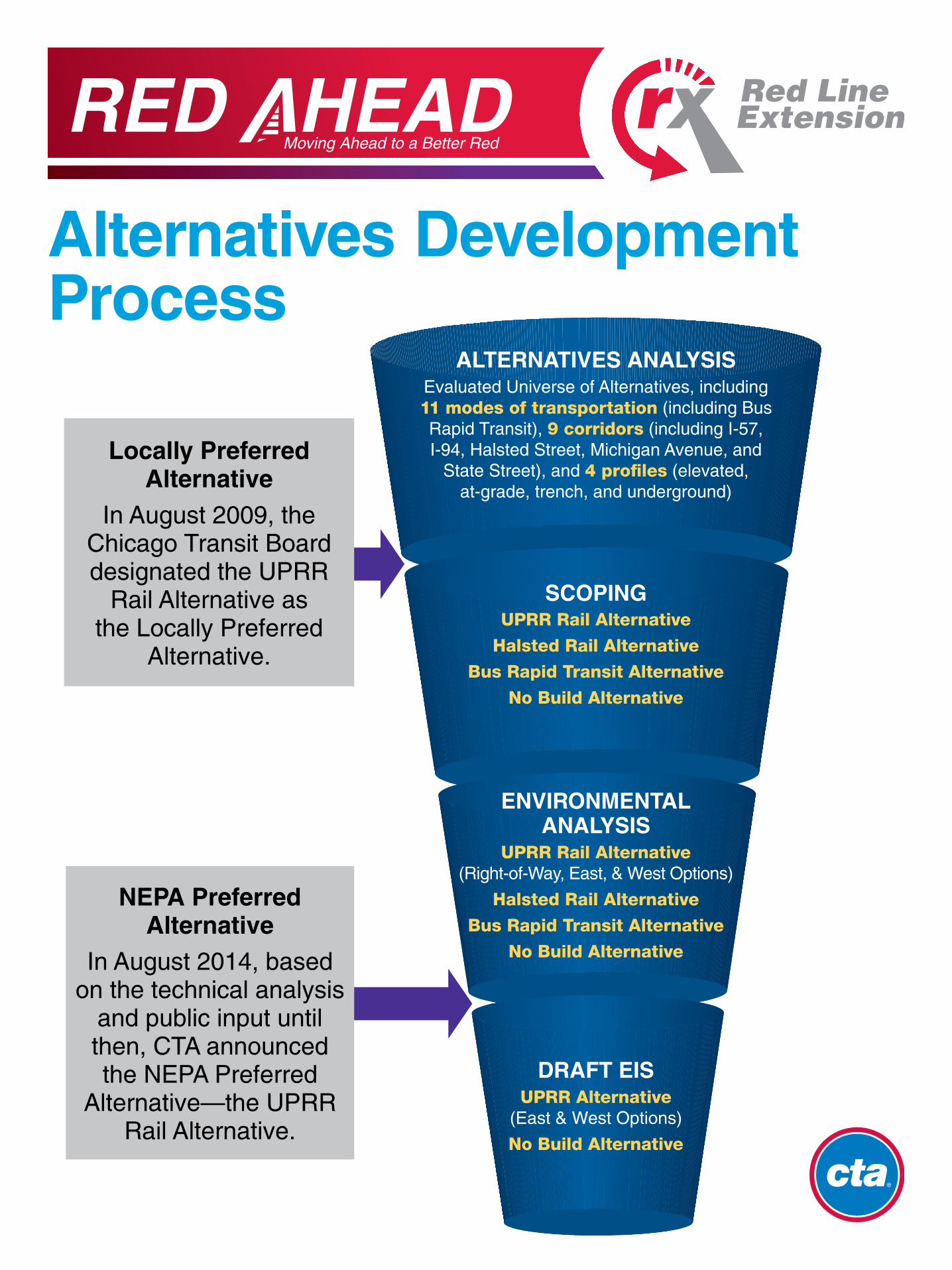
Alternatives Development Process
Locally Preferred Alternative
In August 2009, the Chicago Transit Board designated the UPRR
Rail Alternative as the Locally Preferred
Alternative.
NEPA Preferred Alternative
In August 2014, based on the technical analysis
and public input until then, CTA announced the NEPA Preferred
Alternative—the UPRR Rail Alternative.
SCOPINGUPRR Rail Alternative
Halsted Rail Alternative
Bus Rapid Transit Alternative
No Build Alternative
ENVIRONMENTALANALYSIS
UPRR Rail Alternative (Right-of-Way, East, & West Options)
Halsted Rail Alternative
Bus Rapid Transit Alternative
No Build Alternative
DRAFT EISUPRR Alternative
(East & West Options)
No Build Alternative
ALTERNATIVES ANALYSISEvaluated Universe of Alternatives, including 11 modes of transportation (including Bus Rapid Transit), 9 corridors (including I-57, I-94, Halsted Street, Michigan Avenue, and
State Street), and 4 profiles (elevated, at-grade, trench, and underground)

Moving Ahead to a Better Red
Project Alternatives Evaluated
No Build Alternative The No Build Alternative represents future conditions if the UPRR Alternative were not implemented. The No Build Alternative is a required alternative as part of the NEPA environmental analysis and is used for comparison purposes to assess the relative benefits and impacts of implementing the UPRR Alternative. No new infrastructure would be built as part of the RLE Project under the No Build Alternative.
Note that appearance of project elements (such as parking structures, beams, columns, etc.) in visualizations is intended to show scale of project elements. Actual construction appearance may differ based on design
decisions for colors, textures, finishes, and choice of specific design features.
UPRR AlternativeThe extension would run along elevated tracks south from the 95th Street Terminal, and follow I-57 until reaching the Union Pacific Railroad (UPRR) corridor near Eggleston Avenue. The alignment would then turn south and follow the UPRR corridor to Prairie Avenue, where it would cross over the freight rail tracks near 119th Street. South of this point, the alignment would follow the existing freight rail tracks and end with a station at 130th Street.
The Draft Environmental Impact Statement (EIS) evaluates two options for this alternative:
East Option (east of UPRR tracks)
West Option (west of UPRR tracks)
Tracks would be elevated from 95th Street to 119th Street
Moving Ahead to a Better Red
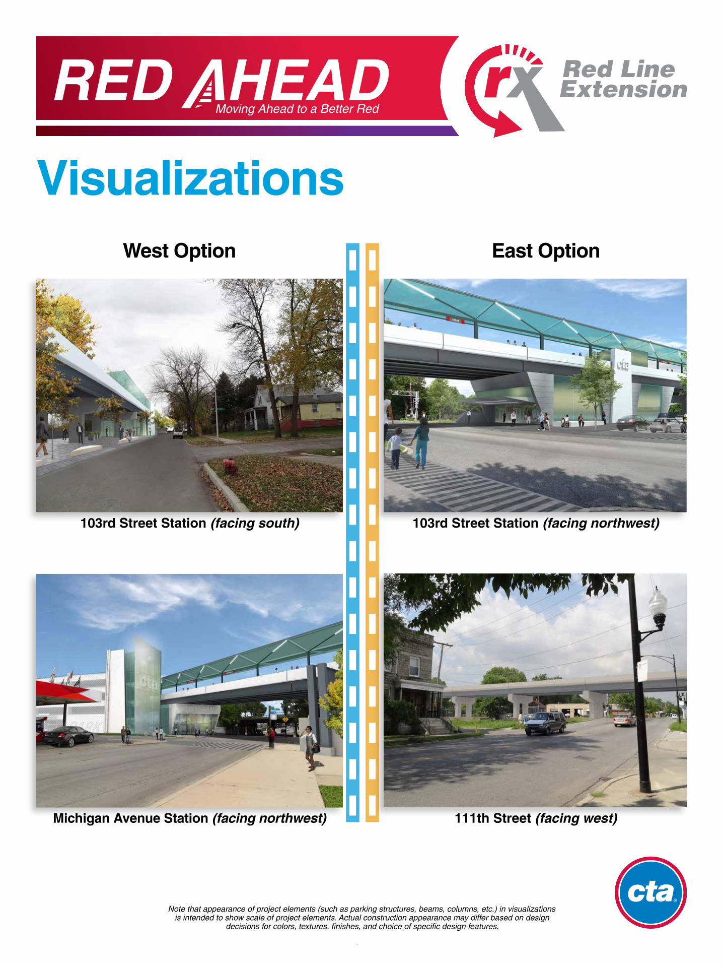
Visualizations
103rd Street Station (facing south)
Michigan Avenue Station (facing northwest)
103rd Street Station (facing northwest)
111th Street (facing west)
West Option East Option
Note that appearance of project elements (such as parking structures, beams, columns, etc.) in visualizations is intended to show scale of project elements. Actual construction appearance may differ based on design
decisions for colors, textures, finishes, and choice of specific design features.

Moving Ahead to a Better Red
Section 4(f) - Impacts to ParksSection 4(f) of the USDOT Act of 1966 is a federal law that establishes special consid-erations and requirements when publicly owned parks or recreational areas are pro-posed to be used by a transportation project. Parks would be affected whether the East or West Option is selected.
Park West Option East Option
Wendell Smith Park — 0.7 acre
Fernwood Parkway 1.9 acres —
Block Park — 0.9 acre
Total 1.9 acres 1.6 acres
Portions of Wendell Smith Park and Block Park would be permanently affected. Both parks would continue to provide park space after implementation of the RLE Project, but park space would be reduced. Both parks would remain active during construction with the exception of the overlapped portion of the parks.
East Option
Wendell Smith Park Block Park
A portion of Fernwood Parkway would be affected. Temporary closure of the overlapped section of Fernwood Parkway would be necessary during construction. There would also be a short-term closure of Wendell Smith Park during construction, but no permanent impacts.
West Option
Fernwood Parkway
UPRR Alt. – East Option UPRR Alt. – West Option Proposed Permanent Easement Proposed Rail Station
Proposed Parking & Bus Facilities
Parks
Buildings
School Buildings

Moving Ahead to a Better Red
Section 4(f) – Mitigation for Impacts to Parks
Potential Replacement Park Concepts
CTA worked with the Chicago Park District to develop replacement park options in the surrounding community.
Mitigation Measures for both the East and West Options� Provide new replacement parks in or near affected community areas� Restore or landscape any disturbed areas on impacted parkland� Incorporate context-sensitive design features at impacted parks
Additional Mitigation Measures for the East Option at Wendell Smith Park� Provide one larger baseball field in Wendell Smith Park� Relocate junior-sized baseball field in replacement park� Relocate walking path and replace benches and other amenities
in Wendell Smith Park
Additional Improvements for the West Option at Fernwood Parkway� Potential to install a new bike path beneath the elevated structure
Addressing Impacts to Parks
Wendell Smith Park – Proposed Park Concept
Michigan Avenue near the UPRR tracks and Kensington Avenue(East or West Option; concept shown is for the East Option)Michigan Avenue
between 101st and 102nd Streets
(East or West Option)
111th Street near the UPRR tracks and Eggleston Street(East Option only)
Moving Ahead to a Better Red
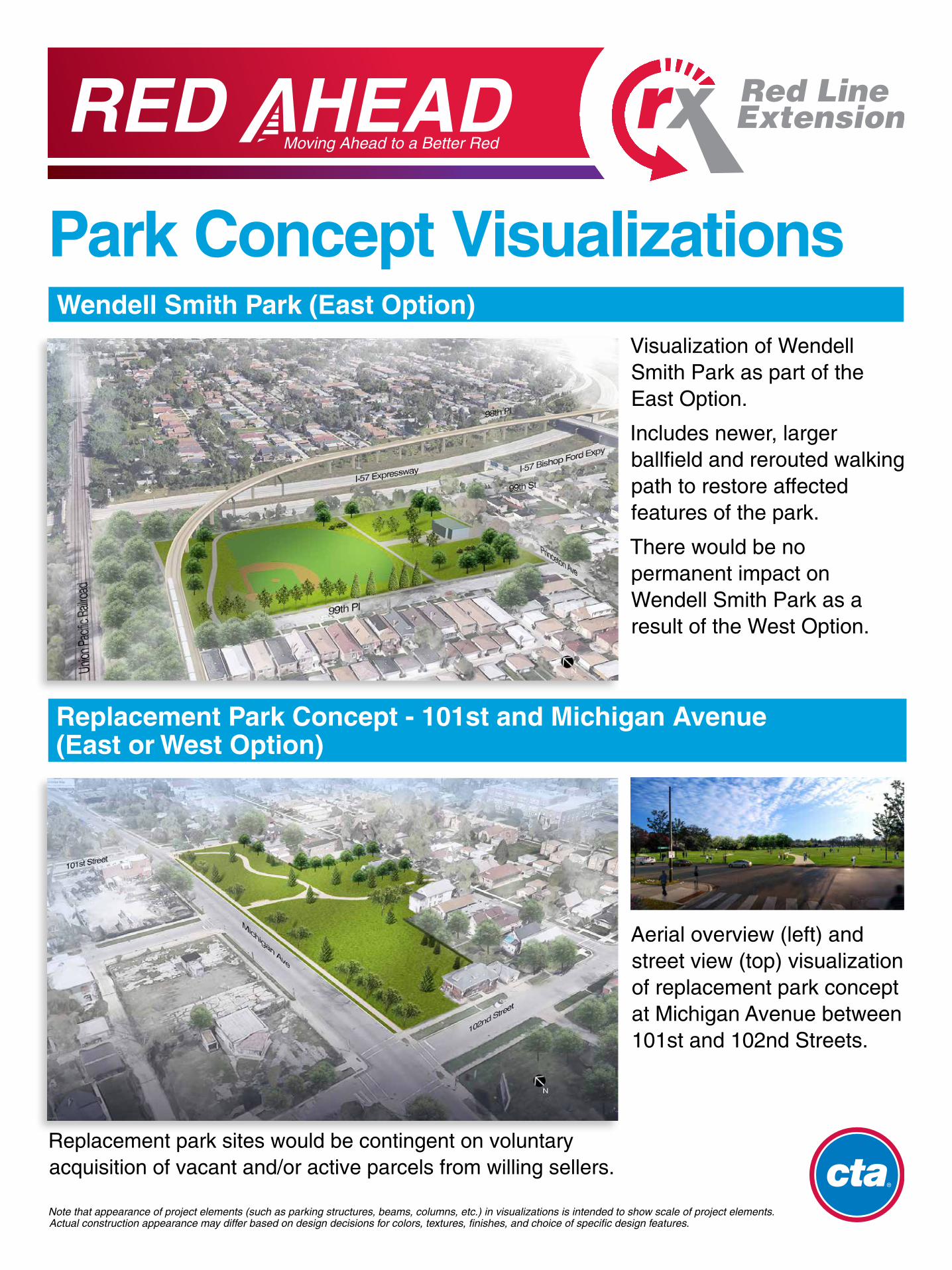
Park Concept VisualizationsWendell Smith Park (East Option)
Replacement Park Concept - 101st and Michigan Avenue (East or West Option)
Visualization of Wendell Smith Park as part of the East Option.
Includes newer, larger ballfield and rerouted walking path to restore affected features of the park.
There would be no permanent impact on Wendell Smith Park as a result of the West Option.
Aerial overview (left) and street view (top) visualization of replacement park concept at Michigan Avenue between 101st and 102nd Streets.
Note that appearance of project elements (such as parking structures, beams, columns, etc.) in visualizations is intended to show scale of project elements. Actual construction appearance may differ based on design decisions for colors, textures, finishes, and choice of specific design features.
Replacement park sites would be contingent on voluntary acquisition of vacant and/or active parcels from willing sellers.

Moving Ahead to a Better Red
Park Concept VisualizationsPark Concept Visualizations
Replacement Park Concept - Michigan Avenue near Kensington Avenue (East or West Option – concept shown for East Option)
Replacement Park Concept - 111th Street and Eggleston Avenue (East Option)
Visualization of replacement park concept, showing a new ballfield and integrated park & ride at the proposed 111th Street station.
Aerial overview (left) and street view (top) visualization of replacement park concept at Michigan Avenue near the UPRR tracks and Kensington Avenue.
Note that appearance of project elements (such as parking structures, beams, columns, etc.) in visualizations is intended to show scale of project elements. Actual construction appearance may differ based on design decisions for colors, textures, finishes, and choice of specific design features.
Replacement park sites would be contingent on voluntary acquisition of vacant and/or active parcels from willing sellers.

Moving Ahead to a Better Red
Property DisplacementsConstruction of the project would require the acquisition of private property.
� Impacts are based on conceptual engineering and represent the maximum impacts on all alternatives.
� Impacts are for the purposes of comparing alternatives and will be confirmed in the Final EIS following more detailed conceptual design
� Availability of vacant parcels and buildings near the affected properties will likely allow for affected businesses and residents to relocate within the project area.
� The total number of properties identified for both the East and West Options is 381, because some properties have been identified as possibly needed for both options. Of the 381 properties, 248 properties are privately owned and 133 properties are publicly or railroad-owned.
Parcels West Option East Option
Affected Parcels without Building Displacements 159 154
Affected Parcels with Building Displacements (Residential Building Displacements)
46 (26)
106 (90)
Total Affected Parcels 205 260

Moving Ahead to a Better Red
Noise and Vibration ImpactsWhat would CTA do to reduce, or mitigate, noise from the elevated track structure?
� Install noise barriers, which absorb and reduce noise from the tracks by 10 decibels.
� Use a closed-deck structure, which limit transmission of noise beneath the tracks.
� Use continuous welded rail, which has fewer joints and means a smoother and quieter ride.
What about construction noise?
� CTA would limit nighttime construction as much as possible.
� CTA would keep the community informed about construction schedules.
� CTA would use construction best management practices to reduce noise.
What about vibration?
Because the CTA train cars are lighter and carry less weight (freight) than the freight trains that pass through the project area, vibration levels would not exceed FTA thresholds and no mitigation measures would be required. Elevated track structures also transmit less vibration through the ground than at-grade tracks.
Noise Barriers Open versus Closed Deck

Moving Ahead to a Better Red
Noise and Vibration ImpactsCTA performed general noise and vibration assessments to identify and estimate the severity of noise and vibration impacts that could occur on noise-sensitive receivers (such as residences) with implementation of the project.
� Because existing noise levels are already high in the project corridor from freight trains, the allowable noise increase (using FTA noise impact criteria) is very small (about 2 dB).
� To minimize noise impacts, CTA will implement specific mitigation strategies (see next board), which would make the Red Line tracks in this area quieter than other parts of the CTA system.
� Because of the mitigation strategies, the RLE Project would not worsen noise conditions.
Aircraft carrier deck (140 dB)
Rail transit horn (90 dB)
Rail transit at 40 mph (65 dB)
Vacuum cleaner (80 dB)
Thunderclap (120 dB)
Air conditioning unit (60 dB)
Motorcycle (100 dB)
Refrigerator hum (40 dB)
Whisper (20 dB)
140 dB
120 dB
100 dB
80 dB
60 dB
40 dB
20 dB
0 dB
Existing noise levels near freight
tracks in the project
area
(~74 dB)
Example Noise Sources

Moving Ahead to a Better Red
Visual ImpactsThe analysis of visual impacts evaluates whether the project would affect scenic vistas, scenic resources, and visual character, or create new adverse sources of light emissions or glare. The RLE Project would have adverse visual impacts at some locations, despite mitigation.
I-57 Right-of-Way from 98th Place and Princeton Avenue (facing east)
Michigan Avenue Station (facing northwest)
117th Street and Prairie Avenue (facing west)
103rd Street Station (facing south)
Adverse Visual Impacts
West Options East Options
� North of I-57� Between 99th and 103rd Streets� Near the 103rd Street station� Michigan Avenue station
� North of I-57� 117th Street and Prairie Avenue
Moving Ahead to a Better Red
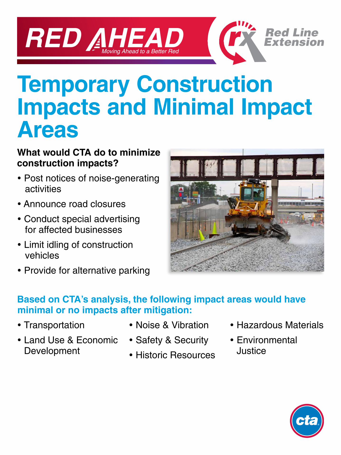
Temporary Construction Impacts and Minimal Impact AreasWhat would CTA do to minimize construction impacts?
� Post notices of noise-generating activities
� Announce road closures
� Conduct special advertising for affected businesses
� Limit idling of construction vehicles
� Provide for alternative parking
Based on CTA’s analysis, the following impact areas would have minimal or no impacts after mitigation:
� Transportation
� Land Use & Economic Development
� Noise & Vibration
� Safety & Security
� Historic Resources
� Hazardous Materials
� Environmental Justice
Moving Ahead to a Better Red
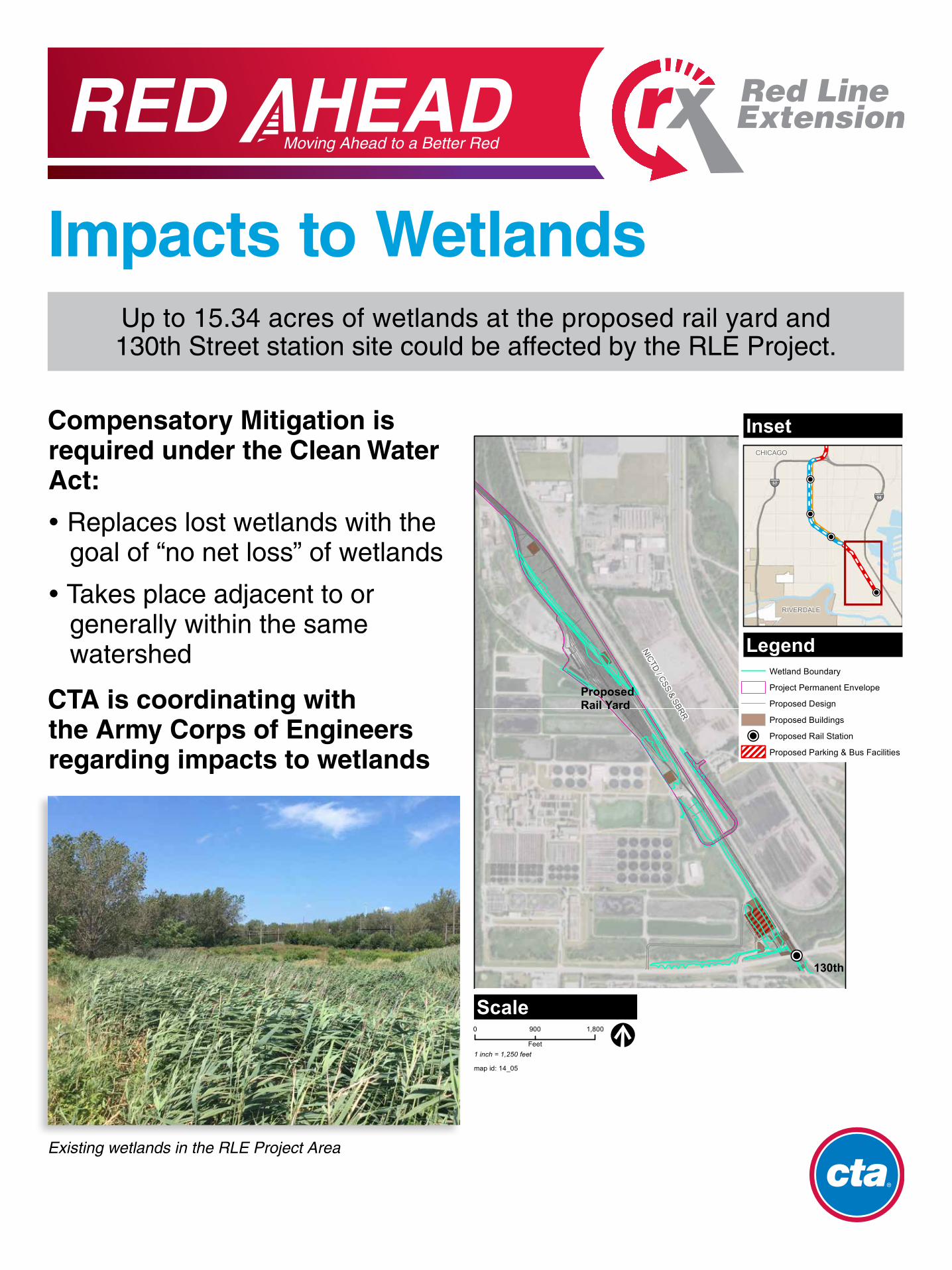
Impacts to Wetlands
Compensatory Mitigation is required under the Clean Water Act:
� Replaces lost wetlands with the goal of “no net loss” of wetlands
� Takes place adjacent to or generally within the same watershed
CTA is coordinating with the Army Corps of Engineers regarding impacts to wetlands
Up to 15.34 acres of wetlands at the proposed rail yard and 130th Street station site could be affected by the RLE Project.
Existing wetlands in the RLE Project Area
!P
AltgeldGardens map id: 14_05
0 1,800900
Feet
!P
!P
!P
!P
§̈¦94
§̈¦57
RIVERDALE
CHICAGO
Inset
Legend
Scale
1 inch = 1,250 feet
LakeCalumet
130th
Wetland Boundary
Project Permanent Envelope
Proposed Design
Proposed Buildings
!P Proposed Rail Station
Proposed Parking & Bus Facilities
NICTD / CSS & SBRR
ProposedRail Yard
!P
AltgeldGardens map id: 14_05
0 1,800900
Feet
!P
!P
!P
!P
§̈¦94
§̈¦57
RIVERDALE
CHICAGO
Inset
Legend
Scale
1 inch = 1,250 feet
LakeCalumet
130th
Wetland Boundary
Project Permanent Envelope
Proposed Design
Proposed Buildings
!P Proposed Rail Station
Proposed Parking & Bus Facilities
NICTD / CSS & SBRR
ProposedRail Yard

Moving Ahead to a Better Red
Project Development ProcessConcept Development
2006
Public Scoping MeetingsSeptember 2009
Prepare Draft EIS2012 – 2016
Publish Draft EIS and Seek Public Comment
Project Development Phase*
Project Engineering Phase*
Receive Full Funding Grant Agreement from FTA*
Construction*(Expected to Last About 5 years)
OPEN FOR OPERATION
Alternatives Analysis Study2006 – 2009
Environmental Impact Statement Process
RLE Added to CMAP GO TO 2040
Regional Plan
Next StepIdentify Funding
for Entry into Project Development
We Are Here
* Dependent on funding and approvals
FTA Project Evaluation and Rating
Final EIS & Record of Decision*
� FTA’s New Starts Program would likely fund up to 49% of the project cost — The New Starts Program is competitive – the Red Line Extension Project would compete with projects across the country for these funds� The remaining costs for construction would need to be funded through local and
non-federal funds
Project Funding
� The East Option is estimated to cost $2.26 billion� The West Option is estimated to cost $2.30 billion
Project Costs

Moving Ahead to a Better Red
Thank You for Participating!Stay Involved
� CTA and FTA will respond to public comments on the Draft EIS as part of the Final EIS.
� CTA and FTA will complete any additional analyses required and prepare the Final EIS.
� The Final EIS will confirm whether the East or West Option is selected.
� FTA intends to issue a single document that consists of the Final EIS and Record of Decision in 2018.
Next Steps