Embed Size (px)
Citation preview

Welcome to the Proposed Genesee Mine Extension Open House

Road PlanAs part of the Proposed Genesee Mine Extension Application to the
Energy Resources Conservation Board (ERCB) and Alberta Environment
(AENV), the Genesee Mine is required to submit a Road Plan.
This Road Plan will indicate all area roads that will need to be closed
for the operation, and roads that can be opened to reduce impacts on
local traffic.
The Genesee Mine would like to hear from area residents who are
directly affected by road openings and closures to learn about their
concerns and priorities.
Feedback received at this open house will be used to develop and share
draft plans with Leduc County to ensure all County regulations and
requirements are met. Those plans will then be presented at a second
Proposed Genesee Mine Extension Project open house in the spring of
2011 for additional comments and feedback from residents.

Would You Like a Tour of the Mine?Winter and spring months are not ideal for tours of the mine
due to snow cover and mud. However, we would be happy
to take you into the mine in the summer or fall for you to see
the mining operation in action, as well as the reclamation
and research work currently underway.
Based on the number of requests we receive, we will
schedule tours and contact you to see which option works
best for you.
Children over the age of 5 are welcome.

Mining Sequence Board

Map of Proposed Mine Extension Area

What is the Proposed Genesee Mine Extension Project?Sherritt Coal will be applying for a new permit to extend the current Genesee Mine. The proposed mine extension
would be to the south of the current mine permit area and include 14.5 sections (or 9, 280 acres) of land. All of the
subsurface rights to the coal within the proposed mine extension area are owned by Capital Power and Sherritt Coal,
and there are no Crown surface lands included in the proposed extension area. Sherritt Coal will also be applying for a
renewed licence to operate the mine.
Why is an extension of the Genesee Mine necessary?Coal from the Genesee Mine is used as fuel to run the three power generation units at Genesee Generating Station
(GGS). There is not enough coal within the current mine permit area to supply fuel for the GGS for the rest of its
economic life, so more coal reserves need to be accessed.
Permitting coal reserves that are directly adjacent to the existing mine permit area allows for the operation to continue a
natural progression of current mining and reclamation practices.
By the numbers:75 million Tonnes mined to date from the existing mine permit area.
80 million Mineable tonnes of coal remaining within the existing permit area.
101 million Tonnes of coal needed in the proposed permit area.
181 million Remaining tonnes expected to be consumed by the GGS by the end of their lifespans.
10% The estimate of coal unavailable due to washouts and poor quality.
200 million Tonnes needed to ensure there is enough coal for GGS in the existing and future mining areas accounting for expected washouts etc.

Anticipated Project Timeline
ACTiviTyTiMElinE
2010 2011 2012 2013 2014Q1 Q2 Q3 Q4 Q1 Q2 Q3 Q4 Q1 Q2 Q3 Q4 Q1 Q2 Q3 Q4 Q1 Q2 Q3 Q4
Ongoing Public Consultation (newsletter updates, website updates, one-on-one consultation and meetings, etc. as required)
land Purchase Begins
Conduct Technical Studies
Open House to present baseline results to date
Open House to present assessment results
Submit Application to AEnv* and ERCB**
AEnv and ERCB Application Review Process
Commence Pre-mining Activities
*Alberta Environment **Energy Resources Conservation Board

Genesee Mine – Safety AchievementsCanadian institute of Mining and Metallurgy (CiM) District 5 Safety Award (Small Mines) 1989, 1990, 1992
Occupational Health and Safety Award, northern Alberta Region, and an Alberta Mine Safety Association Award
1990
John T. Ryan Safety Committee, national Safety AwardAwarded 10 times
between 1992–2010
John T. Ryan national Award for 21 years of operation without a lost Time Accident June 2009
The Genesee Mine completes 22 years of operation without a lost Time Accident June 2010
Genesee Mine Rescue TeamDozer leveling subsoil Dozers pushing in a ramp
John T. Ryan Trophies are awarded by Mine Safety Appliances Canada limited as a memorial to the founder of the
company. The national trophies are awarded by the institute to the metalliferous mine, the select mine, and the coal
mine which experienced the lowest accident frequencies during the previous year in all of Canada.
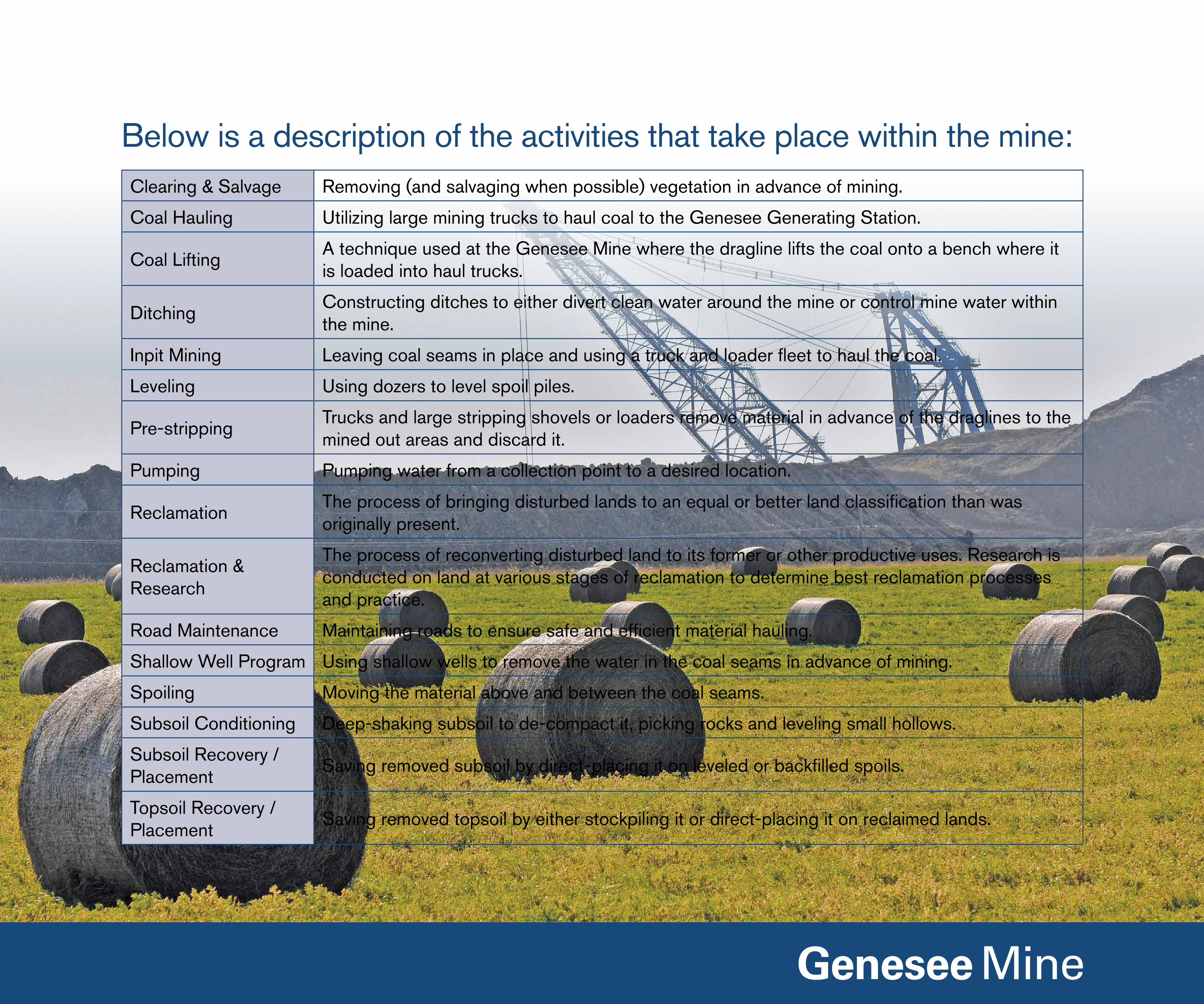
Below is a description of the activities that take place within the mine:Clearing & Salvage Removing (and salvaging when possible) vegetation in advance of mining.
Coal Hauling Utilizing large mining trucks to haul coal to the Genesee Generating Station.
Coal liftingA technique used at the Genesee Mine where the dragline lifts the coal onto a bench where it is loaded into haul trucks.
DitchingConstructing ditches to either divert clean water around the mine or control mine water within the mine.
inpit Mining leaving coal seams in place and using a truck and loader fleet to haul the coal.
leveling Using dozers to level spoil piles.
Pre-strippingTrucks and large stripping shovels or loaders remove material in advance of the draglines to the mined out areas and discard it.
Pumping Pumping water from a collection point to a desired location.
ReclamationThe process of bringing disturbed lands to an equal or better land classification than was originally present.
Reclamation & Research
The process of reconverting disturbed land to its former or other productive uses. Research is conducted on land at various stages of reclamation to determine best reclamation processes and practice.
Road Maintenance Maintaining roads to ensure safe and efficient material hauling.
Shallow Well Program Using shallow wells to remove the water in the coal seams in advance of mining.
Spoiling Moving the material above and between the coal seams.
Subsoil Conditioning Deep-shaking subsoil to de-compact it, picking rocks and leveling small hollows.
Subsoil Recovery / Placement
Saving removed subsoil by direct-placing it on leveled or backfilled spoils.
Topsoil Recovery / Placement
Saving removed topsoil by either stockpiling it or direct-placing it on reclaimed lands.

These are some of the terms used when referring to mining activities:Ash Dump location for storage of fly and bottom ash which are the by-product of burning coal.
Backfill The material used to bring the surface to a predetermined grade.
Bench A close to level working elevation that equipment operates on.
Dead PileThe coal stockpile (covered in grasses) adjacent to the Genesee Generating Station that can be utilized in an emergency.
interburden Waste material in between coal seams.
Overburden Waste material on top of the first coal seam encountered.
Reclamation Certified
The status of reclaimed land once it has been investigated by Alberta Environment and verified as having achieved equivalent land capability.
Spoil The material that is moved by the draglines or pre-strip operations, such as dirt, rocks and clay.
Subsoil Soil found beneath the topsoil but above the bedrock and can extend up to 100 cm.
Topsoil The top most layer of soil that is moved in tillage and naturally ranges in depth from 5 cm to 45 cm.
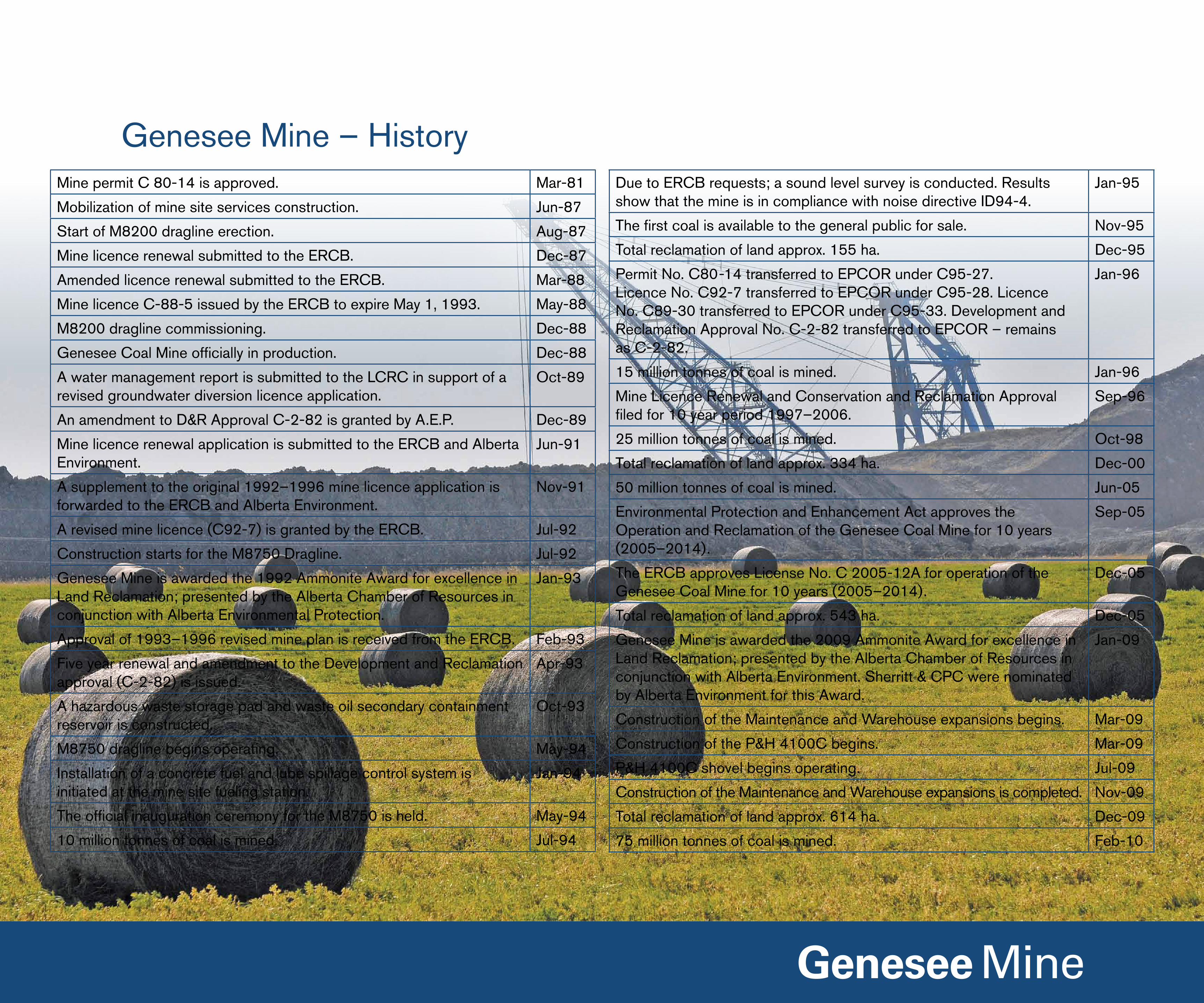
Genesee Mine – HistoryMine permit C 80-14 is approved. Mar-81
Mobilization of mine site services construction. Jun-87
Start of M8200 dragline erection. Aug-87
Mine licence renewal submitted to the ERCB. Dec-87
Amended licence renewal submitted to the ERCB. Mar-88
Mine licence C-88-5 issued by the ERCB to expire May 1, 1993. May-88
M8200 dragline commissioning. Dec-88
Genesee Coal Mine officially in production. Dec-88
A water management report is submitted to the lCRC in support of a revised groundwater diversion licence application.
Oct-89
An amendment to D&R Approval C-2-82 is granted by A.E.P. Dec-89
Mine licence renewal application is submitted to the ERCB and Alberta Environment.
Jun-91
A supplement to the original 1992–1996 mine licence application is forwarded to the ERCB and Alberta Environment.
nov-91
A revised mine licence (C92-7) is granted by the ERCB. Jul-92
Construction starts for the M8750 Dragline. Jul-92
Genesee Mine is awarded the 1992 Ammonite Award for excellence in land Reclamation; presented by the Alberta Chamber of Resources in conjunction with Alberta Environmental Protection.
Jan-93
Approval of 1993–1996 revised mine plan is received from the ERCB. Feb-93
Five year renewal and amendment to the Development and Reclamation approval (C-2-82) is issued.
Apr-93
A hazardous waste storage pad and waste oil secondary containment reservoir is constructed.
Oct-93
M8750 dragline begins operating. May-94
installation of a concrete fuel and lube spillage control system is initiated at the mine site fueling station.
Jan-94
The official inauguration ceremony for the M8750 is held. May-94
10 million tonnes of coal is mined. Jul-94
Due to ERCB requests; a sound level survey is conducted. Results show that the mine is in compliance with noise directive iD94-4.
Jan-95
The first coal is available to the general public for sale. nov-95
Total reclamation of land approx. 155 ha. Dec-95
Permit no. C80-14 transferred to EPCOR under C95-27. licence no. C92-7 transferred to EPCOR under C95-28. licence no. C89-30 transferred to EPCOR under C95-33. Development and Reclamation Approval no. C-2-82 transferred to EPCOR – remains as C-2-82.
Jan-96
15 million tonnes of coal is mined. Jan-96
Mine licence Renewal and Conservation and Reclamation Approval filed for 10 year period 1997–2006.
Sep-96
25 million tonnes of coal is mined. Oct-98
Total reclamation of land approx. 334 ha. Dec-00
50 million tonnes of coal is mined. Jun-05
Environmental Protection and Enhancement Act approves the Operation and Reclamation of the Genesee Coal Mine for 10 years (2005–2014).
Sep-05
The ERCB approves license no. C 2005-12A for operation of the Genesee Coal Mine for 10 years (2005–2014).
Dec-05
Total reclamation of land approx. 543 ha. Dec-05
Genesee Mine is awarded the 2009 Ammonite Award for excellence in land Reclamation; presented by the Alberta Chamber of Resources in conjunction with Alberta Environment. Sherritt & CPC were nominated by Alberta Environment for this Award.
Jan-09
Construction of the Maintenance and Warehouse expansions begins. Mar-09
Construction of the P&H 4100C begins. Mar-09
P&H 4100C shovel begins operating. Jul-09
Construction of the Maintenance and Warehouse expansions is completed. nov-09
Total reclamation of land approx. 614 ha. Dec-09
75 million tonnes of coal is mined. Feb-10

Genesee Mine – EquipmentFlEET # SizE PRiMARy WORk FUnCTiOn
Marion 8750 walking dragline 1 Bucket - 88 m3 Removal of overburden and intraburden to expose and pile coal
Marion 8200 walking dragline 1 Bucket - 52 m3 Removal of overburden and intraburden to expose and pile coal
P&H 4100C electric shovel 1 Bucket - 44 m3 Removal of overburden and subsoil
Marion 191B electric shovel 1 Bucket - 13 m3 Removal of overburden and subsoil
Caterpillar 994F Front End loader 1 Bucket - 21 m3 load coal and topsoil
Caterpillar 992C Front End loader 1 Bucket - 10 m3 load coal and tram coal
Hitachi 1800 hydraulic shovel 1 Bucket - 52 m3 Removal of overburden and intraburden, loading topsoil and loading coal

FlEET # SizE PRiMARy WORk FUnCTiOn
komatsu 830E AC Electric Truck 3 Capacity 218 tonnes Hauling overburden
Caterpillar 789C Mechanical Truck 2 Capacity 175 tonnes Hauling overburden
Caterpillar 785C Mechanical Truck 3 Capacity 136 tonnes Hauling coal and ash
Haulpak 630E DC Electric Truck 2 Capacity 170 tonnes Hauling overburden and coal
Haulpak 510E DC Electric Truck 2 Capacity 136 tonnes Hauling coal/ash, watering roads
Haulpak 210M DC Electric Truck 2 Capacity 50 tonnes Watering roads
Caterpillar D11T Dozer 5 nA Supporting the draglines, shovels and trucks
Caterpillar D10R Dozer 1 nA Supporting the draglines, shovels and trucks
Caterpillar 637E Scraper 2 Capacity - 23 m3 Road maintenance
komatsu PC 300 Excavator 1 nA Ditching and working with pumps
Caterpillar 16G Grader 1 nA Road maintenance
Caterpillar 16H Grader 1 nA Road maintenance
Genesee Mine – Equipment

Progressive Mine image – year 2020

Progressive Mine image – year 2030

Progressive Mine image – year 2040

Mining Completion – year 2055

Research Projects
Live root transfer Live root transfer Public tour of research
Aspen seedlings Tree planting

Air QualityGoal of the Baseline Study
The goal of the baseline air quality study is to determine the
current level of air quality in the local and regional communities
with a specific focus on dust resulting from haul trucks and mine
operations.
Study Area
Figure 1: WCAS Monitoring Stations in Proximity of the Mine
Methodology
MEMS has relied on regional air quality data collected at
established sites in the West Central Airshed (WCAS) zone to
determine baseline conditions. The WCAS operates a network
of 13 continuous on-line air quality monitoring stations, five
agricultural bio-receptor monitoring sites, and two forestry bio-
monitoring sites within the west central region of Alberta. Stations
are strategically located throughout the zone to represent areas
with industrial activity and areas remote from man-made emission
sources.
Air quality monitoring and reporting methods used by the WCAS
are compatible with those of Alberta Environment. Continuous
monitoring is required to meet the Alberta Environment compliance
standards for maximum hourly concentrations of pollutants.
Trace level monitors are used to measure the wide range of
pollutant concentrations within the WCAS zone and to accurately
determine changes in air quality.
WCAS uses passive monitoring systems at two bio-monitoring
sites. These passive monitoring systems are capable of providing
approximate average measurements of a pollutant concentration
over extended periods of time.

Data recorded is subject to quality control by the WCAS and
is also reviewed by consulting agencies (MEMS) that use the
data as it is an integral part of any baseline study. The data is
available to anyone and the local air quality data can be found
at http://www.wcas.ca/info/reports.php. The data collection
site closest to the Genesee Mine is near the eastern end of the
proposed mine permit extension boundary and is referred to as
Station 910: Genesee. The Wagner Station is located northwest
of the active Genesee Mine, north of the north Saskatchewan
River and is referred to as Station 909: Wagner.
A full map of the West Central Airshed Society Regional air
monitoring stations can be found at www.wcas.ca.
Baseline Results
Emissions from mine operations and hauling are local in nature,
with most impacts restricted to within a few hundred metres of
the source. At the mine site, winds primarily blow from the west
and northwest.
Air quality data from the Wagner and the Genesee WCAS
monitoring sites was used to provide current data relevant to
the Project.
A review of monitoring data from 2005–2009 shows that:
• Regional concentrations of SO2 and nO2 meet Alberta air
quality standards.
• Ozone (O3) concentrations meet Alberta air quality standards
except during the months of July and September. This is likely a
result of industrial or large urban sources in the region.
• Particulate concentrations (PM2.5) meet Alberta air
quality standards except during the months of July and
September. This is likely a result of forest fires in the region
or windblown dust.
Next Steps
Data collection from the established WCAS sites will be used to
develop an air dispersion model to predict the potential affect the
proposed Project may have on local air quality. it will also provide
guidance for mitigation and monitoring plans.

Surface Water (Hydrology)Goals of the Baseline Study
The primary goal of the surface water baseline study is to
determine the quantity and quality of surface water that currently
drains from the Project area.
Study Area
The study area includes the proposed Project area and all of
the local watercourses located downstream of the Project that
receive surface runoff from the Project area. The study area
ends where the impacts to the surface water downstream of the
Project are no longer measurable.
The study area includes Strawberry Creek and unnamed Creeks
2 and 3, all of which drain to the north Saskatchewan River.
The study area does not include the north Saskatchewan River
as the proposed Project’s impacts to the water in the north
Saskatchewan River are not expected to be measurable due to
its distance from the river.
Water level recorders were previously installed near the
downstream end of Creeks 2 and 3 basins, at approximately the
locations indicated in Photos 1 and 2.
Photo 1 Photo 2
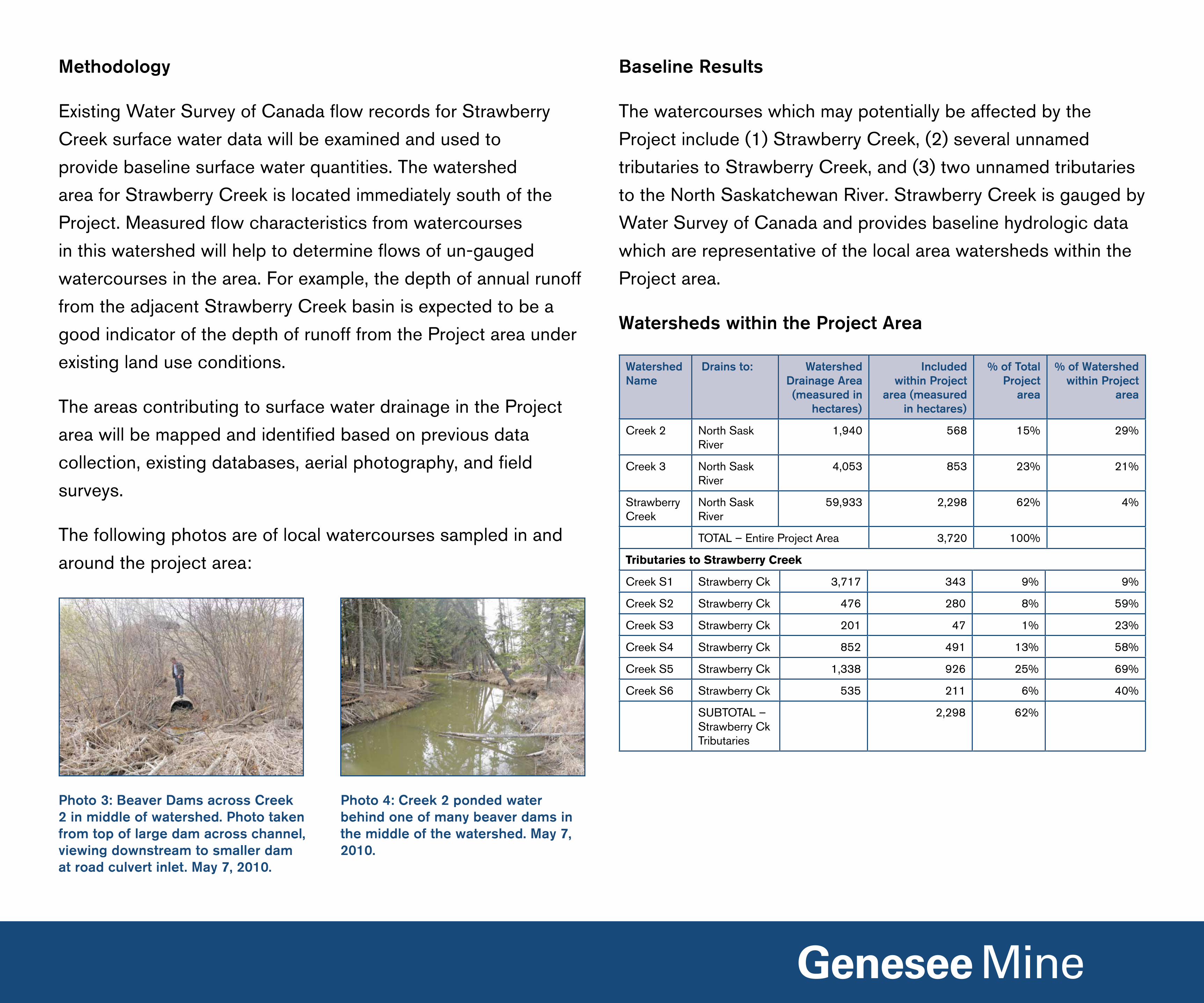
Methodology
Existing Water Survey of Canada flow records for Strawberry
Creek surface water data will be examined and used to
provide baseline surface water quantities. The watershed
area for Strawberry Creek is located immediately south of the
Project. Measured flow characteristics from watercourses
in this watershed will help to determine flows of un-gauged
watercourses in the area. For example, the depth of annual runoff
from the adjacent Strawberry Creek basin is expected to be a
good indicator of the depth of runoff from the Project area under
existing land use conditions.
The areas contributing to surface water drainage in the Project
area will be mapped and identified based on previous data
collection, existing databases, aerial photography, and field
surveys.
The following photos are of local watercourses sampled in and
around the project area:
Baseline Results
The watercourses which may potentially be affected by the
Project include (1) Strawberry Creek, (2) several unnamed
tributaries to Strawberry Creek, and (3) two unnamed tributaries
to the north Saskatchewan River. Strawberry Creek is gauged by
Water Survey of Canada and provides baseline hydrologic data
which are representative of the local area watersheds within the
Project area.
Watersheds within the Project Area
Photo 3: Beaver Dams across Creek 2 in middle of watershed. Photo taken from top of large dam across channel, viewing downstream to smaller dam at road culvert inlet. May 7, 2010.
Photo 4: Creek 2 ponded water behind one of many beaver dams in the middle of the watershed. May 7, 2010.
Watershed Name
Drains to: WatershedDrainage Area (measured in
hectares)
Includedwithin Project
area (measured in hectares)
% of Total Project
area
% of Watershed within Project
area
Creek 2 north Sask River
1,940 568 15% 29%
Creek 3 north Sask River
4,053 853 23% 21%
Strawberry Creek
north Sask River
59,933 2,298 62% 4%
TOTAl – Entire Project Area 3,720 100%
Tributaries to Strawberry Creek
Creek S1 Strawberry Ck 3,717 343 9% 9%
Creek S2 Strawberry Ck 476 280 8% 59%
Creek S3 Strawberry Ck 201 47 1% 23%
Creek S4 Strawberry Ck 852 491 13% 58%
Creek S5 Strawberry Ck 1,338 926 25% 69%
Creek S6 Strawberry Ck 535 211 6% 40%
SUBTOTAl – Strawberry Ck Tributaries
2,298 62%

The monthly runoff graph (below) shows the average distribution
of runoff through the year. Runoff is normally highest in March
and April during the snowmelt period. High flows in July are due
to summer rain.
local area streamflow data are only available for 2009. The year
2009 daily and instantaneous runoff data show how the flows
in local area Creeks 2 and 3 compare to the flows in Tomahawk
and Strawberry Creeks, for which long term gauge records are
available.
Tomahawk Creek was chosen to be used as a baseline control
due to its comparable characteristics to creeks in the area.
The variability of annual runoff graph (below) shows the year-to-
year variability in annual runoff at two Water Survey of Canada
stream gauges in the area of the proposed Genesee Mine
Extension. in some years, Tomahawk Creek has higher runoff than
Strawberry Creek, but the reverse is true in other years. Total
runoff range for these two basins has ranged from about 3 mm in
2009 (a record dry year) to more than 140 mm in very wet years.
Next Steps
Baseline information collected from Strawberry Creek will be
compared to watersheds in the Project area to determine where
impacts to flow may occur. Drainage and water management
plans for the Project area will be developed to mitigate any
significant adverse effects to surface water.

What are Baseline Studies?What are we doing?
Millennium EMS Solutions ltd. is conducting the baseline and
impact assessment studies for the proposed Genesee Mine
Extension Project (the Project). The studies will:
• ensure a complete understanding of existing environmental
conditions;
• identify potential project-related effects; and
• provide the basis for proposed mitigation to minimize
significant adverse effects.
in the case of the Project, several of the study areas are confined
to the proposed mine permit extension boundary. For some
disciplines, areas outside of the proposed mine permit extension
boundary have been included in the study area to make sure a
complete range of information is collected.
The completion of baseline studies is the first step to completing
environmental assessment studies. The purpose of baseline
studies is to determine the conditions that exist prior to the
development of a proposed project.
Study areas are typically selected based on whether there is
a reasonable potential for environmental effects to occur as
a result of a proposed project and can be different for each
environmental discipline.
in the second step to completing environmental studies,
baseline results are incorporated into the impact assessments
to understand the extent, duration and significance of potential
effects an extension of the Genesee Mine permit boundary may
have on each environmental discipline. if required, mitigation
measures are proposed to minimize significant adverse effects to
the environment.

About MillenniumMillennium EMS Solutions ltd. (MEMS) was founded in 1998
with a small group of reclamation and remediation experts in the
environmental field. MEMS has since grown such that now, with
offices located in Edmonton and Calgary, they are able to provide
a full complement of environmental services to Alberta’s mining
and oil and gas industry.
MEMS is committed to providing environmental consulting
services of the highest quality with a focus on timely, innovative
and cost effective solutions. MEMS assists industry and
government clients in developing and implementing environmental
management strategies in all aspects of their operations.
Since 1998, MEMS has been involved in Alberta’s coal mining
industry. Collectively, the MEMS’ team can draw upon nearly
a century of varied and extensive experience with all aspects
of mining.
• air quality
• forestry
• agrology
• auditing
• biology
• construction
• engineering
• hydrogeology
• geology
• socio-economics
• assessment
• reclamation
• remediation
• dispersion modeling
• greenhouse gases
MEMS is the leading environmental consulting firm in Alberta’s
coal industry with numerous projects underway.
MEMS’ experienced team consists of professionals in:

Aquatic EcologyGoals of Baseline Study
The goal of the baseline aquatic ecology studies is to
collect aquatic ecology (fish, fish habitat and water quality) data
to understand the existing conditions within and downstream of
the Project area.
Study Area
The study area includes the proposed Project area and all of
the local watercourses located downstream of the Project that
receive surface runoff from the Project area.
Methodology
in an aquatic ecology assessment, sampling sites are assessed
during each season (i.e. spring, summer, fall, and winter) to
ensure that the natural variability that occurs in each year is well
understood. Seasonal variations can change the availability of
fish habitat. For example, less water in the dryer/frozen months
limits suitable fish habitat whereas in the spring there is an
increase in the amount of suitable fish habitat and the ability of
fish to move around within a water body.
Selected sites (see map) were sampled for baseline data;
methods used during the baseline field program included:
• Sampling fish populations in watercourses to determine
abundance, density and species composition;
• Collecting and analyzing surface water from potentially
impacted watercourses for chemical composition (i.e. metals,
nutrients, etc.) and biological activity;
• Assessing the quality, quantity, flow characteristics and type of
riparian habitat; and
• Compiling and analyzing existing data from previous studies
within the local study area.

Baseline Results
Creeks 2 and 3 are the only major watercourses located within
the Project area. The upper extent of Creek 3 (the portion within
the Project area) is either permanently dry or has low water levels
that provide for poor fish habitat. The upper portions of Creek
2 are heavily influenced by beaver activity. Although Creek 2
provides low fish habitat, it is an important source of water for
cattle in the Genesee area.
Baseline field work results indicate the presence of a variety
of fish species within local watercourses in the Genesee area,
including Strawberry Creek, such as:
• Brook Stickleback (Photo 1)
• longnose Sucker
• Emerald Shiner
• Fine Scale Dace
• Fathead Minnow (Photo 2)
• lake Chub
• longnose Dace
• White Sucker (Photo 3)
• Freshwater Crayfish (Photo 4)
There is limited riparian habitat surrounding watercourses within
the Project area. The watercourses downstream of the Project
area contain moderate to high quality fish habitat. This habitat
is primarily dominated by gravel and sand, secondary growth
shrubs, and mixed coniferous and deciduous forests.
Early results indicate that the watercourses within and
downstream of the Project area are typical of streams found
in agricultural landscapes. Water in many of the sampled
watercourses:
• is moderately-hard to hard;
• has high alkalinity (e.g. phosphate, nitrates, etc.);
• has high conductivity;
• has high Total Dissolved Solids (TDS) (i.e. completely
dissolved minerals and compounds); and
• generally has low Total Suspended Solids (TSS), although
there can be high TSS seasonally and in particular locations,
as well as in response to major precipitation.
Next Steps
Aquatic surveys will continue with final baseline sampling in the
upcoming winter season. The baseline data will be compared to
the proposed mine plan to identify any potential effects the Project
may have on aquatic resources. To minimize significant adverse
impacts to aquatic ecology, mitigation measures will be proposed
if needed.
Photo 1: Three Spined (Brook) Stickleback from Strawberry Creek
Photo2: Fathead Minnow from Strawberry Creek
Photo 3: White Sucker from Strawberry Creek
Photo 4: Freshwater Crayfish from Strawberry Creek

Historical ResourcesGoals of the Baseline Study
The goal of the historical resources baseline study is to understand
the location and significance of archaeological sites within
the Project area that may provide information on history in the
Genesee region.
Study Area
The study area includes the land contained within the
Project area, and focuses on areas included in the mine plan.
Methodology
To compile baseline information, a records review was completed
to identify previously recorded sites from surveys in the proposed
Project area in 1980–81 and 2003–2004. The records were
examined to determine which areas could be affected by the
Project.
Field work was completed in July 2010 to confirm earlier data and
identify and record new sites within the Project area. A detailed
site evaluation was completed to evaluate the nature of the existing
sites in terms of content, uniqueness, and complexity.
Lifeways of Canada Staff undergoing a Field Survey in July 2010

Baseline Results
The Genesee Historical Resources studies represent the first
major effort to evaluate and conserve data related to plow zone
sites. These studies still stand as the most comprehensive study
of ploughed field sites in Canada. The results are a significant
contribution to the Pre-contact Archaeology of Alberta’s First
nations, and represent one of the most inclusive studies of
cultural resources found in the Parklands of Alberta.
Previous surveys have shown the location of sites to be scattered
due to a number of landscape factors. The types of artifacts
found range from isolated tools and small scatters of stone chips
found in lookout locations, to larger concentrations of tools and
flakes indicating more intensive camp activities.
Archaeological resource sites have been recorded in the current
mine permit area but the potential of finding intact artifacts in
the Project area is low. This is primarily due to disturbance or
destruction that has occurred over the many years from the time
the artifacts would have been deposited to present day. These
disturbances are due to agricultural and industrial activity, as well
as natural weathering.
This past summer field surveys were successful in recovering
such artifacts as bifaces and a stone axe (see Plate 1). These
stone tools are common finds in the Genesee area. The bifaces
(Plate 1: FhPn -184:1; FhPo-96:4) are thinly flaked stone tools
with a serrated edge that would be used as knives, while the
stone axe (Plate 1: FhPn-183:1) would function similarly to
modern day metal axes.
Next Steps
An assessment will be completed to determine potential effects to
the identified historical resource sites, and measures to mitigate
significant adverse effects to archaeological and historic heritage
resources will be recommended.

Hydrogeology (groundwater)Goals of the Baseline Study
The goals of the hydrogeology baseline study are to understand the
existing groundwater availability and chemistry in the Project area.
Study Area
Methodology
Groundwater monitoring has been ongoing in and around the
Genesee Mine for 18 years. Baseline data collection for the
Project consisted of analyzing several years worth of existing
monitoring data from the Genesee Mine to understand the
changing groundwater conditions of the existing mine and
surrounding area over time. The existing monitoring network was
also extended into the southern portion of the Project area in
2010 by installing new groundwater wells.
Groundwater monitoring wells are installed with a water well
drilling rig which drills a borehole and lowers a well casing
into the hole. The wells may be used to measure groundwater
pressure and chemistry from specific depths in the ground.
Drilling truck and support truck Drill truck, water truck and support truck

Groundwater level readings are taken at different times of the
year so seasonal changes are recorded. Monitoring wells are
kept locked and sealed to prevent any contamination from
the surface.
Water samples were collected in selected monitoring wells and
subjected to chemical analysis.
Baseline Results
it is noted that groundwater quality in the area is fair for human
consumption and acceptable for stock consumption based on
the monitoring data and Canadian Drinking Water Guidelines
(www.hc-sc.gc.ca/ewh-semt/water-eau/drink-potab/guide/
index-eng.php). Baseline monitoring data indicates that:
• The Total Dissolved Solids (TDS) ranges from 600 to 1,500
mg/l which is above the provincial drinking water limit of
500mg/l.
• Sodium content ranges from 70 to 550 mg/l compared to the
standard drinking water limit of 200mg/l.
• The pH levels of the groundwater range from 7.7 to 9 whereas
the drinking water limit is 6.5 to 8.5.
The water level monitoring data shows that drawdown of water
levels in wells occurs within 2 kilometres of the active pit.
Next Steps
The current groundwater monitoring system has been a valuable
resource and this system will be expanded to operate throughout
the Project area. An inventory of the water wells and dugouts
outside of the Project area will be undertaken once the boundary
is approved. As data continues to be gathered and evaluated, the
Genesee Mine practices will be examined to ensure that current
monitoring methods are effective for future development.

noiseGoals of the Baseline Study
The purpose of the baseline noise survey is to measure sound
levels at the existing Genesee Mine.
Study Area
The study area consists of locations where mine equipment
is currently operating and where it is anticipated that mine
equipment will be operating in the future. The Energy Resources
Conservation Board (ERCB) Directive 038, requires that
residential receptors within 1.5 kilometres of active mining
areas be included. Where no residents exist, a 1.5 km zone
surrounding the mine permit boundary will be used for
assessment purposes.
Methodology
Sound levels from the existing mining equipment were measured
with a sound level meter during a variety of operational activities.
A Model 2250 Bruel and kjaer Type 1 integrating sound level
meter was used. This sound level meter is used because it is
more precise than the Type 2 Sound level meter that is specified
as the minimum required by the ERCB.
Type of Equipment
Make ModelMeasured in Decibels (dBA)
Dragline Marion 8750 80Dragline (with noise control)
Marion 8200 75
Cable Shovel P&H 4100 82Cable Shovel Marion 191B 77Haul Truck 150 Ton
Caterpillar 785 81
Haul Truck 190 Ton
Caterpillar 789 82
Haul Truck 240 Ton
komatsu 830E 85
Water Truck komatsu 510 82Bulldozer Caterpillar D10R 84Bulldozer Caterpillar D11 84Front End loader
Caterpillar 992 88
Grader Caterpillar 16G 73
Major Active Mine Machinery –
measured in dBA at 15 metres
General sound levels
from common sources
Baseline Results
The following table is a list of the major active machinery in the
mine and their corresponding sound pressure levels in decibels
(dBA) at a standard distance of 15 metres.
The levels of sound being emitted
from the active machinery can be
compared to everyday sound levels.

These photos are from the 2010 Sound
Measurement program that used a sound
level meter to measure levels from various
active mine machinery including haul trucks,
bulldozers, front end loaders, earth movers,
cable shovels and draglines.
Next Steps
Equipment sound levels will be combined
with other sources of information, such as
the proposed mine plan, project equipment
usage, topographical information, and
specific locations of residential receptors,
to generate a sound model that will predict
sound levels occurring as a result of the
Project.
Predicted sound levels at certain residential
receptors will be calculated and compared
to the ERCB permissible sound levels to
demonstrate compliance with Directive 038.Sound Level Meter Measuring Levels from the Dragline
Sound Level Meter Measuring Levels from Active Mine Activities
Sound Level Meter Measuring Levels from Active Mine Activities
Sound Level Meter Measuring Levels from Active Mine Activities

SoilsGoals of the Baseline Study
The goal of the baseline soils study is to understand which types
of soils and landscapes are present in the Project area.
Study Area
All soil inspection sites within the Project area were selected to
adequately represent local soil-terrain patterns.
Each soil inspection site involved digging a hole by hand between
20–40 centimetres deep. Then a hand auger was used to examine
soil materials down to a depth of 100 centimetres (Photos
1–6). Site and soil characteristics were observed and recorded on
field forms.
Baseline Results
To date, site and soil data has been collected at 408 inspection
sites. A representative 30 were sampled for laboratory analyses.
Methodology
Slope position, landform, surface materials, vegetative cover,
and land use were considered when selecting soil inspection
locations.
Photo 2: Subsoil exposed auger hole
Photo 3: Deep soil augering Photo 4: Auger sample
Photo 5: Texturing Photo 6: Soil sample site reclaimed
Photo 1: Site Selection
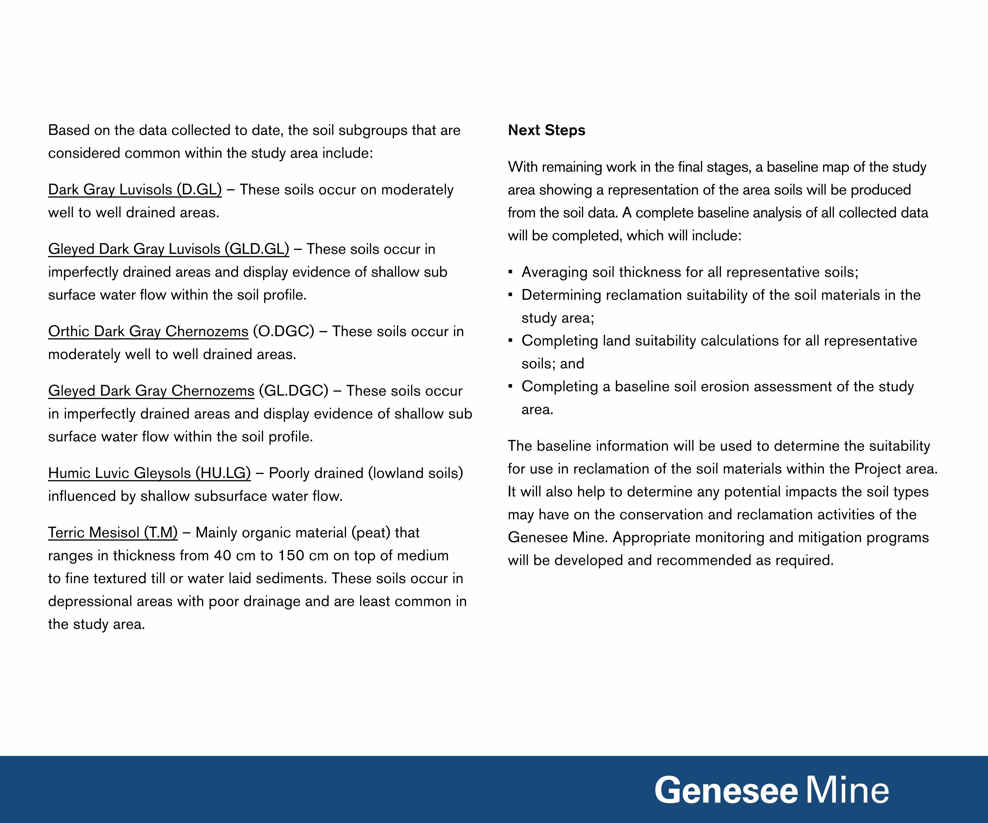
Based on the data collected to date, the soil subgroups that are
considered common within the study area include:
Dark Gray luvisols (D.Gl) – These soils occur on moderately
well to well drained areas.
Gleyed Dark Gray luvisols (GlD.Gl) – These soils occur in
imperfectly drained areas and display evidence of shallow sub
surface water flow within the soil profile.
Orthic Dark Gray Chernozems (O.DGC) – These soils occur in
moderately well to well drained areas.
Gleyed Dark Gray Chernozems (Gl.DGC) – These soils occur
in imperfectly drained areas and display evidence of shallow sub
surface water flow within the soil profile.
Humic luvic Gleysols (HU.lG) – Poorly drained (lowland soils)
influenced by shallow subsurface water flow.
Terric Mesisol (T.M) – Mainly organic material (peat) that
ranges in thickness from 40 cm to 150 cm on top of medium
to fine textured till or water laid sediments. These soils occur in
depressional areas with poor drainage and are least common in
the study area.
Next Steps
With remaining work in the final stages, a baseline map of the study
area showing a representation of the area soils will be produced
from the soil data. A complete baseline analysis of all collected data
will be completed, which will include:
• Averaging soil thickness for all representative soils;
• Determining reclamation suitability of the soil materials in the
study area;
• Completing land suitability calculations for all representative
soils; and
• Completing a baseline soil erosion assessment of the study
area.
The baseline information will be used to determine the suitability
for use in reclamation of the soil materials within the Project area.
it will also help to determine any potential impacts the soil types
may have on the conservation and reclamation activities of the
Genesee Mine. Appropriate monitoring and mitigation programs
will be developed and recommended as required.

Wildlife
Goals of Baseline Study
The goal of the wildlife baseline study is to understand current
wildlife types and populations within the Project area.
Study Area
The land contained within the Project area was used for the
baseline study.
Methodology
Wildlife populations in the Project area are well known as a result
of recently collected and ongoing data collections. Sources of
baseline information include:
• Baseline field data collected in 2009 for owls, waterfowl,
amphibians and mammals;
• Baseline breeding bird surveys conducted in June 2010;
• Data collected since 2005 for the Genesee Wildlife Monitoring
Program. This monitoring program involves:
– annual monitoring of peregrine falcons and overwintering
waterfowl;
– surveys of hawks, owls, songbirds, and amphibians at
selected monitoring locations every 2 years;
– ungulate surveys and habitat mapping every 4 years;
• Overall ‘health’ of wildlife in the Genesee area through
monitoring population characteristics and tissue quality of
red-backed voles (a terrestrial wildlife indicator species) every
4 years;
• Provincial government databases for Species at Risk and
Species of Management Concern; and
• information provided by stakeholders and local residents.

Baseline Results
• Over 70% of the land within the Project area has previously
been cleared for agriculture.
• Although previous habitat loss has reduced the value of the area
for wildlife, remaining habitats (i.e. wetlands, riparian areas and
mixed wood forest) still support a diversity of wildlife species:
– Sixty nine bird species were recorded in the study area during
the breeding period; including owl species (the great-horned
owl, great gray owl and northern saw-whet owl);
– Twelve waterfowl species were observed at wetlands in the
study area – the mallard, Canada goose, blue-winged teal,
lesser scaup and common goldeneye being the most common;
– The most number of songbird species were the least
flycatcher, American robin, house wren, red-eyed vireo, song
sparrow and Baltimore oriole;
– Four amphibian species were recorded during the 2009
surveys, including the boreal chorus frog, wood frog, western
(boreal) toad and Canadian toad;
– White-tailed deer are present in the study area, and many
larger blocks of forest are also used by moose.
The following images are of wildlife commonly found within the
study area.
Photo 3: Saw-Whet Owl
Photo 4: Blue-Winged Teal
Photo 5: Least-Flycatcher
Photo 1: Boreal Chorus Frog
Photo 2: White-Tailed Deer
Species at Risk
Several species in the study area are listed as ‘Sensitive’ (Sensitive
– native species are not immediately at risk to expiration or
extinction, but are sensitive to exploitation or habitat loss and
may require special attention or protection to prevent them from
becoming at risk) by the provincial government visit
www.srd.alberta.ca/BiodiversityStewardship/SpeciesAtRisk/Default.aspx
for a full list of At Risk Species in Alberta. These include the
great gray owl, lesser scaup, green-winged teal, horned grebe,
sora, pileated woodpecker, least flycatcher, Eastern phoebe and
Baltimore oriole. The Canadian toad is listed as ‘Maybe at Risk’
(Maybe at Risk – native species may be at risk of expiration
or extinction and are therefore candidates for a detailed risk
assessment and research priority).
Next Steps
The wildlife assessment will involve a review of all potential
effects the Project may have on area wildlife. Areas of
assessment may include:
• loss of habitat for species at risk or other key management
species;
• reductions in wildlife habitat diversity (which effects biodiversity);
• disruption of regional wildlife movement patterns;
• effects of air emissions on wildlife habitat;
• potential for accidental mortality of wildlife.
Based on an evaluation of the baseline and assessment data,
mitigation plans may be developed to help reduce potential
significant adverse effects of the Project on wildlife.

vegetation Goals of the Baseline Study
The primary goal of the baseline vegetation study is to classify
and map all vegetation and wetland communities that exist in the
Project area.
Study Area
The land contained within the Project area was used for the
baseline study.
Field surveys were planned to cover a variety of both upland
and wetland areas. Upland areas are found on higher land than
wetlands. Upland areas tend to have drier soils and wetland soils
tend to be more moist. Given this, each area supports a different
variety of plant life.
Upland surveys were conducted in treed, shrub-dominated
and pasture areas (Photo 1). Wetland surveys were conducted
throughout the spring and summer season in wetlands (Photo 2),
riparian zones (along the edge of creeks and wetlands) (Photo 3),
and large open bodies of water.
Methodology
Using maps created with satellite images and existing data on
Alberta lands, field surveys were conducted on foot throughout
the growing season to identify vegetation community types, rare
plants, rare plant communities, and classify wetlands.
Photo 1: Upland Treed Vegetation Plot Photo 2: Typical Wetlands within the Project area
Photo 3: Typical Riparian Zone found within the Project area
Photo 4: Wetland Plot
Data on documented rare plants in the area was collected and
then confirmed through field studies. Collected species were
verified by experts with knowledge in the identification of rare plant
species (taxonomists).

Baseline Results
Since 2009, a total of 439 plots have been sampled. Of these
plots, 91 plots were sampled during the 2010 vegetation survey.
Of the 91 plots sampled, 43 plots were wetland sites and 48 plots
were upland sites. To confirm baseline work that was completed
in 2009 and wetland classification, 75% of the wetland plots
sampled in 2009 were re-sampled during the 2010 program.
During the baseline field program, 5 rare plant species were
identified. They are listed in the table below. A rare plant species
is considered to be any native plant that, because of its biological
characteristics or for some other reason, exists in low numbers or in
very restricted areas in Alberta. Although not technically classified
as plants, the definition of rarity also applies to lichens and fungi.
non-vascular plants do not have specialized conducting tissues
and therefore are restricted to relatively small sizes. Mosses and
lichens are examples of non-vascular plants.
Field identification of non-vascular plants is not possible for every
species. Therefore, samples of those species that could not be
identified in the field were collected, and have been sent to moss
and lichen experts for identification. vascular plants have been the
only type of species reported to date, and the identification of non-
vascular species is expected to be complete in 2011.
Some of the additional vegetation observed in the proposed mine
extension area includes:
*Complete list of rare plant can be found at - http://tpr.alberta.ca/parks/heritageinfocentre/plants/vascularbryophytes/default.aspx
Photo 5: Cattail – Typha latifolia
Photo 6: Low-bush cranberry – Viburnum edule
Photo 7: Water dock – Rumex orbiculatus
Photo 8: Aspen and White Spruce Trees
Rare plant species found in the Project area
Common name Species number of sites found
browned sedge Carex adusta 5
Crawe’s sedge Carex crawei 1
golden saxifrage Chrysosplenium iowense 10
moss Seligeria tristichoides 1
Baseline field work also consisted of sampling vascular and non-
vascular plants. Vascular plants are plants that have specialized
tissue to circulate water and minerals through the plant and
therefore can grow to a larger size than non-vascular plants.
Trees, shrubs, ferns, and grasses are examples of vascular plants.
Non vascular plants are also important indicators of biodiversity
and ecosystem health and are included in field surveys.
Next Steps
A wetland and ecosystem classification map of the Project
area is being prepared based on the field surveys and photo
interpretations of the area. Together, the data collected and the
ecosystem classification map will help determine the number of
ecosites and the area they cover.
Using this information in comparison to the proposed mine plan,
appropriate monitoring and mitigation strategies may be developed
to help protect any existing rare or sensitive plant communities that
may experience significant adverse effects as a result of the Project.