Embed Size (px)
Citation preview
WEBER HYDROELECTRIC PROJECT (FERC NO. 1744)
DRAFT APPLICATION FOR NEW LICENSE
FOR MAJOR CONSTRUCTED PROJECT LESS THAN 5MW
INITIAL STATEMENT
DECEMBER 2017

Weber Hydroelectric Project (P-1744) 1 Draft License Application – Initial Statement
BEFORE THE FEDERAL ENERGY REGULATORY COMMISSION
WEBER HYDROELECTRIC PROJECT PROJECT NO. 1744
DRAFT APPLICATION FOR NEW LICENSE FOR MAJOR CONSTRUCTED PROJECT LESS THAN 5MW
INITIAL STATEMENT
(Pursuant to 18 CFR 4.61)
(1) PacifiCorp (hereinafter “Licensee” or PacifiCorp) applies to the Federal Energy Regulatory Commission (hereinafter “FERC” or “Commission”) for a new license for the Weber Hydroelectric Project (hereinafter “Project”), as described in the attached exhibits. The Project is currently licensed to PacifiCorp as Project No. 1744, by Order dated June 28, 1990.
(2) The location of the Project is:
State or territory: Utah County: Weber, Morgan, Davis Township or nearby towns: Ogden Stream or other body of water: Weber River
(3) The exact name, business address, and telephone number of the applicant are:
PacifiCorp 825 NE Multnomah, Suite 1500 Portland, OR 97232 Telephone: 503-813-6657
(4) The exact name, business address, and telephone number of each person authorized to act as agent for the applicant in this application are:
Mark Sturtevant, Managing Director PacifiCorp – Renewable Resources 825 NE Multnomah, Suite 1500 Portland, OR 97232 Telephone: 503-813-6680 E-mail: [email protected]
Todd Olson, Director of Compliance PacifiCorp – Renewable Resources 825 NE Multnomah, Suite 1500 Portland, OR 97232 Telephone: 503-813-6657 E-mail: [email protected]

Weber Hydroelectric Project (P-1744) 2 Draft License Application – Initial Statement
Eve Davies, Licensing Project Manager PacifiCorp – Renewable Resources 1407 West North Temple, Suite 210 Salt Lake City, UT 84116 Telephone: 801-220-2245 Email: [email protected]
(5) The applicant is a citizen of the United States and is not claiming preference under
section 7(a) of the Federal Power Act. See 16 U.S.C. 796.
(6) (a) The statutory or regulatory requirements of the State of Utah, in which the Project is located, which would, assuming jurisdiction and applicability, affect the Project with respect to bed and banks, and to the appropriation, diversion, and use of water for power purposes, and with respect to the right to engage in the business of developing, transmitting, and distributing power and in any other business necessary to accomplish the purposes of the license under the Federal Power Act are:
401 Water Quality Certification from the Utah Department of Environmental Quality to assure compliance with section 401 of the Federal Clean Water Act.
State of Utah Division of Water Rights for both regulation of the water rights to operate the Project, and for a necessary stream alteration permit for the proposed fish passage.
(b) The steps which the Applicant has taken, or plans to take, to comply with each of the laws cited above are:
The applicant will apply for the 401 Water Quality Certification per 18 CFR § 5.23 (b).
PacifiCorp will maintain its 1938 water right (35-8061) for 365 cubic feet per second (cfs) to operate the Project.
PacifiCorp will maintain its 1965 water right (35-8062) for 100 acre-feet for storage.
PacifiCorp will maintain its 1949 water right (35-8741) for storage at Echo Reservoir (U.S. Bureau of Reclamation project) and releases to be used for power generation.
(7) Brief Project description:
The Weber Hydroelectric Project is located in Weber, Davis, and Morgan (primarily the latter) counties in northern Utah. The Project is situated on the Weber River and is located approximately nine miles southeast of the City of Ogden. The existing Project consists of a concrete diversion dam, two radial gates, an intake structure, a steel pipeline encased in concrete, a historic and non-operational fish passage structure (commonly referred to as the ‘ice chute’), a powerhouse with one generating unit, a discharge pipe,

Weber Hydroelectric Project (P-1744) 3 Draft License Application – Initial Statement
and a transmission line. An upstream fish ladder is proposed for inclusion in the licensed project works for the new license. The FERC project boundary encompasses 14.94 acres of land managed by the US Department of Agriculture Forest Service (USFS), Wasatch-Cache National Forest, as well as lands owned by the Union Pacific Railroad Company and the Utah Department of Transportation. There are no Tribal reservations in the project boundary. Facilities included within the Project Boundary include the dam, impoundment, the 9,107-foot-long penstock, powerhouse and tailrace, and a small picnic area and recreation site immediately adjacent and to the north of the dam. The Project is a run-of-river operation and is not used for daily peaking of generation. Downstream of the Project dam, the current license mandates a continuous minimum stream flow of 34 cfs or inflow to Project, whichever is less, from October 1-March 31 annually; and, a continuous minimum flow of 34-50 cfs (range dependent on the annual runoff forecast), or inflow to Project, whichever is less, from April 1 - September 30 annually. Inflows less than approximately 50 cfs (minimum hydraulic capacity plus minimum flows) are passed at the dam. Flows greater than 354-370 cfs (maximum hydraulic capacity plus minimum flows) are likewise spilled. The Project has a single Horizontal Francis turbine rated at 5,000 hp (3,850 kW) and a generator rated at 3,850 kW.
(8) Lands of the United States.
The Weber Hydroelectric Project is located on a combination of public and private lands.
U.S. Forest Service Ogden Ranger District 507 E. 25th Street Ogden, UT 84401
Union Pacific Railroad 1400 Douglas Street Omaha, NE 68179
(9) Construction of the Project.
This is an existing project and no new generation is planned in association with this application for new license. Construction of a new fish ladder is proposed as a Protection, Mitigation and Enhancement measure for the new license.
Weber Hydroelectric Project (P-1744) 4 Draft License Application – Initial Statement
ADDITIONAL GENERAL INFORMATION
(Pursuant to 18 C.F.R. § 5.18)
(1) Identify every person, citizen, association of citizens, domestic corporation, municipality, or state that has or intends to obtain and will maintain any proprietary right necessary to construct, operate, or maintain the Project:
PacifiCorp (Licensee) has obtained and will maintain any proprietary rights necessary to construct, operate, or maintain the Weber Hydroelectric Project (FERC No. 1744) (Project).
(2) Identify (providing names and addresses):
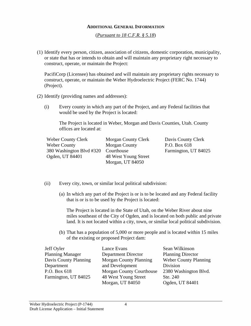
(i) Every county in which any part of the Project, and any Federal facilities that would be used by the Project is located:
The Project is located in Weber, Morgan and Davis Counties, Utah. County offices are located at:
Weber County Clerk Weber County 380 Washington Blvd #320 Ogden, UT 84401
Morgan County Clerk Morgan County Courthouse 48 West Young Street Morgan, UT 84050
Davis County Clerk P.O. Box 618 Farmington, UT 84025
(ii) Every city, town, or similar local political subdivision:
(a) In which any part of the Project is or is to be located and any Federal facility that is or is to be used by the Project is located:
The Project is located in the State of Utah, on the Weber River about nine miles southeast of the City of Ogden, and is located on both public and private land. It is not located within a city, town, or similar local political subdivision.
(b) That has a population of 5,000 or more people and is located within 15 miles of the existing or proposed Project dam:
Jeff Oyler Planning Manager Davis County Planning Department P.O. Box 618 Farmington, UT 84025
Lance Evans Department Director Morgan County Planning and Development Morgan County Courthouse 48 West Young Street Morgan, UT 84050
Sean Wilkinson Planning Director Weber County Planning Division 2380 Washington Blvd. Ste. 240 Ogden, UT 84401

Weber Hydroelectric Project (P-1744) 5 Draft License Application – Initial Statement
Marsha Morrow City Recorder 250 North Main Street Centerville, UT 84014
Harrisville City 363 West Independence Boulevard Harrisville, UT 84404
Clearfield City 55 S. State St. Clearfield, UT 84015
Clinton City 2267 N. 1500 W. Clinton, UT 84015
Farr West City Farr West City Office 1896 N. 1800 W. Farr West, UT 84404
Fruit Heights City City Hall 910 S. Mountain Rd. Fruit Heights, UT 84037
Hooper City Hooper City Civic Center 5580 W. 4600 S. Hooper, UT 84315
Kaysville City 23 E. Center Kaysville, UT 84037
Layton City 437 N. Wasatch Dr. Layton, UT 84041
North Ogden City Municipal Bldg. 505 E. 2600 N. North Ogden, UT 84414
Plain City 4160 W. 2200 N. Plain City, UT 84404
Pleasant View City 520 W. Elberta Drive Ogden, UT 84414
Riverdale City 4600 S. Weber River Dr. Riverdale, UT 84405
Roy City Roy Municipal Building 5051 S. 1900 W. Roy, UT 84067
South Ogden City 3950 S. Adams Avenue, Ste. 1 South Ogden, UT 84403
South Weber City 1600 E. South Weber Dr. South Weber, UT 84405
Sunset City Corporation 200 W. 1300 N. Sunset, UT 84015
Syracuse City Municipal Building 1979 W. 1900 S. Syracuse, UT 84075
Washington Terrace City City Hall 5249 S. South Pointe Dr. Washington Terrace, UT 84405
West Haven City 4150 S. 3900 W. West Haven, UT 84401
West Point City West Point City Hall 3200 W. 300 N. West Point, UT 84015
(iii) Every irrigation district, drainage district, or similar special purpose political
subdivision:
The following parties are signatories with PacifiCorp predecessor-companies to two water interference agreements which affect Project water rights:
Wayne Pullan U.S. Bureau of Reclamation 302 E. 1860 South Provo, UT 84606
Jeff Budge Provo River Water Users 285 W. 1100 North Pleasant Grove, UT 84062
Richard D. Smith Weber River Water Users & Davis and Weber Co. Canal Company 138 W. 1300 North Sunset, UT 84105

Weber Hydroelectric Project (P-1744) 6 Draft License Application – Initial Statement
(iv) Every other political subdivision in the general area of the Project that there is reason to believe would be likely to be interested in, or affected by, the application:
Sean Harwood U.S. Forest Service Ogden Ranger District 507 E. 25th Street Ogden, UT 84401
Brent DeYoung Utah Department of Transportation, Region 1 166 W. Southwell St. S. Willard, UT 84340
Mark Anderson, Assistant General Manager Weber River Water Conservancy District 2837 E. Highway 193 Layton, UT 84040
(v) All Indian Tribes that may be affected by the Project:
There are no tribal lands or tribal claims within or immediately adjacent to the Project Area. The following Indian Tribes are associated with the larger region where the Project is located and may be interested in the application:
Darren B. Parry, Chairman Northwestern Band of Shoshone Nation 707 North Main Street Brigham City, UT 84302
Candace Bear, Chairwoman Skull Valley Band of Goshute 407 Skull Valley Rd. Skull Valley, UT 84029
Nathan Small Tribal Chairman Shoshone-Bannock Tribes P. O. Box 306 Fort Hall, ID 83203
Luke Duncan, Chairman Ute Indian Tribe P.O. Box 190 Fort Duchesne, UT 84026-0190
Virgil W. Johnson, Chairman Confederated Tribe of Goshute HC 61. Box 6104 195 Tribal Center Rd. Ibapah, UT 84034
Tamra Borchardt-Slayton, Chairperson Paiute Tribes of Utah 440 North Paiute Dr. Cedar City, UT 84721
(3) The Applicant has, in accordance with 18 CFR § 5.18 (3)(i), made a good-faith effort to
notify, by certified mail (for the Final License Application; this Draft will use U.S. Mail), the following entities of the filing of this application:
(a) Every property owner of record of any interest within the bounds of the Project;
(b) The entities listed in (2) above;
(c) Other governmental agencies that would likely be interested in or affected by the application.

Weber Hydroelectric Project (P-1744) 7 Draft License Application – Initial Statement
A complete listing of appropriate agencies, tribes, local governments, non-governmental organizations, and abutting property owners to which notice of this license application was distributed is provided in Appendix A.
(4) In accordance with 18 CFR § 4.61 of the Commission's regulations, the following Exhibits are attached to and made a part of this application:
Exhibit A – Project Description and Description of Operations
Exhibit E – Environmental Report (Applicant Prepared Environmental Assessment)
Exhibit F – General Design Drawings and Supporting Design Report (provided under separate cover as CEII for security purposes)
Exhibit G – Project Boundary Maps
Exhibit H – Description of Project Management and Need for Project Power

Weber Hydroelectric Project (P-1744) 8 Draft License Application – Initial Statement
SUBSCRIPTION This Application for License for the Weber Hydroelectric Project, FERC No. 1744, is executed
in the State of Utah, Counties of Weber, Morgan and Davis, by Signee of PacifiCorp (Mark
Sturtevant), who, being duly sworn, deposes and says that the contents of this application are true
to the best of his knowledge or belief and that he is authorized to execute this application on
behalf of PacifiCorp. The undersigned has signed this application this ___ day of __________,
2017.
PacifiCorp
By (To be signed for final license application)
VERIFICATION SWORN to before me, Commissioner for [Insert Notary Language], this ______ day of ______________ 2017. My commission expires on: _______________________

Weber Hydroelectric Project (P-1744) 9 Draft License Application – Initial Statement
CERTIFICATE OF SERVICE
I hereby certify that I have this day served notice of availability and/or a copy of the Final
License Application for the Weber Hydroelectric Project (FERC Project No. 1744), via certified
mail, upon each person designated on the attached Distribution List.
Dated this [Insert Date] day of [Insert Month, Year], at Portland, Oregon.
_______________________________________ Beth Bendickson, Sr. Project Coordinator PacifiCorp – Renewable Resources 825 NE Multnomah, Suite 1500 Portland, OR 97232
(To be signed for final license application)

APPENDIX A
DISTRIBUTION LIST

Weber Distribution List December 2017
Federal Agencies Sean Harwood District Ranger U.S. Forest Service Ogden Ranger District 507 E. 25th St., Suite 103 Ogden, UT 84401
Jamie Gough Water Rights and Uses Program Manager/Interregional Hydropower Team Leader U.S. Forest Service Intermountain Region 4 324 25th St. Ogden, UT 84401
Charlie Rosier Recreation, Lands & Special Uses U.S. Forest Service, Uinta-Wasatch-Cache National Forest Forest Supervisor’s Office 857 W. South Jordan Pkwy South Jordan, UT 84095
Director U.S. Department of Energy Denver Regional Support Office 1617 Cole Blvd., Flr 2 Golden, CO 80401
Regional Director Bureau of Reclamation 125 S State St., Room 6107 Salt Lake City, UT 84138
Robert F. Stewart Regional Environmental Officer US Dept. of Interior PO Box 25007 Denver, CO 80225
David Hurd Environmental Protection Specialist NPS Intermountain Regional Office 12795 W. Alameda Pkwy Denver, CO 80225-0287
Wayne Pullan Area Manager U.S. Bureau of Reclamation 302 E. 1860 South Provo, UT 84606
Rick Jones Wildlife Biologist U.S. Bureau of Reclamation 302 E. 1860 South Provo, UT 84606
Director of Lands USDA-Forest Service Intermountain Region 324 25th St. Ogden, UT 84401
Regional Director Attn: LC 705 Bureau of Reclamation Lower Colorado Region PO Box 61470 Boulder City, CO 89006
Hydropower Program Manager U.S. Bureau of Indian Affairs 911 NE 11th Avenue Portland, OR 97232
Larry Cist Utah Field Supervisor U.S. Fish and Wildlife Service 2369 W. Orton Circle, Suite 50 West Valley City, UT 84119
Doug Benevento Regional Administrator U.S. Env. Protection Agency Region 8 1595 Wynkoop St. Mailcode 8RA Denver, CO 80202-1129
Evan Williams Federal Energy Regulatory Commission Division of Hydropower Licensing 888 First St., NE Washington, DC 20426
Sue Masica Regional Director National Park Service 12795 Alameda Pkwy Denver, CO 80225
Paul Chase Fisheries Biologist U.S. Forest Service Logan Ranger District Wasatch-Cache National Forest 1500 E. Hwy 89 Logan, UT 84321
Weber Distribution List December 2017
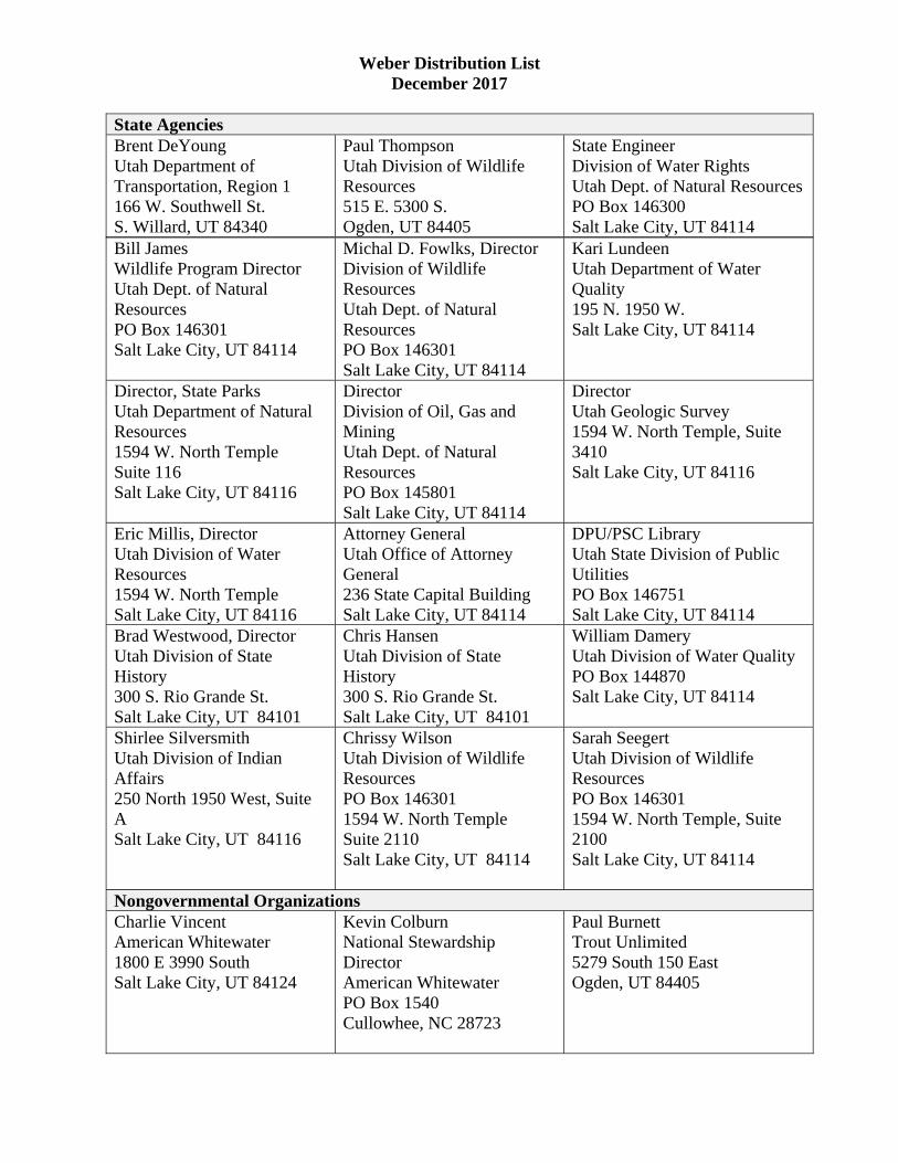
Bill James Wildlife Program Director Utah Dept. of Natural Resources PO Box 146301 Salt Lake City, UT 84114
Michal D. Fowlks, Director Division of Wildlife Resources Utah Dept. of Natural Resources PO Box 146301 Salt Lake City, UT 84114
Kari Lundeen Utah Department of Water Quality 195 N. 1950 W. Salt Lake City, UT 84114
Director, State Parks Utah Department of Natural Resources 1594 W. North Temple Suite 116 Salt Lake City, UT 84116
Director Division of Oil, Gas and Mining Utah Dept. of Natural Resources PO Box 145801 Salt Lake City, UT 84114
Director Utah Geologic Survey 1594 W. North Temple, Suite 3410 Salt Lake City, UT 84116
Eric Millis, Director Utah Division of Water Resources 1594 W. North Temple Salt Lake City, UT 84116
Attorney General Utah Office of Attorney General 236 State Capital Building Salt Lake City, UT 84114
DPU/PSC Library Utah State Division of Public Utilities PO Box 146751 Salt Lake City, UT 84114
Brad Westwood, Director Utah Division of State History 300 S. Rio Grande St. Salt Lake City, UT 84101
Chris Hansen Utah Division of State History 300 S. Rio Grande St. Salt Lake City, UT 84101
William Damery Utah Division of Water Quality PO Box 144870 Salt Lake City, UT 84114
Shirlee Silversmith Utah Division of Indian Affairs 250 North 1950 West, Suite A Salt Lake City, UT 84116
Chrissy Wilson Utah Division of Wildlife Resources PO Box 146301 1594 W. North Temple Suite 2110 Salt Lake City, UT 84114
Sarah Seegert Utah Division of Wildlife Resources PO Box 146301 1594 W. North Temple, Suite 2100 Salt Lake City, UT 84114
Nongovernmental Organizations Charlie Vincent American Whitewater 1800 E 3990 South Salt Lake City, UT 84124
Kevin Colburn National Stewardship Director American Whitewater PO Box 1540 Cullowhee, NC 28723
Paul Burnett Trout Unlimited 5279 South 150 East Ogden, UT 84405
State Agencies Brent DeYoung Utah Department of Transportation, Region 1 166 W. Southwell St. S. Willard, UT 84340
Paul Thompson Utah Division of Wildlife Resources 515 E. 5300 S. Ogden, UT 84405
State Engineer Division of Water Rights Utah Dept. of Natural Resources PO Box 146300 Salt Lake City, UT 84114

Weber Distribution List December 2017
Tribes Darren B. Parry Tribal Chairman Northwestern Band of Shoshone Nation 707 North Main St. Brigham City, UT 84302
Candace Bear Chairwoman Skull Valley Band of Goshute 407 Skull Valley Rd. Skull Valley, UT 84029
Nathan Small Tribal Chairman Shoshone-Bannock Tribes PO Box 306 Fort Hall, ID 83203
Luke Duncan Chairman Ute Indian Tribe PO Box 190 Fort Duchesne, UT 84026-0190
Virgil W. Johnson Chairman Confederated Tribe of Goshute HC 61 Box 6104 195 Tribal Center Rd. Ibapah, UT 84034
Tamra Borchardt-Slayton Chairperson Paiute Tribes of Utah 440 North Paiute Dr. Cedar City, UT 84721
Cleve Davis Environmental Coordinator Fish and Wildlife Department Shoshone-Bannock Tribes PO Box 306 Fort Hall, ID 83203
Dan Stone Policy Analyst Shoshone-Bannock Tribe PO Box 306 Fort Hall, ID 83203
Local/Governments Jeff Oyler Planning Manager Davis County Planning Department PO Box 618 Farmington, UT 84025
Lance Evans Department Director Morgan County Planning and Development Morgan County Courthouse 48 West Young St. Morgan, UT 84050
Sean Wilkinson Planning Director Weber County Planning Division 2380 Washington Blvd., Suite 240 Ogden, UT 84401
Davis County Board of County Commissioners Farmington, UT 84025
Morgan County Board of County Commissioners Morgan, UT 84050
Weber County Board of County Commissioners 2380 Washington Blvd. Flr 3 Ogden, UT 84401
Marsha Morrow City Recorder 250 North Main St. Centerville, UT 84014
Harrisville City 363 West Independence Boulevard Harrisville, UT 84404
Clearfield City 55 S. State St. Clearfield, UT 84015
Clinton City 2267 N. 1500 W. Clinton, UT 84015
Farr West City Farr West City Office 1896 N. 1800 W. Farr West, UT 84404
Fruit Heights City City Hall 910 S. Mountain Rd. Fruit Heights, UT 84037
Hooper City Hooper City Civic Center 5580 W. 4600 S. Hooper, UT 84315
Kaysville City 23 E. Center Kaysville, UT 84037
Layton City 437 N. Wasatch Drive Layton, UT 84041

Weber Distribution List December 2017
North Ogden City Municipal Bldg. 505 E. 2600 N. North Ogden, UT 84414
Plain City 4160 W. 2200 N. Plain City, UT 84404
Pleasant View City 520 W. Elberta Drive Ogden, UT 84414
Riverdale City 4600 S. Weber River Drive Riverdale, UT 84405
Roy City Roy Municipal Building 5051 S. 1900 W. Roy, UT 84067
South Ogden City 3950 S. Adams Avenue, Suite 1 South Ogden, UT 84403
South Weber City 1600 E. South Weber Drive South Weber, UT 84405
Sunset City Corporation 200 W. 1300 N. Sunset, UT 84015
Syracuse City Municipal Building 1979 W. 1900 S. Syracuse, UT 84075
Washington Terrace City City Hall 5249 S. South Pointe Drive Washington Terrace, UT 84405
West Haven City 4150 S. 3900 W. West Haven, UT 84401
West Point City West Point City Hall 3200 W. 300 N. West Point, UT 84015
Farmington City PO Box 160 Farmington, UT 84025
Ogden City Ogden Municipal Building 2549 Washington Blvd. Ogden, UT 84401
Cole Panter Weber & Ogden Water Commissioner PO Box 741 Ogden, UT 84402
Mark Anderson Assistant General Manager. Weber Basin Water Conservancy District 2837 E. Hwy. 193 Layton, UT 84040
Jeff Budge Provo River Water Users 285 W. 1100 North Pleasant Grove, UT 84062
Richard D. Smith Weber River Water Users & Davis and Weber Co. Canal Company 138 W. 1300 North Sunset, UT 84105
Uintah City 2191 East 6550 South Uintah, UT 84405
Other Justin Mahr Contract Manager Union Pacific Rail Rd. 1400 Douglas St. Omaha, NE 6817
Mark Sturtevant Managing Director PacifiCorp Renewable Resources 825 NE Multnomah Suite 1500 Portland, OR 97232
Eve Davies Licensing Project Manager PacifiCorp Renewable Resources 1407 West North Temple Suite 210 Salt Lake City, UT 84116

Weber Distribution List December 2017
Beth Bendickson Sr. Project Coordinator PacifiCorp Renewable Resources 825 NE Multnomah Suite 1500 Portland, OR 97232
Todd Olson Director, Compliance PacifiCorp Renewable Resources 825 NE Multnomah Suite 1500 Portland, OR 97232


WEBER HYDROELECTRIC PROJECT (FERC NO. 1744)
DRAFT APPLICATION FOR NEW LICENSE
FOR MAJOR CONSTRUCTED PROJECT LESS THAN 5MW
EXHIBIT A
PROJECT DESCRIPTION
AND
APPENDIX A: DETAILED PROJECT LOCATION MAPS
DECEMBER 2017

Weber Hydroelectric Project (P-1744) i Draft License Application – Exhibit A
TABLE OF CONTENTS
1.0 PROJECT LOCATION ............................................................................................ 1
2.0 DESCRIPTION OF PROJECT §4.61 (C)(1) ........................................................... 4
2.1 PROJECT FEATURES ................................................................................................................. 4
2.1.1 Turbine Type §4.61 (c)(1)(i-ii) .............................................................................................. 4
2.1.2 Description of Project Operation §4.61 (c)(1)(iii) ................................................................. 4
2.1.2.1 Low Flow Operations ....................................................................................................... 5
2.1.2.2 Proposed Project Operations............................................................................................. 5
2.1.2.3 Annual Generation §4.61 (c)(1)(iv) .................................................................................. 6
2.1.3 Average Head §4.61 (c)(1)(v) ................................................................................................ 7
2.1.4 Reservoir Surface Area and Storage Capacity §4.61 (c)(1)(vi) ............................................. 8
2.1.5 Hydraulic Capacity §4.61 (c)(1)(vii) ..................................................................................... 8
2.1.6 Size, Capacity & Construction Materials of Structures §4.61 (c)(1)(viii) ........................... 12
2.1.7 Project Photos ...................................................................................................................... 13
2.1.7.1 Diversion Dam ................................................................................................................ 13
2.1.7.2 Powerhouse ..................................................................................................................... 14
2.1.7.3 Bypass Reach and Tailrace ............................................................................................. 16
2.1.7.4 Appurtenant Facilities and Equipment ........................................................................... 17
2.2 PROJECT COSTS §4.61 (C)(1)(IX) ........................................................................................... 17
2.3 CAPITAL COSTS AND ESTIMATED O&M COSTS OF PROPOSED ENVIRONMENTAL MEASURES §4.61 (C)(1)(X) ................................................................. 17
2.3.1 Protection, Mitigation, and Enhancement Measures (PM&E) ............................................ 17
3.0 PROJECT PURPOSE §4.61 (C)(2) ........................................................................ 27
4.0 APPLICATION DEVELOPMENT COSTS §4.61 (C)(3) ..................................... 28
5.0 ON-PEAK AND OFF-PEAK VALUES OF PROJECT §4.61 (C)(4) ................... 29
6.0 ESTIMATED CHANGE IN PROJECT GENERATION §4.61 (C)(5) ................. 30
7.0 UNDEPRECIATED NET INVESTMENT (BOOK VALUE) OF THE PROJECT §4.61 (C)(6) .......................................................................................... 31
8.0 ESTIMATED ANNUAL COST OF THE PROJECT §4.61 (C)(7) ...................... 32
9.0 SINGLE LINE ELECTRICAL DIAGRAM §4.61 (C)(8) ..................................... 34
10.0 MEASURES TO ENSURE SAFE MANAGEMENT §4.61 (C)(9) ...................... 35
10.1 OWNER’S DAM SAFETY PROGRAM ................................................................................... 35
10.1.1 Emergency Action Plan ....................................................................................................... 35

Weber Hydroelectric Project (P-1744) ii Draft License Application – Exhibit A
10.1.2 Public Safety Plan ................................................................................................................ 35
10.1.3 Site Security ......................................................................................................................... 36
10.1.4 Continuous Improvement .................................................................................................... 36
10.2 ENVIRONMENTAL INSPECTION REPORT .......................................................................... 36
LIST OF TABLES
Table 1. 1966 – 2016 Average Monthly Generation Rate and Turbine Discharge ............. 7
Table 2. Historical Monthly Generation Totals at the Weber Hydroelectric Project 2007-2016 ........................................................................................................................... 7
Table 3. Size, Capacity & Construction Materials of Structures ..................................... 12
Table 4. Estimated Capital and Operation and Maintenance Costs for Potential Project Upgrades ................................................................................................................ 17
Table 5. Existing PM&E Measures ................................................................................... 18
Table 6. Proposed PM&E Measures ................................................................................ 19
Table 7. Current and Proposed PM&E Measure Costs. Values are in 2017 dollars ........ 21
Table 8. Project's Capitalized Expenses for Period of 44 Years ....................................... 32
Table 9. Project's Capitalized Expenses for Period of 44 Years With Inflation ............... 32
Table 10. Environmental Inspection Action Items 2017 ................................................... 36

Weber Hydroelectric Project (P-1744) iii Draft License Application – Exhibit A
LIST OF FIGURES
Figure 1. Project Location Map ........................................................................................... 3
Figure 2. Daily Flow Duration Curve - Weber River at Gateway (Inflow Gage). Data from 1966 - 2016. ................................................................................................................ 9
Figure 3. Monthly Flow Duration Curves - Weber River at Gateway (inflow gage). ...... 10
Figure 4. Alternative Monthly Flow Duration with Identical Axis for all Months ........... 11
Figure 5. Weber Project Current Public Safety Plan Part 12 Signage (Powerhouse) ....... 38
Figure 6. Weber Project Current Public Safety Plan Part 12 Signage (Dam and Recreation Site) ................................................................................................................. 39
Figure 7. Legend for Current Public Safety Plan .............................................................. 40
LIST OF PHOTOS
Photo 1. Diversion Dam .................................................................................................... 13
Photo 2. Diversion Dam and Intake Street Level View .................................................... 13
Photo 3. Pipeline ................................................................................................................ 14
Photo 4. Aerial View of Powerhouse and Substation ....................................................... 15
Photo 5. Street Level View of Weber Substation and Powerhouse .................................. 16
Photo 6. Bypass Reach to Powerhouse .............................................................................. 16
LIST OF APPENDICES
Appendix A – Detailed Project Location Maps

Weber Hydroelectric Project (P-1744) 1 Draft License Application – Exhibit A
DRAFT APPLICATION FOR NEW LICENSE
FOR MAJOR CONSTRUCTED PROJECT LESS THAN 5 MW
WEBER HYDROELECTRIC PROJECT (FERC NO. 1744)
PACIFICORP
EXHIBIT A
PROJECT DESCRIPTION §4.61 (C)
1.0 PROJECT LOCATION
PacifiCorp, a subsidiary of Berkshire Hathaway Energy, is the Licensee for the Weber Hydroelectric Project (FERC No. 1744) (Project). The Project is located in the northern portion of the State of Utah in a small area of Weber, Morgan, and Davis counties, approximately nine miles from the City of Ogden on the Weber River. The Project is partially located on lands managed by the Wasatch-Cache National Forest, and partially on lands owned by the Union Pacific Railroad Company. There are no Tribal reservations in the Federal Energy Regulatory Commission (FERC) Project Boundary. The U.S. Department of Agriculture Forest Service (USFS) manages approximately 15 acres within the proposed Project Boundary.
The exact names, addresses, telephone numbers, and email addresses of the Licensee’s representatives are:
Mark Sturtevant, Managing Director PacifiCorp – Renewable Resources 825 NE Multnomah, Suite 1500 Portland, OR 97232 Phone Number: 503-813-6680 [email protected] Eve Davies, Relicensing Program Manager PacifiCorp – Renewable Resources 1407 W. North Temple, NTO 210 Salt Lake City, UT 84116 Phone Number: 801-220-2245 [email protected]
Todd Olson, Director of Compliance PacifiCorp – Renewable Resources 825 NE Multnomah, Suite 1500 Portland, OR 97232 Phone Number: 503-813-6657 [email protected]
For the purposes of this document, the Project Boundary is defined as all lands and waters within the FERC Project Boundary (whether existing or proposed) for the Weber
Weber Hydroelectric Project (P-1744) 2 Draft License Application – Exhibit A
Hydroelectric Project No. 1744, as denoted by the Project’s Exhibit G. The Project Area is the area which contains all Project features (encompassing the FERC Project Boundary as defined above), and which extends out for the purposes of characterization and analysis from the furthest edge of the Project Boundary, and across the river to the far riverbank (including the river regardless of which side of the river the Project features are found), as shown in Figure 1. Where appropriate, the Area of Potential Effect (APE) is defined by resource as the lands and waters within a given vicinity, often an additional one-mile buffer, around the Project Area.
The location of the Project is shown in Figure 1. Detailed maps showing lands and waters both within the Project Boundary and the Project Area, land ownership, and Project facilities are provided in Appendix A.

Weber Hydroelectric Project (P-1744) 3 Draft License Application – Exhibit A
Figure 1. Project Location Map

Weber Hydroelectric Project (P-1744) 4 Draft License Application – Exhibit A
2.0 DESCRIPTION OF PROJECT §4.61 (C)(1)
The Project was initially constructed in 1910 by Utah Light and Railway Company, which was acquired by a predecessor company and became part of Rocky Mountain Power and PacifiCorp (then Utah Power and Light) in 1915. The Project has a generating capacity of 3.85 megawatts (MW). The original license was made effective January 1, 1938 and expired June 30, 1970. Subsequently a FERC operating license was issued annually for a period from June 30, 1970 to June 28, 1990, due to a dispute with a nearby municipality that wanted to acquire the Weber Project. After a follow-up relicensing process with FERC, the current license was issued on June 28, 1990. It expires on May 31, 2020.
2.1 PROJECT FEATURES
The existing Project consists of a concrete diversion dam, two radial gates, a low-level outlet gate, an intake structure, a steel pipeline (encased in concrete for the first approximately 125 feet of its length), a powerhouse with one generating unit, a discharge pipe, a transmission line, and a fish passage structure (historic and non-operational), hereafter referred to as the ‘ice chute.’
2.1.1 Turbine Type §4.61 (c)(1)(i-ii)
The Project is operated through a single Horizontal Francis turbine with 5,000 horse-power.
2.1.2 Description of Project Operation §4.61 (c)(1)(iii)
The Project is a run-of-river operation and is not used for daily peaking of generation. The current operating license was issued by FERC in 1990 with a 30-year license term, expiring May 31, 2020. The license does not specify any daily/seasonal ramping rates, flushing flows, reservoir operations, or flood control operations. Prior to 1993, the Project was manually operated locally. Following the installation of an automated control system in 1993, the Weber Project is now designed to be capable of unmanned semi-automatic operation and is controlled by a programmable logic controller. Two local operators are located nearby in Ogden, Utah, and visit the Project daily and as dispatched by PacifiCorp’s Hydro Control Center located in Ariel, Washington. However, the plant may at times be unattended. The Hydro Control Center monitors the Project operations remotely and notifies the local operators when an issue arises. In addition to standard local generator protection equipment and alarms, the penstock pressure, generator load, forebay level, and circuit breaker status at the Weber Project are monitored by a hydro control operator at the Hydro Control Center. The Weber flowline can divert up to approximately 365 cubic feet per second (cfs) at the Project dam; the bypass reach is approximately 1.7 miles long.
Downstream of the Weber diversion dam, the current license mandates a continuous minimum stream flow of 34 cfs or inflow, whichever is less, from October 1 - March 31

Weber Hydroelectric Project (P-1744) 5 Draft License Application – Exhibit A
annually; and, a continuous minimum flow of 34-50 cfs (range dependent on the annual runoff forecast), or inflow, whichever is less, from April 1 - September 30 annually.
Annual maintenance is routinely conducted each year and involves vegetation management (including landscaping areas) on Project lands, recreation area maintenance and management (including seasonal portable restroom facilities), limited road maintenance activities, as-needed maintenance on the water conveyance system and generating unit, and non-routine forebay dredging. The timing and scope of annual maintenance activities are coordinated with the Wasatch-Cache National Forest during required annual consultation and as the need arises, as provided in the 1990 Weber license articles and in the Special-Use Permit issued for the Project by the USFS.
2.1.2.1 LOW FLOW OPERATIONS The Weber Project functions in run-of-river mode under all operational conditions, but
particularly during low flow operations when the forebay is emptied and the river channel carries water directly to and through the low-level outlet in the Weber dam (and spillway gates, as required). If the forebay falls four inches below the top of the spillway gate, turbine flows are reduced via automated pond level control. Flows are continually reduced until the unit shuts down, at which point all flow is passed through the minimum flow gate/ice chute (and spillway gates, as required). During winter months, the pond level controls are set to maintain a low water set point up to 12 inches below the normal pond level. For operation of the proposed future fish ladder, at times when the forebay elevation is lower than the inverted opening of the proposed fish ladder intake (or conditions exist that prevent the required 20 cfs flow into the proposed fish ladder), PacifiCorp has committed to keep the low-level gate operational, subject to operational constraints and requirements such as extreme winter icing conditions (PacifiCorp will undertake periodic maintenance as required to ensure operation). If the low-level gate is inoperable for 10 days or more due to extreme temperature or flow conditions, PacifiCorp will consult the specified members of the Fisheries Working Group (FWG) as required by the October 11, 2017 Memorandum of Agreement (MOA) regarding Proposed Protection, Mitigation and Enhancement (PM&E) measures and open the low-level gate as soon as possible (also see Appendix A of Exhibit E of this Draft License Application).
2.1.2.2 PROPOSED PROJECT OPERATIONS The Project will continue to operate as a run-of-the-river facility with new PM&E
measures for potential recreation (boating) flows and a new proposed fish ladder slightly modifying the manner, but not the timing, of flow releases into the bypass reach. PacifiCorp proposes to continue the existing minimum flow regime (34-50 cfs, depending on season and annual runoff forecast), although the minimum flow will be released through both the proposed fish ladder (20 cfs) as well as the existing ice chute structure that would underlie the new fish ladder and release the remainder of the minimum flow (14-30 cfs).
The proposed fishway at the Project is a vertical slot fish ladder, with a design flow of 20 cfs. Any remaining minimum flows will be passed via the existing minimum flow gate/ice chute. The 20 cfs through the fishway would remain constant with the existing minimum flow gate being used to provide the flow adjustment required to accommodate the varying minimum

Weber Hydroelectric Project (P-1744) 6 Draft License Application – Exhibit A
flow requirement (34-50 cfs). To ensure that supplemental attraction flows through the ice chute provide the necessary attraction flow for fish passage, when needed, the south radial gate would be opened rather than the north radial gate (currently the north radial gate is opened; this change would require a new motor and controls on the south radial gate). In addition, in the event of a prolonged Project outage, PacifiCorp would keep the forebay full, if possible, to ensure continued fish ladder operation and consult with the specified members of the FWG as noted in the October 11, 2017 MOA regarding the Proposed PM&E measures.
The proposed recreation-related PM&E measure deals with supporting whitewater boating use of the bypass reach. If a safe and legal egress site is identified by the boating community, and agreed to by the USFS and PacifiCorp, PacifiCorp would provide boater flows to the bypass reach by curtailing generation (up to 320 cfs or inflow) for 4-hour segments on four Saturdays prior to July 15 annually. If undertaken, the exact schedule of this provision of boater flows would be determined in conjunction with American Whitewater, and coordinated with the USFS and Davis and Weber Counties Canal Company (DWCCC). Boater flows in the future may be subject to minimum boater use.
In all other respects, the Project operations described in this section would remain the same under the proposed action.
2.1.2.3 ANNUAL GENERATION §4.61 (C)(1)(IV) The Project has an existing installed generating capacity of 3.85 MW. The average
annual generation is 16,926 megawatt-hours (MWh). The average monthly generation is 1,411 MWh. PacifiCorp began collecting electronic records of Project generation and water outflow in 1966. Therefore, approximately 50 years of data (1966-2016) were used to calculate the values in Table 1, below. The table provides the average monthly generation rate (MWh) and turbine discharge (cfs) based on hourly data. The daily average generation and turbine discharge is highest in June (65.4 MWh/day, 1,961 MWh/30 days, 303 cfs) and lowest in November (20.4 MWh/day, 613 MWh/30 days, 95 cfs). Winter flows and associated generation are affected by the seasonal diversion of water away from the lower Weber River resulting from the 1938 and 1965 Bureau of Reclamation contracts that can provide storage water to Deer Creek (and subsequently Jordanelle) and Echo Reservoirs during winter months. These contracts result in an average annual power generation increase of 5,246 additional MWh from the generation at the Bureau of Reclamation’s Deer Creek Hydroelectric Facility during the time that water is diverted away from the Weber Hydroelectric Project, for a total average annual generation of 22,307 MWh credited to the Weber Project. Table 2 shows generation data for the Weber Project during the most recent 10-year period.

Weber Hydroelectric Project (P-1744) 7 Draft License Application – Exhibit A
Table 1. 1966 – 2016 Average Monthly Generation Rate and Turbine Discharge1 Month Generation (MWh) Discharge (cfs) January 838 125 February 883 145 March 1,430 214 April 1,742 269 May 1,981 296 June 1,961 303 July 1,982 296 August 1,954 292 September 1,754 271 October 1,095 164 November 613 95 December 692 103 1These averages include the approximate three-year period (1983 – 1985) that the Weber plant was offline due to a fire; the average annual generation with those years excluded is 750 MWh higher than shown above.
Table 2. Historical Monthly Generation Totals at the Weber Hydroelectric Project 2007-2016 (MWh)
Month 2007 2008 2009 2010 2011 2012 2013 2014 2015 2016 AVERAGEJanuary 559 157 212 35 903 1,042 (15)1 (14) (14) - 287
February 628 301 307 85 1,846 391 (11) (12) (12) 71 359 March 1,743 1,210 1,489 508 2,200 1,657 285 (11) (11) 1,221 1,029 April 2,069 1,875 2,051 1,661 2,193 2,024 744 (10) 334 1,956 1,490 May 2,069 2,240 1,322 2,210 2,277 2,057 1,864 (9) 1,814 2,254 1,810 June 2,196 2,254 2,157 2,263 2,230 2,123 1,748 (6) 1,635 2,090 1,869 July 2,122 2,318 2,307 2,276 2,283 2,152 1,688 1,237 2,021 2,115 2,052
August 2,133 2,252 2,329 2,254 2,253 1,702 1,431 2,011 1,930 1,934 2,023 September 1,800 2,212 2,129 2,037 2,188 1,351 1,152 1,768 1,822 1,440 1,790
October 999 1,294 700 1,069 2,176 601 46 100 422 501 791 November 97 179 111 160 1,246 13 (11) (11) (7) 44 182 December 68 178 40 758 2,071 (13) (13) (12) (8) - 307
Total Annual
16,483 16,470 15,154 15,316 23,866 15,100 8,908 5,031 9,926 13,626 13,989 1 Negative values shown in parentheses
2.1.3 Average Head §4.61 (c)(1)(v)
The estimated average head on the plant is 185 feet. There is no storage reservoir as the Project is operated as a run-of-river Project. The forebay area within the Project Boundary is 8.86 acres with a water surface area of 8.4 acres. The storage volume of the reservoir is 42 acre-feet.

Weber Hydroelectric Project (P-1744) 8 Draft License Application – Exhibit A
2.1.4 Reservoir Surface Area and Storage Capacity §4.61 (c)(1)(vi)
The normal maximum water surface area and normal maximum water surface elevation (North American Vertical Datum of 1988 [NAVD88]), and gross storage capacity of the Project impoundment (forebay) are:
Area 8.4 acres, maximum Elevation 4,797.19 feet (dam crest) Storage Approximately 42 acre-feet
2.1.5 Hydraulic Capacity §4.61 (c)(1)(vii)
Minimum Hydraulic Capacity: The turbine can be operated to 9.0 kilowatts (kW)/0 cfs with either standard (automated mode) or manual operation.
Maximum Hydraulic Capacity: The Weber flowline can divert up to approximately 320 cfs (up to 365 cfs instantaneously) at the Project dam.1
Estimated Dependable Capacity: 1,160 kW using the most recent 30-year period of record. For the purpose of this document, dependable capacity is based on the annual energy production during the driest year, 2002, of the 30-year period of record. The dependable capacity was based on the 2002 annual energy production divided by the number of hours per year.
Drainage Area: The Weber River Basin drains an area of 2,476 square miles in Summit, Morgan, Weber, and Davis Counties, Utah, and part of Uinta County, Wyoming. The primary drainage of the basin, the Weber River, begins its journey near Reids Peak (11,708 feet) in the Uinta Mountains, flows west to Oakley, Utah, and then flows in a northwesterly direction to its terminus at Great Salt Lake. The Weber River is approximately 125 miles long, and within its drainage there are approximately 968 miles of perennial streams and 1,254 miles of intermittent streams (Utah Water Atlas 2015). Flows in the Weber River Basin are regulated by seven major reservoirs. Echo and Rockport Reservoirs are located on the mainstem of the Weber River, whereas Pineview, Causey, East Canyon, Lost Creek, and Smith & Morehouse Reservoirs are located on tributaries.
Flow duration curves can be found below in Figures 2, 3, and 4.
1 1938 and 1965 agreements and existing water rights: 35-8061—365 cfs flow right, 35-8062—100 af storage, 35-8741— af storage in Echo.

Weber Hydroelectric Project (P-1744) 9 Draft License Application – Exhibit A
Figure 2. Daily Flow Duration Curve - Weber River at Gateway (Inflow Gage). Data from 1966 - 2016.

Weber Hydroelectric Project (P-1744) 10 Draft License Application – Exhibit A
Figure 3. Monthly Flow Duration Curves - Weber River at Gateway (inflow gage). Note that the maximum flow on each axis is the maximum observed daily average flow for that month. Data from January 1, 1966 through December 31, 2016.

Weber Hydroelectric Project (P-1744) 11 Draft License Application – Exhibit A
Figure 4. Alternative Monthly Flow Duration with Identical Axis for all Months

Weber Hydroelectric Project (P-1744) 12 Draft License Application – Exhibit A
2.1.6 Size, Capacity & Construction Materials of Structures §4.61 (c)(1)(viii)
Table 3 details size and construction material information of Weber Project structures.
Table 3. Size, Capacity & Construction Materials of Structures
Equipment/Structure Dimensions Capacity Construction Materials
Diversion Dam 27 ft. high by 79 ft. wide by 114 feet long; crest elevation of 4,797.18 ft. (NAVD88)
42 acre-feet Concrete
Radial Gates (2) 29 ft. wide N/A Steel-original
Intake Structure 20 ft. wide by 27 ft. long N/A Concrete and wood building
Trash Racks 18.6 ft. wide by 14.6 ft. high with 2-inch clear spacing
N/A Steel
Pipeline 9,110 ft. long by 5.5 ft. to 6.3 ft. diameter
N/A Steel and steel encased in concrete
Fish Passage Structure (non-operational)
3 ft. wide by 18 ft. long N/A Concrete
Generator Rated at 1.0 power factor, 360 rpm, three-phase, 60 cycles, and 2,300 volts, under 185-ft head.
3,850 kW Steel
Powerhouse 73.5 ft. long by 56.4 ft. wide 3.85 MW Brick and concrete
Turbine N/A
3,850 kW generating unit (5,000 HP) operating under a head of 185 ft.
Steel
Discharge Pipeline (Draft tube)
N/A N/A Steel
Transmission Line 77 ft. long 46 kilovolts (kV) Steel tower and wire
Weber Hydroelectric Project (P-1744) 13 Draft License Application – Exhibit A
2.1.7 Project Photos
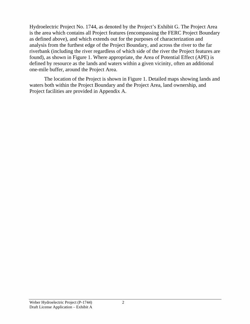
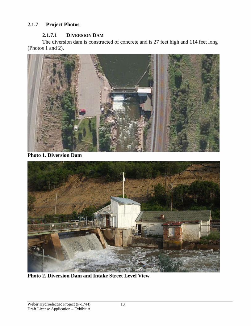
2.1.7.1 DIVERSION DAM The diversion dam is constructed of concrete and is 27 feet high and 114 feet long
(Photos 1 and 2).
Photo 1. Diversion Dam
Photo 2. Diversion Dam and Intake Street Level View

Weber Hydroelectric Project (P-1744) 14 Draft License Application – Exhibit A
The intake structure, located in the white building shown in Photo 2, measures approximately 27 feet long and 20 feet wide. Trash racks are located slightly upstream of the intake to ensure debris does not enter the pipeline. Water is diverted from the Weber River into the intake structure, and continues down the pipeline. The approximately 1.7-mile-long pipeline (approximately 9,110 feet long) is located partially on land owned by the Union Pacific Railroad, and partially on land managed by the USFS. The pipeline is constructed of concrete and steel (Photo 3). The width ranges from 5.5 to 6.3 feet. The intake structure is located on the dam between the low-level gate and the south buttress wall, housed in a small wood frame intake house. A one-story wood-frame watchman’s house (currently unused, and proposed for removal as part of the potential intake modernization project listed in Table 4) is located just downstream from the intake house, and is joined to the intake house. The intake diverts flow into a 74-inch-diameter reinforced concrete pipe for the first 125 feet, transitioning to a welded steel pipe. This replaced 2,000 feet of concrete pipe and 7,075 feet of wood stave pipe in 1949. The pipeline is buried along most of its length. It crosses the river on a 99-foot-span riveted steel Howe truss bridge made by the American Bridge Company downstream from the dam.
Photo 3. Pipeline
2.1.7.2 POWERHOUSE The powerhouse, associated cottages, and diversion dam occupy land managed by the
USFS. The 46-kV transmission line is approximately 77 feet long. The dam is located approximately 1.7 miles upstream from the powerhouse. The powerhouse discharges into the Weber River, as shown in Photo 4. The powerhouse (Photo 4 and Photo 5) is approximately 73.5 feet long by 56.4 feet wide, and 29 feet in height to the top of the concrete parapet wall (does not include the height of the stepped roof detail). The powerhouse is a rectangular brick building with a gabled concrete roof supported by riveted steel Fink trusses. The end walls are five bays wide with stepped parapets at the gables. Original window openings have been
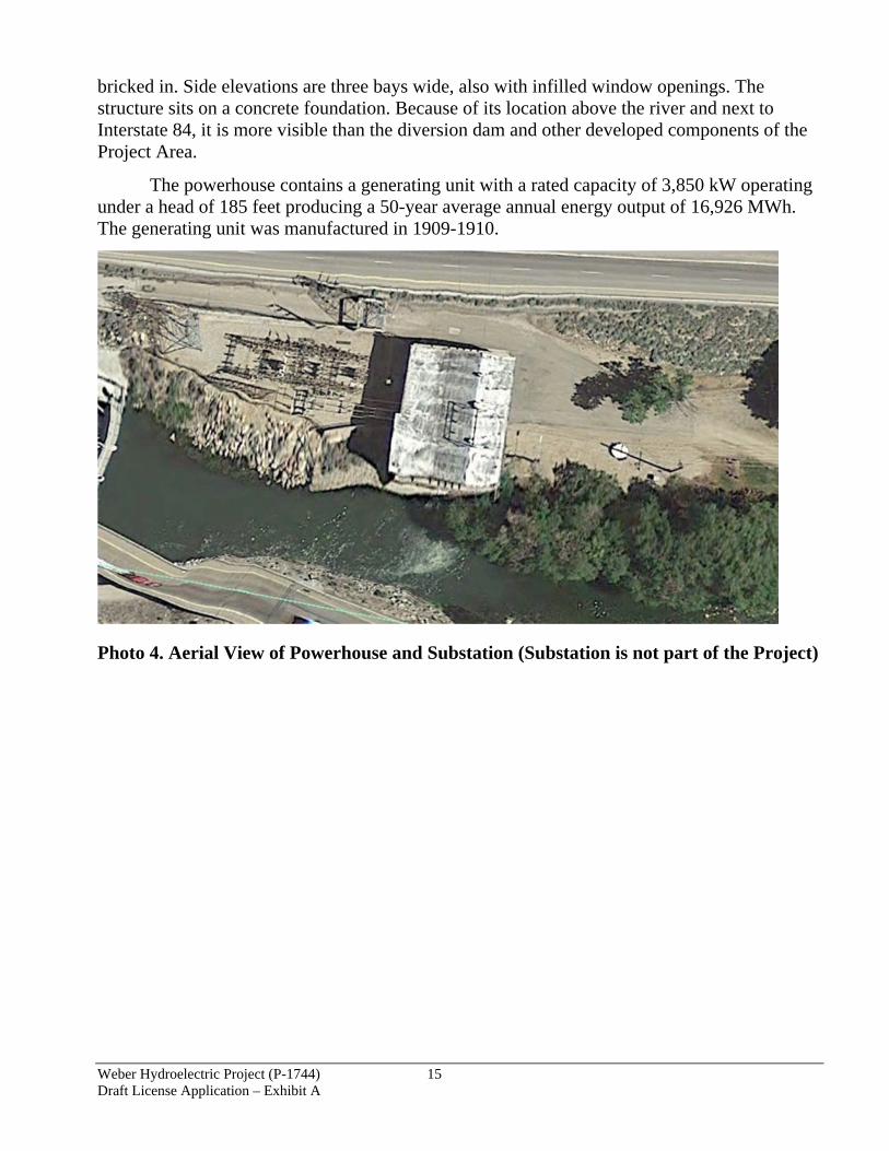
Weber Hydroelectric Project (P-1744) 15 Draft License Application – Exhibit A
bricked in. Side elevations are three bays wide, also with infilled window openings. The structure sits on a concrete foundation. Because of its location above the river and next to Interstate 84, it is more visible than the diversion dam and other developed components of the Project Area.
The powerhouse contains a generating unit with a rated capacity of 3,850 kW operating under a head of 185 feet producing a 50-year average annual energy output of 16,926 MWh. The generating unit was manufactured in 1909-1910.
Photo 4. Aerial View of Powerhouse and Substation (Substation is not part of the Project)

Weber Hydroelectric Project (P-1744) 16 Draft License Application – Exhibit A
Photo 5. Street Level View of Weber Substation (Not part of the Project) and Powerhouse
2.1.7.3 BYPASS REACH AND TAILRACE The bypass reach is the portion of the Weber River where water is removed from the
river between the diversion dam and powerhouse. (Photo 6). The Project bypass reach is approximately two miles long and the upper portion is frequently used by anglers. The bypass reach terminates where the water enters the powerhouse downstream and is returned to the Weber River. The discharge area is approximately 16 feet wide.
Photo 6. Bypass Reach to Powerhouse

Weber Hydroelectric Project (P-1744) 17 Draft License Application – Exhibit A
2.1.7.4 APPURTENANT FACILITIES AND EQUIPMENT Plant operators’ cottages were built near the Weber powerhouse approximately 1.7
miles downstream of the Weber diversion dam. The entire area, including the plant powerhouse, associated substation, cottages, and associated outbuildings is listed on the National Register of Historic Places as an historic district. Originally known as Devil’s Gate (Register No. 89000276), it is now known as the Weber Hydroelectric Plant District.
One section of the flowline, near the Weber powerhouse, was subsequently placed in a three-sided concrete box culvert under the westbound lanes of Interstate 84 when the freeway was constructed in the 1960s.
2.2 PROJECT COSTS §4.61 (C)(1)(IX)
Table 4. Estimated Capital and Operation and Maintenance (O&M) Costs for Potential Project Upgrades
Year Upgrades Capital O&M
2021 Weber Intake Modernization $1,768,000 n/a 2022-2025 Owner’s Dam Safety Program
Analysis and Implementation $115,000 $50,000 periodically;
$400,000 life-of-license total 2022 Weber Butterfly Valve and
Penstock Section $640,000 n/a
2022 Weber Penstock Support Structure Upgrade (aka Trestle Work)
$219,000 n/a
2022 Weber Pipeline River Crossing Recoat
$186,000 n/a
2024 Weber #2 House Removal $28,000 n/a 2025 Cathodic Protection $691,000 n/a 2029 Weber Penstock and Gate Painting $430,000 n/a 2030 Weber Journal Bearing Re-
rabbiting $59,000 n/a
2030 Weber Flow Monitor Replacement $323,000 n/a 2034 Weber Powerhouse Roof
Replacement $86,000 n/a
2034 Weber Relay Replacement $323,000 n/a Annual Operations and Maintenance $274,000/year
$12,039,000 life-of-license total Various Small Projects $288,000 n/a
2.3 CAPITAL COSTS AND ESTIMATED O&M COSTS OF PROPOSED ENVIRONMENTAL MEASURES §4.61 (C)(1)(X)
2.3.1 Protection, Mitigation, and Enhancement Measures (PM&E)
PacifiCorp’s Proposed PM&E strategies focus on preserving areas in the watershed that are ecologically important. In situations where habitat impacts are unavoidable and cannot be recovered, PacifiCorp’s mitigation strategies have been employed to offset the losses. In cases when a change to the environment occurs, enhancement can help alleviate the effects. Table 5 describes PacifiCorp’s current PM&E measures.

Weber Hydroelectric Project (P-1744) 18 Draft License Application – Exhibit A
Table 5. Existing PM&E Measures
Resource Environmental Measure License Article or Other Reference
Compliance History
Fisheries and Aquatic Resources
Maintain required 34-50 cfs minimum stream flow for the bypass reach of the river affected by the Project.
Article 401
Variances average less than once/year, reported to FERC as they have occurred
Operational measures to reduce impacts to aquatic resources, such as minimizing sediment release during forebay elevation changes, and not flushing sediment from the Project forebay.
Voluntary Full compliance
Botanical Resources
Annual consultation with the USFS regarding any planned maintenance or operational measures that would involve ground-disturbing activities.
Article 104 Full compliance
Annual weed control around the Project recreation site, dam and flowline intake, and powerhouse/cottage area.
Voluntary Full compliance
Terrestrial Wildlife Resources
Annual consultation with the USFS regarding any planned maintenance or operational measures that could impact wildlife habitat.
Article 104 Full compliance
Cultural Resources Implementation of a Cultural Resources Management Plan.
Article 403 Full compliance
Recreation Resources
Construction (completed in 1992) and maintenance of the existing recreation site consisting of the following: a paved parking area, five picnic tables, a grassy area, fishing access to the Weber River downstream of the dam, fishing access to the forebay with a handicapped-accessible platform, and a portable toilet that is available on a seasonal basis.
Article 405 Full compliance
Table 6 details proposed PM&E measures under the new License. All existing PM&E measures (those shown in Table 5) are also part of the proposed mitigation measures. Table 7 details the costs of both the existing and proposed mitigation measures. All Weber relicensing stakeholders signed a Memorandum of Agreement regarding the Proposed PM&E measures, with the exception of the Utah Department of Environmental Quality - Division of Water Quality (UDWQ), who instead sent a letter of support for the proposed PM&E measures (also see Exhibit E, Appendix A)

Weber Hydroelectric Project (P-1744) 19 Draft License Application – Exhibit A
Table 6. Proposed PM&E Measures Resource Proposed PM&E Measure Geology and Soils None. Water Resources (Hydrology)
HYD-1: Continue existing seasonally-adjusted minimum stream flows (34-50 cfs). Implement annual change, if needed, in required minimum streamflow within 10 days of the final Weber River runoff forecast from Natural Resources Conservation Service (NRCS), using the current formula.
Water Resources (Water Rights)
No PM&E measure is proposed because existing 1938 and 1965 agreements and existing water rights [35-8061—365 cfs flow right, 35-8062—100 af storage, 35-8741—af storage in Echo] will remain unchanged.
Water Resources (Water Quality)
No PM&E measure is proposed because adherence to existing O&M practices is protective of the resource (state water quality standards are being met).
Fisheries and Aquatic Resources
FISH-1: Continue to provide minimum stream flow for the bypassed reach of the river affected by the Weber Project (identical to HYD-1, above). FISH-2: Construct, operate, and maintain a fish ladder suitable for upstream passage of both Bonneville Cutthroat Trout (BCT) and Bluehead Sucker, including a fish trap operated by Utah Division of Wildlife Resources (UDWR) and Trout Unlimited (TU) and maintained by PacifiCorp. PacifiCorp will consult annually with UDWR, TU, and USFS related to fish ladder and trap operation and maintenance according to a Communication Plan developed between UDWR, TU, USFS, U.S. Fish and Wildlife Service (FWS) and PacifiCorp. The Communication Plan will also specify group contacts, alternates, and contact methods over the life of the license.FISH-3: Keep the low-level gate operational when forebay is dewatered subject to operational constraints and requirements such as extreme winter icing conditions (undertake periodic maintenance as required to ensure operation). If the forebay is dewatered and the low-level gate is inoperable for more than 10 days due to extreme temperature or flow conditions, PacifiCorp will consult with UDWR, TU, FWS, Utah Division of Water Quality (UDWQ), and USFS (per the Communication Plan methods) and open the low-level gate as soon as possible. FISH-4: In the event of a prolonged Project outage, keep forebay full if possible to ensure fish ladder operation; PacifiCorp will consult with UDWR, TU, FWS, UDWQ, and USFS (per the Communication Plan methods) to discuss fishway operation during any interim periods exceeding 10 days when neither the low-level gate nor the fishway are operable.
Botanical Resources BOT-1: Continue existing annual USFS consultation. BOT-2: Conduct weed control per historic practice, adding the area abutting improved Project river access point in riparian habitat (see REC-8, below), subject to landowner weed control requirements and constraints.
Terrestrial Wildlife Resources
WL-1: Continue existing annual USFS consultation.
Cultural and Tribal Resources
CULT-1: Finalize and implement the Historic Properties Management Plan (HPMP) (formerly approved as the Cultural Resources Management Plan [CRMP]).
Recreation Resources REC-1: Continue to maintain the existing Weber Recreation Site, but with modifications outlined below. REC-2: Coordinate with USFS, UDWR, TU, UDWQ, FWS, and American Whitewater (AW) on improved interpretive signage; include potential for improved technology to include a code that is scan-able and that links to flow information (REC-3). Install signage instructing visitors on dog waste protocol and provide dog waste bags for disposal. REC-3: Create a webpage hosted and maintained by PacifiCorp (linked on both the Corporate website and the Project website) indicating approximate bypass reach flows (program subtracts generation flow from U.S. Geological Survey (USGS) gage site flow and posts it to website)—when minimum streamflow only, the calculated number will be replaced by the phrase “minimum streamflow of approximately 50 cfs or inflow” to eliminate the risk of showing a calculated flow that could be less than the minimum for that period. REC-4: Install and maintain a year-round permanent vault Americans with Disabilities Act (ADA)/Architectural Barriers Act (ABA)-compliant toilet facility (flush bathrooms are available at the Utah Department of Transportation (UDOT) rest stop upstream).
Weber Hydroelectric Project (P-1744) 20 Draft License Application – Exhibit A
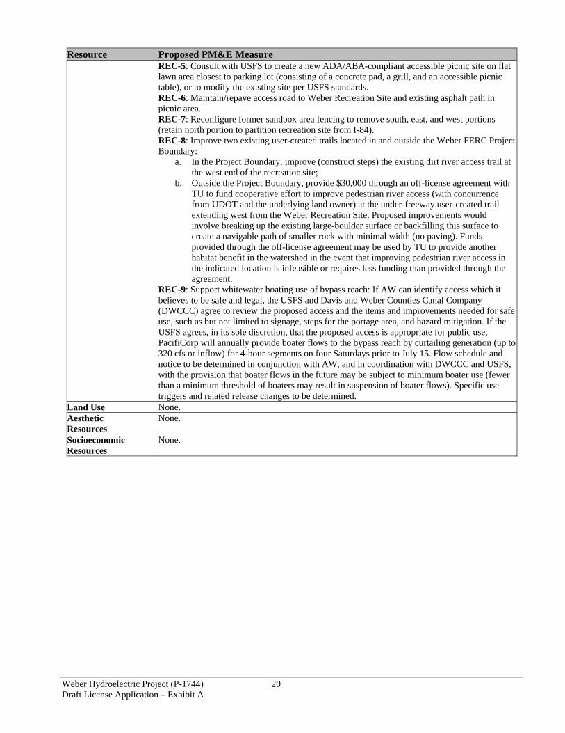
Resource Proposed PM&E Measure REC-5: Consult with USFS to create a new ADA/ABA-compliant accessible picnic site on flat lawn area closest to parking lot (consisting of a concrete pad, a grill, and an accessible picnic table), or to modify the existing site per USFS standards. REC-6: Maintain/repave access road to Weber Recreation Site and existing asphalt path in picnic area. REC-7: Reconfigure former sandbox area fencing to remove south, east, and west portions (retain north portion to partition recreation site from I-84). REC-8: Improve two existing user-created trails located in and outside the Weber FERC Project Boundary:
a. In the Project Boundary, improve (construct steps) the existing dirt river access trail at the west end of the recreation site;
b. Outside the Project Boundary, provide $30,000 through an off-license agreement with TU to fund cooperative effort to improve pedestrian river access (with concurrence from UDOT and the underlying land owner) at the under-freeway user-created trail extending west from the Weber Recreation Site. Proposed improvements would involve breaking up the existing large-boulder surface or backfilling this surface to create a navigable path of smaller rock with minimal width (no paving). Funds provided through the off-license agreement may be used by TU to provide another habitat benefit in the watershed in the event that improving pedestrian river access in the indicated location is infeasible or requires less funding than provided through the agreement.
REC-9: Support whitewater boating use of bypass reach: If AW can identify access which it believes to be safe and legal, the USFS and Davis and Weber Counties Canal Company (DWCCC) agree to review the proposed access and the items and improvements needed for safe use, such as but not limited to signage, steps for the portage area, and hazard mitigation. If the USFS agrees, in its sole discretion, that the proposed access is appropriate for public use, PacifiCorp will annually provide boater flows to the bypass reach by curtailing generation (up to 320 cfs or inflow) for 4-hour segments on four Saturdays prior to July 15. Flow schedule and notice to be determined in conjunction with AW, and in coordination with DWCCC and USFS, with the provision that boater flows in the future may be subject to minimum boater use (fewer than a minimum threshold of boaters may result in suspension of boater flows). Specific use triggers and related release changes to be determined.
Land Use None. Aesthetic Resources
None.
Socioeconomic Resources
None.
Weber Hydroelectric Project (P-1744) 21 Draft License Application – Exhibit A
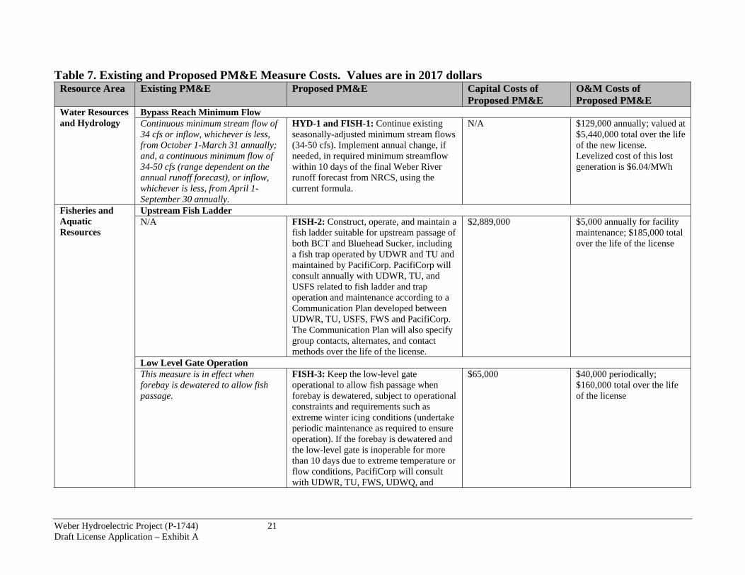
Table 7. Existing and Proposed PM&E Measure Costs. Values are in 2017 dollars Resource Area Existing PM&E Proposed PM&E Capital Costs of
Proposed PM&E O&M Costs of Proposed PM&E
Water Resources and Hydrology
Bypass Reach Minimum Flow Continuous minimum stream flow of 34 cfs or inflow, whichever is less, from October 1-March 31 annually; and, a continuous minimum flow of 34-50 cfs (range dependent on the annual runoff forecast), or inflow, whichever is less, from April 1-September 30 annually.
HYD-1 and FISH-1: Continue existing seasonally-adjusted minimum stream flows (34-50 cfs). Implement annual change, if needed, in required minimum streamflow within 10 days of the final Weber River runoff forecast from NRCS, using the current formula.
N/A $129,000 annually; valued at $5,440,000 total over the life of the new license. Levelized cost of this lost generation is $6.04/MWh
Fisheries and Aquatic Resources
Upstream Fish Ladder N/A FISH-2: Construct, operate, and maintain a
fish ladder suitable for upstream passage of both BCT and Bluehead Sucker, including a fish trap operated by UDWR and TU and maintained by PacifiCorp. PacifiCorp will consult annually with UDWR, TU, and USFS related to fish ladder and trap operation and maintenance according to a Communication Plan developed between UDWR, TU, USFS, FWS and PacifiCorp. The Communication Plan will also specify group contacts, alternates, and contact methods over the life of the license.
$2,889,000 $5,000 annually for facility maintenance; $185,000 total over the life of the license
Low Level Gate Operation This measure is in effect when forebay is dewatered to allow fish passage.
FISH-3: Keep the low-level gate operational to allow fish passage when forebay is dewatered, subject to operational constraints and requirements such as extreme winter icing conditions (undertake periodic maintenance as required to ensure operation). If the forebay is dewatered and the low-level gate is inoperable for more than 10 days due to extreme temperature or flow conditions, PacifiCorp will consult with UDWR, TU, FWS, UDWQ, and
$65,000 $40,000 periodically; $160,000 total over the life of the license

Weber Hydroelectric Project (P-1744) 22 Draft License Application – Exhibit A
Resource Area Existing PM&E Proposed PM&E Capital Costs of Proposed PM&E
O&M Costs of Proposed PM&E
Fisheries and Aquatic Resources (continued)
USFS and open the low-level gate as soon as possible.
Project Operation During Prolonged Outages N/A FISH-4: In the event of a prolonged
Project outage, keep forebay full if possible to ensure fish ladder operation; PacifiCorp will consult with UDWR, TU, FWS, UDWQ, and USFS (per the Communication Plan methods) to discuss fishway operation during any interim periods exceeding 10 days when neither the low-level gate nor the fishway are operable.
$0 $1,000 annually; $44,000 total over the life of the license
Vegetation and Botanical Resources
Annual Consultation Meet each year with the USFS to review any planned maintenance or operational measures that would involve ground-disturbing activities.
BOT-1: Continue existing annual USFS consultation
$0 $2,000 annually; $78,000 total over the life of the (includes costs for WL-1, below)
Annual Weed Control Complete weed management activities around the Project recreation site, dam and flowline intake, and powerhouse/cottage area.
BOT-2: Conduct weed control per historic practice, adding the area abutting improved Project river access point in riparian habitat (see REC-8, below), subject to landowner weed control requirements and constraints.
$0 $2,000 annually; $76,000 total over the life of the license
Terrestrial and Wildlife Resources
Annual Consultation Meet each year with the USFS to review any planned maintenance or operational measures that could impact wildlife habitat.
WL-1: Continue existing annual USFS consultation.
$0 $0 additional (included as part of BOT-1, above)
Cultural and Tribal Resources
Cultural Resources Management Plan (CRMP) Plan currently serves to identify, evaluate, document, register, and establish basic information about known and discovered cultural resources so that proper planning
CULT-1: Finalize and implement the updated HPMP (formerly approved as the CRMP).
$6,000 $15,000 total over the life of the license

Weber Hydroelectric Project (P-1744) 23 Draft License Application – Exhibit A
Resource Area Existing PM&E Proposed PM&E Capital Costs of Proposed PM&E
O&M Costs of Proposed PM&E
can take place to protect cultural and historic resources and provide stewardship to these resources.
Recreational Resources
Day-Use Site Construction (completed in 1992) and maintenance of the existing recreation site consisting of the following: a paved parking area, five picnic tables, a grassy area, fishing access to the Weber River downstream of the dam, fishing access to the forebay with a handicapped-accessible platform, and a portable toilet that is available on a seasonal basis
REC-1: Continue to maintain the existing Weber Recreation Site, but with modifications outlined below.
$0 Included in O&M costs in Table 4, above
Interpretive Signs at Recreation Site Signs are posted and include required FERC Form 80 signage, site rules and regulations, and some additional interpretive signage.
REC-2: Coordinate with USFS, UDWR, TU, UDWQ, FWS, and AW on improved interpretive signage; include potential for improved technology to include a code that is scan-able and that links to flow information (REC-3). Install signage instructing visitors on dog waste protocol and provide dog waste bags for disposal.
$15,000 $25,000
Website Outreach N/A REC-3: Create a webpage hosted and
maintained by PacifiCorp (linked on both the Corporate web site and the Project web site) indicating approximate bypass reach flows (program subtracts generation flow from USGS gage site flow and posts it to website)—when minimum streamflow only, the calculated number will be replaced by the phrase “minimum streamflow of approximately 50 cfs or inflow” to eliminate the risk of showing a
$20,000 $0

Weber Hydroelectric Project (P-1744) 24 Draft License Application – Exhibit A
Resource Area Existing PM&E Proposed PM&E Capital Costs of Proposed PM&E
O&M Costs of Proposed PM&E
Recreational Resources (continued)
calculated flow that could be less than the minimum for that period.
Restroom Maintain seasonal restroom facilities (currently these are portable restrooms) at Weber Recreation Site.
REC-4: Install and maintain a year-round permanent vault ADA/ABA-compliant toilet facility (flush bathrooms are available at the UDOT rest stop upstream).
$64,000 Included in O&M costs in Table 4, above
ADA-Compliant Access Some ADA access provided at Weber Recreation Site, although standards have changed since 1992 installation.
REC-5: Consult with USFS to create a new ADA/ABA-compliant accessible picnic site on flat lawn area closest to parking lot (consisting of a concrete pad, a grill, and an accessible picnic table), or to modify the existing site per current USFS standards.
$20,000 $0 (maintained with overall recreation site)
Access Road and Path This PM&E measure was implemented as part of original recreation site construction in 1992.
REC-6: Maintain/repave access road to Weber Recreation Site and existing asphalt path in picnic area.
$100,000 As needed; $44,000 total over the life of the license
Recreation Site Fencing Fencing was installed during original recreation site construction in 1992, but modifications are proposed as part of the current relicensing.
REC-7: Reconfigure former sandbox area fencing to remove south, east, and west portions (retain north portion to partition recreation site from I-84).
$12,000 $2,000 periodically; $20,000 over the life of the license
Pedestrian River Access N/A REC-8: Improve two existing user-created
trails located in and outside the Weber FERC Project Boundary:
Included in REC O&M cost above $0
a. In the Project Boundary, improve (construct steps) the existing dirt river access trail at the west end of the recreation site;
a. $22,000
b. Outside the Project Boundary, provide $30,000 through an off-license
b. $50,000

Weber Hydroelectric Project (P-1744) 25 Draft License Application – Exhibit A
Resource Area Existing PM&E Proposed PM&E Capital Costs of Proposed PM&E
O&M Costs of Proposed PM&E
Recreational Resources (continued)
agreement with TU to fund cooperative effort to improve pedestrian river access (with concurrence from UDOT and the underlying land owner) at the under-freeway user-created trail extending west from the Weber Recreation Site—proposed improvements would involve breaking up the existing large-boulder surface or backfilling this surface to create a navigable path of smaller rock with minimal width (no paving). Funds provided through the off-license agreement may be used by TU to provide another habitat benefit in the watershed in the event that improving pedestrian river access in the indicated location is infeasible or requires less funding than provided through the agreement.
Boating Use of Bypass Reach N/A REC-9: Support whitewater boating use of
bypass reach: If AW can identify access which it believes to be safe and legal, the USFS and DWCCC agree to review the proposed access and the items and improvements needed for safe use, such as but not limited to signage, steps for the portage area, and hazard mitigation. If the USFS agrees, in its sole discretion, that the proposed access is appropriate for public use, PacifiCorp will annually provide boater flows to the bypass reach by curtailing generation (up to 320 cfs or inflow) for 4-hour segments on four Saturdays prior to July 15. Flow schedule and notice to be determined in conjunction
$10,000 $4,000 annually; $166,000 total over the life of the license.

Weber Hydroelectric Project (P-1744) 26 Draft License Application – Exhibit A
Resource Area Existing PM&E Proposed PM&E Capital Costs of Proposed PM&E
O&M Costs of Proposed PM&E
with AW, and in coordination with DWCCC and USFS, with the provision that boater flows in the future may be subject to minimum boater use (fewer than a minimum threshold of boaters may result in suspension of boater flows). Specific use triggers and related release changes to be determined.

Weber Hydroelectric Project (P-1744) 27 Draft License Application – Exhibit A
3.0 PROJECT PURPOSE §4.61 (C)(2)
FERC, when issuing a new license for the Weber Project, requires that PacifiCorp undertake appropriate measures to promote both the development (power) and non-development uses (e.g., scenic, recreational, environmental) of the waterway. These public interest uses, identified by FERC in its licensing orders, constitute the “project purpose.” The Weber Project is owned and operated by PacifiCorp to provide electricity to its customers. The Weber Project lands enclose only the lands necessary to operate and maintain the Weber Project and for other purposes such as recreation, shoreline control, or protection of environmental resources.
The Project Boundary is an administrative marker that clearly delineates those lands necessary for the operation and maintenance of the Project and for other Project purposes. These lands are determined through Exhibit G (Project Boundary maps) reflecting the inclusion or exclusion of certain lands.
Continued operation of the Project as proposed under a new license would provide affordable renewable hydroelectric generation to meet a portion of local power requirements, resource diversity, and capacity needs in the northern Utah region of PacifiCorp’s service territory.

Weber Hydroelectric Project (P-1744) 28 Draft License Application – Exhibit A
4.0 APPLICATION DEVELOPMENT COSTS §4.61 (C)(3)
The current budget estimate for the development of the new license application and associated materials is currently $1,099,000.

Weber Hydroelectric Project (P-1744) 29 Draft License Application – Exhibit A
5.0 ON-PEAK AND OFF-PEAK VALUES OF PROJECT §4.61 (C)(4)
The Project is only operated in run-of-river mode, and therefore, estimated values of on- and off-peak Project power are not required.

Weber Hydroelectric Project (P-1744) 30 Draft License Application – Exhibit A
6.0 ESTIMATED CHANGE IN PROJECT GENERATION §4.61 (C)(5)
The Project will continue to operate as a run-of-river facility, with new PM&E efforts for recreation (boating) flows and a new proposed fishway modifying the manner, but not the timing nor the volume, of minimum flows in the bypass reach.
The recreation-related PM&E measure deals with supporting potential whitewater boating use of the bypass reach. In the event that a safe and legal egress site is identified by the boating community and agreed to by the USFS and PacifiCorp, PacifiCorp would provide boater flows to the bypass reach by curtailing generation (up to 320 cfs or inflow) for 4-hour segments on four Saturdays prior to July 15 annually, for a total of up to 16 hours (48 MWh) annually of potential lost generation. The exact schedule of this provision of boater flows would be determined in conjunction with AW, and coordinated with the USFS and DWCCC. Boater flows in the future may be subject to minimum boater use. The Project operations described in this section would remain the same under the proposed action. Therefore, the value of power due to Project changes is expected to change minimally (up to 48 MWh annually, if approved) under the new license.

Weber Hydroelectric Project (P-1744) 31 Draft License Application – Exhibit A
7.0 UNDEPRECIATED NET INVESTMENT (BOOK VALUE) OF THE PROJECT §4.61 (C)(6)
As of December 31, 2016, PacifiCorp had incurred an Original Cost Investment of $4,554,002, Accumulated Depreciation of $3,201,688, and a Net Book Value of $1,352,314 for the Project.

Weber Hydroelectric Project (P-1744) 32 Draft License Application – Exhibit A
8.0 ESTIMATED ANNUAL COST OF THE PROJECT §4.61 (C)(7)
Project costs were calculated using rate-based methodology that incorporates existing net investment, routine hydro operations O&M, property and income taxes, depreciation and amortization, deferred taxes, and rate of return (PacifiCorp is self-insured).
The total Project forecast period is 44 years2, from 2017 to 2060. Period of analysis is based on PacifiCorp’s financial model duration. The annual inflation rate estimate is 2.53%. PacifiCorp’s discount rate of 6.59% is based on the after-tax, weighted average cost of capital.
Property taxes paid on the Project were 1.51% of the 2016 net book value, or $20,409, in 2016 (2016 is the last year calculated at the time of this analysis). PacifiCorp’s corporate tax rate is 37.951%. See Tables 8 and 9 for additional information regarding analysis period capital expenses.
Table 8. Project's Capitalized Expenses for Period of 44 Years
Item 44-year Total (2016 $s, Millions of $s)
Present Value Cost (2016 $s, Millions of $s)
Property Taxes 1,869 694 Book Depreciation 48,189 6,414 Rate of Return @7.56% 10,872 4,121 Current and Deferred Income Taxes 4,420 1,680 Total $66,349 $12,909
Table 9. Project's Capitalized Expenses for Period of 44 Years With Inflation Item 44-year Total
(2016 $s, Millions of $s) Present Value Cost (2016 $s, Millions of $s)
Routine O&M 12,039 5,421 Dam Safety 400 176 Impoundment Dredging/Maintenance
160 69
1965 Contract (401) (181) Implementation O&M 345 141 Total $12,543 $5,626
2PacifiCorp uses a financial model that considers the future 44-year period. It is expected that the analysis outcome for a 50-year analysis period (PacifiCorp is proposing a 50-year license period) is not significantly different than a 44-year period, due to the time-value of money nearing the end of the forecast period, and the additional level of uncertainty and risk injected into the analysis. This uncertainty, specifically affecting the analysis of the rate of inflation and the forward power cost price curve, has the effect of making the forecasted differences between the 44- and a 50-year mark meaningless. It is expected that a 50-year license would slightly improve the net customer benefit calculated in the current 44-year analysis from the generation benefit of a zero-fuel cost generating asset while adding no additional insight from a financial analysis perspective.

Weber Hydroelectric Project (P-1744) 33 Draft License Application – Exhibit A
O&M estimates can vary significantly from year to year. PacifiCorp estimates are based on historical data as well as budget forecast estimates. Annual Project routine O&M costs were $273,619 in 2016 dollars, totaling $12 million over the 44-year analysis period. This estimate is based on the average of the prior three years of FERC Form 1 costs directly attributable to the Project reduced by relicensing implementation expenses. Table 9 shows the projected expenses to operate the Project for 44 years, unadjusted for inflation. The far-right column shows the total 44-year inflated costs, on a 2016 present value basis discounted at 6.59%.

Weber Hydroelectric Project (P-1744) 34 Draft License Application – Exhibit A
9.0 SINGLE LINE ELECTRICAL DIAGRAM §4.61 (C)(8)

Weber Hydroelectric Project (P-1744) 35 Draft License Application – Exhibit A
10.0 MEASURES TO ENSURE SAFE MANAGEMENT §4.61 (C)(9)
Per Section 10(c) of the Federal Power Action (FPA), FERC is authorized to establish regulations requiring licensees to operate and properly maintain their projects for the protection of life, health, and property. The Weber Project dam is classified as a low hazard rating with a regulatory inspection frequency of every three years; however, several measures are taken to ensure safe management of the Project, as described in the following sections.
10.1 OWNER’S DAM SAFETY PROGRAM
The purpose of the Owner’s Dam Safety Program (ODSP) is to define the procedures and actions that are to be taken by its employees and representatives to ensure that all dams and related water retaining structures are designed, constructed, maintained and operated in a manner sufficient to protect the public and its employees from the consequences of an unplanned event that could result in the uncontrolled release of water. On December 18, 2013, PacifiCorp filed a new ODSP with FERC. On February 24, 2015, FERC requested additional information and provided comments on the 2013 ODSP. On February 10, 2017, PacifiCorp filed a revised final of the 2013 ODSP. Several elements specific to the Weber Hydroelectric Project are currently planned for implementation in 2022. The Public Safety Program Elements of this ODSP consist of Emergency Action Plans (EAPs), Public Safety Plans (PSPs) and Security Plans. These are utilized to protect the public and provide notification to Emergency Management Agencies and/or the public if a course of events could or are leading to the uncontrolled release of water from a dam.
10.1.1 Emergency Action Plan
The EAP is a formal document that identifies potential emergency conditions at a dam and specifies a preplanned set of actions to be followed to minimize the notification time to the public and enable emergency management authorities to facilitate evacuations in the event of a failure. The Weber Project has been granted annual exemptions from the requirement of filing an EAP. As required by 18 CFR 12.21, PacifiCorp conducts annual comprehensive reviews of circumstances upstream and downstream of this Project to determine if there are changes that would endanger life, health, or property. Upon completion of these reviews, annual EAP exemptions are requested.
10.1.2 Public Safety Plan
A Public Safety Plan (PSP) is a formal document that identifies the location of specific safety features intended to provide the public with information about potentially hazardous conditions and areas restricted from public access, in and around PacifiCorp’s dams and related facilities. The Weber Project PSP was Ordered by FERC on August 29, 1990. On April 28, 1993, PacifiCorp filed the new PSP with FERC. PSPs are updated

Weber Hydroelectric Project (P-1744) 36 Draft License Application – Exhibit A
periodically; on December 18, 2014, PacifiCorp submitted a revised PSP for the Weber Project. A subsequent revision (Figures 5-7), was filed on December 6, 2017.
10.1.3 Site Security
PacifiCorp’s Weber Project security consists of specific physical security measures such as locked gates, locked powerhouse doors, security fences and gates (some with razor wire to discourage unauthorized access), alarms, 24/7 electronic monitoring, and the potential for 24/7 access by the plant operators. These have been implemented to prevent an attack on the dam or other Project features that could result in an emergency condition leading to the potential uncontrolled release of water or a threat to public safety.
10.1.4 Continuous Improvement
Continuous improvement requires an organizational environment that enables identification and learning of relevant information to improve both the content and execution of PacifiCorp’s ODSP on a continual basis. PacifiCorp formally maintains a “Plan/Execute/Measure/Correct” management system in order to ensure this cycle of continuous improvement. The most important role in ensuring the continued safe and efficient operation of PacifiCorp’s dams belongs to PacifiCorp personnel. Efficient paths of communication have been established between all segments of PacifiCorp’s organization including open sharing and distribution of information upward and downward within the organization. Implementation of the system, including annual training, places an emphasis on the importance of information sharing amongst PacifiCorp personnel. The results of assessments and audits of this ODSP are shared within the PacifiCorp organization as lessons identified become available. Where applicable, company procedures for “root cause” and “significant event report” type analyses are utilized to investigate events.
10.2 ENVIRONMENTAL INSPECTION REPORT
On May 15, 2017, FERC notified PacifiCorp that Environmental Inspections would be conducted at the project site on June 13, 2017 and June 14, 2017. On June 23, 2017, FERC issued the results of the 2017 Environmental Inspection. PacifiCorp completed the action items noted below on/before July 21, 2017.
Table 10. Environmental Inspection Action Items 2017 Action Item Status Trim the vegetation at the entrance to the accessible fishing pier upstream of the Weber Diversion Dam and report back on its completion within 30 days of the date of this letter.
Completed
Replace the missing grills and report back on their replacement within 30 days of the date of this letter
Completed
Boater warning signage upstream of the dam was obscured by overgrown willows. This vegetation should be trimmed to make the signage adequately visible to recreationists. [Suggested but not required.]
Completed
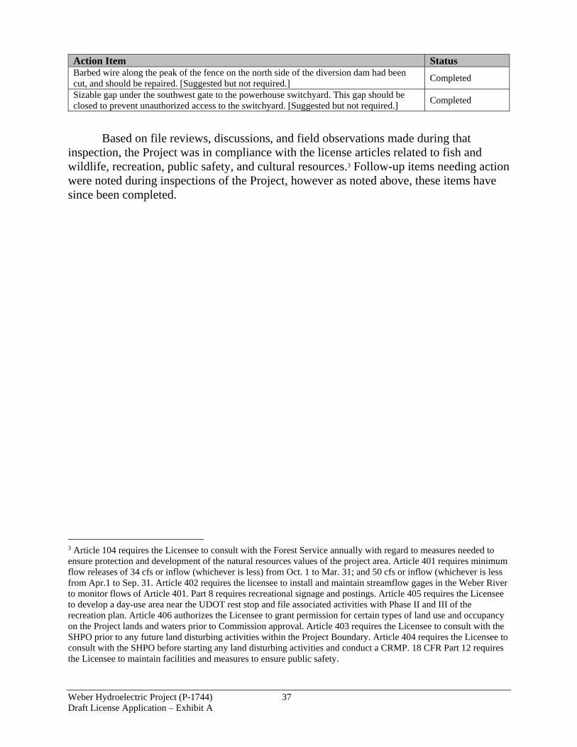
Weber Hydroelectric Project (P-1744) 37 Draft License Application – Exhibit A
Action Item Status Barbed wire along the peak of the fence on the north side of the diversion dam had been cut, and should be repaired. [Suggested but not required.]
Completed
Sizable gap under the southwest gate to the powerhouse switchyard. This gap should be closed to prevent unauthorized access to the switchyard. [Suggested but not required.]
Completed
Based on file reviews, discussions, and field observations made during that inspection, the Project was in compliance with the license articles related to fish and wildlife, recreation, public safety, and cultural resources.3 Follow-up items needing action were noted during inspections of the Project, however as noted above, these items have since been completed.
3 Article 104 requires the Licensee to consult with the Forest Service annually with regard to measures needed to ensure protection and development of the natural resources values of the project area. Article 401 requires minimum flow releases of 34 cfs or inflow (whichever is less) from Oct. 1 to Mar. 31; and 50 cfs or inflow (whichever is less from Apr.1 to Sep. 31. Article 402 requires the licensee to install and maintain streamflow gages in the Weber River to monitor flows of Article 401. Part 8 requires recreational signage and postings. Article 405 requires the Licensee to develop a day-use area near the UDOT rest stop and file associated activities with Phase II and III of the recreation plan. Article 406 authorizes the Licensee to grant permission for certain types of land use and occupancy on the Project lands and waters prior to Commission approval. Article 403 requires the Licensee to consult with the SHPO prior to any future land disturbing activities within the Project Boundary. Article 404 requires the Licensee to consult with the SHPO before starting any land disturbing activities and conduct a CRMP. 18 CFR Part 12 requires the Licensee to maintain facilities and measures to ensure public safety.

Weber Hydroelectric Project (P-1744) 38 Draft License Application – Exhibit A
Figure 5. Weber Project Current Public Safety Plan Part 12 Signage (Powerhouse)

Weber Hydroelectric Project (P-1744) 39 Draft License Application – Exhibit A
Figure 6. Weber Project Current Public Safety Plan Part 12 Signage (Dam and Recreation Site)
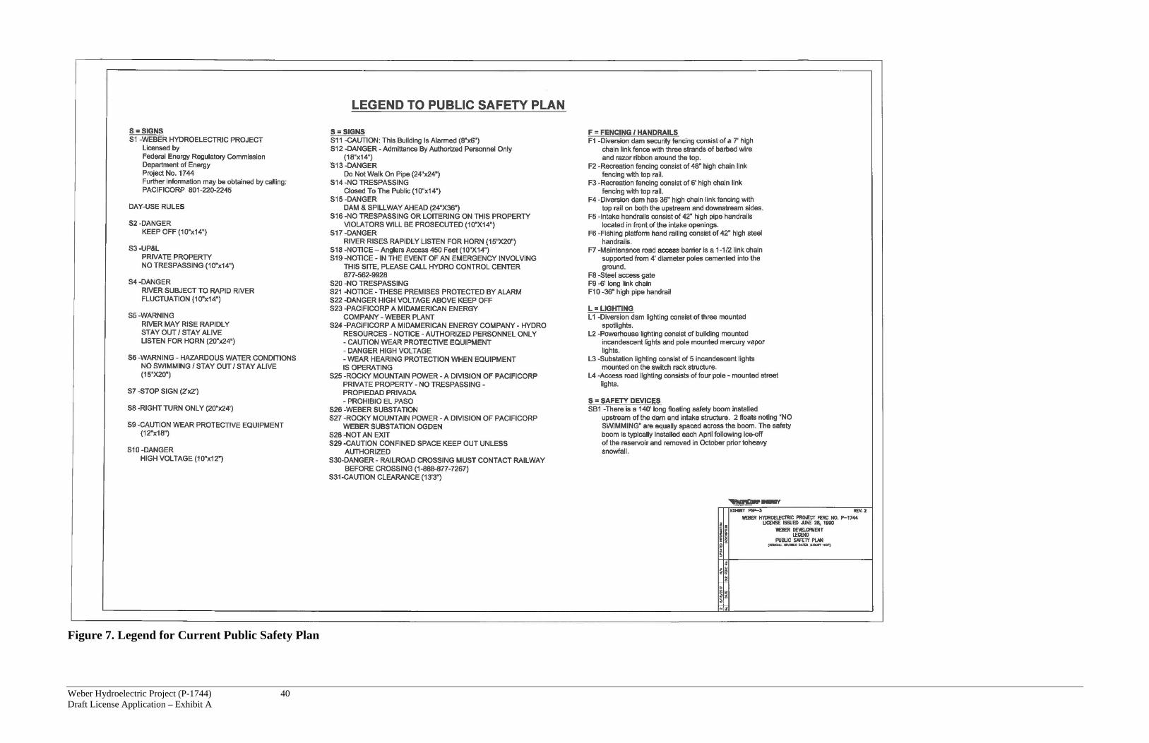
Weber Hydroelectric Project (P-1744) 40 Draft License Application – Exhibit A
Figure 7. Legend for Current Public Safety Plan

APPENDIX A: DETAILED PROJECT LOCATION MAPS

Weber Hydroelectric Project (P-1744) Draft License Application – Exhibit A A-1
FIGURE A-1. DETAILED PROJECT LOCATION MAP (1 OF 3)

Weber Hydroelectric Project (P-1744) Draft License Application – Exhibit A A-2
FIGURE A-2. DETAILED PROJECT LOCATION MAP (2 OF 3)

Weber Hydroelectric Project (P-1744) Draft License Application – Exhibit A A-3
FIGURE A-3. DETAILED PROJECT LOCATION MAP (3 OF 3)


WEBER HYDROELECTRIC PROJECT
(FERC NO. 1744)
DRAFT APPLICATION FOR NEW LICENSE
FOR MAJOR CONSTRUCTED PROJECT LESS THAN 5MW
EXHIBIT G
PROJECT MAPS
DECEMBER 2017

Weber Hydroelectric Project (P-1744) 1
Draft License Application – Exhibit G
DRAFT APPLICATION FOR NEW LICENSE
FOR MAJOR CONSTRUCTED PROJECT LESS THAN 5 MW
WEBER HYDROELECTRIC PROJECT
(FERC NO. 1744)
PACIFICORP
EXHIBIT G
PROJECT MAPS
The Weber Hydroelectric Project is located in Weber, Morgan, and Davis counties
in the state of Utah. The existing Exhibit G contains three drawings listed below in Table 1.
Table 1. Existing Exhibit G Drawings
Exhibit
Sheet
FERC
Drawing
No.
Title/Showing
Approval
order
date
G-1 1744-19 Project Layout 6/28/1990
G-2 1744-20 Recreation and Forebay Sites 6/28/1990
G-3 1744-21 Existing Weber Plant Site 6/28/1990
The revised Exhibit G replaces the three current drawings with four newly created
sheets that consist of a series of three overlapping maps depicting the proposed Project
Boundary location and principal features of the Project and a fourth sheet with coordinates,
distances, and descriptions for the boundary and flowline (buried pipeline center line)
shown on the maps (Table 2). These maps also delineate the land ownership and property
interests within that boundary. For the Weber Final License Application, PacifiCorp will
also submit Geographic Information System (GIS) shapefiles for the Project Boundary,
federal lands within the boundary, and georeference control points, and metadata text file
(on CD) for the electronic filing.

Weber Hydroelectric Project (P-1744) 2
Draft License Application – Exhibit G
Table 2. Revised Exhibit G Drawings
Exhibit
Sheet
FERC
Drawing
No.
Title/Showing
G-1 1744-__ Project Boundary Map/ shows eastern part of Project
G-2 1744-__ Project Boundary Map/ shows central part of Project
G-3 1744-__ Project Boundary Map/ shows western part of Project
G-4 1744-__ Project Boundary Description
The existing FERC Project Boundary occupies a total of 18.48 acres, of which
approximately 15.51 acres (according to the list on sheet G-1, FERC drawing no. 1744-19)
are lands of the United States administered by the U.S. Forest Service (USFS).
PacifiCorp proposes to revise the Project Boundary under the next license term to
include additional areas needed for operation and maintenance, and exclude areas outside
of Project influence. The revised exhibits improve the alignment of the boundary with
existing features based on new survey data and aerial imagery. The proposed Project
Boundary would occupy a total of 18.08 acres, of which approximately 14.94 acres are
lands of the United States administered by the USFS. There is a short segment of
transmission line between the powerhouse building and the adjacent substation that
occupies approximately 0.02 acres of lands of the United States (0.02 acres occupied by
transmission line and the remaining 14.92 acres not occupied by transmission line).
There are several proposed changes to the Project Boundary on federally-owned
lands (see Revised Exhibit G sheets G-1 and G-3). On revised sheet G-1, the first change
includes adjusting the alignment of the Project Boundary along the forebay and recreation
area to more accurately follow existing features. The forebay shoreline at the normal
maximum pool elevation as depicted on the original Exhibit G sheet G-2 (FERC drawing
no. 1744-20), remains the intended boundary but the traverse description on that drawing
did not align well with the actual forebay location. The proposed boundary improves
alignment with the forebay. Likewise, the portion of the boundary that extends around the
recreation area on the north side of the forebay, as shown on the original Exhibit G sheet
G-2, required slight adjustments to improve the alignment with existing recreation area
features. The proposed boundary continues to run along the north side of the recreation
area fence but now it closely follows the north side of the recreation area access road to the
junction with the highway rest area access road which avoids encroachment on the
highway rest area. The other proposed change in this vicinity includes expanding the

Weber Hydroelectric Project (P-1744) 3
Draft License Application – Exhibit G
boundary approximately 520 feet downstream of the dam to incorporate the river and
riparian area that lie between the recreation site and the flowline to provide a management
buffer downstream of the dam.
The Project is located within the Uinta-Wasatch-Cache National Forest
administrative boundary; however, the central portion of the Project in Section 29 T5N
R1E SLM is located on private ownership. For this area, the proposed Project Boundary
maintains the same 25-foot width along the flowline (12.5 feet on each side of the center
line of the flowline) as the existing boundary (see revised Exhibit sheet G-2).
West of the section line between Section 29 and 30 T5N R1E SLM, the flowline and
powerhouse are located on federally owned land. Once the flowline crosses under the
highway (I-84) the proposed boundary expands to include the highway access ramp and the
area between the highway, the Weber River, and the downstream side of the powerhouse.
This part of the proposed boundary has been widened to include access roads, buildings,
and maintenance areas that are currently used by the Project.
Downstream of the powerhouse, the proposed boundary has been reduced to include
only the small area occupied by the Project transmission line (excluding the substation) and
the access road and highway access ramp. The changes around the powerhouse are
intended to include only those areas that are needed for the Project rather than the arbitrary
rectangular area that defines the existing boundary.
A Public Land Survey System (PLSS) description of lands of the United States
located within the proposed Project boundary and identified on these maps can be found in
Table 3.
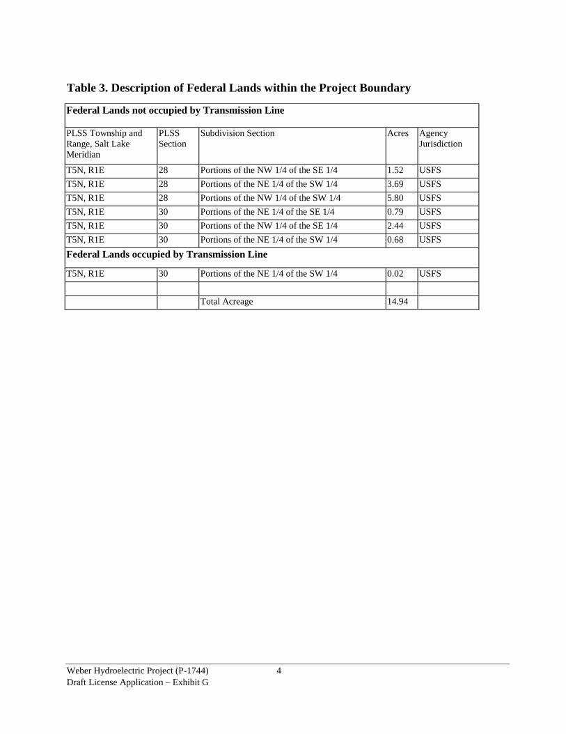
Weber Hydroelectric Project (P-1744) 4
Draft License Application – Exhibit G
Table 3. Description of Federal Lands within the Project Boundary
Federal Lands not occupied by Transmission Line
PLSS Township and
Range, Salt Lake
Meridian
PLSS
Section
Subdivision Section Acres Agency
Jurisdiction
T5N, R1E 28 Portions of the NW 1/4 of the SE 1/4 1.52 USFS
T5N, R1E 28 Portions of the NE 1/4 of the SW 1/4 3.69 USFS
T5N, R1E 28 Portions of the NW 1/4 of the SW 1/4 5.80 USFS
T5N, R1E 30 Portions of the NE 1/4 of the SE 1/4 0.79 USFS
T5N, R1E 30 Portions of the NW 1/4 of the SE 1/4 2.44 USFS
T5N, R1E 30 Portions of the NE 1/4 of the SW 1/4 0.68 USFS
Federal Lands occupied by Transmission Line
T5N, R1E 30 Portions of the NE 1/4 of the SW 1/4 0.02 USFS
Total Acreage 14.94

03
27
22 24 21
03
34
2927
22
28
02 05
35 36
23
25
31
30
32
20
26
0604
33 34
01
19
5N 1W 5N 1E4N 1W 4N 1E
U I NTA H
S O U T HW E B E R
LAY TO N
S O U T HO G D E N
I-84
High
way
89
Highway 89 I-84
UINTA-WASATCH-CACHENATIONAL FOREST
USFS
ADM
INIST
RATI
VEBO
UNDA
RY
Weber Hydro ProjectWEBER CO.
DAVIS CO.
DAVIS CO.
WEBER
CO.
MORGAN CO.
MORG
AN CO
.
USFS
ADM
INIST
RATI
VEBO
UNDA
RY
G-1G-2G-3I-84
""
""
""
"
DDDDDDDDDDDDDD
DDDD
DD
DD
DD
DD
DD
DD
DD
DD
DDDD
DDDDDDDDDD
DDDD
DD
DD
DD
DD
DD
DD
DD
DD
DDDD
DDDD
DDDD
DDDD
DDDD
DDDD
DDDD
DD
DDDDDDDDDD
> >
>>
FISHLADDER
WEBERDIVERSIONDAM
FISHINGPLATFORM
BURIED PIPELINE
POINT OFDIVERSION
INTAKE HOUSEAND CHAMBER
CONCRETE RETAINING WALL,BETWEEN POINTS 55 AND 57
RESTAREA
SafetyBoom
Sec.
28Se
c. 28
Sec.
29Se
c. 29
¬«28
Sec.
28Se
c. 29
UINTA-WASATCH-CACHENATIONAL FOREST
WeberForebayWeber River
Weber River
Weber Forebay
Normal Water SurfaceElev. 4797.4 FT NAVD88(Top of Spillway Gates)
RecreationArea
FenceFence
Parking
Exposed Pipeline,P1 to P2
Fence
Power Site Reserve No. 377
PRIVE1
SESWPRIV
NWSWFED USFS
SWSEPRIVSWSW
FED USFS
SENEFED USFS
SESEPRIV
SESEPRIV
NESEPRIV
NESEPRIV
SENEFED USFS
NESEPRIV
NWSWFED USFS
NESWFED USFS
NWSEFED USFS
NWSEFED USFS
NESWFED USFS
FEDUSFS
FEDUSFSFED
USFS
FEDUSFS
FEDUSFS
SWNWFED USFS SWNE
FED USFSSENWFED USFS
PRIVE1
FEDUSFS
DAVIS CO.
WEBER CO.
MORGAN CO.
MORGAN CO.
MORGAN CO.DAVIS CO.
DAVIS CO.
WEBER CO.
REST
RECREATIONROAD
I-84 (Westbound)
I-84 (Eastbound)
I-84 (Westbound)I-84 (Eastbound)
AREA
AREA EXIT
REST AREAPARKING
25'River to Forebaytransition area
4797.4 FT NAVD88
12.5' to Pipe CL
Township 5 North
Township 5 North
Range 1 EastSec. 28
Rang
e 1 E
astSe
c. 29
14
15
22
28
29
42
43
5758
27
16 1718 19 20 21
2324
25 2630
31
34
36
3738 40
4445
4748
49
51
52
53
5556
33
54
35
39 41
46
5032
P1P3P4P5
P6
P7
P8P9
P10
P11 P2!
!
!
!
!
!
!
!!
!
!!
! !!
!
!
!
! !
!
!
!
!
!
!!
!!
!
!
!
!
!
!
!!
!
!
!
!
!
!
!
!
!!!
!
!
!!
!
!
! !
4554783 N428299 E
4554784 N429090 E
4554316 N429092 E4554309 N
428268 E
* Boundary Point numbers correspond to the boundary description tables on sheet G-4.** Reference Point coordinates are in UTM Zone 12, NAD 83, meters.Map Projection: UTM Zone 12, NAD 83, meters
This Document is Considered Public Information.
MAP TEXT ABBREVIATIONS:- FED = Federally Owned Land- POB = Point of Beginning- E# = Easement/Property Rights (see sheet G-4)- PRIV = Private Land- USFS = USDA Forest Service
Weber Hydroelectric Project FERC No. 1744Draft License Application December 15, 2017
Exhibit G-1 Rev. 0a
FERC Drawing No. P-1744-______
Project Boundary Map
NO.
DATE
OLD
FERC
NO.
DESC
RIPT
ION
12/15
/2017
Draft
Appli
catio
n for
Licen
se0a
³
Original Drawing Dated November 2017
© 2017 PacifiCorp C:\Projects\Exhibit_G\Weber\2016-07 Revised\Weber Exhibit G.mxd 11/28/2017 116071.710
State of Utah, Salt Lake MeridianLocation Map ®
Scale as Shown
Project BoundaryProject FacilityNon-Project FacilitySectionQtr Qtr SectionLand OwnershipNational ForestWater BodyRoad EdgeRailroad
! Boundary Point *> Reference Point **") Gate
DD DD DD Flowline" " " Safety Boom
Non-Project Transmission LineFenceStreamCounty Boundary
100 0 100 20050Feet
0 5,000 10,000Feet
PacifiCorp has reviewed the Project boundary shown herein. PacifiCorp possesses property rights*for all non-federal lands drawn on this map that are inside the boundary.*See Easement/Property Rights Reference Table. Further records research may expose privateland easements inside the project boundary that are not shown herein. It is not the intent of thismap to impede the bona fide property rights of those private land easements that may exist forpurposes unrelated to the operation and maintenance of the project (non-Project uses).
I hereby state that the project boundary represented on this drawing is developed withreasonable accuracy in accordance with FERC requirements. PLSS is based on the Utah BLMPLSS/GCDB Cadastre Data set (8/25/2015 update) except the SW1/4 SEC 30, T5N, R1Ewhich was adjusted by Meridian Engineering Inc., using found corners for SE SEC 25 T5NR1W and W1/4 SEC 30 T5N R1E. The adjusted PLSS is the basis for property boundaries.Other data has been developed from orthophotos and other sources including Federal, State,County, and PacifiCorp GIS sources. All reasonable efforts have been made to ensure thatpositional accuracy conforms to National Map Accuracy Standards for maps at 1:24,000 scale.Public Land Survey lines and Property lines are based on the Salt Lake Meridian.
Total PacifiCorp Project Boundary: 18.08 acresFederal Lands within the boundary:
1) USFS (transmission line) 0.02 acres2) USFS (non-transmission line) 14.92 acres
14.94 acres
PROJECT BOUNDARY ACREAGE
Scale as shown

03
27
22 24 21
03
34
2927
22
28
02 05
35 36
23
25
31
30
32
20
26
0604
33 34
01
19
5N 1W 5N 1E4N 1W 4N 1E
U I NTA H
S O U T HW E B E R
LAY TO N
S O U T HO G D E N
I-84
High
way
89
Highway 89 I-84
UINTA-WASATCH-CACHENATIONAL FOREST
USFS
ADM
INIST
RATI
VEBO
UNDA
RY
Weber Hydro ProjectWEBER CO.
DAVIS CO.
DAVIS CO.
WEBER
CO.
MORGAN CO.
MORG
AN CO
.
USFS
ADM
INIST
RATI
VEBO
UNDA
RY
G-1G-2G-3I-84
DD
DDDD
DDDD
DDDD
DDDDDDDDDDDDDDDDDDDDDDDDDDDDDDDDDDDDDDDDDDDDDDDDDDDDDDDDDDDDDDDDDDDDDDDDDDDDDDDDDDDDDDDDDDDDDDDDDDDDDDDDDDDDDDDDDDDDDDDDDDDDDDDDDDDDDDDDDDDDDDDDDDDDDDDDDDDDDDDDDDDDDD
DDDD
DDDD
DDDD
DDDD
DDDDDDDDDDDDDDDDDDDD
DDDD
DDDD
DDDD
DD
DD
DD
DD
DD
DD
DD
DD
DD
DD
DD
DDDD
DDDDDDDDDD
DDDD
DDDD
DDDD
DDDD
DDDDDDDDDDDD
DDDD
DDDD
DDDD
DDDD
DDDD
DDDD
DDDD
DDDD
DDDD
DDDD
DDDD
DDDD
DDDD
DDDDDDDD
DDDDDDDDDDDDDD
DDDD
DD
DD
DD
DD
DD
DD
DD
DD
DDDD
DDDDDDDDDD
DDDD
DD
DD
DD
DD
DD
DD
DD
DD
DDDD
DDDD
DDDD
DDDD
DDDD
DDDD
DDDD
DDDDDD
DDDD
DDDDDD
DDDD
DD
>>
>
>
BURIED PIPELINE
BURIED PIPELINE
BURIED PIPELINE
BURIED PIPELINE
¬«29
UINTA-WASATCH-CACHENATIONAL FOREST
Weber River
River
Weber
Tatter
son Cr
eek
Exposed Pipeline,P13 to P14(trestle)
PRIVE1
PRIVE1
PRIVE1 PRIV
E1
SENEFED USFS
SWSWPRIV
NWSWPRIV
NWSWPRIV
SWNWFED USFS
SENWFED USFS
NESWPRIV
NESWPRIV
SESWPRIV SWSE
PRIV
NWSEPRIV
SWNEFED USFS
NWSEPRIV
NESEPRIV
SESEPRIV
NESEPRIV
PRIVE1
PRIVE1
PRIVE1
PRIVE1
DAVIS CO.
WEBER CO.
DAVIS CO.
WEBER CO.
DAVIS CO.
WEBER CO.
MORGAN CO.
MORGAN CO.DAVIS CO.
WEBER CO.
I-84 (Westbound)
I-84 (Eastbound)
I-84 (Westbound)
I-84 (Eastbound)
I-84 (Westbound)
I-84 (Eastbound)
25'
25'
Township 5 North
Township 5 North
Rang
e 1 E
astSe
c. 29
Range 1 EastSec. 29
P10
P11P12
P13
P14
P15
P16
P17
P18P19P20P21P22
!
!
!
!
!
!
!
!
!
!!!
!
!
4554716 N427038 E
4554721 N427859 E
4554196 N427868 E
4554171 N426931 E
* Boundary Point numbers correspond to the boundary description tables on sheet G-4.** Reference Point coordinates are in UTM Zone 12, NAD 83, meters.Map Projection: UTM Zone 12, NAD 83, meters
This Document is Considered Public Information.
MAP TEXT ABBREVIATIONS:- FED = Federally Owned Land- POB = Point of Beginning- E# = Easement/Property Rights (see sheet G-4)- PRIV = Private Land- USFS = USDA Forest Service
Weber Hydroelectric Project FERC No. 1744Draft License Application December 15, 2017
Exhibit G-2 Rev. 0a
FERC Drawing No. P-1744-______
Project Boundary Map
NO.
DATE
OLD
FERC
NO.
DESC
RIPT
ION
12/15
/2017
Draft
Appli
catio
n for
Licen
se0a
³
Original Drawing Dated November 2017
© 2017 PacifiCorp C:\Projects\Exhibit_G\Weber\2016-07 Revised\Weber Exhibit G.mxd 11/28/2017 116071.711
State of Utah, Salt Lake MeridianLocation Map ®
Scale as Shown
Project BoundaryProject FacilityNon-Project FacilitySectionQtr Qtr SectionLand OwnershipNational ForestWater BodyRoad EdgeRailroad
! Boundary Point *> Reference Point **") Gate
DD DD DD Flowline" " " Safety Boom
Non-Project Transmission LineFenceStreamCounty Boundary
100 0 100 20050Feet
0 5,000 10,000Feet
PacifiCorp has reviewed the Project boundary shown herein. PacifiCorp possesses property rights*for all non-federal lands drawn on this map that are inside the boundary.*See Easement/Property Rights Reference Table. Further records research may expose privateland easements inside the project boundary that are not shown herein. It is not the intent of thismap to impede the bona fide property rights of those private land easements that may exist forpurposes unrelated to the operation and maintenance of the project (non-Project uses).
I hereby state that the project boundary represented on this drawing is developed withreasonable accuracy in accordance with FERC requirements. PLSS is based on the Utah BLMPLSS/GCDB Cadastre Data set (8/25/2015 update) except the SW1/4 SEC 30, T5N, R1Ewhich was adjusted by Meridian Engineering Inc., using found corners for SE SEC 25 T5NR1W and W1/4 SEC 30 T5N R1E. The adjusted PLSS is the basis for property boundaries.Other data has been developed from orthophotos and other sources including Federal, State,County, and PacifiCorp GIS sources. All reasonable efforts have been made to ensure thatpositional accuracy conforms to National Map Accuracy Standards for maps at 1:24,000 scale.Public Land Survey lines and Property lines are based on the Salt Lake Meridian.
Total PacifiCorp Project Boundary: 18.08 acresFederal Lands within the boundary:
1) USFS (transmission line) 0.02 acres2) USFS (non-transmission line) 14.92 acres
14.94 acres
PROJECT BOUNDARY ACREAGE
Scale as shown

03
27
22 24 21
03
34
2927
22
28
02 05
35 36
23
25
31
30
32
20
26
0604
33 34
01
19
5N 1W 5N 1E4N 1W 4N 1E
U I NTA H
S O U T HW E B E R
LAY TO N
S O U T HO G D E N
I-84
High
way
89
Highway 89 I-84
UINTA-WASATCH-CACHENATIONAL FOREST
USFS
ADM
INIST
RATI
VEBO
UNDA
RY
Weber Hydro ProjectWEBER CO.
DAVIS CO.
DAVIS CO.
WEBER
CO.
MORGAN CO.
MORG
AN CO
.
USFS
ADM
INIST
RATI
VEBO
UNDA
RY
G-1G-2G-3I-84
DD
DDDD
DDDD
DDDD
DDDDDDDDDDDDDDDDDDDDDDDDDDDDDDDDDDDDDDDDDDDDDDDDDDDDDDDDDDDDDDDDDDDDDDDDDDDDDDDDDDDDDDDDDDDDDDDDDDDDDDDDDDDDDDDDDDDDDDDDDDDDDDDDDDDDDDDDDDDDDDDDDDDDDDDDDDDDDDDDDDDDDD
DDDD
DDDD
DDDD
DDDD
DDDDDDDDDDDDDDDDDDDD
DDDD
DDDD
DDDD
DD
DD
DD
DD
DD
DD
DD
DD
DD
DD
DD
DDDD
DDDDDDDDDD
DDDD
DDDD
DDDD
DDDD
DDDDDDDDDDDD
DDDD
DDDD
DDDD
DDDD
DDDD
DDDD
DDDD
DDDD
DDDD
DDDD
DDDD
DDDD
DDDD
DDDDDDDDDDDDDDDD
DDDD
DDDD
")
")
>
>
>
>
POWERHOUSE
BURIED PIPELINE
TAILRACE46kVTRANSMISSION
LINE
TRANSFORMER
BURIED PIPELINE
DWCCCDiversion
DamSUBSTATION
Sec.
29Se
c. 29
Sec.
30Se
c. 30
¬«30
Sec.
29Se
c. 30
UINTA-WASATCH-CACHENATIONAL FOREST
Weber River
Weber River
Weber River
N 43-45
E 2,672.
4 feet f
rom SW Sect
ion Corn
er to P
OB
Power Site Reserve No. 377
NWSEFED USFS
FEDUSFS
FEDUSFS
SWNWFED USFS
PRIVE1
NWSWPRIV
PRIVE1
SENWFED USFS
NESWFED USFS
SWNEFED USFS
SENEFED USFS
NESWFED USFS
NWSEFED USFS
SESWFED USFS
SWSEFED USFS SESE
FED USFS
NESEFED USFS
NESEFED USFS
NWSWPRIV
SWSWPRIV
FEDUSFS
FEDUSFS
FEDUSFS
DAVIS CO.
WEBER CO.
DAVIS CO.
WEBER CO.
DAVIS CO.
WEBER CO.
I-84 (Westbound)
I-84 (Eastbound)
I-84 (Westbound)(Eastbound)
ACCESSROAD
HIGHWAYACCESS
ROAD
Gate
I-84
HIGHWAYACCESS
ROAD
Gate
12.5' to Pipe CL
25'
25'
Interstate Edge
Road Edge
Road Edge12.5' to Pipe CL
Fence
Road Edge
Road Edge
Township 5 North
Township 5 North
Rang
e 1 E
astSe
c. 30
Range 1 EastSec. 29
6 7
9
1259
60
6263
7072
74 75 7613
11
61
5
3
10
8
646566676869
2
4
7173
1 - POB
P22
P23P24P25
P26
P27
P28P29P30P31
P32P33P34
P35
P36P37P38P39P40
!
!!
!
! ! !
!
!
!
!
! ! ! !
!!
!
!
!
!
!
!!
!!
!!
!!
!
!
!
!!
!
!
!
!
!!!
!!
!
!
!!!
!
!
4554662 N425589 E
4554672 N426622 E
4554162 N426622 E4554150 N
425576 E
* Boundary Point numbers correspond to the boundary description tables on sheet G-4.** Reference Point coordinates are in UTM Zone 12, NAD 83, meters.Map Projection: UTM Zone 12, NAD 83, meters
This Document is Considered Public Information.
MAP TEXT ABBREVIATIONS:- FED = Federally Owned Land- POB = Point of Beginning- E# = Easement/Property Rights (see sheet G-4)- PRIV = Private Land- USFS = USDA Forest Service
Weber Hydroelectric Project FERC No. 1744Draft License Application December 15, 2017
Exhibit G-3 Rev. 0a
FERC Drawing No. P-1744-______
Project Boundary Map
NO.
DATE
OLD
FERC
NO.
DESC
RIPT
ION
12/15
/2017
Draft
Appli
catio
n for
Licen
se0a
³
Original Drawing Dated November 2017
© 2017 PacifiCorp C:\Projects\Exhibit_G\Weber\2016-07 Revised\Weber Exhibit G.mxd 11/28/2017 116071.712
State of Utah, Salt Lake MeridianLocation Map ®
Scale as Shown
Project BoundaryProject FacilityNon-Project FacilitySectionQtr Qtr SectionLand OwnershipNational ForestWater BodyRoad EdgeRailroad
! Boundary Point *> Reference Point **") Gate
DD DD DD Flowline" " " Safety Boom
Non-Project Transmission LineFenceStreamCounty Boundary
100 0 100 20050Feet
0 5,000 10,000Feet
PacifiCorp has reviewed the Project boundary shown herein. PacifiCorp possesses property rights*for all non-federal lands drawn on this map that are inside the boundary.*See Easement/Property Rights Reference Table. Further records research may expose privateland easements inside the project boundary that are not shown herein. It is not the intent of thismap to impede the bona fide property rights of those private land easements that may exist forpurposes unrelated to the operation and maintenance of the project (non-Project uses).
I hereby state that the project boundary represented on this drawing is developed withreasonable accuracy in accordance with FERC requirements. PLSS is based on the Utah BLMPLSS/GCDB Cadastre Data set (8/25/2015 update) except the SW1/4 SEC 30, T5N, R1Ewhich was adjusted by Meridian Engineering Inc., using found corners for SE SEC 25 T5NR1W and W1/4 SEC 30 T5N R1E. The adjusted PLSS is the basis for property boundaries.Other data has been developed from orthophotos and other sources including Federal, State,County, and PacifiCorp GIS sources. All reasonable efforts have been made to ensure thatpositional accuracy conforms to National Map Accuracy Standards for maps at 1:24,000 scale.Public Land Survey lines and Property lines are based on the Salt Lake Meridian.
Total PacifiCorp Project Boundary: 18.08 acresFederal Lands within the boundary:
1) USFS (transmission line) 0.02 acres2) USFS (non-transmission line) 14.92 acres
14.94 acres
PROJECT BOUNDARY ACREAGE
Scale as shown

This Document is Considered Public Information.
Exhibit G-4 Rev. 0a
FERC Drawing No. P-1744-______
Project Boundary Description
NO.
DATE
OLD FERC NO.
DESCRIPTION
12/15/2017
Draft Application for License
0a
© 2017 PacifiCorp C:\Projects\Exhibit_G\W eber\2016-07 R evised\W eber Exhibit G_4 Boundary T able.mxd 11/28/2017 116071.713
Project Boundary Table Project Boundary Table (continued) Pipeline Center Line Table
Easement/Property Rights Reference TableNotes:1) Information in the table is based on GIS derived coordinatesand measurements, and is not intended to represent stationpoints or measurements established by ground surveys.2) Coordinates and Bearings are in UTM Zone 12, NAD 83, meters.3) Distances are in U.S. survey feet (Grid).3) Project is located in the state of Utah, Salt Lake Meridian.
Point Northing(Meters)
Easting(Meters) Bearing Distance
(feet) Remarks46 4554611 429175
S 73-27-35W 8047 4554604 429152
S 81-11-6W 14648 4554597 429108
S 78-11-3W 21749 4554584 429043
S 54-43-17W 7250 4554571 429025
S 45-45-46W 11451 4554547 429000
S 61-1-16W 9552 4554533 428975
S 72-34-1W 20853 4554514 428914
S 77-39-53W 15854 4554504 428867
S 80-18-2W 16755 4554495 428817 INT X W / CONCR ETE R ETAINING W ALL
S 89-11-24W 549ALONG CONCR ETE R ETAINING W ALL56 4554493 428650 BEND POINT ALONG CONCR ETE R ETAINING W ALL
S 89-12-0W 565ALONG CONCR ETE R ETAINING W ALL57 4554490 428478 INT X W / INTAKE HOU S E AND CHAMBER AT DIVER S ION DAM
88ALONG FACILITIES AT DIVER S ION DAM58 4554494 428457 INT X W / PIPELINE BU FFER (12.5' FR OM PIPELINE C.L. - S EE PIPELINE
CENTER LINE TABLE)8188ALONG PIPELINE BU FFER (12.5' FR OM PIPELINE C.L.)
59 4554412 426008 INT X W / S OU TH S IDE OF INTER S TATE 84, W ES T BOU NDN88-21-15E 68ALONG S OU TH S IDE OF INTER S TATE 84
60 4554412 426029 INT X W / U NMAR KED NOR TH/S OU TH BOU NDAR Y LINES 0-0-0W 18ALONG U NMAR KED NOR TH/S OU TH BOU NDAR Y LINE
61 4554407 426029 INT X W / S OU TH S IDE OF ACCES S R OADS 85-14-27W 174ALONG S OU TH S IDE OF ACCES S R OAD
62 4554402 425976 INT X W / U NMAR KED NOR TH/S OU TH BOU NDAR Y LINE S OU TH OF GATES 0-0-0W 47ALONG U NMAR KED NOR TH/S OU TH BOU NDAR Y LINE
63 4554388 425976 INT X W / NOR TH S HOR ELINE OF W EBER R IVER ; THENCE ALONG THE NOR TH S HOR ELINE OF THE W EBER R IVER AS APPR OX. R EPR ES ENTED BY THE FOLLOW ING COU R S ES BET W EEN POINT S 63 AND 70:
S 83-42-1W 25464 4554380 425899
S 83-44-30W 12065 4554376 425862
N82-9-23W 7366 4554379 425840
N88-37-39W 18767 4554380 425783
N74-48-43W 9068 4554387 425757
N86-47-2W 6869 4554388 425736
N33-3-16W 4670 4554400 425728 INT X W / W EBER POW ER HOU S E W ALL
N81-40-32W 28ALONG W EBER POW ER HOU S E W ALL71 4554401 425720 BEND POINT ON W EBER POW ER HOU S E W ALL
N7-52-52E 20ALONG W EBER POW ER HOU S E W ALL72 4554407 425721 INT X W / T R ANS MIS S ION LINE BOU NDAR Y
N82-50-17W 56ALONG T R ANS MIS S ION LINE BOU NDAR Y (9 FOOT OFFS ET FR OM C.L. OF T R ANS MIS S ION LINE)
73 4554409 425704 BEND POINT ON T R ANS MIS S ION LINE BOU NDAR YN7-9-45E 18ALONG T R ANS MIS S ION LINE BOU NDAR Y (9 FOOT OFFS ET FR OM C.L. OF
T R ANS MIS S ION LINE)74 4554415 425705 INT X W / W EBER S U BS TATION BOU NDAR Y
S 82-50-11E 33ALONG W EBER S U BS TATION BOU NDAR Y75 4554414 425715 INT X W / T R ANS MIS S ION LINE BOU NDAR Y
S 82-50-12E 23ALONG T R ANS MIS S ION LINE BOU NDAR Y76 4554413 425722 INT X W / W EBER POW ER HOU S E W ALL
N7-52-56E 36ALONG W EBER POW ER HOU S E W ALL1 4554424 425723 NW COR NER OF THE W EBER POW ER HOU S E, THE POB
Point Northing(Meters)
Easting(Meters) Bearing Distance
(feet) RemarksP1 4554497 428471 POINT OF DIVER S ION
S 89-51-28W 174ALONG EX POS ED PIPEP2 4554497 428418 INT X W / BU R IED PIPE
S 89-51-27W 84ALONG BU R IED PIPE, THE FOLLOW ING COU R S ES :P3 4554497 428392
N85-20-40W 120P4 4554500 428356
N76-5-40W 111P5 4554508 428323
N71-38-32W 320P6 4554539 428231
N77-58-3W 97P7 4554545 428202
S 87-53-37W 120P8 4554544 428165
S 74-19-38W 88P9 4554537 428139
S 68-34-28W 250P10 4554509 428068
S 71-37-17W 130P11 4554496 428030
S 78-9-17W 149P12 4554487 427986
S 81-38-28W 547P13 4554463 427821 INT X W / EX POS ED PIPE
S 81-38-28W 141ALONG EX POS ED PIPE (T R ES TLE)P14 4554456 427778 INT X W / BU R IED PIPE
N62-21-30W 53ALONG BU R IED PIPE, THE FOLLOW ING COU R S ES :P15 4554464 427764
S 81-38-28W 257P16 4554453 427686
N85-51-32W 977P17 4554474 427389
N85-51-32W 896P18 4554494 427117
N88-39-46W 187P19 4554495 427060
S 86-5-14W 163P20 4554492 427011
S 83-38-27W 158P21 4554486 426963
N88-26-32W 592P22 4554491 426782
N80-31-32W 348P23 4554509 426677
N85-9-17W 185P24 4554514 426621
S 85-45-13W 178P25 4554510 426567
S 76-44-4W 182P26 4554497 426513
S 67-52-32W 172P27 4554477 426464
S 63-34-28W 210P28 4554449 426407
S 69-30-53W 88P29 4554439 426382
S 81-30-36W 90P30 4554435 426355
N86-15-19W 92P31 4554437 426327
N80-4-32W 335P32 4554455 426226
N86-9-17W 143P33 4554458 426183
S 81-19-43W 151P34 4554451 426137
S 74-53-28W 440P35 4554416 426008
S 81-51-28W 424P36 4554397 425880
S 84-27-31W 91P37 4554395 425852
S 89-26-30W 84P38 4554394 425827
N84-41-33W 122P39 4554398 425790
N81-7-6W 171P40 4554406 425738 EAS T W ALL OF POW ER HOU S E
Easement/Property Rights No.
Interest Type
E1 Agreement No. 316 between U nion Pacific R ailroad Company and U tah Light & R ailway Co. dated August 1, 1908 – grants rights to construct and maintain the hy droelectric project and is binding to the successors and assigns of both parties.
PacifiCorp has reviewed the Project boundary shown herein. PacifiCorp possesses property rights*for all non-federal lands drawn on this map that are inside the boundary .*S ee Easement/Property R ights R eference T able. Further records research may expose privateland easements inside the project boundary that are not shown herein. It is not the intent of thismap to impede the bona fide property rights of those private land easements that may exist forpurposes unrelated to the operation and maintenance of the project (non-Project uses).
I hereby state that the project boundary represented on this drawing is developed withreasonable accuracy in accordance with FER C requirements. PLS S is based on the U tah BLMPLS S /GCDB Cadastre Data set (8/25/2015 update) except the S W 1/4 S EC 30, T 5N, R 1Ewhich was adjusted by Meridian Engineering Inc., using found corners for S E S EC 25 T 5NR 1W and W 1/4 S EC 30 T 5N R 1E. T he adjusted PLS S is the basis for property boundaries.Other data has been developed from orthophotos and other sources including Federal, S tate,County, and PacifiCorp GIS sources. All reasonable efforts have been made to ensure thatpositional accuracy conforms to National Map Accuracy S tandards for maps at 1:24,000 scale.Public Land S urvey lines and Property lines are based on the S alt Lak e Meridian.
Original Drawing Dated November 2017
Weber Hydroelectric Project FERC No. 1744Draft License Application December 15, 2017
Point Northing(Meters)
Easting(Meters) Bearing Distance
(feet) Remarks1 4554424 425723 BEGINNING AT THE S W COR NER OF S EC 30 T5N R 1E, AND BEAR ING N43-44-
55E 2672.4 FEET (GIS CALCU LATED) TO THE NW COR NER OF THE W EBER POW ER HOU S E, THE POB
19ALONG S U BS TATION FENCE2 4554427 425719 BEND POINT ON S U BS TATION FENCE
144ALONG S U BS TATION FENCE3 4554430 425675 INT X OF S U BS TATION FENCE AND EDGE OF ACCES S R OAD
S 4-32-37E 10ALONG S OU TH S IDE OF ACCES S R OAD4 4554427 425675 BEND POINT ON S OU TH S IDE OF ACCES S R OAD
N76-42-58W 194ALONG S OU TH S IDE OF ACCES S R OAD5 4554441 425618 INT X W / U NMAR KED NOR TH/S OU TH BOU NDAR Y LINE
N0-0-0E 18ALONG U NMAR KED NOR TH/S OU TH BOU NDAR Y LINE6 4554447 425618 INT X W / INTER S TATE 84, W ES T BOU ND
S 80-1-57E 75ALONG S OU TH S IDE OF INTER S TATE 847 4554443 425640 INT X W / NOR TH S IDE OF ACCES S R OAD
S 74-2-12E 73ALONG NOR TH S IDE OF ACCES S R OAD8 4554437 425662 BEND POINT ON NOR TH S IDE OF ACCES S R OAD
S 84-37-10E 270ALONG NOR TH S IDE OF ACCES S R OAD9 4554429 425744 INT X W / INTER S TATE 84, W ES T BOU ND
S 87-5-54E 300ALONG S OU TH S IDE OF INTER S TATE 8410 4554424 425835 BEND POINT ON INTER S TATE 84, W ES T BOU ND
S 84-54-27E 191ALONG S OU TH S IDE OF INTER S TATE 8411 4554419 425893 INT X W / EDGE OF ACCES S R OAD
S 81-18-13E 180ALONG EDGE OF ACCES S R OAD12 4554411 425947 INT X W / PIPELINE BU FFER (12.5' FR OM PIPELINE C.L.)
N81-51-33E 69ALONG PIPELINE BU FFER (12.5' FR OM PIPELINE C.L.)13 4554414 425968 INT X W / INTER S TATE 84, W ES T BOU ND
7843ALONG PIPELINE BU FFER (12.5' FR OM PIPELINE C.L.)14 4554516 428314 INT X W / U NMAR KED NOR TH/S OU TH BOU NDAR Y LINE
N0-0-0E 126ALONG U NMAR KED NOR TH/S OU TH BOU NDAR Y LINE15 4554554 428314 INT X W / R ECR EATION AR EA FENCE
N11-10-23E 10ALONG R ECR EATION AR EA FENCE16 4554557 428314 BEND POINT ON R ECR EATION AR EA FENCE
N73-13-39E 45ALONG R ECR EATION AR EA FENCE17 4554561 428327 BEND POINT ON R ECR EATION AR EA FENCE
N81-38-10E 100ALONG R ECR EATION AR EA FENCE18 4554565 428357 BEND POINT ON R ECR EATION AR EA FENCE
S 89-17-48E 232ALONG R ECR EATION AR EA FENCE19 4554564 428428 BEND POINT ON R ECR EATION AR EA FENCE
N63-53-23E 18ALONG R ECR EATION AR EA FENCE20 4554567 428433 BEND POINT ON R ECR EATION AR EA FENCE
S 85-35-3E 144ALONG R ECR EATION AR EA FENCE21 4554563 428477 BEND POINT ON R ECR EATION AR EA FENCE
S 88-33-20E 295ALONG R ECR EATION AR EA FENCE22 4554561 428567 INT X W / R ECR EATION AR EA ACCES S R OAD
S 81-34-0E 219ALONG R ECR EATION AR EA ACCES S R OAD23 4554551 428633 BEND POINT ON R ECR EATION AR EA ACCES S R OAD
S 86-55-15E 343ALONG R ECR EATION AR EA ACCES S R OAD24 4554546 428737 BEND POINT ON R ECR EATION AR EA ACCES S R OAD
S 76-41-17E 167ALONG R ECR EATION AR EA ACCES S R OAD25 4554534 428787 BEND POINT ON R ECR EATION AR EA ACCES S R OAD
N89-8-55E 41ALONG R ECR EATION AR EA ACCES S R OAD26 4554534 428800 BEND POINT ON R ECR EATION AR EA ACCES S R OAD
N23-53-13E 26ALONG R ECR EATION AR EA ACCES S R OAD27 4554542 428803 INT X W / R ES T AR EA ACCES S R OAD
S 79-56-10E 44ALONG EDGE OF R ES T AR EA ACCES S R OAD28 4554539 428816 INT X W / EDGE OF R ES T AR EA ACCES S R OAD AND EAS T EDGE OF
R ECR EATION AR EA ACCES S R OADS 0-0-0W 56ALONG U NMAR KED NOR TH/S OU TH BOU NDAR Y LINE
29 4554522 428816 INT X W / W EBER FOR EBAY S HOR ELINE (4797.4 FT NAVD88); THENCE THE PR OJECT BOU NDAR Y FOLLOW S THE NOR MAL W ATER S U R FACE AT ELEV 4792.3 FT MS L AS APPR OX. R EPR ES ENTED BY THE FOLLOW ING COU R S ES BET W EEN POINT S 29 AND 55:
N85-12-4E 12830 4554525 428855
N76-49-24E 31231 4554547 428948
N57-2-50E 5432 4554556 428961
N71-13-41E 4433 4554560 428974
N37-15-4E 7434 4554578 428988
N59-47-35E 5735 4554587 429003
N49-25-56E 8336 4554604 429022
N79-34-32E 44137 4554628 429154
N77-13-35E 14738 4554638 429198
N88-56-59E 11539 4554638 429233
S 79-16-31E 6940 4554635 429254
S 87-21-10E 10341 4554633 429285
S 79-31-27E 10642 4554627 429317 INT X W / W EBER R IVER TO W EBER FOR EBAY T R ANS ITION LOCATION
S 13-5-28W 85ALONG W EBER R IVER TO W EBER FOR EBAY T R ANS ITION LOCATION43 4554602 429311 INT X W / W EBER FOR EBAY S HOR ELINE (4797.4 FT NAVD88); CONTINU ING
ALONG THE NOR MAL W ATER S U R FACE (POINT S 29 TO 55):N80-43-42W 170
44 4554610 429260N85-9-46W 156
45 4554614 429213S 84-58-10W 124


WEBER HYDROELECTRIC PROJECT
(FERC NO. 1744)
DRAFT APPLICATION FOR NEW LICENSE
FOR MAJOR CONSTRUCTED PROJECT LESS THAN 5MW
EXHIBIT H
DESCRIPTION OF PROJECT MANAGEMENT AND NEED FOR PROJECT POWER
DECEMBER 2017

Weber Hydroelectric Project (P-1744) i
Draft License Application – Exhibit H
DRAFT APPLICATION FOR NEW LICENSE
FOR MAJOR CONSTRUCTED PROJECT LESS THAN 5MW
WEBER HYDROELECTRIC PROJECT
(FERC NO. 1744)
PACIFICORP
EXHIBIT H
DESCRIPTION OF PROJECT MANAGEMENT AND NEED FOR PROJECT POWER
TABLE OF CONTENTS
1.0 INTRODUCTION .................................................................................................... 1
2.0 INFORMATION TO BE SUPPLIED BY ALL APPLICANTS ............................. 2 2.1 PLANS AND ABILITY OF THE APPLICANT TO OPERATE AND MAINTAIN
THE PROJECT §5.18 (C)(1)(I)(A) .............................................................................................. 2
2.1.1 Plans to Increase Capacity or Generation § 5.18 (c)(1 (i)(A)(1) ............................................ 3
2.1.2 Plans to Coordinate the Operation of the Project with Other Water Resource
Projects §5.18 (c)(1)(i)(A)(2) ................................................................................................. 3
2.1.3 Plans to Coordinate the Operation of the Project with Other Electrical Systems
§5.18(c)(1)(i)(A)(3) ................................................................................................................ 4
2.2 NEED FOR THE ELECTRICITY GENERATED BY THE PROJECT §5.18
(C)(1)(I)(B) ................................................................................................................................... 4
2.2.1 The Reasonable Costs and Availability of Alternative Sources of Power §5.18
(c)(1)(i)(B)(1) ......................................................................................................................... 5
2.2.2 Increase in Costs if the Licensee is not Granted a License §5.18 (c)(1)(i)(B)(2) .................. 6
2.2.3 Effects of Alternative Sources of Power §5.18 (c)(1)(i)(B)(3) .............................................. 6
2.3 EFFECT OF POWER ON APPLICANT’S INDUSTRIAL FACILITY §5.18
(C)(1)(I)(D) ................................................................................................................................... 8
2.4 NEED OF THE TRIBE FOR ELECTRICITY §5.18 (C)(1)(I)(E) ............................................... 8
2.5 IMPACTS ON THE OPERATIONS AND PLANNING OF THE LICENSEE’S
TRANSMISSION SYSTEM OF RECEIVING OR NOT RECEIVING THE LICENSE
§5.18 (C)(1)(I)(F) ......................................................................................................................... 9
2.6 STATEMENT OF NEED FOR MODIFICATIONS TO EXISTING PROJECT
FACILITIES OR OPERATIONS §5.18 (C)(1)(I)(G) .................................................................. 9
2.6.1 Proposed Project Operation .................................................................................................... 9
2.7 CONSISTENCY WITH COMPREHENSIVE PLANS §5.18 (C)(1)(I)(H) ............................... 10
2.7.1 Overview .............................................................................................................................. 10
2.7.2 FERC-Approved State of Utah and Federal Comprehensive Plans ..................................... 10
2.8 FINANCIAL AND PERSONNEL RESOURCES §5.18 (C)(1)(I)(I) ........................................ 15

TABLE OF CONTENTS (CONT’D)
Weber Hydroelectric Project (P-1744) ii
Draft License Application – Exhibit H
2.9 NOTIFICATION OF AFFECTED LANDOWNERS §5.18 (C)(1)(I)(J). .................................. 16
2.10 APPLICANT’S ELECTRICITY CONSUMPTION EFFICIENCY IMPROVEMENT
PROGRAM §5.18 (C)(1)(I)(K)(1) ............................................................................................. 16
2.11 INDIAN TRIBES AFFECTED BY THE PROJECT §5.18 (C)(1)(I)(L) ................................... 16
3.0 INFORMATION TO BE PROVIDED BY AN APPLICANT WHO IS AN
EXISTING LICENSEE .......................................................................................... 17 3.1 MEASURES PLANNED TO INSURE SAFE MANAGEMENT, OPERATION AND
MAINTENANCE OF THE PROJECT §5.18 (C)(1)(II)(B) ....................................................... 17
3.2 CURRENT OPERATION OF THE PROJECT §5.18 (C)(1)(II)(C) .......................................... 17
3.3 PROJECT HISTORY §5.18 (C)(1)(II)(D) ................................................................................. 17
3.4 LOST GENERATION DUE TO UNSCHEDULED OUTAGES §5.18 (C)(1)(II)(E) ............... 18
3.5 LICENSEE’S RECORD OF COMPLIANCE §5.18 (C)(1)(II)(F) ............................................ 19
3.6 ACTIONS AFFECTING THE PUBLIC §5.18 (C)(1)(II)(G) ................................................... 19
3.7 OWNERSHIP AND OPERATING EXPENSES THAT WOULD BE REDUCED IF
THE LICENSE WERE TRANSFERRED §5.18 (C)(1)(II)(H) .................................................. 19
3.8 ANNUAL FEES FOR USE OF FEDERAL OR NATIVE AMERICAN LANDS §5.18
(C)(1)(II)(I) ................................................................................................................................. 20
LIST OF TABLES
Table 1. Utah Hydroelectric Projects Owned by PacifiCorp .............................................. 3
Table 2. Lost Generation and Explanation for Outages for Last 5 Years ......................... 18
Table 3. Annual Fees Paid Under Part I of the Federal Power Act ................................... 20

Weber Hydroelectric Project (P-1744) 1
Draft License Application – Exhibit H
DRAFT APPLICATION FOR NEW LICENSE
FOR MAJOR CONSTRUCTED PROJECT LESS THAN 5MW
WEBER HYDROELECTRIC PROJECT
(FERC NO. 1744)
PACIFICORP
EXHIBIT H § 5.18 (C)
DESCRIPTION OF PROJECT MANAGEMENT AND NEED FOR PROJECT POWER
1.0 INTRODUCTION
The Weber Hydroelectric Project (Project) is an existing, 3.85 megawatt (MW)
generating facility owned and operated by PacifiCorp, and licensed by the Federal
Energy Regulatory Commission (FERC No. 1744) . The 18.8-acre Project is located in
Weber, Davis, and Morgan counties, Utah, on the Weber River, approximately nine miles
southeast of the City of Ogden, Utah. The powerhouse is located approximately 0.6 miles
upstream of the mouth of Weber Canyon, and the diversion is located approximately 2.5
miles upstream of the canyon mouth. The plant facilities consist of the powerhouse, and
several storage garages and former operator’s cottages. Project works include a single
3,850 kW unit generator with a horizontal reaction turbine, a concrete dam, intake and
spill gates, a 1.7-mile flowline, a historic fish passage structure (referred to as the ‘ice
chute’ as it is unusable for fish passage but used to move ice past the spill gates), a day-
use recreation site, a powerhouse, and a 77-foot 46 kV electrical transmission line which
carries electricity from the powerhouse to the adjacent (non-Project) PacifiCorp dba
Rocky Mountain Power substation.
The current (1990 license) Exhibit G does not include several Project features,
including the storage areas around the powerhouse and the Weber Recreation Site, but
does include several non-Project features, such as a portion of the I-84 freeway and a
downstream irrigation diversion; the proposed Exhibit G addresses those issues. The
Weber Hydroelectric Project operates as a run-of-river facility controlled by water
releases from upstream and unrelated non-FERC licensed U.S. Bureau of Reclamation
(BOR) and irrigation storage facilities including Echo, Rockport, Lost Creek, and East
Canyon Reservoirs, and inflows from tributaries of the Weber River basin.
Weber Hydroelectric Project (P-1744) 2
Draft License Application – Exhibit H
2.0 INFORMATION TO BE SUPPLIED BY ALL APPLICANTS
2.1 PLANS AND ABILITY OF THE APPLICANT TO OPERATE AND
MAINTAIN THE PROJECT §5.18 (C)(1)(I)(A)
PacifiCorp, a wholly-owned subsidiary of Berkshire Hathaway Energy Company
(BHE), is a United States-regulated electric utility company headquartered in Oregon that
serves 1.8 million retail electric customers in portions of Utah, Oregon, Wyoming,
Washington, Idaho and California. PacifiCorp is principally engaged in the business of
generating, transmitting, distributing and selling electricity. PacifiCorp's combined
service territory covers approximately 143,000 square miles and includes diverse regional
economies across six states. No single segment of the economy dominates the service
territory, which helps mitigate PacifiCorp's exposure to economic fluctuations. In the
western portion of the service territory, consisting of Oregon, southern Washington and
northern California, the principal industries are agriculture, manufacturing, forest
products, food processing, technology, government and primary metals. In the eastern
portion of the service territory, consisting of Utah, Idaho, and Wyoming, the principal
industries are agriculture, manufacturing, energy generation and mining, technology, and
government industries. In addition to retail sales, PacifiCorp buys and sells electricity on
the wholesale market with other utilities, energy marketing companies, financial
institutions and other market participants to balance and optimize the economic benefits
of electricity generation, retail customer loads and existing wholesale transactions.
PacifiCorp's operations are conducted under numerous franchise agreements,
certificates, permits and licenses obtained from federal, state and local authorities. The
average term of the franchise agreements is approximately 27 years, although their terms
range from five years to indefinite. Several of these franchise agreements allow the
municipality the right to seek amendment to the franchise agreement at a specified time
during the term. PacifiCorp generally has an exclusive right to serve electric customers
within its service territories and, in turn, has an obligation to provide electric service to
those customers. In return, the state utility commissions have established rates on a cost-
of-service basis, which are designed to allow PacifiCorp an opportunity to recover its
costs of providing services and to earn a reasonable return on its investments.
PacifiCorp was initially incorporated in 1910 under the laws of the state of Maine
under the name Pacific Power & Light Company. In 1984, Pacific Power & Light
changed its name to PacifiCorp. In 1989, it merged with Utah Power and Light Company,
a Utah corporation, in a transaction wherein both corporations merged into a newly
formed Oregon corporation. The resulting Oregon corporation was re-named PacifiCorp,
which is the operating entity today. PacifiCorp delivers electricity to customers in Utah,

Weber Hydroelectric Project (P-1744) 3
Draft License Application – Exhibit H
Wyoming and Idaho under the trade name Rocky Mountain Power and to customers in
Oregon, Washington and California under the trade name Pacific Power.
PacifiCorp and its antecedent business entities have furnished electric service
within Utah for over 100 years. Since the development of the Weber hydroelectric project
in 1909-1910, PacifiCorp has modified and upgraded Project facilities and control
equipment to provide reliable, efficient electricity supply for their customers.
2.1.1 Plans to Increase Capacity or Generation § 5.18 (c)(1 (i)(A)(1)
PacifiCorp has no plans to increase the capacity or generation of the Project.
2.1.2 Plans to Coordinate the Operation of the Project with Other Water Resource
Projects §5.18 (c)(1)(i)(A)(2)
Although PacifiCorp owns and operates multiple hydroelectric projects in Utah
(see Table 1) and Idaho, including the Weber Project, there are no other PacifiCorp or
FERC projects located on the Weber River. All other Weber River diversions are owned
and operated by the BOR, Weber Basin Water Conservancy District, or irrigation
diversions such as the Davis and Weber Counties Canal Company (DWCCC) structure
located immediately downstream of the Weber powerhouse. Although the Weber River
flow volume is in large part determined by the status of the upstream BOR storage
projects on the mainstem Weber River and its’ tributaries (e.g., Echo, Rockport, East
Canyon, etc.) and the associated trans-basin diversion that takes water from the Weber
River and delivers it to the Provo River system, the Weber Project is operated
independently from all the other diversions on the Weber River and its’ tributaries in that
there is no scheduling or coordination of flows. Weber generates with the water that is
delivered in the system, minus the required Project minimum stream flows.
Table 1. Utah Hydroelectric Projects Owned by PacifiCorp Project Name FERC Status Name of Waterway Type of Operation and
Interdependency status Granite Exempt
(FERC No. 14293)
Big Cottonwood Creek Conduit exemption
Run- of-river; Independent
Santa Clara (Veyo,
Sand Cove,
Gunlock)
Exempt
(FERC No. 9281)
Santa Clara River Conduit exemption
Run-of-river; Independent
Cutler Licensed
(FERC No. 2420)
Bear River Run-of-river; Independent
Weber Licensed
(FERC No. 1744)
Weber River Run-of-river; Independent
Pioneer Licensed
(FERC No. 2722)
Ogden River Conduit Exemption
Run-of-river; Independent
Stairs Licensed
(FERC No. 597)
Big Cottonwood Creek Run-of-river; Independent
none Non-Jurisdictional n/a n/a

Weber Hydroelectric Project (P-1744) 4
Draft License Application – Exhibit H
2.1.3 Plans to Coordinate the Operation of the Project with Other Electrical
Systems §5.18(c)(1)(i)(A)(3)
PacifiCorp operates and maintains the Project in accordance with guidelines
established by both the Western Electricity Coordinating Council (WECC) and the North
American Electric Reliability Council (NERC). The Project resides within the PacifiCorp
East Balancing Authority Area.
PacifiCorp and the California Independent System Operator (ISO) launched the
Energy Imbalance Market (EIM) on November 1, 2014. The EIM is a voluntary market
and the first western energy market outside of California, including six states upon
launch: California, Idaho, Oregon, Utah, Washington, and Wyoming. The EIM uses
California ISO’s advanced market systems that automatically balance supply and demand
for electricity every 15 minutes, dispatching the least-cost resources every five minutes.
Since the launch of the EIM, NV Energy joined the market December 1, 2015, adding
Nevada to the EIM footprint. Puget Sound Energy and Arizona Public Service joined the
EIM on October 1, 2016, Portland General Electric joined the EIM on October 1, 2017,
and Idaho Power is scheduled to join on April 1, 2018. Additionally, other balancing
authorities in the west have indicated interest or are pursuing participation. PacifiCorp
continues to work with the California ISO, existing and prospective EIM entities, and
stakeholders to enhance market functionality and support market growth with the
addition of new EIM entities.
The California ISO is exploring expanding into a regional ISO. PacifiCorp is
exploring joining the regional ISO and becoming a full participating transmission owner
or potentially facilitating greater coordination with a regional ISO. This effort is aimed at
reducing costs for consumers, enhancing coordination and reliability of western electric
networks, facilitating the integration of renewable resources, reducing emissions, and
enhancing regional transmission planning and expansion.
2.2 NEED FOR THE ELECTRICITY GENERATED BY THE PROJECT §5.18
(C)(1)(I)(B)
PacifiCorp serves 1.9 million retail customers, representing residential,
commercial and industrial sectors, including 1,133,000 in Utah, Idaho, and Wyoming as
PacifiCorp dba Rocky Mountain Power, and an additional 786,000 in Washington,
Oregon, and California as PacifiCorp dba Pacific Power. In 2017, their load
requirements are approximately 60,000,000 MWh.
PacifiCorp is required to have resources available to continuously meet its
customer needs. The percentage of PacifiCorp's energy supplied by energy source varies
from year to year and is subject to numerous operational and economic factors such as

Weber Hydroelectric Project (P-1744) 5
Draft License Application – Exhibit H
planned and unplanned outages, fuel commodity prices, fuel transportation costs,
weather, environmental considerations, transmission constraints, and wholesale market
prices of electricity. PacifiCorp evaluates these factors continuously in order to facilitate
economical dispatch of its generating facilities. When factors for one energy source are
less favorable, PacifiCorp must place more reliance on other energy sources. For
example, PacifiCorp can generate more electricity using its low cost hydroelectric and
wind-powered generating facilities when factors associated with these facilities are
favorable. When factors associated with hydroelectric and wind resources are less
favorable, PacifiCorp increases its reliance on coal- and natural gas-fueled generation or
purchased electricity.
In addition to meeting its customers' energy needs, PacifiCorp is required to
maintain operating reserves on its system to mitigate the impacts of unplanned outages or
other disruption in supply, and to meet intra-hour changes in load and resource balance.
This operating reserve requirement is dispersed across PacifiCorp's generation portfolio
on a least-cost basis based on the operating characteristics of the portfolio. Operating
reserves may be held on hydroelectric, coal-fueled or natural gas-fueled resources.
PacifiCorp manages certain risks relating to its supply of electricity and fuel requirements
by entering into various contracts, which may be accounted for as derivatives and may
include forwards, options, swaps and other agreements.
The 30-year (1986-2015) average annual generation of the Project is 16,926
MWh. All of the power produced by the Project is taken into PacifiCorp’s electric
system for consumption by the utility’s customers. The Project’s estimated historical
annual cost to produce power is based on the BusBar cost of the Project. BusBar costs
include annual depreciation, capital project financing based on the weighted average cost
of capital, income and real estate taxes, and annual operations and maintenance costs.
The average historical annual cost of power produced by the Project has been
approximately $1.6 million, or approximately $43.45 per MWh, for the period 2012 to
2016. Based on an average annual consumption of 12,000 kWhs per household, the
average power production from the Project is enough to satisfy the needs of
approximately 2,920 homes.
2.2.1 The Reasonable Costs and Availability of Alternative Sources of Power
§5.18 (c)(1)(i)(B)(1)
PacifiCorp purchases and sells power in the short-term energy markets to balance
the seasonal and daily variations in its customer loads and PacifiCorp’s owned and
contracted resources. PacifiCorp has also engaged in progressive conservation efforts to
encourage its customers to be as efficient as possible with their electric consumption. If
load growth cannot be met through cost-effective conservation, then new resource
acquisitions, wholesale market purchases, or power supply contracts must be sought. If a

Weber Hydroelectric Project (P-1744) 6
Draft License Application – Exhibit H
new license is not granted for the Project, PacifiCorp would purchase an equivalent
amount of replacement power from the wholesale power market.
2.2.2 Increase in Costs if the Licensee is not Granted a License §5.18
(c)(1)(i)(B)(2)
In the event a new license is not granted for the Project, PacifiCorp would
purchase an equivalent amount of replacement power from the wholesale power market.
At a discount rate of 6.59% and based on the December 2016 Palo Verde flat-price
official forward price curve1, the net present value of replacement power from 2020
through 2040 is $20.7 million (i.e., $57.1 million in 2016 dollars). Relying on the
wholesale power market to replace the Project’s generation exposes PacifiCorp to
increased financial and supply risks.
2.2.3 Effects of Alternative Sources of Power §5.18 (c)(1)(i)(B)(3)
Any viable new generating resource equal in output and comparable in operating
characteristics to the Project would likely be more expensive in the long-term than
continued operation of the existing Project. Therefore, under current laws and
regulations, replacing the Project with a different generating resource and
decommissioning the Project could increase the retail power costs in PacifiCorp’s service
territory.
2.2.3.1 Effects on Licensee’s Customers §5.18 (c)(1)(i)(B)(3)(a)
In the unlikely event the license were transferred to a different licensee, the
Project’s operating costs and power benefits would be transferred to the new licensee.
This would result in a reallocation of the Project’s net benefits from PacifiCorp’s
customers to the customers of the new licensee. However, there is no proposal from
another potential licensee to license the Weber Project.
2.2.3.2 Effect on Licensee’s Operating and Load Characteristics §5.18
(c)(1)(i)(B)(3)(b)
Because the Project is a small contributor to PacifiCorp’s overall power supply
portfolio, there would be minimal impact to the region’s overall load characteristics.
However, the loss of any base load generation, such as the Project, could increase the
number of transmission curtailments PacifiCorp may expect under certain system
conditions, and result in the loss of the low-cost power to PacifiCorp’s customers that
Weber has historically generated.
1 The last year of the December 2016 official forward price curve is 2038. Projected costs for years beyond 2038
were inflated based on the 2037 inflation forecast costs .

Weber Hydroelectric Project (P-1744) 7
Draft License Application – Exhibit H
2.2.3.3 Effect on Communities Served by the Project §5.18
(c)(1)(i)(B)(3)(c)
PacifiCorp has provided a comprehensive set of Demand Side Management
(DSM) programs to its customers since the 1970s. The programs are designed to reduce
energy consumption and more effectively manage when energy is used, including
management of seasonal peak loads. PacifiCorp offers services to customers such as
energy engineering audits and information on how to improve the efficiency of their
homes and businesses. To assist customers in investing in energy efficiency, PacifiCorp
offers rebates or incentives encouraging the purchase and installation of high-efficiency
equipment such as lighting, heating and cooling equipment, weatherization, motors,
process equipment and systems, as well as incentives for energy project management,
efficient building operations and efficient construction. Incentives are also paid to solicit
participation in load management programs by residential, business and agricultural
customers through programs such as PacifiCorp's residential and small commercial air
conditioner load control program and irrigation equipment load control programs.
Although subject to prudence reviews, state regulations allow for contemporaneous
recovery of costs incurred for the DSM programs through state-specific energy efficiency
surcharges to retail customers or for recovery of costs through rates.
During 2016, PacifiCorp spent $141 million on these DSM programs, which
resulted in an estimated 689,815 MWh of first-year energy savings and an estimated 290
MW of peak load management. In addition to these DSM programs, PacifiCorp has load
curtailment contracts with a number of large industrial customers that deliver up to 315
MW of load reduction when needed, depending on the customers' actual loads. Recovery
of the costs associated with the large industrial load management program are captured in
the retail rate agreements with those customers approved by their respective state
commissions or through PacifiCorp's general rate case process.
Without the above DSM program and alternatives provided by PacifiCorp to its
customers, costs to consumers would likely be significantly higher and lack of
conservation measures would put greater demand on the power resources thus causing the
need for new development to make up for the higher demand.
See the discussion above in Sections 2.2.1, The Reasonable Costs and Availability
of Alternative Sources of Power, and 2.2.2, Increase in Costs if the Licensee is not
Granted a License, regarding the loss of the Project’s generation.
2.2.3.4 Need, Reasonable Cost and Availability of Alternative Sources of
Power §5.18 (c)(1)(i)(C)
As PacifiCorp experiences the need for new generating resources, it will need to
determine whether it is better to own a resource or purchase power from another party.

Weber Hydroelectric Project (P-1744) 8
Draft License Application – Exhibit H
While the ultimate decision will be made at the time resources are acquired, and will
primarily be based on cost, there are other considerations that may be relevant.
With owned resources, PacifiCorp is in a better position to control costs, make life
extension improvements, use the site for additional resources in the future, change fueling
strategies or sources, efficiently address plant modifications that may be required as a
result of changes in environmental or other laws and regulations, and utilize the plant at
cost as long as it remains economic. In addition, by owning a plant, PacifiCorp can hedge
itself from the uncertainty of the ability to perform consistent with the terms and
conditions outlined in a power purchase agreement over time.
Depending on contract terms, purchasing power from a third party in a long-term
contract may help mitigate and may avoid liabilities associated with closure of a plant. A
long-term power purchase agreement relinquishes control of construction cost, schedule,
ongoing costs and compliance to a third party, and exposes the buyer to default events
and contract remedies that will not likely cover the potential negative impacts. Finally,
credit rating agencies impute debt associated with long-term resource contracts that may
result from a competitive procurement process, and such imputation may affect
PacifiCorp’s credit ratios and credit rating.
PacifiCorp’s IRP considers an integrated portfolio analysis to value new resources.
If an alternative to the Project’s power and capacity is required, no single replacement
resource would be assumed. Instead, integrated portfolio planning implies that all
existing resources and loads would be evaluated together to find the best mix of resources
based on least cost and lowest risk. To match the Project’s average annual generation
and capacity, the alternative cost estimate is based on the Project’s projected annual
output as if wholesale market purchases were utilized to replace Project MWhs.
2.3 EFFECT OF POWER ON APPLICANT’S INDUSTRIAL FACILITY §5.18
(C)(1)(I)(D)
This section is not applicable as all power generated by the Weber Project moves
via the Project transmission line to the adjacent non-Project substation and subsequently
to the grid.
2.4 NEED OF THE TRIBE FOR ELECTRICITY §5.18 (C)(1)(I)(E)
This section is not applicable as PacifiCorp is not an Indian tribe.

Weber Hydroelectric Project (P-1744) 9
Draft License Application – Exhibit H
2.5 IMPACTS ON THE OPERATIONS AND PLANNING OF THE
LICENSEE’S TRANSMISSION SYSTEM OF RECEIVING OR NOT
RECEIVING THE LICENSE §5.18 (C)(1)(I)(F)
The Project is connected to the PacifiCorp transmission system via a short lateral
77-foot 46 kV transmission line from the powerhouse to Weber Substation (not part of
the Project), which integrates the generation resources with the local PacifiCorp
transmission system via four 46kV transmission lines.
Reducing generation levels at the Project would remove the power flow into the
local transmission grid (affecting customer’s costs, as noted above), but would not affect
PacifiCorp’s ability to serve its customer load in the vicinity.
2.6 STATEMENT OF NEED FOR MODIFICATIONS TO EXISTING
PROJECT FACILITIES OR OPERATIONS §5.18 (C)(1)(I)(G)
No new or upgraded facilities or structural changes to the Project during the term
of the new license are proposed, with the exception of the proposed Protection,
Mitigation and Enhancement (PM&E) measures to provide an upstream fish ladder
associated with the Project diversion dam, as well as several recreation site amenities and
upgrades. Project facilities described previously in Exhibit A would otherwise remain the
same under the proposed action.
2.6.1 Proposed Project Operation
No operational changes to the Weber Project during the term of the new license
are proposed except for those necessary to accommodate the following Proposed PM&E
measures described in detail in both the associated Weber Applicant-Prepared
Environmental Analysis (APEA) and Exhibit A: FISH-2, FISH-3, FISH-4, and REC-9.
The fisheries related Proposed PM&E measures deal with facilitating fish passage.
The proposed fish ladder, with a design flow of 20 cubic feet per second (cfs) through the
proposed fishway, would accommodate upstream fish passage for Bonneville cutthroat
trout (BCT) and bluehead sucker. The remaining minimum flow (14-30 cfs) would be
passed via the existing minimum flow gate and historic fish passage flume. The 20 cfs
through the fishway would remain constant with the existing minimum flow gate being
used to provide the flow adjustment required to accommodate the varying annual
minimum flow requirement (34-50 cfs). To ensure that supplemental attraction flows
through the historic fish passage flume provide the necessary attraction flow, when
needed, the south radial gate would be opened rather than the north radial gate (currently
the north radial gate is opened). In addition, in the event of a prolonged Project outage
PacifiCorp would keep the forebay full if possible to ensure fish ladder operation. When
the forebay is dewatered PacifiCorp would keep the low-level gate operational, subject to
Weber Hydroelectric Project (P-1744) 10
Draft License Application – Exhibit H
constraints such as extreme winter icing conditions. Keeping the low-level gate
operational would facilitate fish passage when the proposed fish ladder is non-
functioning.
The recreation related Proposed PM&E measure deals with supporting whitewater
boating use of the bypass reach. In the event that a safe and legal egress site is obtained
by the boating community and agreed to by the U.S. Forest Service (USFS) and
PacifiCorp, PacifiCorp would provide boater flows to the bypass reach by curtailing
generation (up to 320 cfs or inflow) for 4-hour segments on four Saturdays prior to July
15 annually. The exact schedule of this provision of boater flows would be determined in
conjunction with American Whitewater, and in coordination with the USFS and Davis
and Weber Counties Canal Company (DWCCC). Boater flows in the future may be
subject to minimum boater use.
In all other respects the Project operations described in Exhibit A would remain
the same under the proposed action.
2.7 CONSISTENCY WITH COMPREHENSIVE PLANS §5.18 (C)(1)(I)(H)
2.7.1 Overview
Section 10(a)(2) of the Federal Power Act (FPA) requires FERC to consider the
extent to which a project is consistent with Commission-approved federal and state
comprehensive plans for improving, developing, and conserving waterways affected by
the project. In accordance with Section 10(a)(1) of the FPA, the list of Commission
approved federal and state comprehensive plans was reviewed to determine applicability
to the Project.
The Project's consistency with FERC-approved state and federal comprehensive
plans is discussed below. The comprehensive plans listed below have not been updated
since their development unless otherwise noted. FERC currently lists 18 comprehensive
plans for the State of Utah.
2.7.2 FERC-Approved State of Utah and Federal Comprehensive Plans
Note: Unless otherwise noted, these plans have not been updated or updates have
not been submitted to FERC for approval since their development dates. Of the 18 listed
plans, the following eight were determined to be applicable and were reviewed during the
relicensing process to ensure that the Project is consistent with the plan’s goals and
objectives. Some of the Commission-listed plans have been updated and the current
version is not listed. In these cases, PacifiCorp will review the most current version of
each listed plan title:

Weber Hydroelectric Project (P-1744) 11
Draft License Application – Exhibit H
1. Forest Service. 2003. Wasatch-Cache National Forest Land and Resource
Management Plan. Department of Agriculture. Salt Lake City, Utah. March 2003.
2. Utah Department of Natural Resources. 2006. Conservation and Management Plan
for Three Fish Species in Utah. Salt Lake City, Utah.
3. Utah Department of Natural Resources. 2006. Range-Wide Conservation
Agreement and Strategy for Roundtail Chub, Bluehead Sucker, and Flannelmouth
Sucker. Salt Lake City, Utah.
4. Utah Department of Natural Resources. 2014. 2014 Utah Statewide
Comprehensive Outdoor Recreation Plan. Salt Lake City, Utah.
5. U.S. Fish and Wildlife Service. n.d. Fisheries USA: The Recreational Fisheries
Policy of the U.S. Fish and Wildlife Service. Washington, D.C.
6. Lentsch et al. Conservation Agreement and Strategy for Bonneville Cutthroat
Trout in the State of Utah.
7. Lentsch et al. 2000. Rangewide Conservation Agreement and Strategy for
Bonneville Cutthroat Trout Rangewide.
8. Weber River Partnership. 2014. The Weber River Watershed Plan.
Of the 18 listed Plans, the following 10 were determined to not be applicable to
the Project and were not reviewed during relicensing:
1. Bureau of Land Management. 1990. Proposed Dixie Resource Management
Plan/Final Environmental Impact Statement. Department of the Interior, Cedar
City, Utah.
2. Bureau of Land Management. 1993. Diamond Mountain Resource Area
Management Plan. Department of the Interior, Vernal, Utah. Spring 1993.
3. Forest Service. 1986. Ashley National Forest Land and Resource Management
Plan. Department of Agriculture, Vernal, Utah. October 8, 1986.
4. Forest Service. 1990. Fishlake National Forest Land and Resource Management
Plan. Department of Agriculture, Richfield, Utah.
5. Forest Service. 1986. Manti-LaSal National Forest Land and Resource
Management Plan. Department of Agriculture, Price, Utah.
6. Forest Service. 2003. Uinta National Forest Land and Resource Management Plan.
Department of Agriculture, Provo, Utah. May 2003.

Weber Hydroelectric Project (P-1744) 12
Draft License Application – Exhibit H
7. Forest Service. n.d. Dixie National Forest Land and Resource Management Plan.
Department of Agriculture, Cedar City, Utah.
8. National Park Service. The Nationwide Rivers Inventory. Department of the
Interior, Washington, D.C. 1993.
9. U.S. Fish and Wildlife Service. 1986. Whooping Crane Recovery Plan.
Department of the Interior, Albuquerque, New Mexico. December 23, 1986.
10. U.S. Fish and Wildlife Service. Canadian Wildlife Service. 1986. North American
Waterfowl Management Plan. Department of the Interior. Environment Canada.
May 1986.
2.7.2.1 State of Utah Comprehensive Plans
Utah Department of Natural Resources. 2006. Conservation and Management Plan
for Three Fish Species in Utah. Salt Lake City, Utah.
This Conservation and Management Plan describes a strategy for identifying and
implementing conservation measures for roundtail chub (Gila robusta), bluehead sucker
(Catostomus discobolus), and flannelmouth sucker (Catostomus latipinnis) (henceforth
referred to as the three species) and their habitats in Utah. Wildlife officials representing
the states of Arizona, Nevada, Utah, New Mexico, Colorado, and Wyoming signed the
Range-wide Conservation Agreement (Agreement) for the Three Species in April 2004.
Federal agencies, such as the Bureau of Land Management and National Park Service,
signed the Agreement in 2005. The Agreement was meant to be a generalized schematic
of conservation goals and objectives designed to expedite implementation of conservation
measures for the species throughout their ranges. Subsequent to the development of the
Agreement, the Utah Division of Wildlife Resources (UDWR) developed a Range-wide
Conservation Strategy (Strategy) for the three species. The Strategy provides general
guidance to each of the cooperators as they develop their state plans, as required by the
Agreement.
FPA §10(a)(2), 16 U.S.C. §803(a)(2)(A), requires the Commission to consider the
extent to which a project is consistent with federal and state comprehensive plans for
improving, developing, or conserving a waterway or waterways affected by a project.
The 2006 Plan was reviewed against the proposed Project and determined to be
consistent.
Utah Department of Natural Resources. 2006. Range-wide Conservation
Agreement and Strategy for Roundtail Chub, Bluehead Sucker, and Flannelmouth
Sucker. Salt Lake City, Utah.

Weber Hydroelectric Project (P-1744) 13
Draft License Application – Exhibit H
This Conservation Agreement was developed to expedite implementation of
conservation measures for the roundtail chub (Gila robusta), bluehead sucker
(Catostomus discobolus), and flannelmouth sucker (Catostomus latipinnis).
FPA §10(a)(2), 16 U.S.C. §803(a)(2)(A), requires the Commission to consider the
extent to which a project is consistent with federal and state comprehensive plans for
improving, developing, or conserving a waterway or waterways affected by a project.
The 2006 Conservation Agreement was reviewed against the proposed Project and
determined to be consistent.
Utah Department of Natural Resources. 2014. 2014 Utah Statewide
Comprehensive Outdoor Recreation Plan. Salt Lake City, Utah.
The major objectives of the Utah State Comprehensive Outdoor Recreation Plan
(SCORP) are to (1) provide information about high-quality outdoor recreation
opportunities through Land and Water Conservation Fund grants and other programs, (2)
describe state strategic planning to improve the quality of life and health in Utah, and (3)
provide facts and recommendations that help guide and justify allocations of scarce
matching grant dollars.
FPA §10(a)(2), 16 U.S.C. §803(a)(2)(A), requires the Commission to consider the
extent to which a project is consistent with federal and state comprehensive plans for
improving, developing, or conserving a waterway or waterways affected by a project.
The Utah SCORP was reviewed against the proposed Project and determined to be
consistent.
2.7.2.2 FERC-Approved Federal Comprehensive Plans
Forest Service. 2003. Wasatch-Cache National Forest Land and Resource
Management Plan. Department of Agriculture. Salt Lake City, Utah. March 2003.
The 2003 Forest Plan guides all natural resource management activities and sets
management direction for the Wasatch-Cache National Forest. It was developed to
implement Alternative 7, the Preferred Alternative in the accompanying Final
Environmental Impact Statement (FEIS) and Record of Decision. This Plan describes
what desired future conditions and goals for the Forest are, what priorities have been
identified (Objectives), what resource management practice may be employed and where,
based on the availability and suitability of lands, and the projected levels of goods and
services expected to result from resource management. This Forest Plan provides broad
program-level direction for management of the land and its resources.
FPA §10(a)(2), 16 U.S.C. §803(a)(2)(A), requires the Commission to consider the
extent to which a project is consistent with federal and state comprehensive plans for
improving, developing, or conserving a waterway or waterways affected by a project.

Weber Hydroelectric Project (P-1744) 14
Draft License Application – Exhibit H
The 2003 Forest Plan was reviewed against the proposed Project and determined to be
consistent.
U.S. Fish and Wildlife Service. n.d. Fisheries USA: The Recreational Fisheries
Policy of the U.S. Fish and Wildlife Service. Washington, D.C.
This Policy defines the U.S. Fish and Wildlife Service’s (USFWS) stewardship
role in the management of the Nation’s recreational fishery resources. The USFWS
believes that the preservation, maintenance, mitigation, and enhancement of aquatic
ecosystems is one of the most important roles the Federal government can undertake to
ensure high-quality recreational fisheries.
FPA §10(a)(2), 16 U.S.C. §803(a)(2)(A), requires the Commission to consider the
extent to which a project is consistent with federal and state comprehensive plans for
improving, developing, or conserving a waterway or waterways affected by a project.
The USFWS Policy was reviewed against the proposed Project and determined to be
consistent.
2.7.2.3 Other Relevant Resource Management Plans
Lentsch et al. Conservation Agreement and Strategy for Bonneville Cutthroat
Trout in the State of Utah.
The primary goal of Bonneville Cutthroat Trout Conservation Agreement is to
ensure the long-term existence of BCT within its historic range in Utah by coordinating
conservation efforts among state agencies, tribal governments, Federal agencies, and
other interested partners. Ensuring the long-term existence of BCT in Utah will require:
1) maintaining, improving, restoring and protecting existing and potential BCT habitat, 2)
protecting and expanding genetically healthy BCT populations, and 3) conservation
outreach.
FPA §10(a)(2), 16 U.S.C. §803(a)(2)(A), requires the Commission to consider the
extent to which a project is consistent with federal and state comprehensive plans for
improving, developing, or conserving a waterway or waterways affected by a project.
The Conservation Agreement was reviewed against the proposed Project and determined
to be consistent.
Lentsch et al. 2000. Rangewide Conservation Agreement and Strategy for
Bonneville Cutthroat Trout Rangewide.
The primary goal of this Agreement is to ensure the long-term existence of
Bonneville cutthroat trout within its historic range by coordinating conservation efforts
among states, tribal governments, Federal management agencies, and other involved
parties.

Weber Hydroelectric Project (P-1744) 15
Draft License Application – Exhibit H
FPA §10(a)(2), 16 U.S.C. §803(a)(2)(A), requires the Commission to consider the
extent to which a project is consistent with federal and state comprehensive plans for
improving, developing, or conserving a waterway or waterways affected by a project.
The Conservation Agreement was reviewed against the proposed Project and determined
to be consistent.
Weber River Partnership. 2014. The Weber River Watershed Plan.
The goal of this plan is to recognize both the human and ecological values that the
Weber watershed provides, identify and assess challenges and threats to those values,
and develop strategies to protect and enhance those values into the future. Restoration
and protection actions will be rooted in the universally shared values that were identified
through the planning process, which includes: Collective Quality of Life, Water Quantity,
Water Quality, Agriculture, Recreational Fishing, Water-based Recreation, and
Community and Economic Development.
FPA §10(a)(2), 16 U.S.C. §803(a)(2)(A), requires the Commission to consider the
extent to which a project is consistent with federal and state comprehensive plans for
improving, developing, or conserving a waterway or waterways affected by a project.
The Weber River Watershed Plan was reviewed against the proposed Project and
determined to be consistent.
2.8 FINANCIAL AND PERSONNEL RESOURCES §5.18 (C)(1)(I)(I)
PacifiCorp has adequate financial resources to meet its obligations under a new
license for the Project. PacifiCorp’s financial information is available in the annual
Securities and Exchange Commission Form 10-K report which can be accessed on-line at
https://www.last10k.com/sec-filings/ppwlm.
As of December 31, 2016, PacifiCorp had approximately 5,700 employees, of
which approximately 3,300 were covered by union contracts, principally with the
International Brotherhood of Electrical Workers, the Utility Workers Union of America
and the International Brotherhood of Boilermakers. Currently PacifiCorp has two full-
time, operations employees that provide 24/7 coverage along with the Hydro Control
Center located in Ariel, Washington, and an assigned multi-functional maintenance team
of up to six employees available as needed from the Utah Hydro Operations Center
located at the nearby Pioneer Plant, dedicated to support of the Project in varying
capacities. Further, engineering and environmental compliance support staff are located
in Salt Lake City, Utah, with additional support services and personnel in Portland,
Oregon. The local employees are adequate in number and have the appropriate training
to operate the Project in accordance with the provisions of the license.

Weber Hydroelectric Project (P-1744) 16
Draft License Application – Exhibit H
2.9 NOTIFICATION OF AFFECTED LANDOWNERS §5.18 (C)(1)(I)(J).
PacifiCorp does not propose to expand the Project to encompass additional lands
of others. Therefore, notification of adjacent landowners will not be made beyond every
property owner of record of any interest in the property within the bounds of the Project
per CFR 18 § 4.32(a).
2.10 APPLICANT’S ELECTRICITY CONSUMPTION EFFICIENCY
IMPROVEMENT PROGRAM §5.18 (C)(1)(I)(K)(1)
Customer conservation is encouraged through PacifiCorp’s “wattsmart” energy
efficiency programs, which include cash incentives for home energy upgrades. The
wattsmart program includes tools and information to help customers save energy and
money through the following methods, available online at
https://www.pacificpower.net/res/sem/eeti.html:
Efficiency Video Clips—Customers can follow the "high-bill detective" through
six areas of the home where they can make improvements to save money.
Calculate Energy Use—Customers choose from common appliances and
equipment for the home to gain a better understanding of electricity use.
Usage Data—Customers can download monthly electricity usage information on
PacifiCorp’s website and use the data to see how a customer’s home measures up.
PacifiCorp Online Home Analysis—Customers can fill out this online survey and
get customized recommendations for savings in a home.
Department of Energy Online Home Audit—Customers can complete this online
survey about a home to find out how they use energy and get detailed instructions
on how to reduce consumption.
2.11 INDIAN TRIBES AFFECTED BY THE PROJECT §5.18 (C)(1)(I)(L)
The existing and proposed Project is not located on or otherwise affecting the land
of any Indian tribes.

Weber Hydroelectric Project (P-1744) 17
Draft License Application – Exhibit H
3.0 INFORMATION TO BE PROVIDED BY AN APPLICANT WHO IS AN
EXISTING LICENSEE
3.1 MEASURES PLANNED TO INSURE SAFE MANAGEMENT,
OPERATION AND MAINTENANCE OF THE PROJECT §5.18
(C)(1)(II)(B)
Per Section 10 (c) of the FPA, FERC is authorized to establish regulations
requiring licensees to operate and property maintain their projects for the protection of
life, health, and property. The Weber Project dam is classified as a low hazard rating with
a regulatory inspection frequency of every three years; however, several measures are
taken to ensure safe management of the project.
PacifiCorp employees attend monthly safety meetings. All mandated safety
training is tracked along with other core competency training. In addition to regular,
monthly safety training, staff members meet daily to review the day’s assignments and
raise awareness about the potential hazards and practices to be followed. PacifiCorp
maintains an electronic database of safety incidents. The database was reviewed from
2005 through June 2016 for any incidents at the Project; no OSHA-reportable, restricted
duty, or lost time incidents were incurred by Project staff. There are no known records of
injury or death to the public within the Project boundary. The most recent Public Safety
Plan was filed with the Commission on December 18, 2014.
See Exhibit A, Section 10 for Project safety information.
3.2 CURRENT OPERATION OF THE PROJECT §5.18 (C)(1)(II)(C)
A description of the Project operation is contained in Exhibit A of this Draft
License Application.
3.3 PROJECT HISTORY §5.18 (C)(1)(II)(D)
The Project was initially constructed in 1909-1910 by Utah Light and Railway
Company and then acquired by a predecessor company to PacifiCorp (Utah Power &
Light) and became part of Rocky Mountain Power and PacifiCorp in 1915. The project
has a generating capacity of 3.85 MW. The original license was made effective January
1, 1938 and expired June 30, 1970. Subsequently, a FERC operating license was issued
annually for the period of June 30, 1970 to June 28, 1990, due to a dispute with a nearby
municipality that wanted to acquire the Weber Project. After a follow-up relicensing
process with FERC, the current license was issued on June 28, 1990. It expires on May
31, 2020.

Weber Hydroelectric Project (P-1744) 18
Draft License Application – Exhibit H
3.4 LOST GENERATION DUE TO UNSCHEDULED OUTAGES §5.18
(C)(1)(II)(E)
Table 2 below details lost generation from 2013-2017.
Table 2. Lost Generation and Explanation for Outages for Last 5 Years Outage Start
(date/time)
Outage End
(date/time)
Duration
(hours)
Potential Lost
Generation
Cause
Date Time Date Time hrs. MWh
2/23/2013 06:00 2/27/2013 06:16 96.2667 370.63 Dewatering and rewatering
equipment
3/21/2013 01:30 3/21/2013 03:27 1.95 7.51 Transmission system problems
other than catastrophes (not
switchyard problems)
3/26/2013 09:03 3/26/2013 09:20 .2833 1.09 Brushes and brush rigging.
4/9/2013 05:37 4/9/2013 07:37 2 7.7 Transmission system problems
other than catastrophes (not
switchyard problems)
6/15/2013 06:05 6/15/2013 10:20 4.25 16.36 Generator metering devices
7/6/2013 17:29 7/6/2013 18:59 1.5 5.78 Transmission system problems
other than catastrophes (not
switchyard problems)
9/11/2013 20:54 9/12/2013 00:59 4.0833 15.72 Other misc. external problems.
2/27/2014 11:00 7/11/2014 11:00 3216 12,381.60 Penstock modifications.
8/15/2014 01:30 8/15/2014 9:15 7.75 29.84 Forced outage--line disturbance
9/1/2014 04:23 9/1/2014 05:55 1.5333 5.9 Forced outage--line disturbance
4/30/2015 14:54 4/30/2015 18:35 3.6833 14.18 Forced outage--line disturbance
5/7/2015 17:37 5/7/2015 18:40 1.05 4.04 Forced outage--line disturbance
6/15/2015 21:33 6/15/2015 22:30 .95 3.66 Forced outage--line disturbance
8/10/2015 07:54 8/10/2015 09:00 1.1 4.24 Forced outage--line disturbance
9/1/2015 16:31 9/1/2015 17:30 .9833 3.79 Forced outage--line disturbance
9/14/2015 19:06 9/14/2015 20:30 1.4 5.39 Forced outage--line disturbance
9/16/2015 08:37 9.16/2015 09:50 1.2167 4.68 Forced outage--line disturbance
9/23/2015 16:56 9/23/2015 18:30 1.5667 6.03 Forced outage--line disturbance
4/4/2016 01:20 4/4/2016 2:20 1.0 3.85 Forced outage--line disturbance
4/25/2016 12:26 4/25/2016 14:40 2.2333 8.6 Forced outage--line disturbance
7/3/2016 15:37 7/3/2016 17:00 1.3833 5.33 Forced outage--line disturbance
7/12/2016 00:04 7/12/2016 01:05 1.0167 3.91 Forced outage--line disturbance
8/7/2016 10:05 8/7/2016 12:45 2.6667 10.27 Forced outage--line disturbance
9/22/2016 14:50 9/24/2016 10:00 43.0167 166.19 Lightning damage--exciter repair
11/30/2016 04:34 - - - ongoing Turbine seal and bearing damage-
repair ongoing

Weber Hydroelectric Project (P-1744) 19
Draft License Application – Exhibit H
3.5 LICENSEE’S RECORD OF COMPLIANCE §5.18 (C)(1)(II)(F)
The Project has a good record of compliance with the terms and conditions of the
existing license A review of the Licensee’s records indicates no violations of the terms
and conditions of the license. On December 20, 2016, FERC issued a notice to
PacifiCorp informing them that a minimum flow deviation that occurred April 5-9, 2016,
and reported by PacifiCorp when it was discovered in late 2016, was not considered a
violation of Article 401. When Commission staff reviewed PacifiCorp’s compliance
history, it was found to be a first-of-its-kind event, and unlikely to be repeated (due to
additional procedures put in place by PacifiCorp when it was discovered). The Licensee
has received no other communication from the Commission indicating possible non-
compliance.
3.6 ACTIONS AFFECTING THE PUBLIC §5.18 (C)(1)(II)(G)
The licensee is not proposing any action that directly affects the public, with the
following exceptions:
Additional and improved proposed public recreation amenities at the Weber
Recreation Site, including a new permanent vault toilet, upgraded accessible
amenities, and improved trails in the local area.
Improved interpretive signage and online information about Weber Project area
flows.
The potential for future whitewater flows in the bypassed reach of the river.
Improved fisheries resources that will in turn improve angling opportunities in the
larger watershed with the implementation of a new fish ladder, as noted
previously.
These actions should affect the public by improving their potential recreation
experiences in the future. Further information on public safety can be found in Section
3.1 and Exhibit A, Section 10.0.
3.7 OWNERSHIP AND OPERATING EXPENSES THAT WOULD BE
REDUCED IF THE LICENSE WERE TRANSFERRED §5.18 (C)(1)(II)(H)
PacifiCorp is applying for a long-term license to continue to maintain and operate
the Project. Additionally, there is no competing application to take over the Project.
Because there is no proposal to transfer the Project license, this section is not applicable
to the Project.
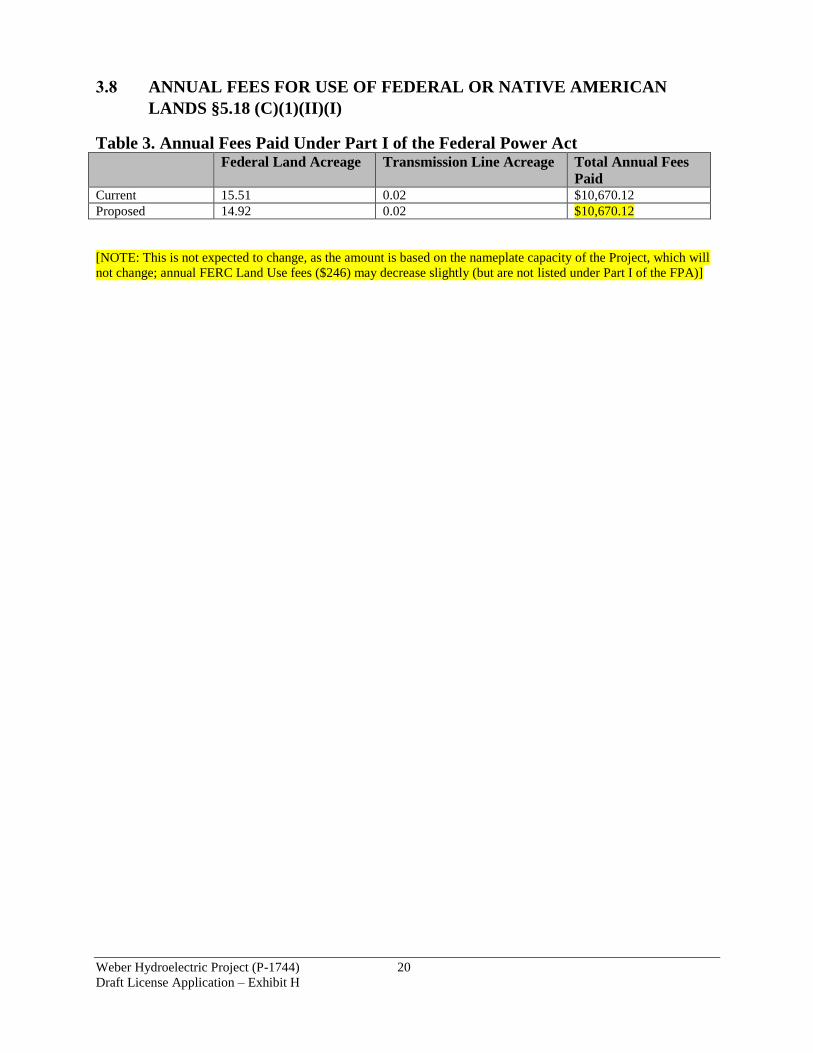
Weber Hydroelectric Project (P-1744) 20
Draft License Application – Exhibit H
3.8 ANNUAL FEES FOR USE OF FEDERAL OR NATIVE AMERICAN
LANDS §5.18 (C)(1)(II)(I)
Table 3. Annual Fees Paid Under Part I of the Federal Power Act Federal Land Acreage Transmission Line Acreage Total Annual Fees
Paid Current 15.51 0.02 $10,670.12
Proposed 14.92 0.02 $10,670.12
[NOTE: This is not expected to change, as the amount is based on the nameplate capacity of the Project, which will
not change; annual FERC Land Use fees ($246) may decrease slightly (but are not listed under Part I of the FPA)]