Embed Size (px)
Citation preview
DRAFT MAIN ROAD TRANSIT CORRIDOR PLANPUBLIC RESPONSE REPORT
October 2013
Department of Infrastructure Energy and Resources
PUBLIC CONSULTATION The draft Main Road Transit Corridor Plan underwent a six week public consultation period from 3 June until 19 July 2013.
A Communication Plan was developed to guide the communication requirements associated with the development of the draft Plan and the consultation approach. The Communication Plan was endorsed by the key stakeholders of Metro Tasmania, Hobart and Glenorchy City Councils.
The following communication tasks were enacted to raise awareness that the draft Plan was available for public consultation:
Consultation with Metro Tasmania Board, Glenorchy and Hobart City Council Alderman:
o Briefing with Metro Tasmania Board.
o Report to Glenorchy City Council meeting.
o Briefing to Hobart City Council Infrastructure Committee.
Consultation with local retailers:
o Meeting with Moonah Business Community Inc.
Preparation of information articles:
o DIERlog (internal newsletter)
o Glenorchy Gazette.
o Media release.
Public advertisement:
o Public notices in the Mercury.
Public display materials:
o Display at Hobart City and Glenorchy City Council offices.
o Notices at Metro Springfield Offices and Metro Shop.
o DIER internet site.
Information sent to key stakeholders:
o DIER email sent to key stakeholders.
o Hobart and Glenorchy City Council email/letters to key Council stakeholders.
The community was invited to comment on the draft Plan either electronically by email or hard copy by post.
A total of ten public submissions were received, including one late submission.
2
PUBLIC RESPONSE REPORTA public response report has been developed as a result of public submissions received. The report will be made available to the public on DIER’s website. The report includes a summary of the comments made by each submitter and a response from DIER. The original submissions can be made available on request. Some respondents requested that their identity remain confidential as part of the public response report.
DIER has consulted with officers from both Hobart and Glenorchy City Councils and Metro Tasmania in developing the response, except where the Councils were the actual submitter.
The draft Plan is a strategic plan, which contains projects which in some cases require further development such as detailed investigation and/or planning and design (including targeted stakeholder consultation). Examples of these projects include the Northern Suburbs Service Review, bus stop optimisation and upgrade and bus priority measures.
Some stakeholders’ comments are not fully investigated as part of this Public Response Report, but will be addressed during the individual project development stage. Comments made in relation to the bus priority and bus stop optimisation measures will be investigated as part of the planning and design phase of these projects, and further consultation will also be undertaken with adjacent residents and businesses, and relevant business and community organisations. The outcomes of these consultation processes will be reported to Metro Tasmania and Hobart and Glenorchy City Councils.
Some comments made on the draft Plan are outside the scope of the Transit Corridor Plan, which is focused on improving the public transport system. Where comments are outside the scope of the Plan, DIER will make the relevant organisation aware of the stakeholder’s comments.
Each submitter will be receive a copy of the Public Response Report.
DEVELOPMENT OF FINAL PLANA Final Transit Corridor Plan will be prepared taking into account the feedback received and detailed in this Public Response Report.
The Final Plan will require endorsement from the Minister for Sustainable Transport and the Minister for Infrastructure, Glenorchy and Hobart City Councils and Metro Tasmania.
3
4
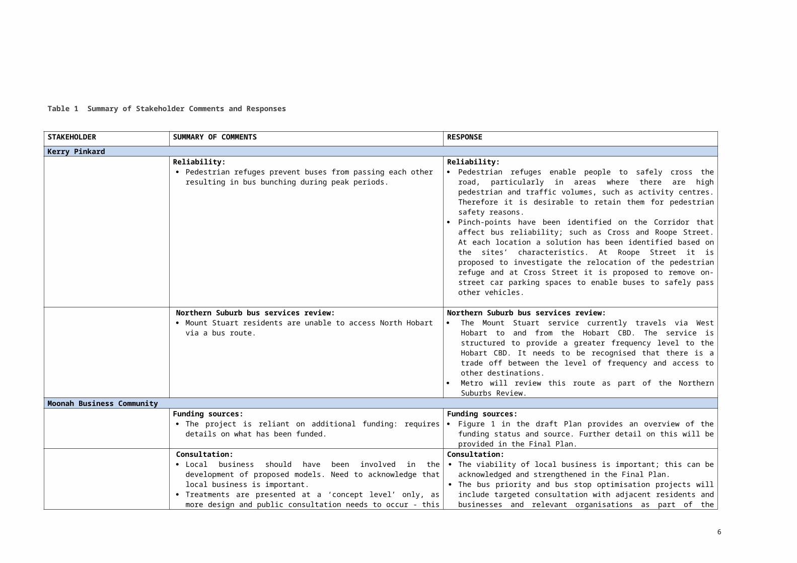
Table 1 Summary of Stakeholder Comments and Responses
STAKEHOLDER SUMMARY OF COMMENTS RESPONSE
Kerry PinkardReliability: Pedestrian refuges prevent buses from passing each other resulting in bus
bunching during peak periods.
Reliability: Pedestrian refuges enable people to safely cross the road, particularly in
areas where there are high pedestrian and traffic volumes, such as activity centres. Therefore it is desirable to retain them for pedestrian safety reasons.
Pinch-points have been identified on the Corridor that affect bus reliability; such as Cross and Roope Street. At each location a solution has been identified based on the sites’ characteristics. At Roope Street it is proposed to investigate the relocation of the pedestrian refuge and at Cross Street it is proposed to remove on-street car parking spaces to enable buses to safely pass other vehicles.
Northern Suburb bus services review: Mount Stuart residents are unable to access North Hobart via a bus route.
Northern Suburb bus services review: The Mount Stuart service currently travels via West Hobart to and from the
Hobart CBD. The service is structured to provide a greater frequency level to the Hobart CBD. It needs to be recognised that there is a trade off between the level of frequency and access to other destinations.
Metro will review this route as part of the Northern Suburbs Review.Moonah Business Community
Funding sources: The project is reliant on additional funding: requires details on what has been
funded.
Funding sources: Figure 1 in the draft Plan provides an overview of the funding status and
source. Further detail on this will be provided in the Final Plan.Consultation: Local business should have been involved in the development of proposed
models. Need to acknowledge that local business is important. Treatments are presented at a ‘concept level’ only, as more design and public
consultation needs to occur - this implies that ‘public consultation’ will only be for show and not taken seriously.
Consultation: The viability of local business is important; this can be acknowledged and
strengthened in the Final Plan. The bus priority and bus stop optimisation projects will include targeted
consultation with adjacent residents and businesses and relevant organisations as part of the project’s planning and design phase.
This consultation will enable stakeholders who may be directly affected to raise their concerns and have these issues taken into consideration during this phase.
Location of bus stops: Why assume the current placement of bus stops? These stops could be
improved for passengers, businesses and vehicles. Eg: remove bus stops which are adjacent to cafes as waiting passengers intrude on the access and amenity of adjacent businesses and result in littering etc.
Location of bus stops: It is desirable to retain the bus stops between Hopkins Street and Albert Road;
bus stop id 358 (outward) and 937 (inward) at the current locations for the following reasons: The bus stops are centrally located which improves passenger access to
the major activity centre of Moonah, which is beneficial to local businesses. The bus stops attract a very high patronage (over 500 boardings a day).
It is proposed to consolidate the bus stops just north of Moonah activity centre; bus stop id 360/359 (outward Amy/Maxwell Street), bus stop id 935/936 (inward Birdwood/old HEC building). If bus stops were also removed from the centre of Moonah, this would mean passengers visiting
5
Moonah would need to walk further to access a service. The current bus stops have good access to both the Hopkins Street and
Albert Road signalised intersections to ensure pedestrian safety. The stops are located in close proximity to the signals at Hopkins Street
and Albert Road, such that buses leaving the stops have direct access to the signalised junctions without the need to negotiate around parked cars. If the stops were moved away from the signals and buses needed to pull in and out around parked cars, this would create delays for all road users.
Because of the nature of businesses within the activity centre, moving the inward bus stops to avoid food premises is likely to be difficult. For example, if the inward bus stop was located further north (opposite Westpac), it would be located outside the Moonah Hotel, which is also a food premises.
As buildings within activity centres do have frequent changes of use, it would be impractical to move a bus stop every time a change of use (such as a new food premises) occurs.
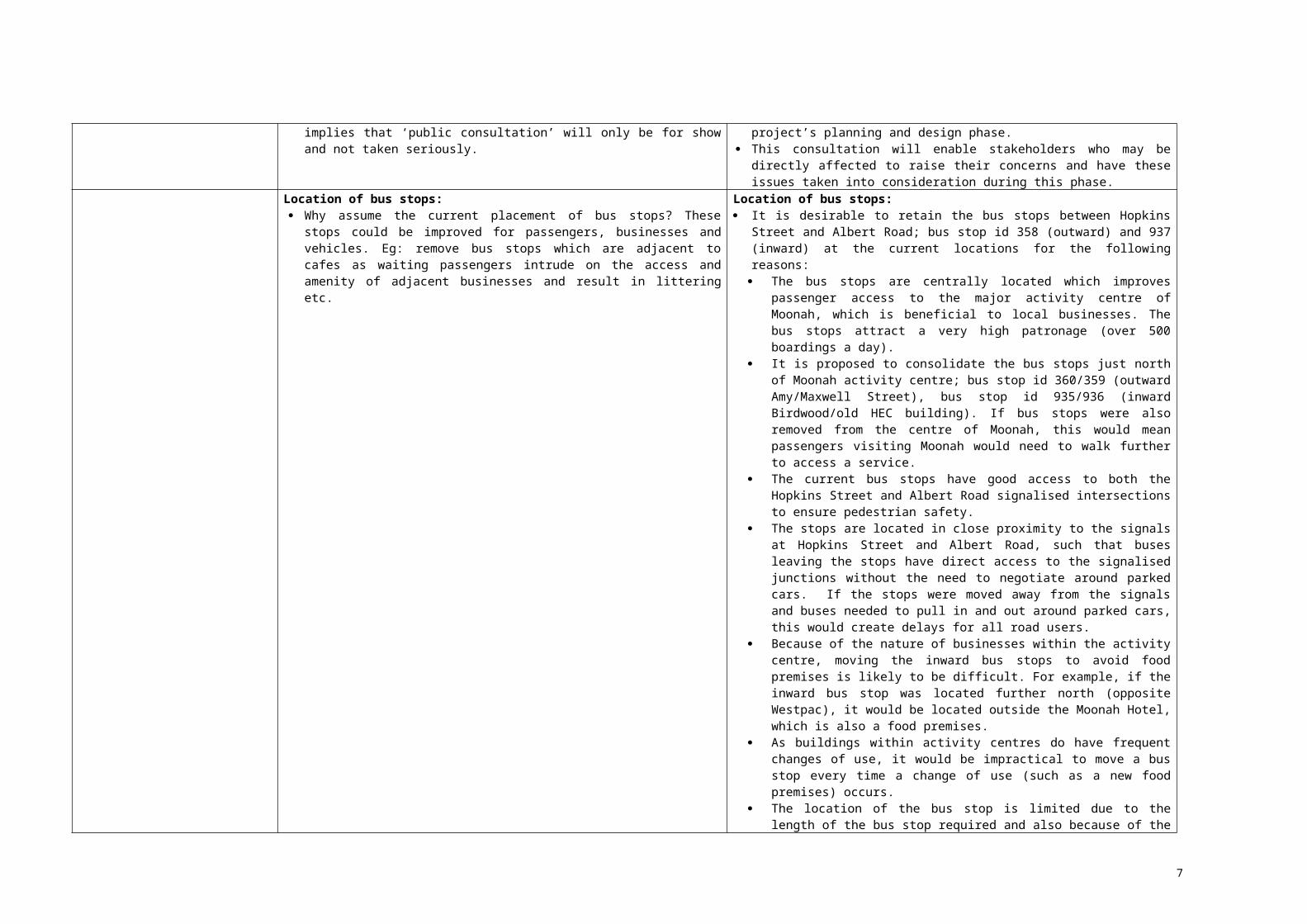
The location of the bus stop is limited due to the length of the bus stop required and also because of the mid-block pedestrian refuge which is designed to increase pedestrian safety.
Improved bus stop facilities: Improved bus shelters, not having passengers huddling under awnings and in
doorways. Better policing of no smoking laws in front of shops, particularly food
businesses.
Improved bus stop facilities: A pedestrian audit of the bus stops was undertaken as part of the draft Plan.
The audit indicates that the inward bus stop does have some passenger waiting issues, including: Limited seating capacity. Passengers leaning against shop walls. Passenger congestion with passing pedestrian traffic.
Anecdotal evidence also suggests there is a problem with littering, smoking and anti-social behaviour.
If funding is received to deliver bus stop upgrades (note currently unfunded), it is recommended that measures to provide better shelter, seating, bins etc are investigated and consultation with adjacent businesses occurs to try and reduce the impact on businesses.
Legislation was introduced to restrict smoking areas for the following public areas: Within 3 metres outside entrances and exits. Pedestrian and bus malls. Bus shelters. All outdoor dining areas.
DIER will work with Metro and Council in regard to determining the responsibility for signage where smoking is prohibited within bus shelters.
It should be noted that it is also the responsibility of local businesses to manage the behaviour of their own patrons eg outside dining, entrances and exits.
If smoking is occurring in restricted areas it may be reported to the Tobacco Control Officers on the Public Health Hotline 1800 671 738 or alternatively Police are empowered to enforce smoking limitations in public places.
Moonah bus priority measures: There is a need for a broader traffic engineering strategy than simply focusing
on buses. Speeding up buses through Moonah, will speed up all through-traffic. Depending on the success of the treatments, additional bus priority measures
Moonah bus priority measures: The focus of the draft Transit Corridor Plan is to improve public transport, in
order to create more sustainable, accessible, healthy and liveable communities. The focus on the Plan is not on the car; however the Plan does take a balanced approach by proposing bus priority measures which do not
6
may be considered – does this imply that the treatments will fail. What other strategies were explored for improving travel times?
For example, close Albert Road and Hopkins Street at Charles Street, allowing buses to use Charles Street as a through-way, and slow traffic down significantly on Main Road between Albert Road and Hopkins Street or even make Main Road a pedestrian zone in that section.
affect the reliability of the car. The bus priority measures proposed are considered to have relatively modest
impacts on general traffic flow, access and amenity. It is not intended that the Plan will be the basis for making major changes to the movement of traffic in Moonah. Proposals which involve dramatic reforms (such as Charles Street being re-configured as a bypass of the Moonah shopping precinct) are most unlikely to progress and their investigation would serve only to delay resolution of the more focussed changes identified in the draft Plan. It is noted that Charles Street would not be conducive to a through traffic diversion. It is not an arterial road and has limited lane widths (approximately 9 metres wide). The intersections at Florence Street, Albert Road and Hopkins Street would not have the capacity to direct traffic back onto Main Road.
The proposed bus priority measures within Moonah improve the traffic flow for all vehicles and reduce delays at Hopkins Street and Albert Road intersections. Improving the traffic flow does not necessarily increase traffic speed, it makes the flow more consistent, which assists in reducing congestion and delays.
The regulatory speed during business hours in Moonah activity centre is 40 km per hour which enhances pedestrian safety. Analysis indicates that the actual travel speed along this section is much lower in the AM and PM peak; 18-27 km per hour.
The bus priority measures proposed can be implemented in the next one to three years (subject to funding) as they do not require major infrastructure changes. Traffic modelling indicates the measures will reduce travel times and are therefore likely to be effective. However with any measure, it is important to undertake evaluation, so changes can be made to ensure it does lead to improvements.
Attachment C of the draft Plan outlines possible future medium term bus priority measures which could be investigated in the next 3-5 years.
The diversion of public transport via Charles Street is not supported. It is important that bus routes are direct as possible, producing an efficient and reliable service keeping total travel times to a minimum. A diversion via Charles Street is likely to increase bus travel times. Buses should penetrate the core of activity centres rather than bypassing them. Bus stops should be located closer than car parking facilities to major trip attractors, such as shopping centres, ideally stopping at the pedestrian entrance to an activity.
Pedestrian access and activity: Greater levels of pedestrian activity need to be encouraged in Moonah. Access to all businesses needs to be enhanced. Liaison with Harris Scarfe and Coogans to encourage pedestrian access
through their stores. Review the concept behind the fences on Albert Road and Hopkins Street to
determine their effectiveness for pedestrians.
Pedestrian access and activity: The draft Plan contains a high level recommendation to improve pedestrian
connections to bus stops, which will attract more people to the Moonah activity centre (note unfunded).
Improvements to pedestrian activity and amenity are a responsibility of Glenorchy City Council. Options to improve amenity could include widening the pedestrian footpath through Moonah activity centre eg between Hopkins Street and Albert Road. However this may require removal of on-street car parking which local businesses may have concerns about.
Walkways and pedestrian access through shops will provide better connectivity from rear car parks to Main Road. This is an issue that DIER is not responsible for and Moonah Business Community Inc is encouraged to pursue this issue with the relevant store owners.
The pedestrian fences work effectively by ensuring pedestrians cross at designated and safe crossing points. It would be undesirable from a
7
pedestrian safety perspective to remove them. The pedestrian fence is also in good condition and helps protect people using the street furniture near the mid block pedestrian crossing from passing traffic.
Streetscaping improvements: The success of North Hobart is attributed to traffic calming and streetscaping. Streetscaping and traffic calming will enhance the viability of Moonah
businesses.
Streetscaping improvements: The focus of the draft Transit Corridor Plan is to improve public transport;
streetscaping and traffic calming improvements are outside the scope of the Plan.
North Hobart contains treatments such as pedestrian refuges and kerb outstands which improves pedestrian safety, together with streetscaping which improves the amenity.
Traffic calming measures such as speed humps, narrowing of the road through outstands and central medians, are typically used to slow traffic speeds. Traffic speeds are already low within Moonah activity centre, so the use of additional traffic calming devices may not be warranted.
It is noted that Glenorchy City Council has, in recent years, renewed the footpaths, kerbs and road pavement through the Moonah shopping precinct, in consultation with the local community. Consequently these assets are in good condition and would not be due for replacement for some years.
Traffic calming devices, such as roundabouts and narrow lane widths, can also make it difficult for larger vehicles (such as buses) to efficiently negotiate movements. Therefore, if any traffic calming is implemented in the future it needs to ensure that larger vehicles are catered for.
On-street parking: Change parking times between Albert Road and Hopkins Street to include five
and 15 minute limits, which would replace the two Loading Zones. Clearer signage to direct people and traffic to long-term parking.
On-street parking: As part of the planning and design for the bus priority measures, mitigating
strategies for proposed changes to on-street car parking will be investigated such as: Parking limits (5 to 15 minutes) to facilitate space for people requiring very
short visits ie to takeaways, cafes, newsagents etc. Better signage to direct customers to long-term off-street car parking sites
within Moonah. This signage needs to be provided on Main Road which is the main vehicular route.
Loading zones are important, particularly in activity centres, in that they enable the pick up/delivery of loads close to their destination. Providing loading zones enables faster and easier delivery, which has productivity benefits. Loading zones are required where it may be impractical to park on a standard car parking space due to the size of the vehicle or where there is a demand for car parking. It is understood that Glenorchy Council is auditing the usage of the loading zones.
Glenorchy City CouncilBus stop optimisation: Consultation with the local community, adjacent residents and businesses
should be conducted prior to optimisation of bus stops. As Development Applications are a likely requirement, advice should be
sought from Councils Planning section.
Bus stop optimisation: Targeted consultation will occur with adjacent residents and businesses as
part of the planning and design of the bus stop optimisation project (planning funding provided).
Advice will be sought from Council on any planning approval requirements.
Springfield Avenue/Derwent Park Road: Changed pedestrian movements and safety will need to be carefully
considered in relation to the changed bus stop locations and the park and ride at the Springfield Depot.
Springfield Avenue/Derwent Park Road: As part of the planning and design of the bus priority and bus stop
optimisation project, impacts on pedestrian safety will be investigated.
Loss of on-street car parking in Moonah: Specific consultation with adjacent businesses should be conducted prior to
Loss of on-street car parking in Moonah: As part of the planning and design of the bus priority measures, targeted
8
the implementation of bus priority measures. consultation with adjacent businesses and Moonah Business Community Inc will occur regarding proposed changes to on-street car parking.
Albert Road right turn ban: Extensive assessment should be undertaken to fully evaluate the impact of
the right turn ban on the surrounding road network due to the new traffic signals at Florence Street and proposed relocation of Moonah Arts Centre to Albert Road.
Albert Road right turn ban: As part of the planning and design of the bus priority measures, a review of
the modelling in relation to proposed right turn ban will be undertaken to determine if further modelling is required.
DIER will consult with Glenorchy City Council on the modelling requirements. There also may be opportunity to change the phasing at Albert Road to
improve reliability.Land use planning:Pg 40 of the draft Plan requires minor rewording in order to prevent ad hoc
conversion of industrial land to residential use: (ii) a proportion of industrial land within Glenorchy may need to be converted to residential or mixed use development as part of a strategic process. Industrial land should only be converted if it is close to the Transit Corridor, isolated from other industrial land, protected form land use conflict, site contamination is remediated and the land has fallen into disuse with little prospect of industrial re-use.
Land use planning:The Plan will be amended to support the suggested wording in relation to
industrial land conversion.
Cycling SouthCycling infrastructure - Appendix E:Archer Street: This is not a known bike route. It is unlikely that city bound riders from
Augusta Rd will turn left (going downhill), then right into Archer St to reach Argyle St to go back uphill. Or vice versa.
The route is indirect and has difficult right hand turns. However bike lanes can be easily installed.
An alternative inbound route would be to create a cut-through to Commercial Rd from New Town Rd and use signs to direct riders to Argyle St along Yardley St.
Outbound route: install a bike lane on Federal St connecting to Elizabeth St and install an uphill bike lane on Elizabeth St between Federal St and Augusta Rd (gentler gradient than Argyle St). The dedicated right turn lane and signals at Elizabeth St/Federal St intersection support use of this route by cyclists.
Archer Street:This route was selected to provide a connection from the proposed extension of
the Argyle Street cycle lanes to Augusta Road.However discussions with Hobart City Council have identified that a more
suitable route would be as follows:Inbound: Elizabeth Street, Commercial Road, Yardley/Thomas Street to
Federal Street and Argyle Street (Commercial Road provides a direct link and avoids backtracking to Archer Street).
Outbound: Argyle Street, Federal Street and Elizabeth Street provides a direct link and avoids the steeper section of Argyle Street and avoids backtracking to Augusta Road catchment.
The draft Plan will be amended to show the Commercial Road/Elizabeth Street as a high priority rather than Archer Street.
Creek Road: An off-road path could be installed alongside Creek Rd as part of a New Town
Rivulet Track upgrade to provide a connection to the Main Road corridor.
Creek Road:In the priority assessment of proposed routes, Creek Road was ranked as a
medium level priority, therefore it was not included as a high priority link within the draft Plan.
It is an existing link (with gaps) within the Regional Arterial Cycling Network.The current boardwalk along New Town Rivulet (east of Main Road) is difficult
for cyclists to access and use because of the width and stairs, with no direct connection to the inter-city cycle way because of the grade separation, except through New Town High and via the footpath. There is an alternative link via Bromby Street which is quiet and suitable for cyclists.
Discussions with Hobart City Council have indicated that more planning is required to determine a suitable link. A link to New Town, would serve a greater catchment area than the Creek Road link and link directly to New Town activity centre. Options that could be explored include a link via Carlton and Forster Street in the short-term, with perhaps Maypole Creek (along transmission line) being looked at for the longer term.
The draft Plan will be amended to show this area may require further investigation.
9
Island Markets: There is an existing laneway that connects to the cycleway at Sunderland St
at one end and Bayswater Road through to the Ashbolt traffic lights on the Brooker Hwy at the other end (route to and from Lutana).
The laneway has tight bollards and chicanes at either end but if they were removed and the surface upgraded. It also has lighting for night. Bayswater Rd is wide and could fit bicycle infrastructure.
Bike lanes can fit if parking is modified.
Island Markets:In the priority assessment of proposed routes, Island Markets was ranked as a
low level priority, however the assessment was based on access through the car park rather than through the laneway. As it is of low importance it has not been included in the draft Plan, however it could be considered as a medium priority in the future.
The current laneway between Island Markets and pump shop is very narrow and has a lack of passive surveillance which results in personal safety issues.
Risdon Rd: Requires bike lanes to improve route for cycling as traffic volumes and
speeds warrant separation.
Risdon Road:In the priority assessment of proposed routes, Risdon Road was ranked as a
medium level priority, therefore it was not included as a high priority link within the draft Plan.
It is a proposed link within the Regional Arterial Cycling Network.This link also carries a high traffic volume, on-street parking and several narrow
sections, as well as gradient issues in connecting with the inter-city cycle way.
The longer term option along Maypole Creek may be a preferable alternative to address the Risdon Road issues indicated above.
For the reasons above it will not be included in the draft Plan.Peltro St: There is space for installing bicycle infrastructure to provide a connection from
the cycleway to Main Road.
Peltro Street:In the priority assessment of proposed routes, Peltro Street was ranked as a
medium level priority and therefore it has not been included as a high priority within the Plan. It will not be included in the draft Plan.
Note the proposed light rail station is located adjacent to Peltro Street and King George V Avenue, so the link could be considered as a higher priority in the future.
John DayFrequency and timetable harmonisation: The Main Road timetable is labelled as a high frequency service but is highly
irregular with many large intervals between buses. Examples include waiting for 16 minutes for buses during inward PM peak.
Many of the deharmonised issues stem from operational issues: The Bus Driver's Union demanding additional running time on the Route
42 (Ten Mile Hill) and the solution chosen was not the best. Route X1 to and from Bridgewater was given additional running time and
this was handled differently by separating the outward and inward trips (ie two buses and drivers used instead of one with dead running to and from Cove Hill Fair).
An alternate approach, which would only affect a small number of passengers, while maintaining a regular timetable would be to swap the Outward 42 times with the Route 34 times so they would leave 10 minutes earlier from Hobart, thus achieving the old Glenorchy inward departure times. Route 34 has a number of weekday trips that are not return (outward and inward).
The proposed additional early morning and night services is good as is standardising the Monday to Friday timetable.
Need to acknowledge that there are different conditions between school term and school holidays when there is less traffic and congestion and fewer passengers in two of the three peaks. Many outward buses can get to Glenorchy in 10 minutes in school holidays and have to wait. This creates problems for passengers who either have to get to the stop much earlier or
Frequency and timetable harmonisation: The deharmonisation of the timetable is noted in the draft Plan. The Plan
contains a recommendation to work towards timetable harmonisation. The 12 month trial to increase frequency will increase the number of services
operating. It will be possible to operate timetables and services at greater efficiency as it
is likely that a harmonised timetable operating at even patterns will be an outcome of the Northern Suburbs Review.
The Northern Suburbs Review will need to look at the detail of route and timetable changes and marketing of services eg school days service.
Travel times for both cars and buses are quicker during school holidays, due to fewer passengers and traffic. This affects the bus in meeting its timetabled departures. It is not feasible to have different timetables for school holidays. Moving to real time information (signage) and phone applications may help to address this issue, by giving passengers access to accurate travel times. Timekeeping by drivers is also an operational issue for Metro, across Greater Hobart.
10
miss the bus. The timetable states that the 5.13 PM service from Hobart be a "School Days
Only" service, why is this the case?Bus Priority measures: Based on the timetable the average speed of a bus is 13-16km/h rather than
the 23km/h quoted. If the trip time can be reduced by 5 minutes by implementing the measures listed, it would be a good start, however travel times need to be comparable to the car to significantly increase patronage.
The proposed 'Bus' (B) traffic signals need to operate properly to give the bus priority, unlike the failure at Main Road and Eady Street, which gives the bus the go ahead as part of the regular cycle instead of interrupting the cycle to give the bus priority. If the bus is not over the sensor before the eastbound traffic on Eady Street gets an orange light, the bus has to wait for the opposite directions to go first. It is quicker for buses to turn left and go around the roundabout and left onto Main Road.
Support bus lanes, slip lanes and other measures, but not convinced that there are many suitable places for them in the corridor. Funding isn't secured which could comprise the success.
Bus Priority measures: The bus priority measures proposed will assist in reducing travel times for
public transport. Depending on the success of the bus priority measures, further measures could be proposed to reduce travel times.
There is one bus priority signal (priority start) proposed at Springfield Avenue/Derwent Park Road. As part of the planning and design phase, the traffic signals section of DIER will be involved in the project to ensure that the signals operate more effectively for buses.
The Plan acknowledges that road space is limited on Main Road, therefore measures have been proposed which result in the better sharing of road space for all users.
Branding: If buses are branded and used exclusively on the Transit Corridor, it will
reduce the efficiencies of linking for scheduling and rostering purposes. Through-city services are favoured, thus if a Transit Corridor was put in place
for Sandy Bay Road (to Lower Sandy Bay or the University), then both corridors could be linked with branded buses to provide a through service to reduce the need for some passengers to change buses.
If buses are still going to be travelling beyond Glenorchy from the corridor, many more buses will have to be branded as opposed to all terminating at Glenorchy.
Branding:Metro is in the process of developing a brand for the Corridor, as part of the Main
Road frequency trial which focuses on bus stop infrastructure (bus stop blade and plinth), rather than bus livery. This resolves the problems associated with scheduling only branded buses on the Corridor.
Hobart City CouncilFunding: Pg 18 - "In considering the remainder of this Draft Plan, it is important that
readers recognise that some of the recommended changes (if approved for the final Plan) cannot be made until additional funding is found".
The language is too informal and implies a haphazard approach to implementation. Would be better to discuss "until funding is secured ('sourced' or 'committed')". Should discuss the process of prioritisation and costing and ensuring funding opportunities are in keeping with these priorities.
Funding: The Plan will be changed to support the suggested wording to improve
understanding of funding processes and priorities.
Bus stop optimisation: Pg 23 - "The bus stop optimisation will mean that bus stops will be located
approximately every 400 metres (within five minute walk), however in areas where there are a large number of trip attractors such as activity centres, or aged care homes, bus stops may be located closer together"
Concerns about two locations which contradict the above statement. Removal of bus stop 945 near the Mary Ogilivy Home in New Town. This
will require the elderly to walk to bus stop 946 - a distance of some 100m. It is recommended that bus stop 946 is removed instead.
The replacement of four existing bus stops northbound on Elizabeth Street between the Mall and Burnett Street with a single bus stop at Elizabeth
Bus stop optimisation: The optimisation of bus stop 945 and the stops between Burnett Street and
Elizabeth Street mall will be reviewed as part of the planning and design phase of the bus stop optimisation project. It is important that there is a balance between accessibility and achieving bus reliability.
Targeted consultation will occur with adjacent residents and businesses on the planning and design of the bus stop optimisation project.
11
College will create gaps that are too big. This would result in spacing between bus stops of over 700m, well in excess of 400m, on an uphill gradient with active street frontages of small businesses and services. Council recommends retaining bus stop 342 as a minimum.
The removal of bus stops can be an emotive issue and consideration of how the community will be engaged needs to occur.
Improved bus stop infrastructure - kerb heights: The section that discusses the benefits of upgrading bus stops (pg 28) needs
to include a commitment to ensuring kerb heights at bus stops are DDA compliant and enable all users, including those with mobility restrictions, to safely board and disembark from buses.
Improved bus stop infrastructure - kerb heights: All bus stops are currently accessible on the Main Road Corridor, this
included a requirement to check that the kerb height was a minimum height of 150mm and asking Council to remedy the height to ensure that it was accessible.
As part of the planning and design phase for the bus stop optimisation project, there will need to be a requirement that the kerb height for new/relocated bus stops is compliant.
Improved bus stop infrastructure - lengthening bus stops: Pg 28 - "As part of the upgrade program, there is a need to ensure that bus
stops have sufficient length to enable the bus to merge in and out easily and not cause disruption to other traffic. Particular attention should be given to bus stops in activity centres such as North Hobart and Moonah, where the potential for buses to obstruct traffic is greater."
It has been assumed that the modal hierarchy in these centres is public transport access, then through traffic and then kerbside activities such as parking and loading in order of highest priority to least. In North Hobart it could be argued that the kerbside activities are more important to supporting the development and use of the area and providing pedestrian friendly environments, than ensuring the continual flow of through traffic.
Alternative infrastructure solutions such as "bus boarders", which improve access and operation of bus stops without physically lengthening the kerbside space, should be explored further. "Bus boarders" (UK term) are used in Melbourne and called "kerbside bus stops".
"Many bus stops are being moved from 'bus stop bays' to 'kerbside' locations. At a kerbside bus stop, buses stop on the road and may temporarily block traffic as passengers get on and off. Drivers behind the bus must not cross a single or double continuous dividing line to overtake the bus. If it is safe and the road is clear, drivers may overtake across a broken dividing line." (Vic Roads description).
The advantages of a bus boarder, as opposed to the proposed lengthened bus stops, in a location such as North Hobart is that they: Enable quicker and more reliable bus stopping times as the time taken for
the bus to leave the bus stop and re-enter the main flow of traffic is significantly reduced.
Require a shorter kerbside length than a traditional stop or bus layby; thus providing more space for parking, loading and other kerbside activities.
Formalise the parking arrangements upstream and downstream of the stop and significantly reduce illegal parking at the bus stop;
It is easier for the bus driver to correctly stop the bus at the kerb and enable low floor buses to be at the same level as the kerb, eliminating a step to board the bus.
Provide a widened footpath at the bus stop location so there are fewer conflicts between pedestrians and waiting passengers.
Improved bus stop infrastructure - lengthening bus stops: The location of bus stops will need to be investigated in the planning and
design phase of the bus stop optimisation project. There may be better alternatives to lengthening the northbound bus stop in
North Hobart, including relocating the bus stop to a position just south of Swan Street. This will reduce the need for a kerbside bus stop. This will be investigated and consultation with Council and adjacent businesses will occur in the planning and design phase.
12
Still discourage the use of Elizabeth Street as a through route for other traffic. This is predicated on a presumption that directing traffic from the north into Federal Street and from the south along Burnett Street remains a 'policy'.
Pedestrian access improvements: Figure 7 (pg 31) - Location of bus stops to target pedestrian improvements:
There is a need to consider improving the location and upgrading pedestrian access to the hospital and education precinct in Campbell/Argyle Streets. This may be done as part of the Hobart Bus Interchange Planning Project.
Pedestrian access improvements: Bus stops that were identified for improvement in terms of pedestrian access
were those bus stops which have a high number of boardings. The bus stop outside the Menzies Centre (bus stop 960) has a very low number of boardings, but is likely to have a high number of passengers alighting. Therefore it was not considered as a high priority for improvement from a pedestrian perspective and will not be included in the draft Plan.
It is noted that the bus stop is in close proximity to the traffic lights on Liverpool/Campbell Street to facilitate safe pedestrian crossing to the hospital.
Improved cycling connections to the Transit Corridor: There is an opportunity to assess and upgrade cycling facilities at all major
intersections and crossings on the corridor, particularly those that cross high priority cycling routes. Advanced Stop Lines (ASLs or 'Green Boxes') should be included in the Figure 8 table of schemes as standard.
It is also noted that Council has limited funds for cycling improvements. However the Transit Corridor Plan will be considered when prioritising works.
Improved cycling connections to the Transit Corridor: The Transit Corridor is not part of the Principal Urban Cycling Network
(PUCN) or Regional Arterial Cycling Network, except on certain sections (eg New Town). However the PUCN and Regional Arterial Cycling Network does cross the transit corridor at key points.
The bus priority project will only be undertaking changes on the actual Transit Corridor itself, rather than on the entering side intersections.
If Council were to assess and identify locations for installing cycling ’Green Boxes’ at its cost, DIER is available to provide advice as required. The cost of relocating traffic detector loops would also need to be met by Council.
Corridor branding and marketing of services: The creation of a 'branded' corridor creates opportunities in the future to
develop further into Quality Bus Corridor style arrangements ie. economic improvement and service quality agreements between the service operators (Metro) and infrastructure providers (Councils and DIER).
Noted.
Increased density and mixed use through infill development: The proposal for State and local Government to jointly investigate
mechanisms to facilitate development, on the Main Road Transit Corridor and its activity centres in the form of higher residential densities and mixed use is supported.
Increasing densities in inner urban areas is consistent with the policies in the Southern Tasmania Regional Land Use Strategy 2010-2035 and the new planning schemes proposed for Glenorchy and Hobart will provide for this through appropriate density provisions. It should be noted that the regional strategy does recognise the heritage constraints to increasing densities in parts of inner Hobart.
Increased density and mixed use through infill development: The Plan will be amended to acknowledge that there are likely to be heritage
constraints to infill development within some parts of Hobart and Glenorchy.
Information Sheet Drawings: It is envisaged that the proposed works will cause considerable concern from
some affected stakeholders. It is noted that DIER has the authority to modify parking and traffic
arrangements without approval by local Government. Ultimately consideration will need to be given whether the benefits of
improved public transport warrants the impact on motorists and affected landowners.
Too much focus on changes to traffic and parking arrangements only. Need to show at a schematic level on the drawings all associated pedestrian
Information Sheet Drawings: Targeted consultation will occur with adjacent residents and businesses
during the planning and design phase on the bus priority project. The targeted consultation process will help to identify what stakeholder concerns are and if the issues can be resolved to deliver the best outcomes.
As part of the planning and design phase, detailed design drawings of the bus priority measures will need to show all infrastructure changes. It should be noted that there are few pedestrian and cycling infrastructure changes associated with the bus priority measures.
13
crossing and potential cycling infrastructure improvements ie. cycle parking locations, cycle lanes, ASLs at junctions, improved pedestrian crossing times or infrastructure at junctions.
Creek Road bus priority: Owners of the convenience store may have concern over loss of parking.
Consultation with the owner is recommended.
Creek Road bus priority: Consultation will occur with the convenience store located opposite the Aurora
Stadium as part of the planning and design phase of the bus priority measures.
Risdon Road bus priority: This proposal will conflict with school buses that pick up and drop off school
students at this location. It is also expected that the bus lane will result in concerns from parents of school children, businesses, bus drivers, the school and residents due to the loss of parking.
Risdon Road bus priority: The concept of developing a bus lane from Tower Road to Risdon Road will
need to be revisited during the planning and design phase of the bus priority project.
Greater evaluation of the impact of the bus priority measures on the Ogilvie bus stop, pedestrian safety and school drop offs/pick ups will be addressed during the planning and design phase.
Roope Street / Cross Street: The loss of parking fronting the Antique Shop will cause complaints from
nearby businesses. The relocation of the pedestrian refuge is likely to be difficult due to the
constrained road width. It may be preferential that the pedestrian refuge should be removed completely.
Roope Street / Cross Street: Consultation will occur with adjacent owners as part of the planning and
design phase on the bus priority measures. Pedestrian safety issues can be reviewed as part of the planning and design
phase of the bus priority measures and bus stop optimisation process.
Augusta Road: No concerns were identified with this proposal.
Noted.
North Hobart Shopping Precinct: The relocation of bus stops is likely to result in complaints from traders.
Instead of relocating bus stops, it is suggested that one bus stop be removed and the other remain in place.
There is no need for a merge lane outside of Fresco given a merge lane is already in place. There is likely to be concerns from traders with this proposal.
There are no identified concerns with the proposed dedicated left turn lane on the intersection with Burnett Street.
The extension of the bus stop in front of the Rain Check Lounge is likely to cause concerns. It is suggested that banning right turns into Lefroy Street be considered instead.
North Hobart Shopping Precinct: Targeted consultation will occur with adjacent residents and businesses on
both the bus stop optimisation and bus priority measures during the planning and design phase.
During the planning and design phase, the proposed location of the inward North Hobart bus stop will be reviewed to determine if it is more suitable for one stop to be removed and the other to remain in place.
The merging area outside Frescos is not well defined. Provision of a marked, downstream merge lane will assist buses to stay in the left lane and travel through the intersection more efficiently.
There may be better alternatives to lengthening the northbound bus stop in North Hobart, including relocating the bus stop to a position just south of Swan Street. This will reduce the need for a kerbside bus stop and right turn bans into Lefroy Street. This will be investigated and consultation with Council and adjacent businesses will occur in the planning and design phase.
Collins Street: The loss of parking in this location is expected to result in concerns from the
traders and Ronald McDonald House. Parking and allowance for bus movements has been reviewed numerous
times by Council. The current layout was considered to provide a reasonable balance for all road users.
Collins Street:As part of the planning and design phase of the bus priority measures, targeted
consultation will occur with adjacent businesses and the accessibility needs of their customers taken into account.
Hobart City Council - Access Advisory CommitteeImproved frequency and hours of operation of bus services: The group supported the increase in frequency.
Noted.
Immediate improvements to hours of operation to ensure consistency across the week:
Noted.
14
The group supported the service hours noting it would increase safety of the public.
Upgrade bus stop infrastructure, including shelters, seating and passenger information displays and ensure stops are accessible (DDA compliant)/ Provision of simplified, easy to understand and accessible pre-trip information The group recommended that Metro publish the locations of accessible stops
to assist in journey planning. The group supported the designated bus stops at activity centres being
prioritised for upgrades.
Upgrade bus stop infrastructure, including shelters, seating and passenger information displays and ensure stops are accessible (DDA compliant): All bus stops on the Main Road Corridor will be designed so that they are
accessible. The journey planner proposed for Greater Hobart is a google maps planner
(similar to Burnie and Launceston), which is unable to publish the location of accessible stops.
Improved pedestrian connections to major bus stops within activity centres through targeted infrastructure upgrades and/or signage: The group recognised this as a vital component of the plan and supported
improvements to high traffic pathways. Note that these designated pathways can be considered by the HCC Access Advisory Sub-Committee.
Noted.
Smart phone applications, SMS and recorded messaging:The group noted that these applications will assist those with sight and hearing
impairment.
Noted.
Adrian PickinGeneral comments: Believe the overall document falls fundamentally short and is flawed in its
approach.
Noted.
Frequency: As a commuter it fails to outline how increased frequency will reduce the
overall commuter travelling time to the destination points, it is very light on detail and specific examples. Example it takes 1.15 hours (assuming meeting connection on time: 10 minute window), from Claremont to Glenorchy bus terminal then onto Hobart.
The challenge, for such a small population within greater Hobart, at what cost is increased frequently, can this be achieved with current fleet, staffing levels and how will it deliver reduced travel times to acceptable customer levels.
Frequency: Improving frequency will reduce waiting times at bus stops and overall travel
time, for those people who rely on just turning up at a bus stop. It will not actually reduce the in-vehicle travel time. This can be made clearer within the Plan.
The 12 month trial of frequency improvements on Main Road, is being funded by the State Government. An evaluation project will be implemented to monitor the success of the trial. If the trial is successful in terms of increasing patronage, it is anticipated that the service levels of the trial could be funded through efficiency gains made as part of the Northern Suburbs Service Review.
Frequency improvements can be made with the current fleet levels.Location of depots: Is the location of the depots right, in the medium and long term?
Location of depots: The location of Metro’s depots is an operational issue, which is outside the
scope of the Transit Corridor Plan.Strategic planning: Infrastructure services should inform planning corridors, not develop first and
then seek services to these areas; though it is noted this strategic planning is not part of the scope, but will play a pivotal role in the future plans.
Strategic planning: The concept of the Transit Corridor project is to improve public transport
along existing key public transport routes, which already have services in place and population and activity centres to support public transport.
Other strategic plans are in place such as the Southern Integrated Transport Plan which state that land use and transport planning need to be undertaken concurrently and not in isolation and that land use planning needs to make best use of existing infrastructure and services.
Provision of secure bicycle parking at select locations on the Transit Corridor: Does support the concept of long-term bicycle parking, though question at
what cost to the community, would expect a triple line cost benefit analysis. Also would the cost be borne at the individual “user pay” level or aggregated
across the whole customer base.
Provision of secure bicycle parking at select locations on the Transit Corridor: The draft Plan contains a recommendation to investigate the provision of
long term bicycle parking at Glenorchy. The investigation will need to determine the capital cost of providing a facility and the management arrangements including the pricing of using a facility.
15
It should be noted that secure bicycle parking is designed to encourage people to use sustainable transport, so pricing may discourage use particularly when car parking is currently free within Glenorchy. These factors will need to be taken into account in the investigation.
Improved ticketing: To encourage use of public transport, convenience, improved customer
service, accessibility to purchase pre-ticket at convenient locations and reduced travel times are paramount for increased patronage.
For many commuters, particularly the elderly they do not use the internet, so would expect to see a better proposal on improved passenger information by segmentation. Ability to purchase frequent travel tickets is not easy to achieve, should be able to buy tickets from say post offices, and have an information payment facility at each depot point.
Improved ticketing: The Metro Greencard provides the opportunity for people to pre-purchase
tickets, by ‘topping up’ either on the bus, Metro shop, Metro agent (select newsagencies) or on the internet. Applications for a Greencard can be made on the internet, postal application or at Metro shop or agent. Cash tickets can also be purchased on the bus.
It is considered that the above options provide adequate opportunities to pre-purchase tickets.
It should be noted that there are costs incurred with establishing ticketing agencies.
Corridor branding and marketing of services: Branding needs to start with the basics, with good reliable and polite
customer service at the driver level. Examples are: Rude drivers, in how they address/communicate with customers. Pushing through at traffic lights whilst pedestrians are crossing; learn to
stop and wait behind the white line, its intimidation to see a bus “creeping” towards you.
Aggressive driving, making you feel nausea when being driven a high speed around corners, it should be a pleasant and efficient journey; not hold on to your seat "thrill ride experience".
Corridor branding and marketing of services: Improved customer service from bus drivers is important in improving the
image of public transport. This is outside the scope of the Transit Corridor Plan, as the Plan directly
focuses on improving public transport on the Transit Corridor rather than across the metropolitan area.
DIER will raise these concerns with Metro.
Park and ride: Common sense approach, but to achieve improved and better support
services is required, such as "park and ride". For example there is limited parking at Glenorchy, so one has to catch a
service further out, making the journey inconvenient and too long to be useful. Suggestions more depots to other locations, for example the show grounds, and the “Deck”.
Park and ride: There are currently park and ride opportunities at the Springfield Depot, with
70 car parking spaces available for this use. Other park and ride options within Glenorchy municipality have been
previously investigated. The approach taken was to use park and ride to extend the catchment of Transit Corridors, intercepting car trips before they reach congested points in the network, ie before Glenorchy. The Tasmanian Urban Passenger Transport Framework also specifically encourages walk and ride within inner urban areas.
Any park and ride site needs to be located directly adjacent to a high frequency public transport route, such as Main Road in order to maximise use of existing services and avoid the need to put on additional services just to service the park and ride. Both the Derwent Entertainment Centre and Hobart Showgrounds are adjacent to the Brooker Highway and although the Highway plays a role in peak periods, it is not a high frequency public transport route.
A park and ride option at Claremont was considered, but based on the identified costs, forecast patronage and operational issues associated with operating the park and ride, it was not considered feasible.
Other options to increase patronage are considered more appropriate such as improving frequency and reliability.
Simple and direct routes: If we can increase more direct routes and feeder routes, this will lend,
overtime, to look at possibilities of better fuelling depot locations with perhaps gas powered buses, a win win for patrons, cost saving and the environment
Simple and direct routes: The Northern Suburbs Service Review will aim to ensure routes are simple
and direct. The location of Metro’s depots and use of alternative fuel sources for
vehicles is an operational issue, which is outside the scope of the Transit Corridor Plan.
16
Bus stop optimisation: Page 23 “The bus stop optimisation will mean that bus stops will be located
approximately every 400 metres (within five minute walk), however in areas where there are a large number of trip attractors such as activity centres, or aged care homes, bus stops may be located closer together”.
How does this compare to other national and internal jurisdictions, as 400 metres does not go far enough, it’s not cost effective (stop and start increases wear and tear on the business and increases fuel consumption) and again still not reduce travel time sufficiently; though what is acceptable can be subjective, thought comparison to best practice would be useful context.
Bus stop optimisation: The guidelines for bus stop placement were reviewed for a number of
jurisdictions around Australia and internationally, to determine best practice for the placement of bus stops; 400 metres was considered to be the generally accepted distance. There is a need to balance meeting accessibility needs, versus improving reliability. The placement of a bus stop every 400 metres meets this balance.
Perception of public safety on buses:There is not only a perception of public safety on buses at night time; the bad
behaviour is on display during the day, eg Glenorchy terminal; despite the police station across the road, and the CCTV. An open police shop front would improve matters – they could simply look out their window, observe and act as necessary or even go for regular walks
Perception of public safety on buses: In Metro’s Annual Customer Satisfaction Survey for 2013, 76% of customers
in Hobart were very satisfied or satisfied with the personal safety on board the bus. All buses have CCTV as a safety feature.
The Glenorchy bus interchange is located in an area which has good passive surveillance from Main Road, it has a high volume of passengers and buses, the presence of which would make people feel safer. It also has CCTV, which since installed has decreased vandalism significantly. It is not considered that a regular Police presence is warranted.
It is understood that the Police station in Glenorchy may be relocated to the former Harvey Norman site at Harold Street.
Stakeholder 1Northern Suburb Services: Support for the spine/feeder system provided transfer facilities and travel
time reliability are good. Support the shift from a low frequency, high penetration model to a high
frequency, corridor based model.
Noted.
Frequency: The proposal has similar frequencies to existing services but a slightly longer
temporal span. During some periods, the proposed service is worse than the existing service.
For example, on Monday-Friday early morning inward, existing services depart Glenorchy at: 6:00, 6:21, 6:38 and 6:57, which is 4 services by 7am. Under the proposed system, buses depart Glenorchy at: 5:30, 6:00, 6:30 and 7:00, which is still only 4 services by 7am, but the longer temporal span results in a longer headway.
Would like to see a copy of the proposed timetable, especially with regard to: Harmonisation at peak times where services run every 10 minutes or less.
Will this be either a 10 mins/5 mins headway or a mixture of 10/9/8/7/6/5 minutes between services?
Connections for areas past Glenorchy. Perhaps beyond the scope of just this transit corridor, but would like to
see the network plan that has been developed but not yet implemented, specifically to see how feeder services will connect to this corridor as well as future transit corridors.
Increases in frequency on the corridor will be of little benefit unless the bunching problem can be fixed. Even with the current 10 minute headway, it is not uncommon to wait more than 20 minutes due to the bunching of services.
Frequency: Where the frequency is moving from a 30 to 10 minute frequency, there may
be a need to phase in some additional services based on demand, eg there may be demand for a service at 6.30 AM and 6.45AM.
Similarly, within the height of the peak there may be a demand for a higher frequency than 10 minutes.
The draft Plan contains a recommendation to monitor demand and make the necessary improvements to frequency and hours of operation..
Detailed timetable design is outside the scope of the Transit Corridor Plan. A timetable will be developed as part of the Main Road frequency improvements.
Bus priority will help to improve reliability on the Corridor, which in turn, should reduce bunching.
Bus stop optimisation: Noted.
17
The bus stop optimisation proposal looks very good and should improve total travel time. At least the stops are located in pairs (inward and outward) unlike recent changes in the Sandy Bay area where there is considerable difference between inward and outward stops.
Bus Priority: Collins Street: The clearway had been extended before. Why not just make it
from Market Place to Argyle Street? Surely there is no argument for providing on-street parking in that section in front of a multi-storey car park.
Bathurst St from Elizabeth St to Argyle St: There are narrow lane widths and issues with a new car park opening soon that need to be addressed. There is an opportunity to remove on-street parking in this section in front of multi-storey car park. This space could be used for either a cycle lane or a bus lane in medium term until the inward diversion is removed.
Burnett St: This is, in my opinion, the worst intersection on the corridor for delays (northbound). It generally takes a minimum of two traffic light cycles to clear this intersection in the peak, and up to five cycles on a really bad day (rare). In addition to the short term priority measures listed in the report, would any of the following be of benefit? Remove the left filter arrow phase from Burnett Street to Elizabeth Street
during peak periods. Ban right turns from Burnett Street to Elizabeth Street (northbound) during
peak periods or even permanently. During peak periods many of these turns are made unsafely during the all red signal phase in any case.
There is ample off-street parking in Elizabeth Street south of Burnett Street (northbound) from just north of Tasma Street. Could some on-street parking be removed here (even if just in peak periods) so that the proposed left turn/bus lane is kept clear?
Do we need left turns for cars from Elizabeth Street to Burnett Street westbound? According to the priority use of roads by transit mode, cars have priority on Argyle Street where as busses have priority on Elizabeth Street. A car travelling from the city to West Hobart can use either Harrington/Murray streets or else Argyle Street where they have priority. This would free up space for a bus only lane northbound in Elizabeth Street and a B-phase northbound at this intersection.
Support of removing some on-street car parking to provide bus priority, e.g. Risdon Road, Creek Road etc.
Bus Priority: Collins Street: Hobart City Council has raised concerns about removing on-
street car parking in this area. It should also be noted that most businesses like convenient access to their premises from on-street parking provision, particularly businesses such as Ronald MacDonald House.
DIER will discuss these issues with Hobart City Council and adjacent businesses as part of the planning and design phase for the bus priority projects.
Bathurst St from Elizabeth St to Argyle St: The draft Plan contains a recommendation to investigate medium term bus priority measures within the Hobart CBD. The implications of the new car park (corner of Bathurst and Argyle Streets/former Mens Gallery) for bus reliability can be included as part of this project (note currently unfunded).
It should be noted that the main car park access/egress would be from Argyle Street. There would be a secondary entry only from Bathurst Street.
Burnett St: The proposed introduction of a downstream merge lane outside Frescos will help to reduce queuing caused by the left filter arrow from Burnett Street to Elizabeth Street.
It is important that cars are allowed to access North Hobart shopping strip from other key arterials such as Harrington Street and Argyle Street as this may be their destination, therefore it is not appropriate to ban right turns or remove the left turn arrow as it provides efficient access into North Hobart.
Including the bus stop itself, currently there are on-street parking restrictions for 70 metres on the approach to Burnett Street (outbound), this is considered sufficient to keep the left turn lane clear. It is proposed to optimise this bus stop (id 345), therefore it would be desirable that the length of the left turn lane is maintained and not converted back into on-street car parking. DIER will discuss this issue with Hobart City Council.
Bus Stop Infrastructure: Would off board fare collection and multi door boarding at bus stop id
3385/341 (Bathurst Street) be an economic benefit (peak times only maybe) given the large number of boardings at that stop compared with others on the corridor? Obviously multi-door boarding is not feasible on the buses with a passenger operated rear door. Note that such a scheme would not be much benefit at the termini given the bus has to wait until departure time anyway.
In my experience, it takes four to five minutes to load a bus here (3385/341). So together with the five minute diversion around the mall, the first ten minutes of the journey takes you only a couple of hundred metres!
There is a problem at bus stop id 346 (Lyndhurst Street) whereby a stopped bus blocks other buses or large vehicles from passing. An adjustment of the road island in this area would fix this.
Bus Stop Infrastructure: Implementation of cashless buses is premature at this stage, until a higher
level of Greencard use is achieved. Buses will never be entirely cashless as a key feature of Greencard is the ability to ‘top up’ on the bus.
Changing boarding practices (eg rear door boarding) would be difficult to achieve and confusing if it was only targeted at certain stops. Changes would need to be implemented at the metropolitan level to avoid passenger confusion.
Since 2000 all new Metro buses have driver operated rear doors, however there is still a large component of the fleet with passenger operated doors. These buses will be gradually replaced. Ticket machines (INIT system) would also need to be installed near the rear door, which would be an additional cost to facilitate rear door boarding. It is considered that rear door boarding is not feasible at this stage.
A more effective strategy to minimise bus dwell times is to encourage a
18
higher uptake of Greencard usage. It is currently at 55 percent. This would be a state-wide strategy as opposed to a Corridor strategy and therefore would not be included in the Plan.
Bus stop id 348 (Lyndhurst Street): The barrier in this area is over 80m long and would require significant modification to reduce the length at the location of the bus stop. The barrier was put in place to improve safety, as the area had a history of cars crashing into oncoming traffic. Given this, it would not be advisable to reduce the length of the barrier.
Cycling:The link between cycling and the transit corridor is confusing given that bikes
are not allowed on buses. If the proposal is for people to ride to the bus stop and then catch the bus, then will bike lockers be provided at the major bus stops?
Cycling:The intent is to improve cycling access to the Transit Corridor as the Corridor
contains key attractors (such as schools and shops) which people want to access from neighbouring suburbs, or from the Principal Urban Cycling Network. There is likely to be a greater demand for cycling to the Corridor to access key attractors, rather than cycling to the Corridor to use public transport (eg a multi-modal trip). This can be made clearer within the Plan.
Hobart Older Persons’ Reference GroupAccess to public transport: Our main concern is to optimise the use of public transport by older people
and many older people can either not afford their own car and/or are no longer able to drive, therefore they are completely reliant on public transport.
Much lip service has been paid to "positive ageing" and a big part of that is easy access to public transport in order to interact with society and not be isolated in their homes. In our ageing population these factors should play a far greater part in the plan, than is presently the case.
Access to public transport: The Draft Transit Corridor Plan aims to improve public transport, such as
improving frequency and bus stop infrastructure. This will have benefits to older people by providing more frequent services and more comfortable waiting facilities.
Public transport does play an important role in social inclusion and accessibility for older people; this role can be acknowledged in the Plan.
However it also needs to be acknowledged that public transport cannot meet everyone’s needs and that other forms of transport (such as door-to-door community transport) has a role in increasing accessibility and social inclusion. The community transport sector is likely to grow in importance in the future as the population ages.
Bus stop optimisation: The distances of the stops is a major concern limiting access to transport,
and isolating older people. By increasing the distance between stops, this becomes a major barrier to access for many members of the community. With an ageing population this will result in increased social isolation.
There is also concern about the issue this will create for school children having increased distances to walk, for parents with children who also rely on public transport. Many people don’t have a car – but this proposal is a push towards the car being more attractive for many.
Bus stop optimisation: The guidelines for bus stop placement were reviewed for a number of
jurisdictions around Australia and internationally, to determine best practice for the placement of bus stops; 400 metres was considered to be the generally accepted distance. There is a need to balance meeting accessibility needs, versus improving reliability. The placement of a bus stop every 400 metres meets this balance.
The bus stops that are proposed to be optimised, are those with low passenger volumes and that are closely spaced together. Therefore the removal of these stops should not cause a significant reduction in accessibility.
Research also shows that people are prepared to walk further if a service is more frequent and reliable, which the draft Plan proposes to improve.
Traffic routes: This is a bigger issue than the buses – it is a car issue. Traffic is currently
being pushed through, for example, Lenah Valley, Mount Stuart and West Hobart in avoidance of the Main Road, Brooker Highway and major traffic flow roads.
Traffic routes: The focus of the draft Transit Corridor Plan is to improve public transport, in
order to create more sustainable, accessible, healthy and liveable communities. The focus on the Plan is not on the car; however the Plan does take a balanced approach by proposing bus priority measures which do not affect the reliability of the car.
The draft Plan also contains a recommendation to develop a road network approach within Hobart and Glenorchy to establish the priority use of roads by transport mode. This approach means that certain roads will be managed to function more efficiently for cars, while other routes will give
19
greater priority to public transport, walking and cycling.Accessible buses: Are the accessible buses being used in this initiative? If not why not? And if
they are – are they being taken away from other routes? Where does this leave people with limited abilities?
Accessible buses: Currently 55% of Metro services are accessible and there is a requirement
for all services to be accessible by 2022.
Frequency: Why are there not smaller buses being used to run more often, to more
destinations?
Frequency: The Corridor has high passenger utilisation, therefore standard capacity
buses are required to meet the passenger demand. Smaller buses have similar operating costs to standard capacity buses,
therefore (contrary to popular opinion) there are no operational or financial advantages of using smaller buses.
Alternative transport: Alternatives to cars needs to be looked at before this proposal – ferries and
light rail would allow for increased options and opportunities for people to choose their mode of transport, and not be compromised by increasing distances to walk.
Alternative transport: The Transit Corridor Plan focuses on specifically improving public transport
on existing public transport corridors such as Main Road Corridor. The Tasmanian Urban Passenger Transport Framework provides the
strategic guiding document for improving public transport more generally in urban areas. It focuses on improving the existing bus based system as the first priority.
The bus system in Greater Hobart has a high penetration network, which means that most urban areas are well serviced by the bus system. By comparison, a Hobart to Glenorchy light rail system or a Derwent River ferry network would have fewer stops because of the fixed nature of the infrastructure, meaning that it would have low penetration and people would have to walk further to access these stops. The establishment of these alternatives are significantly higher than improving the existing bus system.
Cost of public transport: This group thinks that unless this proposal is free – it won’t have an impact
on traffic, or social inclusion.
Cost of public transport: Public transport is already significantly subsidised by the State Government.
Metro was provided approximately $36 million by the State Government to support the delivery of bus services in 2011/12. Further subsidising public transport to enable all passengers to travel free, would result in a significantly increased impost on the State Government’s budget.
All passengers on Metro’s urban services receive some level of subsidy. All fares are less than the full cost of providing the transport service. Specific further concessions are also provided; this includes flat fares for students and adult concession passengers, regardless of the distance travelled.
On-street car parking: Will there be increased parking available at bus stops? The proposal only
discusses increase to pedestrian and cycle facilities.
On-street car parking: The Tasmanian Urban Passenger Transport Framework specifically
encourages walk and ride within inner urban areas, therefore there are no plans to increase on-street car parking close to bus stops.
It is also not physically possible to provide more space for on-street car parking. Where parking is not available it is used by other road users.
Bus priority: This group thinks it would be good to have the slip lane at the lights – it will
improve reliability, but potentially increase confusion for drivers. This group would really like to see the same number of on road car parks
available at North Hobart especially at the Burnett Street end where pickups of takeaways are very popular.
Bus priority: The proposed bus priority measure at Burnett Street (left turn only lane,
which buses can use) will contain a ‘left turn only, buses excepted’ sign to aid drivers.
No net overall reduction of on-street car parking is proposed within North Hobart. Removal of two car parking spaces and relocation of the loading zone outside Frescos is required to create a downstream merge lane in order to improve reliability for buses. These two spaces will be replaced with new spaces elsewhere through optimisation of bus stops.
20
21