Embed Size (px)
Citation preview
Land Acquisition and Resettlement FrameworkEnhancing the Climate Resilience of the West Coast Road Project (CRWCR)
March 2015
RP1317 V2
Table of Contents1. Introduction.................................................................................................................................................62. General Overview.......................................................................................................................................63. Rationale and Application of LARF.....................................................................................................73. Project Description....................................................................................................................................94. Legal and Regulatory Framework....................................................................................................155. Developing an Abbreviated Resettlement Action Plan (ARAP)..........................................236. Procedures for Involuntary Acquisition and Voluntary Donation.....................................277. Compensation Measures......................................................................................................................328. Implementation........................................................................................................................................359. Budget, Timing and Costs....................................................................................................................3510. Public Consultation and Disclosure..............................................................................................3511. Monitoring Arrangements................................................................................................................4012. Grievance Procedures.........................................................................................................................40
Annex 1 Schedule One of the Land Titles Registration Act 2008..........................43
Annex 2 Template for Abbreviated Resettlement Action Plan (ARAP)................46
Annex 3 CRWCR Consultation Strategy...............................................................54
Annex 4 Voluntary Land Donation Protocol........................................................57
Annex 5 Easement Agreement...........................................................................59
Glossary of Key Terms
Term Description SourceAffected Persons
Persons who are affected in any of the ways described in paragraph 3 of OP4.12, i.e. all those people who lose land or the right to use land (para. 3a) or who lose “access to legally designated parks and protected areas resulting in adverse impacts on the livelihoods” (para. 3b). The term is synonymous with “displaced persons” and is not limited to those subjected to physical displacement; may also refer to persons affected by project-related changes in the use of land, water and other natural resources.
World Bank OP4.12
Aigapotopoto Extended familyAigapatino HouseholdAlii (and Faipule)
Village council of chiefs and orators of a village in Samoa
Appurtenant A right, such as an easement of right of way, over other land is said to be appurtenant to the land; or land to which the easement is attached
NZ Institute of Surveyors1
Census A survey carried out to identify Affected Persons in accordance with procedures, satisfactory to the WB, including criteria for eligibility to compensation, resettlement and other rehabilitation measures, and consultations with Affected Persons
World Bank OP4.12
Compensable loss
Loss or damage of the kind referred to in subsection 79 (1), other than loss or damage of the kind referred to in subsection 79 (2)
Part 13 s78, Land Title Registration Act 2008
Compensation Payment in land, cash or other assets given in exchange for the taking of land and buildings, in whole or in part, and all fixed assets on the land and buildings (e.g. fences, crops). There are two types: land compensation and asset compensation.
World Bank OP4.12
Paid where the loss of damage arises from the registration of some other person (i.e. the State) or interest in the land.
Land Title Registration Act 2008 s79(1)(b)
Cut off date Date of the start of census for eligibility to entitlements World Bank OP4.12
Compulsory acquisition
See involuntary land acquisition (below).
Displaced Persons1
See Affected Persons (above).
Drainage easement
The right to convey sewage and/or stormwater through adjoining lands
NZ Institute of Surveyors
Dominant tenement
Land which has attached to it an easement over other land Survey Act 2010 (GoS)
The name of the land to which the easement is attached or appurtenant (i.e., enjoys the benefits of the easement over another’s land)
NZ Institute of Surveyors
Easement A legal right to use of land of another, without the right to possession of that land, or to take any part of the soil or produce
Survey Ordinance Act
1http://www.nzisltsurveybook.org.nz/land-title-surveys/chapter-2/section-2
of such land 1961 No. 12 (GoS)
The property owner who grants the easement retains possession of the land and access over the land but has restrictions placed over the use of the servient tenement
WCR Drainage Position Paper 2010
Easement in gross
An easement over land, which is not appurtenant to other land, but which belongs to a person independently of the ownership of land
Survey Ordinance Act 1961 No. 12 (GoS)
An easement over land may be created without being attached or made appurtenant to other land
Taking of Land Act 1964 (s122) (GoS)
Incorporeal hereditament
Giving the possessor of the easement certain rights in respect of another’s land, but giving no rights of ownership.
NZ Institute of Surveyors
Informed consent
Affected persons are fully knowledgeable about the project and its implications and consequences and freely agree to participate in the project
World Bank OP4.12
Involuntary Actions that may be taken without the displaced person’s informed consent or power of choice.
World Bank OP4.12
Involuntary resettlement/ displacement
Direct economic and social impacts caused by (a) the involuntary taking of land resulting in: (i) relocation or loss of shelter; (ii) loss of assets or access to assets; or (iii) loss of income sources or means of livelihood, whether or not the Displaced Persons must move to another location; or (b) the involuntary restriction of access to legally designated parks and protected areas resulting in adverse impacts on the livelihoods of the displaced persons
World Bank OP4.12
Involuntary restriction of access
Applicable to easements where ‘right of way’ is being exercised.
Involuntary Land Acquisition
Compulsory acquiring, or involuntary taking, of land by government for public purpose where the landowner must surrender their land involuntarily but retains the right to negotiate and appeal the amount of compensation proposed or terms on which the involuntary acquisition will take place. This includes land or assets for which the owner enjoys uncontested customary rights.
World Bank OP4.12
Matai Title holder and representative of extended family in Samoa.Pule Authority over land established by the Lands and Titles Court in
Samoa.Pulenu’u Village mayorPower of choice Affected persons have the option to agree or disagree with the
land acquisition or involuntary measures without adverse consequences imposed formally or informally by the state
World Bank OP4.12
Relocation A method of valuation of assets which assists in determining the amount sufficient to replace lost assets and cover transaction costs.
World Bank OP4.12
Replacement cost
A method of valuation of assets that helps to determine the amount sufficient to replace lost assets and cover transaction costs. Depreciation of structures and assets to be replaced is not taken into account to determine the compensation amount necessary to meet full replacement cost. Applies to urban or agricultural land, structures and fixed assets.
World Bank OP4.12
Reasonable access
In relation to land, means physical access for persons or services of a nature and quality that is reasonably necessary to enable the owner or occupier of the land to use and enjoy the land for any purpose for which it may be used in accordance with any right, permission, authority, consent or approval
Survey Act 2010 (GoS)
Right of way (ROW)
An easement entitling the owner of a dominant tenement, or in the case of an easement in gross, the person entitled to the easement to pass and repass over the servient tenement
Survey Ordinance Act 1961 No. 12 (GoS)
River protection reserve
The distance of five (5) metres from the top of the river banks Survey Act 2010 (GoS)
Road reserve The width of a public road verge encompassing the road pavement and road shoulder
Sa’o The head matai in the extended family, by virtue of the rank of his/her title
Servient tenement
Land over which there is an easement Survey Act 2010 (GoS)
Service easement
An easement in favour of sewerage or water supply, drainage, or electricity supply purposes
NZ Institute of Surveyors
Sui o le Malo Generally refers to the appointed woman representative of the Village for Government liaison purposes
Sui o le Nuu Village mayorSurveyor A person for the time being licensed as a surveyor under the
Survey Ordinance Act 1961.Survey Ordinance Act 1961 No. 12 (GoS)
Tautua Service provided by an individual to family, village or country in Samoa.
Voluntary Land Donation or Contribution
Registered landowner (or community for communal/customary land) agrees to provide land or property for project-related activities. Voluntary contribution is an act of informed consent made with the prior knowledge of other options available and their consequences, including the right not to contribute or transfer the land. It must be obtained without undue coercion or duress, and may still require the compensation for assets on the land (but excludes compensation for land).
World Bank OP4.12
1 “Displaced persons,” under OP 4.12, refers to all the people who are affected by (a) involuntary acquisition of land and (b) the involuntary restriction of access to legally designated parks and protected areas resulting in adverse impacts on the livelihoods of the displaced persons.
1. Introduction
This LARF guides implementing agencies and partners on the appropriate process for which to approach dealings with land according to the potential scenarios likely to be generated by the Enhancing the Climate Resilience of the West Coast Road (CRWCR Project. A major focus of this LARF is to outline an agreed process and procedures for dealing with drainage easements required as part of the CRWCR.
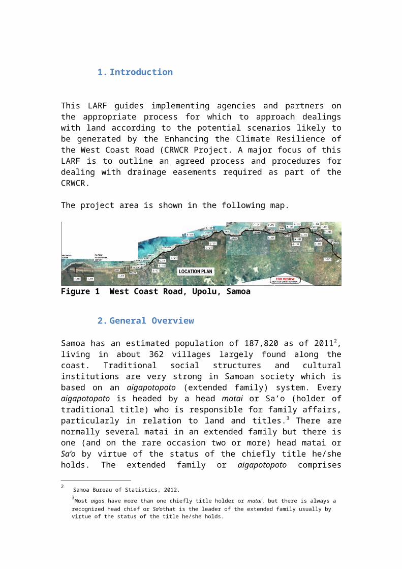
The project area is shown in the following map.
Figure 1 West Coast Road, Upolu, Samoa
2. General Overview
Samoa has an estimated population of 187,820 as of 20112, living in about 362 villages largely found along the coast. Traditional social structures and cultural institutions are very strong in Samoan society which is based on an aigapotopoto (extended family) system. Every aigapotopoto is headed by a head matai or Sa’o (holder of traditional title) who is responsible for family affairs, particularly in relation to land and titles.3 There are normally several matai in an extended family but there is one (and on the rare occasion two or more) head matai or Sa’o by virtue of the status of the chiefly title he/she holds. The extended family or aigapotopoto comprises several households or aigapatino of nuclear families of couples and their children who are part of the extended family but live in their own house, cultivate their own crops on extended family land and operate independently on a day-to-day basis. The aigapatino have shared responsibilities towards the extended family or aigapotopoto with respect to matters such as funeral, weddings, family gathering and feasts, and in some cases, church obligations. Many extended families make up a village.
Every village has a fono (council) that maintains law and order, provides direction for village development including land use. The Fono which meets monthly, and consists of all the matai in the village. Every village has a pulenu’u (village mayor) who is the contact person and the conduit of information between the Fono and the Government, and a Sui o le Malo, a women representative.
2 Samoa Bureau of Statistics, 2012.3Most aigas have more than one chiefly title holder or matai, but there is always a recognized head chief or Sa’othat is the leader of the extended family usually by virtue of the status of the title he/she holds.
Samoa comprises two large islands – i.e. Upolu and Savai’i, two smaller inhabited islands, Manono and Apolima, and a number of smaller islands. These islands cover a total area of 2,800 km².
Of the country’s total land area, 81 percent is held under customary ownership, 15 percent by government and 4 percent by freehold. While customary tenure guarantees ownership rights to all Samoans, it is often very difficult for development purposes to get agreement from all the different parties involved at any one time. Whenever customary land is affected by any form of development, disputes will invariably arise and cause delays to development projects, sometimes extended for certain periods of time. While the knowledge of customary land boundaries are handed down by word of mouth and are known to family members, the pule (authority) is often uncertain or disputed.
The main feature of land tenure is the significant percentage of communally owned land by villages and aiga. These lands are awarded through historic claims and by family genealogy and connections. Village lands comprises of (i) village controlled customary land which is normally the undeveloped hinterland that is used by all members of the village for hunting, firewood collecting, etc and (ii) extended family land or land allocated to each extended family for their houses, crops etc. Village land is governed by the Village Fono. Extended family land is allocated by the Sa’o in consultation with members of his extended family.
3. Rationale and Application of LARF
The Government of Samoa (GoS) has developed this Land Acquisition and Resettlement Framework (LARF) in accordance with principles, objectives, procedures and rules set out in the World Bank Operational Policy OP/BP 4.12 – Involuntary Resettlement4. It establishes parameters for the conduct of land acquisition and associated displacement for the CRWCR Project.
Component One includes funding for the design and enhancement of the West Coast Road. This includes construction works for drainage improvements (longitudinal and cross-drainage) to reduce flooding, road rehabilitation and shoulder improvements including pedestrian footpaths and crossings to improve public road safety (Section 3 provides a detailed description). At the time of project appraisal, the precise siting of the works was not determined. Therefore, this LARF establishes the principles, objectives, procedures and rules to be used in the preparation of Abbreviated Resettlement Action Plan/s (ARAP).
Affected persons include those who involuntarily or voluntarily relinquish land or assets to accommodate for the enhancement of the West Coast Road (WCR) in Upolu, particularly for the creation of new drainage easements. An ARAP is required when project activities may result in involuntary resettlement impacts that are minor, i.e. no persons are physically displaced, and/or less than 10 percent of their productive assets are lost. The GoS will finalise one or more ARAPs once the final design is complete and impacted sites are known. This will occur prior to the commencement of any works.
4 BP/OP4.12 Available at http://go.worldbank.org/ZDIJXP7TQ0
The Project will not fund any activity or works with significant resettlement impacts, i.e. that would result in the involuntary physical displacement of 200 or more people or which would cause more than 200 people to lose 10 per cent or more of their productive assets (land and incomes).
Given the focus of the project is to enhance an existing road alignment, it is extremely unlikely that there will be any major demand for new land or encroachment outside the designated road reserve. The design phase will maximise drainage from the road reserve into natural water-courses (i.e. public land) to avoid the issue of securing an easement on freehold, leasehold or customary land. Easements already existing for the natural watercourse will likely be either widened or deepened under the Project. However, it is likely that new easements will also be required, there is potential for involuntary resettlement impacts to eventuate as a result of the Project. It is for this reason that the LARF has been prepared.
2.1 Objectives and Key Principles
For this project, the GoS agrees to carry out the project in accordance with this LARF and OP/BP 4.12. As such, the GoS agrees to waive any national legal, regulatory provisions in contradiction to the requirements established in this LARF, and to take actions necessary to ensure full and effective implementation of the ARAP prepared in accordance with the LARF.
2.1.1 Objectives
The World Bank’s OP4.12 on Involuntary Resettlement outlines the following objectives, which have been adopted in the preparation of this document and will govern the project implementation:
Avoid or minimize involuntary resettlement where feasible; Assist affected persons in improving their former living standards, earning
capacity and production levels or at least restoring them; Encourage community in planning and implementing resettlement; and Provide assistance to affected people regardless of the legality of title of land.
In World Bank-assisted projects, borrowers are expected to take all necessary measures to avoid, minimize, mitigate and compensate for adverse social impacts, including, but not limited to, those impacts associated with involuntary resettlement. Every viable alternative project design should be explored to avoid, where feasible, or minimize involuntary resettlement.
If involuntary resettlement cannot be avoided altogether, sufficient resources should be made available to conceive and implement resettlement activities as sustainable development programs, in close consultation with affected persons.
Affected persons should be assisted in their efforts to improve, or at least restore, their livelihoods and living standards to pre-displacement levels or levels prevailing prior to project implementation. This is accomplished primarily through: (a) compensation at full replacement cost for losses of assets (for example, land, unharvested crops, improvements on the land to be acquired, etc); and (b) provision of other forms of assistance for livelihood restoration or physical relocation, as necessary in accordance with OP 4.12.
Where the law of the GoS does not meet the standard of compensation at full replacement cost, compensation under domestic law is supplemented by the additional measures set out in this LARF.
2.1.2 Key principles
OP/BP 4.12 establishes the key principles to be followed in resettlement planning and implementation. Of particular relevance for this LARF are the following:
Involuntary resettlement should be avoided where feasible, or minimized, exploring all viable alternative project designs.
Wherever possible, project design and ARAP should be conceived as sustainable development programs, so that affected persons may benefit from the services and facilities created for, or by, project activities.
All affected persons are provided prompt and effective compensation at full replacement cost for losses of assets (e.g., land, trees) attributable directly to the project(without depreciation or deduction for tax arrears, licensing or registration fees, or for any other purpose).
Affected persons without a recognizable legal claim or right to the land they are occupying are provided with compensation for loss of assets, other land and resettlement assistance (example, cash, employment, etc).
Methods by which displaced persons can pursue grievances will be established as necessary, and information regarding these grievance procedures will be provided to displaced persons.

3. Project Description
3.1 Country and Sector Context
Samoa's road network is of critical importance to the country's economic development. It provides for the day-to-day well-being of its people by increasing their access to economic activities and social services. Approximately 70 percent of Samoa's population lives within one kilometer of the coast, and critical infrastructure, such as hospitals, schools, places of employment, tourist infrastructure, port facilities, power plants, airports, and roads, is located primarily in the coastal zone. Expected climate change effects - the combination of rising sea level and more intense tropical cyclones - place these coastal infrastructure and communities at high risk.
The Samoa road network faces a range of vulnerability issues, in particular: (i) coastal exposure to sea-level rise, storm surge, wave action during cyclones and tsunamis; (ii) inland flooding and landslips during extreme rainfall events; (iii) damage from earthquakes; and (iv) accelerated pavement deterioration due to extreme weather and rising water tables in some locations. The West Coast Road (WCR) is the primary artery on the main island of Upolu and provides a vital land transport link connecting Samoa's capital city Apia and the Port of Apia with Faleolo International Airport, the Mulifanua inter-island ferry wharf (the main gateway to Samoa's second island, Savai'i), and communities and industry along the north-west coast. Its upkeep is critical for continued economic development as more than 50 percent of Samoa's population and most of its industry is currently located along the WCR corridor. WCR follows, and in places, is immediately adjacent to, the coast. In some locations the road is within five meters of the water, and more than 50percent of the WCR is less than three meters above mean sea level, with approximately 10 percent less than two meters. It is vulnerable to high rainfall events (leading to surface flooding, deterioration of the road surface and road closures), and extreme high sea levels (for instance during severe tropical storms) that can lead to accelerated erosion of the road profile, structural damage and road closures. In addition, the road surface is at risk, particularly at its eastern end, by a high water table, which exacerbates deterioration of the road pavement. The existing carriageway is two-lane, generally seven meters wide, with unsealed (or very narrow) road shoulders. It has numerous culverts, no major bridges, and a sealed bituminous surface in varying condition. For almost half of its 30 km length, the condition of the WCR is rated as poor to fair.
The GoS is developing a systematic approach to strengthen the WCR's resiliency to climate change and to build an overarching adaptation strategy for the entire Samoa road network. One of the main components of its strategy - relocating the WCR further inland - is the long-term solution in response to the threat of rising sea levels, which after several decades, may eventually submerge the WCR. While the relocation of the WCR inland has been shown to be economically feasible and is likely to be necessary in the long-term, it is not practical in the short- to medium-term for several reasons. First, it is unlikely that the existing road would be submerged by rising sea levels within its 25-year upgraded design life. This is according to Samoa's Second National Communication to the United Nations Framework Convention on Climate Change (UNFCCC), which indicates sea level rise of 36 cm by 2050. Second, a
detailed feasibility study carried out under the World Bank-funded Second Infrastructure Asset Management Project (SIAM-2) has shown that constructing a new inland route would be an extremely expensive option, and given the country's commitment to reduce the fiscal deficit (as noted in the 2012 Country Partnership Strategy), the inland route would only be considered as a long-term solution, since rehabilitating the existing WCR is a viable option for the short- to medium-term. Third, relocating the WCR further inland would involve complex land issues that would cause significant delays requiring several years to resolve.
Given the critical importance of the WCR to the country's economic development and the constraints noted above, the Government plans to rehabilitate and enhance the WCR's resiliency to climate change over the next 30-year timeframe, or until around 2040. Furthermore, GoS plans to prepare a detailed assessment of vulnerabilities in road transport and develop a strategy for enhancing the climate resilience of the overall network for the same time- frame. GoS is working with donors to support its climate change initiatives and has requested the Bank's assistance through the Enhancing the Climate Resilience of the West Coast Road Project (CRWCR), which will be the first of two projects for Samoa under the Pilot Program for Climate Resilience (PPCR). Other aspects of coastal resilience will be addressed under the second PPCR project, Enhancing the Climate Resilience of Coastal Resources and Communities Project, which will adopt a "ridge to reef' approach and focus on enhancing climate resilience and the capacity of natural systems and coastal communities to adapt to climate change.
The Bank has a long and successful history of engagement with the GoS in strengthening road sector infrastructure, and in responding to and building resilience against natural disasters. Over the last ten years, a series of Bank projects has supported reforms in road maintenance and management arrangements, including the establishment of a Land Transport Authority (LTA), which will be the implementing agency for this project, and with major road rehabilitation projects. The Bank previously worked with the GoS under the Cyclone Emergency Recovery Project supporting the recovery from Cyclone Heta and reducing coastal vulnerability. Bank support to GoS in the transport sector includes: (i) a successful program of contracting out road maintenance to the private sector; (ii) upgrading Vaitele Street, which is an extension of the WCR into urban Apia; and (iii) upgrading road infrastructure along affected areas of the 2009 tsunami. The combination of completed and planned upgrading of Vaitele Street under SIAM-2, and the proposed rehabilitation and enhancing of the WCR's resiliency to climate change under this project, will contribute to a high quality, climate-resilient road link that will serve as the backbone of land transport in Samoa.
3.2 Project Development Objective
Project development objectives of the CRWCR are to: (i) improve the climate resilience of the West Coast Road; and (ii) enhance local capacity to develop a more climate resilient road network.
3.3 Project Description
3.3.1 Component One: Improving Climate Resilience of the West Coast Road
This component will implement measures to strengthen the climate resilience of the economically critical WCR, which is a key GoS objective under the Strategic Program for Climate Resilience (SPCR). Proposed works will improve the road pavement between Vailoa Junction in Apia and Faleolo International Airport (approximately 23.8km) by raising and strengthening vulnerable sections of the WCR, sealing shoulders, and improving longitudinal and cross drainage. These investments will serve to: (i) reduce road closures during extreme weather events and high sea levels; (ii) reduce surface flooding and impounding of water, which contributes to road deterioration and adversely impacts roadside communities; (iii) reduce road deterioration due to runoff and increasingly high water tables, and generally improve pavement quality to reduce future maintenance requirements; and (iv) contribute to increased road safety by providing marked sealed shoulders for pedestrians and dedicated bus stops and road signage.
All road reconstruction works are expected to take place within the existing road reserve, but the need to access roadside properties to complete the associated drainage works is expected. Technical assistance will also be included in this component for the detailed design and supervision of works on the WCR. This will mitigate technical capacity risks and deliver high quality to the design and implementation of construction works.
3.3.2 Component Two: Vulnerability Assessment of the Samoa Road Network
This component involves technical assistance that will directly support the SPCR by bringing about transformative change in the way that climate change is addressed in the Samoa roads sector. The assistance will assess the climate change vulnerability of the main road network on the two principal islands of Upolu and Savai'i, and prepare a climate resilience/adaptation strategy for the road network. This will involve using best available climate change and natural hazard risk information to identify key hazard types and risk levels, such as sea-level rise, tropical cyclones, extreme rainfall and temperature events, tsunamis, etc., and then assessing the likely severity and timing of risk impacts for all major links of the road network. In particular, the analysis will use latest results from the Pacific-Australia Climate Change Science and Adaptation Planning Program, and the Pacific Catastrophe Risk Assessment and Financing Initiative. Based on this analysis, the study will then prepare a road network adaptation strategy that will: (i) outline a general climate change adaptation policy framework and objectives for the national road network; (ii) identify and prioritize specific locations that require investments to improve the resilience of the national road network; (iii) determine specific measures to update design and planning standards and maintenance procedures taking into account expected climate change; (iv) prepare tools to assess the vulnerability of road assets to climate events, including methodologies for determining the adequacy of existing roads to resist climate impacts, and Environmental Codes of Practice (ECOP) for existing and new roads; and (v) review the institutional and legal framework and recommend specific reforms required to facilitate climate change resilience in the roads sector from infrastructure and operational perspectives.
3.3.3 Component Three: Project Management and Operating Costs
Given the limited capacity in Samoa to managedonor projects, a consulting firm will be hired to assist the LTA in project implementation, including preparing procurement documentation, maintaining a financial management system, reviewing and commenting on technical outputs from consultants, and monitoring and evaluating results and indicators. This Component will also provide funding for specific inter-project SPCR coordination activities, such as: (i) knowledge exchange and lessons learned to feed into the coordination of the SPCR at a programmatic level; (ii) resources for GoS officials to participate and contribute to overall SPCR processes; and (iii) monitoring and evaluating project results.
Monitoring and evaluation (M&E) and project data will be shared with the other PPCR-financed project for Samoa, Enhancing the Climate Resilience of Coastal Resources and Communities Project, as well as with the PPCR Sub-Committee.
3.4 Easements
Easements give a dominant lot of land a benefit of a right over a servient lot of land. The right created by the easement can be utilised by the owner of the dominant lot. As the right is attached to the land, the benefit can be enjoyed by the subsequent owners of the dominant land. An example would be one lot having the right travel on a track through a neighboring lot. The establishment of the easement does not require any change to land ownership.
A drainage easement is designed to allow for the drainage of water or effluent within pipes or overland from a dominant tenement (benefitting land / individual) across a servient tenements5 lot. The easement gives the right to channel water across, over or under (i.e. open or piped) a servient tenement to allow for waterflow and improved drainage.
The landowner retains ownership of the land where an easement is present, but may have restrictions placed over the servient tenement. For instance, in most cases the landowner will not be able to build on or over the land, plant large trees, fill in the channel (if open), and it may limit building design or earthworks in some cases. The servient tenement (if piped/closed) may however continue to be used to for other purposes (i.e. to park a car, for recreation, small crops such as taro, etc) so long as it does not impede drainage. Importantly, the landowner must allow access for maintenance of the easement for as long as the easement is in place. The right to enter servient tenement is only for the purpose of infrastructure, repairing, removing and examining infrastructure.
3.4.1 Options for Securing Easements
5The portion of land where the easement is located is known as the ‘servient tenement’
This section draws on a comprehensive study on the legal and valuation aspects of drainage easements in Samoa completed by LandEquity in 2013. There are three options for securing easements including:
i) Drainage easements;ii) License or lease agreements; andiii) Nature reserve.
Drainage easements are one option for enabling drainage from public roads. They have the following advantages:
Rights are legally secure, permanent (apply to all future owners of the servient tenement) and clearly marked on the property;
Only the right to drain is acquired, applicable only to the servient tenement - i.e. it does not affect the land ownership status of the property, and the owner of the servient tenement is able to use their land (except where it would interfere with drainage and maintenance rights);
Costs to the dominant tenement owner are cheaper than acquisition of the servient tenement;
The dominant tenement owner is not obliged to maintain the property; One-off payment (if applicable) and no ongoing fees.
In addition, easements are likely to enhance the value of the property, since there will be a reduction in flooding risk and events as a direct result of the improved drainage.
Other options include licence or lease agreements for the servient tenement and drainage reserves. A licence is a temporary right to do something on another person’s property that would otherwise be unlawful for a specific duration and usually involves a fee. A reserve for the area used to drain water would need to be owned, or compulsorily acquired for public purpose, by government.
The preferred option is for the Project design to maximize drainage from the road reserve into natural watercourses (public land), which avoids the issue of securing an easement on customary or freehold land.
3.5 Potential safeguard issues related to drainage easements
Rehabilitation of the WCR will involve road carriageway improvements, pavement rehabilitation, and improvements of drainage and road shoulders, among others. Potential safeguard issues that may be generated by the project include:
Restriction of land use on the servient tenement; Establishing a new easement on a property which requires ongoing access for
maintenance and may partially negate land use on the servient tenement (i.e. affected portion of land) and result in either (i) the loss of asset/s, or (ii) acquisition of land for public purpose where an open channel is required;
Re-establishing or widening an existing easement.
In the majority of cases, existing easements (registered and unregistered) may be widened and deepened to improve drainage and reduce flooding risk. A preliminary study undertaken in 2010 proposed the following:
TYPE OF OUTFALL NONew outfall channel required 5Re-grading of existing channel 12New pipe required 4New box culvert required 1Total 22
Depending on the outcome of the design phase, there is the potential that new easements will be created in addition to the existing easements. Wherever possible, government land will be used for new drainage easements and works will be limited to the existing road reserve/carriageway. However, natural waterflows and hydrology will determine the most appropriate location for drainage easements to reduce flooding and to be of benefit to the broader community and road users. Hence, there may be a few instances for new drainage easements to be located on private properties or customary land. This may involve limited involuntary land acquisition (in the case of open channels), and temporary disruption and disturbance on affected properties for works and maintenance.
4. Legal and Regulatory Framework
This section outlines the legal and regulatory setting in Samoa related to involuntary land acquisition, consultation and negotiation, compensation entitlement and grievance resolution.
4.1 Samoan Legislative and Regulatory Setting
Legislation and policy relevant to the requirements of OP4.12, easements and compulsory land acquisition includes:
The Constitution Property Law Act 1952 Taking of Land Act 1964 Land Titles Registration Act 2008 and regulations Survey Act 2010 and regulations Alienation of Customary Land Act 1965 Land Transport Authority Act 2007 Land Valuation Act 2010; and Samoa Code of Environmental Practice.
The GoS has limited power of eminent domain, which is the power of the government to take private property and convert it for public purpose. The Constitution, as the Supreme law of the land, states that ‘no property shall be taken possession of compulsorily and no right over interest in any property
shall be acquired compulsorily’ (Clause 14). However, the Constitution does allow for compulsory acquisition for public purposes and the following provisions apply:
Payment within a reasonable time of adequate compensation; Right of access to the Supreme Court regarding the amount of compensation;
and Right of appeal to the Supreme Court.
The Taking of Lands Act 1964 establishes the taking of lands for "public purposes" (i.e. alienation of freehold or customary land).Once land is identified for acquisition reasonable notice (e.g. one month) is required to be given to the owner or occupier of freehold land or the matai who has the pule over customary land. Public notice of 28 days is allowed for any objections. If no written objection is received, the Minister may then proceed to take the land by Proclamation. This Act briefly refers to easements, where a proclamation is the basis for acquiring an easement. It also provides for compensation entitlements (s11, 25, 37).
The Land Registration Titles Act 2008 (LTRA) regulates the property title registration system and rules for land transactions. Part 9 details easements and deed of restriction due to easements, and Part 13 outlines compensation by government. The terms in the LTRA provide for the rights and responsibilities of the dominant and servient tenements. This Act does not apply to customary land and only deals with private easements on freehold land (and easements in gross6 are excluded). These involve what type of water is allowed to flow across or under the land, how the infrastructure (such as pits, stormwater pits, open channel drains) can be maintained and accessed, and what responsibility the dominant tenement has to restore the land to its original condition after any service or maintenance (Schedule 1, Annex 1). The terms also describe the responsibility of the landowner (grantee) to minimize disturbance over the land and to restore the land, as nearly as practicable to its original condition. Section s67(3) allows a deed of restriction to be registered. Section 68-69 details rules for the release, modification and extinguishment of easements. Easements must be registered to be considered legally valid.
The Lands, Surveys and Environment Act 1989 includes the process for the alienation7 of Government land. Government land is a subclass of public land which is not set aside for any public purpose and includes land which has become the property of the Government as ownerless property. There are a variety of controls under this Act on both leases and sales of Government land. Applications from the public are called for leases and tenders may be called for sales. Leases have to be in the approved form and subject to the covenants and conditions imposed by the Land Board not exceeding 20 years. In Samoa, land within three meters of a natural watercourse is public land over whose property it flows and maintenance of the watercourse is therefore the responsibility of the government.
6 An Easement in Gross allows the dominant tenement of the easement to be an entity independent of land ownership. Section 65 of the LTRA does not specifically provide for the creation of Easements in Gross, although the rights implied for Easement in Gross are detailed in Schedule One of the Act.7 Defined to include limited disposal by lease.
Part IX of the Property Law Act 1952 deals with easements and provides for easements in gross (s122)8; power of the courts to modify or extinguish easements (s127); and permission for the court to impose easement for encroachment (s129).
The Survey Act 2010 (and regulations) requires existing and proposed easements (either easements in gross, or dominant or servient tenement) to be clearly shown on a survey plan (s19, 24).
4.1.3 Customary Land
Most of the land in Samoa is held under customary ownership and is protected by the Constitution for the "customs and usages" of the people of Samoa. Customary land is held in the name of the matai or head of the family, who has the authority (pule) over the family land that is similar to a trustee. The matai determines the distribution of family land among members of the family for their use. It is believed that every Samoan has rights to land that will provide him with a means to earn a living and support his family. It is uncommon for a Samoan to be without rights to some land as a descendant of Samoan parents. It is also uncommon for a Samoan not to have access to alternative areas of land on which to relocate or to cultivate. However these rights to customary land are dictated by one's blood connections. Consequently, one does not have a choice about the location of customary land to which one is entitled.
Alienation of customary land is possible by only two methods:
i. By lease of the land to a person determined by the matai of the family. The Minister of Lands is appointed by the Alienation of Customary Land Act 1965 to act for and on behalf of all beneficial owners in signing a lease for registration. The Minister may grant a lease or licence of customary land for authorized purposes (which are defined). The maximum lease in aggregate for a public, commercial, business or religious purpose is 40 years.
ii. By the Taking of Lands Act 1964 for a "public purpose." The Lands and Titles Court is an independent Court specifically established to deal with customary lands and titles. Lawyers are not permitted to appear before this Court unless they are representing their personal interest in any customary land or title. The records of the Lands and Titles Court are accessible exclusively to the members and descendants or their heirs to the land or title. One can only access the records by providing proof to the Registrar of Lands and Titles that one is an "heir" to the land or a descendant of the family to which the land or title belongs. The register of customary land is not a public record.
8s122 Easement in gross permitted – an easement over land may be created without being attached or made appurtenant to other land, and such as easement shall run with and bind the land over which it is created, and all persons claiming title to that land by, through, or under the person creating the easement; and the easement so created shall be to all intents and purposes an incorporeal hereditament, and shall be assignable accordingly.
There are many instances where the authority or ownership of customary land is uncertain or disputed. Such disputes are referred to the Lands and Titles Court for decision about the pule over the land or title in dispute.
The Alienation of Customary Lands Act 1965 does not permit the creation of easements over customary land, but provides provisions for the granting of leases and licences.
Section 9 of the Land Titles Registration Act 2008 is very clear that no provision of that Act is to be seen as disposing of any customary land. Under this Act, the Registrar has a duty to include land in the Register that becomes public land or freehold land or customary land leased or licensed under the provisions of the Alienation of Customary Land Act 1965.The Land Registrar is empowered by s15 of the Land Titles Registration Act 2008to register all public land, freehold land or customary land that is leased or alienated. There is also provision for the Registrar to record and register any customary land where the pule or authority over it has been established.
4.1.4 Freehold land
Freehold land is registered under a deeds registration system established prior to Independence in 1962. The Register of freehold lands is a public record which can be accessed by the payment of a search fee. In Samoa, the Deeds Registration System operates in principle. In practice, the Samoan legal profession applies the principles of the Torrens system to registration of title.
Freehold land is situated mainly within the Apia urban area and the outskirts of Apia. The acreage of freehold land has increased since the Government has made several hundred acres of Government land available for purchase by the Public. Freehold land is highly valued and the current market value of the land is determined by the price a willing buyer will pay for it and factors such as comparable land sales and the services and amenities accessible to the area in which the land is located. Residence on freehold land is not subject to the authority of the chiefs and orators of a village, even if it is located in a village.
4.1.5 Government Land
The Land Board established by the Lands Surveys and Environment Act 1989 administers government land. Records of Government land estimated that the total area of Samoa comprised 725,000 acres with Government land at 85,630 acres.
4.2 Land Valuation under Involuntary Acquisition
The Land Valuation Act 2010 deals with the practice of land valuations and licensing of valuers. Valuations for the same area of freehold or customary land tend to be guided by market value overall.
4.2.1 Freehold
The GoS does not undertake annual valuations of freehold land on an annual basis. Determination of compensation to be paid for freehold land is easily valued because it is regularly sold and conveyed, mortgaged as collateral for loans and its value is determined by the fluctuation of the open market of "willing buyer and seller. "Land is valued according to the availability of amenities such as water, electricity and telephones, its proximity to amenities such as schools and hospitals and the comparable sales of land in the same area of similar size.
4.2.2 Customary
Current market value of customary land presents many difficulties because customary land cannot be sold, mortgaged or alienated other than by lease. Such land has never been subject to any rates or land tax payments (nor has freehold land), therefore, it is difficult to ascertain the "market value" of customary land other than by using the market value of freehold land as a basis. However, the Taking of Lands Act 1964, states that compensation should be paid at the "market value" when customary land is rarely, if ever, given a market value. The valuation of customary land has, in the past, been measured by initially considering the current market value of freehold land in the same area.
4.2.3 Easements
The Principle Valuer in MNRE has the task, on a case by case basis, to assess the value of the proposed easements based on freehold sales with full use land rights and then making appropriate adjustments (if any) for the restrictions that the landowner will have over the narrow strips required for the drainage.
4.3 Gap Analysis
Table 1. Gap Analysis on National Laws and OP/BP4.12
Samoa Legislation WB Policy Requirements Gaps and Consistencies between the GoS and WB Policies
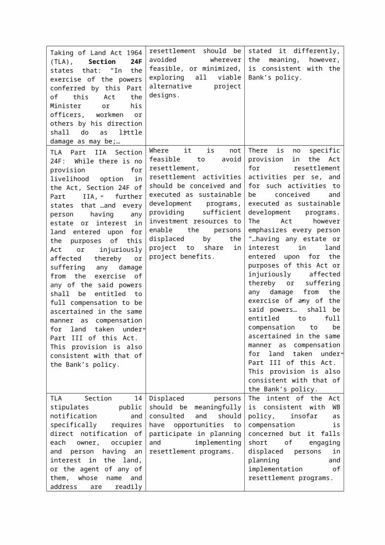
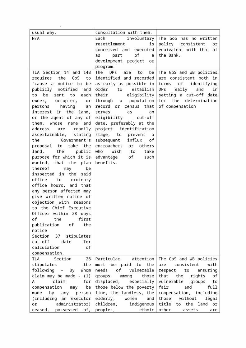
Consultation and Negotiation under Land AcquisitionIn Part IIA of the Taking of Land Act 1964 (TLA), Section 24F states that: “In the exercise of the powers conferred by this Part of this Act the Minister or his officers, workmen or others by his direction shall do as little damage as may be;…”
Involuntary resettlement should be avoided wherever feasible, or minimized, exploring all viable alternative project designs.
While the Act has stated it differently, the meaning, however, is consistent with the Bank’s policy.
TLA Part IIA Section 24F: While there is no provision for livelihood option in the Act, Section 24F of Part IIA, further states that”…and every person having any estate or interest in land entered upon for the purposes of this Act or injuriously affected thereby or suffering any damage from the exercise of any of the said powers shall be entitled to full
Where it is not feasible to avoid resettlement, resettlement activities should be conceived and executed as sustainable development programs, providing sufficient investment resources to enable the persons displaced by the project to share in project benefits.
There is no specific provision in the Act for resettlement activities per se, and for such activities to be conceived and executed as sustainable development programs. The Act however emphasizes every person “…having any estate or interest in land entered upon for the purposes of this Act or injuriously affected thereby or suffering any damage from the
compensation to be ascertained in the same manner as compensation for land taken under Part III of this Act.” This provision is also consistent with that of the Bank’s policy.
exercise of any of the said powers…” shall be entitled to full compensation to be ascertained in the same manner as compensation for land taken under Part III of this Act.” This provision is also consistent with that of the Bank’s policy.
TLA Section 14 stipulates public notification and specifically requires direct notification of each owner, occupier and person having an interest in the land, or the agent of any of them, whose name and address are readily ascertainable, stating the Government's proposal to take the land, the public purpose for which it is wanted, that the plan thereof may be inspected in the said office in ordinary office hours, and that any person affected may give written notice of objection with reasons to the Chief Executive Officer within 28 days of the first publication of the notice;The same provision is written in Section 14A covering customary land in which the notice is written in Savali.
Displaced persons should be meaningfully consulted and should have opportunities to participate in planning and implementing resettlement programs.
The intent of the Act is consistent with WB policy, insofar as compensation is concerned but it falls short of engaging displaced persons in planning and implementation of resettlement programs.
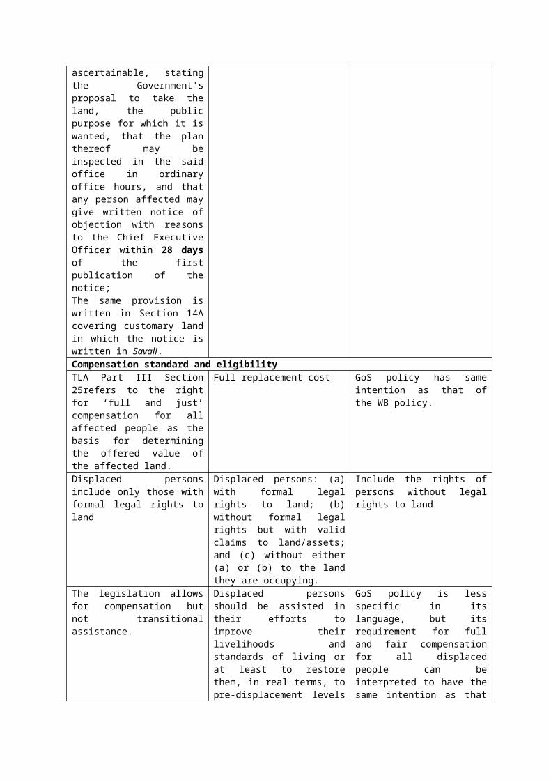
Compensation standard and eligibilityTLA Part III Section 25refers to the right for ‘full and just’ compensation for all affected people as the basis for determining the offered value of the affected land.
Full replacement cost GoS policy has same intention as that of the WB policy.
Displaced persons include only those with formal legal rights to land
Displaced persons: (a) with formal legal rights to land; (b) without formal legal rights but with valid claims to land/assets; and (c) without either (a) or (b) to the land they are occupying.
Include the rights of persons without legal rights to land
The legislation allows for compensation but not transitional assistance.
Displaced persons should be assisted in their efforts to improve their livelihoods and standards of living or at least to restore them, in real terms, to pre-displacement levels or to levels prevailing prior to the beginning of project implementation, whichever is higher.
GoS policy is less specific in its language, but its requirement for full and fair compensation for all displaced people can be interpreted to have the same intention as that of the WB policy. Moving and/or transitional assistance will be offered where applicable.
Impacts resulting from the taking of lands is widely defined in the TLA under phrases such as - every person having any estate or interest in land entered upon for the purposes of this Part or injuriously affected thereby or suffering any damage from the exercise of such
Relevant impacts are direct economic and social impacts that both result from Bank assisted investment projects and caused by (a) the involuntary taking of land resulting in (i) relocation or loss of shelter; (ii) loss of assets or access to assets; or (iii) loss of income
WB and GoS differ in terms of the level of specificity and wording but the intent is the same. The same intent is applicable to involuntary restriction of access to legally designated parks and protected areas even though parks in Samoa did not come into
powers. sources or means of livelihoods, whether or not the affected persons must move to another location; or (iv) the involuntary restriction of access to legally designated parks and protected areas resulting in adverse impacts on livelihoods of the displaced persons.
existence until 1974.
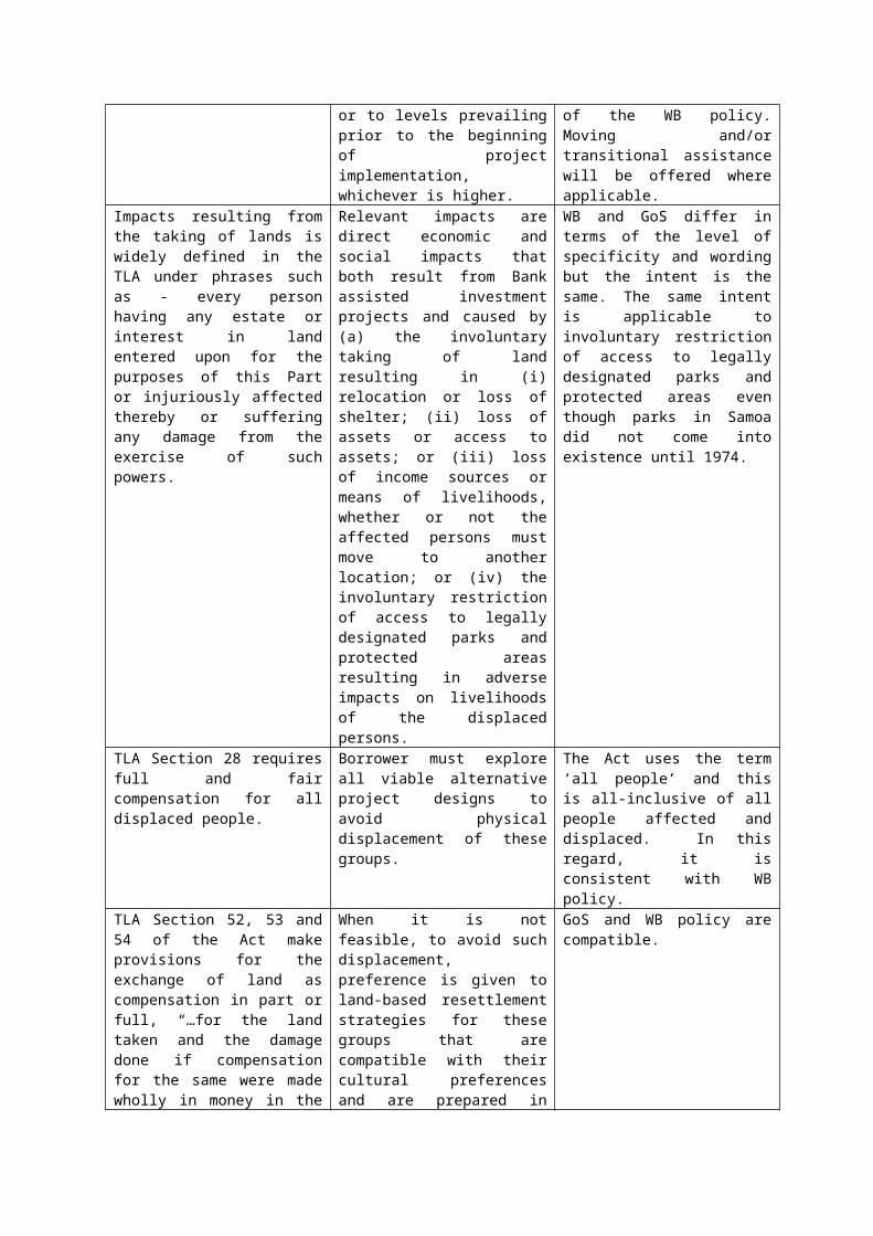
TLA Section 28 requires full and fair compensation for all displaced people.
Borrower must explore all viable alternative project designs to avoid physical displacement of these groups.
The Act uses the term ‘all people’ and this is all-inclusive of all people affected and displaced. In this regard, it is consistent with WB policy.
TLA Section 52, 53 and 54 of the Act make provisions for the exchange of land as compensation in part or full, “…for the land taken and the damage done if compensation for the same were made wholly in money in the usual way.”
When it is not feasible, to avoid such displacement, preference is given to land-based resettlement strategies for these groups that are compatible with their cultural preferences and are prepared in consultation with them.
GoS and WB policy are compatible.
N/A Each involuntary resettlement is conceived and executed as part of a development project or program.
The GoS has no written policy consistent or equivalent with that of the Bank.
TLA Section 14 and 14B requires the GoS to “cause a notice to be publicly notified and to be sent to each owner, occupier, or persons having an interest in the land, or the agent of any of them, whose name and address are readily ascertainable, stating the Government's proposal to take the land, the public purpose for which it is wanted, that the plan thereof may be inspected in the said office in ordinary office hours, and that any person affected may give written notice of objection with reasons to the Chief Executive Officer within 28 days of the first publication of the noticeSection 37 stipulates cut-off date for calculation of compensation.
The DPs are to be identified and recorded as early as possible in order to establish their eligibility through a population record or census that serves as an eligibility cut-off date, preferably at the project identification stage, to prevent a subsequent influx of encroachers or others who wish to take advantage of such benefits.
The GoS and WB policies are consistent both in terms of identifying DPs early and in setting a cut-off date for the determination of compensation
TLA Section 28 stipulates the following - By whom claim may be made - (1) A claim for compensation may be made by any person (including an executor or administrator) ceased, possessed of, or entitled to such lands, or to any estate or interest therein, whether such person has or has not the power to sell and convey the same. (2) Any such claim on behalf of beneficiaries, infants or mentally defective persons may be made by their trustees, guardians or committees respectively.
Particular attention must be paid to the needs of vulnerable groups among those displaced, especially those below the poverty line, the landless, the elderly, women and children, indigenous peoples, ethnic minorities, or other displaced persons who may not be protected through national land compensation legislation.
The GoS and WB policies are consistent with respect to ensuring that the rights of vulnerable groups to fair and full compensation, including those without legal title to the land or other assets are upheld.
(3) Where a beneficiary, infant or mentally defective person does not have a trustee, guardian or committee in Samoa, the Public Trustee shall be deemed to be his or her trustee, guardian or committee, as the case may be, for the purposes of this ActN/A The full cost of resettlement
activities necessary to achieve the objectives of the project are included in the total cost of the Project. The cost of resettlement, like the cost of other project activities, are treated as a charge against the economic benefits of the project; and any benefits to displaced persons (as compared to the without-project circumstances) are added to the benefit stream of the project. Resettlement components of free-standing resettlement policies need not be economically viable on their own, but they should be cost effective.
The GoS has no equivalent written implementing rules and regulations. This policy requirement needs to be adapted in the ARAPs.
N/A Where loans include subprojects, components or investments prepared only after project approval and loans through financial intermediaries that are likely to cause involuntary resettlement, sufficient contingency allowance must be allocated for resettlement prior to approval of the loan.
The GoS has no equivalent written implementing rules and regulations. This policy requirement needs to be adapted in the ARAPs.
N/A Similarly resettlement plans should also reflect the timeframe for resettlement planning and implementation.
The GoS has no equivalent written implementing rules and regulations. This policy requirement needs to be adapted in the ARAPs.
N/A Eligible cost of compensation, relocation and rehabilitation may be considered for inclusion in WB loan financing for the Project, if requested, to ensure timely availability of the requested resources and to ensure compliance with involuntary resettlement procedures during implementation.
The GoS has no equivalent written implementing rules and regulations.
LTA Section 37 2(b) The value of land shall, subject as hereinafter provided, be taken to be the amount, which the land if sold in the open market by a willing seller on the specified date. LTA also stipulates that compensation shall be full and fair.
Cash compensation levels should be sufficient to replace the lost land and other assets at full replacement cost in local markets.
Both the WB and GoS policies are in agreement.

5. Developing an Abbreviated Resettlement Action Plan (ARAP)
Responsibility for preparation, implementation and monitoring of RAPs/ARAPs (including responsibility for meeting all associated costs with their implementation), in accordance with this LARF, rests with the GoS. The agency in GoS with direct and overall responsibility for managing the involuntary land acquisition process in this project is MNRE in conjunction with the LTA. As necessary, these government agencies will exercise authority to coordinate actions with any other agencies and contractors involved to ensure timely and effective ARAP implementation.
Abbreviated Resettlement Action Plans (ARAP) – apply when impacts are minor, i.e. no persons are physically displaced, and/or less than 10 percent of their productive assets are lost. The OP4.12 states that an ARAP will apply when less than 200 people are displaced, however this is not applicable since the CRWCR Project will not result in physical displacement.
5.1 When is an ARAP prepared?
Preparation of the ARAP begins as soon as it is determined that involuntary resettlement is essential to complete any of the project activities. The GoS will finalise one or more ARAPs upon completion of the final design and impacted sites are known. This will occur prior to the commencement of any works or implementation and shall be finalized prior to the commencement of any works to carry out said project activities.
5.2 Stages of ARAP Development
Step 1: Project Screening for Involuntary Resettlement
Engineering designs will be screened for involuntary resettlement impacts and where impacts have been identified by LTA and the PMU, the plan will be revisited to avoid, or ‘design out’, such impacts. If this is not possible, an ARAP will be prepared (as outlined below).
Step 2: Preparation of Abbreviated Resettlement Action Plans (ARAPs)
The LTA will carry, or cause to be carried, out: (i) a census to identify and enumerate affected persons (i.e. census); and (ii) land and asset survey to identify and inventory residential or productive land and other assets to be affected. The surveys must cover 100 percent of the affected persons, landholdings and include an inventory of assets. The survey should also establish whether any commercial enterprises are affected. A ‘cut off date’ for the survey(s) will be established to avoid ongoing compensation claims and encroachment issues from outsiders. The cut off date will be the date the census begins unless otherwise notified by the LTA. Under OP4.12, any persons encroaching on the area after the cut off date are not entitled to compensation or assistance, however this will be at the discretion of LTA.
The person(s) responsible for developing the ARAP must ensure the process includes:(i) Adequate consultation on the Project with affected persons;(ii) Affected persons being informed about their options and rights pertaining to involuntary acquisition and resettlement;(iii) Consulted and offered choices on technically and economically feasible alternatives;(iv) Provided prompt and effective compensation, regardless of their legal rights or lack of their land and assets, at full replacement cost for losses of land, building or fixed assets on the land and buildings taken by the Project;(vi) Offered support for a transition period if significantly impacted, based on a reasonable estimate of the time likely to be needed to restore their living standards, income earning capacity and production levels, or at least maintain them at pre-Project levels;(vii) Provided with assistance in addition to compensation measures described in (vi) above, such as land preparation, credit facilities, training, or job opportunities.
ARAPs will be prepared in consultation with the relevant pulenu’u and matai.
Step 3: ARAP Review
The Bank will prior review and provide no objection (N.O.) to ARAPs.
Step 4: Compensation entitlements
Section 7 sets out the eligibility criteria for compensation. All compensation shall be paid at least four weeks prior to the commencement date of civil works. Payments for uncollected compensation due to lack of clarity of an authorized representative of a landowner shall be put in trust by the Minister of Lands.
Affected persons entitled to compensation may be categorized according to land ownership and magnitude of impact, for example:
Category 1 - Village Fono or Council of Chiefs For compensation of village owned customary lands that are not under extended family use that will be acquired or affected. These eligible village lands are not occupied or cultivated, but may have forest trees and other wild vegetation of economic value for uses such as raw material for carving, house building, canoe making, traditional medicine, firewood etc. At the minimum, the Pulenu’u (village mayor) and the high chiefs (tapa’au) of each village affected should suffice to represent the Fono or Council.
Category 2 - Extended family (aigapotopoto)For extended family land and assets that are collectively owned and that may be affected by the Project, in part or in total. The extended family shall be represented by the head matai (Sa’o) and heads of all the households comprising the extended family.
Category 3 – Aiga Patinoor householdFor individual households who occupy extended family customary owned land and who own crops, houses and other assets that may be affected or damaged
as a result of the Project. The head of the household is usually the father, or in his absence, the mother.
Category 4 - Legal Owners of freehold lands For all legally recognized freehold landowners whose lands and assets may be affected.
Category 5 - Legal occupants of freehold land For legal occupants including leaseholders of freehold lands whose assets such as crops, houses etc may be affected by a subproject.
Category 6 - Illegal occupants of freehold landFor illegal occupants of freehold land who will be entitled to compensation of their crops, shelters, etc that maybe affected.
Category 7 - General public For the public at large whose access to legally designated parks and protected areas will be affected by the Project.
Step 5: ARAP Implementation
Implementation will be carried out by MNRE’s Land Management Division (LMD) in association with the LTA and contractor.
5.3 Contents of an ARAP
An ARAP will be prepared in accordance with the policy, principles, planning and implementation arrangements set forth in this LARF. The ARAP is based on accurate baseline information and establishes appropriate mitigation measures (e.g., compensation at full replacement cost for loss assets, transitional assistance for relocation/livelihood restoration/commercial enterprises) for all relevant categories of adverse impacts. A template for the CRWCR Project is set out in Annex Two.
The ARAP specifically addresses the following:
Description of the project activity causing involuntary resettlement and explanation of efforts to avoid or minimize involuntary resettlement associated with the project (alternative project designs considered);
Range and scope of potential adverse resettlement impacts; Socioeconomic survey and baseline census survey information; Review of relevant laws and regulations relating to land acquisition and
involuntary resettlement; Description of asset valuation procedures and specific compensation rates (or
alternative measures) for all categories of affected assets;
Other assistance measures, if any, necessary to provide opportunities for livelihood restoration for displaced persons;
Assistance to affected commercial enterprises; Eligibility criteria for compensation and all other forms of assistance; Relocation arrangements, if necessary, including transitional support; Resettlement site selection, site preparation, and measures to mitigate impacts
on host communities, if necessary; Restoration or replacement of community infrastructure and other services; Land donation arrangements and documentation requirements, if relevant; Organizational arrangements for implementation; Consultation and disclosure requirements and arrangements; Resettlement implementation schedule; Costs and budget; Monitoring arrangements; Grievance procedures; and Summary entitlements matrix.
Based on the baseline surveys and in consultation with affected persons and matai, a time-bound action plan with budget shall be prepared. All compensation and assistance, must be provided to affected persons before construction commences. All recipients have the right to be informed of the method of valuation of their assets.

6. Procedures for Involuntary Acquisition and Voluntary Donation
The ARAP is the key safeguard document for identifying and managing Project-inducted resettlement impacts in compliance with OP4.12. As outlined in Section 3.4, there are four main options for securing easements for the Project. The ARAP will incorporate the procedures outlined below applicable to each scenario for securing easements, including:
(i) Voluntary land donation by community or household that may or may not also involve loss of assets;
(ii) Imposition of easement (servient tenement) which may result in restriction of access to land or land uses or removal of assets is required;
(iii) Compulsory acquisition under the Taking of Land Act 1964 where design options have been considered but involuntary land acquisition is unavoidable.
Where a ‘willing buyer, willing seller’ negotiated settlement agreement is the preferred option, national legislation and procedures should be followed.
6.1 Voluntary Land Donation
Where the project is of obvious community benefit, land maybe donated in-kind to facilitate the Project’s development. There are two categories for voluntary land donation:
Voluntary land donation with compensation for loss of assets, and
Voluntary land donation without asset compensation by consent of donor.
Where land is donated by the community or registered landowner, arrangements are required to ensure that the donation is indeed voluntarily given, the donor is the legitimate owner of such lands, and that the donor is fully informed of the nature of the Project and the consequences or terms of donating the land. Such arrangements will include demonstrating that the easement will directly benefit the grantor and the grantor willingly chose to donate the land.
In accordance with the Bank’s Voluntary Land Donation Protocol (VLDP), compensation for loss of assets (or access to assets) must be provided (Annex 4). The only exception to this is in circumstances where the landholder has agreed to gift the land but states, without coercion, they do not require compensation for loss of assets. Written evidence of this consent must be obtained (Annex 4).
The procedures regarding consultation and documentation of the voluntary land donation process are outlined below:
Step 1:
In accordance with the Bank’s Voluntary Land Donation Protocol (VLDP), determine the appropriateness of voluntary land donation for the local and project context.
Step 2:Verify the land donation requirements and carry out due diligence on the owners and users of land donated and identify any assets which may be affected or lost.
Step 3:Ensure affected person/s: (i) are made aware of different modes of land acquisition and that it is not limited to land donation and exercise of expropriation by the government, and the conditions under which the donation will be made; and (ii) do not suffer a substantial loss affecting his/her economic viability as a result of the donation by completing an inventory of crops, fruit trees, buildings or assets lost as a result of the donation (in accordance with the Ministry of Agriculture and Fisheries Schedule of Payments compensation for crop damage).
Step 4:Establish informed consent with the donor and get confirmation from the appointed matai (for customary land), landowner (for freehold) and any beneficial owners in writing, that the land is free of disputes or encroachments from any third party.
Step 5:Sign Deed or Land Commitment Letter (Annex 4) specifying the conditions of the donation, witnessed by a person authorized under the Oaths, Affidavits and Declarations Act 1963.
Step 6:Provide sufficient notification (i.e. two weeks minimum) to the donor of when works / activities may occur on the donated land.
Step 7:If it has been identified that assets (such as fixed structures or crops) are present on the donated land, or portion of land, and will be removed for the Project compensation for loss of assets applies and must be paid four weeks prior to their removal.
6.2 Imposition of easement
In some cases, an easement may be imposed on a property or customary land. The easement will be a servient tenement on a land parcel (i.e. only a portion of the land, not the whole parcel). This means the land is only partially affected, and where a piped (closed) channel is constructed, the disturbance will only be temporary in nature. However, the imposition of an easement may result in restriction of use or access to the portion of land where the servient tenement is. It may also require the removal of assets or permanent structures from the easement to facilitate improved drainage. These impacts will be managed through the procedures set out below.
Step 1: LTA to identify the affected parcels of land requiring an easement and notify landowners and/or matai with assistance from MWCSD as appropriate. Individual households directly affected will be approached by MNRE’s Land Management Division (LMD) and/or LTA regarding easements and entitlements.
Step 2: Verify the land boundary in consultation with MNRE, LTA and landowner(s) and identify any affected assets, crops or structures over the servient tenement.
Step 3: In accordance with s65 of the LTRA, complete a form for the creation of easement specifying: (a) the nature of the easement, the period for which the easement is granted (i.e. whether this is in perpetuity or not) and any conditions, limitations or restrictions intended to affect its enjoyment; (b) the land burdened by the easement (servient tenement); (c) the site of the easement; and (d) the land which enjoys the benefit of the easement (dominant tenement). Identify easements on a survey plan as per the Survey Act 2010 (s19/s24).
Step 4: Make an agreement with affected person(s) and/or landowner(s) regarding the nature of the restrictions necessary to maintain a drainage easement over the servient tenement and the easement fee to be paid. Complete and submit a deed of restriction as per the LTRA (s67).
Step 5: Register the easement so it is legally valid and seek endorsement on the drainage easement from Register of Land.
Step 6: Complete a written Easement Agreement with landowners and affected parties four weeks prior to the commencement of works. The agreement should confirm the location, duration and restrictions in place for the purpose of the drainage easement, as well as land access requirements for maintenance (Annex 5).
6.3 Involuntary Land Acquisition (Compulsory acquisition)
The procedure described below is from the Taking of Land Act 1964 to provide guidance where involuntary land acquisition is required under the Project:
Step 1:LTA obtain Cabinet Approval to acquire customary and freehold land required by government for public purposes.
Step 2:In the case of customary land, LTA to ascertain from the Samoa Land and Titles Court if that Court has determined the matai who has the pule over that land; and in the case of freehold land ascertain who the registered owner or owners of the freehold land to be acquired.
Step 3:LTA cause a survey of potentially affected land to be made; and a ARAP to be prepared and certified to be accurate showing:-
(i) land to be acquired; and (ii) the names of the owners and occupiers of that land as far as they can be ascertained or (iii) in the case of customary land the name of the matai who has the pule over the land if that has been determined by the Land & Titles Court; and if not the names of the matai proposed by the Minister to be dealt with as if he has that pule until the Samoa Land & Titles Court has determined who has that pule.
Step 4:LTA/MNRE cause a copy of such ARAP to be deposited in the MNRE office in Apia.
Step 5:MNRE obtain government market valuation of land to be acquired as at date of Proclamation and notify landowner(s) (who may deem it necessary to obtain an independent valuation) of same for compensation purposes. Said compensation, however, is to be based on replacement value of similar land in location and productive capacity.
Step 6:Public notice to be published in the Savali Newspaper and the Observer.
Step 7:MNRE LMD/MWCSD send a copy of public notice to each owner, occupier and person having an interest in the land or agent of them, whose name and address are readily ascertainable stating:
Government’s Proposal to acquire the land; The public purpose for which it is wanted; That the plan may be inspected in the MNRE office during working hours; and That any person affected may give written notice of objection with reasons to
the Chief Executive Officer of the MNRE within 28 days of the first publication of the Notice.
Step 8:Objections: Upon receiving any such objection the Chief Executive Officer of MNRE may appoint a time and place in Samoa at which the objector may appear before the Minister or some person appointed by him and support the objection by such evidence and argument as the objector thinks fit.
Step 9:Dispose of objection(s) and Prepare Proclamation: After the 28 day-period from the first publication of the Public Notice in the Savali and/or Observer newspaper, and if there are no objections received to the Notice or after due consideration of the objection or objections, the Minister is of the opinion that effect should be given to the proposal to acquire land for the public purpose; and that no private injury will be done thereby for which due compensation is not provided by this Act, the Head of
State acting on the advice of the Minister may, by Proclamation, describing the land and stating the public purpose acquire the land for the public purpose.
Step 10:Prepare Proclamation for land acquired and arrange for its execution by the Head of State.
Step 11:Proclamation to be gazetted and publicly notified as soon as possible; Proclamation to come into effect on the day named in the Proclamation.
Step 12:Register the Proclamation in the Land Register of Samoa.
Step 13:MNRE LMD/LTA pay compensation or secure agreements for payment of compensation with landowner(s) before commencement of works (see Section 7 of this LARF for compensation entitlements).
6.3.1 Customary Land Acquisition
If communal land is required for the project, the process establishes the following:
(a) Alternatives to land acquisition are considered. Especially where replacement land is scarce or non-existent, or where customary land tenure is deemed inalienable, negotiated agreements for long-term lease, even for infrastructure siting, should be considered.
(b) Where communal land must be acquired, collective compensation may be appropriate. Under such conditions, compensation is used solely for appropriate community purposes, or is distributed equitably among community members. The ARAP describes arrangements for usage of collective compensation.
(c) Individual users and occupants of acquired communal land are identified in the census prepared for the ARAP and describes mitigation measures or negotiated agreements providing for restoration of their livelihoods or living standards.
(d) The ARAP will need to describe alternative means used for valuation having regard to the type and scale of the loss proposed. This may include negotiated agreement with affected communities.
(e) Where negotiated agreements for land valuation, for long-term lease, or for provision of remedial assistance to users or occupants of acquired communal land, are to be established, the resettlement plan describes the methods by which affected communities are involved in the negotiations, and methods by which terms of negotiated agreements are fully disclosed to them, in a manner accessible to the affected community.
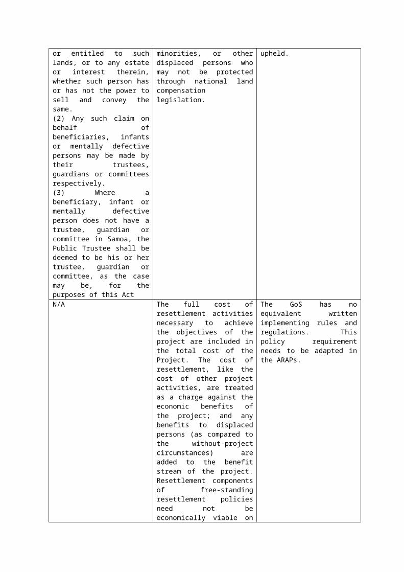
(f) If relevant, the ARAP describes any changes that may occur regarding land use and tenurial arrangements for remaining communal land in project-affected areas.
Where conflicting claims to ownership or use rights exist, such land will be avoided.
7. Compensation Measures
This section clarifies the circumstances and criteria when affected persons are eligible for compensation.OP4.12 uses land ownership and severity of impact to determine eligibility for compensation related to resettlement. Where the law of the GoS does not meet the standard under OP4.12, compensation under domestic law is supplemented by the additional measures set out in this LARF. The ARAP will provide details of compensation for losses of assets and/or involuntary land acquisition (if any) attributed directly to the Project whether voluntary donation, imposition of easements or involuntary land acquisition apply.
7.1 Eligibility Criteria
Affected persons eligible for compensation or assistance are classified into five groups as outlined in the matrix below.
Category of Affected Person Eligibility for Compensation or AssistanceI. Those who have formal legal rights to land, building or fixed assets on the land and buildings taken by the Project (including customary and traditional rights recognized under the laws of the Borrower)
Eligible for compensation for land or assets they lose, and other assistance at full replacement cost9. Where persons are identified as losing more than 10 percent of their productive land area (e.g., land used for cultivation or grazing), they receive additional assistance for livelihood restoration.
II. Those who do not have formal legal rights to land, building or fixed assets on the land and buildings taken by the Project at the time the census begins but have a claim to such land, building or fixed assets on the land and buildings taken by the Project (provided that such claims are recognized under the laws of the Borrower or become recognized through a process identified in the ARAP)
Eligible for compensation for land or assets they lose, and other assistance at full replacement cost. Where persons are identified as losing more than 10 percent of their productive land area (e.g., land used for cultivation or grazing), they receive additional assistance for livelihood restoration.
III. Those who have no recognizable legal right or claim to the land, building or fixed assets they are occupying
Shall be provided assistance(in lieu of compensation for the land, buildings or other fixed assets being taken by the Project) sufficient to achieve the objectives set forth in this Framework, if they occupy the Project area prior to the census cut-off date.
IV. Those who are subject to involuntarily restriction of access to land or assets, or
Shall be provided assistance (in lieu of compensation for the land, buildings or other
9 The amount sufficient to replace lost assets and cover transaction costs. Depreciation costs are not taken into account. Agricultural, urban land, houses and structures are eligible for full replacement cost under OP4.12. Ministry of Works may be engaged to assist in the determination of cost of lost assets or structures if damaged or removed by the Project.
temporary closure of business fixed assets being taken by the Project). Where a commercial enterprise (e.g., shop or vendor) is required to close temporarily, the owner or operator is compensated for temporary loss of profits.
V. Persons who voluntarily consent to gifting land as donation for easement or Project purpose that benefits the wider community
Compensation at replacement value for any asset lost by virtue of donated land (but compensation for loss of land does not apply).
7.2 Entitlements
The payment of compensation should be negotiated and determined using the following matrix:
Land Use Type of Loss Nature of impact Compensation measureAgricultural or productive land on freehold or customary land (<10%)
Involuntary acquisition Permanent Compensation based on market value
Damage to, or loss, of assets, crops, etc
Permanent/ Temporary
Compensation based on Ministry of Agriculture Schedule of Payments for crop damage for the current year.
Restriction due to imposition of easement
Permanent One-off easement fee to affected household
Voluntary donation of land
Permanent Compensation for crops, gardens, fences or other assets lost due to donation
Removal of temporary structure
Temporary Moving assistance
Residential or urban land on freehold or customary land (<10%)
Involuntary acquisition Permanent Compensation based on market value
Damage to, or loss, of assets, crops, etc
Permanent/ Temporary
Compensation based on Ministry of Agriculture Schedule of Payments for crop damage for the current year.
Restriction due to imposition of easement
Permanent One-off easement fee to affected household
Voluntary donation of land
Permanent Compensation for crops, gardens, fences or other assets lost due to donation
Removal of temporary structure
Temporary Moving assistance
Business or commercial property
Disruption to business due to works
Temporary Compensation based on loss of income or profit (net average)
Community facilities (schools, recreation areas, cultural sites, utilities, etc)
Disruption to services Temporary Restored at no cost to the community in negotiation with the community
7.3 Compensation Procedures
The GoS bears responsibility for meeting all costs associated with involuntary resettlement. Any ARAPs prepared in accordance with this LARF require a budget

with estimated costs for all aspects of their implementation. All Affected Persons are entitled to compensation or other appropriate assistance and mitigation measures, regardless of whether these persons have been identified at the time of resettlement planning, and regardless of whether sufficient mitigation funds have been allocated. For this reason, and to meet any other unanticipated costs that may arise, the ARAP budget shall include contingency funds, i.e. at least 10 percent of estimated total costs.
Compensation must be paid promptly and in full to Affected Person identified as eligible under the criteria presented above. No deductions from compensation will occur for any reason. The ARAP should describe the procedures by which compensation funds will flow from GoS to the displaced persons.
The process for the payment of compensation will be as follows:
Step 1:Establish a ‘cut off date’ for the census and land and asset survey to identify and enumerate affected persons and inventory residential or productive land and other assets to be affected. Compile a list of affected persons and associated assets.
Step 2:LTA and MNRE LMD assess the list of affected persons and property in the ARAP and agree on compensation arrangements based on the extent to which the assets, crops and land affected.
Step 3:Affected person/s, landowners or matai are offered a fair and just sum for compensation by the Minister.
Step 4:If the affected person(s) agree, compensation payment is made in the timeframe agreed to. If the affected person(s) disagree with the amount of compensation or conditions, the outcome will be determined by the Land and Titles Court.
8. Implementation
A time-bound implementation schedule of all activities relating to involuntary resettlement shall be included in the ARAP. All compensation shall be paid at least four weeks prior to the commencement of civil works. If there is a delay of one year or more between land or asset valuation and payment of compensation, compensation rates will be adjusted for inflation purposes.
Overall responsibility for the implementation of this LARF will reside with the LTA in Samoa. LTA will be assisted by Ministry of Natural Resources and Environment (MNRE), Ministry of Works, Transport and Infrastructure (MWTI), Ministry of Women, Community and Social Development (MWCSD) and the Ministry of Finance (MoF) in conjunction with the Design and Supervision Contractor.
9. Budget, Timing and Costs
The LTA and MNRE bear responsibility for meeting all costs associated with the implementation of this LARF and associated ARAPs. Any ARAPs prepared require a budget with estimated costs for all aspects of their implementation. All affected persons are entitled to compensation or other appropriate assistance and mitigation measures, regardless of whether these persons have been identified at the time of resettlement planning, and regardless of whether sufficient mitigation funds have been allocated. For this reason, and to meet any other unanticipated costs that may arise, the ARAP budget shall include contingency funds, i.e., at least 10 percent of estimated total costs.
Compensation must be paid promptly one month prior to the commencement of works, in full to the affected person/s. No deductions from compensation will occur for any reason. The ARAP should describe the procedures by which compensation funds will flow from LTA to the affected persons.
10. Public Consultation and Disclosure
Meaningful consultation is a mandatory prerequisite for any World Bank supported projects. The need is heightened when voluntary land donation is being contemplated.
10.1 Consultation and social surveys to date
Consultation activities have been ongoing since January 2012. A high level of support from various stakeholders was recorded in consultation session delivered by World Bank safeguards specialists, the PMU, LTA and MNRE representatives and independent consultants. Consultation was conducted in January and February 2012 with village mayors (Sui o le Nuu), government agencies, individuals (potentially affected persons), village leaders and residents. Stakeholders raised issues of planning
and coordination of activities, defined roles and responsibilities, acquisition of land, community awareness, road safety, compensation, contractors and water resources near the road.
Government stakeholders specifically pressed the need for the following:(i) Advance and timely planning and coordination among agencies
together with effective communication to allow effective interfacing of activities;
(ii) Well-defined specific roles and responsibilities amongst the stakeholders namely government ministries and agencies to minimize unnecessary hindrances to the progress of the project;
(iii) Processes and documentation for land acquisition for the project should be done efficiently well in advance at least a month before any construction to minimize disruptions and unforeseen delays in construction activities;
(iv) Timely delivery of awareness programs allowing stakeholders to make plans or arrangements as required, and to enable cost efficiencies.
Effective coordination and communication between responsible agencies will be key. This was a prominent lesson from the Vaitele Street widening project, in that many of the delays were due mainly to the lack of coordination between the key stakeholders involved especially on a timetable that would alert particular personnel who needed to be ready to execute necessary tasks to allow for progress of the next phase of the road project. Furthermore the damage to equipment and facilities operated by agencies notably communications and water was the result of the absence and non availability of vital information and just the lack of communication and contact at vital times between contractors and service providers on the whereabouts or location of these services (Solomona 2012, p4).
10.2 Community Perceptions
Community perceptions of the Project are as important to manage as the actual environmental and social impacts themselves. Misinformation and miscommunication are a key project risk where communities (and their anticipation of compensation in particular) are involved. For instance, there maybe expectations that land used for drainage easements will be leased out by government for later purchase; unrealistic expectations in relation to compensation payments where land or assets have been impacted; and that property value may decrease as a result of the Project or construction of easements, where this is not the case since it is highly likely that land amenity will be improved due to the enhancement of the road and reduced frequency in flooding in/near properties.
This is why is it important to have a strategic communications and consultation plan to ensure consistent messages and adequate information is shared and reiterated (see Section 10.4for guidance). It is pertinent that community stakeholders understand fully the options and conditions for establishing easements required by the Project and that such messages are stressed to the community to overcome misconceptions about impacts and potential damage.
10.3 Past Experience in Samoa
Past acquisitions of land as provided by the Taking of Lands Act have sometimes been haphazard or done with very little consultation or even notification because of the perceived urgency for the completion of the required works. In some instances, the projects are completed before the land is proclaimed and the land remains un-proclaimed.
It has often been the case that compensation has not been paid or people have not claimed compensation because they are not aware of their rights to compensation or because they voluntarily give their land for the public purpose, in the belief that it is in the public interest to do so and furthermore, that this is a way of providing tautua or service to the country.
Customary land often has multiple or overlapping land rights and disputed pule sometimes results in the owners not being determined. Compensation is sometimes paid to the matai of a family who does not use it for his family or distribute the payment to family members. Several years later members of the matai's family may claim compensation over the same land themselves. As a consequence Affected Persons are not compensated, or compensation is paid to the wrong person.
Departments or Corporations have acted unilaterally and with little interdepartmental coordination after obtaining consent from Cabinet to take land for a public purpose. Negotiations with landowners and promises of compensation are made without the involvement of the Minister of Lands and are later not honored. As a result, Affected Persons are disillusioned when they do not receive the compensation initially promised and expected from the Government representatives they were approached by in the first instance.
10.4 Consultation Process
Samoa has a well-developed and culturally-embedded system of consultation guided by informal and formal guidelines. The Samoa Codes of Environmental Practice (2007) strictly prescribes acceptable procedures for carrying out consultations (COEP 3). Public participation is also one of the key principles underlying the Planning and Urban Management Act 2004 in Samoa. This section outlines the consultation process to be followed for the Project.
Step 1: Consultation PlanConsultation activities along the WCR corridor will take considerable coordination and planning among LTA, MNRE, MWCSD, contractors and the communities themselves. The Consultation process involves four key stages:
(i) Awareness-raising with broader community(ii) Identification of affected persons, households, and villages(iii) Detailed consultation sessions with affected villages and persons(iv) Formal notification of works commencement.
A Consultation Plan structured on these four stages will be developed with the template provided in Annex 3.The Plan will identify the key milestones in the lead up to the implementation phase, and clearly define messages and focus on the key activities proposed under the CRWCR Project, their timing and topics for discussion.

Consultation will need to be multi-tiered: general community consultation to describe the overall works program, village level consultation to detail impacts within discrete sections of the alignment; and household level consultation for property access, impacts, compensation etc. The Consultation Plan will specify which methods will be used to communicate with interested and affected stakeholders, including workshops, meetings, etc.
Meetings among respective villages with sui o le nuu, matai, village councils and Project and government representatives will be initiated by the Ministry of Women, Community and Social Development (MWCSD) as per formal government process. Local consultations will be conducted using methods that are consistent to the social and cultural values of the local community. Liaison officers from MWCSD who can facilitate intergenerational and gender equal participation will support the Project consultation session.
Step 2: Public AwarenessIt is important for the general public to be first made aware of the proposed Project, through various media and networks to facilitate a general understanding and acceptance. Involving communities early-on builds support and helps to identify potential conflicts with community-held property and owners of freehold land.
Section 10.1 details the consultation activities that have been undertaken to date, which have resulted in strong awareness and acceptance of the Project by communities and village mayors. These efforts should be ongoing as the Project moves forward.
Step 3: Identify Affected CommunitiesThe implementing agency should identify persons involved in, or potentially affected by, the Project and proposed design options. COEP3 identifies those who should be consulted as:
- Owners, occupiers and users of the affected, adjacent and nearby land;- Occupiers of land living up or down stream;- People, groups or organisations with a specific interest in the site or area;- Statutory bodies and utility providers.
Once canvassing of potentially affected persons, stakeholder groups and communities has been undertaken, directly affected persons should be identified.
Step 4: Consult Affected CommunitiesInformation will be provided to affected communities at each stage of project implementation on the following points:
The new road design and specific requirements at each point along the road; Improved longitudinal drainage will reduce flooding and flood risk to the main
road, and easements are essential to reduce flooding risk and improve water flow and are unlikely to affect property values, and will benefit the public overall;
Drainage reserves/easements/rights of way – the works will involve upgrades to existing cross drainage and construction of new cross drainage infrastructure and ownership of the land does not change where an easement is secured, easements are legally secure and remain with the land and any new owners of that land, unless they are extinguished (through legal process).
Existing drainage features (including open channels, natural drainage lines and piped drainage) will need to be maintained and/or upgraded. This may involve the following activities:
o Open channels – currently many of these drainage features are compromised by either insufficient capacity or local obstructions. Hence, activities may involve deepening, widening and removal of obstructions to rehabilitate hydraulic capacity. This will require access to properties and civil works, with likely impacts on landholdings, including crop loss and land disturbance.
o Natural drainage lines – in locations where the road easement crosses natural drainage lines, there may be a requirement to improve longitudinal or cross drainage. This may include enlargement of capacity or relocation of discharge points.
o Recognised natural drainage features need to be delineated from artificial channels. Land title legislation recognizes natural waterways as government land, with the adjacent property boundary defined as 5 metres from top of bank on either side of the drainage line.
o Piped drainage – closed channels. Access – affects to local businesses and property access. Road reserve encroachment– many properties appear to be encroaching on the
road easement and boundary fences may need to be relocated to allow works to be undertaken.
The cut off date for census and land and asset surveys.
Sui o le Nuu should begin leading discussions on the proposed project in particular to drainage easements as an item during their weekly village council meetings and providing feedback to the LTA project team via their designated government ministry, MWCD.SN will confirm which families are affected and engagement them.
Each consultation event will be well-documented by the lead facilitator or implementing agency and consolidated into a summary report. This will be submitted to PUMA to support the development consent application.
Step 5: Formal NotificationIndividual households directly affected by the Project will be approached by MNRE’s Land Management Division (LMD) and/or LTA regarding land arrangements (voluntary donation, involuntary acquisition, etc) and compensation entitlements prior to construction commencing. The procedure(s) for establishing an easement will be presented and discussed with affected persons and any land, access or compensation agreement should be finalized two to four weeks prior to the commencement of works.
Step 6: Follow UpLTA ensures all grievances in relation to the Project and addressed and closed out.
10.5 Disclosure
The following consultation and disclosure activities and tasks will be overseen by the LTA and factored into the Project schedule:
LARF - The LARF was disclosed in July 2012 in Samoa and the World Bank Infoshop. It detailed consultation activities undertaken with community representatives in 2012 to inform the development of the LARF. The LARF was updated to reflect the most recent Bank templates and procedures aligned to OP4.12 and the needs of stakeholders implementing the LARF, then disclosed again in April 2015.
ARAP - The ARAP must describe measures taken to consult with affected persons regarding proposed land acquisition, transitional assistance, relocation arrangements, and other arrangements, and summarizes results of those consultations. The LTA discloses the draft ARAP to the affected persons and the general public for a public comment period, in a language and location accessible to them. Disclosure of the final ARAP occurs after comments have been address and Bank approval.
Negotiations and finalized compensation agreements to occur four weeks prior to the commencement of works on the property.
Compensation payments to be made at least two weeks prior to the commencement of works on the affected property or landholding.
11. Monitoring Arrangements
Monitoring arrangements will be established in the ARAP to assess the effectiveness of ARAP implementation in a timely manner. Monitoring includes review of progress in land acquisition, payment of compensation, provision of transitional assistance, and functioning of project grievance procedures. The ARAP should establish the frequency of monitoring activities. Monitoring should be conducted by an individual, firm, or community organization not directly affiliated with the government ministries involved in overseeing implementation of the ARAP. Any issues or problems associated with ARAP implementation that are observed in the monitoring process will be reported to the LTA and the World Bank project team.
Prior to project completion, the monitoring process will assess whether livelihoods and living standards of displaced persons have been improved, or at least restored. If these objectives have not been achieved, LTA identifies, plans and implements supplemental measures necessary to achieve satisfactory outcomes.
12. Grievance Procedures
A consultative ARAP process and effective ARAP implementation will reduce the likelihood of project-related complaints. However, to ensure that displaced persons have avenues for raising complaints relating to land acquisition, compensation payment, relocation, impacts on livelihoods, construction-related damages, or other aspects of project implementation, a multi-step grievance procedure has been established in the Project’s Environmental Management Plan (EMP).
Necessary elements of the grievance procedure include:
Stage OneA grievance can be lodged in one of two ways:
(i) The project will establish a complaints system to facilitate the lodging of grievances and store these in a database. A detailed protocol for management of these complaints will be included in the ARAP.
(ii) Any person aggrieved by any aspect of the land acquisition or involuntary resettlement process can lodge an oral or written grievance to LTA PMD or Project’s Project Management Unit (PMU). This complaint shall be appropriately documented and registered, which the LTA will then include it in its semi-annual progress reporting to the World Bank. If the complaint cannot be resolved within 30 days of receipt, it advances to the second stage of the process.
Stage TwoIf the aggrieved person is not satisfied with the outcome of initial stage consideration, or if local level review is unable to reach a proposed solution, the aggrieved person can refer the issue to a grievance committee established by GoS. The grievance committee, which is chaired by the LTAPMD and includes representatives not directly affiliated with the LTA, reviews issues raised in the initial complaint and any actions for resolution suggested at the lower level and makes recommendations for resolution within 30 days.
Stage ThreeIf the aggrieved person is still dissatisfied following review by the grievance committee, the case may be referred to legal proceedings in accordance with Samoan laws and procedures (see below).
The LTA keeps a record of all complaints referred to the grievance committee, including a description of issues raised and the outcome of the review process.
12.1 Traditional
Consensus and negotiation are part and parcel of Samoan life and decision-making. Generally, Samoan people are keenly aware of their standing or vafealoa'I with any other person. Tautua or service to the country and to one's village and family are central to one's life as a citizen of the country. For that reason, many Government initiatives relating to the establishment of infrastructure, water, electricity and other amenities and services have been completed without interruption or obstacles being placed before Government by affected persons. From experience of the Government Departments and service Corporations, the nature of the initial contact made by the Government's representatives with a village or community, is crucial to the success or failure of any project.
Negotiation and agreement by consensus should provide the best avenue to iron out and resolve any grievances expressed by the individuals, the matai or households whose land might be affected by sub projects. Grievances are commonly made known to the Government representatives or implementing agency in the first instance.
Direct approaches to the Government are common. Many village councils or individuals will approach the relevant Minister of State directly for a resolution to any grievances. Members of Parliament may also be approached to make representations on behalf of their constituents or affected persons, to the Government.
12.2 Grievance Mechanism Mandated by Law
The grievance procedures defined by the Taking of Lands Act 1964 are only utilized as a last resort. It is more common for any differences to be settled by negotiation and consensus reached between the Government and the village or villagers involved and this is usually the first step in the resolution of any grievances.
In addition to compensation, it is not unusual for payments to be made to certain individuals and also to the Alii and Faipule (councils of matai) of a village as part of the traditional gifts made by those who approach a village or community with a request to use a village's lands or other resources. The manner in which the delicate issue of taking lands for public purposes is handled often determines the likelihood of obstacles or resistance from Affected Persons. There is a commonly held understanding that any matter of contention can be resolved with the customary or traditional negotiation and consensus agreement. It is therefore crucial to fully involve local village groups and individuals in a fully transparent process at the inception of the Project.

Annex 1 Schedule One of the Land Titles Registration Act 2008
Part 1RIGHTS IMPLIED IN DRAINAGE EASEMENT
Full and free right for every person who is at any time entitled to an estate or interest in possession in the land herein indicated as the dominant tenement (hereinafter referred to as the grantee) or any part thereof with which the right shall be capable of enjoyment, and every person authorised by that person, from time to time and at all times to drain water (whether rain, storm, spring, soakage, or seepage water), sewerage or other effluent in any quantities across and through the land herein indicated as the servient tenement, together with the right to use, for the purposes of the easement, any line of pipes already laid within the servient tenement for the purpose of drainage or any pipe or pipes in replacement or in substitution therefore and where no such line of pipes exists, to lay, place and maintain a line of pipes of sufficient internal diameter beneath or upon the surface of the servient tenement, and together with the right for the grantee and every person authorised by the grantee, with any tools, implements, or machinery, necessary for the purpose, to enter upon the servient tenement and to remain there for any reasonable time for the purpose of laying, inspecting, cleansing, repairing, maintaining, or renewing such pipe line or any part thereof and for any of the aforesaid purposes to open the soil of the servient tenement to such extent as may be necessary provided that the grantee and the persons authorised by the grantee will take all reasonable precautions to ensure as little disturbance as possible to the surface of the servient tenement and will restore that surface as nearly as practicable to its original condition.
Part 2RIGHTS IMPLIED IN RIGHT OF WAY
1. The right of the proprietor of the dominant tenement, that proprietor’s servants, tenants, agents, workmen, licensees, and invitees (in common with the proprietor of the servient tenement, that proprietor’s tenants, and any other person lawfully entitled) at all times by day and by night to go, pass, and repass, with or without vehicles, machinery, and implements of any kind, over and along the land over which the right of way is granted.
2. The following rights of the occupiers of the land for the benefit of which, and the land over which, the right of way is granted.
(a) The right to establish a driveway, and to effect necessary repairs to any existing driveway, and to carry out any necessary maintenance and upkeep, where necessary altering the state of the land over which the right of way is granted; and any necessary rights of entry on the land over which the right of way is granted with or without machinery, plant, and equipment.
(b) The right to have that land over which the right of way is granted kept clear at all times of obstructions whether caused by parked vehicles, deposit of materials, or unreasonable impediment to the use and enjoyment of the driveway.
(c) The right to a reasonable contribution from other occupiers towards the cost of establishment, maintenance, upkeep, and repair of the driveway to an appropriate standard.
(d) The right to recover from the other occupiers the cost of repairs to the driveway occasioned by any willful or negligent act, and all such costs occasioned by them, their agents, servants, contractors, permitted occupants, residents, or invitees arising out of the use of the driveway.
(e) Where work is carried out by one occupier on the land of an adjoining owner pursuant to paragraph (b) of this clause or to any order of a Court, the right of the latter owner or occupier to have the land restored as far as possible to its former condition after the completion of the work, subject to the right of contribution described in paragraph (c) of this clause.
Part 3RIGHTS IMPLIED IN EASEMENT FOR DRAINAGE IN GROSS
Full and free right for the body in whose favour the easement is created (hereinafter referred to as the grantee) and every person authorised by it, from time to time and at all times to drain water (whether rain, storm, spring, soakage, or seepage water), sewerage or other effluent in any quantities across and through the land herein indicated as the servient tenement, together with the right to use, for the purposes of the easement, any line of pipes already laid within the servient tenement for the purpose of drainage or any pipe or pipes in replacement or in substitution therefore and where no such line of pipes exists, to lay, place and maintain a line of pipes of sufficient internal diameter beneath or upon the surface of the servient tenement, and together with the right for the grantee and every person authorised by the grantee, with any tools, implements, or machinery, necessary for the purpose, to enter upon the servient tenement and to remain there for any reasonable time for the purpose of laying, inspecting, cleansing, repairing, maintaining, or renewing such pipe line or any part thereof and for any of the aforesaid purposes to open the soil of the servient tenement to such extent as may be necessary provided that the grantee and the persons authorised by the grantee will take all reasonable precautions to ensure as little disturbance as possible to the surface of the servient tenement and will restore that surface as nearly as practicable to its original condition.
Part 4RIGHTS IMPLIED IN RIGHT OF WAY IN GROSS
1. The right of the body in whose favour the right of way is created (hereinafter referred to as the grantee) and that body’s servants, tenants, agents, workmen, licensees, and invitees (in common with the proprietor of the servient tenement, that proprietor’s tenants, and any other person lawfully entitled) at all times by day and by night to go, pass, and repass, with or without vehicles, machinery, and implements of any kind, over and along the land over which the right of way is granted.
2. The following rights of the grantee, and the occupiers of the land over which, the right of way is granted.
(a) The right to establish a driveway, and to effect necessary repairs to any existing driveway, and to carry out any necessary maintenance and upkeep, where necessary altering the state of the land over which the right of way is granted; and any necessary rights of entry on the land over which the right of way is granted with or without machinery, plant, and equipment.
(b) The right to have that land over which the right of way is granted kept clear at all times of obstructions whether caused by parked vehicles, deposit of materials, or unreasonable impediment to the use and enjoyment of the driveway.
(c) The right to a reasonable contribution from the grantee or other occupiers towards the cost of establishment, maintenance, upkeep, and repair of the driveway to an appropriate standard.
(d) The right to recover from the grantee or other occupiers the cost of repairs to the driveway occasioned by any willful or negligent act, and all such costs occasioned by them, their agents, servants, contractors, permitted occupants, residents, or invitees arising out of the use of the driveway.
(e) Where work is carried out by the grantee or one occupier on the land of an adjoining owner pursuant to paragraph (b) of this clause or to any order of a Court, the right of the latter owner or occupier to have the land restored as far as possible to its former condition after the completion of the work, subject to the right of contribution described in paragraph (c) of this clause.
Annex 2 Template for Abbreviated Resettlement Action Plan (ARAP)
This template provides the Implementing Agency and contractor involved in resettlement planning with guidance as to the content required for an ARAP.
A. Introduction
The Climate Resilience of the West Coast Road (CRWCR) will not result in the physical displacement of any persons.
The scope and level of resettlement planning should be commensurate to the scale and complexity of those impacts in accordance with OP4.12 Involuntary Resettlement (para 19).
Key elements for all abbreviated plans include:
(a)A census survey of affected persons and valuation of assets;
(b)Description of compensation and other resettlement assistance to be provided;
(c) Consultations with displaced people about acceptable alternatives;
(d)Institutional responsibility for implementation and procedures for grievance redress;
(e)Arrangements for monitoring and implementation; and(f) A timetable and budget
B. Census Survey and Asset Inventory
The process for conducting a census or land and asset survey/inventory is outlined in this section.
A census survey is conducted early in project preparation, as soon as all siting requirements are known. The primary purposes of the census survey are to identify and enumerate affected persons, and to establish an inventory of land and other fixed assets to be affected by the project. The census survey also provides the bulk of the information necessary for most other aspects of resettlement planning, including determination of categories of affected persons; categories of impact and corresponding forms of assistance; eligibility criteria for assistance; and baseline data for monitoring and evaluation (and often for addressing grievances), for estimating costs and budgeting, for identifying persons with particular

vulnerabilities, and for determining the significance of impacts (as described above). Census survey results are necessary before determining whether preparation of an abbreviated plan is appropriate.
The assistance of traditional leaders or community associations may be very useful in conducting the census survey for PIC projects. Since coverage of 100 percent of potentially affected households is intended, it cannot be conducted on a sample basis. This is necessary to achieve full identification and enumeration of affected persons, and to identify, measure and categorize affected land and other fixed assets. In practice, reaching all potentially affected households often means that the census survey team must make repeated visits to project areas. Leaders or residents may be helpful in identifying and contacting absentee landowners or others not present at the time of the census. The census also requires direct household contact; it cannot be based solely on land registry or other records that may be out of date or that would provide an incomplete basis for identifying persons in actual occupancy of affected lands, or who own or use fixed assets.
Census survey data may be presented in varying ways in the abbreviated plan, depending on project context:
(a)One or more tables may be prepared to enumerate and categorize affected persons. A sample table regarding affected persons is attached (Attachment 1).
(b)One or more tables may be prepared to enumerate and categorize affected land and other fixed assets. A sample impact table is attached (Attachment2).
(c) In most resettlement plans, an Entitlements Matrix summarizing categories of impact, eligibility criteria, and compensation and other assistance measures is included. A sample Entitlements Matrix is attached (Attachment3).
To discourage opportunistic land invasion or fraudulent claims for compensation, the first day of the census survey normally is taken to be (and is publicized as) the cut-off date in determining eligibility for compensation or other assistance. It is important to emphasize, however, that the census can be amended if required; for example, persons able to demonstrate that they were mistakenly excluded from the census, or for whom the scope or scale of impacts was not properly registered, remain eligible for assistance.
Because local economic and social conditions can change, census survey data must be considered to be perishable. The census survey may need to be repeated if there is a prolonged delay (e.g., more
than 1-2 years) between completion of the survey and actual taking of land and assets.
For PIC projects, identification of all affected persons and assets is also necessary to determine whether land or other fixed assets may be, or have been, contributed voluntarily by owners or users for project purposes.
C. Valuation of Assets
World Bank policy requires that compensation for land and other fixed assets be calculated and provided at full replacement cost. The replacement cost criterion is intended to incorporate both the actual value of the land or asset and any associated transaction costs borne by the affected person in adapting to involuntarily imposed changes.
Because economic conditions throughout the world are not the same, the replacement cost criterion is based on widely varying valuation methods. Where active markets exist, real estate prices usually provide a sound basis for valuation. Where markets do not function well, replacement cost can be established for land by reference to its output value in agricultural areas, and by reference to the cost of necessary material and labor inputs for structures and other fixed assets. In some instances, government procurement prices for materials are accepted as a basis for initiating negotiations on compensation amounts with affected persons. Negotiated compensation may be appropriate in many PIC projects, providing that affected persons are made aware of their rights under the project, including the right to refuse settlement offers, and have access to a grievance redress mechanism (described below).
PIC projects may face an additional issue in areas in which land is viewed as inalienable communal property. Under such circumstances, the resettlement plan describes means by which the replacement cost criterion has been employed, establishes how compensation or other assistance is to be allocated among community members, and reviews the process by which owners, users and other community members have been consulted.
Where formal land acquisition processes are particularly onerous or contentious, the Bank task team should encourage PIC project proponents to consider obtaining rights to land through long-term leasing arrangements.
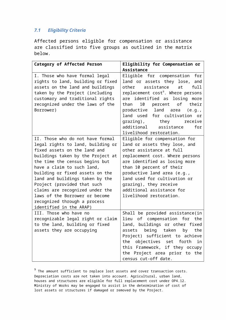
D. Compensation and Assistance
Normally, the resettlement plan includes unit compensation rates for various categories of land (e.g., type of agricultural use, residential, commercial, unutilized, or other) and for various categories of fixed assets (e.g., houses, shops or other commercial structures, livestock enclosures or other ancillary structures, fences, wells, irrigation channels, tombs, others). Unit rates, combined with reference to census survey results, provide the basis for determining how much compensation is due to each affected person.
Arrangements for distribution of compensation should ensure that compensation is paid (directly or through established bank accounts) to the head of the affected household, in full, without deduction for any purpose. Because compensation at replacement cost is intended to allow affected persons to replace lost assets, deductions from compensation because of tax arrears or other debts is not acceptable.
As noted above, many PIC communities view land as inalienable communal property (and this is consistent with legal arrangements in some areas). In such instances, it is appropriate to provide compensation for land to the community as a whole, though the resettlement plan should include provisions for ensuring adequate transitional support for households directly occupying or using the land to be acquired. Compensation for structures or other fixed assets should be paid to individual owners or users, unless improvements have been made by the community as a whole.
The resettlement plan also clearly establishes the basis for which all other forms of assistance are to be calculated for each household. This may include any transaction costs such as moving expenses, interim living expenses, or payment of fees or taxes that result from the project. It may also include any special measures intended to assist vulnerable persons (e.g., the disabled, elderly, single-parent households or others) that may have particular difficulties in adapting to changes imposed by the project. For projects with abbreviated plans, the scope of impacts is relatively minor so the need for supplemental assistance measures may be slight or non-existent.
The Project will give one-time payment of easement fees to the matais or the freehold landowner.
For temporary disturbance and storage of project materials, the MNRE will pay lease for the duration of temporary use of lands.
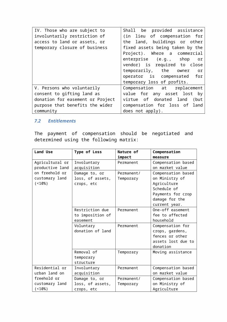
E. Consultation Strategy
Bank experience demonstrates that affected persons adapt better and more quickly to land acquisition and other associated impacts when plans are based on their preferences and concerns. The resettlement plan is based, in part, on consultations with affected persons, and the results of consultations are briefly summarized in the resettlement plan.
The resettlement plan also briefly summarizes methods used in consultations, including special measures that have been taken to solicit the views of women, minorities, or others who may not be likely to make themselves heard in community-level consultations. Consultation methods also should be culturally appropriate, and conducted in a manner that encourages frank and open expression. While it is entirely appropriate to consult with traditional leaders, it also is necessary to ensure a broader representation in consulting about affected persons’ preferences and concerns.
In addition to summarizing past consultation results, the resettlement plan describes arrangements for further consultation with affected persons during the course of project implementation. Though consultation arrangements may be free standing, in some PIC project contexts periodic resettlement monitoring may suffice as a form of consultation.
F. Implementation Arrangements
To promote effective implementation, the resettlement plan should clearly establish which agency or agencies are responsible for undertaking required actions. The plan should also establish that overall management responsibility is vested in an individual or group with the authority to ensure that necessary actions are undertaken in a timely and effective manner. Where more than one agency or one jurisdiction will be involved in implementation, the plan should describe means by which coordination among agencies or jurisdictions will be assured and any conflicts between or among them will be resolved.
Plans sometimes cannot be fully or effectively implemented because of unanticipated issues or changes in project circumstances. The plan should indicate who is responsible for making adaptive planning changes, and should indicate what form of planning change requires the prior approval of the World Bank. Normally, reductions in compensation or other forms of assistance, or restrictions on existing eligibility criteria, require prior Bank approval.
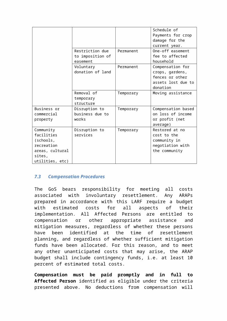
G. Grievance Redress Mechanism
A grievance redress mechanism (GRM) provides a venue for raising complaints and procedures for dealing with them to effectively serve to mitigate harm to affected persons while increasing the likelihood that complaints can be addressed relatively quickly and quietly – without resort to other remedies (e.g., legal procedures or media attention) external to the project.
H. Monitoring Arrangements
The resettlement plan establishes arrangements for monitoring its implementation. This may be particularly difficult in the PIC project context, where monitoring expertise may be slight and where travel logistics make on-the-spot field visits costly and burdensome.
The plan should specify the range of activities or issues to be monitored. Project authorities may monitor performance as it relates to construction progress. The primary purposes of resettlement monitoring, however, are to determine whether compensation and other assistance is flowing in the right amounts (and at the right time) to all those eligible to receive it, and whether provision of assistance is satisfactorily mitigating economic and social impacts. Assuming that impacts in PIC projects are expected to be relatively minor in scope and scale, the range of monitoring information desired, and duration of time over which monitoring may be necessary, is likely to be limited.
More problematic, perhaps, will be identifying who will conduct periodic monitoring and how they will do their work. In some PICs, consultants may be available to conduct monitoring in an efficient and unbiased manner. In other PIC contexts, however, it may make more sense to make arrangements for community-based monitoring (e.g., members of affected communities report on implementation progress), and to rely on cell phones or other means of inter-island communications to overcome logistical constraints.
The resettlement plan also should indicate how and when monitoring information is to be provided to the primary project agency for review and consideration.
I. Timetable
Effective resettlement implementation requires timely actions undertaken in an appropriate sequence. Particularly, delivery of compensation and other assistance should be provided before corresponding impacts actually occur. For most PIC projects, a simple flow chart should be included in the resettlement plan, relating resettlement plan implementation steps to the overall project construction and implementation timetable. The
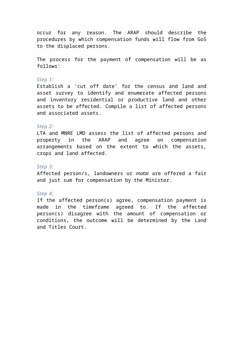
resettlement plan should also establish a cut off date (census date) and that taking of land and other assets cannot commence prior to payment of compensation (unless agreed with the Bank).
J. Budget and Financial Arrangements
The resettlement plan includes a budget with a categorical estimation of costs for compensation and all other forms of assistance. The budget also includes administrative and other costs associated with implementation of the resettlement plan. The budget includes an amount for contingencies (usually 10 percent of all other costs), and the resettlement plan establishes responsibility for meeting all resettlement-related costs, including contingencies. A sample budget sheet is attached (Attachment 4).
Attachment 1. Affected PersonsDistrict /Village
Land Acquisition
Significantly Affectedby Land Acquisition
Housing Affected
Business Affected
Vulnerable Persons
Other
(name)
OwnersHH:People:
UsersHH:People
OwnersHH:People:
UsersHH:People:
Partially AffectedOwner HH:People:Tenant HH:People:
RequireRelocationOwner HH:People:Tenant HH:People:
Owners
Workers
Category
Category
Total
Attachment 2
Category Subcategory Volume/Unit
Unit Cost Local Currency
USD
Land Compensation
Private land – residential - acquisitionPrivate land – residential - easementPrivate land – agricultural - acquisitionPrivate land – agricultural - easement
Private land – commercial - acquisitionPrivate land – commercial - easementPrivate land – other -acquisitionPrivate land – other - acquisitionCommunity land - acquisitionCommunity land – easement
Productive Assets
Crop (Specify)
Compensation
Crop (Specify)
Crop (Specify)Crop (Specify)Tree – fruitTree – nutTree – otherOther productive assets
Residential Structures
Private housing
Compensation
Community housing
Water facilitiesAncillary structuresWalls, fencesOther
Business Structures
Shops, food services
Compensation
Other services
Other businesses
Attachment 3. Budget
Allowances and Support to Affected PersonsType of Support Unit Rate CostMoving allowance, residentialTemporary living allowance, residentialMoving allowance, commercialTemporary income support, commercialAssistance to squatters, illegal occupantsAssistance to shareholders, renters, employeesAssistance to vulnerable personsDisruption to business (per day/week)OtherSUBTOTAL
Administrative and Other CostsCategory Unit/Basis WSTAdministrative costs
Typically 5% of subtotals 1 and 2
External monitoring Negotiated contract (estimate)Contingency Typically 10% of subtotals 1 and 2SUBTOTALARAP TOTAL COSTS
Annex 3 CRWCR Consultation Strategy
Title or Topic Subproject / matter being consulted on
Consultation Lead Name of person managing the consultation
Organisation Name of organisation the Consultation Lead represents
Partners / Team Detail of partnership arrangements and team members assisting with consultation
Project Overview Overview of the subproject for which the consultation is taking place (including reference code)
Location Location for consultation activities (for each stakeholder group).
Purpose/objectives/scope
Why is the consultation being undertaken? e.g. To establish a participatory process for marine and coastal management.
What is the policy, plan or strategy you are consulting on/about? What matters need to be decided? Is there an expected / preferred outcome of this consultation?
Decide on the level of engagement required: Inform (provide stakeholders with objective information that
informs their feedback) Consult (obtain public feedback, alternatives etc.) Engage (work directly with stakeholders to ensure public & private
concerns are understood) Participation (involve stakeholders in each aspect of the issue,
including developing alternatives, decision-making etc.)
Relevant Statutory provision
Describe the specific issue that is governed by the Fisheries Act or Regulations. Are there any non-statutory needs or requirements that also apply
to this consultation?
Budget Allocation Outline budget allocation across key tasks or components
Stakeholder groups Identification of stakeholders at (local, district, state/provincial, national levels -Commercial………………Other group/s (please specify):
Methods per project phaseProject DesignProject Implementation
What kind of consultation is most suited to the issue? Introductory Letter Information sessions Awareness campaign Radio program
Social media and websites Public forums and meetings Workshops Advisory committees Surveys Discussion groupsWill the engagement technique suit the capacity and language needs of the stakeholders involved?
Information dissemination
What information is being provided to stakeholders to inform their input/feedback?
Does the information articulate clearly the purposes, objectives and methods of the consultation process?
Is the information written/published in a way that is easily understood? (Layman’s terms?)
How will you communicate with communities? (e.g. nominated Liaison Officer?)How will you ensure the stakeholders have enough time to absorb the information and understand it before providing comment/input/feedback?
Resources and technical assistance
Consider sources of expertise. Resources may be available internally, or from other agencies/partners, or available for purchase. Have you investigated experts from other government agencies? Are there provisions for the purchase of advice/support/research if
required?Resource considerations: Translation of materials into local vernacular Posters, flyers, radio script, etc Transport requirements, lodging and logistics.
Grievance Management
Consider the grievance procedures for the subproject. Has the consultation team been familiarised with the grievance
procedures? Who will record and report grievances?Ensure the consultation team has access to Grievance resolution template and database and/or person in charge of these.
Monitoring, Output and Reporting
How will the consultation process outcomes be documented and you know if ithas been successful?
How will the information gained from such consultation be used? How will decisions reached from completed consultation be
implemented? How will you inform the stakeholder/public of the outcomes? Who should the consultation report be submitted too?
Example Consultation Planning Tool: Work Plan and Budget
Code Activity Total days Budget Year One
Village/Stakeholder/Subproject: {insert name} Jan Feb Mar Apr May Jun Jul Aug Sep Oct Nov Dec
Inception meeting 1
Brief Liaison Officer and MWCSD 1
Identify key stakeholder groups 3
Develop Consultation Plan 2
Develop engagement materials 5
Community pre-awareness 7
Information session/meeting 5
Conduct social assessment 5
Annex 4 Voluntary Land Donation Protocol
For cases where communities and/or individual landholders have offered to donate their land for the project because it is of direct and substantive benefit, the World Bank’s Voluntary Land Donation (VLD) Protocol should be followed. Detailed due diligence is required to avoid adverse impacts. Donations are based on the premise that the project benefit will offset or outweigh the loss of the land to be donated.
Voluntary donation of land by beneficiary households or village is acceptable where:
(i) It has been verified the donation did not result from any form of coercion or manipulation and is offered in good faith;
(ii) The donation does not severely affect the living standards of the community and/or individual landholder responsible for the donation (i.e. impacts are marginal based on percentage of loss and minimum size of remaining assets);
(iii) Alternatives and the viability of other locations or sites have been considered;(iv) The donation does not result in the displacement of households or cause loss of
income/livelihood;(v) The landholder/s making the donation will directly benefit from the project;(vi) Consultation has been conducted in an open and transparent manner and to a
degree that the landholder/s can make an informed choice;(vii) The land is free from disputes regarding ownership; and(viii) Full and proper documentation of all consultations, meetings, grievances and
actions taken to address grievances has been reviewed and made available.
To ensure that any land provided for the siting of subprojects is contributed voluntarily, in accordance with the requirements of the VLDP, two representatives of the landowners (family or clan) are asked to sign a Land Commitment Letter (see below). This certifies that the land is voluntarily donated for the purposes for the benefit of the landowner(s). The signature of the letter is witnessed (as attested by their signature) by a suitable project representative.
LAND COMMITMENT LETTER TEMPLATE
Project: ___________________
Location: ___________________
Project Partner Name OrganisationTeam Leader (PMU)
Provincial Support Unit
Project Representative
Dear Sir/Madam,
Re: LAND AVAILABILITY FOR THE PROJECT
This letter serves to confirm our commitment that land is available for the project. This land is
given for the use of the _____________________.
The owners of the land in our community are Mr/Mrs. __________________________ who with a
second family confirm our commitment by putting their hand hereto;
This piece of land (______________________) is confirmed to be free from dispute and the Project
Representative and subsequent committees appointed by the village to administrate the
infrastructure are free to use the said land to provide/improve/expand the provision of the
services directly provided by the infrastructure. The landowners fully agree that this
commitment is irrevocable and agree compensation for loss of land does not apply.
I/we hereby sign confirming that the above is true and correct:
Party Name Signature DateLandowner
Landowner Representative
Project Representative (verification)
Annex 5 Easement Agreement
As detailed in Section 6.2 of the LARF,a written Easement Agreement is required between landowners and affected parties and the government.
EASEMENT AGREEMENT
Land Parcel ……………………………………………………………………….
GPS Coordinates …………………………………………………………………….
Purpose ……………………………………………………………………….
Sketch of servient tenement on land parcel (including assets, structures, crops, etc):
Duration ……………………………………………………………………….
Type of Restrictions ……………………………………………………………….
Conditions of access to servient tenement:
……………………………………………………………………………………….
Party Name Signature DateLandowner/Matai
Landowner Representative/Pulenu’u
Project Representative (verification)