Embed Size (px)
Citation preview

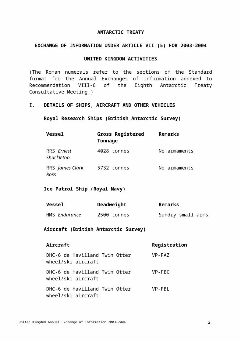
ANTARCTIC TREATY
Annual Exchange of Information Under
Article VII (5) for 2003 – 2004
UNITED KINGDOM ACTIVITIES
United Kingdom Annual Exchange of Information 2003-2004 1
ANTARCTIC TREATY
EXCHANGE OF INFORMATION UNDER ARTICLE VII (5) FOR 2003-2004
UNITED KINGDOM ACTIVITIES
(The Roman numerals refer to the sections of the Standard format for the Annual Exchanges of Information annexed to Recommendation VIII-6 of the Eighth Antarctic Treaty Consultative Meeting.)
I. DETAILS OF SHIPS, AIRCRAFT AND OTHER VEHICLES
Royal Research Ships (British Antarctic Survey)
Vessel Gross Registered Tonnage Remarks
RRS Ernest Shackleton 4028 tonnes No armaments
RRS James Clark Ross 5732 tonnes No armaments
Ice Patrol Ship (Royal Navy)
Vessel Deadweight Remarks
HMS Endurance 2500 tonnes Sundry small arms
Aircraft (British Antarctic Survey)
Aircraft Registration
DHC-6 de Havilland Twin Otter wheel/ski aircraft VP-FAZ
DHC-6 de Havilland Twin Otter wheel/ski aircraft VP-FBC
DHC-6 de Havilland Twin Otter wheel/ski aircraft VP-FBL
DHC-7 de Havilland Dash 7 aircraft VP-FBQ
The aircraft will be based in the Antarctic during the summer and flown by civilian personnel (see para. IV(c) below). The Twin Otter aircraft are used to provide logistic support for scientists in the Antarctic Peninsula, Ellsworth Land, Ronne Ice Shelf, Coats Land, Dronning Maud Land, and polewards of Halley station. The Dash 7 aircraft will operate between the Falkland Islands and Rothera Station and provide logistic support within Antarctica. See also Annex VI for information on aircraft landing facilities.
Aircraft (Royal Navy)
United Kingdom Annual Exchange of Information 2003-2004 2

Two unarmed Royal Navy Lynx helicopters aboard HMS Endurance.
These are used to provide aerial photographic and logistic support for field operations of the British Antarctic Survey and for hydrographic survey purposes.
Vehicles See VIII below.
Boats See VIII below.
Military equipment Only on HMS Endurance.
II. DETAILS OF EXPEDITIONS
Ships:
The itinerary of RRS Ernest Shackleton is presented in Annex I Section 1 and on the BAS Web site www.antarctica.ac.uk
The itinerary of RRS James Clark Ross is presented in Annex I Section 2 and on the BAS
Web site www.antarctica.ac.uk
The itinerary of HMS Endurance is presented in Annex I Section 3.
Aircraft:
The flight schedule for DHC-7 Aircraft (VP-FBQ) is presented in Annex I Section 4 and
on the BAS web site www.antarctica.ac.uk
III. DETAILS OF STATIONS IN THE ANTARCTIC
Fuller details of the UK Antarctic stations are to be found on the COMNAP Web Site http://www.comnap.aq.
The full address of the UK home page on the COMNAP site is: http://www.comnap.aq/comnap/comnap.nsf/P/CountryByISO/UK
Summer and winter operation
Station Position Opened Remarks
RotheraAdelaide Island
6734'S 6808'W
1 Dec 1976 Scientific station with laboratories, wharf and airfield
HalleyCoats Land
7533'S 2630'W
6 Jan 1956 Geospace, ozone and meteorological observatory
United Kingdom Annual Exchange of Information 2003-2004 3

Summer operation only
Station Position Opened Remarks
Fossil BluffAlexander Island
7120'S 6817'W
20 Feb 1961 Air transit station
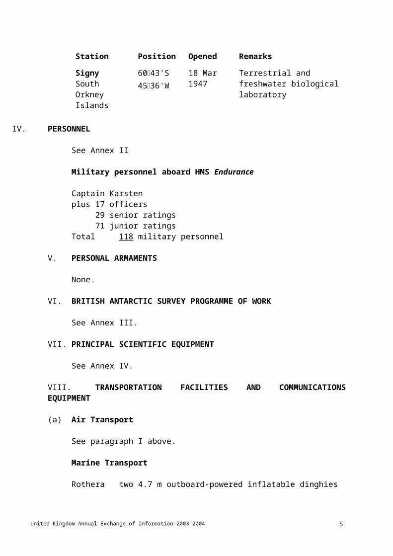
SignySouth Orkney Islands
6043'S 4536'W
18 Mar 1947 Terrestrial and freshwater biological laboratory
IV. PERSONNEL
See Annex II
Military personnel aboard HMS Endurance
Captain Karstenplus 17 officers
29 senior ratings71 junior ratings
Total 118 military personnel
V. PERSONAL ARMAMENTS
None.
VI. BRITISH ANTARCTIC SURVEY PROGRAMME OF WORK
See Annex III.
VII. PRINCIPAL SCIENTIFIC EQUIPMENT
See Annex IV.
VIII. TRANSPORTATION FACILITIES AND COMMUNICATIONS EQUIPMENT
(a) Air Transport
See paragraph I above.
Marine Transport
Rothera two 4.7 m outboard-powered inflatable dinghiesTwo 5.3 m outboard-powered inflatable dinghies
one 5.5 m rigid hull outboard-powered inflatable dinghy
United Kingdom Annual Exchange of Information 2003-2004 4
two outboard-powered semi-rigid inflatable dinghies
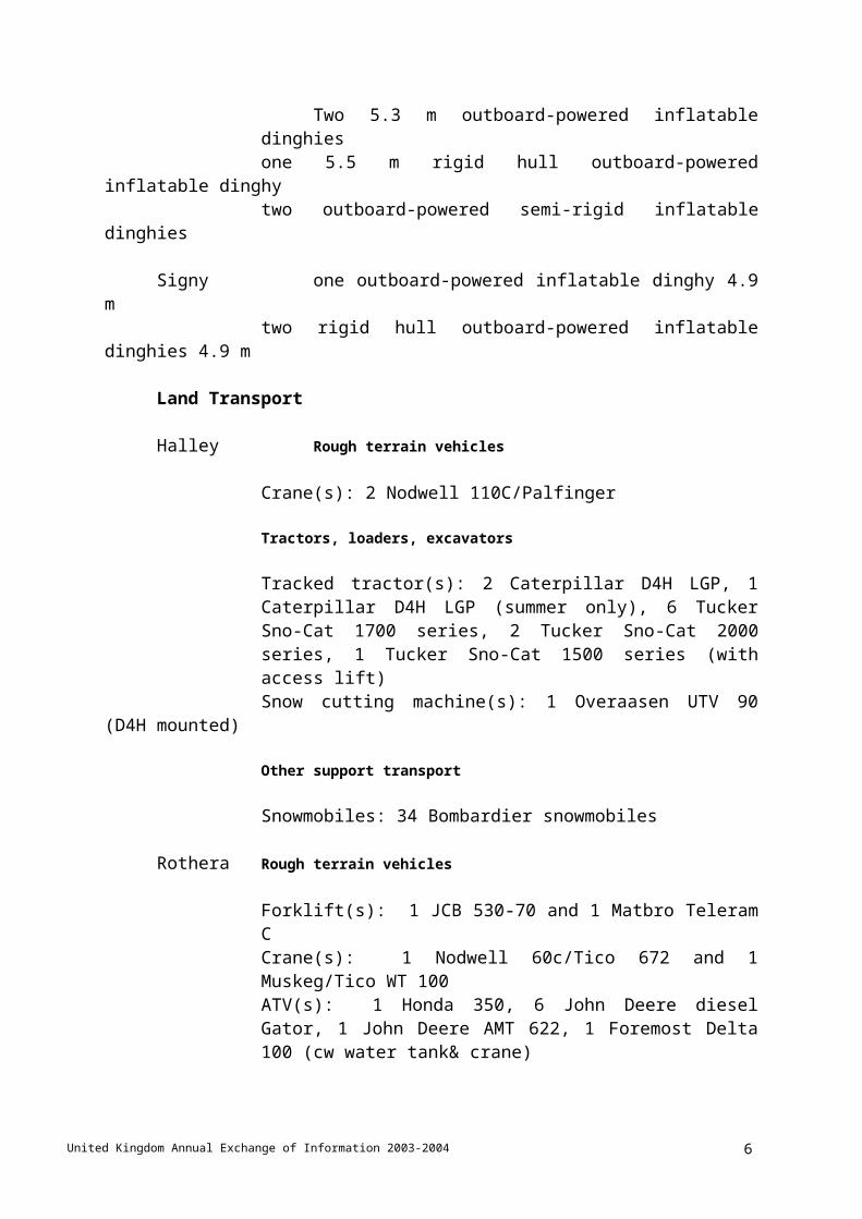
Signy one outboard-powered inflatable dinghy 4.9 mtwo rigid hull outboard-powered inflatable dinghies 4.9 m
Land Transport
Halley Rough terrain vehicles
Crane(s): 2 Nodwell 110C/Palfinger
Tractors, loaders, excavators
Tracked tractor(s): 2 Caterpillar D4H LGP, 1 Caterpillar D4H LGP (summer only), 6 Tucker Sno-Cat 1700 series, 2 Tucker Sno-Cat 2000 series, 1 Tucker Sno-Cat 1500 series (with access lift)Snow cutting machine(s): 1 Overaasen UTV 90 (D4H mounted)
Other support transport
Snowmobiles: 34 Bombardier snowmobiles
Rothera Rough terrain vehicles
Forklift(s): 1 JCB 530-70 and 1 Matbro Teleram CCrane(s): 1 Nodwell 60c/Tico 672 and 1 Muskeg/Tico WT 100ATV(s): 1 Honda 350, 6 John Deere diesel Gator, 1 John Deere AMT 622, 1 Foremost Delta 100 (cw water tank& crane)
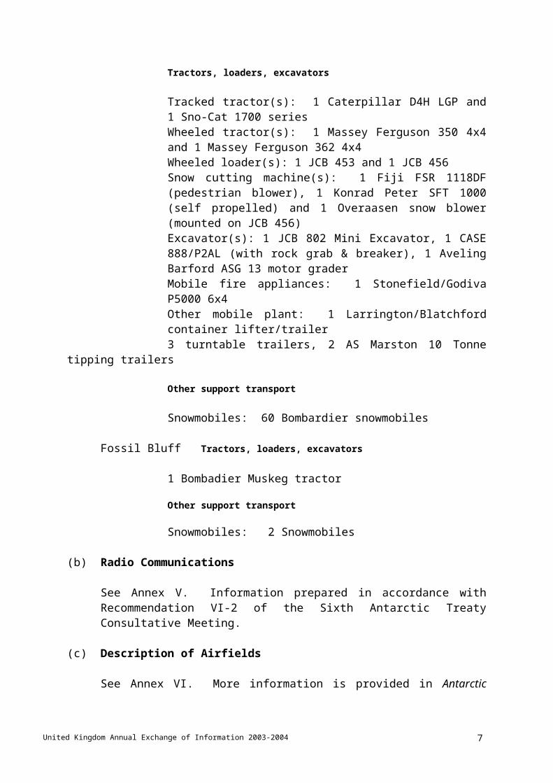
Tractors, loaders, excavators
Tracked tractor(s): 1 Caterpillar D4H LGP and 1 Sno-Cat 1700 seriesWheeled tractor(s): 1 Massey Ferguson 350 4x4 and 1 Massey Ferguson 362 4x4Wheeled loader(s): 1 JCB 453 and 1 JCB 456Snow cutting machine(s): 1 Fiji FSR 1118DF (pedestrian blower), 1 Konrad Peter SFT 1000 (self propelled) and 1 Overaasen snow blower (mounted on JCB 456)Excavator(s): 1 JCB 802 Mini Excavator, 1 CASE 888/P2AL (with rock grab & breaker), 1 Aveling Barford ASG 13 motor graderMobile fire appliances: 1 Stonefield/Godiva P5000 6x4Other mobile plant: 1 Larrington/Blatchford container lifter/trailer3 turntable trailers, 2 AS Marston 10 Tonne tipping trailers
Other support transport
Snowmobiles: 60 Bombardier snowmobiles
Fossil Bluff Tractors, loaders, excavators
United Kingdom Annual Exchange of Information 2003-2004 5
1 Bombadier Muskeg tractor
Other support transport
Snowmobiles: 2 Snowmobiles
(b) Radio Communications
See Annex V. Information prepared in accordance with Recommendation VI-2 of the Sixth Antarctic Treaty Consultative Meeting.
(c) Description of Airfields
See Annex VI. More information is provided in Antarctic Flight Information Manual. The Standing Committee on Antarctic Logistics and Operations (SCALOP) of the Council of Managers of National Antarctic Programmes (COMNAP) produces this. The document was produced at the request of the ATCM, and is updated annually prior to the start of the Antarctic summer season.
IX. FACILITIES FOR RENDERING ASSISTANCE
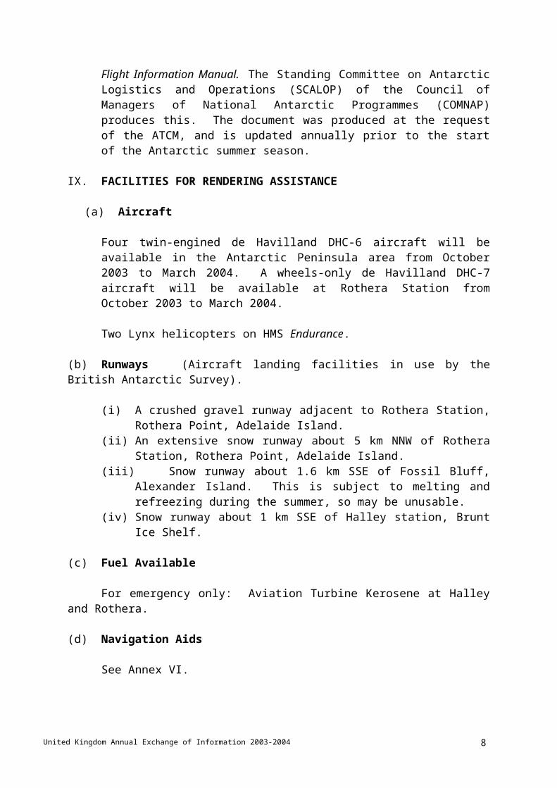
(a) Aircraft
Four twin-engined de Havilland DHC-6 aircraft will be available in the Antarctic Peninsula area from October 2003 to March 2004. A wheels-only de Havilland DHC-7 aircraft will be available at Rothera Station from October 2003 to March 2004.
Two Lynx helicopters on HMS Endurance.
(b) Runways (Aircraft landing facilities in use by the British Antarctic Survey).
(i) A crushed gravel runway adjacent to Rothera Station, Rothera Point, Adelaide Island.
(ii) An extensive snow runway about 5 km NNW of Rothera Station, Rothera Point, Adelaide Island.
(iii) Snow runway about 1.6 km SSE of Fossil Bluff, Alexander Island. This is subject to melting and refreezing during the summer, so may be unusable.
(iv) Snow runway about 1 km SSE of Halley station, Brunt Ice Shelf.
(c) Fuel Available
For emergency only: Aviation Turbine Kerosene at Halley and Rothera.
(d) Navigation Aids
See Annex VI.
United Kingdom Annual Exchange of Information 2003-2004 6
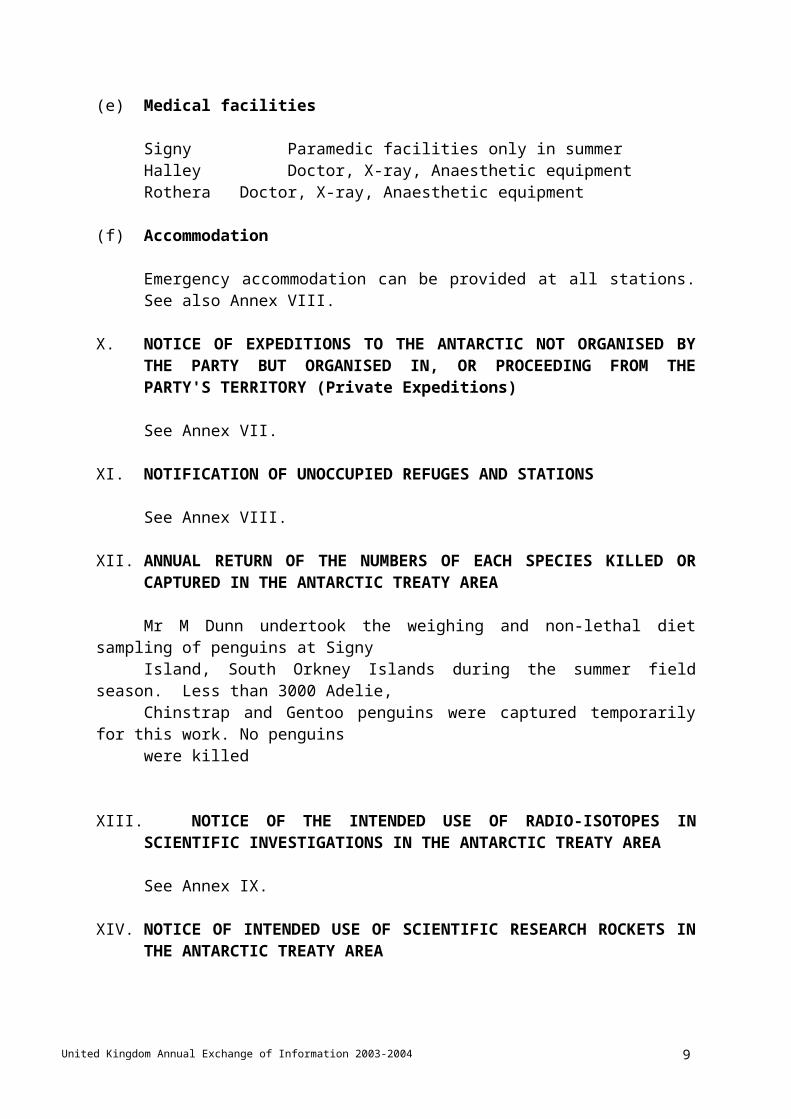
(e) Medical facilities
Signy Paramedic facilities only in summerHalley Doctor, X-ray, Anaesthetic equipmentRothera Doctor, X-ray, Anaesthetic equipment
(f) Accommodation
Emergency accommodation can be provided at all stations. See also Annex VIII.
X. NOTICE OF EXPEDITIONS TO THE ANTARCTIC NOT ORGANISED BY THE PARTY BUT ORGANISED IN, OR PROCEEDING FROM THE PARTY'S TERRITORY (Private Expeditions)
See Annex VII.
XI. NOTIFICATION OF UNOCCUPIED REFUGES AND STATIONS
See Annex VIII.
XII. ANNUAL RETURN OF THE NUMBERS OF EACH SPECIES KILLED OR CAPTURED IN THE ANTARCTIC TREATY AREA
Mr M Dunn undertook the weighing and non-lethal diet sampling of penguins at Signy
Island, South Orkney Islands during the summer field season. Less than 3000 Adelie, Chinstrap and Gentoo penguins were captured temporarily for this work. No penguins were killed
XIII. NOTICE OF THE INTENDED USE OF RADIO-ISOTOPES IN SCIENTIFIC
INVESTIGATIONS IN THE ANTARCTIC TREATY AREA
See Annex IX.
XIV. NOTICE OF INTENDED USE OF SCIENTIFIC RESEARCH ROCKETS IN THE ANTARCTIC TREATY AREA
United Kingdom Annual Exchange of Information 2003-2004 7
No scientific research rockets will be used during this period.
XV. NOTICE OF SHIPS CARRYING OUT SUBSTANTIAL OCEANOGRAPHIC RESEARCH PROGRAMMES IN THE ANTARCTIC TREATY AREA
See Annex X
XVI NOTICE OF PERMITS ISSUED IN ACCORDANCE WITH ANTARCTIC ACT 1994
See Annex XI
XVII. WASTES MANAGEMENT REPORT FOR PERIOD 1 OCTOBER 2000 TO 30 SEPTEMBER 2001
See Annex XII
XVIII ENACTMENT OF UNITED KINGDOM DOMESTIC LEGISLATION TO GIVE EFFECT TO THE ANTARCTIC TREATY
The Antarctic Act 1994 (except for sections 3 to 7) was brought into effect in the United Kingdom on 1 November 1995 (Statutory Instrument 1995 No. 2748), consequent to the United Kingdom’s ratification of the Environmental Protocol to the Antarctic Treaty on 25 April 1995. The Regulations to the Act (The Antarctic Regulations 1995) in respect of the United Kingdom also came into effect on 1 November 1995 (Statutory Instrument No. 2741). Section 7 of the Antarctic Act 1994 was brought into effect on 1 November 1996. Sections 5 and 6 of the Antarctic Act 1994 were brought into effect on 1 June 1997 and 1 October 1997 respectively. Sections 3 and 4 were both brought into effect on the date that the Environmental Protocol to the Antarctic Treaty came into force, 14 January 1998.
The Antarctic Regulations were amended by the Antarctic (Amendment) Regulations 1998 (Statutory Instrument No. 1007), the Antarctic (Amendment) Regulations 2000 (Statutory Instrument No. 2147), the Antarctic (Amendment) Regulations 2002 (Statutory Instrument No. 2054) and the Antarctic (Amendment) Regulations 2003 (Statutory Instrument No. 323). These may be cited together as the Antarctic Regulations 1995-2003.
The Antarctic Act 1994 was extended to British Overseas Territories by the Antarctic Act (Overseas Territories) Order 1995 (Statutory Instrument 1995 No. 1030).
Polar Regions UnitOverseas Territories DepartmentForeign and Commonwealth OfficeLONDON SW1A 2AH
www.fco.gov.uk
November 2003
ANNEX I Section 1
RRS ERNEST SHACKLETON – ITINERARY 2003-2004
Depart Portsmouth 22 October 2003Arrive Immingham 24 October 2003Depart Immingham 28 October 2003Arrive Montevideo 20 November 2003Depart Montevideo 22 November 2003Arrive Falkland Islands 26 November 2003Depart Falkland Islands 30 November 2003Arrive Signy 02 December 2003Depart Signy 04 December 2003Arrive King Edward Point/Bird Island 07 December 2003Depart King Edward Point/Bird Island 11 December
Science work ES05
Arrive Halley 24 December 2003Depart Halley 02 January 2004Arrive Signy 09 January 2004Depart Signy 12 January 2004Arrive Mare Harbour 15 January 2004Depart Mare Harbour 19 January 2004
Science work ES06Science cruise ES07Depot work ES08
Arrive Halley 14 February 2004Depart Halley 21 February 2004Arrive Bird Island 26 February 2004Depart Bird Island 29 February 2004Arrive Falkland Islands 03 March 2004Depart Falkland Islands 06 March 2004Arrive Detaille 11 March 2004Depart Detaille 13 March 2004Arrive Rothera 14 March 2004Depart Rothera 17 March 2004Arrive Vernadsky 19 March 2004Depart Vernadsky 19 March 2004Arrive Lockroy 19 March 2004Depart Lockroy 19 March 2004Arrive Jubany 20 March 2004Depart Jubany 20 March 2004Arrive Falkland Islands 24 March 2004Depart Falkland Islands 26 March 2004Arrive Detaille 30 March 2004Depart Detaille 01 April 2004

Arrive Prospect Point 02 April 2004Depart Prospect Point 08 April 2004Arrive Danco 10 April 2004Depart Danco 15 April 2004Arrive Deception 17 April 2004Depart Deception 17 April 2004Arrive Stanley 20 April 2004Depart Stanley 25 April 2004Arrive UK 23 May 2004

ANNEX I Section 2
RRS JAMES CLARK ROSS – ITINERARY 2003-2004
Depart Immingham 10 September 2003Arrive Ponta Delgada 18 September 2003Depart Ponta Delgada 18 September 2003Arrive Falkland Islands 14 October 2003Depart Falkland Islands 19 October 2003Arrive King Edward Point/Bird Island 23 October 2003Depart King Edward Point/Bird Island 25 October 2003Arrive Falkland Islands 28 October 2003Depart Falkland Islands 30 October 2003Arrive Signy 02 November 2003Depart Signy 05 November 2003
Science cruise JR95
Arrive King Edward Point/Bird Island 09 November 2003Depart King Edward Point/Bird Island 13 November 2003
Science cruise JR92
Arrive Falkland Islands 23 November 2003Depart Falkland Islands 28 November 2003
Science cruise JR93
Arrive Port Lockroy 04 December 2003Depart Port Lockroy 04 December 2003Arrive Rothera 05 December 2003Depart Rothera 08 December 2003
Science cruise JR94
Arrive Falkland Islands 17 December 2003Depart Falkland Islands 20 December 2003Arrive King Edward Point 23 December 2003Depart King Edward Point 23 December 2003Arrive Falkland Islands 27 December 2003Depart Falkland Islands 30 December 2003
Science cruise JR103Science cruise JR96
Arrive King Edward Point 15 January 2004Depart King Edward Point 15 January 2004Arrive Bird Island 16 January 2004Depart Bird Island 16 January 2004

Arrive Falkland Islands 20 January 2004Depart Falkland Islands 23 January 2004
Science cruise JR104
Arrive Falkland Islands 13 February 2004Depart Falkland Islands 15 February 2004
Science cruise JR77/78
Arrive Falkland Islands 05 March 2004Depart Falkland Islands 08 March 2004
Science cruise JR100
Arrive Falkland Islands 05 April 2004Depart Falkland Islands 08 April 2004Arrive Signy 10 April 2004Depart Signy 12 April 2004Arrive King Edward Point/Bird Island 14 April 2004Depart King Edward Point/Bird Island 19 April 2004Arrive Falkland Islands 23 April 2004Depart Falkland Islands 26 April 2004Arrive UK 02 June 2004

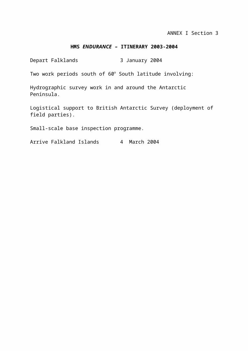
ANNEX I Section 3
HMS ENDURANCE – ITINERARY 2003-2004
Depart Falklands 3 January 2004
Two work periods south of 60o South latitude involving:
Hydrographic survey work in and around the Antarctic Peninsula.
Logistical support to British Antarctic Survey (deployment of field parties).
Small-scale base inspection programme.
Arrive Falkland Islands 4 March 2004

Annex I Section 4
DASH 7 PASSENGER AND CARGO SCHEDULE 2003-04
The following flights are scheduled between Stanley, Falkland Islands and Rothera Station, Antarctica.
Flight No. Flight No. Date
1 SOUTH 22 October 2003 1 NORTH 24 October 20032 SOUTH 30 October 2003 2 NORTH 29 October 20033 SOUTH 30 October 2003 3 NORTH 1 November 20034 SOUTH 2 November 2003 4 NORTH 3 November 20035 SOUTH 4 November 2003 5 NORTH 7 November 20036 SOUTH 9 November 2003 6 NORTH 13 November 20037 SOUTH 14 November 2003 7 NORTH 17 November 20038 SOUTH 18 November 2003 8 NORTH 1 December 20039 SOUTH 2 December 2003 9 NORTH 19 December 200310 SOUTH 21 December 2003 10 NORTH 2 January 200411 SOUTH 4 January 2004 11 NORTH 8 January 200412 SOUTH 9 January 2004 12 NORTH 14 January 200413 SOUTH 16 January 2004 13 NORTH 26 January 200414 SOUTH 27 January 2004 14 NORTH 12 February 200415 SOUTH 13 February 2004 15 NORTH 17 February 200416 SOUTH 19 February 2004 16 NORTH 26 February 200417 SOUTH 28 February 2004 17 NORTH 3 March 2004

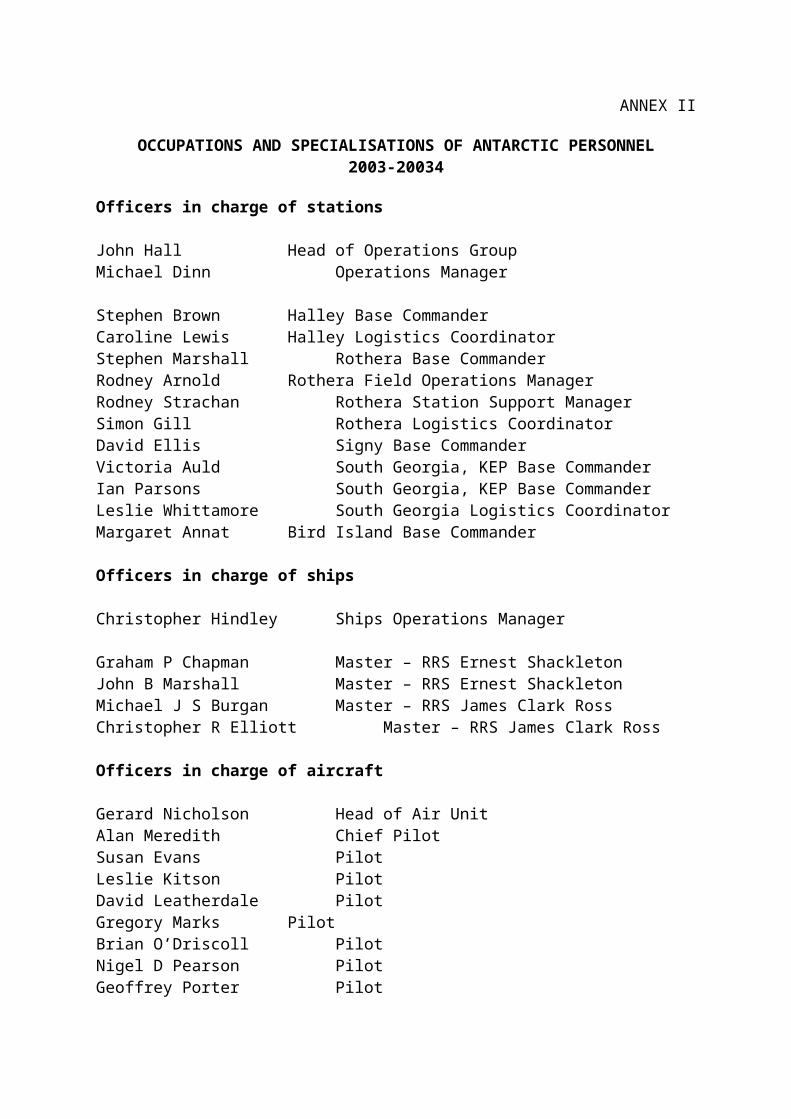
ANNEX II
OCCUPATIONS AND SPECIALISATIONS OF ANTARCTIC PERSONNEL 2003-20034
Officers in charge of stations
John Hall Head of Operations GroupMichael Dinn Operations Manager
Stephen Brown Halley Base CommanderCaroline Lewis Halley Logistics CoordinatorStephen Marshall Rothera Base CommanderRodney Arnold Rothera Field Operations ManagerRodney Strachan Rothera Station Support ManagerSimon Gill Rothera Logistics CoordinatorDavid Ellis Signy Base CommanderVictoria Auld South Georgia, KEP Base CommanderIan Parsons South Georgia, KEP Base CommanderLeslie Whittamore South Georgia Logistics CoordinatorMargaret Annat Bird Island Base Commander
Officers in charge of ships
Christopher Hindley Ships Operations Manager
Graham P Chapman Master – RRS Ernest ShackletonJohn B Marshall Master – RRS Ernest ShackletonMichael J S Burgan Master – RRS James Clark RossChristopher R Elliott Master – RRS James Clark Ross
Officers in charge of aircraft
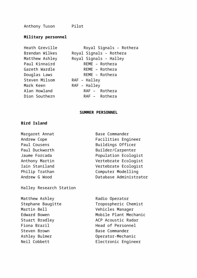
Gerard Nicholson Head of Air UnitAlan Meredith Chief PilotSusan Evans PilotLeslie Kitson PilotDavid Leatherdale PilotGregory Marks PilotBrian O’Driscoll PilotNigel D Pearson PilotGeoffrey Porter PilotAnthony Tuson Pilot
Military personnel
Heath Greville Royal Signals – RotheraBrendan Wilkes Royal Signals – Rothera Matthew Ashley Royal Signals – Halley
Paul Kinnaird REME – RotheraGareth Wardle REME – RotheraDouglas Laws REME – RotheraSteven Milsom RAF – HalleyMark Keen RAF – HalleyAlan Howland RAF – RotheraDion Southern RAF – Rothera
SUMMER PERSONNEL
Bird Island
Margaret Annat Base CommanderAndrew Cope Facilities EngineerPaul Cousens Buildings OfficerPaul Duckworth Builder/CarpenterJaume Forcada Population EcologistAnthony Martin Vertebrate EcologistIain Staniland Vertebrate EcologistPhilip Trathan Computer ModellingAndrew G Wood Database Administrator
Halley Research Station
Matthew Ashley Radio OperatorStephane Baugitte Tropospheric ChemistMartin Bell Vehicles ManagerEdward Bowen Mobile Plant MechanicStuart Bradley ACP Acoustic RadarFiona Brazil Head of PersonnelSteven Brown Base CommanderAshley Bulmer Operator-MechanicNeil Cobbett Electronic EngineerPaul Cousens Buildings OfficerElaine Cowie Meteorologist/PhysicistCrispin Day Field AssistantJohn Dudeney Deputy DirectorShaun Dudek Steel ErectorLeonard Evans Steel ErectorNeil Farnell Base AssistantAnnette Faux Meteorologist/PhysicistDavid Ganiford AMOS W SpecialistChristopher Gilbert Senior PhotographerMark Godfrey Senior Electrical Services EngineerKatherine Hayes Applied GlaciologistSimon Higgins Electrical Services TechnicianCaroline Lewis Logistics CoordinatorMark Keen Mast Erector

Nathan Keen Facilities EngineerRussell Ladkin Boundary Layer ScientistKevin Larkin Steel Fabricator/WelderPatrick McGoldrick CarpenterStuart McMillan Chef ManagerSteven Milsom Mast ErectorCraig Nicholson Chef ManagerBenjamin Norrish Mobile Plant MechanicSusan Patterson Administrative SupportTerence Pepper Steel ErectorKate Read Visiting ScientistPaul Rodhouse Head of Biological SciencesShane Rodwell Electronics TechnicianMark Ryan Communications ManagerAlfonso Saiz-Lopez Atmospheric ChemistLance Seviour Operator-MechanicStephen Shorrock Software EngineerRobert Shortman Mechanical Services TechnicianMark Stewart Data ManagerDonald Taylor Head of Building ServicesPaul Torode Field AssistantMark Wales Electrical Services TechnicianDouglas Willis IT EngineerDavid Worthy Steel Erector
James Ross Island
Joanne Johnson Diagenetic GeochemistB De Vries VisitorJohn Smellie Petrologist
Detaille Island
David Burkitt Abandoned BasesRebecca Roper-Gee Abandoned BasesJohn Shears Environmental ManagerPeter Wilmott Abandoned Bases
Shipborne Personnel on RRS James Clark Ross and RRS Ernest Shackleton
Kjetil Aasekjaer Simrad EngineerVsevolod Afanasev Electronics EngineerClare Allen MicropalaeontologistAlex Baker Visiting ScientistTiffany Barry Visiting ScientistThomas Bell Visiting ScientistAndrew Black Visiting ScientistFernando Bohoyo Visiting ScientistDouglas Bone Science Support

Mark Brandon Visiting ScientistStephen Bremner Head of Engineering TechnologyAndrew Brierley Visiting ScientistDarren Clark Visiting ScientistCharles Cook AstrobiologistPatrick Cooper Electronics EngineerKate Creswell Visiting ScientistNathan Cunningham Data ManagerJulian Dowdeswell Visiting ScientistJohnnie Edmonston IT EngineerPeter Enderlein Marine ScientistGrant Forster Visiting ScientistPauline Forward VisitorJames Fox IT EngineerBernard Fuchs Visiting ScientistNicola Gist Visiting ScientistCatherine Goss Marine EcologistAngelica Granda Visiting ScientistPaul Hampton Visiting ScientistSarah Hardy Visiting ScientistGeoffrey Hargreaves Visiting ScientistSimeon Hill Ecosystem ModellerAndrew Hind Visiting ScientistChristopher Hindley Ships Operations ManagerAndrew Hirst OceanographerZackary Johnson Visiting ScientistRobert Larter Marine GeophysicistSamantha Lavender Visiting ScientistPhilip Leat Principal InvestigatorPeter Lens IT EngineerEva Lopez Visiting ScientistChristopher Lowe Visiting ScientistStephen Mack Visiting ScientistHugh Marsden Postal ClerkIan Millar PetrologistJames Miller Personnel OfficerNicholas Millward Visiting ScientistBenjamin Molyneux Dental OfficerPeter Morris Data ManagerAnthony North Fish BiologistTimothy Parham SOAPJulian Pearce Visiting ScientistUwe Piatkowski Visiting ScientistDavid Pond Marine BiochemistGraeme Potter Visiting ScientistAlexander Poulton Visiting ScientistDavid Prentice IT EngineerMark Preston Electronics EngineerCarol Pudsey Marine Geophysicist
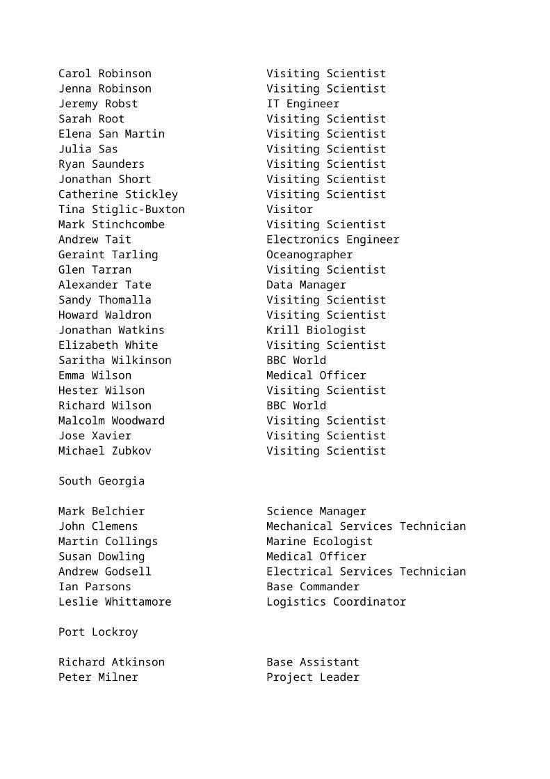
John Pye Head of Admin & Logistics DivisionAndrew Rees VisitorCarol Robinson Visiting ScientistJenna Robinson Visiting ScientistJeremy Robst IT EngineerSarah Root Visiting ScientistElena San Martin Visiting ScientistJulia Sas Visiting ScientistRyan Saunders Visiting ScientistJonathan Short Visiting ScientistCatherine Stickley Visiting ScientistTina Stiglic-Buxton VisitorMark Stinchcombe Visiting ScientistAndrew Tait Electronics EngineerGeraint Tarling OceanographerGlen Tarran Visiting ScientistAlexander Tate Data ManagerSandy Thomalla Visiting ScientistHoward Waldron Visiting ScientistJonathan Watkins Krill BiologistElizabeth White Visiting ScientistSaritha Wilkinson BBC WorldEmma Wilson Medical OfficerHester Wilson Visiting ScientistRichard Wilson BBC WorldMalcolm Woodward Visiting ScientistJose Xavier Visiting ScientistMichael Zubkov Visiting Scientist
South Georgia
Mark Belchier Science ManagerJohn Clemens Mechanical Services TechnicianMartin Collings Marine EcologistSusan Dowling Medical OfficerAndrew Godsell Electrical Services TechnicianIan Parsons Base CommanderLeslie Whittamore Logistics Coordinator
Port Lockroy
Richard Atkinson Base AssistantPeter Milner Project LeaderDavid Wattam Base Assistant
Rothera Research Station
David Adam JournalistOlivier Alemany Berkner Island Drilling
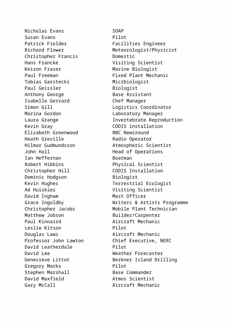
Paul Arnold BBC NewsroundRodney Arnold Field Operations ManagerAndrew Barker Communications ManagerPaul Best Mobile Plant TechnicianAndrew Binney Buildings OfficerDavid Bloomer Finance Officer, NERCStefen Bokhorst Visiting ScientistAlois Bory Berkner Island DrillingDavid Bowden Marine EcologistStuart Bradley ACP Acoustic RadarFiona Brazil Head of PersonnelPaul Bridge Head of Evolutionary BiologyJonathan Bursnall Field AssistantRichard Burt Field AssistantLinda Capper Head of Press, PR & EducationAndrew Cavanagh Head of FinanceSandra Chapman Writers & Artists ProgrammeStuart Cochrane AWGGary Constantine DomesticPeter Convey Research ScientistLucy Conway Fish NurseAlexander Cottle Plant OperatorJohn Coyle Concreter/BuilderJustin Cranfield DomesticJohn Davies AWGMatthew Davies Base AssistantJan Diettrich Lidar Research EngineerAthena Dinar Media LiaisonMichael Dinn Operations ManagerRoy Dodson IT EngineerRoderick Downie Fossil Bluff Clean UpDarren Edmunds AWGStuart Eggington EcologistAndreas Engelen Lichen StudyNicholas Evans SOAPSusan Evans PilotPatrick Fielder Facilities EngineerRichard Flower Meteorologist/PhysicistChristopher Francis DomesticHans Francke Visiting ScientistKeiron Fraser Marine BiologistPaul Freeman Fixed Plant MechanicTobias Garstecki MicrbiologistPaul Geissler BiologistAnthony George Base AssistantIsabelle Gerrard Chef ManagerSimon Gill Logistics CoordinatorMarina Gordon Laboratory ManagerLaura Grange Invertebrate Reproduction

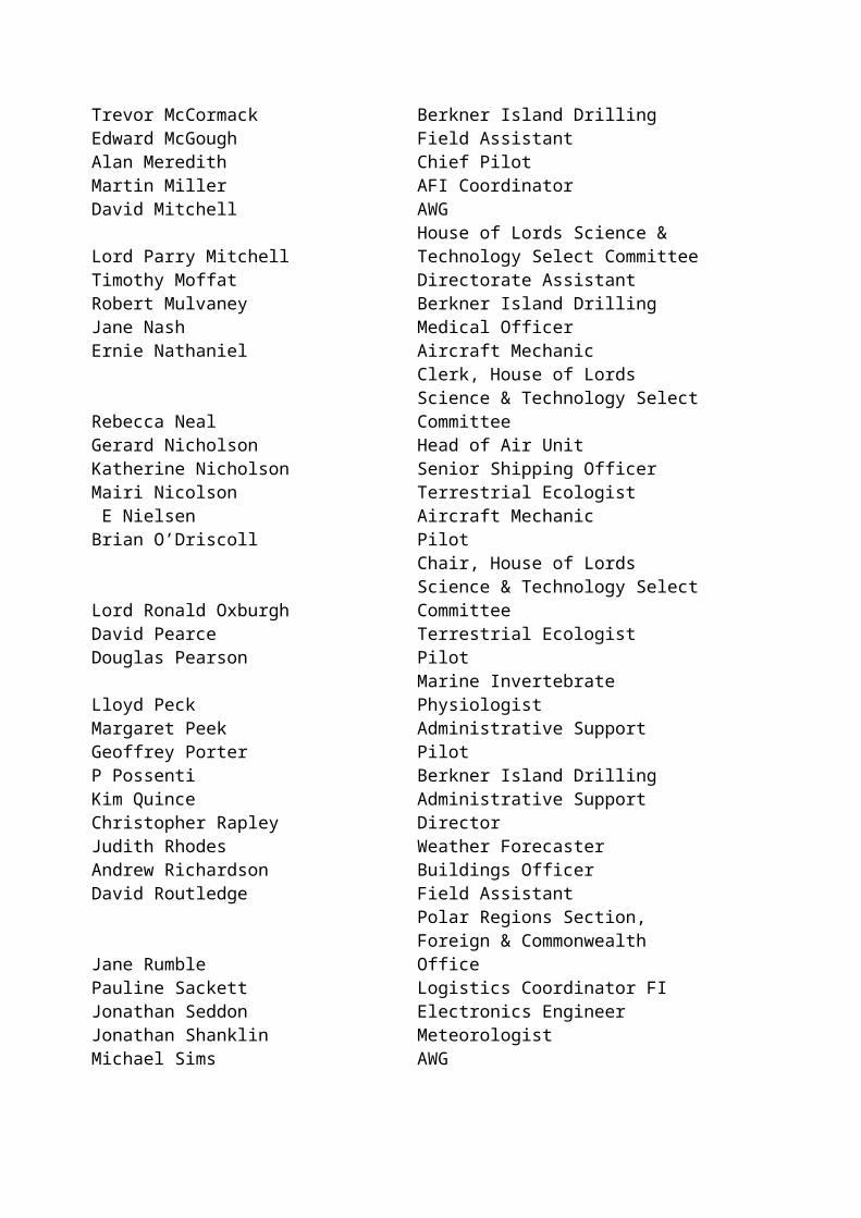
Kevin Gray CODIS installationElizabeth Greenwood BBC NewsroundHeath Greville Radio OperatorHilmar Gudmundsson Atmospheric ScientistJohn Hall Head of OperationsIan Heffernan BoatmanRobert Hibbins Physical ScientistChristopher Hill CODIS InstallationDominic Hodgson BiologistKevin Hughes Terrestrial EcologistAd Huiskies Visiting ScientistDavid Ingham Mast OfficerGrace Ingoldby Writers & Artists ProgrammeChristopher Jacobs Mobile Plant TechnicianMatthew Jobson Builder/CarpenterPaul Kinnaird Aircraft MechanicLeslie Kitson PilotDouglas Laws Aircraft MechanicProfessor John Lawton Chief Executive, NERCDavid Leatherdale PilotDavid Lee Weather ForecasterGenevieve Littot Berkner Island DrillingGregory Marks PilotStephen Marshall Base CommanderDavid Maxfield Atmos ScientistGary McCall Aircraft MechanicTrevor McCormack Berkner Island DrillingEdward McGough Field AssistantAlan Meredith Chief PilotMartin Miller AFI CoordinatorDavid Mitchell AWG
Lord Parry MitchellHouse of Lords Science & Technology Select Committee
Timothy Moffat Directorate AssistantRobert Mulvaney Berkner Island DrillingJane Nash Medical OfficerErnie Nathaniel Aircraft Mechanic
Rebecca NealClerk, House of Lords Science & Technology Select Committee
Gerard Nicholson Head of Air UnitKatherine Nicholson Senior Shipping OfficerMairi Nicolson Terrestrial Ecologist E Nielsen Aircraft MechanicBrian O’Driscoll Pilot
Lord Ronald OxburghChair, House of Lords Science & Technology Select Committee
David Pearce Terrestrial EcologistDouglas Pearson PilotLloyd Peck Marine Invertebrate Physiologist

Margaret Peek Administrative SupportGeoffrey Porter PilotP Possenti Berkner Island DrillingKim Quince Administrative SupportChristopher Rapley DirectorJudith Rhodes Weather ForecasterAndrew Richardson Buildings OfficerDavid Routledge Field Assistant
Jane RumblePolar Regions Section, Foreign & Commonwealth Office
Pauline Sackett Logistics Coordinator FIJonathan Seddon Electronics EngineerJonathan Shanklin MeteorologistMichael Sims AWGRobert Smith Field AssistantNeil Stevenson Field AssistantRodney Strachan Station Support ManagerJohn Taylor AWGG Teste Berkner Island DrillingAlistair Taylor Field AssistantEric Thornthwaite Mechanical Services TechnicianAnthony Tuson Pilot
Andrew TylerNERC Science & Innovation Strategy Board
Paul Tyler Visiting ScientistMarc van de Wouw Visiting ScientistAllan Vaughan Structural GeologistCraig Vear Artists & Writers Programme
Baroness Joan WalmsleyHouse of Lords Science & Technology Select Committee
David WaltonHead of Environment & Information Division
Gary Wardle Aircraft MechanicKaren Webb Research AssistantAnke Wendt PetrologistStephen White Head of Vehicles SectionBrendan Wilkes Radio OperatorRoger Worland Terrestrial Biologist
Signy Research Station
Richard Borthwick Facilities TechnicianSimon Buckles Electrical TestingJudith Dickson Biological Research AssistantMichael Dunn Zoological Research AssistantDavid Ellis Base CommanderSimon Herniman Field AssistantAndrew Hodson Visiting ScientistMarc Patrick Electrical Testing

Crew of RRS Ernest Shackleton and RRS James Clark Ross
RRS Ernest Shackleton
Graham Chapman Master Antonio Gatti Chief OfficerAlan Newman 2nd OfficerVacant 3rd OfficerSteven Buxton ETODerek Forward Chief EngineerMichael Jones 2nd EngineerRobert Mathieson 3rd EngineerWaterhouse Kevin 4th EngineerRobert Roullier ETOMichael Quinn Catering ManagerCharles Chalk BosunNoel Littlehales Bosun’s MateMurdo Nicholson LaunchmanDavid Taylor ABJames Baker ABMichael Brown EDHRichard Parsley MotormanRichard Simpson ChefRobert Shields Assist ChefMark Jones StewardJohn Marshall Master John Harper Chief OfficerNoel Lynam 2nd OfficerChristopher Handy 3rd OfficerSteven Mee ETO(R)Peter Brigden Chief EngineerMalcolm Inch 2nd EngineerRobert Macaskill 3rd EngineerThomas Balfe 4th EngineerThomas Waller ETO (L)David Bailey Catering ManagerMartin Brookes BosunRaymond Davis Bosun’s MateKeith Dickson ABAndrew Campbell ABBarry Edwards ABJohn McGowan ABCraig Paice Motorman
Keith Walker Assist Chef
RRS James Clark Ross
Christopher Elliott Master Robert Paterson Chief OfficerAndrew Liddell 2nd OfficerMichael Golding 3rd OfficerCharles Waddicor ETODavid Cutting Chief EngineerGerard Armour 3rd EngineerSteven Eadie 4th EngineerNicholas Dunbar Electrical OfficerJames Gibson Catering OfficerJohn Summers Deck OfficerSimon Wright Deck EngineerGeorge Stewart BosunDavid Williams Bosun’s mateDerek Jenkins ABTerence Spiers ABJohn McLeod EDHLester Jolly ABMark Blaby ABMark Robinshaw MotormanSydney Smith MotormanDuncan Macintyre Chief CookRaymond Collins 2nd CookClifford Pratley Snr StewardDerek Lee StewardJames Newall StewardKenneth Weston Steward
M Jeremy Burgan Master David Gooberman Chief OfficerDavid King 2nd OfficerPaul Clarke 3rd OfficerMicael Gloistein ETODuncan Anderson Chief EngineerColin Smith 2nd EngineerJames Stevenson 3rd EngineerThomas Elliott 4th EngineerAnthony Rowe Elect OfficerRichard Turner Catering OfficerDouglas Trevett Deck Engineer

Colin Lang BosunDavid Peck Bosun’s mateGeorge Dale ABIan Raper ABAlbert Bowen ABKelvin Chappell ABKevin Holmes ABBruce Smith MotormanAngus Macaskill MotormanD Hume Chief CookWilliam Hyslop 2nd CookNicholas Greenwood StewardGraham Raworth StewardMichael Weirs Steward
WINTERING PERSONNEL 2003
Bird Island
Isaac Forster Zoological Field AssistantChristopher Green Zoological Field AssistantSarah Robinson Zoological Field Assistant
Halley
Stephane Baugitte Tropospheric ChemistGraeme Barton Fixed Plant TechnicianSimon Coggins Data ManagerJeffrey Cohen Electronic EngineerNigel Colgan Mechanical Services TechnicianStuart Colley Meteorologist/PhysicistEdwyn Dodd Field AssistantThomas Gillie Builder/ CarpenterRussell Locke Electronic EngineerMark Maltby Electronic EngineerCraig Nicholls Meteorologist/Elec TechVanessa O’Brien Meteorologist/PhysicistKevin O’Donnell Chef ManagerSteven Randall Mechanical Services TechnicianMichael Rooney Communications ManagerRhian Salmon Tropospheric ChemistFrank Swinton Medical OfficerAllen Thomas Electrical Services TechnicianGareth Wale Mobile Plant Technician
Rothera
Ian Airth Mobile Plant TechnicianAlec Berry Field AssistantTimothy Burton Field AssistantPaul Booth Mobile Plant TechnicianAnthony Brennan Fixed Plant TechnicianHamish Campbell Visiting ScientistPhilip Harding Communications ManagerStephen Hinde Base CommanderRobin Jarvis Field AssistantJulian Klepacki Electronic EngineerAndrew Miller Assistant Marine BiologistCyril Millet Chef ManagerGraham Nott Lidar EngineerFinbar O’Sullivan Medical OfficerAndrew Porte Electrical Services TechnicianDougal Ranford Field AssistantJohn Riseborough Carpenter/BuilderAndrew Silvester Mechanical Services TechnicianDaniel Smale Marine BiologistKatherine Snell Terrestrial Research AssistantAdam Thornhill Meteorologist/PhysicistAndrew Wilson Boat HandlerJohn Withers Diving Officer
South Georgia
Victoria Auld Base CommanderBrian Beck Plant TechnicianJenny Corser Medical OfficerChristopher Hall Electrical Services TechnicianSusan Hawkins Scientific AssistantPeter Love Boat Handler/ MaintainerRichard Mitchell Scientific AssistantHoward Owen Boat Handler/MaintainerKatherine Ross Scientific Officer
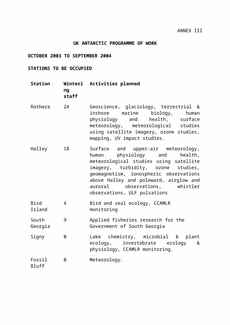
ANNEX III
UK ANTARCTIC PROGRAMME OF WORK
OCTOBER 2003 TO SEPTEMBER 2004
STATIONS TO BE OCCUPIED
Station Wintering staff
Activities planned
Rothera 24 Geoscience, glaciology, terrestrial & inshore marine biology, human physiology and health, surface meteorology, meteorological studies using satellite imagery, ozone studies, mapping, UV impact studies.
Halley 18 Surface and upper-air meteorology, human physiology and health, meteorological studies using satellite imagery, turbidity, ozone studies, geomagnetism, ionospheric observations above Halley and poleward, airglow and auroral observations, whistler observations, ULF pulsations
Bird Island 4 Bird and seal ecology, CCAMLR monitoring
South Georgia 9 Applied fisheries research for the Government of South Georgia
Signy 0 Lake chemistry, microbial & plant ecology, invertebrate ecology & physiology, CCAMLR monitoring.
Fossil Bluff 0 Meteorology.
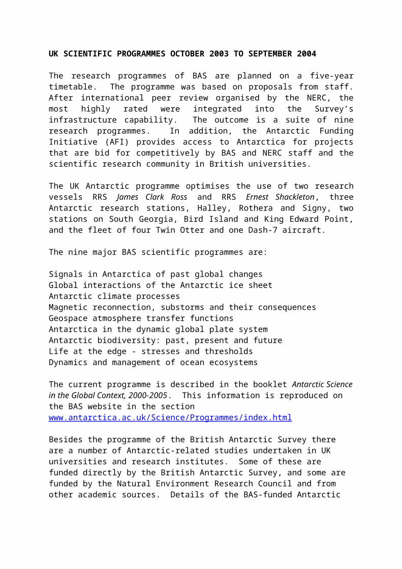
UK SCIENTIFIC PROGRAMMES OCTOBER 2003 TO SEPTEMBER 2004
The research programmes of BAS are planned on a five-year timetable. The programme was based on proposals from staff. After international peer review organised by the NERC, the most highly rated were integrated into the Survey’s infrastructure capability. The outcome is a suite of nine research programmes. In addition, the Antarctic Funding Initiative (AFI) provides access to Antarctica for projects that are bid for competitively by BAS and NERC staff and the scientific research community in British universities.
The UK Antarctic programme optimises the use of two research vessels RRS James Clark Ross and RRS Ernest Shackleton, three Antarctic research stations, Halley, Rothera and Signy, two stations on South Georgia, Bird Island and King Edward Point, and the fleet of four Twin Otter and one Dash-7 aircraft.
The nine major BAS scientific programmes are:

Signals in Antarctica of past global changesGlobal interactions of the Antarctic ice sheetAntarctic climate processesMagnetic reconnection, substorms and their consequencesGeospace atmosphere transfer functionsAntarctica in the dynamic global plate systemAntarctic biodiversity: past, present and futureLife at the edge - stresses and thresholdsDynamics and management of ocean ecosystems
The current programme is described in the booklet Antarctic Science in the Global Context, 2000-2005. This information is reproduced on the BAS website in the section www.antarctica.ac.uk/Science/Programmes/index.html
Besides the programme of the British Antarctic Survey there are a number of Antarctic-related studies undertaken in UK universities and research institutes. Some of these are funded directly by the British Antarctic Survey, and some are funded by the Natural Environment Research Council and from other academic sources. Details of the BAS-funded Antarctic Funding Initiative may be found be accessed through:http://www.nerc-bas.ac.uk/public/afi/

ANNEX IV
SCIENTIFIC EQUIPMENT IN USE IN ANTARCTICA
At Halley Research Station
Advanced ionospheric sounder (AIS)Southern Hemisphere Auroral Radar Experiment (SHARE) RadarFour wide-beam riometers with directional aerialsImaging Riometer System (IRIS) with 49 beamsFluxgate magnetometerVLF radio receivers and analysis systemDobson spectrophotometerRadiosonde systemAutomatic weather stationsMeteorological instrumentsLaser Cloud Base RecorderSonic anemometers and other instruments for turbulence studiesMeteosat DCP for transmission of meteorological observationsNetwork services Sun, and Viglen computing systems and Satcomm connectionDigital all-sky cameraAcoustic radar (SODAR)Kite-borne atmospheric profiling systemDartcom HRPT receiverMedical X-ray machineBomem spectrometer
Clean Air Sector laboratory instruments:High Volume air samplers (HiVol)Aerosol sampling pumpAethalometer for soot carbonCondensation nucleus counterOzone monitor (troposphere)Dual channel NOx analyserSpectroradiometerFormaldehyde analyserDenuder sampling systemHONO AnalyserDifferential Optical Absorption SpectrometerGas chromatographs (2)Hydrogen Peroxide analyser
At 77°31'24"S, 23°25'18"W
Fluxgate magnetometer

At 79°04'36"S, 24°07'11"W
Fluxgate magnetometer
At 80°53'30"S, 22°14'48"W
Fluxgate magnetometerInfra red radiometer
At 81°30'00"S, 03°00'00"E
Fluxgate magnetometer
At 82°53'58"S, 12°14'57"W
Fluxgate magnetometer
At 84°21'34"S, 23°51'06"W
Fluxgate magnetometerInfra red radiometer
At 85°21'25"S, 02°03'44"E
Fluxgate magnetometer
At 85°23'22"S, 95°58'26"E
Fluxgate magnetometer
At 86°59'57"S, 28°24'49"E
Fluxgate magnetometer
At 86°30'53"S, 68°10'30"E
Fluxgate magnetometer
At 88°01'31"S, 43°51'56"W
Fluxgate magnetometer
At Automatic Geophysical Observatory (AGO) Site A80 (8054'S, 2216'W)
MagnetometerRiometerVLF receiverMeteorological instrumentsScanning receiver (Dartmouth College, USA)

Search coil magnetometer (University of New Hampshire, USA)
At Automatic Geophysical Observatory (AGO) Site A81 (8130'S, 300'E)
MagnetometerRiometerVLF receiverScanning receiver (Dartmouth College, USA)Search coil magnetometer (University of New Hampshire, USA)Meteorological instruments
At Automatic Geophysical Observatory (AGO) Site A84 (8422'S, 2352'E)
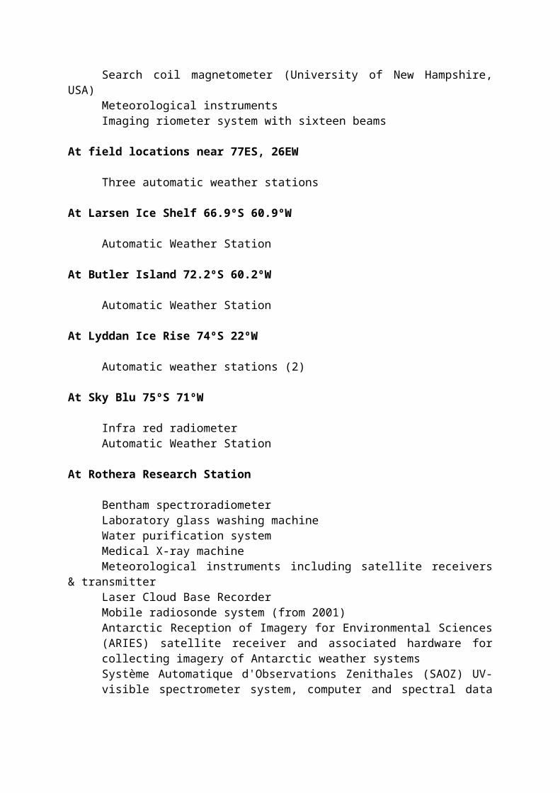
MagnetometerRiometerVLF receiver (to be deployed in January 1998)Scanning receiver (Dartmouth College, USA)Search coil magnetometer (University of New Hampshire, USA)Meteorological instrumentsImaging riometer system with sixteen beams
At field locations near 77ES, 26EW
Three automatic weather stations
At Larsen Ice Shelf 66.9ºS 60.9ºW
Automatic Weather Station
At Butler Island 72.2ºS 60.2ºW
Automatic Weather Station
At Lyddan Ice Rise 74ºS 22ºW
Automatic weather stations (2)
At Sky Blu 75ºS 71ºW
Infra red radiometerAutomatic Weather Station
At Rothera Research Station
Bentham spectroradiometerLaboratory glass washing machineWater purification systemMedical X-ray machineMeteorological instruments including satellite receivers & transmitter

Laser Cloud Base RecorderMobile radiosonde system (from 2001)Antarctic Reception of Imagery for Environmental Sciences (ARIES) satellite receiver and associated hardware for collecting imagery of Antarctic weather systemsSystème Automatique d'Observations Zenithales (SAOZ) UV-visible spectrometer system, computer and spectral data analysis suiteSea water level recorderMicrobiology incubatorsLaminar flow unit
Network services and computersMicrobalancesEnvironmental growth cabinets

-20°C freezers-80°C freezersCarbolite furnacesOvensData loggersCentrifugeIncubatorsFluorimeterClass II microbiological safety cabinetMarine aquarium systemDiving decompression systemVLF receiver experimentIron Lidar (from 01.01.03)Infra red radiometerAirglow imagerBomem spectrometerSun Unix workstations, Viglen computers and Satcomm connectionCTD with fluorometer and photosynthetically active radiation (PAR) sensorMF radar for mesospheric windsSpectrophotometerAutoclaveFume Hoods
At Signy Research Station
Microclimate stations (two) Rackbeta Scintillation counterMicrobalances (two)Viglen computers and Satcomm connectionNetwork servicesSea water level recorder Data loggersSea ice camera for unattended operationFume cupboards (two); one with flume; one with filters onlyCentrifugeSanyo incubator, PH meter and Autoclave CorersLaminar flow cabinetAutoanalyser-80C freezerWater deioniserFluorimeterFurnaceFreezer and refrigerator
At Fossil Bluff
Infra red radiometerAutomatic weather station
Equipment used in aircraft
Trimble 4000SE global positioning system (GPS) (used on ground only or not at all)
Ice sounding radar equipmentAshtec Z12 global positioning system (GPS) equipmentHF antenna radiation pattern measurement equipmentScintrex Magnetometer SystemAirborne gravimeterZeiss camera
For ground surveys/field use
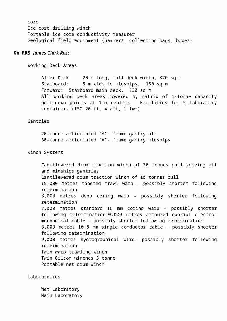
1 Trimble 4000SSE GPS receiver for geophysical survey2 Trimble 4000SSI GPS receivers for geophysical survey3 broadband seismometersTheodolites (various) and levelsHand-held GPS receivers for navigationMagellan 5000 PRO GPS position fixing equipmentTwo Trimble 4000 SSE GPS for studies of ice deformation and flowBISON 24-and 48-channel seismic recording systems with peripheral cables and geophonesGeodimeter 220 Electronic Distance Measurement EDMsThree geophysical tiltmeters for ice dynamical studiesAdvanced Geophysical MicroMax seismic data processing system.Towed geophone arrayLacoste-Romberg gravimeterThree Worden gravimeter-geodetic modelsTwo hot water drills (40 kW power) for obtaining seismic shot holesHot water drill (250 kW power) for drilling through ice shelves with a proven capability of 600 metresBorehole oceanographic profiling systemIce sounding radar (BAS-SPRI Mark 4)Automatic weather stationMicroclimate loggersLaptop computersAutomatic air sampling system (located in Dronning Maud Land)2 hand operated ice core drills capable of attaining 50 metresElectromechanical ice core drill for attaining 200 metres of ice coreIce core drilling winchPortable ice core conductivity measurerGeological field equipment (hammers, collecting bags, boxes)
On RRS James Clark Ross
Working Deck Areas
After Deck: 20 m long, full deck width, 370 sq mStarboard: 5 m wide to midships, 150 sq mForward: Starboard main deck, 130 sq mAll working deck areas covered by matrix of 1-tonne capacity bolt-down points at 1-m centres. Facilities for 5 Laboratory containers (ISO 20 ft, 4 aft, 1 fwd)
Gantries
20-tonne articulated "A"- frame gantry aft30-tonne articulated "A"- frame gantry midships
Winch Systems
Cantilevered drum traction winch of 30 tonnes pull serving aft and midships gantriesCantilevered drum traction winch of 10 tonnes pull15,000 metres tapered trawl warp – possibly shorter following retermination8,000 metres deep coring warp – possibly shorter following retermination7,000 metres standard 16 mm coring warp – possibly shorter following retermination10,000 metres armoured coaxial electro-mechanical cable – possibly shorter following retermination8,000 metres 10.8 mm single conductor cable – possibly shorter following retermination9,000 metres hydrographical wire– possibly shorter following reterminationTwin warp trawling winchTwin Gilson winches 5 tonnePortable net drum winch
Laboratories
Wet LaboratoryMain LaboratoryRough WorkshopScientific WorkshopWater Bottle RoomChemistry LaboratoryPreparation LaboratoryBiochemistry LaboratoryMicrobiology/Radioactive Laboratory
Computer/Electronic/Control Spaces
Underway Instrumentation and Control RoomElectronics WorkshopData Preparation RoomComputer RoomPaper and Magnetic Tape Ready-Use StoreSun Unix workstations and Viglen personal computers
Other scientific spaces
Gravity Meter RoomCool Specimen RoomWalk-in Scientific Freezer (-20C)Scientific Chest Freezer (-80C)Scientific HoldExplosives MagazineHazardous Chemicals LockersStorm Clothing Annex
Scientific Data Logging
NOAA SCS Data Logging systemSun/Solaris workstationsNetware ServersViglen PCs for general useHP Designjet 650C A0 colour plottersHP Laserjet printers

Local Area Network providing 100Mbits/s to all equipmentLogging PCs connected to instrumentation
Scientific Instrumentation
Simrad EM 120 1 degree by 1 degree multibeam swath bathymetry systemKongsberg TOPAS sub-bottom profilerSimrad EA 500 navigational sounderSimrad EK 60, 38 kHz 120 kHz and 200 kHz transceiversPrecision Echo Sounder, 10 kHzFuruno CSH50 directional sonarAcoustic Doppler Current Profiler (RD1 Type RD-VDM150)Acoustic pinger 10/12 kHzPitch, Roll, Heave monitor/compensatorDual Axis Doppler Log (Sperry SRD 421S)Electromechanical Log (Chernikeef Aquaprobe Mk 5)BAS STCM three-component magnetometersSeismic compressors for air gunsGun handling equipmentMarine Magnetics towed overhauser magnetometer
Navigation and Oceanography
Two Ashtec G12 global positioning system (DGPS) for Kongsberg Dynamic Positioning System on vesselUltrasonic anemometerTrimble 8-channel DGPS receiverAshtech ADU2 3D DGPSAshtech GLONASS/GPS receiverPC based Oceanlogger underway instrumentationincluding:
SeaBird ThermosalinographThru-Flow fluorometerVaisala Digital BarometerTIR sensorPAR sensorAir temp PRTHumidity sensorSea water intake PRT
Bench top salinometerScintillation counterConductivity-temperature-depth profiler (CTD )- including
PAR sensor, dissolved oxygen sensorFluorometerTransmissometerAltimeterDeep ocean standards thermometer12 bottle rosette sampler
XBT systemDartcom HRPT satellite receiverSound velocity profilerDeionised water maker

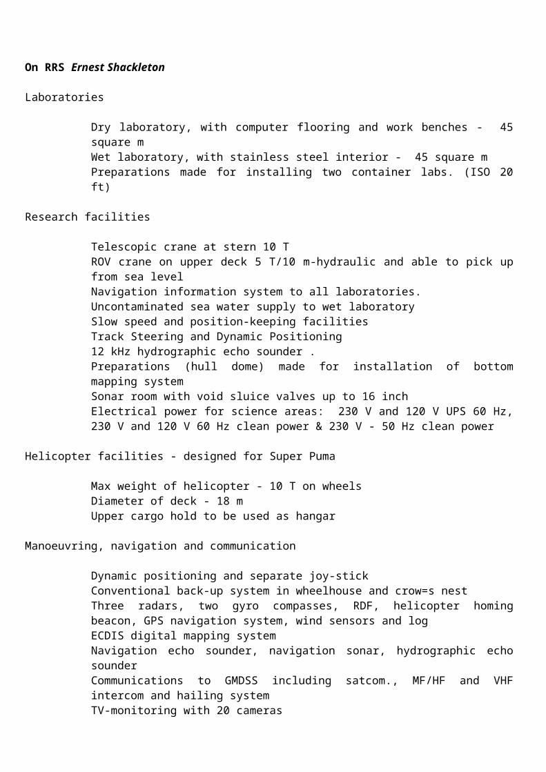
On RRS Ernest Shackleton
Laboratories
Dry laboratory, with computer flooring and work benches - 45 square mWet laboratory, with stainless steel interior - 45 square mPreparations made for installing two container labs. (ISO 20 ft)
Research facilities
Telescopic crane at stern 10 TROV crane on upper deck 5 T/10 m-hydraulic and able to pick up from sea levelNavigation information system to all laboratories.Uncontaminated sea water supply to wet laboratorySlow speed and position-keeping facilitiesTrack Steering and Dynamic Positioning12 kHz hydrographic echo sounder .Preparations (hull dome) made for installation of bottom mapping systemSonar room with void sluice valves up to 16 inchElectrical power for science areas: 230 V and 120 V UPS 60 Hz, 230 V and 120 V 60 Hz clean power & 230 V - 50 Hz clean power
Helicopter facilities - designed for Super Puma
Max weight of helicopter - 10 T on wheelsDiameter of deck - 18 mUpper cargo hold to be used as hangar
Manoeuvring, navigation and communication
Dynamic positioning and separate joy-stickConventional back-up system in wheelhouse and crow=s nestThree radars, two gyro compasses, RDF, helicopter homing beacon, GPS navigation system, wind sensors and logECDIS digital mapping systemNavigation echo sounder, navigation sonar, hydrographic echo sounderCommunications to GMDSS including satcom., MF/HF and VHF intercom and hailing systemTV-monitoring with 20 cameras
Scientific instrumentation
Dartcom HRPT satellite receiverEA 500 echo sounderBAS STCM three-component magnetometerViglen PCs Compaq ServerXBT system

ANNEX V
INFORMATION ON UNITED KINGDOM TELECOMMUNICATIONS
EQUIPMENT AND SCHEDULES IN THE ANTARCTIC
Date of preparation
November 2003

INFORMATION ON TELECOMMUNICATIONS EQUIPMENT AND SCHEDULES FOR THE YEAR 2003 - 2004
COUNTRY: UNITED KINGDOM ADDRESS FOR CORRESPONDENCE ON THIS INFORMATION:The Director
STATION: BIRD ISLAND British Antarctic SurveyHigh Cross, Madingley Road
LAT 5400'S LONG 3803'W Cambridge CB3 OET
CALLSIGN ZBH 22 Telephone: + 44 (0)1223 221400SELCAL 05438 Telegrams: Polasurvey, CambridgeINMARSAT STD B I/D Telex: 817725TPH 382343127 Telephone: + 44 (0)1223 362616FAX 382343131
TRANSMITTERS RECEIVERS REMARKS
TYPE FREQUENCYBANDS
TYPES OFTRANSMISSION
AND POWER
FREQUENCY SELECTION
TYPE FREQUENCY BANDS
TYPES OFRECEPTIONAVAILABLE
FREQUENCYSELECTION
TRP8250 S
PRM 4021TA 944C
PRM 4051
Icom M59e
NERA SATURN B+
1.6-30 MHz
2-15.9 MHz
2-11.9 MHz
156-162 MHz
1635.5 MHz1645.0 MHz
AM. H3E, J3EFI.B 250 W PEP
H3E, J3E10/100 W PEP
H3E, J3E5 W
FM J3E25 W
TDM36 W
Synthesised
Synthesised
Synthesised
Synthesised FRG 7700 0.15-29.9 MHz
1535 MHz1543.5 MHz
AM H3E, J3E
TDM
Synthesised
Transceiver with linear amp
Transceiver
General purpose B/C receiver
Marine band VHF transceiver
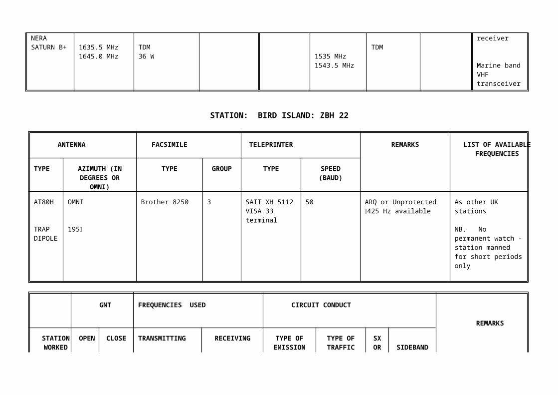
STATION: BIRD ISLAND: ZBH 22
ANTENNA FACSIMILE TELEPRINTER REMARKS LIST OF AVAILABLE FREQUENCIES
TYPE AZIMUTH (INDEGREES OR
OMNI)
TYPE GROUP TYPE SPEED(BAUD)
AT80H
TRAPDIPOLE
OMNI
195
Brother 8250 3 SAIT XH 5112VISA 33terminal
50 ARQ or Unprotected 425 Hz available
As other UK stations
NB. No permanent watch - station manned for short periods only
GMT FREQUENCIES USED CIRCUIT CONDUCT
REMARKS
STATIONWORKED
OPEN CLOSE TRANSMITTING RECEIVING TYPE OFEMISSION(SEE CCIR
432) (X)
TYPE OFTRAFFIC
SXORDX
SIDEBAND
SIGNY ZHF 33
2000 4067/9016 SIMPLEX FIB or J3E Dependent on quantity of traffic

INFORMATION ON TELECOMMUNICATIONS EQUIPMENT AND SCHEDULES FOR THE YEAR 2003 - 2004
COUNTRY: UNITED KINGDOM ADDRESS FOR CORRESPONDENCE ON THIS INFORMATION:The Director
STATION: HALLEY British Antarctic SurveyHigh Cross, Madingley Road
LAT 7558'S LONG 02634'W Cambridge CB3 OET
CALLSIGN ZHF 22 Telephone: + 44 (0)1223 221400SELCAL 89022 Telegrams: Polasurvey, CambridgeINMARSAT STD B I/D Telex: 817725TPH 323202010 Fax No: + 44 (0)1223 362616FAX 323202011TLX 323202013 ZHFZ
TRANSMITTERS RECEIVERS REMARKS
TYPE
FREQUENCYBANDS
TYPES OFTRANSMISSION
AND POWER
FREQUENCY SELECTION
TYPE FREQUENCYBANDS
TYPES OFRECEPTIONAVAILABLE
FREQUENCYSELECTION
SKANTITRP8757 STXCVRS (x2)
PRM 4790A
1.6-30 MHz
1.6-30 MHz
J3E, R3E, H3E, A1A, H2A, F1B750 W PEP
A3E, J3E20 Watts
Synthesised100 Hz steps
Synthesised100 Hz steps
SKANTIR8000
10 kHz-30 MHz J3E, R3E, H3E, A3E, F1B, A1A, H2A
Synthesised 10 Hz steps
HF Field Transceiver

STATION: HALLEY ZHF 22
TRANSMITTERS RECEIVERS REMARKS
TYPE FREQUENCYBANDS
TYPES OFTRANSMISSION
AND POWER
FREQUENCY SELECTION
TYPE FREQUENCY BANDS
TYPES OFRECEPTIONAVAILABLE
FREQUENCYSELECTION
VHF TXCVRSAILOR RT2048
KENWOODTK260
STANDARDHX390
JOTRONTR-6102
WALTER DITTEL FSG 5
InmarsatTerminal
Saturn Bm
154.40- 163.75 MHz
156-161 MHz
156-161 MHz
118-136.975 MHz
118-136.975 MHz
1626.5-1646.5MHz
F3E25 Watts
F3E5 Watts
F3E5 Watts
A3E10 Watts
A3E1 Watt
TDM33/25 dBW EIRP
Synthesised
Synthesised
Synthesised
Synthesised
Synthesised
1530.0-1559.0 MHz TDM
HandheldChannels 6, 8, 9, 16 programmed
HandheldChannels 1-16 Programmed
Air/Ground Communications
Handheld Air/Ground Communications
STATION: HALLEY ZHF 22

ANTENNA FACSIMILE TELEPRINTER
REMARKS LIST OF AVAILABLE
FREQUENCIES
TYPE AZIMUTH(IN DEGREES
OR OMNI)
TYPE GROUP TYPE SPEED(BAUD)
WIDEBAND FAN DIPOLE (x2)
INVERTED V DIPOLE
OMNI
OMNI
PITNEY BOWES 9820
GPIII XH5112 50 ARQ or UNPROTECTED TELEX AVAILABLE
Frequencies pairs scanned on ARQ (KHz): (RX, TX)(3800, 3186)(4030, 4553)(7623, 7623)(8198, 9106)(11255, 11565)(14475, 14915)(16040, 16315)
Frequencies in common use for RT (KHz):4067, 5080, 5150, 5800 6210, 7450, 7775, 9106, 9115, 10049, 11055, 11255, 12425, 14915
INFORMATION ON TELECOMMUNICATIONS EQUIPMENT AND SCHEDULES FOR THE YEAR 2003 - 2004
COUNTRY: UNITED KINGDOM ADDRESS FOR CORRESPONDENCE ON THIS INFORMATION:The Director
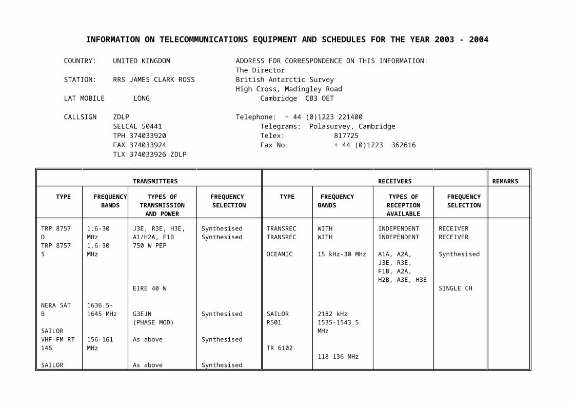
STATION: RRS JAMES CLARK ROSS British Antarctic SurveyHigh Cross, Madingley Road
LAT MOBILE LONG Cambridge CB3 OET
CALLSIGN ZDLP Telephone: + 44 (0)1223 221400SELCAL 50441 Telegrams: Polasurvey, CambridgeTPH 374033920 Telex: 817725FAX 374033924 Fax No: + 44 (0)1223 362616TLX 374033926 ZDLP
TRANSMITTERS RECEIVERS REMARKS
TYPEFREQUENCY
BANDS
TYPES OFTRANSMISSION
AND POWER
FREQUENCY SELECTION
TYPE FREQUENCY BANDS
TYPES OFRECEPTIONAVAILABLE
FREQUENCYSELECTION
TRP 8757 DTRP 8757 S
NERA SAT B
SAILOR VHF-FM RT 146
SAILORRT 2048
TRP 3000
JOTRON VHF-AM TR 6102
1.6-30 MHz1.6-30 MHz
1636.5-1645 MHz
156-161 MHz
156-161 MHz
156-161 MHz
118-136 MHz
J3E, R3E, H3E,A1/H2A, F1B750 W PEP
EIRE 40 W
G3EJN(PHASE MOD)
As above
As above
As above
SynthesisedSynthesised
Synthesised
Synthesised
Synthesised
Synthesised
TRANSRECTRANSREC
OCEANIC
SAILOR R501
TR 6102
WITHWITH
15 kHz-30 MHz
2182 kHz1535-1543.5 MHz
118-136 MHz
INDEPENDENTINDEPENDENT
A1A, A2A, J3E, R3E, F1B, A2A, H2B, A3E, H3E
RECEIVERRECEIVER
Synthesised
SINGLE CH
STATION: RRS JAMES CLARK ROSS

ANTENNA FACSIMILE TELEPRINTER REMARKS LIST OF AVAILABLE FREQUENCIES
TYPE AZIMUTH (INDEGREES OR
OMNI)
TYPE GROUP TYPE SPEED(BAUD)
A59ST
AT100D
STA10A
Z5086001
OMNI
OMNI
OMNI
OMNI
PITNEY BOWES8050
GPIII TT1585ETEXTEL3200
PCU 9000
50
50
SAT-STD B TLX
HF TLX - ARQ or UNPROTECTED AVAILABLE
NORMALLY ALLOCATED MARINE FREQUENCIESPLUS FREQUENCIESALLOCATED FOR USE INANTARCTIC WATERS
GMT FREQUENCIES USED
CIRCUIT CONDUCT
REMARKS
STATION WORKED
OPEN CLOSE
TRANS- MITTING
RECEIVING TYPE OF EMISSION
TYPE OF TRAFFIC
SX ORDX
SIDEBAND
UK ANTARCTICSTATIONS
HX HX Various Various J3E, H3E, F1B ADMIN, DATA PVT
AS REQUIRED
OPERATES IN ANTARCTIC FOR APPROX 7 MONTHS OF YEAROCT-APR
INFORMATION ON TELECOMMUNICATIONS EQUIPMENT AND SCHEDULES FOR THE YEAR 2003 - 2004

COUNTRY: UNITED KINGDOM ADDRESS FOR CORRESPONDENCE ON THIS INFORMATION:The Director
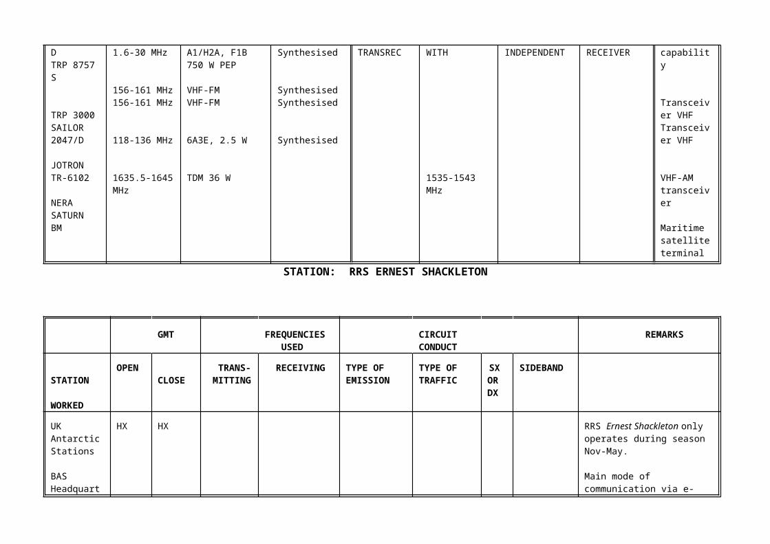
STATION: RRS ERNEST SHACKLETON British Antarctic SurveyHigh Cross, Madingley Road
LAT MOBILE LONG Cambridge CB3 OET
CALLSIGN ZDLS1 Telephone: + 44 (0)1223 221400SELCAL 45968 Telegrams: Polasurvey, CambridgeINMARSAT Telex: 817725TPH 374035710 Fax No: + 44 (0)1223 362616FAX 374035712Telex 374035714 ZDLS1
TRANSMITTERS RECEIVERS REMARKS
TYPE FREQUENCYBANDS
TYPES OFTRANSMISSION
AND POWER
FREQUENCY SELECTION
TYPE FREQUENCY BANDS
TYPES OFRECEPTIONAVAILABLE
FREQUENCYSELECTION
TRP 8757 DTRP 8757 S
TRP 3000SAILOR 2047/D
JOTRON TR-6102
NERASATURN BM
1.6-30 MHz1.6-30 MHz
156-161 MHz156-161 MHz
118-136 MHz
1635.5-1645 MHz
J3E, R3E, H3E,A1/H2A, F1B750 W PEP
VHF-FMVHF-FM
6A3E, 2.5 W
TDM 36 W
SynthesisedSynthesised
SynthesisedSynthesised
Synthesised
TRANSRECTRANSREC
WITHWITH
1535-1543 MHz
INDEPENDENTINDEPENDENT
RECEIVERRECEIVER
Frequency capability
Transceiver VHFTransceiver VHF
VHF-AM transceiver
Maritime satelliteterminal
STATION: RRS ERNEST SHACKLETON
GMT FREQUENCIES CIRCUIT REMARKS
USED CONDUCT
STATION WORKED
OPEN CLOSE
TRANS- MITTING
RECEIVING TYPE OF EMISSION
TYPE OF TRAFFIC
SX ORDX
SIDEBAND
UK Antarctic Stations
BAS Headquarters in Cambridge, UK
HX HX RRS Ernest Shackleton only operates during season Nov-May.
Main mode of communication via e-mail
ANTENNA FACSIMILE TELEPRINTER REMARKS LIST OF AVAILABLE FREQUENCIES
TYPE AZIMUTH (INDEGREES OR
OMNI)
TYPE GROUP TYPE SPEED(BAUD)
Comrod
1.3 M DISH
OMNI-TXCage DipoleOMNI RX
OMNI-TXOMNI-TX
DISH
Brother 8250p PCU 9000 with Scancom software.
50 Maritime TOR protectedwide band - unprotectedavailable
Normal allocated maritime Freqs plus Freqs allocated for use in Antarctic waters.
INFORMATION ON TELECOMMUNICATIONS EQUIPMENT AND SCHEDULES FOR THE YEAR 2003 - 2004
COUNTRY: UNITED KINGDOM ADDRESS FOR CORRESPONDENCE ON THIS INFORMATION:The Director
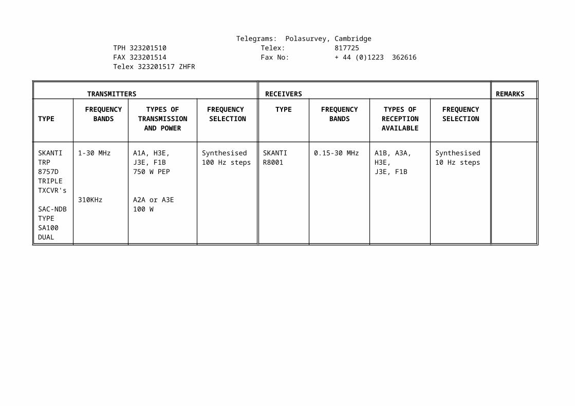
STATION: ROTHERA British Antarctic SurveyHigh Cross, Madingley Road
LAT 6734'S LONG 6808'W Cambridge CB3 OET

CALLSIGN ZHF 45 Telephone: + 44 (0)1223 221400Telegrams: Polasurvey, Cambridge
TPH 323201510 Telex: 817725FAX 323201514 Fax No: + 44 (0)1223 362616Telex 323201517 ZHFR
TRANSMITTERS RECEIVERS REMARKS
TYPE FREQUENCYBANDS
TYPES OFTRANSMISSION
AND POWER
FREQUENCY SELECTION
TYPE FREQUENCYBANDS
TYPES OFRECEPTIONAVAILABLE
FREQUENCYSELECTION
SKANTITRP 8757DTRIPLE TXCVR's
SAC-NDBTYPE SA100DUAL
1-30 MHz
310KHz
A1A, H3E, J3E, F1B750 W PEP
A2A or A3E100 W
Synthesised100 Hz steps
SKANTI R8001
0.15-30 MHz A1B, A3A, H3E,J3E, F1B
Synthesised10 Hz steps

STATION: ROTHERA ZHF 45
TRANSMITTERS RECEIVERS REMARKS
TYPE FREQUENCYBANDS
TYPES OFTRANSMISSION
AND POWER
FREQUENCY SELECTION
TYPE FREQUENCY BANDS
TYPES OFRECEPTIONAVAILABLE
FREQUENCYSELECTION
HF Field TXCVR
PRM4021
PRM4031
PRM4051
PRM 4041
PRM 4790A
2-16 MHz
2-30 MHz
2-12 MHz
2-30 MHz
2-30 MHz
A3E, J3E, A1A10 W
A3E, J3E, A1A10 W
A1A, J3E5 W
A1A J3E20 W
A1A, A3E, J3E F2B20 W
Synthesised100 Hz steps
Synthesised100 Hz steps
Synthesised100 Hz steps
Synthesised100 Hz steps
Synthesised100 Hz steps

STATION: ROTHERA ZHF 45
TRANSMITTERS RECEIVERS REMARKS
TYPE FREQUENCYBANDS
TYPES OFTRANSMISSION
AND POWER
FREQUENCY SELECTION
TYPE FREQUENCY BANDS
TYPES OFRECEPTIONAVAILABLE
FREQUENCYSELECTION
NDB
SS 1000A
DME
Fernau DME2020
INMARSAT EQUIPMENT
NERA SATURN BM
310 kHz
Ch119Y
1636.5-1645 MHz
A1A100 W PEP
PULSE100 WATTS
TDM 40 W
Fixed frequency crystal
119Y
1535-1543.5 MHzL BAND
TDM
STATION: ROTHERA ZHF 45
TRANSMITTERS RECEIVERS REMARKS
TYPE FREQUENCYBANDS
TYPES OFTRANSMISSION
AND POWER
FREQUENCY SELECTION
TYPE FREQUENCYBANDS
TYPES OFRECEPTIONAVAILABLE
FREQUENCYSELECTION
VHF TRANS-RECEIVER
Icom M59
Icom M15
JOTRON
DITTEL
Motorola
Motorola
Icom M3
156-158 MHz
156-158 MHz
118-136 MHz
118-136 MHz
Channel 18
Channel 1
156-158 MHz
VHF-FM25 Watt
VHF-FM5 WattVHF-AM50 WattVHF-AM2 Watt
25 Watt
10 Watt
VHF-FM5 Watt
Synthesised
Synthesised
Synthesised
Synthesised
Synthesised
Synthesised
Synthesised
118.1, 118.3121.5
118.1, 118.3121.5
Marine channel repeater

STATION: ROTHERA ZHF 45
ANTENNA FACSIMILE TELEPRINTER
REMARKS LIST OF AVAILABLE FREQUENCIES
TYPE AZIMUTH (INDEGREES OR
OMNI)
TYPE GROUP TYPE SPEED(BAUD)
SABRERLPA
SABRE800-4800-4
NDBSACMONOPOLE
STEERABLE
0/18090/270
OMNI
Brother 8250 GP 111XH5112
TT1585ETEXTEL320
50
50 Used with SES terminal
3186, 3250, 3800, 48925930, 7623, 8190, 9480
Frequencies in common use4067, 4553, 5080, 5800 6386.5, 7450, 8198, 8265 9106, 10049, 11055, 11255 12425, 14915, 17975

STATION: ROTHERA ZHF 45
GMT FREQUENCIES USED CIRCUIT CONDUCT REMARKS
STATION WORKED OPEN
CLOSE
TRANSMITTING RECEIVING
TYPE OF EMISSION
TYPE OF TRAFFIC
SXDX
SIDEBAND
HALLEYDEEP FIELDFIELD PARTIESSTANLEY
FOSSIL BLUFFMET SCHEDSFIELD PARTIESINTER-BASEBAS HQMET SCHEDSINTER-BASEDEEP FIELD
BAS HQ FIELDPARTIESFOSSIL BLUFFMET SCHEDS
LISTENINGWATCHES
100010151030
1100
1130
11351200
12301430173518301830
20002230
2330
2335
0000-1000
1130-2359
101510301045
1130
1135
12001230
14451800
1900
20152330
2335
0000
9106U, 7775U7775U, 9106U4067U, 5080U, 7775U
7775U, 8855U, 9106U, 10049U4067U, 5080U
as required5080U, 6386.5U
11055U, 9106USatelliteas required4067U9106U, 7623U, 11055U Satellite5080U, 4067U
5080U, 4067U
as required
5080U, 7775U, 118.1 MHz, 156.8 MHz & Marine Channel 62023.5
J3EJ3EJ3E
J3E
J3E
J3EJ3E
J3ESATELLITEJ3EJ3E
J3ESATELLITEJ3E
J3E
J3E
J3EJ3EJ3E
METSAFETYSAFETYADMINMET
MET
METSAFETYADMINADMINFAXMETMET
ADMINE-MAILSAFETYADMINMET
MET
SAFETY
DAILYOCT-MAR DAILYOCT-MAR DAILY
OCT-MAR DAILY
OCT-MAR DAILY
DAILYOCT-MAR DAILY
APR-SEP SATURDAYMON-FRI DAILYOCT-MAR DAILY
APR-SEP SATURDAYMON-FRIOCT-MAR DAILY
OCT-MAR DAILY
DAILY
OCT-MAR DAILY
APR-SEP DAILY
DURING PERIOD OCT-MAR, 6, 8, 10, 11 AND 12 MHZ FREQUENCIES ARE USED AS REQUIRED TO COMMUNICATE WITH AIRCRAFT AND DISTANT FIELD PARTIES

INFORMATION ON TELECOMMUNICATIONS EQUIPMENT AND SCHEDULES FOR THE YEAR 2003 - 2004
COUNTRY: UNITED KINGDOM ADDRESS FOR CORRESPONDENCE ON THIS INFORMATION:The Director
STATION: SIGNY British Antarctic SurveyHigh Cross, Madingley Road
LAT 6043'S LONG 4536'W Cambridge CB3 OET
CALLSIGN ZHF 33 Telephone: + 44 (0)1223 221400SELCAL 89042 Telegrams: Polasurvey, CambridgeINMARSAT Telex: 817725TPH 382341575 Fax No: + 44 (0)1223 362616FAX 382341579
SIGNY STATION OPERATES SUMMER ONLY
TRANSMITTERS RECEIVERS REMARKS
TYPE FREQUENCYBANDS
TYPES OF
TRANSMISSION
AND POWER
FREQUENCY SELECTION
TYPE FREQUENCYBANDS
TYPES OFRECEPTIONAVAILABLE
FREQUENCYSELECTION
SKANTITRP 8253S
Navico
HF FieldTXCVR
InmarsatEquipment
NeraSATURN Bt
2-28 MHz
156-161MHz
1636.5-1645 MHz
J3E, R3E, H3EFIB 250 W PEP
25W
TDM 36 EIRE
Synthesised
Synthesised
1535-1543.5 MHz TDM
VHF Marine radio

STATION: SIGNY ZHF 33
ANTENNA FACSIMILE TELEPRINTER REMARKS LIST OF AVAILABLEFREQUENCIES
TYPE AZIMUTH (INDEGREES OR
OMNI)
TYPE GROUP TYPE SPEED(BAUD)
WB15103-30 MHz
AT80H1.6-30 MHzDipolesvarious
120 approx
OMNI
PITNEYBOWES7100
GROUP III
SIEMENS T100
OKITEXTERMINAL
50
50
ARQ or UNPROTECTEDTLX AVAILABLE
Used with SES Terminal
3186, 3250, 3800, 48925930, 7623, 8190, 9480
Frequencies in common use4067, 4553, 5080, 5800 6386.5, 7450, 8198, 8265 9106, 10049, 1125512425, 14915, 17975

INFORMATION ON TELECOMMUNICATIONS EQUIPMENT AND SCHEDULES FOR THE YEAR 2003-2004
COUNTRY: UNITED KINGDOM ADDRESS FOR CORRESPONDENCE ON THIS INFORMATION:The Director
STATION: King Edward Point,South Georgia British Antarctic Survey
High Cross, Madingley RoadLAT 5417'S LONG 3630'W Cambridge CB3 OET CALLSIGN KEP MMSI No. 740365000 Telephone: + 44 (0)1223 221400
SELCAL 45969 Telegrams: Polasurvey, CambridgeINMARSAT STD B Telex: 817725 BASCAM GTPH 382359030 Telephone: + 44 (0)1223 362616FAX 382359035 Telex 382359038 BASD X
TRANSMITTERS RECEIVERS REMARKS
TYPE FREQUENCYBANDS
TYPES OFTRANSMISSION
AND POWER
FREQUENCY SELECTION
TYPE FREQUENCY BANDS
TYPES OFRECEPTIONAVAILABLE
FREQUENCYSELECTION
TRP9500
TRP 1000
Icom M59e
NERA SATURN Bm
1.6-30 MHz
156-162 MHz
156-162 MHz
1635.5 MHz
AM. H3E, J3EF1B 500 W PEP
FM J3E25 W
FM J3E25 W
TDM36 W
Synthesised
Synthesised
Synthesised
Synthesised
DSC9000
1535 MHz1543.5 MHz
TDM
DSC Equipped
DSC Equipped

STATION: KING EDWARD POINT
ANTENNA FACSIMILE TELEPRINTER REMARKS LIST OF AVAILABLE FREQUENCIES
TYPE AZIMUTH (INDEGREES OR
OMNI)
TYPE GROUP TYPE SPEED(BAUD)
Vertical Whip
Jay Beam Wide BandDipole
OMNI
270-090
Brother 8250P 3 PCU9000 with Scancomm Software
PCU 9000 with Telex Software
50
50
ARQ or Unprotected 425 Hz available
for use with SES terminal
As other UK stations
NB. No permanent watch - station manned for short periods only
GMT FREQUENCIES USED CIRCUIT CONDUCT
REMARKS
STATIONWORKED
OPEN CLOSE TRANSMITTING RECEIVING TYPE OFEMISSION(SEE CCIR
432) (X)
TYPE OFTRAFFIC
SXORDX
SIDEBAND
Fishing Fleets 0900Z 0930Z 4049 SIMPLEX J3E USB Fisheries Report
ANNEX VI
AIRCRAFT LANDING FACILITIES IN USE BY THE BRITISH ANTARCTIC SURVEY
All information in this Annex is to be found in the Antarctic Flight Information Manual (AFIM). AFIM is a document produced by the Standing Committee on Antarctic Logistics and Operations (SCALOP) of the Council of Managers of National Antarctic Programmes. The Antarctic Flight Information Manual (AFIM) is produced at the request of the ATCM and is updated annually prior to the start of the Antarctic summer season. Please consult this document for a fuller description and additional details.
1. ROTHERA STATION GRAVEL RUNWAY (See AFIM)
Position: ROTHERA - situated on the eastern coast of Adelaide Island in Laubeuf Fjord, lat. 6734'19"S, long. 6807'37"W. (Magnetic variation 21E in 1980.)
Height of runway above mean sea level: 3 metres.
Nearest station: The runway is within the Rothera Station complex.
Runway facilities: One runway designated 360/180 magnetic on true bearings 22/202. Length 900 metres. Width 45 metres.
Surface of runway: Crushed gravel.
Period of operation: Summer operation - October to March.
Ground facilities: Medical and fire fighting facilities available. Hanger space may be available for visiting aircraft by prior arrangement only. Snowblower and grader available. Runway lighting and apron lights. PAPI at south end of runway. Hazard beacon on hanger. Grounded icebergs may obstruct runway thresholds.
Taxiing guidance system: VHF with ground crew on 118.1 MHz.Base monitors 5080 kHz (USB), 1000Z - 0030Z.
Call sign: ZHF 45, voice identification "Rothera Base".Ground/air communications: 5080 kHz as primary frequency with secondary frequency of 7775 kHz (all USB).
Radio aids for navigation and approach: At all stations the main transmitters may be called upon to act as beacons (for information on transmitter equipment at each station see Annex V).
At Rothera Point: NDB 310 kHz. IDENT ROT.DME Channel 119 Y (117.25 MHz).
2. ROTHERA STATION SKIWAY (see AFIM)
Position: ROTHERA SKIWAY - situated on the eastern coast of Adelaide Island in Laubeuf Fjord, lat. 6734'S, long. 6807'W. (Magnetic variation 21E in 1980.)

Height of skiway above mean sea level: 900 feet.
Nearest station: Rothera Station is about 5 km SSE of landing area on bearing 140 magnetic.
Skiway facilities: One skiway designated 020/200 magnetic on true bearing of 041/221T. The skiway is marked by drums on its west side. Skiway is situated on bearing 320 magnetic at 3 nautical miles when over-head NDB. The skiway has a slight concave profile with the col in a mountain ridge at its southern end. Total marked length is 2.5 km.
Surface of skiway: Unprepared snow.
Period of operation: Summer operation - October to April.
Ground facilities: At Skiway: No ground installations apart from pickets for aircraft, two small cabooses and windsock.Skiway and base VHF: capability 118.1 MHzBase monitors 5080 kHz (USB), 1000Z - 0030ZCall sign: ZHF 45, voice identification "Rothera Base".Ground/air communications: 5080 kHz primary frequency with secondary frequency 7775 kHz (all USB).
Radio aids for navigation and approach: At all stations the main transmitters may be called upon to act as beacons (for information on transmitter equipment at each station see Annex V).At Rothera Point: NDB 310 kHz. IDENT ROT.DME Channel 119 Y (117.25 MHz).
3. FOSSIL BLUFF (See AFIM)
Position: FOSSIL BLUFF, George VI Sound, lat. 7120'S, long. 6817'W. (Magnetic Variation 23.5E in 1980)
Height of skiway above mean sea level: 300 feet. Slope up to south.
Nearest station: Fossil Bluff lies about 1.6 km NNW of landing area. Food and medical supplies at huts. Station normally manned October-February, with party reporting to Rothera Station.
Skiway facilities:
The skiway is 1200 metres long and marked by drums on the west of the skiway. The bearing is 330/150T. This landing area is an ice shelf in front of the hut and immediately on its western side is bounded by the steep-sided bluff. During summer with high melt conditions the strip may become unusable, being either a small lake or a hard frozen area of sharp-edged corrugations.
Surface of skiway: Unprepared snow.

Period of operation: Summer operation. Skiway can deteriorate due to heavy melt in mid-summer season.
Ground facilities: HF link on 5080 USB to Rothera (minimum twice daily).Hand-held VHF capability 118.1 MHz when aircraft known in area.
Radio aids for navigation and approach: At all stations the main transmitters may be called upon to act as beacons (for information on transmitter equipment at each station see Annex V).
4. HALLEY (See AFIM)
Position: HALLEY, Brunt Ice Shelf, Coats Land, lat. 75 33.87'S, long. 026 33.72W. The coordinates change due to the movement of the ice on which the station is located. (Magnetic variation 2ºW in 1988).
Height of skiway above mean sea level: about 30 metres.
Nearest station: Halley Station lies approximately 1100 metres SSW of skiway. The skiway is marked with drums and there are some radio masts in the vicinity. The highest antennae are 45 metres tall, and lie approximately 750 metres south of the station.
Skiway facilities: One skiway on true bearing of 09/27T marked by single line of drums approximately 1200 metres long. Many other perimeter and guide drum lines in vicinity. Only land on south side of skiway drum markers.
Surface of skiway: Unprepared snow.
Period of operation: Summer operation.
Ground facilities: HF 5080 USB, 7775 USB, Marine VHF Channel 16, Aero VHF 118.1 MHz. Call sign: ZHF 22, voice identification "Halley".
Radio aids for navigation and approach: At all stations the main transmitters may be called upon to act as beacons (for information on transmitter equipment at each station see Annex V).
ANNEX VII
NOTICE OF EXPEDITIONS TO THE ANTARCTIC NOT ORGANISED BY THE PARTY BUT ORGANISED IN, OR PROCEEDING FROM, THE PARTY’S TERRITORY (Private Expeditions)
1. Wings Around the World - Mrs Polly Vacher
Gilbournes FarmDraytonAbingdonOX14 4HA
Operations for 2003/2004 Season
Circumnavigation of the globe via Antarctica by solo flight.
2. Falkland Islands Government Coroner - Mr Nicholas Sanders
c/o Government HousePort Stanley Falkland Islands
Operations for 2003/2004 Season
Investigation of the death of Ms Kirsty Brown, British Antarctic Survey scientist (August 2003).
3. University of York – Mr David Wevill
Department of ChemistryUniversity of YorkYORKYO10 5DD
Operations for 2003/2004 Season
To undertake air-monitoring.
4. Scott Polar Research Institute – Ms Susannah Grant
University of CambridgeLensfield RoadCAMBRIDGECB2 1ER
Operations for 2003/2004 Season
To research human uses of the marine environment.

5. Landrover 4 × 4 × 4 Challenge – Sir Ranulph Fiennes Bt
GreenlandsExfordSOMERSETTA24 7NU
Operations for 2003/2004 Season
To run a marathon (October 2003).
6. Saga Shipping Company – Saga Rose 2004 World Cruise
The Saga BuildingEnbrook ParkFOLKESTONECT20 3SE
Operations for 2003/2004 Season
Application still pending: To briefly visit Antarctica with the cruise ship Saga Rose as part of her 107 night World Cruise, landing passengers ashore at three sites.
ANNEX VIII
NOTIFICATION OF UNOCCUPIED UNITED KINGDOM STATIONSAND REFUGES IN THE ANTARCTIC 2003-2004
In accordance with Recommendation III-II of Antarctic Treaty Consultative Meeting (ATCM) III, the location and facilities available at unoccupied United Kingdom stations and refuges are noted below. All refuges are built on rock unless otherwise stated. No radio facilities are available at any of these stations or refuges. Any person who visits any of these stations or refuges, or uses any of the facilities, is requested to leave it closed. They are also requested to inform the Director of the British Antarctic Survey of the state of repair and of the facilities used as soon as possible.
SOUTH ORKNEY ISLANDS
Cape Geddes: 6041'S, 4434'W, on north coast of Laurie Island; established January 1946 and evacuated in March 1947. Accommodation for 4 people; no food or fuel. Occasionally used by other national operators as a field refuge. Last inspection by BAS personnel on 23 January 1992.
Shingle Cove: 6039'S, 4533'W, on beach in Shingle Cove, Iceberg Bay, Coronation Island; established May 1962. Accommodation for 2 people, food and fuel. Field refuge for Signy station. Last inspected January 1996.
Cummings: 6043'45"S, 4539'50"W, at Cummings Cove, Signy Island. Close proximity to Signy Research Station over the ice cap. Scientific field hut visited regularly by BAS personnel from Signy Station. Accommodation for 2 people; food and fuel for 2 person-months.
Foca: 6041'50"S, 4538'40"W, at Foca Cove, Signy Island. Close proximity to Signy Research Station on opposite side of the island. Scientific field hut visited regularly by BAS personnel from Signy Station. Accommodation for 4 people; food and fuel for 2 person-months.
Gourlay: 6043'50"S, 4535'05"W, on Gourlay Peninsula overlooking Rock Haven, Signy Island. Close proximity to Signy Research Station, 3 km overland. Scientific field hut visited regularly by BAS personnel from Signy Station. Accommodation for two people; food and fuel for 2 person-months.
SOUTH SHETLAND ISLANDS
Deception Island: 6259'S, 6034'W, at Whalers Bay, Deception Island; established February 1944 and evacuated during a major volcanic eruption in February 1969. Station buildings are now in a very dilapidated condition. However, the aircraft hangar remains standing and intact. In March 1991 a two-man team carried out a thorough survey of the site, and collected a large quantity of widely scattered rubbish. Follow-up visit during January 1992 when a four-man clean-up team removed all accessible hazardous wastes and fuel and a large quantity of rubbish. Last inspection by BAS personnel was during January 2002 when a resurvey of the contents and condition of the buildings was carried out. Designated as part of Historic Site and Monument No. 71 at the XXVI ATCM in 2003.
ANTARCTIC PENINSULA: West coast of Graham Land.

Danco Island: 6444'S, 6236'W, on northern end of island in Errera Channel, Danco Coast; established March 1956. Accommodation for 6 people; no food, coal, l.5 kW generator and fuel. Hut in good order. Occasionally used by other national operators as a field refuge. Last visited by BAS personnel on 13 January 2003.
Damoy: 6448'S, 6330'W, at Dorian Bay on west coast of Wiencke Island; established November 1975. Accommodation for 15 people; food for 4 person-years, but no fuel. Hut in good order. Visited by BAS personnel in March 2003.
Port Lockroy: 6450'S, 6318'W, on Goudier Island, a small rocky island in a sheltered harbour on the west coast of Wiencke Island; established February 1944. Designated as Historic Site and Monument No 61 at ATCM XIX in 1995. Accommodation for 6 people; base repaired and cleaned up by five-man team in February 1996. Since then the station has been opened for visitors and further work carried out during each summer season. The British Antarctic Survey has undertaken the conservation work with the guidance of the United Kingdom Heritage Trust and the UK Foreign and Commonwealth Office.
Rasmussen Peninsula: 6515'S, 6406'W, at 9 m above sea-level, attached to mainland east of the Argentine Islands; established March 1984. Accommodation for 4 people; food, fuel and sleeping equipment, also mountain rescue equipment. Last inspected by BAS personnel in March 1991. Hut now used regularly by scientists and support staff from the Ukrainian Antarctic research programme operating from Vernadsky.
Wordie House: 6515'05"S, 6415'15"W, on opposite side of Stella Creek to Faraday Research Station. Established in 1947 on the site of the 1937/38 British Graham Land Expedition hut. Accommodation for 4 people. In view of close proximity (0.75 km) to Ukrainian Vernadsky station it is not regarded as an emergency refuge and so does not hold food and fuel stock. Designated as Historic Site and Monument No 62 at ATCM XIX in 1995. Last inspected by BAS personnel in 2000.
Prospect Point: 6600'S, 6521'W, on small rock outcrop south of Ferin Head, Graham Coast, established February 1957. Accommodation for 6-10 people, no food, coal. Last inspected by BAS personnel in March 2000, when hazardous wastes, fuel and rubbish were removed. Hut now in very poor condition. Last visited by BAS personnel on 14 January 2003.
Detaille Island: 6652'S, 6648'W, on small rocky island at entrance to Lallemand Fjord, Loubet Coast; established February 1956. Accommodation for 10 people (hut was left insecure by a private yacht in 1984-85 and has deteriorated); coal. The hut is habitable. Visited by BAS personnel in March 1997 when the hut was cleaned up and hazardous waste removed. Last visited by BAS personnel on 15 January 2003.
ANTARCTIC PENINSULA: Marguerite Bay.
Blaiklock Island: 6733'S, 6714'W, on beach on west coast of Blaiklock Island, Bigourdan Fjord; established March 1957. Accommodation for 4 people; food and fuel. Used intermittently by BAS field parties from Rothera Research Station. Considered to be part of Horseshoe Island base and designated along with Horseshoe as Historic Site and Monument No. 63 at ATCM XIX in March 1995. Last visited by BAS personnel during 1999.
Lagoon Island: 6735'S, 6815'W, on small rocky beach on Lagoon Island, part of the Anchorage Islands; established November 1989. Accommodation for 4 people; food and fuel. Used regularly by field parties from Rothera Research Station.

Léonie Island: 6736'S,6821'W, on small rocky beach on Léonie Island; established March 1996. Accommodation for 6 people, food and fuel. Used regularly by scientific field parties from Rothera research station.
Horseshoe Island: 6748'S, 6718'W, in Sally Cove on north-west coast of Horseshoe Island; established 11 March 1955. Accommodation for 10 people; food and fuel. Used regularly by field parties from Rothera Research Station and occasionally by other national operators. Designated as Historic Site and Monument No 63 at ATCM XIX in March 1995. A programme of renovation was carried out during March 1997. Last visited by BAS staff in 2002.
Stonington Island: 6811'S, 6700'W, on small rocky island attached to glacier on mainland, Falličres Coast; established February 1946. Accommodation for 18 people; food. Generators. Buildings watertight and in reasonable condition. Clean-up by two-man team in February 1992 with removal of fuel, hazardous wastes and empty drums. Designated as Historic Site and Monument No 64 at ATCM XIX in March 1995. Emergency repair work undertaken by two-man team during January 2003.

ANNEX IX
ADVICE NOTE FOR CONSULTATIVE PARTIES TO THE ANTARCTIC TREATYPROJECTED USE OF RADIOCHEMICALS AND RADIONUCLIDES
BY BRITISH ANTARCTIC SURVEY 2003-2004 SEASON
Research Worker
Base Project Radiochemical Activity
Kieron Fraser RotheraLow temper-ature proteinmetabolism
3H-phenylalanine 185 MBq

ANNEX X
NOTICE OF SHIPS CARRYING OUT SUBSTANTIAL OCEANOGRAPHIC RESEARCH PROGRAMMES IN THE ANTARCTIC TREATY AREA
CRUISE JR077
Contact point: Dr Phil Leat, British Antarctic Survey
Project Title/Location: Geochemical tracing of Pacific-to-Atlantic mantle flow through the Drake Passage/Scotia Sea 'gateway'(AFI 2/36)
Personnel : Phil Leat + 5 science staff
Dates : Early February 2004 (Postponed from Nov 2002 due to ship accident)
Logistics: We will survey the sea floor using the swath bathymetry system (5 days), and dredge at least 12 sites on the spreading centre (5 days). We also will collect standard underway geophysical data, for example using towed and fixed magnetometers.
Equipment: Standard to the JCR, except: Dredging equipment and Towed Magnetometer.
Samples: We will collect basalt lavas from the sea floor.
Science plan: The Drake Passage/Scotia Sea region is one of three 'gateways' which allow mantle to flow beneath the ocean crust from the shrinking Pacific Ocean to the expanding Atlantic Ocean. Working on the existing BAS collection, we have established using isotope geochemistry that mantle has flowed eastwards from the Pacific through the Drake Passage and westwards from the Atlantic through the East Scotia Sea. Thus a mantle domain boundary should lie somewhere within the hitherto unsampled Central Scotia Sea. The aim of this project is to survey, and dredge samples from, this critical area. Elemental and isotope (Sr, Nd, Pb, Hf) analyses will be used to fingerprint mantle provenance. The results will be used to locate and investigate the nature of the Pacific-South Atlantic mantle domain boundary and thus to contribute to the understanding and quantification of global upper mantle fluxes.

CRUISE JR078
Contact point : Roy Livermore, British Antarctic Survey.
Project Title: ADGPS
Location: Scotia Sea
Personnel : PSO Roy Livermore
Dates : Early February 2004 (postponed from Nov 2002 due to ship accident)
Summary: It's generally believed that the glaciation of Antarctica was a direct consequence of its thermal isolation by the Antarctic Circumpolar Current. For the current to form, there had to be a circumpolar, deep-water pathway, and the last impediment to that lay at what is today Drake Passage.
If opening had a direct and immediate effect on global climate, then we expect major tectonic events (i.e. the creation of deep seaways) in the region at around 33 and 24 million years ago, when the oxygen isotope record says it became suddenly cooler. But the truth is, we don't know exactly when or even how Drake Passage opened. The story is complicated by the possible presence of fragments of continent which may have blocked the passage even after separation of South America from Antarctica.
We know that the floor of the western Scotia Sea formed between about 28 and 7 million years ago, and that the east Scotia Sea has been growing since about 15 million years ago. Between the two lies a large fragment of crust (the central Scotia Sea) of unknown age. If this is older than about 20 million years, then it must have played a part in the early opening story. If it is younger, then there must have been a complex network of plate boundaries operating simultaneously in the Scotia Sea at some time during the past 20 million years.
Our task during JR78, which is combined in a single leg with JR77, is simple. We need to date the sea floor of the central Scotia Sea. We plan to do this by:
i. bathymetric mapping, to examine the processes of crustal formation and search for sampling sites, ii. magnetic anomaly mapping, to identify datable magnetic intervals,iii. dredging any sediment-free areas of basement rock for samples.
Normally, rocks this old on the sea bed are covered with a thick layer of sediments. However, we can see from old seismic sections that this may not always be the case here.
What will it mean if we are successful? Well, it will resolve one of the major outstanding problems of Scotia Sea evolution, and help us take a step towards confirming whether Drake Passage had such a profound effect on global climate as we have believed.

CRUISE JR091
Contact point: Carol Robinson, Plymouth Marine Laboratory ([email protected])
Project Title/Location: The Atlantic Meridional Transect Programme (www.amt-uk.org )
Personnel : C Robinson + 25 science staff
Dates: Sept/Oct 2003
The Atlantic Meridional Transect Programme (AMT) is a NERC funded project which aims to quantify the nature and causes of ecological and biogeochemical variability in the planktonic ecosystems of the Atlantic Ocean, and the effects of this variability on the biological C pump and on air-sea exchange of radiatively active gases and aerosols. The programme continues a series of 12 bi-annual transect cruises between the UK (50oN) and the Falkland Islands (52oS) which took place between 1995 and 2000 making measurements of hydrographic and bio-optical properties, plankton community structure and primary production. Six further cruises will take place between 2003 and 2005 to provide a unique decadal time series of spatially extensive observations on the structure and biogeochemical properties of planktonic ecosystems. The project will allow 45 investigators from 6 partner UK institutions to test nine inter-related hypotheses which fall within the following three scientific objectives :
* To determine how the structure, functional properties and trophic status of the major planktonic ecosystems vary in space and timeThe first three hypotheses strive to address the question of linking plankton biodiversity with variability in biogeochemical fluxes, in particular the potential for carbon export to the deep sea and ocean / atmosphere exchange of carbon dioxide. A fourth hypothesis will develop and validate models and empirical relationships to enable the use of remote sensing to interpolate in time between the two AMT sampling periods per year and to extrapolate in space from the single track of in situ samples to the basin scale.
* To determine the role of physical processes in controlling the rates of nutrient supply, including dissolved organic matter, to the planktonic ecosystemHypothesis 5 and 6 deal with the physical supply of nutrients on two space and time scales. The programme will derive an indication of lateral transport of nutrients from upwelling regions into the gyres as well as validating models which predict the impact of atmospheric forcing functions on nutrient supply mechanisms.
* To determine the role of atmosphere-ocean exchange and photo-degradation in the formation and fate of organic matterHypothesis 7 assesses the impact of atmospheric input of nutrients such as inorganic nitrogen and iron, and hypothesis 8 will further investigate the link between the production of radiatively important gases and plankton community structure with a view to improving basin scale estimates of the fluxes of CO2, DMS, N2O and CH4. Finally hypothesis 9 will determine the magnitude and variability of the photodegradation products of coloured dissolved organic matter.
The first cruise of the programme occurred in May / June 2003 [JR90] and aimed to compare and contrast the functioning of the plankton in the North and South Atlantic Gyres.
AMT13 [JR91] will sample some of the stations in the North Atlantic and all of the stations

in the South Atlantic that were sampled during AMT12 [JR90] in order to compare the plankton community structure and activity in May / June and Sept / October. In addition, a primary focus of this cruise will be to sample in coastal upwelling regions off the north west coast of Africa. Coastal upwellings tend to support plankton communities dominated by larger phytoplankton and have a well developed mesozooplankton community whereas the open ocean gyres are dominated by smaller sized phytoplankton and microzooplankton. The cruise participants will reflect this dominance of microbial loop science (ie berths to scientists studying bacterial, microzooplankton and mesozooplankton dynamics). The daily sampling routine will be a 2.5 to 3 hr station at 2:00 / 3:00 am plus a 1 hour station at 11:00 am.

CRUISE JRO92
Contact point: Peter Enderlein, British Antarctic Survey
Project Title/Location Acoustic/Oceanographic surveys North-West of South Georgia, Year 4, early season + AFI 3/16 mooring recovery and redeployment.
Personnel : P Enderlein, D Bone
Dates : Early November 2003
Acoustic survey: Each summer for the past seven years acoustic surveys for krill in areas to the north of South Georgia have enhanced our understanding of the functioning of the pelagic ecosystem there. Surveys were also carried out intermittently at the Island prior to this. To continue the time series of acoustic estimates of krill density (and other associated biological and oceanographic data sets), a sequence of surveys was planned for the five years 2000/01 to 2004/05, which included simplified surveys carried out at the time of the ship's first and last visits to the Island each year.
Methods: Continuous Daylight operation of the Simrad EK60 echosounder. Periodic deployments of XBTs (Expendable bathythermographs) and of the CTD (Chlorinity, temperature depth recorder). Continuous operation of underway data logging system (bathymetry, location, sea surface temperature etc.)
AFI 3/16 mooring recovery and redeployment:The AFI moorings are sampling long tern acoustic and oceanographic data at two locations within the Western Core Box. They are unique in the area and will, for the first time, show the year around changes in krill abundances, water mass temperature, salinity and tide action.

CRUISE JRO93
Contact point : Roy Livermore, British Antarctic Survey
Project Title: ADGPS
Location: Drake Passage
Personnel : PSO Roy Livermore
Dates : Nov-Dec 2003
Summary: It's generally believed that the glaciation of Antarctica was a direct consequence of its thermal isolation by the Antarctic Circumpolar Current. For the current to form, there had to be a circumpolar, deep-water pathway, and the last impediment to that lay at what is today Drake Passage.
If opening had a direct and immediate effect on global climate, then we expect major tectonic events (i.e. the creation of deep seaways) in the region at around 33 and 15 million years ago, when the oxygen isotope record says it became suddenly cooler. But the truth is, we don't know exactly when or even how Drake Passage opened. The story is complicated by the possible presence of fragments of continent which may have blocked the passage even after separation of South America from Antarctica.
We believe that these fragments may not, in fact, be continental, and that they may not have existed during the early opening of Drake Passage. Our task during JR93, is to sample the biggest fragment, to determine its nature and age. We plan to do this by:
iv. bathymetric mapping, to examine the processes of crustal formation and search for sampling sites, v. dredging any sediment-free areas of basement rock for samples.
What will it mean if we are successful? Well, we will have to change our ideas about the role played by the opening of Drake Passage in the story in global climate development since about 35 million years ago.

CRUISE JRO94
Contact point: Brian King, Southampton Oceanography Centre
Project Title/Location: Drake Passage repeat hydrography: WOCE Southern Repeat Section 1b - Burdwood Bank to Elephant Island.
Personnel: Brian King + 5
Dates: 27 November 2003 to 17 December 2003
Summary: Circling Antarctica is the Antarctic Circumpolar Current (ACC), the major feature of the Southern Ocean, connecting the Atlantic, Pacific and Indian Oceans. The ACC transports around 130 million tonnes of seawater per second eastwards in an irregular ring around Antarctica. In addition to this huge zonal flux, the Southern Ocean plays an important role in the global meridional overturning circulation (the 'Conveyor Belt'). North Atlantic Deep Water is drawn up to the surface while Antarctic intermediate and bottom waters descend into the oceans' depths. The ACC's narrowest 'choke point' is at Drake Passage, between the Antarctic Peninsula and the tip of South America, and it is here that SOC has been making annual hydrographic measurements for nearly a decade. The Southern Ocean is one of the most hostile environments on the planet, and consequently is greatly undersampled in time and space.
JR94 will be the ninth occupation of the Drake Passage section, established during the World Ocean Circulation Experiment as repeat section SR1b, first occupied by Southampton Oceanography Centre in collaboration with the British Antarctic Survey in 1993, and re-occupied in most years since then. Thirty CTD/LADCP stations will be carried out across the 753 km section from Burdwood Bank to Elephant Island, plus one test station, and one station at the Rothera Time Series (RaTS) site, just off Biscoe Wharf at Rothera. Maximum station spacing on the section is 33 km, with stations closer together on the continental shelves. Water samples are drawn for salinity analysis, for subsequent CTD conductivity calibration. Various underway measurements include navigation, vessel-mounted ADCP, sea surface temperature and salinity, water depth and meteorological parameters.
The main objectives are:i. To determine the interannual variability of the position, structure and transport of the Antarctic Circumpolar Current (ACC) in Drake Passage;ii. To examine the fronts associated with the ACC, and to determine their positions and strengths;iii. By comparing geostrophic velocities with those measured directly (by the lowered ADCP), to determine the size of ageostrophic motions, and to attempt to estimate the barotropic components;iv. To examine the temperature and salinity structure of the water flowing through Drake Passage, and to identify thereby the significant water masses;v. To calculate the total flux of water through Drake Passage by combining all available measurements.

CRUISE JRO95
Proudman Oceanographic Laboratory
Contact point: Mike Meredith
Project Title/Location: Investigation of the Antarctic Circumpolar Current (ACC)
Personnel :Geoff Hargreaves + Steve Mack
Dates : Early November 2003
Summary: POL work in the Southern Ocean in late 2003
In late 2003, scientists from the Proudman Oceanographic Laboratory will sailon the RRS James Clark Ross to recover MYRTLE, the Multi-Year Recording Tide Level Equipment. MYRTLE has been on the seabed in 2800m of water close toSigny Island for the last 4 years, and has been recording pressure and temperaturecontinuously over that period.
The pressure data will provide a valuable index of transport changes associated with the Antarctic Circumpolar Current (ACC), whilst the temperature data will reflect changes in the properties of the Antarctic Bottom Water (AABW) that overflows the South Scotia Ridge to escape the Weddell Sea.
These are key components of the Southern Ocean circulation, and can each exert influences on the regional and global climate system.
In addition, we will take the opportunity to deploy a bottom pressure recorder on the southside of Burdwood Bank, to replace one lost in 2002.

CRUISE JR096
Contact point: Jon Watkins, British Antarctic Survey
Project Title/Location Acoustic/Oceanographic survey North-West of South Georgia, Year 4, mid season + AFI 3/16 mooring recovery and redeployment.
Personnel : J Watkins, D Bone, N. Cunningham, C. Goss, P. Enderlein, M. Brandon, S. Hardy
Dates : 30 December 2003 - 24 January 2004
Acoustic survey: Each summer for the past seven years acoustic surveys for Antarctic krill in areas to the north of South Georgia have provided an estimate of krill biomass and enhanced our understanding of the functioning of the pelagic ecosystem there. Surveys were also carried out intermittently at the Island prior to this. This survey is part of the time series of acoustic estimates of krill density (and other associated biological and oceanographic data sets) that are being undertaken three times a year, every year from 2000/01 to 2004/05.
Methods: Acoustic transects of the Western Core Box will be run during daytime using Simrad EK60 echosounder. During transects the UOR (Undulating Oceanographic Recorder) will be towed and XBTs (Expendable bathythermographs) deployed at regular intervals along transects. Station-based sampling using a CTD (Chlorinity, temperature depth recorder) will be undertaken at 2 stations each night. Sampling for krill using an RMT8 net will be undertaken at stations and opportunistically after the end of transecting each day. Continuous operation of underway data logging system (bathymetry, location, sea surface temperature etc.) will also take place.
AFI 3/16 mooring recovery and redeployment:The AFI moorings are sampling long tern acoustic and oceanographic data at two locations within the Western Core Box. They are unique in the area and will, for the first time, show the year around changes in krill abundances, water mass temperature, salinity and tide action. The two moorings will be recovered during the cruise and data downloaded before being re-deployed.
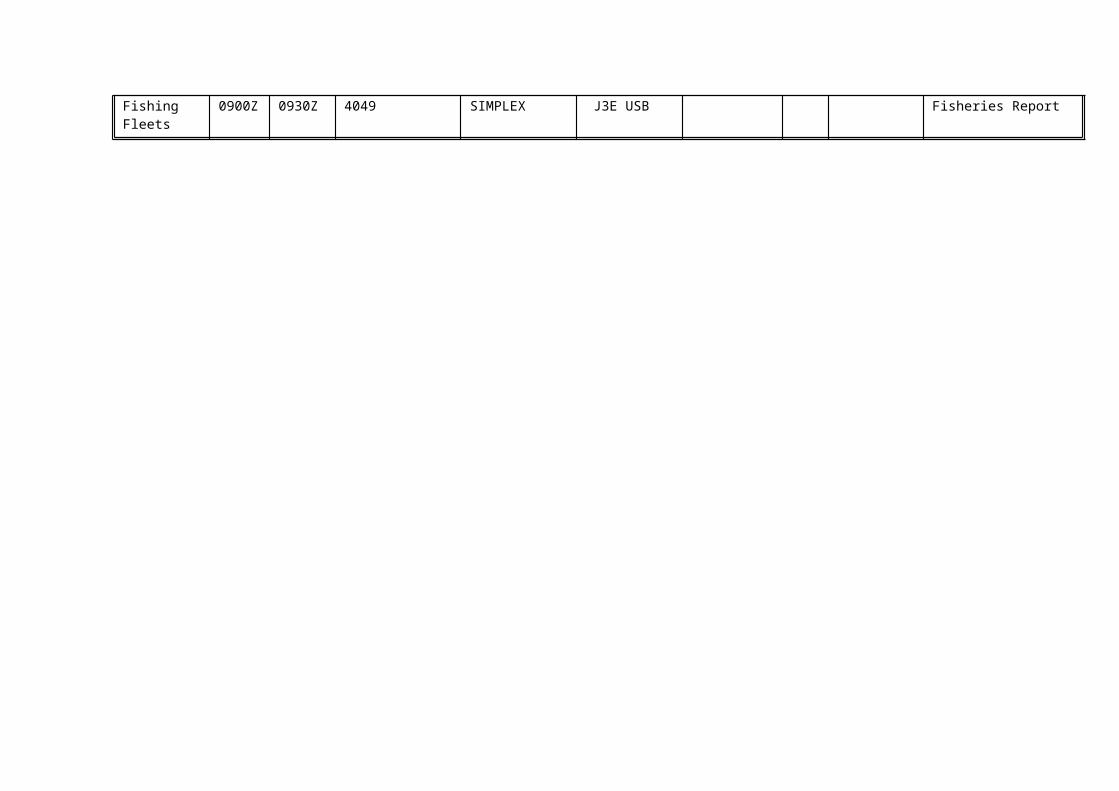
CRUISE JR100
Contact point : Martin Collins, British Antarctic Survey
Project Title: Mesopelagic fish Location - See chart
Personnel : PSO M Collins + 23 science staff
Dates : Early March 2004
Background and Aim: Lanternfish (Family Myctophidae) are the dominant mesopelagic fish of the world's oceans, where they play an important role in oceanic food-webs and in cycling carbon from the surface to deeper waters. They are vertical migrants, typically migrating from deep waters during the day to near the surface at night. In the Southern Ocean myctophids potentially play a key role as predators of macro-plankton such as krill and as prey of higher predators such as king penguins and fur seals. Data from fur seals at Bird Island indicates that myctophids are particularly important in the diet of fur seals late in the summer season, during which time the seals are principally foraging in the area between South Georgia and Shag Rocks. The aim of cruise JR100 is to characterise the vertical and horizontal distribution of fish in an area between the Shag Rocks and South Georgia shelves, and relate fish distribution to the physical oceanography of the region and the foraging behaviour of fur seals.
The cruise: The cruise will last 26 days, including mobilisation and demobilisation. The main work will focus on the ecology of mesopelagic fish, but the cruise will also undertake the end of season survey of the western core box to determine krill biomass and service the acoustic moorings, which are part of an AFI project.
The distribution of fish will be determined using a combination of ship-board acoustics and trawling. A broad acoustic survey will be undertaken with a series of 10 parallel tracks, with netting focussing on three of the legs. Mesopelagic fish will be sampled with a 25 m2 rectangular midwater trawl (RMT 25) and with a scientific pelagic otter trawl (IGYPT). Sampling will focus on four depth bins (0-100 m; 100-400m; 400-700m & 700-1000m) and will be undertaken throughout the 24 hr period to determine diurnal patterns of vertical distribution. The oceanography of the area will be charcterised using CTD and XBT drops. The prey of the different myctophids will be determined from stomach contents analysis and biomarkers, such as fatty acids. The potential prey of myctophids will be sampled using a Longhurst-Hardy Plankton Recorder. The vertical distribution of myctophids will be related to the physiological characteristics of the fish, such as enzyme activities and visual capabilities.
The three dimensional distribution of foraging fur seals will be obtained from satellite tags and time depth recorders fitted to breeding fur seals at Bird Island, and the cruise will focus on areas known to be hotspots of fur seal foraging activity. In addition fur seal distribution data will be supplemented with at sea observations.

CRUISE JR101
Contact point: Carol Robinson, Plymouth Marine Laboratory ([email protected])
Project Title/Location: The Atlantic Meridional Transect Programme (www.amt-uk.org )
Personnel : C Robinson + 25 science staff
Dates: April/May 2004
The Atlantic Meridional Transect Programme (AMT) is a NERC funded project which aims to quantify the nature and causes of ecological and biogeochemical variability in the planktonic ecosystems of the Atlantic Ocean, and the effects of this variability on the biological C pump and on air-sea exchange of radiatively active gases and aerosols. The programme continues a series of 12 bi-annual transect cruises between the UK (50oN) and the Falkland Islands (52oS) which took place between 1995 and 2000 making measurements of hydrographic and bio-optical properties, plankton community structure and primary production. Six further cruises will take place between 2003 and 2005 to provide a unique decadal time series of spatially extensive observations on the structure and biogeochemical properties of planktonic ecosystems. The project will allow 45 investigators from 6 partner UK institutions to test nine inter-related hypotheses which fall within the following three scientific objectives :
* To determine how the structure, functional properties and trophic status of the major planktonic ecosystems vary in space and timeThe first three hypotheses strive to address the question of linking plankton biodiversity with variability in biogeochemical fluxes, in particular the potential for carbon export to the deep sea and ocean / atmosphere exchange of carbon dioxide. A fourth hypothesis will develop and validate models and empirical relationships to enable the use of remote sensing to interpolate in time between the two AMT sampling periods per year and to extrapolate in space from the single track of in situ samples to the basin scale.
* To determine the role of physical processes in controlling the rates of nutrient supply, including dissolved organic matter, to the planktonic ecosystemHypothesis 5 and 6 deal with the physical supply of nutrients on two space and time scales. The programme will derive an indication of lateral transport of nutrients from upwelling regions into the gyres as well as validating models which predict the impact of atmospheric forcing functions on nutrient supply mechanisms.
* To determine the role of atmosphere-ocean exchange and photo-degradation in the formation and fate of organic matterHypothesis 7 assesses the impact of atmospheric input of nutrients such as inorganic nitrogen and iron, and hypothesis 8 will further investigate the link between the production of radiatively important gases and plankton community structure with a view to improving basin scale estimates of the fluxes of CO2, DMS, N2O and CH4. Finally hypothesis 9 will determine the magnitude and variability of the photodegradation products of coloured dissolved organic matter.
June 2003 [JR90] and aimed to compare and contrast the functioning of the plankton in the North and South Atlantic Gyres. [JR91] Sept 2003 sampled the upwelling regions off the coast of NW Africa and repeating the transect of the South Atlantic Gyre from the equator southwards.

AMT14 (JR101) will follow a track similar to that of AMT12 (but travel further into the N Atlantic gyre. The aim of the cruise is to assess the transport of nutrients into the N Atlantic Gyre and compare the plankton functioning of the North and South gyres. The cruise track will therefore follow the same track from the equator southwards in order to collect a time series of data in the southern gyre. The cruise participants and methodologies used will reflect the focus on nitrogen, phosphorus and carbon cycling, and more time will be allocated to staying on station in order to deploy Stand Alone Pumps (SAPS), collect deep water samples and deploy instruments to measure nutrient supply across the thermocline.
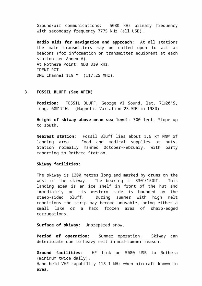
CRUISE JR103
Project Title/Location: Swath Bathymetry, Topas and Magneticsurvey on the South Georgia shelf margins.
Personnel : Peter Morris, British Antarctic Survey
Dates : January 2004
Geophysical Survey: The target areas for the survey sites of major earthquakes in 2001 and it is hoped that there may be signs of recent tectonics visible on the seafloor which will give evidence of the way in which the northern margin of the Scotia Plate is currently being deformed. In addition area 1 could contain magnetic anomalies dating from the earliest period of the currently active East Scotia plate spreading system which would shed light on how and when spreading was initiated. Area 3 is a zone of huge mudwaves where the Antarctic circumpolar current flows along the South Falkland Trough. Earlier conventional bathymetric surveys have failed to image these properly but with swath bathymetry this should not be a problem and the information will cast light on current flow and sediment transport and deposition in the area.
Methods: Swath Bathymetry , using the Simrad EM120 system, Sub Bottom Profiling using Topas and Magnetometry using the towed Marine Magnetics SeaSpy Overhauser magnetometer.

CRUISE JR104
Contact point: Rob Larter, British Antarctic Survey
Project Title/Location: Glacial-interglacial changes in the lost drainage basin of the West Antarctic Ice Sheet (AFI 4/17)/Bellingshausen Sea
Personnel: Rob Larter + 3 BAS science staff + 3 Scott Polar Research Institute Science Staff
Dates: late January to mid-February 2004
Summary/Logistics: We will image the sea floor on the continental shelf and slope using the multibeam echo sounder and sub-bottom profiler. These data will be used to select 20 sites at which we will collect gravity cores and box cores. We will also collect multibeam echo sounder, sub-bottom profiler and magnetic data on passage to and from the Bellingshausen Sea.
Equipment: Standard to the JCR, except: coring equipment (newly purchased from AFI award) and towed magnetometer (provided by GSD)
Samples: Gravity cores up to 6 m long and 0.3 m x 0.3 m box cores will be collected from 20 sites.
Science plan: The history of the major glacial systems draining >40% of the area of the West Antarctic Ice Sheet towards the Pacific Ocean remains virtually unknown. However, available data suggest that a very dynamic glacial system in the Bellingshausen Sea probably drained >300,000 km2 of the ice sheet, making it an important region for investigation of glacial-interglacial changes. We propose the first systematic investigation of this glacial system using sediment cores and the new state-of-the-art marine sonar systems on RRS James Clark Ross. The results will allow us to address questions about the timing and rate of grounding line retreat from the continental shelf, the dynamic characteristics of the ice that covered the shelf, and its influence on glaciomarine processes on the adjacent continental slope.
Location map of area of interest. Inset shows existing seismic (dotted lines) and acoustic (thin lines) profiles overlaid on free-air gravity field in marine part of area. Bold lines A and B show locations of profiles that define the flanks of a 150 km-wide trough on the outer shelf. Thin dashed lines indicate inferred flanks of trough. Shelf break (SB) and 1500 m contour positions (thick dashed lines) reveal that the broad, lobate gravity high on the continental margin is due to the presence of a trough-mouth fan.

CRUISE ES05
Contact point : Keith Nicholls, British Antarctic Survey
Project Title: XBT casts from Ernest Shackleton
Location: Weddell Sea
Personnel : R Salmon
Dates : Dec 2003
2003-04 season
This work is a continuation of the Ten Degrees West XBT section that has been conducted since late 1998. The aim is to do XBT casts between 65°S and the coast, along 10°W, so far as the sea ice conditions will allow. This line passes through the location of the Weddell Polynya of the mid-1970's, and the time series will provide a valuable archive for when the next polynya occurs.
Dr Rhian Salmon, PSD, will be the managing the work on board. The POC at BAS HQ is Keith Nicholls. A cast will be made approximately every degree of latitude, with the frequency raised somewhat as the continental shelf break is approached in an attempt to capture the structure of the coastal current.
Four cartons of T7 XBTs (48 in total) have been loaded on the ship. A launch requires the ship to slow to 5-7 knots, or even to stop if floes are likely to snag the XBT wire.

CRUISE ES07
Contact point : Keith Nicholls, British Antarctic Survey
Project Title: Halley Lifetime Study
Location: Weddell Sea
Personnel : K Hayes
Dates : Dec 2003
2003-04 season: The aim of this work is to recover moorings originally deployed during the 2002-03 field season on the RISOC cruise. The three moorings arrayed around the ice shelf constitute an element of the Halley Lifetime Study, and will help determine the oceanographic stresses on the ice shelf.
Keith Nicholls is the BAS HQ point of contact. Kathy Hayes will be the scientist in charge of the moorings recovery on board. An acoustic command unit (already loaded on Shackleton) will be used to trigger the acoustic releases. The locations of the moorings (B1, B2 and B3) are:
Position Depth Ice front range and bearingB1: S75° 27'.911 W26° 50'.477 228 m 900 m at 053°B2: S75° 43'.268 W27° 16'.603 301 m 2600 m at 071°B3: S75° 48'.734 W26° 51'.953 329 m 2000 m at 070°
Once recovered, the instruments will be washed down, dismantled and stored in wooden cases (already loaded on Shackleton).

ANNEX XI
NOTICE OF PERMITS ISSUED IN ACCORDANCE WITH THE ANTARCTIC ACT 1994
a) Notice of permits issued for activities under Section 3 of the Antarctic Act 1994 (British Expeditions)
Permit No. S3-01/2003: Mrs Polly Vacher of Gilbournes Farm, Drayton, Abingdon, UK to circumnavigate globe over Antarctica. Valid between 15 October 2003 – 15 February 2004.
Permit No. S3-02/2003: Mr David Wevill of York University, York, United Kingdom to carry out air monitoring. Valid between 1 October 2003 – 31 February 2004.
Permit No. S3/4-01/2003: Mr Nicholas Sanders of the Falkland Islands Government to investigate death of British Antarctic Survey scientist. Valid between 5 August – 30 August 2003.
Permit No. S3-05/2003: Sir Ranulph Fiennes Bt of Greenlands, Exford, Somerset, UK to run a marathon. Valid between 23-27 October 2003.
b) Notice of permits issued under Section 5 of the Antarctic Act 1995 (British vessels, aircraft and hovercraft entering Antarctica)
Aircraft
Permit No. S5-01/2003: Issued to Mrs Polly Vacher of Gilbournes Farm, Drayton, Abingdon, UK authorising a Fixed wing single engine Piper Dakota PA28-236 to enter Antarctica between 15 October 2003 - 28 February 2004.
Permit No. S5-02/2003: Issued to British Antarctic Survey authorising a Fixed wing multi engine DHC-7 aircraft to enter Antarctica between 5 August – 30 August 2003.
Permit No. S5-03/2003: Issued to British Antarctic Survey authorising Two (x2) Fixed wing twin engine DHC-6 aircraft to enter Antarctica between 5 August – 30 August 2003.
Permit No. S5-06/2003: Issued to British Antarctic Survey authorising Four (x4) Fixed wing multi-engine DHC-6 aircraft to enter Antarctica between 1 October 2003 – 30 April 2004.
Permit No. S5-07/2003: Issued to British Antarctic Survey authorising a Fixed-wing multi-engine DHC-7 aircraft to enter Antarctica between 1 October 2003 – 30 April 2004.
Vessels
Permit No. S5-04/2003: Issued to British Antarctic Survey authorising the RRS Ernest Shackleton to enter Antarctica between 26 November 2003 – 28 April 2004.
Permit No. S5-05/2003: Issued to British Antarctic Survey authorising the RRS James Clark Ross to enter Antarctica between 25 October 2003 – 23 April 2004.
Permit No. S5-12/2003: Issued to Jérôme Poncet of Golden Fleece Limited, Beaver Island Falkland Islands authorising the Golden Fleece to enter Antarctic between 1 February – 1

March 2004.
c) Notice of permits issued under Section 6 of the Antarctic Act 1994 (Mineral resource activities).
Permit No. S6-01/2003: Issued to Dr John Smellie of British Antarctic Survey authorising rock and fossil sampling between 1 January – 31 March 2004.
Permit No. S6-02/2003: Issued to Dr Neil Stevenson of British Antarctic Survey authorising rock sampling between 14 November 2003 – 12 February 2004.
Permit No. S6-03/2003: Issued to Dr John Bursnall of British Antarctic Survey authorising rock sampling between 1 November 2003 – 1 March 2004.
Permit No. S6-04/2003: Issued to Dr Robert Larter of British Antarctic Survey (Antarctic Funding Initiative) authorising gravity core sampling between 1 January – 29 February 2004.

ANNEX XIIWASTE MANAGEMENT REPORT FOR PERIOD
1 OCTOBER 2002 TO 30 SEPTEMBER 2003
PART 1 GENERAL
Country: United Kingdom
Waste Management Official: Mr Rod Downie
Job Title: BAS Environmental Manager
Postal Address: British Antarctic SurveyHigh Cross, Madingley RoadCambridge, CB3 0ET, UK
Telephone Number: 01223 221248
Facsimile Number: 01223 362616
Electronic Mail Number: [email protected]
PART 2 TRAINING OF EXPEDITION MEMBERS
1) Is training given to expedition members on waste management:
prior to leaving for Antarctica? [Y] [ ]
Briefings given at annual introductory conferencesfor new personnel.
while in Antarctica? [Y] [ ]
Briefings and hands-on training given for on site procedures and equipment on board BAS vessels and at BAS research stations
Written material available [Y] [ ]
(i) BAS Waste Management Handbook(ii) Station and field camp waste guidelines (iii) Notices on research stations and ships(iv) BAS Environmental protection leaflet
2) Are expeditions advised of any PVC products being provided? [Y] [ ]
The BAS discourages the use of PVC products and only uses them when there is no practical alternative. Details of products where the major constituent is PVC are supplied to each research station.
3) Are expeditions advised that pesticides, polychlorinated biphenyls (PCBs), [Y] [ ]non-sterile soil or polystyrene beads, chips or similar forms of packaging shall not be sent to Antarctica?
A section of the BAS Waste Management Handbook and the BAS Participants Handbook deals with prohibited products. The Logistics Purchasing Section of BAS makes every effort to prevent such products from being sent to Antarctica. The BAS packaging guidelines stipulate that polystyrene beads or chips must not be used as packaging material for goods being sent to Antarctica.

PART 3 WASTE MANAGEMENT PLANS FOR EACH FIXED SITE, FIELD CAMPS GENERALLY, AND FOR EACH SHIP.
1) Current and planned programmes for cleaning up existing waste disposal sites and abandoned work sites:
Existing waste disposal sites and abandoned work sites
i) Removal of the waste dump at Fossil Bluff successfully undertaken during 2002/03 season.
ii) Survey of abandoned bases at Danco Island, Detaille Island and Prospect Point carried out during 2002/03 season., with their removal planned for 2003/04 season.
iii) Minor repair works carried out at Stonnington Island during 2002/03
iv) Further work undertaken on a Conservation Strategy for Whalers Bay, Deception Island. Minor clean-up work planned for 2003/04 season.
v) Maintenance work carried out at Port Lockroy during 2002/03. Base operated by BAS with guidance from the UK Antarctic Heritage Trust and the UK Foreign and Commonwealth Office.
2) Current and planned waste management arrangements, including final disposal:
i) Biodegradable wasteSewage, wet food waste, bones and grey water are disposed of on site and are not returned from Antarctica. A sewage treatment plant was commissioned at Rothera during 2002/03 season.
ii) General non-hazardous wasteMetal, glass, plastics, paper and wood are taken by BAS ships to the Falkland Islands where a contractor disposes of them properly and safely to landfill. Waste oils and fuel are also taken to the Falkland Islands and used as heating oil. Empty fuel drums produced by BAS are reused by the major fuel supplier on the Falkland Islands.
iii) Hazardous and recyclable wastesAll hazardous and some recyclable wastes are returned to the UK where they are properly and safely disposed of by specialist contractors. Hazardous wastes are disposed of in a number of ways including high temperature incineration and controlled landfill. The UK Environment Agency is notified of all movements of BAS hazardous wastes when BAS vessels reach UK. Drinks cans, lead acid batteries, and photochemicals are recycled by specialist contractors. BAS is currently investigating returning paper, cardboard and plastics for recycling in the UK.
3) Current and planned arrangements for analysing the environmental effects of wastes and waste management:
i) Current environmental monitoring programme
The incidence of marine debris found at Bird Island and Signy.The entanglement in marine debris of Antarctic fur seals, and the ingestion of marine debris, particularly fishing hooks, by seabirds at Bird Island.Monitoring of the sewage treatment plant at Rothera planned for 2003/04.Audit of waste management at Rothera planned for 2003/04Independant Environmental observer from Antarctica New Zealand will audit the removal and clean-
up of the old bases at Detaille, Danco and Prospect Point.
4) Other efforts to minimize any environmental effects of wastes and waste management:
i) Rod Downie, BAS Environmental Manager, undertook an examination of waste management procedures at Halley, Signy, and onboard the RRS Ernest Shackleton during 2002/03
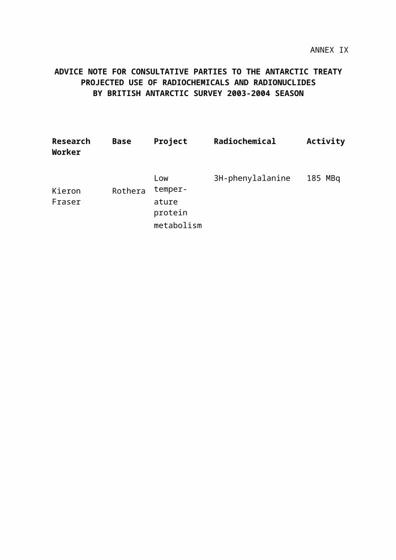
ii) Orwak ‘in-drum’ compactor was installed at Halley during the 2002/03 season.