Embed Size (px)
Citation preview
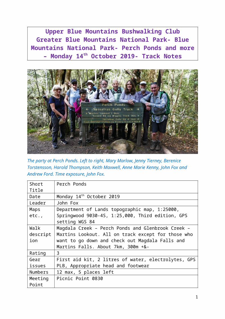
Upper Blue Mountains Bushwalking ClubGreater Blue Mountains National Park- Blue Mountains
National Park- Perch Ponds and more – Monday 14th October 2019- Track Notes
The party at Perch Ponds. Left to right, Mary Marlow, Jenny Tierney, Berenice Torstensson, Harold Thompson, Keith Maxwell, Anne Marie Kenny, John Fox and Andrew Ford. Time exposure, John Fox.
Short Title Perch PondsDate Monday 14th October 2019Leader John FoxMaps etc., Department of Lands topographic map, 1:25000, Springwood 9030-4S,
1:25,000, Third edition, GPS setting WGS 84Walk description
Magdala Creek – Perch Ponds and Glenbrook Creek – Martins Lookout. All on track except for those who want to go down and check out Magdala Falls and Martins Falls. About 7km, 300m +&-
Rating 3Gear issues First aid kit, 2 litres of water, electrolytes, GPS PLB, Appropriate head and
footwear Numbers 12 max, 5 places leftMeeting Point
Picnic Point 0830
Transport Club carsBookings Contact leaderEnquiries John Fox email [email protected]
The Party
John Fox, leader, Michael Keats, Keith Maxwell, Andrew Ford, Jenny Tierney, Mary Marlow, Harold Thompson, Anne Marie Kenny and Berenice Torstensson. 9.
1
The Weather
A cool start developing into a warm humid day. Variable cloud cover. Temperature range 11 to 22 degrees C.
Local Place Names
Fishing Pool, The was an alternate name for Perch Ponds on Glenbrook Creek, Blue Labyrinth. Ref: Blue Mountains Daily, 24 March 1939, p. 4 records, “track leads down stream to Martin’s Lookout The first pool is popularly known as the Fishing Pool.” S 748 649.
Perch Ponds is a series of waterholes near the junction of Magdala Creek and Glenbrook Creek, Springwood. Named after the native perch which used to be found in this creek. Ref: Blue Mountain Echo, 20 November 1909, p. 8. Melville, Ninian. One Day Walking Tours, 1938. The Blue Mountains Daily, 10 March 1939, p. 4 records that several natural waterholes in this area were referred to as Perch Ponds. Also known as The Fishing Pool. S 748 649.
Magdala Creek is a perennial creek (in the lower reaches) rising on the southern side of the Blue Mountains Range near Springwood Railway Station, Springwood. It flows for 4km through Fairy Dell, over Magdala and Martins Falls, generally south, and into Glenbrook Creek. Named after the Parish of Magdala. Magdala and Coomassie (the parish adjoining) were the names given to British Battle Campaigns in Africa. Magdala is a locality in Ethiopia and Coomassie a town in Ghana. Ref: Springwood topographic map 1st edition, 1969. S 743 684 to 747 649.
Magdala Falls are within Magdala Creek, 700m upstream from the junction of Glenbrook Creek, Springwood. Named after Magdala Creek. The pool at the base of these falls is called the Blue Pool. Ref: Melville. Ninian. One Day Walking Tours, 1938 records, “Upper Falls.” The Lower Falls on this map refers to Martins Falls. Springwood topographic map, 1st edition, 1969. Geographical Names Board Minutes, 18 September 1969 recommends the name “Magdala Falls.” S 749 654.
Martins Falls are within Magdala Creek, Springwood. Located 400m upstream from the junction of Glenbrook Creek and 250m downstream of Magdala Falls. Named after Sir James Martin (1820-1886), Premier of NSW for three terms spanning the period 1863-1872. Ref: Melville, Ninian. One Day Walking Tours map, 1938 records, “Lower Falls.” Geographical Names Board assigned, 28 November 1969. S 750 652.
Martins Lookout is located on the top of the escarpment, at the southern end of Farm Road, Springwood. Named after Sir James Martin (1820-1886), Premier of NSW for three terms spanning the period 1863-1872, who owned extensive holdings of land in this area (1870s). Martin Place, Sydney is also named after him. A plaque at the lookout reads, “The Cross opposite. Was erected to honour the memory of Rev. Br. G. E. Raymer. (Christian Brother) Who often led hiking parties through the valleys in this district. He was drowned at Wollongong 25.7.53 in an endeavour to rescue a pupil." The Cross opposite refers to the white cross at Lost World Lookout. Ref: Nepean Times, 10 June 1899, p. 8 records, Martin’s View.” The Nepean Times, 24 August 1901, p. 4 records, “Martin’s Look-out…one of the prettiest places in the district.” S 754 646.
2
Glenbrook Creek rises on the eastern side of the junction of the Blue Mountains Range and Woodford Range, Woodford. This perennial creek flows for 17km generally east and south east into the Nepean River, north east of Mount Portal. Named by Sir John Jamison (1776-1844), 15 November 1818 as Glen Brook, as he assumed incorrectly the brook originated from the Glen (Prince Regents Glen). Ref: Survey Plan E5.788, dated 5 April 1833 records, “Glen Brook.” Andrews, Alan. Major Mitchell’s Map 1834 The Saga of the Survey of the Nineteen Counties, 1992, p. 204 records, Assistant Surveyor Rusden’s entry, 1831 as, “Glen brook.” Maps and plans after these dates show the creek name as Glenbrook Creek. K 674 644 to P 816 597
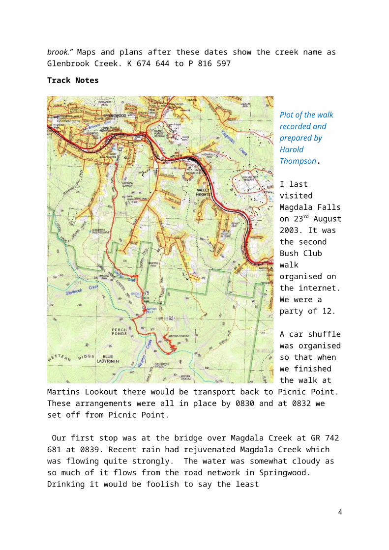
Track Notes
Plot of the walk recorded and prepared by Harold Thompson.
I last visited Magdala Falls on 23rd August 2003. It was the second Bush Club walk organised on the internet. We were a party of 12.
A car shuffle was organised so that when we finished the walk at Martins Lookout there would be transport back to Picnic Point. These arrangements were all in place by 0830 and at 0832 we set off from Picnic Point.
Our first stop was at the bridge over Magdala Creek at GR 742 681 at 0839. Recent rain had rejuvenated Magdala Creek which was flowing quite strongly. The water was somewhat cloudy as so much of it flows from the road network in Springwood. Drinking it would be foolish to say the least
3
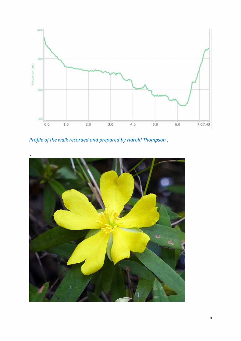
Profile of the walk recorded and prepared by Harold Thompson.
.
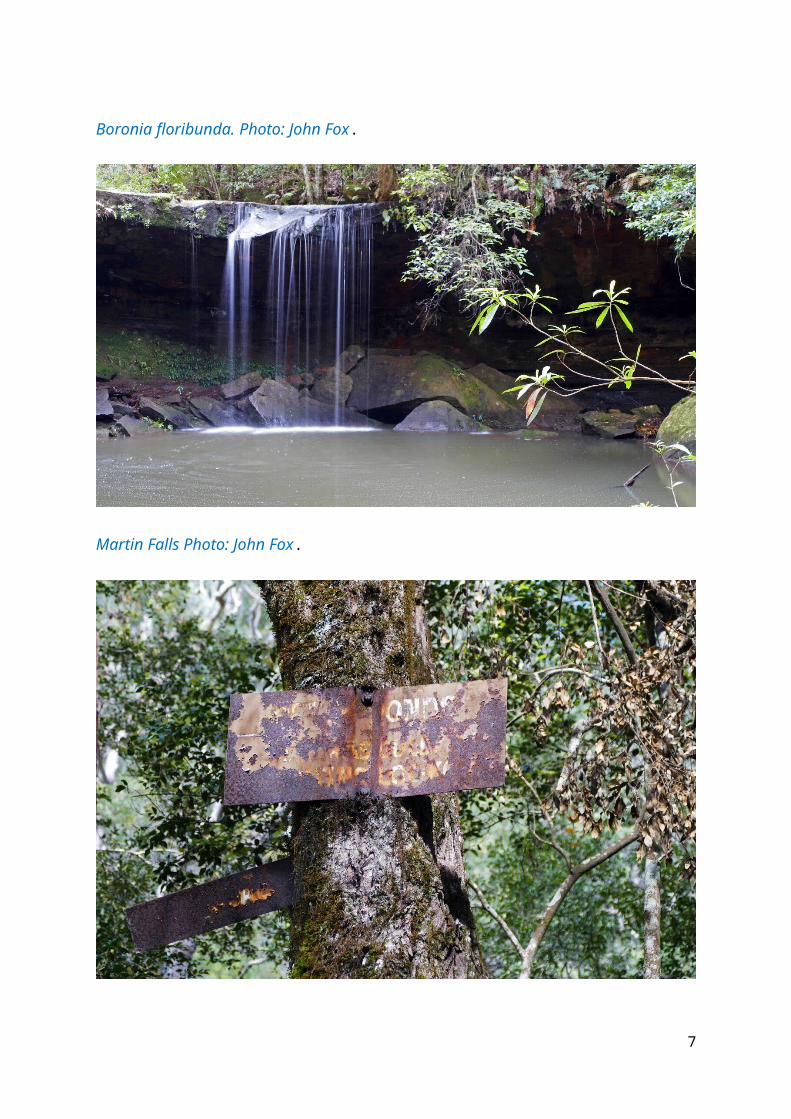
Hibbertia linearis. Photo: John Fox
4
Crossing Magdala Creek. Photo: John Fox.
Boronia floribunda. Photo: John Fox.
5
Martin Falls Photo: John Fox.
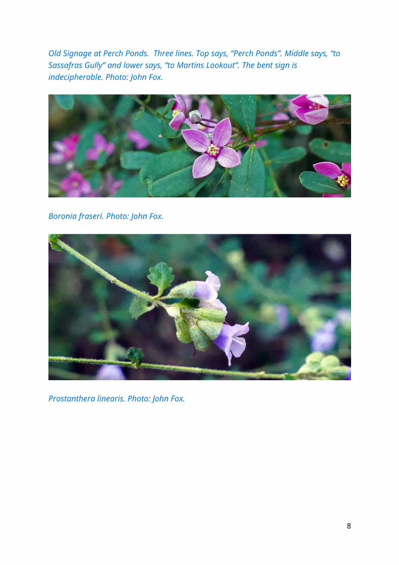
Old Signage at Perch Ponds. Three lines. Top says, “Perch Ponds”. Middle says, “to Sassafras Gully” and lower says, “to Martins Lookout”. The bent sign is indecipherable. Photo: John Fox.
6
Boronia fraseri. Photo: John Fox.
Prostanthera linearis. Photo: John Fox.
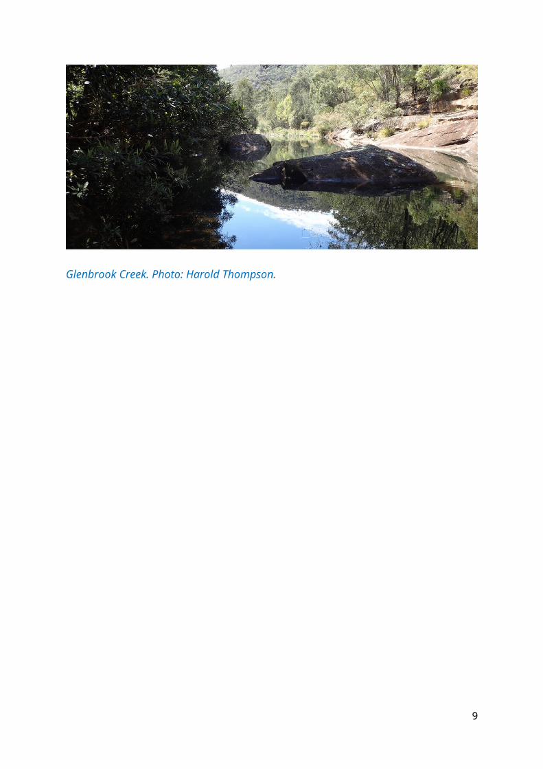
Glenbrook Creek. Photo: Harold Thompson.
7
Eastern Water Dragon, in Glenbrook Creek Physignathus lesueurii Photo: John Fox
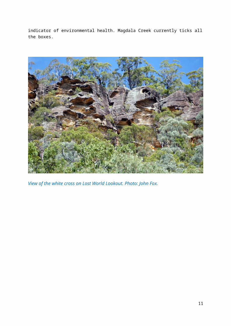
An interesting observation was made as we progressed downstream. At 0850, GR 743 677 the creek disappears underground. When it emerges it is much cleaner, so much so that the local frog population was in full voice. Frogs are very sensitive to pollutants and a good indicator of environmental health. Magdala Creek currently ticks all the boxes.
8
View of the white cross on Lost World Lookout. Photo: John Fox.
9

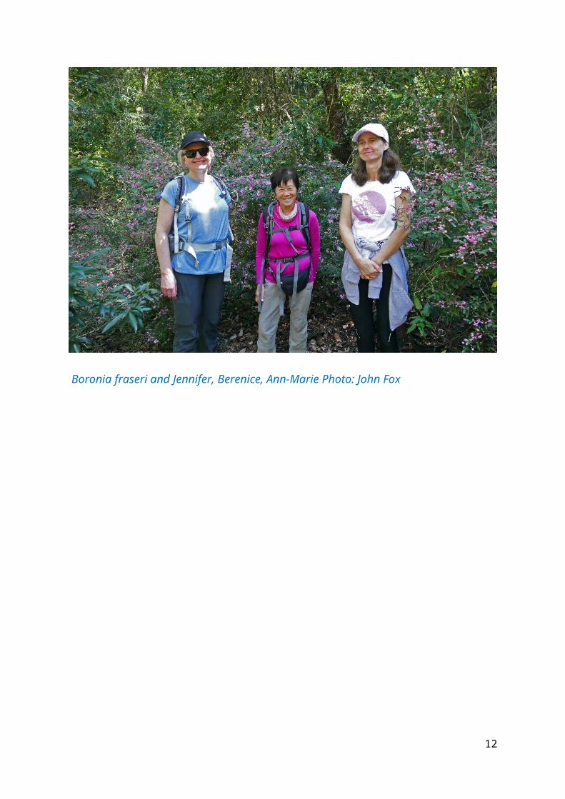
Boronia fraseri and Jennifer, Berenice, Ann-Marie Photo: John Fox
Dodonea triqueta. Photo: John Fox.
10
Historic plaque at Martins Lookout, Photo: John Fox.
The Magdala Track is a very old one, possibly constructed in the late 19th century. In the 21st century, the track is a shared responsibility between the Blue Mountains City Council and the NPWS. Currently the section which is BMCC responsibility is in much better condition.
The track which closely follows and cross the creek many times is set in dense rainforest. The dominant species if the Grey Myrtle, Backhousia myrtilifolia, closely followed by Turpentine trees, Syncarpia glommulifera. Coachwood Trees and Sydney Redgums Angophora costata are also common. Spring flowers were very late in 2019 and many Boronia species were just coming into full bloom now some 8 weeks later than normal.
At 1008 signage to Magdala Falls some 30m away was noted. GR 749 654. We did not attempt to visit as the water flow was poor and the vegetation obstruction very dense.Only a short distance further down the track is signage to Martins Falls which are basically trackside. The falls were in full spate and the pool below was brimming with dark blue water. Making a very attractive setting for morning tea, 1015 to 1037, GR 749 653.
Refreshed we kept on pushing south and at 1043 arrived at the Perch Ponds, GR 747 650 which is also the junction with Glenbrook Creek. This is also a track junction for walkers wanting to go to Sassafras Gully or to Martins Lookout. The area is still used occasionally for camping although it is so close to Springwood that it would hardly be necessary. Perch from which the ponds derive their name have long ago disappeared through a combination of overfishing and upstream pollution.
11
Moving along we had a choice of two options to exit to Martins Lookout. A shorter track takes off at 742 657. This old track is poorly maintained and much steeper than the one we followed.
As we walked along Glenbrook Creek, the pools became larger deeper and more frequent. At 1120 we arrived at a well-used swimming hole, GR 755 643. While admiring this large body of water we disturbed a very large Eastern Water Dragon, Physignathus lesueurii. busy sunning itself. Frightened, it leapt into the pool and then partly emerged within the protection of a rock crevice. John Fox captured a great image, see page 8.
Nearby this location there is a good view of the White Cross near the Lost World Lookout. The Cross was erected to honour the memory of Rev. Br. G. E. Raymer. (Christian Brother) Who often led hiking parties through the valleys in this district. He was drowned at Wollongong 25.7.53 attempting to rescue a pupil.
At 1130 we began the ascent from Glenbrook Creek to Martins Lookout. It took me till 1204 to reach the top and the lookout platform., GR 754 646. The others had been a bit faster. Total distance walked 7.95km and total ascents 320m.
Michael KeatsBushexplorers17th October 2019
UBMBWC Perch Ponds 141019-Track Notes/MK
12


![Beyond SQLite & Core Data - YOW! Conference...Core Data CouchBase Lite YapDatabase LevelDB Awesome Crap Cost of Abstraction CBLQuery *query = [[self.database viewNamed:@"tags"] createQuery];](https://img.pdfslide.us/doc/110x75/60cba3018cf4c605b508f49c/beyond-sqlite-core-data-yow-conference-core-data-couchbase-lite-yapdatabase.jpg)