Embed Size (px)
Citation preview
NAME: ___________________________________________________
Each exam is a new chance to do well. Are you ready to show what you know? What are you going to do to prepare yourself for this exam that you didn’t do the first time?
Now that you know what the exams will be like, you can focus on doing what you need to do to do well. Did you spend too long on the multiple choice last time? Were the FRQs your trouble area? Know where you are weak and focus on those places. Our job all year is to focus on your weak areas so by the time the AP exam rolls around in May, your weak areas will be strengths.
Hydrosphere (Video 2.1 Hydrosphere Basics due ___________) (Textbook Pages 80-81, 293-300)1. Water covers / 71 percent of the Earth’s surface. 97 percent is salt water. Glaciers and polar ice caps
account for 2 percent of frozen inaccessible drinking water. Out of the remaining 1 percent less than half is accessible freshwater in the form or streams, lakes, and groundwater.
2. Hydrologic Cycle / continuous cycle that moves water through atmosphere, on surface of earth, below surface powered by the sun’s energy and gravity (know all steps in diagram 1)
a. Evaporation / liquid changes to gas at temp below boilingb. Transpiration / process through which plants give off water vapor through leavesc. Condensation / process where gas changes to liquid (cloud formation)d. Precipitation / water that falls from clouds in form of rain, snow, sleet, haile. Runoff / water that falls as precipitation on surface & flows over surface to water bodies; surface
movement of waterf. Infiltration (aka Percolation) / movement of water through soil
3. Aquifer (Zone of Saturation) / any underground layer of porous rock in which water collects4. Most of LI gets its water from / the groundwater and it is called the Magothy aquifer (diagram 3)5. Ogallala Aquifer / world’s largest aquifer; under parts of Wyoming, South Dakota, Nebraska, Kansas,
Colorado, Oklahoma, New Mexico and Texas. Hold enough water to cover the U.S. with 1.5 feet of water. Being depleted for agricultural and urban use
6. Watershed or Drainage Basin / all of the land that drains into a body of water or aquifer7. Know the different parts of a lake / (diagram 2) (Textbook Page 134)
a. Littoral zone / shallow water along the shore i. most productive zone/filled with aquatic plants, frogs, turtles, worms, insects, fish
b. Limnetic Zone (euphotic) / open water away from shore i. cannot sustain rooted plants but there is much production due to photosynthetic
organisms and contains larger fishc. Profundal Zone / beneath Limnetic: no sunlight & no plants...decomposers release nutrients that
sit there producing mineral rich zone d. Benthic zone / is the bottom of the lake and organisms that live here are dependent of detritus
from the limnetic zone
Unit 2 Atmosphere, Hydrosphere, and Biomes
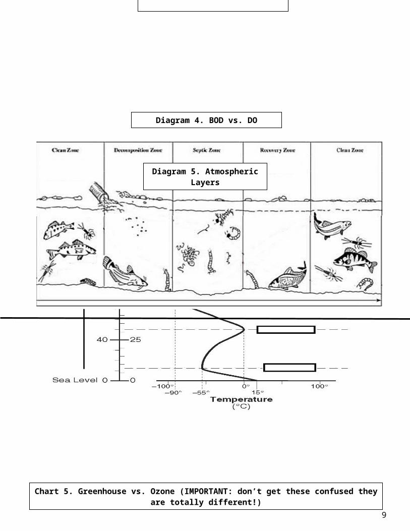
8. Biological Oxygen Demand (BOD) / Water Quality Indicator: the amount of oxygen used by microorganisms in aerobic oxidation (diagram 4)
9. Eutrophic Lakes / mature lakes, poor water clarity, high productivity and biodiversity, which leads to low dissolved oxygen (DO)
10. Oligotrophic Lakes / are typically young, clear, associated with colder climates have high dissolved oxygen (DO), but low productivity
11. Surface Ocean Currents / continuous movement of ocean water, distributes heat from equator toward polar regions; driven by winds (pages 117 – 119)
12. Ocean Global Conveyor Belt (Thermohaline Circulation) / global circulation of water, shaped by differences in temp & salinity takes over a 1,000 years to complete one circulation (pages 117 – 119)
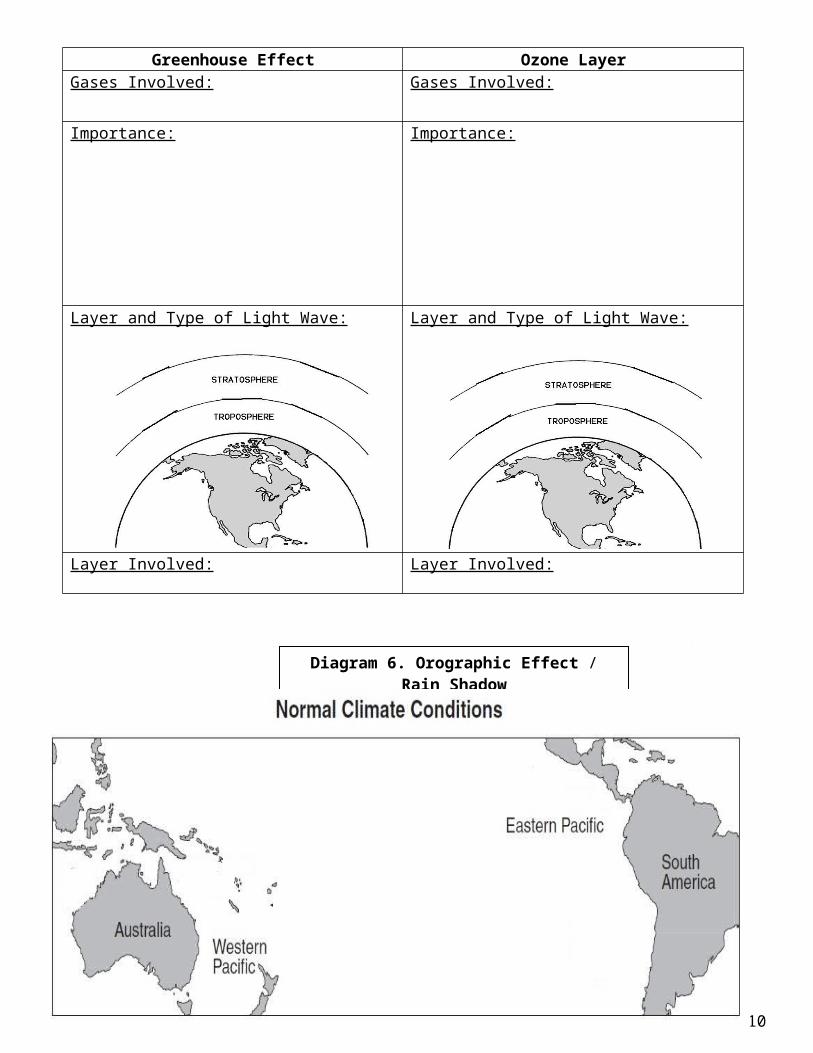
Atmosphere (Video 2.2 Atmosphere Basics due ___________) (Textbook Pages 103-116)13. The atmosphere formed from / outgassing of volcanoes early in Earth’s history (CO2, N2, H2O)14. Troposphere / closest to the Earth’s surface, contains air we breathe and our weather (water vapor).
78% nitrogen, 21% oxygen and small amounts of CO2, methane, water vapor and other trace gases 15. Stratosphere / the layer directly above the troposphere 10 – 30 miles, contains the ozone layer (O3)
which blocks harmful, ionizing UV light (chart 5)a. Ozone Layer / located in the stratosphere helps block most UV light from reaching the surface
of the Earth. UV light is harmful to living organisms, without it life wouldn’t have been able to thrive on land
16. Greenhouse Effect / shorter wave light and UV energy from the sun penetrates the Earth’s atmosphere; some of that radiation is released as longer wave infrared (heat) nitrous oxides, and water vapor. This is a good thing, like a global homeostasis GAIA! (chart 5)
17. Greenhouse Gases / water vapor, carbon dioxide, methane; These absorb infrared radiation emitted by Earth's surface & reradiate some of infrared energy in all directions
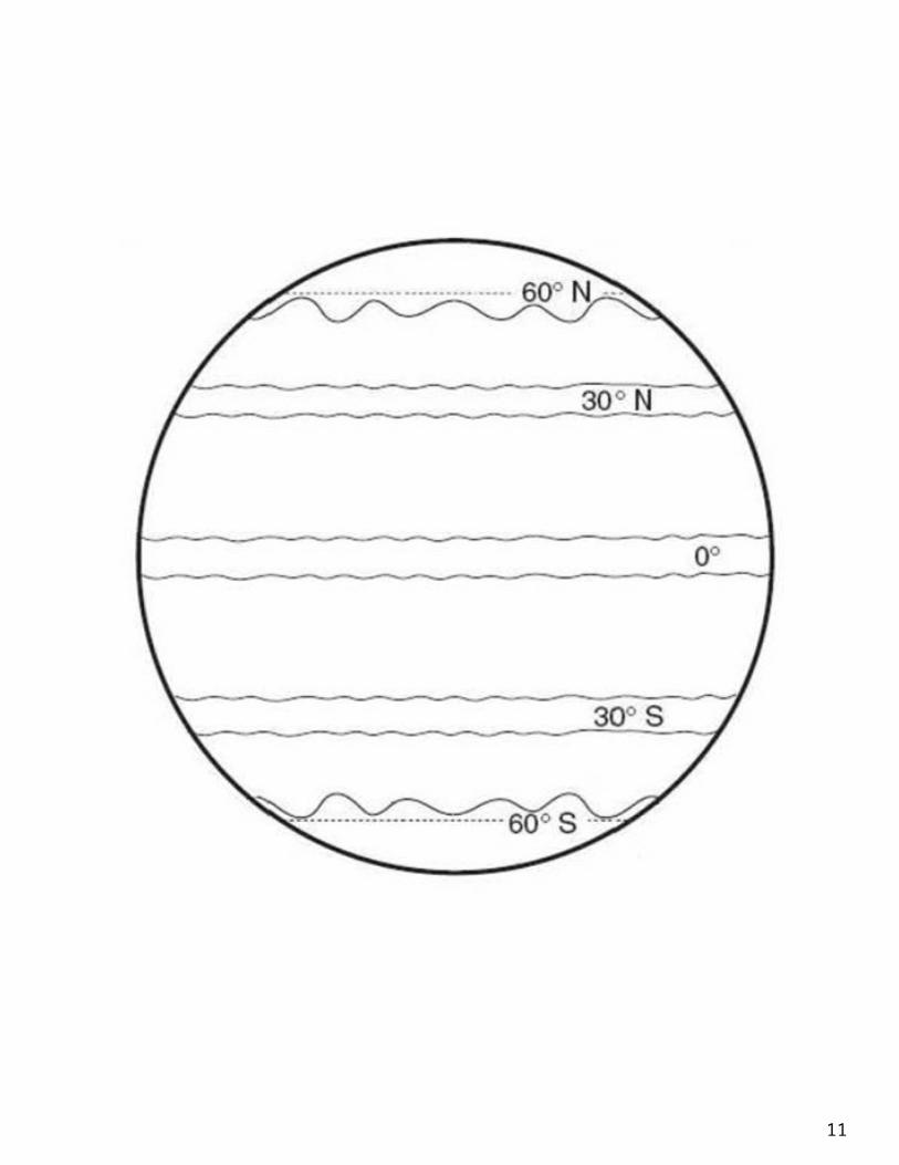
18. Wind is caused by / differences in air pressure H L (caused by the uneven heating of Earth)19. Warm air rises because / it is less dense than cold air! (the molecules are more compact in cold air)20. Clouds form when / warm, moist air rises, expands, cools, & condenses (think the tropics/rainforest)21. High Pressure System / air is sinking, clouds unlikely to form, clear, cool, sunny skies (30°N&S,
90°N&S) this is where Earth’s deserts are located (diagram 9)22. Low Pressure System / air is rising, clouds likely to form, overcast, warmer, rainy weather (0°,
60°N&S) this is where Earth’s rainforests are located (diagram 9)23. Coriolis Effect / Deflection of moving objects, ex. wind and ocean currents, due to Earth's rotation
a. In Northern Hemisphere, objects are deflected to the rightb. In Southern Hemisphere, objects are deflected to the left
24. Hadley Cell / cell that drives air around tropical regions from 0 (wet) to 30 (dry) latitude (diagram 9)25. Ferrel Cell / cell that moves air form 30 (dry) degrees to 60 (wet) degrees latitude (diagram 9)26. Polar Cell / cell that moves air from 60 (wet) degrees to 90 (dry) degrees latitude (diagram 9)
Climate (Textbook Pages 103-116)27. How is climate different from weather? / weather is the short-term atmospheric conditions and climate
is the average temp. & precip. over long time periods, often years or decades 28. The two VARIABLES that make up a regions climate are / 1. temperature and 2. precipitation which
are graphed on a climatograph (you need to be able to read these and tell the type of biome from it)29. As latitude increases / temperature decreases (inversely related) (main FACTOR in climate)
2
a. The poles are cold because / they receive low angle, less direct sunlight (insolation)b. The equator is hot because / it receives high angle, more direct sunlight (insolation)
30. Large bodies of water / moderate temperatures because water has a high specific heata. Marine climate has / cool summers and warm winter (smaller temp. range)b. Continental climate has / cold winter and hot summers (larger temp. range)
31. Orographic Effect or Rain Shadow / as moisture is forced up the mountain it cools and condenses to form clouds and therefore rain. By the time the air reaches the other side of the mountain is lost all its moisture (diagram 8)
a. Windward side / cooler and wetter due to expansion, forests, and more life (low pressure)b. Leeward side / dryer, hotter, desert, less life (rain “shadow” side, high pressure)
32. The seasons are caused by / the tilt of the earth’s axis and the revolution around the suna. If the earth was not tilted / there would be no seasons (more tilt / more extreme seasons)
(Video 2.3 El Nino due ___________) (Chapter 4 Page 120)33. El Nino / trade winds weaken and warm water sloshed back towards South America causes diminished
fisheries off South America, Northern US has mild winters, drought in western Pacific, increased precipitation in southwestern North America, fewer Atlantic hurricanes (diagram 7)
34. La Nina / “extreme normal” year, easterly trade winds and ocean current pool warm water in the western Pacific, allowing upwelling of nutrient rich water off the West Coast of South America
a. ENSO / El Nino Southern Oscillation: See-Sawing of air pressure over the South Pacific35. Why are upwelling’s important to fisheries? / because the cold water bring many nutrients to the
surface, which increases fish populations in that area, fish are food for many organism including feed for our domestic animals (our food system)
Biomes (Video 2.4 Biomes due ___________) (Chapter 4 Pages 121 – 132)36. Biome / large distinct terrestrial region having similar climate (temp. & precip.), soil, plants and animals37. Biomes which Benefit from Fire / evergreen forests, grasslands, and chaparral rely on fire to help some
plants germinate (some pine cones open only when fire is present), remove ground cover to allow more sunlight, and return nutrients back into the soil
38. Tropical Rain Forest / characterized by the greatest diversity of species, believed to include many undiscovered species. Occur near the equator. Soil tends to be low in nutrients. Distinct seasonality: winter is absent and only two seasons are present (rainy and dry). HIGH PRODUCTIVITY!
a. Temperatures are warm year-round, with precipitation daily b. Poor soils: organic matter cannot accumulate, high temperatures foster rapid decomposition c. Most diversity of species of any biome, very high productivity d. Trees form a dense multi-layered canopy, with shallow mat – like roots e. Most varied insects, reptiles and amphibians on earth, mammals such as sloths and monkeys f. Destruction likely by 2030
39. Temperate Deciduous Forests / occur in eastern North America, Japan, northeastern Asia, and western and central Europe. THIS IS LONG ISLAND’S BIOME!!!
a. Hot summers/cold winters (distinct seasons)b. Rich topsoil with deep clay rich layer c. Dominated by broadleaved hardwood trees such as oak, hickory, and beech that are deciduous d. Virgin forest contained large mammals such as puma, wolves, bison
3
e. Now contain bears, deer, small mammals and birds 40. Boreal Forests or Taiga / represents the largest terrestrial biome. Dominated by needle leaf, coniferous
trees. Seasons are divided into short moist, and moderately warm summers, and long, cold, and dry winters. Extensive logging may soon cause their disappearance.
a. In cold regions of Northern Hemisphere adjacent to tundra b. Dominated by conifers c. Large mammals such as caribou, wolves, bear and moose
41. Temperate Shrub Lands or Chaparral / occurs along the coast of Southern California and the Mediterranean region. Characterized by areas of miniature woodlands dominated by dense stands of shrubs.
a. Mediterranean climate: mild winter w/ abundant rainfall, dry summers b. Called Chaparral in North American southwest c. Soil is thin, not very fertile. d. Fires common in summer and fall
42. Savannas / grassland with scattered individual trees. Cover almost half of the surface of Africa and large areas of Australia, South America, and India. Warm or hot climates where the annual rainfall is 20-50 inches per year. The rainfall is concentrated in a six to eight month period of the year, followed by a long period of drought when fires can occur. (ecotone)
a. Herds of hoofed animals (wildebeest, antelope, giraffe, zebra, elephants) b. Large predators: lions and hyenas
43. Temperate Grasslands / Occur in South Africa, Hungary, and Argentina, the steppes of the former Soviet Union, and the plains and prairies of central North America.
a. Summers hot/winters cold: rainfall uncertain b. Rich soil supports grasses affected by periodic wildfires c. Grassland with widely scattered clumps of low trees (Acacia) d. Seasonal rainfall with prolonged dry periods e. Being converted to rangeland and farmland
44. Deserts / covers about one fifth of the Earth’s surface and occur where rainfall is less than 50 cm a year (20 inches a year). Most deserts occur at low latitudes, have a considerable amount of specialized vegetation, as well as specialized animals. Soils have abundant nutrients, need only water to become productive, and have little or no organic matter. LOW PRODUCTIVITY!
a. Major daily temperature changes (very hot during day and can get below freezing at night)b. Plant cover sparse: cacti, yuccas, Joshua trees; plants adapt to conserve waterc. Animals small, remain under cover during the day
45. Tundra / treeless plains that are the coldest of all the biomes. Occur in the Artic and Antarctica. Dominated by lichens, mosses, sedges, and dwarfed shrubs.
a. extreme northern latitudes or high elevationsb. long harsh winters, very short summers c. nutrient poor soils c. permafrost - permanently frozen ground
i. interferes with drainage and prevents roots of larger plants from becoming established d. broad shallow lakes, ponds and bogs therefore lots of mosquitoes and black flies e. regenerates very slowly...just hiking causes damage
46. AQUATIC ECOSYSTEMS (pages 133 – 139)
4
a. Three types of organisms i. Plankton / small or microscopic (phytoplankton & zooplankton)
ii. Nekton / large, swimming (dolphins, whales, tuna)iii. Benthos / bottom dwellers (lobsters, crabs)
47. Freshwater Wetlands HIGH PRODUCTIVITY!a. covered by shallow water for at least part of the year b. is a nursery for many species of fish and other wildlifec. acts a sponge during storms; collecting storm surge and floodsd. purifies water by trapping contaminates like heavy metalse. habitats for migratory waterfowl, beaver, otters, muskrats, fish
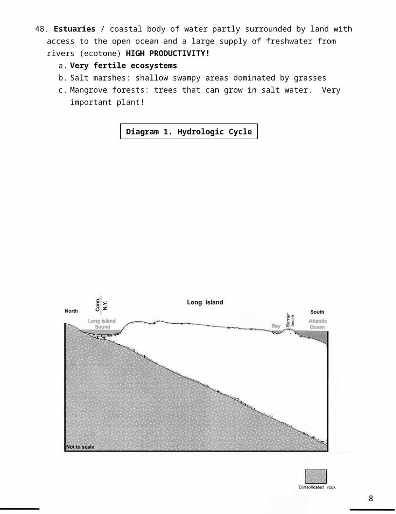
48. Estuaries / coastal body of water partly surrounded by land with access to the open ocean and a large supply of freshwater from rivers (ecotone) HIGH PRODUCTIVITY!
a. Very fertile ecosystems b. Salt marshes: shallow swampy areas dominated by grasses c. Mangrove forests: trees that can grow in salt water. Very important plant!
5
Diagram 1. Hydrologic Cycle
Diagram 2. Lake Zones
Greenhouse Effect Ozone LayerGases Involved: Gases Involved:
6
Diagram 5. Atmospheric Layers
Chart 5. Greenhouse vs. Ozone (IMPORTANT: don’t get these confused they are totally different!)
Diagram 4. BOD vs. DO
Importance: Importance:
Layer and Type of Light Wave: Layer and Type of Light Wave:
Layer Involved: Layer Involved:
7
Diagram 8. (Happens Every 2-7 Years)
Diagram 6. Orographic Effect / Rain Shadow
Diagram 9. Global Atmospheric Circulation
Diagram 7.
8
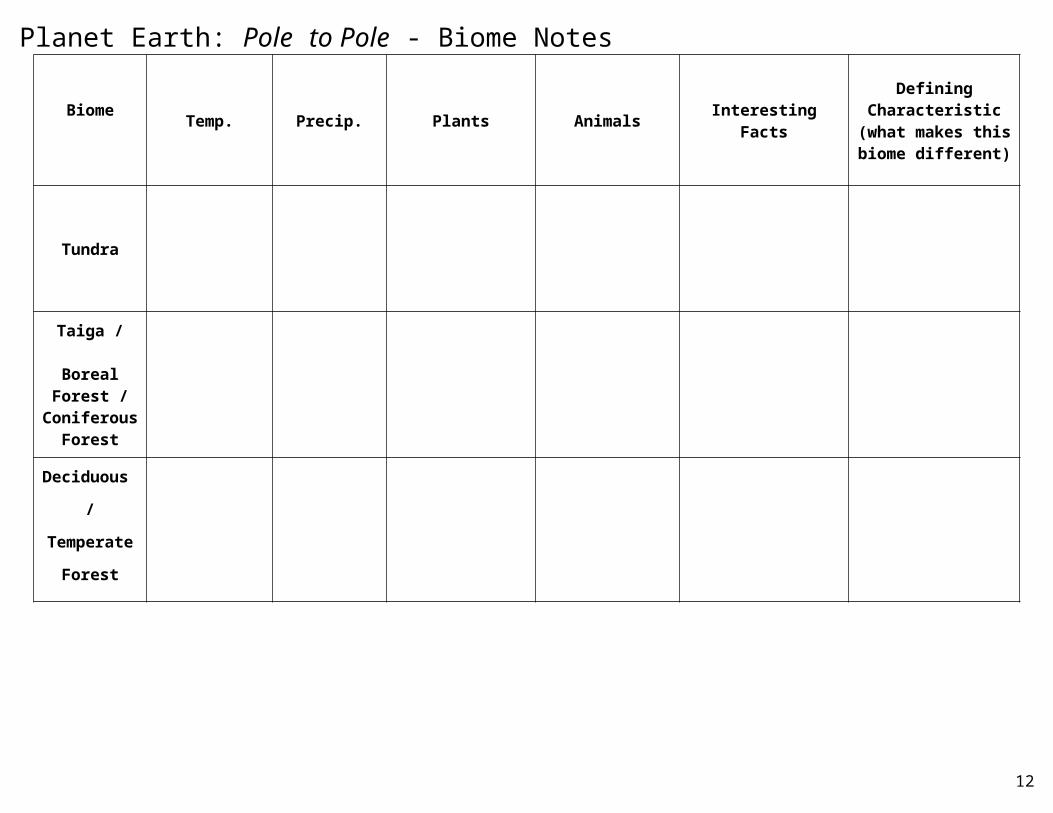
Planet Earth: Pole to Pole - Biome Notes
Biome Temp. Precip. Plants Animals Interesting Facts
Defining Characteristic
(what makes this biome different)
Tundra
Taiga /
Boreal Forest /
Coniferous Forest
Deciduous /
Temperate
Forest
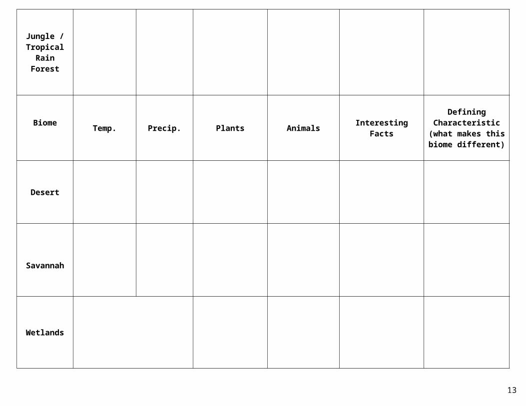
Jungle / Tropical Rain
Forest
Biome Temp. Precip. Plants Animals Defining Characteristic
9
Interesting Facts (what makes this biome different)
Desert
Savannah
Wetlands
Estuaries(separate
video)
10
Temperate Grasslands(separate
video)
11
Can you identify a biome for each climograph? Which is prone to fire? Losing permafrost? A rainforest? Etc…
12
Extra Space for NOTES
___________________________________________________________________________________________
___________________________________________________________________________________________
___________________________________________________________________________________________
___________________________________________________________________________________________
___________________________________________________________________________________________
___________________________________________________________________________________________
___________________________________________________________________________________________
___________________________________________________________________________________________
___________________________________________________________________________________________
___________________________________________________________________________________________
___________________________________________________________________________________________
______________________________________________________________________________________________________________________________________________________________________________________
___________________________________________________________________________________________
___________________________________________________________________________________________
___________________________________________________________________________________________
___________________________________________________________________________________________
___________________________________________________________________________________________
___________________________________________________________________________________________
___________________________________________________________________________________________
___________________________________________________________________________________________
___________________________________________________________________________________________
___________________________________________________________________________________________
___________________________________________________________________________________________
___________________________________________________________________________________________
___________________________________________________________________________________________
___________________________________________________________________________________________
___________________________________________________________________________________________
___________________________________________________________________________________________
___________________________________________________________________________________________
___________________________________________________________________________________________
___________________________________________________________________________________________
___________________________________________________________________________________________
13