Embed Size (px)
Citation preview
Unit 1 Review Packet- AP Human Geography
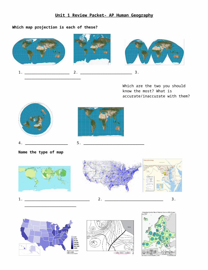
Which map projection is each of these?
1. ____________________ 2. _______________________ 3. _________________________
Which are the two you should know the most? What is accurate/inaccurate with them?
4. ___________________ 5. ___________________________
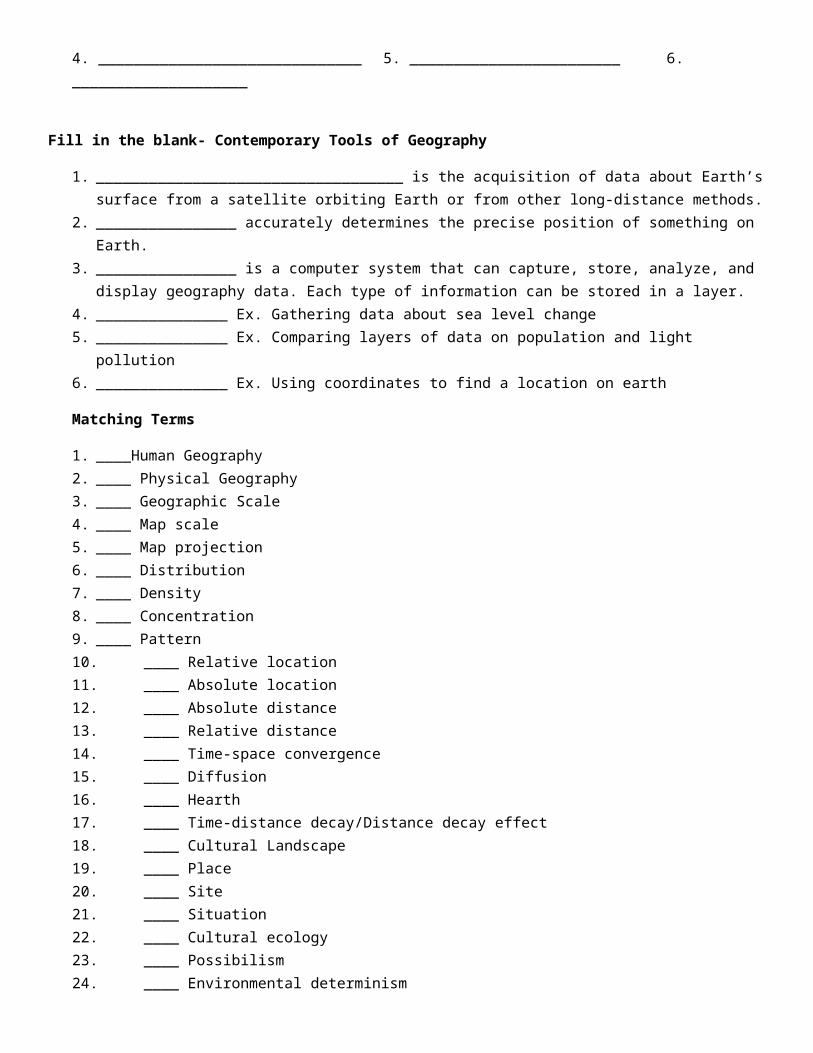
Name the type of map
1. _____________________________ 2. __________________________ 3. _______________________
4. ______________________________ 5. ________________________ 6. ____________________
Fill in the blank- Contemporary Tools of Geography
1. ___________________________________ is the acquisition of data about Earth’s surface from a satellite orbiting Earth or from other long-distance methods.
2. ________________ accurately determines the precise position of something on Earth.3. ________________ is a computer system that can capture, store, analyze, and display geography data. Each type
of information can be stored in a layer.4. _______________ Ex. Gathering data about sea level change5. _______________ Ex. Comparing layers of data on population and light pollution6. _______________ Ex. Using coordinates to find a location on earth
Matching Terms
1. ____Human Geography2. ____ Physical Geography3. ____ Geographic Scale4. ____ Map scale5. ____ Map projection6. ____ Distribution7. ____ Density8. ____ Concentration9. ____ Pattern10. ____ Relative location11. ____ Absolute location12. ____ Absolute distance13. ____ Relative distance14. ____ Time-space convergence15. ____ Diffusion16. ____ Hearth17. ____ Time-distance decay/Distance decay effect18. ____ Cultural Landscape19. ____ Place20. ____ Site21. ____ Situation22. ____ Cultural ecology23. ____ Possibilism24. ____ Environmental determinism25. ____ Globalization26. ____ Local Diversity27. ____ Absolute Direction28. ____ Relative Direction29. ____ Sustainability30. ____ Land Use31. ____ Sequent Occupancea. Scientific method of transferring locations on Earth’s surface to a flat mapb. Extent of a feature’s spread over space (clustered vs. dispersed)c. Includes costs of overcoming the friction of absolute distance separating two places. (Ex. Time to get there)d. Study of where and why human activities are located where they are.e. The process by which a characteristic spreads across space from one place to another over time.f. Arrangement of a feature in spaceg. Force or process that involves the entire world and results in making the world essentially “shrink”. Everything is
more interconnected and worldwide.
h. Physical character of a placei. Geographic study of human-environment relationships.j. Specific point on Earth distinguished by a particular characterk. Physical environment may limit some human actions, but people have the ability to adjust to their environment.l. Combination of cultural features such as language, religion, economic features such as agriculture and industry
and physical features such as climate and vegetation.m. Belief that the physical environment caused social development.n. The farther an idea is from the source, the less likely it is to be adopted.o. Focal point of innovation and invention from which cultural ideas spread outward fromp. Location in relation to other places.q. The unique differences that are maintained around the world between places and cultural groups no matter how
much globalization occurs. Groups try to preserve this diversity.r. Scale at which a geographer analyzes a particular phenomenon.s. Frequency with which something occurs in space.t. Idea states that with increasing transportation and communication technology, the absolute distance between
certain places is, in effect shrinking.u. Exact measurement in standard units between places.v. Geometric arrangement of objects in space.w. Exact location on Earthx. Location of something in relation to something elsey. Study of where and why natural forces occur as they do.z. Relationship of a feature’s size on a map to its actual size on Earth.aa. Meeting the needs of the present without compromising the ability of future generations to meet theirs. Includes
economic, environment, and social components.bb. Left, right, forward, backward- directions based on people’s surroundings and perceptioncc. Every group of people that lived on the land left their markdd. Compass direction such as North and Southee. Function that humans apply to the land available to them- ex: residential, agricultural, commercial
Fill-in-the- blank Types of Diffusion
1. _____________________ is the spread of an idea from persons or nodes of authority or power to other persons or places.
2. _______________________ is the spread of an idea through physical movement of people from one place to another.
3. ______________________ is the rapid, widespread diffusion of a characteristic throughout the population.4. _____________________ is the spread of an underlying principle, even though a characteristic itself apparently
fails to diffuse.5. _____________________ is the spread of something from lower class/less populated areas to higher class/more
populated cultural centers6. _____________________Ex. Beyonce starts wearing a certain shirt and some other people start wearing the shirt.7. ______________________ Ex. The spread of the Spanish Flu across Europe8. _______________________ Ex. The spread of Spanish and French to the United States9. _________________________ Ex. The spread of paper money to all parts of the globe, but each type of paper
money is unique.10. __________________________ Ex. Walmart being made in rural Arkansas and spreading all over the world from
there11. _________________ Computers were once as big as a closet and only wealthy companies or large research labs
could afford to have them. However, as technology improved, smaller computers were purchased for office use. It was not until the 1990s that wealthy American families began purchasing computers for their homes.
12. _________________The Ebola virus outbreak began in a small village in Sierra Leone. Within a couple of weeks, it had spread to other areas of the country. After 3 months, 4 countries in West Africa were dealing with Ebola outbreaks.
13. _________________Most of South America speaks Spanish because Spain established colonies in South America beginning in the 1500s. Spanish missionaries and conquistadors taught most of native South Americans to speak a European language.
14. _________________Jazz music is often described as “America’s gift to the world”. What began in the U.S. in the 1920s is now popular everywhere in the world. Each country that adopts jazz music, puts their own spin on the sound. Often times, they keep the same jazz beats, but include different instruments from their own music traditions.
15. ___________________ In the 1960s, surfing started to gain popularity in Southern California. These surfers began to look for new surf spots in Mexico, Peru, and South Africa. By 1980, all of these countries had developed surf cultures of their own.
16. ___________________ Austin is known for its breakfast tacos and Mexican restaurants. The types of food served in these places are often very different from traditional cuisine in Mexico. Austin has created a whole different style of cooking that combines Mexican recipes with more Texas style ingredients.
17. ____________________ Soccer is the world’s most popular sport. Often times, when a famous player, like Neymar, creates a new hair style, other players adopt the same hair, fans of their team start to choose the same hairstyle for themselves. Suddenly, what started as a pro player trend, becomes a world-wide trend, especially for teenagers who want to emulate their favorite players.
18. ___________________ There are several traditions of Santa Claus around the world. Each carry their own cultural style.
19. ___________________ There are many types of burgers in India that are chicken burgers or tikka burgers made out of potatoes or other vegetables.
20. __________________ The spreading of the Yanny vs. Laurel audio clip on the internet
Latitude vs. Longitude
- ________________________ is major line of______________ because it splits the Earth into Northern and Southern Hemispheres.
- ___________________ measures distance from Equator ___________ and _______________- _______________________ is major line of _______________ because it splits the Earth into the Eastern and
Western Hemispheres.- ____________________ measures distance from Prime Meridian ____________ and ___________
Types of Region Fill-in-the-blank
1. ___________________ area within which everyone shares in common one or more distinctive characteristics.2. ___________________ area organized around a node or focal point. The activity is more intense near the center
of the region and loses intensity as you move outward from the center3. ___________________ area that people believe exists as part of their cultural identity. Defined by how people
perceive an area.
Directions: Identify which type each of the following regions are.
New Hampshire
Reception area for a tv station
American Rust Belt (area where a lot of automobiles are produced)American SouthDC metro region
The Midwest
Brazil
Route 95 corridorAustin, Texas
The distribution network for the newspaper USA TodayFrench-language region in Canada
The Middle East
Haitian neighborhood in Miami, Florida
DMV (DC, Maryland, Virginia)
Baltimore Ravens “Nation”
Multiple Choice
1. Why is the Mercator map projection especially useful for navigation on the surface of the earth?a. Distortion of shape is minimizedb. Direction is constant across the mapc. Distances are correctly portrayedd. Area of land masses is shown correctlye. It shows the sizes of bodies of water realistically
2. How are a cartogram and proportional symbols map similar?a. Both indicate exact locations of specific data preciselyb. Both portray numerical data for comparison between placesc. Both provide a good compromise among distortions of shape, size, direction and distance.d. Both display latitude and longitude accurately.e. Both are useful for comparing the physical area of a country.
3. Which term refers to the collection of geospatial data through the use of satellite imagery?a. Remote sensingb. Fieldworkc. Global position systemd. Geographic information system
4. _______________ argued that cultural landscapes should form the basic unit of geographic inquiry.a. Ptolemyb. George Perkins Marshc. Eratosthenesd. Carl Sauere. W. D. Pattison
5. A perceptual region’s boundaries area. Determined by a set of uniform physical and cultural characteristics across a particular area.b. Drawn around the functions that occur between a particular place and the surrounding area.
c. Determined by the portion of a particular area that has been modified by human activities.d. Fuzzy because they allow for individual interpretation.e. Designated by the inclusion of a particular cultural characteristic.
6. A ratio of the number of items within a defined unit of area measuresa. Dispersionb. Directionc. Patternd. Densitye. Diffusion
7. Which of the following best describes the site of Manhattan?a. A regional transportation hub for the northeastern United States.b. A midway point along an urban corridor stretching from Boston to Washington D.C. c. An island bordered by the Hudson and East Riversd. An important center for international trade and commercee. An urban center located two hours northeast of Philadelphia by train
8. Thematic maps that employ a range of color tones to illustrate how particular values vary across predefined areas, such as counties, provinces, or states, are referred to as
a. Dot mapsb. Choropleth mapsc. Proportional symbol mapsd. Isoline mapse. Cartograms
9. What elements of study do human and physical geography have in common?a. They are taught or studied within the same department in major universities, but only rarely.b. They are concerned with where things occur and why they occur where they do.c. They are dedicated primarily to managing national park systems.d. They are focused primarily on managing the world's growing human population.e. They represent a network of academic professionals dedicated primarily to studying coal
mining's effects on physical and human systems.
10. Without looking at a map, we might deduce that the coordinates 170 W longitude, 11 S latitude are likely
a. just west of the International Date Line and just north of the equator.b. just south of the equator and just east of the prime meridian.c. just east of the International Date Line and just south of the equator.d. just east of the prime meridian and just south of the equator.e. just south of the International Date Line and just east of the equator.
11. The acquisition of data about Earth's surface from a satellite, spacecraft, or specially equipped high-altitude balloon is
a. GIS.b. GPS.c. remote sensing.
d. aerial photography.e. USGS.
12. The diffusion of HIV/AIDS prevention methods and treatments in the United States is an example of which type of diffusion?
a. Contagiousb. Hierarchicalc. Relocationd. Stimuluse. Geospatial
13. The region of Idaho is an example of which type of regiona. Functionalb. Vernacularc. Culturald. Governmentale. Formal
14. Which of the following is an example of a functional region?a. A newspaper’s distribution areab. Texasc. A neighborhood in a city where everyone speaks Spanishd. Redskins natione. Takoma Park
15. Who is considered to be the father of geography?a. Ptolemyb. Aristotlec. Eratosthenesd. Galileoe. Thanes