Embed Size (px)
Citation preview

Start1
2
3
4
56
8
910
1112
13End
wales nature&outdoors Weatherman Walking - Churchtown to Montgomery
bbc.co.uk/walesnature © 2012
1
Reproduced by permission of Ordnance Survey on behalf of HMSO. © Crown copyright and database right 2009.All rights reserved. Ordnance Survey Licence number 100019855
The Weatherman Walking maps are intended as a guide to help you walk the route. We recommend using an OS map of the area in conjunction with this guide. Routes and conditions may have changed since this guide was written. The BBC takes no responsibility for any accident or injury that may occur while following the route. Always wear appropriate clothing and footwear and check weather conditions before heading out.
N
S
W E
Approximate distance: 7.5 milesFor this walk we’ve included GPS marker points as an option, should you wish to follow them.
wales nature&outdoors Weatherman Walking - Churchtown to Montgomery
bbc.co.uk/walesnature © 2012
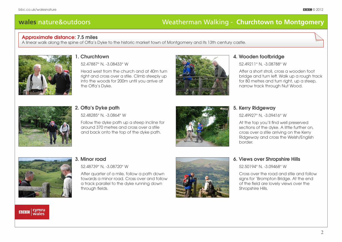
2
Approximate distance: 7.5 milesA linear walk along the spine of Offa’s Dyke to the historic market town of Montgomery and its 13th century castle.
1. Churchtown52.47887° N, -3.08433° W
Head west from the church and at 40m turn right and cross over a stile. Climb steeply up into the woods for 200m until you arrive at the Offa’s Dyke.
2. Offa’s Dyke path52.48285° N, -3.0864° W
Follow the dyke path up a steep incline for around 370 metres and cross over a stile and back onto the top of the dyke path.
3. Minor road 52.48739° N, -3.08720° W
After quarter of a mile, follow a path down towards a minor road. Cross over and follow a track parallel to the dyke running down through fields.
4. Wooden footbridge52.49211° N, -3.08788° W
After a short stroll, cross a wooden foot bridge and turn left. Walk up a rough track for 80 metres and turn right, up a steep, narrow track through Nut Wood.
5. Kerry Ridgeway52.49927° N, -3.09416° W
At the top you’ll find well preserved sections of the dyke. A little further on, cross over a stile arriving on the Kerry Ridgeway and cross the Welsh/English border.
6. Views over Shropshire Hills52.50194° N, -3.09468° W
Cross over the road and stile and follow signs for ‘Brompton Bridge. At the end of the field are lovely views over the Shropshire Hills.

wales nature&outdoors Weatherman Walking - Churchtown to Montgomery
bbc.co.uk/walesnature © 2012
3
7. Road to Cwm52.50242° N, -3.09462° W
Follow a steep path down along the dyke, through trees and into fields. Turn left onto a minor road for quarter of a mile, arriving at the hamlet of Cwm.
8. Mellington Hall52.52092° N, -3.09406° W
Cross over a minor road and follow the dyke path, taking a detour to Mellington Hall Hotel (signposted ‘Walkers Welcome’), a Gothic mansion and caravan park.
9. Motte and Bailey Castle52.53055° N, -3.10544° W
Leaving Mellington Hall, return to the dyke path and head through an archway at Mellington Lodge, onto the B4385. Over the hedge near Bluebell House are the remains of a Motte & Bailey castle.
10. Blue Bell Hotel and oak tree52.53190° N, -3.10634° W
The Blue Bell Hotel is built on an old drovers’ route. Cross the A489 and turn right after 150 metres towards Brompton Hall house and back onto the dyke path.
11. Old stone engraving - 196952.55716° N, -3.12137° W
Follow the dyke (on your right) for a couple of miles along the field boundaries. Near a stile into Lymore Park you’ll spot a stone engraved with 1969, although noone knows how it came to be here.
12. Montgomery Cricket Club52.55867° N, -3.13155° W
Turn left along a metalled road through Lymore Park and after 700 metres, you’ll arrive at Montgomery Cricket Club, one of the oldest clubs in Britain.
13. Montgomery Castle52.56317° N, -3.14964° W
At 400m turn left onto a track and join the B4385 to Montgomery. It’s a steep hike up to Montgomery castle but well worth it.