Embed Size (px)
Citation preview
Available online at www.worldscientificnews.com
( Received 22 January 2021; Accepted 09 February 2021; Date of Publication 10 February 2021 )
WSN 154 (2021) 89-100 EISSN 2392-2192
Weathering Profile of Schistose Rock from Geotechnical and Geochemical Parameters at Okpe,
Igarra Schist Belt in Edo State, Nigeria
E. C. O. Omokpariola1,* and D. O. Omokpariola2
1Department of Geology, University of Port Harcourt, Choba, Nigeria
2Department of Pure and Industrial Chemistry, Nnamdi Azikiwe University, Awka, Nigeria
*E-mail address: [email protected]
ABSTRACT
This work focuses on the weathering profile study of Okpe Schistose Rock at the Igarra Schist
Belt, Edo State, Nigeria. The aim is to understand the degree of weathering which is the removal of
mobile elements by meteoric water and subsequent ionic concentration of stable weathering products in
schistose rock. The two methodologies applied were geotechnical and geochemical data to determine
the weathering profile of four layers. The results from geochemical analysis showed that S3L3 and S4L4
have been enriched with in Al2O3, K2O, Fe2O3, and MgO, while the geotechnical data showed a highly
weathered zone a layer S3L3 and S4L4 from the particle size distribution curve, specific density, bulk
density, plasticity, colour index tests, respectively. In conclusion, the weathering profile of the Okpe
Schist shows that it’s ionic concentration and weathering profile increases downwards which gives rise
to lateritic soils that is of great economic value.
Keywords: Weathering Profile, Schistose Rock, Okpe Edo State, Lateralization, Geotechnical
Parameters

World Scientific News 154 (2021) 89-100
-90-
1. INTRODUCTION
Weathering is the process of degradation of rock components by the action of a physical,
chemical and biological process that leads to the production of rock fragment or sediment.
Weathering is known to reduce rock-bulk composition, specific gravity, particle size
distribution, morphology of the rock (grain-size, shape, orientation, degree of roundness). The
rate of rock disintegration depends on both external forces and rock type on which the rock is
exposed. The impact of moisture, high-low temperature, air-movement, humans, plant and
animal activities contribute to the rate of rock weathering. Engineering projects occur in
weathered zone which varies laterally and vertically. Accurate description of weathering profile
at site of an engineering project is sine-qua-non. Weathering factors include topography,
vegetation and time, parent material, climate, nearness to settlement and chemical action which
impact on the rock profile of a location.
The weathering profile of rock mineral is the capacity of elements, ions, and molecules
to move from one compartment of soil to another when they combine and react with air and
water to form new minerals. The specific reactions include oxidation, hydration, hydrolysis,
and reduction. Mineral weathering takes place in micro-fissures, narrow solution channels and
capillary water in such spatially restricted volume may be expected to be in close equilibrium
or similar with primary minerals. The study seeks to assess the weathering profile of schistose
rock at Okpe in Edo State.
2. MATERIALS AND METHODS
2. 1. Study Area
The study area is Okpe, which is located at Igarra in Akoko-Edo local government area
of Edo State lies between longitude 06°15’E and Latitude 07°08’N to 07°40’N. The climate has
dry season commonly from December to March, the period is characterized by low or no rainfall
with average temperature of 26 °C, while the wet season is characterized by a drastic rainfall
for a period of about seven to eight months, i.e., April to November; the conveying medium for
this rain is the south-west trade wind which blows across the Atlantic Ocean. Rainfall at this
geographical terrain is measured to about 2000 mm from May to October and about 500-750
mm from November to April. The nature of various sub-surface tectonic processes in geologic
time scale gave rise to the relief of the area (Okpe) which is moderately a plane with small hills
and valleys alternating each other. The highest elevation is found to be about 400 m above sea
level (Figs 1 & 2).
2. 2. Geological Setting
Okpe Junction, a sub-area of Igarra, lies at a triaxial boundary that leads to Somorika,
Aiyetore, Aiyegunle, and Ogugu areas, respectively. It lies in south-western Nigeria with the
presence of primary and secondary roads, road cuts and recently blasted outcrops but at site.
Generally, study has proven that the schist belt at Igarra, Okpe area is predominantly composed
of basement rock as the dominant Igneous Rock type is Biotite Granite, having major rock type
such as banded gneiss and granitic gneiss and minor rocks type such as quartz vein and
pegmatite. It belongs to the Pan-African Orogeny, an Upper Proterozoic formation during the
Precambrian Eon (600 ±150 mya).

World Scientific News 154 (2021) 89-100
-91-
Figure 1. Site map indicating sampling site.

World Scientific News 154 (2021) 89-100
-92-
Mineralogically, Okpe consists of plagioclase, quartz, and biotite. The mafic bands
present is composed of solely biotite, while felsic layer on the other hand has residues of
quartzofeldspartic minerals. The banded gneiss present in Okpe Schistose is highly prone to
weathering because of its exposure to axial planes of weakness and erosional surfaces. It
consists of phenocryst of feldspar minerals infused in the matrix of feldspar and quartz.
The felsic minerals present, consist of quartz, muscovite flakes, and high amount of
feldspar while the mafic mineral consists of biotite and other accessory minerals. The mafic
minerals present are randomly distributed within the porphyritic granite which is an associate
of the basement rock complex. The migmatite located at the central part of Igarra is made up of
leucocratic components alternates with basic components.
Figure 2. Location of study area
2. 3. Sampling methodology
Table 1. Soil type and recommended sampling type.
S/N Soil Type Type of sampling
1 Granular Soils Split-tube
2. Plastic (cohesive) Soils
(N<30)
Alternate split-tube and thin-
wall
3. Plastic (cohesive) Soils
(N>30) Split-tube
4. Organic Soil Thin-wall

World Scientific News 154 (2021) 89-100
-93-
Soil samples were collected at Okpe quarry site with the aid of a hand auger. The hand
auger was drilled laterally from 0 – 213.36 cm, respectively with 12.70 cm sampling intervals
to get 16 samples, as shown in Table 1. The samples thereafter were packaged in a black
cellophane, labeled and taken to the lab within 36 hours of collection and kept in a refrigerator
until analyzed. Sample preparation and handling was carried out according to APHA 1999.
2. 4. Laboratory Studies Method
15 grams of soil samples were weighed, washed and dried with stainless pan in oven at
105 ºC for 24 h; thereafter they were reweighed to determine moisture content.
% moisture = weight of moist soil−weight of dry soil
weight of dry soil× 100% (1)
2. 5. Geotechnical Study Method
2. 5. 1. Sample Preparation
Soils were sieved to remove stones and gravel (>2 mm diameter). Three types of sieving
was adopted for sieving soil samples depending on the soil’s physical characteristics of stones,
concretions and plant debris contained.
2. 5. 2. Particle Size Analysis
100 grams of soil samples were weighed on 0.053 mm sieve, washed into a 100 mL
measuring cylinder and oven-dried at 105 ºC for 24 h; thereafter they were reweighed before
transfer into ASTM Sieve No. 200 with different mesh size in the following order: 0.5 µm; 0.25
µm; 0.106 µm; 0.053 µm and Pan to determine particle size distribution. The mass of each sand
fraction (coarse, medium, fine and very fine sand) was weighed and expressed as a percentage
(%) of the weight of the soil sample.
2. 5. 3. Bulk Density
The bulk density of the soil, ρsand (mg/m3) was calculated using the equation;
ρsoil = (mas of soil excavated
mass of soil required to fill the hole) × ρsand (2)
where bulk density of the sand, ρsand (mg/m3):
ρsand =weight of sand
volume of sand (100ml) (3)
2. 5. 4. Specific Gravity
The weight of dry specific gravity bottle with stopper was weighed accurately designated
as W1. 10 g of the oven dried soil was transferred into the bottle reweighed and assigned to W2.
Distilled water was added to the bottle until excess air bubbles were expelled using a desiccators
and wiped water from the outside bottle and weighed as W3. Then, distilled water was added to
dry empty bottle to top-lid and weighed as W4. The specific gravity, Gs is given as:

World Scientific News 154 (2021) 89-100
-94-
2314
12
WWWW
WW
waterofvolumeequalofMass
particlessoilofMass
(4)
The procedure was repeated for three times to get average of soil samples.
2. 5. 5. Soil Colour Test
It was determined using Munsell Soil Colour Chart.
2. 6. Geochemical Analysis Method
1 g of samples was digested in a conical flask using 100 ml of total volume H2SO4, HNO3,
and HClO in the ratio of 40%, 40%, 20% and mixed together which was done in a fume
cupboard before analysis of Fe2O3, MgO, Al2O3, and K2O using atomic adsorption
spectrophotometer (AAS).
3. RESULT AND DISCUSSION
3. 1. Geotechnical Properties Results
The weathering schist has a brownish clayey shale residual soil at the sub surface layer,
running from 0 m to 0.70 m. The first layer that runs from 0.70 m to 15.80 m is slightly
weathered from the top layer. The second layer contains high amount of lateritic soil which
makes it a completely weathered zone and it ranges from 15.90 m to 21.60 m. The third layer
is underlained by a mixture of highly weathered Schistose and it runs down to 30.10 m depth.
The fourth layer is moderately weathered as it contains a dark brown schist and it ranges from
30.20 m to 44.54 m from the top. The final layer is the bed rock which is orange brown and
gradually weathering because of its contact with water, a major agent of weathering.
3. 1. 1. Particle Size Distribution
Table 2. Particle Size Distribution of Okpe SCHIST
Sieve
diameter
Mass of soil Retained
(g) Mass passing (g) % passing
S1L1 S2L2 S3L3 S4L4 S1L1 S2L2 S3L3 S4L4 S1L1 S2L2 S3L3 S4L4
2 mm 0.00 3.00 10.00 3.90 4.00 38.00 71.30 10.00 100.00 92.68 87.70 71.94
1 mm 0.30 2.60 5.40 1.60 4.60 35.40 65.90 8.40 93.88 86.34 81.06 60.43
500 μm 0.50 3.40 7.60 1.50 4.10 32.00 58.30 6.90 83.67 78.05 71.71 49.64
250 μm 1.30 6.20 19.00 2.00 2.80 25.80 39.30 4.90 57.14 62.93 48.34 35.25
150 μm 2.40 8.70 17.80 2.00 1.40 17.10 21.50 2.90 28.57 41.71 26.45 20.86

World Scientific News 154 (2021) 89-100
-95-
75 μm 0.40 3.20 3.10 0.90 1.00 13.90 18.40 2.00 20.41 33.90 22.63 14.39
Pan 1.00 13.90 18.40 2.00 0.00 0.00 0.00 0.00 0.00 0.00 0.00 0.00
Figure 3 shows particle size distribution of residual soils from various depths of the Okpe
schistose, the first portion (0 to 15.80 m depth) had a fines content of about 39% and was plastic
(M, Unified Soil Classification System). At deeper depths (15.90 m to 21.60 m) the fine content
is 50%. The coarse-grained portion is less than the fine-grained portion present, and the soil
type postulates lateritic soils (MH, Unified Soil Classification System) [9] and so, it is
completely weathered. The third layer with a depth of (21.70 m to 30.10 m) has fines of 35%
which is highly weathered. This implies that the fines content decreases with depth as the degree
of weathering decreases. In addition, above average of the soils from different depths of the
Okpe Schistose are mainly composed of coarse-grained, with fines contents varying from 25%
and 47%. It is also observed that there is no standard variation in the particle size distribution
with various depths observed for residual soils at the Shistose exposure.
Figure 3. Particle Size Distribution Curve of Okpe Schist
2mm 1mm 500μm 250μm 150μm 75μm Pan
S1L1 100% 93,88% 83,67% 57,14% 28,57% 20,41% 0,00%
S2L2 92,68% 86,34% 78,05% 62,93% 41,71% 33,90% 0,00%
S3L3 87,70% 81,06% 71,71% 48,34% 26,45% 22,63% 0,00%
S4L4 71,94% 60,43% 49,64% 35,25% 20,86% 14,39% 0,00%
0%
10%
20%
30%
40%
50%
60%
70%
80%
90%
100%
% P
asss
ing
Sieve Diameter

World Scientific News 154 (2021) 89-100
-96-
3. 1. 2. Bulk density and specific gravity
Figure 4 tells us about the volume that replaced by water and air in the porous structure.
S1L1 gives residual soils (regoliths), porosity and void ratio are higher. Therefore, the water
and air phases occupy more space compared to the S2L2, S3L3 and S4L4. As a result, the bulk
density of the residual soils from the Okpe Schist ranged from 1.22 to 1.54 g/cm3 with
increasing depth down the basement. For both residual soils the void ratio appeared to decrease
with depth (Fig. 4) reflecting the variation in the degree of weathering.
For the Specific Gravity; this depends on the soil mineralogy and it reflects the weathering
history. The specific gravity of S1L1 is 2.03 g/cm3, S2L2 is 2.49 g/cm3 indicating the presence
of Feldspatic arenite at that layer, S3L3 is 2. 55g/cm3 which indicates a very high degree of
weathering and amounts of Kaolinite mineral at that profile, and S4L4 is 2.21g/cm3. These
results are similar to the results of [Rahardjo, 2004] (i.e. gravity range of 1). This is due to the
presence of different minerals other than quartz in the deeper layers that have a higher specific
gravity than quartz mineral.
Figure 4. Bulk Density and Specific Gravity of Okpe Schist
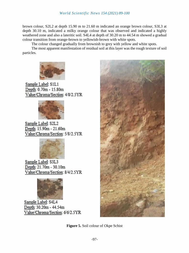
3. 1. 3. Soil Colour Chart
Figure 5 shows the use of Munsell Soil Colour chart as a standard. The soil colour ranged
from reddish-brown to orange brown. S1L1 at depth of 0.70 m to 15.80m indicated a dark
Bulk Density, ρ (g/cm3) Specific gravity Gs (g)
S1L1 1,26 2,03
S2L2 1,22 2,49
S3L3 1,46 2,55
S4L4 1,54 2,21
0
0,5
1
1,5
2
2,5
3
Val
ue
of
each
lay
er
World Scientific News 154 (2021) 89-100
-97-
brown colour, S2L2 at depth 15.90 m to 21.60 m indicated an orange brown colour, S3L3 at
depth 30.10 m, indicated a milky orange colour that was observed and indicated a highly
weathered zone and also a lateritic soil. S4L4 at depth of 30.20 m to 44.54 m showed a gradual
colour transition from orange-brown to yellowish-brown with white spots.
The colour changed gradually from brownish to grey with yellow and white spots.
The most apparent manifestation of residual soil at this layer was the rough texture of soil
particles.
Figure 5. Soil colour of Okpe Schist

World Scientific News 154 (2021) 89-100
-98-
3. 2. Geochemical Results
Figure 6 gives the study of the core ionic concentration values from of the four layers to
determine the variables in Fe2O3, Al2O3, K2O, and MgO. There is an increase of Fe2O3 and
Al2O3 at S3L3 and S4L4; which postulates a downward increase in the weathering of Schistose
rock. The ionic concentration also gives an insight on the oxidation and the production of new
elements that are similar to the primary elements.
Figure 6. Line graph indicating mean anion concentrations in different locations
4. CONCLUSION
In conclusion, this study revealed the geotechnical, and geochemical properties of the Okpe
schist from various reconnaissance surveys, field exercises, and laboratory analysis. Although
in some areas the degree of weathering of the residual soils from Okpe Schistose rock appeared
to be not uniform, as the third layer has the highest weathered zone while the fourth one is
moderately weathered. This study has led to a conclusion that the degree of weathering
increases as we go down, the weathered zone at the third layer is having a depth range of 15.00
m – 21.40 m which facilitates laterization of the weathered schist to obtain laterites. The results
of this work will be of immense benefit for economic value, and a higher degree of weathering
would result in a higher pore volume and a larger range of pore-size distribution. It is therefore
possible to use the variation in the pore volume and the pore size distribution through a
weathered profile as an indication of the variation in the degree of weathering with depth.
S1L1 S2L2 S3L3 S4L4
Fe2O3 30,49 31,14 38,74 52,64
MgO 12,17 18,92 23,38 28,15
Al2O3 21,57 25,9 34,26 41,13
K2O 5,62 10,5 17,22 26,36
0
10
20
30
40
50
60
Ionic
Co
nce
ntr
atio
n (
mg/l
)
Fe2O3 MgO Al2O3 K2O

World Scientific News 154 (2021) 89-100
-99-
References
[1] Fang, Q., Hong, H., Algeo, T.J., Huang, X., Sun, A., Churchman, G.J., Chorover, J.,
Chen, S., and Liu, Y. Microtopology-mediated hydrologic environment control
elemental migration and mineral weathering in subalpine surface soils of subtropic
monsoonal China. Geoderma. 344 (2019) 82-98.
http://doi.org/10.1016/j.geoderma.2019.03.008
[2] Oyebamiji, A., Adewumi, A. J. P., Zafar, T., Odebunmi, A., Falae, P., Fadamoro, O.
Petrogenetic and Compositional Features of Rare Metal PanAfrican Post-Collisional
Pegmatites of Southwestern Nigeria; A Status Review. Contemporary Trends in
Geoscience 2018, Vol. 7, iss. 2, 166-187
[3] Rahardjo, H. Aung, K.K. Leong, E.C. and Rezaur, R.B. Characteristics of residual soils
in Singapore as formed by weathering. Engineering Geology, 73 (2004) 157-169
[4] Oyinloye, A. O. Geology and geochemistry of some crystalline basement rocks in Ilesha
area, southwestern Nigeria: Implications on provenance and evolution. Pakistan Journal
of Scientific and Industrial Research 50 (2007) 223-231
[5] Raj, J.K. Saturated hydraulic conductivity (Ks) of earth materials in the weathering
profile over quarz-mica schist of the sermban area, Negeri Sembilan. Bulletin of the
Geological Society of Malaysian 69 (2020) 1-10
[6] Raj, J.K. Residual shear strength of a weathered graphitic quartz-mica schist in humid
tropical Peninsular Malaysian. Bulletin of the Geological Society of Malaysian 68
(2019) 109-116
[7] Rahardjo, H; Aung, K.K; Leong, E.C; Rezaur, R.B (2004). Characteristics of residual
soils in Singapore as formed by weathering. Engineering Geology, 73 (1–2): 157-169,
doi:10.1016/j.enggeo.2004.01.002
[8] E.R. Tuncer, R.A. Lohnes. An engineering classification for certain basalt-derived
lateritic soils. Engineering Geology Volume 11, Issue 4, December 1977, Pages 319-
339. https://doi.org/10.1016/0013-7952(77)90037-0
[9] Ibiam Ntachiobi Ama, Godfry E. Nwajei and P. O. Agbaire. Distribution of Trace
Elements in Surface Water and Sediments from Warri River in Warri, Delta State of
Nigeria. World News of Natural Sciences 11 (2017) 65-82
[10] P. I. Ibe, I. P. Aigbedion, M. Marcellinus, F. U. Okoli, A. B. Sola. Assessment of water
quality Index for groundwater in Ado Ekiti, Nigeria. World News of Natural Sciences
22 (2019) 93-101
[11] Kar-Winn, K. Raharadjo, H. and Peng, S.C. Characterization of Residual Soils in
Singapore. Journal of the Southeast Asian Geotechnical Society, 1 (2001) 1-13
[12] Pothuri, R.P., Lira, R., Espeche, M.J., Rokalla, A.R. Geochemical and Petrological
studies of carbonatised metalamprophyre at Kalagalla. Geochimica Brasiliensis 34(1)
(2020) 1-27.

World Scientific News 154 (2021) 89-100
-100-
[13] Harraz, H. and Monsef, M.A. Elemental substitutions and compositional evolution
during tourmaline formulation in metasomatic schistose rocks of Sikait area in the
Southern Eastern Desert, Egypt. Arabian Journal of Geosciences 13(15) (2020) 1-21
[14] Adesina, R.B., Tijani, M.N. Geotechnical and Geochemical Assessments of Shales in
Anambra Basin, Southeastern Nigeria, as Landfill Liners. Earth Syst Environ 1, 20
(2017). https://doi.org/10.1007/s41748-017-0022-x
[15] Ige OO (2011) Geotechnical assessment of lateritic soils from a dumpsite in Ilorin
(Southwestern Nigeria) as liners in sanitary landfills. Glob J Geol Sci 9(1): 27-31
[16] ma KO, Onuoha KM (1997) Hydrodynamic flow and formation pressures in the
Anambra Basin, Southern Nigeria. Hydrol Sci 42(2): 141-152
[17] Adamu, C.I., Duru, C.C. Composition, Geotechnical Characteristics and the Potential
for Industrial Use of Some Clay Bodies in Obudu and its Environs, Southeastern
Nigeria. Geotech Geol Eng 38, 6909-6922 (2020). https://doi.org/10.1007/s10706-020-
01424-0
[18] Ukaegbu VU, Oti MN (2005) Structural elements of the Pan-African Orogeny and their
geodynamic implications in Obudu Plateau, southeastern Nigeria. J Min Geol 41: 41-49
[19] Ushie FA, Anike OI (2011) Lateritic weathering of granite gneiss in Obudu plateau,
South Eastern Nigeria. Global J Geol Sci 9(1): 75-83
[20] Elueze AA, Ntekini EE, Ekwere JJ (1999) Compositional and industrial assessment of
clay bodies in Itu area South Eastern Nigeria. J Min Geol 35(2): 117-124
[21] Adeyemi, G.O., Wahab, K.A. Variability in the geotechnical properties of a lateritic soil
from south western Nigeria. Bull Eng Geol Environ 67, 579-584 (2008).
https://doi.org/10.1007/s10064-008-0137-2
[22] Momah, M., & Okieimen, F. E. (2020). Minerology, geochemical composition and
geotechnical properties of termite mound soil. Journal of Ecology and The Natural
Environment, 12(1), 1-8. https://doi.org/10.5897/JENE2019.0798
[23] Joshua O. Ighalo, Adewale George Adeniyi. (2020). A comprehensive review of water
quality monitoring and assessment in Nigeria. Chemosphere 260, pages 127569
[24] G M Olayanju, K A Mogaji, H S Lim, T S Ojo, Foundation integrity assessment using
integrated geophysical and geotechnical techniques: case study in crystalline basement
complex, southwestern Nigeria, Journal of Geophysics and Engineering, Volume 14,
Issue 3, June 2017, Pages 675–690, https://doi.org/10.1088/1742-2140/aa64f7
[25] Igwe, O., Egbueri, J.C. The Characteristics and the Erodibility Potentials of Soils from
Different Geologic Formations in Anambra State, Southeastern Nigeria. J Geol Soc
India 92, 471–478 (2018). https://doi.org/10.1007/s12594-018-1044-1