Embed Size (px)
Citation preview
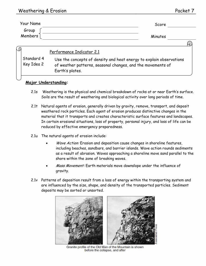
Weathering & Erosion Packet 7
Your Name Score
Group
Members
Minutes
Standard 4
Key Idea 2
Performance Indicator 2.1
Use the concepts of density and heat energy to explain observations
of weather patterns, seasonal changes, and the movements of
Earth’s plates.
Major Understanding:
2.1s Weathering is the physical and chemical breakdown of rocks at or near Earth’s surface.
Soils are the result of weathering and biological activity over long periods of time.
2.1t Natural agents of erosion, generally driven by gravity, remove, transport, and deposit
weathered rock particles. Each agent of erosion produces distinctive changes in the
material that it transports and creates characteristic surface features and landscapes.
In certain erosional situations, loss of property, personal injury, and loss of life can be
reduced by effective emergency preparedness.
2.1u The natural agents of erosion include:
Wave Action: Erosion and deposition cause changes in shoreline features,
including beaches, sandbars, and barrier islands. Wave action rounds sediments
as a result of abrasion. Waves approaching a shoreline move sand parallel to the
shore within the zone of breaking waves.
Mass Movement: Earth materials move downslope under the influence of
gravity.
2.1v Patterns of deposition result from a loss of energy within the transporting system and
are influenced by the size, shape, and density of the transported particles. Sediment
deposits may be sorted or unsorted.

Page 2 ESworkbooks©2011cdunbar
Mini Lesson 1: Weathering
Weathering is the breakdown of rock material. The first type we will investigate is physical
(mechanical) weathering. During physical weathering the rocks are simply broken up into
fragments. It does not change the composition of the rock but it does create more surface area. The dominant climate condition for physical weathering is cold and moist. Chemical
weathering occurs on the surface of rocks and changes the composition of the material. This
causes the rocks to weaken and makes it easier for them to break apart. Chemical weathering
dominates in warm moist climates and occurs on the surface of the rocks. Usually both types
of weathering work together but the dominant type depends on the climate of the area.
Need to know:
1. What is weathering?
2. What is another name for physical weathering?
3. What does physical weathering do?
4. Does physical weathering change the composition of the rock?
5. What does physical weathering create?
6. What are the dominant climate conditions for physical weathering? and
7. What does chemical weathering do?
8. What does chemical weathering cause?
9. Where on the rock does chemical weathering occur?
10. What are the dominant climate conditions for chemical weathering? and
11. Explain how physical weathering helps chemical weathering occur. ** Use a complete sentence.
12. Explain how chemical weathering helps physical weathering occur. ** Use a complete sentence.
13. What climate factor is aids in both chemical and physical weathering?

Guided Inquiry: Weathering & Erosion Page 3
The information below gives a short description of different types of
weathering. Read each description very carefully. Determine if the
type of weathering listed is physical weathering or chemical
weathering. Write the word “physical” or “chemical” in the space
provided, next to each description.
Frost Wedging
occurs in climates with freezing and thawing
temperatures
water gets into cracks and crevases of rock
expands when it freezes
causes the cracks to get bigger
pieces break off
example: pot holes
Oxidation
iron atoms combine with oxygen to form
iron oxide (rust)
Exfoliation
surface of the rock “peels” off
unloading – caused by uplift and exposure of rock
that was once deep underground
decreases the pressure on the rocks
Root Action
roots grow into and under rocks
roots pry the rock apart
causes cracks to get bigger
example: cracks in the sidewalk
Carbonation
carbonic acid in rain causes
minerals to dissolve
ex. marble gravestones
Show what you know: Weathering
Materials ESRT’s Highlighter Color pencils
CCCooonnnnnniiieee SSSmmmiiittthhh 111888666222 --- 111999555888
Beloved Earth
Science Teacher
of New York
State
1994 - 2007

Page 4 ESworkbooks©2011cdunbar
Hydration
water weakens the rock
and the rock crumbles
ex. feldspar becomes
clay
Abrasion
bumping and breaking up of
rocks as they collide
rocks become smaller,
smoother and rounder
a. Time of exposure refers to the amount of time the rocks surface is exposed to the atmosphere
and hydrosphere. The longer the rock is exposed the elements, the (greater / less) the
weathering that takes place.
b. Composition of rock material refers to what type of rock it is, the minerals and elements that
make up or hold the rock together. For each set of rocks below, circle the least resistant
rock and give an explanation to why you know that rock is weaker than the other.
Rock name Why is that rock less resistant to the other?
Limestone or Granite
Marble or Pegmatite
Marble or Gneiss
Shale or Diorite
The rate at which rocks weather is dependent on three basic factors:
time of exposure, composition of the rock material and climate.
Guided Inquiry: Weathering & Erosion Page 5
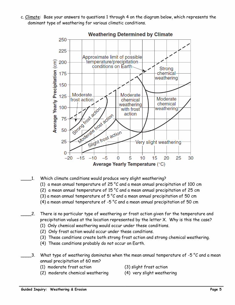
c. Climate: Base your answers to questions 1 through 4 on the diagram below, which represents the
dominant type of weathering for various climatic conditions.
____1. Which climate conditions would produce very slight weathering?
(1) a mean annual temperature of 25 °C and a mean annual precipitation of 100 cm
(2) a mean annual temperature of 15 °C and a mean annual precipitation of 25 cm
(3) a mean annual temperature of 5 °C and a mean annual precipitation of 50 cm
(4) a mean annual temperature of -5 °C and a mean annual precipitation of 50 cm
____2. There is no particular type of weathering or frost action given for the temperature and
precipitation values at the location represented by the letter X. Why is this the case?
(1) Only chemical weathering would occur under these conditions.
(2) Only frost action would occur under these conditions.
(3) These conditions create both strong frost action and strong chemical weathering.
(4) These conditions probably do not occur on Earth.
____3. What type of weathering dominates when the mean annual temperature of -5 °C and a mean
annual precipitation of 60 mm?
(1) moderate frost action (3) slight frost action
(2) moderate chemical weathering (4) very slight weathering

Page 6 ESworkbooks©2011cdunbar
____4. Why is no frost action shown for locations with a mean annual temperature greater than
13 °C?
(1) Very little freezing takes place at these locations.
(2) Large amounts of evaporation take place at these locations.
(3) Very little precipitation falls at these locations.
(4) Large amounts of precipitation fall at these locations.
____5. Landscapes will undergo the most chemical weathering if the climate is
(1) cool and dry (2) cool and wet (3) warm and dry (4) warm and wet
____6. Which factor has the greatest influence on the weathering rate of Earth’s surface
bedrock?
(1) local air pressure (3) age of the bedrock
(2) angle of insolation (4) regional climate
____7. Which activity demonstrates chemical weathering?
(1) freezing of water in the cracks of a sandstone sidewalk
(2) abrasion of a streambed by tumbling rocks
(3) grinding of talc into a powder
(4) dissolving of limestone by acid rain
____8. What is the main factor that causes the bedrock to weather at different rates?
(1) elevation above sea level (3) age of rock layers
(2) mineral composition (4) environment of formation
____9. The diagram below represents a naturally occurring geologic process.
Which process is best illustrated by the diagram?
(1) cementation (2) erosion (3) metamorphism (4) weathering
____10. Which geologic feature is caused primarily by chemical weathering?
(1) large caves in limestone bedrock
(2) a pattern of parallel cracks in a granite mountain
(3) blocks of basalt at the base of a steep slope
(4) the smooth, polished surface of a rock in a dry, sandy area

Guided Inquiry: Weathering & Erosion Page 7
Materials 18 blocks
Ruler
Calculator
Laboratory Activity 7.1 Surface Area [40]
Introduction:
Physical weathering creates more surface area. Although the pieces of rock
continue to get smaller each time a rock breaks apart, more surface is exposed.
In order to demonstrate this, you will use wooden cubes to represent rocks
(blocks) to measure the surface area each time you separate them.
Objective:
Determine what happens to the surface area of a material as it breaks apart
Procedure
1. Take the blocks and arrange them so that you have 6 blocks in 3 row.
2. Place 9 blocks on top of the other 9 blocks.
3. Determine the area of the top and bottom of the large cube you have just constructed.
length cm area of the top (length x width) cm2
width cm area of the bottom (same as the top) cm2
The area of the top PLUS the area of the bottom cm2
4. Determine the area of one side of the large cube:
length cm area of one side (length x width) cm2
height cm number of sides on the cube
The area of all four sides (multiply the area of one side by the number of sides) cm2
5. What is the total surface area of the large cube? (add the answers to 3 and 4)
cm2
Place the answer to procedure 5 in the table on page 9
6. Take the top layer off of the large cube (9 blocks) so that you have two separate blocks with 9
cubes in each. Measure ONLY ONE of the two blocks
.

Page 8 ESworkbooks©2011cdunbar
7. Determine the area of the top and bottom of only one of the cubes.
length cm area of the top (length x width) cm2
width cm area of the bottom (same as the top) cm2
The area of the top PLUS the area of the bottom cm2
8. Determine the area of one side of the cube:
length cm area of one side (length x width) cm2
height cm number of sides on the cube
The area of all four sides (multiply the area of one side by the number of sides) cm2
What is the total surface area of the one cube? (add the answers to 7 and 8) cm2
How many cubes are there (hint – look at page 7 procedure 6)
9. What is the total surface area of the two cubes? (multiply the surface area of one cube with the number of cubes)
cm2
Place the answer to procedure 9 in the table on page 9
10. Separate the two blocks (sections) into 6 individual rows.
Determine the surface area of ONE ROW only
11. Determine the area of the front and back of only one of the rows.
length cm area of the front (length x width) cm2
width cm area of the back (same as the front) cm2
The area of the front PLUS the area of the back cm2
12. Determine the area of one side of the cube:
length cm area of one side (length x width) cm2
height cm number of sides on the cube
The area of all four sides (multiply the area of one side by the number of sides) cm2
What is the total surface area of the one row? (add the answers to 11 and 12) cm2
How many rows are there (hint – look at procedure 10 above)
13. What is the total surface area of the rows? (multiply the surface area of one row with the number of rows)
cm2
Place the answer to procedure 13 in the table on page 9

Guided Inquiry: Weathering & Erosion Page 9
14. Separate the 18 cubes completely.
Determine the surface area of ONE cube
15. Determine the area of one side of the one cube.
length cm area of one side (length x width) cm2
width cm number of sides with this area cm2
The surface area of all six sides (multiply the area of one side by the number of sides) cm2
How many cubes are there (hint – look at procedure 14 above)
16. What is the total surface area of the all of the cubes together? (multiply the surface area of one cube with the number of cubes)
cm2
Place the answer to procedure 16 in the table below
Fill in the Data table below:
Type of formation Answer to procedure
Total surface area
One large cube 5 cm2
Two smaller blocks 9 cm2
Six separate rows 13 cm2
Individual cubes 16 cm2
Check Point
1. What type of weathering breaks down rocks into smaller pieces?
2. What happened to the surface area each time the blocks were separated?
3. What happens to the surface area of a rock each time it is broken into smaller pieces?
4. Where does chemical weathering take place on rocks?
5. How does physical weathering aid in the process of chemical weathering?
6. How does chemical weathering aid in the process of physical weathering?
7. What climate is dominant for physical weathering?
8. What climate is dominant for chemical weathering?
9. List the three factors that affect weathering rate: ,
and

Page 10 ESworkbooks©2011cdunbar
Laboratory Activity 7.2 Chemical Weathering [40]
Introduction:
Chemical weathering takes place on the surface of rocks, so as physical
weathering creates more surface area chemical weathering has more places
to occur. Another factor that affects the rate of chemical weathering is
temperature.
Objective:
Determine what happens to the surface area of a material as it breaks apart
Procedure A
1. Place 300 mL of ice cold water in a 400 ml beaker on the hot plate (leave it OFF).
2. Take the temperature of the water and record it on the data table below.
3. Lay out paper towels at least two thick and place an empty clear film container in the center of
them.
4. Turn the hot plate on high and leave it on the entire activity.
5. Fill the turkey baster to two ounces by squeezing the ball
at the end. Keep the baster as vertical as possible.
6. Put the water from the turkey baster into the film
container by squeezing the end.
7. Place one Alka-Seltzer tablet into the canister and quickly
place the lid on tight.
8. Start the timer as soon as the lid is placed on the container
(at least two timers per group).
9. Stop the timer as soon as the lid pops off.
10. Record the time in the data table to the right.
11. Stir the water occasionally. Take the temperature from
the center of the beaker after you have stirred the water with the stirring rod. As soon as the
temperature of the water is at least 8 degrees higher, repeat steps 5 – 11.
12. Continue to test the reaction rate until the water begins to boil, recording the data as you go.
13. Turn the hot plate off, carefully remove the beaker with gloves and pour out hot water in sink.
14. Graph the results.
Data Table:
Trial Temperature
(C)
Time
(seconds)
1
2
3
4
5
6
7
8
SAFTY ISSUES: You will be working with extreme temperatures.
DO NOT touch the hot plate – its HOT
38 ˚C is approximately 100 ˚F – the water is HOT
DO NOT touch the film container as you are placing water into it.
Move away from the container while waiting for the lid to pop off.
Keep your safety goggles on at ALL times.
Replace paper towels when needed
Materials
Safety goggles
Alka-Seltzer
Film containers
Hot plate
400 mL Beaker
Water
Thermometer
Turkey baster
Paper towels
Timers
Stirring rods
Fire retardant
gloves

Guided Inquiry: Weathering & Erosion Page 11
Procedure B
1. Place approximately 100 mL of cool tap water in a 400 mL beaker.
2. Fill the turkey baster to two ounces by squeezing the ball at the end. Keep the baster as vertical
as possible.
3. Put the water from the turkey baster into the film container by squeezing the end.
4. Place one Alka-Seltzer tablet into the canister and quickly place the lid on tight.
5. Start the timer (at least two timers per group) as soon as the lid is placed on the container.
6. Stop the timer as soon as the lid pops off.
7. Record the time in the data table.
8. Take another Alka-Seltzer and break it into pieces.
9. Repeat steps 4 through 9.
Surface Area Data Table
Whole Alka-Seltzer Broken up Alka-Seltzer
Time (seconds)
10. Clean up ENTIRE AREA.
Page 12 ESworkbooks©2011cdunbar
Check Point
1. Complete the relationship between temperature and chemical reaction time:
As temperature increases, reaction time
2. State the relationship between surface area and chemical reaction:
As
3. Explain how physical weathering helps chemical weathering to accelerate.
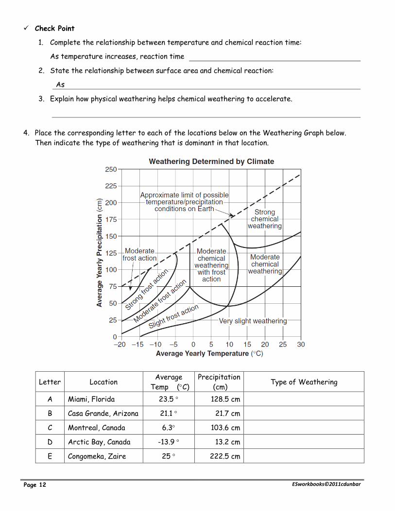
4. Place the corresponding letter to each of the locations below on the Weathering Graph below.
Then indicate the type of weathering that is dominant in that location.
Letter Location Average
Temp (C)
Precipitation
(cm) Type of Weathering
A Miami, Florida 23.5 128.5 cm
B Casa Grande, Arizona 21.1 21.7 cm
C Montreal, Canada 6.3 103.6 cm
D Arctic Bay, Canada -13.9 13.2 cm
E Congomeka, Zaire 25 222.5 cm

Guided Inquiry: Weathering & Erosion Page 13
1. Carefully remove the last page of this packet and cut out the four diagrams.
2. Match the diagrams to each of the bolded descriptions below.
3. Glue the layers next to the descriptions.
A. Before soil begins to form, the parent rock is present.
(1) Name the rock type in the diagram to the right
(2) What is the name of the rock?
(3) What is the composition of the rock to the right?
B. Organisms help break up the rocks as they go through the
broken rock particles. Organic material is added to the rock
particles when they die.
(1) What type of weathering breaks up the rock?
(2) What type of weathering occurs once biological activity is
present?
C. The top layer (Horizon A) starts to become rich with organic
matter. More growth of plants on the surface further weakens
the rocks and adds organic material.
(1) What increases with physical weathering?
(2) What type of weathering weakens the rock?
Soil is the result of weathering and biological activity over long periods of
time. Parent rock breaks down into smaller pieces (sediments). Organisms
help break up the rocks as they go through the broken rock particles and
organic material is added to the rock particles.
Show what you know: Soils
Materials Scissors Glue

Page 14 ESworkbooks©2011cdunbar
D. Soil continues to form and minerals leach into the lower levels.
Soil continues to thicken and develop
(1) Both and
weathering aid in the formation of soils.
(2) Soil is the result of weathering and
over a long period of time.
Below is a description of each layer of a well developed soil.
Horizon A – has dark to black soil with high organic content.
Horizon B – tan to orange soil with a high clay content, some rock fragments.
Horizon C – light gray to black soil, coarse rock fragments
Write the Horizon and description next to each of the layers below that match the picture.
Write the word “Residual Soil” if the description describes a soil that has not been moved
next on the line provided to the left of the statements.
Write the words “Transported Soil” if the soil was formed at some other location and moved.
A. - Soil is the same substance as the underlying bedrock
B. - Soil was moved
C. - Soil formed and stayed in the same place
D. - Soil is made up of completely different material than the
underlying Bedrock
Some soils are composed of the same material as the underlying bedrock. These soils
formed and stayed in the same place. Other soils have been moved by some agent of
erosion. They are composed of materials from different areas and have been dropped
(deposited) in their current location.

Guided Inquiry: Weathering & Erosion Page 15
Regents Questions:
____1. Which factors most directly control the development of soils?
(1) soil particle sizes and method of deposition
(2) bedrock composition and climate characteristics
(3) direction of prevailing winds and storm tracks
(4) earthquake intensity and volcanic activity.
____2. The cross section to the right shows the residual soils that developed on rock outcrops of
metamorphic quartzite and sedimentary
limestone. Which statement best explains why
the soil is thicker above the limestone than it is
above the quartzite?
(1) The quartzite formed from molten magma
(2) The limestone is thicker that the quartzite.
(3) The quartzite is older than the limestone.
(4) The limestone is less resistant to weathering than the quartzite.
____3. Soil horizons develop as a result of
(1) evaporation and transpiration
(2) compacting and cementing
(3) weathering and biological activity
(4) faulting and folding
____4. Equal masses of two identical rock samples. Sample A is one large block, while sample B was
cut into four smaller blocks of equal size.
If subjected to the same environmental
conditions, sample B will weather more
quickly than sample A. The best
explanation for this is that the
Sample A Sample B
(1) volume of Sample B is greater than that of Sample A
(2) surface area of Sample B is greater than that of Sample A
(3) density of Sample A is greater than that of Sample B
(4) hardness of Sample A is greater than that of Sample B
____5. Which change in the climate of New York State would most likely cause the greatest
increase in chemical weathering of local bedrock?
(1) lower temperature in the winter
(2) lower humidity in the winter
(3) higher atmospheric pressure in the summer
(4) greater precipitation in the summer
____6. The surface bedrock of a region of eastern New York State is shale. Which statement best
explains why the soil that covers the shale in this region contains abundant garnet and gneiss
pebbles?
(1) Volcanic lava flowed over the shale bedrock.
(2) A meteor impact scattered garnet and gneiss pebbles over the area.
(3) The soil consists of rock materials transported to this region by agents of erosion.
(4) The soil formed from the chemical and physical weathering of shale.

Page 16 ESworkbooks©2011cdunbar
____7. The cross section to the right shows a soil profile. This
soil was formed primarily by
(1) erosion by glaciers
(2) erosion by running water
(3) capillarity and human activity
(4) weathering and biological activity
____8. Which substance has the greatest effect on the rate of
weathering of rock?
(1) nitrogen (3) hydrogen
(2) water (4) argon
____9. Which factor has the least effect on the weathering of a rock?
(1) climatic conditions
(2) composition of the rock
(3) exposure of the rock to the atmosphere
(4) the number of fossils found in the rock
____10. Solid bedrock is changed to soil primarily by the process of
(1) erosion (2) weathering (3) infiltration (4) transpiration
____11. Water is the major agent of chemical weathering because water
(1) cools the surrounding air when it evaporates
(2) dissolves many of the minerals that make up rocks
(3) has density of about one gram per cubic centimeter
(4) has the highest specific heat of all common earth materials
____12. How does chemical weathering help to increase the amount of physical weathering?
(1) creates more surface area
(2) weakens the rock
(3) by exfoliation
(4) frost wedging
____13. Which is the best example of physical weathering?
(1) the cracking of rock caused by the freezing and thawing of water
(2) the transportation of sediment in a stream
(3) the reaction of limestone with acid rainwater
(4) the formation of a sandbar along the side of a stream
____14. Which change would cause the topsoil in New York State to increase in thickness?
(1) an increase in slope
(2) a decrease in rainfall
(3) an increase in biologic activity
(4) a decrease in air temperature
____15. At high elevations in New York State, which is the most common form of physical
weathering?
(1) abrasion of rocks by the wind
(2) oxidation by oxygen in the atmosphere
(3) dissolving of minerals into solution
(4) alternate freezing and melting of water

Guided Inquiry: Weathering & Erosion Page 17
Mini Lesson 2: Erosion and Deposition
Erosion is the transportation of weathered material. Gravity is the primary agent of erosion
that can work alone or in combination with other agents. Erosion by gravity alone is called mass
movement. It is the process whereby sediments move down hill. The term “landslide” is
sometimes used when referring to mass movement. Other agents of erosion include running
water, glaciers, wave action, and wind. Deposition is the process by which sediment is
deposited. The same agents that pick up and move sediments’ are the same agents that drop
sediments out.
Factors that affect erosion and deposition are velocity of the transportation medium
(the agent moving the sediment), size, shape, and density of the material.
Need to know:
1. What is erosion?
2. What is the primary agent of erosion?
3. What is erosion by gravity called?
4. List the four other agents of erosion mentioned in the passage. ,
, ,
5. What is deposition?
Circle the correct choice that describes how the factors listed above in the passage
affect erosion and deposition.
6. The faster the velocity of the medium the [ more or less ] sediment it can carry.
7. As the velocity of the medium slows down [ more or less ] sediment is deposited.
8. The larger the particle size the [ easier or more difficult ] it is moved.
9. The larger the particle size the [ faster or slower ] it is deposited.
10. The rounder the shape the [ easier or more difficult ] it is moved.
11. The rounder the shape the [ faster or slower ] it is deposited.
12. The more dense the particle size the [ easier or more difficult ] it is moved.
13. The more dense the particle size the [ faster or slower ] it is deposited.
Think

Page 18 ESworkbooks©2011cdunbar
Laboratory Activity 7.3 Erosion & Deposition [40]
Introduction:
Erosion is the transportation of weathered rock materials. Agents of erosion
include gravity (mass movement), streams (running water), glaciers (moving ice),
wave action, and wind. Deposition is the “depositing” of sediments that have
been moved. The term “transportation medium” refers to the agent of erosion.
Objective:
Determine how the following effects erosion and deposition:
velocity of a medium , size of a particle , density of a particle, and shape of
a particle
Procedure: Factors that affect Erosion and Deposition
1. Velocity (sand, dots, fan, plate)
a. Place sand and hole punch dots in a flat plate.
b. Place the fan in front of the plate so that it faces the wall (or back board).
c. Tilt the fan so that will blow on the plate.
d. Turn the fan on low. Make observations - for example . . .
i. Is any thing moving in the plate? What?
ii. How much of the material is moving?
iii. Is the material moving out of the plate?
iv. What material is moving the most?
v. Where in the plate is the material that is moving located (top, bottom, mixed).
e. Place ALL observations in the table below.
f. Turn the fan on medium and make the same observations.
g. Turn the fan on high and make the same observations.
Fan on LOW
Fan on Medium
Fan on High
Materials Sand Hole punch dots Fan Plate 2 sheets of paper settling tube water beaker 3 different size
spheres low density
sphere
timer

Guided Inquiry: Weathering & Erosion Page 19
a. State the relationship between velocity and movement of sediment.
b. Draw the relationship between velocity and movement on the graph
provided to the right. Remember to label “Velocity” and “Movement”.
c. Infer which size particles would stop moving and settle out first
(be deposited) as the wind begins to slow down.
2. Size (5 of each size sphere: small, medium, large, settling tube, water beaker, timer) a. Using the small spheres first:
i. Drop the sphere into the water.
ii. Start the timer when the sphere reaches Line A.
iii. Stop the timer when the sphere reaches Line B.
iv. Write the settling time in the table below.
v. Repeat until all 5 small spheres are timed. (this is called the “settling time”)
b. Repeat “a” for the medium and large spheres.
c. Determine the average settling rate for each size sphere and record it in the table below.
d. Graph the settling time for each size sphere by placing ONE dot using their average settling
time. Connect the points with a smooth line.
Settling Time (seconds) 8.0
Small Medium Large 7.0 Trial 1 6.0 Trial 2 5.0 Trial 3 4.0 Trial 4 3.0 Trail 5 2.0
Average Time 1.0
0.0 Small Medium Large
Page 20 ESworkbooks©2011cdunbar
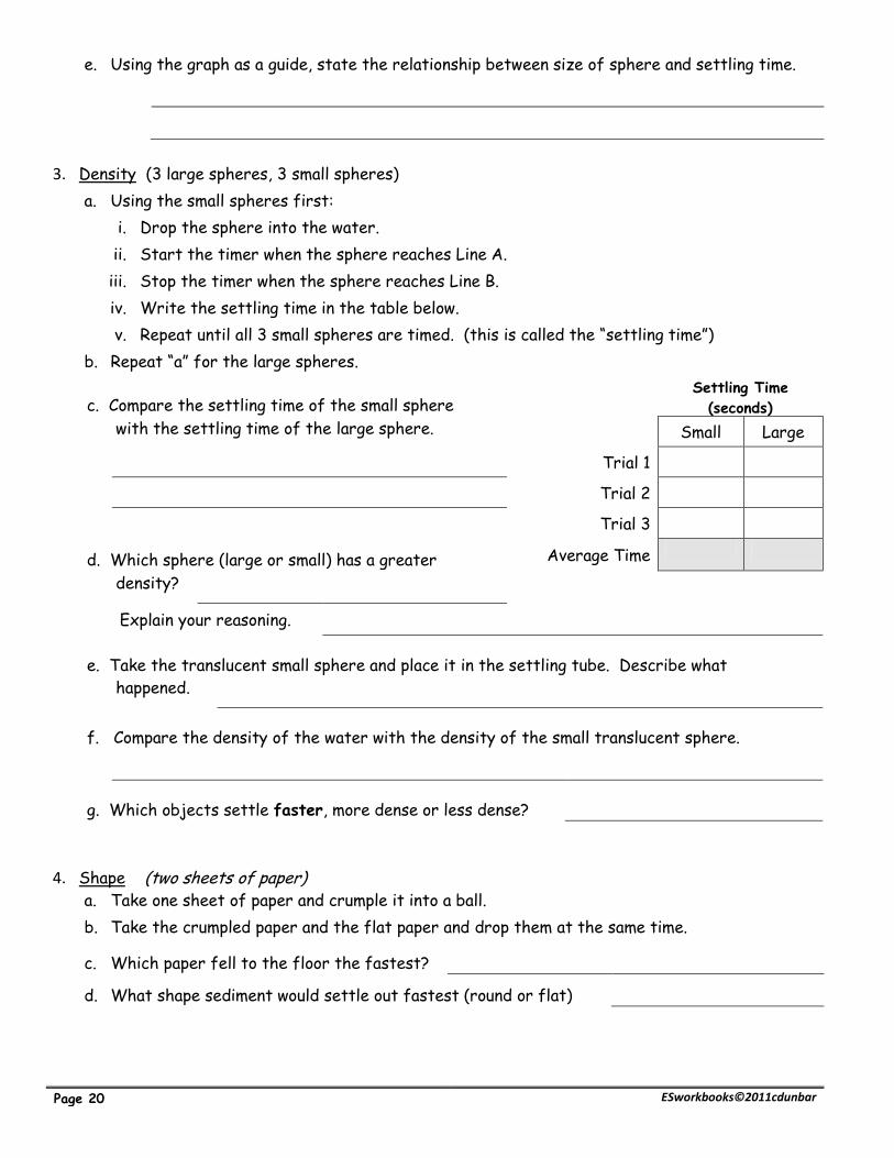
e. Using the graph as a guide, state the relationship between size of sphere and settling time.
3. Density (3 large spheres, 3 small spheres)
a. Using the small spheres first:
i. Drop the sphere into the water.
ii. Start the timer when the sphere reaches Line A.
iii. Stop the timer when the sphere reaches Line B.
iv. Write the settling time in the table below.
v. Repeat until all 3 small spheres are timed. (this is called the “settling time”)
b. Repeat “a” for the large spheres.
c. Compare the settling time of the small sphere Settling Time
(seconds) with the settling time of the large sphere. Small Large
Trial 1
Trial 2
Trial 3
d. Which sphere (large or small) has a greater Average Time
density?
Explain your reasoning.
e. Take the translucent small sphere and place it in the settling tube. Describe what
happened.
f. Compare the density of the water with the density of the small translucent sphere.
g. Which objects settle faster, more dense or less dense?
4. Shape (two sheets of paper) a. Take one sheet of paper and crumple it into a ball.
b. Take the crumpled paper and the flat paper and drop them at the same time.
c. Which paper fell to the floor the fastest?
d. What shape sediment would settle out fastest (round or flat)

Guided Inquiry: Weathering & Erosion Page 21
Base your answers to questions 1 through 3 on the diagrams below and descriptions of the two
laboratory activities below. The particles used in these activities are described below.
Particles Used in Activites
Combination A Combination B
Particle Diameter Density Particle Diameter Density
15 mm Al (aluminum) 2.7 g/cm3
15 mm Al (aluminum) 2.7 g/cm3
10 mm Al (aluminum) 2.7 g/cm3 15 mm Fe (iron) 7.9 g/cm3
5 mm Al (aluminum) 2.7 g/cm3 . 15 mm Pb (lead) 11.4 g/cm3
Activity 1
Three different particles of different
sizes were released in a plastic tube filled
with water. The length of time each
particle took to drop from point A to point
B is shown in data table 1.
Activity 2
Different combinations of particles were
placed in a tube filled with a thick liquid and
allowed to fall to the bottom. The tube was
then stoppered and quickly turned upside
down, allowing the particles to settle. The
different combinations of particles are
shown in data table 2. The diagram of the
partical sorting in data table 2 has been
omitted intentially. .
Data Table 1
Particle Size
Time of
Settling
15 mm Al 3.2 sec
10 mm Al 5.4 sec
5 mm Al 7.2 sec
Using the relative sizes in the chart above, draw
in a diagram to illusdtrate where each of the
spheres would appear.
Using the labeled spheres in the chart above,
draw in a diagram to illusdtrate where each of
the spheres would appear.
Al
Fe
Pb

Page 22 ESworkbooks©2011cdunbar
______ 1. The diagrams below represent where each of the spheres would most likely be found
once they settled to the bottom of the tube. In Activity 1, when the tube is turned
upside down, the aluminum particles , labeled “Combination A,” are allowed to settle.
Which diagram below represents the sorting that is most likely to occur?
Explain your reasoning.
(1) (2) (3) (4)
______ 2. In Activity 2, when the tube is turned upside down, the particles of three different
metals, labeled “Combination B,” are allowed to settle. Which diagram below
represents the sorting that is most likely to occur?
Explain your reasoning.
(1) (2) (3) (4)
______ 3. A third activity, similar in setup to Activity 1 was done using flat, oval, and round aluminum
particles with identical masses. Which table shows the most likely results of this third
activity?
Particle
Shape
Settling
Time
Particle
Shape
Settling
Time
Particle
Shape
Settling
Time
Particle
Shape
Settling
Time
Round 3.2 sec Round 5.1 sec Round 5.1 sec Round 6.7 sec
Oval 5.1 sec Oval 3.2 sec Oval 5.1 sec Oval 5.1 sec
Flat 6.7 sec Flat 6.7 sec Flat 5.1 sec Flat 3.2 sec
(1) (2) (3) (4)

Guided Inquiry: Weathering & Erosion Page 23
Refer to the previous questions for clues: Describe what each of the following terms mean.
Sorted
Unsorted
A. Horizontal sorting: Occurs when a stream enters a large body of water. The velocity of a stream
slows down and the larger particles settle out first.
Base your answers to questions 4 and 5 on the cross section and data table shown below. The cross
section shows a sediment-laden river flowing into the ocean. The arrows show the direction of river
flow. Different zones of sorted sediments, A, B, C, and D, have been labeled. Sediments have been
taken from these zones and measured. The data table shows the range of sediment sizes in each
zone.
Data Table
Zone Major Sediment Sizes
A 0.04 cm to 6 cm
B 0.006 cm to 0.1 cm
C 0.0004 cm to 0.006 cm
D Less than 0.0004 cm
______ 4. How is this pattern of horizontal sorting produced?
(1) High-density materials generally settle more slowly.
(2) Rounded sediments generally settle more slowly.
(3) Dissolved minerals are generally deposited first.
(4) Bigger particles are generally deposited first.
______ 5. The sedimentary rock, siltstone, will most likely form from sediments deposited in
zone.
(1) A (2) B (3) C (4) D

Page 24 ESworkbooks©2011cdunbar
______ 6. The cross section below illustrates the general sorting of sediment by a river as it
flows from a mountain to a plain.
Which factor most likely caused the sediment to be sorted in the pattern shown?
(1) velocity of the river water
(2) hardness of the surface bedrock
(3) mineral composition of the sediment
(4) temperature of the water
B. Vertical sorting: The sorting of sediments from bottom to top. The largest, roundest, most
dense particles settle out first and are on the bottom. Vertical sorting occurs after a major
event such as volcanic eruptions, earthquakes and hurricanes.
Graded Bedding is a series of depositional events that occurred
at different times. You can count how many events have
occurred by counting the beds.
How many events are represented in the diagram to the
right?
REVIEW: State how each of the following factors affect erosion and deposition.
Velocity of medium
Shape
Density
Size

Guided Inquiry: Weathering & Erosion Page 25
Regents Questions:
______ 1. On Earth’s surface, transported materials are more common than residual materials. This
condition is mainly the result of
(1) recrystallization (2) erosion (3) folding (4) subduction
______ 2. The composition of sediments on Earth’s surface usually is quite different from the
composition of the underlying bedrock. This observation suggests that most
(1) bedrock is formed from sediments (3) bedrock is resistant to weathering
(2) sediments are residual (4) sediments have been transported
______ 3. Most of the surface materials in New York State can be classified as
(1) igneous rock (3) metamorphic rocks
(2) coastal plain deposits (4) transported soils
______ 4. Granite pebbles are found on the surface in a certain area where only sandstone bedrock
is exposed. Which is the most likely explanation for the presence of these pebbles?
(1) The granite pebbles were transported to the area from a different region.
(2) Some of the sandstone has been changed into granite.
(3) The granite pebbles were formed by weathering of the exposed sandstone bedrock.
(4) Ground water tends to form granite pebbles within layers of sandstone rock.
______ 5. By which processes are rocks broken up and moved to different locations?
(1) evaporation and condensation (3) burial and cementation
(2) weathering and erosion (4) compaction and transportation
______ 6. Transported rock materials are more common than residual rock materials in the soils of
New York State. Which statement best explains this observation?
(1) Solid rock must be transported to break.
(2) Weathering changes transported rock materials more easily than residual rock
materials.
Most rock materials are moved by some agent of erosion at some time in their history.
Residual rock materials form only from bedrock that is difficult to change into soil.
______ 7. Each dot on the graph below shows the result of separate scientific studies of the
relationship between the rates of erosion in regions of different relief. Relief is the local
difference between the highest and the lowest
elevations.
The results of these combined studies
indicate that with each 100-meter increase
in relief, the rate of erosion generally
(1) decreases at a rate of 10 cm/1,000 years
(2) decreases at a rate of 20 cm/1,000 years
(3) increases at a rate of 10 cm/1,000 years
(4) increases at a rate of 20 cm/1,000 years

Page 26 ESworkbooks©2011cdunbar
Mini Lesson 3: Erosion by Gravity
Landslide is a general term that includes rock falls, slides and flows. Any of these landslides
can occur when the angle of the slope, type of soil or rock and amount of moisture are in the
correct combination. They can happen abruptly or over a long period of time. Landslides can be
brought on by excessive rain, earthquakes and even human impact. Avalanches are also caused
by gravity and are considered a form of erosion as well.
Mass wasting:
The steeper the slope the greater the mass wasting
Weak sediments and fractured rocks increase the chance of mass wasting
Water loosens the rocks and sediments to allow movement to occur easily
Rock falls Mud flow Debris flow Soil Creep
Rapid falling of
pieces of rock from
a cliff or steep
slope
Downward flow of
fine particles (mud)
and large amounts of
water
Rapid downslope flow
of debris
gradual downhill
movement of soil
Reading Review
1. What does the term landslide include?
2. What can cause a landslide?
3. List the three things that make mass wasting easier.
(a)
(b)
(c)

Guided Inquiry: Weathering & Erosion Page 27
Laboratory Activity 7.4 Gravity [40]
Introduction:
Three basic factors contribute to mass movement; the slope of the land, the
type of soil and the moisture content. Depending on the type of mass wasting,
there may be a trigger as well.
Objective:
To observe the factors that affects the downward movement of soil.
Procedure:
1. Fill about ½ a shoebox with dry soil (for measurement purposes).
2. Place the soil onto the flat pan.
3. Slowly tip the cookie sheet until the soil begins to move.
4. Place a protractor at the bottom of the pan and record the
angle at which the soil begins and your observations in the table below.
5. Place the soil back into the container.
6. Using dry sand, repeat steps 1 through 4.
7. Set the pan flat on the table and move the sand back to its original place.
8. Raise the pan to about half of the angle it began to move before.
9. Using a watering can, begin sprinkling water onto the sand.
10. Does the sand begin to move? ___________ if so – record the angle in the table below.
11. If the sand doesn’t begin to move, raise the pan until it does. Record the angle in the table.
12. Continue to add water once sand moves. Write down the observations below.
Material Angle of
Pan Describe your observations
Observations when more
water was added.
Dry soil
Dry sand
Wet sand
Review:
1. State the relationship between slope and chance of mass movement.
2. Explain the role that water plays in mass movement.
3. What impact does the composition of the rock material have on the chance of mass movement?
Materials Protractor Flat pan Dry soil Dry sand Plastic shoe box Watering can

Page 28 ESworkbooks©2011cdunbar
______ 1. The diagram below shows the surface features of a landscape.
Based on the features shown, which erosional
agent had the greatest effect on tree growth and
the structures that humans have built on this
landscape?
(1) running water (3) prevailing wind
(2) moving ice (4) mass movement
______ 2. The best evidence that erosion has taken place would be provided by
(1) deep residual soil observed on a hill side
(2) sediment observed at the bottom of a cliff
(3) tilted rock layers observed on a mountain
(4) faulted rock layers observed on a plateau
______ 3. Which erosional force acts alone to produce avalanches and landslides?
(1) gravity (2) running water (3) winds (4) sea waves
______ 4. Which movement of earth materials is gravity NOT the main force?
(1) sediments flowing in a river
(2) boulders carried by a glacier
(3) snow tumbling in an avalanche
(4) moisture evaporating from an ocean
______ 5. The diagram below shows the sequence of events leading to the deposition of landslide
debris.
What was the primary force that caused this landslide?
(1) gravity (2) moving ice (3) prevailing winds (4) stream discharge
______ 6. Glacial movement is caused primarily by
(1) Earth’s rotation (2) gravity (3) erosion (4) global winds
______ 7. The primary force responsible for the flow of water in a stream is
(1) solar energy (2) magnetic fields (3) wind (4) gravity
______ 8. The block diagram below shows a displacement of rock layers.
Which process describes the downward sliding of
the rock material?
(1) tidal changes (3) mass movement
(2) glacial erosion (4) lava flow
Guided Inquiry: Weathering & Erosion Page 29
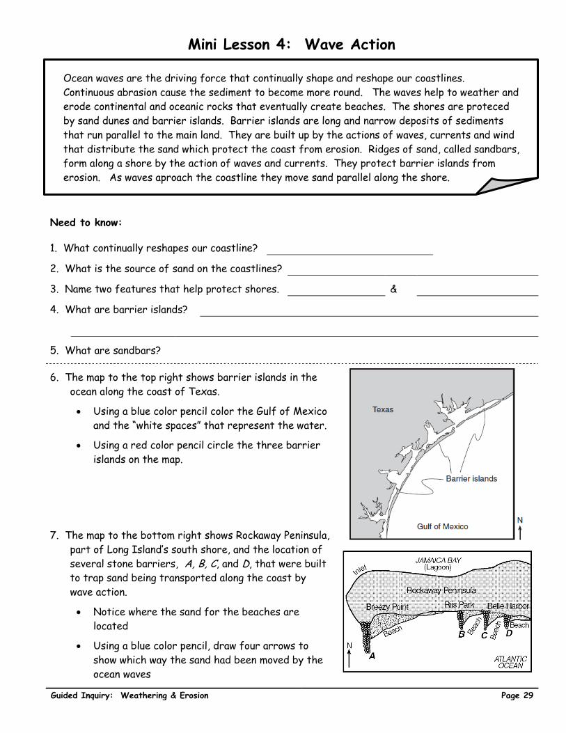
Mini Lesson 4: Wave Action
Ocean waves are the driving force that continually shape and reshape our coastlines.
Continuous abrasion cause the sediment to become more round. The waves help to weather and
erode continental and oceanic rocks that eventually create beaches. The shores are proteced
by sand dunes and barrier islands. Barrier islands are long and narrow deposits of sediments
that run parallel to the main land. They are built up by the actions of waves, currents and wind
that distribute the sand which protect the coast from erosion. Ridges of sand, called sandbars,
form along a shore by the action of waves and currents. They protect barrier islands from
erosion. As waves aproach the coastline they move sand parallel along the shore.
Need to know:
1. What continually reshapes our coastline?
2. What is the source of sand on the coastlines?
3. Name two features that help protect shores. &
4. What are barrier islands?
5. What are sandbars?
6. The map to the top right shows barrier islands in the
ocean along the coast of Texas.
Using a blue color pencil color the Gulf of Mexico
and the “white spaces” that represent the water.
Using a red color pencil circle the three barrier
islands on the map.
7. The map to the bottom right shows Rockaway Peninsula,
part of Long Island’s south shore, and the location of
several stone barriers, A, B, C, and D, that were built
to trap sand being transported along the coast by
wave action.
Notice where the sand for the beaches are
located
Using a blue color pencil, draw four arrows to
show which way the sand had been moved by the
ocean waves

Page 30 ESworkbooks©2011cdunbar
Laboratory Activity 7.5 Ocean Waves [40]
Introduction:
As stated before, ocean waves shape and reshape our coastlines. One of the
major factors is the direction in which the waves strike the coastline.
Objective:
Observe what happens as ocean waves hit the coastline
Procedure:
1. Using the stream table, place approximately 2 inches of sand to cover half
of the table.
2. Insert three large rocks on the edge of the sand.
3. Plug off the end of the table and place fill half of the EMPTY space with water.
4. Use the diagram below as a guide.
5. Using the plastic board, slowly move the water back and forth against the sand. Do not touch the
sand with the board. Try to move the water at an angle, not directly.
6. Using a blue color pencil draw the result in the diagram above. Show the direction you moved the
water and where the sand ended up.
7. Place the sand and rocks back to where they were before moving the water.
8. Using the plastic board, slowly move the water back and forth against the sand. Do not touch the
sand with the board. Try to move the water at an angle opposite the direction in step 5.
9. Using a blue color pencil draw the result in the diagram below. Show the direction you moved the
water and where the sand ended up.
Materials
Pencil
Sand
Stream table
water
elevation
blocks
plastic board
large rocks
sand water
rocks
sand water
rocks

Guided Inquiry: Weathering & Erosion Page 31
Regents questions:
Base your answers to questions 1 through 4 on the diagram below. The arrows show the direction in
which sediment is being transported along the shoreline. A barrier beach has formed, creating a
lagoon (a shallow body of water in which sediments are being deposited). The eroded headlands are
composed of diorite bedrock. A groin has recently been constructed. Groins are wall-like structures
built into the water perpendicular to the shoreline to trap beach sand.
____ 1. The groin structure will change the pattern of deposition along the shoreline, initially
causing the beach to become
(1) wider on the western side of the groin (3) narrower on both sides of the groin
(2) wider on the eastern side of the groin (4) wider on both sides of the groin
____ 2. Which two minerals are most likely found in the beach sand that was eroded from the
headlands?
(1) quartz and olivine (3) potassium feldspar and biotite
(2) plagioclase feldspar and amphibole (4) pyroxene and calcite
____ 3. The sediments that have been deposited by streams flowing into the lagoon are most likely
(1) sorted and layered (3) unsorted and layered
(2) sorted and not layered (4) unsorted and not layered
____ 4. Which event will most likely occur during a heavy rainfall?
(1) Less sediment will be carried by the streams.
(2) An increase in sea level will cause more sediments to be deposited along the shoreline.
(3) The shoreline will experience a greater range in tides.
(4) The discharge from the streams into the lagoon will increase.

Page 32 ESworkbooks©2011cdunbar
____ 5. The major source of sediments found on the deep ocean bottom is
(1) erosion of continental rocks (3) submarine landslides from the mid-ocean ridges
(2) submarine volcanic eruptions (4) icebergs that have broken off continental glaciers
____ 6. The long, sandy islands along the south shore of Long Island are composed mostly of sand
and rounded pebbles arranged in sorted layers. The agent of erosion that most likely
shaped and sorted the sand and pebbles while transporting them to their island location
was
(1) glaciers (2) wind (3) landslides (4) ocean waves
____ 7. The map below shows some features along an ocean shoreline. In which general direction is
the sand being moved along this shoreline by ocean (longshore) currents?
(1) northeast
(2) northwest
(3) southeast
(4) southwest
____ 8. The diagrams below represent landscape features found along the seacoast. The arrows
show ocean-wave direction. Which shoreline has been shaped more by deposition than by
erosion?
____ 9. The map to the right shows barrier islands in the ocean along the coast of Texas.
Which agent of erosion most likely formed these
barrier islands?
(1) mass movement
(2) wave action
(3) streams
(4) glaciers

Guided Inquiry: Weathering & Erosion Page 33
Soil Horizons