Embed Size (px)
Citation preview
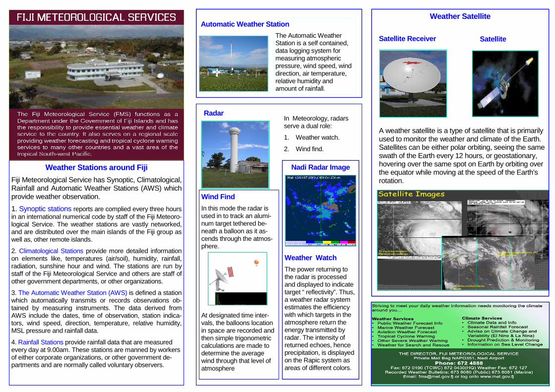
A weather satellite is a type of satellite that is primarily used to monitor the weather and climate of the Earth. Satellites can be either polar orbiting, seeing the same swath of the Earth every 12 hours, or geostationary, hovering over the same spot on Earth by orbiting over the equator while moving at the speed of the Earth's rotation.
In Meteorology, radars serve a dual role:
1. Weather watch.
2. Wind find.
Wind Find
In this mode the radar is used in to track an alumi-num target tethered be-neath a balloon as it as-cends through the atmos-phere.
At designated time inter-vals, the balloons location in space are recorded and then simple trigonometric calculations are made to determine the average wind through that level of atmosphere
Satellite Images
TC Waka overhead Vavau, Tonga
TC Paula brushing past Fiji on its way southeast
TC Susan turning southeast, just east of Vanuatu
Weather Satellite
Radar
The Automatic Weather Station is a self contained, data logging system for measuring atmospheric pressure, wind speed, wind direction, air temperature, relative humidity and amount of rainfall.
Nadi Radar Image
Weather Watch
The power returning to the radar is processed and displayed to indicate target “ reflectivity”. Thus, a weather radar system estimates the efficiency with which targets in the atmosphere return the energy transmitted by radar. The intensity of returned echoes, hence precipitation, is displayed on the Rapic system as areas of different colors.
Satellite Receiver Satellite
Automatic Weather Station
Weather Stations around Fiji
Fiji Meteorological Service has Synoptic, Climatological, Rainfall and Automatic Weather Stations (AWS) which provide weather observation.
1. Synoptic stations reports are complied every three hours in an international numerical code by staff of the Fiji Meteoro-logical Service. The weather stations are vastly networked, and are distributed over the main islands of the Fiji group as well as, other remote islands.
2. Climatological Stations provide more detailed information on elements like, temperatures (air/soil), humidity, rainfall, radiation, sunshine hour and wind. The stations are run by staff of the Fiji Meteorological Service and others are staff of other government departments, or other organizations.
3. The Automatic Weather Station (AWS) is defined a station which automatically transmits or records observations ob-tained by measuring instruments. The data derived from AWS include the dates, time of observation, station indica-tors, wind speed, direction, temperature, relative humidity, MSL pressure and rainfall data.
4. Rainfall Stations provide rainfall data that are measured every day at 9.00am. These stations are manned by workers of either corporate organizations, or other government de-partments and are normally called voluntary observers.
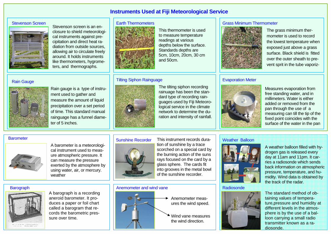
This thermometer is used to measure temperature readings at various depths below the surface. Standards depths are 5cm, 10cm, 20cm, 30 cm and 50cm.
This instrument records dura-tion of sunshine by a trace scorched on a special card by the burning action of the suns rays focused on the card by a glass sphere. The cards fit into grooves in the metal bowl of the sunshine recorder.
A weather balloon filled with hy-drogen gas is released every day at 11am and 11pm. It car-ries a radiosonde which sends back information on atmospheric pressure, temperature, and hu-midity. Wind data is obtained by the track of the radar.
Radiosonde
The grass minimum ther-mometer is used to record the lowest temperature when exposed just above a grass surface. Black shield is fitted over the outer sheath to pre-vent sprit in the tube vaporiz-
Measures evaporation from free standing water, and in millimeters. Water is either added or removed from the pan through the use of a measuring can till the tip of the fixed point coincides with the surface of the water in the pan
The standard method of ob-taining values of tempera-ture,pressure and humidity at different levels in the atmos-phere is by the use of a bal-loon carrying a small radio transmitter known as a ra-diosonde.
Rain Gauge Evaporation Meter
Anemometer meas-ures the wind speed.
Wind vane measures the wind direction.
A barometer is a meteorologi-cal instrument used to meas-ure atmospheric pressure. It can measure the pressure exerted by the atmosphere by using water, air, or mercury. weather
Barometer
Barograph A barograph is a recording aneroid barometer. It pro-duces a paper or foil chart called a barogram that re-cords the barometric pres-sure over time.
Anemometer and wind vane
Weather Balloon Sunshine Recorder
Instruments Used at Fiji Meteorological Service
Stevenson screen is an en-closure to shield meteorologi-cal instruments against pre-cipitation and direct heat ra-diation from outside sources, allowing air to circulate freely around. It holds instruments like thermometers, hygrome-ters, and thermographs.
Rain gauge is a type of instru-ment used to gather and measure the amount of liquid precipitation over a set period of time. This standard manual rainguage has a funnel diame-ter of 5 inches.
Stevenson Screen
Tilting Siphon Rainguage
The tilting siphon recording rainuage has been the stan-dard type of recording rain-guages used by Fiji Meteoro-logical service in the climate network to determine the du-ration and intensity of rainfall.
Earth Thermometers Grass Minimum Thermometer