Embed Size (px)
Citation preview

Our Planet is Changing
We need advanced tools to understand and monitor our
oceans, coasts and Great Lakes
Zdenka Willis Director, US IOOS Program Office
US IOOS®: A Partnership for Lives and Livelihoods
Integrated, Interdependent, Indispensible

U.S. IOOS: Program Overview
12
WHO
2 Enhances science and improves decision making
Weather and climate change Maritime operations Natural hazards Homeland security Public health risks Healthy coastal ecosystems Sustain Living Marine Resources
WHAT
• Observations
• Data Management
• Modeling and Analysis
WHY: 7 Goals, 1 System

Integration
Interdependent
Indispensible

Observation Networks: Waves
• Nation’s wave data now accessible
– 181 platforms in 2008; 227 2011
– Wave Plan called for 296
– New IOOS supported wave sites being deployed collaboratively with USACE/ CDIP program
– Some platforms need to be upgraded to directional wave measurements

The value of NANOOS
1. Washington Dept
of Ecology
2. Oceanic Remote
Chemical-optical
Analyzer (ORCA)
3. USGS
4. University of
Washington –
Applied Physics
Lab
5. NOAA National
Data Buoy Center
6. King County
7. NOAA National
Ocean Service
8. IntelliCheck
Mobilisa
9. Hood Canal
Dissolved Oxygen
Program
1 2
2
2 2
3
3 3
3
4
4
5 6 6 1 6 6
6
7
7 7 1
8 9
NANOOS is a community of people that provides
data through one place for quicker decision-
making.
Data Integration - Community

Data Integration – Regional to National
6

U.S. IOOS®: Modeling Testbed
7
Coastal Inundation
Rick Leuttich, UNC-CH
Gulf & Atlantic Coast
Shelf Hypoxia
John Harding, USM
Gulf of Mexico
Estuarine Hypoxia
Carl Friedrichs, VIMS
Chesapeake Bay
Cyber Infrastructure
Eoin Howlett, ASA
Testbed Advisory
Rich Signell, USGS
Evaluation Group
• 5 teams, 64 scientists/analysts
• SURA is overall lead for execution
• Began in June 2010; now in the second year
• Multi-sector engagement (federal agency, academia, industry)
• Goals:
• Less about model than process
• Focus is on stable infrastructure (testing environment, tools, standard obs) and transition to operations
• Enable Modeling and Analysis subsystem

Integration
Interdependent
Indispensible
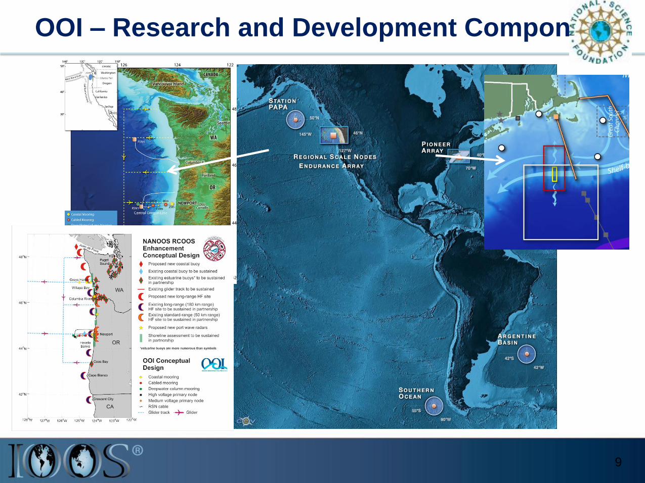
OOI – Research and Development Component
9

Beach Water Quality Predictive Modeling

Beach Water Quality Predictive Modeling
U.S. Integrated Ocean Observing System (IOOS)
"This model has reduced the sampling burden for our Regional staff; but the major benefit has been the Department's quicker response time for posting beach advisories and subsequent enhancement of our agency's primary mission of protecting the public health.“
David E. Tilson, PE, Chief, Bureau of Water, South Carolina Department of
Health and Environmental Control (SCDHEC)

NOAA
14.21%
Industry
5.91%
NOPP
5.72%
EPA
0.39%
USDA
0.37%
DHS
16.66% NSF
21.79%
ONR
23.80%
State Governments
0.79%
Foreign Governments
3.80%
DOE
3.36%
Foundations
2.14%
NASA
1.06%
ONR
NSF
DHS
NOAA
Industry
NOPP
Foreign Governments
DOE
Foundations
NASA
State Governments
EPA
USDA
1997 - 2008 Total Grants $76,717,845
Funding Distribution

Observing Networks: HF Radar
13
Stakeholders • > 30 institutions operate HF Radars
•Used by >40 government/private entities
• Partnership with Industry: US-based CODAR Ocean Sensor
Who Depends on it •USCG Search and Rescue: Oil spill response •Water quality; Criminal forensics •Commercial marine navigation • Offshore energy; Harmful algal blooms • Marine fisheries • Emerging - Maritime Domain Awareness • Emerging – Tsunami
Decreases search area by 66% in 96 hours
IOOS – White DHS – Green DoD – Yellow NJ DEP - Red
Mid Atlantic

U.S. IOOS® : Working with NGO community
14
A tool that enables the Nation to track, predict, manage and adapt to changes in our marine environment and delivers
critical information to decision makers to…
M. J Murdock Trust: seeks to enrich the quality of life in the Pacific Northwest by providing grants and enrichment programs to non-profit organizations that seek to strengthen the region's educational, spiritual, and cultural base in creative and sustainable ways.

87%
Total in situ networks 61%
59%
81%
62% 73% 34% 48%
100%
100%
Global Component: Global Ocean Observing System for
Climate
15

Integration
Interdependent
Indispensible

Responding to Crisis: Deepwater Horizon
U.S. IOOS partnership demonstrated ability to:
• Quickly deploy technologies: Gliders and HF radar, saving resources/improving safety
• Models/Imagery ingested into NOAA/Navy models
• Data assimilation improved spill response decision-making and public understanding
USM HFR
USF HFR
TS Bonnie
Web Portal
17
HFR data informed NOAA trajectory forecasts
Briefing Blog
HFR validation of SABGOM Forecast with satellite detected oil slicks

Responding to Crisis: Japan Tsunami Warning
• International buoy program
•Tsunami wave at DART Station 21418
located 470n mi northeast of Tokyo.
• Largest peak 1.8M
Graphic courtesy NOAA / PMEL / Center for Tsunami Research

Responding to Crisis: Japan Tsunami Response
19
CeNCOOS: • Recorded the tsunami passage with
U.S. IOOS sensors • Five-fold increase in web traffic
NANOOS: • Featured “Tsunami Evacuation Zones
for the Oregon Coast” application • NANOOS Visualization System provided
easy access to current and water height data
• Four-fold increase in web traffic
PacIOOS: • Provided the only real-time water level
and turbidity measurements for Waikiki
• Ten-fold increase in web traffic

Types of Information:
a) Initial info including link to tsunami portal;
b) graphs of water level for various locations;
c) synthesis information
Facebook:
= Posts
= Tsunami event
www.facebook.com/NANOOS.PNW
Using Social Media to reach out in new ways

Around-the-clock data and other information before, during and after hurricanes
Responding to Crisis: Hurricane Irene
• CaRa:
– 4 buoys provided real-time observations
• SECOORA:
– Buoys used to initialized models/verified forecasts.
– Forecast system used by Coast Guard, North Carolina Division of Emergency Management, National Hurricane Center, USACE, and multiple National Weather Service Forecast Offices
• MARACOOS:
– Surface currents by the High Frequency Radar
– Delivered forecasts to New Jersey Board of Public Utilities , Connecticut governors office and Delaware River Basin Commission
– Underwater glider collected data
• NERACOOS:
– Buoys critical to the National Weather Service
– Local television stations in Connecticut reported conditions from the NERACOOS buoy
– Northeast Coastal Ocean Forecast System (NeCOFS) provided to the National Weather Service

U.S. IOOS® : Challenge
22
• Leveraging resources yields positive results.
• Multi-sector approach is a hallmark of IOOS but adds complexity
• As we are now interdependent both from a fiscal, science and operational perspectives loss of any 1 funding stream means significant risk to the entire enterprise
• So what is needed?
– Unified portrayal of what Ocean Observing is critical
– Coordinated message
– Continued mutual engagement

U.S. IOOS® : A National Endeavor but in a Global
Context
23