Embed Size (px)
Citation preview
FIRST AIDCENTER
FIRST AIDCENTER
Wi Fi
CATNAP
UPPER LYNX
CAT TRACK
MIDD L E LY
NX LYNX
CONN
ECTIO
N
MIDDLE WILDCAT
CAT WALK
LOW
ER LY
NX
CATENARY
HAINES
VILLE
PASS
COUGAR
PANTHERALLEY CAT
LOWER CATAPULT
BOBCAT
CHEETAH
LOWER WILDCAT
ANNIE’SALLEY
LOWERCAT
TRACK
CATNAP
UPPER LYNX
CAT TRACK
MIDD L E LY
NX LYNX
CONN
ECTIO
N
MIDDLE WILDCAT
MIDWAY
CAT WALK
LOW
ER LY
NX
CATENARY
HAINES
VILLE
PASS
COUGAR
PANTHERALLEY CAT
LOWER CATAPULT
COPY CAT
BOBCAT
CHEETAH
LOWER WILDCAT
ANNIE’SALLEY
LOWERCAT
TRACK
CATNAP
UPPER CATAPULT
CAT TRACK
MIDD L E LY
NX LYNX
CONN
ECTIO
N
MIDDLE WILDCAT
MIDWAY
CAT WALK
LOW
ER LY
NX
CATENARY
HAINES
VILLE
PASS
COUGAR
PANTHERALLEY CAT
LOWER CATAPULT
COPY CAT
BOBCAT
CHEETAH
LOWER WILDCAT
ANNIE’SALLEY
LOWERCAT
TRACK
LEO’SLEAP
SPHYNXLOW
ER
CATENARY
WILDCATPITCH
BLACK CAT
MIDDLE
CATAPULT
STARR LINE
FELINE
TOMCAT SCHUSS
AL’S
FOL
LY
HAIRBALL
PINKHAM NOTCH
THE DEN
BOBCATLODGEBASE ELEVATION
1,950’
THE CHUTE
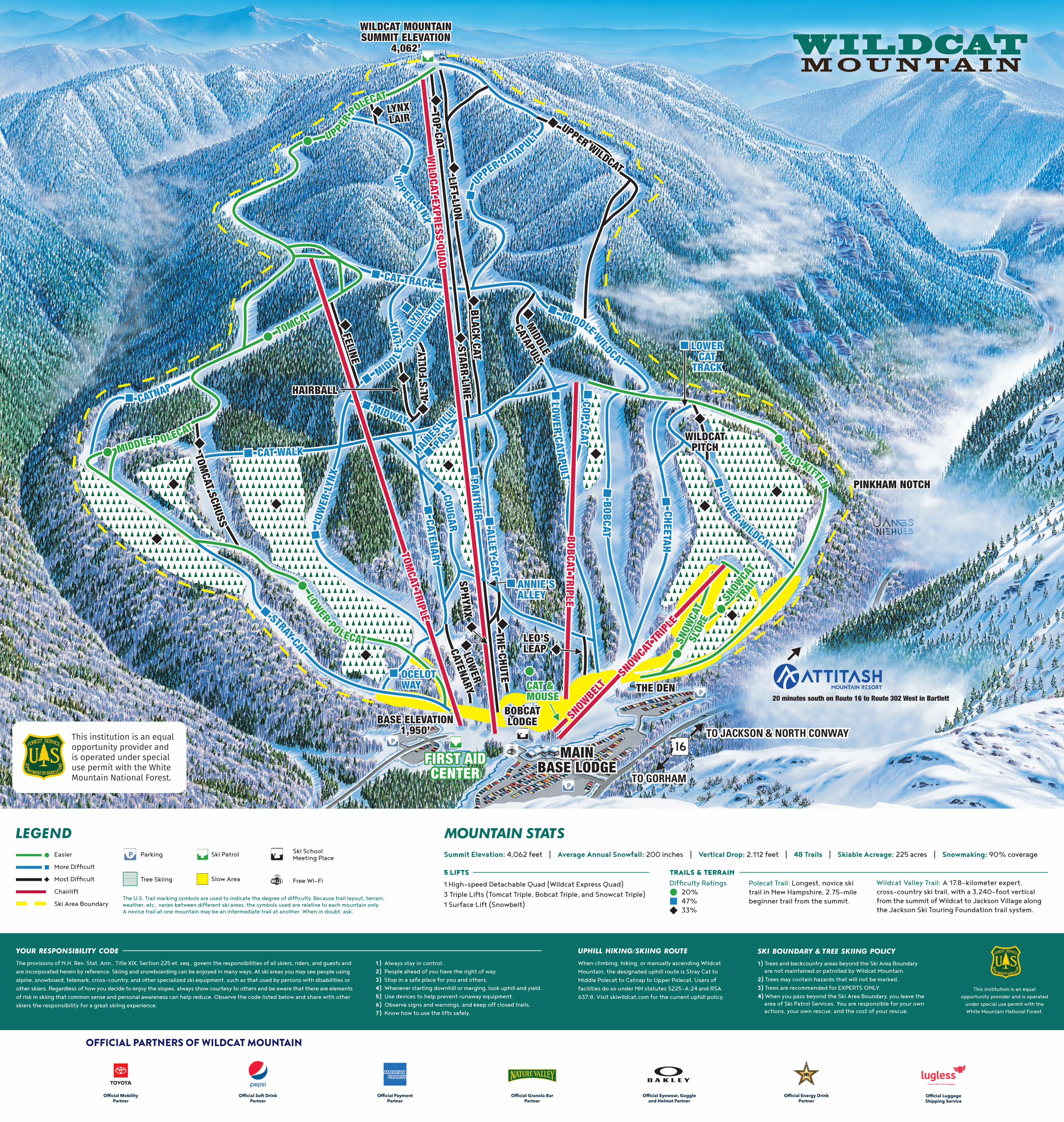
WILDCAT MOUNTAINSUMMIT ELEVATION
4,062’
LYNXLAIR
TOP CATLIFT LION
UPPER WILDCAT
MAINBASE LODGE
LEO’SLEAP
SPHYNXLOW
ER
CATENARY
WILDCATPITCH
BLACK CAT
MIDDLE
CATAPULT
STARR LINE
FELINE
TOMCAT SCHUSS
AL’S
FOL
LY
HAIRBALL
PINKHAM NOTCH
THE DEN
BOBCATLODGEBASE ELEVATION
1,950’
THE CHUTE
WILDCAT MOUNTAINSUMMIT ELEVATION
4,062’
LYNXLAIR
TOP CATLIFT LION
UPPER WILDCAT
MAINBASE LODGE
SNOW
CAT
SLOP
E
SNOW
CAT
SLOP
E
SNOW
CAT
TRAIL
SNOW
CAT
TRAIL
UPPER PO
LECAT
UPPER PO
LECAT
MIDDLE POLECAT
MIDDLE POLECAT
TOMCATTOMCAT
WI L D KITTEN
WI L D KITTEN
STRAY CAT
STRAY CATLOWER POLECAT
LOWER POLECAT
CAT &MOUSECAT &MOUSE
OCELOTWAYOCELOTWAY
20 minutes south on Route 16 to Route 302 West in Bartlett
SNOWBELT
BOBCAT TRIPLE
SNOWCA
T TRIPL
ETOM
CAT TRIPLEW
ILDCAT EXPRESS QUAD
SNOWBELT
BOBCAT TRIPLE
SNOWCA
T TRIPL
ETOM
CAT TRIPLEW
ILDCAT EXPRESS QUAD
Wi Fi
Easier
More Difficult
Most Difficult
Chairlift
Ski Area Boundary
Summit Elevation: 4,062 feet | Average Annual Snowfall: 200 inches | Vertical Drop: 2,112 feet | 48 Trails | Skiable Acreage: 225 acres | Snowmaking: 90% coverage
5 LIFTS 1 High-speed Detachable Quad (Wildcat Express Quad)3 Triple Lifts (Tomcat Triple, Bobcat Triple, and Snowcat Triple)1 Surface Lift (Snowbelt)
The U.S. Trail marking symbols are used to indicate the degree of difficulty. Because trail layout, terrain, weather, etc., varies between different ski areas, the symbols used are relative to each mountain only.A novice trail at one mountain may be an intermediate trail at another. When in doubt, ask.
Ski Patrol
Slow Area
Parking
Tree Skiing
Ski SchoolMeeting Place
Free Wi-Fi
MOUNTAIN STATSLEGEND
This institution is an equal opportunity provider and is operated
under special use permit with the White Mountain National Forest.
UPHILL HIKING/SKIING ROUTE
When climbing, hiking, or manually ascending Wildcat Mountain, the designated uphill route is Stray Cat to Middle Polecat to Catnap to Upper Polecat. Users of facilities do so under NH statutes S225-A:24 and RSA 637:8. Visit skiwildcat.com for the current uphill policy.
SKI BOUNDARY & TREE SKIING POLICY
1) Trees and backcountry areas beyond the Ski Area Boundary are not maintained or patrolled by Wildcat Mountain.
2) Trees may contain hazards that will not be marked.3) Trees are recommended for EXPERTS ONLY.4) When you pass beyond the Ski Area Boundary, you leave the
area of Ski Patrol Services. You are responsible for your ownactions, your own rescue, and the cost of your rescue.
YOUR RESPONSIBILITY CODE
The provisions of N.H. Rev. Stat. Ann., Title XIX, Section 225 et. seq., govern the responsibilities of all skiers, riders, and guests and are incorporated herein by reference. Skiing and snowboarding can be enjoyed in many ways. At ski areas you may see people using alpine, snowboard, telemark, cross-country, and other specialized ski equipment, such as that used by persons with disabilities or other skiers. Regardless of how you decide to enjoy the slopes, always show courtesy to others and be aware that there are elements of risk in skiing that common sense and personal awareness can help reduce. Observe the code listed below and share with other skiers the responsibility for a great skiing experience.
1 ) Always stay in control.2) People ahead of you have the right of way.3) Stop in a safe place for you and others.4) Whenever starting downhill or merging, look uphill and yield.5) Use devices to help prevent runaway equipment.6) Observe signs and warnings, and keep off closed trails.7) Know how to use the lifts safely.
Polecat Trail: Longest, novice ski trail in New Hampshire, 2.75-mile beginner trail from the summit.
Wildcat Valley Trail: A 17.8-kilometer expert, cross-country ski trail, with a 3,240-foot vertical from the summit of Wildcat to Jackson Village along the Jackson Ski Touring Foundation trail system.
TRAILS & TERRAIN Difficulty Ratings
20% 47% 33%
OFFICIAL PARTNERS OF WILDCAT MOUNTAIN
Official Luggage Shipping Service
Official Payment Partner
Official Granola Bar Partner
Official Soft DrinkPartner
Official Mobility Partner
Official Eyewear, Goggle and Helmet Partner
Official Energy DrinkPartner
WARNING! Under the New Hampshire law (N.H. Rev. Stat. Ann., Title XIX, Section 225 et. seq.), any individual who engages in the sport of skiing, alpine or Nordic, or any person who is within the boundaries for the purpose of observing any skiing activity, accepts and assumes the inherent risk of skiing insofar as they are reasonably obvious, expected, or necessary.
WARNING! Inherent risks of skiing include, but are not limited to those dangers or conditions which are an integral part of the sport and can also include changing weather conditions, variation or steepness of terrain, snow or ice conditions, surface or subsurface conditions, whether man-made or not, bare spots, creeks, gully, forest growth or rocks, stumps, lift towers and other structures and their components, collision with other skiers and a skier's failure to ski within the skier's own ability.
Skiing and riding off open and designated trails;• Pursuit to New Hampshire law, the ski area assumes no responsibility for skiers and riders going beyond the open and designated ski trails. Ski area is not liable for
damages, including injury or death, to persons who venture beyond the open and designated ski trails.
• Areas beyond the open and designated ski trails are not patrolled or maintained. Unmarked obstacles and other natural hazards exists.
• You can be charged for costs of your rescue beyond the open and designated ski trails
Please Note It is unlawful to access Wildcat Mountain lifts without a valid lift access card or season pass under New Hampshire state law. Skiing or riding without a lift access card or pass or with a fraudulent lift access card or pass will result in prosecution. Lift access cards are non-refundable.
First Aid Services For immediate assistance and to report all accidents, please call the Ski Patrol at (603) 466-4294. Emergency Phones are available with all lift operators. All parties involved in a collision must exchange information and contact the Ski Patrol.
Slow Zones Certain areas are designated as SLOW ZONES. Please observe the posted slow zone areas by maintaining a speed no faster than the general flow of traffic. Space and speed are especially important in these areas. Fast and aggressive skiing will not be tolerated and may result in termination of your resort privileges.
Freestyle Terrain Freestyle Terrain may contain jumps, hits, ramps, banks, fun boxes, jibs, rails, half pipes, and other constructed or natural terrain features. Prior to using freestyle terrain, you are responsible for familiarizing yourself with all elements and landings and obeying all instructions, warnings, and signs. Freestyle skills require maintaining control on the ground and in the air.
Know the Code – Play It Safe Skiing and riding, in their various forms, are inherently hazardous sports. Trail and slope conditions change constantly with weather and use. It is your responsibility to avoid natural and manmade objects regardless of the presence of markings or other mitigation, and to avoid and use courtesy with other people. Wildcat Mountain uses many different types of marking devices to alert you to some hazards.
Your Responsibility Code
1. Stay in control.
2. People ahead have the right of way.
3. Stop in a safe place for you and others.
4. When starting downhill or merging, look uphill and yield.
5. Use devices to help prevent runaway equipment.
6. Observe signs and warnings, and keep off closed trails.
7. Know how to use the lifts safely.
SMOKING IN THE LIFT LINE IS PROHIBITED
Backcountry Warning Skiing and Riding off Open and Designated Trails: Pursuant to New Hampshire law, the ski area assumes no responsibility for skiers and riders going beyond the open and designated trails at Wildcat Mountain. Areas beyond the open and designated trails are not patrolled or maintained. Unmarked obstacles and other natural hazards exist. New Hampshire law also states that you shall be liable for any costs of rescue, medical or other services.
Wildcat Mountain Off Trail Policy Wooded areas between designated trails within the ski area boundary are not patrolled and have no skier/ snowboarder services. If you ski/ride in wooded areas that are not designated trails, you are solely responsible for yourself. You must enter from and exit onto designated trails that are open to the public for skiing/riding. Failure to do so will result in the loss of your skiing/ riding privileges. Wooded areas are recommended for expert skiers/riders, in groups of three or more. Do not ski/ride alone. Unmarked obstacles exists throughout.
Uphill Access Program – Hiking, Skinning, and Snowshoeing Non-lift access to ski area facilities such as uphill snowshoeing, hiking or “skinning”, may present high danger of personal injury to participants or others. Therefore, we have designated certain trails for uphill access, which may be limited or forbidden based on conditions, on-mountain activity, and/or mountain policy. To identify those trails that are available for use see www.skiwildcat.com. Resort rescue services are not available outside of hours of lift operations. Before you participate in any uphill activities, view our full policy at www.skiwildcat.com.
Snowcats and Snowmobiles CAUTION – snowcats, snowmobiles and snowmaking may be encountered at any time.
Sun Protection With every 3,000 foot increase in altitude, UV levels rise by 10-12%. We recommend eye protection and sunscreen.
HEADS UP

![wc EME žäC&ff DAIOU ILLUST MAP (77? wc wc wc ÞY5 260 260 ... · DAIOU ILLUST MAP (77? wc wc wc ÞY5 260 260 wc (DÎIÉ] 167 wc 9155} 7—Jb wc -k ;knlc 220km 61 km 55B R 167 45](https://img.pdfslide.us/doc/110x75/5f097c067e708231d4270c2d/wc-eme-cff-daiou-illust-map-77-wc-wc-wc-y5-260-260-daiou-illust.jpg)