Embed Size (px)
Citation preview

A Resource for Enviromental Issuesin the U.S. Virgin Islands
Waves of Change:
AcknowledgmentsThis document was produced by the University of theVirgin Islands (UVI) Center for
Marine and Environmental Studies, Virgin Islands Marine Advisory Service in collaboration with a number of USVI natural resource management, environmental and political
professionals across the territory including:
Marcia Taylor, Virgin Islands Marine Advisory Service, UVILihla Noori, Virgin Islands Marine Advisory Service, UVI
Kemit-Amon Lewis, DPNR- Division of Coastal Zone ManagementEmily Tyner, Virgin Islands Marine Advisory Service, UVI
Elizabeth Ban, Virgin Islands Marine Advisory Service, UVI (formerly)Dr. Richard Nemeth, Center for Marine and Environmental Studies, UVI
Toni Thomas, Cooperative Extension Services, UVIMay Adams Cornwall, Virgin Islands Waste Management Authority
Stella Saunders, Virgin Islands Waste Management AuthorityDr. Tyler Smith, Center for Marine and Environmental Studies, UVIShaun Kadison, Center for Marine and Environmental Studies, UVI
Jeremiah Blondeau, Center for Marine and Environmental Studies, UVIDr. Barbara Kojis, Division of Science and Mathematics, UVI
Maria Dillard, VI-EPSCOR, University of Virgin Islands (formerly)William Tobias, DPNR-Division of Fish and Wildlife
Dr. Renata Platenberg, DPNR-Division of Fish and WildlifeDr. Wanda Bocachica-Mills, DPNR-Division of Planning (formerly)
Carol Cramer-Burke, St. Croix Environmental AssociationDee Osinski, Virgin Islands Network of Environmental Educators
Stevie Henry, Eastern Caribbean Center, UVIPedro Nieves, Eastern Caribbean Center, UVI
Dr. Simon Pittman, NOAA Biogeography BranchJulie Wright, Natural Resource Conservation Service
Dr. William Coles, DPNR-Division of Fish and WildlifeSonia Zilberman, The Nature Conservancy(formerly)
Dr. Caroline Rogers, US Geological ServiceAlexandra Holecek, DPNR-Divison of Enviromental Protection
Ackn
owle
dgm
ents
Ackn
owle
dgm
ents
The authors gratefully acknowledge the support for the printing of this document, from VI-EPSCoR through the NSF Award No. 0814417.
Any opinions, findings, and conclusions or recommendations expressed in this material are those of the author(s) and do not necessarily reflect the views of the National Science Foundation.

Table of Contents
Introduction ............................................................................................................................... 4
Coastal Planning ........................................................................................................................ 5
Water Quality ............................................................................................................................ 7
Waste Water Management ........................................................................................................ 9
Solid Waste Management ........................................................................................................ 11
Wetlands .................................................................................................................................. 13
Coral Reefs .............................................................................................................................. 15
Protected Areas ........................................................................................................................ 19
Fisheries Management ............................................................................................................ 23
Threatened and Endangered Species ..................................................................................... 25
Appendix 1: Resource Maps ....................................................................................................28
Appendix 2: Relevant Agency ..................................................................................................31
Appendix 3: Information Sources ...........................................................................................34
Table of ContentsTable of Contents
Waves of Change: A Resource for Environmental Issues in the U.S. Virgin Islands 4
The Virgin Islands Marine Advisory Service (VIMAS) is pleased to present this collection of briefing statements in order to provide information on some of the important environmental issues affecting the Territory. VIMAS is a cooperative program between the University of the Virgin Islands and the University of Puerto Rico Sea Grant College Program. VIMAS is dedicated to providing information in a usable format that educates and increases awareness about the marine environment and our natural resources.
This document features nine topics that are of particular relevance locally. While each briefing is focused on a distinct issue, it is best to view these topics as intertwined. As the environment is made up of interconnected parts, especially in terms of impact, so is this resource book. Each topic contains a background section titled: “Fundamentals,” followed by how legislative officials can influence progress in the respective topic area titled: “Changing Tides.” Each distinct section also provides examples of the applied topic titled: “Currents.”
As a rock thrown into the water creates ripples around the initial point of impact, we hope that we have created a picture of how one impact on the environment creates ripples throughout the entire community. These impacts can be experienced in our economy, our health, our landscape, and in our ecosystems.
Waves of Change: A Resource for Environmental Issues in the US Virgin Islands represents the collaborative effort of dedicated environmental professionals in government, education, marine biology, conservation, and resource management. This briefing book is meant to be a source of information to assist in making environmentally sound decisions in higher level policy, legislation, and management arenas. By using this guide, you are ensuring the land and marine resources of the United States Virgin Islands can sufficiently provide for its residents for decades to come.
Introduction
Intro
duct
ion
Intro
duct
ion
Waves of Change: A Resource for Environmental Issues in the U.S. Virgin Islands 5
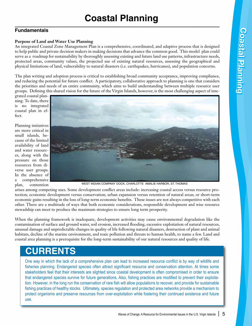
Coastal Planning____________________________________________________Fundamentals
Purpose of Land and Water Use PlanningAn integrated Coastal Zone Management Plan is a comprehensive, coordinated, and adaptive process that is designed to help public and private decision makers in making decisions that advance the common good. This model plan could serve as a roadmap for sustainability by thoroughly assessing existing and future land use patterns, infrastructure needs, protected areas, community values, the projected use of existing natural resources, assessing the geographical and physical limitations of land, vulnerability to natural disasters (i.e. earthquakes, hurricanes), and population concerns.
The plan writing and adoption process is critical to establishing broad community acceptance, improving compliance, and reducing the potential for future conflict. A participatory, collaborative approach to planning is one that considers the priorities and needs of an entire community, which aims to build understanding between multiple resource user groups. Defining this shared vision for the future of the Virgin Islands, however, is the most challenging aspect of inte-grated coastal plan-ning. To date, there is no integrated coastal plan in ef-fect.
Planning initiatives are more critical in small islands, be-cause of the limited availability of land and water resourc-es, along with the pressure on those resources from di-verse user groups. In the absence of a comprehensive plan, contention arises among competing uses. Some development conflict areas include: increasing coastal access versus resource pro-tection; economic development versus conservation; urban expansion versus retention of natural areas; or short-term economic gains resulting in the loss of long-term economic benefits. These issues are not always competitive with each other. There are a multitude of ways that both economic considerations, responsible development and wise resource stewadship can meet to produce the maximum strategies to ensure long term prosperity.
When the planning framework is inadequate, development activities may cause environmental degradation like the contamination of surface and ground water, soil erosion, increased flooding, excessive exploitation of natural resources, unusual damage and unpredictable changes in quality of life following natural disasters, destruction of plant and animal habitats, decline of the marine environment, and toxic pollution and threats to human health, to name a few. Land and coastal area planning is a prerequisite for the long-term sustainability of our natural resources and quality of life.
One way in which the lack of a comprehensive plan can lead to increased resource conflict is by way of wildlife and fisheries planning. Endangered species often attract significant resource and conservation attention. At times some stakeholders feel that their interests are slighted since coastal development is often compromised in order to ensure that endangered species survive for future generations. Also, fishing practices are modified to prevent their exploita-tion. However, in the long run the conservation of rare fish will allow populations to recover, and provide for sustainable fishing practices of healthy stocks. Ultimately, species regulation and protected area networks provide a mechanism to protect organisms and preserve resources from over-exploitation while fostering their continued existence and future use.
CURRENTS
Co
astal Planning
Co
astal Planning
WEST INDIAN COMPANY DOCK, CHARLOTTE AMALIE HARBOR, ST. THOMAS

Waves of Change: A Resource for Environmental Issues in the U.S. Virgin Islands 6
History of Land Use Planning in the U.S. Virgin IslandsSince 1917, numerous plans have been prepared for and by various governmental agencies and departments with varying results. The Virgin Islands Comprehensive Policy Plan, developed between 1983 and 1991, provided goals, objectives, and strategies for governmental action on a wide range of issues, including Guidelines for the Development of a Long-Range Comprehensive Plan for the United States Virgin Islands. These guidelines provided the basis for the Comprehensive Land and Water Use Plan proposed
in 1994. The plan was developed in three phases. Phase One involved the collection and analysis of data in areas such as land use, transportation, public services, etc; Phase Two consisted of the creation of alternative conceptual planning approaches; including public meetings with community leaders, technical advisors, and general public. Phase Three consisted of the formulation of the final “plan” and the preparation of the required regulations for the plan’s implementation. The Comprehensive Land and Water Use Plan was completed in 1995 but was never adopted by the Legislature.
The Law currently governing land and water use in the Territory, the Virgin Islands Coastal Zone Management Act, was enacted in 1978. This legislation defined and delineated
the coastal zone and established permissible land and water uses, a land and water use plan, and a set of policies to administer the program. This two-tiered system establishes separate sets of criteria for development of coastal lands or “Tier 1”, and upland areas or “Tier 2”. Despite the intimate connection between upland areas and coastal waters, and prevalence of steep slopes around the territory, major project review criteria is only applied to the narrow coastal areas, currently defined as Tier 1.
The Department of Planning and Natural Resources is responsible for implementing the provisions of the Law through the Division of Coastal Zone Management, Division of Building Permits, and Division of Comprehensive Coastal Zone Planning. To learn more go to http://www.dpnr.gov.vi/about.htm and http://www.viczmp.com.
More recently, in 2004, Senator Raymond “Usie” Richards proposed Bill No. 25-0209 to enact the “Virgin Islands Development Law of 2003.” This plan was based on the “town center” model of growth. This model supports mixed zoning and limits residential and commercial sprawl. It would also eliminate the two-tiered system, placing all major development under the jurisdiction of the Division of Coastal Zone Management. These recent proposals and the understanding that land use in Tier 2 affects the coastal zone, highlight the need to revisit and revise the existing land and water use legislation.
• Reexamine Bill No. 25-0209 to enact the “Virgin Islands Development Law of 2003,” towards a single tiered system.
• Encourage DPNR to enhance Integrated Coastal Planning efforts.
• Support interagency efforts like the St. Thomas East End Reserve Planning Process and seek opportunities that build institutional and human capacity for DPNR to better facilitate collaborative site planning where stakeholder involvement is maximized.
CHANGING TIDES
Co
C
o
Pla
nnin
gP
lann
ing
NORTH WEST TIP OF ST. CROIX
CHRISTIANSTED HARBOR, ST. CROIX
aast
lst
aal
Waves of Change: A Resource for Environmental Issues in the U.S. Virgin Islands 7
________________________________________________Fundamentals
Protecting Our Water QualityThe quality of the waters that surround our islands is vital to our economy, health and the abundant marine life. Residents depend on high quality waters for their livelihoods, and along with visitors, enjoy the crystal blue seas surrounding of the Virgin Islands. These waters and the marine life that inhabits them are among our most valuable resources.
Unfortunately, local bays are no longer always safe for bathing and fishing. Inadequate land use planning, increasing development and industrial activities are key factors in the decline of the quality of the marine waters surrounding the VI. Although some areas around our islands still have excellent water quality, many are declining. As marine communities are increasingly being damaged by excess sewage nutrients and sediment, we need to closely monitor activities that will impact the quality of our waters and human health.
Types of PollutionThere are two types of water pollution: point source pollution and nonpoint source pollution. Point source pollution comes from easily identifiable and controllable sources,
CURRENTSA number of University of Virgin Islands research projects have contributed to the gathering of information concerning water quality in watersheds around the US Virgin Islands including:
“Pilot study to integrate the effects of watershed activity patterns and coastal processes on near-shore coral reefs”• 2005-2007, funded by the National Science Foundation’s VI Experimental Program to Stimulate Competitive Research (VI EPSCoR). This project characterized target watersheds using GIS methodology to quantitatively and qualitatively assess natural conditions and the primary contributing land use alterations that impact runoff water quality and nearshore marine water quality. In cooperation with, Island Resources Foundation research 2002-2004 – - • “The Virgin Islands Wetlands and Riparian Areas Inventory” 2002-2004, funded by the VI Department of Planning and Natural Resources Division of Environmental Protection. This study along with many other related projects provided information about watershed and wetland characteristics through GIS mapping and field studies that assessed the links between watersheds/wetlands and VI coastal water quality.The University of the Virgin Islands, Center for Marine and Environmental Studies is currently measuring the amount of sedi-• ment being deposited on several coral reefs in the Territory with funding from US EPA and DPNR. This is being done to support the development of additional water quality standards for marine waters. See http://www.uvi.edu/sites/uvi/Pages/Publications.aspx?s=RE§ionCode=CMES for several published reports on the damaging effects of sediments on coral reefs.
The Resource Conservation and Development Council (RC&D) is reducing stormwater runoff by installing rain gardens around the Territory. RC&D installed a model rain garden at the Waste Management Authority Green House Program at Estate Lower Love, St. Croix and will be installing others at local schools around the Territory in the next year. This project is being funded by US EPA and DPNR.
RC&D also partnered with US EPA, DPNR and USDA to design and install a stormwater retention pond to reduce nonpoint source pollution at Estate Bethlehem, St. Croix in 2006.
Water Quality Water Q
ualityW
ater Quality
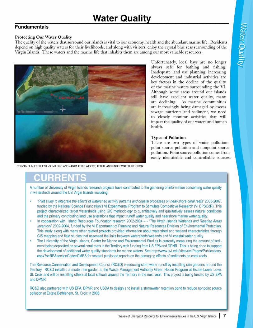
CRUZAN RUM EFFLUENT ~9KM LONG AND ~400M AT ITS WIDEST, AERIAL AND UNDERWATER, ST. CROIX

Waves of Change: A Resource for Environmental Issues in the U.S. Virgin Islands 8
CHANGING TIDES
such as pipes that discharge into drainage ditches, bays and other coastal waters. Nonpoint source (NPS) pollution originates from sources that are not as easily identified. Stormwater runoff, leaking septic tanks, and atmospheric deposition are examples of nonpoint source pollution. A watershed drainage basin is the area of land from the ridge line to the sea that captures rain water which flows across and underground to drain into a common shore outlet such as a gut, mouth, pond, mangrove, lagoon, beach or other coastal area. Please refer to Appendix 1 for the location of all the USVI watersheds. For example, although Magens Bay does not have a major point source pollution, the non point source pollutants, such as sediment run-off, have come from users higher up on the hillside in Tier 2 behind the bay. This has contributed to very low levels of light penetration, often with values similar to that of Charlotte Amalie Harbor, and it is likely that corals and plants are being harmed.
All point source discharges must have a permit from the DPNR, Division of Environmental Protection (DEP). These permits control the flow and concentrations of pollutants discharged and are subject to local and federal monitoring, and must be renewed every five years. Over 50 facilities currently have permits to discharge wastewater into the waters of the VI including power plants, an oil refinery, a rum distillery, desalinization facilities and municipal sewage treatment plants. Please refer to Wastewater Section for more information.
Nonpoint sources of pollution are more difficult to regulate and more pervasive. NPS pollution is potentially the most damaging type of water pollution in the VI as there is no way to trace the source or accurately measure it, even partially. NPS pollution results from rain water moving over and through the ground, picking up and carrying away pollutants that end up in stormwater. Occuring over a wide area and from multiple sources, these cumulative pollutants are deposited into guts, ponds, beaches, coastal waters and ground water.
Stormwater is a major force behind soil erosion in urban developing areas. Whenever trees and other vegetation are removed, the soil is exposed to the forces of rain and runoff. Soil is dislodged by raindrops and picked up by swiftly moving stormwater. As stormwater flows across impervious surfaces (roads, parking lots, and driveways) it picks up oil, trash, street dirt, and other pollutants. The soil and other pollutants are deposited onto roads, downstream properties, guts, ponds, beaches and coastal waters (sedimentation). Local studies have shown that runoff from unpaved roads without proper drainage is particularly significant.
During land development, the lack of effective sediment control practices results in excessive soil erosion and degradation in marine water quality and marine life. Sediment from eroding construction sites, dirt roads, and other disturbed areas is the largest pollutant of VI waters, by volume. Pollutants from vessels, such as bottom paints and sewage, are also considered nonpoint sources of pollution.
• Encourage the enforcement of existing environmental rules and regulations, such as stormwater management and prevent- ion, and water pollution, ultimately abating the potential threat of water pollution from current and future developments.
• Impose greater oversight and more stringent methods of sediment control at all private and public development and construction sites.
• Impose stricter penalties for illegal point source discharges.
• Impose an interagency mandate for the coordination of a Safe Sea’s Program between Department of Health and DPNR. This program would allow for the study of the number of water borne illnesses and reporting, diagnosis and prevention of seafood related illnesses such as fish poisoning (ciguatera toxin).
• Support watershed conservation and protection initiatives similar to those in Coral Bay, St. Thomas East End Reserve, and DEP’s Total Maximum Daily Load (TMDL) project.
RED MUD RESIDUE FROM FORMER ALUMINA FACILITY, ST. CROIX
Waves of Change: A Resource for Environmental Issues in the U.S. Virgin Islands 9
____________________________________________ Fundamentals
How Do We Manage Our Wastewater?Perhaps the biggest point source pollution challenge to our marine water quality is from Publicly Owned Treatment Works (POTW’s), operated by VIWMA and permitted by DPNR-Division of Environmental Protection. Frequent pumping station and treatment plant breakdowns, as well as collection system failures cause bypasses of untreated sewage into marine waters. In addition, stormwater runoff infiltrating the system causes manholes to overflow during heavy rains.
The Virgin Islands has two methods of wastewater disposal: septic tanks and sewer lines. Some hotels even dispose of sewage by irrigation. The local wastewater system is comprised of a series of lines, manholes, and pump stations that transport sewage from approximately 60% of the population to treatment plants on each island. Everyday, more than 4.5 million gallons of wastewater rushes through those pipes, heading toward the wastewater treatment plants on St. Croix, St. Thomas and St. John. The sewer system, which is more than 120 miles of line, consists of pipes made of ductile iron, bricks, and PVC piping, ranging in size from 4-inches to 30 inches. According to the VI Law, once you are located within 50 feet of a public sewer line, you are required to connect to the system. The sewer user fee for the maintenance of this system is currently incorporated into one’s property tax bill, but does not meet the financial requirements of maintaining and operating the system. Additional fees will likely be needed to insure safe operations of the wastewater system. An increase to the Sewer User Fee, now referred to as the Wastewater User Fee (WUF) was approved in the
latter part of 2007 and is now reflected accordingly on property owners’ tax bills.
The public sewer system does not extend throughout the island so many residents depend on septic tank/leach field systems. Unfortunately, hilly terrain and shallow clay-like soils make much of the VI land inappropriate for these systems. Septic system failure results in bacterial contamination of coastal waters, especially after heavy rains. Infections, fungi, gastro intestinal ailments,
CURRENTSThe VI Waste Management Authority has brought online two new state-of-the-art Sequencing Batch Reactor (SBR) wastewater plants within the past year, one on St. Thomas and one on St. Croix, to satisfy mandates by the U.S. Environmental Protection Agency. DPNR-DEP’s Stormwater Pollution Prevention Plan(SWPPP) and Territorial Pollutants Discharge Elimination System(TPDES), are two recent elevations in permitting requirements that help ensure development applicants incorporate best practice management for stormwater runoff control.
Some believe that discharging off-shore does not impact our environment since sewage is quickly diluted and washed far from the islands. They believe that the cost of higher treatment is unnecessary when pollutants will naturally breakdown over time at sea. Where the “Dilution Principle” may have worked in the past when population levels and discharge volumes were significantly lower, the precautionary principal is the more accepted approach for dealing with urban wastewater in coastal environments.
Increasing existing wastewater related fees to meet the cost of operations, maintenance and replacement of existing lines to better manage and protect resources will not be popular with many. However, as the population increases and land development continues, additional controls will be necessary in order to protect our resources and our way of life.
Waste Water Management Waste W
ater Managem
entW
aste Water M
anagement
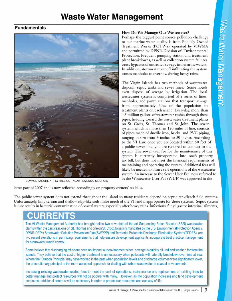
SEWAGE FAILURE AT FIG TREE GUT NEAR HOVENSA, ST. CROIX
Waves of Change: A Resource for Environmental Issues in the U.S. Virgin Islands 10
salmonella poisoning, nausea, vomiting, and even death can result from the variety of bacteria present. Spot rezoning of properties further increases these NPS pollution problems.The transporting, collection, and disposal of wastewater through a safe and reliable system is essential to public health. The proper operations and maintenance of a large network of underground pipes and pump stations that transport wastewater to the treatment plants ensure that the ocean discharge of treated effluent meets local and federal requirements. The system currently consists of 8 treatment plants and 31 pump stations, territorially, to perform this task.
Treatment plants in the VI are either providing secondary treatment or are currently being upgraded to provide secondary treatment. The water product is then released into the sea. In the future, this product could be reclaimed for agricultural use to the local farmers. The water reclamation project could provide a year-round source of water for farming use. A recent successful lawsuit by a St. Croix attorney requires the VI Government to end the St. Croix outfall discharge within 3-4 years and treat the existing municipal wastewater to tertiary levels for agricultural use. Improper discharges of wastewater from vessels also contribute to excessive nutrients and bacteria in marine waters. Control of vessel wastes is important as the number of vessels increases in the VI. Adequate pumpout stations for vessel wastes and enforcement of vessel waste regulations must be performed. The legislature has a crucial responsibility as stewards of our environment today, while impacts are still manageable.
Mapping and Testing of Sewer Collection System The mapping of the sewer system is essential in providing proficient operation and maintenance services and includes information such as location, size, and condition of existing lines. This will assist in conducting regular inspection and facilitate identification of damaged, blocked or otherwise compromised lines and manholes within the collection system. A series of smoke tests can be used to identify problems within the system. The smoke will help locate places where storm and other surface waters are entering the Territory’s sewers as well as reveal sources of sewer odors. A special non-toxic smoke is used for the leak tests. The smoke is manufactured for this purpose and leaves no residuals or stains and has no effect on plants and animals. To reduce the likelihood of smoke entering buildings, residents are advised to run water into all of their drains for one minute, especially those used infrequently. The correction of any defects in the pipes and sewer on private property is the responsibility of the owner.
CHANGING TIDES• Investigate and encourage the use of alternative methods to discharge waste water and the potential of reclaiming treated wastewater for irrigation.
• Impose user fees and fines for improper sewage waste disposal.
• Develop reallocation financing strategy, to use fees and fines from above to help offset the cost of the federally required up graded wastewater system. Was
te W
ater
Man
agem
ent
Was
te W
ater
Man
agem
ent
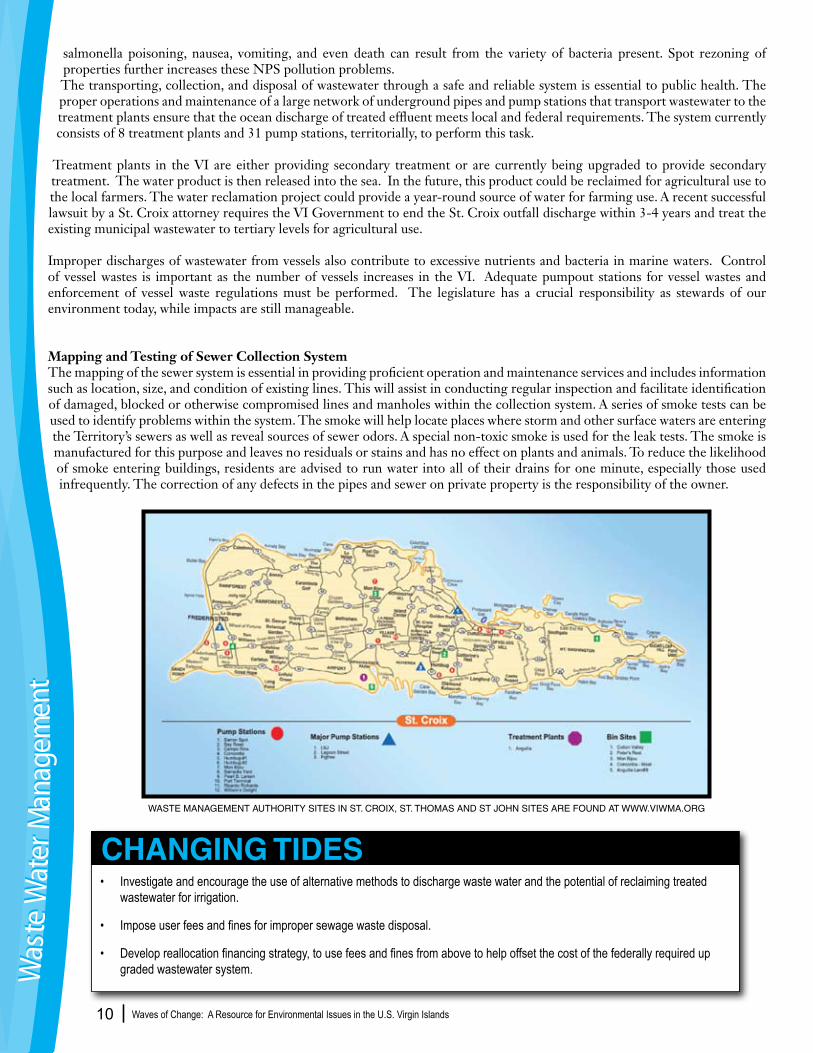
WASTE MANAGEMENT AUTHORITY SITES IN ST. CROIX, ST. THOMAS AND ST JOHN SITES ARE FOUND AT WWW.VIWMA.ORG

Waves of Change: A Resource for Environmental Issues in the U.S. Virgin Islands 11
________________________________________________ Fundamentals
Where does our trash go?Accommodating a continuously growing population that produces almost three times the national daily average of solid waste, the U.S. Virgin Islands is severely challenged to find space for solid waste collection and disposal. Solid waste is defined as any garbage or refuse from industrial, commercial, agricultural or residential activities. The average American produces about 4 pounds of waste per day per person; whereas, the average Virgin Islander produces almost 12 pounds of waste per person per day. The disparity of this lies in the fact that we import more than ninety percent of what is used locally and what comes here stays here, eventually ending up in our Territory’s landfills.
Residents have two methods available for solid waste disposal locally. Some residents receive house-to-house collection, at least twice per week. Those residents who do not receive this service must dispose of their waste at one of several bin disposal sites located strategically around each island.
Businesses are required, by law, to dispose of their waste directly to the landfill. Many business owners and residents utilize the services of private haulers. This includes apartment buildings, condominiums, and commercial and industrial businesses. Private haulers disposing waste at the landfills must be licensed, inspected and permitted on an annual basis by the VIWMA’s Division of Compliance Management and Enforcement to collect and dispose of waste at one of the local landfills on St. Croix and St. Thomas or at the transfer station on St. John.
CURRENTSThe VIWMA was mandated by the federal government to close the St. Croix landfill at Anguilla by December 2009 and St. Thomas landfill at Bovoni to be closed by 2014. In the near future, the WMA will be contracting a firm to develop a strategy for solid waste management and disposal on St. Croix. The WMA is also investigating possible ways to fund solid waste disposal which could include tipping fees or other types of fees. Anguilla Dump completed a fire extinguisher project to extinguish ongoing fires. VIWMA works with WAPA on waste to energy potential and are active members of VI recycling associations. If it is found necessary to identify a new site for waste disposal on St. Croix, this may well be controversial. As in other com-munities, the NIMBY (not in my back yard) principle is active. Also, increased solid waste disposal fees, in whatever form, will not be popular. However the federal government has set a deadline for the VI to implement solid waste disposal consistent with federal laws. To refrain from being fined for a major infraction, additional funds will need to be secured to dispose of VI solid waste in a safe manner and consistent with federal mandates
Solid Waste Management Solid Waste M
anagement
Solid Waste M
anagement
BOVONI LANDFILL PROXIMITY TO WILDLIFE RESERVE AND SANCTUARY, ST. THOMAS
Waves of Change: A Resource for Environmental Issues in the U.S. Virgin Islands 12
Each type of disposal practice requires adherence to various guidelines. Our local landfills and transfer stations are regulated by local and federal agencies as to the type of waste that they receive. Hazardous, medical, and electronic waste, tires, batteries and any type of fluids are not accepted. House-to-house collection requires that residents place their waste in a large receptacle lined with a plastic bag with a secure cover at the curbside on the day(s) of their neighborhood collection. Disposal at the bin sites also requires that the waste is placed inside of the disposal bin and not on the ground adjacent to the bin. There are certain items that are not collected curbside or at the bin sites and must go directly to the landfill for disposal (i.e. yard waste, appliances, gas cylinders, etc). For a complete list of what types of solid waste can be accepted at bins, transfer stations and local landfills, contact the Waste Management Authority or visit their website at www.viwma.org .
Diverting solid waste from the landfillReduce, recycle, and reuse are options to diverting the amount of waste that residents produce which ends up in our landfills. Almost 40 percent of the waste produced is yard waste or biodegradable plant product that can be composted. Consumers can control the amount of waste that they produce by shopping smart and supporting the various recycling programs that are being introduced locally (i.e. aluminum, backyard composting, reusable grocery bags, electronic waste, used motor oil, etc.). Source reduction is another good method of reducing your waste. It is the practice of designing, manufacturing, purchasing, or using materials in ways to reduce the amount or toxicity of trash created. Residents can perform household waste audits to identify their waste creation and disposal practices. The reuse of various products also diverts them from entering the waste stream. It also saves natural resources, reduces toxicity of waste and reduces costs.
• Encourage tax incentives for businesses that practice recycling, provide recycling services or are certifiable “green” businesses.
• Investigate U.S. industry responsibility for including USVI in federal waste recycling, and reduction programs.
• Mandate a “Bottle Bill”- a cash redemption program for glass bottles and cans that allows consumers to be paid for return of their recyclable waste.
• Stimulate small business development opportunities for manufacturing local products out of locally recycled goods.
CHANGING TIDES
Solid
Was
te M
anag
emen
tSo
lid W
aste
Man
agem
ent
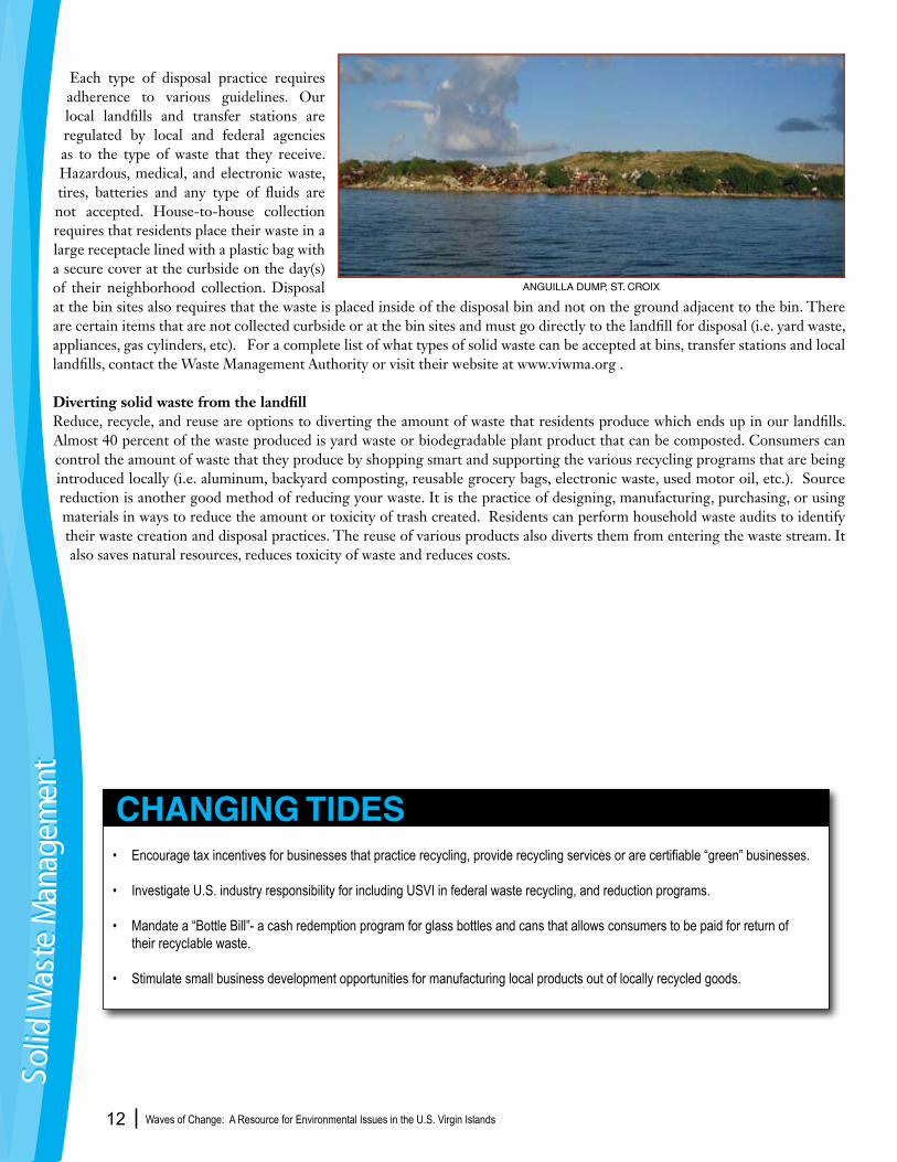
ANGUILLA DUMP, ST. CROIX
Waves of Change: A Resource for Environmental Issues in the U.S. Virgin Islands 13
_______________________________________________ Fundamentals
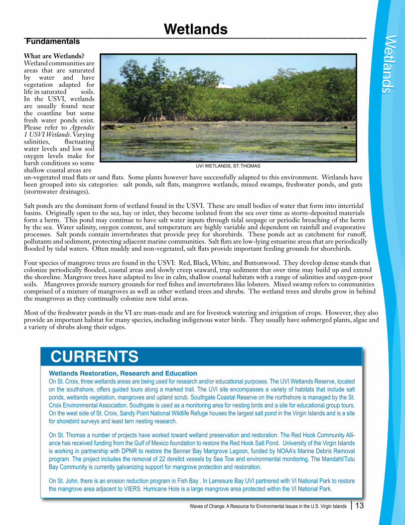
What are Wetlands?Wetland communities are areas that are saturated by water and have vegetation adapted for life in saturated soils. In the USVI, wetlands are usually found near the coastline but some fresh water ponds exist. Please refer to Appendix 1 USVI Wetlands. Varying salinities, fluctuating water levels and low soil oxygen levels make for harsh conditions so some shallow coastal areas are un-vegetated mud flats or sand flats. Some plants however have successfully adapted to this environment. Wetlands have been grouped into six categories: salt ponds, salt flats, mangrove wetlands, mixed swamps, freshwater ponds, and guts (stormwater drainages).
Salt ponds are the dominant form of wetland found in the USVI. These are small bodies of water that form into intertidal basins. Originally open to the sea, bay or inlet, they become isolated from the sea over time as storm-deposited materials form a berm. This pond may continue to have salt water inputs through tidal seepage or periodic breaching of the berm by the sea. Water salinity, oxygen content, and temperature are highly variable and dependent on rainfall and evaporative processes. Salt ponds contain invertebrates that provide prey for shorebirds. These ponds act as catchment for runoff, pollutants and sediment, protecting adjacent marine communities. Salt flats are low-lying estuarine areas that are periodically flooded by tidal waters. Often muddy and non-vegetated, salt flats provide important feeding grounds for shorebirds.
Four species of mangrove trees are found in the USVI: Red, Black, White, and Buttonwood. They develop dense stands that colonize periodically flooded, coastal areas and slowly creep seaward, trap sediment that over time may build up and extend the shoreline. Mangrove trees have adapted to live in calm, shallow coastal habitats with a range of salinities and oxygen-poor soils. Mangroves provide nursery grounds for reef fishes and invertebrates like lobsters. Mixed swamp refers to communities comprised of a mixture of mangroves as well as other wetland trees and shrubs. The wetland trees and shrubs grow in behind the mangroves as they continually colonize new tidal areas.
Most of the freshwater ponds in the VI are man-made and are for livestock watering and irrigation of crops. However, they also provide an important habitat for many species, including indigenous water birds. They usually have submerged plants, algae and a variety of shrubs along their edges.
Wetlands Restoration, Research and EducationOn St. Croix, three wetlands areas are being used for research and/or educational purposes. The UVI Wetlands Reserve, located on the southshore, offers guided tours along a marked trail. The UVI site encompasses a variety of habitats that include salt ponds, wetlands vegetation, mangroves and upland scrub. Southgate Coastal Reserve on the northshore is managed by the St. Croix Environmental Association. Southgate is used as a monitoring area for nesting birds and a site for educational group tours. On the west side of St. Croix, Sandy Point National Wildlife Refuge houses the largest salt pond in the Virgin Islands and is a site for shorebird surveys and least tern nesting research.
On St. Thomas a number of projects have worked toward wetland preservation and restoration. The Red Hook Community Alli-ance has received funding from the Gulf of Mexico foundation to restore the Red Hook Salt Pond. University of the Virgin Islands is working in partnership with DPNR to restore the Benner Bay Mangrove Lagoon, funded by NOAA’s Marine Debris Removal program. The project includes the removal of 22 derelict vessels by Sea Tow and environmental monitoring. The Mandahl/Tutu Bay Community is currently galvanizing support for mangrove protection and restoration.
On St. John, there is an erosion reduction program in Fish Bay . In Lamesure Bay UVI partnered with VI National Park to restore the mangrove area adjacent to VIERS. Hurricane Hole is a large mangrove area protected within the VI National Park.
Wetlands
CURRENTS
Wetlands
Wetlands
UVI WETLANDS, ST. THOMAS
Waves of Change: A Resource for Environmental Issues in the U.S. Virgin Islands 14
Guts are the waterways through which stormwater drains through a watershed. Within guts there may be freshwater spring pools that provide habitat for a unique native ecosystem containing freshwater shrimp, fishes, amphibians, and aquatic insects. Because these drainages act as conduits for sediment and non-point source pollution, they are susceptible to disturbance from upland activities.
It has been estimated that at least half of our wetlands nation-wide, and in the VI, have been lost. Wetland areas comprise less than two percent of the Territory’s land but are extremely important biologically. Of the remaining 636 wetland areas identified in the Territory, 371 are on St. Croix, 151 on St. Thomas and 114 on St. John.
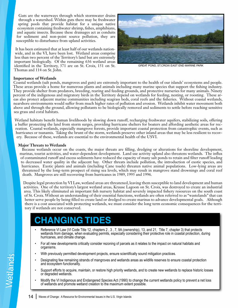
Importance of WetlandsCoastal wetlands (salt ponds, mangroves and guts) are extremely important to the health of our islands’ ecosystems and people. These areas provide a home for numerous plants and animals including many marine species that support the fishing industry. They provide shelter from predators, breeding, rearing and feeding grounds, and protective nurseries for many animals. Ninety percent of the indigenous and migratory birds in the Territory depend on wetlands for feeding, nesting, or roosting. These ar-eas also protect adjacent marine communities including seagrass beds, coral reefs and the fisheries. Without coastal wetlands, nearshore environments would suffer from much higher rates of pollution and erosion. Wetlands inhibit water movement both above and through the ground, allowing pollutants to be biologically removed and sediments to settle before reaching sensitive sea grass and coral habitats.
Wetland habitats benefit human livelihoods by slowing down runoff, recharging freshwater aquifers, stabilizing soils, offering a buffer protecting the land from storm surges, providing hurricane shelters for boaters and affording aesthetic areas for rec-reation. Coastal wetlands, especially mangrove forests, provide important coastal protection from catastrophic events, such as hurricanes or tsunamis. Taking the brunt of the storm, wetlands preserve other inland areas that may be less resilient to recov-ery. Because of these, wetlands are essential to the environmental health of the USVI.
Major Threats to Wetlands Because wetlands occur on the coasts, the major threats are filling, dredging or alterations for shoreline development, marinas, tourist activities, and water-dependent development. Land use activity upland also threatens wetlands. The influx of contaminated runoff and excess sediments have reduced the capacity of many salt ponds to retain and filter runoff leading to decreased water quality in the adjacent bay. Other threats include pollution, the introduction of exotic species, and hurricanes. Exotic plants and animals (including Cane toads) threaten native animal populations. Low-lying areas are threatened by the long-term prospect of rising sea levels, which may result in mangrove stand drownings and coral reef death. Mangroves are still recovering from hurricanes in 1989, 1995 and 1996.
Despite legal protection by VI Law, wetland areas are threatened, leaving them susceptible to land development and human activities. One of the territory’s largest wetland areas, Krause Lagoon on St. Croix, was destroyed to create an industrial area. This likely eliminated an important fish nursery habitat and severely impacted fishery resources on the south coast of St. Croix. Without an understanding of their essential functions, wetlands are often referred to as “wastelands” that can better serve people by being filled to create land or dredged to create marinas to advance developmental goals. Although there is a cost associated with protecting wetlands, we must consider the long term economic consequences for the terri-tory if wetlands are not conserved.
• Reference VI Law (VI Code Title 12, chapters 2 , 3 , 7, 9A (ownership), 13, and 21, Title 7, chapter 3) that protects wetlands from damage, when evaluating permits, especially considering their protective role in coastal protection, during hurricanes, and climate change.• For all new developments critically consider rezoning of parcels as it relates to the impact on natural habitats and organisms. • With previously permitted development projects, ensure scientifically sound mitigation practices.• Designating few remaining strands of mangroves and wetlands areas as wildlife reserves to ensure coastal protection and ecosystem functionality.• Support efforts to acquire, maintain, or restore high priority wetlands, and to create new wetlands to replace historic losses or degraded wetlands. • Modify the VI Indigenous and Endangered Species Act (1990) to change the current wetlands policy to prevent a net loss of wetlands and promote wetland creation to the maximum extent possible.
CHANGING TIDES
Wet
land
sW
etla
nds
GREAT POND, ST.CROIX EAST END MARINE PARK
Waves of Change: A Resource for Environmental Issues in the U.S. Virgin Islands 15
________________________________________________Fundamentals
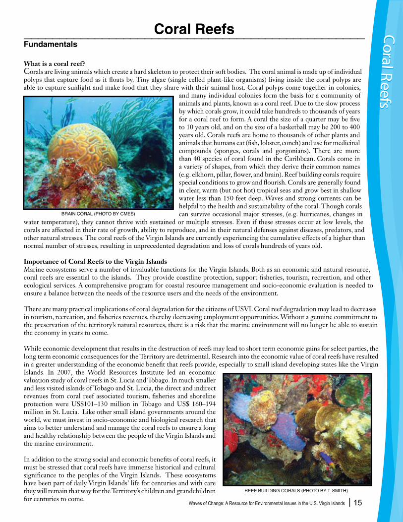
What is a coral reef?Corals are living animals which create a hard skeleton to protect their soft bodies. The coral animal is made up of individual polyps that capture food as it floats by. Tiny algae (single celled plant-like organisms) living inside the coral polyps are able to capture sunlight and make food that they share with their animal host. Coral polyps come together in colonies,
and many individual colonies form the basis for a community of animals and plants, known as a coral reef. Due to the slow process by which corals grow, it could take hundreds to thousands of years for a coral reef to form. A coral the size of a quarter may be five to 10 years old, and on the size of a basketball may be 200 to 400 years old. Corals reefs are home to thousands of other plants and animals that humans eat (fish, lobster, conch) and use for medicinal compounds (sponges, corals and gorgonians). There are more than 40 species of coral found in the Caribbean. Corals come in a variety of shapes, from which they derive their common names (e.g. elkhorn, pillar, flower, and brain). Reef building corals require special conditions to grow and flourish. Corals are generally found in clear, warm (but not hot) tropical seas and grow best in shallow water less than 150 feet deep. Waves and strong currents can be helpful to the health and sustainability of the coral. Though corals can survive occasional major stresses, (e.g. hurricanes, changes in
water temperature), they cannot thrive with sustained or multiple stresses. Even if these stresses occur at low levels, the corals are affected in their rate of growth, ability to reproduce, and in their natural defenses against diseases, predators, and other natural stresses. The coral reefs of the Virgin Islands are currently experiencing the cumulative effects of a higher than normal number of stresses, resulting in unprecedented degradation and loss of corals hundreds of years old.
Importance of Coral Reefs to the Virgin IslandsMarine ecosystems serve a number of invaluable functions for the Virgin Islands. Both as an economic and natural resource, coral reefs are essential to the islands. They provide coastline protection, support fisheries, tourism, recreation, and other ecological services. A comprehensive program for coastal resource management and socio-economic evaluation is needed to ensure a balance between the needs of the resource users and the needs of the environment.
There are many practical implications of coral degradation for the citizens of USVI. Coral reef degradation may lead to decreases in tourism, recreation, and fisheries revenues, thereby decreasing employment opportunities. Without a genuine commitment to the preservation of the territory’s natural resources, there is a risk that the marine environment will no longer be able to sustain the economy in years to come.
While economic development that results in the destruction of reefs may lead to short term economic gains for select parties, the long term economic consequences for the Territory are detrimental. Research into the economic value of coral reefs have resulted in a greater understanding of the economic benefit that reefs provide, especially to small island developing states like the Virgin Islands. In 2007, the World Resources Institute led an economic valuation study of coral reefs in St. Lucia and Tobago. In much smaller and less visited islands of Tobago and St. Lucia, the direct and indirect revenues from coral reef associated tourism, fisheries and shoreline protection were US$101–130 million in Tobago and US$ 160–194 million in St. Lucia. Like other small island governments around the world, we must invest in socio-economic and biological research that aims to better understand and manage the coral reefs to ensure a long and healthy relationship between the people of the Virgin Islands and the marine environment.
In addition to the strong social and economic benefits of coral reefs, it must be stressed that coral reefs have immense historical and cultural significance to the peoples of the Virgin Islands. These ecosystems have been part of daily Virgin Islands’ life for centuries and with care they will remain that way for the Territory’s children and grandchildren for centuries to come.
Coral Reefs Coral R
eefsC
oral Reefs
BRAIN CORAL (PHOTO BY CMES)
REEF BUILDING CORALS (PHOTO BY T. SMITH)

Waves of Change: A Resource for Environmental Issues in the U.S. Virgin Islands 16
Threats to Coral ReefsThe threats to coral reefs come from both natural and human sources. Natural threats include predators, hurricanes and storms, and rising seawater temperatures due to global warming. Though these natural phenomena have a substantial impact on the health of the coral reefs, they are largely beyond our control. However, there are several human sources of harm to coral reefs that fall well within our control, including pollution, development, overfishing, global warming and the effects of tourism and recreation. It is with human based threats that policy makers and other stakeholders have the power to shape the protection and management of the Territory’s natural resources. Because corals are grow and reproduce so slowly, prevention of damage before it occurs andalleviation of co-occurring stresses are far superior to natural and managed restoration.
Development and pollution are major issues for the USVI. Development affects corals via two processes:the disruption of land and increased human populations in coastal environments. During the construction of new roads, homes, hotels, resorts, and other structures in the Virgin Islands, most vegetation is usually removed, which results in the exposure of the topsoil. The exposed soil is washed away with the rain and as a result, ends up as sediment runoff in the coastal waters. After heavy rainfall, the brown plumes of sediment along the shoreline is an unfortunate, yet common sight around the USVI. In addition, development activities (e.g. residential, tourist, industrial and port development) often involve land reclamation and dredging, which invariably results in the disruption of coastal sediment. This sediment settles on, smothers and kills corals, and blocks sunlight while providing nutrients for the growth of harmful algae and pathogens.
The other aspect of development is an increase in human activity in coastal environments and the potential for increased chronic pollution. Pollutants like oil, pesticides, heavy metals, sediments, garbage, and even abnormally salty water from desalinization plants cause severe stress on corals. Likewise, the deteriorating municipal sewage system contributes to the factors negatively impacting the marine environment. Three quarters of the pollutants entering the oceans originate on land, and nearly half of these pollutants come from improperly treated wastes and run-off. Corals are sensitive to alterations in the cleanliness of water and may be killed outright, or suffer from decreased growth and reproduction, and increased susceptibility to disease, predators and competitors.
As the demand for seafood in the Virgin Islands increases, so does the impact of fishing on the coral reefs. Fishing on and around coral reefs leads to a decreased number of fish. Fish are vital components of a healthy coral reef ecosystem and perform critical functions such as the removal of harmful algae and the creation of sand for beaches. If unregulated, decreased populations of fish can lead to reefs dominated by algae, not coral, which in-turn compromises the ability of the reef to support those fish. In addition, some fishermen have made changes in their gear, as to keep up with the demands for fresh catch. Certain types of gear (e.g. fish traps, seine and gill nets, fish spears) can cause physical damage to the corals and degrade coral reefs.Tourism and recreation can result in damage to our reefs also. Inexperience and a lack of awareness among divers, snorkelers, and boaters cause trouble for coral reefs. Divers and snorkelers break coral colonies with their dive fins and collect specimens from the reef. Boaters run aground on reefs and throw their anchors on reefs. Tourism related sources of sewage pollution
• Participate and support DPNR/NOAA’s upcoming research that will provide for the social and economic valuation USVI Coral Reefs.
• Review the recent final habitat designation of federally list endangered Acropora coral listing, which designates the mean high watermark to 30m in depth as critical habitat to the protection of Acropora corals across the entire USVI.
• Given the connection between the economy and marine health, invest in a multi-sectoral coral reef protection strategy to ensure the stability of this threatened ecosystem and our local economy.
• Examine alternative income generating mechanisms aimed at strengthening the territorial capacity to better manage our coral reefs and related ecosystems.
CHANGING TIDES
Cor
al R
eefs
Cor
al R
eefs
CORAL REEFS CAN BE AFFECTED BY ADJACENT LAND DEVELOPMENT

Waves of Change: A Resource for Environmental Issues in the U.S. Virgin Islands 17
from cruise ships and recreational vessels are also a major concern. Cruise ships discharge enormous amounts of pollutants and waste into the coastal waters, but are not subject to the same environmental regulations as comparable sized cities on land. They also cause physical damage to the reefs with their propellers, vessel groundings, and improper or careless usage of anchors and anchor chains.
Efforts to understand and reduce the impact of such threats to the coral reefs in the short and long term are essential to the conservation and management of USVI marine resources.
Coral Bleaching and DiseaseBleaching is a state of health where the coral turns stark white or very pale. Bleaching arises from various stresses impacting corals including elevated seawater temperatures, high light, and sediments from terretrial run off. When corals are stressed, the algae that live within their polyps are released and the coral loses its dark coloration as well as the majority of its food resources. The sickened coral is left hungry with its white skeleton showing through clear tissue. If corals are not killed outright, they are left more susceptible to stresses and diseases for years afterwards. The Virgin Islands has experienced major bleaching events in 1998 and 2005 caused by abnormally warm water temperatures. In particular, the 2005 mass coral bleaching event was the worst on record for the Caribbean, and in the Virgin Islands. A subsequent disease outbreak caused the loss of over half the coral cover on many reefs. This represents centuries of coral growth lost. Recovery from this event will require a clean and healthy marine environment.
In addition to the increasing impacts of bleaching events, coral reefs have recently been suffering from outbreaks of disease. In combination with bleaching, diseases have posed one of the greatest threat to coral reefs in the USVI. The increase in diseases has been linked to degradation of water quality, inputs of pathogens from the land and air, and warming seas. Many coral diseases actively erode living coral tissue and, in many cases, destroyed tissue is not re-grown and entire colonies are lost. In the last ten years, many diseases or conditions have been documented in the Virgin Islands. The following are known diseases that impact corals in the USVI: white band, white plague, white pox, black band, yellow blotch, and dark spots. Other diseases are known for the Virgin Islands, but remain undescribed. Reduction and removal of stresses that impact corals will help them maintain strong immune systems to fight diseases.
Opportunities for Management Intervention
Four conditions determine the outcome of stressful temperatures for coral reefs’ bleaching resistance, coral tolerance, reef recovery and human adaptive capacity. Each of these is influenced by a suite of factors that in combination determine the reslience or vulnerability of the system. Factors that can be influenced by local management actions are highlighted in green. Factors shown in black cannot be changed through local interventions, but can be incorporated in the design and placement of management initiatives to enhance ecosystem reslience. (Diagram from Reef Managers Guide to Coral Bleaching)
Coral R
eefsC
oral Reefs
BLEACHED CORAL (PHOTO BY C. ROGERS)
WHITE PLAGUE DISEASED CORAL (C. ROGERS)

Waves of Change: A Resource for Environmental Issues in the U.S. Virgin Islands 18
Future Considerations of Coral Bleaching and Disease Beyond the environmental impact of an ecosystem collapse, there are many practical implications of coral deterioration for the citizens of USVI. Coral reef degradation may lead to decreases in tourism and recreation revenues, thereby decreasing employment opportunities in these industries, as well as decreasing revenues from commercial fishing. Without a genuine commitment to the preservation of the territory’s natural resources, there is a risk that the marine environment will no longer be able to sustain the economy in years to come. The magnitude of the social and economic costs associated with coral reef degradation far exceeds the cost of protecting this precious resource.
The extensive damage of coral reefs observed in the Virgin Islands is not a result of global factors alone. Local stresses like those discussed above, only amplify the problem. Although natural causes of coral reef degradation may be beyond our immediate power, the numerous human stresses can be decreased. For example, certain diseases impacting corals have human origins. Poor waste water treatment has been identified as a contributing factor in white pox disease. While there is an important point to be made in regards to natural phenomena leading to substantial damage of coral, the extensive damage of coral reefs observed in the Virgin Islands is not a result of these factors alone. Diminishing the number of continual stresses that the coral reefs must withstand will result in healthier corals that are better able to fight off diseases that come into their path. (See page 17 coral reef resilience pyramid)
How Much are Coral Reefs Worth? Economic Valuation of Coral ReefsAlthough coral reef protective strategies may irritate developers, what kind of attraction does USVI offer to investors if our oceans and reefs continue to suffer from pollution, disease, bleaching? Protecting our ocean is the equivalent of protecting our local economy and our people’s livelihoods. “The importance of coral reefs to local economies is frequently underappreciated by government officials, coastal developers, and the wider population. A clear presentation of the magnitude of these impacts (the economic values derived from coral reefs) can provide support for appropriate policy, investment, and development decisions.” (World Resources Institute).
While economic development that results in the destruction of reefs may lead to short term economic gains for select individuals, the long term economic consequences for the Territory are detrimental. Efforts to determine the economic value of coral reefs have resulted in a greater understanding of the economic benefit that reefs provide, especially to small island developing states like the Virgin Islands. Recent estimates place the value of one square meter of coral reef in the range of hundreds to thousands of US dollars (United Nations Atlas of the Oceans). When development is unplanned and high-impact, the sustainability of coral reefs is threatened, which equates to a threatened tourist industry. Ultimately, a threatened coral reef results in a weakened economy because of its importance to the tourism industry (The Coral Reef Alliance 2003). Supporting efforts to better understand and manage the coral reefs helps to ensure a long and healthy relationship between the people of the Virgin Islands and the marine environment. By combining local research and the development and implementation of a coastal resources management p r o g r a m b a s e d u p o n scientific expertise, the wise stewardship of the Territory’s marine resources will become a real i ty. In cooperat ion with DPNR, NOAA National Ocean Service is preparing to conduct a comprehensive socio-economic valuation of the USVI coral reefs. This study will help the territory best orient its coral reef management and education strategy.
CURRENTS
Cor
al R
eefs
Cor
al R
eefs
WORLD RESOURCES INSTITUTE ECONOMIC VALUATION OF CORAL REEFS DRAWING
Waves of Change: A Resource for Environmental Issues in the U.S. Virgin Islands 19
___________________________________________Fundamentals
What is a Protected Area?A protected area is defined as an area of land and/or sea that is specifically dedicated to the maintenance and protection of biological diversity, as well as natural and cultural resources. Executive Order 13158 defines marine protected areas as “any area of the marine environment that has been reserved by Federal, State, territorial, tribal, or local laws or regulations to provide lasting protection for part or all of the natural and cultural resources therein.”
Protected areas vary in purpose, size, legal structure, and management approach depending on the broader goals of the site. They are also referred to as reserves, sanctuaries, managed areas, marine parks, and conservation areas. Some protected areas are for conservation of special habitats like coral, mangrove, wetlands, or seagrasses, while others are for the protection of endangered or economically important species like lobster, coral, or Nassau Grouper or for particularly sensitive areas used by marine animals for nursery habitats or spawning grounds. For example, an area that was once teaming with fish and used often by local fisherman becomes the subject of possible conservation measures. It is possible that in partnership with those fishermen and other stakeholders, that the management authority can enable legislation and regulation, so that the future of that site may have the chance, once again, to house large populations of fish and be a popular fishing location for future generations.
Some ways to manage fisheries are by imposing restrictions on catch limits, season, time of day, moon phase, gear or size in a specific delineated site. Other reasons for establishing a protected area may be to preserve a tourist site, historical, cultural, scientific, or educational property. The more combined justifications for a site’s protection and the more involvement there is from the community and stakeholders in planning and managing of the site, the greater the likliehood of success in achieving the area’s conservation goals.
Why establish Protected Areas?With the U.S. Virgin Islands’ population increasing dramatically in the last 15 years, a variety of pressures on marine resources are taking their toll, in the form of degradation of coastal habitats, pollution, erosion, overuse and overexploitation of living resources. If Virgin Islanders wish to have safe and abundant seafood, stable fisheries, clean beaches, healthy coral reefs and associated habitats and vibrant coastal communities, priority must be given to protecting and restoring marine and coastal
Protected Areas
• Draft legislation that enables the effectiveness of the designated Areas of Particular Concern and provides legal support for the existing marine protected areas.
• Support the development and implementation of the Uniform Habitat Easement Act (VI Code Title 12, Chapter 15) such that it provides a real and significant incentive to protect undeveloped habitat.
• Support community initiatives aimed at planning, managing, and establishing protected areas and reserves.
• Encourage DPNR’s ecosystem-based management approach, whose goal is to protect, maintain and restore ecosystem funct- ions in order to achieve long-term sustainability of coastal ecosystems and the human communities that depend upon them.
• Examine and provide innovative ways such as alternative livelihoods for overcoming or discouraging the persistence of human activities that yield undesirable and unsustainable environmental and socio-economic outcomes (over-fishing, unsustainable coastal development, destruction of critical habitats, influx of nutrient and chemical pollution and sedimentation, etc).
• Continue USVI government commitment to protecting habitat for public use, ecosystem function and habitat protection.
• Establish a Committee for Planning and Natural Resources to support the Territorial Park System, especially in the designation of the future parks.
CHANGING TIDES
Protected Areas
Protected Areas
SPAWNING AGGREGATION, GRAMMANIK BANK, ST. THOMAS

Waves of Change: A Resource for Environmental Issues in the U.S. Virgin Islands 20
environments. We are therefore faced with the challenge of “sustainable development”: to ensure our terrestrial and marine resources are used effectively for the benefit of the present generations, while ensuring that the resource needs of future generations is reserved. One of the options for accomplishing this conservation task is to appropriate natural areas as reserves or protected areas that provide habitat, non extractive use and ecological function, without the threat of exploitation. The appropriate selection of these sites and corresponding management measures designated in each location ensures that the environmental quality and services we are accustomed to will not diminish with increasing population pressure or tourism and infrastructure developments.
How Can Protected Areas Benefit Us?Marine Protected Areas (MPAs) benefit coastal communities in several ways. First, MPAs can provide valuable tourism opportunities that generate significant revenue for the territory. In 2003, 2 million tourists provided 1.3 billion dollars to the territory. Many islands in the Caribbean are beginning to realize that the value of one large charismatic grouper on the coral reef is worth tens of thousands of dollars annually by attracting hundreds of SCUBA diving tourists, but its value in the local fish market may only be $5.00/ lb. on a single day. It is currently permissable to fish within many tourist-intense marine areas, such as Buck Island and Flat Cay on St. Thomas, where large groupers and other fishes that may attract word-of mouth and repeat tourist visitors are being removed from these natural revenue-generating systems. Second, by regulating human activities, the MPAs can restore natural ecological relationships that generate livelihoods in the community. Third, MPAs can reverse the effects of overfishing and potentially enhance fishing outside of its boundaries through spillover effect where fish migrate out of the MPA and, most importantly, allow for the maturation and growth of larger fish which produce exponentially more eggs than smaller fish. Furthermore, MPAs are essential for the preservation of historical and cultural heritage, biodiversity and genetic diversity. While protecting natural and cultural resources, and providing the community with research and education of those resources, it is important to note that protected areas allow for the equitable use of resources across all stakeholders and sectors, which minimizes conflicts in management and decision making, thereby increasing overall compliance with regulations. In times of natural disasters, these protected, intact and functioning habitats like forests, watersheds, guts, mangroves and coral reefs, will ensure proper water quality, soil retention, shoreline protection and nutrients processing. The overall improved resource condition is more likely to show resilience, or bounce back after severe damage.
Protected Area EffectivenessA well designed and managed system of protected areas includes:
• Monitoringthehealthofthevariousresourceswithintheboundaries,andthehumanimplicationsoftheprotected areas, are necessary to reach the conservation goals of the area. Evaluation of protected areas and their efficacy as a tool for conserving natural resources should include socioeconomic impacts to better understand the relationship between people and protected areas. In particular, there is a need to determine how the designation of an area as “protected” affects the people that use the area and/or its resources.
• Inorderforaprotectedareatobeconsideredatruesuccess,thecommunityatlargeandvariousstakeholdergroups should be involved in planning and managing while having an opportunity to experience the benefits of the protected areas. Socioeconomic factors need to be included in the development, management and evaluation of the MPAs to ensure that the success isn’t merely biological, but shared by the stakeholders and surrounding community.
• Sincemanyhabitatsandspeciesareinterdependent,likewiththelandandseainterfaceinawatershedsystemor coral reefs, mangroves and seagrass habitats, the most effective protected area is one that includes both marine and land based areas or multiple marine habitats, which are networked together to provide maximum benefit to the entire surrounding ecosystem.
Prot
ecte
d A
reas
Prot
ecte
d A
reas CURRENTS
St. Croix East End Marine ParkThe planning and implementation of a Territorial Protected Areas System should be endorsed both politically and financially. While the system has been discussed and outlined in previous years, the St. Croix East End Marine Park is the first cornerstone in the Territorial Protected Area system proposed within the USVI. Although the Park is a major achievement, as of early 2009 rules and regulations have not been put into effect. This illustrates one of the critical issues with local protected areas. Simply designating protected areas (e.g. “paper parks”) does not always translate into the necessary infrastructure required to support their efficacy including: funding, staff, enforcement, management, and legal structure. Likewise, poor planning can lead to bad protection or a complete lack of protection. Moreover, there are threats outside of protected areas like adjacent land development or improper waste disposal that can impact the productivity of the protected area, even if all the proper steps are being taken to protect the environment (IUCN 2005).
Waves of Change: A Resource for Environmental Issues in the U.S. Virgin Islands 21
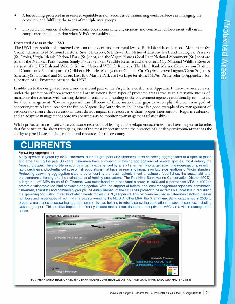
Spawning AggregationsMany species targeted by local fishermen, such as groupers and snappers, form spawning aggregations at a specific place and time. During the past 30 years, fishermen have eliminated spawning aggregations of several species, most notably the Nassau grouper. The short-term economic gains experienced by a few fishermen who target spawning aggregations, result in rapid declines and potential collapse of fish populations that have far reaching impacts on future generations of Virgin Islanders. Protecting spawning aggregation sites is paramount to the local replenishment of valuable food fishes, the sustainability of the commercial fishery and the maintenance of healthy ecosystems. The Red Hind Bank Marine Conservation District (MCD), a large 41 km2 MPA south of St. Thomas, was established as a seasonal closure in 1990 and a permanent MPA in 1999 to protect a vulnerable red hind spawning aggregation. With the support of federal and local management agencies, commercial fishermen, scientists and community groups, the establishment of the MCD has proved to be extremely successful in rebuilding the spawning population of red hind which nearly tripled in a 3 year period. This recovery resulted in fishermen catching greater numbers and larger sizes of red hind in areas surrounding the MCD. Another MPA, the Grammanik Bank, established in 2005 to protect a multi-species spawning aggregation site, is also helping to rebuild spawning populations of several species, including Nassau grouper. This positive impact of a fishery closure makes more fishermen receptive to MPAs as a viable management option.
• Afunctioningprotectedareaensuresequitableuseofresourcesbyminimizingconflictsbetweenmanagingthe ecosystem and fulfilling the needs of multiple user groups.
• Directedenvironmentaleducation,continuouscommunityengagementandconsistentenforcementwillensure compliance and cooperation when MPA’s are established.
Protected Areas in the USVIThe USVI has established protected areas on the federal and territorial levels. Buck Island Reef National Monument (St. Croix), Christiansted National Historic Site (St. Croix), Salt River Bay National Historic Park and Ecological Preserve (St. Croix), Virgin Islands National Park (St. John), and the Virgin Islands Coral Reef National Monument (St. John) are part of the National Park System. Sandy Point National Wildlife Reserve and the Green Cay National Wildlife Reserve are part of the US Fish and Wildlife Service National Wildlife Reserves. The Hind Bank Marine Conservation District and Grammanik Bank are part of Caribbean Fisheries Management Council. Cas Cay/Mangrove Lagoon/Great St. James Sanctuary(St.Thomas) and St. Croix East End Marine Park are two large territorial MPA’s. Please refer to Appendix 1 for a location of all Protected Areas in the USVI.
In addition to the designated federal and territorial park of the Virgin Islands shown in Appendix 1, there are several areas under the protection of non-governmental organizations. Both types of protected areas serve as an alternative means of managing the resources with existing deficits in staffing and funding in the government agencies traditionally responsible for their management. “Co-management” can fill some of these institutional gaps to accomplish the common goal of conserving natural resources for the future. Magens Bay Authority in St. Thomas is a good example of co-management of resources to ensure that recreational users do not impact the resources without proper intervention. Regular evaluation and an adaptive management approach are necessary to monitor co-management relationships.
While protected areas often come with some restriction of fishing and development activities, they have long-term benefits that far outweigh the short term gains; one of the most important being the presence of a healthy environment that has the ability to provide sustainable, rich natural resources for the economy.
CURRENTS
Protected Areas
Protected Areas
SOUTHERN SHELF EDGE OF RED HIND BANK MARINE CONSERVATION DISTRICT AND GRAMMANIK BANK. (GRAPHIC BY CMES)
HIND BANK
TERRITORIAL CORAL REEF MONITORING PROGRAM SITE
Waves of Change: A Resource for Environmental Issues in the U.S. Virgin Islands 22
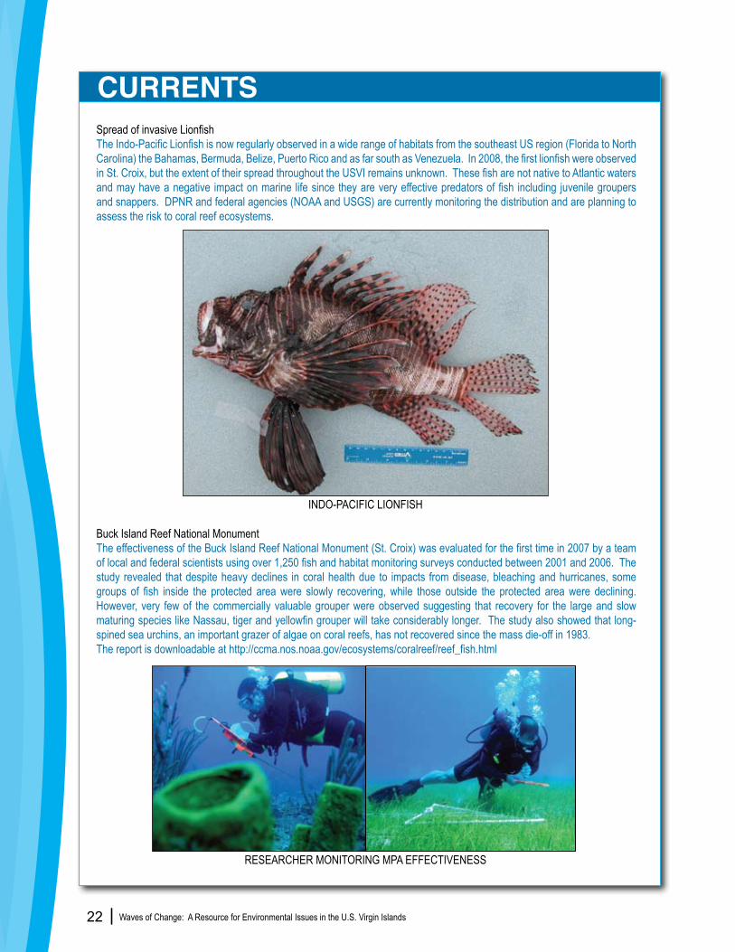
Spread of invasive LionfishThe Indo-Pacific Lionfish is now regularly observed in a wide range of habitats from the southeast US region (Florida to North Carolina) the Bahamas, Bermuda, Belize, Puerto Rico and as far south as Venezuela. In 2008, the first lionfish were observed in St. Croix, but the extent of their spread throughout the USVI remains unknown. These fish are not native to Atlantic waters and may have a negative impact on marine life since they are very effective predators of fish including juvenile groupers and snappers. DPNR and federal agencies (NOAA and USGS) are currently monitoring the distribution and are planning to assess the risk to coral reef ecosystems.
Buck Island Reef National MonumentThe effectiveness of the Buck Island Reef National Monument (St. Croix) was evaluated for the first time in 2007 by a team of local and federal scientists using over 1,250 fish and habitat monitoring surveys conducted between 2001 and 2006. The study revealed that despite heavy declines in coral health due to impacts from disease, bleaching and hurricanes, some groups of fish inside the protected area were slowly recovering, while those outside the protected area were declining. However, very few of the commercially valuable grouper were observed suggesting that recovery for the large and slow maturing species like Nassau, tiger and yellowfin grouper will take considerably longer. The study also showed that long-spined sea urchins, an important grazer of algae on coral reefs, has not recovered since the mass die-off in 1983.The report is downloadable at http://ccma.nos.noaa.gov/ecosystems/coralreef/reef_fish.html
CURRENTS
INDO-PACIFIC LIONFISH
RESEARCHER MONITORING MPA EFFECTIVENESS

Waves of Change: A Resource for Environmental Issues in the U.S. Virgin Islands 23
___________________________________________Fundamentals
Commercial fishing in the USVI is a cornerstone of Virgin Islands history and culture. Today nearly 350 commercial fishers in the USVI are divided mainly between trap (pot), line, and net (seine) fisheries. Some use a combination of two or all three of the methods. Others free dive or use SCUBA to catch conch and lobster, or to spearfish. Cast nets are also used to catch baitfish.
In federal waters (three to 200 nautical miles from shore), fisheries are managed by the Caribbean Fisheries Management Council (CFMC) which is based in Puerto Rico. Fisheries within territorial waters (within three nautical miles of shore) are managed by the Virgin Islands government largely through the Department of Planning and Natural Resources (DPNR). Fisheries regulations are developed by DPNR based in part on recommendations by the Fisheries Advisory Committees (FAC; one representing St. Croix and another St. Thomas and St. John), and DPNR’s Division of Fish and Wildlife (DFW). While territorial regulations apply throughout territorial waters, much of the waters surrounding St. John (the Virgin Islands National Park and VI Coral Reef National Monument) as well as waters surrounding Buck Island Reef National Monument off St. Croix are managed by the National Park Service and have additional fisheries regulations, ranging from bag limits for conch, lobster, and whelk to the complete prohibition of fishing and anchoring.
Problems in Our FisheriesIncreasing demand for locally caught species, a decline in important fish habitat and more efficient fishing techniques are changing the biological make up of our fisheries. Fishermen have been forced to fish further away from shore to catch species previously found in near-shore waters. Citing evidence of reduced catch and the absence of many large species that were historically common, individual fishers, district fishermen’s associations, DPNR/DFW, and conservation groups work with the FACs and the CMFC to make recommendations for effective management tools that can improve fish stocks.
St. Thomas Fishermen’s AssociationVirgin Islands fishers have recently begun organizing to take an active role in designating existing and potential fishing regulations. The St. Thomas Fishermen’s Association (STFA), representing commercial fishers from St. Thomas and St. John, believes not enough research has been done to develop an accurate picture of VI fisheries. The STFA feels the claims of overfishing in St. Thomas and St. John are based on inaccurate data or information from other areas and are promoted by well-funded international environmental organizations. The STFA believes fair and successful fisheries management requires commercial fishers be a part of the management process. They are currently conducting a study to determine if escape vents should be required for fish traps, and, if so, what size they should be to reduce bycatch and ensure minimal loss of marketable fish. They have recently partnered with NMFS and MRAG Americas, Inc. to request funding for scientific research on bycatch of the yellowtail snapper and queen triggerfish fishery. According to the STFA, the federal government has relied too heavily on closures rather than other management tools, thus threatening the economic well-being of the local fishing communities. However, many scientists and conservationists believe that the only means of ensuring the sustainability of commercial species is by protecting them during important and vulnerable life history events such as reproduction by prohibiting fishing during seasonal spawning periods either through seasonal closures of territorial and federal waters or seasonal closures of spawning sites.
Fisheries Management
CURRENTS
Fisheries Managem
entFisheries M
anagement
FRENCHTOWN, ST. THOMAS

Waves of Change: A Resource for Environmental Issues in the U.S. Virgin Islands 24
Current USVI fishing regulations include gear restrictions, seasonal and year-round species closures, seasonal and permanent area closures, bag limits, and minimum size limits for certain species. In 2001 the local VI government enacted a moratorium on new commercial fishing permits to further address fishery management problems, and in 2006 the Governor approved a ban on gill-nets in USVI waters. The FACs and DPNR are currently working on modifications to the commercial fishing regulations and enacting recreational fishing regulations. There are recent calls for and discussions on more regulations including limiting the number of traps per fisher, and making the fishing permit moratorium permanent with a “limited entry” program similar to the VI taxi medallion program.
The University of the Virgin Islands (UVI) has been working to ascertain the status of commercial reef fish species within the region. UVI has focused on the health and population of spawning aggregations – large groups of normally solitary reef fish that migrate from distant areas to join together for reproduction annually. In an effort to rebuild fish stocks, this research, coupled with lessons learned from the collapse of a Nassau grouper spawning aggregation due to overfishing in the 1970’s, has led to several local spawning areas being protected by seasonal or permanent closures. These closures have helped some fish populations recover and also improved catch rates ( See “Protected Areas” Section).
The Division of Fish and Wildlife requires fishers to turn in monthly catch reports. It has been determined that fisherman catch reports are inadequate to understand and analyze the trends of fish stocks or even the fishery as a whole.Thirty years of catch data have been entered into a database and is being analyzed by DFW and NOAA National Marine Fishery Service (NMFS) Southeast Science Center. The best fishery data collection method is to establish a port survey program where trained DFW staff count, identify and measure a portion of the commercial catch. Accurate and consistent data are invaluable for understanding the influence of fishing pressure and environmental changes on fish populations.
In addition to fishing pressures, recent studies conducted by the U.S. National Marine Fisheries Service (NMFS) and many other scientists have shown that land-based sources of pollution, the destruction of important near-shore and coral reef habitats and recreational activities are also negatively impacting fishery resources.
Lack of environmental enforcement is another problem facing local fisheries management. One role of the DPNR Division of Environmental Enforcement is the protection of marine resources from illegal fishing and ensuring that legally registered fishermen are in compliance with territorial and federal regulations. The Division of Environmental Enforcement is currently overburdened with Homeland Security, public safety, hazmat and other concerns, and have little available time or personnel to enforce fishing regulations.
• Support and approve legislation that will update Act 3330, our Territorial Fisheries Regulations that are currently severely outdated and inadequate.
• Increase funding for fisheries enforcement to facilitate effective training and education, additional staff, and equipment.
• Instigate measures that will better protect the fisheries stocks of the US Virgin Islands and the health of the people by building, maintaining and regulating fish markets that meet widely accepted health and fisheries reporting standards.
• Support strong environmental legislation that protects near shore fisheries habitat ( coral reef, seagrass, and mangrove) from unregulated development, destructive land use, solid waste, and sewage and industrial runoff.
• Provide funding for regular monitoring of commercial catches (see port surveys discussion above).
CHANGING TIDES
Fish
erie
s M
anag
emen
tFi
sher
ies
Man
agem
ent
Recreational FishingThe Fisheries Advisory Council is working to make recommendations for a recreational fishers permitting program. The program can work to offset the cost of enforcement for current and future fishing regulations. Left unregulated, recreational fishing activity can inhibit the recovery of protected and nearshore fishes and coral reef health. Regular anchoring of recreational fishing boats on reefs is a long term detriment to the resources that the fisherman are actually targeting. A recreational fishers permitting program will allow for directed education and enforcement to ensure sustainable fishing practices in the USVI. Funding for surveys of recreational catch will provide critical data to DFW for better management of local fisheries.
CURRENTS
FISHERMANS CATCH, ST. THOMAS
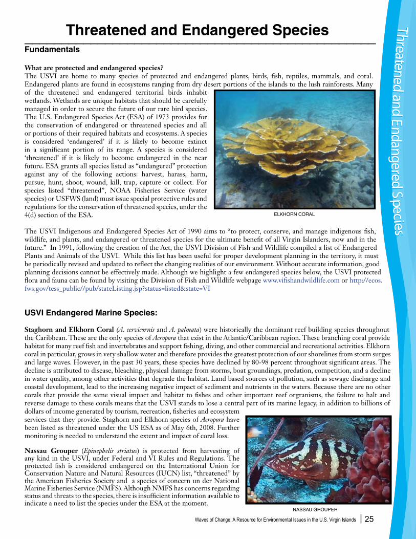
Waves of Change: A Resource for Environmental Issues in the U.S. Virgin Islands 25
________________________________________________Fundamentals
What are protected and endangered species?The USVI are home to many species of protected and endangered plants, birds, fish, reptiles, mammals, and coral. Endangered plants are found in ecosystems ranging from dry desert portions of the islands to the lush rainforests. Many of the threatened and endangered territorial birds inhabit wetlands. Wetlands are unique habitats that should be carefully managed in order to secure the future of our rare bird species. The U.S. Endangered Species Act (ESA) of 1973 provides for the conservation of endangered or threatened species and all or portions of their required habitats and ecosystems. A species is considered ‘endangered’ if it is likely to become extinct in a significant portion of its range. A species is considered ‘threatened’ if it is likely to become endangered in the near future. ESA grants all species listed as “endangered” protection against any of the following actions: harvest, harass, harm, pursue, hunt, shoot, wound, kill, trap, capture or collect. For species listed “threatened”, NOAA Fisheries Service (water species) or USFWS (land) must issue special protective rules and regulations for the conservation of threatened species, under the 4(d) section of the ESA. The USVI Indigenous and Endangered Species Act of 1990 aims to “to protect, conserve, and manage indigenous fish, wildlife, and plants, and endangered or threatened species for the ultimate benefit of all Virgin Islanders, now and in the future.” In 1991, following the creation of the Act, the USVI Division of Fish and Wildlife compiled a list of Endangered Plants and Animals of the USVI. While this list has been useful for proper development planning in the territory, it must be periodically revised and updated to reflect the changing realities of our environment. Without accurate information, good planning decisions cannot be effectively made. Although we highlight a few endangered species below, the USVI protected flora and fauna can be found by visiting the Division of Fish and Wildlife webpage www.vifishandwildlife.com or http://ecos.fws.gov/tess_public//pub/stateListing.jsp?status=listed&state=VI
USVI Endangered Marine Species:
Staghorn and Elkhorn Coral (A. cervicornis and A. palmata) were historically the dominant reef building species throughout the Caribbean. These are the only species of Acropora that exist in the Atlantic/Caribbean region. These branching coral provide habitat for many reef fish and invertebrates and support fishing, diving, and other commercial and recreational activities. Elkhorn coral in particular, grows in very shallow water and therefore provides the greatest protection of our shorelines from storm surges and large waves. However, in the past 30 years, these species have declined by 80-98 percent throughout significant areas. The decline is attributed to disease, bleaching, physical damage from storms, boat groundings, predation, competition, and a decline in water quality, among other activities that degrade the habitat. Land based sources of pollution, such as sewage discharge and coastal development, lead to the increasing negative impact of sediment and nutrients in the waters. Because there are no other corals that provide the same visual impact and habitat to fishes and other important reef orgranisms, the failure to halt and reverse damage to these corals means that the USVI stands to lose a central part of its marine legacy, in addition to billions of dollars of income generated by tourism, recreation, fisheries and ecosystem services that they provide. Staghorn and Elkhorn species of Acropora have been listed as threatened under the US ESA as of May 6th, 2008. Further monitoring is needed to understand the extent and impact of coral loss.
Nassau Grouper (Epinephelis striatus) is protected from harvesting of any kind in the USVI, under Federal and VI Rules and Regulations. The protected fish is considered endangered on the International Union for Conservation Nature and Natural Resources (IUCN) list, “threatened” by the American Fisheries Society and a species of concern un der National Marine Fisheries Service (NMFS). Although NMFS has concerns regarding status and threats to the species, there is insufficient information available to indicate a need to list the species under the ESA at the moment.
Threatened and Endangered Species Threatened and Endangered SpeciesThreatened and Endangered Species
NASSAU GROUPER
ELKHORN CORAL

Waves of Change: A Resource for Environmental Issues in the U.S. Virgin Islands 26
The Nassau Grouper is a predatory fish that inhabits the Caribbean Sea, Florida Keys and the Gulf of Mexico. It is one of the four species that can eat the poisonous lionfish, an introduced species from the Pacific that has recently been found in the Caribbean, including St. Croix and Puerto Rico.(See page “Currents” page 22)Characterized by a black saddle spot on its tail base, the Nassau Grouper grows up to four feet in length and usually inhabits the bottom of reefs. Though once one of the most important fishery species in the region, fishing, especially of spawning aggregations, has eliminated this fish from much of its historic range in the USVI waters. Proper enforcement of the ‘no-take’ law and prevention of illegal fishing in territorial waters is necessary to reverse the current decline of this fishery. With so little known about the local breeding and spawning habits of these species, further research and monitoring is warranted.
Sea Turtles Sea turtles are among the oldest extant reptiles on Earth. They are important biological contributors to energy and nutrient cycling in their individual habitats as well as nutrient poor beaches on which they nest. More importantly, each species of sea turtle that migrates to, or are resident of the territory, is a keystone species to their respective habitats. Historically, sea turtles have been hunted for their meat, eggs, bones, carapace (shell), skulls, fats, oils, and blood for a number of cultural and medicinal purposes. Global declines in population levels are primarily due to a number of anthropogenic impacts that include loss of nesting habitat, interactions with commercial fishing industries, poaching, and pollution.
The USVI provide critical nesting, foraging and developmental habitats for three species of sea turtles: green, hawksbill, and leatherback; all of which are federally listed as either threatened or endangered. Leatherback females require nesting beaches with no near shore reef for nesting (i.e. Trunk Bay, St. John and Sandy Point, St. Croix). Green and hawksbill sea turtles nest in vegetated dunes and on beaches. In recent years, sightings of loggerhead sea turtles have been documented in territorial waters. The greatest threats to sea turtles in the USVI include coastal and upland development, domestic and non-indigenous animal predators, boating, accidental interactions with fishers, disorientation of nesting females and hatchlings by beach lighting, and ineffective protection against illegal harvesting of eggs and poaching. When coastal zones and beaches are considered for development, it is essential that critical sea turtle habitats are secured and protected. In addition, destructive fishing practices such as gill and trammel netting should be prohibited as they can entangle and drown sea turtles and other protected species. Monitoring and research of sea turtles migration patterns, nesting habits and life cycles should be supported to ensure proper management, enforcement and conservation strategies.
USVI Endangered Terrestrial Species
The VI Tree Boa (Epicrates monensis granti) is federally endangered because of low population numbers and limited distribution. In the entire USVI it is only found on the eastern most end of St. Thomas and on a few offshore cays. It lives in the subtropical dry forest with an interlocking canopy, where it forages at night on lizards sleeping in trees and seeks refuge during the day in tree cavities, termite nests, or under rock and logs. Threats to this species come in the form of mammalian predators (rats, cats, and dogs), wanton killing by humans, and traffic fatalities. However, the major cause of decline of this species is habitat loss. This species long-term survival in a highly developed and densely populated eastern end of St. Thomas, where it is uncommon and presumably declining, is unlikely without immediate efforts to protect its habitat. More stringent regulations on permitting and vegetation clearing areas where the tree boa occurs must be developed.
The endemic St. Croix Ground Lizard (Ameiva polps), has been extirpated from the main island of St. Croix where it was once widespread along the coast. The strictly terrestrial ground lizard thrives in dry, rocky coastal areas with sandy soils. Listed as endangered by the USFWS, this lizard is now restricted to three cays off St. Croix. These three cays are currently free of the non-native Small Indian Mongoose (Herpestes javanicus), the lizard’s primary predator, but the ground lizard remains highly vulnerable because of its limited distribution, small population size, and susceptibility to accidental or deliberate introductions of the mongoose. Protestant Cay and Green Cay have been designated critical habitat in the ESA, with limited success due to a hotel in the vicinity on one cay and hurricane disturbances on the other. Conservation plans for the St. Croix Ground Lizard include restoration of habitat on Protestant Cay and removal of exotic vegetation from Green Cay. The Lizard was recently introduced to Buck Island following the eradication of mongooses and rats. The ground lizard is highly unlikely to be delisted as an endangered species but its perpetuity should be assured as long as the small offshore islands remain mongoose-free.Thre
aten
ed a
nd E
ndan
gere
d Sp
ecie
sTh
reat
ened
and
End
ange
red
Spec
ies
HAWKSBILL SEA TURTLE
VI TREE BOA
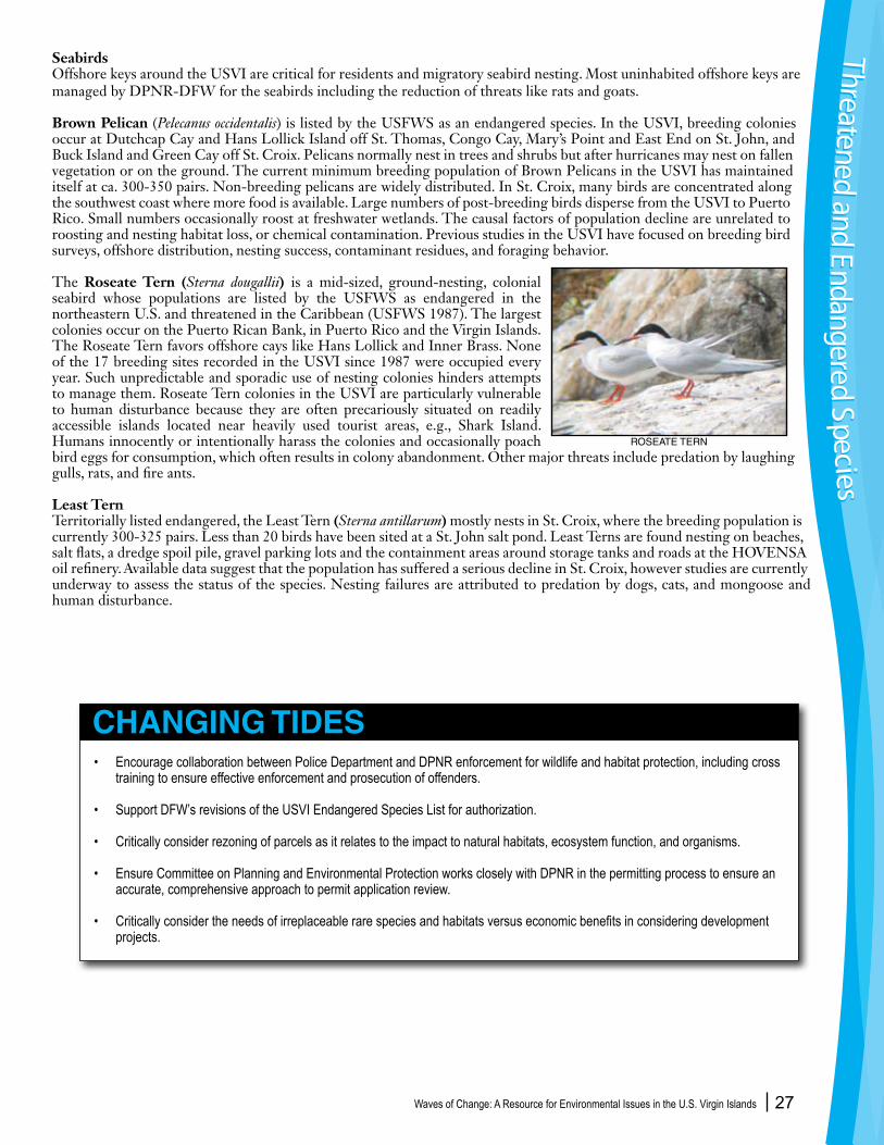
Waves of Change: A Resource for Environmental Issues in the U.S. Virgin Islands 27
Seabirds Offshore keys around the USVI are critical for residents and migratory seabird nesting. Most uninhabited offshore keys are managed by DPNR-DFW for the seabirds including the reduction of threats like rats and goats.
Brown Pelican (Pelecanus occidentalis) is listed by the USFWS as an endangered species. In the USVI, breeding colonies occur at Dutchcap Cay and Hans Lollick Island off St. Thomas, Congo Cay, Mary’s Point and East End on St. John, and Buck Island and Green Cay off St. Croix. Pelicans normally nest in trees and shrubs but after hurricanes may nest on fallen vegetation or on the ground. The current minimum breeding population of Brown Pelicans in the USVI has maintained itself at ca. 300-350 pairs. Non-breeding pelicans are widely distributed. In St. Croix, many birds are concentrated along the southwest coast where more food is available. Large numbers of post-breeding birds disperse from the USVI to Puerto Rico. Small numbers occasionally roost at freshwater wetlands. The causal factors of population decline are unrelated to roosting and nesting habitat loss, or chemical contamination. Previous studies in the USVI have focused on breeding bird surveys, offshore distribution, nesting success, contaminant residues, and foraging behavior.
The Roseate Tern (Sterna dougallii) is a mid-sized, ground-nesting, colonial seabird whose populations are listed by the USFWS as endangered in the northeastern U.S. and threatened in the Caribbean (USFWS 1987). The largest colonies occur on the Puerto Rican Bank, in Puerto Rico and the Virgin Islands.The Roseate Tern favors offshore cays like Hans Lollick and Inner Brass. None of the 17 breeding sites recorded in the USVI since 1987 were occupied every year. Such unpredictable and sporadic use of nesting colonies hinders attempts to manage them. Roseate Tern colonies in the USVI are particularly vulnerable to human disturbance because they are often precariously situated on readily accessible islands located near heavily used tourist areas, e.g., Shark Island. Humans innocently or intentionally harass the colonies and occasionally poach bird eggs for consumption, which often results in colony abandonment. Other major threats include predation by laughing gulls, rats, and fire ants.
Least Tern Territorially listed endangered, the Least Tern (Sterna antillarum) mostly nests in St. Croix, where the breeding population is currently 300-325 pairs. Less than 20 birds have been sited at a St. John salt pond. Least Terns are found nesting on beaches, salt flats, a dredge spoil pile, gravel parking lots and the containment areas around storage tanks and roads at the HOVENSA oil refinery. Available data suggest that the population has suffered a serious decline in St. Croix, however studies are currently underway to assess the status of the species. Nesting failures are attributed to predation by dogs, cats, and mongoose and human disturbance.
• Encourage collaboration between Police Department and DPNR enforcement for wildlife and habitat protection, including cross training to ensure effective enforcement and prosecution of offenders.
• Support DFW’s revisions of the USVI Endangered Species List for authorization.
• Critically consider rezoning of parcels as it relates to the impact to natural habitats, ecosystem function, and organisms.
• Ensure Committee on Planning and Environmental Protection works closely with DPNR in the permitting process to ensure an accurate, comprehensive approach to permit application review.
• Critically consider the needs of irreplaceable rare species and habitats versus economic benefits in considering development projects.
CHANGING TIDES
Threatened and Endangered SpeciesThreatened and Endangered Species
ROSEATE TERN
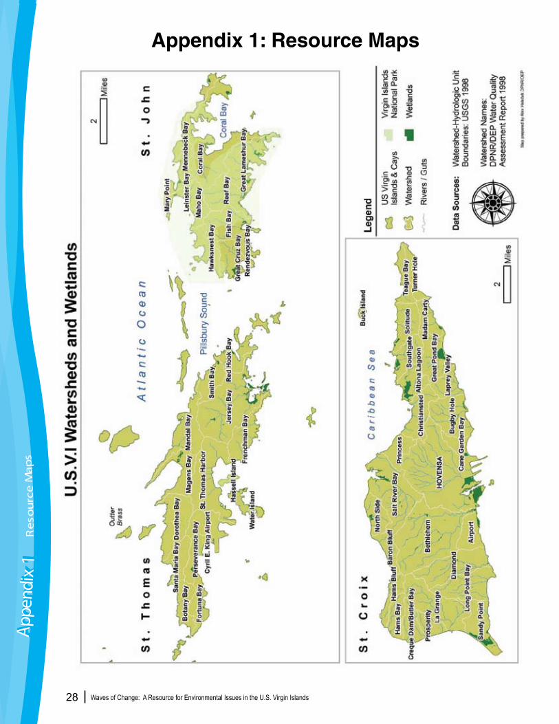
Waves of Change: A Resource for Environmental Issues in the U.S. Virgin Islands 28
Appendix 1: Resource MapsAp
pend
ix 1
Appe
ndix
1R
eso
urc
e M
aps
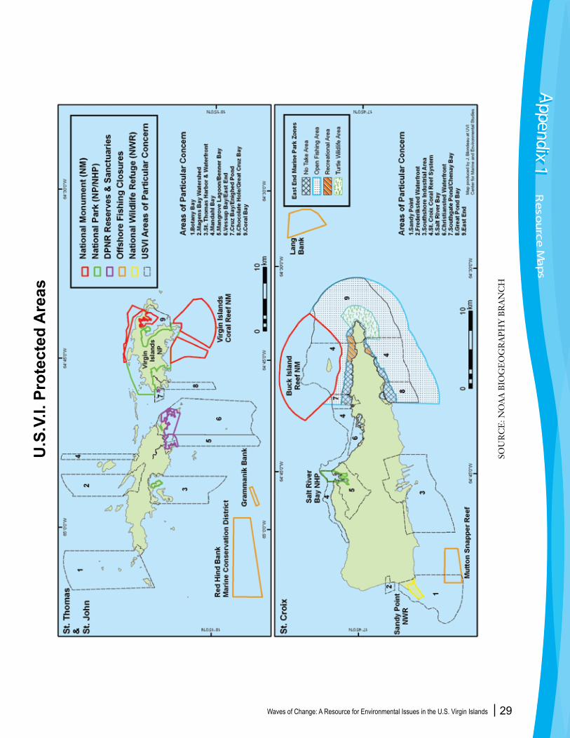
Waves of Change: A Resource for Environmental Issues in the U.S. Virgin Islands 29
U.S
.V.I.
Pro
tect
ed A
reas
Appendix 1Appendix 1
Reso
urce M
aps
SOU
RC
E: N
OA
A B
IOG
EO
GR
AP
HY
BR
AN
CH

Waves of Change: A Resource for Environmental Issues in the U.S. Virgin Islands 30
U.S
.V.I.
Cor
al R
eefs
SOU
RC
E: N
OA
A B
IOG
EO
GR
AP
HY
BR
AN
CH
Waves of Change: A Resource for Environmental Issues in the U.S. Virgin Islands 31
_____________________________________________________________________________________________
Department of Planning and Natural Resources 340-773-1082 (STX), 340-774-3320 (STT)
DPNR serves as the agency responsible for the administration and enforcement of all laws pertaining to the preservation and conservation of fish and wildlife, trees and vegetation, coastal zones, cultural and historical resources, water resources, and air, water and oil pollution. DPNR is also responsible for oversight and compliance of land survey, land subdivision, development and building permits, code enforcement, earth change permits, zoning administration, boat registration, and mooring and anchoring of vessels within territorial waters. The Department formulates long-range comprehensive and functional development plans for the human, economic and physical resources of the territory. Division of Coastal Zone Management The Division of Coastal Zone Management (CZM) works to develop and implement a variety of projects and programs, including review, processing and enforcement of minor and major development permits in the first tier of the coastal zone.
Division of Comprehensive and Coastal Zone Planning Division of Comprehensive and Coastal Zone Planning (CCZP) has the broad responsibility for long-range comprehensive planning, subdivision and zoning administration.
Division of Environmental Protection The Division of Environmental Protection (DEP) is responsible for environmental protection and the enforcement of environmental laws and regulations in the US Virgin Islands. The DEP receives funding and has been delegated responsibility for environmental protection by the US Environmental Protection Agency (EPA).
Division of Fish and Wildlife The Division of Fish and Wildlife (DFW) is charged with monitoring, assessing and implementing public awareness and other activities that help to enhance and safeguard fish and wildlife resources in the USVI.
Environmental Association of St. Thomas (EAST) 340-776-1976, http://www.usvi.net/east/The Environmental Association of St. Thomas-St. John is a private, non-profit organization with more than 300 members. The mission of EAST is to educate the community about environmental concerns, encourage greater awareness of the value of our natural and cultural resources, and to advocate responsible methods for environmental conservation and preservation.
St. Croix Environmental Association (SEA) 340-773-1989 http://www.stxenvironmental.org/The St. Croix Environmental Association is a private, non-profit organization committed to protecting and conserving the beautiful island environment of St. Croix. The mission of SEA is to encourage environmental action through awareness, education, and advocacy. SEA has more than 500 members.
Saint Thomas Fishermen’s Association 340-714-2556The STFA is a non-profit, non-governmental organization dedicated to the representation of the interests of commercial fishermen of St. Thomas and St. John. This organization believes sustainable fisheries require commercial fishermen be a part of the management process.
Appendix 2: Relevant AgenciesAppendix 2Appendix 2
Relevan
t Ag
encies
Waves of Change: A Resource for Environmental Issues in the U.S. Virgin Islands 32
University of the Virgin Islands Center for Marine and Environmental Studies 340-693-1380 (STT) 340-692-4046 (STX) CMES seeks to advance knowledge and learning in marine, coastal and watershed systems through research, education, student training and outreach programs and to disseminate such knowledge to the academic body, scientific community, government agencies and to the general public.
Virgin Islands Marine Advisory Service (VIMAS) 340-692-4046 (STX), 340-693-1392 (STT) VIMAS is part of the University of Puerto Rico Sea Grant College Program, located within the Center for Marine and Environmental Studies (CMES) at the UVI. VIMAS agents develop outreach and education activities and publications relevant to the marine environment.
Cooperative Extension Service 340-692-4053 (STX) 340-693-1086 (STT) CES is funded by the US Dept. of Agriculture and does outreach and education for the community.
Conservation Data Center 340-693-1033 The CDC compiles, analyzes, and disseminates natural resource and socioeconomic data. The data being collected are stored in a Geographic Information System (GIS)—a computerized system that links maps to data. The CDC also provides training in GIS.
Virgin Islands Experimental Program to Stimulate Competitive Research (VI-EPSCoR) 340-693-1215 (STT) The Virgin Islands Experimental Program to Stimulate Competitive Research (VI-EPSCoR) promotes the development of the Territory’s science and technology resources. VI- EPSCoR is hosted by the University of the Virgin Islands on behalf of the people of the Virgin Islands and is currently focused on work related to the seas surrounding the territory.
National Park Service Buck Island Reef National Monument 340-773-1460 (STX) Buck Island Reef National Monument is part of the US National Park Service. The park is one of a few fully marine protected areas in the National Park System. The 176-acre island and surrounding coral reef ecosystem support a large variety of native flora and fauna.
Salt River Bay National Historical Park and Ecological Preserve 340-773-1460 Salt River Bay National Historical Park and Ecological Preserve on the Virgin Island of St. Croix, contains the only known site where members of a Columbus expedition set foot on what is now United States territory. It also preserves upland watersheds, mangrove forests, and estuarine and marine environments that support threatened and endangered species.
Virgin Islands National Park 340-776-6201 Virgin Islands National Park (VINP) covers approximately 3/5 of St. John, and nearly all of Hassel Island in the Charlotte Amalie harbor on St. Thomas. In addition to the nearly 7,000 acres on land, the VINP also manages over 5,600 acres of submerged lands surrounding the Park. Managed by the National Park Service, the VINP is dedicated to the protection and preservation of its natural and cultural resources and promotes the responsible enjoyment of this unique national treasure.
Virgin Islands Coral Reef National Monument 340-776-6201 (STJ) Seeking to provide greater protection to the sensitive coral reef resources, President Clinton established the Virgin Islands Coral Reef National Monument in 2001. The monument includes 12,708 acres of federal submerged lands within the 3 mile belt off of Saint John, including Hurricane Hole and areas north and south of Saint John. The VI National Coral Reef National Monument is manged by the VI National Park.
Appe
ndix
2Ap
pend
ix 2
Rel
evan
t A
gen
cies
Waves of Change: A Resource for Environmental Issues in the U.S. Virgin Islands 33
United States Geological Survey 340-693-8950 (STJ)As the Nation’s largest water, earth, and biological science and civilian mapping agency, the U.S. Geological Survey (USGS) collects, monitors, analyzes, and provides scientific understanding about natural resource conditions, issues, and problems.
United States Natural Resources Conservation Service 340-692-9662 (STX)NRCS's natural resources conservation programs help people reduce soil erosion, enhance water supplies, improve water quality, increase wildlife habitat, and reduce damages caused by floods and other natural disasters.
VI Waste Management Authority 340-773-4489 (STX) 340-777-3073 (STT)The VIWMA manages solid waste and the government wastewater treatment system. VIWMA also does educational programs about solid waste and wastewater.
VI Department of Health, Division of Environmental Health 340-773-1311 (STX) 340-774-9000 (STT) The Department of Health has direct responsibility for conducting programs of preventive medicine including special programs in maternal and child health, family planning, environmental sanitation, mental health, and drug and substance abuse prevention.
Virgin Islands Network of Environmental Educators (VINE) www.usvircd.org/VINE (RCD) 340-692-9632 x5 (STX) 340-778-7657 (STT) 340-714-2333 VINE members work together to offer environmental education programs and provide resources for teachers and the community. The network links K-20 educators, natural and cultural resource organizations and stakeholders to promote environmental and cultural education throughout the USVI.
West Indies Animal Research and Conservation Service, Inc. 340-772-1382 (Steve Garner, Executive Director) WIMARCS is a non-profit organization who’s main goal is to protect and conserve marine resources through research, education, and outreach.
The Nature Conservancy(TNC) 340-718-5575 (STX)The Nature Conservancy runs various programs to support its mission which is to preserve the plants, animals and natural communities that represent the diversity of life on Earth by protecting the lands and waters they need to survive.
Caribbean Fisheries Management Council 787-766-5926 (PR)CFMC is dedicated to protecting and preserving our nation's living marine resources through scientific research, fisheries management, enforcement, and habitat conservation. It is part of the NOAA Fisheries and acts as a voice for commercial and recreational fisheries and continues to focus its efforts on sustaining our marine resources.
Appendix 2Appendix 2
Relevan
t Ag
encies
Waves of Change: A Resource for Environmental Issues in the U.S. Virgin Islands 34
Bill No. 25-0209, June 16, 2004, proposed by Senator Usie R. Richards
Caribbean Fisheries Management Council, Sustainable Fisheries Act. http://www.caribbeanfmc.com/SFA-FMP.htm
Cesar, Herman and Chiew Kieok Chong. Economic Valuation and Socioeconomics of Coral Reefs: Methodological Issues and Three Case Studies. WorldFish Center Contribution No. 1721. WorldFish Center.
Cicin-Sain, B., Bernal, P., Vanderweerd, V., Belfiore, S. and Goldstein, K. 2002. Oceans, Coasts and Islands at the World Summit on Sustainable Development and Beyond. Integrated Management from Hilltops to Oceans. Center for the Study of Marine Policy, Newark, Delaware.
Convention on Biological Diversity. http://www.biodiv.org
Coral Reefs and Sustainable Coastal Development: Planning for a sustainable reef. 2003. The Coral Reef Alliance. San Francisco, CA.
The Daily News, Jan 8, 2008. Accord Reached in St. Croix Wastewater Lawsuit
Eltman, Joan K. 1994. United States Virgin Islands Coastal Conflicts: Can ComprehensivePlanning Save Coastal Resources?
Henry, Stevie. UVI Conservation Data Center, personal communication.
Herz, M., “Cruise Control: A Report on How Cruise Ships Affect the Marine Environment”. Ocean Conservancy. May 2002.
In the Front Line: Shoreline Protection and other ecosystems services from mangroves and coral reefs. 2006.UNEP World Conservation Monitoring Centre. Cambridge, UK.
Magnuson-Stevens Fisheries Conservation and Management Act Public Law 94-265. http://www.nmfs.noaa.gov/sfa/magact/mag3.html#s301
Marshall, P., and Schuttenberg, H. 2006. A reef manager’s guide to coral bleaching. Townsville, Australia, Great Barrier Reef Marine Park Authority.
Mumby, P.J., 2005, Connectivity of Reef Fishes Between Mangroves and Coral Reefs. Biological Conservation, 218: 215-222.
Nemeth, R.,2005. Population characteristics of a recovering US Virgin Islands red hind spawning aggregation following protection. Mar Ecol Prog Ser. 286: 81–97.
NOAA Fisheries Office of Protected Resources: http://www.nmfs.noaa.gov
Appendix 3: Information SourcesAp
pend
ix 3
Appe
ndix
3In
form
atio
n S
ou
rces

Waves of Change: A Resource for Environmental Issues in the U.S. Virgin Islands 35
Progress in the Implementation of the Programme of Action for the Sustainable Development of Small Island Developing States; United Nations Commission on Sustainable Development, seventh session, April 19-30, 1998.Protected Areas and Biodiversity: An Overview of Key Issues.2005. The World Conservation Union. http://www.iucn.org/
Ramos-Scharron, C.E. and MacDonald L. H. (2007). “Measurement and prediction of natural and anthropogenic sediment sources, St. John, U.S. Virgin Islands” www.sciencedirect.com.
Rogers C, Miller J, Muller E, Edmunds P, Nemeth RS, Beets JP, Friedlander AM, Smith TB, Bou-lon R, Jeffrey CFG, Menza C, Caldow C, Idrisi N, Kojis B, Monaco ME, Spitzack A, Gladfelter EH, Ogden JC, Hillis-Starr Z, Lundgren I, Schill WB, Kuffner IB, Richardson LL, Devine B, Voss J (2008) Ecology of Coral Reefs in the US Virgin Islands. Chapter 8. In: Riegl B, Dodge R (eds.) Coral Reefs of the USA. Springer, Berlin. (pp 303-374)
Rogers C, “Coral diseases following massive bleaching in 2005 casue 60 percent decline in coral cover and mortality of threatened species, Acropoa palmata, on reefs in the U.S. Virgin Islands.” US Department of the Interior US Geological Survey. Fact Sheet 2008-3058 June 2008.
St. Croix East End Marine Park. http://www.stxeastendmarinepark.org/
The State of the Coral Reefs Of the U.S. Virgin Islands. 2004. The Ocean Conservancy. Washington, D.C. http://www.oceanconservancy.org/site/DocServer/Reefs_USVI
Taylor, Marcia. Coast Notes “Water Pollution in the VI”.
Thomas, Toni and Barry Devine. Island Peak to Coral Reef: A Field Guide to the Plant and Marine Communities of the Virgin Islands. 2005. University of the Virgin Islands. St. Thomas, USVI.
United Nations Atlas of the Oceans. www.oceansatlas.com
U.S. Virgin Islands Development Plan, 1995.
U.S. Virgin Islands Department of Planning and Natural Resources. http://www.dpnr.gov.vi/clwup/index.htm
VI Division of Environmental Protection. www.dpnr.gov.vi
VI Fish and Wildlife. www.vifishandwildlife.com
Waste Management Authority: http://www.viwma.org/
“The University of the Virgin Islands is accredited by the Commission on Higher Education of the Middles States Association of Colleges and Schools. The University is also an active member of the American As-sociation for Higher Education, the American Association of State Colleges and Universities, the American Council on Education, the Association of Caribbean Information Systems, the Association of Caribbean Universities and Research Institutes, the Association of Governing Boards, the National Association of Equal Opportunity and the National Association of State Universities and Land Grant Colleges. UVI is a land-granted institution and the only one of the 117 Historically Black Colleges and Universities outside of the continental United States. The University of the Virgin Islands is an equal opportunity, affirmative action, Title IX, Section 504, PL 101-542 educator and employer.”
Appendix 3Appendix 3
Info
rmatio
n S
ou
rces
VI MARINE OUTREACH PROGRAM
Lihla Noori Virgin Islands Marine AdvisoryService
Center for Marine and Environmental Studies2 John Brewers Bay, St. Thomas, VI 00802Phone: 340-693-1392 • Fax: 340-693-1395
Marcia TaylorVirgin Islands Marine Advisory ServiceCenter for Marine and Environmental StudiesRR#2 box 10,000, St. Croix, VI 00850Phone: 349-692-4046 • Fax: [email protected]
For more information about this document please contact:
Virgin Islands EPSCoRUniversity of the Virgin Islands
#2 John Brewer’s Bay, St. Thomas, VI 00802-9990340.693.1478 – epscor.uvi.edu - [email protected]