Embed Size (px)
Citation preview
VIRGINIA COASTAL PROGRAM
Watershed Management Plan
January 2001
Department of Environmental ServicesEnvironmental Planning Office2100 Clarendon Boulevard, Suite 801Arlington, Virginia 22201(703) 228-3613
Arlington CountyVirginia
Arlington County, Virginia
Arlington County BoardJay Fisette, ChairChristopher E. Zimmerman, Vice ChairBarbara FavolaPaul FergusonCharles Monroe
Office of the County ManagerWilliam T. Donahue, County ManagerJohn Mausert-Mooney, Assistant County Manager
Prepared ByJason Papacosma, Environmental PlannerDepartment of Environmental ServicesEnvironmental Planning Office
January 2001 i
Table of Contents
Acknowledgements ..................................................................................vExecutive Summary................................................................................vii
Organization of the Watershed Management Plan................................................................................ viiiSummary of Major Findings and Recommendations...............................................................................ix
Existing County water resource and runoff management practices .....................................................ixBaseline subwatershed conditions........................................................................................................ix
Streams .............................................................................................................................................ixCurrent and future land use ..............................................................................................................ix
Subwatershed goals ..............................................................................................................................ixWatershed management recommendations ...........................................................................................x
Sources of stormwater runoff and dry weather pollution..................................................................xStormwater BMPs, BMP retrofits, and maintenance ........................................................................xStormwater infrastructure.................................................................................................................xiStream and buffer management, restoration and monitoring ...........................................................xi
Pollution prevention and watershed education................................................................................... xiiImplementation Plan .............................................................................................................................. xii
Funding.............................................................................................................................................. xiiiConclusion......................................................................................................................................... xiii
1 Introduction .........................................................................................11.1 State and Federal requirements .........................................................................................................11.2 Chesapeake Bay ................................................................................................................................31.3 Arlington County's role .....................................................................................................................31.4 Components of the Watershed Management Plan.............................................................................41.5 Scale and scope of the Watershed Management Plan .......................................................................4
2 The Watershed Management Plan......................................................82.1 Watershed management responsibility..............................................................................................82.2 Existing County water resource and runoff management practices ..................................................8
2.2.1 Sources of stormwater runoff and dry weather pollution ..........................................................82.2.1.1 Existing development ........................................................................................................82.2.1.2 New Development and Redevelopment ............................................................................92.2.1.3 Point sources ...................................................................................................................112.2.1.4 Dry weather pollution......................................................................................................172.2.1.5 Septic Tanks ....................................................................................................................172.2.1.6 Spill response ..................................................................................................................20
2.2.2 Stormwater BMPs, BMP retrofits, and maintenance ..............................................................202.2.2.1 Structural controls ..........................................................................................................202.2.2.2 Street Sweeping...............................................................................................................21
2.2.3 Stormwater infrastructure........................................................................................................222.2.4 Stream and buffer management, restoration, and monitoring .................................................22
2.2.4.1 Management and restoration ...........................................................................................222.2.4.2 Monitoring.......................................................................................................................23
2.2.4.2.1 Four Mile Run water quality .......................................................................................232.2.4.2.2 Stormwater runoff .......................................................................................................24
2.2.5 Pollution prevention and watershed education........................................................................312.2.5.1 Arlingtonians for a Clean Environment (ACE)...............................................................312.2.5.2 Department of Parks, Recreation and Community Resources Educational Programs ....312.2.5.3 County Fair......................................................................................................................32
January 2001 ii
2.2.5.4 Non-point Source Public Education Materials ................................................................322.2.5.5 Bacteria Source Identification .........................................................................................322.2.5.6 Pet Waste Education........................................................................................................322.2.5.7 Dog Exercise Areas .........................................................................................................322.2.5.8 Cooperative Extension Homeowner Lawn Care Education ............................................332.2.5.9 Pesticide and Herbicide Use............................................................................................332.2.5.10 Storm Drain Stenciling....................................................................................................332.2.5.11 Household Hazardous Waste Program............................................................................332.2.5.12 Oil Recycling...................................................................................................................33
2.3 Baseline subwatershed conditions...................................................................................................342.3.1 Streams ....................................................................................................................................34
2.3.1.1 Methods...........................................................................................................................342.3.1.2 Results .............................................................................................................................352.3.1.3 Discussion .......................................................................................................................42
2.3.1.3.1 Importance of impervious and forested areas..............................................................422.3.1.3.2 Limitations ..................................................................................................................44
2.3.2 Land use ..................................................................................................................................452.4 Future land use changes ..................................................................................................................48
2.4.1 Zoning, Development, and General Land Use Plan ................................................................482.4.2 'Built-out' estimates and future impervious cover ...................................................................50
2.5 Subwatershed goals .........................................................................................................................512.6 Watershed management recommendations .....................................................................................57
2.6.1 Sources of stormwater runoff and dry weather pollution ........................................................572.6.1.1 County-wide ....................................................................................................................57
2.6.1.1.1 Stormwater management program ..............................................................................572.6.1.1.2 Chesapeake Bay Preservation Ordinance....................................................................602.6.1.1.3 BMP retrofits...............................................................................................................612.6.1.1.4 Utilities Ordinance ......................................................................................................612.6.1.1.5 Septic Tanks ................................................................................................................61
2.6.1.2 Subwatershed strategies ..................................................................................................622.6.1.2.1 Least impacted subwatersheds (!) and More impacted subwatersheds (")..............622.6.1.2.2 Most impacted subwatersheds (● ) ..............................................................................63
2.6.2 Stormwater BMPs, BMP retrofits, and maintenance ..............................................................652.6.2.1 County-wide ....................................................................................................................662.6.2.2 Subwatershed strategies ..................................................................................................67
2.6.2.2.1 Least impacted subwatersheds (!) and More impacted subwatersheds (")..............672.6.2.2.2 Most impacted subwatersheds (● ) ..............................................................................68
2.6.3 Stormwater infrastructure........................................................................................................712.6.4 Stream and buffer management, restoration, and monitoring .................................................71
2.6.4.1 Management and restoration ...........................................................................................712.6.4.1.1 Subwatershed strategies ..............................................................................................74
2.6.4.2 Monitoring.......................................................................................................................812.6.5 Pollution prevention and watershed education........................................................................82
2.7 Watershed Tracking System............................................................................................................832.8 Implementation plan........................................................................................................................87
2.8.1 Key Recommendations............................................................................................................872.8.1.1 Expand street sweeping program.....................................................................................872.8.1.2 Increase inspections and plan review staff ......................................................................872.8.1.3 Revise ChesBay Ordinance .............................................................................................872.8.1.4 Retrofit, build, and maintain stormwater facilities ..........................................................872.8.1.5 Restore and maintain streams..........................................................................................88
January 2001 iii
2.8.1.6 Monitor streams regularly ...............................................................................................882.8.1.7 Educate and involve residents .........................................................................................88
2.8.2 Resource Implications for Proposed Implementation Plan .....................................................892.8.3 Funding....................................................................................................................................892.8.4 Conclusion...............................................................................................................................90
3 References............................................................................................924 Acronym List ........................................................................................945 Glossary................................................................................................95
TablesTable 1. Total drainage area, drainage area outside Arlington County, and percent impervious cover for
19 subwatersheds...................................................................................................................................6Table 2. Criteria and points used to assign RSAT scores under modified RSAT method. .........................36Table 3. Number of RSAT stations and composite RSAT scores for 16 subwatersheds............................37Table 4. Average values for seven RSAT parameters for 16 subwatersheds.............................................37Table 5. Current land uses in 16 subwatersheds .........................................................................................46Table 6. Zoning in 16 subwatersheds..........................................................................................................49Table 7. General Land Use Plan for each subwatershed .............................................................................49Table 8. Percent 'built-out' estimate and predicted impervious area for 16 subwatersheds. .......................50Table 9. Qualitative RSAT ratings, Storm Water Master Plan and CWP management categories, and
overall management categories for County subwatersheds.................................................................56Table 10. Vacant land and estimated built-out impervious cover in ! and " subwatersheds..................62Table 11. Vacant land and estimated built-out impervious cover in ● subwatersheds...............................64Table 12. Data elements for Watershed Tracking System ..........................................................................85Table 13. Current and projected watershed management expenditures in Arlington County.....................91
FiguresFigure 1. Existing and historical streams in Arlington County. ....................................................................2Figure 2. Subwatersheds. ..............................................................................................................................7Figure 3. Point source discharges of phosphorus in the Potomac River Basin, 1985 vs. 1998...................13Figure 4. Change in point source phosphorus loads in the Potomac River Basin, 1985-1998....................14Figure 5. Point source discharges of nitrogen in the Potomac River Basin, 1985 vs. 1998........................15Figure 6. Change in point source nitrogen loads in the Potomac River Basin, 1985-1998.........................16Figure 7. Septic tanks in Arlington County.................................................................................................19Figure 8. Four Mile Run Water Quality, 1980-1997...................................................................................25Figure 9. Average concentrations of physical and organic/cyanide parameters at four MS4 outfalls. .......28Figure 10. Average concentrations of nutrients and metals at four MS4 outfalls. ......................................29Figure 11. Average concentrations of bacteria at four MS4 outfalls. .........................................................30Figure 12. Locations of 15 long-term monitoring stations..........................................................................38Figure 13. Composite RSAT scores for 16 subwatersheds. ........................................................................39Figure 14. RSAT station scores in 16 subwatersheds. ................................................................................40Figure 15. Distribution of RSAT station scores for 236 stations. ...............................................................41Figure 16. Average values for seven RSAT parameters for 16 subwatersheds. .........................................41Figure 17. Percent impervious cover vs. RSAT score.................................................................................43Figure 18. Percent riparian forest cover vs. RSAT score. ...........................................................................44Figure 19. Current land use in Arlington County........................................................................................47Figure 20. Current land use, zoning, and General Land Use Plan for eight subwatersheds........................52Figure 21. Current land use, zoning, and General Land Use Plan for eight subwatersheds........................53
January 2001 iv
Figure 22. BMP retrofit priority locations: Gulf Branch, Donaldson Run, Windy Run, Little Pimmit Run,and Upper Long Branch. .....................................................................................................................69
Figure 23. BMP retrofit priority locations: Lower Long Branch, Doctors Branch, Spout Run, Lubber Run,Colonial Village/Rocky Run, Upper Four Mile Run, Middle Four Mile Run, and Lower Four MileRun. .....................................................................................................................................................70
Figure 24. Utility crossing problems...........................................................................................................72Figure 25. Storm sewer outfall problems. ...................................................................................................73Figure 26. Priority stream reaches: Gulf Branch, Donaldson Run, Windy Run, Little Pimmit Run, and
Upper Long Branch. ............................................................................................................................76Figure 27. Priority stream reaches: Lower Long Branch, Doctors Branch, Spout Run, Lubber Run,
Colonial Village/Rocky Run, Upper Four Mile Run, Middle Four Mile Run, and Lower Four MileRun. .....................................................................................................................................................77
Figure 28. Stream obstructions....................................................................................................................78Figure 29. Riparian buffer recommendations..............................................................................................79Figure 30. Channel or streambank erosion..................................................................................................80
January 2001 v
AcknowledgementsThis report was 50 percent ($52,895) funded by the Virginia Coastal Resources Management Program atthe Virginia Department of Environmental Quality (DEQ) through Grant #NA87OZ0253-01 of theNational Oceanic and Atmospheric Administration (NOAA), Office of Ocean and Coastal ResourceManagement, under the Coastal Zone Management Act of 1972, as amended. The views expressed hereinare those of the authors and do not necessarily reflect the views of NOAA or any of its subagencies.
Arlington County wishes to thank NOAA and DEQ for providing funding for this project. Laura McKay,Coastal Program Manager, and Jeannie Lewis Butler, Senior Program Coordinator, administered the grantfor the Virginia Coastal Program.
Arlington County also expresses its thanks to Environmental Systems Analysis, Inc. (ESA), forconducting a County-wide stream inventory, training County staff in stream surveying techniques,providing a report detailing the stream inventory results (ESA, 1999), and helping to present the streaminventory results to County staff. ESA worked with The Center for Watershed Protection (CWP) to writethe report and present the results. Mark Burchick, Senior Project Manager for ESA, and Richard Claytor,Principal Engineer for CWP, managed this effort.
Arlington County provided an in-kind match for the Virginia Coastal Program grant. The principalauthor for this document is Jason Papacosma, Environmental Planner in the Department of EnvironmentalServices, and the following staff comprise the County's Watershed Management Workgroup—a groupformed to oversee the development of this document, and which will continue to meet to discuss waterresources management in Arlington County:
Department of Parks, Recreation, and Community ResourcesErik BeachRobert CapperDenise ChauvetteHoward Hudgins
Department of Public WorksRobert CollCornelius CooperRobert FrohDavid HolladayJim RakestrawAllan Rowley
Department of Environmental ServicesJeff HarnJason Papacosma

January 2001 vi
January 2001 vii
Executive SummaryArlington County received a grant in late-1998 from the Virginia Department of Environmental Quality toassist with the preparation of a Watershed Management Plan. The County’s Stormwater Master Plan,adopted by the County Board in 1996, identified the need for a Watershed Management Plan to address avariety of problems affecting Arlington's streams and adjacent riparian areas.
For example, Arlington is mostly built-out, and almost 40 percent of its total area is covered byimpervious surfaces such as streets, buildings, driveways, and sidewalks. Serious stream degradation hasbeen shown to occur when levels of impervious cover exceed 25 percent, according to numerous studies.
More than half of the County's original stream network has been replaced by a dense network ofunderground storm sewers. During storms, these storm sewers convey a large volume of runoff andpollutants to streams at high velocities, causing streambank erosion, water quality problems, and habitatdegradation. Much of the County was developed before local environmental statutes that address waterquality and water quantity, like the Chesapeake Bay Preservation Ordinance and the StormwaterDetention Ordinance, took effect. Therefore, most of the development that now exists in the County doesnot adequately address the impact of this development on County streams.
In addition, an imperfect mix of federal, state, and local regulations and regional programs exists in aneffort to protect human health and aquatic ecosystems from the effects of development. Arlington issubject to several such regulatory programs, as well as the Chesapeake Bay Agreement, a highly visibleregional program that addresses multiple environmental problems and endpoints. Most of these programsshare a common goal: improved water quality, safe recreation for citizens, and healthy aquaticecosystems. However, none of these programs fully address the effects of existing development on localstreams and riparian zones. As a result, many Arlington streams are degraded and suffer from a variety ofproblems that are not addressed by current County programs or policies.
A Countywide stream inventory conducted in 1999 as part of the DEQ grant found that most Countystreams were in fair condition—and no County streams were evaluated to be in excellent condition. Theinventory found 40 locations with active streambank erosion and 70 locations where riparian buffers arein poor condition. Litter is a pervasive problem in streams because storm sewers are very efficient litterdelivery systems. There is also evidence of recurring spills and leaks that adversely affect water quality.
Bacteria levels in Four Mile Run, like most urban streams, routinely exceed water quality standards.Unfortunately, a DNA study recently completed by the Northern Virginia Regional Commission (NVRC–formerly the Northern Virginia Planning District Commission (NVPDC)) suggests that most sources ofbacteria in Arlington streams are not readily controllable because they come from urban wildlife.Waterfowl, raccoon, and deer accounted for over 60 percent of the bacterial DNA samples collected in theFour Mile Run watershed. In contrast, human DNA was identified in 17 percent of the samples, whiledog DNA was identified in only nine percent of the samples.
At the same time, the County's stream valley parks are a magnet for residents, and the pressure on theseriparian systems increases as population increases. Local problems in County streams also contribute toregional water quality problems in the Potomac River and Chesapeake Bay. As a result, the combinedneed to protect local streams and comply with multiple state, regional, and federal programs reinforce theimportance of comprehensive watershed management.
January 2001 viii
The challenge for Arlington is to come up with a coordinated watershed management strategy, sincecomplying with one federal or state program does not guarantee compliance with others. The WatershedManagement Plan provides the framework for such a strategy.
The Watershed Management Plan analyzes existing County water resource and runoff managementpractices; sets management goals for County subwatersheds based on existing stream conditions, currentland use, and future land use changes; provides overall management recommendations for Countysubwatersheds; and lays out an implementation plan. The technical document addresses five componentsthat provide a roadmap for watershed management. These components include: i) stormwater runoff anddry weather pollution control; ii) stormwater Best Management Practices (BMPs), BMP retrofits, andmaintenance; iii) stormwater infrastructure maintenance; iv) stream and riparian buffer management,restoration, and monitoring; and, v) public information and outreach.
It is fortuitous that at the same time the County received a grant from DEQ to prepare a WatershedManagement Plan, the County Board also appointed the Chesapeake Bay Preservation Ordinance TaskForce, since the Task Force recommendations complement the recommendations in the WatershedManagement Plan. The Task Force was formed in response to a number of community concerns aboutthe impact of in-fill development on the County’s remaining headwater streams. The key Task Forcerecommendations focus on the need for more comprehensive plan review and more frequent inspectionsof development sites, while the Watershed Management Plan provides a broad framework for waterresources management. The Plan addresses programs like stream restoration and stormwater BMPs andinfrastructure maintenance, and generally supports the sorts of ordinance changes recommended by theTask Force.
Organization of the Watershed Management Plan
This plan divides the County into 19 subwatersheds, ranging in size from 0.3 square miles to 5 squaremiles. The document:• Analyzes existing County water resource and runoff management practices;• Establishes management goals for each of the County subwatersheds based on existing stream
conditions, current land use, and future land use changes;• Translates subwatershed goals into specific management recommendations; and• Provides a plan for implementation.
For both existing and recommended County water resources and runoff management practices, the plancovers five components that provide a logical framework for watershed management:1) Addressing the sources of stormwater runoff and dry weather pollution from existing and new
development, point sources, or illegal discharges;2) Implementing and maintaining Best Management Practices (BMPs)1 to control stormwater
pollution;3) Maintaining stormwater infrastructure;4) Managing, restoring, and monitoring streams and buffers; and5) Implementing pollution prevention and watershed education initiatives. 1 Best Management Practices or BMPs are structural or nonstructural practices, or a combination of practices,designed to act as effective, practicable ways to minimize the impacts of development and human activity on waterquality. Structural BMPs, which include extended detention dry ponds, wet ponds, infiltration trenches, sand filters,and in-line filters, rely heavily on gravitational settling and/or infiltration through a porous medium for pollutantremoval. Nonstructural BMPs range from programs that increase public awareness to prevent pollution tovegetation-utilizing controls such as bioretention areas or wetlands (NVPDC, 1996).
January 2001 ix
Summary of Major Findings and Recommendations
Existing County water resource and runoff management practices
Arlington County is responsible for a variety of programs that address stormwater runoff and implementsa number of educational and pollution prevention initiatives. The Watershed Management Plan concludesthat:# There are significant gaps in County water resource management programs, including inadequate
control of runoff from existing development, lack of stream monitoring, and lack of systematic,prioritized stream restoration programs;
# The County needs to improve regulations that govern new development and redevelopment in theCounty to protect and preserve streams and riparian buffers, including the Storm Water DetentionOrdinance, the Chesapeake Bay Preservation Ordinance, and the Erosion and Sediment ControlOrdinance.
Baseline subwatershed conditions
Streams
# The DES Environmental Planning Office (EPO) hired a consultant to conduct a stream and riparianbuffer inventory during the spring and summer of 1999;
# The inventory data suggest most County subwatersheds are in ‘fair’ condition, with generally betterstream conditions in the lower-density Palisades area as well as in stream-valley parks.
Current and future land use
# Arlington County is an 'ultra urban' jurisdiction—most of the County is already 'built-out;'# The largest percentage of remaining undeveloped land in any County subwatershed is only seven
percent;# Current conditions closely match projections of future land use based on what is allowed under the
Zoning Ordinance and the General Land Use Plan.
Subwatershed goals
All of Arlington's streams have been impacted by development. The County's urban subwatersheds cantherefore be classified as 'least impacted', 'more impacted', and 'most impacted,' based on the amount ofimpervious cover and the results of a detailed stream inventory.# Least impacted subwatersheds: Gulf Branch and Donaldson Run
• Management goals include reducing the rate and volume of stormwater runoff, reducingstormwater pollution, especially sediment, nutrients, and bacteria2, stabilizing eroded streamchannels, improving in-stream and riparian habitat, and improving the diversity ofmacroinvertebrate organisms that live in County streams (based on Caraco et al., 1998);
# More impacted subwatersheds: Little Pimmit Run, Lower Long Branch, and Windy Run• Management goals for these subwatersheds include preventing further increases in the rate and
volume of stormwater runoff, reducing stormwater pollution, especially sediment, nutrients, andbacteria, stabilizing eroded stream channels, preventing degradation of in-stream and riparianhabitat, and maintaining the diversity of the macroinvertebrate community (based on Caraco etal., 1998);
# Most impacted subwatersheds: Lower Long Branch, Doctors Branch, Spout Run, Lubber Run,Colonial Village/Rocky Run, and Upper, Middle, and Lower Four Mile Run• Management goals for these subwatersheds include minimizing increases in the rate and volume
of stormwater runoff, reducing flooding, and minimizing sediment, nutrients, and bacteria loadsto Four Mile Run and the Potomac River (based on Caraco et al., 1998);
2 These goals are consistent with the Chesapeake Bay Agreement and Potomac Tributary Strategy goals, as well aslocal and State concerns over water quality standards violations due to bacteria.
January 2001 x
# For all three categories of subwatersheds, management goals should also include expanding streamvalley parks and improving aesthetic conditions.
Watershed management recommendations
Sources of stormwater runoff and dry weather pollution
# In Arlington, existing development is responsible for most runoff generated during storms.• Runoff from existing development can only be controlled at or near the source if a BMP retrofit
or other water quality/quantity reduction measured is employed;# For new development, redevelopment, and construction, the County should enforce existing
ordinances regulating such activities (Stormwater Detention, Chesapeake Bay Preservation, Erosionand Sediment Control) as strictly as possible;
# The County could also improve provisions of Storm Water Detention Ordinance and Chesapeake BayPreservation Ordinance;• In April 2000, a County Board-appointed task force provided recommendations to strengthen the
Chesapeake Bay Preservation Ordinance;• The County's existing Stormwater Detention Ordinance, enacted County-wide in 1982, pre-dates
the State of Virginia's Stormwater Management Act of 1990;• Virginia revised its voluntary stormwater management regulations in March 1998, but Arlington
is not required to promulgate new local stormwater management ordinance consistent with stateregulation since the County's ordinance pre-dates the State law;
• Arlington must consider whether efforts to develop and implement a new stormwatermanagement ordinance that addresses only new development and redevelopment is worth thestream channel and water quality benefits that could be incorporated into a new ordinance in abuilt-out jurisdiction such as Arlington.
Stormwater BMPs, BMP retrofits, and maintenance
Arlington's National Pollutant Discharge Elimination System (NPDES) storm water permit (also knownas a Municipal Separate Storm Sewer System, or MS4, permit), provides legal obligation and authority tocontrol runoff from existing development to the 'maximum extent practicable' by:1) Reducing pollutants discharged to the MS4 in runoff from commercial and residential areas;2) Detecting and eliminating illicit discharges and/or improper disposal into MS4;3) Reducing pollutants in stormwater runoff from construction sites.
# Implementation of the first item has been limited for existing or new development andredevelopment;• Failure to address stormwater runoff from existing development could result in enforcement
actions by the State of Virginia under the NDPES stormwater program;• Inaction could also subject the County or the State of Virginia to the possibility of citizen suits
under the Clean Water Act;# Total Maximum Daily Load3 (TMDL) regulations will directly affect Four Mile Run, since it is listed
on Virginia's 303(d) listing of impaired waters for exceeding State water quality standards for fecalcoliform bacteria. This underscores the need for effective stormwater management programs toaddress both runoff quality and quantity.
3 The TMDL program requires states to determine the maximum pollutant loads that can be delivered to impairedwaterbodies so that these rivers, lakes, and estuaries can meet water quality standards. Four Mile Run, which drainsa large portion of Arlington County, will fall under this program because the stream does not meet water qualitystandards for fecal coliform bacteria. The development of TMDLs is a data and resource intensive process, andstates and municipalities that begin to collect watershed information now—and start to reduce stream pollution—will be in a strong position to comply with these regulations.
January 2001 xi
This plan recommends the following BMP implementation strategy for the County, listed in an 'upstream-downstream' treatment hierarchy. By reducing pollutant loads to County streams, this approach will helpensure compliance with the County's MS4 permit. Because of the limited open space in the County,Arlington County should explore these BMP retrofit opportunities wherever feasible.# Source control:
• Implement high-efficiency street sweeping and increase the frequency of sweeping;• According to some studies, high efficiency sweepers may represent the best method of improving
water quality in Arlington's older urban watersheds (NVRC, 1998).# Treatment upgradient of storm sewers and streams:
• The County needs to complete the existing BMP inventory and identify potential retrofits toimprove detention capacity and pollutant removal efficiency;
• The County should explore site-level and small drainage area BMPs.# Treatment between surface drainage/storm sewer interface and storm sewer/stream interface:
• The County should install in-line devices wherever appropriate to filter stormwater at strategiclocations within the storm sewer system (especially high risk or chronic spill areas);
# Treatment downstream of storm sewer/stream interface:• The County should continue to explore recommendations of the 1993 NVRC report that
identified and investigated the feasibility of 24 regional BMP sites in the Four Mile Runwatershed;
• The County should assess the feasibility of regional BMPs in other County subwatersheds.
It must be stressed that without regular inspections and maintenance, structural BMP strategies will not besuccessful. Therefore, it is imperative that the County identify funding and/or procedures not only toretrofit or install BMPs but also to inspect and maintain them.
Stormwater infrastructure
Arlington County implements a systematic storm sewer and sanitary network inspection and maintenanceprogram.# However, the stream inventory revealed locations with utility crossing and storm sewer outfall
problems;# County staff that observe stormwater infrastructure problems in the field should report observations
of problems to supplement this program.
Stream and buffer management, restoration and monitoring
The stream inventory provides comprehensive information to prioritize and coordinate stream and buffermanagement in the County, including:# Stabilizing badly eroded channels;# Restoring instream habitat;# Re-establishing riparian cover, consistent with the Chesapeake Bay Program goal of reforesting
stream buffers in the 64,000 square mile Bay watershed;# Improving stream aesthetics;# Restoring the most degraded stream reaches.
During the stream inventory, Arlington County established 15 long-term monitoring stations in 10subwatersheds.# Stations will serve as focal points for future in-stream monitoring;# Monitoring objectives include:
• Refining baseline subwatershed conditions;• Assessing progress towards the management goals for three categories of subwatersheds;• Determining the extent, magnitude, and variability of fecal coliform pollution in the Four Mile
Run watershed;
January 2001 xii
# Volunteers will be critical to success of a monitoring program.
Pollution prevention and watershed education
Pollution prevention and watershed education programs can be categorized as:# Programs targeting citizens;
• Arlington County, NVRC, Arlingtonians for a Clean Environment (ACE), and the VirginiaCooperative Extension implement a number of such programs;
• Public education activities could be improved by better communication among responsibleagencies, but programs are generally well-run and moderately effective. Future efforts shouldconsider mass media like radio, newspaper, and television, as well as the Internet, because oftheir proven effectiveness in reaching a broader audience.
# Programs targeting public and private entities, such as County facilities, private businesses, anddevelopers;• The County should develop brochures that describe Arlington's legal responsibility to control
stormwater runoff and stream pollution; explain how buildings, parking lots, and typical siteoperations contribute to increased stormwater runoff and stream pollution; and suggests what canbe done to reduce these impacts;
• For new development/redevelopment, the Green Building Pilot Program could serve as amechanism to encourage site design that minimizes stormwater runoff;
• A County-wide stormwater management voluntary program could be created to set targets forreducing runoff and pollution from different types of sites;
• For residents, schools, and non-profit groups, the Source Control Fund could support an annualsmall watershed grants program to support small-scale site restoration, monitoring, or educationactivities.
# Programs targeting County employees responsible for stream and buffer management;• The Planning and Design and Parks and Natural Resources Divisions of the Department of Parks,
Recreation, and Community Resources (PRCR) have identified a need for better education forstaff about stream and riparian buffer maintenance;
• The Department of Public Works (DPW) Engineering Division could also benefit from streamrestoration training to improve the effectiveness of the Division's stream projects.
In addition, EPO plans to expand the information provided on its own Internet homepage to include muchof the data presented in this Watershed Management Plan, including maps and photos, along with water-related educational and public outreach information.
Implementation Plan
Determining the current resources devoted to watershed management is difficult because there aremultiple programs, multiple agencies, and these programs are often not traced as a separate activity. Thebest estimate is that, at this time, approximately seven FTEs are allocated in DES, DPW, and PRCR toprograms like erosion and sediment control inspections, plan review, stormwater permit monitoring, BMPmaintenance, and stormwater master planning activities. An estimated $2.6 million annually fundsprograms like the existing street sweeping and litter control programs, storm sewer maintenance, and theFour Mile Run flood control channel maintenance program. This total also includes amountsprogrammed in the CIP for flood management projects, BMP retrofits, and storm sewer systemrehabilitation.
The key recommendations in the Watershed Management Plan and Chesapeake Bay PreservationOrdinance Task Force Report can be grouped into the following principal recommendations:# Expand street sweeping program;# Increase inspections and plan review staff;
January 2001 xiii
# Revise ChesBay Ordinance;# Retrofit, build, and maintain stormwater facilities;# Restore and maintain streams;# Monitor streams regularly; and# Educate and involve residents.
On average, these programs will require an additional $1.2 million in annual operating and personnelexpenditures and $352,000 in additional CIP money each year.
Funding
Stream restoration and protection requires a long-term programmatic, as well as financial, commitment toArlington's environment. The existing CIP program and the approximately $350,000 in the SourceControl Fund can be used to begin funding some of the proposed watershed management programs,including stream restoration and street sweeping. Changing the Source Control Fund formula mayincrease this source of funding in the future. However, the cost of the proposed programs exceedsexisting resources. And, although there are a number of grants available from state and federal agencies,these funding sources, which will be explored where possible, cannot be relied upon as a long-termfunding source.
There are other competing uses for the monies that fund the CIP and General Fund. The WatershedManagement Plan and ChesBay Task Force both recommend that Arlington County seriously consider adedicated, and potentially more equitable, funding source such as a stormwater utility to pay for streamrestoration, BMPs, inspections and plan review staff, and other watershed management programs, as isdone by a number of other Virginia jurisdictions.. The proposed implementation plan calls for astormwater utility needs assessment and feasibility study to be conducted in FY 2002. The purpose ofthis study would be to determine if a stormwater utility could generate enough funds to cover both currentand proposed expenditures for watershed management, replacing current CIP and General Fund sourcesfor these activities.
Conclusion
Even today, after all the progress that has been made towards cleaning up the pollution from factories andwastewater treatment plants, the threats posed to streams by urban development and runoff remain one ofthe most difficult challenges facing local governments. The Watershed Management Plan provides acomprehensive framework for water resources management in Arlington County and helps us recognizethat healthy urban streams are a key component of a sustainable community and a restored ChesapeakeBay. Even greater attention to "smart" growth management is critical if we are to successfully restore andprotect our remaining streams and open spaces, not only for today's residents, but for future generationsof Arlingtonians as well.

January 2001 xiv
January 2001 1
1 IntroductionStreams are an important recreational resource in Arlington as well as a part of the County’s naturalheritage. Arlington’s stream valley parks such as Glencarlyn, Barcroft, Bluemont, Lubber Run, LongBranch, and Potomac Overlook are among the County’s most attractive natural resources and most usedrecreational areas. In addition, the County spans the Piedmont/Coastal Plain transition zone known as the‘fall line’—characterized by geological features such as rocky outcrops and waterfalls. Metropolitanareas such as Washington and Baltimore are located where they are in part because of the fall line’shistorical significance as the limit of upstream navigation.
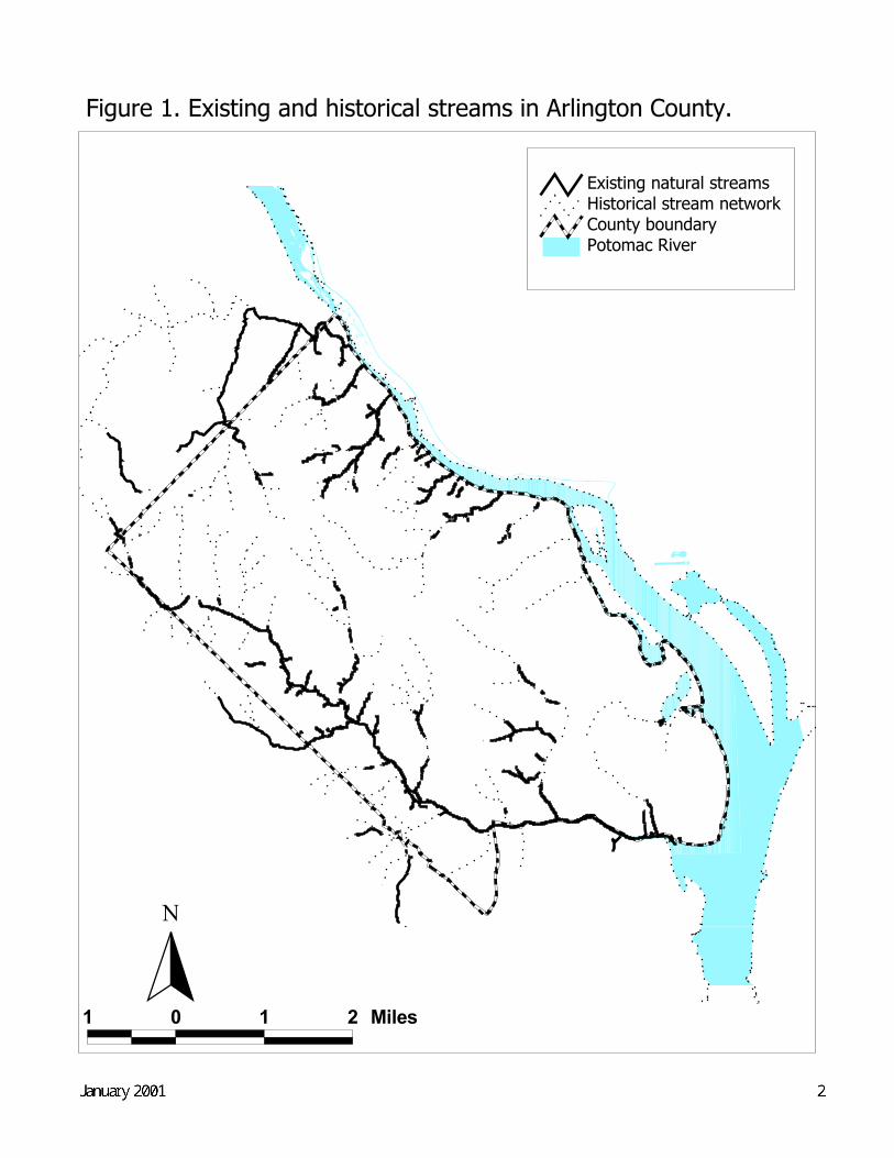
However, development in Arlington has significantly impacted the nearly 30 miles of perennial streams inthe County. There were once many more miles of streams in Arlington until the steady development ofthe last 60 or 70 years put much of the stream network into underground pipes. Figure 1 shows thelocations of existing and historical streams in the County.
Today, Arlington County is a highly urbanized jurisdiction, with 30-40 percent of the County covered byimpervious surfaces such as streets, parking lots, and buildings that do not allow rain to soak into the soil.The more impervious area in a watershed, the more rainfall that becomes runoff in streams. This runoffoften contains harmful pollutants, erodes streams, and damages habitat for fish, insects, and other streamorganisms. In addition, this runoff absorbs heat from hot pavement and causes thermal pollution that canfurther harm many aquatic species.
In general, stream degradation begins when imperviousness exceeds 10 percent, and significantdeterioration occurs beyond 25 percent imperviousness (Caraco et al., 1998). Urban development andrunoff are among the leading causes of water pollution in the U.S., and more than 20 percent of streamsand rivers inventoried by states are impaired because of urban runoff and its effects on water quality andstream habitat (US EPA, 1996).
1.1 State and Federal requirements
To address the problem of urban runoff, the U.S. Environmental Protection Agency (EPA) issuedmunicipal storm water regulations in 1992. These regulations require large municipalities, includingArlington County, to obtain and comply with National Pollutant Discharge Elimination System (NPDES)permits to discharge storm water. Arlington County’s NPDES storm water permit (also known as amunicipal separate storm sewer, or MS4, permit), issued through the state of Virginia in 1997, requiresthe County to monitor storm water runoff at representative outfalls and to demonstrate that the Countyhas effective management practices in place to control urban storm water to the 'maximum extentpracticable.'
Over the next decade, EPA’s Total Maximum Daily Load (TMDL) regulations will also affect ArlingtonCounty. The TMDL program requires states to determine the maximum pollutant loads that can bedelivered to impaired waterbodies so that these rivers, lakes, and estuaries can meet water qualitystandards. Four Mile Run, which drains a large portion of Arlington County, will fall under this programbecause the stream does not meet water quality standards for fecal coliform bacteria. The development ofTMDLs is a data and resource intensive process, and states and municipalities that begin to collectwatershed information now—and start to reduce stream pollution—will be in a strong position to complywith these regulations.
1 0 1 2 Miles
Potomac RiverCounty boundaryHistorical stream networkExisting natural streams
N
Draft Final--May 2000 2
Figure 1. Existing and historical streams in Arlington County.
January 2001 3
1.2 Chesapeake Bay
On a regional level, the members of the Chesapeake Bay Program, which include Virginia, Maryland, theDistrict of Columbia, Pennsylvania, and EPA, recently released 'Chesapeake 2000'—a document thatrenews the 1987 Chesapeake Bay Agreement to restore the bay. The primary goal of the new agreementis "to improve water quality sufficiently in order to sustain the living resources of the Chesapeake Bayand its tidal tributaries and to maintain that water quality into the future." (source:http://www.chesapeakebay.net/pubs/C2Kintro.pdf) One of the more specific goals of the new agreementis to improve water quality so that the bay and its tidal rivers will be removed from EPA's list of impairedwaters by 2010.
1.3 Arlington County's role
Arlington County has an obligation to support regional efforts such as the Chesapeake Bay Program andis required by state and federal law to manage and protect its water resources. The County's historicallycentral role in local water resource management and land use control must become an even stronger andmore effective role. To date, the County's Chesapeake Bay Preservation Ordinance, StormwaterDetention Ordinance, and Erosion and Sediment Control Ordinance have been the primary tools toregulate the impacts of new development and redevelopment on County streams. However, the effects ofexisting development in a highly urban environment like Arlington County far outweigh the effects ofnew development or redevelopment. Therefore, the County has considerable work to do to achieve the'maximum extent practicable' level of stormwater and water resource management to protect not only theCounty's streams but also the Potomac River and the Chesapeake Bay.
In recognition of the need for more effective and integrated water resource management, ArlingtonCounty’s Department of Environmental Services (DES) Environmental Planning Office (EPO) appliedfor and received a grant from the Virginia Department of Environmental Quality (DEQ) in 1998 todevelop a Watershed Management Plan for the County. This plan, developed in conjunction with theDepartment of Public Works (DPW), the Department of Parks, Recreation, and Community Resources(PRCR), and other County staff, with input from County residents and the County Board, will be animportant tool for the County to:
• Determine baseline conditions in County streams;• Comply with NPDES and TMDL regulations;• Target funding from the County’s Source Control Fund and Capital Improvement Program;• Conduct watershed outreach and education; and• Address the cumulative effects of development on Arlington’s streams.
This watershed management plan is also an important complement to the Water Quality element of theCounty's Comprehensive Plan—a new element that will focus on the consistency of County ordinancesand development policies that relate to the County’s administration of its Chesapeake Bay PreservationOrdinance. Arlington County's Comprehensive Plan formally sets forth the policies for the County'sfuture and serves as a guide for many public decisions including land use changes, preparation of capitalimprovements programs, and the enactment of zoning and related growth management legislation.
As a component of the Comprehensive Plan, the Water Quality element therefore will serve as an officialguide for County implementation of the Chesapeake Bay Preservation Ordinance. The watershedmanagement plan, on the other hand, will serve as a more comprehensive blueprint for local waterresource management.
January 2001 4
As such, this plan is not intended to provide detailed recommendations and schedules for specificprojects. There are too many issues and entities involved, including funding, in implementing capitalprojects that are beyond the scope of this plan to resolve. Instead, the watershed management plan isultimately a 'needs analysis' that identifies the County's water resource management responsibilities andlays out the effort needed above and beyond current practice to meet those responsibilities.
County residents have an important role to play in watershed management, too. Along with Countymanagement practices, the actions of citizens and business owners can have significant positive andnegative impacts on streams—especially in an ultra-urban jurisdiction like Arlington County.
1.4 Components of the Watershed Management Plan
As specified in the DEQ grant, the broad objectives of the Watershed Management Plan include: i)developing a stream and riparian buffer inventory to identify restoration priorities; ii) providing ananalysis of County management practices that affect streams and riparian buffers; iii) identifyingstrategies to protect and restore streams; iv) establishing a system to track development and stream andriparian buffer conditions; and, v) conducting a review of resources available for stream and watershedprotection.
The Center for Watershed Protection (CWP), an innovative watershed restoration and protectionorganization, outlines discrete steps in the watershed planning process that are consistent with theseobjectives and therefore provide the framework for this Watershed Management Plan. These steps,modified for this plan, are:
1) Identify a watershed management entity;2) Evaluate County water resource management practices;3) Determine baseline watershed conditions;4) Project future land use changes in the watershed;5) Determine goals for the watershed;6) Translate goals into action items for a watershed; and7) Provide a plan for implementation.(based on Caraco et al., 1998).
Fundamentally, the watershed management plan will evaluate the extent and type of existing and futuredevelopment in a watershed and the condition of streams in the watershed. The plan will then identifyfeasible goals for the streams in a watershed which involve restoring streams (e.g., throughbioengineering or improved buffer maintenance practices) and/or reducing the flow and improving thequality of storm water that reaches streams (e.g., through land use controls and Best ManagementPractices (BMPs)4 as well as through education).
1.5 Scale and scope of the Watershed Management Plan
All of the rain that falls on Arlington County eventually drains to the Potomac River. On a somewhatsmaller scale, drainage in Arlington County flows either directly to the Potomac River or into two 4 Best Management Practices or BMPs are structural or nonstructural practices, or a combination of practices,designed to act as effective, practicable ways to minimize the impacts of development and human activity on waterquality. Structural BMPs, which include extended detention dry ponds, wet ponds, infiltration trenches, sand filters,and in-line filters, rely heavily on gravitational settling and/or infiltration through a porous medium for pollutantremoval. Nonstructural BMPs range from programs that increase public awareness to prevent pollution tovegetation-utilizing controls such as bioretention areas or wetlands (NVPDC, 1996).

January 2001 5
tributaries of the Potomac Four Mile Run and Pimmit Run. These scales, however, are too large foreffective watershed planning (Caraco et al., 1998).
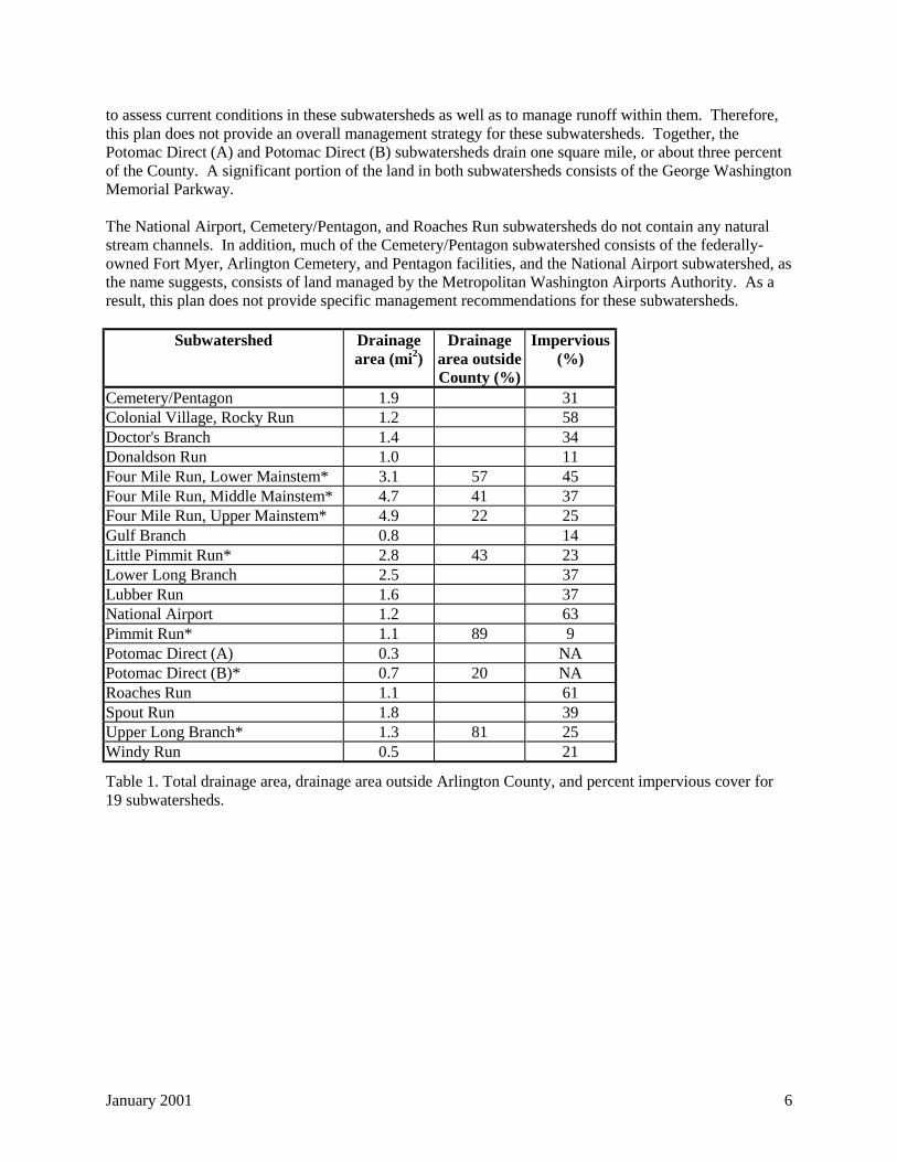
Therefore, this plan divides the County into 19 subwatersheds, which range in size from 0.3 square milesto 5 square miles, a scale that facilitates effective watershed assessment and management (Schueler,1995). These subwatersheds are shown in Figure 2 and are also listed in Table 1, along with theirimpervious cover an important determinant of stream quality in a watershed (Caraco et al., 1998). Morethan 20 years of urban storm water research indicates that impervious surfaces such as buildings andstreets that prevent rain from soaking into the ground have a strong effect on stream conditions in awatershed (Schueler, 1995)
Impervious area has been calculated for each of Arlington's subwatersheds using a technique known asthe Normalized Difference Vegetation Index (NDVI). The NDVI method uses the reflectivecharacteristics of LANDSAT satellite imagery at 30 meter resolution to determine the percentage of each30 meter pixel comprised of vegetative cover. The method then assumes that the remainder of the pixelarea is comprised of impervious cover (Frost, 1995).
Table 1 also indicates that seven of these subwatersheds (identified by *) have drainage areas that extendbeyond Arlington County borders. Areas outside the County were not analyzed for this plan. As a result,the plan will also need to include a mechanism to coordinate watershed management activities withFairfax County, Falls Church, and Alexandria.
In particular, almost 90 percent of the 12.4 square mile Pimmit Run watershed, which includes the LittlePimmit Run subwatershed, is outside of Arlington County. The nine percent impervious figure in Table 1is for a small portion of the Pimmit Run watershed along the George Washington Memorial Parkway.Given the mostly low-density residential land uses in this watershed as a whole, this impervious coverfigure is most likely a considerable underestimate. Moreover, most of the Pimmit Run stream channel islocated outside of Arlington County, and conditions in this portion of the stream channel are currentlyunknown. Because of the lack of information about the entire watershed, this plan does not providemanagement recommendations for Pimmit Run.
In contrast, although more than 80 percent of the Upper Long Branch subwatershed is outside ofArlington County, land uses in the portion of the subwatershed outside of Arlington appear similar tothose within the County. As a result, the 25 percent impervious cover for the portion of this subwatershedwithin the County is probably indicative of the impervious cover for the subwatershed as a whole.Further, about one-third of the Upper Long Branch stream channel is within the County, and baselineconditions in this portion of the stream channel are known.
Similarly, the Lower, Middle, and Upper Four Mile Run subwatersheds have significant portions of theirdrainage outside the County. However, impervious cover estimates for the portion of these threesubwatersheds within the County appear representative of the subwatersheds as a whole. And, the FourMile Run mainstem stream channel is almost entirely within the County.
Although 43 percent of the Little Pimmit Run subwatershed is outside of the County, the upper drainagearea is completely within Arlington. Therefore, the County has jurisdiction over the drainage areagenerating runoff that reaches the Little Pimmit Run stream channels within Arlington.
Impervious cover data are not currently available for the Potomac Direct (A) and Potomac Direct (B)subwatersheds. In addition, these subwatersheds both have a number of stream channels and drainageswales that reaches the Potomac—so, in fact, the Potomac Direct (A) and Potomac Direct (B)subwatersheds actually consist of several small and distinct drainage areas. These issues make it difficult
January 2001 6
to assess current conditions in these subwatersheds as well as to manage runoff within them. Therefore,this plan does not provide an overall management strategy for these subwatersheds. Together, thePotomac Direct (A) and Potomac Direct (B) subwatersheds drain one square mile, or about three percentof the County. A significant portion of the land in both subwatersheds consists of the George WashingtonMemorial Parkway.
The National Airport, Cemetery/Pentagon, and Roaches Run subwatersheds do not contain any naturalstream channels. In addition, much of the Cemetery/Pentagon subwatershed consists of the federally-owned Fort Myer, Arlington Cemetery, and Pentagon facilities, and the National Airport subwatershed, asthe name suggests, consists of land managed by the Metropolitan Washington Airports Authority. As aresult, this plan does not provide specific management recommendations for these subwatersheds.
Subwatershed Drainagearea (mi2)
Drainagearea outsideCounty (%)
Impervious(%)
Cemetery/Pentagon 1.9 31Colonial Village, Rocky Run 1.2 58Doctor's Branch 1.4 34Donaldson Run 1.0 11Four Mile Run, Lower Mainstem* 3.1 57 45Four Mile Run, Middle Mainstem* 4.7 41 37Four Mile Run, Upper Mainstem* 4.9 22 25Gulf Branch 0.8 14Little Pimmit Run* 2.8 43 23Lower Long Branch 2.5 37Lubber Run 1.6 37National Airport 1.2 63Pimmit Run* 1.1 89 9Potomac Direct (A) 0.3 NAPotomac Direct (B)* 0.7 20 NARoaches Run 1.1 61Spout Run 1.8 39Upper Long Branch* 1.3 81 25Windy Run 0.5 21
Table 1. Total drainage area, drainage area outside Arlington County, and percent impervious cover for19 subwatersheds.
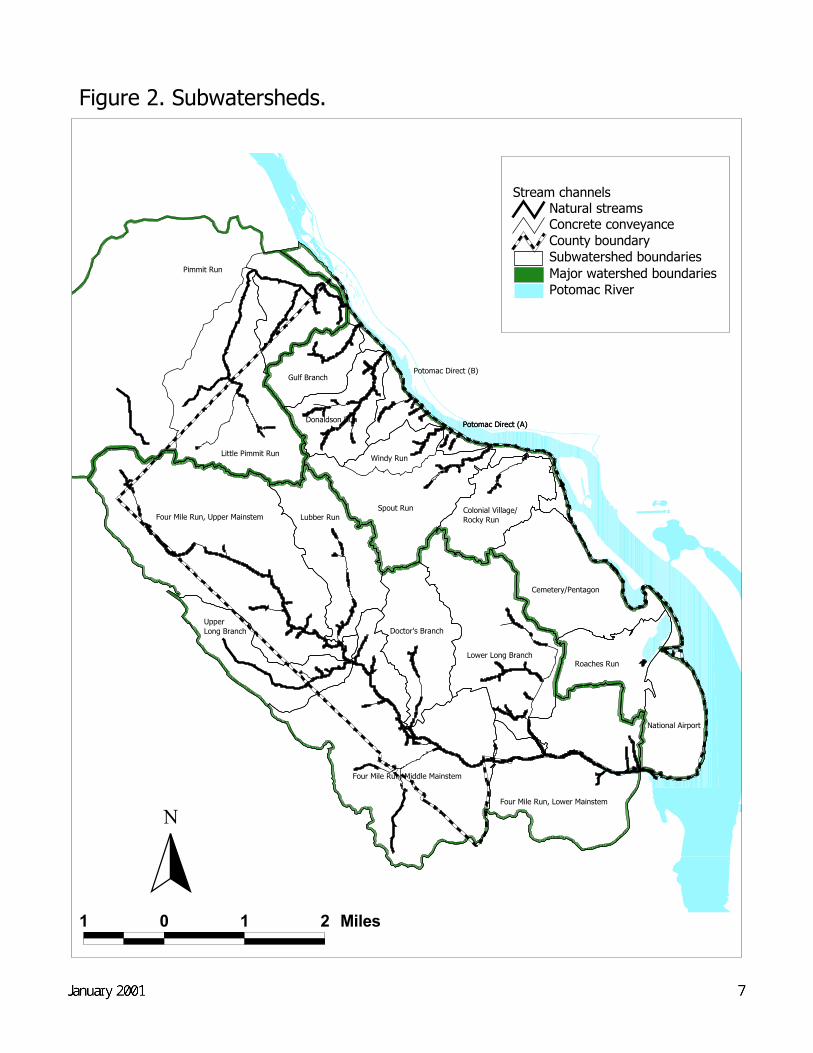
Figure 2. Subwatersheds.
Spout Run
Little Pimmit Run
Four Mile Run, Upper Mainstem Lubber Run
Lower Long Branch
Pimmit Run
Cemetery/Pentagon
Doctor's Branch
Roaches Run
National Airport
Gulf Branch
Donaldson Run
Upper Long Branch
Windy Run
Colonial Village/ Rocky Run
Potomac Direct (A)
Four Mile Run, Middle Mainstem
Four Mile Run, Lower Mainstem
Potomac Direct (A)
Potomac Direct (B)
1 0 1 2 Miles
Potomac RiverMajor watershed boundariesSubwatershed boundariesCounty boundary
Stream channelsNatural streamsConcrete conveyance
N
Draft Final--May 2000 7
January 2001 8
2 The Watershed Management Plan
2.1 Watershed management responsibility
Arlington County is required by state and federal law to manage and protect its water resources. TheCounty therefore has a central role and expertise in, and responsibility for, local water resourcemanagement and land use control. In December 1999, DES, DPW, and PRCR formed a work group toanalyze the results of the stream inventory and continue with the watershed planning process. This groupdeveloped this plan as a direct extension of the County's overall responsibility for watershed managementand will serve as the primary entity for its implementation and revision.
However, County residents and the County Board will provide critical input into the development of thisplan through an extensive public comment period. The role of the public will continue to be importantduring plan implementation as citizens identify problems and restoration opportunities within theirsubwatersheds and participate in stream monitoring and cleanups. Ultimately, the actions of Countyresidents, along with business owners, can have a large impact, positive or negative, on streams—especially in an ultra-urban jurisdiction like Arlington County. In recognition of this fact, this planemphasizes watershed education and pollution prevention as a key component. The phrase, "We all liveupstream," is a profound message that all County residents, as well as County staff, must understand forthis plan to be effective.
2.2 Existing County water resource and runoff management practices
The County has a variety of programs that address stormwater runoff and implements a considerablenumber of educational and pollution prevention initiatives. There are, however, significant gaps inCounty water resource management programs—gaps this watershed management plan identifies andmakes recommendations to address. These include control of runoff from existing development, streammonitoring, and systematic, prioritized stream restoration. In addition, the regulations that govern newdevelopment and redevelopment in the County—the Storm Water Detention Ordinance, the ChesapeakeBay Preservation Ordinance, and the Erosion and Sediment Control Ordinance—have some shortcomingsthat are discussed later in this document.
The following sections highlight major County practices that address stormwater runoff and streams,covering five components that provide a logical framework for watershed management. These include:
1. Addressing the sources of stormwater runoff and dry weather pollution (existing and newdevelopment, point sources, illegal discharges);
2. Implementing and maintaining BMPs to control stormwater pollution;3. Maintaining stormwater infrastructure;4. Managing, restoring, and monitoring streams and buffers; and5. Implementing pollution prevention and watershed education initiatives.
2.2.1 Sources of stormwater runoff and dry weather pollution
2.2.1.1 Existing development
Arlington County's NPDES stormwater or MS4 permit mandates that the County reduce stormwaterpollution in all County subwatersheds. In particular, the 'maximum extent practicable' provisions of thepermit, although not quantitative, require reductions in the concentrations of pollutants in stormwatersamples collected. At this time, however, the County collects stormwater samples at four outfalls only—located in Little Pimmit Run, Colonial Village/Rocky Run, and Middle Four Mile Run. Therefore, the
January 2001 9
scope of pollutant reductions that can be demonstrated through stormwater sampling is limited. Inaddition, the County has not yet implemented, and the state has not yet enforced, the 'maximum extentpracticable' provisions of the permit (these provisions are discussed further in Section 2.6, 'Watershedmanagement recommendations'). However, the County's MS4 permit will be renewed every five years.The first renewal will occur in 2002. This is a likely timeframe for the state to include new monitoring ormanagement requirements in the County's permit.
2.2.1.2 New Development and Redevelopment
The County's Chesapeake Bay Preservation Ordinance, Stormwater Detention Ordinance, and Erosionand Sediment Control Ordinance provide legal authority to minimize increases in stormwater runoff andpollution before development or redevelopment occur. The Storm Water Detention Ordinance requiresthat the peak runoff rate from new development and redevelopment be maintained close topredevelopment levels, unless a waiver is granted. Arlington County first enacted the ordinance in 1976in response to the Four Mile Run flood control agreement with the U.S. Army Corps of Engineers(USACOE). This agreement, which also includes the cities of Alexandria and Falls Church and FairfaxCounty, created a program to prevent new development in the Four Mile Run watershed from increasingstorm water runoff to the extent that it might reduce the effectiveness of the USACOE flood controlproject in the lower reaches of Four Mile Run to adequately contain runoff from the 100-year storm5.
Under the Stormwater Detention ordinance, for the Four Mile Run watershed, stormwater detention mustbe provided for the 100-year flood from the developed site and released at a rate equivalent to a 10-yearflood from the site in its pre-developed condition. For the Potomac watershed, stormwater detention mustbe provided for the 10-year flood from the developed site and released at a rate equivalent to a 10-yearflood from the site in its pre-developed condition. Release at the 10-year flood runoff rate was chosenbecause public sewers are designed to convey this magnitude event.
Depending on the size and level of impervious cover on a proposed site and its proximity to a streamchannel, new development/redevelopment may also be subject to the County's Chesapeake BayPreservation Ordinance, and storm water quality controls may be required in addition to stormwaterdetention.
In addition, the County's Floodplain Management Ordinance ensures compliance with the National FloodInsurance Program by i) defining and establishing the floodplain district, including areas subject to the100-year flood; ii) describing uses permitted and banned in the floodplain district; iii) setting out flooddamage control and floodproofing requirements for new construction in the floodplain district; and iv)defining the information needed from a building permit and development plan for construction in thefloodplain district (Arlington County DPW, 1996).
DPW's Engineering Division reviews development plans for compliance with these ordinances. Underthe Chesapeake Bay Ordinance, most developers contribute to the Source Control Fund—a fund 5 For any given storm event duration (e.g., 1 hour, 6 hours, 24 hours), a 1-year storm event has a 100 percent chanceof occurring in any given year, a 2-year storm event has a 50 percent chance of occurring in any given year, a 10-year storm event has a 10 percent chance of occurring in any given year, a 100-year storm event has a 1 percentchance of occurring in any given year, etc. The frequency of these events is referred to as a 'recurrence interval' and,for a given region, is estimated by a statistical analysis of the historical record of storm events of a given duration.Because a historical record of the magnitude of runoff events is not available for most small stream channels,stormwater engineers make the assumption that the runoff produced by a given storm event (simulated as a worst-case 'design storm') has the same recurrence interval as the storm event itself. For small, impervious drainage areassuch as a street or subdivision, this assumption is reasonable. The duration of the design storm is equal to the 'timeof concentration' of the drainage area—the time required for flow to reach the drainage area outlet from thehydraulically most distant part of the drainage area (Dunne and Leopold, 1978).
January 2001 10
established under Section 61-9 of the ordinance which is to be used for water quality improvements andwatershed education. The intent of allowing this contribution is to minimize the proliferation of smallBMPs which can be difficult to inspect and maintain.
However, if stormwater issues are raised early enough in the site plan review process, developers haveshown a willingness to look more closely at providing water quality BMPs. The involvement of the DES'Environmental Planning Office (EPO) earlier in the process (e.g., at the development proposal stage)could provide more opportunities to encourage water quality protection (BMPs, etc.) as one condition forgranting a building permit. There are limits, however, to what the County can require beyond ordinancerequirements because of by-right development. Currently, the County does encourage some water qualityprotection site design measures before approving a Source Control Fund contribution.
For FY 1999, DPW reviewed approximately 70 building permit applications for projects that will disturbgreater than 2,500 square feet of land—the threshold that triggers a water quality impact assessment underthe ordinance within a Resource Protection Area. About one-third of these proposed projects met thecriteria that require controls to offset potential water quality impacts. If these projects are approved, thedevelopers for these projects must contribute approximately $145,000 to the Source Control Fund. Noonsite BMPs will be constructed. The proposed impervious surface of these projects totals approximately120 acres or about 0.2 square miles. In total, developers contributed more than $43,000 to the SourceControl Fund in FY 1999. The total fund balance at the end of FY 1999 was approximately $230,000.(Arlington County DES, 1999) The fund's current balance is close to $340,000.
DPW usually grants waivers under the Storm Water Detention ordinance for sites with post-developmentpeak flow increases of less than one cubic foot per second (cfs). Currently, the County has no mechanismto consider the cumulative impacts of granting such waivers because the ordinance requires the County toreview waiver requests on case-by-case basis only. However, with County funding, NVRC models theeffect on channel capacity of increased flows from all development in the Four Mile Run watershed underthe Four Mile Run flood control agreement. In addition, this watershed management plan proposes asystem to track development projects on a subwatershed scale to attempt to account for the cumulativeeffects of development in the County on streams and buffers.
DPW and the Department of Community Planning, Housing and Development (CPHD) share in themanagement of the Erosion and Sediment (E&S) Control Program for Arlington County. There are threeinspectors, one plan reviewer, and one program administrator that work in the program and have beencertified by the Virginia Department of Conservation and Recreation. In addition, two certifiedprofessional engineers assist with plan review.
There were no stop-work orders issued as a result of erosion and sediment control violations in FY 1999,during which a total of 84.91 acres was disturbed for 43 developments, single family lots, and schoolprojects. However, violations of the E&S ordinance are common (for example, EPO staff observedviolations at three different construction sites on one day in November 1999) and, because of limitedstaff, inspections cannot occur frequently. In FY 2000, DPW hired another staff person to act as anerosion control specialist to be in charge of compliance, make spot inspections, and deal with problemsites (Arlington County DES, 1999).
DPW's Planning Division coordinates plan review, including storm water detention and erosion andsediment control, within DPW for larger development projects (single family development goes directlyto DPW Engineering and then to Building Permits). This department is also involved with theconstruction phase after a building permit is granted.
January 2001 11
2.2.1.3 Point sources
According to information contained in EPA's Permit Compliance System, there are three NPDES-permitted point sources in Arlington County subwatersheds: Concrete Supply & Service Corp. in UpperFour Mile Run; Falcon Concrete in Roaches Run; and the County's Water Pollution Control Plant(WPCP) in Lower Four Mile Run. Discharges from these facilities are required to meet specific effluentstandards.
The Arlington WPCP is the major permitted point source discharger in Arlington County. The plantdischarges treated wastewater to Four Mile Run about one mile upstream from its confluence with thePotomac River. The plant is currently being expanded to accommodate average daily sanitary sewageflows of 40 million gallons per day.
The plant is an advanced wastewater treatment facility that includes primary treatment that screens andsettles out organic material and other solids. Secondary treatment is also provided that biologicallybreaks down the organic waste to reduce pollutants, and tertiary treatment that uses chemicals andactivated carbon to reduce nutrients like phosphorus to very low levels. The sludge produced as a resultof the various treatment processes is currently treated with lime to produce a biosolid that is land appliedon agricultural land, or is landfilled when weather conditions make land application sites inaccessible.
As part of the current upgrade, the facility is also adding a new technology called Biological NutrientReduction (BNR). This technology reduces the levels of nitrogen compounds, like ammonia, in theeffluent. This is important because ammonia is toxic to aquatic life at higher concentrations and alsobreaks down into nitrites and nitrates that contribute to the nutrient problem in the Chesapeake Bay.
In addition, the plant is adding a large holding tank that will help the plant significantly reduce the wetweather bypasses6 that have occurred in the past. These bypasses are caused by hydraulic overloading ofthe plant, which is a direct result of the County’s early plumbing code, which allowed roof drains andareaway drains to be connected to the sanitary sewer system. Although the building code was amended in1968 to prevent these types of connections, the cost to disconnect many existing homes with suchconnections is cost-prohibitive. DPW does have an active infiltration/inflow program which works toidentify, quantify, and repair leaks in sanitary sewers, and to replace or re-line sewers that are failing (seeSection 2.2.3, 'Stormwater infrastructure'). Such lines allow groundwater into the sanitary sewer systemand contribute to the hydraulic overloading at the plant. The new holding tank is currently underconstruction, and is expected to be operational by mid-2001.
Finally, before being discharged the treated wastewater undergoes chlorination to eliminate fecal coliformbacteria and other pathogens. The final effluent is then dechlorinated to prevent adverse impacts onaquatic life in Four Mile Run.
Because the WPCP is a major discharger, it is useful to put its contribution of nutrients in perspective.The following information is taken from the Virginia Secretary of Natural Resources report entitled,“1999 Annual Report on the Development and Implementation of Nutrient Reduction Strategies forVirginia’s Tributaries to the Chesapeake Bay” (November 1999).
6 Most wet weather bypasses—with the exception of extreme storms such as Hurricane Floyd—involve releases ofpartially treated waste water, not “raw sewage.” Partially treated waste water typically has been through two ormore stages of treatment, and its potential environmental and health effects are significantly less than that ofuntreated waste water. Also, when partially treated waste water is released to Four Mile Run during large storms,the high flows in the stream dilute the release. The Virginia Department of Environmental Quality (DEQ) is alwaysnotified when discharges of wastewater occur, regardless of the reason for the discharge.
January 2001 12
According to this report, there are 34 permitted point source dischargers located in Virginia’s portion ofthe Potomac River Basin (including the Shenandoah River). Most of these point source dischargers arewastewater treatment plants, but there are several industrial dischargers like Merck (pharmaceuticals) andDupont (chemicals), as well as several food processing industries that discharge treated wastewater to thePotomac River or one of its tributaries.
Figure 3 shows the relative contributions of phosphorus from these point source dischargers. The figurecompares the total 1998 phosphorus discharge of 539,111 pounds per year, with a phosphorus dischargeof 678,481 pounds per year in 1985. Northern Virginia point sources are highlighted in the figure, and itcan be seen that together they contributed approximately ten percent of the point source phosphorusdischarge in 1998, while 90 percent of the phosphorus is discharged by other point sources in the basin.The figure also shows that Arlington’s contribution of phosphorus dropped from 6.9 percent of thebasinwide total in 1985, to approximately 1.2 percent in 1998. Arlington is the 20th largest of the 34point sources of phosphorus, discharging 6,669 pounds per year to Four Mile Run.
As seen in Figure 4, between 1985 and 1998, Arlington County’s phosphorus discharge dropped by over40,000 pounds per year. With the exception of Virginia’s contribution to the Blue Plains WastewaterTreatment Plant in the District of Columbia, there was actually a decline in phosphorus loads throughoutthe basin, with Arlington County ahead of other jurisdictions in Northern Virginia by a substantialmargin. In terms of percentage change, Arlington County actually reduced its phosphorus discharge byalmost 86 percent, which was ahead of all other jurisdictions. The net overall reduction in phosphorusthroughout the basin equaled 20.5 percent between 1985 and 1998, due primarily to improved wastewatertreatment technology and more stringent phosphorus discharge limits.
The second important nutrient that affects the Chesapeake Bay is nitrogen. Here, the basinwide story isless encouraging, although Arlington County’s nitrogen discharges have fallen dramatically. Figure 5compares the point source nitrogen loadings in the Potomac River Basin between 1985 and 1998. It canbe seen that the total point source nitrogen loads actually increased from approximately 10.7 millionpounds per year to 11.2 million pounds per year.
Arlington County’s contribution dropped from 15.4 percent to 8.1 percent of the basinwide total over thisperiod. However, it is important to recognize that Arlington County ranked as the fourth largest pointsource discharger of nitrogen, delivering 912,736 pounds of nitrogen to Four Mile Run. Also apparentfrom the figure is that in 1998, Northern Virginia dischargers accounted for approximately 79 percent ofthe nitrogen discharges, with the remainder of the basin accounting for 21 percent of the total, reflectingthe concentration of population in Northern Virginia.
Arlington County, on the other hand, has made considerable progress in reducing its nitrogen discharge.Figure 6 shows that between 1985 and 1998, Arlington reduced its nitrogen load by 728,545 pounds peryear, or over 44 percent. This is significant, because it means that Arlington County was the onlyjurisdiction in Northern Virginia that actually met the Chesapeake Bay Tributary Strategy goal of a 40percent reduction for both phosphorus and nitrogen. And with the introduction of Phase I of the newBNR technology scheduled for completion by 2002, the WPCP will reduce its nitrogen levels evenfurther in the future.
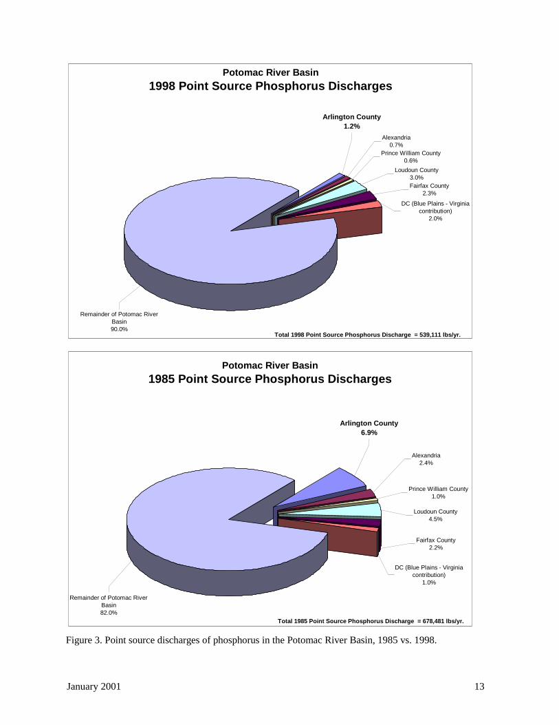
January 2001 13
Figure 3. Point source discharges of phosphorus in the Potomac River Basin, 1985 vs. 1998.
Potomac River Basin
1998 Point Source Phosphorus Discharges
Remainder of Potomac River Basin90.0%
Arlington County1.2%
Prince William County0.6%
DC (Blue Plains - Virginia contribution)
2.0%
Fairfax County2.3%
Alexandria0.7%
Loudoun County3.0%
Total 1998 Point Source Phosphorus Discharge = 539,111 lbs/yr.
Potomac River Basin
1985 Point Source Phosphorus Discharges
Loudoun County4.5%
Alexandria2.4%
Fairfax County2.2%
DC (Blue Plains - Virginia contribution)
1.0%
Prince William County1.0%
Arlington County6.9%
Remainder of Potomac River Basin82.0%
Total 1985 Point Source Phosphorus Discharge = 678,481 lbs/yr.
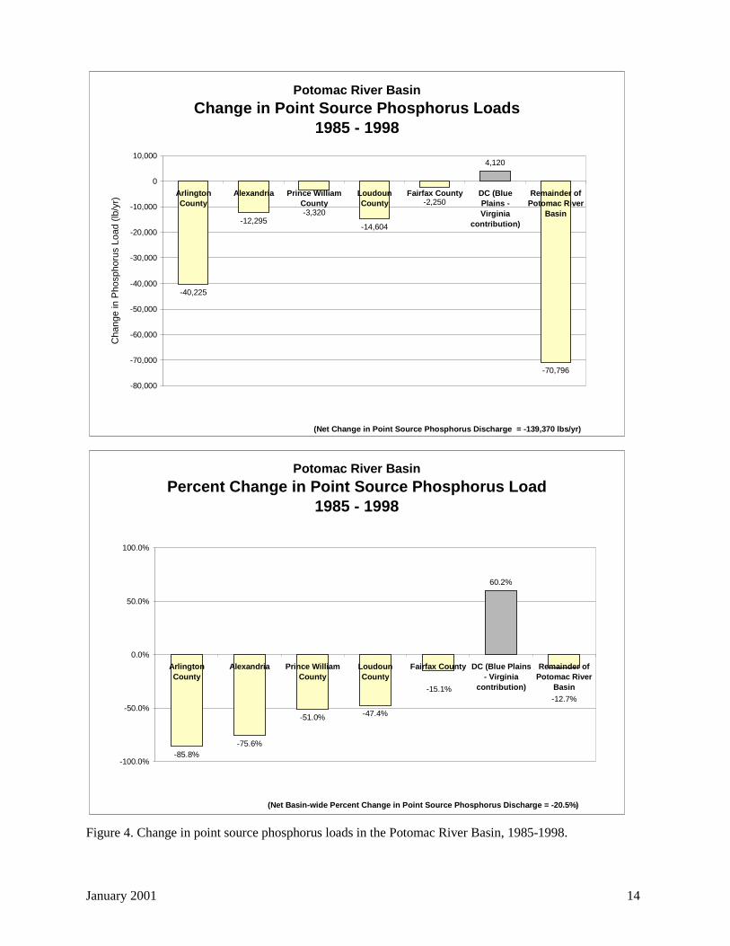
January 2001 14
Figure 4. Change in point source phosphorus loads in the Potomac River Basin, 1985-1998.
Potomac River Basin
Change in Point Source Phosphorus Loads1985 - 1998
-40,225
-12,295-14,604
4,120
-70,796
-3,320-2,250
-80,000
-70,000
-60,000
-50,000
-40,000
-30,000
-20,000
-10,000
0
10,000
ArlingtonCounty
Alexandria Prince WilliamCounty
LoudounCounty
Fairfax County DC (BluePlains -Virginia
contribution)
Remainder ofPotomac River
Basin
Ch
an
ge
in P
ho
sph
oru
s L
oa
d (
lb/y
r)
(Net Change in Point Source Phosphorus Discharge = -139,370 lbs/yr)
Potomac River Basin
Percent Change in Point Source Phosphorus Load1985 - 1998
-85.8%-75.6%
-51.0% -47.4%
60.2%
-15.1%-12.7%
-100.0%
-50.0%
0.0%
50.0%
100.0%
ArlingtonCounty
Alexandria Prince WilliamCounty
LoudounCounty
Fairfax County DC (Blue Plains- Virginia
contribution)
Remainder ofPotomac River
Basin
(Net Basin-wide Percent Change in Point Source Phosphorus Discharge = -20.5%)
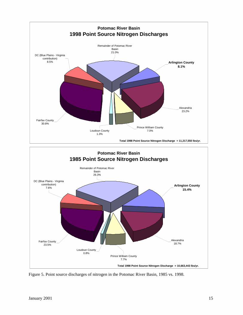
January 2001 15
Figure 5. Point source discharges of nitrogen in the Potomac River Basin, 1985 vs. 1998.
Potomac River Basin
1998 Point Source Nitrogen Discharges
Loudoun County1.3%
Alexandria23.2%
Fairfax County30.8%
DC (Blue Plains - Virginia contribution)
8.5%
Prince William County7.0%
Arlington County8.1%
Remainder of Potomac River Basin21.0%
Total 1998 Point Source Nitrogen Discharge = 11,217,550 lbs/yr.
Potomac River Basin
1985 Point Source Nitrogen Discharges
Loudoun County0.8%
Alexandria18.7%
Fairfax County23.5%
DC (Blue Plains - Virginia contribution)
7.6%
Prince William County7.7%
Arlington County15.4%
Remainder of Potomac River Basin26.3%
Total 1998 Point Source Nitrogen Discharge = 10,663,443 lbs/yr.
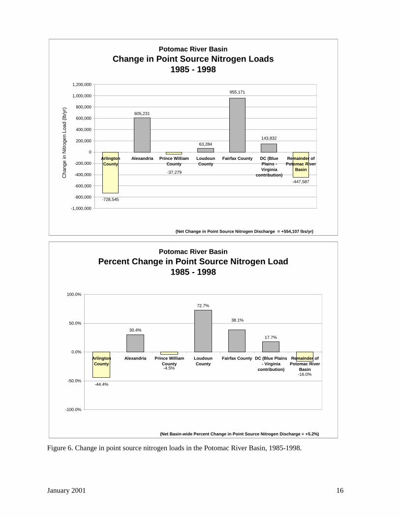
January 2001 16
Figure 6. Change in point source nitrogen loads in the Potomac River Basin, 1985-1998.
Potomac River Basin
Change in Point Source Nitrogen Loads1985 - 1998
605,231
63,284
-447,587
-728,545
955,171
143,832
-37,279
-1,000,000
-800,000
-600,000
-400,000
-200,000
0
200,000
400,000
600,000
800,000
1,000,000
1,200,000
ArlingtonCounty
Alexandria Prince WilliamCounty
LoudounCounty
Fairfax County DC (BluePlains -Virginia
contribution)
Remainder ofPotomac River
Basin
Change in
Nitr
ogen L
oad (
lb/y
r)
(Net Change in Point Source Nitrogen Discharge = +554,107 lbs/yr)
Potomac River Basin
Percent Change in Point Source Nitrogen Load1985 - 1998
30.4%
72.7%
17.7%
-44.4%
-4.5%
-16.0%
38.1%
-100.0%
-50.0%
0.0%
50.0%
100.0%
ArlingtonCounty
Alexandria Prince WilliamCounty
LoudounCounty
Fairfax County DC (Blue Plains- Virginia
contribution)
Remainder ofPotomac River
Basin
(Net Basin-wide Percent Change in Point Source Nitrogen Discharge = +5.2%)
January 2001 17
2.2.1.4 Dry weather pollution
The County's MS4 permit also requires annual dry weather inspections for illicit non-stormwaterdischarges at major outfalls in all the subwatersheds identified in this plan. Each year, the Countyanalyzes samples collected from one-fifth of these outfalls for major indicators of illicit connections. Dryweather inspections during FY 1999 discovered a cross-connection to a storm sewer in Bluemont Parkfrom a Fairfax County apartment building. The connection had existed since the apartment building’sconstruction 27 years ago.
Annually, DES visually inspects each major outfall (greater than 36 inches in diameter) for flow, odor,color, clarity, floatables, stains, and algae. In addition, each year, the County tests one-fifth of the outfallsfor temperature, pH, chlorine, copper, phenols, and surfactants, using a Hach colorimeter kit.
To date, odor, color, and clarity have been the three most effective indicators of contamination. InArlington’s urbanized watersheds, floatables such as garbage, foam, and scum are found frequently indischarges that appear clean otherwise. Stains do not usually indicate any dry weather contamination.Vegetation and pipe condition tend to be essentially normal everywhere. Where vegetation is excessive,it is usually above the outfall caused by ambient conditions such as light. Algae is found frequently, andorange iron oxidizing bacteria/algae are common. Other varieties probably indicate excessive nutrients, aproblem County-wide.
Follow-up procedures will focus on two chronic sources of illicit discharges under the County’s directcontrol: sanitary sewers and water mains. This approach also addresses the County’s concern with levelsof pathogens reported in its streams, and will allow Arlington to focus its resources on finding andremoving the sources (Arlington County DES, 1999).
In addition, County funds help support NVRC's optical brightener outfall monitoring project—a low-techapproach to detecting illicit discharges into the storm sewer network in the Four Mile Run watershed bylooking for evidence of optical brighteners in dry weather flows. Optical brighteners are added to laundrydetergent sold in the U.S. to make light colors appear brighter without the use of bleach. Since laundryeffluent is a major component of human sewage, and since optical brighteners decompose very slowly,these brighteners serve as good indicators of the presence of wastewater in storm drains (NVRC, 2000).Using this method, NVRC screened 187 outfalls in a 10-square mile area of Four Mile Run during thesummer of 1999. One of these outfalls contained consistently elevated levels oflaundry brighteners. NVRC reported the results from this outfall, located within Fairfax County nearSeven Corners, to appropriate Fairfax County staff. Results for many of the 187 outfalls monitored wereinconclusive. If optical brighteners were present at these inconclusive outfalls, they were in moderate-to-minor concentrations only (NVRC, 2000; Waye, 2000).
2.2.1.5 Septic Tanks
EPO has identified approximately 75 residential parcels throughout the County that use septic tanks,rather than being connected to the County’s sanitary sewer collection system, as shown in Figure 7.Although septic tanks are found throughout the County, most of these properties are concentrated in thePalisades area in the northeastern portion of the County. The steep topography in this area makes itexpensive to serve these areas with sanitary sewer lines. In most cases, a force main and pumping stationwould be required to lift the sewage up to connect with the rest of the sanitary sewer system, which is agravity flow system.
The County's Department of Human Services—Environmental Health Division (EHD) issues septic tankpermits under Virginia state law. EHD conducts soil evaluations and issues construction permits for onsite sewage disposal systems, which include septic tanks as well as alternative systems.

January 2001 18
Septic tanks rely on natural decomposition of solids in a large holding tank to reduce the volume of waste.Solids sink to the bottom of the tank where they accumulate and periodically must be pumped out. Theliquid waste flows out into an underground drainage field, where soil bacteria are supposed to break downthe remaining dissolved nutrients and organic matter in the drainage field. Although there have beensome improvements in the efficiency of advanced septic systems (e.g., mound systems, recirculating sandfilters, etc.), the conventional septic tank serving a single residence is not considered a very effectivemethod of waste treatment from a water quality perspective.
Performance of septic systems is very dependent on the organic loading to the drain field, the percolationrate of the soils, and the distance to the groundwater table. The natural bacterial breakdown of waste inthe septic tank or in the drainfield can also be seriously disrupted by the disposal of various householdproducts into the septic system, including solvents and cleaners.
Numerous studies from around the country have raised environmental concerns about septic tanks. Septictanks do not eliminate bacteria or other pathogens, and soil bacteria do not effectively metabolize all ofthe dissolved constituents. This is particularly true for nutrients like nitrates and nitrites. For example,studies in Door County, Wisconsin, identified septic tanks as a primary cause of nitrate-contaminatedgroundwater, as well as a higher than normal frequency of gastrointestinal illnesses. This problem wasespecially serious where soils were thin, the underlying bedrock geology was highly porous or fractured,and many of the vacation homes in this area relied on shallow wells for their water supply (Sherrill,1978).
Bacterial contamination of shellfish beds has also been traced to leaking septic systems, particularly inestuaries like the Chesapeake Bay and in Florida. According to an article by Bill Matuzeski, Director ofEPA’s Chesapeake Bay Program, in the Bay Journal (Vol. 7, No. 1, March 1997), roughly one quarter ofall residents in the Chesapeake Bay watershed rely on septic tanks for their domestic waste disposal, orapproximately 3.3 million people.
The article goes on to state that a properly operating septic system has been shown to release more than10 pounds of nitrogen per year to the groundwater for each person using it. Using the County’s averageof 2.12 persons per household, the existing 75 Arlington households served by septic systems could bereleasing as much as 1,590 pounds of nitrogen per year to the groundwater.
Although such individual contributions may seem minimal, the overall impact on the Bay is enormous.For example, the 3.3 million people on septic tanks in the Bay watershed generate 33.5 million pounds ofnitrogen loaded into the groundwater each year. Of this, an estimated 13.4 million pounds reach openwater, and about 9 million pounds of nitrogen reach the Bay.
This source of nitrogen is not insignificant. The Bay Program's 40 percent nitrogen reduction goal is 74million pounds per year. This means that existing septic systems are delivering one-eighth of the poundsof nitrogen that are needed to meet the goal.
Fortunately, Arlington County gets its drinking water supply from the Potomac River and does not rely ongroundwater. This significantly reduces the possibility of adverse public health impacts from septic tanksin residential areas. Nevertheless, septic tanks may contribute to local water quality problems becausethey contribute nutrients, and possibly bacteria or viral pathogens to groundwater. This could be a sourceof pollution affecting water quality in areas that have higher concentrations of septic systems, especiallyduring baseflow conditions when most of the water flowing in County streams consists of groundwater.

Figure 7. Septic Tanks in Arlington County.
#Y#Y#Y
#Y#Y#Y
#Y#Y
#Y#Y#Y#Y#Y#Y#Y#Y#Y#Y#Y#Y#Y#Y#Y#Y#Y#Y#Y
#Y
#Y
#Y#Y
#Y#Y
#Y#Y#Y#Y#Y#Y#Y#Y#Y
#Y#Y
#Y#Y
#Y#Y#Y#Y#Y#Y#Y#Y#Y#Y#Y#Y#Y
#Y
#Y#Y
#Y
#Y#Y
#Y
#Y #Y #Y#Y#Y#Y#Y
#Y
#Y
#Y
1 0 1 2 Miles
Potomac RiverSubwatershed boundariesCounty boundary
Stream channelsNatural streamsConcrete conveyance
#Y Septic tanks
N
Draft Final--May 2000 19
January 2001 20
2.2.1.6 Spill response
The Northern Virginia Regional Hazardous Materials Response Team is comprised of team membersfrom Arlington and Alexandria and responds to calls from Arlington, Alexandria, Falls Church andFairfax. A team of four firefighters, two paramedics and one police support unit responds to possiblehazardous material spills and discharges. Backup teams are called to the site if full containment isrequired. The Arlington County Department of Public Works assists in clean up and investigation asneeded.
There were approximately 540 calls to the Fire Department in FY 1999 regarding unknown substancesthat involved an odor, material spill, or discharge. Of these calls, 7-10 per month normally requireinvestigation and possible enforcement by the Fire Marshal. The party responsible for an illegaldischarge can be fined up to $2500 and the cost of clean up.The Department of Environmental Services, the Fire Marshal’s office and the Department of PublicWorks hope to develop a pollution response tracking system, which would be a component of the largerwatershed tracking system discussed in this plan.
Citizens or staff suspecting stream pollution should adhere to the following hierarchy for the mosteffective County response:• Active or on-going spills or dumpings of any kind should be reported to the Arlington County
Emergency Communications Center (ECC) to either the non-emergency number (558-2222) or to911. An engine company and/or a Hazardous Materials Team will be sent to investigate immediately.
• If the spill or dumping is no longer taking place and does not appear to be a significant threat to theenvironment or human safety, it should be reported to the Fire Prevention Division's main line (228-4644). A Deputy Fire Marshall will then investigate the complaint, normally within 24 hours.
• A suspected sewer leak or break in a sewer line, should be reported immediately to the DPW Water,Sewer, Streets Division at 228-6485 (7 AM - 4 PM) or 228-6555 (after hours). A foul sewage odor,white cloudy water, or floating organic material typically characterizes sewer leaks.
• DPW Water, Sewer, & Streets Division will report all confirmed sanitary sewer leaks into Arlingtonstreams and storm sewers to the Virginia DEQ within 24 hours.
• DPW will also report confirmed sanitary sewer leaks to Jason Papacosma, DES EnvironmentalPlanning Office, 228-3613 (8 AM - 5 PM or voicemail), within 24 hours. This information is neededto satisfy a reporting requirement of the County's stormwater permit.
2.2.2 Stormwater BMPs, BMP retrofits7, and maintenance
2.2.2.1 Structural controls
Arlington County owns very few major structural BMPs for storm water management. However, theCounty has reserved funds in the Capital Improvement Plan (CIP) to construct BMPs identified throughthe planning process (see Section 2.8, 'Implementation plan').
In FY 1999, Arlington County developed plans to restore Sparrow Pond, a constructed wetland at theoutlet of Arlington Forest Branch in the Middle Four Mile Run subwatershed, using CIP funds. Thiswork is scheduled to begin in FY 2000. In FY 1999, the Army-Navy Country Club (ANCC) approachedCounty staff to study three possible sites where the Club would donate land in return for construction of apond to help reduce downstream erosion. The County and ANCC staff evaluated two sites but found thesites to be too disruptive to the golf course and discontinued planning efforts (Arlington County DES,1999). 7 A BMP retrofit modifies an existing stormwater BMP or stormwater drainage system to enhance water qualityand/or adds water quality components in already developed areas to slow runoff, remove sediment and nutrients, andprovide a basis for restoring eroded stream channels (Bell and Champagne, 1998).
January 2001 21
On-site detention systems are constructed as part of development and are owned and maintainedprivately. DPW's Construction Management Section enforces maintenance of these facilities throughperiodic inspections. A letter is sent and a follow-up inspection is carried out if a problem is found. InFY 1999, no problems were found that required enforcement (Arlington County DES, 1999).
In FY 1999, DPW staff began an updated inventory of privately owned detention systems. Boundaries ofdevelopment sites built since the County enacted the Storm Water Detention Ordinance were digitizedinto the GIS system and flagged if detention was part of the project. These were reviewed and comparedwith the detention systems on the storm sewer map and missing systems were indicated on the file, to beadded when map update and maintenance begins. An updated list of detention sites is in preparation forDPW’s Construction Management Section (Arlington County DES, 1999).
One significant detention facility in the County is the "Ballston Beaver Pond," a detention storage site forrunoff from a 379 acre drainage area (0.6 square miles), including portions of I-66. This facility detainsand treats runoff from about one-third of the Lubber Run subwatershed.
2.2.2.2 Street Sweeping
Street sweeping is an important non-structural stormwater BMP because this practice removes pollutant-laden sediments from paved surfaces before this sediment is washed into streets during storms. InArlington County, street sweeping is conducted by three one-person crews with one operator workingprimarily at night. These crews have the responsibility for daily sweeping of County streets incommercial corridors to remove sand, salt and particulates. In the spring, the program providesresidential street sweeping to remove the accumulations of sand, salt, and debris from the winter season.Four vacuum carts are used for removing litter and debris from the County streets and sidewalks(Arlington County DES, 1999).
DES currently operates three regenerative air sweepers. They are superior to older brush and vacuumtechnologies and use a closed loop vacuum/blower air system that re-circulates the air internally. This issound environmental technology that picks up most, but not all, fine particles and that reduces, but doesnot eliminate, exhausting fine particles, some laden with pollutants, into the air.
Recent work, most notably by Roger Sutherland of Pacific Water Resources and Roger Bannerman of theWisconsin Department of Natural Resources, has shown that new high-efficiency dry vacuum streetsweepers are much more effective than conventional and regenerative street sweepers at removingsediments, especially fine particles, from paved areas (e.g., Sutherland and Jelen, 1996, Bannerman,1999). However, the new dry vacuum sweepers lack a consistent sustained track record on streets withcrowns, uneven surfaces, and other imperfections. They also require twice the capital investment,compared to regenerative air sweepers at this time, and would benefit from more experience in a streetenvironment. However, long-term maintenance costs for dry vacuum sweepers may be lower than forconventional and regenerative air sweepers.
In FY 1998, NVRC and Arlington County submitted a pre-proposal to the Section 319 Nonpoint SourceProgram of the Virginia Department of Conservation and Recreation to purchase and demonstrate thewater quality improvements provided by high efficiency dry vacuum street sweeping. DCR did not inviteNVRC and the County to submit a formal proposal.
County staff continue to monitor the evolution of high-efficiency street sweeping technology and hope tobe able to add this capability—effectively a "mobile BMP"—to the County's street sweeping equipmentas soon as it has a proven track record.
January 2001 22
2.2.3 Stormwater infrastructure
DPW's Engineering Division designs storm sewers and sanitary sewers and administers the CIP for stormdrainage (DPW's Water, Sewer, and Streets Division will take over this latter function in September2000). The sanitary sewer system is included in this discussion since leaks from the system can causewater pollution problems.
DPW’s Water, Sewer, and Streets (WSS) Division is responsible for cleaning catch basins and manholes,removing storm sewer blockages within 12-24 hours of notice, and repairing broken storm sewer linesthroughout the County's approximately 400-mile storm sewer network. Two crews of six people repairall sanitary and storm sewers. Four crews are responsible for flushing both systems (Arlington CountyDES, 1999). The division has also begun regular cleaning of storm sewer pipes and maintenance of stormsewer outfalls (failed outfalls are repaired only if they threaten public health or safety).
DPW's WSS Division also:
• Updates the storm, sanitary, and water system master plans and administer the CIP projects for thesesystems;
• Oversees the Infiltration and Inflow (I&I) program to identify entry of stormwater into the sanitarysystem which can cause bypasses at the Water Pollution Control Plant;
• Notifies Virginia DEQ of sanitary sewer overflows or breaks that leak into streams;• Covers exposed sanitary lines (usually with rip rap);• Stabilizes channel erosion if there is a threat to public health or safety; and• Responds to citizen inquiries about storm and sanitary sewers.
Arlington County’s I&I program consists of 20 sanitary sewer flow meters and four rain gauges used toidentify areas of high infiltration and inflow of groundwater into the County’s sanitary sewer system.Analysis of flow data and rainfall data has indicated that the main source of I&I is wet weatherinfiltration. Closed circuit TV inspections are used to identify sanitary sewers in need of rehabilitation toprevent infiltration into the system (Arlington County DES, 1999).
2.2.4 Stream and buffer management, restoration, and monitoring
2.2.4.1 Management and restoration
Because most of the County's streams are located within County parkland and many County parks areadjacent to streams, PRCR has a primary role in stream and buffer management. PRCR manages Countyparkland and designs recreational facilities to minimize stream impacts, protects forested buffers, andpractices minimal use of pesticides, herbicides, and fertilizers near streams.
PRCR's Parks and Natural Resources division removes stream obstructions in response to complaints(i.e., no active monitoring occurs). The division also has an informal list of riparian buffer areas whereplanting to expand buffers could occur, although the division has only limited funds and labor availablefor implementing planting projects. The division has not implemented a systematic program to controlinvasive species in buffer areas. Such activities are complaint-driven, however, the division is exploringthe possibility of recruiting a volunteer force for removal of invasive vegetation. PRCR also lackssufficient funds to address streambank erosion in a systematic manner.
DPW also plays a major role in stream management. As discussed in Section 2.2.3, 'Stormwaterinfrastructure', DPW's Engineering Division administers the CIP for storm drainage—a program whichincludes streambank stabilization and improvement projects. However, the division does not prioritizesuch projects on a subwatershed or watershed scale. DPW's WSS division is responsible for streamsoutside County parkland, but the division's limited budget does not currently fund restoration projects.
January 2001 23
The WSS division shares with the City of Alexandria maintenance of the Four Mile Run flood controlchannel under the Four Mile Run flood control program. The County is responsible for maintaining thehydraulic function of the channel by removing vegetation on the north side of the channel from Interstate-395 to the Potomac River and the entire channel from Shirlington Road to Walter Reed Drive.
2.2.4.2 Monitoring
Until the County-wide stream inventory conducted in the summer of 1999 (see 'Baseline SubwatershedConditions' section), Arlington County had very little data on the condition of County streams. Theinventory, although it provides the most comprehensive information about County streams collected todate, is a screening level tool primarily intended for the watershed planning process. The technique doesnot supply detailed information about any given stream in the County—especially in-stream waterchemistry and biology. However, the County established 15 'long-term' stations during the streaminventory. An outline for the next level of monitoring at these stations is provided in Section 2.6,'Watershed management recommendations.'
In addition to the data collected through the stream inventory, NVRC and the U.S. Geological Survey(USGS) monitor flow in Four Mile Run at the Shirlington Road bridge as part of the flood controlagreement with the U.S. Army Corps of Engineers. Further flow monitoring is planned at other locationswithin the Four Mile Run watershed. Also, Virginia DEQ operates a long-term monitoring station at theGeorge Washington Bridge (Station 1AFOU000.19) near the mouth of Four Mile Run. Samples arecollected and analyzed for a variety of water quality constituents approximately once a month. NVRCperformed chemical monitoring in Four Mile Run in 1992 and 1993, and individual citizens and citizengroups have sporadically monitored various County streams. However, in-stream water quality and flowmonitoring has been limited County-wide.
2.2.4.2.1 Four Mile Run water quality
Since the samples collected at the Virginia DEQ station are grab samples, they do not provide acontinuous record of water quality conditions in Four Mile Run. The data do provide a useful time-series,showing monthly snapshots of water quality conditions. And, these data can be used to evaluate the long-term impact of nitrogen and phosphorous loading reductions at the Arlington WPCP on water qualityconditions in Four Mile Run, the Potomac River, and ultimately the Chesapeake Bay.
It should be remembered that this record characterizes the combined impact of both point sources, as wellas urban nonpoint sources of various pollutants. Samples were also collected without regard to flowconditions in Four Mile Run, so there may be some atypical values due to samples being taken duringhigh flow conditions, when pollutants are washed into the stream from upstream areas in the Four MileRun watershed during storms.
Figure 8 shows the historical record for three important water quality constituents. Fecal coliformbacteria are important because they may indicate the presence of other waterborne pathogenic bacteria,viruses, or parasites. They generally are associated with fecal material from any warm-blooded animals,or possible contamination caused by untreated sewage discharges from sewer main breaks or illegalconnections to the storm sewer system. Samples at this location are also collected without regard to tidalconditions, so these samples may be influenced by water quality conditions in the Potomac River.
As can be seen in the figure, fecal coliform levels in Four Mile Run are highly variable. The figure showsthe Virginia water quality standard of 1000 bacterial colonies per 100 milliliters. Above this level, watercontact activities like swimming are discouraged because of the possibility of becoming ill, particularlydue to various waterborne gastrointestinal diseases. As can be seen, recent monthly grab samples atGeorge Washington Bridge have regularly exceeded this water quality standard, which is why Four Mile
January 2001 24
Run is listed on Virginia’s 303(d) listing of impaired waterbodies. Although the long-term median fecalcoliform bacteria level, based on 155 samples, is only 200 colonies per 100 milliliter, individual samplesas high as 24,000 colonies per 100 milliliter have been recorded.
The WPCP’s effluent is normally chlorinated before discharge, even during occasional wet-weatherbypass events. For this reason, it is unlikely that the plant is a significant source of fecal coliformbacteria. It is much more likely that most of the fecal coliform bacteria in Four Mile Run is derived froma variety of sources, including urban wildlife (raccoons, geese, rats, squirrels, etc.), improperly disposedpet waste from dogs and cats, and sanitary sewer main leaks or illegal connections to the storm sewersystem. Although the County has identified a few sewer leaks during the dry weather inspectionsprogram required by the County’s stormwater permit, this does not appear to be a common problem.
In terms of nutrients, the long-term record for total nitrate nitrogen at the mouth of Four Mile Run is alsohighly variable. Nitrate is the form of nitrogen that is most readily available to algae and other aquaticplants. It can contribute to algae blooms and is a major concern in the restoration of the Chesapeake Bay.The median value for nitrates based on 188 samples between 1980 and 1997 is approximately 2.19milligrams per liter. However, readings over 14 milligrams per liter have been recorded, probablyassociated with rainfall events. There is currently no State water quality standard for nitrates.
The time series for phosphorus shows a dramatic decline in the levels of phosphorus between 1980 and1997. This is due in part to the County’s significant financial investment in improved treatmentefficiency at the WPCP upstream, as well as the effect of the phosphate detergent ban that went into effectin the early 1980’s. The median total phosphorus concentration over this period, based on 189 samples, is0.10 milligrams per liter. There is currently no State water quality standard for phosphorus in streams(unless a water body is declared a nutrient impaired stream). The County's WPCP is required to meet aphosphorus limit of 0.18 milligrams per liter in the treated effluent it discharges to Four Mile Run.
2.2.4.2.2 Stormwater runoff
As required by the County's MS4 permit, DES collects stormwater samples from four storm seweroutfalls in the County. Although these activities do not provide data about in-stream water quality, eachof the four outfalls drains a different land use, and the data collected at these outfalls provide informationabout pollutant concentrations and loadings from four different land use types in the County—commercial, light industrial, low density residential, and medium density residential. The outfall drainingcommercial land in Shirlington discharges to Four Mile Run adjacent to Arlington Mill Drive, acrossfrom South Randolph Street. Another outfall 300 yards upstream from this outfall discharges runoff fromthe light industrial land uses at the Arlington County Trades Center. A third outfall discharges runofffrom the medium density Colonial Village subdivision to Colonial Village Branch near the intersection ofN. Rhodes St. and Lee Highway. And, the fourth outfall, located near the intersection of WilliamsburgBlvd. and North Potomac Street, discharges runoff to Little Pimmit Run from low-density residential landin North Arlington.
At each of these four outfalls, the County must collect samples during four storms each year—two stormsbetween April and September and two storms between October and March. Stormwater regulators chosethese two periods to represent seasonal variations in stormwater pollutant concentrations and loadings.The MS4 regulations require the County to collect flow-weighted composite samples8 for parameters such 8 During a sampling event, a flow-weighted composite sample is collected in a single container (with the exceptionof grab samples), and the volume of sample collected in the container during each sample collection interval (e.g.,every 15 minutes) is proportional to the flow during the interval.
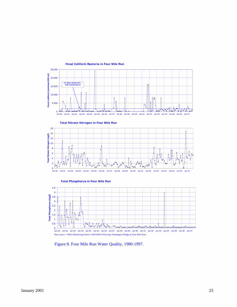
Data source: VDEQ Monitoring Station 1AFOU000.19 (George Washington Bridge @ Four Mile Run)
Figure 8. Four Mile Run Water Quality, 1980-1997.
Fecal Coliform Bacteria in Four Mile Run
0
5,000
10,000
15,000
20,000
25,000
Jan-80 Jan-81 Jan-82 Jan-83 Jan-84 Jan-85 Jan-86 Jan-87 Jan-88 Jan-89 Jan-90 Jan-91 Jan-92 Jan-93 Jan-94 Jan-95 Jan-96 Jan-97
Fec
al c
olif
orm
(co
lon
ies/
100
ml)
Va. Water Quality Std. = 1000 colonies/100 ml
Total Nitrate Nitrogen in Four Mile Run
0
2
4
6
8
10
12
14
16
Jan-80 Jan-81 Jan-82 Jan-83 Jan-84 Jan-85 Jan-86 Jan-87 Jan-88 Jan-89 Jan-90 Jan-91 Jan-92 Jan-93 Jan-94 Jan-95 Jan-96 Jan-97
To
tal N
itra
te N
itro
gen
(m
g/l)
Total Phosphorus in Four Mile Run
0
0.5
1
1.5
2
2.5
3
3.5
4
4.5
Jan-80 Jan-81 Jan-82 Jan-83 Jan-84 Jan-85 Jan-86 Jan-87 Jan-88 Jan-89 Jan-90 Jan-91 Jan-92 Jan-93 Jan-94 Jan-95 Jan-96 Jan-97
To
tal P
ho
sph
oru
s (m
g/l)
January 2001 25
January 2001 26
as nutrients and total suspended solids. Grab samples must be collected for parameters such as fecalcoliform bacteria and metals. The different sampling approaches for different parameters stem fromconcerns over total downstream loadings for pollutants such as nutrients versus concerns about the toxiceffects of elevated concentrations of pollutants like bacteria and metals. Laboratory analysis of the flow-weighted composite samples collected during each sampling event provides an Event Mean Concentration(EMC) for each parameter analyzed. At each of the four outfalls sampled, the County must calculateseasonal EMCs for the October-March and April-September periods as the average of EMCs at eachoutfall for all storms sampled during the two periods. For grab samples, the County simply calculates anaverage concentration for each outfall during each period. For concentrations below method detectionlimits, a value of half the detection limit is the assumed concentration used in the calculation of EMCs(rather than '0')—a method used by other MS4 permitees such as Los Angeles County (Los AngelesCounty Department of Public Works, 1999). This is a conservative approach, since compounds belowmethod detection limits may not be present in the sample at all.
For each of the four outfalls covered by the County's MS4 permit, Figure 9, Figure 10, and Figure 11provide average EMCs for composite sample constituents and average concentrations for grab sampleconstituents for all storms sampled at each outfall for which laboratory data are currently available.Since the issuance of its MS4 permit in FY 1998, the County has monitored 21 storm events as of thiswriting. Of these events, laboratory data are available at this writing for 18 events: seven events at theindustrial outfall, five events at the commercial outfall, three events at the medium density residentialoutfall, and three events at the low density residential outfall. The results presented should therefore beviewed as preliminary because of the relatively small number of storms sampled at each outfall.
Data for the October-March and April-September periods have been aggregated to simplify thepresentation. For comparison, the figures also provide the median, 10th percentile, and 90th percentilevalues for EMCs of constituents collected during the Nationwide Urban Runoff Program (NURP) duringthe early 1980s (EPA, 1992)9. Also, the figures show State of Virginia water quality standards for acuteand chronic aquatic life toxicity and for human health. Acute toxicity measures are more appropriate forstormwater samples because stormwater discharges are episodic in frequency and relatively short induration. In addition, concentrations of constituents in stormwater discharges from a given outfall aretypically diluted by the receiving water body.
Concentrations of the physical parameters analyzed to date are below or within concentration ranges fromthe NURP study—except for the total dissolved solids (TDS) concentration at the industrial outfall, whichis two orders of magnitude higher than the NURP median and one order of magnitude higher than theNURP 90th percentile. Concentrations of total suspended solids (TSS) and hardness are also highest at theindustrial outfall.
For organic constituents, concentrations of the oil and grease parameter are within the typical range,except for the industrial outfall, where both oil and grease and total petroleum hydrocarbons (TPH)concentrations were twice as high as at the other outfalls. Given the vehicle and equipment maintenanceactivities at the Trades Center, this result is not unexpected and points to the need for BMPs such as in- 9 To provide a more relevant analysis, Figure 9, Figure 10, Figure 11 compare data collected under the County'sMS4 permit with NURP data for the Washington DC area only, where available, rather than nationwide.Washington DC NURP data are available for fecal coliform, fecal streptococcus, total dissolved solids,nitrate+nitrite, total Kjeldahl nitrogen, ammonia, total phosphorus, ortho-phosphorus, and alkalinity (Noel et al.,1987). For oil and grease and total petroleum hydrocarbons, the values shown represent the typical range ofhydrocarbons overall found in urban runoff, rather than the NURP median, 10th percentile, and 90th percentile, asreported in Schueler (1987). Sampling and analytical methods during the NURP study may be different from themethods specified in the County's MS4 permit.
January 2001 27
line filters to treat runoff from this site. The precise impacts of hydrocarbons on the aquatic environmentare not well understood. Only a small number of toxicity tests have been performed to examine the effectof hydrocarbon loads in urban runoff on aquatic communities under the typical exposure conditions foundin urban streams (EPA, 1992).
For most of the stormwater samples collected at the four outfalls, concentrations of chloroform werebelow detection limits. For samples where chloroform was detected, chloroform is a common laboratorycontaminant, and the stormwater samples may have been contaminated by laboratory sources ofchloroform during sample analysis. In addition, the State of Virginia water quality standard to protecthuman health is 4,700 micrograms per liter (ug/L) or 4.7 parts per million, more than 800 times thehighest average concentration of chloroform among the four outfalls, which were observed at thecommercial outfall.
Cyanide concentrations for most of the stormwater samples collected at the four outfalls were also belowdetection limits. For samples where cyanide was detected, naturally occurring sulfides sometimesinterfere with the analytical method for cyanide, resulting in false identification of cyanide in a sample.Further, the Virginia water quality standard to protect human health is 215,000 ug/L, more than 34,000times the highest average concentration of chloroform at the four outfalls. The Virginia water qualitystandard for acute toxicity for aquatic life is more than three times the highest average concentration ofcyanide at the four outfalls, which was found at the medium density residential outfall (due to one storm'srelatively high cyanide concentration).
Nutrient concentrations are within concentration ranges from the NURP study with the exception ofdissolved phosphorus at the commercial outfall due to one storm's relatively high concentration.Otherwise, the nutrient data show no discernible pattern among land uses.
For metals, concentrations are below those found during the NURP study. However, because dissolvedmetals present the most toxicity problems, the MS4 permit requires that all metals samples be filteredbefore analysis. The NURP study most likely did not analyze filtered metals samples, so analyticalconcentrations from that study would tend to be higher.
Average metals concentrations at all four outfalls are below Virginia water quality standards10—exceptfor zinc and copper at the medium density residential site, where average concentrations slightly exceedaquatic life toxicity standards. Both of these metals have been associated with automobile sources, aswell as the use of copper gutters.
Bacteria concentrations at all four outfalls are two orders of magnitude higher than NURP concentrationsand about 1.5 orders of magnitude higher than the state water quality standard for human health. Amongthe four outfalls, bacteria concentrations are within the same order of magnitude. Bacterial levels inundiluted runoff from stormwater outfalls usually exceed water quality standards. However, the healthimplications of high fecal coliform concentrations are unclear, and fecal coliform may not be consistentlyreliable in identifying human health risks from urban runoff pollution (EPA, 1992).
10 Water quality standards for cadmium, copper, lead, silver, and zinc are a function of water hardness. For thisanalysis, the average hardness value for all sites of 70 mg/L was used to calculate acute and chronic water qualitystandards with which to compare the average metals concentrations at the four outfalls.
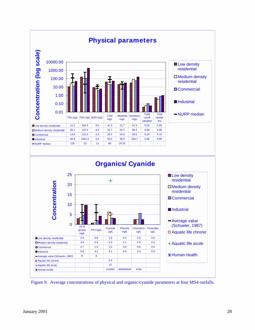
Figure 9. Average concentrations of physical and organic/cyanide parameters at four MS4 outfalls.
Physical parameters
0.01
0.10
1.00
10.00
100.00
1000.00
10000.00
Co
nce
ntr
atio
n (
log
sca
le)
Low densityresidential
Medium densityresidential
Commercial
Industrial
NURP median
Low density residential 11.2 164.3 8.5 41.3 21.7 31.3 0.04 0.56
Medium density residential 25.1 107.0 6.5 21.7 29.7 80.4 0.06 0.35
Commercial 13.6 121.2 4.2 20.2 24.6 59.5 0.10 0.75
Industrial 49.8 1951.4 6.4 55.0 30.9 164.7 0.06 0.96
NURP median 125 23 12 80 20.25
TSS mg/L TDS mg/L BOD mg/LCOD mg/L
Alkalinity mg/L
Hardness mg/L
Total runoff
sampled
Total rainfall
(in)
Organics/Cyanide
0
5
10
15
20
25
Co
nce
ntr
atio
n
Low densityresidential
Medium densityresidential
Commercial
Industrial
Average value(Schueler, 1987)
Aquatic life chronic
Aquatic life acute
Human health
Low density residential 3.0 0.8 2.5 0.0 2.5 0.0
Medium density residential 3.6 0.8 6.3 0.1 2.5 0.0
Commercial 4.7 1.9 3.3 0.0 5.8 0.0
Industrial 9.8 4.2 3.1 0.0 2.5 0.0
Average value (Schueler, 1987) 6 6
Aquatic life chronic 5.2
Aquatic life acute 22
Human health 215000 460000000 4700
Oil & grease mg/L
TPH mg/LCyanide
ug/LPhenols
mg/LChloroform
ug/L Pesticides
ug/L
January 2001 28
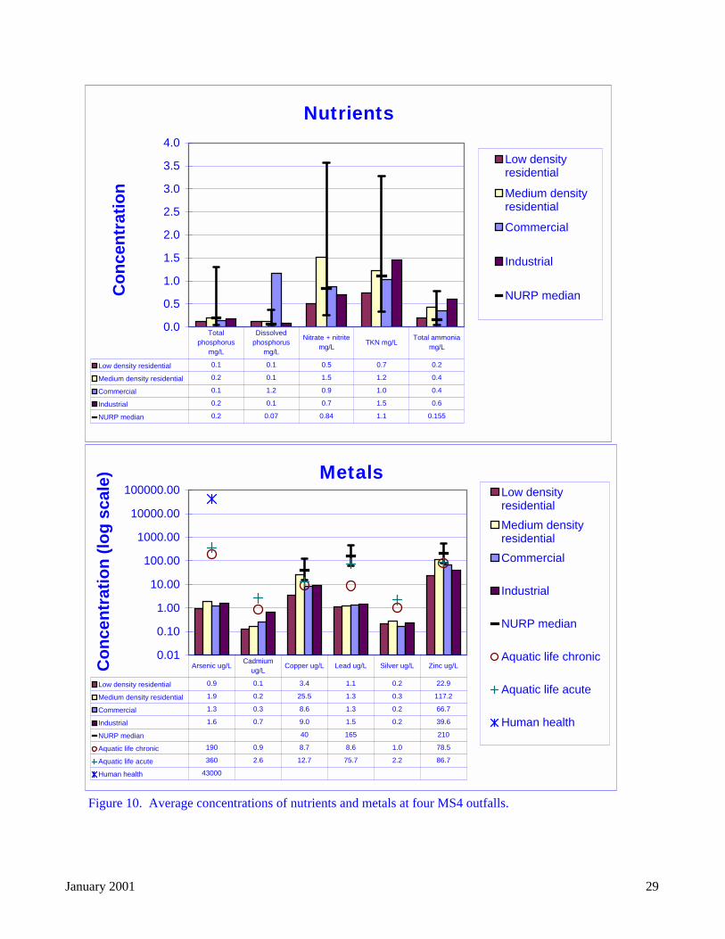
Figure 10. Average concentrations of nutrients and metals at four MS4 outfalls.
Nutrients
0.0
0.5
1.0
1.5
2.0
2.5
3.0
3.5
4.0
Co
nce
ntr
atio
n
Low densityresidential
Medium densityresidential
Commercial
Industrial
NURP median
Low density residential 0.1 0.1 0.5 0.7 0.2
Medium density residential 0.2 0.1 1.5 1.2 0.4
Commercial 0.1 1.2 0.9 1.0 0.4
Industrial 0.2 0.1 0.7 1.5 0.6
NURP median 0.2 0.07 0.84 1.1 0.155
Total phosphorus
mg/L
Dissolved phosphorus
mg/L
Nitrate + nitrite mg/L
TKN mg/LTotal ammonia
mg/L
Metals
0.01
0.10
1.00
10.00
100.00
1000.00
10000.00
100000.00
Co
nce
ntr
atio
n (
log
sca
le)
Low densityresidential
Medium densityresidential
Commercial
Industrial
NURP median
Aquatic life chronic
Aquatic life acute
Human health
Low density residential 0.9 0.1 3.4 1.1 0.2 22.9
Medium density residential 1.9 0.2 25.5 1.3 0.3 117.2
Commercial 1.3 0.3 8.6 1.3 0.2 66.7
Industrial 1.6 0.7 9.0 1.5 0.2 39.6
NURP median 40 165 210
Aquatic life chronic 190 0.9 8.7 8.6 1.0 78.5
Aquatic life acute 360 2.6 12.7 75.7 2.2 86.7
Human health 43000
Arsenic ug/L Cadmium
ug/L Copper ug/L Lead ug/L Silver ug/L Zinc ug/L
January 2001 29
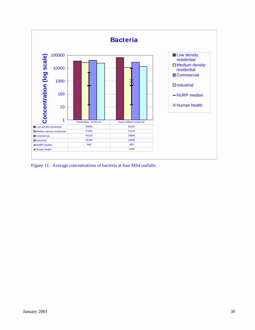
Figure 11. Average concentrations of bacteria at four MS4 outfalls.
Bacteria
1
10
100
1000
10000
100000
Co
nce
ntr
atio
n (
log
sca
le) Low density
residentialMedium densityresidentialCommercial
Industrial
NURP median
Human health
Low density residential 35600 65267
Medium density residential 27200 11515
Commercial 40120 29640
Industrial 25150 13000
NURP median 445 460
Human health 1000
Fecal strep #/100 mL Fecal coliform #/100 mL
January 2001 30
January 2001 31
2.2.5 Pollution prevention and watershed education
Pollution prevention, or source reduction, methods are an important complement to structural BMPs suchas stormwater ponds, especially in areas such as Arlington County where development occurred beforestructural BMPs were required (NVRC, 1997). Pollution prevention activities include public education,improved lawn and turf care practices, street sweeping, and other activities that can result in water qualityimprovements by targeting practices and behaviors that cause the pollution (NVRC, 1997). ArlingtonCounty and its partners conduct a number of educational programs that emphasize pollution preventionand watershed protection. These programs are summarized below. Street sweeping is included in the'Stormwater BMPs, BMP maintenance, and retrofits' section above rather than this section because of itsimportance to an effective BMP implementation program. This section emphasizes education-basedpollution prevention activities.
2.2.5.1 Arlingtonians for a Clean Environment (ACE)
ACE is a non-profit educational and service organization serving the residents of Arlington County andfunded primarily through DES. ACE has presented information to students and adults about local issuesincluding non-point source pollution and the Chesapeake Bay. Several schools participate each year inschoolyard outdoor educational programs which include stream walks. ACE also leads cleanups of localstreams and publishes a quarterly newsletter, “The Arlington Environment,” highlighting environmentalissues that impact Arlington County residents. Approximately 1,500 copies are mailed and 1,000 aredistributed by ACE every quarter. ACE also has an email distribution list for volunteer and educationalopportunities (Arlington County DES, 1999).
In February 1999, ACE unveiled three new interpretive signs in Barcroft Park that will greet recreationalusers with messages about water quality. The signs were designed to educate people about how theiractivities affect the quality in the Four Mile Run watershed and ultimately the Chesapeake Bay. ACEdeveloped the signs with a grant from the Alliance for the Chesapeake Bay and collaborated with anumber of County agencies and other local organizations on this project, including the Arlington CountyCultural Affairs Division, Neighborhood Conservation Program, PRCR, DES, the Barcroft School andCivic League, and the Glencarlyn Citizens Association.
The County will use the signs in a new park being planned for the area where Four Mile Run crossesColumbia Pike. The signs have already been reproduced for use along other sections of the Four Mile Runstream. Information on reprinting signs is available from the ACE office.
2.2.5.2 Department of Parks, Recreation and Community Resources Educational Programs
The Conservation & Interpretation (C&I) Section of PRCR provides environmental education programsand technical information and referral on environmental topics to the residents of Arlington through thestaff of the County nature centers. The Park Ranger program is also part of the C&I Section. As part oftheir mission, the Park Rangers serve as on-site monitors in County parks, ensuring park user compliancewith County ordinances and emphasizing environmentally responsible behaviors during their citizeninteractions. The nature centers offer water-related educational and volunteer project opportunities to boththe general public and school groups on an on-going basis.
In FY 1999, the nature centers sponsored nine stream cleanups, presented 49 programs that had watershededucation as their theme, and trained a number of volunteer stream monitors. Additionally, the C&ISection has developed the Project Watershed Watch (PWW) program. Since its inception, over 24,000people have participated in hands on watershed education offered through this program. ProjectWatershed Watch has twice been awarded the Take Pride in America award. Through a variety oforganized activities and educational programs, citizen volunteers have donated approximately 7,000 hoursof labor to improve Arlington’s water resources. Additionally, volunteers have removed more than 39tons of trash from Arlington streams and associated parklands during sponsored clean-ups. As part of
January 2001 32
PWW, in 1997, the C&I Section produced and distributed educational brochures regarding stream safetyto every child enrolled in Arlington public schools. In 1998, multi-lingual signs regarding safe streambehavior were developed and posted in all County park kiosks. During FY 1999, the C&I Section workedcooperatively with ACE, NVRC, and others to develop and install interpretive signage with watershededucation as its theme, for installation in County parks. Literature regarding PWW activities is mailed toapproximately 1,000 households, and an additional 1,000 copies are distributed biannually.
PRCR is also developing both a list of places to implement ‘no-mow’ areas and a list of areas to installplantings to increase and improve riparian buffers in Arlington parks. A critical component of this workwill be coordination with any planned streambank restoration. Internally, PRCR is considering naturalresource management education for its field crews. PRCR is also developing an educational brochure forpublic distribution about invasive plants and planting alternatives.
To promote tree planting, PRCR's Parks and Natural Resources Division oversees a Public Tree PlantingProgram through which citizens can suggest locations for the County to fund plantings on public land.This is one mechanism to expand riparian buffer areas. In addition, in 1999, the Arlington Forest CivicAssociation started a program that will pay for (through civic association dues) half of the cost to planttrees in residents' front yards (there often is not enough space to plant trees between the sidewalk and thestreet). PRCR hopes to encourage similar programs in other civic associations (Feldberg, 2000).
2.2.5.3 County Fair
The Department of Environmental Services had a display booth at the annual Arlington County Fair inAugust 1998. Information on such topics as Household Hazardous Waste, water conservation,composting, watershed management, recycling and wastewater treatment was provided. Approximately60,000 people attend the Fair every year. The Department’s display booth received an award from thefair organizers for the quality of its outreach efforts (Arlington County DES, 1999).
2.2.5.4 Non-point Source Public Education Materials
County staff developed a non-point source pollution brochure with the Northern Virginia PlanningDistrict Commission and has distributed it at various events, including the County Fair.
2.2.5.5 Bacteria Source Identification
Like most urban streams, Four Mile Run is impaired by fecal coliform bacteria contamination. In July,1999, Virginia DEQ awarded NVRC a grant, with full County support, to use DNA testing to determinethe source(s) of fecal contamination in the watershed. The results, released in October 2000, suggest thatmost sources of bacteria in Four Mile Run are not readily controllable because they come from urbanwildlife. Waterfowl, raccoon, and deer accounted for over 60 percent of the bacterial DNA samplescollected in the watershed. In contrast, human DNA was identified in 17 percent of the samples, whiledog DNA was identified in only nine percent of the samples.
2.2.5.6 Pet Waste Education
Because dogs are one possible source of fecal coliform contamination in Four Mile Run, County staffworked with several citizen groups to develop an informational brochure aimed at educating dog ownersabout non-point source nutrient and bacterial pollution. The brochure urges dog owners to pick up aftertheir dogs and dispose of the waste properly. This brochure has been distributed at County parks, by theAnimal Welfare League and will be distributed by the County’s Treasurer’s office in dog registrationrenewal notices (Arlington County DES, 1999).
2.2.5.7 Dog Exercise Areas
In March 1998, the County Manager initiated a joint citizen/staff work group to draft standards for off-leash Dog Exercise Areas (DEAs). The group was asked to address size, use, carrying capacity,sponsorship, rules, environmental impacts, containment, ground cover, funding, and complaints. Public
January 2001 33
meetings were held monthly from June 1998 to March 1999 and two public forums were conducted.Final standards were issued in May 1999. Properly established and maintained DEAs are expected toimprove water quality by concentrating pet activity away from stream edges and by encouraging ownersto collect and dispose of waste before it contaminates the watershed (Arlington County DES, 1999).PRCR has already identified several existing DEAs that may be relocated because of their proximity tostreams. PRCR is also considering developing educational kiosks for DEAs and other public spaces.
2.2.5.8 Cooperative Extension Homeowner Lawn Care Education
The Arlington office of the Virginia Cooperative Extension (VCE) Service is responsible for publicoutreach and education about lawn care and maintenance in the County. In 1998, the Arlington VCEoffice received a Virginia Water Quality Improvement Fund grant to develop an Urban NutrientManagement program in the County to educate suburban homeowners about nutrient managementpractices that protect water quality and also allow for attractive and sustainable lawns and landscapes.
Through this program, known as the “Water-wise Gardener” program, the Arlington VCE office developsseminars and publications that focus on fertilizer and pesticide use, soil testing, composting, andIntegrated Pest Management. The three seminars scheduled for Fall 1999 include “Soil Testing, Aerating,and Overseeding,” “Fertilizing and Weed Control,” and “Composting and Winter Treatment."
Arlington VCE estimates that the 35 participants in the Fall 1998 Water-wise Gardener program usedapproximately 80 fewer pounds of nitrogen as a result of the program. Arlington VCE continued thisproject in FY 1999 with additional funding from the Water Quality Improvement Fund, and DES staffwill continue to work closely with the Arlington VCE office (Arlington County DES, 1999).
2.2.5.9 Pesticide and Herbicide Use
PRCR continues to maintain a list of approved pesticide and herbicide products and uses and to train andlicense staff in application methods and safety measures.
2.2.5.10 Storm Drain Stenciling
Since 1997, ACE has stenciled approximately 40 storm drains in two neighborhoods, Rosslyn andColonial Village, as well as at Williamsburg Middle School, with the message “Don’t Dump –Chesapeake Bay Drainage” (Arlington County DES, 1999). In addition, in the early 1990s, NVRC andDPW sponsored a storm drain stenciling pilot program in Arlington.
2.2.5.11 Household Hazardous Waste Program
Arlington County operates a permanent, year-round and no-fee Household Hazardous Waste drop-offfacility at the Water Pollution Control Plant for residents. Materials collected are stored at the facilityuntil a scheduled pick-up by a licensed hazardous waste disposal contractor. The materials are recycled,incinerated for BTU recovery, neutralized or disposed of in a permitted hazardous waste facility. Thefacility accepts typical HHW items as well as latex paint (program established October 1997) andhousehold batteries. Batteries can also be dropped off at most Arlington County Fire Stations. Residentparticipation in the program continues to increase. In FY 1999, 182,000 pounds of household hazardouswastes were collected, up 25% from FY 1998. There were 736 calls to the County and 1,339 drop-offs
Through events such as the bi-annual Household Hazardous Waste Roundup Days, County FireDepartment Open House nights, and the County Fair, staff is working to educate residents about HHWdisposal and alternatives. The part-time HHW coordinator also makes presentations to school childrenand community groups upon request (Arlington County DES, 1999).
2.2.5.12 Oil Recycling
Motor oil can be taken to many participating automotive service stations in Arlington County forrecycling. If the oil has been mixed with water, solvents, or fuel, residents can bring it to the Household
January 2001 34
Hazardous Waste drop off center at the County’s Water Pollution Control Plant for proper disposal. InSeptember 1998, a new 150-gallon capacity used oil collection center opened at the HHW facility and820 gallons were collected. This unit is secured with a padlock to prevent accidental contamination fromuntested sources. No businesses are allowed to use this site (Arlington County DES, 1999).
2.3 Baseline subwatershed conditions
2.3.1 Streams
To begin the watershed planning process and identify watershed protection and restoration priorities, EPOhired a consultant, Environmental Systems Analysis, Inc. (ESA), to conduct a stream and riparian bufferinventory, using a modified version of the Rapid Stream Assessment Technique (RSAT) to assess thecondition of the County’s streams and buffers. RSAT is a field screening approach developed in 1992 byJohn Galli of the Metropolitan Washington Council of Governments (COG) to conduct watershed-wideanalyses for Piedmont streams (Galli, 1996). RSAT incorporates chemical, biological, and physicalindicators to evaluate stream health relative to a reference stream known to have reaches in goodcondition. For this study, the reference stream is based on the best conditions observed in the relativelyless developed Gulf Branch subwatershed, located in the Palisades area of north Arlington. ESArecommended the use of Gulf Branch as the reference stream, rather than a pristine Piedmont stream, torepresent the best achievable conditions in an urban environment.
2.3.1.1 Methods
The original RSAT approach assigns points to six stream and riparian parameters, which are based onapproximately 30 quantitative and qualitative measurements, evaluated at a given stream reach. The sixparameters include channel stability, channel scouring/deposition, physical instream habitat, waterquality, riparian habitat conditions, and biological indicators. In consultation with County staff, ESAmodified the RSAT approach to evaluate seven parameters on a 0-56 point scale. ESA replaced thebiological indicators parameter, which requires extensive field work, with an aesthetic rating parameterthat considers the amount of litter and refuse in the stream or adjacent streambanks, as well as thecondition of riparian vegetation, and a remoteness parameter which essentially reflects the accessibility ofthe site. The County intends to perform additional biological sampling at 15 permanent monitoringstations in the future, based on more rigorous biological monitoring criteria recommended by U.S. EPA.
The descriptive criteria used to assign points to each parameter are described in Table 2. Additionalinformation about these criteria is provided in ESA’s final report. These criteria include both quantitativemeasures and qualitative evaluations based on best professional judgement. Note that for each parameter,point values are divided at equal intervals into four qualitative categories: excellent, good, fair, and poor.These qualitative categories are for general comparative purposes only. The numeric RSAT score is themore important indicator of stream health.
In May 1999, ESA, with assistance from County staff, surveyed 28.5 miles of natural stream channels inthe County, evaluating the seven stream and riparian parameters at 400-foot intervals and wherever ESAobserved unique or hazardous conditions. ESA evaluated a total of 236 stations in 16 subwatersheds.ESA did not evaluate an additional 85 stations because of limited access to streams through private landor because riffles were not present along the reach.11 In addition, ESA also did not evaluate theCemetery/Pentagon, National Airport, and Roaches Run subwatersheds because of a lack of perennial 11 The RSAT methodology is designed for use at riffles since they represent optimal habitat for most aquaticorganisms. Although some RSAT stations were located in the Coastal Plain rather than the Piedmont, ESA onlyevaluated stations where riffles were present. Therefore, the use of the RSAT technique in the County’s CoastalPlain streams should provide acceptable data.
January 2001 35
streams and only evaluated stream reaches within Arlington County for those subwatersheds that extendinto adjacent jurisdictions, such as Pimmit Run, Little Pimmit Run, and Upper Long Branch.
To supplement the modified RSAT data, ESA established long-term monitoring stations at 15 sites in 10subwatersheds in August 1999 (Figure 12). At these 15 stations, ESA collected macroinvertebratesamples, surveyed baseline channel cross sections, and installed bank pins to provide futuremeasurements of erosion, downcutting, and widening. These data, and additional water quality/quantityand habitat data, will be collected at these stations to measure stream and riparian buffer conditions overtime (see Section 2.6.4.2, 'Monitoring').
2.3.1.2 Results
Composite RSAT scores by subwatershed—calculated by averaging the scores at each station in asubwatershed for each of the seven RSAT parameters and then summing these averages—are shown inTable 3 and Figure 13. Four of the 16 subwatersheds are considered in ‘good’ condition and 12 are in‘fair’ condition. The four subwatersheds with RSAT scores in the ‘good’ category comprise 12 percent ofthe total area of the 16 subwatersheds evaluated, and two of these subwatersheds, Pimmit Run and UpperLong Branch, are not completely contained within Arlington County. The conditions of reaches in theportions of these subwatersheds outside of Arlington County are therefore unknown.
The Gulf Branch subwatershed is actually the highest scoring of the watersheds located fully within theCounty. The composite RSAT score for this subwatershed, along with the RSAT scores for two of thethree other subwatersheds in the ‘good’ category (Pimmit Run, Upper Long Branch), is close to thebreakpoint between the ‘good’ and ‘fair’ categories (the other subwatershed in the ‘good’ category,Potomac Direct (A), has only one RSAT station). The subwatershed with the lowest RSAT score is SpoutRun, with an RSAT score two points above the ‘poor’ category. Like the composite RSAT scores foreach subwatershed, the majority of RSAT stations scores (65 percent) fall into the 'fair' category. Sevenpercent of RSAT station scores are in the 'poor' category, and 28 percent fall into the 'good category.Figure 14 shows the 16 subwatersheds evaluated and the RSAT scores for each station, and Figure 15shows the distribution of RSAT scores for the 236 stations.
Table 4 and Figure 16 show the average value for each of the seven RSAT parameters in eachsubwatershed that comprise the composite subwatershed RSAT score. In general, most of thesubwatersheds have ‘good’ to ‘excellent’ scores for the channel stability and channel scouring/sedimentdeposition parameters. The range of scores for these two parameters is relatively narrow and tendstoward the middle and upper end of the scale. In contrast, the range of scores for the physical in-streamhabitat, riparian habitat, and aesthetic parameters is wider. No watershed received an average waterquality or remoteness score higher than the ‘fair’ range. Not surprisingly, the distribution of scores foreach RSAT parameter at all 236 stations follows a pattern similar to the average parameter scores in eachsubwatershed. The majority of the RSAT parameter scores fall into the ‘good’ category for the twostream morphology parameters, channel stability and channel scouring/deposition. However, the majorityof scores for the habitat parameters (physical in-stream habitat and riparian habitat) and the water qualityparameter are in the ‘fair’ to ‘poor’ range. Similarly, most of the scores for the aesthetic rating andremoteness parameters fall into the ‘fair’ to ‘poor’ range. The full results of the stream inventory,including original field data sheets and a photo inventory, are provided in ESA’s final report to theCounty (ESA, 1999).
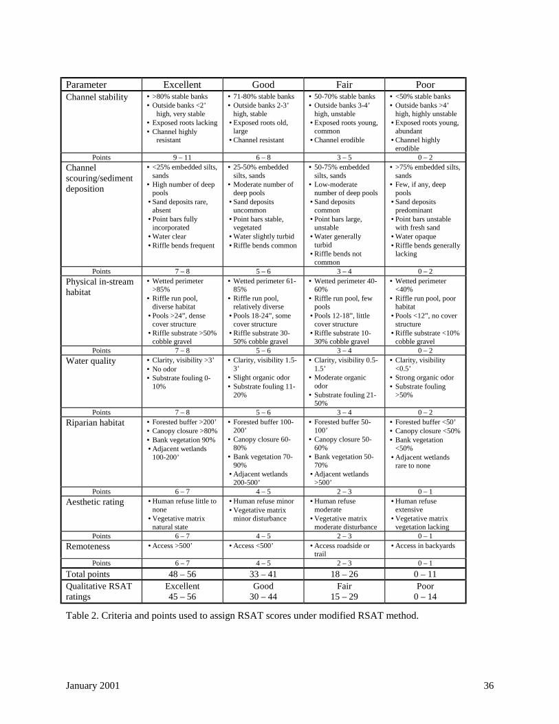
January 2001 36
Parameter Excellent Good Fair PoorChannel stability • >80% stable banks
• Outside banks <2’high, very stable
• Exposed roots lacking• Channel highly
resistant
• 71-80% stable banks• Outside banks 2-3’
high, stable• Exposed roots old,
large• Channel resistant
• 50-70% stable banks• Outside banks 3-4’
high, unstable• Exposed roots young,
common• Channel erodible
• <50% stable banks• Outside banks >4’
high, highly unstable• Exposed roots young,
abundant• Channel highly
erodiblePoints 9 – 11 6 – 8 3 – 5 0 – 2
Channelscouring/sedimentdeposition
• <25% embedded silts,sands
• High number of deeppools
• Sand deposits rare,absent
• Point bars fullyincorporated
• Water clear• Riffle bends frequent
• 25-50% embeddedsilts, sands
• Moderate number ofdeep pools
• Sand depositsuncommon
• Point bars stable,vegetated
• Water slightly turbid• Riffle bends common
• 50-75% embeddedsilts, sands
• Low-moderatenumber of deep pools
• Sand depositscommon
• Point bars large,unstable
• Water generallyturbid
• Riffle bends notcommon
• >75% embedded silts,sands
• Few, if any, deeppools
• Sand depositspredominant
• Point bars unstablewith fresh sand
• Water opaque• Riffle bends generally
lacking
Points 7 – 8 5 – 6 3 – 4 0 – 2
Physical in-streamhabitat
• Wetted perimeter>85%
• Riffle run pool,diverse habitat
• Pools >24”, densecover structure
• Riffle substrate >50%cobble gravel
• Wetted perimeter 61-85%
• Riffle run pool,relatively diverse
• Pools 18-24”, somecover structure
• Riffle substrate 30-50% cobble gravel
• Wetted perimeter 40-60%
• Riffle run pool, fewpools
• Pools 12-18”, littlecover structure
• Riffle substrate 10-30% cobble gravel
• Wetted perimeter<40%
• Riffle run pool, poorhabitat
• Pools <12”, no coverstructure
• Riffle substrate <10%cobble gravel
Points 7 – 8 5 – 6 3 – 4 0 – 2
Water quality • Clarity, visibility >3’• No odor• Substrate fouling 0-
10%
• Clarity, visibility 1.5-3’
• Slight organic odor• Substrate fouling 11-
20%
• Clarity, visibility 0.5-1.5’
• Moderate organicodor
• Substrate fouling 21-50%
• Clarity, visibility<0.5’
• Strong organic odor• Substrate fouling
>50%
Points 7 – 8 5 – 6 3 – 4 0 – 2
Riparian habitat • Forested buffer >200’• Canopy closure >80%• Bank vegetation 90%• Adjacent wetlands
100-200’
• Forested buffer 100-200’
• Canopy closure 60-80%
• Bank vegetation 70-90%
• Adjacent wetlands200-500’
• Forested buffer 50-100’
• Canopy closure 50-60%
• Bank vegetation 50-70%
• Adjacent wetlands>500’
• Forested buffer <50’• Canopy closure <50%• Bank vegetation
<50%• Adjacent wetlands
rare to none
Points 6 – 7 4 – 5 2 – 3 0 – 1
Aesthetic rating • Human refuse little tonone
• Vegetative matrixnatural state
• Human refuse minor• Vegetative matrix
minor disturbance
• Human refusemoderate
• Vegetative matrixmoderate disturbance
• Human refuseextensive
• Vegetative matrixvegetation lacking
Points 6 – 7 4 – 5 2 – 3 0 – 1
Remoteness • Access >500’ • Access <500’ • Access roadside ortrail
• Access in backyards
Points 6 – 7 4 – 5 2 – 3 0 – 1
Total points 48 – 56 33 – 41 18 – 26 0 – 11Qualitative RSATratings
Excellent45 – 56
Good30 – 44
Fair15 – 29
Poor0 – 14
Table 2. Criteria and points used to assign RSAT scores under modified RSAT method.
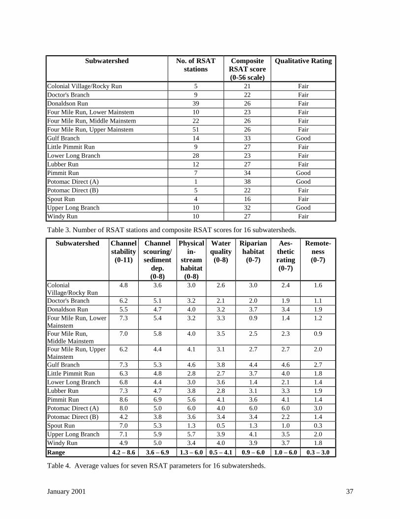
January 2001 37
Subwatershed No. of RSATstations
CompositeRSAT score(0-56 scale)
Qualitative Rating
Colonial Village/Rocky Run 5 21 FairDoctor's Branch 9 22 FairDonaldson Run 39 26 FairFour Mile Run, Lower Mainstem 10 23 FairFour Mile Run, Middle Mainstem 22 26 FairFour Mile Run, Upper Mainstem 51 26 FairGulf Branch 14 33 GoodLittle Pimmit Run 9 27 FairLower Long Branch 28 23 FairLubber Run 12 27 FairPimmit Run 7 34 GoodPotomac Direct (A) 1 38 GoodPotomac Direct (B) 5 22 FairSpout Run 4 16 FairUpper Long Branch 10 32 GoodWindy Run 10 27 Fair
Table 3. Number of RSAT stations and composite RSAT scores for 16 subwatersheds.
Subwatershed Channelstability(0-11)
Channelscouring/sediment
dep.(0-8)
Physicalin-
streamhabitat
(0-8)
Waterquality(0-8)
Riparianhabitat
(0-7)
Aes-theticrating(0-7)
Remote-ness(0-7)
ColonialVillage/Rocky Run
4.8 3.6 3.0 2.6 3.0 2.4 1.6
Doctor's Branch 6.2 5.1 3.2 2.1 2.0 1.9 1.1Donaldson Run 5.5 4.7 4.0 3.2 3.7 3.4 1.9Four Mile Run, LowerMainstem
7.3 5.4 3.2 3.3 0.9 1.4 1.2
Four Mile Run,Middle Mainstem
7.0 5.8 4.0 3.5 2.5 2.3 0.9
Four Mile Run, UpperMainstem
6.2 4.4 4.1 3.1 2.7 2.7 2.0
Gulf Branch 7.3 5.3 4.6 3.8 4.4 4.6 2.7Little Pimmit Run 6.3 4.8 2.8 2.7 3.7 4.0 1.8Lower Long Branch 6.8 4.4 3.0 3.6 1.4 2.1 1.4Lubber Run 7.3 4.7 3.8 2.8 3.1 3.3 1.9Pimmit Run 8.6 6.9 5.6 4.1 3.6 4.1 1.4Potomac Direct (A) 8.0 5.0 6.0 4.0 6.0 6.0 3.0Potomac Direct (B) 4.2 3.8 3.6 3.4 3.4 2.2 1.4Spout Run 7.0 5.3 1.3 0.5 1.3 1.0 0.3Upper Long Branch 7.1 5.9 5.7 3.9 4.1 3.5 2.0Windy Run 4.9 5.0 3.4 4.0 3.9 3.7 1.8
Range 4.2 – 8.6 3.6 – 6.9 1.3 – 6.0 0.5 – 4.1 0.9 – 6.0 1.0 – 6.0 0.3 – 3.0
Table 4. Average values for seven RSAT parameters for 16 subwatersheds.
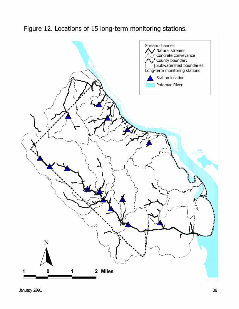
Figure 12. Locations of 15 long-term monitoring stations.
$T
$T$T$T
$T
$T
$T
$T
$T
$T$T$T
$T
$T$T
1 0 1 2 Miles
Potomac River
Long-term monitoring stations$T Station location
Subwatershed boundariesCounty boundary
Stream channelsNatural streamsConcrete conveyance
N
Draft Final--May 2000 38
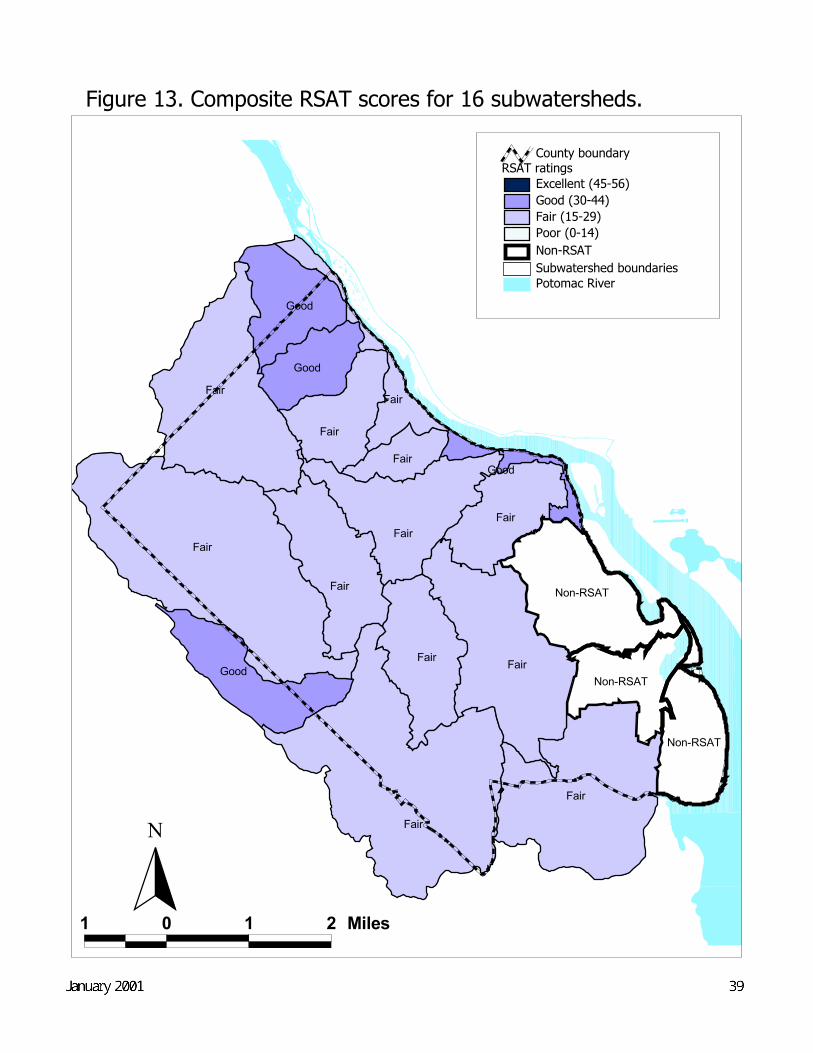
Figure 13. Composite RSAT scores for 16 subwatersheds.
Fair
Fair
Fair
Fair
Fair
Fair
Fair
Fair
Fair
Fair
Good
Good
Non-RSAT
Fair
Good
Fair
Non-RSAT
Non-RSAT
Good
1 0 1 2 Miles
Potomac RiverSubwatershed boundaries
RSAT ratingsExcellent (45-56)Good (30-44)Fair (15-29)Poor (0-14)Non-RSAT
County boundary
N
Draft Final--May 2000 39
Figure 14. RSAT station scores in 16 subwatersheds.
ÊÚSSÊÚSSS
SSSSÊÚSSSSSSÊÚSSSSSÊÚSSS
SÊÚSSSSSSSSSSSÊÚS
SSÑSSÑÑS
SSÊÚÊÚSSSÊÚÑS
ÊÚSÊÚSÊÚÊÚÊÚÊÚÊÚS
SSS SS
ÊÚSÑS
SSSSS
ÊÚ
ÊÚÊÚÊÚÊÚÊÚSÊÚ
ÊÚÊÚSÊÚÑÊÚSÊÚÊÚS
ÑS
ÑSSSSSSSSS Ñ
ÊÚ ÊÚÊÚSSÑSSS
ÊÚSSS
SSSS
SSSSSSSSSS
S
SSÊÚSS
SS S
ÊÚÊÚÊÚÊÚÊÚÊÚÊÚÊÚÊÚÊÚÊÚSSS
ÊÚÊÚÊÚÊÚÊÚSÊÚÊÚSSSSSÊÚÊÚSSS
SÊÚSS
SSÑÑÑÑÑ
ÊÚÊÚÊÚSÊÚSSSSS
SSSS
SSSSÑ
SSSSSS
SÊÚSSSSSSS
ÊÚÊÚÊÚÊÚÊÚÊÚS
1 0 1 2 Miles
Potomac RiverSubwatershed boundariesCounty boundary
Stream channelsNatural streamsConcrete conveyance
RSAT station scoresr Excellent (45 - 56)ÊÚ Good (30 - 44)S Fair (15 - 29)Ñ Poor (0 - 14)
N
Draft Final--May 2000 40
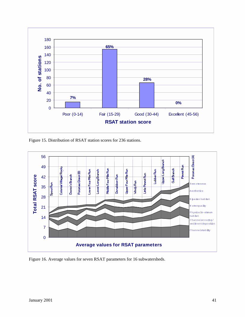
January 2001 41
Figure 15. Distribution of RSAT station scores for 236 stations.
Figure 16. Average values for seven RSAT parameters for 16 subwatersheds.
0
7
14
21
28
35
42
49
56
Average values for RSAT parameters
Tota
l RS
AT
sco
re
Channel stability
Physical in-stream habitat
Channel scouring/sedim ent deposition
W ater quality
Riparian habitat
Aesthetics
Rem oteness
0
20
40
60
80
100
120
140
160
180
Poor (0-14) Fair (15-29) Good (30-44) Excellent (45-56)
RSAT station score
No.
of
stat
ion
s
7%
65%
28%
0%
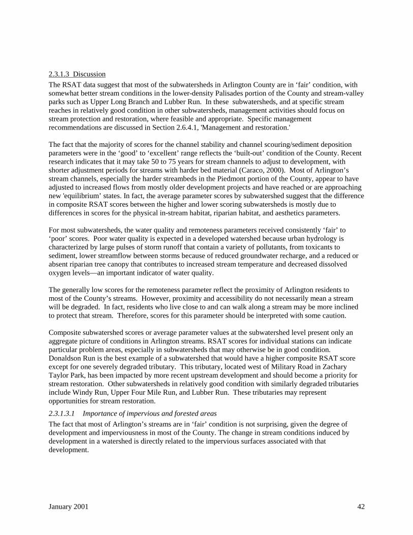
January 2001 42
2.3.1.3 Discussion
The RSAT data suggest that most of the subwatersheds in Arlington County are in ‘fair’ condition, withsomewhat better stream conditions in the lower-density Palisades portion of the County and stream-valleyparks such as Upper Long Branch and Lubber Run. In these subwatersheds, and at specific streamreaches in relatively good condition in other subwatersheds, management activities should focus onstream protection and restoration, where feasible and appropriate. Specific managementrecommendations are discussed in Section 2.6.4.1, 'Management and restoration.'
The fact that the majority of scores for the channel stability and channel scouring/sediment depositionparameters were in the ‘good’ to ‘excellent’ range reflects the ‘built-out’ condition of the County. Recentresearch indicates that it may take 50 to 75 years for stream channels to adjust to development, withshorter adjustment periods for streams with harder bed material (Caraco, 2000). Most of Arlington’sstream channels, especially the harder streambeds in the Piedmont portion of the County, appear to haveadjusted to increased flows from mostly older development projects and have reached or are approachingnew 'equilibrium’ states. In fact, the average parameter scores by subwatershed suggest that the differencein composite RSAT scores between the higher and lower scoring subwatersheds is mostly due todifferences in scores for the physical in-stream habitat, riparian habitat, and aesthetics parameters.
For most subwatersheds, the water quality and remoteness parameters received consistently ‘fair’ to‘poor’ scores. Poor water quality is expected in a developed watershed because urban hydrology ischaracterized by large pulses of storm runoff that contain a variety of pollutants, from toxicants tosediment, lower streamflow between storms because of reduced groundwater recharge, and a reduced orabsent riparian tree canopy that contributes to increased stream temperature and decreased dissolvedoxygen levels—an important indicator of water quality.
The generally low scores for the remoteness parameter reflect the proximity of Arlington residents tomost of the County’s streams. However, proximity and accessibility do not necessarily mean a streamwill be degraded. In fact, residents who live close to and can walk along a stream may be more inclinedto protect that stream. Therefore, scores for this parameter should be interpreted with some caution.
Composite subwatershed scores or average parameter values at the subwatershed level present only anaggregate picture of conditions in Arlington streams. RSAT scores for individual stations can indicateparticular problem areas, especially in subwatersheds that may otherwise be in good condition.Donaldson Run is the best example of a subwatershed that would have a higher composite RSAT scoreexcept for one severely degraded tributary. This tributary, located west of Military Road in ZacharyTaylor Park, has been impacted by more recent upstream development and should become a priority forstream restoration. Other subwatersheds in relatively good condition with similarly degraded tributariesinclude Windy Run, Upper Four Mile Run, and Lubber Run. These tributaries may representopportunities for stream restoration.
2.3.1.3.1 Importance of impervious and forested areas
The fact that most of Arlington’s streams are in ‘fair’ condition is not surprising, given the degree ofdevelopment and imperviousness in most of the County. The change in stream conditions induced bydevelopment in a watershed is directly related to the impervious surfaces associated with thatdevelopment.
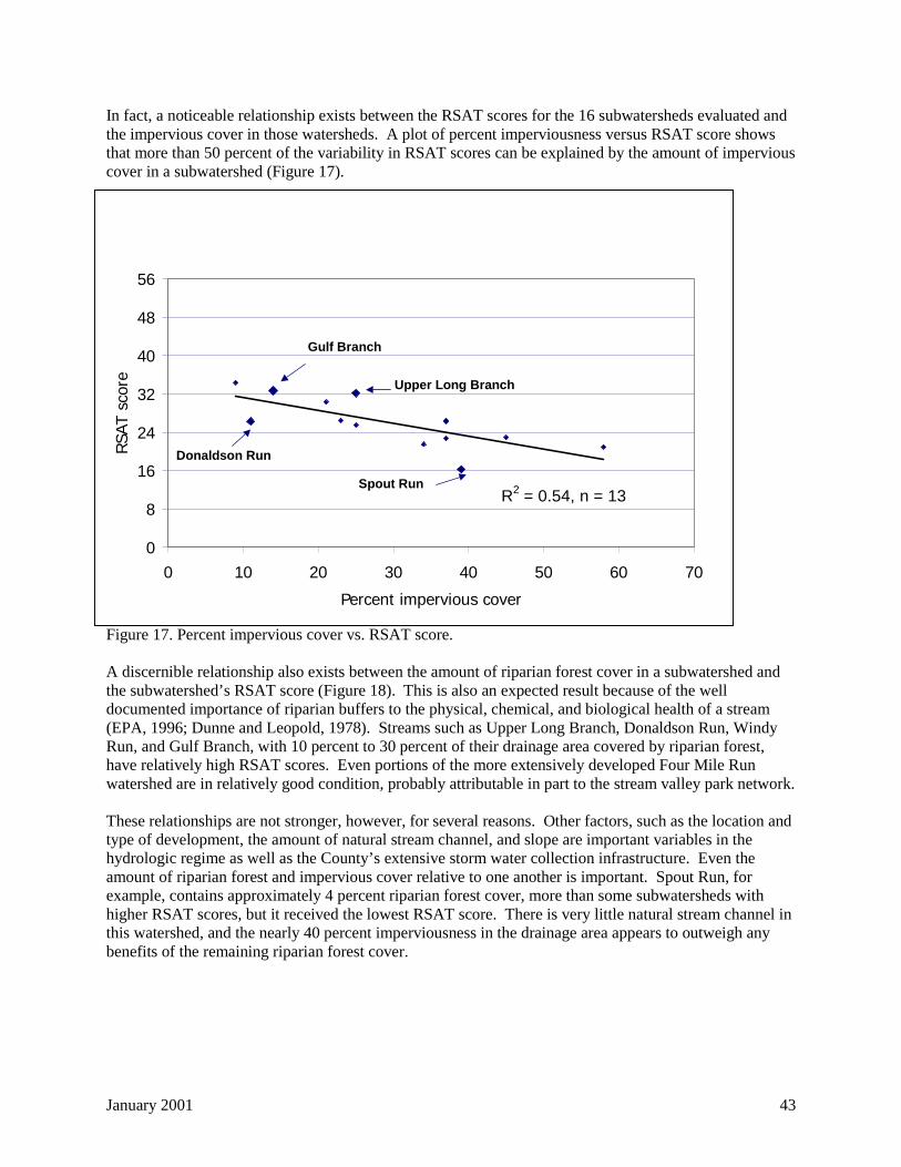
January 2001 43
In fact, a noticeable relationship exists between the RSAT scores for the 16 subwatersheds evaluated andthe impervious cover in those watersheds. A plot of percent imperviousness versus RSAT score showsthat more than 50 percent of the variability in RSAT scores can be explained by the amount of imperviouscover in a subwatershed (Figure 17).
Figure 17. Percent impervious cover vs. RSAT score.
A discernible relationship also exists between the amount of riparian forest cover in a subwatershed andthe subwatershed’s RSAT score (Figure 18). This is also an expected result because of the welldocumented importance of riparian buffers to the physical, chemical, and biological health of a stream(EPA, 1996; Dunne and Leopold, 1978). Streams such as Upper Long Branch, Donaldson Run, WindyRun, and Gulf Branch, with 10 percent to 30 percent of their drainage area covered by riparian forest,have relatively high RSAT scores. Even portions of the more extensively developed Four Mile Runwatershed are in relatively good condition, probably attributable in part to the stream valley park network.
These relationships are not stronger, however, for several reasons. Other factors, such as the location andtype of development, the amount of natural stream channel, and slope are important variables in thehydrologic regime as well as the County’s extensive storm water collection infrastructure. Even theamount of riparian forest and impervious cover relative to one another is important. Spout Run, forexample, contains approximately 4 percent riparian forest cover, more than some subwatersheds withhigher RSAT scores, but it received the lowest RSAT score. There is very little natural stream channel inthis watershed, and the nearly 40 percent imperviousness in the drainage area appears to outweigh anybenefits of the remaining riparian forest cover.
R2 = 0.54, n = 13
0
8
16
24
32
40
48
56
0 10 20 30 40 50 60 70
Percent impervious cover
RSA
T sc
ore
Donaldson Run
Spout Run
Upper Long Branch
Gulf Branch
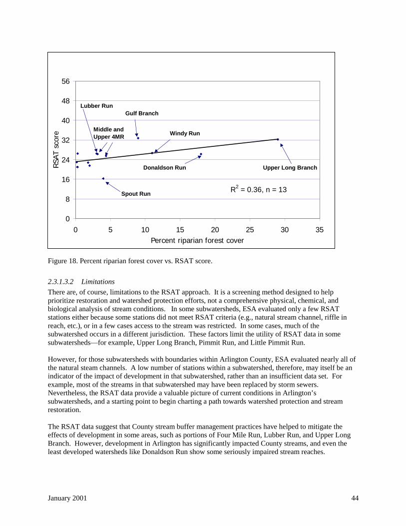
January 2001 44
Figure 18. Percent riparian forest cover vs. RSAT score.
2.3.1.3.2 Limitations
There are, of course, limitations to the RSAT approach. It is a screening method designed to helpprioritize restoration and watershed protection efforts, not a comprehensive physical, chemical, andbiological analysis of stream conditions. In some subwatersheds, ESA evaluated only a few RSATstations either because some stations did not meet RSAT criteria (e.g., natural stream channel, riffle inreach, etc.), or in a few cases access to the stream was restricted. In some cases, much of thesubwatershed occurs in a different jurisdiction. These factors limit the utility of RSAT data in somesubwatersheds—for example, Upper Long Branch, Pimmit Run, and Little Pimmit Run.
However, for those subwatersheds with boundaries within Arlington County, ESA evaluated nearly all ofthe natural steam channels. A low number of stations within a subwatershed, therefore, may itself be anindicator of the impact of development in that subwatershed, rather than an insufficient data set. Forexample, most of the streams in that subwatershed may have been replaced by storm sewers.Nevertheless, the RSAT data provide a valuable picture of current conditions in Arlington’ssubwatersheds, and a starting point to begin charting a path towards watershed protection and streamrestoration.
The RSAT data suggest that County stream buffer management practices have helped to mitigate theeffects of development in some areas, such as portions of Four Mile Run, Lubber Run, and Upper LongBranch. However, development in Arlington has significantly impacted County streams, and even theleast developed watersheds like Donaldson Run show some seriously impaired stream reaches.
R2 = 0.36, n = 13
0
8
16
24
32
40
48
56
0 5 10 15 20 25 30 35Percent riparian forest cover
RSA
T sc
ore
Upper Long BranchDonaldson Run
Windy Run
Gulf Branch
Middle and Upper 4MR
Lubber Run
Spout Run
January 2001 45
On the positive side, the macroinvertebrate data collected at the 15 permanent monitoring stationsindicate that County streams are not mere lifeless conduits for storm water. There are, in fact, livelyaquatic ecosystems. However, because of high flows during storms and repeated pulses of urbanpollutants, only a relatively small number of pollution-tolerant species of aquatic organisms can thrive inArlington’s streams. At the same time, water quality in most of the streams surveyed was characterizedas poor. A ubiquitous algal and bacterial film covered the streambeds at most stations during the latespring, low flow conditions when ESA and County staff conducted the stream survey. This biologicalgrowth is an indication of nutrient enrichment, supporting a variety of pollution-tolerantmacroinvertebrates like net-spinning caddisflies (Hydropsychidae), midges (Chironomidae), and mayflies(Baetidae). Nutrient enrichment and other stream pollution can be exacerbated during low flowconditions because pollutants in the water column often become concentrated.
Although ESA did not collect water samples during the inventory, other known water quality problems inCounty streams include fecal coliform bacteria levels that often exceed state water quality standards. Thisproblem is not unique to Arlington, however. Fecal coliform levels in urban stormwater frequentlyexceed water quality standards by factors of 50 or more (Schueler, 1999).
Overall, the RSAT study was a screening level analysis of conditions of Arlington County streams over athree-week period during the growing season—it is a starting point for evaluation, discussion, and action.As such, the RSAT inventory data provide a framework to identify protection and restoration priorities,including specific actions that the County can take now, and long-term projects that will require morestudy.
2.3.2 Land use
Arlington County's geographic information system (GIS) contains a real estate data layer that includesinformation on land use at the parcel level. EPO analyzed this information to calculate current land usesin each subwatershed, as shown in Table 5 and Figure 19. Streets and highways generally are not includedin this analysis because they are not contained in the real estate database as parcels.
Table 5 also shows the amount of vacant, developable land in each subwatershed, defined as parcels with$0 of improved value in the real estate database (a method suggested by the County's Real EstateAssessments division). However, parcels with a $0 improved value that also fall under the public, semi-public, government/community facilities category were not considered vacant, since many of theseparcels are parks and similar facilities that will remain in their current condition indefinitely. Instead,these parcels were included in the public, semi-public, government/community facilities category.
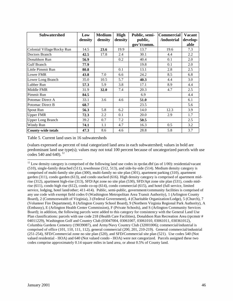
January 2001 46
Subwatershed Lowdensity
Mediumdensity
Highdensity
Public, semi-public,
gov't/comm.
Commercial/industrial
Vacantdevelop-
ableColonial Village/Rocky Run 14.5 23.6 19.9 13.7 19.6 7.3Doctors Branch 42.5 17.8 2.4 30.1 4.4 2.2Donaldson Run 56.9 0.2 40.4 0.1 2.0Gulf Branch 77.9 19.8 0.1 2.0Little Pimmit Run 80.8 0.1 13.1 2.8 2.5Lower FMR 43.8 7.0 6.6 24.2 8.5 6.8Lower Long Branch 35.0 10.5 5.7 40.3 4.4 3.0Lubber Run 57.3 5.9 3.8 17.1 8.9 4.4Middle FMR 31.9 32.0 7.4 20.3 4.7 2.5Pimmit Run 84.5 6.9 4.4Potomac Direct A 33.1 3.6 4.6 51.0 6.1Potomac Direct B 68.7 23.5 5.6Spout Run 56.3 5.8 6.2 14.0 12.3 3.9Upper FMR 72.3 2.2 0.1 20.0 2.9 1.7Upper Long Branch 39.2 0.7 7.2 50.5 2.5Windy Run 74.1 1.1 4.7 16.3 0.5 3.2
County-wide totals 47.3 8.6 4.6 28.8 5.8 3.7
Table 5. Current land uses in 16 subwatersheds
(values expressed as percent of total categorized land area in each subwatershed; values in bold arepredominant land use type(s); values may not total 100 percent because of uncategorized parcels with usecodes 540 and 640). 12
12 Low density category is comprised of the following land use codes in rpcdat.dbf (as of 1/00): residential/vacant(510), single-family detached (511), townhouse (512, 513), and side-by-side (514). Medium density category iscomprised of multi-family site plan (300), multi-family no site plan (301), apartment parking (310), apartmentgarden (311), condo garden (613), and condo stacked (616). High density category is comprised of apartment mid-rise (312), apartment high-rise (313), SFD/Apt zone no site plan (530), SFD/Apt zone site plan (531), condo mid-rise (611), condo high rise (612), condo co-op (614), condo commercial (615), and hotel (full service, limitedservice, lodging, hotel land/other; 411-414). Public, semi-public, government/community facilities is comprised ofany use code with exempt field codes 0 (Washington Metropolitan Area Transit Authority), 1 (Arlington CountyBoard), 2 (Commonwealth of Virginia), 3 (Federal Government), 4 (Charitable Organization/Lodge), 5 (Church), 7(Volunteer Fire Department), 8 (Arlington County School Board), 9 (Northern Virginia Regional Park Authority), A(Embassy), E (Arlington Health Center Commission), F (Private Schools), and S (Arlington Community ServicesBoard); in addition, the following parcels were added to this category for consistency with the General Land UsePlan classifications: parcels with use code 218 (Health Care Facilities), Donaldson Run Recreation Area (rpcmstr #04011229), Washington Golf and Country Club (03047004, 03061007, 03061010, 03061011, 030361012),Columbia Gardens Cemetery (19039087), and Army/Navy Country Club (32001006); commercial/industrial iscomprised of office (101, 110, 111, 112), general commercial (200, 201, 210-219). General commercial/industrial(251-254), SFD/Commercial zone no site plan (520), and SFD/Commercial site plan (521). Use codes 540 (Notvalued residential - HOA) and 640 (Not valued condo - HOA) were not categorized. Parcels assigned these twocodes comprise approximately 0.14 square miles in land area, or about 0.5% of County land.
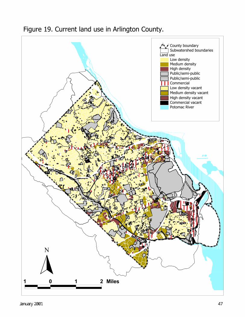
Figure 19. Current land use in Arlington County.
1 0 1 2 Miles
Potomac River
Land useLow densityMedium densityHigh densityPublic/semi-publicPublic/semi-publicCommercialLow density vacantMedium density vacantHigh density vacantCommercial vacant
Subwatershed boundariesCounty boundary
N
January 2001 48
2.4 Future land use changes
2.4.1 Zoning, Development, and General Land Use Plan
Arlington County's zoning ordinance and map classify all land according to various zoning districts.Each zoning district permits a certain type and level of development 'by-right.' Beyond the by-rightdevelopment permitted in each district, certain districts provide public review processes for specialexceptions by site plan or use permit that allow greater flexibility in the use, density, and form ofdevelopment.
The County's zoning represents the legal rights and constraints for existing and future development ineach subwatershed. The County's General Land Use Plan (GLUP) is the primary policy guide for thefuture development of the County. The two work in tandem to provide aguide for future development in the County, with the by-right development process allowing developmentconsistent with zoning.
EPO used the zoning and GLUP data layers in the GIS system to estimate the planned land uses in eachsubwatershed, as shown in Table 6 and Table 7. The land use categories shown have been aggregatedfrom those provided in the General Land Use Plan13,14. Differences in land use percentages betweenTable 6 and Table 7 may in part be due to the simplification of land use categories.
13 Zoning key: the General Land Use Plan lists zoning codes associated with each GLUP category. GLUPcategories have been simplified for this analysis, as described in the next footnote. The zoning codes associatedwith these simplified categories, as shown in Table 4, are as follows: the low density category is comprised ofzoning codes R2-7, R5, R6, R8, R10, R10T, R15-30T, and R20. Medium density category is comprised of zoningcodes CO1.0, CO1.5, CO2.5, CR, RA6-15, RA7-16, RA8-18, RA14-26, and RA-H. High density category iscomprised of zoning codes CO, RA4.8, RAH3.2, and RC. Public, semi-public, and government/community facilitiesis comprised of zoning codes PS, S3A, and SD. Commercial/industrial is comprised of zoning codes C1, C1O,C1R, CM, COA, COROSS, CTH, C2, C3, M1, and M2.14 General Land Use Plan key: low density category is comprised of the following GLUP categories (as of 12/99):residential low; medium density category is comprised of GLUP categories residential low-medium, residentialmedium, office/apartment/hotel low and medium, and medium density mixed-use; high density category iscomprised of GLUP categories residential high-medium, residential high, office/apartment/hotel high, and high-medium residential mixed use; Public, semi-public, and government/community facilities is comprised of the sameGLUP categories; Commercial/industrial is comprised of GLUP categories service commercial, general commercial,service industry, and coordinated mixed use development district.
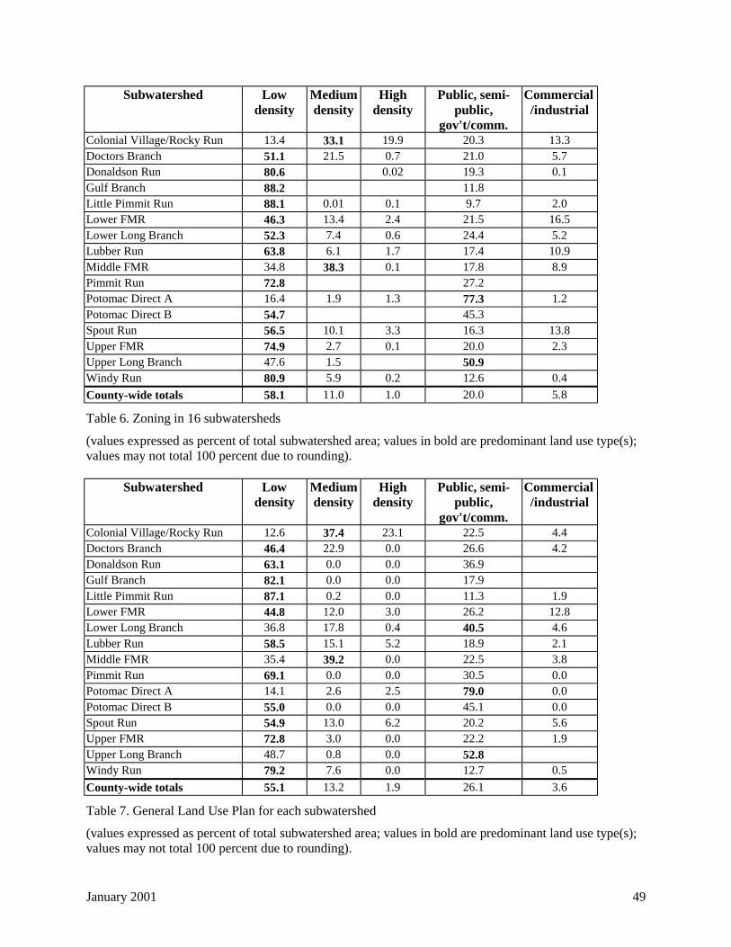
January 2001 49
Subwatershed Lowdensity
Mediumdensity
Highdensity
Public, semi-public,
gov't/comm.
Commercial/industrial
Colonial Village/Rocky Run 13.4 33.1 19.9 20.3 13.3Doctors Branch 51.1 21.5 0.7 21.0 5.7Donaldson Run 80.6 0.02 19.3 0.1Gulf Branch 88.2 11.8Little Pimmit Run 88.1 0.01 0.1 9.7 2.0Lower FMR 46.3 13.4 2.4 21.5 16.5Lower Long Branch 52.3 7.4 0.6 24.4 5.2Lubber Run 63.8 6.1 1.7 17.4 10.9Middle FMR 34.8 38.3 0.1 17.8 8.9Pimmit Run 72.8 27.2Potomac Direct A 16.4 1.9 1.3 77.3 1.2Potomac Direct B 54.7 45.3Spout Run 56.5 10.1 3.3 16.3 13.8Upper FMR 74.9 2.7 0.1 20.0 2.3Upper Long Branch 47.6 1.5 50.9Windy Run 80.9 5.9 0.2 12.6 0.4
County-wide totals 58.1 11.0 1.0 20.0 5.8
Table 6. Zoning in 16 subwatersheds
(values expressed as percent of total subwatershed area; values in bold are predominant land use type(s);values may not total 100 percent due to rounding).
Subwatershed Lowdensity
Mediumdensity
Highdensity
Public, semi-public,
gov't/comm.
Commercial/industrial
Colonial Village/Rocky Run 12.6 37.4 23.1 22.5 4.4Doctors Branch 46.4 22.9 0.0 26.6 4.2Donaldson Run 63.1 0.0 0.0 36.9Gulf Branch 82.1 0.0 0.0 17.9Little Pimmit Run 87.1 0.2 0.0 11.3 1.9Lower FMR 44.8 12.0 3.0 26.2 12.8Lower Long Branch 36.8 17.8 0.4 40.5 4.6Lubber Run 58.5 15.1 5.2 18.9 2.1Middle FMR 35.4 39.2 0.0 22.5 3.8Pimmit Run 69.1 0.0 0.0 30.5 0.0Potomac Direct A 14.1 2.6 2.5 79.0 0.0Potomac Direct B 55.0 0.0 0.0 45.1 0.0Spout Run 54.9 13.0 6.2 20.2 5.6Upper FMR 72.8 3.0 0.0 22.2 1.9Upper Long Branch 48.7 0.8 0.0 52.8Windy Run 79.2 7.6 0.0 12.7 0.5
County-wide totals 55.1 13.2 1.9 26.1 3.6
Table 7. General Land Use Plan for each subwatershed
(values expressed as percent of total subwatershed area; values in bold are predominant land use type(s);values may not total 100 percent due to rounding).
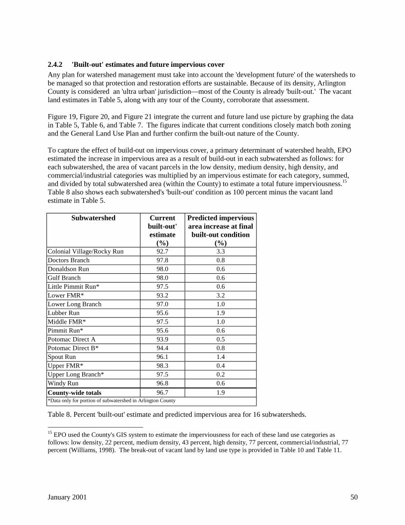
January 2001 50
2.4.2 'Built-out' estimates and future impervious cover
Any plan for watershed management must take into account the 'development future' of the watersheds tobe managed so that protection and restoration efforts are sustainable. Because of its density, ArlingtonCounty is considered an 'ultra urban' jurisdiction—most of the County is already 'built-out.' The vacantland estimates in Table 5, along with any tour of the County, corroborate that assessment.
Figure 19, Figure 20, and Figure 21 integrate the current and future land use picture by graphing the datain Table 5, Table 6, and Table 7. The figures indicate that current conditions closely match both zoningand the General Land Use Plan and further confirm the built-out nature of the County.
To capture the effect of build-out on impervious cover, a primary determinant of watershed health, EPOestimated the increase in impervious area as a result of build-out in each subwatershed as follows: foreach subwatershed, the area of vacant parcels in the low density, medium density, high density, andcommercial/industrial categories was multiplied by an impervious estimate for each category, summed,and divided by total subwatershed area (within the County) to estimate a total future imperviousness.15
Table 8 also shows each subwatershed's 'built-out' condition as 100 percent minus the vacant landestimate in Table 5.
Subwatershed Currentbuilt-out'estimate
(%)
Predicted imperviousarea increase at finalbuilt-out condition
(%)Colonial Village/Rocky Run 92.7 3.3Doctors Branch 97.8 0.8Donaldson Run 98.0 0.6Gulf Branch 98.0 0.6Little Pimmit Run* 97.5 0.6Lower FMR* 93.2 3.2Lower Long Branch 97.0 1.0Lubber Run 95.6 1.9Middle FMR* 97.5 1.0Pimmit Run* 95.6 0.6Potomac Direct A 93.9 0.5Potomac Direct B* 94.4 0.8Spout Run 96.1 1.4Upper FMR* 98.3 0.4Upper Long Branch* 97.5 0.2Windy Run 96.8 0.6
County-wide totals 96.7 1.9*Data only for portion of subwatershed in Arlington County
Table 8. Percent 'built-out' estimate and predicted impervious area for 16 subwatersheds.
15 EPO used the County's GIS system to estimate the imperviousness for each of these land use categories asfollows: low density, 22 percent, medium density, 43 percent, high density, 77 percent, commercial/industrial, 77percent (Williams, 1998). The break-out of vacant land by land use type is provided in Table 10 and Table 11.
January 2001 51
Like the current and future land use analysis, the lowest built-out estimate for 16 subwatersheds, 93percent, and the largest predicted impervious area increase, just over 3 percent, also support the 'ultraurban' characterization of Arlington County.
However, an additional and significant factor to consider for predicting future land use andimperviousness, and a factor not fully captured in the above analyses in part because of the simplifiedland use and zoning categories, is redevelopment, since many parcels in Arlington are zoned for higherdensities, or could be rezoned for higher densities, than the current use. As a result, redevelopment in theCounty could result in considerably higher impervious cover in the subwatersheds in which it is likely tooccur.
According to the County's Department of Economic Development (DED), there are approximately 80sites in the County with good potential for commercial redevelopment. These sites are located in Ballston,Virginia Square, Clarendon, Courthouse, Rosslyn, Crystal City, Pentagon City, and Shirlington, as well asalong Columbia Pike, Lee Highway, and Route 7 (Arlington County DED, 1999; William Thomas,CPHD, personal communication). And, as Arlington's aging housing stock begins to be replaced withlarger homes, incremental increases in site coverage on single-family lots will likely occur County-wide.
In addition, existing and future development data are needed for the portions of the subwatersheds inArlington County that extend into Fairfax County, Alexandria, and Falls Church to fully characterizethese subwatersheds (e.g., Upper Long Branch, Pimmit Run, and Lower Four Mile Run).
2.5 Subwatershed goals
The stream inventory data and current and future land use analyses, along with data provided in theCounty's Storm Water Master Plan (SWMP), provide the framework for overall management goals foreach subwatershed that are achievable goals. The SWMP, a required element of the County’sComprehensive Plan completed in 1996, relies heavily on research conducted by the Center forWatershed Protection (CWP).
CWP identifies three major categories of watersheds based on impervious cover, described as 'sensitive'(!), 'impacted' ("), and 'non-supporting' (● ) (Caraco et al., 1998).• Watersheds with less than 11 percent impervious cover are characterized by stable channels and
excellent biodiversity and water quality (!);• Between 10 and 25 percent impervious cover, watersheds begin to show unstable channels and
exhibit good to fair biodiversity and water quality ("). Some streams in this category have goodpotential for restoration because of impervious cover towards the lower end of this range and/or goodopportunities for BMP retrofits that will improve the hydrology and water quality of the stream (!+);and
• Beyond 25 percent imperviousness, most indicators of stream quality, such as aquatic diversity, waterquality, and habitat, shift to a poor condition because of high storm flows, channel erosion andsedimentation, and elevated levels of bacteria, nutrients, and metals (● ).
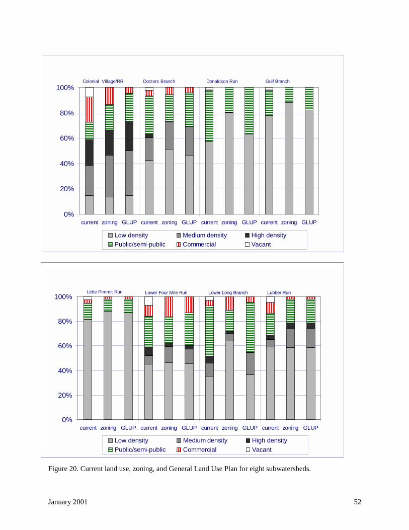
January 2001 52
Figure 20. Current land use, zoning, and General Land Use Plan for eight subwatersheds.
���������������������������
���������������������������������������������
����������������������������������������
������������������������������������������������
�����������������������������������
�����������������������������������
��������������������������������������������������������������������������������
����������������������������������������
����������������������������������������������������������������������
���������������������������������������������
���������������������������
��������������������������������
���������������������������������������������
���������������������������
����������������
����������������
��������������
��������������
���������� ���������
0%
20%
40%
60%
80%
100%
current zoning GLUP current zoning GLUP current zoning GLUP current zoning GLUP
Low density Medium density High density�������� Public/semi-public
���������� Commercial Vacant
Colonial Village/RR Doctors Branch Donaldson Run Gulf Branch
������������������������
����������������
����������������
�����������������������������������
����������������������������
������������������������������������������������������������������
����������������������������������������������������������������������������������������
��������������������������������������������
����������������������������������������������������������������������
����������������������������������������
����������������������������������������
����������������������������������������
������������������������
���������������� �������
��������������
����������������������������
���������������������������������
��������������������������������������������
�������������������� ����������
����������
��������������������
��������������������
0%
20%
40%
60%
80%
100%
current zoning GLUP current zoning GLUP current zoning GLUP current zoning GLUP
Low density Medium density High density����Public/semi-public
�����Commercial Vacant
Little Pimmit Run Lower Four Mile Run Lower Long Branch Lubber Run
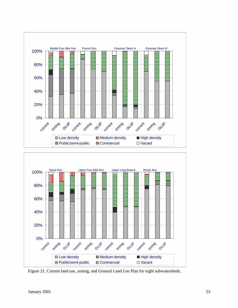
January 2001 53
Figure 21. Current land use, zoning, and General Land Use Plan for eight subwatersheds.
����������������������������
����������������������������������������
��������������������������������
��������������������
����������������������������������������
������������������������������������
������������������������������������������������������������������������
�������������������������������������������������������������������������������������������
���������������������������������������������������������������������������������������������������������������������
�����������������������������������
������������������������������������������������������������������������
��������������������������������������������������������
���������������������������
����������������
�������
0%
20%
40%
60%
80%
100%
curre
nt
zonin
gGLU
P
curre
nt
zonin
gGLU
P
curre
nt
zonin
gGLU
P
curre
nt
zonin
gGLU
P
Low density Medium density High density������������
Public/semi-public
��������
Commercial Vacant
Middle Four Mile Run Pimmit Run Potomac Direct A Potomac Direct B
������������������������
����������������������������������������
��������������������������������
������������������������
������������������������������������
�����������������������������������
������������������������������������������������������������������������
���������������������������������������������������������������
������������������������������������������������������������������������������������������
������������������������
������������������������������
������������������������
������������������������
������������������������������
����������������
������������
��������� ���������������
���������� ��������
0%
20%
40%
60%
80%
100%
curre
nt
zonin
g
GLUP
curre
nt
zonin
g
GLUP
curre
nt
zonin
g
GLUP
curre
nt
zonin
g
GLUP
Low density Medium density High density���������� Public/semi-public
�������� Commercial Vacant
Spout Run Upper Four Mile Run Upper Long Branch Windy Run
January 2001 54
Building on CWP's work, the SWMP recommends three management goals for County subwatersheds(for comparison purposes in Table 9, these three goals also are identified by the symbols !"● ):• Stream restoration (!): watersheds with natural channels and less than 25 percent imperviousness;• Water quality improvements ("): streams in subwatersheds with more than 25 percent
imperviousness which flow through areas of moderate imperviousness and little forest or open spaceand where habitat restoration is difficult; and,
• Flood damage reduction (● ): watersheds with no natural drainage, regardless of imperviousness(along with some water quality measures to improve receiving waters). (Arlington County DPW,1996)
For each of the 16 subwatersheds evaluated using the RSAT technique, Table 9 integrates the RSATresults (! = Good, " = Fair, ● = Poor) and the CWP and SWMP management categories to develop anoverall watershed management category. The table lists the 16 subwatersheds evaluated with the RSATanalysis, with the 32 subwatersheds discussed in the SWMP as a subset of these 16 subwatersheds.
Table 9 suggests that the RSAT data are consistent with the management goals of the SWMP. TheSWMP recommends restoration activities in watersheds that also have the highest RSAT scores—GulfBranch, Upper Long Branch, and Windy Run. Low RSAT scores in one degraded tributary of DonaldsonRun reduced the composite RSAT score for the subwatershed. However, the low imperviousness of thissubwatershed makes it a good candidate for stream restoration, especially in the degraded tributary inZachary Taylor Park.
The table also confirms the importance of imperviousness as an indicator of stream health (supported bythe plot of percent imperviousness versus RSAT score in Figure 17) as well as whether or not therestoration and management priorities identified by the SWMP and RSAT analyses are worth considering.In general, restoration activities in streams with more than 25 percent impervious may not be sustainable.
Because no subwatershed in Arlington County has less than 10 percent impervious cover, CWP's'sensitive' category does not really apply to County streams. At the same time, although many Arlingtonsubwatersheds have more than 25 percent impervious cover, 'non-supporting' may not be the mostdescriptive term because many of these streams do support viable aquatic ecosystems—albeit ones oftendominated by pollution-tolerant species.
Therefore, recognizing that all of the County's streams have been affected by development, this plan usesthe following qualitative descriptions of management categories for Arlington's urban subwatersheds:'least impacted' (!), 'more impacted' ("), and 'most impacted' (● ).
Least impacted subwatersheds (!): Gulf Branch and Donaldson Run are probably the best candidatesfor stream restoration in Arlington County. The management goals for these subwatersheds include:• reducing the flow rate and volume of stormwater runoff;• reducing stormwater pollution, especially sediment, nutrients, and bacteria (consistent with overall
Chesapeake Bay Agreement and Potomac Tributary Strategy goals as well as concerns over waterquality violations for bacteria in urban streams);
• stabilizing eroded stream channels;• improving in-stream and riparian habitat;• improving the diversity of the macroinvertebrate community;• expanding stream valley parks; and• improving aesthetic conditions.(based on Caraco et al., 1998)
January 2001 55
More impacted subwatersheds (""""): Because of the higher level of impervious cover in Little PimmitRun, Lower Long Branch, and Windy Run, management goals for these subwatersheds include:• preventing further increases in the flow rate and volume of stormwater runoff;• reducing stormwater pollution, especially sediment, nutrients, and bacteria;• stabilizing eroded stream channels;• preventing degradation of in-stream and riparian habitat;• maintaining the diversity of the macroinvertebrate community;• expanding stream valley parks; and• improving aesthetic conditions.(based on Caraco et al., 1998)
Most impacted subwatersheds (● ): Because of the highest level of impervious cover in Lower LongBranch, Doctors Branch, Spout Run, Lubber Run, Colonial Village/Rocky Run, and Upper, Middle, andLower Four Mile Run, the management goals for these subwatersheds include:• minimizing increases in the flow rate and volume of stormwater runoff;• reducing flooding;• minimizing pollutant loads to downstream waterbodies (Four Mile Run, Potomac River), especially
sediment, nutrients, and bacteria;• expanding stream valley parks; and• improving aesthetic conditions.(based on Caraco et al., 1998)
However, the stream inventory and SWMP suggest portions of 'more impacted' and 'most impacted'subwatersheds may be suitable for restoration projects (e.g., Four Mile Run Upper Mainstem 2). The nextsection will discuss such projects, as well as other specific actions to implement in each subwatershed.
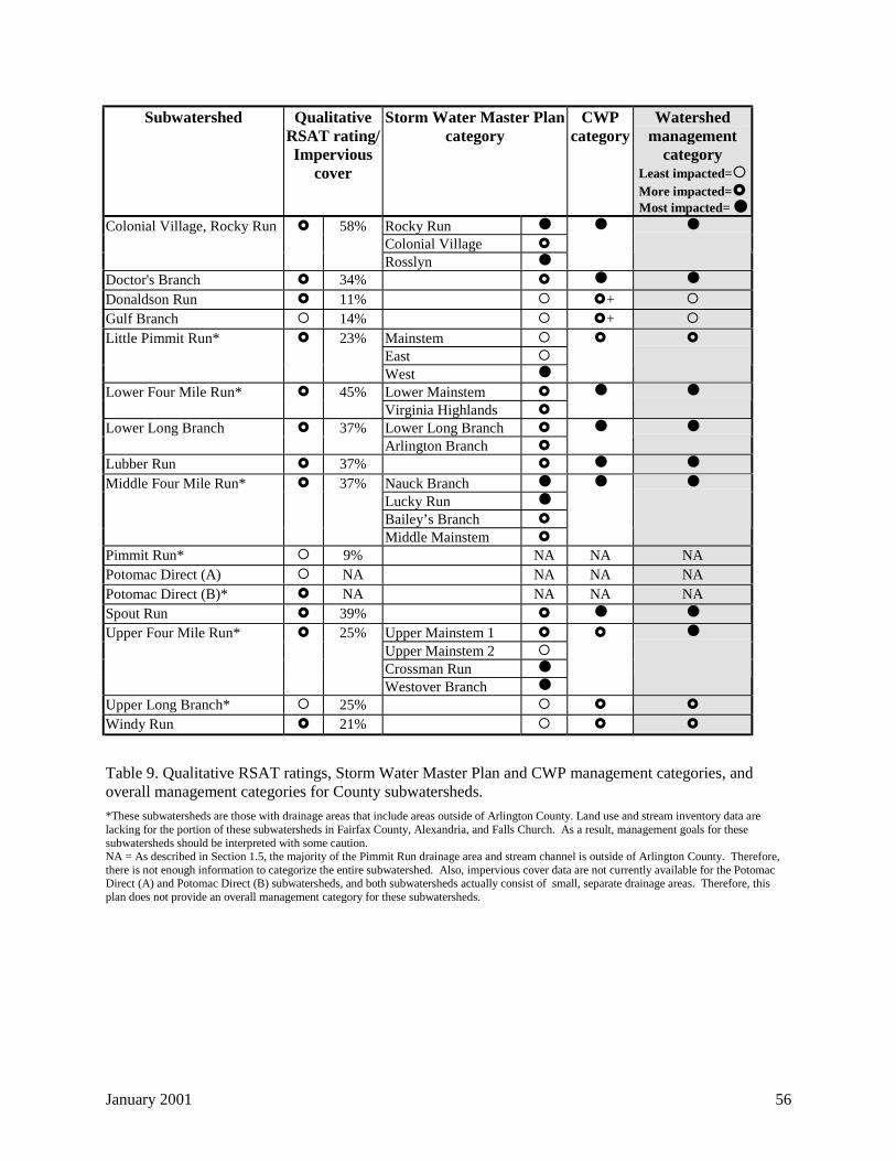
January 2001 56
Subwatershed QualitativeRSAT rating/Impervious
cover
Storm Water Master Plancategory
CWPcategory
Watershedmanagement
categoryLeast impacted=!More impacted="Most impacted= ●
Rocky Run ●
Colonial Village "Colonial Village, Rocky Run " 58%
Rosslyn ●
● ●
Doctor's Branch " 34% " ● ●
Donaldson Run " 11% ! "+ !Gulf Branch ! 14% ! "+ !
Mainstem !East !
Little Pimmit Run* " 23%
West ●
" "
Lower Mainstem "Lower Four Mile Run* " 45%Virginia Highlands "
● ●
Lower Long Branch "Lower Long Branch " 37%Arlington Branch "
● ●
Lubber Run " 37% " ● ●
Nauck Branch ●
Lucky Run ●
Bailey’s Branch "
Middle Four Mile Run* " 37%
Middle Mainstem "
● ●
Pimmit Run* ! 9% NA NA NAPotomac Direct (A) ! NA NA NA NAPotomac Direct (B)* " NA NA NA NASpout Run " 39% " ● ●
Upper Mainstem 1 "Upper Mainstem 2 !Crossman Run ●
Upper Four Mile Run* " 25%
Westover Branch ●
" ●
Upper Long Branch* ! 25% ! " "Windy Run " 21% ! " "
Table 9. Qualitative RSAT ratings, Storm Water Master Plan and CWP management categories, andoverall management categories for County subwatersheds.
*These subwatersheds are those with drainage areas that include areas outside of Arlington County. Land use and stream inventory data arelacking for the portion of these subwatersheds in Fairfax County, Alexandria, and Falls Church. As a result, management goals for thesesubwatersheds should be interpreted with some caution.NA = As described in Section 1.5, the majority of the Pimmit Run drainage area and stream channel is outside of Arlington County. Therefore,there is not enough information to categorize the entire subwatershed. Also, impervious cover data are not currently available for the PotomacDirect (A) and Potomac Direct (B) subwatersheds, and both subwatersheds actually consist of small, separate drainage areas. Therefore, thisplan does not provide an overall management category for these subwatersheds.
January 2001 57
2.6 Watershed management recommendations
Implementation of this watershed management plan is divided into the same five components introducedin the County management practices section of this document. These include:
1) Addressing the sources of stormwater runoff and dry weather pollution (existing and newdevelopment, point sources, illegal discharges);
2) Implementing and maintaining BMPs to control stormwater pollution;3) Maintaining stormwater infrastructure;4) Managing, monitoring, and restoring streams and buffers; and5) Implementing pollution prevention and watershed education initiatives.
The paragraphs below describe County-wide and subwatershed-specific approaches to carrying out thesecomponents.
2.6.1 Sources of stormwater runoff and dry weather pollution
2.6.1.1 County-wide
In mostly built-out Arlington County, existing development, rather than new development orredevelopment, is responsible for most of the runoff generated during storms. Runoff from thisdevelopment, although regulated under the County's MS4 permit, can be controlled at or near the sourceif: a) impervious cover is 'disconnected' so that effective imperviousness is reduced and runoff is lessconcentrated; or b) if a BMP retrofit or other water quality/quantity reduction measured is employed.There may be only limited opportunities to disconnect impervious cover on a County-wide scale,although such actions should be explored and encouraged, particularly in older residential areas wheredownspouts connect directly to the storm sewer network. The rest of the recommendations for addressingrunoff from existing development are contained in Section 2.6.2, 'Stormwater BMPs, BMP retrofits, andmaintenance.'
For new development, redevelopment, and construction that does occur in Arlington County, the Countyordinances regulating such activities (Stormwater Detention, Chesapeake Bay Preservation, Erosion andSediment Control) should be enforced as strictly as possible. Without strong enforcement, there are few,if any, incentives for developers to comply with the provisions of these ordinances.
In addition, there are a number of vacant, developable parcels in the County that overlap ResourceProtection Areas16 (RPAs) delineated under the Chesapeake Bay Preservation Ordinance. AlthoughPRCR's mission is to meet the fast-growing recreational needs of the County, PRCR believes that itmakes sense to place those parcels required for resource protection among the County’s land purchasingpriorities in addition to those purchased for active recreation. Such efforts should be coordinated withDPW's floodplain mapping staff to include parcels also subject to flooding. To initiate discussion of thisissue, DES and DPW should produce a map showing property boundaries, vacant parcels, RPAboundaries, and the boundaries of the 100-year floodplain.
2.6.1.1.1 Stormwater management program
The County's Stormwater Detention Ordinance, enacted County-wide in 1982, pre-dates Virginia'sStormwater Management Act of 1990. As a result, the State does not consider the ordinance a localstormwater management program as defined by state law and regulation (Arlington County DPW, 1996). 16 According to Section 61-6 of the County's Chesapeake Bay Preservation Ordinance, the RPA includes i) tidalwetlands and tidal shores, iii) nontidal wetlands contiguous to tidal wetlands or tributary streams, iii) tributarystreams, and iv) a 100-foot vegetated buffer located adjacent to and landward of i) and ii) and along both sides ofany tributary stream.

January 2001 58
Virginia revised its stormwater management regulation (4 VAC 3-20-10 et seq.) in March 1998 to makethe stormwater programs of the Department of Conservation and Recreation (DCR), the Department ofEnvironmental Quality (DEQ), and the Chesapeake Bay Local Assistance Department (CBLAD)consistent, as well as to provide flexibility for local governments implementing stormwater managementprograms.
The revised State regulations allow localities to address water quality, flooding, and stream channelerosion from new development/redevelopment, to develop watershed-wide stormwater plans which canalso address runoff from existing development through regional BMPs, and to require stormwatermanagement plans for proposed development projects. These activities are consistent with the goals ofthis Watershed Management Plan.
In particular, the revised regulations eliminate the previous explicit requirements to control runoff for the2-year storm from the developed site at pre-developed flow rates (the 'flooding' section of the newregulations requires control of the 10-year storm at pre-developed flow rates). Instead, the newregulations require that properties and streams downstream of a development project must be protectedfrom erosion and damage due to increases in the volume, velocity, and peak flow rate of stormwaterrunoff.
In lieu of controlling 2-year floods, Virginia's revised Stormwater Management regulations includeprovisions for localities to require up to 24-hour extended detention of runoff from the 1-year event,releasing this runoff at the pre-developed 1-year flow rates. This extended detention can decrease theflow rate and velocity of runoff from a developed site enough to offset the increases in volume,frequency, and duration of the runoff—especially increases in the frequency of bankfull flows17 (VirginiaDCR, 2000).
However, channel erosion resulting from site runoff may still occur and is addressed by MinimumStandard 19 (MS-19) of the State's Erosion and Sediment Control regulations (4 VAC 50-30-40.19),which provides criteria for the analysis of the downstream channel, as well as options for cases where thechannel has been determined to be inadequate to convey flows from the site or where increases in thevolume, velocity, and peak flow rate will result in channel erosion. (Virginia DCR, 2000).
Earlier this year, Virginia DCR published Technical Bulletin No. 1 (TB-1), Stormwater Management andErosion and Sediment Control Program Erosion Control Policy Guidance, which provides guidance forimplementing MS-19 criteria, along with criteria in the state's Stormwater Management regulations, forstream channel erosion control (Virginia DCR, 2000).
Further, TB-1 provides guidance for the Ultimate Development Conditions provisions of the State'sErosion and Sediment Control and Stormwater Management regulations (4 VAC 50-30-40.19.j and 4VAC 3-20-60.H). These provisions require consideration of the hydrologic impacts of an entiredevelopment project, not just individual lots or parcels, and the TB-1 guidance extends these provisions toinclude entire watersheds (Virginia DCR, 2000).
Arlington County's Storm Water Detention Ordinance controls runoff at the 10-year pre-development ratebut generally does not control runoff for the 2-year or 1-year post-development storm because the releaseorifice from the detention structure is too large. The ordinance also supercedes MS-19 for several 17 In undeveloped watersheds, hydrologists consider the 1.5- to 2-year flood as the channel-forming, or'bankfull' flood. Bankfull flows are flows that completely fill a stream channel to the top of the bank, andthese flows control the shape and form of stream channels through erosion and sediment deposition(Schueler, 1987). After development, the frequency of bankfull flows increases.
January 2001 59
reasons, including the Four Mile Run flood control agreement. However, MS-19 can be applied inArlington County when stormwater detention requirements are waived and runoff from a site dischargesdirectly to a stream channel or swale.
Although the County's Stormwater Detention Ordinance focuses strictly on peak flow reduction for the10-year and 100-year storm events, Virginia law does not require Arlington County to promulgate a newlocal stormwater management ordinance consistent with the revised, more comprehensive State regulationbecause the County's ordinance pre-dates the state law. The County should, however, weigh severalarguments in determining whether to revise the Storm Water Detention Ordinance to create a broader'Storm Water Management Ordinance':
Arguments for revising the County's Stormwater Detention Ordinance:• Since many parcels in Arlington are zoned for higher densities, or could be rezoned for higher
densities than the current use, redevelopment in the County could result in considerably higherimpervious cover and further stream degradation in the subwatersheds in which it is likely to occur(see Section 2.4, 'Future land use changes'). Such development already triggers the existing StormWater Detention Ordinance, and if the County revised the ordinance, such development would berequired to implement water quantity and quality controls.
• The 10-year flood controls required by the existing Stormwater Detention Ordinance are based onstorm sewer capacity, not stream channel impacts.
• The controls required by the County's Stormwater Detention Ordinance do not reduce the totalvolume of surface water runoff from a given site and often provide few water quality benefits. Moresurface water runoff means lower groundwater recharge, which in turn contributes to degradedbaseflow water quality in streams.
• If, as the stream inventory data suggest, many of the County's stream channels have reached or areapproaching equilibrium with existing development, the cumulative increase in flows in a givenwatershed from future development projects could negatively impact stream channels and streamhabitat.
• Where runoff from a development project discharges to a tributary of Four Mile Run (rather than themainstem), stormwater controls that protect tributary stream channels may be more desirable thancontrolling for peak flows downstream. Indeed, the Four Mile Run flood control program should beevaluated for consistency with the 'maximum extent practicable' provisions of the County's MS4permit.
• For subwatersheds in the Potomac drainage, especially Gulf Branch, Donaldson Run, and WindyRun, controlling for 1-year or 2-year post-development flows in addition to the 10-year post-development flood could provide better protection for these relatively sensitive stream channels—especially on a cumulative level.
• This watershed management plan addresses many of the areas covered by the state stormwaterregulation but does not have the legal authority of an ordinance, especially specific stormwater runoffrequirements for development/redevelopment projects. The County's MS4 permit does provideoverall legal authority for stormwater management but not with the specificity of a local stormwaterordinance requiring conditions for site plan approval.
January 2001 60
Arguments against revising the County's Stormwater Detention Ordinance:• In a built-out jurisdiction such as Arlington, the effort to develop and implement a revised stormwater
management ordinance that addresses only new development and redevelopment may not be worththe stream channel and water quality benefits. A revised ordinance would have to be consistent withthe state regulations, and the County may not have sufficient staff or resources to develop andadminister such an ordinance.
• In Arlington County, most development/redevelopment projects will be located away from a naturalstream channel and runoff from these sites will be conveyed to the channel by storm sewers. By thetime runoff from the new site reaches a stream channel through the storm sewer network, this runoffwill be combined with runoff from many other sites and streets that have existed for many years. Asa result, the requirements of the new State stormwater regulations to evaluate stream channel impactsfrom new development/redevelopment may seem impractical for Arlington, unless the new site isvery large and its impacts on a stream channel are significant.
• MS-19 already applies to Arlington County. Applying this standard with the enhancements offered inVirginia DCR's TB-1, especially extended detention, should improve stream channel protection fromnew development/redevelopment without the need to revise the County's Stormwater DetentionOrdinance. The revised state stormwater management regulations do allow localities to adopt morestringent channel analysis criteria and design standards to reduce channel erosion to the maximumextent practicable (Virginia DCR, 2000). Arlington County should begin consulting and applying theTB-1 guidance during the site plan review process. The guidance provides important tools to achievemany of the goals of this Watershed Management Plan.
• Requiring extended detention within the Four Mile Run watershed may conflict with the requirementsof the Four Mile Run flood control program by synchronizing the release of runoff from newdevelopment/redevelopment. And, controlling for 1-year or 2-year post-development flows inaddition to the 100-year post-development flood may not be practical.
• Detention of the 1-year or 2-year flood with discharge from a detention facility at pre-developedrunoff rates still results in an increased frequency and duration of the bankfull flood, with thepotential to erode stream channels and degrade stream habitat (Strecker and Reininga, 2000).
Before Arlington County begins to consider the above issues in deciding whether to revise the StormWater Detention Ordinance, for purposes of consistency, the County should first complete its review andrevision of the Chesapeake Bay Preservation Ordinance (see next section).
2.6.1.1.2 Chesapeake Bay Preservation Ordinance
Arlington County is already in the process of amending its Chesapeake Bay Preservation Ordinance(CPBO). The Chesapeake Bay Task Force appointed by the County Board began meeting in January1999. This citizens' task force is charged with reviewing and making recommendations for updating theCBPO in accordance with the proposed changes to the State's Chesapeake Bay Preservation Act,comments received from the Chesapeake Bay Local Assistance Department on the County's ordinance,and the County's experience administering the ordinance since its adoption in 1992. The Task Forcesubmitted a final draft of the report to the County Board in April 2000. Following a work session withthe County Board in July 2000 and public review of the final report, the County Board instructed staff toamend the Chesapeake Bay Preservation Ordinance. This effort began in late 2000.
Issues addressed by the Task Force include designation of Resource Protection Areas (RPAs) (includingremapping of County streams), development in RPAs (including whether the 2,500 square foot thresholdthat currently triggers County review of proposed activities within the RPA is appropriate), development

January 2001 61
in Resource Management Areas18 (including performance criteria for site design), and the Source ControlFund (including the rate charged to developers, when contributions should be encouraged, and the use offunds).
2.6.1.1.3 BMP retrofits
Independent of potential revisions to the Storm Water Detention Ordinance and the pending revisions tothe Chesapeake Bay Preservation Ordinance, Arlington County should emulate the 'Targets ofOpportunity' program of the City of Alexandria. The objective of this program is to address runoff fromexisting development not directly regulated by the Chesapeake Bay Preservation program to furtherreduce pollutants reaching the bay and its tributaries. To achieve this objective, the program identifiespotential sites for urban stormwater BMP retrofits, stresses early exploration of retrofit options with siteowners/developers, and strives to implement BMP retrofits wherever opportunities arise to do so.
To date, the seven significant BMP retrofits approved under Alexandria's program treat runoff from morethan 1,000 acres. These retrofits are primarily regional or onsite ponds and most have been designed andbuilt by developers (Bell and Champagne, 1998). The City of Alexandria estimates that these facilitiesare meeting a significant portion of the urban retrofit pollution reduction targets for the VirginiaShenandoah and Potomac River Basins Nutrient Reduction Strategy.19
2.6.1.1.4 Utilities Ordinance
The County also has a Utilities Ordinance (Chapter 26 of the County Code) which states:
It shall be unlawful for any person to discharge any sewage, chemicals, oils, tars, toxic orpoisonous wastes or any substance likely, in the opinion of the County Manager, to have anadverse effect on the storm drains or open watercourses or to endanger life or limb or which mayconstitute a public nuisance into any storm drain or open stream.
To improve the County's compliance with its MS4 permit, this ordinance should be amended to define theterm 'discharge' (i.e., direct dumping into a storm drain as well as runoff from washing industrialequipment and property) and to define 'wastes' and 'substance' in a regulatory context consistent withstatutes such as the federal Clean Water Act. The County has not used this ordinance for broadenvironmental protection purposes, in the past. Enforcement of the existing ordinance raises concernsabout staffing and authority that need to be resolved before revising the ordinance.
2.6.1.1.5 Septic Tanks
Staff recommends two strategies to address the remaining septic tanks in Arlington County. First,existing septic tanks need to be well maintained and operating as efficiently as possible. Under theCounty’s Chesapeake Bay Preservation Ordinance, all properties within the County served by septic tanksare required to have their tanks pumped out by a licensed hauler at least once every five years.
Since the adoption of the Chesapeake Bay Preservation Ordinance in 1992, the County has not taken stepsto enforce this requirement, primarily due to an unclear delineation of authority among County agenciesand lack of staff resources. DES should work closely with the County’s Department of Human Services –Environmental Health Division to define appropriate authority. 18 According to Section 61-6 of the County's Chesapeake Bay Preservation Ordinance, a Resource ManagementArea includes all areas within the County not designated as RPAs.19 Source: http://www.ci.alexandria.va.us/solidwaste/teswbst.html. Virginia's Shenandoah and PotomacRiver Basins Nutrient Reduction Strategy is part of the state's implementation of the Chesapeake BayAgreement of 1987, which included a commitment to reduce the controllable loads of phosphorus and nitrogenentering the Bay by 40 percent by the year 2000. The signatories to the 1987 agreement released a draft revisedagreement in 2000.
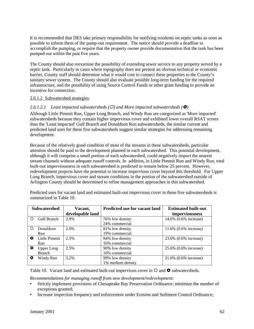
January 2001 62
It is recommended that DES take primary responsibility for notifying residents on septic tanks as soon aspossible to inform them of the pump-out requirement. The notice should provide a deadline toaccomplish the pumping, or require that the property owner provide documentation that the tank has beenpumped out within the past five years.
The County should also reexamine the possibility of extending sewer service to any property served by aseptic tank. Particularly in cases where topography does not present an obvious technical or economicbarrier, County staff should determine what it would cost to connect these properties to the County’ssanitary sewer system. The County should also evaluate possible long-term funding for the requiredinfrastructure, and the possibility of using Source Control Funds or other grant funding to provide anincentive for connection.
2.6.1.2 Subwatershed strategies
2.6.1.2.1 Least impacted subwatersheds (!) and More impacted subwatersheds (")
Although Little Pimmit Run, Upper Long Branch, and Windy Run are categorized as 'More impacted'subwatersheds because they contain higher impervious cover and exhibited lower overall RSAT scoresthan the 'Least impacted' Gulf Branch and Donaldson Run subwatersheds, the similar current andpredicted land uses for these five subwatersheds suggest similar strategies for addressing remainingdevelopment.
Because of the relatively good condition of most of the streams in these subwatersheds, particularattention should be paid to the development planned in each subwatershed. This potential development,although it will comprise a small portion of each subwatershed, could negatively impact the neareststream channels without adequate runoff controls. In addition, in Little Pimmit Run and Windy Run, totalbuilt-out imperviousness in each subwatershed is predicted to remain below 25 percent. However,redevelopment projects have the potential to increase impervious cover beyond this threshold. For UpperLong Branch, impervious cover and stream conditions in the portion of the subwatershed outside ofArlington County should be determined to refine management approaches in this subwatershed.
Predicted uses for vacant land and estimated built-out impervious cover in these five subwatersheds issummarized in Table 10.
Subwatershed Vacant,developable land
Predicted use for vacant land Estimated built-outimperviousness
! Gulf Branch 2.0% 76% low density24% commercial
14.6% (0.6% increase)
! DonaldsonRun
2.0% 81% low density19% commercial
11.6% (0.6% increase)
" Little PimmitRun
2.5% 84% low density16% commercial
23.6% (0.6% increase)
" Upper LongBranch
2.5% 90% low density10% commercial
25.6% (0.6% increase)
" Windy Run 3.2% 99% low density1% medium density
21.6% (0.6% increase)
Table 10. Vacant land and estimated built-out impervious cover in ! and " subwatersheds.
Recommendations for managing runoff from new development/redevelopment:• Strictly implement provisions of Chesapeake Bay Preservation Ordinance; minimize the number of
exceptions granted;• Increase inspection frequency and enforcement under Erosion and Sediment Control Ordinance;
January 2001 63
• Minimize or eliminate waivers granted under Storm Water Detention Ordinance;• Encourage reduced impervious cover and water quality BMPs during the site plan review process;• Purchase vacant land and encourage conservation easements for property owners to preserve open
space for parkland and/or stormwater retrofits; and• Disconnect impervious cover from new development (and existing development) as much as possible
to maintain or even reduce current levels of effective imperviousness in these subwatersheds.
2.6.1.2.2 Most impacted subwatersheds (● )
Impervious cover ranges from 25 to 58 percent in the Lower Long Branch, Doctors Branch, Spout Run,Lubber Run, Colonial Village/Rocky Run, Upper Four Mile Run, Middle Four Mile Run, and Lower FourMile Run subwatersheds. At the same time, all of these subwatersheds, except for Upper Four Mile Run,contain County-targeted, high-density development areas in the Rosslyn-Ballston, Columbia Pike,Pentagon City, and Jefferson Davis corridors. As a result, management of subwatersheds that includethese corridors should focus on encouraging further concentrated development within these corridors andcontrolling runoff quality and quantity from this development, rather than reducing future imperviouscover in each subwatershed as a whole. Table 11 shows a maximum increase of 3.3 percent in estimated'built-out' impervious cover in these subwatersheds.
In addition, with the exception of the Spout Run and Colonial Village/Rocky Run subwatersheds, all ofthe subwatersheds in this category are located within the larger Four Mile Run watershed. Stormwatermanagement in this subwatershed is governed by the Four Mile Run flood control program. Therefore,development in the Four Mile Run watershed is subject to stringent peak flow controls. However,providing stormwater detention at this level still does not eliminate the problems of increased runoffvolume and duration of peak flows, and decreased groundwater recharge, from the increased impervioussurfaces that accompany development.
Recently, a proposed development project at Potomac Yards in south Arlington has prompted questionsabout the conditions imposed by the more than 25-year old Four Mile Run flood control program. Inparticular, a working group charged with looking at the open space and riparian features of the proposedproject has begun to explore whether the channel has more than adequate capacity to convey the 100-yearflood and if riparian restoration above the 100-year flood elevation is possible. In March 2000, ArlingtonCounty and the City of Alexandria sent a letter to Congressman Moran requesting federal funding toreevaluate the flood control project, including current and future channel capacity, channel and riparianrestoration, preliminary urban design elements for waterfront revitalization, and upstream measuresneeded throughout the Four Mile Run watershed to maintain the long-term viability of the flood controlproject. Congress approved a special appropriation of $1 million and work on this project is expected tobegin early in 2001.
Recommendations for managing runoff from new development/redevelopment• Continue to implement County land-use and economic development policies to encourage further
development in the Rosslyn-Ballston, Columbia Pike, Pentagon City, Shirlington, and JeffersonDavis corridors;
• Continue to control runoff quality and quantity from development through the Chesapeake Bay,Erosion and Sediment Control, and Storm Water Detention Ordinances;
• Encourage water quality BMPs, in addition to stormwater detention, during the site plan reviewprocess;
• Outside the Rosslyn-Ballston, Columbia Pike, Pentagon City, Shirlington, and Jefferson Daviscorridors, disconnect impervious cover from new development (and existing development) as muchas possible to maintain or even reduce current levels of effective imperviousness in these areas;
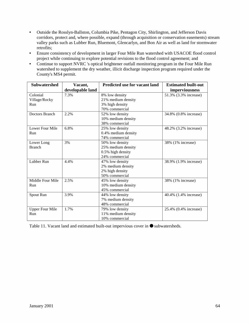
January 2001 64
• Outside the Rosslyn-Ballston, Columbia Pike, Pentagon City, Shirlington, and Jefferson Daviscorridors, protect and, where possible, expand (through acquisition or conservation easements) streamvalley parks such as Lubber Run, Bluemont, Glencarlyn, and Bon Air as well as land for stormwaterretrofits;
• Ensure consistency of development in larger Four Mile Run watershed with USACOE flood controlproject while continuing to explore potential revisions to the flood control agreement; and
• Continue to support NVRC 's optical brightener outfall monitoring program in the Four Mile Runwatershed to supplement the dry weather, illicit discharge inspection program required under theCounty's MS4 permit.
Subwatershed Vacant,developable land
Predicted use for vacant land Estimated built-outimperviousness
ColonialVillage/RockyRun
7.3% 8% low density21% medium density3% high density70% commercial
51.3% (3.3% increase)
Doctors Branch 2.2% 52% low density10% medium density38% commercial
34.8% (0.8% increase)
Lower Four MileRun
6.8% 25% low density0.4% medium density74% commercial
48.2% (3.2% increase)
Lower LongBranch
3% 50% low density25% medium density0.5% high density24% commercial
38% (1% increase)
Lubber Run 4.4% 47% low density2% medium density2% high density50% commercial
38.9% (1.9% increase)
Middle Four MileRun
2.5% 45% low density10% medium density45% commercial
38% (1% increase)
Spout Run 3.9% 44% low density7% medium density48% commercial
40.4% (1.4% increase)
Upper Four MileRun
1.7% 79% low density11% medium density10% commercial
25.4% (0.4% increase)
Table 11. Vacant land and estimated built-out impervious cover in ● subwatersheds.
January 2001 65
2.6.2 Stormwater BMPs, BMP retrofits, and maintenance
Although identifying funds and/or available land to install new BMPs will be a challenging task,Arlington County's MS4 permit provides the legal obligation and authority to control runoff from existingdevelopment. Specifically, the County's MS4 permit states:
The permittee shall develop, implement, and, where appropriate, modify a comprehensive StormWater Management Program...., including pollution prevention measures, management orremoval techniques, storm water monitoring, use of legal authority, and other appropriate meansto control the quality and quantity of stormwater discharged from the municipal separate stormsewer system [MS4]. The Storm Water Management Program shall....reduce the discharge ofpollutants from the [MS4] to the maximum extent practicable (Commonwealth of Virginia,1997).
The 'maximum extent practicable' requirement is not explicitly defined in the permit, but the permit doesspecify four tools to achieve this level of water resource management:
1) Implementing structural and source control measures to reduce pollutants discharged to the MS4 instormwater runoff from commercial and residential areas;
2) Detecting and eliminating illicit discharges and/or improper disposal into the MS4;3) Monitoring and controlling pollutants in storm water discharges from municipal landfills, hazardous
waste treatment, storage, and disposal facilities, and certain industrial facilities; and4) Implementing and maintaining structural and nonstructural measures to reduce pollutants in
stormwater runoff from construction sites.
It is the first item, existing commercial and residential development, that presents the greatest challenge tothe County. The County conducts annual dry weather inspections of major MS4 outfalls to implementitem two of this list. Only a small number of facilities identified in item three exist within the County,and these are covered under existing permits.
The fourth item is mostly covered by the County's Erosion and Sediment Control Ordinance. However,the County should increase the frequency of construction site inspection and enforcement under thisordinance. To that end, DPW hired an additional Erosion and Sediment Control inspector in early 2000.
In Arlington County, implementation of the first item has been limited for existing or newdevelopment/redevelopment. Despite the difficulty of retrofitting existing residential and commercialdevelopment in an urban jurisdiction like Arlington because of limited funds and space for BMPs,inattention to stormwater runoff from existing development could result in enforcement actions by theState of Virginia under the NDPES stormwater program. Inaction could also subject the County or theState of Virginia to the possibility of citizen suits under the Clean Water Act. This is a real concern—environmental advocacy groups have won several successful suits recently to force EPA and the states toimplement the TMDL provisions of the Clean Water Act, in Virginia and throughout the nation.
TMDL regulations will also directly affect Four Mile Run, and therefore much of the County,underscoring the need for an effective stormwater management program to address both runoff qualityand quantity.
January 2001 66
2.6.2.1 County-wide
This plan recommends the following BMP implementation strategy for the County, listed in an 'upstream-downstream' treatment hierarchy (items 2, 3, and 4 address runoff quality and quantity):
1) Source control: Identify funding to enable DES to purchase or lease at least one high-efficiency dryvacuum street sweeper and either an additional regenerative air sweeper or another dry vacuumsweeper; increase the frequency of sweeping in residential and commercial areas. These actions willremove sediment and associated pollutants at the source (paved areas) and will do so more frequentlyand more effectively than current street sweeping practices.
'On the street' performance data for relatively new high-efficiency dry vacuum sweepers, includinganalyses of optimal sweeping frequencies, are still limited20. Early work by Sutherland (1995)estimates that the use of dry vacuum sweepers once per year could reduce annual sediment washoffby 20 percent, four times per year by 28 percent, and weekly by 80 percent. Regenerative airsweepers achieve an estimated 8 percent reduction in annual sediment washoff through annualsweeping, a 10 percent reduction through sweeping four times per year, and a 20 percent reductionthrough weekly sweeping. These preliminary estimates suggest sweeping using either technologyshould occur at least four times per year, but probably more frequently to obtain the best results. Thiswould require a substantial increase in the County's street sweeping program.
More data are needed to determine optimal frequencies, and it is beyond the scope of this plan torecommend a specific combination of sweeping frequency and sweeper technology. However, recentpeer reviewed articles have established dry vacuum sweepers as the Best Available Technology(BAT) sweepers for achieving water quality benefits. Moreover, high efficiency sweepers mayrepresent the best method of restoring water quality in older urban watersheds such as those inArlington County where land, and BMP retrofit opportunities, are limited (NVRC, 1998).
2) Treatment upgradient of storm sewers and streams: Complete an inventory of existing waterquantity and quality BMPs and identify potential retrofits to improve detention capacity and pollutantremoval efficiency. The inventory should explore site-level and small drainage area BMPs such assand filters21, bioretention22, and check dams23 for residential sites, including cul-de-sacs, and largepublic, office, and commercial sites, especially parking lots. These BMPs are designed for land-constrained urban areas and are relatively inexpensive to install and maintain. The inventory shouldalso consider vegetated roofs and onsite detention/retention ponds for large sites and buildings whereappropriate. Resources for implementing these BMPs include Coffman (2000), NVRC (1997),
20 Ongoing work by the Wisconsin Department of Natural Resources is attempting to verify the benefits of dryvacuum sweepers on a six-lane freeway in downtown Milwaukee. The study will compare the water quality ofstormwater runoff from freeway that is swept to an adjacent portion of freeway that is not swept. The test will beconducted in both the summer and winter seasons, and water quality samples will be analyzed for several differenttypes of pollutants. The study should be completed by summer 2000 (Bannerman, 1999). In addition, the LakeBarcroft Watershed Improvement District conducted a one-week demonstration of high-efficiency dry vacuum streetsweeping in 1998. The high-efficiency sweeper collected twice as much fine sediment as a conventional sweeper(Lubold, 1998).21 A sand filter diverts and filters runoff through a self-contained sand bed before discharging the runoff to a streamchannel (Claytor and Schueler, 1996).22 Bioretention uses landscaping and soil to treat stormwater by collecting it in shallow depressions and filtering itthrough the planted soil media (Claytor and Schueler, 1996).23 A 'check dam' attenuates storm flow and, in urban areas, typically consists of a railroad tie perpendicular to thedirection of flow with rip-rap placed on the downstream end of the check dam to prevent erosion Check dams canbe used in vegetated swales to slow stormwater runoff velocities (NVPDC, 1997).
January 2001 67
Claytor and Schueler (1996), Northern Virginia Soil and Water Conservation District (NVSWCD)(1994), and the City of Alexandria (1992).
3) Treatment between surface drainage/storm sewer interface and storm sewer/stream interface:The County should install in-line devices wherever appropriate to filter stormwater at strategiclocations within the storm sewer system (especially high risk or chronic spill areas) that maximizefilter capacity and cost-effectiveness, using RSAT water quality scores and/or land uses a screeningtool.24
4) Treatment downstream of storm sewer/stream interface: Continue to explore therecommendations of a 1993 report by the Northern Virginia Planning District Commission (NVRC)that identified and investigated the feasibility of 24 potential regional BMPs in the Four Mile Runwatershed—the report concludes that, despite the level of urban development in the watershed,opportunities for regional BMPs do exist (NVRC, 1993). The County should assess the feasibility ofregional BMPs in other County subwatersheds.
It must be stressed that without regular inspections and maintenance, structural BMP strategies will not besuccessful. Therefore, it is imperative that the County identify funding and/or procedures not only toretrofit or install BMPs but also to inspect and maintain them. This issue will be discussed in the'Implementation plan' section. For privately-owned BMPs, the City of Alexandria has developed amaintenance and monitoring agreement with property owners that could be adopted in Arlington (City ofAlexandria, 1992).
By reducing pollutant loads to County streams, beginning with source reduction through street sweeping,this approach will help ensure compliance with the County's MS4 permit. Overall, because of the limitedopen space in the County, Arlington County should explore these BMP retrofit opportunities whereverfeasible, similar to the City of Alexandria's 'Targets of Opportunity' policy described above. In particular,sewersheds25 with outfalls 36 inches in diameter or greater26 and sewersheds that contain RSAT stationswith water quality scores less than three should receive priority attention (the majority of water qualityscores at all RSAT stations, 62 percent, totaled between three and four; only 14 percent of water qualityscores at all RSAT stations were greater than four).
2.6.2.2 Subwatershed strategies
The three sections below describe subwatershed-specific applications of the hierarchy presented above.
2.6.2.2.1 Least impacted subwatersheds (!) and More impacted subwatersheds (")
BMP implementation strategies for Gulf Branch, Donaldson Run, Little Pimmit Run, Upper LongBranch, and Windy Run are similar, with an increased focus on channel protection for Windy Run andLittle Pimmit Run because of higher levels of impervious cover.
24 The RSAT water quality parameter consists of an evaluation of water clarity/visibility (poor, <0.5', fair, 0.5'-1.5';good, 1.5'-3.0', and excellent, >3.0'), odor (poor, strong organic odor; fair, moderate organic odor; good, slightorganic odor; excellent, no odor), and substrate fouling, an observation of the extent of algal and bacterial growth onstream bed material (poor, >50%; fair, 21-50%; good, 11-20%; excellent, 0-10%).25 The term 'sewershed' is used here because most of Arlington County's drainage network is comprised of stormsewers. A sewershed is simply an area in which all surface water drainage exits a specific storm sewer outfall to astream channel.26 Discharges from outfalls less than this diameter should have fewer adverse physical effects on stream channels.In addition, the County's MS4 permit defines a major outfall using this 36 inch threshold.
January 2001 68
1) Source control: Implement regenerative air and/or dry vacuum street sweeping in residential areas atleast four times per year and weekly in commercial/industrial areas; encourage property owners todisconnect roof drains from the storm sewer system where possible.
2) Treatment upgradient of storm sewers and streams: Begin evaluation of small-scale BMPs byfocusing on:a) Sewersheds upgradient of RSAT stations with water quality scores less than three (poor) (Figure
22);b) Sewersheds that contain land uses other than low density or parkland; andc) Cul-de-sacs and parking lots.
3) Treatment between surface drainage/storm sewer interface and storm sewer/stream interface:Determine optimal locations to install in-line devices to filter stormwater, focusing on:a) Sewersheds with outfalls equal to or greater than 36 inches in diameter (Figure 22);b) Sewersheds upgradient of RSAT stations with water quality scores less than three (poor) (Figure
22); andc) Sewersheds that contain land uses other than low density residential or parkland.
4) Treatment downstream of storm sewer/stream interface: Perform feasibility studies in thesesubwatersheds to identify potential locations for BMPs; preliminary candidate sites include ArlingtonCountry Club, Gulf Branch Nature Center, Rock Spring Park, and Woodmont Center; target BMPsthat emphasize channel protection (by releasing water at a 1-year recurrence interval, for example) aswell as pollutant reductions.
2.6.2.2.2 Most impacted subwatersheds (● )
BMP implementation approaches in the Lower Long Branch, Doctors Branch, Spout Run, Lubber Run,Colonial Village/Rocky Run, Upper Four Mile Run, Middle Four Mile Run, and Lower Four Mile Runsubwatersheds are similar to those for the 'Least impacted' and 'More impacted' subwatersheds, except fora focus on a) sewersheds that contain RSAT stations with water quality scores less than two (rather thanthree) in recognition of potentially higher pollutant loadings in these subwatersheds, and b) source controlefforts and BMPs that reduce bacterial pollution, since all of these subwatersheds (except for Spout Runand Colonial Village/Rocky Run) are within the larger Four Mile Run watershed—a DEQ-identifiedimpaired stream for fecal coliform bacteria that will be subject to the TMDL program.
1) Source control: Implement regenerative air and/or dry vacuum street sweeping in residential areas atleast four times per year and weekly in commercial/industrial areas; disconnect roof drains fromstorm sewer system where possible; develop bacterial loading reduction strategies from results ofNVRC bacteria source identification study (e.g., dog parks; increased 'pooper scooper' stations,wildlife control, increased I&I inspection, etc.);
2) Treatment upgradient of storm sewers and streams: Begin evaluation of small-scale BMPs byfocusing on:a) Sewersheds with outfalls equal to or greater than 36 inches in diameter (Figure 23) (a larger
diameter threshold may be more practical for these subwatersheds);b) Sewersheds upgradient of RSAT stations with water quality scores less than two (very poor)
(Figure 23);c) Sewersheds that contain land uses other than low density, medium density, or parkland; andd) Parking lots.
3) Treatment between surface drainage/storm sewer interface and storm sewer/stream interface:Determine optimal locations to install in-line devices to filter stormwater, focusing on:a) Sewersheds upgradient of RSAT stations with water quality scores less than two (very poor)
(Figure 23); andb) Sewersheds that contain land uses other than low density, medium density, or parkland, especially
sewersheds with known 'hotspots', such as industrial areas (e.g., Trades Center and other facilitiesin Shirlington).
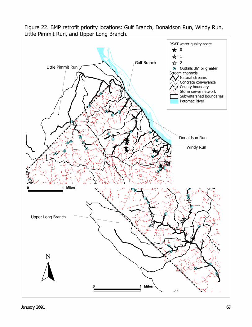
#
Upper Long Branch
Figure 22. BMP retrofit priority locations: Gulf Branch, Donaldson Run, Windy Run, Little Pimmit Run, and Upper Long Branch.
#Y
#Y
#Y
#Y#Y #Y
#Y#Y#Y#Y
#Y#Y
#Y#Y
#Y#Y#Y #Y
#Y
#Y#Y#Y #Y
#Y
#Y#Y
ÊÚÊÚÊÚ
ÊÚÊÚÊÚÊÚ ÊÚ
ÊÚ
ÊÚÊÚ
ÊÚ
ÊÚ
ÊÚÊÚÊÚÊÚÊÚ
0 1 Miles
Potomac RiverSubwatershed boundariesStorm sewer networkCounty boundary
Stream channelsNatural streamsConcrete conveyance
#Y Outfalls 36" or greater
RSAT water quality scoreÊÚ 0ÊÚ 1ÊÚ 2
N
Draft Final--May 200069
#Y
#Y
#Y#Y
#Y#Y#Y#Y#Y
#Y
#Y
#Y#Y
#Y
#Y
#Y
#Y
ÊÚÊÚÊÚ
ÊÚÊÚ
ÊÚ
ÊÚ
#
Donaldson Run
#
Gulf Branch
# Windy Run
0 1 Miles
#
Little Pimmit Run
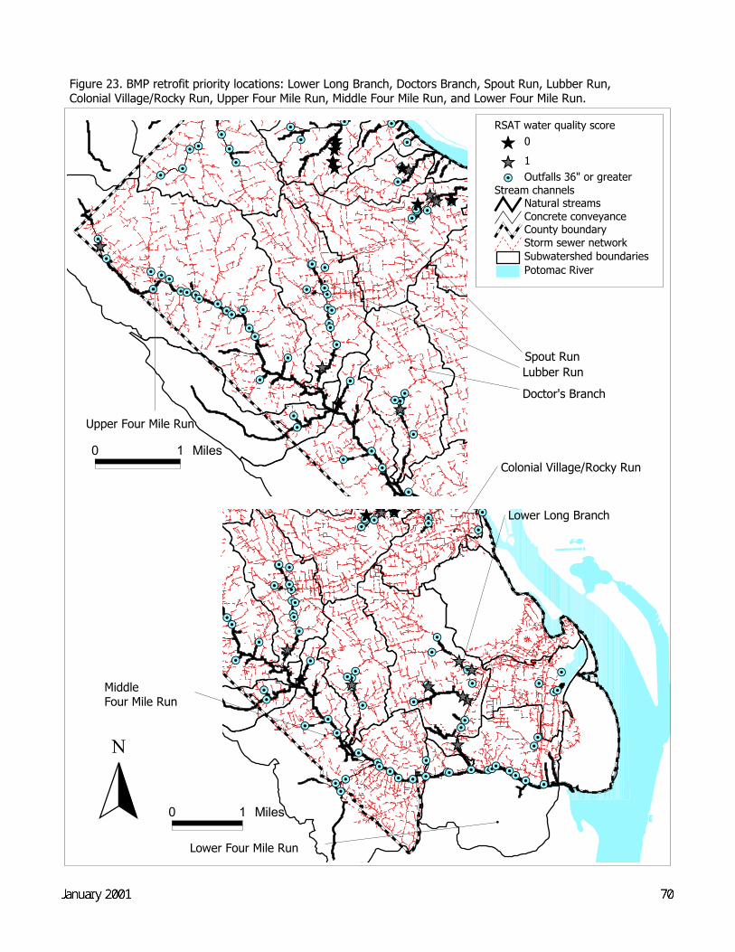
#Y#Y#Y#Y#Y #Y#Y
#Y#Y
#Y
#Y#Y
#Y
#Y#Y
#Y#Y#Y#Y#Y
#Y
#Y#Y#Y#Y#Y#Y#Y
#Y#Y
#Y
#Y#Y
#Y#Y
#Y#Y
#Y#Y#Y
#Y#Y#Y#Y#Y #Y #Y
#Y#Y#Y #Y #Y#Y#Y #Y
#Y#Y #Y
#Y#Y
#Y
#Y
#Y#Y#Y
#Y
#Y #Y#Y#Y
ÊÚÊÚÊÚ
ÊÚ
ÊÚ
ÊÚÊÚÊÚÊÚÊÚ
ÊÚÊÚ
70Draft Final--May 2000
N
Potomac RiverSubwatershed boundariesStorm sewer networkCounty boundary
Stream channelsNatural streamsConcrete conveyance
#Y Outfalls 36" or greater
RSAT water quality scoreÊÚ 0ÊÚ 1
#Y#Y #Y
#Y#Y
#Y#Y
#Y#Y#Y
#Y
#Y#Y
#Y#Y#Y #Y
#Y
#Y#Y#Y#Y
#Y
#Y
#Y#Y#Y#Y#Y#Y#Y
#Y#Y
#Y#Y#Y#Y
#Y#Y#Y#Y#Y #Y#Y#Y#Y #Y#Y
#Y
#Y
#Y#Y
#Y#Y
#Y
#Y
#Y
#Y
#Y
#Y#Y
#YÊÚ
ÊÚÊÚÊÚÊÚÊÚÊÚ
ÊÚ
ÊÚÊÚÊÚÊÚÊÚ
ÊÚÊÚ
Figure 23. BMP retrofit priority locations: Lower Long Branch, Doctors Branch, Spout Run, Lubber Run, Colonial Village/Rocky Run, Upper Four Mile Run, Middle Four Mile Run, and Lower Four Mile Run.
#
Upper Four Mile Run
#
Spout Run
#
Lubber Run#
Doctor's Branch
#
Colonial Village/Rocky Run
#
Lower Long Branch
0 1 Miles#
Lower Four Mile Run
0 1 Miles
#
MiddleFour Mile Run
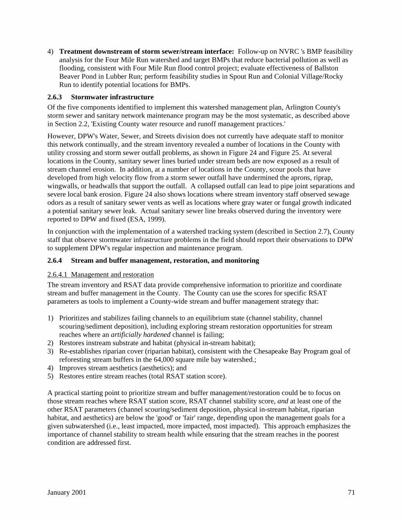
January 2001 71
4) Treatment downstream of storm sewer/stream interface: Follow-up on NVRC 's BMP feasibilityanalysis for the Four Mile Run watershed and target BMPs that reduce bacterial pollution as well asflooding, consistent with Four Mile Run flood control project; evaluate effectiveness of BallstonBeaver Pond in Lubber Run; perform feasibility studies in Spout Run and Colonial Village/RockyRun to identify potential locations for BMPs.
2.6.3 Stormwater infrastructure
Of the five components identified to implement this watershed management plan, Arlington County'sstorm sewer and sanitary network maintenance program may be the most systematic, as described abovein Section 2.2, 'Existing County water resource and runoff management practices.'
However, DPW's Water, Sewer, and Streets division does not currently have adequate staff to monitorthis network continually, and the stream inventory revealed a number of locations in the County withutility crossing and storm sewer outfall problems, as shown in Figure 24 and Figure 25. At severallocations in the County, sanitary sewer lines buried under stream beds are now exposed as a result ofstream channel erosion. In addition, at a number of locations in the County, scour pools that havedeveloped from high velocity flow from a storm sewer outfall have undermined the aprons, riprap,wingwalls, or headwalls that support the outfall. A collapsed outfall can lead to pipe joint separations andsevere local bank erosion. Figure 24 also shows locations where stream inventory staff observed sewageodors as a result of sanitary sewer vents as well as locations where gray water or fungal growth indicateda potential sanitary sewer leak. Actual sanitary sewer line breaks observed during the inventory werereported to DPW and fixed (ESA, 1999).
In conjunction with the implementation of a watershed tracking system (described in Section 2.7), Countystaff that observe stormwater infrastructure problems in the field should report their observations to DPWto supplement DPW's regular inspection and maintenance program.
2.6.4 Stream and buffer management, restoration, and monitoring
2.6.4.1 Management and restoration
The stream inventory and RSAT data provide comprehensive information to prioritize and coordinatestream and buffer management in the County. The County can use the scores for specific RSATparameters as tools to implement a County-wide stream and buffer management strategy that:
1) Prioritizes and stabilizes failing channels to an equilibrium state (channel stability, channelscouring/sediment deposition), including exploring stream restoration opportunities for streamreaches where an artificially hardened channel is failing;
2) Restores instream substrate and habitat (physical in-stream habitat);3) Re-establishes riparian cover (riparian habitat), consistent with the Chesapeake Bay Program goal of
reforesting stream buffers in the 64,000 square mile bay watershed.;4) Improves stream aesthetics (aesthetics); and5) Restores entire stream reaches (total RSAT station score).
A practical starting point to prioritize stream and buffer management/restoration could be to focus onthose stream reaches where RSAT station score, RSAT channel stability score, and at least one of theother RSAT parameters (channel scouring/sediment deposition, physical in-stream habitat, riparianhabitat, and aesthetics) are below the 'good' or 'fair' range, depending upon the management goals for agiven subwatershed (i.e., least impacted, more impacted, most impacted). This approach emphasizes theimportance of channel stability to stream health while ensuring that the stream reaches in the poorestcondition are addressed first.
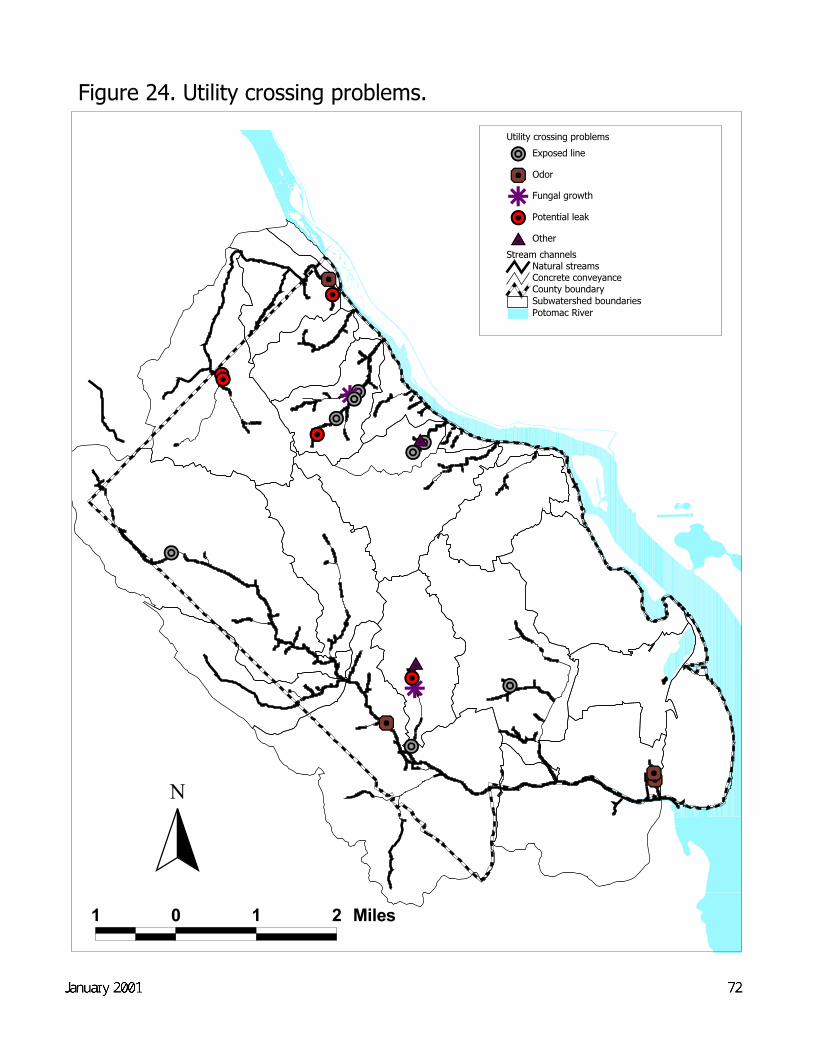
Figure 24. Utility crossing problems.
"º
"º"º$Z
x{"G
"º
x{x{
"G"G "ºr"º"º"G
"º
r"G$Z
x{
1 0 1 2 Miles
Potomac RiverSubwatershed boundariesCounty boundary
Stream channelsNatural streamsConcrete conveyance
Utility crossing problems"º Exposed line
x{ Odor
r Fungal growth
"G Potential leak
$Z Other
N
Draft Final--May 2000 72
']']
']
']']']
']
']
']
']
']
'] ']']
']']
']
']
']
73Draft Final--May 2000
N
Potomac RiverSubwatershed boundariesCounty boundary
Stream channelsNatural streamsConcrete conveyance
'] Storm sewer outfall problems
1 0 1 2 Miles
Figure 25.Storm sewer outfall problems.
January 2001 74
An additional component to this approach could be to explore opportunities to 'daylight' streams that arecurrently in underground pipes by recreating stream channels at the surface.. This process would help torestore the County's stream network to its pre-development conditions. The feasibility of 'daylighting' islimited on a County-wide scale, but there may be a number of opportunities to investigate this streamrestoration approach.
In the Four Mile Run watershed, PRCR is currently evaluating opportunities for buffer expansion in thestream valley. The majority of areas PRCR has identified for potential expansion are most suitable as 'nomow' areas, with a few locations where reforestation may be possible.
Field observations at each of the 236 stations surveyed for the inventory also provide a more specific 'todo' list for removing stream obstructions, expanding riparian buffers, removing invasive species, andaddressing channel erosion. In an already eroded urban stream, obstructions such as fallen trees that spana stream channel can exacerbate bank erosion and collapse. Most of the stream obstructions observedduring the inventory were small accumulations of logs and/or other debris which occasionally spanned anentire stream width. Most of the obstructions do not yet present a threat to stream banks but are likely towith further accumulation of debris (ESA, 1999).
Riparian vegetation is widely recognized for its benefits to near-stream and in-stream ecology. Thestream inventory identifies a number of locations where riparian vegetation could be planted or expandedto increase riparian buffer widths. The inventory also noted locations where the County should controlinvasive species such as kudzu and porcelainberry, especially along the tops of stream banks and withinstream channels (ESA, 1999).
In addition, the stream inventory noted actively eroding streams with significant channel downcutting,bank undercutting, bank failure, and gully erosion. These represent priority areas for stream restoration(ESA, 1999).
2.6.4.1.1 Subwatershed strategies
2.6.4.1.1.1 Least impacted subwatersheds (!)
In Gulf Branch and Donaldson Run:• Investigate acquiring land or conservation easements for vacant parcels such as those adjacent to
Glebe Recreation Area in the headwaters of a Gulf Branch tributary;• Improve and coordinate management of publicly-owned streams and buffers (Gulf Branch: Gulf
Branch Nature Center, Glebe Recreation Area, Madison Center; Donaldson Run: Potomac OverlookRegional Park, Taylor Park, and Taylor Elementary; and
• Evaluate priority stream reaches for improvement; focus on stream reaches with total RSAT stationscores less than 30, channel stability scores less than six, and one of the following: channelscouring/sediment deposition scores less than five, instream substrate/habitat scores less than five,riparian habitat scores less than four, stream aesthetics scores less than four. (Figure 26).
Specific stream reach action items (Figure 28, Figure 29, and Figure 30):# Expand riparian buffers at two locations along Gulf Branch mainstem and five locations in
Donaldson Run within the Washington Golf/Country Club;# Remove stream obstruction in Donaldson Run; and# Address active channel erosion at two locations in Gulf Branch and five locations in Donaldson
Run (and restore degraded Taylor Park tributary, with the goal of achieving a 'good' RSATscore).
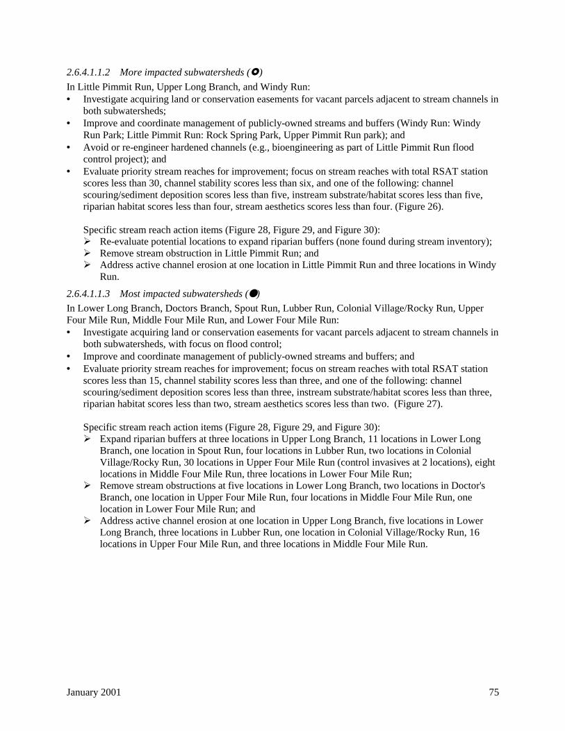
January 2001 75
2.6.4.1.1.2 More impacted subwatersheds (")
In Little Pimmit Run, Upper Long Branch, and Windy Run:• Investigate acquiring land or conservation easements for vacant parcels adjacent to stream channels in
both subwatersheds;• Improve and coordinate management of publicly-owned streams and buffers (Windy Run: Windy
Run Park; Little Pimmit Run: Rock Spring Park, Upper Pimmit Run park); and• Avoid or re-engineer hardened channels (e.g., bioengineering as part of Little Pimmit Run flood
control project); and• Evaluate priority stream reaches for improvement; focus on stream reaches with total RSAT station
scores less than 30, channel stability scores less than six, and one of the following: channelscouring/sediment deposition scores less than five, instream substrate/habitat scores less than five,riparian habitat scores less than four, stream aesthetics scores less than four. (Figure 26).
Specific stream reach action items (Figure 28, Figure 29, and Figure 30):# Re-evaluate potential locations to expand riparian buffers (none found during stream inventory);# Remove stream obstruction in Little Pimmit Run; and# Address active channel erosion at one location in Little Pimmit Run and three locations in Windy
Run.
2.6.4.1.1.3 Most impacted subwatersheds (● )
In Lower Long Branch, Doctors Branch, Spout Run, Lubber Run, Colonial Village/Rocky Run, UpperFour Mile Run, Middle Four Mile Run, and Lower Four Mile Run:• Investigate acquiring land or conservation easements for vacant parcels adjacent to stream channels in
both subwatersheds, with focus on flood control;• Improve and coordinate management of publicly-owned streams and buffers; and• Evaluate priority stream reaches for improvement; focus on stream reaches with total RSAT station
scores less than 15, channel stability scores less than three, and one of the following: channelscouring/sediment deposition scores less than three, instream substrate/habitat scores less than three,riparian habitat scores less than two, stream aesthetics scores less than two. (Figure 27).
Specific stream reach action items (Figure 28, Figure 29, and Figure 30):# Expand riparian buffers at three locations in Upper Long Branch, 11 locations in Lower Long
Branch, one location in Spout Run, four locations in Lubber Run, two locations in ColonialVillage/Rocky Run, 30 locations in Upper Four Mile Run (control invasives at 2 locations), eightlocations in Middle Four Mile Run, three locations in Lower Four Mile Run;
# Remove stream obstructions at five locations in Lower Long Branch, two locations in Doctor'sBranch, one location in Upper Four Mile Run, four locations in Middle Four Mile Run, onelocation in Lower Four Mile Run; and
# Address active channel erosion at one location in Upper Long Branch, five locations in LowerLong Branch, three locations in Lubber Run, one location in Colonial Village/Rocky Run, 16locations in Upper Four Mile Run, and three locations in Middle Four Mile Run.
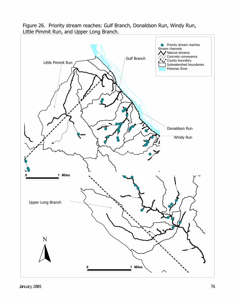
#
Little Pimmit Run
0 1 Miles
# Windy Run
#
Gulf Branch
#
Donaldson Run
#Y#Y
#Y
#Y#Y
#Y#Y
#Y
#Y#Y#Y
#Y
76Draft Final--May 2000
N
Potomac RiverSubwatershed boundariesCounty boundary
Stream channelsNatural streamsConcrete conveyance
#Y Priority stream reaches
0 1 Miles
#Y#Y#Y#Y
#Y#Y#Y#Y#Y
#Y
#Y#Y#Y#Y
#Y
#Y#Y
#Y
#Y#Y#Y
#Y#Y#Y
#Y#Y#Y#Y#Y
#Y#Y
#Y
Figure 26. Priority stream reaches: Gulf Branch, Donaldson Run, Windy Run, Little Pimmit Run, and Upper Long Branch.
#
Upper Long Branch
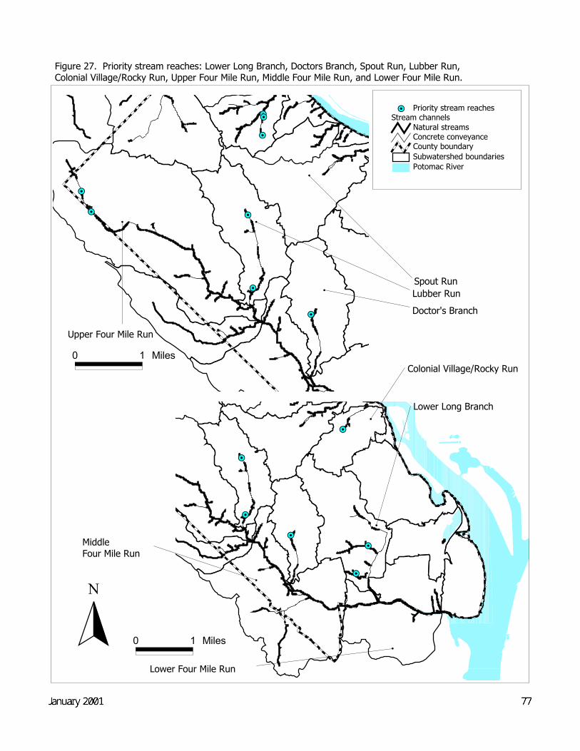
#Y
#Y
#Y
#Y
#Y#Y
#
MiddleFour Mile Run
0 1 Miles
#
Lower Four Mile Run
0 1 Miles
#
Lower Long Branch#
Colonial Village/Rocky Run
#
Doctor's Branch
#
Lubber Run
#
Spout Run
#
Upper Four Mile Run
Figure 27. Priority stream reaches: Lower Long Branch, Doctors Branch, Spout Run, Lubber Run, Colonial Village/Rocky Run, Upper Four Mile Run, Middle Four Mile Run, and Lower Four Mile Run.
#Y
#Y
#Y
#Y
#Y#Y
#Y
#Y
Potomac RiverSubwatershed boundariesCounty boundary
Stream channelsNatural streamsConcrete conveyance
#Y Priority stream reaches
N
Draft Final--May 2000 77
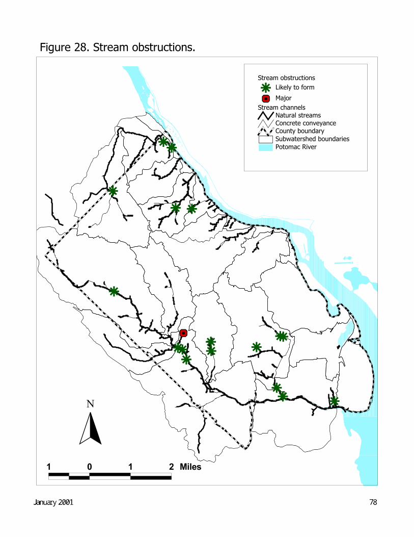
r
r
rr
rr
rrr
r
rr
rr
rrrx{
78Draft Final--May 2000
N
Potomac RiverSubwatershed boundariesCounty boundary
Stream channelsNatural streamsConcrete conveyance
Stream obstructionsr Likely to formx{ Major
1 0 1 2 Miles
Figure 28. Stream obstructions.
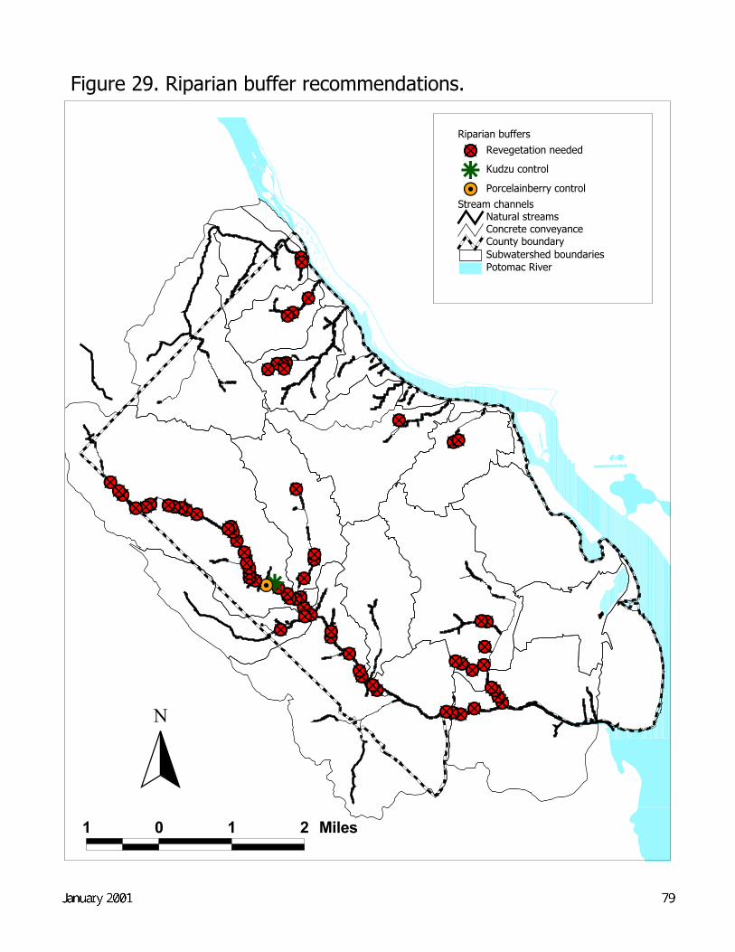
"M"M"M"M"M"M"Mr#Y
"M"M"M"M"M"M"M"M"M"M
"M"M"M"M"M"M"M"M"M"M"M
"M"M"M
"M"M"M
"M"M
"M"M"M
"M
"M"M"M"M"M"M"M"M"M"M"M
"M"M"M
"M"M"M
"M"M"M"M"M
"M"M"M"M
"M"M
"M"M
79Draft Final--May 2000
N
Potomac RiverSubwatershed boundariesCounty boundary
Stream channelsNatural streamsConcrete conveyance
Riparian buffers"M Revegetation needed
r Kudzu control#Y Porcelainberry control
1 0 1 2 Miles
Figure 29. Riparian buffer recommendations.
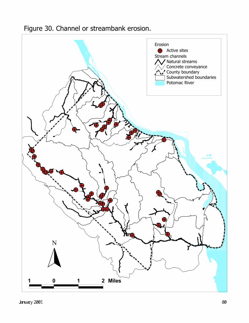
"²"²"²"²"²
"²"²
"²"²"²"²"²"²"²"²"²
"²"²"²
"²
"²
"²
"²"²"²
"²"²"²
"²"²
"²
"²"²
"²"²"²"²"²
"²
"²"²
80Draft Final--May 2000
N
Potomac RiverSubwatershed boundariesCounty boundary
Stream channelsNatural streamsConcrete conveyance
Erosion"² Active sites
1 0 1 2 Miles
Figure 30. Channel or streambank erosion.

January 2001 81
2.6.4.2 Monitoring
During the stream inventory, ESA and Arlington County established 15 'long-term' monitoring stations in10 subwatersheds. At these stations, the County measured channel cross sections, installed bank pins tomeasure stream channel erosion and downcutting, and performed a screening-level macroinvertebratesurvey, with specimen identification to the family level.
These 15 stations will serve as focal points for future in-stream monitoring. EPO has already haddiscussions with Arlingtonians for a Clean Environment (ACE), Audubon Naturalist Society (ANS),Potomac Conservancy, and Friends of Four Mile Run to discuss coordinated stream monitoring inArlington County at these stations. Volunteer citizen monitors will be critical for staffing this effort, andthese groups have large memberships from which to draw. Ideally, a citizen watershed coordinator orteam would be appointed for each County subwatershed to help oversee and coordinate monitoringactivities.
Monitoring activities at the 15 stations will consist of:
• Biological monitoring for macroinvertebrates, with identification to the genus level, using standardmethods such as EPA's Rapid Bioassessment Protocol for Use in Streams and Wadeable Rivers(EPA, 1999a);
• Chemical monitoring during baseflow and stormflow conditions; and• Physical monitoring of streamflow and channel characteristics.
The objectives of such monitoring include:
• Refining baseline subwatershed conditions that account for seasonal and meteorological variation;• Measuring changes in stream hydrology and chemistry, stream channel morphology, and stream
biology over time to assess progress towards the management goals for the three categories ofsubwatersheds—including the effects of BMPs and stream restoration, as well as developmentprojects, on stream health;
• Determining the extent, magnitude, and variability of fecal coliform pollution in the Four Mile Runwatershed (building on the NVRC bacterial DNA study).
Clearly, these monitoring activities cannot be conducted simultaneously at all 15 stations because oflimited staff and funds. With input from ACE, ANS, NVRC, adjacent jurisdictions with monitoringprograms such as Fairfax County, and others, EPO will develop a monitoring plan and a schedule forimplementation. In the meantime, EPO and ANS are planning a macroinvertebrate sampling event at oneor two of the 15 monitoring stations to assess citizen interest and to evaluate results obtained with a morerigorous and detailed sampling methodology with the preliminary macroinvertebrate data collected duringthe stream inventory.
EPO already has stream monitoring equipment that includes a portable automatic sampler, a portablecolorimeter for chemical tests, a flow meter, a stream probe that measures parameters such as dissolvedoxygen, conductivity, pH, and temperature, and macroinvertebrate sampling nets. The County's SourceControl Fund can provide funding for additional equipment, such as water level monitors, needed for aCounty-wide monitoring program.
The County will also continue to monitor four storm sewer outfalls as required by its MS4 Permit. As thestormwater dataset increases in size and the magnitude and seasonal characteristics of pollutant loadings
January 2001 82
from the four outfalls can be determined with more confidence, the County can use the data to targetstormwater management strategies for the four land use types drained by the four outfalls.
2.6.5 Pollution prevention and watershed education
Pollution prevention and watershed education programs can be categorized as follows:
• Programs targeting citizens;• Programs targeting public and private entities, such as County facilities, private businesses, and
developers; and• Programs targeting County employees responsible for stream and buffer management.
As described in the 'Existing County water resource and runoff management practices' section of thisreport, Arlington County, along with NVRC, ACE, and Arlington VCE, implement a wide range ofprograms targeting citizens. These activities could be improved by better communication among theresponsible agencies (e.g., a committee could be established to exchange ideas and coordinate programs),but, ultimately, these programs are well-run and moderately effective.
Arlington County should also consider installing signs in high-visibility areas that mark the drainageboundaries for County subwatersheds. These signs, in conjunction with 'watershed walks', would bevaluable educational tools to raise watershed awareness and reinforce the 'know your watershed address'theme. The County should also make use of television and radio in its public awareness efforts becauseof their proven ability to reach a much wider audience. Targeted mailings to residents in specificsubwatersheds or to riparian property owners should also be used.
The County has not been very active in the other two categories of watershed education described at thebeginning of this section. Given the 'ultra-urban' nature of Arlington County, programs that target thepublic and private office, commercial, and industrial sites in the County are also critical to the success ofa watershed management program—and compliance with the 'maximum extent practicable' provisions ofthe County's MS4 permit. The GIS-based land use analysis presented in this plan can be used as a tool totarget these facilities.
To start this process, Arlington County should develop a brochure for site owners and occupants thatdescribes: a) Arlington County's legal responsibility to control stormwater runoff and stream pollution; b)how buildings, parking lots, and typical site operations contribute to increased stormwater runoff andstream pollution; and, c) what can be done to reduce these impacts (e.g., bioretention areas to treatparking lot runoff, rooftop gardens, covered waste piles, etc.). Used in conjunction with a program suchas a stormwater utility (see 'Implementation plan' section), implementation of activities at a given site thatreduce stormwater runoff and pollution could be encouraged by a reduced utility fee. In the absence of astormwater utility, the County should investigate incentives to implement such programs (for commercialdevelopment, at least), including publicity on the County website, or, possibly, some form of tax relief.
For new development/redevelopment, the Green Building Pilot Program, with an expanded stormwatermanagement component, could serve as a mechanism to encourage site design that minimizes stormwaterrunoff. In fact, an in-line filter manufactured by Vortechnics, Inc., recently received U.S. Green BuildingCouncil (USGBC) certification to fulfill the 'surface water filtration credit of the USGBC's Leadership inEnergy and Environmental Design (LEED) green building rating system (Vortechnics, 2000). In addition,a County-wide stormwater management voluntary program could be created that would set targets forreducing runoff and pollution from different types of sites.
January 2001 83
For residents, schools, and non-profit groups, the Source Control Fund could be used to support an annualsmall watershed grants program, with awards of $10,000 to $20,000 to fund stream restoration projectsCounty-wide.
Internally, Arlington County's stream and buffer management practices have improved over the years—streambank stabilization projects in portions of Four Mile Run and Donaldson Run, for example, provideevidence of sound restoration practices. Yet, both the Planning and Design and Parks and NaturalResources divisions of PRCR have identified a need for better education for staff about stream and buffermaintenance. Similarly, DPW's Engineering division, which oversees streambank stabilization andimprovement projects in the County, could benefit from stream restoration training to improve theeffectiveness of the division's stream projects. Time is limited for members of these PRCR and DPWdivisions to attend formal training classes to improve their management practices. However, a one- ortwo-day, on-site seminar would be a good place to start.
In addition, facilitated by the recent redesign of the County Internet site, EPO plans to expand theinformation provided on its own homepage to include much of the data presented in this WatershedManagement Plan, including maps and photos, along with water-related educational information. EPOwill start working on this effort with the County's contracted web designers during the summer of 2000.
2.7 Watershed Tracking System
Coordinated and systematic implementation of the actions identified in this Watershed Management Planis critical to successful local water resource management in Arlington. A key component for suchcoordinated implementation—and therefore for effective watershed management— will be an informationsystem (or systems) to track:
1) Development projects in the County, including size, impervious cover, and location, as well asimplementation and enforcement data for the Stormwater Detention, Chesapeake Bay Preservation,and Erosion and Sediment Control ordinances;
2) Spills and illicit discharges;3) Stormwater BMPs and BMP retrofits, including type, cost, inspection, and maintenance data;4) Stormwater infrastructure projects, including I&I and sanitary sewer leak data; and5) Stream and buffer projects, including restoration project costs, and physical, chemical, and biological
stream monitoring data, and buffer reforestation data.
By consolidating the key measures of development, runoff management, and stream health, thisinformation system will facilitate evaluation at the subwatershed level of the cumulative effects ofindividual development decisions in the County on streams and buffers. The system will also allow staffto assess the effectiveness of runoff management, stream restoration, and watershed education/pollutionprevention strategies. Table 12 provides the major element and subelements of this system, organizedaccording to the watershed management categories identified in this plan. The table also provides, whereknown, the data owner, the format of the data, and the frequency of update.
As indicated by Table 12, developing such a system will not be an easy task. Many data elements are notcurrently collected, and the data elements that are available are not all in a consistent format. Further, realtime acquisition of some data may not be possible. However, the table also indicates that some dataelements are already available and others will begin to be collected soon.
In particular, CPHD's Inspection Services Division maintains the 'Permits Plus' system, which tracks allbuilding permits issued in the County. This extensive system includes parcel information such aslocation, size, and building square footage. DES and CPHD have had preliminary discussions about the
January 2001 84
possibility of expanding the system to include information connected to a specific parcel—especiallyinformation related to the Stormwater Detention Ordinance, Chesapeake Bay Preservation Ordinance, andErosion and Sediment Control Ordinance.
The next steps include meeting with data owners to refine data availability and format, working withCPHD's data systems specialist to determine the feasibility of expanding the Permits Plus system, andoutlining the design for the other portions of the system. The goal is to develop procedures for dataacquisition and entry and to construct a georeferenced database (or series of databases) that can beaccessed by staff County-wide.
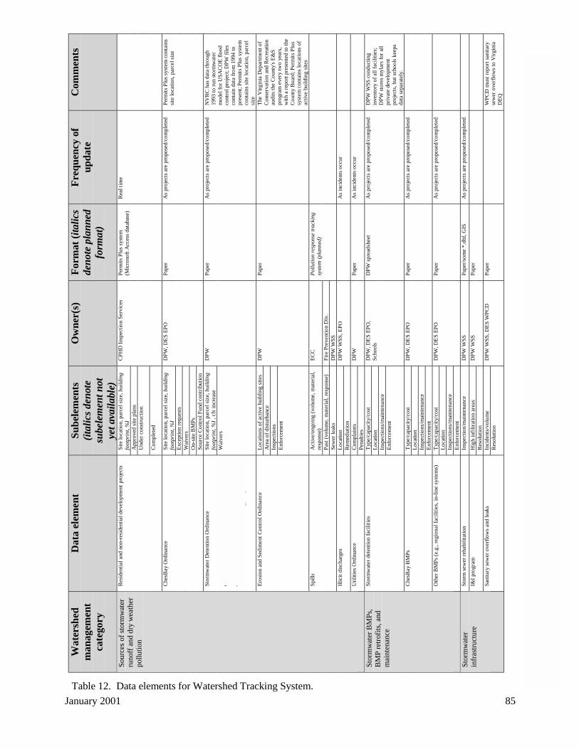
Janu
ary
2001
85
Wat
ersh
edm
anag
emen
tca
tego
ry
Dat
a el
emen
tS
ub
elem
ents
(ita
lics
den
ote
sube
lem
ent n
otye
t ava
ilab
le)
Ow
ner(
s)F
orm
at (
ital
ics
den
ote
plan
ned
form
at)
Fre
qu
ency
of
up
dat
eC
omm
ents
Site
loca
tion,
par
cel s
ize,
bui
ldin
gfo
otpr
int,
%I
App
rove
d si
te p
lans
Und
er c
onst
ruct
ion
Res
iden
tial
and
non
-res
iden
tial
dev
elop
men
t pr
ojec
ts
Com
plet
ed
CP
HD
Ins
pect
ion
Ser
vice
sP
erm
its P
lus
syst
em(M
icro
soft
Acc
ess
data
base
)R
eal t
ime
Site
loca
tion,
par
cel s
ize,
bui
ldin
gfo
otpr
int,
%I
Exc
epti
on r
eque
sts
Wai
vers
On-
site
BM
Ps
Che
sBay
Ord
inan
ce
Sou
rce
Con
trol
Fun
d co
ntri
butio
n
DP
W, D
ES
EP
OP
aper
As
proj
ects
are
pro
pose
d/co
mpl
eted
Per
mits
Plu
s sy
stem
con
tain
ssi
te lo
catio
n, p
arce
l siz
e
Site
loca
tion,
par
cel s
ize,
bui
ldin
gfo
otpr
int,
%I
, cfs
incr
ease
Sto
rmw
ater
Det
entio
n O
rdin
ance
Tab
le 1
2. D
ata
elem
ents
for
Wat
ersh
ed T
rack
ing
Sys
tem
Wai
vers
DP
WP
aper
As
proj
ects
are
pro
pose
d/co
mpl
eted
NV
RC
has
dat
a th
roug
h19
93 to
run
sto
rmw
ater
mod
el f
or U
SA
CO
E f
lood
cont
rol p
roje
ct; D
PW
file
sco
ntai
n da
ta f
rom
199
4 to
pres
ent;
Per
mit
s P
lus
syst
emco
ntai
ns s
ite lo
catio
n, p
arce
lsi
zeL
ocat
ions
of
acti
ve b
uild
ing
site
sA
rea
of d
istu
rban
ceIn
spec
tions
Ero
sion
and
Sed
imen
t C
ontr
ol O
rdin
ance
Enf
orce
men
t
DP
WP
aper
The
Vir
gini
a D
epar
tmen
t of
Con
serv
atio
n an
d R
ecre
atio
nau
dits
the
Cou
nty'
s E
&S
prog
ram
eve
ry t
wo
year
s,w
ith a
rep
ort p
rese
nted
to th
eC
ount
y B
oard
; Per
mits
Plu
ssy
stem
con
tain
s lo
cati
ons
ofac
tive
bui
ldin
g si
tes
Act
ive/
ongo
ing
(vol
ume,
mat
eria
l,re
spon
se)
EC
C
Pas
t (v
olum
e, m
ater
ial,
resp
onse
)F
ire
Pre
vent
ion
Div
.
Spi
lls
Sew
er le
aks
DP
W W
SS
Pol
luti
on r
espo
nse
trac
king
syst
em (
plan
ned)
Loc
atio
nIl
licit
disc
harg
esR
emed
iati
onD
PW
WS
S, E
PO
As
inci
dent
s oc
cur
Com
plai
nts
Sou
rces
of
stor
mw
ater
runo
ff a
nd d
ry w
eath
erpo
lluti
on
Uti
litie
s O
rdin
ance
Pen
alti
esD
PW
Pap
erA
s in
cide
nts
occu
r
Typ
e/ca
paci
ty/c
ost
Loc
atio
nIn
spec
tions
/mai
nten
ance
Sto
rmw
ater
det
entio
n fa
cilit
ies
Enf
orce
men
t
DP
W, D
ES
EP
O,
Sch
ools
DP
W s
prea
dshe
etA
s pr
ojec
ts a
re p
ropo
sed/
com
plet
edD
PW
WS
S c
ondu
ctin
gin
vent
ory
of a
ll fa
cilit
ies;
DP
W s
tore
s m
ylar
s fo
r al
lpr
ivat
e de
velo
pmen
tpr
ojec
ts, b
ut s
choo
ls k
eeps
data
sep
arat
ely.
Typ
e/ca
paci
ty/c
ost
Loc
atio
nIn
spec
tions
/mai
nten
ance
Che
sBay
BM
Ps
Enf
orce
men
t
DP
W, D
ES
EP
OP
aper
As
proj
ects
are
pro
pose
d/co
mpl
eted
Typ
e/ca
paci
ty/c
ost
Loc
atio
nIn
spec
tions
/mai
nten
ance
Sto
rmw
ater
BM
Ps,
BM
P re
trof
its,
and
mai
nten
ance
Oth
er B
MP
s (e
.g.,
regi
onal
fac
ilit
ies,
in-l
ine
syst
ems)
Enf
orce
men
t
DP
W, D
ES
EP
OP
aper
As
proj
ects
are
pro
pose
d/co
mpl
eted
Sto
rm s
ewer
reh
abil
itatio
nIn
spec
tion/
mai
nten
ance
DP
W W
SS
Pap
er/s
ome
*.db
f, G
ISA
s pr
ojec
ts a
re p
ropo
sed/
com
plet
ed
Hig
h in
filtr
atio
n ar
eas
I&I
prog
ram
Res
olut
ion
DP
W W
SS
Pap
er
Inci
dent
s/vo
lum
e
Sto
rmw
ater
infr
astr
uctu
re
San
itary
sew
er o
verf
low
s an
d le
aks
Res
olut
ion
DP
W W
SS
, DE
S W
PC
DP
aper
WP
CD
mus
t re
port
san
itary
sew
er o
verf
low
s to
Vir
gini
aD
EQ
Table 12. Data elements for Watershed Tracking System.
January 2001 85
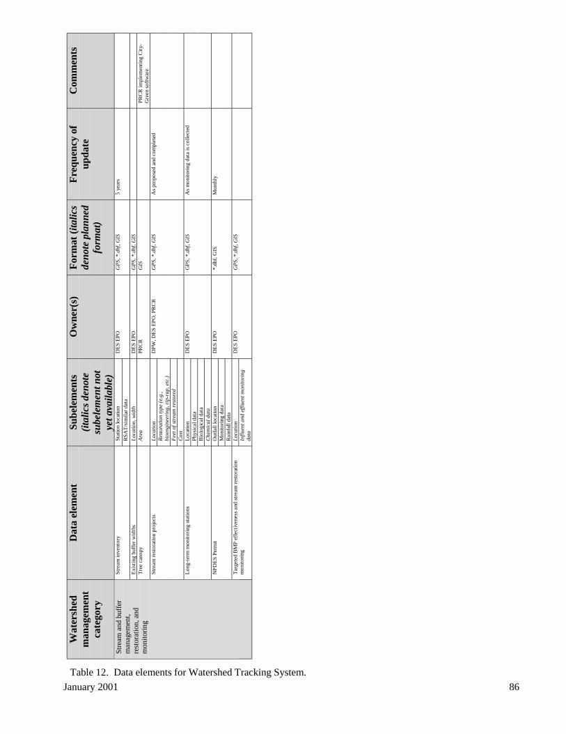
Janu
ary
2001
86
Wat
ersh
edm
anag
emen
tca
tego
ry
Dat
a el
emen
tS
ub
elem
ents
(ita
lics
den
ote
sube
lem
ent n
otye
t ava
ilab
le)
Ow
ner(
s)F
orm
at (
ital
ics
den
ote
plan
ned
form
at)
Fre
qu
ency
of
up
dat
eC
omm
ents
Sta
tion
loca
tion
Str
eam
inve
ntor
y
RS
AT
/sim
ilar
data
DE
S E
PO
GP
S, *
.dbf
, GIS
5 ye
ars
Exi
stin
g bu
ffer
wid
ths
Loc
atio
n, w
idth
DE
S E
PO
GP
S, *
.dbf
, GIS
Tre
e ca
nopy
Are
aP
RC
RG
ISP
RC
R im
plem
enti
ng C
ity-
Gre
en s
oftw
are
Loc
atio
nR
esto
rati
on ty
pe (
e.g.
,bi
oeng
inee
ring
, rip
-rap
, etc
.)F
eet o
f st
ream
res
tore
d
Str
eam
res
tora
tion
proj
ects
Cos
t
DP
W, D
ES
EP
O, P
RC
RG
PS,
*.d
bf, G
ISA
s pr
opos
ed a
nd c
ompl
eted
Loc
atio
nP
hysi
cal d
ata
Bio
logi
cal d
ata
Lon
g-te
rm m
onito
ring
sta
tions
Che
mic
al d
ata
DE
S E
PO
GP
S, *
.dbf
, GIS
As
mon
itori
ng d
ata
is c
olle
cted
Out
fall
loca
tion
Mon
itori
ng d
ata
NP
DE
S P
erm
it
Rai
nfal
l dat
a
DE
S E
PO
*.db
f, G
ISM
onth
ly
Loc
atio
n
Str
eam
and
buf
fer
man
agem
ent,
rest
orat
ion,
and
mon
itor
ing
Tar
gete
d B
MP
eff
ecti
vene
ss a
nd s
trea
m r
esto
ratio
nm
onito
ring
Infl
uent
and
eff
luen
t mon
itor
ing
data
DE
S E
PO
GP
S, *
.dbf
, GIS
Table 12. Data elements for Watershed Tracking System.
January 2001 86
January 2001 87
2.8 Implementation plan
2.8.1 Key Recommendations
The key recommendations in the Watershed Management Plan and Chesapeake Bay PreservationOrdinance Task Force Report can be grouped into the following principal recommendations:
2.8.1.1 Expand street sweeping program
Space is very limited for stormwater facilities in ultra-urban areas like Arlington County. As a result,street sweeping is one of the most cost-effective approaches to removing the sediments and associatedpollutants that accumulate on streets before they wash into streams. Clean streets also have an immediatepay-off in terms of community appearance and can help with economic development efforts.
2.8.1.2 Increase inspections and plan review staff
The key ChesBay Task Force recommendations focus on more comprehensive plan review and morefrequent inspections of development sites. These recommendations will require additional staff, and theireffective implementation also depends on staff trained in low-impact development principles. Inspectionsstaff are also critical for inspecting development sites and inspecting and maintaining both existing andnew stormwater facilities. Because of the potential for substantial redevelopment in Arlington, theChesBay Ordinance and other ordinances provide opportunities for staff to encourage designs with fewerenvironmental impacts. Overall, this recommendation should result in more environmentally sustainableprojects, fewer violations of County ordinances, fewer water quality problems, and fewer citizencomplaints.
2.8.1.3 Revise ChesBay Ordinance
In addition to protecting more Resource Protection Areas, the major impact of revising the ChesBayOrdinance is the opportunity this will provide to improve water quality through the redevelopmentprocess. However, several of the recommendations will require significant policy changes, including: i)developing a definition for open channels (e.g., dry swales and ditches, or only channels containing wateror lined with concrete); ii) developing a straightforward process for citizens and developers to petition toadd or remove an RPA designated property; iii) developing a simple process to administer exceptions orrequire reasonable water quality mitigation measures for small projects like decks and gazebos; iv)developing a defensible method to determine compliance with the ChesBay Ordinance's PerformanceCriteria, which provide potentially powerful tools to require environmentally sound site design; v)developing clear guidelines to determine when Source Control Fund contributions are, or are not,appropriate; vi) setting a Source Control Fund contribution rate that reflects the life-cycle costs of a BMP;and vii) assessing the appropriateness of the existing 38 percent County average impervious threshold,which must be exceeded before the water quality impacts of development are mitigated through a BMP ora contribution to the Source Control Fund.
2.8.1.4 Retrofit, build, and maintain stormwater facilities
Street sweeping does not address pollutants that accumulate on buildings or other impervious surfaces,pollutants like lawn fertilizers that wash onto streets during storms, or pollutants that are deposited byrainfall. To address these sources, stormwater quality facilities that treat runoff during storms are animportant complement to a good sweeping program.
There are several stormwater detention facilities in the County, such as the Ballston Beaver Pond, thatcould be retrofitted to provide improved water quality treatment. In addition, innovative BMPs like theStormceptor®, which is an in-line filtering device, installed at the new Barcroft Sports Center, could beinstalled where appropriate and cost-effective. And, County staff should work closely with developersand their engineers during the site plan review process to encourage innovative designs and water qualityBMPs such as bioretention and 'green' roofs. This approach has been pioneered by the City of Alexandria
January 2001 88
through its Targets of Opportunity BMP program and was used successfully in Arlington during therecent Use Permit review process for the concrete batch plant located in Shirlington.
In addition, regular cleaning of storm sewer catch basins which collect a large volume of sediments andlitter is important to reduce loadings of these pollutants to County streams. EPA recommends catch basincleaning as a cost-effective part of an overall storm water management program, with important waterquality and aesthetic benefits (EPA, 1999b). According to EPA, removal of sediment, debris, andpolluted water from catch basins reduces foul odors, suspended solids, and the load of oxygen demandingsubstances that reach receiving waters. The agency recommends that catch basins should be inspected atleast annually to determine if they need to be cleaned.
Also, inspecting and maintaining the County's up to 50-year old storm sewer system will identifyproblems that may be developing in the system such as clogged inlets, collapsed pipes, and leaking joints,as well as illicit connections prohibited under the County's Municipal Stormwater Permit. Collapsedpipes and leaking joints can saturate soils and cause sinkholes and flooding. Failing pipes can also allowdirt and sediment to enter stormwater, which carries the material out to streams and rivers. In addition,inspecting and maintaining the storm sewer system is important to protect the County's investment in this$350,000,000 infrastructure.
2.8.1.5 Restore and maintain streams
The volume and velocity of runoff from existing impervious surfaces has taken its toll on County streams.Street sweeping and BMPs address water quality but not erosion and habitat problems caused byimpervious cover. The stream inventory provides a prioritized list of stream restoration projects, inconjunction with citizen-identified problem areas. Restoring and maintaining the County's natural stream"infrastructure" can improve stream ecology, as well as enhance recreation and open space.
2.8.1.6 Monitor streams regularly
The stream inventory provided a planning level assessment of conditions County-wide, with an emphasison physical stream habitat. More detailed data, particularly biological data, are needed to fullycharacterize and monitor changes in all County streams. Biological monitoring is crucial because aquaticorganisms reflect the overall health of a stream. Since pollution incidents in urban streams tend to besporadic, periodic chemical or physical monitoring alone will usually miss these incidents. Measuring theabundance and diversity of aquatic organisms provides one of the best performance measures to assessthe health of local streams. Volunteer monitors will be critical to this effort.
2.8.1.7 Educate and involve residents
Arlington residents range from those who are well-versed in environmental issues to those who do notfully understand the role they play in environmental protection. Many residents do not make the personalconnection between home and auto maintenance, lawn care activities, responsible pet waste disposal, orcommunity development standards, and the impact of these activities on stream health. Television, radio,and various print media, as well as the Internet, and field programs will be critical tools to effectivelycommunicate the connection between where and how we live and water quality and to emphasize theshared government and citizen responsibility for stream and riparian stewardship. Without active citizeninvolvement, County efforts will be much less effective.
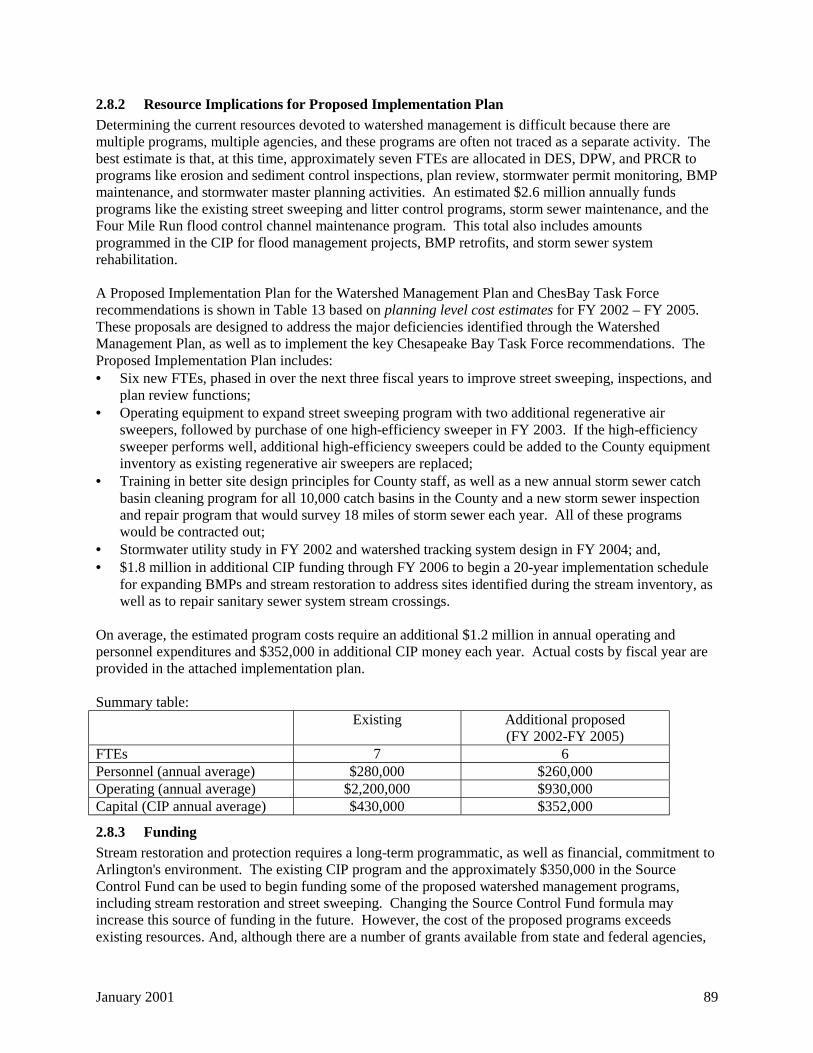
January 2001 89
2.8.2 Resource Implications for Proposed Implementation Plan
Determining the current resources devoted to watershed management is difficult because there aremultiple programs, multiple agencies, and these programs are often not traced as a separate activity. Thebest estimate is that, at this time, approximately seven FTEs are allocated in DES, DPW, and PRCR toprograms like erosion and sediment control inspections, plan review, stormwater permit monitoring, BMPmaintenance, and stormwater master planning activities. An estimated $2.6 million annually fundsprograms like the existing street sweeping and litter control programs, storm sewer maintenance, and theFour Mile Run flood control channel maintenance program. This total also includes amountsprogrammed in the CIP for flood management projects, BMP retrofits, and storm sewer systemrehabilitation.
A Proposed Implementation Plan for the Watershed Management Plan and ChesBay Task Forcerecommendations is shown in Table 13 based on planning level cost estimates for FY 2002 – FY 2005.These proposals are designed to address the major deficiencies identified through the WatershedManagement Plan, as well as to implement the key Chesapeake Bay Task Force recommendations. TheProposed Implementation Plan includes:• Six new FTEs, phased in over the next three fiscal years to improve street sweeping, inspections, and
plan review functions;• Operating equipment to expand street sweeping program with two additional regenerative air
sweepers, followed by purchase of one high-efficiency sweeper in FY 2003. If the high-efficiencysweeper performs well, additional high-efficiency sweepers could be added to the County equipmentinventory as existing regenerative air sweepers are replaced;
• Training in better site design principles for County staff, as well as a new annual storm sewer catchbasin cleaning program for all 10,000 catch basins in the County and a new storm sewer inspectionand repair program that would survey 18 miles of storm sewer each year. All of these programswould be contracted out;
• Stormwater utility study in FY 2002 and watershed tracking system design in FY 2004; and,• $1.8 million in additional CIP funding through FY 2006 to begin a 20-year implementation schedule
for expanding BMPs and stream restoration to address sites identified during the stream inventory, aswell as to repair sanitary sewer system stream crossings.
On average, the estimated program costs require an additional $1.2 million in annual operating andpersonnel expenditures and $352,000 in additional CIP money each year. Actual costs by fiscal year areprovided in the attached implementation plan.
Summary table:Existing Additional proposed
(FY 2002-FY 2005)FTEs 7 6Personnel (annual average) $280,000 $260,000Operating (annual average) $2,200,000 $930,000Capital (CIP annual average) $430,000 $352,000
2.8.3 Funding
Stream restoration and protection requires a long-term programmatic, as well as financial, commitment toArlington's environment. The existing CIP program and the approximately $350,000 in the SourceControl Fund can be used to begin funding some of the proposed watershed management programs,including stream restoration and street sweeping. Changing the Source Control Fund formula mayincrease this source of funding in the future. However, the cost of the proposed programs exceedsexisting resources. And, although there are a number of grants available from state and federal agencies,
January 2001 90
these funding sources, which will be explored where possible, cannot be relied upon as a long-termfunding source.
There are other competing uses for the monies that fund the CIP and General Fund. The WatershedManagement Plan and ChesBay Task Force both recommend that Arlington County seriously consider adedicated, and potentially more equitable, funding source such as a stormwater utility to pay for streamrestoration, BMPs, inspections and plan review staff, and other watershed management programs, as isdone by a number of other Virginia jurisdictions.. The proposed implementation plan calls for astormwater utility needs assessment and feasibility study to be conducted in FY 2002. The purpose ofthis study would be to determine if a stormwater utility could generate enough funds to cover both currentand proposed expenditures for watershed management, replacing current CIP and General Fund sourcesfor these activities.
2.8.4 Conclusion
Even today, after all the progress that has been made towards cleaning up the pollution from factories andwastewater treatment plants, the threats posed to streams by urban development and runoff remain one ofthe most difficult challenges facing local governments. The Watershed Management Plan provides acomprehensive framework for water resources management in Arlington County and helps us recognizethat healthy urban streams are a key component of a sustainable community and a restored ChesapeakeBay. Even greater attention to "smart" growth management is critical if we are to successfully restore andprotect our remaining streams and open spaces, not only for today's residents, but for future generationsof Arlingtonians as well.
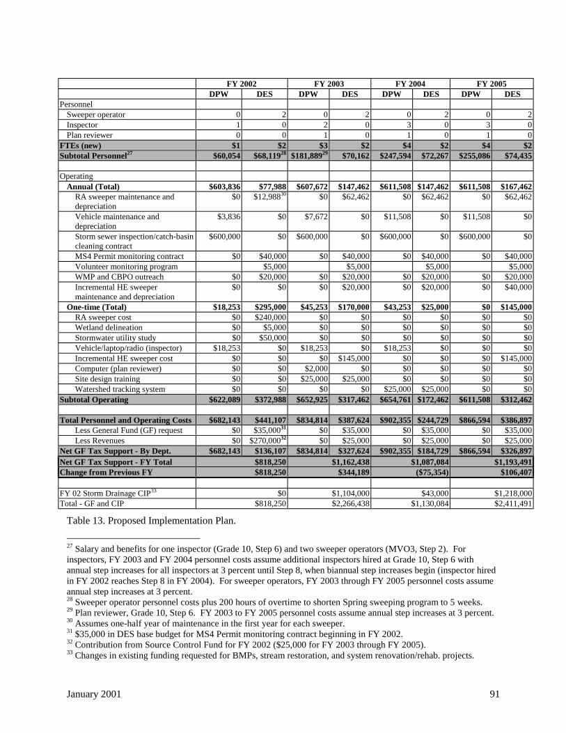
January 2001 91
FY 2002 FY 2003 FY 2004 FY 2005DPW DES DPW DES DPW DES DPW DES
PersonnelSweeper operator 0 2 0 2 0 2 0 2Inspector 1 0 2 0 3 0 3 0Plan reviewer 0 0 1 0 1 0 1 0
FTEs (new) $1 $2 $3 $2 $4 $2 $4 $2Subtotal Personnel27 $60,054 $68,11928 $181,88929 $70,162 $247,594 $72,267 $255,086 $74,435
OperatingAnnual (Total) $603,836 $77,988 $607,672 $147,462 $611,508 $147,462 $611,508 $167,462
RA sweeper maintenance anddepreciation
$0 $12,98830 $0 $62,462 $0 $62,462 $0 $62,462
Vehicle maintenance anddepreciation
$3,836 $0 $7,672 $0 $11,508 $0 $11,508 $0
Storm sewer inspection/catch-basincleaning contract
$600,000 $0 $600,000 $0 $600,000 $0 $600,000 $0
MS4 Permit monitoring contract $0 $40,000 $0 $40,000 $0 $40,000 $0 $40,000Volunteer monitoring program $5,000 $5,000 $5,000 $5,000WMP and CBPO outreach $0 $20,000 $0 $20,000 $0 $20,000 $0 $20,000Incremental HE sweepermaintenance and depreciation
$0 $0 $0 $20,000 $0 $20,000 $0 $40,000
One-time (Total) $18,253 $295,000 $45,253 $170,000 $43,253 $25,000 $0 $145,000RA sweeper cost $0 $240,000 $0 $0 $0 $0 $0 $0Wetland delineation $0 $5,000 $0 $0 $0 $0 $0 $0Stormwater utility study $0 $50,000 $0 $0 $0 $0 $0 $0Vehicle/laptop/radio (inspector) $18,253 $0 $18,253 $0 $18,253 $0 $0 $0Incremental HE sweeper cost $0 $0 $0 $145,000 $0 $0 $0 $145,000Computer (plan reviewer) $0 $0 $2,000 $0 $0 $0 $0 $0Site design training $0 $0 $25,000 $25,000 $0 $0 $0 $0Watershed tracking system $0 $0 $0 $0 $25,000 $25,000 $0 $0
Subtotal Operating $622,089 $372,988 $652,925 $317,462 $654,761 $172,462 $611,508 $312,462
Total Personnel and Operating Costs $682,143 $441,107 $834,814 $387,624 $902,355 $244,729 $866,594 $386,897Less General Fund (GF) request $0 $35,00031 $0 $35,000 $0 $35,000 $0 $35,000Less Revenues $0 $270,00032 $0 $25,000 $0 $25,000 $0 $25,000
Net GF Tax Support - By Dept. $682,143 $136,107 $834,814 $327,624 $902,355 $184,729 $866,594 $326,897Net GF Tax Support - FY Total $818,250 $1,162,438 $1,087,084 $1,193,491Change from Previous FY $818,250 $344,189 ($75,354) $106,407
FY 02 Storm Drainage CIP33 $0 $1,104,000 $43,000 $1,218,000Total - GF and CIP $818,250 $2,266,438 $1,130,084 $2,411,491
Table 13. Proposed Implementation Plan.
27 Salary and benefits for one inspector (Grade 10, Step 6) and two sweeper operators (MVO3, Step 2). Forinspectors, FY 2003 and FY 2004 personnel costs assume additional inspectors hired at Grade 10, Step 6 withannual step increases for all inspectors at 3 percent until Step 8, when biannual step increases begin (inspector hiredin FY 2002 reaches Step 8 in FY 2004). For sweeper operators, FY 2003 through FY 2005 personnel costs assumeannual step increases at 3 percent.28 Sweeper operator personnel costs plus 200 hours of overtime to shorten Spring sweeping program to 5 weeks.29 Plan reviewer, Grade 10, Step 6. FY 2003 to FY 2005 personnel costs assume annual step increases at 3 percent.30 Assumes one-half year of maintenance in the first year for each sweeper.31 $35,000 in DES base budget for MS4 Permit monitoring contract beginning in FY 2002.32 Contribution from Source Control Fund for FY 2002 ($25,000 for FY 2003 through FY 2005).33 Changes in existing funding requested for BMPs, stream restoration, and system renovation/rehab. projects.
January 2001 92
3 ReferencesArlington County, Department of Economic Development. 1999. Potential Development Sites. Arlington County
Government, Arlington, VA.
Arlington County, Department of Environmental Services. 1999. Fiscal Year 1999 Annual Report. VPDES PermitNo. VA0088579. Arlington County Government, Arlington, VA.
Arlington County, Department of Public Works. 1996. Storm Water Master Plan. Arlington County Government,Arlington, VA.
Bannerman, R. 1999. Sweeping Water Clean. American Sweeper Magazine, Vol. 7, No. 1. Schwarze Industries,Huntsville, AL.
Bell, W. and P.C. Champagne. 1998. Targets of Opportunity: Alexandria's Urban Retrofit Program. Proceedings,National Conference on Retrofit Opportunities for Water Resource Protection in Urban Environments. USEPA Office of Research and Development, Washington, DC.
Caraco, D. 2000. The Dynamics of Urban Stream Channel Enlargement. Watershed Protection Techniques 3(3):729-734.
Caraco, D., R. Claytor, P. Hinkle, H.Y. Kwon, T. Schueler, C. Swann, S Vysotsky, and J. Zielinski. 1998. RapidWatershed Planning Handbook. Center for Watershed Protection, Ellicot City, MD.
City of Alexandria. 1992. Alexandria Supplement to the Northern Virginia BMP Handbook. City of Alexandria,Alexandria, VA.
Claytor, R. and T.R. Schueler. 1996. Design of Stormwater Filtering Systems. Center for Watershed Protection,Ellicot City, MD.
Coffman, L. 2000. Low-impact Development Design: A New Paradigm for Stormwater Management Mimickingand Restoring the Natural Hydrologic Regime. Proceedings, National Conference on Tools for UrbanWater Resource Management and Protection. US EPA Office of Research and Development, Cincinnati,OH.
Commonwealth of Virginia. 1997. Permit No. VA008579: Authorization to Discharge Under the Virginia PollutantDischarge Elimination System and the Virginia State Water Control Law. Department of EnvironmentalQuality, Richmond, VA.
Daman. J. 1999. City of Norfolk. Personal communication.
Dunne, T. and L.B. Leopold. 1978. Water in Environmental Planning. W.H. Freeman and Sons, San Francisco, CA.
Environmental Systems Analysis (ESA), Inc. 1999. Provision of a Stream Inventory, Report on WatershedRestoration Opportunities, and Training Services for County Staff in Stream Surveying Techniques.Environmental Systems Analysis, Inc., Annapolis, MD.
Feldberg, R. 2000. Arlington County Department of Parks, Recreation, and Community Resources, Parks andNatural Resources Division. Personal communication.
Frost, W.H. 1995. Delineation of Impervious Area by Remote Sensing. Master's Thesis. University of Maryland,College Park, MD.
Galli, J. 1996. Final Technical Memorandum: Rapid Stream Assessment Technique (RSAT) Field Methods.Metropolitan Washington Council of Governments, Washington, DC.
Los Angeles County, Department of Public Works. 1999. Stormwater Monitoring Report, 1998-1999. Los AngelesCounty Government, Alhambra, CA.
Lubold, G. 1998. Clean a Street, Save a Stream. The Journal, July 17, 1998, Arlington, VA.
Noel, D. et al. 1987. Nationwide Urban Runoff Program Data Report: Washington, D.C. Illinois State WaterSurvey, Department of Energy and Natural Resources, Champaign, IL.
January 2001 93
NVRC. 2000. Illuminating Leaks: Shedding Light on the Sewage Question in Four Mile Run. http://www.novaregion.org/4MileRun/outfall.htm. NVRC, Annandale, VA.
—. 1998. Implementing High Efficiency Water Quality Street Sweeping in the Four Mile Run Watershed: ADemonstration Project. NVRC, Annandale, VA.
—. 1997 (draft). Evaluation of Urban NPS Pollution Control Alternatives: Structural Controls and PollutionPrevention in the Four Mile Run Watershed. NVRC, Annandale, VA.
—. 1993. Regional BMPs in the Four Mile Run Watershed, A Feasibility Investigation. NVRC. Annandale, VA.
NVSWCD. 1994. Developing Successful Runoff Control Programs for Urbanized Areas. NVSWCD. Fairfax, VA.
Schueler, T.R. 1999. Microbes and Urban Watersheds: Concentrations, Sources, and Pathways. WatershedProtection Techniques 3(1): 554-565.
—. 1995. Crafting Better Urban Watershed Protection Plans. Watershed Protection Techniques 2(2): 329-337.
—. 1995. The Importance of Imperviousness. Watershed Protection Techniques 1(3): 100-111.
—. 1987. Controlling Urban Runoff: A Practical Manual for Planning and Designing Urban BMPs. MetropolitanWashington Council of Governments, Washington, DC.
Sherrill, M.G. 1978. Geology and ground water in Door County, Wisconsin, with emphasis on contaminationpotential in the Silurian dolomite. U.S. Geological Survey Water-Supply Paper 2047. U.S. GeologicalSurvey, Madison, WI.
Strecker, E. and K. Reininga. 2000. Integrated Urban Stormwater Master Planning. Proceedings, NationalConference on Tools for Urban Water Resource Management and Protection. US EPA Office of Researchand Development, Cincinnati, OH.
Sutherland, R. and S. Jelen. 1996. Studies Show Sweeping Has Beneficial Impact on Stormwater Quality. AmericanPublic Works Association (APWA) Reporter. APWA, Kansas City, MO.
Sutherland, R. 1995. Street Sweeper Pick-up Performance. Kurahashi and Associates, Inc., Seattle, WA.
US EPA. 1999a. Rapid Bioassessment Protocol for Use in Streams and Wadeable Rivers. Office of Water,Washington, DC.
—. 1999b. Stormwater O&M Fact Sheet: Catch Basin Cleaning. Office of Water, Washington, DC.
—. 1996. National Water Quality Inventory: 1996 Report to Congress. Office of Water, Washington, DC.
—. 1992. Environmental Impacts of Stormwater Discharges: A National Profile. Office of Water, Washington, DC.
Virginia Department of Conservation and Recreation. 2000. Technical Bulletin No. 1: Stream Channel ErosionControl Policy Guidance. Virginia DCR, Richmond, VA.
Vortechnics. 2000. Vortechs System Earns Green Building Credit. Stormwatch. Vortechnics, Inc., Portland, ME.
Waye, D. 2000. NVRC. Personal communication.
Williams, C. 1998. The Stormwater Utility: What's in it for Arlington County? Research paper for Urban Theoryand Public Policy. University of Virginia.
January 2001 94
4 Acronym ListACE Arlingtonians for a Clean EnvironmentANCC Army-Navy Country ClubANS Audubon Naturalist SocietyBAT Best Available TechnologyBMP Best Management PracticeBNR Biological Nutrient ReductionCBLAD Chesapeake Bay Local Assistance DepartmentCfs Cubic foot per secondCOG Metropolitan Washington Council of GovernmentsCPHD Arlington County Department of Community Planning, Housing and DevelopmentCWP Center for Watershed ProtectionDCR Virginia Department of Conservation and RecreationDEA Dog Exercise AreaDED Arlington County Department of Economic DevelopmentDEQ Virginia Department of Environmental QualityDES Arlington County Department of Environmental ServicesDPW Arlington County Department of Public WorksE&S Erosion and sedimentECC Arlington County Emergency Communications CenterEMC Event Mean ConcentrationEPA U.S. Environmental Protection AgencyEPO Arlington County DES Environmental Planning OfficeESA Environmental Systems Analysis, Inc.GIS Geographic Information SystemGLUP General Land Use PlanI&I Infiltration and InflowLEED Leadership in Energy and Environmental DesignMS4 Municipal Separate Storm Sewer SystemMS-19 Minimum Standard 19NDVI Normalized Difference Vegetation IndexNOAA National Oceanic and Atmospheric AdministrationNPDES National Pollutant Discharge Elimination SystemNURP Nationwide Urban Runoff ProgramNVPDC Northern Virginia Planning District Commission, now Northern Virginia Regional CommissionNVSWCD Northern Virginia Soil and Water Conservation DistrictPRCR Arlington County Department of Parks, Recreation, and Community ResourcesRPA Resource Protection AreaRSAT Rapid Stream Assessment TechniqueSWMP Storm Water Master PlanTDS Total dissolved solidsTMDL Total Maximum Daily LoadTPH Total petroleum hydrocarbonsTSS Total suspended solidsUSACOE U.S. Army Corps of EngineersUSGBC U.S. Green Building CouncilUSGS U.S. Geological SurveyVCE Virginia Cooperative ExtensionWPCP Water Pollution Control PlantWSS Arlington County DPW Water, Sewer, and Streets Division
January 2001 95
5 Glossary
Bankfull Flow: Condition where flow fills a stream channel to the top of bank and at a point where thewater begins to overflow onto a floodplain.
Best Management Practices (BMPs): Best Management Practices are structural or nonstructuralpractices, or a combination of practices, designed to act as effective, practicable ways to minimize theimpacts of development and human activity on water quality. Structural BMPs, which include extendeddetention dry ponds, wet ponds, infiltration trenches, sand filters, and in-line filters, rely heavily ongravitational settling and/or infiltration through a porous medium for pollutant removal. NonstructuralBMPs range from programs that increase public awareness to prevent pollution to vegetation-utilizingcontrols such as bioretention areas or wetlands (NVRC, 1996).
Bioengineering: A method of construction using living plants, or plants in combination with dead orinorganic materials. The practice brings together biological, ecological, and engineering concepts toproduce living, functioning systems to prevent erosion, to control sedimentation, and/or to providehabitat.
By-right Development: The type and level of development allowed in a certain zoning district dependingon the classification of that district.
Capital Improvement Program (CIP): A planning tool which provides funding guidelines for the futureinfrastructure needs of Arlington County.
Catch Basin: An inlet chamber usually built at the curb line of a street or low area, for collection ofsurface runoff into a storm sewer or subdrain.
Channel Erosion: The widening, deepening, and headward cutting of small channels and waterways, dueto erosion caused by moderate to large floods.
Chesapeake Bay Preservation Ordinance: As required by Virginia’s Chesapeake Bay Preservation Act(1988), this ordinance authorizes the County Board to designate Chesapeake Bay Preservation Areaswithin which future development must meet performance criteria designed to reduce nonpoint sourcepollution and/or protect the most sensitive lands from disturbance. Those performance criteria include:
• Limiting land disturbance and impervious cover to the amount necessary to provide for desired use ordevelopment.
• Preserving indigenous vegetation as much as possible consistent with use.• Strictly controlling soil erosion during clearing, grading and construction.• Controlling stormwater runoff and its quality, in many cases by employing best management
practices (BMPs), which are natural features or engineered devices that trap runoff and detain it toallow pollutants to settle or filter out.
Erosion and Sediment Control Ordinance: As required by Virginia's Erosion and Sediment ControlAct, requires individuals engaging in land-disturbing activities, such as construction, to submit an erosionand sediment control plan to the County. This plan must be approved by the County before the work canbegin. Applicants and County staff refer to the “Virginia Erosion and Sediment Control Handbook” indesigning and approving the control measures.
January 2001 96
Event Mean Concentration: Flow-weighted concentration of an analyte averaged over the entire lengthof a sampling event.
Fecal Coliform Bacteria: Bacteria that are associated with fecal material and are used to indicate thepossible presence of other waterborne pathogenic bacteria, viruses or parasites.
Illicit Non-stormwater Discharges: Illegal and/or improper waste discharges into storm drainagesystems and receiving waters, including residential or commercial wastewater or hazardous materialssuch as motor oil or paint.
Impervious Cover: Any surface in the urban landscape that cannot effectively absorb or infiltrate rainfall(e.g., streets, sidewalks, parking lots, and buildings).
Infiltration: The downward movement of water from the ground surface to the subsoil and eventuallyinto the groundwater system.
In-line BMP Devices: Devices that are placed internally along the length of a storm sewer system tofilter, treat, or otherwise improve the water quality of stormwater runoff before it enters a waterway.
Invasive Species: Species that are not native to an area, and which can compete aggressively with nativespecies. In their new locations, invasive species lack the natural controls such as predators or disease thatkeep them in balance in their native ecosystem.
Macroinvertebrates: Aquatic insects that live in stream habitats and can be used as indicators of streamhealth. The various species of macroinvertebrates have different levels of sensitivity to changes in streamhabitat, with some being very sensitive and other being very tolerant of pollution.
Municipal Separate Storm Sewer System (MS4) Permit (see also Virginia Pollutant DischargeElimination System Permit): Issued by the Virginia Department of Environmental Quality, this permitgoverns discharges of stormwater and non-stormwater through Arlington County’s storm sewer system,and requires the County to monitor storm water runoff at representative storm sewer outfalls, to screenmajor storm sewer outfalls for illicit discharges, and to demonstrate that the County has effectivemanagement practices in place to reduce storm water pollution to the “maximum extent practicable.”
Non-point source pollution: Contaminants such as sediment, nitrogen and phosphorous, hydrocarbons,heavy metals, and toxins whose sources cannot be pinpointed but rather are washed from the land surfacein a diffuse manner by stormwater runoff.
Outfall: Location where effluent is discharged into receiving waters.
Point Source Pollution: The discernible, confined and discrete conveyance, including but not limited to,any pipe, ditch, channel, tunnel, conduit, well, container, concentrated animal feeding operation, orlandfill leachate collection system from which pollutants may be discharged.
Resource Management Area (RMA): As defined in Arlington’s Chesapeake Bay PreservationOrdinance, RMAs are lands in which improper development will also degrade water quality or diminishthe functional health of the Resource Protection Area. Any use allowed under local zoning is permitted inan RMA, but all new development and redevelopment must meet the performance criteria.
January 2001 97
Resource Protection Area (RPA): As defined in Arlington’s Chesapeake Bay Preservation Ordinance,RPAs are lands with the greatest importance for water quality. They generally include streams and otheropen watercourses, wetlands, and shorelines, as well as a buffer area at least 100 feet wide on thelandward side of these natural features. Within RPAs, activities are generally limited to water-dependentuses such as piers and the redevelopment of existing uses. Requests to develop within RPAs requireanalysis of the water quality impacts of such development.
Rip Rap: A combination of large stone, cobbles, and boulders used to line channels, stabilize banks,reduce runoff velocities, and filter out sediment.
Riparian Buffers: A vegetated or forested area adjacent to a shoreline, wetland, or stream that helps“filter” pollutants and bacteria before they enter the waterway. Development is generally restricted orprohibited in these buffer zones.
Rapid Stream Assessment Technique (RSAT): a field screening approach developed in 1992 by JohnGalli of the Metropolitan Washington Council of Governments (COG) to conduct watershed-wideanalyses for Piedmont streams (Galli, 1996). RSAT incorporates chemical, biological, and physicalindicators to evaluate stream health relative to a reference stream known to have reaches in goodcondition.
Sanitary Sewer: A system of pipes, separate from storm sewers, that carries wastewater from homes andbusinesses to a wastewater treatment plant. In some older urban jurisdictions, the sanitary sewer systemand storm sewer system are combined.
Source Control Fund: A fund established under Section 61-9 of the Chesapeake Bay Ordinance that canbe used for water quality improvements and watershed education. Developers can contribute to this fundin lieu of creating BMPs on properties that they develop. The intent of allowing this contribution is tominimize the proliferation of small BMPs which can be difficult to inspect and maintain.
Storm Sewer: A system of pipes, separate from sanitary sewers, that only carries runoff from buildingsand land surfaces directly to streams. In some older urban jurisdictions, the sanitary sewer system andstorm sewer system are combined.
Stormwater Detention Ordinance: This County ordinance requires new development to maintain runoffcharacteristics similar to those of undeveloped land, regardless of prior land use.
Stormwater Utility: A fee paid by all users of the storm sewer network in a municipality with is used toaddress impacts of stormwater runoff. The fee is proportional to the user’s contribution to stormwaterrunoff, as estimated through a measure of the amount of impervious cover on the lot.
Total Maximum Daily Load (TMDL) Regulations: A TMDL or Total Maximum Daily Load is acalculation of the maximum amount of a pollutant that a waterbody can receive and still meet waterquality standards, and an allocation of that amount to the pollutant's sources. Water quality standards areset by States, Territories, and Tribes. They identify the uses for each waterbody, for example, drinkingwater supply, contact recreation (swimming), and aquatic life support (fishing), and the scientific criteriato support that use. The Clean Water Act, section 303, establishes the water quality standards and TMDLprograms.
Vegetated Roofs: A thin layer of soil and plants placed on the roof of a building, which absorbs rainfallto reduce stormwater runoff, provides additional building insulation, improves air quality, and absorbs
January 2001 98
sunlight to reduce the temperature of the roof, which cools the interior of the building and extends the lifespan of the roof.
Virginia Pollutant Discharge Elimination System (VPDES) Permit (see also Municipal SeparateStorm Sewer System Permit): Issued by the Virginia Department of Environmental Quality, this permitgoverns discharges of stormwater and non-stormwater through Arlington County’s storm sewer system,and requires the County to monitor storm water runoff at representative storm sewer outfalls, to screenmajor storm sewer outfalls for illicit discharges, and to demonstrate that the County has effectivemanagement practices in place to reduce storm water pollution to the “maximum extent practicable.”
Watershed: All the land area that contributes runoff to a particular portion of a waterway.
Zoning: A set of regulations and requirements that govern the use, placement, spacing, and size ofbuildings and lots within a specified area or in a common class (zone).