Embed Size (px)
DESCRIPTION
--- major watershed. --- smaller watershed. watershed. what is a watershed?. The land area that water moves across or under, while flowing to a stream, spring, pond, lake or river The area of land where all of the water that is under it or drains off of it goes into the same place. medium. - PowerPoint PPT Presentation
Citation preview
1July 2003
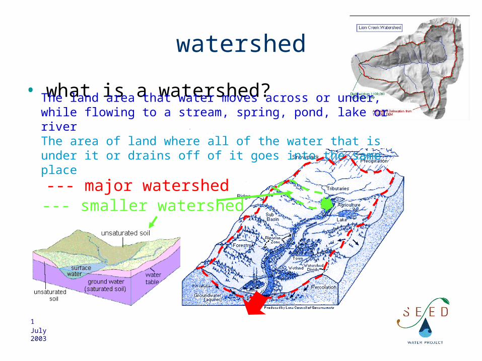
watershed
• what is a watershed?
--- major watershed
The land area that water moves across or under, while flowing to a stream, spring, pond, lake or river The area of land where all of the water that is under it or drains off of it goes into the same place
--- smaller watershed
2July 2003
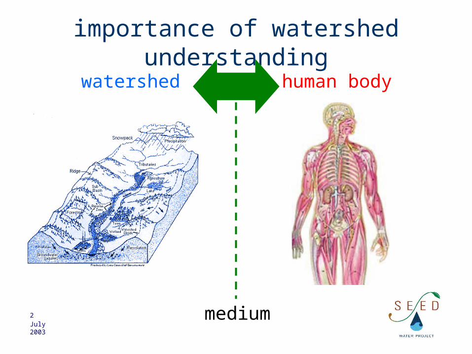
importance of watershed understanding
watershed human body
medium

3July 2003
importance of watershed understanding
watershed human body
health problems
pollution/catastrophe
diseases/injury

4July 2003
importance of watershed understanding
watershed human body
investigation
examination
fieldstudy

5July 2003
importance of watershed understanding
watershed human body
tests
medical analysis
chemical,biological,…
tests

6July 2003
importance of watershed understanding
watershed human body
medication/surgery
diagnostic and action
remediation,law enforcement,
better management,…
7July 2003
watershed
raingroundwater
water input input increasesthe amount ofwater in thewatershed
watershed outlet, domestic, agriculture,and industrial use
transpiration, evaporation…
water output
output decreasesthe amount ofwater in thewatershed
importance of watershed understanding
amount of water available today=
amount of water available yesterday
+water input between today and
yesterday-
water output between today a yesterday
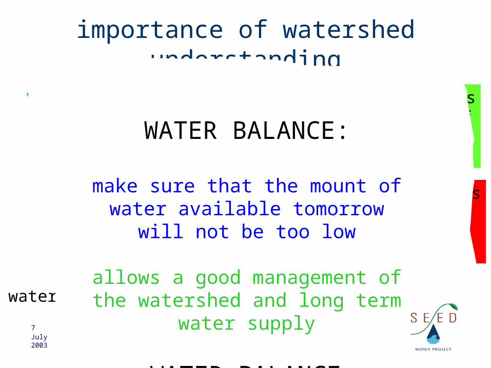
WATER BALANCE
equilibrium means
OUTPUT=INPUT
WATER BALANCE:
make sure that the mount of water available tomorrow will
not be too low
allows a good management of the watershed and long term
water supply
8July 2003
watershed
importance of watershed understanding
Why? Where is thepollution source?
Understanding the watershed also means:
understanding where the water is, how the different water bodies are inter-connected,
in which direction water flows in the watershed
Important to help identify pollution sources

9July 2003
wateshed
• what is a river?
runoff
groundwate
rwater table
a river is surface water, it is where the water table is higher than the ground. It then follows
gravity
recharge
infiltration
tributary
main river
source
discharge
runoff
10July 2003
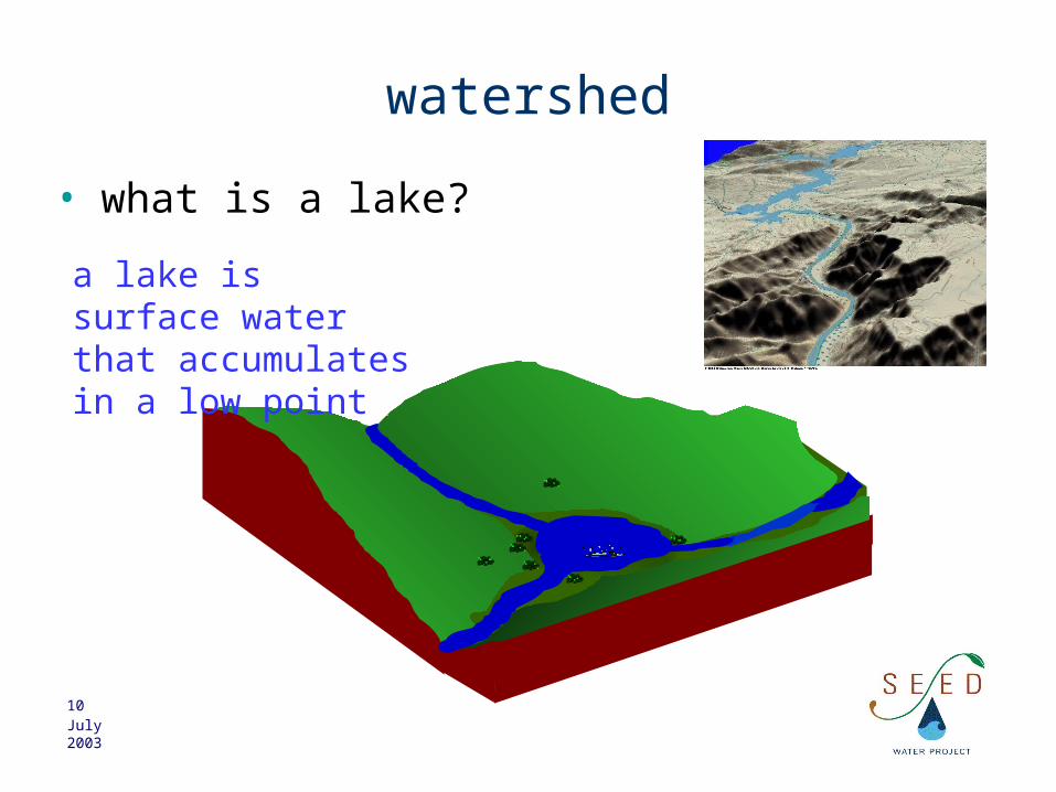
watershed
• what is a lake?
a lake is surface water that accumulates in a low point

11July 2003
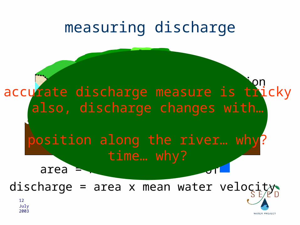
measuring discharge
river
distance
duration (hours)
surface velocity of water = distance / duration
mean velocity of water ~ 0.8 x velocity
12July 2003
measuring discharge
cross-section
area = number of x area of
discharge = area x mean water velocity
accurate discharge measure is trickyalso, discharge changes with…
position along the river… why?time… why?
13July 2003
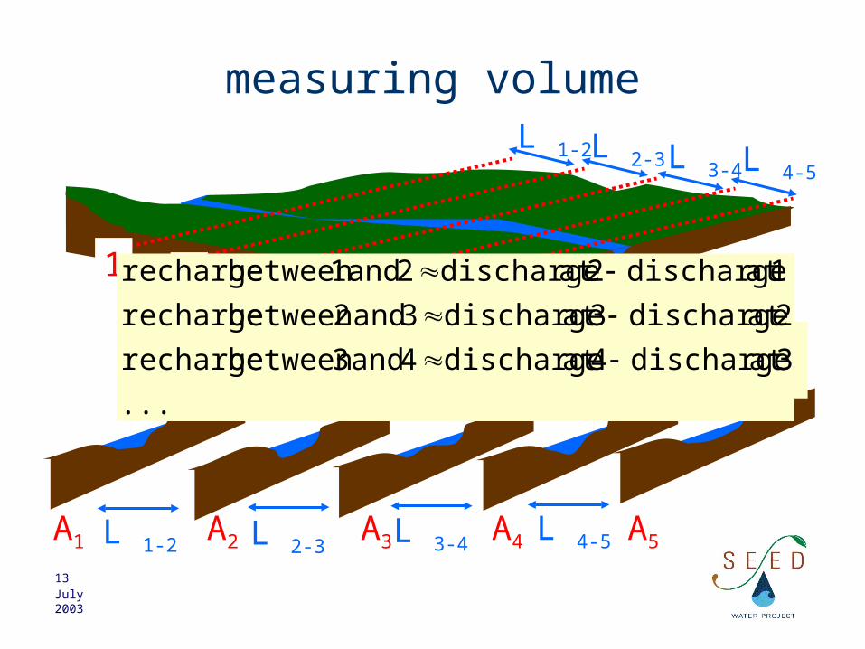
measuring volume
1
A1
2
A2
3
A3
4
A4
5
A5L 1-2 L 2-3 L 3-4 L 4-5
L 4-5L 3-4L 2-3
L 1-2
...2
AAL
2
AAL
2
AAL Volume 43
4332
3221
21
...
3at discharge4at discharge4 and 3between recharge
2at discharge3at discharge3 and 2between recharge
1at discharge2at discharge2 and 1between recharge
14July 2003
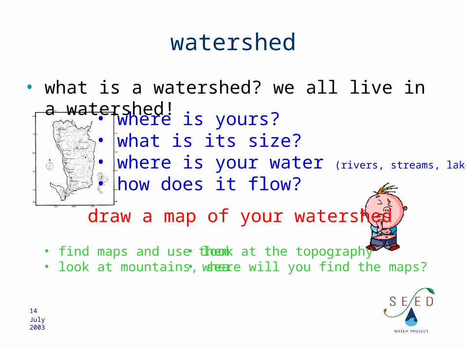
watershed
• what is a watershed? we all live in a watershed!• where is yours?
• what is its size?• where is your water (rivers, streams, lakes) ?• how does it flow?
draw a map of your watershed
• find maps and use them• look at mountains, sea
• look at the topography• where will you find the maps?

15July 2003
water source team
• where are the rivers and streams in your area?
– what names do your rivers have?
– how large are they?
– where do they come from?
– how would you measure their stream-discharge?
– how much water do they have at any time?
complete your map
16July 2003
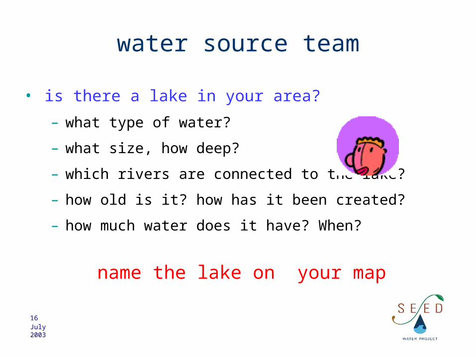
water source team
• is there a lake in your area?
– what type of water?
– what size, how deep?
– which rivers are connected to the lake?
– how old is it? how has it been created?
– how much water does it have? When?
name the lake on your map

17July 2003
groundwater and runoff
• what is groundwater and runoff?
impervious rock
permeableunderground
ground water=aquiferrunoff soil surface

18July 2003
underground structures
soillayer 1
layer 2
impervious rock (granite, clay)bedro
ck

19July 2003
groundwater and runoff
Permeability measures how fast water flowsin the rock. The flow-rate is proportionalto the permeability
L
P
μ
AKQ L
h
A=r2
pressureP = g h
permeability
water viscosity
water density
gravity
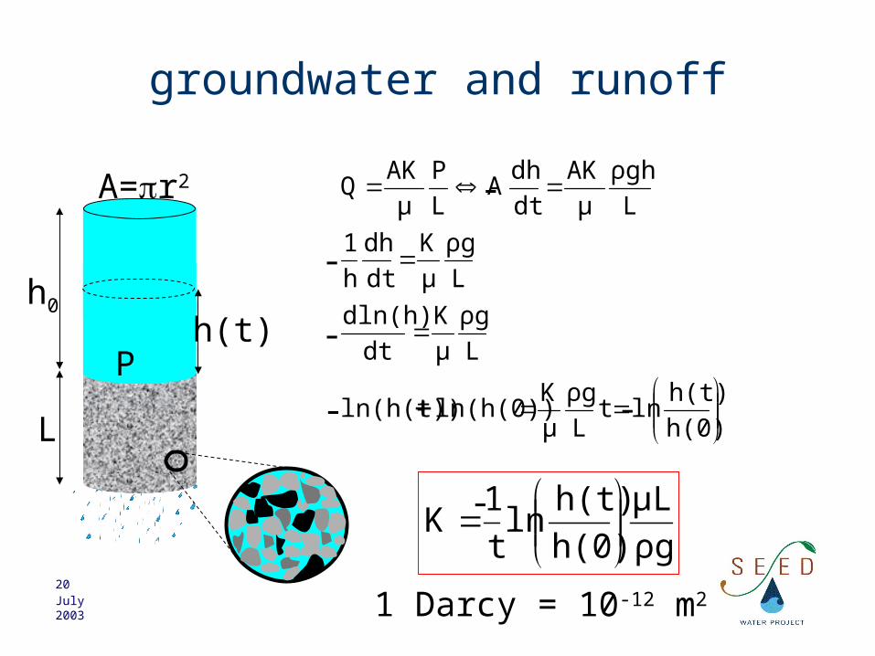
20July 2003
groundwater and runoff
L
ρgh
μ
AK
dt
dhA
L
P
μ
AKQ
L
h0
A=r2
P
ρg
μL
h(0)
h(t)ln
t
1K
L
ρg
μ
K
dt
dln(h)
L
ρg
μ
K
dt
dh
h
1
h(0)
h(t)lnt
L
ρg
μ
Kln(h(0))ln(h(t))
h(t)
- +
-
-
-
-
1 Darcy = 10-12 m2
-

21July 2003
groundwater and runoff
water tank
rock sample
water saturates
Permeability measures how fast
water flowsin the rock.
The flow-rate is proportional
to the permeability
porosity=volume of water in the sample
volume of the sample

22July 2003
K
permeability
enter initial volume of water in ml
enter volume of soil sample in ml
enter time at which measure is made in secondsenter volume of water at measurement in ml
absolute permeability in Darcy (1Darcy=1E-12m2)permeability coefficient in Darcy cm/hpermeability coefficient in Darcy cm/s
μ
kρρK,
L
Dp
μ
AkQ
K is the velocity of waterunder gravity
analysis of experimental (falling head) data

23July 2003
groundwater
soillayer 1
layer 2
bedro
ck
impervious rock (granite, clay)
water-table depthdepth of
aquifer bottom
unconfined aquifer
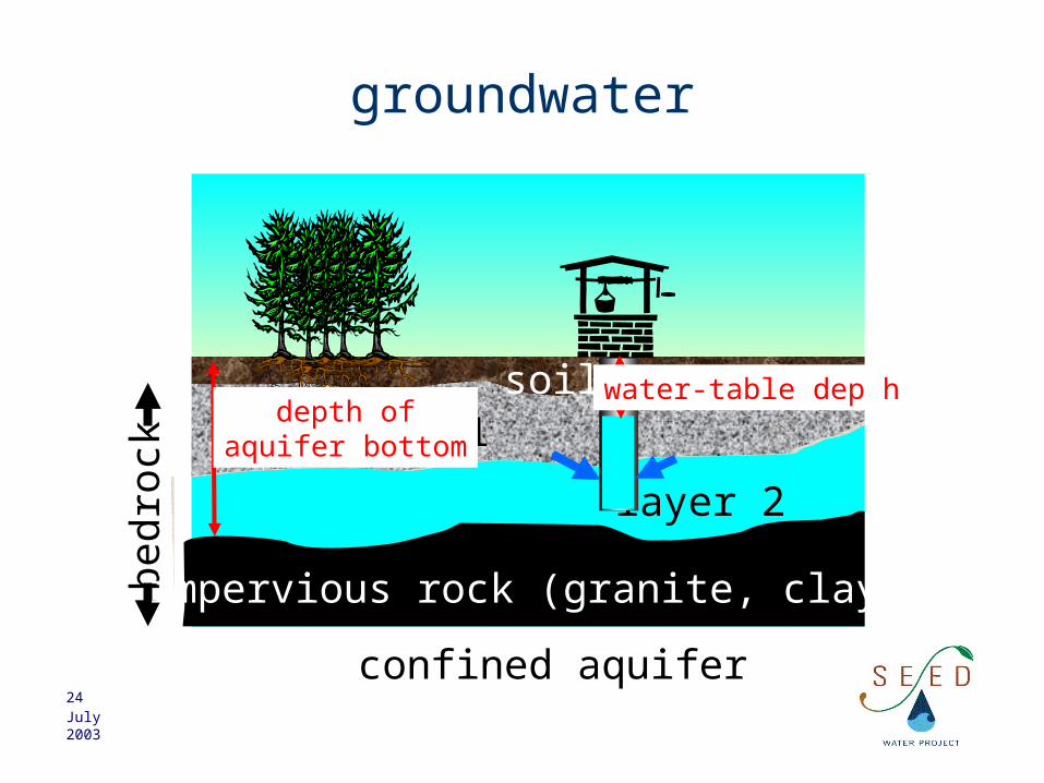
24July 2003
groundwater
soillayer 1
layer 2
bedro
ck
impervious rock (granite, clay)
water-table depthdepth of
aquifer bottom
confined aquifer
25July 2003
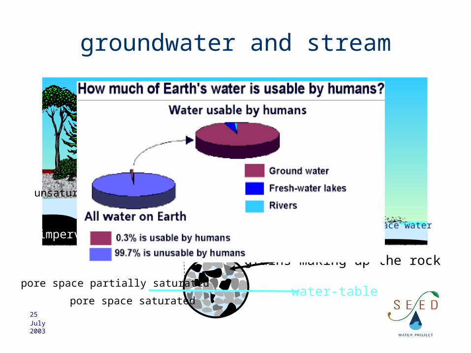
groundwater and stream
surface water
water table
soil
grains making up the rock
water-tablepore space saturated
pore space partially saturated
saturated zone
unsaturated zone
impervious rock

26July 2003
aquifer-stream connections
aquifer gaining
perched aquifer
aquifer loosing
27July 2003
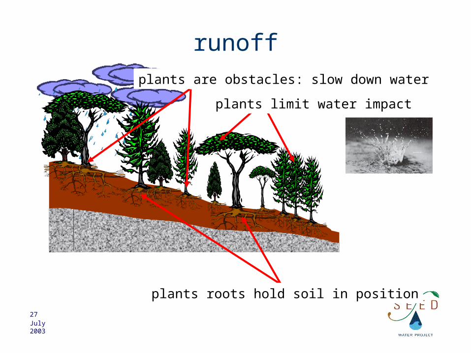
runoff
plants roots hold soil in position
plants are obstacles: slow down water
plants limit water impact

28July 2003
groundwater and runoff
soil erodes
sediment transported tonearby stream
desertification: plant cannot grow back
deforestation can trigger soil erosion,sediment pollution and desertification

29July 2003
runoff
lower runoff higher runoff
the larger the angle, the faster the runoffthe fast the runoff, the larger the erosion force
velocity is proportional to sin(angle)force is proportional to velocity
angleangle
runoffrunoff

30July 2003
water source team
• what is groundwater and runoff?– what parameters affects surface runoff?– how important is runoff in your area?– where can you measure the water-table?– when should you measure it?– how deep is your aquifer?– how could estimate its volume?
complete your map
31July 2003
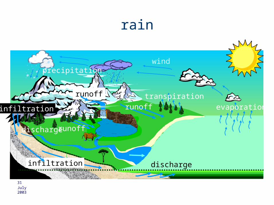
rain
evaporation
windprecipitation
runoff
runofftranspirationrunoff
infiltration
infiltration discharge
discharge

32July 2003
rain
it varies with season
March August September
runoff varies with seasonsfiltration varies seasonriver level and discharge vary with season

33July 2003
amount (mm)
duration (hours)
rule
rrain
• measuring rainintensity =
rainfall amountrainfall duration

34July 2003
water source team
• how is rain on your watershed?– rainfall amount– rainfall intensity– rainfall duration– rainfall distribution– rainfall frequencycomplete your map

35July 2003
water source team
• what would you measure to perform a water balance?
• rain amount?• consumption?• aquifer volumes?• river volumes?• …?

36July 2003
pollution transport and dispersionpoint source pollution
initial extent of pollution
final extent of pollution
dispersion
point source pollution initial extent of pollution
final extent of pollution
dispersiontransport
transport
37July 2003
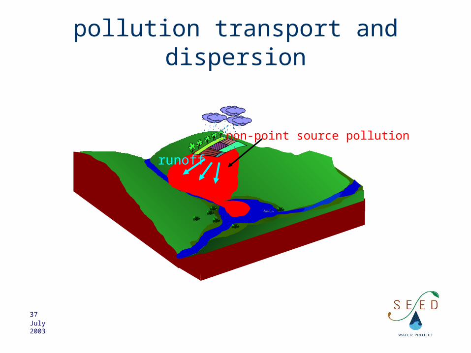
pollution transport and dispersion
non-point source pollution
runoff
38July 2003
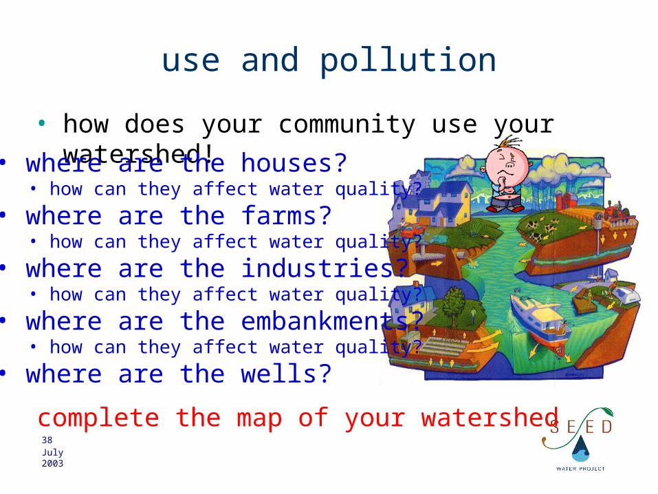
use and pollution
• how does your community use your watershed!• where are the houses?
• how can they affect water quality?
• where are the farms?• how can they affect water quality?
• where are the industries?• how can they affect water quality?
• where are the embankments?• how can they affect water quality?
• where are the wells?
complete the map of your watershed

39July 2003
example
Nongboanoi village, Nam Phong river,Khon Kaen province
500,000 fishes dead,enormous numbers of dead shellfishes and aquatic fauna
December 5th 1997
Hg j gj g jg jg kihik ho u kh kg uf jh loh kg kg iy I gbkjgbjgfj tgj gj gj gt hk hg kh kh k hk y kg kjy kh hi yk h ,jh lk h hk hk hk h kj ;l ;p I;p oi; I [ppo ‘;k ;k k; k; k ;l ;k ;ip uipuilkhk h hk hk h hkhkhk kj khkh kjh kj hkjhkh iu gtf re t jlk jp; kuhjyghfdtyd lk kg jyfgj b li lj lj Hg j gj g jg jg kihik ho u kh kg uf jh loh kg kg iy I gbkjgbjgfj tgj gj gj gt hk hg kh kh k hk y kg kjy kh k hi yk h ,jh lk h hk hk hk h kj ;l ;p I;p oi; I I [ppo ‘;k ;k k; k; k ;l ;k hk hk h kj ;l ;p I;p oi; I I [ppo ‘;k ;k k; k; k ;lkg iy I gbkjgbjgfj tgj gj gj gt hk hg kh kh k hk y kg kjy kh hi yk h ,jh lk h hk hk hk h kj ;l ;p I;p oi; I [ppo ‘;k ;k k; k; k ;l ;k ;ip uipuilkhk h hk hk h hkhkhk kj khkh kjh kj hkjhkh iu gtf re t jlk jp; kuhjyghfdtyd lk kg jyfgj b li lj lj Hg j gj g jg jg kihik ho u kh kg uf jh loh kg kg iy I gbkjgbjgfj tgj gj gj gt hk hg kh kh k hk y kg kjy kh k hi yk h ,jh lk h hk hk hk h kj ;l ;p I;p oi; I I [ppo ‘;k ;k k; k; k ;l ;k hk hk h kj ;l ;p I;p oi; I I [ppo ‘;k ;k k; k; k ;l
Thailand News
why?

40July 2003
1st step
• where is it? find a map, locate village and riverKhon Kaen province
Upper Mae Nam Chin basin
Nam Phong river
Chot
strea
m
Nongboanoivillage
Ubolr
ata
na d
am

41July 2003
2nd step
• ask the locals: what do you think, what do you know?
Nam Phong river
Chot
strea
m
Nongboanoivillage
Ubolr
ata
na d
am
Pulp and paper factory!
wood, bamboo
pulp, paper, organic wastes
42July 2003
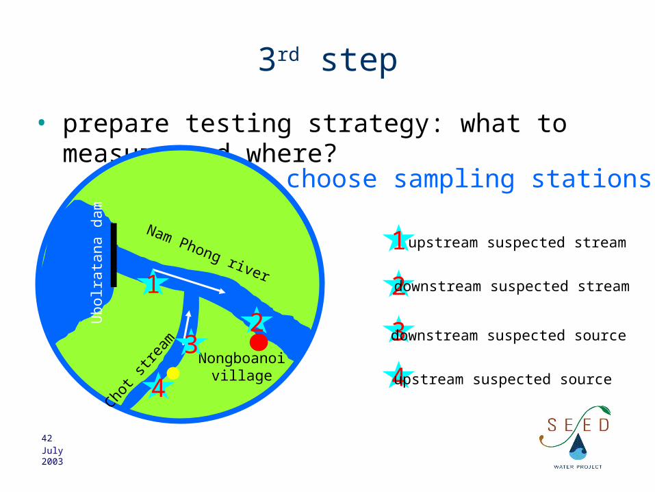
3rd step
• prepare testing strategy: what to measure and where?
Nam Phong river
Chot
strea
m
Nongboanoivillage
Ubolr
ata
na d
am
choose sampling stations
4 4upstream suspected source
3 3downstream suspected source2
2downstream suspected stream1
1 upstream suspected stream

43July 2003
3rd step
• prepare testing strategy: what to measure and where?
Nam Phong river
Chot
strea
m
Nongboanoivillage
Ubolr
ata
na d
am
choose what to measure
4
32
1
organic material
bacterialactivity
decay(tannin/lignin)
BOD, DO tannin
COD
oxidised
44July 2003
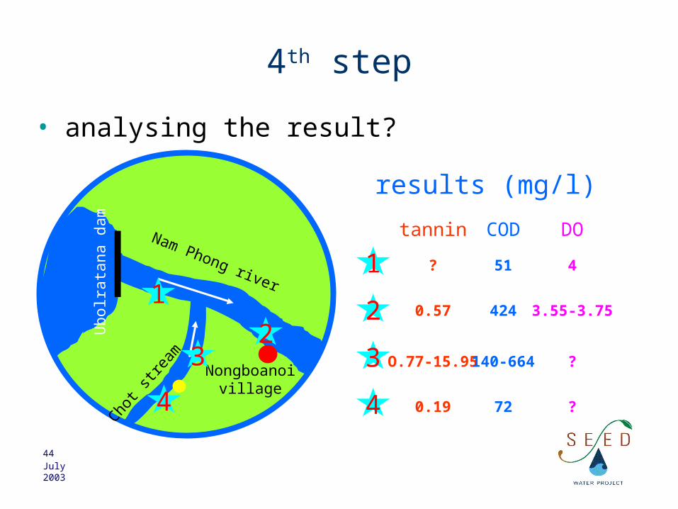
4th step
• analysing the result?
Nam Phong river
Chot
strea
m
Nongboanoivillage
Ubolr
ata
na d
am
results (mg/l)
4
32
1
4
3
2
1
0.19
O.77-15.95
0.57
?
tannin
72
140-664
424
51
COD
?
?
3.55-3.75
4
DO

45July 2003
5th step
• conclusion?
Nam Phong river
Chot
strea
m
Nongboanoivillage
Ubolr
ata
na d
am
4
32
1
Where does pollution come from?
How to improve the investigation?
What could make the investigationmore difficult?