Embed Size (px)
Citation preview
Police .............................................................524-6161
State Police ....................................................524-6161
Sheriff ........................................................... 524-6177
Baraga County Memorial Hospital ................ 524-6166
Marquette General Hospital ..................800-562-9753
Bay Ambulance .............................................353-6789
EMERGENCY NUMBERS:
755 E. Broad St. • L’Anse, MI 49946(906) 524-7444
email: [email protected] site: www.baragacountytourism.com
Baraga CountyTOURIST & RECREATION ASSOCIATION
LAKESUPERIOR
HURON BAY
FINLANDER BAY
HO
UG
HTO
N CO
UN
TY
EIOLA RD
PRIC
KETT
DAM
RD
ARNHEIM RD
Stur
geon
Riv
er
CUT-OFF
CLEAR CREEK RD
Stur
geon
Rive
r
TOW
NLI
NE
RD
SKANEE RD
AURA
RD
SILVER RD
HURON BAY-PESHEKE
GRADE
INDIAN CEMETERY RD
HERMAN RD
NESTORIA HERMAN RD
OLD M-28
Craig LkCrooked Lk
Petticoat Lk
Ruth Lk
Beaufort Lk
Heart Lk
KING LA
KE RD
BAY
SHOR
E RD
LINBLOOM RD
MAP LEG ENDBARAGA CO. TOURIST & RECREATION ASSOC.
Shows location of sites
Camping
Highways
County Roads
Seasonal Roads
IRON COUNTY
MAR
QU
ETTE
CO
UN
TYPO
RTIC
E R
D
1T
LOWER RDLOWER RD
SKANEESKANEE
BIG ERIC’SBIG ERIC’SBIG ERIC’SBRIDGE &BRIDGE &BRIDGE &FALLS
SILVER RIVER FALLS
HERMAN
ALBERTA
US41
CAN YON FALLS
NESTORIA
THREE LAKES
MT. CURWOODMT. CURWOOD
MT. ARVON
COVINGTON King Lk
Vermilac Lk
TIBBETS FALLSTIBBETS FALLS
Big Lk
WATTONWATTON
SILVER MT.SILVER MT.
US141
LITTLE MT.
GR
ISTM
ILL
RD
PLAI
NS
RD
MEN
GE
CREE
K R
D
STURGEON
GORGE RD
PLAI
NS
RD
PRICKETTDAM
ARVO
N R
DAR
VON
RD
L’ANSE
PEQU
AMIN
G RD
AURASECOND SAND BEACHPEQUAMING
PIKES PEAK RD
BARAGABARAGA
KEWEENAWBAY
ZEBA
SKANEE RD
MAI
N ST
FROBERG RDFROBERG RD
PELK
IE R
DPE
LKIE
RD
PELKIEPAPIN RD
KROLIK RD
BELL
AIR
E R
DBE
LLAI
RE
RD
ARNHEIM
MTU FORD FORESTRY CENTER & SAWMILL
MOUTH OF HURON RIVERMOUTH OF HURON RIVER
HURON ISLANDS HURON ISLANDS LIGHTHOUSE
POINT ABBAYE
KEWEENAWBAY
9
Silv
er R
iver
STURGEON RD
NIEMI RD
ASSININSASSININSASSININSASSININS
HAM
AR R
D
KYRO RDKYRO RD
STUR GEON STUR GEON FALLS & GORGEFALLS & GORGE
CEM
ETER
Y R
DSEC. 16 RD
PRISON CAMP RD
OLD 41
FOR
D R
DKO
RPI
RD
NO
RW
AY L
AKE
RD
SAAR
INEN
RD
SAAR
INEN
RD
RIS
KU R
D
FENC
E LA
KE R
D
PETTICOAT RD
DYNAMITE HILL RD
DAM RD
GOLF COURSE RD
OLD 41
Slate River
HURON RD
BLAC
K CR
EEK
RD
RO
LAN
D L
K R
D
RAVI
NE R
D
POINT ABBAYE RD
WAI
SAN
EN
SAAR
I RD
HAA
TAJA
RD
FORD R
D
AURA RD
US41
US41
CELOTEX RD
SUMM
IT RD
PLAI
NS
RD
PLAI
NS
RD
PLAI
NS
RD
M28
HOUGHTON COUNTY
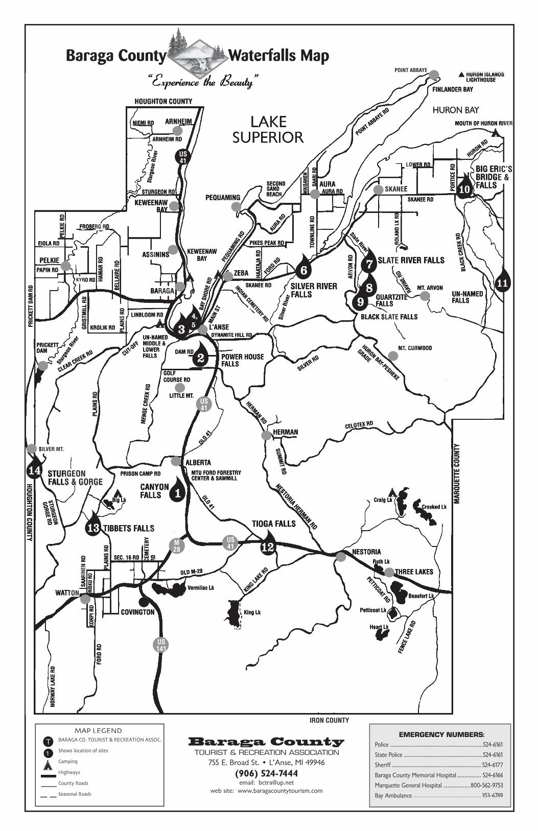
Baraga County Waterfalls MapBaraga County Waterfalls Map
“Experience the Beauty”“Experience the Beauty”
1
2
3
6
4,5
7
10
12
13
14
TIOGA FALLS
9
SLATE RIVER FALLSSLATE RIVER FALLSSLATE RIVER FALLS
8QUARTZITEFALLS
BLACK SLATE FALLSBLACK SLATE FALLSBLACK SLATE FALLS
11UN-NAMEDFALLS
POWER HOUSE FALLS
UN-NAMEDMIDDLE &LOWERFALLS
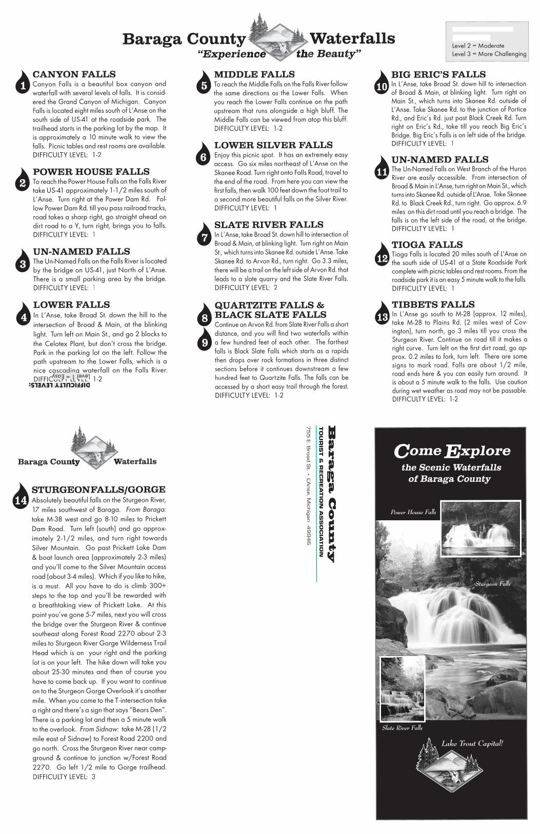
BIG ERIC’S FALLSIn L’Anse, take Broad St. down hill to intersection of Broad & Main, at blink ing light. Turn right on Main St., which turns into Skanee Rd. out side of L’Anse. Take Skanee Rd. to the junc tion of Portice Rd., and Eric’s Rd. just past Black Creek Rd. Turn right on Eric’s Rd., take till you reach Big Eric’s Bridge. Big Eric’s Falls is on left side of the bridge.DIFFICULTY LEVEL: 1
UN-NAMED FALLSThe Un-Named Falls on West Branch of the Huron River are easily accessible. From intersection of Broad & Main in L'Anse, turn right on Main St., which turns into Skanee Rd. outside of L'Anse. Take Skanee Rd. to Black Creek Rd., turn right. Go approx. 6.9 miles on this dirt road until you reach a bridge. The falls is on the left side of the road, at the bridge. DIFFICULTY LEVEL: 1
TIOGA FALLSTioga Falls is located 20 miles south of L'Anse on the south side of US-41 at a State Roadside Park complete with picnic tables and rest rooms. From the roadside park it is an easy 5 minute walk to the falls.DIFFICULTY LEVEL: 1
TIBBETS FALLSIn L’Anse go south to M-28 (approx. 12 miles), take M-28 to Plains Rd. (2 miles west of Cov-ington), turn north, go 3 miles till you cross the Sturgeon River. Con tin ue on road till it makes a right curve. Turn left on the fi rst dirt road, go ap-prox. 0.2 miles to fork, turn left. There are some signs to mark road. Falls are about 1/2 mile, road ends here & you can easily turn around. It is about a 5 minute walk to the falls. Use caution during wet weath er as road may not be passable.DIFFICULTY LEVEL: 1-2
CANYON FALLSCanyon Falls is a beautiful box can yon and waterfall with several levels of falls. It is consid-ered the Grand Can yon of Michigan. Canyon Falls is located eight miles south of L’Anse on the south side of US-41 at the roadside park. The trailhead starts in the parking lot by the map. It is approximately a 10 minute walk to view the falls. Picnic tables and rest rooms are avail able.DIFFICULTY LEVEL: 1-2
POWER HOUSE FALLSTo reach the Power House Falls on the Falls River take US-41 approximately 1-1/2 miles south of L’Anse. Turn right at the Power Dam Rd. Fol-low Power Dam Rd. till you pass railroad tracks, road takes a sharp right, go straight ahead on dirt road to a Y, turn right, brings you to falls.DIFFICULTY LEVEL: 1
UN-NAMED FALLSThe Un-Named Falls on the Falls River is located by the bridge on US-41, just North of L’Anse. There is a small park ing area by the bridge.DIFFICULTY LEVEL: 1
LOWER FALLSIn L’Anse, take Broad St. down the hill to the intersection of Broad & Main, at the blinking light. Turn left on Main St., and go 2 blocks to the Celotex Plant, but don’t cross the bridge. Park in the parking lot on the left. Follow the path upstream to the Lower Falls, which is a nice cas cad ing waterfall on the Falls River.DIFFICULTY LEVEL: 1-2
MIDDLE FALLSTo reach the Middle Falls on the Falls River follow the same directions as the Lower Falls. When you reach the Lower Falls con tin ue on the path up stream that runs alongside a high bluff. The Middle Falls can be viewed from atop this bluff.DIFFICULTY LEVEL: 1-2
LOWER SILVER FALLSEnjoy this picnic spot. It has an ex tremely easy access. Go six miles north east of L’Anse on the Skanee Road. Turn right onto Falls Road, travel to the end of the road. From here you can view the fi rst falls, then walk 100 feet down the foot trail to a second more beau ti ful falls on the Silver River.DIFFICULTY LEVEL: 1
SLATE RIVER FALLSIn L’Anse, take Broad St. down hill to intersection of Broad & Main, at blinking light. Turn right on Main St., which turns into Skanee Rd. outside L’Anse. Take Skanee Rd. to Arvon Rd., turn right. Go 3.3 miles, there will be a trail on the left side of Arvon Rd. that leads to a slate quarry and the Slate River Falls.DIFFICULTY LEVEL: 2
QUARTZITE FALLS & BLACK SLATE FALLSContinue on Arvon Rd. from Slate River Falls a short distance, and you will fi nd two waterfalls within a few hundred feet of each other. The farthest falls is Black Slate Falls which starts as a rapids then drops over rock formations in three distinct sections before it continues downstream a few hundred feet to Quartzite Falls. The falls can be accessed by a short easy trail through the forest.DIFFICULTY LEVEL: 1-2
Ba
ra
ga
Co
un
ty
75
5 E
. Bro
ad S
t. • L’A
nse, M
ichig
an 4
99
46
TO
UR
IST &
RE
CR
EA
TIO
N A
S S
O C
I A TIO
N
STURGEON FALLS/GORGEAbsolutely beautiful falls on the Sturgeon River, 17 miles southwest of Baraga. From Baraga:take M-38 west and go 8-10 miles to Prickett Dam Road. Turn left (south) and go ap prox-imate ly 2-1/2 miles, and turn right to wards Silver Mountain. Go past Prickett Lake Dam & boat launch area (approximately 2-3 miles) and you’ll come to the Silver Moun tain access road (about 3-4 miles). Which if you like to hike, is a must. All you have to do is climb 300+ steps to the top and you’ll be rewarded with a breathtaking view of Prickett Lake. At this point you’ve gone 5-7 miles, next you will cross the bridge over the Stur geon River & con tin ue south east along Forest Road 2270 about 2-3 miles to Sturgeon River Gorge Wil der ness Trail Head which is on your right and the parking lot is on your left. The hike down will take you about 25-30 minutes and then of course you have to come back up. If you want to continue on to the Sturgeon Gorge Overlook it’s an oth er mile. When you come to the T -intersection take a right and there’s a sign that says “Bears Den”. There is a park ing lot and then a 5 minute walk to the overlook. From Sidnaw: take M-28 (1/2 From Sidnaw: take M-28 (1/2 take M-28 (1/2 From Sidnaw:mile east of Sidnaw) to Forest Road 2200 and go north. Cross the Stur geon River near camp- ground & con tin ue to junc tion w/Forest Road 2270. Go left 1/2 mile to Gorge trailhead.DIFFICULTY LEVEL: 3
Baraga County WaterfallsBaraga County Waterfalls“Experience the Beauty”“Experience the Beauty”
DIFFICULTY LEVELS:Level 1 = Easy
Level 2 = ModerateLevel 3 = More Challenging
Baraga County WaterfallsBaraga County Waterfalls
1
2
3
6
5
4
7
8
9
10
14
11
12
13
Baraga CountyTOURIST & RECREATION AS SO CI A TION
the Scenic Waterfallsof Baraga County
xploreComeE
Lake Trout Capital!
Slate River Falls
Sturgeon Falls
Power House Falls