Embed Size (px)
Citation preview
Prepared in cooperation with the Iowa Department of Natural Resources—Iowa Geological Survey, Iowa Department of Transportation, and Federal agencies
Water Resources Data Iowa Water Year 2004
Volume 2. Ground Water and Quality of Precipitation
Water-Data Report IA-04-2
U.S. Department of the InteriorU.S. Geological Survey
Calendar for Water Year 20042003
January
November December
S M T W T F S S M T W T F S S M T W T F S
1 2 3 4 5 6 7 8 9 10 11
12 13 14 15 16 17 18 19 20 21 22 23 24 25 26 27 28 29 30 31
1 2 3 4 5 6 7 8 9 10 11 12 13 14 15
16 17 18 19 20 21 22 23 24 25 26 27 28 29 30
1 2 3 4 5 6 7 8 9 10 11 12 13
14 15 16 17 18 19 20 21 22 23 24 25 26 27 28 29 30 31
2004
1 2 3 4 5 6 7 8 9 10
11 12 13 14 15 16 17 18 19 20 21 22 23 24 25 26 27 28 29 30 31
October
February March
1 2 3 4 5 6 7 8 9 10 11 12 13 14
15 16 17 18 19 20 21 22 23 24 25 26 27 28 29
1 2 3 4 5 6 7 8 9 10 11 12 13
14 15 16 17 18 19 20 21 22 23 24 25 26 27 28 29 30 31
S M T W T F SS M T W T F SS M T W T F S
April May June
S M T W T F S S M T W T F S S M T W T F S
1 2 3 4 5 6 7 8 9 10
11 12 13 14 15 16 17 18 19 20 21 22 23 24 25 26 27 28 29 30
1 2 3 4 5 6 7 8 9 10 11 12 13 14 15
16 17 18 19 20 21 22 23 24 25 26 27 28 29 30 31
1 2 3 4 5 6 7 8 9 10 11 12
13 14 15 16 17 18 19 20 21 22 23 24 25 26 27 28 29 30
July August September
S M T W T F S S M T W T F S S M T W T F S
1 2 3 4 5 6 7 8 9 10
11 12 13 14 15 16 17 18 19 20 21 22 23 24 25 26 27 28 29 30 31
1 2 3 4 5 6 7 8 9 10 11 12 13 14
15 16 17 18 19 20 21 22 23 24 25 26 27 28 29 30 31
1 2 3 4 5 6 7 8 9 10 11
12 13 14 15 16 17 18 19 20 21 22 23 24 25 26 27 28 29 30
Water Resources Data Iowa Water Year 2004
Volume 2. Ground Water and Quality of Precipitation
By Greg M. Nalley, S. Michael Linhart, Greg R. Littin, Von E. Miller, and Kevin S. Housel
Water-Data Report IA-04-2
U.S. Department of the Interior U.S. Geological Survey
Prepared in cooperation with Iowa Department of Natural Resources- Iowa Geological Survey
U.S. Department of the InteriorGale A. Norton, Secretary
U.S. Geological SurveyCharles G. Groat, Director
U.S. Geological Survey P.O. Box 1240 Iowa City, Iowa 52244 (319) 337-4191
2005
Information about the USGS, Water Science Center-Iowa is available on the Internet at http://ia.water.usgs.gov/.
Information about all USGS reports and products is available by calling 1-888-ASK-USGS or on the Internet via the World Wide Web at http://www.usgs.gov/.
Additional earth science information is available by accessing the USGS home page at http://www.usgs.gov/.
iii
Preface
This volume of the annual hydrologic data report of Iowa is one of a series of annual reports that document hydrologic data gathered from the U.S. Geological Survey’s surface- and ground-water data-collection networks in each State, Puerto Rico, and the Trust Territories. These records of streamflow, ground-water levels, and quality of water provide the hydrologic information needed by local, State, and Federal agencies, and the private sector for developing and managing our Nation’s land and water resources.
This report is the culmination of a concerted effort by dedicated personnel of the U.S. Geological Survey who collected, compiled, analyzed, verified, and organized the data, and who typed, edited, and assembled the report. The authors had primary responsibility for assuring that the information contained herein is accurate, complete, and adheres to Geological Survey policy and established guidelines.
Personnel in charge of the field units are:
Joseph G. Gorman, Western Field Unit
Robert D. Goodrich, Eastern Field Unit
The data were collected, computed and processed by the following personnel:
K.D. Becher J.C. McVay
J.F. CervenyD.E. ChristiansenD.T. ConellA.R. ConklingA.L. DonnellyD.A. EashN.C. ElmendorfE.E. FischerA. GroteJ.S. HansenJ.W. HarmsK.S. HouselR.L. KopishS.M. LinhartG.R. LittinJ. VJ.FJ.AMS.DMP.J.RS.S.
This report was prepared in cooperation with the State of Iow
J. Moline.E. Miller. Nania. Nason
.J. NoonA. Rundquist.J. Schnoebelen.K. SegretoK. Smith
. SondagR. StraderA. Thul
a and with other agencies under the general supervision of
Greg M. Nalley, Chief Hydrologic Surveillence Section, and Rob G. Middlemis-Brown, Center Director, Iowa.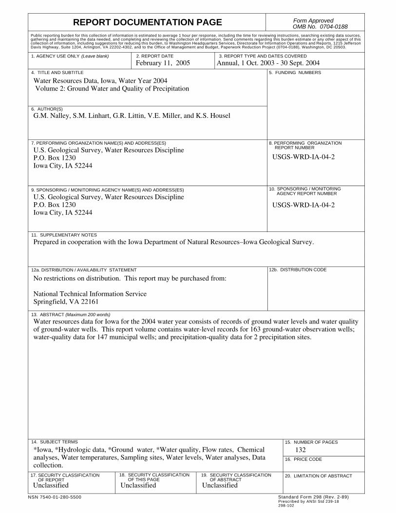
REPORT DOCUMENTATION PAGE Form ApprovedOMB No. 0704-0188
NSN 7540-01-280-5500
1. AGENCY USE ONLY (Leave blank)
Public reporting burden for this collection of information is estimated to average 1 hour per response, including the time for reviewing instructions, searching existing data sources, gathering and maintaining the data needed, and completing and reviewing the collection of information. Send comments regarding this burden estimate or any other aspect of this collection of information, including suggestions for reducing this burden, to Washington Headquarters Services, Directorate for Information Operations and Reports, 1215 Jefferson Davis Highway, Suite 1204, Arlington, VA 22202-4302, and to the Office of Management and Budget, Paperwork Reduction Project (0704-0188), Washington, DC 20503.
2. REPORT DATE February 11, 2005 A
3. REPORT TYPE AND DATES COVEREDnnual, 1 Oct. 2003 - 30 Sept. 2004
5. FUNDING NUMBERS
4. TITLE AND SUBTITLEWater Resources Data, Iowa, Water Year 2004 Volume 2: Ground Water and Quality of Precipitation
6. AUTHOR(S)G.M. Nalley, S.M. Linhart, G.R. Littin, V.E. Miller, and K.S. Housel
8. PERFORMING ORGANIZATION
7. PERFORMING ORGANIZATION NAME(S) AND ADDRESS(ES)U.S. Geological Survey, Water Resources DisciplineP.O. Box 1230Iowa City, IA 52244
REPORT NUMBER
USGS-WRD-IA-04-2
10.AGENCY REPORT NUMBERSPONSORING / MONITORING
9. SPONSORING / MONITORING AGENCY NAME(S) AND ADDRESS(ES)U.S. Geological Survey, Water Resources DisciplineP.O. Box 1230Iowa City, IA 52244
USGS-WRD-IA-04-2
11. SUPPLEMENTARY NOTES
Prepared in cooperation with the Iowa Department of Natural Resources–Iowa Geological Survey.
12a. DISTRIBUTION / AVAILABILITY STATEMENT
No restrictions on distribution. This report may be purchased from:
National Technical Information ServiceSpringfield, VA 22161
12b. DISTRIBUTION CODE
13. ABSTRACT (Maximum 200 words)
Water resources data for Iowa for the 2004 water year consists of records of ground water levels and water quality of ground-water wells. This report volume contains water-level records for 163 ground-water observation wells; water-quality data for 147 municipal wells; and precipitation-quality data for 2 precipitation sites.
5
6.
14. SUBJECT TERMS 1
1
18. SECURITY CLASSIFICATION 19. SECURITY CLASSIFICATION
*Iowa, *Hydrologic data, *Ground water, *Water quality, Flow rates, Chemical analyses, Water temperatures, Sampling sites, Water levels, Water analyses, Data collection.
StandPrescr298-10
. NUMBER OF PAGES
132
PRICE CODE17. SECURITY CLASSIFICATIONOF REPORT
Unclassified
OF THIS PAGEUnclassified
OF ABSTRACTUnclassified
20. LIMITATION OF ABSTRACT
ard Form 298 (Rev. 2-89)ibed by ANSI Std 239-182
v
CONTENTS
Preface . . . . . . . . . . . . . . . . . . . . . . . . . . . . . . . . . . . . . . . . . . . . . . . . . . . . . . . . . . . . . . . . . . . . . . . . . . . . . . . . . . . . . . . . . . . . . . . . . . . . . . . . . . . . . . . . . . . . . . . . iii
Figures . . . . . . . . . . . . . . . . . . . . . . . . . . . . . . . . . . . . . . . . . . . . . . . . . . . . . . . . . . . . . . . . . . . . . . . . . . . . . . . . . . . . . . . . . . . . . . . . . . . . . . . . . . . . . . . . . . vi
Ground-Water Wells, by County, for which Records are Published in this Volume . . . . . . . . . . . . . . . . . . . . . . . . . . . . . . . . . . . . . . . . . . . . . . . . .vii
Introduction . . . . . . . . . . . . . . . . . . . . . . . . . . . . . . . . . . . . . . . . . . . . . . . . . . . . . . . . . . . . . . . . . . . . . . . . . . . . . . . . . . . . . . . . . . . . . . . . . . . . . . . . . . . . . . . . . . . .1
Cooperation . . . . . . . . . . . . . . . . . . . . . . . . . . . . . . . . . . . . . . . . . . . . . . . . . . . . . . . . . . . . . . . . . . . . . . . . . . . . . . . . . . . . . . . . . . . . . . . . . . . . . . . . . . . . . . . . . . . .1
Summary of Hydrologic Conditions . . . . . . . . . . . . . . . . . . . . . . . . . . . . . . . . . . . . . . . . . . . . . . . . . . . . . . . . . . . . . . . . . . . . . . . . . . . . . . . . . . . . . . . . . . . . . . .2
Precipitation . . . . . . . . . . . . . . . . . . . . . . . . . . . . . . . . . . . . . . . . . . . . . . . . . . . . . . . . . . . . . . . . . . . . . . . . . . . . . . . . . . . . . . . . . . . . . . . . . . . . . . . . . . . . . . .2
Ground-Water-Level Observation Network . . . . . . . . . . . . . . . . . . . . . . . . . . . . . . . . . . . . . . . . . . . . . . . . . . . . . . . . . . . . . . . . . . . . . . . . . . . . . . . . . . . .3
Ground-Water Quality . . . . . . . . . . . . . . . . . . . . . . . . . . . . . . . . . . . . . . . . . . . . . . . . . . . . . . . . . . . . . . . . . . . . . . . . . . . . . . . . . . . . . . . . . . . . . . . . . . . . . .6
Ground-Water Monitoring Network . . . . . . . . . . . . . . . . . . . . . . . . . . . . . . . . . . . . . . . . . . . . . . . . . . . . . . . . . . . . . . . . . . . . . . . . . . . . . . . . . . . . . . . . . .7
Numbering system for wells and miscellaneous sites . . . . . . . . . . . . . . . . . . . . . . . . . . . . . . . . . . . . . . . . . . . . . . . . . . . . . . . . . . . . . . . . . . . . . . . . . . . . . . . . .8
Special networks and programs . . . . . . . . . . . . . . . . . . . . . . . . . . . . . . . . . . . . . . . . . . . . . . . . . . . . . . . . . . . . . . . . . . . . . . . . . . . . . . . . . . . . . . . . . . . . . . . . . . .9
Explanation of Ground-Water-Level Records . . . . . . . . . . . . . . . . . . . . . . . . . . . . . . . . . . . . . . . . . . . . . . . . . . . . . . . . . . . . . . . . . . . . . . . . . . . . . . . . . . . . . .10
Data Collection and Computation . . . . . . . . . . . . . . . . . . . . . . . . . . . . . . . . . . . . . . . . . . . . . . . . . . . . . . . . . . . . . . . . . . . . . . . . . . . . . . . . . . . . . . . . . . .10
Data Presentation . . . . . . . . . . . . . . . . . . . . . . . . . . . . . . . . . . . . . . . . . . . . . . . . . . . . . . . . . . . . . . . . . . . . . . . . . . . . . . . . . . . . . . . . . . . . . . . . . . . . . . . . .11
Explanation of precipitation records . . . . . . . . . . . . . . . . . . . . . . . . . . . . . . . . . . . . . . . . . . . . . . . . . . . . . . . . . . . . . . . . . . . . . . . . . . . . . . . . . . . . . . . . . . . . . . .12
Data Collection and Computation . . . . . . . . . . . . . . . . . . . . . . . . . . . . . . . . . . . . . . . . . . . . . . . . . . . . . . . . . . . . . . . . . . . . . . . . . . . . . . . . . . . . . . . . . . .12
Data Presentation . . . . . . . . . . . . . . . . . . . . . . . . . . . . . . . . . . . . . . . . . . . . . . . . . . . . . . . . . . . . . . . . . . . . . . . . . . . . . . . . . . . . . . . . . . . . . . . . . . . . . . . . .12
Explantion of Water-Quality Records . . . . . . . . . . . . . . . . . . . . . . . . . . . . . . . . . . . . . . . . . . . . . . . . . . . . . . . . . . . . . . . . . . . . . . . . . . . . . . . . . . . . . . . . . . . . .12
Collection and Examination of Data . . . . . . . . . . . . . . . . . . . . . . . . . . . . . . . . . . . . . . . . . . . . . . . . . . . . . . . . . . . . . . . . . . . . . . . . . . . . . . . . . . . . . . . . .12
Water Analysis . . . . . . . . . . . . . . . . . . . . . . . . . . . . . . . . . . . . . . . . . . . . . . . . . . . . . . . . . . . . . . . . . . . . . . . . . . . . . . . . . . . . . . . . . . . . . . . . . . . . . . . . . . .12
Ground-Water-Quality Data . . . . . . . . . . . . . . . . . . . . . . . . . . . . . . . . . . . . . . . . . . . . . . . . . . . . . . . . . . . . . . . . . . . . . . . . . . . . . . . . . . . . . . . . . . . . . . . . . . . . .13
Data Collection and Computation . . . . . . . . . . . . . . . . . . . . . . . . . . . . . . . . . . . . . . . . . . . . . . . . . . . . . . . . . . . . . . . . . . . . . . . . . . . . . . . . . . . . . . . . . . .13
Laboratory Measurements . . . . . . . . . . . . . . . . . . . . . . . . . . . . . . . . . . . . . . . . . . . . . . . . . . . . . . . . . . . . . . . . . . . . . . . . . . . . . . . . . . . . . . . . . . . . . . . . .13
Blank Samples . . . . . . . . . . . . . . . . . . . . . . . . . . . . . . . . . . . . . . . . . . . . . . . . . . . . . . . . . . . . . . . . . . . . . . . . . . . . . . . . . . . . . . . . . . . . . . . . . . . . . . . . . . .13
Reference Samples . . . . . . . . . . . . . . . . . . . . . . . . . . . . . . . . . . . . . . . . . . . . . . . . . . . . . . . . . . . . . . . . . . . . . . . . . . . . . . . . . . . . . . . . . . . . . . . . . . . . . . . .14
Replicate Samples . . . . . . . . . . . . . . . . . . . . . . . . . . . . . . . . . . . . . . . . . . . . . . . . . . . . . . . . . . . . . . . . . . . . . . . . . . . . . . . . . . . . . . . . . . . . . . . . . . . . . . . .14
Spike Samples . . . . . . . . . . . . . . . . . . . . . . . . . . . . . . . . . . . . . . . . . . . . . . . . . . . . . . . . . . . . . . . . . . . . . . . . . . . . . . . . . . . . . . . . . . . . . . . . . . . . . . . . . . . .14
Access to USGS Water Data . . . . . . . . . . . . . . . . . . . . . . . . . . . . . . . . . . . . . . . . . . . . . . . . . . . . . . . . . . . . . . . . . . . . . . . . . . . . . . . . . . . . . . . . . . . . . . . . . . . . .14
Definition of Terms . . . . . . . . . . . . . . . . . . . . . . . . . . . . . . . . . . . . . . . . . . . . . . . . . . . . . . . . . . . . . . . . . . . . . . . . . . . . . . . . . . . . . . . . . . . . . . . . . . . . . . . . . . . . .14
Techniques of Water-Resources Investigations of the U.S. Geological Survey . . . . . . . . . . . . . . . . . . . . . . . . . . . . . . . . . . . . . . . . . . . . . . . . . . . . . . . . . .32
Ground-Water Levels . . . . . . . . . . . . . . . . . . . . . . . . . . . . . . . . . . . . . . . . . . . . . . . . . . . . . . . . . . . . . . . . . . . . . . . . . . . . . . . . . . . . . . . . . . . . . . . . . . . . . . . . . . .33
Ground-Water-Quality Monitoring Program. . . . . . . . . . . . . . . . . . . . . . . . . . . . . . . . . . . . . . . . . . . . . . . . . . . . . . . . . . . . . . . . . . . . . . . . . . . . . . . . . . . . . . .106Quality of Precipitation . . . . . . . . . . . . . . . . . . . . . . . . . . . . . . . . . . . . . . . . . . . . . . . . . . . . . . . . . . . . . . . . . . . . . . . . . . . . . . . . . . . . . . . . . . . . . . . . . . . . . . . . .126Index . . . . . . . . . . . . . . . . . . . . . . . . . . . . . . . . . . . . . . . . . . . . . . . . . . . . . . . . . . . . . . . . . . . . . . . . . . . . . . . . . . . . . . . . . . . . . . . . . . . . . . . . . . . . . . . . . . . . . . . .130
vi
Figures
Figure 1. Water year 2004 precipitation record for the National Weather Service’s designated Climatological Districts 2
Figure 2. Location of wells in the ground-water-level observation network, water year 2004. . . . . . . . . . . . . . . . . . 3Figure 3. Location of active ground-water-quality monitoring wells, water year 2004. . . . . . . . . . . . . . . . . . . . . . . 7Figure 4. System for numbering wells and miscellaneous sites (latitude and longitude). . . . . . . . . . . . . . . . . . . . . . 9
vii
Ground-Water Wells, by County, for which Records are Published in this Volume
ADAMS COUNTY410247094324801. Local number, 72-32-09 CBCC. . . . . . . . . . . . . . . . . . . . . . . . . . . . . . . . . . . . . . . . . . . . . . 34410248094324801. Local number, 72-32-09 CCBB. . . . . . . . . . . . . . . . . . . . . . . . . . . . . . . . . . . . . . . . . . . . . . 34
APPANOOSE COUNTY404103092404001. Local number, 68-16-15 DDAD. . . . . . . . . . . . . . . . . . . . . . . . . . . . . . . . . . . . . . . . . . . . . 34
AUDUBON COUNTY413044094565601. Local number, 78-36-35 ADCC1. . . . . . . . . . . . . . . . . . . . . . . . . . . . . . . . . . . . . . . . . . . . . 35413958094544501. Local number, 79-35-10 CABB. . . . . . . . . . . . . . . . . . . . . . . . . . . . . . . . . . . . . . . . . . . . . . 35415023094593801. Local number, 81-36-12 CBCA. . . . . . . . . . . . . . . . . . . . . . . . . . . . . . . . . . . . . . . . . . . . . . 35
BENTON COUNTY420731092083801. Local number, 85-11-33 CCBC1. . . . . . . . . . . . . . . . . . . . . . . . . . . . . . . . . . . . . . . . . . . . . 36420731092083802. Local number, 85-11-33 CCBC. . . . . . . . . . . . . . . . . . . . . . . . . . . . . . . . . . . . . . . . . . . . . . 36420731092083803. Local number, 85-11-33 CCBC3. . . . . . . . . . . . . . . . . . . . . . . . . . . . . . . . . . . . . . . . . . . . . 36
BREMER COUNTY424224092133901. Local number, 91-12-11 DBB. . . . . . . . . . . . . . . . . . . . . . . . . . . . . . . . . . . . . . . . . . . . . . . 37
BUENA VISTA COUNTY424023095571401. Local number, 91-35-26 BCCC. . . . . . . . . . . . . . . . . . . . . . . . . . . . . . . . . . . . . . . . . . . . . . 37425233094545001. Local number, 93-35-13 ADAA. . . . . . . . . . . . . . . . . . . . . . . . . . . . . . . . . . . . . . . . . . . . . 37
CALHOUN COUNTY422350094380601. Local number, 88-33-36 ABAD. . . . . . . . . . . . . . . . . . . . . . . . . . . . . . . . . . . . . . . . . . . . . 38422812094383501. Local number, 88-32-01 BACD. . . . . . . . . . . . . . . . . . . . . . . . . . . . . . . . . . . . . . . . . . . . . . 38
CARROLL COUNTY420230094455101. Local number, 84-34-35 DAAA. . . . . . . . . . . . . . . . . . . . . . . . . . . . . . . . . . . . . . . . . . . . . 38420233094475901. Local number, 83-35-34 BCDC. . . . . . . . . . . . . . . . . . . . . . . . . . . . . . . . . . . . . . . . . . . . . . 39420643094403701. Local number, 84-33-03 CADA. . . . . . . . . . . . . . . . . . . . . . . . . . . . . . . . . . . . . . . . . . . . . 39421058094582701. Local number, 85-35-07 CCCC. . . . . . . . . . . . . . . . . . . . . . . . . . . . . . . . . . . . . . . . . . . . . . 39
CASS COUNTY411900094530101. Local number, 75-35-07 BBAB. . . . . . . . . . . . . . . . . . . . . . . . . . . . . . . . . . . . . . . . . . . . . . 40412832095033501. Local number, 77-37-13 BBBB. . . . . . . . . . . . . . . . . . . . . . . . . . . . . . . . . . . . . . . . . . . . . . 40
CERRO GORDO COUNTY430757093131801. Local number,96-20-17 DAAD. . . . . . . . . . . . . . . . . . . . . . . . . . . . . . . . . . . . . . . . . . . . . . 41430806093164501. Local number, 96-21-13 BCCB. . . . . . . . . . . . . . . . . . . . . . . . . . . . . . . . . . . . . . . . . . . . . . 41
CHEROKEE COUNTY424132095480211. Local number, 91-42-16 DDDD11. . . . . . . . . . . . . . . . . . . . . . . . . . . . . . . . . . . . . . . . . . . 41424348095231601. Local number, 91-39-01 ADAD1. . . . . . . . . . . . . . . . . . . . . . . . . . . . . . . . . . . . . . . . . . . . 42424348095231602. Local number, 91-39-01 ADAD2. . . . . . . . . . . . . . . . . . . . . . . . . . . . . . . . . . . . . . . . . . . . 42
CLAYTON COUNTY424023091291201. Local number, 91-05-30 BBBB. . . . . . . . . . . . . . . . . . . . . . . . . . . . . . . . . . . . . . . . . . . . . . 43425433091285002. Local number, 94-05-31 DACC2. . . . . . . . . . . . . . . . . . . . . . . . . . . . . . . . . . . . . . . . . . . . . 43425736091260303. Local number, 94-05-31 A. . . . . . . . . . . . . . . . . . . . . . . . . . . . . . . . . . . . . . . . . . . . . . . . . . 43430156091182901. Local number, 95-04-22 BCBD. . . . . . . . . . . . . . . . . . . . . . . . . . . . . . . . . . . . . . . . . . . . . . 44
viii
CLINTON COUNTY414806090212301. Local number, 81-05E-22 DDD. . . . . . . . . . . . . . . . . . . . . . . . . . . . . . . . . . . . . . . . . . . . . . 44414921090450401. Local number, 81-02E-17 ACA. . . . . . . . . . . . . . . . . . . . . . . . . . . . . . . . . . . . . . . . . . . . . . 44
CRAWFORD COUNTY415514095312001. Local number, 82-40-17 AABB. . . . . . . . . . . . . . . . . . . . . . . . . . . . . . . . . . . . . . . . . . . . . . 45420608095111701. Local number, 84-37-08 BCCB. . . . . . . . . . . . . . . . . . . . . . . . . . . . . . . . . . . . . . . . . . . . . . 45421005095342801. Local number, 85-41-13 CCCC. . . . . . . . . . . . . . . . . . . . . . . . . . . . . . . . . . . . . . . . . . . . . . 45421031095225601. Local number, 85-39-16 ADDD1. . . . . . . . . . . . . . . . . . . . . . . . . . . . . . . . . . . . . . . . . . . . 46421031095225602. Local number, 85-39-16 ADDD2. . . . . . . . . . . . . . . . . . . . . . . . . . . . . . . . . . . . . . . . . . . . 46421106095125501. Local number, 85-38-12 DCBA. . . . . . . . . . . . . . . . . . . . . . . . . . . . . . . . . . . . . . . . . . . . . . 46
DALLAS COUNTY413613093530401. Local number, 79-26-33 CDBA. . . . . . . . . . . . . . . . . . . . . . . . . . . . . . . . . . . . . . . . . . . . . . 47
DECATUR COUNTY404422093445602. Local number, 69-25-29 DDDD. . . . . . . . . . . . . . . . . . . . . . . . . . . . . . . . . . . . . . . . . . . . . 47
DELAWARE COUNTY422029091144302. Local number, 87-03-18 CBCD2. . . . . . . . . . . . . . . . . . . . . . . . . . . . . . . . . . . . . . . . . . . . . 47
DUBUQUE COUNTY422901090471901. Local number, 89-01-36 ABC. . . . . . . . . . . . . . . . . . . . . . . . . . . . . . . . . . . . . . . . . . . . . . . 48
FLOYD COUNTY430200092435301. Local number, 95-16-22 BCA1. . . . . . . . . . . . . . . . . . . . . . . . . . . . . . . . . . . . . . . . . . . . . . 48430200092435303. Local number, 95-16-22 BCA3. . . . . . . . . . . . . . . . . . . . . . . . . . . . . . . . . . . . . . . . . . . . . . 48430200092435304. Local number, 95-16-22 BCA4. . . . . . . . . . . . . . . . . . . . . . . . . . . . . . . . . . . . . . . . . . . . . . 49430200092435305. Local number, 95-16-22 BCA5. . . . . . . . . . . . . . . . . . . . . . . . . . . . . . . . . . . . . . . . . . . . . . 49430200092435306. Local number, 95-16-22 BCA6. . . . . . . . . . . . . . . . . . . . . . . . . . . . . . . . . . . . . . . . . . . . . . 49430800092540301. Local number, 96-17-18 CDBA. . . . . . . . . . . . . . . . . . . . . . . . . . . . . . . . . . . . . . . . . . . . . . 50
GREENE COUNTY415449094155601. Local number, 82-29-18 DBAA. . . . . . . . . . . . . . . . . . . . . . . . . . . . . . . . . . . . . . . . . . . . . 50420116094363001. Local number, 83-32-08 BBBC. . . . . . . . . . . . . . . . . . . . . . . . . . . . . . . . . . . . . . . . . . . . . . 50420146094272301. Local number, 83-31-04 ADDB. . . . . . . . . . . . . . . . . . . . . . . . . . . . . . . . . . . . . . . . . . . . . 51420149094344701. Local number, 83-32-04 ACCC. . . . . . . . . . . . . . . . . . . . . . . . . . . . . . . . . . . . . . . . . . . . . . 51420507094141901. Local number, 84-29-16 CBAB. . . . . . . . . . . . . . . . . . . . . . . . . . . . . . . . . . . . . . . . . . . . . . 51
GRUNDY COUNTY422611092552501. Local number, 88-18-14 BCCB. . . . . . . . . . . . . . . . . . . . . . . . . . . . . . . . . . . . . . . . . . . . . . 52
GUTHRIE COUNTY413223094150801. Local number, 78-29-24 CAAB. . . . . . . . . . . . . . . . . . . . . . . . . . . . . . . . . . . . . . . . . . . . . . 52413248094314301. Local number, 78-32-21 AAAA. . . . . . . . . . . . . . . . . . . . . . . . . . . . . . . . . . . . . . . . . . . . . 52414728094385301. Local number, 81-33-26 DDDD. . . . . . . . . . . . . . . . . . . . . . . . . . . . . . . . . . . . . . . . . . . . . 53414821094271301. Local number, 81-31-22 CCCC. . . . . . . . . . . . . . . . . . . . . . . . . . . . . . . . . . . . . . . . . . . . . . 53
HAMILTON COUNTY422610093474202. Local number, 88-25-17BCCA2. . . . . . . . . . . . . . . . . . . . . . . . . . . . . . . . . . . . . . . . . . . . . 54422610093474203. Local number, 88-25-17BCCA3. . . . . . . . . . . . . . . . . . . . . . . . . . . . . . . . . . . . . . . . . . . . . 56
HARDIN COUNTY423310093032802. Local number, 89-19-02 BDAC2. . . . . . . . . . . . . . . . . . . . . . . . . . . . . . . . . . . . . . . . . . . . . 58
ix
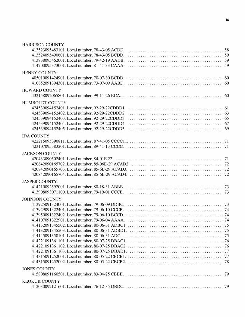
HARRISON COUNTY413523095483101. Local number, 78-43-05 ACDD. . . . . . . . . . . . . . . . . . . . . . . . . . . . . . . . . . . . . . . . . . . . . 58413524095490601. Local number, 78-43-05 BCDD. . . . . . . . . . . . . . . . . . . . . . . . . . . . . . . . . . . . . . . . . . . . . . 59413838095462001. Local number, 79-42-19 AADB. . . . . . . . . . . . . . . . . . . . . . . . . . . . . . . . . . . . . . . . . . . . . 59414700095373001. Local number, 81-41-33 CAAA. . . . . . . . . . . . . . . . . . . . . . . . . . . . . . . . . . . . . . . . . . . . . 59
HENRY COUNTY405010091424901. Local number, 70-07-30 BCDD. . . . . . . . . . . . . . . . . . . . . . . . . . . . . . . . . . . . . . . . . . . . . . 60410852091394301. Local number, 73-07-09 AABD. . . . . . . . . . . . . . . . . . . . . . . . . . . . . . . . . . . . . . . . . . . . . 60
HOWARD COUNTY432158092065801. Local number, 99-11-26 BCA. . . . . . . . . . . . . . . . . . . . . . . . . . . . . . . . . . . . . . . . . . . . . . . 60
HUMBOLDT COUNTY424539094152401. Local number, 92-29-22CDDD1. . . . . . . . . . . . . . . . . . . . . . . . . . . . . . . . . . . . . . . . . . . . . 61424539094152402. Local number, 92-29-22CDDD2. . . . . . . . . . . . . . . . . . . . . . . . . . . . . . . . . . . . . . . . . . . . . 63424539094152403. Local number, 92-29-22CDDD3. . . . . . . . . . . . . . . . . . . . . . . . . . . . . . . . . . . . . . . . . . . . . 65424539094152404. Local number, 92-29-22CDDD4. . . . . . . . . . . . . . . . . . . . . . . . . . . . . . . . . . . . . . . . . . . . . 67424539094152405. Local number, 92-29-22CDDD5. . . . . . . . . . . . . . . . . . . . . . . . . . . . . . . . . . . . . . . . . . . . . 69
IDA COUNTY422215095390811. Local number, 87-41-05 CCCC11. . . . . . . . . . . . . . . . . . . . . . . . . . . . . . . . . . . . . . . . . . . . 71423107095383201. Local number, 89-41-13 CCCC. . . . . . . . . . . . . . . . . . . . . . . . . . . . . . . . . . . . . . . . . . . . . . 71
JACKSON COUNTY420433090502401. Local number, 84-01E 22. . . . . . . . . . . . . . . . . . . . . . . . . . . . . . . . . . . . . . . . . . . . . . . . . . . 71420842090165702. Local number, 85-06E-29 ACAD2. . . . . . . . . . . . . . . . . . . . . . . . . . . . . . . . . . . . . . . . . . . 72420842090165703. Local number, 85-6E-29 ACAD3. . . . . . . . . . . . . . . . . . . . . . . . . . . . . . . . . . . . . . . . . . . . 72420842090165704. Local number, 85-6E-29 ACAD4. . . . . . . . . . . . . . . . . . . . . . . . . . . . . . . . . . . . . . . . . . . . 72
JASPER COUNTY414210092592001. Local number, 80-18-31 ABBB. . . . . . . . . . . . . . . . . . . . . . . . . . . . . . . . . . . . . . . . . . . . . . 73413908093071100. Local number, 79-19-01 CCCB. . . . . . . . . . . . . . . . . . . . . . . . . . . . . . . . . . . . . . . . . . . . . . 73
JOHNSON COUNTY413925091324001. Local number, 79-06-09 DDBC. . . . . . . . . . . . . . . . . . . . . . . . . . . . . . . . . . . . . . . . . . . . . . 73413929091322401. Local number, 79-06-10 CCCB. . . . . . . . . . . . . . . . . . . . . . . . . . . . . . . . . . . . . . . . . . . . . . 74413950091322402. Local number, 79-06-10 BCCD. . . . . . . . . . . . . . . . . . . . . . . . . . . . . . . . . . . . . . . . . . . . . . 74414107091322901. Local number, 79-06-04 AAAA. . . . . . . . . . . . . . . . . . . . . . . . . . . . . . . . . . . . . . . . . . . . . 74414132091345502. Local number, 80-06-31 ADBC1. . . . . . . . . . . . . . . . . . . . . . . . . . . . . . . . . . . . . . . . . . . . . 75414132091345503. Local number, 80-06-31 ADBD1. . . . . . . . . . . . . . . . . . . . . . . . . . . . . . . . . . . . . . . . . . . . 75414145091350101. Local number, 80-06-31 ADC. . . . . . . . . . . . . . . . . . . . . . . . . . . . . . . . . . . . . . . . . . . . . . . 75414221091361101. Local number, 80-07-25 DBAC1. . . . . . . . . . . . . . . . . . . . . . . . . . . . . . . . . . . . . . . . . . . . . 76414221091361102. Local number, 80-07-25 DBAC2. . . . . . . . . . . . . . . . . . . . . . . . . . . . . . . . . . . . . . . . . . . . . 76414221091361103. Local number, 80-07-25 DBAD1. . . . . . . . . . . . . . . . . . . . . . . . . . . . . . . . . . . . . . . . . . . . 77414315091252001. Local number, 80-05-22 CBCB1. . . . . . . . . . . . . . . . . . . . . . . . . . . . . . . . . . . . . . . . . . . . . 77414315091252002. Local number, 80-05-22 CBCB2. . . . . . . . . . . . . . . . . . . . . . . . . . . . . . . . . . . . . . . . . . . . . 78
JONES COUNTY415808091160501. Local number, 83-04-25 CBBB. . . . . . . . . . . . . . . . . . . . . . . . . . . . . . . . . . . . . . . . . . . . . . 79
KEOKUK COUNTY412030092121601. Local number, 76-12-35 DBDC. . . . . . . . . . . . . . . . . . . . . . . . . . . . . . . . . . . . . . . . . . . . . . 79
x
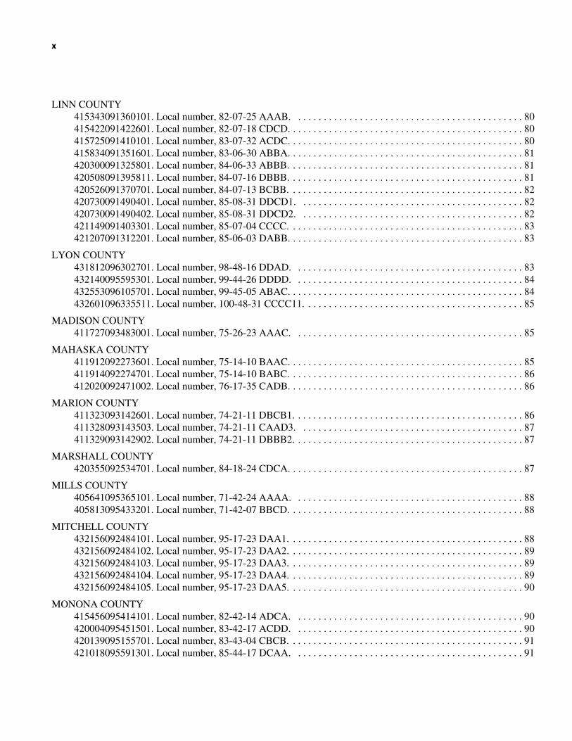
LINN COUNTY415343091360101. Local number, 82-07-25 AAAB. . . . . . . . . . . . . . . . . . . . . . . . . . . . . . . . . . . . . . . . . . . . . 80415422091422601. Local number, 82-07-18 CDCD. . . . . . . . . . . . . . . . . . . . . . . . . . . . . . . . . . . . . . . . . . . . . . 80415725091410101. Local number, 83-07-32 ACDC. . . . . . . . . . . . . . . . . . . . . . . . . . . . . . . . . . . . . . . . . . . . . . 80415834091351601. Local number, 83-06-30 ABBA. . . . . . . . . . . . . . . . . . . . . . . . . . . . . . . . . . . . . . . . . . . . . . 81420300091325801. Local number, 84-06-33 ABBB. . . . . . . . . . . . . . . . . . . . . . . . . . . . . . . . . . . . . . . . . . . . . . 81420508091395811. Local number, 84-07-16 DBBB. . . . . . . . . . . . . . . . . . . . . . . . . . . . . . . . . . . . . . . . . . . . . . 81420526091370701. Local number, 84-07-13 BCBB. . . . . . . . . . . . . . . . . . . . . . . . . . . . . . . . . . . . . . . . . . . . . . 82420730091490401. Local number, 85-08-31 DDCD1. . . . . . . . . . . . . . . . . . . . . . . . . . . . . . . . . . . . . . . . . . . . 82420730091490402. Local number, 85-08-31 DDCD2. . . . . . . . . . . . . . . . . . . . . . . . . . . . . . . . . . . . . . . . . . . . 82421149091403301. Local number, 85-07-04 CCCC. . . . . . . . . . . . . . . . . . . . . . . . . . . . . . . . . . . . . . . . . . . . . . 83421207091312201. Local number, 85-06-03 DABB. . . . . . . . . . . . . . . . . . . . . . . . . . . . . . . . . . . . . . . . . . . . . . 83
LYON COUNTY431812096302701. Local number, 98-48-16 DDAD. . . . . . . . . . . . . . . . . . . . . . . . . . . . . . . . . . . . . . . . . . . . . 83432140095595301. Local number, 99-44-26 DDDD. . . . . . . . . . . . . . . . . . . . . . . . . . . . . . . . . . . . . . . . . . . . . 84432553096105701. Local number, 99-45-05 ABAC. . . . . . . . . . . . . . . . . . . . . . . . . . . . . . . . . . . . . . . . . . . . . . 84432601096335511. Local number, 100-48-31 CCCC11. . . . . . . . . . . . . . . . . . . . . . . . . . . . . . . . . . . . . . . . . . . 85
MADISON COUNTY411727093483001. Local number, 75-26-23 AAAC. . . . . . . . . . . . . . . . . . . . . . . . . . . . . . . . . . . . . . . . . . . . . 85
MAHASKA COUNTY411912092273601. Local number, 75-14-10 BAAC. . . . . . . . . . . . . . . . . . . . . . . . . . . . . . . . . . . . . . . . . . . . . . 85411914092274701. Local number, 75-14-10 BABC. . . . . . . . . . . . . . . . . . . . . . . . . . . . . . . . . . . . . . . . . . . . . . 86412020092471002. Local number, 76-17-35 CADB. . . . . . . . . . . . . . . . . . . . . . . . . . . . . . . . . . . . . . . . . . . . . . 86
MARION COUNTY411323093142601. Local number, 74-21-11 DBCB1. . . . . . . . . . . . . . . . . . . . . . . . . . . . . . . . . . . . . . . . . . . . . 86411328093143503. Local number, 74-21-11 CAAD3. . . . . . . . . . . . . . . . . . . . . . . . . . . . . . . . . . . . . . . . . . . . 87411329093142902. Local number, 74-21-11 DBBB2. . . . . . . . . . . . . . . . . . . . . . . . . . . . . . . . . . . . . . . . . . . . . 87
MARSHALL COUNTY420355092534701. Local number, 84-18-24 CDCA. . . . . . . . . . . . . . . . . . . . . . . . . . . . . . . . . . . . . . . . . . . . . . 87
MILLS COUNTY405641095365101. Local number, 71-42-24 AAAA. . . . . . . . . . . . . . . . . . . . . . . . . . . . . . . . . . . . . . . . . . . . . 88405813095433201. Local number, 71-42-07 BBCD. . . . . . . . . . . . . . . . . . . . . . . . . . . . . . . . . . . . . . . . . . . . . . 88
MITCHELL COUNTY432156092484101. Local number, 95-17-23 DAA1. . . . . . . . . . . . . . . . . . . . . . . . . . . . . . . . . . . . . . . . . . . . . . 88432156092484102. Local number, 95-17-23 DAA2. . . . . . . . . . . . . . . . . . . . . . . . . . . . . . . . . . . . . . . . . . . . . . 89432156092484103. Local number, 95-17-23 DAA3. . . . . . . . . . . . . . . . . . . . . . . . . . . . . . . . . . . . . . . . . . . . . . 89432156092484104. Local number, 95-17-23 DAA4. . . . . . . . . . . . . . . . . . . . . . . . . . . . . . . . . . . . . . . . . . . . . . 89432156092484105. Local number, 95-17-23 DAA5. . . . . . . . . . . . . . . . . . . . . . . . . . . . . . . . . . . . . . . . . . . . . . 90
MONONA COUNTY415456095414101. Local number, 82-42-14 ADCA. . . . . . . . . . . . . . . . . . . . . . . . . . . . . . . . . . . . . . . . . . . . . 90420004095451501. Local number, 83-42-17 ACDD. . . . . . . . . . . . . . . . . . . . . . . . . . . . . . . . . . . . . . . . . . . . . 90420139095155701. Local number, 83-43-04 CBCB. . . . . . . . . . . . . . . . . . . . . . . . . . . . . . . . . . . . . . . . . . . . . . 91421018095591301. Local number, 85-44-17 DCAA. . . . . . . . . . . . . . . . . . . . . . . . . . . . . . . . . . . . . . . . . . . . . 91
xi
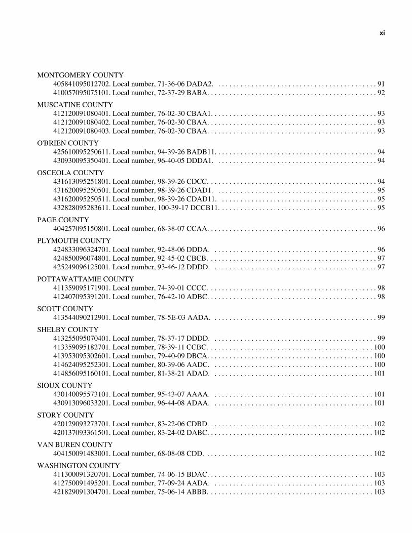
MONTGOMERY COUNTY405841095012702. Local number, 71-36-06 DADA2. . . . . . . . . . . . . . . . . . . . . . . . . . . . . . . . . . . . . . . . . . . . 91410057095075101. Local number, 72-37-29 BABA. . . . . . . . . . . . . . . . . . . . . . . . . . . . . . . . . . . . . . . . . . . . . . 92
MUSCATINE COUNTY412120091080401. Local number, 76-02-30 CBAA1. . . . . . . . . . . . . . . . . . . . . . . . . . . . . . . . . . . . . . . . . . . . . 93412120091080402. Local number, 76-02-30 CBAA. . . . . . . . . . . . . . . . . . . . . . . . . . . . . . . . . . . . . . . . . . . . . . 93412120091080403. Local number, 76-02-30 CBAA. . . . . . . . . . . . . . . . . . . . . . . . . . . . . . . . . . . . . . . . . . . . . . 93
O'BRIEN COUNTY425610095250611. Local number, 94-39-26 BADB11. . . . . . . . . . . . . . . . . . . . . . . . . . . . . . . . . . . . . . . . . . . . 94430930095350401. Local number, 96-40-05 DDDA1. . . . . . . . . . . . . . . . . . . . . . . . . . . . . . . . . . . . . . . . . . . . 94
OSCEOLA COUNTY431613095251801. Local number, 98-39-26 CDCC. . . . . . . . . . . . . . . . . . . . . . . . . . . . . . . . . . . . . . . . . . . . . . 94431620095250501. Local number, 98-39-26 CDAD1. . . . . . . . . . . . . . . . . . . . . . . . . . . . . . . . . . . . . . . . . . . . 95431620095250511. Local number, 98-39-26 CDAD11. . . . . . . . . . . . . . . . . . . . . . . . . . . . . . . . . . . . . . . . . . . 95432828095283611. Local number, 100-39-17 DCCB11. . . . . . . . . . . . . . . . . . . . . . . . . . . . . . . . . . . . . . . . . . . 95
PAGE COUNTY404257095150801. Local number, 68-38-07 CCAA. . . . . . . . . . . . . . . . . . . . . . . . . . . . . . . . . . . . . . . . . . . . . . 96
PLYMOUTH COUNTY424833096324701. Local number, 92-48-06 DDDA. . . . . . . . . . . . . . . . . . . . . . . . . . . . . . . . . . . . . . . . . . . . . 96424850096074801. Local number, 92-45-02 CBCB. . . . . . . . . . . . . . . . . . . . . . . . . . . . . . . . . . . . . . . . . . . . . . 97425249096125001. Local number, 93-46-12 DDDD. . . . . . . . . . . . . . . . . . . . . . . . . . . . . . . . . . . . . . . . . . . . . 97
POTTAWATTAMIE COUNTY411359095171901. Local number, 74-39-01 CCCC. . . . . . . . . . . . . . . . . . . . . . . . . . . . . . . . . . . . . . . . . . . . . . 98412407095391201. Local number, 76-42-10 ADBC. . . . . . . . . . . . . . . . . . . . . . . . . . . . . . . . . . . . . . . . . . . . . . 98
SCOTT COUNTY413544090212901. Local number, 78-5E-03 AADA. . . . . . . . . . . . . . . . . . . . . . . . . . . . . . . . . . . . . . . . . . . . . 99
SHELBY COUNTY413255095070401. Local number, 78-37-17 DDDD. . . . . . . . . . . . . . . . . . . . . . . . . . . . . . . . . . . . . . . . . . . . . 99413359095182701. Local number, 78-39-11 CCBC. . . . . . . . . . . . . . . . . . . . . . . . . . . . . . . . . . . . . . . . . . . . . 100413953095302601. Local number, 79-40-09 DBCA. . . . . . . . . . . . . . . . . . . . . . . . . . . . . . . . . . . . . . . . . . . . . 100414624095252301. Local number, 80-39-06 AADC. . . . . . . . . . . . . . . . . . . . . . . . . . . . . . . . . . . . . . . . . . . . 100414856095160101. Local number, 81-38-21 ADAD. . . . . . . . . . . . . . . . . . . . . . . . . . . . . . . . . . . . . . . . . . . . 101
SIOUX COUNTY430140095573101. Local number, 95-43-07 AAAA. . . . . . . . . . . . . . . . . . . . . . . . . . . . . . . . . . . . . . . . . . . . 101430913096033201. Local number, 96-44-08 ADAA. . . . . . . . . . . . . . . . . . . . . . . . . . . . . . . . . . . . . . . . . . . . 101
STORY COUNTY420129093273701. Local number, 83-22-06 CDBD. . . . . . . . . . . . . . . . . . . . . . . . . . . . . . . . . . . . . . . . . . . . . 102420137093361501. Local number, 83-24-02 DABC. . . . . . . . . . . . . . . . . . . . . . . . . . . . . . . . . . . . . . . . . . . . . 102
VAN BUREN COUNTY404150091483001. Local number, 68-08-08 CDD. . . . . . . . . . . . . . . . . . . . . . . . . . . . . . . . . . . . . . . . . . . . . . 102
WASHINGTON COUNTY411300091320701. Local number, 74-06-15 BDAC. . . . . . . . . . . . . . . . . . . . . . . . . . . . . . . . . . . . . . . . . . . . . 103412750091495201. Local number, 77-09-24 AADA. . . . . . . . . . . . . . . . . . . . . . . . . . . . . . . . . . . . . . . . . . . . 103421829091304701. Local number, 75-06-14 ABBB. . . . . . . . . . . . . . . . . . . . . . . . . . . . . . . . . . . . . . . . . . . . . 103
xii
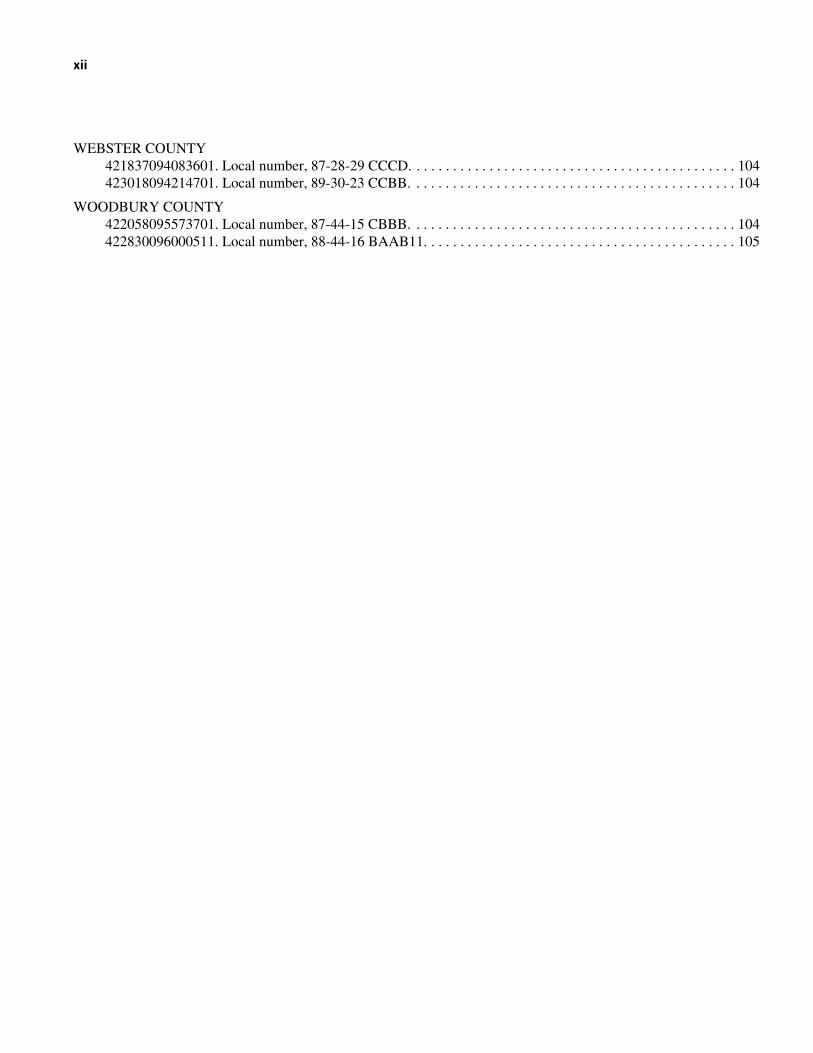
WEBSTER COUNTY421837094083601. Local number, 87-28-29 CCCD. . . . . . . . . . . . . . . . . . . . . . . . . . . . . . . . . . . . . . . . . . . . . 104423018094214701. Local number, 89-30-23 CCBB. . . . . . . . . . . . . . . . . . . . . . . . . . . . . . . . . . . . . . . . . . . . . 104
WOODBURY COUNTY422058095573701. Local number, 87-44-15 CBBB. . . . . . . . . . . . . . . . . . . . . . . . . . . . . . . . . . . . . . . . . . . . . 104422830096000511. Local number, 88-44-16 BAAB11. . . . . . . . . . . . . . . . . . . . . . . . . . . . . . . . . . . . . . . . . . . 105
Water Resources Data, Iowa, Water Year 2004Volume 2—Ground Water and Quality of Precipitation
By Greg M. Nalley, S. Michael Linhart, Greg R. Littin, Von E. Miller, and Kevin S. Housel
Introduction
The Water Resources Discipline of the U.S. Geological Survey, in cooperation with State, county, municipal, and other Federal agencies, obtains a large amount of data pertaining to the water resources of Iowa each water year. These data, accumulated during many water years, constitute a valuable data base for developing an improved understanding of the water resources of the State. To make this data readily available to interested parties outside of the Geological Survey, the data is published annually in this report series entitled “Water Resources Data - Iowa” as part of the National Water Data System.
Water-resources data for water year 2004 for Iowa consists of records of stage, discharge, and water quality of streams; stage and contents of lakes and reservoirs; and water levels and water quality of ground water. This volume of the report contains water levels for 163 ground-water observation wells; water-quality data from 147 municipal wells; and precipitation-quality data from 2 precipitation sites. Additional water data were collected at various sites not included in the systematic data-collection program and are published as miscellaneous measurements and analyses.
Records of discharge or stage of streams, and contents or stage of lakes and reservoirs were first published in a series of U.S. Geological Survey water-supply papers entitled “Surface Water Supply of the United States.” Through September 30, 1960, these water-supply papers were published in an annual series; during 1961–65 and 1966–70, they were published in 5-year series. Records of chemical quality, water temperatures, and suspended sediment were published from 1941 to 1970 in an annual series of water-supply papers entitled “Quality of Surface Waters of the United States.” Records of ground-water levels were published from 1935 to 1974 in a series of water-supply papers entitled “Ground-Water Levels in the United States.” Water-supply papers may be consulted in the libraries of the principal cities in the United States, or they may be purchased from Books and Open-File Reports Section, Federal Center, Box 25425, Denver, Colorado 80225.
For water years 1961 through 1970, streamflow data were released by the Geological Survey in annual reports on a State-boundary basis. Water-quality records for water years 1964 through 1970 were similarly released either in separate reports or in conjunction with streamflow records.
Beginning with the 1971 water year, water data for streamflow, water quality, and ground water are published in official U.S. Geological Survey reports on a State-boundary basis. These official reports carry an identification number consisting of the two-letter State postal abbreviation, the last two digits of the water year, and the volume number. For example, this report is identified as “U.S. Geological Survey Water-Data Report IA-04-2.” These water-data reports are for sale by the National Technical Information Service, U.S. Department of Commerce, Springfield, Virginia 22161.
Additional information for ordering specific reports may be obtained from the Center Director at the address given on the back of the title page or by telephone, (319) 337-4191.
Cooperation
The U.S. Geological Survey has had cooperative agreements with various governmental agencies in the State of Iowa for measuring ground-water levels since 1935 and collecting water-quality records since 1943. During water year 2004, the agencies that assisted through cooperative agreements were:
Iowa Department of Natural Resources–Iowa Geological SurveyUniversity of Iowa, Hygienic Laboratory
2 Water Resources Data, Iowa, Water Year 2004
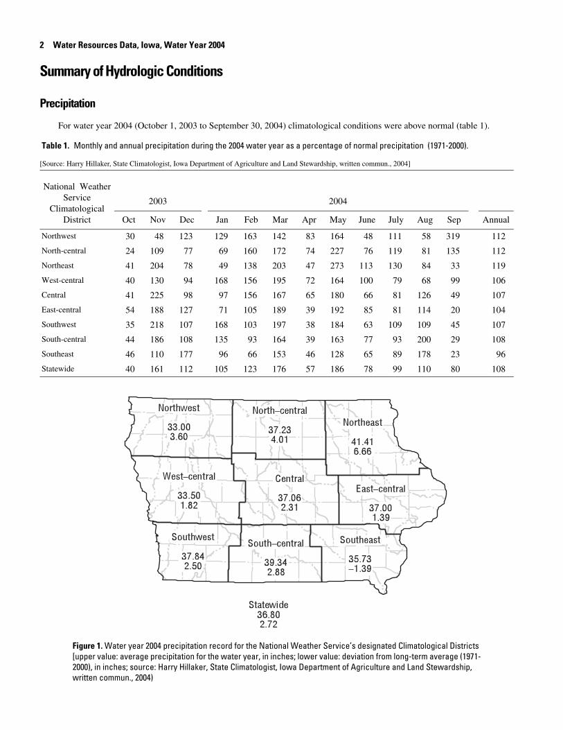
Summary of Hydrologic Conditions
Precipitation
For water year 2004 (October 1, 2003 to September 30, 2004) climatological conditions were above normal (table 1).
Table 1. Monthly and annual precipitation during the 2004 water year as a percentage of normal precipitation (1971-2000).
[Source: Harry Hillaker, State Climatologist, Iowa Department of Agriculture and Land Stewardship, written commun., 2004]
National Weather Service
Climatological District
2003 2004
Oct Nov Dec Jan Feb Mar Apr May June July Aug Sep Annual
Northwest 30 48 123 129 163 142 83 164 48 111 58 319 112
North-central 24 109 77 69 160 172 74 227 76 119 81 135 112
Northeast 41 204 78 49 138 203 47 273 113 130 84 33 119
West-central 40 130 94 168 156 195 72 164 100 79 68 99 106
Central 41 225 98 97 156 167 65 180 66 81 126 49 107
East-central 54 188 127 71 105 189 39 192 85 81 114 20 104
Southwest 35 218 107 168 103 197 38 184 63 109 109 45 107
South-central 44 186 108 135 93 164 39 163 77 93 200 29 108
Southeast 46 110 177 96 66 153 46 128 65 89 178 23 96
Statewide 40 161 112 105 123 176 57 186 78 99 110 80 108
Figure 1. Water year 2004 precipitation record for the National Weather Service’s designated Climatological Districts [upper value: average precipitation for the water year, in inches; lower value: deviation from long-term average (1971-2000), in inches; source: Harry Hillaker, State Climatologist, Iowa Department of Agriculture and Land Stewardship, written commun., 2004)
Water Resources Data, Iowa, Water Year 2004 3
Recorded precipitation for the year ranged from +6.66 inches above normal in the Northeast Iowa Climatological District to -1.39 inches less than normal in the Southeast Iowa Climatological District (fig. 1). Precipitation recorded for the State averaged 36.80 inches, which was +2.72 inches above normal or 108 percent of the normal 34.08 inches for 1971-00 (table 1). Overall, water year 2004 was the 22nd wettest and 62nd warmest for 131 years of record. [In this summary of hydrologic conditions, all data and statistics pertaining to precipitation and temperature in Iowa were provided by Harry Hillaker, State Climatologist, Iowa Department of Agriculture and Land Stewardship, (oral and written commun., 2004)
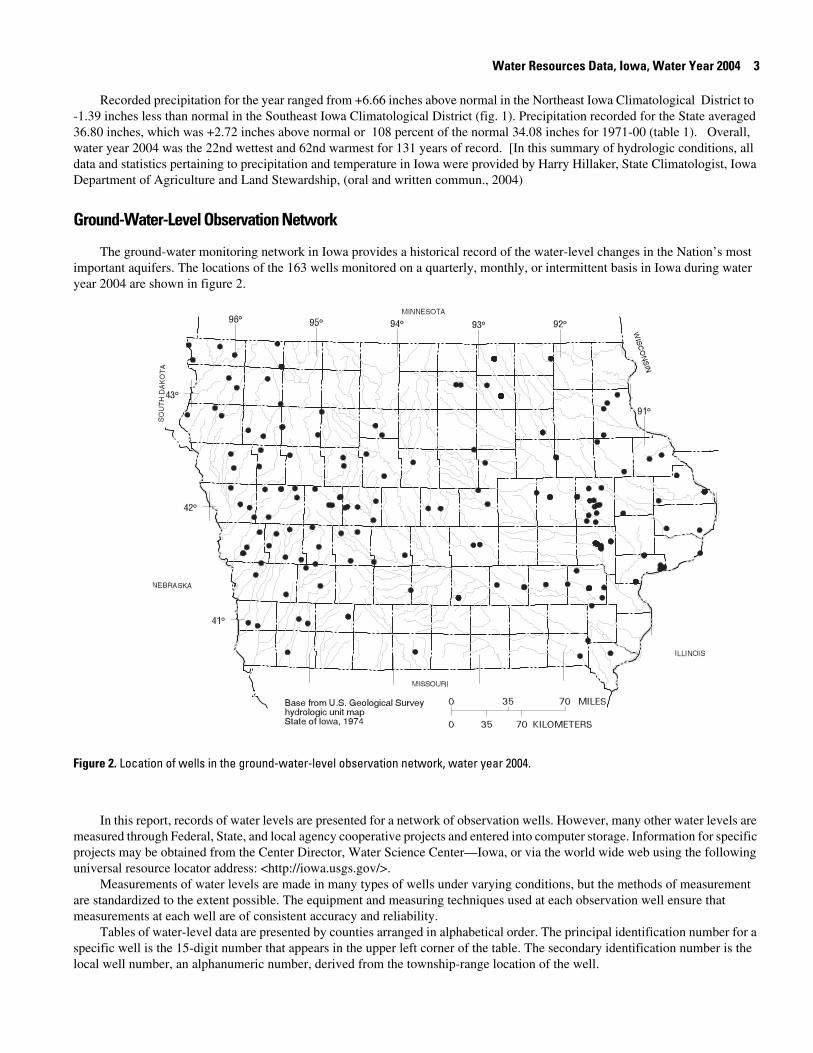
Ground-Water-Level Observation Network
The ground-water monitoring network in Iowa provides a historical record of the water-level changes in the Nation’s most important aquifers. The locations of the 163 wells monitored on a quarterly, monthly, or intermittent basis in Iowa during water year 2004 are shown in figure 2.
Figure 2. Location of wells in the ground-water-level observation network, water year 2004.
In this report, records of water levels are presented for a network of observation wells. However, many other water levels are measured through Federal, State, and local agency cooperative projects and entered into computer storage. Information for specific projects may be obtained from the Center Director, Water Science Center—Iowa, or via the world wide web using the following universal resource locator address: <http://iowa.usgs.gov/>.
Measurements of water levels are made in many types of wells under varying conditions, but the methods of measurement are standardized to the extent possible. The equipment and measuring techniques used at each observation well ensure that measurements at each well are of consistent accuracy and reliability.
Tables of water-level data are presented by counties arranged in alphabetical order. The principal identification number for a specific well is the 15-digit number that appears in the upper left corner of the table. The secondary identification number is the local well number, an alphanumeric number, derived from the township-range location of the well.
4 Water Resources Data, Iowa, Water Year 2004
Water-level records are obtained from direct measurements with a steel tape or from an airline. The water-level measurements in this report are provided in feet with reference to land-surface datum. Land-surface datum is a datum plane that is approximately at land surface at each well. The measuring point is the height above or below the land-surface datum and the point where the water level is measured. Both the measuring point and land-surface datum are provided for each well.
Water levels are reported to as many significant figures as can be justified by the local conditions. For example, in a measurement to a depth of water of several hundred feet, the error of determining the absolute value of the total depth to water may be a few tenths of a foot, whereas the error in determining the net change of water level between successive measurements may be only a hundredth or a few hundredths of a foot. For lesser depths to water, the accuracy is greater. Accordingly, most measurements are reported to a hundredth of a foot, but some are given to a tenth of a foot or a larger unit.
Ground-water supplies in Iowa are withdrawn from unconsolidated and bedrock aquifers. There are three types of unconsolidated aquifers: (1) alluvial aquifers, which consist of sand-and-gravel deposits associated with present-day fluvial systems; (2) glacial-drift aquifers, which consist of shallow, discontinuous, permeable lenses of sand and gravel interbedded with less-permeable glacial drift; and (3) buried-channel aquifers. Buried-channel aquifers are formed in areas where coarse sand and gravel were deposited in bedrock valleys and overlain by a thick layer of glacial drift.
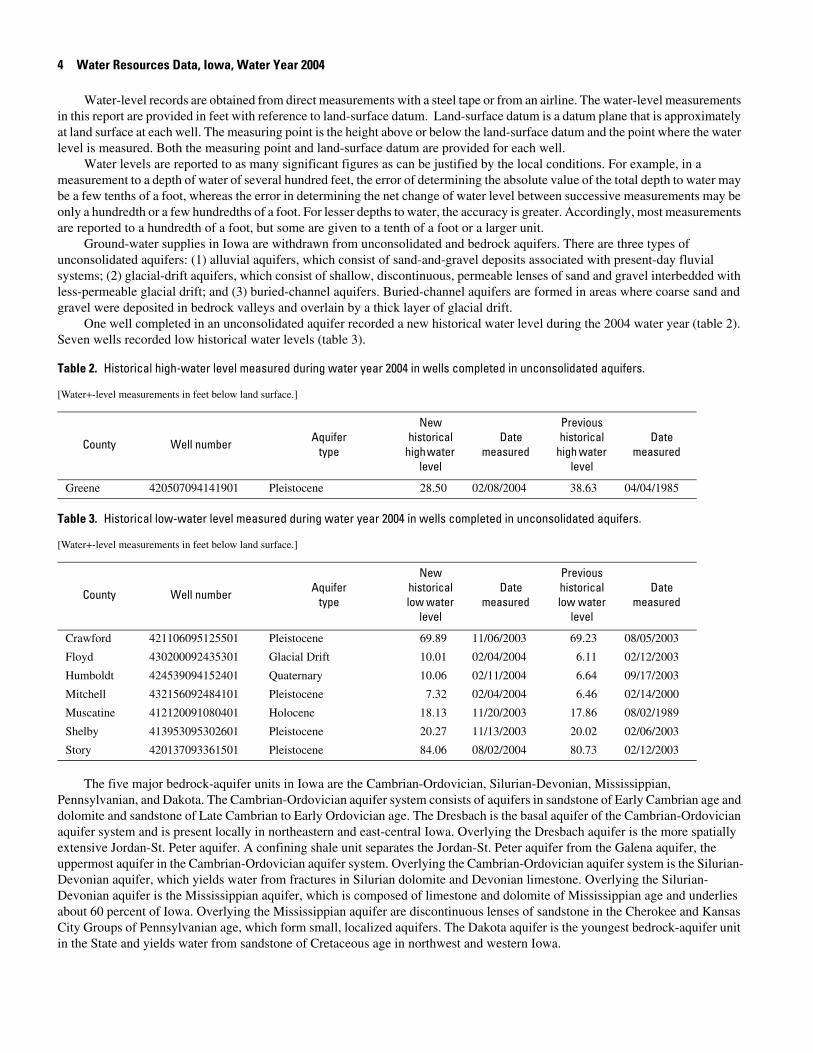
One well completed in an unconsolidated aquifer recorded a new historical water level during the 2004 water year (table 2).
Table 2. Historical high-water level measured during water year 2004 in wells completed in unconsolidated aquifers.
[Water+-level measurements in feet below land surface.]
County Well number Aquifertype
New historical
high water level
Date measured
Previous historical
high water level
Date measured
Greene 420507094141901 Pleistocene 28.50 02/08/2004 38.63 04/04/1985
Seven wells recorded low historical water levels (table 3).
Table 3. Historical low-water level measured during water year 2004 in wells completed in unconsolidated aquifers.
[Water+-level measurements in feet below land surface.]
County Well number Aquifertype
New historical low water
level
Date measured
Previous historical low water
level
Date measured
Crawford 421106095125501 Pleistocene 69.89 11/06/2003 69.23 08/05/2003
Floyd 430200092435301 Glacial Drift 10.01 02/04/2004 6.11 02/12/2003
Humboldt 424539094152401 Quaternary 10.06 02/11/2004 6.64 09/17/2003
Mitchell 432156092484101 Pleistocene 7.32 02/04/2004 6.46 02/14/2000
Muscatine 412120091080401 Holocene 18.13 11/20/2003 17.86 08/02/1989
Shelby 413953095302601 Pleistocene 20.27 11/13/2003 20.02 02/06/2003
Story 420137093361501 Pleistocene 84.06 08/02/2004 80.73 02/12/2003
The five major bedrock-aquifer units in Iowa are the Cambrian-Ordovician, Silurian-Devonian, Mississippian, Pennsylvanian, and Dakota. The Cambrian-Ordovician aquifer system consists of aquifers in sandstone of Early Cambrian age and dolomite and sandstone of Late Cambrian to Early Ordovician age. The Dresbach is the basal aquifer of the Cambrian-Ordovician aquifer system and is present locally in northeastern and east-central Iowa. Overlying the Dresbach aquifer is the more spatially extensive Jordan-St. Peter aquifer. A confining shale unit separates the Jordan-St. Peter aquifer from the Galena aquifer, the uppermost aquifer in the Cambrian-Ordovician aquifer system. Overlying the Cambrian-Ordovician aquifer system is the Silurian-Devonian aquifer, which yields water from fractures in Silurian dolomite and Devonian limestone. Overlying the Silurian-Devonian aquifer is the Mississippian aquifer, which is composed of limestone and dolomite of Mississippian age and underlies about 60 percent of Iowa. Overlying the Mississippian aquifer are discontinuous lenses of sandstone in the Cherokee and Kansas City Groups of Pennsylvanian age, which form small, localized aquifers. The Dakota aquifer is the youngest bedrock-aquifer unit in the State and yields water from sandstone of Cretaceous age in northwest and western Iowa.
Water Resources Data, Iowa, Water Year 2004 5
Thirty-six wells completed in bedrock aquifers recorded new historical water levels during the 2004 water year. Five wells recorded historical high water levels (table 4)
Table 4. Historical high-water level measured during water year 2004 in wells completed in bedrock aquifers.
[Water+-level measurements in feet below land surface; readings above land surface indicated by “+”]
County Well number Aquifertype
New historical
high water level
Date measured
Previous historical
high water level
Date measured
Hamilton 422610093474202 Mississippian 52.05 06/16/2004 52.18 07/14/2003
Ida 423107095383201 Mississippian 170.82 08/03/2004 202.55 06/04/1980
Jackson 420842090165702 Cambrian-Ordovician +2.00 08/23/2004 +1.84 05/21/1987
Johnson 414145091350101 Cambrian 284 06/16/2004 318 05/07/1997
Pottawattamie 412407095391201 Cambrian 70.98 05/07/2004 71.30 05/08/2003
, and 31 wells recorded historical low water levels (table 5).
Table 5. Historical low-water level measured during water year 2004 in wells completed in bedrock aquifers.
[Water+-level measurements in feet below land surface]
County Well number Aquifertype
New historical low water
level
Date measured
Previous historical low water
level
Date measured
Appanoose 404103092404001 Cambrian-Ordovician 394.23 08/20/2004 392.64 08/11/2003
Audubon 413044094565601 Cretaceous 54.43 11/06/2003 54.06 11/20/2003
Buena Vista 424023095571401 Cretaceous 100.31 08/04/2004 100.14 08/14/2003
Buena Vista 425233094545001 Cretaceous 138.49 11/12/2003 138.10 08/14/2003
Cherokee 424132095480211 Cretaceous 159.07 11/05/2003 158.04 08/04/2003
Cherokee 424348095231601 Cambrian-Ordovician 197.88 11/06/2003 197.41 02/13/2003
Cherokee 424348095231602 Cretaceous 194.94 11/06/2003 194.16 08/04/2003
Crawford 421005095342801 Cretaceous 249.95 11/06/2003 249.36 08/05/2003
Decatur 404422093445602 Cambrian-Ordovician 450.79 05/06/2004 448.85 08/06/2003
Dubuque 422901090471901 Cambrian-Ordovician 255.20 05/20/2004 254.17 05/20/2003
Floyd 430200092435303 Devonian 92.06 02/04/2004 85.93 02/12/2003
Floyd 430200092435304 Devonian 97.63 02/04/2004 91.86 02/12/2003
Floyd 430200092435305 Devonian 91.77 02/04/2004 83.13 02/14/2001
Floyd 430200092435306 Devonian 97.58 02/04/2004 91.87 02/12/2003
Floyd 430800092540301 Cambrian-Ordovician 216 02/04/2004 198 08/03/1999
Howard 432158092065801 Cambrian-Ordovician 355 11/13/2003 355 11/07/2001
Humboldt 424539094152402 Mississippian 43.26 01/13/2004 40.57 09/17/2003
Humboldt 424539094152403 Mississippian 43.83 01/13/2004 41.38 09/17/2003
Humboldt 424539094152404 Mississippian 43.65 02/11/2004 41.23 09/17/2003
Humboldt 424539094152405 Mississippian 43.73 02/11/2004 41.22 09/17/2003
Ida 422215095390811 Cretaceous 208.89 02/11/2004 208.52 11/18/2002
Mitchell 432156092484102 Devonian 14.07 02/04/2004 13.52 02/11/2003
Mitchell 432156092484103 Devonian 15.41 02/04/2004 13.52 02/11/2003
Mitchell 432156092484104 Devonian 19.52 02/04/2004 18.80 02/11/2003
6 Water Resources Data, Iowa, Water Year 2004
Ground-Water Quality
The Iowa ground-water-quality monitoring program has been operated since 1982 by the U.S. Geological Survey in cooperation with the Iowa Department of Natural Resources, Iowa Geological Survey. The purpose of the program is twofold: (1) provide consistent and representative data describing the chemical water quality of the principal aquifers of the State; and (2) determine possible trends in both water quality and spatial distribution of water quality.
The ground-water-quality monitoring program was initiated to continue a program begun in 1950 by the State Health Department that consisted of periodic, nonspecific sampling of untreated water from municipal supply wells. Each year, approximately 250 wells, primarily municipal supply, were randomly-selected for sampling between April and November. Between 1985 and 1989, the emphasis of the program was on the analysis of nitrate and herbicide concentrations in samples from wells less than 200 feet in depth. Because of the random pattern of sampling both spatially (different wells each year) and seasonally (different times during the year), trends in ground-water quality were difficult to determine from the data. Therefore, in 1990, to provide year-to-year continuity of data and a more statistically sound basis for the study of long-term water-quality trends, a sampling strategy based on a random selection of wells weighted by aquifer vulnerability was implemented. Aquifer vulnerability was determined by the frequency of atrazine detections in water samples collected from wells in the respective aquifers. In 1990 and 1991, a fixed network of 50 wells was selected to be sampled annually, and approximately 200 wells continued to be selected on a rotational basis.
In 1992, the investigation of water-quality trends became the primary focus of the program, and a 10-year work plan was designed to eliminate spatial and seasonal variance, yet allow flexibility within the schedule to address additional data needs. For sampling site selection in 1992, the well inventory was divided into categories based on aquifer type and again on well depth for surficial aquifers, and into categories designated "vulnerable to contamination" and "not vulnerable to contamination" based on the map Groundwater Vulnerability Regions of Iowa (Hoyer, B.E., and Hallberg, G.R., 1991, Special Map Series 11: Iowa Department of Natural Resources, scale 1:500,000) for bedrock aquifers. Vulnerability was determined by the combination and interpretation of factors including geologic and soil data, thickness of Quaternary cover, proximity to agricultural injection wells and sinkholes through which contaminants can be introduced to the aquifer, and evaluation of historical ground water and well contamination. A total of 90 sites were selected for sampling from a well inventory comprising approximately 1,640 public supply wells. From the 90 sites in the fixed network, 45 wells from two surficial aquifer types were selected to be sampled annually. The other 45 wells (from the bedrock aquifers) were selected to be sampled on a rotational schedule based on aquifer vulnerability to contamination. The wells determined to be vulnerable to contamination would be sampled every 2 years and those wells categorized as not vulnerable to contamination would be sampled every 4 years. All 90 wells were sampled in the first 2 years (1992 and 1993) and the sampling rotation began in 1994. In 2001, the sampling rotation was suspended in favor of sampling all 90 wells annually. The sampling effort during the 2004 water year is the thirteenth year of this program to determine possible ground-water-quality trends.
Mitchell 432156092484105 Devonian 25.59 02/04/2004 24.46 02/11/2003
Muscatine 412120091080402 Silurian-Devonian 18.06 11/20/2003 17.72 08/14/2003
O’Brien 425610095250611 Cretaceous 39.76 11/12/2003 39.40 02/13/2003
Plymouth 425249096125001 Cretaceous 129.55 08/04/2004 128.05 11/19/2002
Sioux 430140095573101 Cretaceous 221.19 11/05/2003 220.61 08/04/2003
Sioux 430913096033201 Cretaceous 198.35 02/10/2004 197.86 02/12/2003
Story 420129093273701 Cambrian-Ordovician 415 11/13/2003 410 08/12/2003
Table 5. Historical low-water level measured during water year 2004 in wells completed in bedrock aquifers.
[Water+-level measurements in feet below land surface]
County Well number Aquifertype
New historical low water
level
Date measured
Previous historical low water
level
Date measured
Water Resources Data, Iowa, Water Year 2004 7
Ground-Water Monitoring Network
During the 2004 water year, a total of 147 ground-water samples were collected from municipal wells located throughout the State (fig. 3).
Figure 3. Location of active ground-water-quality monitoring wells, water year 2004.
These wells were sampled as part of the Iowa ground-water-quality monitoring (GWM) program to determine water-
quality trends. The surficial aquifers include: (1) alluvial aquifers comprising sand and gravel associated with present-day fluvial systems and (2) glacial drift and buried-channel aquifers associated with previous glaciation. The bedrock aquifers include: (1) Cretaceous aquifers comprised of fine- to coarse-grained sandstones of the Dakota Group (2) Mississippian aquifers composed primarily of porous limestones and dolomites (3) Silurian-Devonian aquifers composed of porous and fractured limestones and dolomites; and (4) Cambrian-Ordovician aquifers comprised of sandstones and dolomitic sandstones of the Jordon Formation. Samples were collected during June through September 2004. All samples were analyzed by the University of Iowa Hygienic Laboratory for common ions and nutrients. One-hundred thirty-one samples were analyzed for herbicides and 57 samples were analyzed for trace metals. In addition, most samples were analyzed for volatile organic compounds (VOCs) and radiochemistry. However, in a few cases only samples from wells less than 300 feet deep were analyzed for VOCs and those from wells deeper than 300 feet were analyzed for radiochemistry. Results for all constituent analyses are published in this report. Discussion of analytical results will be limited to the nitrogen species nitrate and ammonia, and herbicides.
A summary of results for nutrient and herbicide analyses are listed by compound in table 5. Nitrate was detected in 87of the 147 samples and ammonia was detected in 72 of the 147 samples analyzed for these compounds. One or more herbicides were detected in 33 of the 131 samples. The laboratory minimum reporting level (MRL) for ammonia is 0.05 mg/L and nitrate is 0.10 mg/L. The MRL’s for the herbicides listed below are 0.05 µg/L. The MRL is the lowest concentration reliably measured by the laboratory.
8 Water Resources Data, Iowa, Water Year 2004
Table 5. Summary of nitrogen species and herbicides detected in samples from the Ground-Water -Quality Monitoring project, water year 2004.
[µg/L, micrograms per liter; mg/L, milligrams per liter; <, less than detection limit]
CompoundNumber of samples analyzed
Number of samples in
which compound
was detected
Median valueMaximum
concentration detected
Acetochlor 131 3 < 0.05 µg/L 0.86 µg/L
Ammonia 147 72 < 0.05 mg/L 8.9 mg/L
Alachlor 131 1 < 0.05 µg/L 0.20 µg/L
Atrazine 131 24 < 0.05 µg/L 1.0 µg/L
Butylate 131 0 < 0.05 µg/L 0.08 µg/L
Cyanazine 131 1 < 0.05 µg/L < 0.05 µg/L
Deethylatrazine 131 20 < 0.05 µg/L 0.20 µg/L
Deisopropylatrazine 131 0 < 0.05 µg/L 0.06 µg/L
Metolachlor 131 5 < 0.05 µg/L 4.0 µg/L
Metribuzin 131 3 < 0.05 µg/L 0.08 µg/L
Nitrate 147 87 0.5 mg/L 17.0 mg/L
Prometone 131 5 < 0.05 µg/L 0.11 µg/L
Trifluralin 131 0 < 0.05 µg/L < 0.05 µg/L
Concentrations of nitrate greater than or equal to 3.0 mg/L generally can be attributed to human activities, whereas concentrations less than 3.0 mg/L may indicate ambient concentrations from naturally occurring soil nitrogen or geologic deposits (Madison, R.J., and Brunett, J.O., 1984, Overview of the occurrence of nitrate in ground water of the United States, in National Water Summary 1984 -- Water quality trends: U.S. Geological Survey Water-Supply Paper 2275, p. 93-105). Nitrate concentrations were greater than or equal to 3.0 mg/L in 44 of 147 samples. The median concentration for the 44 samples with detections above 3.0 mg/L was 6.6 mg/L. Concentrations in 11 samples exceeded 10 mg/L, which is the U.S. Environmental Protection Agency (USEPA) Maximum Contaminant Level (MCL) for public drinking water. The median nitrate concentration for all samples was 0.5 mg/L. The maximum nitrate concentration detected was 17 mg/L. Of the 87 samples with detectable nitrate concentrations, 70 percent were from wells less than 100 ft. deep and 8 percent were from wells greater than 300 ft. deep.
Nine commonly used herbicides and two atrazine degradation products (deethylatrazine and deisopropylatrazine) were analyzed during the 2004 water year. Atrazine was the most commonly detected herbicides (18 percent), followed by metolachlor (13 percent) and deethylatrazine (11 percent). No sample contained herbicide concentrations that exceeded the MCL or proposed MCL of any of the analytes. The largest concentration of any herbicide compound detected was a metolachlor concentration of 4.0 µg/L. No detectable amounts of cyanazine or trifluralin were found in any of the samples.
Numbering system for wells and miscellaneous sites
The USGS well and miscellaneous site-numbering system is based on the grid system of latitude and longitude. The system provides the geographic location of the well or miscellaneous site and a unique number for each site. The number consists of 15 digits. The first 6 digits denote the degrees, minutes, and seconds of latitude, and the next 7 digits denote degrees, minutes, and seconds of longitude; the last 2 digits are a sequential number for wells within a 1-second grid. In the event that the latitude-
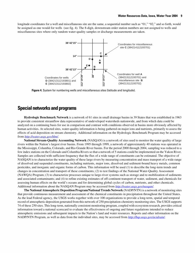
Water Resources Data, Iowa, Water Year 2004 9
longitude coordinates for a well and miscellaneous site are the same, a sequential number such as “01,” “02,” and so forth, would be assigned as one would for wells (see fig. 4). The 8-digit, downstream order station numbers are not assigned to wells and miscellaneous sites where only random water-quality samples or discharge measurements are taken.
Coordinates for well A (384213112193701) and miscellaneous site B (384213112193702)
Coordinates for miscellaneoussite C (384214112193701)
C
AD
E B
38°42'15"
14"
38°42'13"
Coordinates for wells D (384213112193801) andE (384213112193802)
112°
19'3
9"
112°
19'3
7"38"
Figure 8. System for numbering wells and miscellaneous sites (latitude and longitude).Figure 4. System for numbering wells and miscellaneous sites (latitude and longitude).
Special networks and programs
Hydrologic Benchmark Network is a network of 61 sites in small drainage basins in 39 States that was established in 1963 to provide consistent streamflow data representative of undeveloped watersheds nationwide, and from which data could be analyzed on a continuing basis for use in comparison and contrast with conditions observed in basins more obviously affected by human activities. At selected sites, water-quality information is being gathered on major ions and nutrients, primarily to assess the effects of acid deposition on stream chemistry. Additional information on the Hydrologic Benchmark Program may be accessed from http://water.usgs.gov/hbn/.
National Stream-Quality Accounting Network (NASQAN) is a network of sites used to monitor the water quality of large rivers within the Nation’s largest river basins. From 1995 through 1999, a network of approximately 40 stations was operated in the Mississippi, Columbia, Colorado, and Rio Grande River basins. For the period 2000 through 2004, sampling was reduced to a few index stations on the Colorado and Columbia Rivers so that a network of 5 stations could be implemented on the Yukon River. Samples are collected with sufficient frequency that the flux of a wide range of constituents can be estimated. The objective of NASQAN is to characterize the water quality of these large rivers by measuring concentration and mass transport of a wide range of dissolved and suspended constituents, including nutrients, major ions, dissolved and sediment-bound heavy metals, common pesticides, and inorganic and organic forms of carbon. This information will be used (1) to describe the long-term trends and changes in concentration and transport of these constituents; (2) to test findings of the National Water-Quality Assessment (NAWQA) Program; (3) to characterize processes unique to large-river systems such as storage and re-mobilization of sediments and associated contaminants; and (4) to refine existing estimates of off-continent transport of water, sediment, and chemicals for assessing human effects on the world’s oceans and for determining global cycles of carbon, nutrients, and other chemicals. Additional information about the NASQAN Program may be accessed from http://water.usgs.gov/nasqan/.
The National Atmospheric Deposition Program/National Trends Network (NADP/NTN) is a network of monitoring sites that provide continuous measurement and assessment of the chemical constituents in precipitation throughout the United States. As the lead Federal agency, the USGS works together with over 100 organizations to provide a long-term, spatial and temporal record of atmospheric deposition generated from this network of 250 precipitation-chemistry monitoring sites. The USGS supports 74 of these 250 sites. This long-term, nationally consistent monitoring program, coupled with ecosystem research, provides critical information toward a national scorecard to evaluate the effectiveness of ongoing and future regulations intended to reduce atmospheric emissions and subsequent impacts to the Nation’s land and water resources. Reports and other information on the NADP/NTN Program, as well as data from the individual sites, may be accessed from http://bqs.usgs.gov/acidrain/.
10 Water Resources Data, Iowa, Water Year 2004
The USGS National Water-Quality Assessment (NAWQA) Program is a long-term program with goals to describe the status and trends of water-quality conditions for a large, representative part of the Nation’s ground- and surface-water resources; to provide an improved understanding of the primary natural and human factors affecting these observed conditions and trends; and to provide information that supports development and evaluation of management, regulatory, and monitoring decisions by other agencies.
Assessment activities are being conducted in 42 study units (major watersheds and aquifer systems) that represent a wide range of environmental settings nationwide and that account for a large percentage of the Nation’s water use. A wide array of chemical constituents is measured in ground water, surface water, streambed sediments, and fish tissues. The coordinated application of comparative hydrologic studies at a wide range of spatial and temporal scales will provide information for water-resources managers to use in making decisions and a foundation for aggregation and comparison of findings to address water-quality issues of regional and national interest.
Communication and coordination between USGS personnel and other local, State, and Federal interests are critical components of the NAWQA Program. Each study unit has a local liaison committee consisting of representatives from key Federal, State, and local water-resources agencies, Indian nations, and universities in the study unit. Liaison committees typically meet semiannually to discuss their information needs, monitoring plans and progress, desired information products, and opportunities to collaborate efforts among the agencies. Additional information about the NAWQA Program may be accessed from http://water.usgs.gov/nawqa/.
The USGS National Streamflow Information Program (NSIP) is a long-term program with goals to provide framework streamflow data across the Nation. Included in the program are creation of a permanent Federally funded streamflow network, research on the nature of streamflow, regional assessments of streamflow data and databases, and upgrades in the streamflow information delivery systems. Additional information about NSIP may be accessed from http://water.usgs.gov/nsip/.
Explanation of Ground-Water-Level Records
Generally, only ground-water-level data from selected wells with continuous recorders from a basic network of observation wells are published in this report. This basic network contains observation wells located so that the most significant data are obtained from the fewest wells in the most important aquifers.
Data Collection and Computation
Measurements are made in many types of wells, under varying conditions of access and at different temperatures; hence, neither the method of measurement nor the equipment can be standardized. At each observation well, however, the equipment and techniques used are those that will ensure that measurements at each well are consistent.
Most methods for collecting and analyzing water samples are described in the TWRIs referred to in the On-site Measurements and Sample Collection and the Laboratory Measurements sections in this report. In addition, TWRI Book 1, Chapter D2, describes guidelines for the collection and field analysis of ground-water samples for selected unstable constituents. Procedures for on-site measurements and for collecting, treating, and shipping samples are given in TWRIs Book 1, Chapter D2; Book 3, Chapters A1, A3, and A4; and Book 9, Chapters A1 through A9. The TWRI publications may be accessed from http://water.usgs.gov/pubs/twri/. The values in this report represent water-quality conditions at the time of sampling, as much as possible, and that are consistent with available sampling techniques and methods of analysis. These methods are consistent with ASTM standards and generally follow ISO standards. Trained personnel collected all samples. The wells sampled were pumped long enough to ensure that the water collected came directly from the aquifer and had not stood for a long time in the well casing where it would have been exposed to the atmosphere and to the material, possibly metal, comprising the casings.
Water-level measurements in this report are given in feet with reference to land-surface datum (lsd). Land-surface datum is a datum plane that is approximately at land surface at each well. If known, the elevation of the land-surface datum above sea level is given in the well description. The height of the measuring point (MP) above or below land-surface datum is given in each well description. Water levels in wells equipped with recording gages are reported for every fifth day and the end of each month (EOM).
Water levels are reported to as many significant figures as can be justified by the local conditions. For example, in a measurement of a depth of water of several hundred feet, the error in determining the absolute value of the total depth to water may be a few tenths of a foot, whereas the error in determining the net change of water level between successive measurements may be only a hundredth or a few hundredths of a foot. For lesser depths to water the accuracy is greater. Accordingly, most measurements are reported to a hundredth of a foot, but some are given only to a tenth of a foot or a larger unit.
Water Resources Data, Iowa, Water Year 2004 11
Data Presentation
Water-level data are presented in alphabetical order by county. The primary identification number for a given well is the 15-digit site identification number that appears in the upper left corner of the table. The secondary identification number is the local or county well number. Well locations are shown in figure2.
Each well record consists of three parts: the well description, the data table of water levels observed during the water year, and, for most wells, a hydrograph following the data table. Well descriptions are presented in the headings preceding the tabular data.
The following comments clarify information presented in these various headings.LOCATION.—This paragraph follows the well-identification number and reports the hydrologic-unit number and a
geographic point of reference. Latitudes and longitudes used in this report are reported as North American Datum of 1927 unless otherwise specified.
AQUIFER.—This entry designates by name and geologic age the aquifer that the well taps. WELL CHARACTERISTICS.—This entry describes the well in terms of depth, casing diameter and depth or screened
interval, method of construction, use, and changes since construction.INSTRUMENTATION.—This paragraph provides information on both the frequency of measurement and the collection
method used, allowing the user to better evaluate the reported water-level extremes by knowing whether they are based on continuous, monthly, or some other frequency of measurement.
DATUM.—This entry describes both the measuring point and the land-surface elevation at the well. The altitude of the land-surface datum is described in feet above the altitude datum; it is reported with a precision depending on the method of determination. The measuring point is described physically (such as top of casing, top of instrument shelf, and so forth), and in relation to land surface (such as 1.3 ft above land-surface datum). The elevation of the land-surface datum is described in feet above National Geodetic Vertical Datum of 1929 (NGVD 29); it is reported with a precision depending on the method of determination.
REMARKS.—This entry describes factors that may influence the water level in a well or the measurement of the water level, when various methods of measurement were begun, and the network (climatic, terrane, local, or areal effects) or the special project to which the well belongs.
PERIOD OF RECORD.—This entry indicates the time period for which records are published for the well, the month and year at the start of publication of water-level records by the USGS, and the words “to current year” if the records are to be continued into the following year. Time periods for which water-level records are available, but are not published by the USGS, may be noted.
EXTREMES FOR PERIOD OF RECORD.—This entry contains the highest and lowest instantaneously recorded or measured water levels of the period of published record, with respect to land-surface datum or sea level, and the dates of occurrence.
Water-Level Tables
A table of water levels follows the well description for each well. Water-level measurements in this report are given in feet with reference to either sea level or land-surface datum (lsd). Missing records are indicated by dashes in place of the water-level value.
For wells not equipped with recorders, water-level measurements were obtained periodically by steel or electric tape. Tables of periodic water-level measurements in these wells show the date of measurement and the measured water-level value.
Hydrographs
Hydrographs are a graphic display of water-level fluctuations over a period of time. In this report, current water year and, when appropriate, period-of-record hydrographs are shown. Hydrographs that display periodic water-level measurements show points that may be connected with a dashed line from one measurement to the next. Hydrographs that display recorder data show a solid line representing the mean water level recorded for each day. Missing data are indicated by a blank space or break in a hydrograph. Missing data may occur as a result of recorder malfunctions, battery failures, or mechanical problems related to the response of the recorder’s float mechanism to water-level fluctuations in a well.
12 Water Resources Data, Iowa, Water Year 2004
Explanation of precipitation records
Data Collection and Computation
Rainfall data generally are collected using electronic data loggers that measure the rainfall in 0.01-inch increments every 15 minutes using either a tipping-bucket rain gage or a collection well gage. Twenty-four hour rainfall totals are tabulated and presented. A 24-hour period extends from just past midnight of the previous day to midnight of the current day. Snowfall-affected data can result during cold weather when snow fills the rain-gage funnel and then melts as temperatures rise. Snowfall-affected data are subject to errors. Missing values are indicated by this symbol “---” in the table.
Data Presentation
Precipitation records collected at surface-water gaging stations are identified with the same station number and name as the stream-gaging station. Where a surface-water daily-record station is not available, the precipitation record is published with its own name and latitude-longitude identification number.
Information pertinent to the history of a precipitation station is provided in descriptive headings preceding the tabular data. These descriptive headings give details regarding location, period of record, and general remarks.
The following information is provided with each precipitation station. Comments that follow clarify information presented under the various headings of the station description.
LOCATION.—See Data Presentation in the EXPLANATION OF STAGE- AND WATER-DISCHARGE RECORDS section of this report (same comments apply).
PERIOD OF RECORD.—See Data Presentation in the EXPLANATION OF STAGE- AND WATER-DISCHARGE RECORDS section of this report (same comments apply).
INSTRUMENTATION.—Information on the type of rainfall collection system is given.REMARKS.—Remarks provide added information pertinent to the collection, analysis, or computation of records.
Explantion of Water-Quality Records
Collection and Examination of Data
The descriptive heading for water-quality records gives the period of record for all water-quality data; the period of daily record for parameters that are measured on a daily basis (specific conductance, water temperature,, and so forth); extremes for the current year; and general remarks.
For ground-water records, no descriptive statements are given; however, the well number, depth of well, sampling date, or other pertinent data are given in the table containing the chemical analyses of the ground water.
Water Analysis
Most of the methods used for collecting and analyzing water samples are described in the TWRIs, which may be accessed from http://water.usgs.gov/pubs/twri/.
Chemical-quality data published in this report are considered to be the most representative values available for the stations listed. The values reported represent water-quality conditions at the time of sampling as much as possible, consistent with available sampling techniques and methods of analysis. In the rare case where an apparent inconsistency exists between a reported pH value and the relative abundance of carbon dioxide species (carbonate and bicarbonate), the inconsistency is the result of a slight uptake of carbon dioxide from the air by the sample between measurement of pH in the field and determination of carbonate and bicarbonate in the laboratory.
For chemical-quality stations equipped with digital monitors, the records consist of daily maximum and minimum values (and sometimes mean or median values) for each constituent measured, and are based on 15-minute or 1-hour intervals of recorded data beginning at 0000 hours and ending at 2400 hours for the day of record.
Water Resources Data, Iowa, Water Year 2004 13
Ground-Water-Quality Data
Data Collection and Computation
The ground-water-quality data in this report were obtained as a part of special studies in specific areas. Consequently, a number of chemical analyses are presented for some wells within a county but not for others. As a result, the records for this year, by themselves, do not provide a balanced view of ground-water quality Statewide.
Most methods for collecting and analyzing water samples are described in the Techniques of Water-Resources Investigations of the United States Geological Survey, which may be accessed from http://water.usgs.gov/pubs/twri/. Procedures for on-site measurements and for collecting, treating, and shipping samples are given in TWRI, Book 1, Chapter D2; Book 3, Chapter C2; and Book 5, Chapters A1, A3, and A4. Also, detailed information on collecting, treating, and shipping samples may be obtained from the USGS District office (see address shown on back of title page in this report).
Laboratory Measurements
Analysis for sulfide and measurement of alkalinity, pH, water temperature, specific conductance, and dissolved oxygen are performed on site. All other sample analyses are performed at the USGS laboratory in Lakewood, Colorado, unless otherwise noted. Methods used by the USGS laboratory are given in TWRI, Book 1, Chapter D2; Book 3, Chapter C2; and Book 5, Chapters A1, A3, and A4, which may be accessed from http://water.usgs.gov/pubs/twri/.
Blank Samples
Blank samples are collected and analyzed to ensure that environmental samples have not been contaminated in the overall data-collection process. The blank solution used to develop specific types of blank samples is a solution that is free of the analytes of interest. Any measured value signal in a blank sample for an analyte (a specific component measured in a chemical analysis) that was absent in the blank solution is believed to be due to contamination. Many types of blank samples are possible; each is designed to segregate a different part of the overall data-collection process. The types of blank samples collected are:
Field blank—A blank solution that is subjected to all aspects of sample collection, field processing preservation, transportation, and laboratory handling as an environmental sample.
Trip blank—A blank solution that is put in the same type of bottle used for an environmental sample and kept with the set of sample bottles before and after sample collection.
Equipment blank—A blank solution that is processed through all equipment used for collecting and processing an environmen-tal sample (similar to a field blank but normally done in the more controlled conditions of the office).
Sampler blank—A blank solution that is poured or pumped through the same field sampler used for collecting an environmental sample.
Filter blank—A blank solution that is filtered in the same manner and through the same filter apparatus used for an environmen-tal sample.
Splitter blank—A blank solution that is mixed and separated using a field splitter in the same manner and through the same apparatus used for an environmental sample.
Preservation blank—A blank solution that is treated with the sampler preservatives used for an environmental sample.
14 Water Resources Data, Iowa, Water Year 2004
Reference Samples
Reference material is a solution or material prepared by a laboratory. The reference material composition is certified for one or more properties so that it can be used to assess a measurement method. Samples of reference material are submitted for analysis to ensure that an analytical method is accurate for the known properties of the reference material. Generally, the selected reference material properties are similar to the environmental sample properties.
Replicate Samples
Replicate samples are a set of environmental samples collected in a manner such that the samples are thought to be essentially identical in composition. Replicate is the general case for which a duplicate is the special case consisting of two samples. Replicate samples are collected and analyzed to establish the amount of variability in the data contributed by some part of the collection and analytical process. Many types of replicate samples are possible, each of which may yield slightly different results in a dynamic hydrologic setting, such as a flowing stream. The types of replicate samples collected in this district are:
Concurrent Samples--A type of replicate sample in which the samples are collected simultaneously with two or more samplers or by using one sampler and alternating the collection of samples into two or more compositing containers.
Sequential samples—A type of replicate sample in which the samples are collected one after the other, typically over a short time.
Split sample—A type of replicate sample in which a sample is split into subsamples, each subsample contemporaneous in time and space.
Spike Samples
Spike samples are samples to which known quantities of a solution with one or more well-established analyte concentrations have been added. These samples are analyzed to determine the extent of matrix interference or degradation on the analyte concentration during sample processing and analysis.
Access to USGS Water Data
The USGS provides near real-time stage and discharge data for many of the gaging stations equipped with the necessary telemetry and historic daily-mean and peak-flow discharge data for most current or discontinued gaging stations through the World Wide Web (WWW). These data may be accessed from http://water.usgs.gov.
Water-quality data and ground-water data also are available through the WWW. In addition, data can be provided in various machine-readable formats on various media. Information about the availability of specific types of data or products, and user charges, can be obtained locally from each Water Discipline District Office (See address that is shown on the back of the title page of this report.)
Definition of Terms
Specialized technical terms related to streamflow, water-quality, and other hydrologic data, as used in this report, are defined below. Terms such as algae, water level, and precipitation are used in their common everyday meanings, definitions of which are given in standard dictionaries. Not all terms defined in this alphabetical list apply to every State. See also table for converting English units to International System (SI) Units. Other glossaries that also define water-related terms are accessible from http://water.usgs.gov/glossaries.html.
Acid neutralizing capacity (ANC) is the equivalent sum of all bases or base-producing materials, solutes plus particulates, in an aqueous system that can be titrated with acid to an equivalence point. This term designates titration of an “unfiltered” sample (formerly reported as alkalinity).
Water Resources Data, Iowa, Water Year 2004 15
Acre-foot (AC-FT, acre-ft) is a unit of volume, commonly used to measure quantities of water used or stored, equivalent to the volume of water required to cover 1 acre to a depth of 1 foot and equivalent to 43,560 cubic feet, 325,851 gallons, or 1,233 cubic meters. (See also “Annual runoff”)
Adenosine triphosphate (ATP) is an organic, phosphate-rich compound important in the transfer of energy in organisms. Its cen-tral role in living cells makes ATP an excellent indicator of the presence of living material in water. A measurement of ATP therefore provides a sensitive and rapid estimate of biomass. ATP is reported in micrograms per liter.
Adjusted discharge is discharge data that have been mathematically adjusted (for example, to remove the effects of a daily tide cycle or reservoir storage).
Algal growth potential (AGP) is the maximum algal dry weight biomass that can be produced in a natural water sample under standardized laboratory conditions. The growth potential is the algal biomass present at stationary phase and is expressed as milligrams dry weight of algae produced per liter of sample. (See also “Biomass” and “Dry weight”)
Alkalinity is the capacity of solutes in an aqueous system to neutralize acid. This term designates titration of a “filtered” sample.
Annual runoff is the total quantity of water that is discharged (“runs off”) from a drainage basin in a year. Data reports may present annual runoff data as volumes in acre-feet, as discharges per unit of drainage area in cubic feet per second per square mile, or as depths of water on the drainage basin in inches.
Annual 7-day minimum is the lowest mean value for any 7-consecutive-day period in a year. Annual 7-day minimum values are reported herein for the calendar year and the water year (October 1 through September 30). Most low-flow frequency analyses use a climatic year (April 1-March 31), which tends to prevent the low-flow period from being artificially split between adjacent years. The date shown in the summary statistics table is the initial date of the 7-day period. (This value should not be confused with the 7-day, 10-year low-flow statistic.)
Aroclor is the registered trademark for a group of poly-chlorinated biphenyls that were manufactured by the Monsanto Company prior to 1976. Aroclors are assigned specific 4-digit reference numbers dependent upon molecular type and degree of substitu-tion of the biphenyl ring hydrogen atoms by chlorine atoms. The first two digits of a numbered aroclor represent the molecular type, and the last two digits represent the percentage weight of the hydrogen-substituted chlorine.
Artificial substrate is a device that purposely is placed in a stream or lake for colonization of organisms. The artificial substrate simplifies the community structure by standardizing the substrate from which each sample is collected. Examples of artificial substrates are basket samplers (made of wire cages filled with clean streamside rocks) and multiplate samplers (made of hard-board) for benthic organism collection, and plexiglass strips for periphyton collection. (See also “Substrate”)
Ash mass is the mass or amount of residue present after the residue from a dry-mass determination has been ashed in a muffle furnace at a temperature of 500 °C for 1 hour. Ash mass of zooplankton and phytoplankton is expressed in grams per cubic meter (g/m3), and periphyton and benthic organisms in grams per square meter (g/m2). (See also “Biomass” and “Dry mass”)
Aspect is the direction toward which a slope faces with respect to the compass.
Bacteria are microscopic unicellular organisms, typically spherical, rodlike, or spiral and threadlike in shape, often clumped into colonies. Some bacteria cause disease, whereas others perform an essential role in nature in the recycling of materials; for example, by decomposing organic matter into a form available for reuse by plants.
Bankfull stage, as used in this report, is the stage at which a stream first overflows its natural banks formed by floods with 1- to 3-year recurrence intervals.
Base discharge (for peak discharge) is a discharge value, determined for selected stations, above which peak discharge data are published. The base discharge at each station is selected so that an average of about three peak flows per year will be published. (See also “Peak flow”)
Base flow is sustained flow of a stream in the absence of direct runoff. It includes natural and human-induced streamflows. Natu-ral base flow is sustained largely by ground-water discharge.
16 Water Resources Data, Iowa, Water Year 2004
Bed material is the sediment mixture of which a stream-bed, lake, pond, reservoir, or estuary bottom is composed. (See also “Bedload” and “Sediment”)
Bedload is material in transport that primarily is supported by the streambed. In this report, bedload is considered to consist of particles in transit from the bed to the top of the bedload sampler nozzle (an elevation ranging from 0.25 to 0.5 foot). These par-ticles are retained in the bedload sampler. A sample collected with a pressure-differential bedload sampler also may contain a component of the suspended load.
Bedload discharge (tons per day) is the rate of sediment moving as bedload, reported as dry weight, that passes through a cross section in a given time. NOTE: Bedload discharge values in this report may include a component of the suspended-sediment discharge. A correction may be necessary when computing the total sediment discharge by summing the bedload discharge and the suspended-sediment discharge. (See also “Bedload,” “Dry weight,” “Sediment,” and “Suspended-sediment discharge”)
Benthic organisms are the group of organisms inhabiting the bottom of an aquatic environment. They include a number of types of organisms, such as bacteria, fungi, insect larvae and nymphs, snails, clams, and crayfish. They are useful as indicators of water quality.
Biochemical oxygen demand (BOD) is a measure of the quantity of dissolved oxygen, in milligrams per liter, necessary for the decomposition of organic matter by microorganisms, such as bacteria.
Biomass is the amount of living matter present at any given time, expressed as mass per unit area or volume of habitat.
Biomass pigment ratio is an indicator of the total proportion of periphyton that are autotrophic (plants). This also is called the Autotrophic Index.
Blue-green algae (Cyanophyta) are a group of phytoplankton and periphyton organisms with a blue pigment in addition to a green pigment called chlorophyll. Blue-green algae can cause nuisance water-quality conditions in lakes and slow-flowing riv-ers; however, they are found commonly in streams throughout the year. The abundance of blue-green algae in phytoplankton samples is expressed as the number of cells per milliliter (cells/mL) or biovolume in cubic micrometers per milliliter (µm3/mL). The abundance of blue-green algae in periphyton samples is given in cells per square centimeter (cells/cm2) or biovolume per square centimeter (µm3/cm2). (See also “Phytoplankton”and “Periphyton”)
Bottom material (See “Bed material”)
Bulk electrical conductivity is the combined electrical conductivity of all material within a doughnut-shaped volume surround-ing an induction probe. Bulk conductivity is affected by different physical and chemical properties of the material including the dissolved-solids content of the pore water, and the lithology and porosity of the rock.
Canadian Geodetic Vertical Datum 1928 is a geodetic datum derived from a general adjustment of Canada’s first order level network in 1928.
Cell volume (biovolume) determination is one of several common methods used to estimate biomass of algae in aquatic systems. Cell members of algae are used frequently in aquatic surveys as an indicator of algal production. However, cell numbers alone cannot represent true biomass because of considerable cell-size variation among the algal species.
Cell volume (biovolume) determination is one of several common methods used to estimate biomass of algae in aquatic systems. Cell members of algae are used frequently in aquatic surveys as an indicator of algal production. However, cell numbers alone cannot represent true biomass because of considerable cell-size variation among the algal species. Cell volume (µm3) is deter-mined by obtaining critical cell measurements or cell dimensions (for example, length, width, height, or radius) for 20 to 50 cells of each important species to obtain an average biovolume per cell. Cells are categorized according to the correspondence of their cellular shape to the nearest geometric solid or combinations of simple solids (for example, spheres, cones, or cylin-ders). Representative formulae used to compute biovolume are as follows:
sphere 4/3 πr3 cone 1/3 πr2h cylinder πr2h.
pi (π) is the ratio of the circumference to the diameter of a circle; pi = 3.14159….

Water Resources Data, Iowa, Water Year 2004 17
From cell volume, total algal biomass expressed as biovolume (µm3/mL) is thus determined by multiplying the number of cells of a given species by its average cell volume and then summing these volumes for all species.
Cells/volume refers to the number of cells of any organism that is counted by using a microscope and grid or counting cell. Many planktonic organisms are multicelled and are counted according to the number of contained cells per sample volume, and gener-ally are reported as cells or units per milliliter (mL) or liter (L).
Cfs-day (See “Cubic foot per second-day”)
Channel bars, as used in this report, are the lowest prominent geomorphic features higher than the channel bed.
Chemical oxygen demand (COD) is a measure of the chemically oxidizable material in the water and furnishes an approxima-tion of the amount of organic and reducing material present. The determined value may correlate with BOD or with carbon-aceous organic pollution from sewage or industrial wastes. [See also “Biochemical oxygen demand (BOD)”]
Clostridium perfringens (C. perfringens) is a spore-forming bacterium that is common in the feces of human and other warm-blooded animals. Clostridial spores are being used experimentally as an indicator of past fecal contamination and the presence of microorganisms that are resistant to disinfection and environmental stresses. (See also “Bacteria”)
Coliphages are viruses that infect and replicate in coliform bacteria. They are indicative of sewage contamination of water and of the survival and transport of viruses in the environment.
Color unit is produced by 1 milligram per liter of platinum in the form of the chloroplatinate ion. Color is expressed in units of the platinum-cobalt scale.
Confined aquifer is a term used to describe an aquifer containing water between two relatively impermeable bound-aries. The water level in a well tapping a confined aquifer stands above the top of the confined aquifer and can be higher or lower than the water table that may be present in the material above it. In some cases, the water level can rise above the ground surface, yield-ing a flowing well.
Contents is the volume of water in a reservoir or lake. Unless otherwise indicated, volume is computed on the basis of a level pool and does not include bank storage.
Continuous-record station is a site where data are collected with sufficient frequency to define daily mean values and variations within a day.
Control designates a feature in the channel that physically affects the water-surface elevation and thereby determines the stage-discharge relation at the gage. This feature may be a constriction of the channel, a bedrock outcrop, a gravel bar, an artificial structure, or a uniform cross section over a long reach of the channel.
Control structure, as used in this report, is a structure on a stream or canal that is used to regulate the flow or stage of the stream or to prevent the intrusion of saltwater.
Cubic foot per second (CFS, ft3/s) is the rate of discharge representing a volume of 1 cubic foot passing a given point in 1 sec-ond. It is equivalent to approximately 7.48 gallons per second or approximately 449 gallons per minute, or 0.02832 cubic meters per second. The term “second-foot” sometimes is used synonymously with “cubic foot per second” but is now obsolete.
Cubic foot per second-day (CFS-DAY, Cfs-day, [(ft3/s)/d]) is the volume of water represented by a flow of 1 cubic foot per sec-ond for 24 hours. It is equivalent to 86,400 cubic feet, 1.98347 acre-feet, 646,317 gallons, or 2,446.6 cubic meters. The daily mean discharges reported in the daily value data tables numerically are equal to the daily volumes in cfs-days, and the totals also represent volumes in cfs-days.
Cubic foot per second per square mile [CFSM, (ft3/s)/mi2] is the average number of cubic feet of water flowing per second from each square mile of area drained, assuming the runoff is distributed uniformly in time and area. (See also “Annual runoff”)
18 Water Resources Data, Iowa, Water Year 2004
Daily mean suspended-sediment concentration is the time-weighted mean concentration of suspended sediment passing a stream cross section during a 24-hour day. (See also “Sediment” and “Suspended-sediment concentration”)
Daily record station is a site where data are collected with sufficient frequency to develop a record of one or more data values per day. The frequency of data collection can range from continuous recording to data collection on a daily or near-daily basis.
Data collection platform (DCP) is an electronic instrument that collects, processes, and stores data from various sensors, and transmits the data by satellite data relay, line-of-sight radio, and/or landline telemetry.
Data logger is a microprocessor-based data acquisition system designed specifically to acquire, process, and store data. Data usu-ally are downloaded from onsite data loggers for entry into office data systems.
Datum is a surface or point relative to which measurements of height and/or horizontal position are reported. A vertical datum is a horizontal surface used as the zero point for measurements of gage height, stage, or elevation; a horizontal datum is a refer-ence for positions given in terms of latitude-longitude, State Plane coordinates, or Universal Transverse Mercator (UTM) coor-dinates. (See also “Gage datum,” “Land-surface datum,” “National Geodetic Vertical Datum of 1929,” and “North American Vertical Datum of 1988”)
Diatoms (Bacillariophyta) are unicellular or colonial algae with a siliceous cell wall. The abundance of diatoms in phytoplankton samples is expressed as the number of cells per milliliter (cells/mL) or biovolume in cubic micrometers per milliliter (µm3/mL). The abundance of diatoms in periphyton samples is given in cells per square centimeter (cells/cm2) or biovolume per square centimeter (µm3/cm2). (See also “Phytoplankton” and “Periphyton”)
Diel is of or pertaining to a 24-hour period of time; a regular daily cycle.
Discharge, or flow, is the rate that matter passes through a cross section of a stream channel or other water body per unit of time. The term commonly refers to the volume of water (including, unless otherwise stated, any sediment or other constituents sus-pended or dissolved in the water) that passes a cross section in a stream channel, canal, pipeline, and so forth, within a given period of time (cubic feet per second). Discharge also can apply to the rate at which constituents, such as suspended sediment, bedload, and dissolved or suspended chemicals, pass through a cross section, in which cases the quantity is expressed as the mass of constituent that passes the cross section in a given period of time (tons per day).
Dissolved refers to that material in a representative water sample that passes through a 0.45-micrometer membrane filter. This is a convenient operational definition used by Federal and State agencies that collect water-quality data. Determinations of “dis-solved” constituent concentrations are made on sample water that has been filtered.
Dissolved oxygen (DO) is the molecular oxygen (oxygen gas) dissolved in water. The concentration in water is a function of atmospheric pressure, temperature, and dissolved-solids concentration of the water. The ability of water to retain oxygen decreases with increasing temperature or dissolved-solids concentration. Photosynthesis and respiration by plants commonly cause diurnal variations in dissolved-oxygen concentration in water from some streams.
Dissolved-solids concentration in water is the quantity of dissolved material in a sample of water. It is determined either analyt-ically by the “residue-on-evaporation” method, or mathematically by totaling the concentrations of individual constituents reported in a comprehensive chemical analysis. During the analytical determination, the bicarbonate (generally a major dis-solved component of water) is converted to carbonate. In the mathematical calculation, the bicarbonate value, in milligrams per liter, is multiplied by 0.4917 to convert it to carbonate. Alternatively, alkalinity concentration (as mg/L CaCO3) can be con-verted to carbonate concentration by multiplying by 0.60.
Diversity index (H) (Shannon index) is a numerical expression of evenness of distribution of aquatic organisms. The formula for diversity index is:
dnin---- log2
nin----
i 1≈
s
∑–= ,
Water Resources Data, Iowa, Water Year 2004 19
where ni is the number of individuals per taxon, n is the total number of individuals, and s is the total number of taxa in the sam-ple of the community. Index values range from zero, when all the organisms in the sample are the same, to some positive num-ber, when some or all of the organisms in the sample are different.
Drainage area of a stream at a specific location is that area upstream from the location, measured in a horizontal plane, that has a common outlet at the site for its surface runoff from precipitation that normally drains by gravity into a stream. Drainage areas given herein include all closed basins, or noncontributing areas, within the area unless otherwise specified.
Drainage basin is a part of the Earth’s surface that contains a drainage system with a common outlet for its surface runoff. (See “Drainage area”)
Dry mass refers to the mass of residue present after drying in an oven at 105 °C, until the mass remains unchanged. This mass represents the total organic matter, ash and sediment, in the sample. Dry-mass values are expressed in the same units as ash mass. (See also “Ash mass,” “Biomass,” and “Wet mass”)
Dry weight refers to the weight of animal tissue after it has been dried in an oven at 65 °C until a constant weight is achieved. Dry weight represents total organic and inorganic matter in the tissue. (See also “Wet weight”)
Embeddedness is the degree to which gravel-sized and larger particles are surrounded or enclosed by finer-sized particles. (See also “Substrate embeddedness class”)
Enterococcus bacteria commonly are found in the feces of humans and other warmblooded animals. Although some strains are ubiquitous and not related to fecal pollution, the presence of enterococci in water is an indication of fecal pollution and the pos-sible presence of enteric pathogens. Enterococcus bacteria are those bacteria that produce pink to red colonies with black or red-dish-brown precipitate after incubation at 41 °C on mE agar (nutrient medium for bacterial growth) and subsequent transfer to EIA medium. Enterococci include Streptococcus feacalis, Streptococcus feacium, Streptococcus avium, and their variants. (See also “Bacteria”)
EPT Index is the total number of distinct taxa within the insect orders Ephemeroptera, Plecoptera, and Trichoptera. This index summarizes the taxa richness within the aquatic insects that generally are considered pollution sensitive; the index usually decreases with pollution.
Escherichia coli (E. coli) are bacteria present in the intestine and feces of warmblooded animals. E. coli are a member species of the fecal coliform group of indicator bacteria. In the laboratory, they are defined as those bacteria that produce yellow or yellow-brown colonies on a filter pad saturated with urea substrate broth after primary culturing for 22 to 24 hours at 44.5 °C on mTEC medium (nutrient medium for bacterial growth). Their concentrations are expressed as number of colonies per 100 mL of sam-ple. (See also “Bacteria”)
Estimated (E) value of a concentration is reported when an analyte is detected and all criteria for a positive result are met. If the concentration is less than the method detection limit (MDL), an E code will be reported with the value. If the analyte is identi-fied qualitatively as present, but the quantitative determination is substantially more uncertain, the National Water Quality Lab-oratory will identify the result with an E code even though the measured value is greater than the MDL. A value reported with an E code should be used with caution. When no analyte is detected in a sample, the default reporting value is the MDL pre-ceded by a less than sign (<). For bacteriological data, concentrations are reported as estimated when results are based on non-ideal colony counts.
Euglenoids (Euglenophyta) are a group of algae that usually are free-swimming and rarely creeping. They have the ability to grow either photosynthetically in the light or heterotrophically in the dark. (See also “Phytoplankton”)
Extractable organic halides (EOX) are organic compounds that contain halogen atoms such as chlorine. These organic com-pounds are semivolatile and extractable by ethyl acetate from air-dried streambed sediment. The ethyl acetate extract is com-busted, and the concentration is determined by microcoulometric determination of the halides formed. The concentration is reported as micrograms of chlorine per gram of the dry weight of the streambed sediment.
Fecal coliform bacteria are present in the intestines or feces of warmblooded animals. They often are used as indicators of the sanitary quality of the water. In the laboratory, they are defined as all organisms that produce blue colonies within 24 hours
20 Water Resources Data, Iowa, Water Year 2004
when incubated at 44.5 °C plus or minus 0.2 °C on M-FC medium (nutrient medium for bacterial growth). Their concentrations are expressed as number of colonies per 100 mL of sample. (See also “Bacteria”)
Fecal streptococcal bacteria are present in the intestines of warmblooded animals and are ubiquitous in the environment. They are characterized as gram-positive, cocci bacteria that are capable of growth in brain-heart infusion broth. In the laboratory, they are defined as all the organisms that produce red or pink colonies within 48 hours at 35 °C plus or minus 1.0 °C on KF-strepto-coccus medium (nutrient medium for bacterial growth). Their concentrations are expressed as number of colonies per 100 mL of sample. (See also “Bacteria”)
Filtered pertains to constituents in a water sample passed through a filter of specified pore diameter, most commonly 0.45 micrometer or less for inorganic analytes and 0.7 micrometer for organic analytes.
Filtered, recoverable is the amount of a given constituent that is in solution after the part of a representative water-suspended sediment sample that has passed through a filter has been extracted. Complete recovery is not achieved by the extraction proce-dure and thus the analytical determination represents something less than 95 percent of the total constituent concentration in the sample. To achieve comparability of analytical data, equivalent extraction procedures are required of all laboratories performing such analyses because different procedures are likely to produce different analytical results.
Fire algae (Pyrrhophyta) are free-swimming unicells characterized by a red pigment spot. (See also “Phytoplankton”)
Flow-duration percentiles are values on a scale of 100 that indicate the percentage of time for which a flow is not exceeded. For example, the 90th percentile of river flow is greater than or equal to 90 percent of all recorded flow rates.
Gage datum is a horizontal surface used as a zero point for measurement of stage or gage height. This surface usually is located slightly below the lowest point of the stream bottom such that the gage height is usually slightly greater than the maximum depth of water. Because the gage datum is not an actual physical object, the datum is usually defined by specifying the eleva-tions of permanent reference marks such as bridge abutments and survey monuments, and the gage is set to agree with the refer-ence marks. Gage datum is a local datum that is maintained independently of any national geodetic datum. However, if the elevation of the gage datum relative to the national datum (North American Vertical Datum of 1988 or National Geodetic Verti-cal Datum of 1929) has been determined, then the gage readings can be converted to elevations above the national datum by adding the elevation of the gage datum to the gage reading.
Gage height (G.H.) is the water-surface elevation, in feet above the gage datum. If the water surface is below the gage datum, the gage height is negative. Gage height often is used interchangeably with the more general term “stage,” although gage height is more appropriate when used in reference to a reading on a gage.
Gage values are values that are recorded, transmitted, and/or computed from a gaging station. Gage values typically are collected at 5-, 15-, or 30-minute intervals.
Gaging station is a site on a stream, canal, lake, or reservoir where systematic observations of stage, discharge, or other hydro-logic data are obtained.
Gas chromatography/flame ionization detector (GC/FID) is a laboratory analytical method used as a screening technique for semivolatile organic compounds that are extractable from water in methylene chloride.
Geomorphic channel units, as used in this report, are fluvial geomorphic descriptors of channel shape and stream velocity. Pools, riffles, and runs are types of geomorphic channel units considered for National Water-Quality Assessment (NAWQA) Program habitat sampling.
Green algae (Chlorophyta) are unicellular or colonial algae with chlorophyll pigments similar to those in terrestrial green plants. Some forms of green algae produce mats or floating “moss” in lakes. The abundance of green algae in phytoplankton samples is expressed as the number of cells per milliliter (cells/mL) or biovolume in cubic micrometers per milliliter (µm3/mL). The abun-dance of green algae in periphyton samples is given in cells per square centimeter (cells/cm2) or biovolume per square centime-ter (µm3/cm2). (See also “Phytoplankton” and “Periphyton”)
Water Resources Data, Iowa, Water Year 2004 21
Habitat, as used in this report, includes all nonliving (physical) aspects of the aquatic ecosystem, although living components like aquatic macrophytes and riparian vegetation also are usually included. Measurements of habitat typically are made over a wider geographic scale than are measurements of species distribution.
Habitat quality index is the qualitative description (level 1) of instream habitat and riparian conditions surrounding the reach sampled. Scores range from 0 to 100 percent with higher scores indicative of desirable habitat conditions for aquatic life. Index only applicable to wadable streams.
Hardness of water is a physical-chemical characteristic that commonly is recognized by the increased quantity of soap required to produce lather. It is computed as the sum of equivalents of polyvalent cations (primarily calcium and magnesium) and is expressed as the equivalent concentration of calcium carbonate (CaCO3).
High tide is the maximum height reached by each rising tide. The high-high and low-high tides are the higher and lower of the two high tides, respectively, of each tidal day. See NOAA Web site: http://www.co-ops.nos.noaa.gov/tideglos.html
Hilsenhoff’s Biotic Index (HBI) is an indicator of organic pollution that uses tolerance values to weight taxa abundances; usually increases with pollution. It is calculated as follows:
HBI sum n( ) a( )N
----------------= ,
where n is the number of individuals of each taxon, a is the tolerance value of each taxon, and N is the total number of organisms in the sample.
Horizontal datum (See “Datum”)
Hydrologic index stations referred to in this report are continuous-record gaging stations that have been selected as representa-tive of streamflow patterns for their respective regions. Station locations are shown on index maps.
Hydrologic unit is a geographic area representing part or all of a surface drainage basin or distinct hydrologic feature as defined by the former Office of Water Data Coordination and delineated on the State Hydrologic Unit Maps by the USGS. Each hydro-logic unit is identified by an 8-digit number.
Inch (IN., in.), in reference to streamflow, as used in this report, refers to the depth to which the drainage area would be covered with water if all of the runoff for a given time period were distributed uniformly on it. (See also “Annual runoff”)
Instantaneous discharge is the discharge at a particular instant of time. (See also “Discharge”)
International Boundary Commission Survey Datum refers to a geodetic datum established at numerous monuments along the United States-Canada boundary by the International Boundary Commission.
Island, as used in this report, is a mid-channel bar that has permanent woody vegetation, is flooded once a year, on average, and remains stable except during large flood events.
Laboratory reporting level (LRL) generally is equal to twice the yearly determined long-term method detection level (LT-MDL). The LRL controls false negative error. The probability of falsely reporting a nondetection for a sample that contained an analyte at a concentration equal to or greater than the LRL is predicted to be less than or equal to 1 percent. The value of the LRL will be reported with a “less than” (<) remark code for samples in which the analyte was not detected. The National Water Quality Laboratory (NWQL) collects quality-control data from selected analytical methods on a continuing basis to determine LT-MDLs and to establish LRLs. These values are reevaluated annually on the basis of the most current quality-control data and, therefore, may change. The LRL replaces the term ‘non-detection value’ (NDV).
Land-surface datum (lsd) is a datum plane that is approximately at land surface at each ground-water observation well.
22 Water Resources Data, Iowa, Water Year 2004
Latent heat flux (often used interchangeably with latent heat-flux density) is the amount of heat energy that converts water from liquid to vapor (evaporation) or from vapor to liquid (condensation) across a specified cross-sectional area per unit time. Usu-ally expressed in watts per square meter.
Light-attenuation coefficient, also known as the extinction coefficient, is a measure of water clarity. Light is attenuated accord-ing to the Lambert-Beer equation:
I IoeλL–
= ,
where Io is the source light intensity, I is the light intensity at length L (in meters) from the source, λ is the light-attenuation coefficient, and e is the base of the natural logarithm. The light-attenuation coefficient is defined as
λ 1L--- loge
IIo----–= .
Lipid is any one of a family of compounds that are insoluble in water and that make up one of the principal components of living cells. Lipids include fats, oils, waxes, and steroids. Many environmental contaminants such as organochlorine pesticides are lipo-philic.Long-term method detection level (LT-MDL) is a detection level derived by determining the standard deviation of a minimum
of 24 method detection limit (MDL) spike-sample measurements over an extended period of time. LT-MDL data are collected on a continuous basis to assess year-to-year variations in the LT-MDL. The LT-MDL controls false positive error. The chance of falsely reporting a concentration at or greater than the LT-MDL for a sample that did not contain the analyte is predicted to be less than or equal to 1 percent.
Low tide is the minimum height reached by each falling tide. The high-low and low-low tides are the higher and lower of the two low tides, respectively, of each tidal day. See NOAA Web site: http://www.co-ops.nos.noaa.gov/tideglos.html
Macrophytes are the macroscopic plants in the aquatic environment. The most common macrophytes are the rooted vascular plants that usually are arranged in zones in aquatic ecosystems and restricted in the area by the extent of illumination through the water and sediment deposition along the shoreline.
Mean concentration of suspended sediment (Daily mean suspended-sediment concentration) is the time-weighted concentra-tion of suspended sediment passing a stream cross section during a given time period. (See also “Daily mean suspended-sedi-ment concentration” and “Suspended-sediment concentration”)
Mean discharge (MEAN) is the arithmetic mean of individual daily mean discharges during a specific period. (See also “Dis-charge”)
Mean high or low tide is the average of all high or low tides, respectively, over a specific period.
Mean sea level is a local tidal datum. It is the arithmetic mean of hourly heights observed over the National Tidal Datum Epoch. Shorter series are specified in the name; for example, monthly mean sea level and yearly mean sea level. In order that they may be recovered when needed, such datums are referenced to fixed points known as benchmarks. (See also “Datum”)
Measuring point (MP) is an arbitrary permanent reference point from which the distance to water surface in a well is measured to obtain water level.
Megahertz is a unit of frequency. One megahertz equals one million cycles per second.
Membrane filter is a thin microporous material of specific pore size used to filter bacteria, algae, and other very small particles from water.
Metamorphic stage refers to the stage of development that an organism exhibits during its transformation from an immature form to an adult form. This developmental process exists for most insects, and the degree of difference from the immature stage
Water Resources Data, Iowa, Water Year 2004 23
to the adult form varies from relatively slight to pronounced, with many intermediates. Examples of metamorphic stages of insects are egg-larva-adult or egg-nymph-adult.
Method code is a one-character code that identifies the analytical or field method used to determine a value stored in the National Water Information System (NWIS).
Method detection limit (MDL) is the minimum concentration of a substance that can be measured and reported with 99-percent confidence that the analyte concentration is greater than zero. It is determined from the analysis of a sample in a given matrix containing the analyte. At the MDL concentration, the risk of a false positive is predicted to be less than or equal to 1 percent.
Method of Cubatures is a method of computing discharge in tidal estuaries based on the conservation of mass equation.
Methylene blue active substances (MBAS) indicate the presence of detergents (anionic surfactants). The determination depends on the formation of a blue color when methylene blue dye reacts with synthetic anionic detergent compounds.
Micrograms per gram (UG/G, µg/g) is a unit expressing the concentration of a chemical constituent as the mass (micrograms) of the element per unit mass (gram) of material analyzed.
Micrograms per kilogram (UG/KG, µg/kg) is a unit expressing the concentration of a chemical constituent as the mass (micro-grams) of the constituent per unit mass (kilogram) of the material analyzed. One microgram per kilogram is equivalent to 1 part per billion.
Micrograms per liter (UG/L, µg/L) is a unit expressing the concentration of chemical constituents in water as mass (micro-grams) of constituent per unit volume (liter) of water. One thousand micrograms per liter is equivalent to 1 milligram per liter. One microgram per liter is equivalent to 1 part per billion.
Microsiemens per centimeter (US/CM, µS/cm) is a unit expressing the amount of electrical conductivity of a solution as mea-sured between opposite faces of a centimeter cube of solution at a specified temperature. Siemens is the International System of Units nomenclature. It is synonymous with mhos and is the reciprocal of resistance in ohms.
Milligrams per liter (MG/L, mg/L) is a unit for expressing the concentration of chemical constituents in water as the mass (mil-ligrams) of constituent per unit volume (liter) of water. Concentration of suspended sediment also is expressed in milligrams per liter and is based on the mass of dry sediment per liter of water-sediment mixture.
Minimum reporting level (MRL) is the smallest measured concentration of a constituent that may be reliably reported by using a given analytical method.
Miscellaneous site, miscellaneous station, or miscellaneous sampling site is a site where streamflow, sediment, and/or water-quality data or water-quality or sediment samples are collected once, or more often on a random or discontinuous basis to pro-vide better areal coverage for defining hydrologic and water-quality conditions over a broad area in a river basin.
Most probable number (MPN) is an index of the number of coliform bacteria that, more probably than any other number, would give the results shown by the laboratory examination; it is not an actual enumeration. MPN is determined from the distribution of gas-positive cultures among multiple inoculated tubes.
Multiple-plate samplers are artificial substrates of known surface area used for obtaining benthic invertebrate samples. They consist of a series of spaced, hardboard plates on an eyebolt.
Nanograms per liter (NG/L, ng/L) is a unit expressing the concentration of chemical constituents in solution as mass (nano-grams) of solute per unit volume (liter) of water. One million nanograms per liter is equivalent to 1 milligram per liter.
National Geodetic Vertical Datum of 1929 (NGVD 29) is a fixed reference adopted as a standard geodetic datum for elevations determined by leveling. It formerly was called “Sea Level Datum of 1929” or “mean sea level.” Although the datum was derived from the mean sea level at 26 tide stations, it does not necessarily represent local mean sea level at any particular place. See NOAA Web site: http://www.ngs.noaa.gov/faq.shtml#WhatVD29VD88 (See “North American Vertical Datum of 1988”)

24 Water Resources Data, Iowa, Water Year 2004
Natural substrate refers to any naturally occurring immersed or submersed solid surface, such as a rock or tree, upon which an organism lives. (See also “Substrate”)
Nekton are the consumers in the aquatic environment and consist of large, free-swimming organisms that are capable of sus-tained, directed mobility.
Nonfilterable refers to the portion of the total residue retained by a filter.
North American Datum of 1927 (NAD 27) is the horizontal control datum for the United States that was defined by a location and azimuth on the Clarke spheroid of 1866.
North American Datum of 1983 (NAD 83) is the horizontal control datum for the United States, Canada, Mexico, and Central America that is based on the adjustment of 250,000 points including 600 satellite Doppler stations that constrain the system to a geocentric origin. NAD 83 has been officially adopted as the legal horizontal datum for the United States by the Federal govern-ment.
North American Vertical Datum of 1988 (NAVD 88) is a fixed reference adopted as the official civilian vertical datum for ele-vations determined by Federal surveying and mapping activities in the United States. This datum was established in 1991 by minimum-constraint adjustment of the Canadian, Mexican, and United States first-order terrestrial leveling networks.
Open or screened interval is the length of unscreened opening or of well screen through which water enters a well, in feet below land surface.
Organic carbon (OC) is a measure of organic matter present in aqueous solution, suspension, or bottom sediment. May be reported as dissolved organic carbon (DOC), particulate organic carbon (POC), or total organic carbon (TOC).
Organic mass or volatile mass of a living substance is the difference between the dry mass and ash mass and represents the actual mass of the living matter. Organic mass is expressed in the same units as for ash mass and dry mass. (See also “Ash mass,” “Biomass,” and “Dry mass”)
Organism count/area refers to the number of organisms collected and enumerated in a sample and adjusted to the number per area habitat, usually square meter (m2), acre, or hectare. Periphyton, benthic organisms, and macrophytes are expressed in these terms.
Organism count/volume refers to the number of organisms collected and enumerated in a sample and adjusted to the number per sample volume, usually milliliter (mL) or liter (L). Numbers of planktonic organisms can be expressed in these terms.
Organochlorine compounds are any chemicals that contain carbon and chlorine. Organochlorine compounds that are important in investigations of water, sediment, and biological quality include certain pesticides and industrial compounds.
Parameter code is a 5-digit number used in the USGS computerized data system, National Water Information System (NWIS), to uniquely identify a specific constituent or property.
Partial-record station is a site where discrete measurements of one or more hydrologic parameters are obtained over a period of time without continuous data being recorded or computed. A common example is a crest-stage gage partial-record station at which only peak stages and flows are recorded.
Particle size is the diameter, in millimeters (mm), of a particle determined by sieve or sedimentation methods. The sedimentation method uses the principle of Stokes Law to calculate sediment particle sizes. Sedimentation methods (pipet, bottom-withdrawal tube, visual-accumulation tube, sedigraph) determine fall diameter of particles in either distilled water (chemically dispersed) or in native water (the river water at the time and point of sampling).
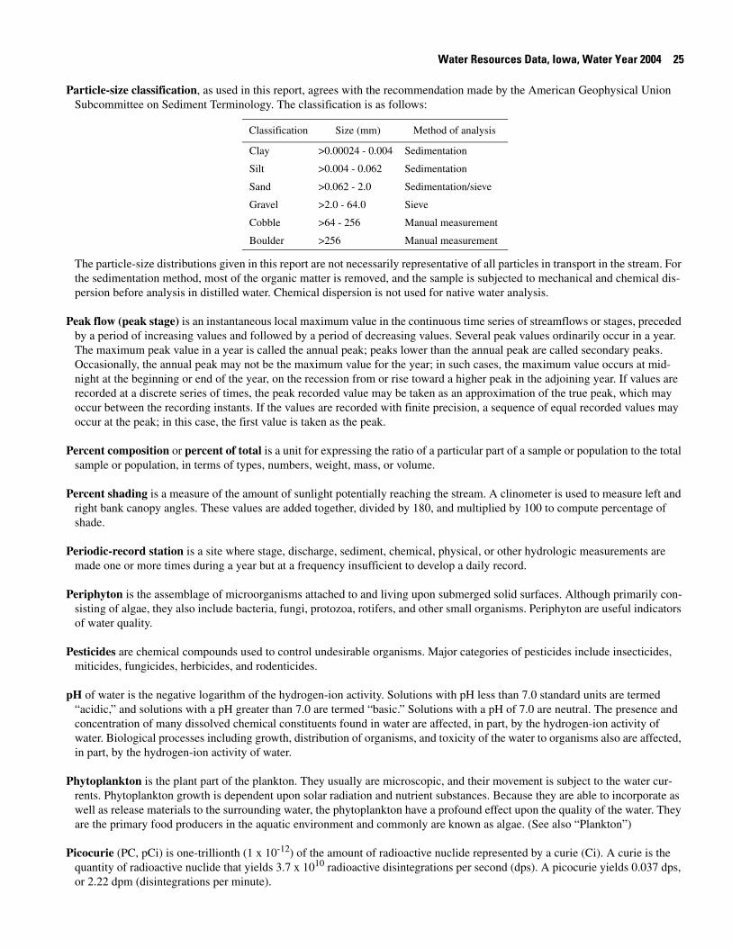
Water Resources Data, Iowa, Water Year 2004 25
Particle-size classification, as used in this report, agrees with the recommendation made by the American Geophysical Union Subcommittee on Sediment Terminology. The classification is as follows:
Classification Size (mm) Method of analysis
Clay >0.00024 - 0.004 Sedimentation
Silt >0.004 - 0.062 Sedimentation
Sand >0.062 - 2.0 Sedimentation/sieve
Gravel >2.0 - 64.0 Sieve
Cobble >64 - 256 Manual measurement
Boulder >256 Manual measurement
The particle-size distributions given in this report are not necessarily representative of all particles in transport in the stream. For the sedimentation method, most of the organic matter is removed, and the sample is subjected to mechanical and chemical dis-persion before analysis in distilled water. Chemical dispersion is not used for native water analysis.
Peak flow (peak stage) is an instantaneous local maximum value in the continuous time series of streamflows or stages, preceded by a period of increasing values and followed by a period of decreasing values. Several peak values ordinarily occur in a year. The maximum peak value in a year is called the annual peak; peaks lower than the annual peak are called secondary peaks. Occasionally, the annual peak may not be the maximum value for the year; in such cases, the maximum value occurs at mid-night at the beginning or end of the year, on the recession from or rise toward a higher peak in the adjoining year. If values are recorded at a discrete series of times, the peak recorded value may be taken as an approximation of the true peak, which may occur between the recording instants. If the values are recorded with finite precision, a sequence of equal recorded values may occur at the peak; in this case, the first value is taken as the peak.
Percent composition or percent of total is a unit for expressing the ratio of a particular part of a sample or population to the total sample or population, in terms of types, numbers, weight, mass, or volume.
Percent shading is a measure of the amount of sunlight potentially reaching the stream. A clinometer is used to measure left and right bank canopy angles. These values are added together, divided by 180, and multiplied by 100 to compute percentage of shade.
Periodic-record station is a site where stage, discharge, sediment, chemical, physical, or other hydrologic measurements are made one or more times during a year but at a frequency insufficient to develop a daily record.
Periphyton is the assemblage of microorganisms attached to and living upon submerged solid surfaces. Although primarily con-sisting of algae, they also include bacteria, fungi, protozoa, rotifers, and other small organisms. Periphyton are useful indicators of water quality.
Pesticides are chemical compounds used to control undesirable organisms. Major categories of pesticides include insecticides, miticides, fungicides, herbicides, and rodenticides.
pH of water is the negative logarithm of the hydrogen-ion activity. Solutions with pH less than 7.0 standard units are termed “acidic,” and solutions with a pH greater than 7.0 are termed “basic.” Solutions with a pH of 7.0 are neutral. The presence and concentration of many dissolved chemical constituents found in water are affected, in part, by the hydrogen-ion activity of water. Biological processes including growth, distribution of organisms, and toxicity of the water to organisms also are affected, in part, by the hydrogen-ion activity of water.
Phytoplankton is the plant part of the plankton. They usually are microscopic, and their movement is subject to the water cur-rents. Phytoplankton growth is dependent upon solar radiation and nutrient substances. Because they are able to incorporate as well as release materials to the surrounding water, the phytoplankton have a profound effect upon the quality of the water. They are the primary food producers in the aquatic environment and commonly are known as algae. (See also “Plankton”)
Picocurie (PC, pCi) is one-trillionth (1 x 10-12) of the amount of radioactive nuclide represented by a curie (Ci). A curie is the quantity of radioactive nuclide that yields 3.7 x 10¹⁰ radioactive disintegrations per second (dps). A picocurie yields 0.037 dps, or 2.22 dpm (disintegrations per minute).
26 Water Resources Data, Iowa, Water Year 2004
Plankton is the community of suspended, floating, or weakly swimming organisms that live in the open water of lakes and rivers. Concentrations are expressed as a number of cells per milliliter (cells/mL) of sample.
Polychlorinated biphenyls (PCBs) are industrial chemicals that are mixtures of chlorinated biphenyl compounds having various percentages of chlorine. They are similar in structure to organochlorine insecticides.
Polychlorinated naphthalenes (PCNs) are industrial chemicals that are mixtures of chlorinated naphthalene compounds. They have properties and applications similar to polychlorinated biphenyls (PCBs) and have been identified in commercial PCB prep-arations.
Pool, as used in this report, is a small part of a stream reach with little velocity, commonly with water deeper than surrounding areas.
Primary productivity is a measure of the rate at which new organic matter is formed and accumulated through photo-synthetic and chemosynthetic activity of producer organisms (chiefly, green plants). The rate of primary production is estimated by mea-suring the amount of oxygen released (oxygen method) or the amount of carbon assimilated (carbon method) by the plants.
Primary productivity (carbon method) is expressed as milligrams of carbon per area per unit time [mg C/(m2/time)] for periphy-ton and macrophytes or per volume [mg C/(m3/time)] for phytoplankton. The carbon method defines the amount of carbon dioxide consumed as measured by radioactive carbon (carbon-14). The carbon-14 method is of greater sensitivity than the oxygen light- and dark-bottle method and is preferred for use with unenriched water samples. Unit time may be either the hour or day, depending on the incubation period. (See also “Primary productivity”)
Primary productivity (oxygen method) is expressed as milligrams of oxygen per area per unit time [mg O/(m2/time)] for per-iphyton and macrophytes or per volume [mg O/(m3/time)] for phytoplankton. The oxygen method defines production and respi-ration rates as estimated from changes in the measured dissolved-oxygen concentration. The oxygen light- and dark-bottle method is preferred if the rate of primary production is sufficient for accurate measurements to be made within 24 hours. Unit time may be either the hour or day, depending on the incubation period. (See also “Primary productivity”)
Radioisotopes are isotopic forms of elements that exhibit radioactivity. Isotopes are varieties of a chemical element that differ in atomic weight but are very nearly alike in chemical properties. The difference arises because the atoms of the isotopic forms of an element differ in the number of neutrons in the nucleus; for example, ordinary chlorine is a mixture of isotopes having atomic weights of 35 and 37, and the natural mixture has an atomic weight of about 35.453. Many of the elements similarly exist as mixtures of isotopes, and a great many new isotopes have been produced in the operation of nuclear devices such as the cyclo-tron. There are 275 isotopes of the 81 stable elements, in addition to more than 800 radioactive isotopes.
Reach, as used in this report, is a length of stream that is chosen to represent a uniform set of physical, chemical, and biological conditions within a segment. It is the principal sampling unit for collecting physical, chemical, and biological data.
Recoverable is the amount of a given constituent that is in solution after a representative water sample has been extracted or digested. Complete recovery is not achieved by the extraction or digestion and thus the determination represents something less than 95 percent of the constituent present in the sample. To achieve comparability of analytical data, equivalent extraction or digestion procedures are required of all laboratories performing such analyses because different procedures are likely to pro-duce different analytical results. (See also “Bed material”)
Recurrence interval, also referred to as return period, is the average time, usually expressed in years, between occurrences of hydrologic events of a specified type (such as exceedances of a specified high flow or nonexceedance of a specified low flow). The terms “return period” and “recurrence interval” do not imply regular cyclic occurrence. The actual times between occur-rences vary randomly, with most of the times being less than the average and a few being substantially greater than the average. For example, the 100-year flood is the flow rate that is exceeded by the annual maximum peak flow at intervals whose average length is 100 years (that is, once in 100 years, on average); almost two-thirds of all exceedances of the 100-year flood occur less than 100 years after the previous exceedance, half occur less than 70 years after the previous exceedance, and about one-eighth occur more than 200 years after the previous exceedance. Similarly, the 7-day, 10-year low flow (7Q10) is the flow rate below which the annual minimum 7-day-mean flow dips at intervals whose average length is 10 years (that is, once in 10 years, on average); almost two-thirds of the nonexceedances of the 7Q10 occur less than 10 years after the previous nonexceedance, half occur less than 7 years after, and about one-eighth occur more than 20 years after the previous nonexceedance. The recurrence
Water Resources Data, Iowa, Water Year 2004 27
interval for annual events is the reciprocal of the annual probability of occurrence. Thus, the 100-year flood has a 1-percent chance of being exceeded by the maximum peak flow in any year, and there is a 10-percent chance in any year that the annual minimum 7-day-mean flow will be less than the 7Q10.
Replicate samples are a group of samples collected in a manner such that the samples are thought to be essentially identical in composition.
Return period (See “Recurrence interval”)
Riffle, as used in this report, is a shallow part of the stream where water flows swiftly over completely or partially submerged obstructions to produce surface agitation.
River mileage is the curvilinear distance, in miles, measured upstream from the mouth along the meandering path of a stream channel in accordance with Bulletin No. 14 (October 1968) of the Water Resources Council and typically is used to denote loca-tion along a river.
Run, as used in this report, is a relatively shallow part of a stream with moderate velocity and little or no surface turbulence.
Runoff is the quantity of water that is discharged (“runs off”) from a drainage basin during a given time period. Runoff data may be presented as volumes in acre-feet, as mean discharges per unit of drainage area in cubic feet per second per square mile, or as depths of water on the drainage basin in inches. (See also “Annual runoff”)
Salinity is the total quantity of dissolved salts, measured by weight in parts per thousand. Values in this report are calculated from specific conductance and temperature. Seawater has an average salinity of about 35 parts per thousand (for additional informa-tion, refer to: Miller, R.L., Bradford, W.L., and Peters, N.E., 1988, Specific conductance: theoretical considerations and applica-tion to analytical quality control: U.S. Geological Survey Water-Supply Paper 2311, 16 p.)
Sea level, as used in this report, refers to one of the two commonly used national vertical datums (NGVD 1929 or NAVD 1988). See separate entries for definitions of these datums.
Sediment is solid material that originates mostly from disintegrated rocks; when transported by, suspended in, or deposited from water, it is referred to as “fluvial sediment.” Sediment includes chemical and biochemical precipitates and decomposed organic material, such as humus. The quantity, characteristics, and cause of the occurrence of sediment in streams are affected by envi-ronmental and land-use factors. Some major factors are topography, soil characteristics, land cover, and depth and intensity of precipitation.
Sensible heat flux (often used interchangeably with latent sensible heat-flux density) is the amount of heat energy that moves by turbulent transport through the air across a specified cross-sectional area per unit time and goes to heating (cooling) the air. Usu-ally expressed in watts per square meter.
Seven-day, 10-year low flow (7Q10) is the discharge below which the annual 7-day minimum flow falls in 1 year out of 10 on the long-term average. The recurrence interval of the 7Q10 is 10 years; the chance that the annual 7-day minimum flow will be less than the 7Q10 is 10 percent in any given year. (See also “Annual 7-day minimum” and “Recurrence interval”)
Shelves, as used in this report, are streambank features extending nearly horizontally from the flood plain to the lower limit of persistent woody vegetation.
Sodium adsorption ratio (SAR) is the expression of relative activity of sodium ions in exchange reactions within soil and is an index of sodium or alkali hazard to the soil. Sodium hazard in water is an index that can be used to evaluate the suitability of water for irrigating crops.
Soil heat flux (often used interchangeably with soil heat-flux density) is the amount of heat energy that moves by conduction across a specified cross-sectional area of soil per unit time and goes to heating (or cooling) the soil. Usually expressed in watts per square meter.
28 Water Resources Data, Iowa, Water Year 2004
Soil-water content is the water lost from the soil upon drying to constant mass at 105 °C; expressed either as mass of water per unit mass of dry soil or as the volume of water per unit bulk volume of soil.
Specific electrical conductance (conductivity) is a measure of the capacity of water (or other media) to conduct an electrical current. It is expressed in microsiemens per centimeter at 25 °C. Specific electrical conductance is a function of the types and quantity of dissolved substances in water and can be used for approximating the dissolved-solids content of the water. Com-monly, the concentration of dissolved solids (in milligrams per liter) is from 55 to 75 percent of the specific conductance (in microsiemens). This relation is not constant from stream to stream, and it may vary in the same source with changes in the com-position of the water.
Stable isotope ratio (per MIL) is a unit expressing the ratio of the abundance of two radioactive isotopes. Isotope ratios are used in hydrologic studies to determine the age or source of specific water, to evaluate mixing of different water, as an aid in deter-mining reaction rates, and other chemical or hydrologic processes.
Stage (See “Gage height”)
Stage-discharge relation is the relation between the water-surface elevation, termed stage (gage height), and the volume of water flowing in a channel per unit time.
Streamflow is the discharge that occurs in a natural channel. Although the term “discharge” can be applied to the flow of a canal, the word “streamflow” uniquely describes the discharge in a surface stream course. The term “streamflow” is more general than “runoff” as streamflow may be applied to discharge whether or not it is affected by diversion or regulation.
Substrate is the physical surface upon which an organism lives.
Substrate embeddedness class is a visual estimate of riffle streambed substrate larger than gravel that is surrounded or covered by fine sediment (<2 mm, sand or finer). Below are the class categories expressed as the percentage covered by fine sediment:
0 no gravel or larger substrate 3 26-50 percent
1 > 75 percent 4 5-25 percent
2 51-75 percent 5 < 5 percent
Surface area of a lake is that area (acres) encompassed by the boundary of the lake as shown on USGS topographic maps, or other available maps or photographs. Because surface area changes with lake stage, surface areas listed in this report represent those determined for the stage at the time the maps or photographs were obtained.
Surficial bed material is the upper surface (0.1 to 0.2 foot) of the bed material that is sampled using U.S. Series Bed-Material Samplers.
Surrogate is an analyte that behaves similarly to a target analyte, but that is highly unlikely to occur in a sample. A surrogate is added to a sample in known amounts before extraction and is measured with the same laboratory procedures used to measure the target analyte. Its purpose is to monitor method performance for an individual sample.
Suspended is the amount (concentration) of undissolved material in a water-sediment mixture. Most commonly refers to that material retained on a 0.45-micrometer filter.
Suspended, recoverable is the amount of a given constituent that is in solution after the part of a representative water-suspended sediment sample that is retained on a 0.45-micrometer filter has been extracted or digested. Complete recovery is not achieved by the extraction or digestion procedures and thus the determination represents less than 95 percent of the constituent present in the sample. To achieve comparability of analytical data, equivalent extraction or digestion procedures are required of all labora-tories performing such analyses because different procedures are likely to produce different analytical results. (See also “Sus-pended”)
Suspended sediment is sediment carried in suspension by the turbulent components of the fluid or by the Brownian movement (a law of physics). (See also “Sediment”)
Water Resources Data, Iowa, Water Year 2004 29
Suspended-sediment concentration is the velocity-weighted concentration of suspended sediment in the sampled zone (from the water surface to a point approximately 0.3 foot above the bed) expressed as milligrams of dry sediment per liter of water-sediment mixture (mg/L). The analytical technique uses the mass of all of the sediment and the net weight of the water-sediment mixture in a sample to compute the suspended-sediment concentration. (See also “Sediment” and “Suspended sediment”)
Suspended-sediment discharge (tons/d) is the rate of sediment transport, as measured by dry mass or volume, that passes a cross section in a given time. It is calculated in units of tons per day as follows: concentration (mg/L) x discharge (ft3/s) x 0.0027. (See also “Sediment,” “Suspended sediment,” and “Suspended-sediment concentration”)
Suspended-sediment load is a general term that refers to a given characteristic of the material in suspension that passes a point during a specified period of time. The term needs to be qualified, such as “annual suspended-sediment load” or “sand-size sus-pended-sediment load,” and so on. It is not synonymous with either suspended-sediment discharge or concentration. (See also “Sediment”)
Suspended solids, total residue at 105 °C concentration is the concentration of inorganic and organic material retained on a fil-ter, expressed as milligrams of dry material per liter of water (mg/L). An aliquot of the sample is used for this analysis.
Suspended, total is the total amount of a given constituent in the part of a water-sediment sample that is retained on a 0.45-micrometer membrane filter. This term is used only when the analytical procedure assures measurement of at least 95 percent of the constituent determined. Knowledge of the expected form of the constituent in the sample, as well as the analytical method-ology used, is required to determine when the results should be reported as “suspended, total.” Determinations of “suspended, total” constituents are made either by directly analyzing portions of the suspended material collected on the filter or, more com-monly, by difference, on the basis of determinations of (1) dissolved and (2) total concentrations of the constituent. (See also “Suspended”)
Synoptic studies are short-term investigations of specific water-quality conditions during selected seasonal or hydro-logic peri-ods to provide improved spatial resolution for critical water-quality conditions. For the period and conditions sampled, they assess the spatial distribution of selected water-quality conditions in relation to causative factors, such as land use and contami-nant sources.
Taxa (Species) richness is the number of species (taxa) present in a defined area or sampling unit.
Taxonomy is the division of biology concerned with the classification and naming of organisms. The classification of organisms is based upon a hierarchial scheme beginning with Kingdom and ending with Species at the base. The higher the classification level, the fewer features the organisms have in common. For example, the taxonomy of a particular mayfly, Hexagenia limbata, is the following:
Kingdom: Animal
Phylum: Arthropeda
Class: Insecta
Order: Ephemeroptera
Family: Ephemeridae
Genus: Hexagenia
Species: Hexagenia limbata
Thalweg is the line formed by connecting points of minimum streambed elevation (deepest part of the channel).
Thermograph is an instrument that continuously records variations of temperature on a chart. The more general term “tempera-ture recorder” is used in the table descriptions and refers to any instrument that records temperature whether on a chart, a tape, or any other medium.
Time-weighted average is computed by multiplying the number of days in the sampling period by the concentrations of individ-ual constituents for the corresponding period and dividing the sum of the products by the total number of days. A time-weighted
30 Water Resources Data, Iowa, Water Year 2004
average represents the composition of water resulting from the mixing of flow proportionally to the duration of the concentra-tion.
Tons per acre-foot (T/acre-ft) is the dry mass (tons) of a constituent per unit volume (acre-foot) of water. It is computed by mul-tiplying the concentration of the constituent, in milligrams per liter, by 0.00136.
Tons per day (T/DAY, tons/d) is a common chemical or sediment discharge unit. It is the quantity of a substance in solution, in suspension, or as bedload that passes a stream section during a 24-hour period. It is equivalent to 2,000 pounds per day, or 0.9072 metric ton per day.
Total is the amount of a given constituent in a representative whole-water (unfiltered) sample, regardless of the constituent’s physical or chemical form. This term is used only when the analytical procedure assures measurement of at least 95 percent of the constituent present in both the dissolved and suspended phases of the sample. A knowledge of the expected form of the con-stituent in the sample, as well as the analytical methodology used, is required to judge when the results should be reported as “total.” (Note that the word “total” does double duty here, indicating both that the sample consists of a water-suspended sedi-ment mixture and that the analytical method determined at least 95 percent of the constituent in the sample.)
Total coliform bacteria are a particular group of bacteria that are used as indicators of possible sewage pollution. This group includes coliforms that inhabit the intestine of warmblooded animals and those that inhabit soils. They are characterized as aer-obic or facultative anaerobic, gram-negative, nonspore-forming, rod-shaped bacteria that ferment lactose with gas formation within 48 hours at 35 °C. In the laboratory, these bacteria are defined as all the organisms that produce colonies with a golden-green metallic sheen within 24 hours when incubated at 35 °C plus or minus 1.0 °C on M-Endo medium (nutrient medium for bacterial growth). Their concentrations are expressed as number of colonies per 100 milliliters of sample. (See also “Bacteria”)
Total discharge is the quantity of a given constituent, measured as dry mass or volume, that passes a stream cross section per unit of time. When referring to constituents other than water, this term needs to be qualified, such as “total sediment discharge,” “total chloride discharge,” and so on.
Total in bottom material is the amount of a given constituent in a representative sample of bottom material. This term is used only when the analytical procedure assures measurement of at least 95 percent of the constituent determined. A knowledge of the expected form of the constituent in the sample, as well as the analytical methodology used, is required to judge when the results should be reported as “total in bottom material.”
Total length (fish) is the straight-line distance from the anterior point of a fish specimen’s snout, with the mouth closed, to the posterior end of the caudal (tail) fin, with the lobes of the caudal fin squeezed together.
Total load refers to all of a constituent in transport. When referring to sediment, it includes suspended load plus bed load.
Total organism count is the number of organisms collected and enumerated in any particular sample. (See also “Organism count/volume”)
Total recoverable is the amount of a given constituent in a whole-water sample after a sample has been digested by a method (usually using a dilute acid solution) that results in dissolution of only readily soluble substances. Complete dissolution of all particulate matter is not achieved by the digestion treatment, and thus the determination represents something less than the “total” amount (that is, less than 95 percent) of the constituent present in the dissolved and suspended phases of the sample. To achieve comparability of analytical data for whole-water samples, equivalent digestion procedures are required of all laborato-ries performing such analyses because different digestion procedures may produce different analytical results.
Total sediment discharge is the mass of suspended-sediment plus bed-load transport, measured as dry weight, that passes a cross section in a given time. It is a rate and is reported as tons per day. (See also “Bedload,” “Bedload discharge,” “Sediment,” “Sus-pended sediment,” and “Suspended-sediment concentration”)
Total sediment load or total load is the sediment in transport as bedload and suspended-sediment load. The term may be quali-fied, such as “annual suspended-sediment load” or “sand-size suspended-sediment load,” and so on. It differs from total sedi-ment discharge in that load refers to the material, whereas discharge refers to the quantity of material, expressed in units of mass per unit time. (See also “Sediment,” “Suspended-sediment load,” and “Total load”)
Water Resources Data, Iowa, Water Year 2004 31
Transect, as used in this report, is a line across a stream perpendicular to the flow and along which measurements are taken, so that morphological and flow characteristics along the line are described from bank to bank. Unlike a cross section, no attempt is made to determine known elevation points along the line.
Turbidity is an expression of the optical properties of a liquid that causes light rays to be scattered and absorbed rather than trans-mitted in straight lines through water. Turbidity, which can make water appear cloudy or muddy, is caused by the presence of suspended and dissolved matter, such as clay, silt, finely divided organic matter, plankton and other microscopic organisms, organic acids, and dyes (ASTM International, 2003, D1889–00 Standard test method for turbidity of water, in ASTM Interna-tional, Annual Book of ASTM Standards, Water and Environmental Technology, v. 11.01: West Conshohocken, Pennsylvania, 6 p.). The color of water, whether resulting from dissolved compounds or suspended particles, can affect a turbidity measurement. To ensure that USGS turbidity data can be understood and interpreted properly within the context of the instrument used and site conditions encountered, data from each instrument type are stored and reported in the National Water Information System (NWIS) using parameter codes and measurement reporting units that are specific to the instrument type, with specific instru-ments designated by the method code. The respective measurement units, many of which also are in use internationally, fall into two categories: (1) the designations NTU, NTRU, BU, AU, and NTMU signify the use of a broad spectrum incident light in the wavelength range of 400-680 nanometers (nm), but having different light detection configurations; (2) The designations FNU, FNRU, FBU, FAU, and FNMU generally signify an incident light in the range between 780-900 nm, also with varying light detection configurations. These reporting units are equivalent when measuring a calibration solution (for example, formazin or polymer beads), but their respective instruments may not produce equivalent results for environmental samples. Specific report-ing units are as follows:
NTU (Nephelometric Turbidity Units): white or broadband [400-680 nm] light source, 90 degree detection angle, one detec-tor.
NTRU (Nephelometric Turbidity Ratio Units): white or broadband [400-680 nm] light source, 90 degree detection angle, multiple detectors with ratio compensation.
BU (Backscatter Units): white or broadband [400-680 nm] light source, 30 ± 15 degree detection angle (backscatter).
AU (Attenuation Units): white or broadband [400-680 nm] light source, 180 degree detection angle (attenuation).
NTMU (Nephelometric Turbidity Multibeam Units): white or broadband [400-680 nm] light source, multiple light sources, detectors at 90 degrees and possibly other angles to each beam.
FNU (Formazin Nephelometric Units): near infrared [780-900 nm] or monochrome light source, 90 degree detection angle, one detector.
FNRU (Formazin Nephelometric Ratio Units): near infrared [780-900 nm] or monochrome light source, 90 degree detection angle, multiple detectors, ratio compensation.
FBU (Formazin Backscatter Units): near infrared [780-900 nm] or monochrome light source, 30±15 degree detection angle.
FAU (Formazin Attenuation Units): near infrared [780-900 nm] light source, 180 degree detection angle.
FNMU (Formazin Nephelometric Multibeam Units): near infrared [780-900 nm] or monochrome light source, multiple light sources, detectors at 90 degrees and possibly other angles to each beam.
For more information please see http://water.usgs.gov/owq/FieldManual/Chapter6/6.7_contents.html.
Ultraviolet (UV) absorbance (absorption) at 254 or 280 nanometers is a measure of the aggregate concentration of the mixture of UV absorbing organic materials dissolved in the analyzed water, such as lignin, tannin, humic substances, and various aro-matic compounds. UV absorbance (absorption) at 254 or 280 nanometers is measured in UV absorption units per centimeter of path length of UV light through a sample.
Unconfined aquifer is an aquifer whose upper surface is a water table free to fluctuate under atmospheric pressure. (See “Water-table aquifer”)
Unfiltered pertains to the constituents in an unfiltered, representative water-suspended sediment sample.
Unfiltered, recoverable is the amount of a given constituent in a representative water-suspended sediment sample that has been extracted or digested. Complete recovery is not achieved by the extraction or digestion treatment and thus the determination rep-
32 Water Resources Data, Iowa, Water Year 2004
resents less than 95 percent of the constituent present in the sample. To achieve comparability of analytical data, equivalent extraction or digestion procedures are required of all laboratories performing such analyses because different procedures are likely to produce different analytical results.
Vertical datum (See “Datum”)
Volatile organic compounds (VOCs) are organic compounds that can be isolated from the water phase of a sample by purging the water sample with inert gas, such as helium, and, subsequently, analyzed by gas chromatography. Many VOCs are human-made chemicals that are used and produced in the manufacture of paints, adhesives, petroleum products, pharmaceuticals, and refrigerants. They often are components of fuels, solvents, hydraulic fluids, paint thinners, and dry-cleaning agents commonly used in urban settings. VOC contamination of drinking-water supplies is a human-health concern because many are toxic and are known or suspected human carcinogens.
Water table is that surface in a ground-water body at which the water pressure is equal to the atmospheric pressure.
Water-table aquifer is an unconfined aquifer within which the water table is found.
Water year in USGS reports dealing with surface-water supply is the 12-month period October 1 through September 30. The water year is designated by the calendar year in which it ends and which includes 9 of the 12 months. Thus, the year ending September 30, 2002, is called the “2002 water year.”
Watershed (See “Drainage basin”)
WDR is used as an abbreviation for “Water-Data Report” in the REVISED RECORDS paragraph to refer to State annual hydro-logic-data reports. (WRD was used as an abbreviation for “Water-Resources Data” in reports published prior to 1976.)
Weighted average is used in this report to indicate discharge-weighted average. It is computed by multiplying the discharge for a sampling period by the concentrations of individual constituents for the corresponding period and dividing the sum of the prod-ucts by the sum of the discharges. A discharge-weighted average approximates the composition of water that would be found in a reservoir containing all the water passing a given location during the water year after thorough mixing in the reservoir.
Wet mass is the mass of living matter plus contained water. (See also “Biomass” and “Dry mass”)
Wet weight refers to the weight of animal tissue or other substance including its contained water. (See also “Dry weight”)
WSP is used as an acronym for “Water-Supply Paper” in reference to previously published reports.
Zooplankton is the animal part of the plankton. Zooplankton are capable of extensive movements within the water column and often are large enough to be seen with the unaided eye. Zooplankton are secondary consumers feeding upon bacteria, phy-toplankton, and detritus. Because they are the grazers in the aquatic environment, the zooplankton are a vital part of the aquatic food web. The zooplankton community is dominated by small crustaceans and rotifers. (See also “Plankton”)
Techniques of Water-Resources Investigations of the U.S. Geological Survey
The USGS publishes a series of manuals, the Techniques of Water-Resources Investigations, describing procedures for planning and conducting specialized work in water-resources investigations. The material is grouped under major subject headings called books and is further divided into sections and chapters. For example, section A of book 3 (Applications of Hydraulics) pertains to surface water. The chapter, the unit of publication, is limited to a narrow field of subject matter. This format permits flexibility in revision and publication as the need arises.
Reports in the Techniques of Water-Resources Investigations series, which are listed below, are online at http://water.usgs.gov/pubs/twri/.. Printed copies are for sale by the USGS, Information Services, Box 25286, Federal Center, Denver, Colorado 80225 (authorized agent of the Superintendent of Documents, Government Printing Office), telephone 1-888-ASK-USGS. Please telephone 1-888-ASK-USGS for current prices, and refer to the title, book number, chapter number, and mention
Water Resources Data, Iowa, Water Year 2004 33
the “U.S. Geological Survey Techniques of Water-Resources Investigations.” Products can then be ordered by telephone, or online at http://www.usgs.gov/sales.html, or by FAX to (303)236-469 of an order form available online at http://mac.usgs.gov/isb/pubs/forms/. Prepayment by major credit card or by a check or money order payable to the “U.S. Geological Survey” is required.
Ground-Water Levels
Ground-water-level records are provided on the following pages.
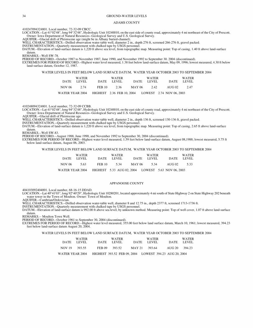
34
GROUND-WATER LEVELSADAMS COUNTY
410247094324801. Local number, 72-32-09 CBCC. LOCATION.--Lat 41°02'48", long 94°32'48", Hydrologic Unit 10240010, on the east side of county road, approximately 4 mi northeast of the City of Prescott.
Owner: Iowa Department of Natural Resources--Geological Survey and U.S. Geological Survey. AQUIFER.--Glacial drift of Pleistocene age (might be in Albany buried-channel). WELL CHARACTERISTICS.--Drilled observation water-table well, diameter 2 in., depth 276 ft, screened 266-276 ft, gravel packed. INSTRUMENTATION.--Quarterly measurement with chalked tape by USGS personnel. DATUM.--Elevation of land-surface datum is 1,220 ft above sea level, from topographic map. Measuring point: Top of casing, 1.40 ft above land-surface
datum. REMARKS.--Well SW-78. PERIOD OF RECORD.--October 1987 to November 1987, June 1990, and November 1992 to September 30. 2004 (discontinued). EXTREMES FOR PERIOD OF RECORD.--Highest water level measured, 1.38 feet below land-surface datum, May 09, 1996; lowest measured, 4.30 ft below
land-surface datum, October 12, 1987.
WATER LEVELS IN FEET BELOW LAND SURFACE DATUM, WATER YEAR OCTOBER 2003 TO SEPTEMBER 2004
DATEWATER LEVEL DATE
WATER LEVEL DATE
WATER LEVEL DATE
WATER LEVEL
NOV 06 2.74 FEB 10 2.36 MAY 06 2.42 AUG 02 2.47
WATER YEAR 2004 HIGHEST 2.36 FEB 10, 2004 LOWEST 2.74 NOV 06, 2003
410248094324801. Local number, 72-32-09 CCBB. LOCATION.--Lat 41°02'48", long 94°32'48", Hydrologic Unit 10240010, on the east side of county road, approximately 4 mi northeast of the City of Prescott.
Owner: Iowa Department of Natural Resources--Geological Survey and U.S. Geological Survey. AQUIFER.--Glacial drift of Pleistocene age. WELL CHARACTERISTICS.--Drilled observation water-table well, diameter 2 in., depth 136 ft, screened 130-136 ft, gravel packed. INSTRUMENTATION.--Quarterly measurement with chalked tape by USGS personnel. DATUM.--Elevation of land-surface datum is 1,220 ft above sea level, from topographic map. Measuring point: Top of casing, 2.65 ft above land-surface
datum. REMARKS.--Well SW-83. PERIOD OF RECORD.--August 1988, June 1990, and November 1992 to September 30, 2004 (discontinued). EXTREMES FOR PERIOD OF RECORD.--Highest water level measured, 1.59 feet below land-surface datum, August 08,1988; lowest measured, 5.75 ft
below land-surface datum, August 06, 2003.
WATER LEVELS IN FEET BELOW LAND SURFACE DATUM, WATER YEAR OCTOBER 2003 TO SEPTEMBER 2004
DATEWATER LEVEL DATE
WATER LEVEL DATE
WATER LEVEL DATE
WATER LEVEL
NOV 06 5.63 FEB 10 5.34 MAY 06 5.34 AUG 02 5.33
WATER YEAR 2004 HIGHEST 5.33 AUG 02, 2004 LOWEST 5.63 NOV 06, 2003
APPANOOSE COUNTY
404103092404001. Local number, 68-16-15 DDAD. LOCATION.--Lat 40°41'03", long 92°40'29", Hydrologic Unit 10280201, located approximately 4 mi south of State Highway 2 on State Highway 202 beneath
water tower in the Town of Moulton. Owner: Town of Moulton. AQUIFER.--Cambrian/Ordovician. WELL CHARACTERISTICS.--Drilled observation water-table well, diameter 8 and 12.75 in., depth 2377 ft, screened 1713-1736 ft. INSTRUMENTATION.--Quarterly measurement with chalked tape by USGS personnel. DATUM.--Elevation of land-surface datum is 992.00 ft above sea level, by unknown method. Measuring point: Top of well cover, 1.07 ft above land-surface
datum. REMARKS.-- Moulton Town Well. PERIOD OF RECORD.--October 1961 to September 30, 2004 (discontinued). EXTREMES FOR PERIOD OF RECORD.--Highest water level measured, 355.00 feet below land surface datum, March 10, 1961; lowest measured, 394.23
feet below land-surface datum August 20, 2004.
WATER LEVELS IN FEET BELOW LAND SURFACE DATUM, WATER YEAR OCTOBER 2003 TO SEPTEMBER 2004
DATEWATER LEVEL DATE
WATER LEVEL DATE
WATER LEVEL DATE
WATER LEVEL
NOV 19 393.55 FEB 09 393.52 MAY 21 393.64 AUG 20 394.23
WATER YEAR 2004 HIGHEST 393.52 FEB 09, 2004 LOWEST 394.23 AUG 20, 2004
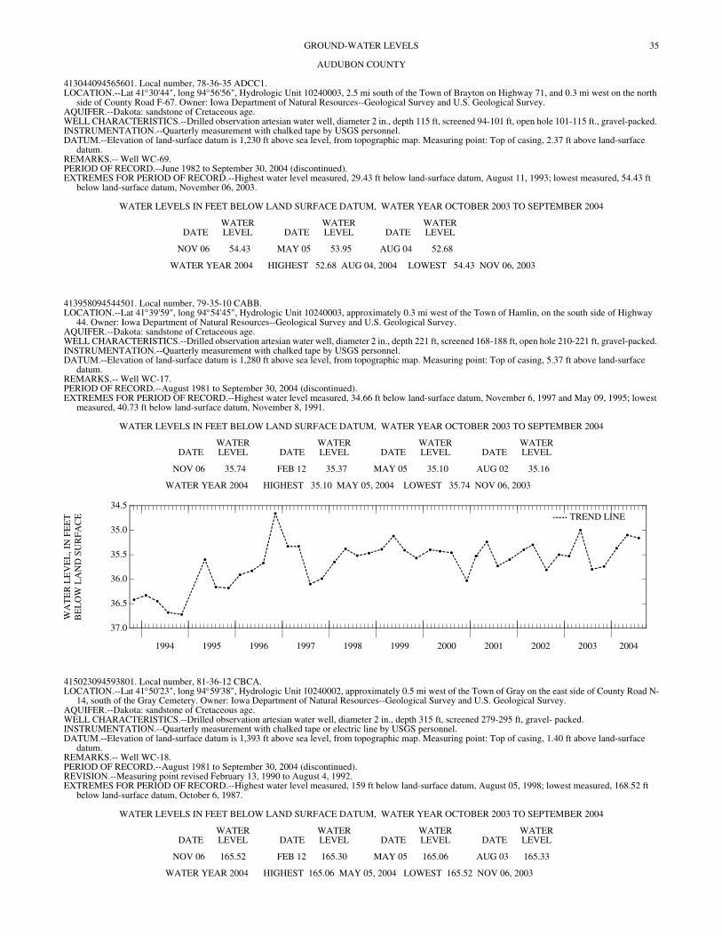
35GROUND-WATER LEVELS
AUDUBON COUNTY
413044094565601. Local number, 78-36-35 ADCC1. LOCATION.--Lat 41°30'44", long 94°56'56", Hydrologic Unit 10240003, 2.5 mi south of the Town of Brayton on Highway 71, and 0.3 mi west on the north
side of County Road F-67. Owner: Iowa Department of Natural Resources--Geological Survey and U.S. Geological Survey. AQUIFER.--Dakota: sandstone of Cretaceous age. WELL CHARACTERISTICS.--Drilled observation artesian water well, diameter 2 in., depth 115 ft, screened 94-101 ft, open hole 101-115 ft., gravel-packed. INSTRUMENTATION.--Quarterly measurement with chalked tape by USGS personnel. DATUM.--Elevation of land-surface datum is 1,230 ft above sea level, from topographic map. Measuring point: Top of casing, 2.37 ft above land-surface
datum. REMARKS.-- Well WC-69. PERIOD OF RECORD.--June 1982 to September 30, 2004 (discontinued). EXTREMES FOR PERIOD OF RECORD.--Highest water level measured, 29.43 ft below land-surface datum, August 11, 1993; lowest measured, 54.43 ft
below land-surface datum, November 06, 2003.
WATER LEVELS IN FEET BELOW LAND SURFACE DATUM, WATER YEAR OCTOBER 2003 TO SEPTEMBER 2004
DATEWATER LEVEL DATE
WATER LEVEL DATE
WATER LEVEL
NOV 06 54.43 MAY 05 53.95 AUG 04 52.68
WATER YEAR 2004 HIGHEST 52.68 AUG 04, 2004 LOWEST 54.43 NOV 06, 2003
413958094544501. Local number, 79-35-10 CABB. LOCATION.--Lat 41°39'59", long 94°54'45", Hydrologic Unit 10240003, approximately 0.3 mi west of the Town of Hamlin, on the south side of Highway
44. Owner: Iowa Department of Natural Resources--Geological Survey and U.S. Geological Survey. AQUIFER.--Dakota: sandstone of Cretaceous age. WELL CHARACTERISTICS.--Drilled observation artesian water well, diameter 2 in., depth 221 ft, screened 168-188 ft, open hole 210-221 ft, gravel-packed. INSTRUMENTATION.--Quarterly measurement with chalked tape by USGS personnel. DATUM.--Elevation of land-surface datum is 1,280 ft above sea level, from topographic map. Measuring point: Top of casing, 5.37 ft above land-surface
datum. REMARKS.-- Well WC-17. PERIOD OF RECORD.--August 1981 to September 30, 2004 (discontinued). EXTREMES FOR PERIOD OF RECORD.--Highest water level measured, 34.66 ft below land-surface datum, November 6, 1997 and May 09, 1995; lowest
measured, 40.73 ft below land-surface datum, November 8, 1991.
WATER LEVELS IN FEET BELOW LAND SURFACE DATUM, WATER YEAR OCTOBER 2003 TO SEPTEMBER 2004
DATEWATER LEVEL DATE
WATER LEVEL DATE
WATER LEVEL DATE
WATER LEVEL
NOV 06 35.74 FEB 12 35.37 MAY 05 35.10 AUG 02 35.16
WATER YEAR 2004 HIGHEST 35.10 MAY 05, 2004 LOWEST 35.74 NOV 06, 2003
1994 1995 1996 1997 1998 1999 2000 2001 2002 2003 2004
37.0
36.5
36.0
35.5
35.0
34.5
WA
TE
R L
EV
EL
, IN
FE
ET
BE
LO
W L
AN
D S
UR
FA
CE TREND LINE
415023094593801. Local number, 81-36-12 CBCA. LOCATION.--Lat 41°50'23", long 94°59'38", Hydrologic Unit 10240002, approximately 0.5 mi west of the Town of Gray on the east side of County Road N-
14, south of the Gray Cemetery. Owner: Iowa Department of Natural Resources--Geological Survey and U.S. Geological Survey. AQUIFER.--Dakota: sandstone of Cretaceous age. WELL CHARACTERISTICS.--Drilled observation artesian water well, diameter 2 in., depth 315 ft, screened 279-295 ft, gravel- packed. INSTRUMENTATION.--Quarterly measurement with chalked tape or electric line by USGS personnel. DATUM.--Elevation of land-surface datum is 1,393 ft above sea level, from topographic map. Measuring point: Top of casing, 1.40 ft above land-surface
datum. REMARKS.-- Well WC-18. PERIOD OF RECORD.--August 1981 to September 30, 2004 (discontinued). REVISION.--Measuring point revised February 13, 1990 to August 4, 1992. EXTREMES FOR PERIOD OF RECORD.--Highest water level measured, 159 ft below land-surface datum, August 05, 1998; lowest measured, 168.52 ft
below land-surface datum, October 6, 1987.
WATER LEVELS IN FEET BELOW LAND SURFACE DATUM, WATER YEAR OCTOBER 2003 TO SEPTEMBER 2004
DATEWATER LEVEL DATE
WATER LEVEL DATE
WATER LEVEL DATE
WATER LEVEL
NOV 06 165.52 FEB 12 165.30 MAY 05 165.06 AUG 03 165.33
WATER YEAR 2004 HIGHEST 165.06 MAY 05, 2004 LOWEST 165.52 NOV 06, 2003
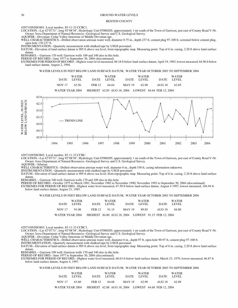
36 GROUND-WATER LEVELS
BENTON COUNTY
420731092083801. Local number, 85-11-33 CCBC1. LOCATION.--Lat 42°07'31", long 92°08'38", Hydrologic Unit 07080205, approximately 1 mi south of the Town of Garrison, just east of County Road V-56.
Owner: Iowa Department of Natural Resources--Geological Survey and U.S. Geological Survey. AQUIFER.--Devonian: Cedar Valley limestone of Middle Devonian age. WELL CHARACTERISTICS.--Drilled observation artesian water well, diameter 0.75 in., depth 237 ft, cement plug 97-100 ft, screened below cement plug,
open hole 170-237 ft. INSTRUMENTATION.--Quarterly measurement with chalked tape by USGS personnel. DATUM.--Elevation of land-surface datum is 905 ft above sea level, from topographic map. Measuring point: Top of 6 in. casing, 2.20 ft above land-surface
datum. REMARKS.-- Garrison 170 well; Garrison wells 109 and 340 also in this hole. PERIOD OF RECORD.--June 1977 to September 30, 2004 (discontinued). EXTREMES FOR PERIOD OF RECORD.--Highest water level measured, 60.18 ft below land-surface datum, April 19, 1983; lowest measured, 64.96 ft below
land-surface datum, August 2, 1994.
WATER LEVELS IN FEET BELOW LAND SURFACE DATUM, WATER YEAR OCTOBER 2003 TO SEPTEMBER 2004
DATEWATER LEVEL DATE
WATER LEVEL DATE
WATER LEVEL DATE
WATER LEVEL
NOV 17 63.56 FEB 12 64.64 MAY 19 62.90 AUG 18 62.85
WATER YEAR 2004 HIGHEST 62.85 AUG 18, 2004 LOWEST 64.64 FEB 12, 2004
1994 1995 1996 1997 1998 1999 2000 2001 2002 2003 2004
65.0
64.5
64.0
63.5
63.0
62.5
62.0
WA
TE
R L
EV
EL
, IN
FE
ET
BE
LO
W L
AN
D S
UR
FAC
E
TREND LINE
420731092083802. Local number, 85-11-33 CCBC. LOCATION.--Lat 42°07'31", long 92°08'38", Hydrologic Unit 07080205, approximately 1 mi south of the Town of Garrison, just east of County Road V-56.
Owner: Iowa Department of Natural Resources--Geological Survey and U.S. Geological Survey. AQUIFER.--Silurian. WELL CHARACTERISTCS.--Drilled observation artesian water well, diameter 6 in., depth 538 ft, casing information unknown. IINSTRUMENTATION.--Quarterly measurement with chalked tape by USGS personnel. DATUM.--Elevation of land-surface datum is 905 ft above sea level, from topographic map. Measuring point: Top of 6 in. casing, 2.20 ft above land-surface
datum. REMARKS.-- Garrison 340 well; Garrison wells 170 and 109 also in this hole. PERIOD OF RECORD.--October 1975 to March 1981; November 1982 to November 1990; November 1993 to September 30, 2004 (discontinued). EXTREMES FOR PERIOD OF RECORD.--Highest water level measured, 67.50 ft below land-surface datum, August 4 1997; lowest measured, 104.94 ft
below land-surface datum, August 21, 1985.
WATER LEVELS IN FEET BELOW LAND SURFACE DATUM, WATER YEAR OCTOBER 2003 TO SEPTEMBER 2004
DATEWATER LEVEL DATE
WATER LEVEL DATE
WATER LEVEL DATE
WATER LEVEL
NOV 17 91.08 FEB 12 91.15 MAY 19 89.85 AUG 18 84.80
WATER YEAR 2004 HIGHEST 84.80 AUG 18, 2004 LOWEST 91.15 FEB 12, 2004
420731092083803. Local number, 85-11-33 CCBC3. LOCATION.--Lat 42°07'31", long 92°08'38", Hydrologic Unit 07080205, approximately 1 mi south of the Town of Garrison, just east of County Road V-56.
Owner: Iowa Department of Natural Resources--Geological Survey and U.S. Geological Survey. AQUIFER.--Devonian: Cedar Valley limestone of Middle Devonian age. WELL CHARACTERISTICS.--Drilled observation artesian water well, diameter 6 in., depth 97 ft, open hole 90-97 ft, cement plug 97-100 ft. INSTRUMENTATION.--Quarterly measurement with chalked tape by USGS personnel. DATUM.--Elevation of land-surface datum is 905 ft above sea level, from topographic map. Measuring point: Top of 6 in. casing, 2.20 ft above land-surface
datum. REMARKS.-- Garrison 109 well; Garrison wells 170 and 340 also in this hole. PERIOD OF RECORD.--June 1977 to September 30, 2004 (discontinued). EXTREMES FOR PERIOD OF RECORD.--Highest water level measured, 60.63 ft below land-surface datum, March 23, 1979; lowest measured, 66.87 ft
below land-surface datum, August 4, 1997.
WATER LEVELS IN FEET BELOW LAND SURFACE DATUM, WATER YEAR OCTOBER 2003 TO SEPTEMBER 2004
DATEWATER LEVEL DATE
WATER LEVEL DATE
WATER LEVEL DATE
WATER LEVEL
NOV 17 63.60 FEB 12 64.68 MAY 19 62.90 AUG 18 62.88
WATER YEAR 2004 HIGHEST 62.88 AUG 18, 2004 LOWEST 64.68 FEB 12, 2004
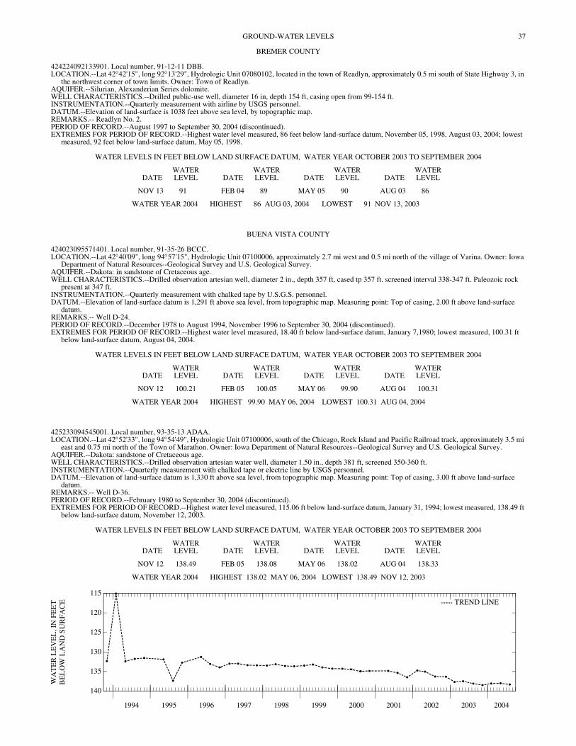
37GROUND-WATER LEVELS
BREMER COUNTY
424224092133901. Local number, 91-12-11 DBB. LOCATION.--Lat 42°42'15", long 92°13'29", Hydrologic Unit 07080102, located in the town of Readlyn, approximately 0.5 mi south of State Highway 3, in
the northwest corner of town limits. Owner: Town of Readlyn. AQUIFER.--Silurian, Alexanderian Series dolomite. WELL CHARACTERISTICS.--Drilled public-use well, diameter 16 in, depth 154 ft, casing open from 99-154 ft. INSTRUMENTATION.--Quarterly measurement with airline by USGS personnel. DATUM.--Elevation of land-surface is 1038 feet above sea level, by topographic map. REMARKS.-- Readlyn No. 2. PERIOD OF RECORD.--August 1997 to September 30, 2004 (discontinued). EXTREMES FOR PERIOD OF RECORD.--Highest water level measured, 86 feet below land-surface datum, November 05, 1998, August 03, 2004; lowest
measured, 92 feet below land-surface datum, May 05, 1998.
WATER LEVELS IN FEET BELOW LAND SURFACE DATUM, WATER YEAR OCTOBER 2003 TO SEPTEMBER 2004
DATEWATER LEVEL DATE
WATER LEVEL DATE
WATER LEVEL DATE
WATER LEVEL
NOV 13 91 FEB 04 89 MAY 05 90 AUG 03 86
WATER YEAR 2004 HIGHEST 86 AUG 03, 2004 LOWEST 91 NOV 13, 2003
BUENA VISTA COUNTY
424023095571401. Local number, 91-35-26 BCCC. LOCATION.--Lat 42°40'09", long 94°57'15", Hydrologic Unit 07100006, approximately 2.7 mi west and 0.5 mi north of the village of Varina. Owner: Iowa
Department of Natural Resources--Geological Survey and U.S. Geological Survey. AQUIFER.--Dakota: in sandstone of Cretaceous age. WELL CHARACTERISTICS.--Drilled observation artesian well, diameter 2 in., depth 357 ft, cased tp 357 ft. screened interval 338-347 ft. Paleozoic rock
present at 347 ft. INSTRUMENTATION.--Quarterly measurement with chalked tape by U.S.G.S. personnel. DATUM.--Elevation of land-surface datum is 1,291 ft above sea level, from topographic map. Measuring point: Top of casing, 2.00 ft above land-surface
datum. REMARKS.-- Well D-24. PERIOD OF RECORD.--December 1978 to August 1994, November 1996 to September 30, 2004 (discontinued). EXTREMES FOR PERIOD OF RECORD.--Highest water level measured, 18.40 ft below land-surface datum, January 7,1980; lowest measured, 100.31 ft
below land-surface datum, August 04, 2004.
WATER LEVELS IN FEET BELOW LAND SURFACE DATUM, WATER YEAR OCTOBER 2003 TO SEPTEMBER 2004
DATEWATER LEVEL DATE
WATER LEVEL DATE
WATER LEVEL DATE
WATER LEVEL
NOV 12 100.21 FEB 05 100.05 MAY 06 99.90 AUG 04 100.31
WATER YEAR 2004 HIGHEST 99.90 MAY 06, 2004 LOWEST 100.31 AUG 04, 2004
425233094545001. Local number, 93-35-13 ADAA. LOCATION.--Lat 42°52'33", long 94°54'49", Hydrologic Unit 07100006, south of the Chicago, Rock Island and Pacific Railroad track, approximately 3.5 mi
east and 0.75 mi north of the Town of Marathon. Owner: Iowa Department of Natural Resources--Geological Survey and U.S. Geological Survey. AQUIFER.--Dakota: sandstone of Cretaceous age. WELL CHARACTERISTICS.--Drilled observation artesian water well, diameter 1.50 in., depth 381 ft, screened 350-360 ft. INSTRUMENTATION.--Quarterly measurement with chalked tape or electric line by USGS personnel. DATUM.--Elevation of land-surface datum is 1,330 ft above sea level, from topographic map. Measuring point: Top of casing, 3.00 ft above land-surface
datum. REMARKS.-- Well D-36. PERIOD OF RECORD.--February 1980 to September 30, 2004 (discontinued). EXTREMES FOR PERIOD OF RECORD.--Highest water level measured, 115.06 ft below land-surface datum, January 31, 1994; lowest measured, 138.49 ft
below land-surface datum, November 12, 2003.
WATER LEVELS IN FEET BELOW LAND SURFACE DATUM, WATER YEAR OCTOBER 2003 TO SEPTEMBER 2004
DATEWATER LEVEL DATE
WATER LEVEL DATE
WATER LEVEL DATE
WATER LEVEL
NOV 12 138.49 FEB 05 138.08 MAY 06 138.02 AUG 04 138.33
WATER YEAR 2004 HIGHEST 138.02 MAY 06, 2004 LOWEST 138.49 NOV 12, 2003
1994 1995 1996 1997 1998 1999 2000 2001 2002 2003 2004
140
135
130
125
120
115
WA
TE
R L
EV
EL
, IN
FE
ET
BE
LO
W L
AN
D S
UR
FAC
E TREND LINE
38 GROUND-WATER LEVELS
CALHOUN COUNTY
422350094380601. Local number, 88-33-36 ABAD. LOCATION.--Lat 42°23'50", long 94°38'06", Hydrologic Unit 07100006, located at the corner of amin and 3rd street, three blocks south of U.S. Highway 20.
Owner: City of Rockwell. AQUIFER.--Cambrian/Ordovician. WELL CHARACTERISTICS.-- Drilled public supply well, depth 1870 ft. INSTRUMENTATION.--Quarterly measurement with airline by USGS personnel. DATUM.--Elevation of land-surface datum is 1,227 ft above sea level, from topographic map. REMARKS.-- Rockwell City Well No. 5. PERIOD OF RECORD.-- February 2004 to September 30, 2004 (discontinued). EXTREMES FOR PERIOD OF RECORD.--Highest water level measured, 212 ft below land-surface datum, February 08, 2004; lowest measured, 333 ft below
land-surface datum, August 03, 2004.
WATER LEVELS IN FEET BELOW LAND SURFACE DATUM, WATER YEAR OCTOBER 2003 TO SEPTEMBER 2004
DATEWATER LEVEL DATE
WATER LEVEL DATE
WATER LEVEL
FEB 08 212 MAY 06 333 AUG 03 230
WATER YEAR 2004 HIGHEST 212 FEB 08, 2004 LOWEST 333 MAY 06, 2004
422812094383501. Local number, 88-32-01 BACD. LOCATION.--Lat 42°28'12", long 94°38'35", Hydrologic Unit 07100006, located approximately 4.5 mi north of Rockwell City, in a trailer park at the south
end of North Twin Lake in Twin Lakes State Park. Owner: Pauline Goins. AQUIFER.--Glacial drift of Pleistocene age. WELL CHARACTERISTICS.--Dug unused water-table well, diameter 24 in., depth 35 ft, casing interval unknown. INSTRUMENTATION.--Quarterly measurement with chalked tape by USGS personnel. DATUM.--Elevation of land-surface datum is 1,222 ft above sea level, from topographic map. Measuring point: Top of casing, 0.96 ft above land-surface
datum. REMARKS.-- Twin Lakes (33F2) well. PERIOD OF RECORD.--May 1989 to September 30, 2004 (discontinued). EXTREMES FOR PERIOD OF RECORD.--Highest water level measured, 1.86 ft below land-surface datum, April 19, 1991; lowest measured, 16.96 ft below
land-surface datum, February 28, 1990.
WATER LEVELS IN FEET BELOW LAND SURFACE DATUM, WATER YEAR OCTOBER 2003 TO SEPTEMBER 2004
DATEWATER LEVEL DATE
WATER LEVEL DATE
WATER LEVEL DATE
WATER LEVEL
NOV 12 11.21 FEB 08 10.86 MAY 06 7.38 AUG 03 8.15
WATER YEAR 2004 HIGHEST 7.38 MAY 06, 2004 LOWEST 11.21 NOV 12, 2003
CARROLL COUNTY
420230094455101. Local number, 84-34-35 DAAA. LOCATION.--Lat 42°02'31", long 94°45'51", Hydrologic Unit 07100007, on the south side of county road, approximately 1 mi east of Arthur N. Neu County
Airport. Owner: Iowa Department of Natural Resources--Geological Survey and U.S. Geological Survey. AQUIFER.--Alluvial and glacial drift: Middle Raccoon River sand and gravel and glacial drift of Quaternary age. WELL CHARACTERISTICS.--Drilled observation water-table well, diameter 2 in., depth 40 ft, screened 28-40 ft, gravel packed. Glacial till 31-36 ft and 37-
40 ft. INSTRUMENTATION.--Quarterly measurement with chalked tape by USGS personnel. DATUM.--Elevation of land-surface datum is 1,185 ft above sea level, from topographic map. Measuring point: Top of casing, 3.35 ft above land-surface
datum. REMARKS.--Well WC-146. PERIOD OF RECORD.--August 1992 to September 30, 2004 (discontinued). EXTREMES FOR PERIOD OF RECORD.--Highest water level measured, 1.47 feet below land-surface datum, August 06, 1996; lowest measured, 8.27 ft
below land-surface datum, November 07, 1995.
WATER LEVELS IN FEET BELOW LAND SURFACE DATUM, WATER YEAR OCTOBER 2003 TO SEPTEMBER 2004
DATEWATER LEVEL DATE
WATER LEVEL
NOV 12 8.09 SEP 15 7.72
WATER YEAR 2004 HIGHEST 7.72 SEP 15, 2004 LOWEST 8.09 NOV 12, 2003
39GROUND-WATER LEVELS
CARROLL COUNTY—Continued
420233094475901. Local number, 83-35-34 BCDC. LOCATION.--Lat 42°02'33", long 94°47'59", Hydrologic Unit 07100007, approximately 3.5 mi west and 1.5 mi south of the Town of Glidden near the airport,
west of County Road N-38. Owner: Iowa Department of Natural Resources--Geological Survey and U.S. Geological Survey. AQUIFER.--Dakota: sandstone of Cretaceous age. WELL CHARACTERISTICS.--Drilled observation artesian water well, diameter 2 in., depth 100 ft, screened 72-76 ft; gravel packed, open hole 99-100 ft.
Pennsylvanian rock 80-100 ft. INSTRUMENTATION.--Quarterly measurement with chalked tape by USGS personnel. DATUM.--Elevation of land-surface datum is 1,225 ft above sea level, from topographic map. Measuring point: Top of casing, 3.05 above land-surface datum. REMARKS.-- Well WC-148. PERIOD OF RECORD.--October 1982 to September 30, 2004 (discontinued). EXTREMES FOR PERIOD OF RECORD.--Highest water level measured, 10.96 ft below land-surface datum, September 27, 1982; lowest measured, 24.85
ft below land-surface datum, November 08, 2000.
WATER LEVELS IN FEET BELOW LAND SURFACE DATUM, WATER YEAR OCTOBER 2003 TO SEPTEMBER 2004
DATEWATER LEVEL
NOV 12 22.13
420643094403701. Local number, 84-33-03 CADA. LOCATION.--Lat 42°06'43", long 94°40'37", Hydrologic Unit 07100006, 3.5 mi north and 2.5 mi east of the Town of Glidden, on the west side of County
Road N-50. Owner: Iowa Department of Natural Resources--Geological Survey and U.S. Geological Survey. AQUIFER.--Alluvial: North Raccoon River sand and gravel of Pleistocene age. WELL CHARACTERISTICS.--Drilled observation water-table well, diameter 2 in., depth 15 ft, screened 13-15 ft, gravel-packed. INSTRUMENTATION.--Quarterly measurement with chalked tape or electric line by USGS personnel. DATUM.--Elevation of land-surface datum is 1,090 ft above sea level, from topographic map. Measuring point: Top of casing, 2.31 ft above land-surface
datum. REMARKS.--Well WC-131. PERIOD OF RECORD.--September 1982 to September 30, 2004 (discontinued). EXTREMES FOR PERIOD OF RECORD.--Highest water level measured, 7.06 ft below land-surface datum, July 10, 1990; lowest measured, 12.53 ft below
land-surface datum, February 12, 2001.
WATER LEVELS IN FEET BELOW LAND SURFACE DATUM, WATER YEAR OCTOBER 2003 TO SEPTEMBER 2004
DATEWATER LEVEL DATE
WATER LEVEL DATE
WATER LEVEL DATE
WATER LEVEL
NOV 12 10.38 FEB 08 11.23 MAY 06 9.58 AUG 03 9.38
WATER YEAR 2004 HIGHEST 9.38 AUG 03, 2004 LOWEST 11.23 FEB 08, 2004
421058094582701. Local number, 85-35-07 CCCC. LOCATION.--Lat 42°10'58", long 94°58'29", Hydrologic Unit 07100006, approximately 1 block north of Iowa Highway 217, next to the town maintenance
building, Breda. Owner: Town of Breda. AQUIFER.--Dakota: sandstone of Cretaceous age. WELL CHARACTERISTICS.--Drilled municipal artesian water well, diameter 10 in., depth 340 ft, screened 320-340 ft. Original depth 349 ft. INSTRUMENTATION.--Quarterly measurement with airline by USGS personnel. DATUM.--Elevation of land-surface datum is 1,362 ft above sea level, from topographic map. Measuring point: Vent pipe, 1.60 ft above land-surface datum. REMARKS.--City of Breda Well No. 5, previously referred to as Town Well No. 2. PERIOD OF RECORD.--March 1942 to August 1966, March 1968 to November 1971, June 1975 to current year. EXTREMES FOR PERIOD OF RECORD.--Highest water level measured, 179.65 ft below land-surface datum, August 08, 2000; lowest measured, 250.40 ft
below land-surface datum, May 24, 1977.
WATER LEVELS IN FEET BELOW LAND SURFACE DATUM, WATER YEAR OCTOBER 2003 TO SEPTEMBER 2004
DATEWATER LEVEL DATE
WATER LEVEL DATE
WATER LEVEL DATE
WATER LEVEL
NOV 12 205 FEB 08 205 MAY 06 208 AUG 03 207
WATER YEAR 2004 HIGHEST 205 NOV 12, 2003 FEB 08, 2004LOWEST 208 MAY 06, 2004
40 GROUND-WATER LEVELS
CASS COUNTY
411900094530101. Local number, 75-35-07 BBAB. LOCATION.--Lat 41°19'00", long 94°55'30", Hydrologic Unit 10240003, approximately 3 mi north and 2.9 mi west of the Town of Cumberland, 2 mi south
of County Road G-35 and 2.9 mi west of County Road N-28. Owner: Iowa Department of Natural Resources--Geological Survey and U.S. Geological Survey.
AQUIFER.--Dakota: sandstone of Cretaceous age. WELL CHARACTERISTICS.--Drilled observation artesian well, diameter 2 in., depth 218 ft, screened 189-209 ft. INSTRUMENTATION.--Quarterly measurement with chalked tape by USGS personnel. DATUM.--Elevation of land-surface datum is 1,295 ft above sea level, from topographic map. Measuring point: Top of casing, 2.35 ft above land-surface
datum. REMARKS.--Well SW-17. PERIOD OF RECORD.--July 1986 to October 1987, February 1990 to September 30, 2004 (discontinued). EXTREMES FOR PERIOD OF RECORD.--Highest water level measured, 111.65 ft below land-surface datum, August 5, 1993; lowest measured, 125.75 ft
below land-surface datum, March 14, 1990.
WATER LEVELS IN FEET BELOW LAND SURFACE DATUM, WATER YEAR OCTOBER 2003 TO SEPTEMBER 2004
DATEWATER LEVEL DATE
WATER LEVEL DATE
WATER LEVEL DATE
WATER LEVEL
NOV 06 123.38 FEB 12 123.94 MAY 06 121.80 AUG 02 120.77
WATER YEAR 2004 HIGHEST 120.77 AUG 02, 2004 LOWEST 123.94 FEB 12, 2004
412832095033501. Local number, 77-37-13 BBBB. LOCATION.--Lat 41°28'32", long 95°03'35", Hydrologic Unit 10240003, approximately 1 mi south of U.S. Interstate 80, and east of Highway 173.
Approximately 2 mi north and 3 mi east of the Town of Marne. Owner: Iowa Department of Natural Resources--Geological Survey and U.S. Geological Survey.
AQUIFER.--Pennsylvanian: limestone of Pennsylvanian age. WELL CHARACTERISTICS.--Drilled observation artesian well, diameter 2 in., depth 201 ft, screened 196-201 ft. INSTRUMENTATION.--Quarterly measurement with chalked tape by USGS personnel. DATUM.--Elevation of land-surface datum is 1,298 ft above sea level, from topographic map. Measuring point: Top of casing, 2.20 ft above land-surface
datum. REMARKS.--Well SW-18. PERIOD OF RECORD.--July 1986 to October 1987, February 1990 to September 30, 2004 (discontinued). EXTREMES FOR PERIOD OF RECORD.--Highest water level measured, 113.50 ft below land-surface datum, November 4, 1993; lowest measured, 128.40
ft below land-surface datum, March 14, 1990.
WATER LEVELS IN FEET BELOW LAND SURFACE DATUM, WATER YEAR OCTOBER 2003 TO SEPTEMBER 2004
DATEWATER LEVEL DATE
WATER LEVEL DATE
WATER LEVEL DATE
WATER LEVEL
NOV 06 125.05 FEB 12 125.74 MAY 05 124.57 AUG 02 121.53
WATER YEAR 2004 HIGHEST 121.53 AUG 02, 2004 LOWEST 125.74 FEB 12, 2004
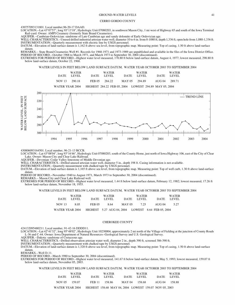
41GROUND-WATER LEVELS
CERRO GORDO COUNTY
430757093131801. Local number,96-20-17 DAAD. LOCATION.--Lat 43°07'57", long 93°13'18", Hydrologic Unit 07080203, in southwest Mason City, 1 mi west of Highway 65 and south of the Iowa Terminal
Rail-yard. Owner: AMPI Creamery (formerly State Brand Creameries). AQUIFER.--Cambrian-Ordovician: sandstone of Late Cambrian age and sandy dolomite of Early Ordovician age. WELL CHARACTERISTICS.--Unused drilled industrial artesian water well, diameter 10 to 6 in. from 0-1080 ft, depth 1,336 ft, open hole from 1,080-1,336 ft. INSTRUMENTATION.--Quarterly measurement with electric line by USGS personnel. DATUM.--Elevation of land-surface datum is 1,162 ft above sea level, from topographic map. Measuring point: Top of casing, 1.50 ft above land-surface
datum. REMARKS.-- State Brand Creameries Well #1. Records for 1968-1971 and 1973-1989 are unpublished and available in the files of the Iowa District Office. PERIOD OF RECORD.--October 1968 to March 1971, and March 1973 to September 30, 2004 (discontinued). EXTREMES FOR PERIOD OF RECORD.--Highest water level measured, 170.80 ft below land-surface datum, August 4, 1977; lowest measured, 298.80 ft
below land-surface datum, October 22, 1968.
WATER LEVELS IN FEET BELOW LAND SURFACE DATUM, WATER YEAR OCTOBER 2003 TO SEPTEMBER 2004
DATEWATER LEVEL DATE
WATER LEVEL DATE
WATER LEVEL DATE
WATER LEVEL
NOV 13 290.18 FEB 05 284.22 MAY 05 294.89 AUG 04 289.71
WATER YEAR 2004 HIGHEST 284.22 FEB 05, 2004 LOWEST 294.89 MAY 05, 2004
1994 1995 1996 1997 1998 1999 2000 2001 2002 2003 2004
300
280
260
240
220
200
WA
TE
R L
EV
EL
, IN
FE
ET
BE
LO
W L
AN
D S
UR
FAC
E TREND LINE
430806093164501. Local number, 96-21-13 BCCB. LOCATION.--Lat 43°08'04", long 93°16'46", Hydrologic Unit 07080203, south of the County Home, just north of Iowa Highway 106, east of the City of Clear
Lake. Owner: Mason City and Clear Lake Railroad. AQUIFER.--Devonian: Cedar Valley limestone of Middle Devonian age. WELL CHARACTERISTICS.--Drilled unused artesian water well, diameter 5 in., depth 198 ft. Casing information is not available. INSTRUMENTATION.--Quarterly measurement with chalked tape by USGS personnel. DATUM.--Elevation of land-surface datum is 1,165 ft above sea level, from topographic map. Measuring point: Top of well curb, 1.30 ft above land-surface
datum. PERIOD OF RECORD.--November 1940 to August 1971, March 1973 to September 30, 2004 (discontinued). REMARKS.-- Mason City and Clear Lake Railroad well. EXTREMES FOR PERIOD OF RECORD.--Highest water level measured, 1.44 ft below land-surface datum, February 12, 1982; lowest measured, 17.26 ft
below land-surface datum, November 18, 1955.
WATER LEVELS IN FEET BELOW LAND SURFACE DATUM, WATER YEAR OCTOBER 2003 TO SEPTEMBER 2004
DATEWATER LEVEL DATE
WATER LEVEL DATE
WATER LEVEL DATE
WATER LEVEL
NOV 13 8.05 FEB 05 8.64 MAY 05 7.25 AUG 04 5.27
WATER YEAR 2004 HIGHEST 5.27 AUG 04, 2004 LOWEST 8.64 FEB 05, 2004
CHEROKEE COUNTY
424132095480211. Local number, 91-42-16 DDDD11. LOCATION.--Lat 42°41'32", long 95°48'02", Hydrologic Unit 10230004, approximately 2 mi north of the Village of Fielding at the junction of County Roads
L-36 and C-44. Owner: Iowa Department of Natural Resources--Geological Survey and U.S. Geological Survey. AQUIFER.--Dakota: sandstone of Cretaceous age. WELL CHARACTERISTICS.--Drilled observation artesian water well, diameter 2 in., depth 390 ft, screened 386-390 ft. INSTRUMENTATION.--Quarterly measurement with chalked tape by USGS personnel. DATUM.--Elevation of land-surface datum is 1,320 ft above sea level, from topographic map. Measuring point: Top of casing, 1.50 ft above land-surface
datum. REMARKS.--Well D-11. PERIOD OF RECORD.--March 1980 to September 30, 2004 (discontinued). EXTREMES FOR PERIOD OF RECORD.--Highest water level measured, 141.67 ft below land-surface datum, May 5, 1993; lowest measured, 159.07 ft
below land-surface datum, November 05, 2003.
WATER LEVELS IN FEET BELOW LAND SURFACE DATUM, WATER YEAR OCTOBER 2003 TO SEPTEMBER 2004
DATEWATER LEVEL DATE
WATER LEVEL DATE
WATER LEVEL DATE
WATER LEVEL
NOV 05 159.07 FEB 11 158.86 MAY 04 158.68 AUG 04 158.88
WATER YEAR 2004 HIGHEST 158.68 MAY 04, 2004 LOWEST 159.07 NOV 05, 2003
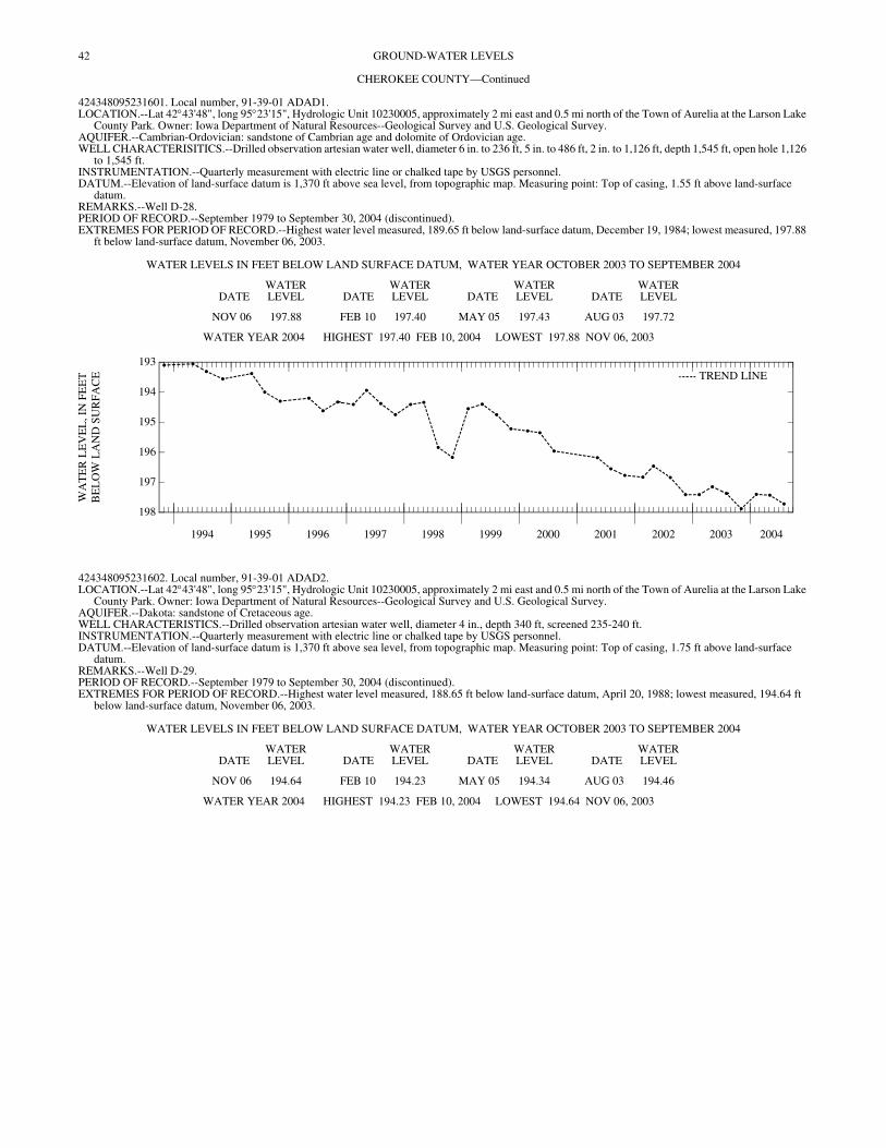
42 GROUND-WATER LEVELS
CHEROKEE COUNTY—Continued
424348095231601. Local number, 91-39-01 ADAD1. LOCATION.--Lat 42°43'48", long 95°23'15", Hydrologic Unit 10230005, approximately 2 mi east and 0.5 mi north of the Town of Aurelia at the Larson Lake
County Park. Owner: Iowa Department of Natural Resources--Geological Survey and U.S. Geological Survey. AQUIFER.--Cambrian-Ordovician: sandstone of Cambrian age and dolomite of Ordovician age. WELL CHARACTERISITICS.--Drilled observation artesian water well, diameter 6 in. to 236 ft, 5 in. to 486 ft, 2 in. to 1,126 ft, depth 1,545 ft, open hole 1,126
to 1,545 ft. INSTRUMENTATION.--Quarterly measurement with electric line or chalked tape by USGS personnel. DATUM.--Elevation of land-surface datum is 1,370 ft above sea level, from topographic map. Measuring point: Top of casing, 1.55 ft above land-surface
datum. REMARKS.--Well D-28. PERIOD OF RECORD.--September 1979 to September 30, 2004 (discontinued). EXTREMES FOR PERIOD OF RECORD.--Highest water level measured, 189.65 ft below land-surface datum, December 19, 1984; lowest measured, 197.88
ft below land-surface datum, November 06, 2003.
WATER LEVELS IN FEET BELOW LAND SURFACE DATUM, WATER YEAR OCTOBER 2003 TO SEPTEMBER 2004
DATEWATER LEVEL DATE
WATER LEVEL DATE
WATER LEVEL DATE
WATER LEVEL
NOV 06 197.88 FEB 10 197.40 MAY 05 197.43 AUG 03 197.72
WATER YEAR 2004 HIGHEST 197.40 FEB 10, 2004 LOWEST 197.88 NOV 06, 2003
1994 1995 1996 1997 1998 1999 2000 2001 2002 2003 2004
198
197
196
195
194
193
WA
TE
R L
EV
EL
, IN
FE
ET
BE
LO
W L
AN
D S
UR
FAC
E TREND LINE
424348095231602. Local number, 91-39-01 ADAD2. LOCATION.--Lat 42°43'48", long 95°23'15", Hydrologic Unit 10230005, approximately 2 mi east and 0.5 mi north of the Town of Aurelia at the Larson Lake
County Park. Owner: Iowa Department of Natural Resources--Geological Survey and U.S. Geological Survey. AQUIFER.--Dakota: sandstone of Cretaceous age. WELL CHARACTERISTICS.--Drilled observation artesian water well, diameter 4 in., depth 340 ft, screened 235-240 ft. INSTRUMENTATION.--Quarterly measurement with electric line or chalked tape by USGS personnel. DATUM.--Elevation of land-surface datum is 1,370 ft above sea level, from topographic map. Measuring point: Top of casing, 1.75 ft above land-surface
datum. REMARKS.--Well D-29. PERIOD OF RECORD.--September 1979 to September 30, 2004 (discontinued). EXTREMES FOR PERIOD OF RECORD.--Highest water level measured, 188.65 ft below land-surface datum, April 20, 1988; lowest measured, 194.64 ft
below land-surface datum, November 06, 2003.
WATER LEVELS IN FEET BELOW LAND SURFACE DATUM, WATER YEAR OCTOBER 2003 TO SEPTEMBER 2004
DATEWATER LEVEL DATE
WATER LEVEL DATE
WATER LEVEL DATE
WATER LEVEL
NOV 06 194.64 FEB 10 194.23 MAY 05 194.34 AUG 03 194.46
WATER YEAR 2004 HIGHEST 194.23 FEB 10, 2004 LOWEST 194.64 NOV 06, 2003
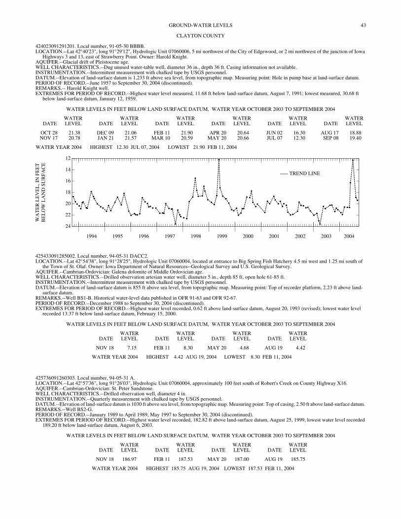
43GROUND-WATER LEVELS
CLAYTON COUNTY
424023091291201. Local number, 91-05-30 BBBB. LOCATION.--Lat 42°40'23", long 91°29'12", Hydrologic Unit 07060006, 5 mi northwest of the City of Edgewood, or 2 mi northwest of the junction of Iowa
Highways 3 and 13, east of Strawberry Point. Owner: Harold Knight. AQUIFER.--Glacial drift of Pleistocene age. WELL CHARACTERISTICS.--Dug unused water-table well, diameter 36 in., depth 36 ft. Casing information not available. INSTRUMENTATION.--Intermittent measurement with chalked tape by USGS personnel. DATUM.--Elevation of land-surface datum is 1,233 ft above sea level, from topographic map. Measuring point: Hole in pump base at land-surface datum. PERIOD OF RECORD.--June 1957 to September 30, 2004 (discontinued). REMARKS.-- Harold Knight well. EXTREMES FOR PERIOD OF RECORD.--Highest water level measured, 11.68 ft below land-surface datum, August 7, 1991; lowest measured, 30.68 ft
below land-surface datum, January 12, 1959.
WATER LEVELS IN FEET BELOW LAND SURFACE DATUM, WATER YEAR OCTOBER 2003 TO SEPTEMBER 2004
DATEWATER LEVEL DATE
WATER LEVEL DATE
WATER LEVEL DATE
WATER LEVEL DATE
WATER LEVEL DATE
WATER LEVEL
OCT 28 21.38 DEC 09 21.06 FEB 11 21.90 APR 20 20.64 JUN 02 16.30 AUG 17 18.88NOV 17 20.78 JAN 21 21.57 MAR 10 20.59 MAY 20 20.66 JUL 07 12.30 SEP 08 19.40
WATER YEAR 2004 HIGHEST 12.30 JUL 07, 2004 LOWEST 21.90 FEB 11, 2004
1994 1995 1996 1997 1998 1999 2000 2001 2002 2003 2004
24
22
20
18
16
14
12
WA
TE
R L
EV
EL
, IN
FE
ET
BE
LO
W L
AN
D S
UR
FAC
E
TREND LINE
425433091285002. Local number, 94-05-31 DACC2. LOCATION.--Lat 42°54'38", long 91°28'25", Hydrologic Unit 07060004, located at entrance to Big Spring Fish Hatchery 4.5 mi west and 1.25 mi south of
the Town of St. Olaf. Owner: Iowa Department of Natural Resources--Geological Survey and U.S. Geological Survey. AQUIFER.--Cambrian-Ordovician: Galena dolomite of Middle Ordovician age. WELL CHARACTERISTICS.--Drilled observation artesian water well, diameter 5 in., depth 85 ft, open hole 61-85 ft. INSTRUMENTATION.--Intermittent measurement with chalked tape by USGS personnel. DATUM.--Elevation of land-surface datum is 855 ft above sea level, from topographic map. Measuring point: Top of recorder platform, 2.23 ft above land-
surface datum. REMARKS.--Well BS1-B. Historical water-level data published in OFR 91-63 and OFR 92-67. PERIOD OF RECORD.--December 1988 to September 30, 2004 (discontinued). EXTREMES FOR PERIOD OF RECORD.--Highest water level recorded, 0.62 ft above land-surface datum, August 20, 1993 (revised); lowest water level
recorded 13.37 ft below land-surface datum, February 15, 2000.
WATER LEVELS IN FEET BELOW LAND SURFACE DATUM, WATER YEAR OCTOBER 2003 TO SEPTEMBER 2004
DATEWATER LEVEL DATE
WATER LEVEL DATE
WATER LEVEL DATE
WATER LEVEL
NOV 18 7.15 FEB 11 8.30 MAY 20 4.68 AUG 19 4.42
WATER YEAR 2004 HIGHEST 4.42 AUG 19, 2004 LOWEST 8.30 FEB 11, 2004
425736091260303. Local number, 94-05-31 A. LOCATION.--Lat 42°57'36", long 91°26'03", Hydrologic Unit 07060004, approximately 100 feet south of Robert's Creek on County Highway X16. AQUIFER.--Cambrian-Ordovician: St. Peter Sandstone. WELL CHARACTERISTICS.--Drilled observation well, diameter 4 in. INSTRUMENTATION.--Quarterly measurement with chalked tape by USGS personnel. DATUM.--Elevation of land-surface datum is 1030 ft above sea level, from topographic map. Measuring point: Top of casing, 2.50 ft above land-surface datum. REMARKS.--Well BS2-G. PERIOD OF RECORD.--January 1989 to April 1989, May 1997 to September 30, 2004 (discontinued). EXTREMES FOR PERIOD OF RECORD.--Highest water level recorded, 182.82 ft above land-surface datum, August 25, 1999, lowest water level recorded
189.20 ft below land-surface datum, August 6, 2003.
WATER LEVELS IN FEET BELOW LAND SURFACE DATUM, WATER YEAR OCTOBER 2003 TO SEPTEMBER 2004
DATEWATER LEVEL DATE
WATER LEVEL DATE
WATER LEVEL DATE
WATER LEVEL
NOV 18 186.97 FEB 11 187.53 MAY 20 187.00 AUG 19 185.75
WATER YEAR 2004 HIGHEST 185.75 AUG 19, 2004 LOWEST 187.53 FEB 11, 2004
44 GROUND-WATER LEVELS
CLAYTON COUNTY—Continued
430156091182901. Local number, 95-04-22 BCBD. LOCATION.--Lat 43°01'56", long 91°18'29", Hydrologic Unit 07060001, approximately 2 mi north of the junction of U.S. Highway 18 and U.S. Highway 52-
Iowa Highway 13, near Spook Cave. Owner: Gerald Mielke. AQUIFER.--Cambrian-Ordovician: St. Peter sandstone of Middle Ordovician age. WELL CHARACTERISTICS.--Drilled unused artesian water well, diameter 6 in., depth 49 ft. Casing information not available. INSTRUMENTATION.--Quarterly measurement with chalked tape by USGS personnel. DATUM.--Elevation of land-surface datum is 940 ft above sea level, from topographic map. Measuring point: Top of casing, 1.00 ft above land-surface datum. PERIOD OF RECORD.--October 1957 to September 30, 2004 (discontinued). REMARKS.-- USGS 22E1. EXTREMES FOR PERIOD OF RECORD.--Highest water level measured, 13.98 ft below land-surface datum, December 7, 1983; lowest measured, 27.88 ft
below land-surface datum, March 4, 1968.
WATER LEVELS IN FEET BELOW LAND SURFACE DATUM, WATER YEAR OCTOBER 2003 TO SEPTEMBER 2004
DATEWATER LEVEL DATE
WATER LEVEL DATE
WATER LEVEL DATE
WATER LEVEL
NOV 18 24.01 FEB 11 25.22 MAY 20 22.70 AUG 19 23.16
WATER YEAR 2004 HIGHEST 22.70 MAY 20, 2004 LOWEST 25.22 FEB 11, 2004
CLINTON COUNTY
414806090212301. Local number, 81-05E-22 DDD. LOCATION.--Lat 41°48'03", long 90°21'26", Hydrologic Unit 07080101, approximately 1 mile south of the intersection of U.S. Interstate 30 and county road
36, on the northwest corner of intersection. Owner: Town of Low Moor. AQUIFER.--Silurian, Alexanderian Series. WELL CHARACTERISTICS.--Drilled public-use well, diameter 12 in. to 62 ft, 8 in. to 62 ft, depth 322 ft, open hole from 85- 322 ft. INSTRUMENTATION.--Quarterly measurement with chalked tape by USGS personnel. DATUM.--Elevation of land-surface datum is 651 feet above sea level, by topographic map. Measuring point: Base of vent pipe, 1.12 above land surface datum. PERIOD OF RECORD.--August 1997 to September 30, 2004 (discontinued). REMARKS.-- Low Moor No.2. EXTREMES FOR PERIOD OF RECORD.--Highest water level measured, 19.92 feet below land-surface datum, May 7, 1998; lowest measured, 30.50 ft below
land-surface datum, May 03, 1999.
WATER LEVELS IN FEET BELOW LAND SURFACE DATUM, WATER YEAR OCTOBER 2003 TO SEPTEMBER 2004
DATEWATER LEVEL DATE
WATER LEVEL DATE
WATER LEVEL DATE
WATER LEVEL
NOV 18 23.84 FEB 10 23.31 MAY 20 20.38 AUG 23 22.48
WATER YEAR 2004 HIGHEST 20.38 MAY 20, 2004 LOWEST 23.84 NOV 18, 2003
414921090450401. Local number, 81-02E-17 ACA. LOCATION.--Lat 41°49'32", long 90°45'08", Hydrologic Unit 07080103, located below water tower near sub-station in the Town of Claims. Owner: Town of
Calamus. AQUIFER.--Silurian. WELL CHARACTERISTICS.--Drilled pumping well, diameter 12 in. to 90 ft, 10 in. to 190 ft, depth 278 ft. INSTRUMENTATION.--Quarterly measurements with airline by USGS personnel. DATUM.--Elevation of land-surface datum is 712 feet above sea level, by topographic map. PERIOD OF RECORD.--August 1997 to September 30, 2004 (discontinued). REMARKS.-- Calamus No.1. EXTREMES FOR PERIOD OF RECORD.--Highest water level measured, 42 feet below land-surface datum, November 14, 2002; lowest measured, 125 ft
below land-surface datum, August 13, 2002.
WATER LEVELS IN FEET BELOW LAND SURFACE DATUM, WATER YEAR OCTOBER 2003 TO SEPTEMBER 2004
DATEWATER LEVEL DATE
WATER LEVEL DATE
WATER LEVEL DATE
WATER LEVEL
NOV 18 43 FEB 10 103 MAY 20 97 AUG 19 96
WATER YEAR 2004 HIGHEST 43 NOV 18, 2003 LOWEST 103 FEB 10, 2004
45GROUND-WATER LEVELS
CRAWFORD COUNTY
415514095312001. Local number, 82-40-17 AABB. LOCATION.--Lat 41°55'14", long 95°31'20", Hydrologic Unit 10230007, approximately 1.5 mi west of the Town of Dow City on the south side of U.S.
Highway 30. Owner: Iowa Department of Natural Resources--Geological Survey and U.S. Geological Survey. AQUIFER.--Dakota: sandstone of Cretaceous age. WELL CHARACTERISTICS.--Drilled observation artesian water well, diameter 2 in., depth 141 ft, screened 123-141 ft, gravel- packed. INSTRUMENTATION.--Quarterly measurement with chalked tape by USGS personnel. DATUM.--Elevation of land-surface datum is 1,150 ft above sea level, from topographic map. Measuring point: Top of casing, 2.50 ft above land-surface
datum. REMARKS.--Well WC-9. PERIOD OF RECORD.--June 1981 to September 30, 2004 (discontinued). EXTREMES FOR PERIOD OF RECORD.--Highest water level measured, 38.15 ft below land-surface datum, May 3, 1983; lowest measured, 43.86 ft below
land-surface datum, June 11, 1981.
WATER LEVELS IN FEET BELOW LAND SURFACE DATUM, WATER YEAR OCTOBER 2003 TO SEPTEMBER 2004
DATEWATER LEVEL DATE
WATER LEVEL DATE
WATER LEVEL DATE
WATER LEVEL
NOV 05 43.33 FEB 12 42.82 MAY 04 42.33 AUG 04 42.40
WATER YEAR 2004 HIGHEST 42.33 MAY 04, 2004 LOWEST 43.33 NOV 05, 2003
420608095111701. Local number, 84-37-08 BCCB. LOCATION.--Lat 42°06'08", long 95°11'14", Hydrologic Unit 10230007, approximately 3 mi north of the Town of Vail on the east side of County Road E-
25. Owner: Iowa Department of Natural Resources--Geological Survey and U.S. Geological Survey. AQUIFER.--Fremont buried channel: sand and gravel of Pleistocene age. WELL CHARACTERISTICS.--Drilled observation artesian water well, diameter 2 in., depth 541 ft, screened 527-541 ft, gravel- packed. INSTRUMENTATION.--Quarterly measurement with chalked tape or electric line by USGS personnel. DATUM.--Elevation of land-surface datum is 1,380 ft above sea level, from topographic map. Measuring point: Top of casing, 1.65 ft above land-surface
datum. REMARKS.--Well WC-226. PERIOD OF RECORD.--August 1983 to September 30, 2004 (discontinued). EXTREMES FOR PERIOD OF RECORD.--Highest water level measured, 208.35 ft below land-surface datum, July 17, 1988; lowest measured, 217.70 ft
below land-surface datum, February 11, 1999.
WATER LEVELS IN FEET BELOW LAND SURFACE DATUM, WATER YEAR OCTOBER 2003 TO SEPTEMBER 2004
DATEWATER LEVEL DATE
WATER LEVEL DATE
WATER LEVEL DATE
WATER LEVEL
NOV 06 216.66 FEB 11 216.41 MAY 05 216.23 AUG 03 216.35
WATER YEAR 2004 HIGHEST 216.23 MAY 05, 2004 LOWEST 216.66 NOV 06, 2003
421005095342801. Local number, 85-41-13 CCCC. LOCATION.--Lat 42°10'05", long 95°34'28", Hydrologic Unit 10230001, approximately 7 mi west of the Town of Schleswig, northeast of the junction of
County Roads L-51 and E-16. Owner: Iowa Department of Natural Resources--Geological Survey and U.S. Geological Survey. AQUIFER.--Dakota and glacial drift: sandstone of Cretaceous age and sand and gravel of Pleistocene age. WELL CHARACTERISTICS.--Drilled observation artesian water well, diameter 2 in., depth 361 ft, screened 307-322 ft, gravel-packed. Open to Dakota 320-
361 ft. INSTRUMENTATION.--Quarterly measurement with electric line or chalked tape by USGS personnel. DATUM.--Elevation of land-surface datum is 1,375 ft above sea level, from topographic map. Measuring point: Top of casing, 3.49 ft above land-surface
datum. REMARKS.--Well WC-6. PERIOD OF RECORD.--May 1981 to September 30, 2004 (discontinued). EXTREMES FOR PERIOD OF RECORD.--Highest water level measured, 244.23 ft below land-surface datum, July 28, 1981; lowest measured, 249.95 ft
below land-surface datum, November 06, 2003.
WATER LEVELS IN FEET BELOW LAND SURFACE DATUM, WATER YEAR OCTOBER 2003 TO SEPTEMBER 2004
DATEWATER LEVEL DATE
WATER LEVEL DATE
WATER LEVEL DATE
WATER LEVEL
NOV 06 249.95 FEB 11 249.61 MAY 05 249.44 AUG 03 249.80
WATER YEAR 2004 HIGHEST 249.44 MAY 05, 2004 LOWEST 249.95 NOV 06, 2003
46 GROUND-WATER LEVELS
CRAWFORD COUNTY—Continued
421031095225601. Local number, 85-39-16 ADDD1. LOCATION.--Lat 42°10'31", long 95°22'56", Hydrologic Unit 10230007, approximately 2.5 mi east and 0.5 mi north of the Town of Schleswig on the west
side of County Road M-27. Owner: Iowa Department of Natural Resources--Geological Survey and U.S. Geological Survey. AQUIFER.--Dakota: sandstone of Cretaceous age. WELL CHARACTERISTICS.--Drilled observation artesian water well, diameter 5 in., depth 351 ft, screened 315-330 ft, gravel-packed. Open to
Pennsylvanian rock 344-351 ft. INSTRUMENTATION.--Quarterly measurement with chalked tape or electric line by USGS personnel. DATUM.--Elevation of land-surface datum is 1,370 ft above sea level, from topographic map. Measuring point: Top of casing, 3.14 ft above land-surface
datum. REMARKS.--Well WC-7A. PERIOD OF RECORD.--June 1981 to September 30, 2004 (discontinued). EXTREMES FOR PERIOD OF RECORD.--Highest water level measured, 232.61 ft below land-surface datum, October 7, 1986; lowest measured, 239.65 ft
below land-surface datum, August 2, 1995.
WATER LEVELS IN FEET BELOW LAND SURFACE DATUM, WATER YEAR OCTOBER 2003 TO SEPTEMBER 2004
DATEWATER LEVEL DATE
WATER LEVEL DATE
WATER LEVEL DATE
WATER LEVEL
NOV 06 237.13 FEB 11 237.34 MAY 05 237.52 AUG 03 237.72
WATER YEAR 2004 HIGHEST 237.13 NOV 06, 2003 LOWEST 237.72 AUG 03, 2004
421031095225602. Local number, 85-39-16 ADDD2. LOCATION.--Lat 42°10'31", long 95°22'56", Hydrologic Unit 10230007, approximately 2.5 mi east and 0.5 mi north of the Town of Schleswig on the west
side of County Road M-27. Owner: Iowa Department of Natural Resources--Geological Survey and U.S. Geological Survey. AQUIFER.--Mississippian: limestone of Mississippian age. WELL CHARACTERISTICS.--Drilled observation artesian water well, diameter 2 in., depth 561 ft, screened 543-561 ft, gravel-packed. INSTRUMENTATION.--Quarterly measurement with chalked tape or electric line by USGS personnel. DATUM.--Elevation of land-surface datum is 1,370 ft above sea level, from topographic map. Measuring point: Top of casing, 3.14 ft above land-surface
datum. REMARKS.--Well WC-7B. PERIOD OF RECORD.--June 1981 to September 30, 2004 (discontinued). EXTREMES FOR PERIOD OF RECORD.--Highest water level measured, 296.63 ft below land-surface datum, May 07, 1996, lowest measured, 307.64 ft
below land-surface datum, October 4, 1983.
WATER LEVELS IN FEET BELOW LAND SURFACE DATUM, WATER YEAR OCTOBER 2003 TO SEPTEMBER 2004
DATEWATER LEVEL DATE
WATER LEVEL DATE
WATER LEVEL DATE
WATER LEVEL
NOV 06 304.43 FEB 11 304.16 MAY 05 303.82 AUG 03 303.77
WATER YEAR 2004 HIGHEST 303.77 AUG 03, 2004 LOWEST 304.43 NOV 06, 2003
421106095125501. Local number, 85-38-12 DCBA. LOCATION.--Lat 42°11'06", long 95°12'55", Hydrologic Unit 10230007, approximately 5.5 mi east of the Town of Kiron on the south side of County Road
E-16 near the Town of Boyer. Owner: Iowa Department of Natural Resources--Geological Survey and U.S. Geological Survey. AQUIFER.--Fremont buried channel: sand and gravel of Pleistocene age. WELL CHARACTERISTICS.--Drilled observation artesian water well, diameter 2 in., depth 341 ft, screened 300-310 ft, open hole from 315-341 ft., gravel
packed. Open to Pennsylvanian limestone and shale 331-341 ft. INSTRUMENTATION.--Quarterly measurement with chalked tape or electric line by USGS personnel. DATUM.--Elevation of land-surface datum is 1,225 ft above sea level, from topographic map. Measuring point: Top of casing, 3.70 ft above land-surface
datum. REMARKS.--Well WC-14. PERIOD OF RECORD.--July 1981 to September 30, 2004 (discontinued). EXTREMES FOR PERIOD OF RECORD.---Highest water level measured, 62.76 ft below land-surface datum, April 16, 1987; lowest measured, 69.89 ft
below land-surface datum, November 06, 2003.
WATER LEVELS IN FEET BELOW LAND SURFACE DATUM, WATER YEAR OCTOBER 2003 TO SEPTEMBER 2004
DATEWATER LEVEL DATE
WATER LEVEL DATE
WATER LEVEL DATE
WATER LEVEL
NOV 06 69.89 FEB 11 69.45 MAY 05 69.32 AUG 03 69.36
WATER YEAR 2004 HIGHEST 69.32 MAY 05, 2004 LOWEST 69.89 NOV 06, 2003
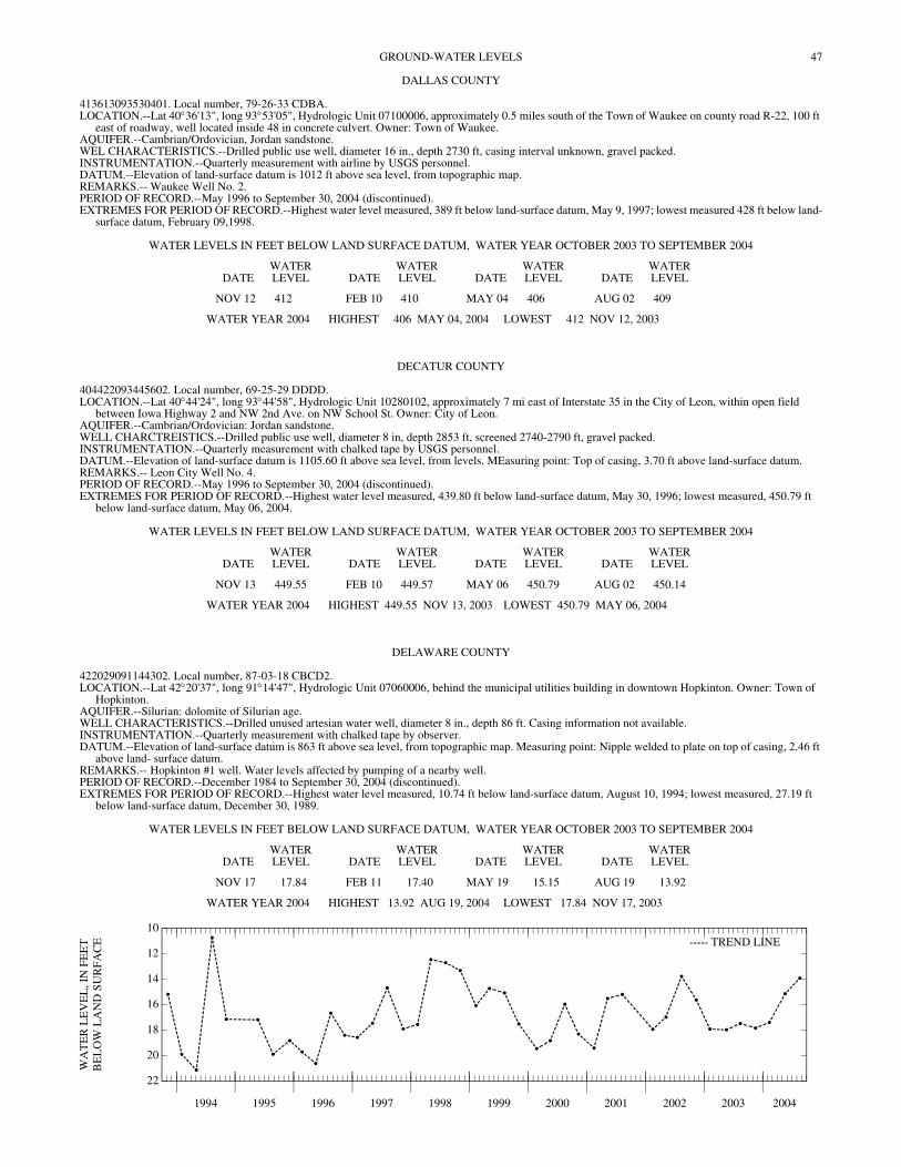
47GROUND-WATER LEVELS
DALLAS COUNTY
413613093530401. Local number, 79-26-33 CDBA. LOCATION.--Lat 40°36'13", long 93°53'05", Hydrologic Unit 07100006, approximately 0.5 miles south of the Town of Waukee on county road R-22, 100 ft
east of roadway, well located inside 48 in concrete culvert. Owner: Town of Waukee. AQUIFER.--Cambrian/Ordovician, Jordan sandstone. WEL CHARACTERISTICS.--Drilled public use well, diameter 16 in., depth 2730 ft, casing interval unknown, gravel packed. INSTRUMENTATION.--Quarterly measurement with airline by USGS personnel. DATUM.--Elevation of land-surface datum is 1012 ft above sea level, from topographic map. REMARKS.-- Waukee Well No. 2. PERIOD OF RECORD.--May 1996 to September 30, 2004 (discontinued). EXTREMES FOR PERIOD OF RECORD.--Highest water level measured, 389 ft below land-surface datum, May 9, 1997; lowest measured 428 ft below land-
surface datum, February 09,1998.
WATER LEVELS IN FEET BELOW LAND SURFACE DATUM, WATER YEAR OCTOBER 2003 TO SEPTEMBER 2004
DATEWATER LEVEL DATE
WATER LEVEL DATE
WATER LEVEL DATE
WATER LEVEL
NOV 12 412 FEB 10 410 MAY 04 406 AUG 02 409
WATER YEAR 2004 HIGHEST 406 MAY 04, 2004 LOWEST 412 NOV 12, 2003
DECATUR COUNTY
404422093445602. Local number, 69-25-29 DDDD. LOCATION.--Lat 40°44'24", long 93°44'58", Hydrologic Unit 10280102, approximately 7 mi east of Interstate 35 in the City of Leon, within open field
between Iowa Highway 2 and NW 2nd Ave. on NW School St. Owner: City of Leon. AQUIFER.--Cambrian/Ordovician: Jordan sandstone. WELL CHARCTREISTICS.--Drilled public use well, diameter 8 in, depth 2853 ft, screened 2740-2790 ft, gravel packed. INSTRUMENTATION.--Quarterly measurement with chalked tape by USGS personnel. DATUM.--Elevation of land-surface datum is 1105.60 ft above sea level, from levels. MEasuring point: Top of casing, 3.70 ft above land-surface datum. REMARKS.-- Leon City Well No. 4. PERIOD OF RECORD.--May 1996 to September 30, 2004 (discontinued). EXTREMES FOR PERIOD OF RECORD.--Highest water level measured, 439.80 ft below land-surface datum, May 30, 1996; lowest measured, 450.79 ft
below land-surface datum, May 06, 2004.
WATER LEVELS IN FEET BELOW LAND SURFACE DATUM, WATER YEAR OCTOBER 2003 TO SEPTEMBER 2004
DATEWATER LEVEL DATE
WATER LEVEL DATE
WATER LEVEL DATE
WATER LEVEL
NOV 13 449.55 FEB 10 449.57 MAY 06 450.79 AUG 02 450.14
WATER YEAR 2004 HIGHEST 449.55 NOV 13, 2003 LOWEST 450.79 MAY 06, 2004
DELAWARE COUNTY
422029091144302. Local number, 87-03-18 CBCD2. LOCATION.--Lat 42°20'37", long 91°14'47", Hydrologic Unit 07060006, behind the municipal utilities building in downtown Hopkinton. Owner: Town of
Hopkinton. AQUIFER.--Silurian: dolomite of Silurian age. WELL CHARACTERISTICS.--Drilled unused artesian water well, diameter 8 in., depth 86 ft. Casing information not available. INSTRUMENTATION.--Quarterly measurement with chalked tape by observer. DATUM.--Elevation of land-surface datum is 863 ft above sea level, from topographic map. Measuring point: Nipple welded to plate on top of casing, 2.46 ft
above land- surface datum. REMARKS.-- Hopkinton #1 well. Water levels affected by pumping of a nearby well. PERIOD OF RECORD.--December 1984 to September 30, 2004 (discontinued). EXTREMES FOR PERIOD OF RECORD.--Highest water level measured, 10.74 ft below land-surface datum, August 10, 1994; lowest measured, 27.19 ft
below land-surface datum, December 30, 1989.
WATER LEVELS IN FEET BELOW LAND SURFACE DATUM, WATER YEAR OCTOBER 2003 TO SEPTEMBER 2004
DATEWATER LEVEL DATE
WATER LEVEL DATE
WATER LEVEL DATE
WATER LEVEL
NOV 17 17.84 FEB 11 17.40 MAY 19 15.15 AUG 19 13.92
WATER YEAR 2004 HIGHEST 13.92 AUG 19, 2004 LOWEST 17.84 NOV 17, 2003
1994 1995 1996 1997 1998 1999 2000 2001 2002 2003 2004
22
20
18
16
14
12
10
WA
TE
R L
EV
EL
, IN
FE
ET
BE
LO
W L
AN
D S
UR
FAC
E TREND LINE
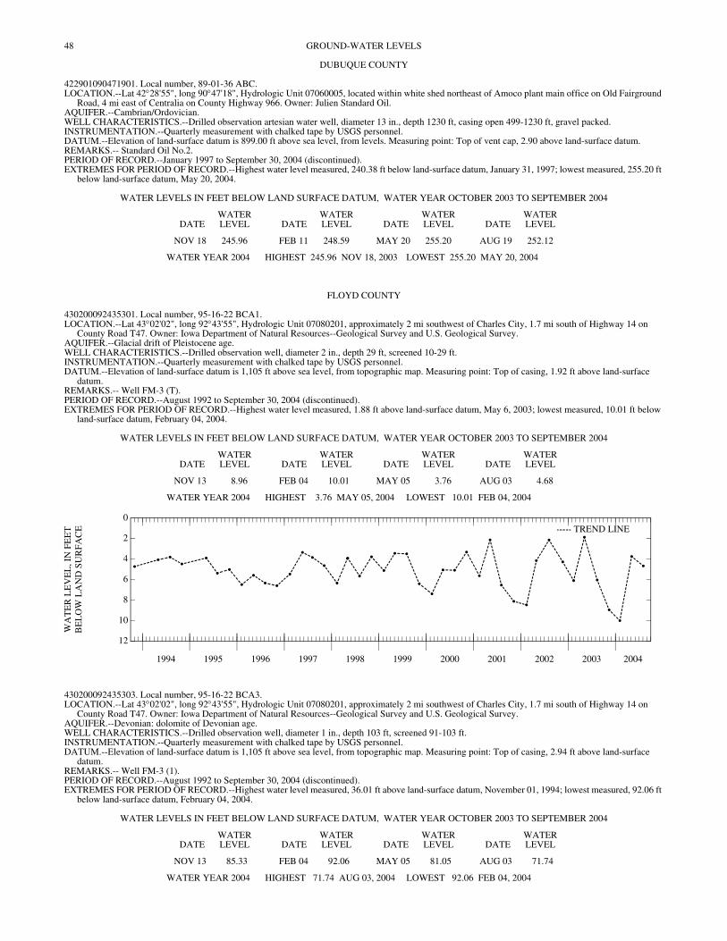
48 GROUND-WATER LEVELS
DUBUQUE COUNTY
422901090471901. Local number, 89-01-36 ABC. LOCATION.--Lat 42°28'55", long 90°47'18", Hydrologic Unit 07060005, located within white shed northeast of Amoco plant main office on Old Fairground
Road, 4 mi east of Centralia on County Highway 966. Owner: Julien Standard Oil. AQUIFER.--Cambrian/Ordovician. WELL CHARACTERISTICS.--Drilled observation artesian water well, diameter 13 in., depth 1230 ft, casing open 499-1230 ft, gravel packed. INSTRUMENTATION.--Quarterly measurement with chalked tape by USGS personnel. DATUM.--Elevation of land-surface datum is 899.00 ft above sea level, from levels. Measuring point: Top of vent cap, 2.90 above land-surface datum. REMARKS.-- Standard Oil No.2. PERIOD OF RECORD.--January 1997 to September 30, 2004 (discontinued). EXTREMES FOR PERIOD OF RECORD.--Highest water level measured, 240.38 ft below land-surface datum, January 31, 1997; lowest measured, 255.20 ft
below land-surface datum, May 20, 2004.
WATER LEVELS IN FEET BELOW LAND SURFACE DATUM, WATER YEAR OCTOBER 2003 TO SEPTEMBER 2004
DATEWATER LEVEL DATE
WATER LEVEL DATE
WATER LEVEL DATE
WATER LEVEL
NOV 18 245.96 FEB 11 248.59 MAY 20 255.20 AUG 19 252.12
WATER YEAR 2004 HIGHEST 245.96 NOV 18, 2003 LOWEST 255.20 MAY 20, 2004
FLOYD COUNTY
430200092435301. Local number, 95-16-22 BCA1. LOCATION.--Lat 43°02'02", long 92°43'55", Hydrologic Unit 07080201, approximately 2 mi southwest of Charles City, 1.7 mi south of Highway 14 on
County Road T47. Owner: Iowa Department of Natural Resources--Geological Survey and U.S. Geological Survey. AQUIFER.--Glacial drift of Pleistocene age. WELL CHARACTERISTICS.--Drilled observation well, diameter 2 in., depth 29 ft, screened 10-29 ft. INSTRUMENTATION.--Quarterly measurement with chalked tape by USGS personnel. DATUM.--Elevation of land-surface datum is 1,105 ft above sea level, from topographic map. Measuring point: Top of casing, 1.92 ft above land-surface
datum. REMARKS.-- Well FM-3 (T). PERIOD OF RECORD.--August 1992 to September 30, 2004 (discontinued). EXTREMES FOR PERIOD OF RECORD.--Highest water level measured, 1.88 ft above land-surface datum, May 6, 2003; lowest measured, 10.01 ft below
land-surface datum, February 04, 2004.
WATER LEVELS IN FEET BELOW LAND SURFACE DATUM, WATER YEAR OCTOBER 2003 TO SEPTEMBER 2004
DATEWATER LEVEL DATE
WATER LEVEL DATE
WATER LEVEL DATE
WATER LEVEL
NOV 13 8.96 FEB 04 10.01 MAY 05 3.76 AUG 03 4.68
WATER YEAR 2004 HIGHEST 3.76 MAY 05, 2004 LOWEST 10.01 FEB 04, 2004
1994 1995 1996 1997 1998 1999 2000 2001 2002 2003 2004
12
10
8
6
4
2
0
WA
TE
R L
EV
EL
, IN
FE
ET
BE
LO
W L
AN
D S
UR
FAC
E TREND LINE
430200092435303. Local number, 95-16-22 BCA3. LOCATION.--Lat 43°02'02", long 92°43'55", Hydrologic Unit 07080201, approximately 2 mi southwest of Charles City, 1.7 mi south of Highway 14 on
County Road T47. Owner: Iowa Department of Natural Resources--Geological Survey and U.S. Geological Survey. AQUIFER.--Devonian: dolomite of Devonian age. WELL CHARACTERISTICS.--Drilled observation well, diameter 1 in., depth 103 ft, screened 91-103 ft. INSTRUMENTATION.--Quarterly measurement with chalked tape by USGS personnel. DATUM.--Elevation of land-surface datum is 1,105 ft above sea level, from topographic map. Measuring point: Top of casing, 2.94 ft above land-surface
datum. REMARKS.-- Well FM-3 (1). PERIOD OF RECORD.--August 1992 to September 30, 2004 (discontinued). EXTREMES FOR PERIOD OF RECORD.--Highest water level measured, 36.01 ft above land-surface datum, November 01, 1994; lowest measured, 92.06 ft
below land-surface datum, February 04, 2004.
WATER LEVELS IN FEET BELOW LAND SURFACE DATUM, WATER YEAR OCTOBER 2003 TO SEPTEMBER 2004
DATEWATER LEVEL DATE
WATER LEVEL DATE
WATER LEVEL DATE
WATER LEVEL
NOV 13 85.33 FEB 04 92.06 MAY 05 81.05 AUG 03 71.74
WATER YEAR 2004 HIGHEST 71.74 AUG 03, 2004 LOWEST 92.06 FEB 04, 2004

49GROUND-WATER LEVELS
FLOYD COUNTY—Continued
430200092435304. Local number, 95-16-22 BCA4. LOCATION.--Lat 43°02'02", long 92°43'55", Hydrologic Unit 07080201, approximately 2 mi southwest of Charles City, 1.7 mi south of Highway 14 on
County Road T47. Owner: Iowa Department of Natural Resources--Geological Survey and U.S. Geological Survey. AQUIFER.--Devonian: dolomite of Devonian age. WELL CHARACTERISTICS.--Drilled observation well, diameter 1.5 in., depth 207 ft, screened 167-207 ft. INSTRUMENTATION.--Quarterly measurement with chalked tape by USGS personnel. DATUM.--Elevation of land-surface datum is 1,105 ft above sea level, from topographic map. Measuring point: Top of casing, 2.77 ft above land-surface
datum. REMARKS.-- Well FM-3 (2). PERIOD OF RECORD.--August 1992 to September 30, 2004 (discontinued). EXTREMES FOR PERIOD OF RECORD.--Highest water level measured, 56.05 ft above land-surface datum, August 23, 1993; lowest measured, 97.63 ft
below land-surface datum, February 04, 2004.
WATER LEVELS IN FEET BELOW LAND SURFACE DATUM, WATER YEAR OCTOBER 2003 TO SEPTEMBER 2004
DATEWATER LEVEL DATE
WATER LEVEL DATE
WATER LEVEL DATE
WATER LEVEL
NOV 13 91.07 FEB 04 97.63 MAY 05 85.63 AUG 03 75.99
WATER YEAR 2004 HIGHEST 75.99 AUG 03, 2004 LOWEST 97.63 FEB 04, 2004
430200092435305. Local number, 95-16-22 BCA5. LOCATION.--Lat 43°02'02", long 92°43'55", Hydrologic Unit 07080201, approximately 2 mi southwest of Charles City, 1.7 mi south of Highway 14 on
County Road T47. Owner: Iowa Department of Natural Resources--Geological Survey and U.S. Geological Survey. AQUIFER.--Devonian: dolomite of Devonian age. WELL CHARACTERISTICS.--Drilled observation well, diameter 1.5 in., depth 297 ft, screened 257-297 ft. INSTRUMENTATION.--Quarterly measurement with chalked tape by USGS personnel. DATUM.--Elevation of land-surface datum is 1,105 ft above sea level, from topographic map. Measuring point: Top of casing, 2.73 ft above land-surface
datum. REMARKS.-- Well FM-3 (3). PERIOD OF RECORD.--August 1992 to September 30, 2004 (discontinued). EXTREMES FOR PERIOD OF RECORD.--Highest water level measured, 55.21 ft above land-surface datum, August 23, 1993; lowest measured, 91.77 ft
below land-surface datum, February 04, 2004.
WATER LEVELS IN FEET BELOW LAND SURFACE DATUM, WATER YEAR OCTOBER 2003 TO SEPTEMBER 2004
DATEWATER LEVEL DATE
WATER LEVEL DATE
WATER LEVEL DATE
WATER LEVEL
NOV 13 84.91 FEB 04 91.77 MAY 05 81.22 AUG 03 71.66
WATER YEAR 2004 HIGHEST 71.66 AUG 03, 2004 LOWEST 91.77 FEB 04, 2004
430200092435306. Local number, 95-16-22 BCA6. LOCATION.--Lat 43°02'02", long 92°43'55", Hydrologic Unit 07080201, approximately 2 mi southwest of Charles City, 1.7 mi south of Highway 14 on
County Road T47. Owner: Iowa Department of Natural Resources--Geological Survey and U.S. Geological Survey. AQUIFER.--Devonian: dolomite of Devonian age. WELL CHARACTERISTICS.--Drilled observation well, diameter 1.5 in., depth 360 ft, screened 340-360 ft. INSTRUMENTATION.--Quarterly measurement with chalked tape by USGS personnel. DATUM.--Elevation of land-surface datum is 1,105 ft above sea level, from topographic map. Measuring point: Top of casing, 2.53 ft above land-surface
datum. REMARKS.-- Well FM-3 (4). PERIOD OF RECORD.--August 1992 to September 30, 2004 (discontinued). EXTREMES FOR PERIOD OF RECORD.--Highest water level measured, 56.23 ft above land-surface datum, August 23, 1993; lowest measured, 97.58 ft
below land-surface datum, February 04, 2004.
WATER LEVELS IN FEET BELOW LAND SURFACE DATUM, WATER YEAR OCTOBER 2003 TO SEPTEMBER 2004
DATEWATER LEVEL DATE
WATER LEVEL DATE
WATER LEVEL DATE
WATER LEVEL
NOV 13 91.05 FEB 04 97.58 MAY 05 85.64 AUG 03 76.02
WATER YEAR 2004 HIGHEST 76.02 AUG 03, 2004 LOWEST 97.58 FEB 04, 2004
50 GROUND-WATER LEVELS
FLOYD COUNTY—Continued
430800092540301. Local number, 96-17-18 CDBA. LOCATION.--Lat 43°07'47", long 92°54'06", Hydrologic Unit 07080202, on the north side of city street approximately 0.5 miles east of county road T-26 in
the Town of Rudd. Owner: Town of Rudd. AQUIFER.--Cambrian/Ordovician: Jordan sandstone and Prairie du Chien Formation dolomite. WELL CHARACTERISTICS.--Drilled public well, diameter 8 in., depth 1290 ft, screened 846-855 ft, gravel-packed. INSTRUMENTATION.--Quarterly measurement by airline by USGS personnel. DATUM.--Elevation of land-surface datum is 1,123 ft above sea level, by altimeter. REMARKS.-- Rudd Town Well No.2. PERIOD OF RECORD.--February 1997 to September 30, 2004 (discontinued). EXTREMES FOR PERIOD OF RECORD.--Highest water level measured, 161 ft below land surface datum, August 5, 1997; lowest measured 216 ft below
land-surface datum, February 04, 2004.
WATER LEVELS IN FEET BELOW LAND SURFACE DATUM, WATER YEAR OCTOBER 2003 TO SEPTEMBER 2004
DATEWATER LEVEL DATE
WATER LEVEL DATE
WATER LEVEL
FEB 04 216 MAY 05 215 AUG 03 214
WATER YEAR 2004 HIGHEST 214 AUG 03, 2004 LOWEST 216 FEB 04, 2004
GREENE COUNTY
415449094155601. Local number, 82-29-18 DBAA. LOCATION.--Lat 41°54'49", long 94°15'56", Hydrologic Unit 07100006, approximately 3.25 mi west and 1.5 mi south of the Town of Rippey, south of County
Road E-57. Owner: Iowa Department of Natural Resources--Geological Survey and U.S. Geological Survey. AQUIFER.--Glacial drift of Pleistocene age. WELL CHARACTERISTICS.--Drilled observation artesian water well, diameter 2 in., depth 90 ft, screened 65-75 ft, gravel- packed; open hole from 75-90
ft. Pleistocene glacial till 75-86 ft, and Pennsylvanian shale and siltstone 86-90 ft. INSTRUMENTATION.--Quarterly measurement with chalked tape by USGS personnel. DATUM.--Elevation of land-surface datum is 1,005 ft above sea level, from topographic map. Measuring point: Top of casing, 1.85 ft above land-surface
datum. REMARKS.-- Well WC-117. PERIOD OF RECORD.--August 1982 to November 1995. November 1996 to September 30, 2004 (discontinued) EXTREMES FOR PERIOD OF RECORD.--Highest water level measured, 32.20 ft below land-surface datum, August 17, 1993; lowest measured, 40.13 ft
below land-surface datum, February 13, 1990.
WATER LEVELS IN FEET BELOW LAND SURFACE DATUM, WATER YEAR OCTOBER 2003 TO SEPTEMBER 2004
DATEWATER LEVEL DATE
WATER LEVEL DATE
WATER LEVEL DATE
WATER LEVEL
NOV 12 37.42 FEB 10 37.71 MAY 04 35.75 AUG 03 36.09
WATER YEAR 2004 HIGHEST 35.75 MAY 04, 2004 LOWEST 37.71 FEB 10, 2004
420116094363001. Local number, 83-32-08 BBBC. LOCATION.--Lat 42°01'16", long 94°36'33", Hydrologic Unit 07100006, approximately 3 mi west of the Town of Scranton, south of U.S. Highway 30. Owner:
Iowa Department of Natural Resources--Geological Survey and U.S. Geological Survey. AQUIFER.--Hardin Creek buried channel: sand and gravel of Pleistocene age. WELL CHARACTERISTICS.--Drilled observation artesian water well, diameter 2 in., depth 181 ft, screened 161-171 ft, gravel-packed. Open to
Pennsylvanian shale and siltstone 171-181 ft. INSTRUMENTATION.--Quarterly measurement with chalked tape by USGS personnel. DATUM.--Elevation of land-surface datum is 1,135 ft above sea level, from topographic map. Measuring point: Top of casing, 2.20 ft above land-surface
datum. REMARKS.-- Well WC-229. PERIOD OF RECORD.--September 1983 to September 30, 2004 (discontinued). EXTREMES FOR PERIOD OF RECORD.--Highest water level measured, 39.44 ft below land-surface datum, August 19, 1993; lowest measured, 51.03 ft
below land-surface datum, July 8, 1985.
WATER LEVELS IN FEET BELOW LAND SURFACE DATUM, WATER YEAR OCTOBER 2003 TO SEPTEMBER 2004
DATEWATER LEVEL DATE
WATER LEVEL DATE
WATER LEVEL
NOV 12 43.39 MAY 06 43.00 AUG 03 45.26
WATER YEAR 2004 HIGHEST 43.00 MAY 06, 2004 LOWEST 45.26 AUG 03, 2004

51GROUND-WATER LEVELS
GREENE COUNTY—Continued
420146094272301. Local number, 83-31-04 ADDB. LOCATION.--Lat 42°01'47", long 94°27'23", Hydrologic Unit 07100006, approximately 4 mi west of the City of Jefferson and 0.5 mi south of U.S. Highway
30, on the west side of County Road P-14. Owner: Iowa Department of Natural Resources--Geological Survey and U.S. Geological Survey. AQUIFER.--Dakota: sandstone of Cretaceous age. WELL CHARACTERISTICS.--Drilled observation artesian water well, diameter 2 in., depth 54 ft, screened 40-51 ft, gravel- packed. Open to Pennsylvanian
shale 51-54 ft. INSTRUMENTATION.--Quarterly measurement with chalked tape by USGS personnel. DATUM.--Elevation of land-surface datum is 1,000 ft above sea level, from topographic map. Measuring point: Top of casing, 2.10 ft above land-surface
datum. REMARKS.-- Well WC-120. PERIOD OF RECORD.--August 1982 to July 1987, February 1990 to September 30, 2004 (discontinued). EXTREMES FOR PERIOD OF RECORD.--Highest water level measured, 6.39 ft below land-surface datum, July 5, 1983; lowest measured, 19.57 ft below
land-surface datum, November 06, 1997.
WATER LEVELS IN FEET BELOW LAND SURFACE DATUM, WATER YEAR OCTOBER 2003 TO SEPTEMBER 2004
DATEWATER LEVEL DATE
WATER LEVEL DATE
WATER LEVEL DATE
WATER LEVEL
NOV 12 17.74 FEB 08 19.02 MAY 06 16.43 AUG 03 16.85
WATER YEAR 2004 HIGHEST 16.43 MAY 06, 2004 LOWEST 19.02 FEB 08, 2004
420149094344701. Local number, 83-32-04 ACCC. LOCATION.--Lat 42°01'49", long 94°34'47", Hydrologic Unit 07100006, 1.5 mi west of the Town of Scranton south of U.S. Highway 30, adjacent to the
Scranton Cemetery. Owner: Iowa Department of Natural Resources--Geological Survey and U.S. Geological Survey. AQUIFER.--Dakota: sandstone of Cretaceous age. WELL CHARACTERISTICS.--Drilled observation artesian water well, diameter 2 in., depth 240 ft, screened 220-240 ft, gravel-packed. Open to
Pennsylvanian shale 234-240 ft. INSTRUMENTATION.--Quarterly measurement with chalked tape or electric line by USGS personnel. DATUM.--Elevation of land-surface datum is 1,202 ft above sea level, from topographic map. Measuring point: Top of casing, 2.10 ft above land-surface
datum. REMARKS.-- Well WC-228. PERIOD OF RECORD.--July 1983 to September 30, 2004 (discontinued). EXTREMES FOR PERIOD OF RECORD.--Highest water level measured, 151.44 ft below land-surface datum, February 8, 1996; lowest measured, 155.48 ft
below land-surface datum, April 17, 1991.
WATER LEVELS IN FEET BELOW LAND SURFACE DATUM, WATER YEAR OCTOBER 2003 TO SEPTEMBER 2004
DATEWATER LEVEL DATE
WATER LEVEL DATE
WATER LEVEL DATE
WATER LEVEL
NOV 12 153.12 FEB 08 153.12 MAY 06 153.00 AUG 03 152.86
WATER YEAR 2004 HIGHEST 152.86 AUG 03, 2004 LOWEST 153.12 NOV 12, 2003 FEB 08, 2004
420507094141901. Local number, 84-29-16 CBAB. LOCATION.--Lat 42°05'07", long 94°14'19", Hydrologic Unit 07100006, approximately 1.5 mi south of the Town of Dana, east of Iowa Highway 144 near
the Chicago and Northwestern Railroad. Owner: Iowa Department of Natural Resources--Geological Survey and U.S. Geological Survey. AQUIFER.--Beaver buried channel: sand and gravel of Pleistocene age. WELL CHARACTERISTICS.--Drilled observation artesian water well, diameter 2 in., depth 181 ft, screened 161-176 ft, gravel-packed. Open to
Pennsylvanian shale 177-181 ft. INSTRUMENTATION.--Quarterly measurement with chalked tape by USGS personnel. DATUM.--Elevation of land-surface datum is 1,075 ft above sea level, from topographic map. Measuring point: Top of casing, 1.43 ft above land-surface
datum. REMARKS.-- Well WC-233. PERIOD OF RECORD.--August 1983 to September 30, 2004 (discontinued). EXTREMES FOR PERIOD OF RECORD.--Highest water level measured, 28.50 ft below land-surface datum, February 08, 2004; lowest measured, 43.28 ft
below land-surface datum, October 2, 1989.
WATER LEVELS IN FEET BELOW LAND SURFACE DATUM, WATER YEAR OCTOBER 2003 TO SEPTEMBER 2004
DATEWATER LEVEL DATE
WATER LEVEL DATE
WATER LEVEL DATE
WATER LEVEL
NOV 12 40.64 FEB 08 28.50 MAY 04 38.84 AUG 03 39.12
WATER YEAR 2004 HIGHEST 28.50 FEB 08, 2004 LOWEST 40.64 NOV 12, 2003
52 GROUND-WATER LEVELS
GRUNDY COUNTY
422611092552501. Local number, 88-18-14 BCCB. LOCATION.--Lat 42°26'07", long 92°55'27", Hydrologic Unit 07080205, located on county road T-19, 0.5 miles north of county road D-25, in the City of
Wellsburg. Owner: City of Wellsburg. AQUIFER.--Cambrian: Jordan Formation sandstone. WELL CHARACTERISTICS.--Drilled public artesian water well, diameter 12 in., depth 2050 ft, casing open 1536-2050 ft. INSTRUMENTATION.--Quarterly measurement with airline by USGS personnel. DATUM.--Elevation of land-surface datum is 1,094 ft above sea level, from topographic map. REMARKS.-- Wellsburg Well No. 1. PERIOD OF RECORD.--November 1996 to September 30, 2004 (discontinued). EXTREMES FOR PERIOD OF RECORD.--Highest water level measured, 184 ft below land-surface datum, August 04, 1998; lowest measured, 296 ft below
land-surface datum, August 02, 1999.
WATER LEVELS IN FEET BELOW LAND SURFACE DATUM, WATER YEAR OCTOBER 2003 TO SEPTEMBER 2004
DATEWATER LEVEL DATE
WATER LEVEL DATE
WATER LEVEL DATE
WATER LEVEL
NOV 13 278 FEB 04 283 MAY 04 275 AUG 03 275
WATER YEAR 2004 HIGHEST 275 MAY 04, 2004 AUG 03, 2004LOWEST 283 FEB 04, 2004
GUTHRIE COUNTY
413223094150801. Local number, 78-29-24 CAAB. LOCATION.--Lat 41°32'23", long 94°15'08", Hydrologic Unit 07100007, approximately 0.5 mi west and 1.5 north of the Town of Dexter. Owner: Iowa
Department of Natural Resources--Geological Survey and U.S. Geological Survey. AQUIFER.--Dakota: sandstone of Cretaceous age. WELL CHARACTERISTICS.--Drill observation artesian water well, diameter 2 in., depth 72 ft, screened 60-68 ft, gravel- packed. Open to Pennsylvanian
shale 65-72 ft. INSTRUMENTATION.--Quarterly measurement with chalked tape by USGS personnel. DATUM.--Elevation of land-surface datum is 1,020 ft above sea level, from topographic map. Measuring point: Top of casing, 2.10 ft above land-surface
datum. REMARKS.-- Well WC-238. PERIOD OF RECORD.--August 1983 to September 30, 2004 (discontinued). EXTREMES FOR PERIOD OF RECORD.--Highest water level measured, 38.20 ft below land-surface datum, May 10, 1995; lowest measured, 48.82 ft below
land-surface datum, April 10, 1986.
WATER LEVELS IN FEET BELOW LAND SURFACE DATUM, WATER YEAR OCTOBER 2003 TO SEPTEMBER 2004
DATEWATER LEVEL DATE
WATER LEVEL DATE
WATER LEVEL DATE
WATER LEVEL
NOV 12 40.23 FEB 10 40.20 MAY 04 39.34 AUG 03 39.23
WATER YEAR 2004 HIGHEST 39.23 AUG 03, 2004 LOWEST 40.23 NOV 12, 2003
413248094314301. Local number, 78-32-21 AAAA. LOCATION.--Lat 41°32'48", long 94°31'43", Hydrologic Unit 07100008, approximately 2.25 mi north of the Town of Casey. Owner: Iowa Department of
Natural Resources--Geological Survey and U.S. Geological Survey. AQUIFER.--Dakota: sandstone of Cretaceous age. WELL CHARACTERISTICS.--Drilled observation artesian water well, diameter 2 in., depth 161 ft, cased to 135 ft, slotted 125-135 ft, gravel-packed. Open
to Pennsylvanian shale and siltstone 158-161 ft. INSTRUMENTATION.--Quarterly measurement with chalked tape by USGS personnel. DATUM.--Elevation of land-surface datum is 1,250 ft above sea level, from topographic map. Measuring point: Top of casing, 1.90 ft above land-surface
datum. REMARKS.-- Well WC-239. PERIOD OF RECORD.--August 1983 to September 30, 2004 (discontinued). EXTREMES FOR PERIOD OF RECORD.--Highest water level measured, 70.50 ft below land-surface datum, January 12, 1988; lowest measured, 74.38 ft
below land-surface datum, January 9, 1985.
WATER LEVELS IN FEET BELOW LAND SURFACE DATUM, WATER YEAR OCTOBER 2003 TO SEPTEMBER 2004
DATEWATER LEVEL DATE
WATER LEVEL DATE
WATER LEVEL DATE
WATER LEVEL
NOV 12 73.45 FEB 10 73.32 MAY 04 71.18 AUG 03 73.03
WATER YEAR 2004 HIGHEST 71.18 MAY 04, 2004 LOWEST 73.45 NOV 12, 2003
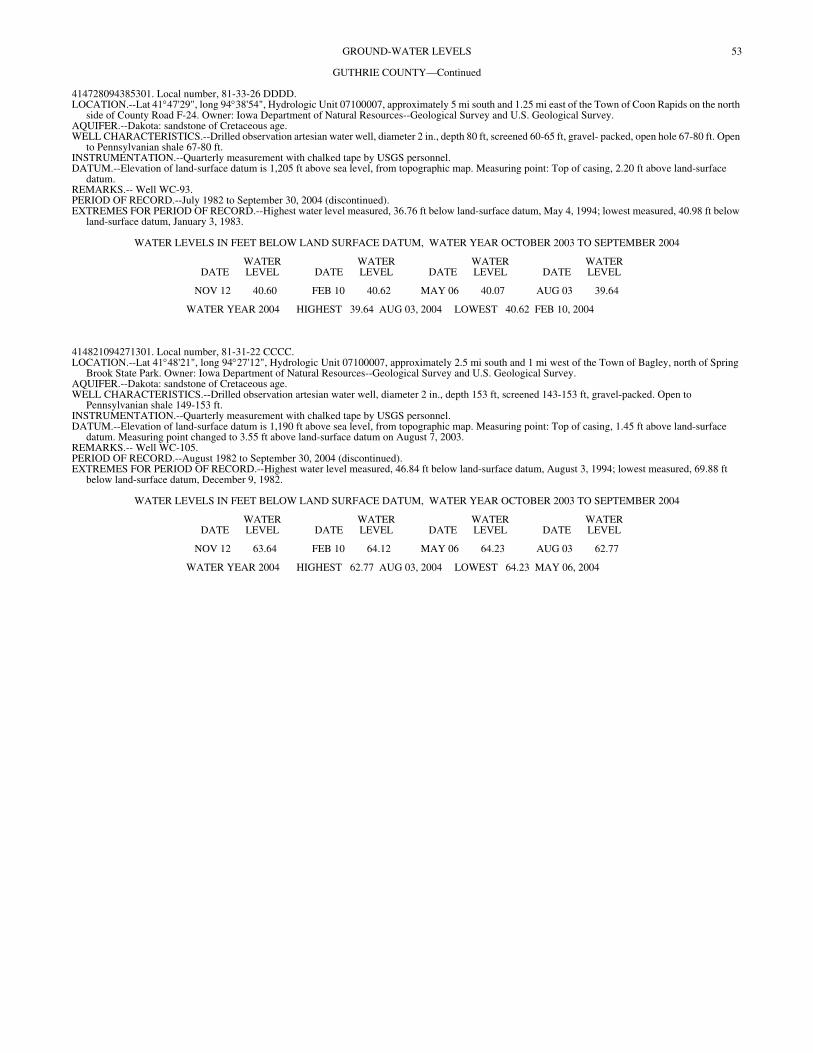
53GROUND-WATER LEVELS
GUTHRIE COUNTY—Continued
414728094385301. Local number, 81-33-26 DDDD. LOCATION.--Lat 41°47'29", long 94°38'54", Hydrologic Unit 07100007, approximately 5 mi south and 1.25 mi east of the Town of Coon Rapids on the north
side of County Road F-24. Owner: Iowa Department of Natural Resources--Geological Survey and U.S. Geological Survey. AQUIFER.--Dakota: sandstone of Cretaceous age. WELL CHARACTERISTICS.--Drilled observation artesian water well, diameter 2 in., depth 80 ft, screened 60-65 ft, gravel- packed, open hole 67-80 ft. Open
to Pennsylvanian shale 67-80 ft. INSTRUMENTATION.--Quarterly measurement with chalked tape by USGS personnel. DATUM.--Elevation of land-surface datum is 1,205 ft above sea level, from topographic map. Measuring point: Top of casing, 2.20 ft above land-surface
datum. REMARKS.-- Well WC-93. PERIOD OF RECORD.--July 1982 to September 30, 2004 (discontinued). EXTREMES FOR PERIOD OF RECORD.--Highest water level measured, 36.76 ft below land-surface datum, May 4, 1994; lowest measured, 40.98 ft below
land-surface datum, January 3, 1983.
WATER LEVELS IN FEET BELOW LAND SURFACE DATUM, WATER YEAR OCTOBER 2003 TO SEPTEMBER 2004
DATEWATER LEVEL DATE
WATER LEVEL DATE
WATER LEVEL DATE
WATER LEVEL
NOV 12 40.60 FEB 10 40.62 MAY 06 40.07 AUG 03 39.64
WATER YEAR 2004 HIGHEST 39.64 AUG 03, 2004 LOWEST 40.62 FEB 10, 2004
414821094271301. Local number, 81-31-22 CCCC. LOCATION.--Lat 41°48'21", long 94°27'12", Hydrologic Unit 07100007, approximately 2.5 mi south and 1 mi west of the Town of Bagley, north of Spring
Brook State Park. Owner: Iowa Department of Natural Resources--Geological Survey and U.S. Geological Survey. AQUIFER.--Dakota: sandstone of Cretaceous age. WELL CHARACTERISTICS.--Drilled observation artesian water well, diameter 2 in., depth 153 ft, screened 143-153 ft, gravel-packed. Open to
Pennsylvanian shale 149-153 ft. INSTRUMENTATION.--Quarterly measurement with chalked tape by USGS personnel. DATUM.--Elevation of land-surface datum is 1,190 ft above sea level, from topographic map. Measuring point: Top of casing, 1.45 ft above land-surface
datum. Measuring point changed to 3.55 ft above land-surface datum on August 7, 2003. REMARKS.-- Well WC-105. PERIOD OF RECORD.--August 1982 to September 30, 2004 (discontinued). EXTREMES FOR PERIOD OF RECORD.--Highest water level measured, 46.84 ft below land-surface datum, August 3, 1994; lowest measured, 69.88 ft
below land-surface datum, December 9, 1982.
WATER LEVELS IN FEET BELOW LAND SURFACE DATUM, WATER YEAR OCTOBER 2003 TO SEPTEMBER 2004
DATEWATER LEVEL DATE
WATER LEVEL DATE
WATER LEVEL DATE
WATER LEVEL
NOV 12 63.64 FEB 10 64.12 MAY 06 64.23 AUG 03 62.77
WATER YEAR 2004 HIGHEST 62.77 AUG 03, 2004 LOWEST 64.23 MAY 06, 2004
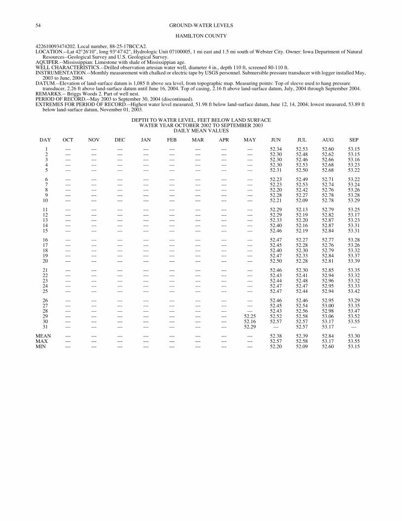
54 GROUND-WATER LEVELS
HAMILTON COUNTY
422610093474202. Local number, 88-25-17BCCA2. LOCATION.--Lat 42°26'10", long 93°47'42", Hydrologic Unit 07100005, 1 mi east and 1.5 mi south of Webster City. Owner: Iowa Department of Natural
Resources--Geological Survey and U.S. Geological Survey. AQUIFER.--Mississippian: Limestone with shale of Mississippian age. WELL CHARACTERISTICS.--Drilled observation artesian water well, diameter 4 in., depth 110 ft, screened 80-110 ft. INSTRUMENTATION.--Monthly measurement with chalked or electric tape by USGS personnel. Submersible pressure transducer with logger installed May,
2003 to June, 2004. DATUM.--Elevation of land-surface datum is 1,085 ft above sea level, from topographic map. Measuring points: Top of sleeve used to hang pressure
transducer, 2.26 ft above land-surface datum until June 16, 2004. Top of casing, 2.16 ft above land-surface datum, July, 2004 through September 2004. REMARKS.-- Briggs Woods 2. Part of well nest. PERIOD OF RECORD.--May 2003 to September 30, 2004 (discontinued). EXTREMES FOR PERIOD OF RECORD.--Highest water level measured, 51.98 ft below land-surface datum, June 12, 14, 2004; lowest measured, 53.89 ft
below land-surface datum, November 01, 2003.
DEPTH TO WATER LEVEL, FEET BELOW LAND SURFACE WATER YEAR OCTOBER 2002 TO SEPTEMBER 2003
DAILY MEAN VALUES
DAY OCT NOV DEC JAN FEB MAR APR MAY JUN JUL AUG SEP
1 --- --- --- --- --- --- --- --- 52.34 52.53 52.60 53.152 --- --- --- --- --- --- --- --- 52.30 52.48 52.62 53.153 --- --- --- --- --- --- --- --- 52.30 52.46 52.66 53.164 --- --- --- --- --- --- --- --- 52.30 52.53 52.68 53.235 --- --- --- --- --- --- --- --- 52.31 52.50 52.68 53.22
6 --- --- --- --- --- --- --- --- 52.23 52.49 52.71 53.227 --- --- --- --- --- --- --- --- 52.23 52.53 52.74 53.248 --- --- --- --- --- --- --- --- 52.20 52.42 52.76 53.269 --- --- --- --- --- --- --- --- 52.28 52.27 52.78 53.28
10 --- --- --- --- --- --- --- --- 52.21 52.09 52.78 53.29
11 --- --- --- --- --- --- --- --- 52.29 52.13 52.79 53.2512 --- --- --- --- --- --- --- --- 52.29 52.19 52.82 53.1713 --- --- --- --- --- --- --- --- 52.33 52.20 52.87 53.2314 --- --- --- --- --- --- --- --- 52.40 52.16 52.87 53.3115 --- --- --- --- --- --- --- --- 52.46 52.19 52.84 53.31
16 --- --- --- --- --- --- --- --- 52.47 52.27 52.77 53.2817 --- --- --- --- --- --- --- --- 52.45 52.28 52.76 53.2618 --- --- --- --- --- --- --- --- 52.40 52.30 52.79 53.3219 --- --- --- --- --- --- --- --- 52.47 52.33 52.84 53.3720 --- --- --- --- --- --- --- --- 52.50 52.28 52.81 53.39
21 --- --- --- --- --- --- --- --- 52.46 52.30 52.85 53.3522 --- --- --- --- --- --- --- --- 52.43 52.41 52.94 53.3223 --- --- --- --- --- --- --- --- 52.44 52.48 52.96 53.3224 --- --- --- --- --- --- --- --- 52.47 52.47 52.95 53.3325 --- --- --- --- --- --- --- --- 52.47 52.44 52.94 53.42
26 --- --- --- --- --- --- --- --- 52.46 52.46 52.95 53.2927 --- --- --- --- --- --- --- --- 52.45 52.54 53.00 53.3528 --- --- --- --- --- --- --- --- 52.43 52.56 52.98 53.4729 --- --- --- --- --- --- --- 52.25 52.52 52.58 53.06 53.5230 --- --- --- --- --- --- --- 52.16 52.57 52.57 53.17 53.5531 --- --- --- --- --- --- --- 52.29 --- 52.57 53.17 ---
MEAN --- --- --- --- --- --- --- --- 52.38 52.39 52.84 53.30MAX --- --- --- --- --- --- --- --- 52.57 52.58 53.17 53.55MIN --- --- --- --- --- --- --- --- 52.20 52.09 52.60 53.15
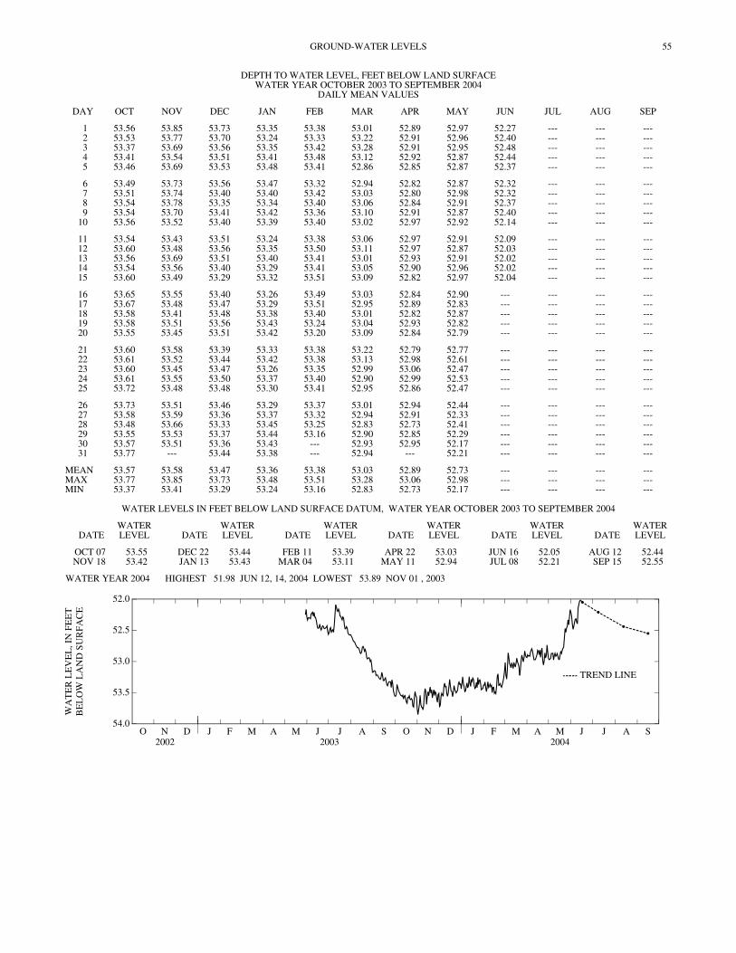
55GROUND-WATER LEVELS
DEPTH TO WATER LEVEL, FEET BELOW LAND SURFACE WATER YEAR OCTOBER 2003 TO SEPTEMBER 2004
DAILY MEAN VALUES
DAY OCT NOV DEC JAN FEB MAR APR MAY JUN JUL AUG SEP
1 53.56 53.85 53.73 53.35 53.38 53.01 52.89 52.97 52.27 --- --- ---2 53.53 53.77 53.70 53.24 53.33 53.22 52.91 52.96 52.40 --- --- ---3 53.37 53.69 53.56 53.35 53.42 53.28 52.91 52.95 52.48 --- --- ---4 53.41 53.54 53.51 53.41 53.48 53.12 52.92 52.87 52.44 --- --- ---5 53.46 53.69 53.53 53.48 53.41 52.86 52.85 52.87 52.37 --- --- ---
6 53.49 53.73 53.56 53.47 53.32 52.94 52.82 52.87 52.32 --- --- ---7 53.51 53.74 53.40 53.40 53.42 53.03 52.80 52.98 52.32 --- --- ---8 53.54 53.78 53.35 53.34 53.40 53.06 52.84 52.91 52.37 --- --- ---9 53.54 53.70 53.41 53.42 53.36 53.10 52.91 52.87 52.40 --- --- ---
10 53.56 53.52 53.40 53.39 53.40 53.02 52.97 52.92 52.14 --- --- ---
11 53.54 53.43 53.51 53.24 53.38 53.06 52.97 52.91 52.09 --- --- ---12 53.60 53.48 53.56 53.35 53.50 53.11 52.97 52.87 52.03 --- --- ---13 53.56 53.69 53.51 53.40 53.41 53.01 52.93 52.91 52.02 --- --- ---14 53.54 53.56 53.40 53.29 53.41 53.05 52.90 52.96 52.02 --- --- ---15 53.60 53.49 53.29 53.32 53.51 53.09 52.82 52.97 52.04 --- --- ---
16 53.65 53.55 53.40 53.26 53.49 53.03 52.84 52.90 --- --- --- ---17 53.67 53.48 53.47 53.29 53.51 52.95 52.89 52.83 --- --- --- ---18 53.58 53.41 53.48 53.38 53.40 53.01 52.82 52.87 --- --- --- ---19 53.58 53.51 53.56 53.43 53.24 53.04 52.93 52.82 --- --- --- ---20 53.55 53.45 53.51 53.42 53.20 53.09 52.84 52.79 --- --- --- ---
21 53.60 53.58 53.39 53.33 53.38 53.22 52.79 52.77 --- --- --- ---22 53.61 53.52 53.44 53.42 53.38 53.13 52.98 52.61 --- --- --- ---23 53.60 53.45 53.47 53.26 53.35 52.99 53.06 52.47 --- --- --- ---24 53.61 53.55 53.50 53.37 53.40 52.90 52.99 52.53 --- --- --- ---25 53.72 53.48 53.48 53.30 53.41 52.95 52.86 52.47 --- --- --- ---
26 53.73 53.51 53.46 53.29 53.37 53.01 52.94 52.44 --- --- --- ---27 53.58 53.59 53.36 53.37 53.32 52.94 52.91 52.33 --- --- --- ---28 53.48 53.66 53.33 53.45 53.25 52.83 52.73 52.41 --- --- --- ---29 53.55 53.53 53.37 53.44 53.16 52.90 52.85 52.29 --- --- --- ---30 53.57 53.51 53.36 53.43 --- 52.93 52.95 52.17 --- --- --- ---31 53.77 --- 53.44 53.38 --- 52.94 --- 52.21 --- --- --- ---
MEAN 53.57 53.58 53.47 53.36 53.38 53.03 52.89 52.73 --- --- --- ---MAX 53.77 53.85 53.73 53.48 53.51 53.28 53.06 52.98 --- --- --- ---MIN 53.37 53.41 53.29 53.24 53.16 52.83 52.73 52.17 --- --- --- ---
WATER LEVELS IN FEET BELOW LAND SURFACE DATUM, WATER YEAR OCTOBER 2003 TO SEPTEMBER 2004
DATEWATER LEVEL DATE
WATER LEVEL DATE
WATER LEVEL DATE
WATER LEVEL DATE
WATER LEVEL DATE
WATER LEVEL
OCT 07 53.55 DEC 22 53.44 FEB 11 53.39 APR 22 53.03 JUN 16 52.05 AUG 12 52.44NOV 18 53.42 JAN 13 53.43 MAR 04 53.11 MAY 11 52.94 JUL 08 52.21 SEP 15 52.55
WATER YEAR 2004 HIGHEST 51.98 JUN 12, 14, 2004 LOWEST 53.89 NOV 01 , 2003
O N D2002
J F M A M J J A S O N D2003
J F M A M J J A S2004
54.0
53.5
53.0
52.5
52.0
WA
TE
R L
EV
EL
, IN
FE
ET
BE
LO
W L
AN
D S
UR
FAC
E
TREND LINE

56 GROUND-WATER LEVELS
HAMILTON COUNTY—Continued
422610093474203. Local number, 88-25-17BCCA3. LOCATION.--Lat 42°26'10", long 93°47'42", Hydrologic Unit 07100005, 1 mi east and 1.5 mi south of Webster City. Owner: Iowa Department of Natural
Resources--Geological Survey and U.S. Geological Survey. AQUIFER.--Mississippian. WELL CHARACTERISTICS.--Drilled observation artesian water well, diameter 4 in., depth 410 ft, screened 370-410 ft. INSTRUMENTATION.--Monthly measurement with chalked or electric tape by USGS personnel. Submersible pressure transducer with logger installed May,
2003 to June, 2004. DATUM.--Elevation of land-surface datum is 1,085 ft above sea level, from topographic map. Measuring point: Top of sleeve used to hang pressure transducer,
2.04 ft above land-surface datum until June 16, 2004. Top of casing, 1.95 ft above land-surface datum from July, 2004 to September, 2004. REMARKS.-- Briggs Woods 3. Part of well nest. PERIOD OF RECORD.--May 2003 to September 30, 2004, (discontinued). EXTREMES FOR PERIOD OF RECORD.--Highest water level measured, 62.19 ft below land-surface datum, June 10, 2003; lowest measured, 76.30 ft below
land-surface datum, April 10, 2004.
DEPTH TO WATER LEVEL, FEET BELOW LAND SURFACE WATER YEAR OCTOBER 2002 TO SEPTEMBER 2003
DAILY MEAN VALUES
DAY OCT NOV DEC JAN FEB MAR APR MAY JUN JUL AUG SEP
1 --- --- --- --- --- --- --- --- 63.89 64.75 64.19 67.752 --- --- --- --- --- --- --- --- 64.00 63.61 65.65 66.523 --- --- --- --- --- --- --- --- 63.18 65.27 64.46 68.504 --- --- --- --- --- --- --- --- 63.82 64.51 65.63 65.835 --- --- --- --- --- --- --- --- 63.18 66.20 64.23 66.80
6 --- --- --- --- --- --- --- --- 63.69 64.44 65.51 66.287 --- --- --- --- --- --- --- --- 63.43 64.83 64.23 67.218 --- --- --- --- --- --- --- --- 64.03 63.21 65.84 65.549 --- --- --- --- --- --- --- --- 63.12 64.23 64.78 66.81
10 --- --- --- --- --- --- --- --- 63.50 62.76 66.14 65.30
11 --- --- --- --- --- --- --- --- 62.94 64.11 64.42 66.8012 --- --- --- --- --- --- --- --- 63.58 63.27 66.37 65.2113 --- --- --- --- --- --- --- --- 63.20 64.71 65.09 66.8614 --- --- --- --- --- --- --- --- 64.66 63.14 66.34 65.6615 --- --- --- --- --- --- --- --- 64.14 64.66 64.89 66.65
16 --- --- --- --- --- --- --- --- 64.11 63.32 66.56 65.2017 --- --- --- --- --- --- --- --- 63.35 64.67 65.16 66.4918 --- --- --- --- --- --- --- --- 63.79 63.51 67.05 65.2019 --- --- --- --- --- --- --- --- 63.37 65.37 65.12 66.6420 --- --- --- --- --- --- --- --- 64.22 64.08 66.20 66.04
21 --- --- --- --- --- --- --- --- 64.29 64.98 65.47 67.3622 --- --- --- --- --- --- --- --- 64.86 63.56 66.71 65.3023 --- --- --- --- --- --- --- --- 63.95 65.04 65.71 66.3924 --- --- --- --- --- --- --- --- 64.33 63.80 66.99 65.0825 --- --- --- --- --- --- --- --- 63.46 65.36 66.34 66.57
26 --- --- --- --- --- --- --- --- 64.12 65.21 67.05 64.9727 --- --- --- --- --- --- --- --- 63.39 66.40 65.83 66.5928 --- --- --- --- --- --- --- --- 64.30 64.08 66.63 65.6529 --- --- --- --- --- --- --- --- 64.06 65.28 65.78 66.6630 --- --- --- --- --- --- --- 63.88 63.53 63.97 67.68 65.3331 --- --- --- --- --- --- --- 64.67 --- 65.67 66.48 ---
MEAN --- --- --- --- --- --- --- --- 63.78 64.45 65.76 66.24MAX --- --- --- --- --- --- --- --- 64.86 66.40 67.68 68.50MIN --- --- --- --- --- --- --- --- 62.94 62.76 64.19 64.97

57GROUND-WATER LEVELS
DEPTH TO WATER LEVEL, FEET BELOW LAND SURFACE WATER YEAR OCTOBER 2003 TO SEPTEMBER 2004
DAILY MEAN VALUES
DAY OCT NOV DEC JAN FEB MAR APR MAY JUN JUL AUG SEP
1 66.53 65.46 64.89 65.88 64.53 65.43 65.56 65.97 63.63 --- --- ---2 65.10 66.64 66.34 64.26 65.89 64.45 64.25 64.73 64.95 --- --- ---3 66.15 65.00 64.61 66.03 64.65 65.88 65.53 65.81 63.94 --- --- ---4 65.29 66.28 66.10 64.61 66.15 64.10 64.04 64.82 66.21 --- --- ---5 66.65 65.20 64.64 66.26 64.55 65.29 65.58 65.71 64.55 --- --- ---
6 65.12 66.63 66.19 64.74 65.88 63.99 63.91 64.43 65.75 --- --- ---7 66.36 65.13 64.34 66.10 64.61 65.69 65.31 65.87 63.51 --- --- ---8 65.08 66.72 65.79 64.57 65.94 64.12 64.34 64.69 64.93 --- --- ---9 66.50 65.07 64.41 66.24 64.43 65.76 67.45 66.15 65.08 --- --- ---
10 65.08 66.21 65.88 64.66 65.97 64.03 69.96 64.30 65.07 --- --- ---
11 66.50 64.60 64.59 65.86 64.45 65.69 66.43 65.98 63.77 --- --- ---12 65.28 66.21 66.18 64.62 66.14 64.24 65.02 64.24 65.88 --- --- ---13 66.57 65.07 64.51 66.17 64.45 65.52 66.13 65.76 64.07 --- --- ---14 65.07 66.23 65.88 64.50 65.94 64.16 64.31 64.60 64.98 --- --- ---15 66.49 64.62 64.08 65.97 64.69 65.70 65.39 66.45 63.34 --- --- ---
16 65.22 66.25 65.95 64.46 66.06 64.06 63.94 65.47 --- --- --- ---17 66.66 64.52 64.41 65.94 64.71 65.43 65.62 65.82 --- --- --- ---18 65.60 65.95 66.03 64.63 65.88 64.11 64.03 64.34 --- --- --- ---19 66.97 64.41 64.59 66.16 64.13 65.61 65.59 65.52 --- --- --- ---20 65.11 65.87 66.00 64.66 65.60 64.27 64.06 64.11 --- --- --- ---
21 66.60 64.52 64.24 65.92 64.49 66.02 66.54 65.64 --- --- --- ---22 65.34 65.97 65.96 64.69 65.87 64.24 64.56 64.26 --- --- --- ---23 66.47 64.26 64.43 65.75 64.54 65.58 65.98 65.82 --- --- --- ---24 65.56 66.05 66.03 64.60 66.07 63.95 64.40 64.52 --- --- --- ---25 66.94 64.30 64.43 65.80 64.63 65.58 65.68 67.32 --- --- --- ---
26 65.37 65.96 65.94 64.43 65.96 64.17 64.18 65.08 --- --- --- ---27 66.43 64.55 64.18 65.98 64.50 65.51 65.58 65.44 --- --- --- ---28 64.72 66.25 65.77 64.70 65.85 63.94 63.75 64.34 --- --- --- ---29 66.44 64.40 64.35 66.09 64.24 65.57 65.49 66.50 --- --- --- ---30 66.08 66.02 65.88 64.62 --- 66.41 64.18 65.49 --- --- --- ---31 67.48 --- 64.58 65.95 --- 64.53 --- 66.50 --- --- --- ---
MEAN 65.96 65.48 65.20 65.32 65.20 64.94 65.23 65.34 --- --- --- ---MAX 67.48 66.72 66.34 66.26 66.15 66.41 69.96 67.32 --- --- --- ---MIN 64.72 64.26 64.08 64.26 64.13 63.94 63.75 64.11 --- --- --- ---
HAMILTON COUNTY—Continued
WATER LEVELS IN FEET BELOW LAND SURFACE DATUM, WATER YEAR OCTOBER 2003 TO SEPTEMBER 2004
DATEWATER LEVEL DATE
WATER LEVEL DATE
WATER LEVEL DATE
WATER LEVEL DATE
WATER LEVEL DATE
WATER LEVEL
OCT 07 65.80 DEC 22 65.68 FEB 11 64.30 APR 22 64.35 JUN 16 64.27 AUG 12 66.05NOV 18 64.85 JAN 13 65.58 MAR 04 64.03 MAY 11 65.23 JUL 08 64.55 SEP 15 66.23
WATER YEAR 2004 HIGHEST 62.92 JUNE 15, 2004 LOWEST 76.30 APRIL 10, 2004
O N D2002
J F M A M J J A S O N D2003
J F M A M J J A S2004
70
69
68
67
66
65
64
63
62
WA
TE
R L
EV
EL
, IN
FE
ET
BE
LO
W L
AN
D S
UR
FAC
E
TREND LINE
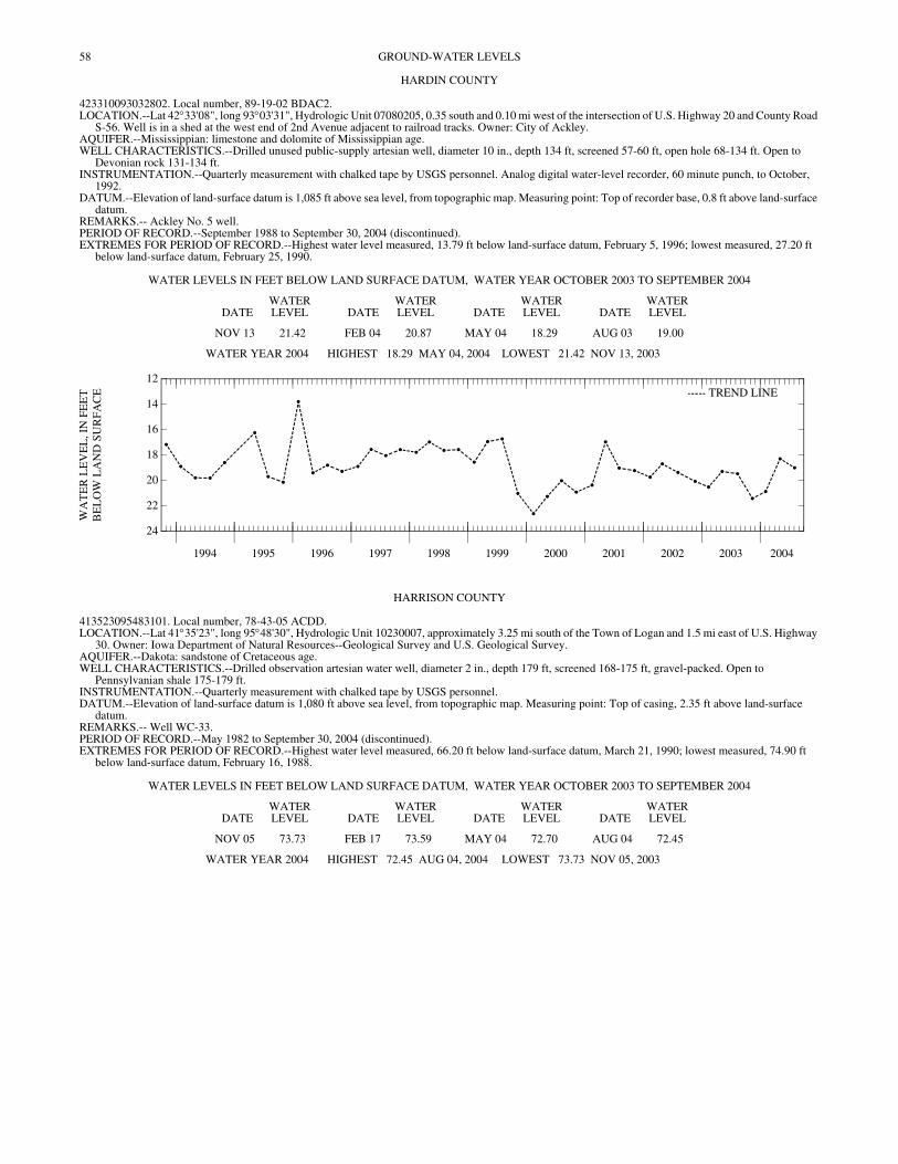
58 GROUND-WATER LEVELS
HARDIN COUNTY
423310093032802. Local number, 89-19-02 BDAC2. LOCATION.--Lat 42°33'08", long 93°03'31", Hydrologic Unit 07080205, 0.35 south and 0.10 mi west of the intersection of U.S. Highway 20 and County Road
S-56. Well is in a shed at the west end of 2nd Avenue adjacent to railroad tracks. Owner: City of Ackley. AQUIFER.--Mississippian: limestone and dolomite of Mississippian age. WELL CHARACTERISTICS.--Drilled unused public-supply artesian well, diameter 10 in., depth 134 ft, screened 57-60 ft, open hole 68-134 ft. Open to
Devonian rock 131-134 ft. INSTRUMENTATION.--Quarterly measurement with chalked tape by USGS personnel. Analog digital water-level recorder, 60 minute punch, to October,
1992. DATUM.--Elevation of land-surface datum is 1,085 ft above sea level, from topographic map. Measuring point: Top of recorder base, 0.8 ft above land-surface
datum. REMARKS.-- Ackley No. 5 well. PERIOD OF RECORD.--September 1988 to September 30, 2004 (discontinued). EXTREMES FOR PERIOD OF RECORD.--Highest water level measured, 13.79 ft below land-surface datum, February 5, 1996; lowest measured, 27.20 ft
below land-surface datum, February 25, 1990.
WATER LEVELS IN FEET BELOW LAND SURFACE DATUM, WATER YEAR OCTOBER 2003 TO SEPTEMBER 2004
DATEWATER LEVEL DATE
WATER LEVEL DATE
WATER LEVEL DATE
WATER LEVEL
NOV 13 21.42 FEB 04 20.87 MAY 04 18.29 AUG 03 19.00
WATER YEAR 2004 HIGHEST 18.29 MAY 04, 2004 LOWEST 21.42 NOV 13, 2003
1994 1995 1996 1997 1998 1999 2000 2001 2002 2003 2004
24
22
20
18
16
14
12
WA
TE
R L
EV
EL
, IN
FE
ET
BE
LO
W L
AN
D S
UR
FAC
E TREND LINE
HARRISON COUNTY
413523095483101. Local number, 78-43-05 ACDD. LOCATION.--Lat 41°35'23", long 95°48'30", Hydrologic Unit 10230007, approximately 3.25 mi south of the Town of Logan and 1.5 mi east of U.S. Highway
30. Owner: Iowa Department of Natural Resources--Geological Survey and U.S. Geological Survey. AQUIFER.--Dakota: sandstone of Cretaceous age. WELL CHARACTERISTICS.--Drilled observation artesian water well, diameter 2 in., depth 179 ft, screened 168-175 ft, gravel-packed. Open to
Pennsylvanian shale 175-179 ft. INSTRUMENTATION.--Quarterly measurement with chalked tape by USGS personnel. DATUM.--Elevation of land-surface datum is 1,080 ft above sea level, from topographic map. Measuring point: Top of casing, 2.35 ft above land-surface
datum. REMARKS.-- Well WC-33. PERIOD OF RECORD.--May 1982 to September 30, 2004 (discontinued). EXTREMES FOR PERIOD OF RECORD.--Highest water level measured, 66.20 ft below land-surface datum, March 21, 1990; lowest measured, 74.90 ft
below land-surface datum, February 16, 1988.
WATER LEVELS IN FEET BELOW LAND SURFACE DATUM, WATER YEAR OCTOBER 2003 TO SEPTEMBER 2004
DATEWATER LEVEL DATE
WATER LEVEL DATE
WATER LEVEL DATE
WATER LEVEL
NOV 05 73.73 FEB 17 73.59 MAY 04 72.70 AUG 04 72.45
WATER YEAR 2004 HIGHEST 72.45 AUG 04, 2004 LOWEST 73.73 NOV 05, 2003
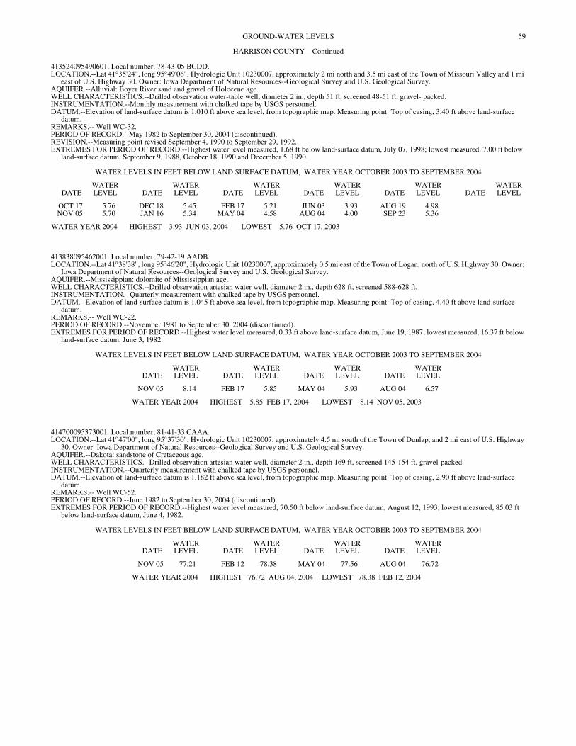
59GROUND-WATER LEVELS
HARRISON COUNTY—Continued
413524095490601. Local number, 78-43-05 BCDD. LOCATION.--Lat 41°35'24", long 95°49'06", Hydrologic Unit 10230007, approximately 2 mi north and 3.5 mi east of the Town of Missouri Valley and 1 mi
east of U.S. Highway 30. Owner: Iowa Department of Natural Resources--Geological Survey and U.S. Geological Survey. AQUIFER.--Alluvial: Boyer River sand and gravel of Holocene age. WELL CHARACTERISTICS.--Drilled observation water-table well, diameter 2 in., depth 51 ft, screened 48-51 ft, gravel- packed. INSTRUMENTATION.--Monthly measurement with chalked tape by USGS personnel. DATUM.--Elevation of land-surface datum is 1,010 ft above sea level, from topographic map. Measuring point: Top of casing, 3.40 ft above land-surface
datum. REMARKS.-- Well WC-32. PERIOD OF RECORD.--May 1982 to September 30, 2004 (discontinued). REVISION.--Measuring point revised September 4, 1990 to September 29, 1992. EXTREMES FOR PERIOD OF RECORD.--Highest water level measured, 1.68 ft below land-surface datum, July 07, 1998; lowest measured, 7.00 ft below
land-surface datum, September 9, 1988, October 18, 1990 and December 5, 1990.
WATER LEVELS IN FEET BELOW LAND SURFACE DATUM, WATER YEAR OCTOBER 2003 TO SEPTEMBER 2004
DATEWATER LEVEL DATE
WATER LEVEL DATE
WATER LEVEL DATE
WATER LEVEL DATE
WATER LEVEL DATE
WATER LEVEL
OCT 17 5.76 DEC 18 5.45 FEB 17 5.21 JUN 03 3.93 AUG 19 4.98NOV 05 5.70 JAN 16 5.34 MAY 04 4.58 AUG 04 4.00 SEP 23 5.36
WATER YEAR 2004 HIGHEST 3.93 JUN 03, 2004 LOWEST 5.76 OCT 17, 2003
413838095462001. Local number, 79-42-19 AADB. LOCATION.--Lat 41°38'38", long 95°46'20", Hydrologic Unit 10230007, approximately 0.5 mi east of the Town of Logan, north of U.S. Highway 30. Owner:
Iowa Department of Natural Resources--Geological Survey and U.S. Geological Survey. AQUIFER.--Mississippian: dolomite of Mississippian age. WELL CHARACTERISTICS.--Drilled observation artesian water well, diameter 2 in., depth 628 ft, screened 588-628 ft. INSTRUMENTATION.--Quarterly measurement with chalked tape by USGS personnel. DATUM.--Elevation of land-surface datum is 1,045 ft above sea level, from topographic map. Measuring point: Top of casing, 4.40 ft above land-surface
datum. REMARKS.-- Well WC-22. PERIOD OF RECORD.--November 1981 to September 30, 2004 (discontinued). EXTREMES FOR PERIOD OF RECORD.--Highest water level measured, 0.33 ft above land-surface datum, June 19, 1987; lowest measured, 16.37 ft below
land-surface datum, June 3, 1982.
WATER LEVELS IN FEET BELOW LAND SURFACE DATUM, WATER YEAR OCTOBER 2003 TO SEPTEMBER 2004
DATEWATER LEVEL DATE
WATER LEVEL DATE
WATER LEVEL DATE
WATER LEVEL
NOV 05 8.14 FEB 17 5.85 MAY 04 5.93 AUG 04 6.57
WATER YEAR 2004 HIGHEST 5.85 FEB 17, 2004 LOWEST 8.14 NOV 05, 2003
414700095373001. Local number, 81-41-33 CAAA. LOCATION.--Lat 41°47'00", long 95°37'30", Hydrologic Unit 10230007, approximately 4.5 mi south of the Town of Dunlap, and 2 mi east of U.S. Highway
30. Owner: Iowa Department of Natural Resources--Geological Survey and U.S. Geological Survey. AQUIFER.--Dakota: sandstone of Cretaceous age. WELL CHARACTERISTICS.--Drilled observation artesian water well, diameter 2 in., depth 169 ft, screened 145-154 ft, gravel-packed. INSTRUMENTATION.--Quarterly measurement with chalked tape by USGS personnel. DATUM.--Elevation of land-surface datum is 1,182 ft above sea level, from topographic map. Measuring point: Top of casing, 2.90 ft above land-surface
datum. REMARKS.-- Well WC-52. PERIOD OF RECORD.--June 1982 to September 30, 2004 (discontinued). EXTREMES FOR PERIOD OF RECORD.--Highest water level measured, 70.50 ft below land-surface datum, August 12, 1993; lowest measured, 85.03 ft
below land-surface datum, June 4, 1982.
WATER LEVELS IN FEET BELOW LAND SURFACE DATUM, WATER YEAR OCTOBER 2003 TO SEPTEMBER 2004
DATEWATER LEVEL DATE
WATER LEVEL DATE
WATER LEVEL DATE
WATER LEVEL
NOV 05 77.21 FEB 12 78.38 MAY 04 77.56 AUG 04 76.72
WATER YEAR 2004 HIGHEST 76.72 AUG 04, 2004 LOWEST 78.38 FEB 12, 2004
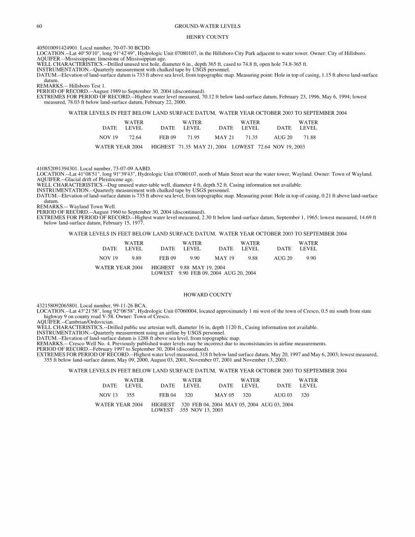
60 GROUND-WATER LEVELS
HENRY COUNTY
405010091424901. Local number, 70-07-30 BCDD. LOCATION.--Lat 40°50'10", long 91°42'49", Hydrologic Unit 07080107, in the Hillsboro City Park adjacent to water tower. Owner: City of Hillsboro. AQUIFER.--Mississippian: limestone of Mississippian age. WELL CHARACTERISTICS.--Drilled unused test hole, diameter 6 in., depth 365 ft, cased to 74.8 ft, open hole 74.8-365 ft. INSTRUMENTATION.--Quarterly measurement with chalked tape by USGS personnel. DATUM.--Elevation of land-surface datum is 733 ft above sea level, from topographic map. Measuring point: Hole in top of casing, 1.15 ft above land-surface
datum. REMARKS.-- Hillsboro Test 1. PERIOD OF RECORD.--August 1989 to September 30, 2004 (discontinued). EXTREMES FOR PERIOD OF RECORD.--Highest water level measured, 70.12 ft below land-surface datum, February 23, 1996, May 6, 1994; lowest
measured, 78.03 ft below land-surface datum, February 22, 2000.
WATER LEVELS IN FEET BELOW LAND SURFACE DATUM, WATER YEAR OCTOBER 2003 TO SEPTEMBER 2004
DATEWATER LEVEL DATE
WATER LEVEL DATE
WATER LEVEL DATE
WATER LEVEL
NOV 19 72.64 FEB 09 71.95 MAY 21 71.35 AUG 20 71.88
WATER YEAR 2004 HIGHEST 71.35 MAY 21, 2004 LOWEST 72.64 NOV 19, 2003
410852091394301. Local number, 73-07-09 AABD. LOCATION.--Lat 41°08'51", long 91°39'43", Hydrologic Unit 07080107, north of Main Street near the water tower, Wayland. Owner: Town of Wayland. AQUIFER.--Glacial drift of Pleistocene age. WELL CHARACTERISTICS.--Dug unused water-table well, diameter 4 ft, depth 52 ft. Casing information not available. INSTRUMENTATION.--Quarterly measurement with chalked tape by USGS personnel. DATUM.--Elevation of land-surface datum is 735 ft above sea level, from topographic map. Measuring point: Hole in top of casing, 0.21 ft above land-surface
datum. REMARKS.-- Wayland Town Well. PERIOD OF RECORD.--August 1960 to September 30, 2004 (discontinued). EXTREMES FOR PERIOD OF RECORD.--Highest water level measured, 2.30 ft below land-surface datum, September 1, 1965; lowest measured, 14.69 ft
below land-surface datum, February 15, 1977.
WATER LEVELS IN FEET BELOW LAND SURFACE DATUM, WATER YEAR OCTOBER 2003 TO SEPTEMBER 2004
DATEWATER LEVEL DATE
WATER LEVEL DATE
WATER LEVEL DATE
WATER LEVEL
NOV 19 9.89 FEB 09 9.90 MAY 19 9.88 AUG 20 9.90
WATER YEAR 2004 HIGHEST 9.88 MAY 19, 2004LOWEST 9.90 FEB 09, 2004 AUG 20, 2004
HOWARD COUNTY
432158092065801. Local number, 99-11-26 BCA. LOCATION.--Lat 43°21'58", long 92°06'58", Hydrologic Unit 07060004, located approximately 1 mi west of the town of Cresco, 0.5 mi south from state
highway 9 on county road V-58. Owner: Town of Cresco. AQUIFER.--Cambrian/Ordovician. WELL CHARACTERISTICS.--Drilled public use artesian well, diameter 16 in, depth 1120 ft., Casing information not available. INSTRUMENTATION.--Quarterly measurement using an airline by USGS personnel. DATUM.--Elevation of land-surface datum is 1288 ft above sea level, from topographic map. REMARKS.-- Cresco Well No. 4. Previously published water levels may be incorrect due to inconsistancies in airline measurements. PERIOD OF RECORD.--February 1997 to September 30, 2004 (discontinued). EXTREMES FOR PERIOD OF RECORD.--Highest water level measured, 318 ft below land surface datum, May 20, 1997 and May 6, 2003; lowest measured,
355 ft below land-surface datum, May 09, 2000, August 03, 2001, November 07, 2001 and November 13, 2003.
WATER LEVELS IN FEET BELOW LAND SURFACE DATUM, WATER YEAR OCTOBER 2003 TO SEPTEMBER 2004
DATEWATER LEVEL DATE
WATER LEVEL DATE
WATER LEVEL DATE
WATER LEVEL
NOV 13 355 FEB 04 320 MAY 05 320 AUG 03 320
WATER YEAR 2004 HIGHEST 320 FEB 04, 2004 MAY 05, 2004 AUG 03, 2004LOWEST 355 NOV 13, 2003
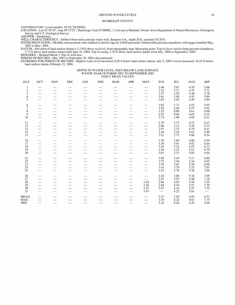
61GROUND-WATER LEVELS
HUMBOLDT COUNTY
424539094152401. Local number, 92-29-22CDDD1. LOCATION.--Lat 42°45'39", long 94°15'24", Hydrologic Unit 07100002, 1.5 mi east of Rutland. Owner: Iowa Department of Natural Resources--Geological
Survey and U.S. Geological Survey. AQUIFER.--Quaternary. WELL CHARACTERISTICS.--Drilled observation artesian water well, diameter 4 in., depth 20 ft, screened 10-20 ft. INSTRUMENTATION.--Monthly measurement with chalked or electric tape by USGS personnel. Submersible pressure transducer with logger installed May,
2003 to May, 2004. DATUM.--Elevation of land-surface datum is 1,130 ft above sea level, from topographic map. Measuring point: Top of sleeve used to hang pressure transducer,
2.17 ft above land-surface datum until June 16, 2004. Top of casing, 2.10 ft above land-surface datum from July, 2004 to September, 2004. REMARKS.-- Rutland Marsh 1. Part of well nest. PERIOD OF RECORD.--May 2003 to September 30, 2004 (discontinued). EXTREMES FOR PERIOD OF RECORD.--Highest water level measured, 0.28 ft below land-surface datum, July 9, 2003; lowest measured, 10.25 ft below
land-surface datum, February 21, 2004.
DEPTH TO WATER LEVEL, FEET BELOW LAND SURFACE WATER YEAR OCTOBER 2002 TO SEPTEMBER 2003
DAILY MEAN VALUES
DAY OCT NOV DEC JAN FEB MAR APR MAY JUN JUL AUG SEP
1 --- --- --- --- --- --- --- --- 3.48 3.07 4.29 5.662 --- --- --- --- --- --- --- --- 3.52 3.17 4.35 5.713 --- --- --- --- --- --- --- --- 3.57 3.29 4.40 5.784 --- --- --- --- --- --- --- --- 3.61 3.40 4.45 5.845 --- --- --- --- --- --- --- --- 3.65 3.02 4.49 5.89
6 --- --- --- --- --- --- --- --- 3.65 1.71 4.53 5.957 --- --- --- --- --- --- --- --- 3.56 2.04 4.57 6.018 --- --- --- --- --- --- --- --- 3.15 0.80 4.61 6.099 --- --- --- --- --- --- --- --- 2.93 0.46 4.65 6.15
10 --- --- --- --- --- --- --- --- 2.74 1.08 4.68 6.21
11 --- --- --- --- --- --- --- --- 2.79 1.71 4.72 6.2712 --- --- --- --- --- --- --- --- 2.86 2.13 4.76 6.3313 --- --- --- --- --- --- --- --- 2.97 2.37 4.79 6.4114 --- --- --- --- --- --- --- --- 3.10 2.54 4.83 6.4915 --- --- --- --- --- --- --- --- 3.21 2.73 4.86 6.54
16 --- --- --- --- --- --- --- --- 3.30 2.89 4.88 6.5917 --- --- --- --- --- --- --- --- 3.38 3.01 4.92 6.6418 --- --- --- --- --- --- --- --- 3.45 3.14 4.97 6.7319 --- --- --- --- --- --- --- --- 3.56 3.25 5.01 6.7920 --- --- --- --- --- --- --- --- 3.63 3.33 5.05 6.84
21 --- --- --- --- --- --- --- --- 3.68 3.43 5.11 6.8822 --- --- --- --- --- --- --- --- 3.73 3.54 5.16 6.9323 --- --- --- --- --- --- --- --- 3.78 3.63 5.20 6.9624 --- --- --- --- --- --- --- --- 3.41 3.70 5.24 7.0325 --- --- --- --- --- --- --- --- 2.52 3.78 5.28 7.09
26 --- --- --- --- --- --- --- --- 2.24 3.88 5.34 7.0927 --- --- --- --- --- --- --- --- 2.47 3.97 5.40 7.1828 --- --- --- --- --- --- --- 3.24 2.66 4.03 5.44 7.2529 --- --- --- --- --- --- --- 3.28 2.84 4.10 5.51 7.3030 --- --- --- --- --- --- --- 3.32 2.97 4.16 5.57 7.3531 --- --- --- --- --- --- --- 3.45 --- 4.22 5.61 ---
MEAN --- --- --- --- --- --- --- --- 3.21 2.95 4.92 6.53MAX --- --- --- --- --- --- --- --- 3.78 4.22 5.61 7.35MIN --- --- --- --- --- --- --- --- 2.24 0.46 4.29 5.66
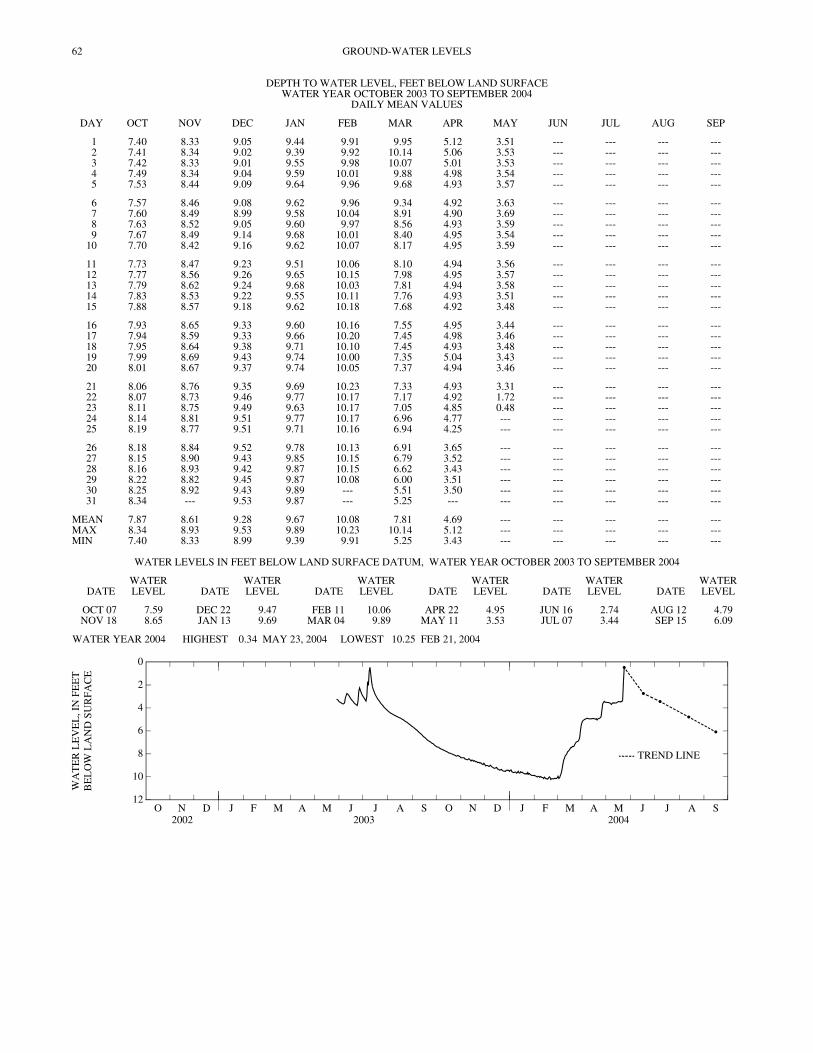
62 GROUND-WATER LEVELS
DEPTH TO WATER LEVEL, FEET BELOW LAND SURFACE WATER YEAR OCTOBER 2003 TO SEPTEMBER 2004
DAILY MEAN VALUES
DAY OCT NOV DEC JAN FEB MAR APR MAY JUN JUL AUG SEP
1 7.40 8.33 9.05 9.44 9.91 9.95 5.12 3.51 --- --- --- ---2 7.41 8.34 9.02 9.39 9.92 10.14 5.06 3.53 --- --- --- ---3 7.42 8.33 9.01 9.55 9.98 10.07 5.01 3.53 --- --- --- ---4 7.49 8.34 9.04 9.59 10.01 9.88 4.98 3.54 --- --- --- ---5 7.53 8.44 9.09 9.64 9.96 9.68 4.93 3.57 --- --- --- ---
6 7.57 8.46 9.08 9.62 9.96 9.34 4.92 3.63 --- --- --- ---7 7.60 8.49 8.99 9.58 10.04 8.91 4.90 3.69 --- --- --- ---8 7.63 8.52 9.05 9.60 9.97 8.56 4.93 3.59 --- --- --- ---9 7.67 8.49 9.14 9.68 10.01 8.40 4.95 3.54 --- --- --- ---
10 7.70 8.42 9.16 9.62 10.07 8.17 4.95 3.59 --- --- --- ---
11 7.73 8.47 9.23 9.51 10.06 8.10 4.94 3.56 --- --- --- ---12 7.77 8.56 9.26 9.65 10.15 7.98 4.95 3.57 --- --- --- ---13 7.79 8.62 9.24 9.68 10.03 7.81 4.94 3.58 --- --- --- ---14 7.83 8.53 9.22 9.55 10.11 7.76 4.93 3.51 --- --- --- ---15 7.88 8.57 9.18 9.62 10.18 7.68 4.92 3.48 --- --- --- ---
16 7.93 8.65 9.33 9.60 10.16 7.55 4.95 3.44 --- --- --- ---17 7.94 8.59 9.33 9.66 10.20 7.45 4.98 3.46 --- --- --- ---18 7.95 8.64 9.38 9.71 10.10 7.45 4.93 3.48 --- --- --- ---19 7.99 8.69 9.43 9.74 10.00 7.35 5.04 3.43 --- --- --- ---20 8.01 8.67 9.37 9.74 10.05 7.37 4.94 3.46 --- --- --- ---
21 8.06 8.76 9.35 9.69 10.23 7.33 4.93 3.31 --- --- --- ---22 8.07 8.73 9.46 9.77 10.17 7.17 4.92 1.72 --- --- --- ---23 8.11 8.75 9.49 9.63 10.17 7.05 4.85 0.48 --- --- --- ---24 8.14 8.81 9.51 9.77 10.17 6.96 4.77 --- --- --- --- ---25 8.19 8.77 9.51 9.71 10.16 6.94 4.25 --- --- --- --- ---
26 8.18 8.84 9.52 9.78 10.13 6.91 3.65 --- --- --- --- ---27 8.15 8.90 9.43 9.85 10.15 6.79 3.52 --- --- --- --- ---28 8.16 8.93 9.42 9.87 10.15 6.62 3.43 --- --- --- --- ---29 8.22 8.82 9.45 9.87 10.08 6.00 3.51 --- --- --- --- ---30 8.25 8.92 9.43 9.89 --- 5.51 3.50 --- --- --- --- ---31 8.34 --- 9.53 9.87 --- 5.25 --- --- --- --- --- ---
MEAN 7.87 8.61 9.28 9.67 10.08 7.81 4.69 --- --- --- --- ---MAX 8.34 8.93 9.53 9.89 10.23 10.14 5.12 --- --- --- --- ---MIN 7.40 8.33 8.99 9.39 9.91 5.25 3.43 --- --- --- --- ---
WATER LEVELS IN FEET BELOW LAND SURFACE DATUM, WATER YEAR OCTOBER 2003 TO SEPTEMBER 2004
DATEWATER LEVEL DATE
WATER LEVEL DATE
WATER LEVEL DATE
WATER LEVEL DATE
WATER LEVEL DATE
WATER LEVEL
OCT 07 7.59 DEC 22 9.47 FEB 11 10.06 APR 22 4.95 JUN 16 2.74 AUG 12 4.79NOV 18 8.65 JAN 13 9.69 MAR 04 9.89 MAY 11 3.53 JUL 07 3.44 SEP 15 6.09
WATER YEAR 2004 HIGHEST 0.34 MAY 23, 2004 LOWEST 10.25 FEB 21, 2004
O N D2002
J F M A M J J A S O N D2003
J F M A M J J A S2004
12
10
8
6
4
2
0
WA
TE
R L
EV
EL
, IN
FE
ET
BE
LO
W L
AN
D S
UR
FAC
E
TREND LINE
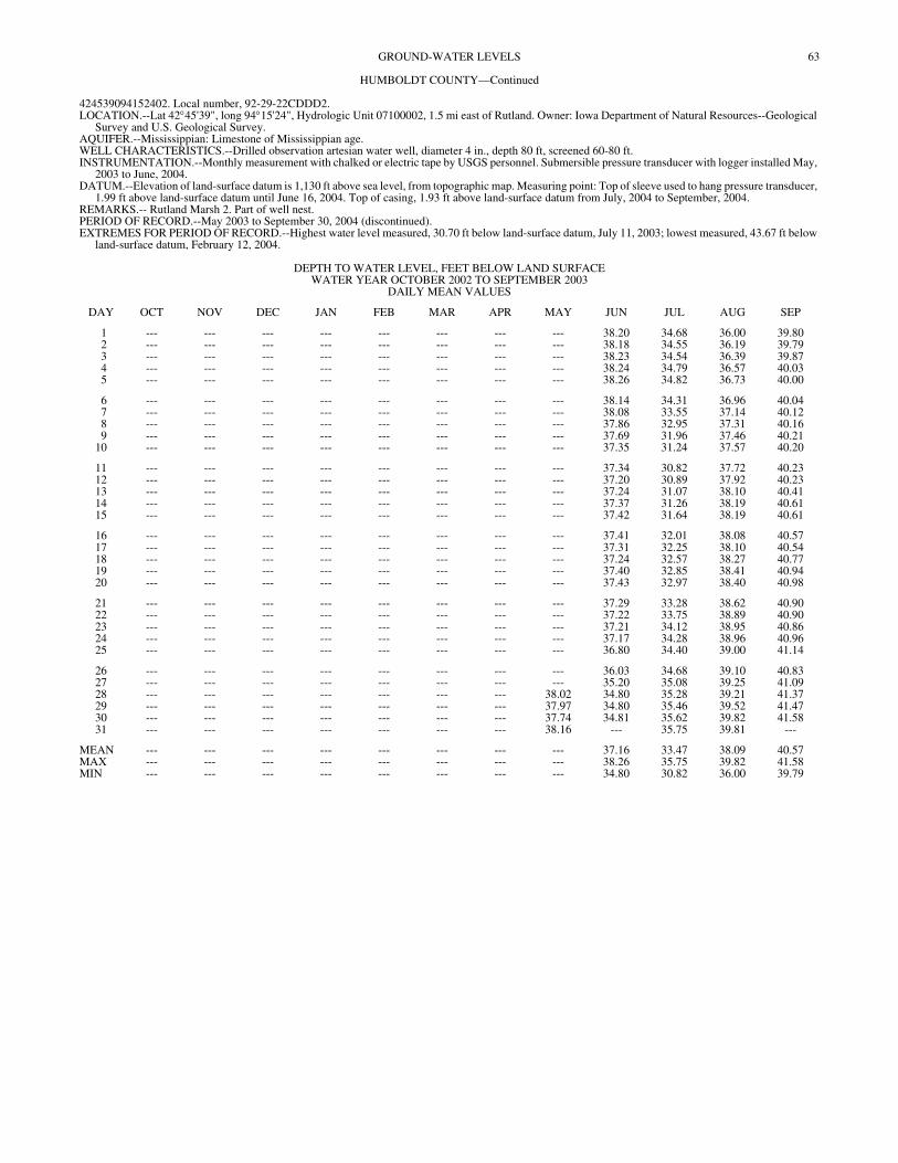
63GROUND-WATER LEVELS
HUMBOLDT COUNTY—Continued
424539094152402. Local number, 92-29-22CDDD2. LOCATION.--Lat 42°45'39", long 94°15'24", Hydrologic Unit 07100002, 1.5 mi east of Rutland. Owner: Iowa Department of Natural Resources--Geological
Survey and U.S. Geological Survey. AQUIFER.--Mississippian: Limestone of Mississippian age. WELL CHARACTERISTICS.--Drilled observation artesian water well, diameter 4 in., depth 80 ft, screened 60-80 ft. INSTRUMENTATION.--Monthly measurement with chalked or electric tape by USGS personnel. Submersible pressure transducer with logger installed May,
2003 to June, 2004. DATUM.--Elevation of land-surface datum is 1,130 ft above sea level, from topographic map. Measuring point: Top of sleeve used to hang pressure transducer,
1.99 ft above land-surface datum until June 16, 2004. Top of casing, 1.93 ft above land-surface datum from July, 2004 to September, 2004. REMARKS.-- Rutland Marsh 2. Part of well nest. PERIOD OF RECORD.--May 2003 to September 30, 2004 (discontinued). EXTREMES FOR PERIOD OF RECORD.--Highest water level measured, 30.70 ft below land-surface datum, July 11, 2003; lowest measured, 43.67 ft below
land-surface datum, February 12, 2004.
DEPTH TO WATER LEVEL, FEET BELOW LAND SURFACE WATER YEAR OCTOBER 2002 TO SEPTEMBER 2003
DAILY MEAN VALUES
DAY OCT NOV DEC JAN FEB MAR APR MAY JUN JUL AUG SEP
1 --- --- --- --- --- --- --- --- 38.20 34.68 36.00 39.802 --- --- --- --- --- --- --- --- 38.18 34.55 36.19 39.793 --- --- --- --- --- --- --- --- 38.23 34.54 36.39 39.874 --- --- --- --- --- --- --- --- 38.24 34.79 36.57 40.035 --- --- --- --- --- --- --- --- 38.26 34.82 36.73 40.00
6 --- --- --- --- --- --- --- --- 38.14 34.31 36.96 40.047 --- --- --- --- --- --- --- --- 38.08 33.55 37.14 40.128 --- --- --- --- --- --- --- --- 37.86 32.95 37.31 40.169 --- --- --- --- --- --- --- --- 37.69 31.96 37.46 40.21
10 --- --- --- --- --- --- --- --- 37.35 31.24 37.57 40.20
11 --- --- --- --- --- --- --- --- 37.34 30.82 37.72 40.2312 --- --- --- --- --- --- --- --- 37.20 30.89 37.92 40.2313 --- --- --- --- --- --- --- --- 37.24 31.07 38.10 40.4114 --- --- --- --- --- --- --- --- 37.37 31.26 38.19 40.6115 --- --- --- --- --- --- --- --- 37.42 31.64 38.19 40.61
16 --- --- --- --- --- --- --- --- 37.41 32.01 38.08 40.5717 --- --- --- --- --- --- --- --- 37.31 32.25 38.10 40.5418 --- --- --- --- --- --- --- --- 37.24 32.57 38.27 40.7719 --- --- --- --- --- --- --- --- 37.40 32.85 38.41 40.9420 --- --- --- --- --- --- --- --- 37.43 32.97 38.40 40.98
21 --- --- --- --- --- --- --- --- 37.29 33.28 38.62 40.9022 --- --- --- --- --- --- --- --- 37.22 33.75 38.89 40.9023 --- --- --- --- --- --- --- --- 37.21 34.12 38.95 40.8624 --- --- --- --- --- --- --- --- 37.17 34.28 38.96 40.9625 --- --- --- --- --- --- --- --- 36.80 34.40 39.00 41.14
26 --- --- --- --- --- --- --- --- 36.03 34.68 39.10 40.8327 --- --- --- --- --- --- --- --- 35.20 35.08 39.25 41.0928 --- --- --- --- --- --- --- 38.02 34.80 35.28 39.21 41.3729 --- --- --- --- --- --- --- 37.97 34.80 35.46 39.52 41.4730 --- --- --- --- --- --- --- 37.74 34.81 35.62 39.82 41.5831 --- --- --- --- --- --- --- 38.16 --- 35.75 39.81 ---
MEAN --- --- --- --- --- --- --- --- 37.16 33.47 38.09 40.57MAX --- --- --- --- --- --- --- --- 38.26 35.75 39.82 41.58MIN --- --- --- --- --- --- --- --- 34.80 30.82 36.00 39.79
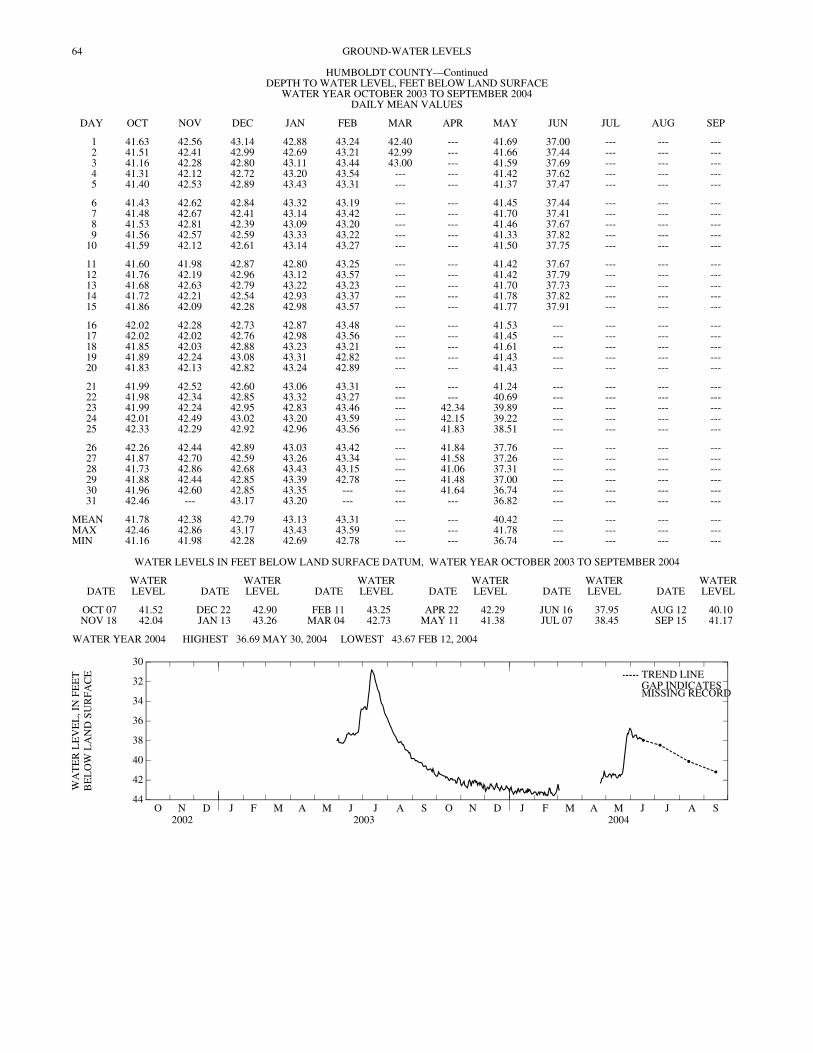
64 GROUND-WATER LEVELS
DEPTH TO WATER LEVEL, FEET BELOW LAND SURFACE WATER YEAR OCTOBER 2003 TO SEPTEMBER 2004
DAILY MEAN VALUES
DAY OCT NOV DEC JAN FEB MAR APR MAY JUN JUL AUG SEP
1 41.63 42.56 43.14 42.88 43.24 42.40 --- 41.69 37.00 --- --- ---2 41.51 42.41 42.99 42.69 43.21 42.99 --- 41.66 37.44 --- --- ---3 41.16 42.28 42.80 43.11 43.44 43.00 --- 41.59 37.69 --- --- ---4 41.31 42.12 42.72 43.20 43.54 --- --- 41.42 37.62 --- --- ---5 41.40 42.53 42.89 43.43 43.31 --- --- 41.37 37.47 --- --- ---
6 41.43 42.62 42.84 43.32 43.19 --- --- 41.45 37.44 --- --- ---7 41.48 42.67 42.41 43.14 43.42 --- --- 41.70 37.41 --- --- ---8 41.53 42.81 42.39 43.09 43.20 --- --- 41.46 37.67 --- --- ---9 41.56 42.57 42.59 43.33 43.22 --- --- 41.33 37.82 --- --- ---
10 41.59 42.12 42.61 43.14 43.27 --- --- 41.50 37.75 --- --- ---
11 41.60 41.98 42.87 42.80 43.25 --- --- 41.42 37.67 --- --- ---12 41.76 42.19 42.96 43.12 43.57 --- --- 41.42 37.79 --- --- ---13 41.68 42.63 42.79 43.22 43.23 --- --- 41.70 37.73 --- --- ---14 41.72 42.21 42.54 42.93 43.37 --- --- 41.78 37.82 --- --- ---15 41.86 42.09 42.28 42.98 43.57 --- --- 41.77 37.91 --- --- ---
16 42.02 42.28 42.73 42.87 43.48 --- --- 41.53 --- --- --- ---17 42.02 42.02 42.76 42.98 43.56 --- --- 41.45 --- --- --- ---18 41.85 42.03 42.88 43.23 43.21 --- --- 41.61 --- --- --- ---19 41.89 42.24 43.08 43.31 42.82 --- --- 41.43 --- --- --- ---20 41.83 42.13 42.82 43.24 42.89 --- --- 41.43 --- --- --- ---
21 41.99 42.52 42.60 43.06 43.31 --- --- 41.24 --- --- --- ---22 41.98 42.34 42.85 43.32 43.27 --- --- 40.69 --- --- --- ---23 41.99 42.24 42.95 42.83 43.46 --- 42.34 39.89 --- --- --- ---24 42.01 42.49 43.02 43.20 43.59 --- 42.15 39.22 --- --- --- ---25 42.33 42.29 42.92 42.96 43.56 --- 41.83 38.51 --- --- --- ---
26 42.26 42.44 42.89 43.03 43.42 --- 41.84 37.76 --- --- --- ---27 41.87 42.70 42.59 43.26 43.34 --- 41.58 37.26 --- --- --- ---28 41.73 42.86 42.68 43.43 43.15 --- 41.06 37.31 --- --- --- ---29 41.88 42.44 42.85 43.39 42.78 --- 41.48 37.00 --- --- --- ---30 41.96 42.60 42.85 43.35 --- --- 41.64 36.74 --- --- --- ---31 42.46 --- 43.17 43.20 --- --- --- 36.82 --- --- --- ---
MEAN 41.78 42.38 42.79 43.13 43.31 --- --- 40.42 --- --- --- ---MAX 42.46 42.86 43.17 43.43 43.59 --- --- 41.78 --- --- --- ---MIN 41.16 41.98 42.28 42.69 42.78 --- --- 36.74 --- --- --- ---
HUMBOLDT COUNTY—Continued
WATER LEVELS IN FEET BELOW LAND SURFACE DATUM, WATER YEAR OCTOBER 2003 TO SEPTEMBER 2004
DATEWATER LEVEL DATE
WATER LEVEL DATE
WATER LEVEL DATE
WATER LEVEL DATE
WATER LEVEL DATE
WATER LEVEL
OCT 07 41.52 DEC 22 42.90 FEB 11 43.25 APR 22 42.29 JUN 16 37.95 AUG 12 40.10NOV 18 42.04 JAN 13 43.26 MAR 04 42.73 MAY 11 41.38 JUL 07 38.45 SEP 15 41.17
WATER YEAR 2004 HIGHEST 36.69 MAY 30, 2004 LOWEST 43.67 FEB 12, 2004
O N D2002
J F M A M J J A S O N D2003
J F M A M J J A S2004
44
42
40
38
36
34
32
30
WA
TE
R L
EV
EL
, IN
FE
ET
BE
LO
W L
AN
D S
UR
FAC
E TREND LINEGAP INDICATESMISSING RECORD

65GROUND-WATER LEVELS
HUMBOLDT COUNTY—Continued
424539094152403. Local number, 92-29-22CDDD3. LOCATION.--Lat 42°45'39", long 94°15'24", Hydrologic Unit 07100002, 1.5 mi east of Rutland. Owner: Iowa Department of Natural Resources--Geological
Survey and U.S. Geological Survey. AQUIFER.--Mississippian: Limestone of Mississippian age. WELL CHARACTERISTICS.--Drilled observation artesian water well, diameter 4 in., depth 150 ft, screened 130-150 ft. INSTRUMENTATION.--Monthly measurement with chalked or electric tape by USGS personnel. Submersible pressure transducer with logger installed May,
2003 to May, 2004. DATUM.--Elevation of land-surface datum is 1,130 ft above sea level, from topographic map. Measuring point: Top of sleeve used to hang pressure transducer,
2.16 ft above land-surface datum until June 16, 2004. Top of casing, 2.07 ft above land-surface datum from July, 2004 to September, 2004. REMARKS.-- Rutland Marsh 3. Part of well nest. PERIOD OF RECORD.--May 2003 to September 30, 2004 (discontinued). EXTREMES FOR PERIOD OF RECORD.--Highest water level measured, 31.44 ft below land-surface datum, July 11, 2003; lowest measured, 44.15 ft below
land-surface datum, February 12, 2004.
DEPTH TO WATER LEVEL, FEET BELOW LAND SURFACE WATER YEAR OCTOBER 2002 TO SEPTEMBER 2003
DAILY MEAN VALUES
DAY OCT NOV DEC JAN FEB MAR APR MAY JUN JUL AUG SEP
1 --- --- --- --- --- --- --- --- 39.10 36.04 37.15 40.722 --- --- --- --- --- --- --- --- 39.10 36.04 37.33 40.723 --- --- --- --- --- --- --- --- 39.17 36.14 37.52 40.804 --- --- --- --- --- --- --- --- 39.21 36.43 37.72 40.945 --- --- --- --- --- --- --- --- 39.25 36.30 37.88 40.92
6 --- --- --- --- --- --- --- --- 39.16 34.99 38.11 40.967 --- --- --- --- --- --- --- --- 39.06 34.01 38.29 41.038 --- --- --- --- --- --- --- --- 38.62 33.23 38.45 41.079 --- --- --- --- --- --- --- --- 38.43 32.10 38.60 41.12
10 --- --- --- --- --- --- --- --- 38.12 31.60 38.71 41.12
11 --- --- --- --- --- --- --- --- 38.17 31.48 38.85 41.1312 --- --- --- --- --- --- --- --- 38.13 31.70 39.04 41.1213 --- --- --- --- --- --- --- --- 38.22 31.93 39.20 41.2814 --- --- --- --- --- --- --- --- 38.40 32.13 39.30 41.4415 --- --- --- --- --- --- --- --- 38.49 32.61 39.31 41.43
16 --- --- --- --- --- --- --- --- 38.52 33.09 39.24 41.4017 --- --- --- --- --- --- --- --- 38.49 33.40 39.28 41.3718 --- --- --- --- --- --- --- --- 38.47 33.75 39.44 41.5719 --- --- --- --- --- --- --- --- 38.64 34.06 39.56 41.6920 --- --- --- --- --- --- --- --- 38.71 34.20 39.54 41.72
21 --- --- --- --- --- --- --- --- 38.62 34.51 39.74 41.6522 --- --- --- --- --- --- --- --- 38.61 34.97 39.95 41.6623 --- --- --- --- --- --- --- --- 38.63 35.32 40.00 41.6324 --- --- --- --- --- --- --- --- 38.29 35.49 40.01 41.7125 --- --- --- --- --- --- --- --- 37.40 35.62 40.05 41.85
26 --- --- --- --- --- --- --- --- 36.07 35.89 40.13 41.5927 --- --- --- --- --- --- --- --- 35.56 36.26 40.27 41.8228 --- --- --- --- --- --- --- 38.81 35.50 36.46 40.23 42.0529 --- --- --- --- --- --- --- 38.79 35.79 36.63 40.50 42.1230 --- --- --- --- --- --- --- 38.63 36.01 36.79 40.74 42.2131 --- --- --- --- --- --- --- 39.04 --- 36.92 40.72 ---
MEAN --- --- --- --- --- --- --- --- 38.13 34.52 39.19 41.39MAX --- --- --- --- --- --- --- --- 39.25 36.92 40.74 42.21MIN --- --- --- --- --- --- --- --- 35.50 31.48 37.15 40.72
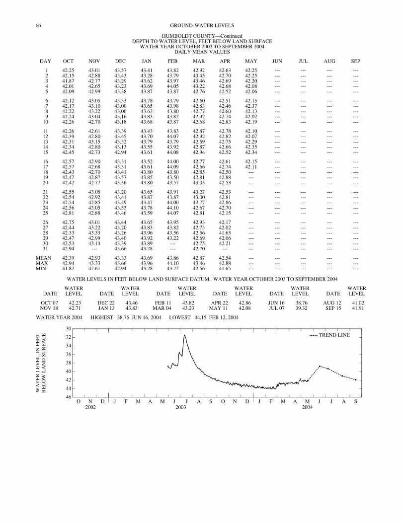
66 GROUND-WATER LEVELS
DEPTH TO WATER LEVEL, FEET BELOW LAND SURFACE WATER YEAR OCTOBER 2003 TO SEPTEMBER 2004
DAILY MEAN VALUES
DAY OCT NOV DEC JAN FEB MAR APR MAY JUN JUL AUG SEP
1 42.25 43.01 43.57 43.41 43.82 42.92 42.63 42.25 --- --- --- ---2 42.15 42.88 43.43 43.28 43.79 43.45 42.70 42.25 --- --- --- ---3 41.87 42.77 43.29 43.62 43.97 43.46 42.69 42.20 --- --- --- ---4 42.01 42.65 43.23 43.69 44.05 43.22 42.68 42.08 --- --- --- ---5 42.09 42.99 43.38 43.87 43.87 42.76 42.52 42.06 --- --- --- ---
6 42.12 43.05 43.33 43.78 43.79 42.60 42.51 42.15 --- --- --- ---7 42.17 43.10 43.00 43.65 43.98 42.83 42.46 42.37 --- --- --- ---8 42.22 43.22 43.00 43.63 43.80 42.77 42.60 42.13 --- --- --- ---9 42.24 43.04 43.16 43.83 43.82 42.92 42.74 42.02 --- --- --- ---
10 42.26 42.70 43.18 43.68 43.87 42.68 42.83 42.19 --- --- --- ---
11 42.26 42.61 43.39 43.43 43.83 42.87 42.78 42.10 --- --- --- ---12 42.39 42.80 43.45 43.70 44.07 42.92 42.82 42.07 --- --- --- ---13 42.31 43.15 43.32 43.79 43.79 42.69 42.75 42.29 --- --- --- ---14 42.34 42.80 43.13 43.55 43.92 42.87 42.66 42.35 --- --- --- ---15 42.45 42.73 42.94 43.61 44.08 42.94 42.52 42.34 --- --- --- ---
16 42.57 42.90 43.31 43.52 44.00 42.77 42.61 42.15 --- --- --- ---17 42.57 42.68 43.31 43.61 44.09 42.66 42.74 42.11 --- --- --- ---18 42.43 42.70 43.41 43.80 43.80 42.85 42.50 --- --- --- --- ---19 42.47 42.87 43.57 43.85 43.50 42.81 42.88 --- --- --- --- ---20 42.42 42.77 43.36 43.80 43.57 43.05 42.53 --- --- --- --- ---
21 42.55 43.08 43.20 43.65 43.91 43.27 42.53 --- --- --- --- ---22 42.54 42.92 43.41 43.87 43.87 43.00 42.81 --- --- --- --- ---23 42.54 42.85 43.49 43.47 44.00 42.77 42.86 --- --- --- --- ---24 42.56 43.05 43.53 43.78 44.10 42.67 42.70 --- --- --- --- ---25 42.81 42.88 43.46 43.59 44.07 42.81 42.15 --- --- --- --- ---
26 42.75 43.01 43.44 43.65 43.95 42.93 42.17 --- --- --- --- ---27 42.44 43.22 43.20 43.83 43.82 42.73 42.02 --- --- --- --- ---28 42.33 43.33 43.26 43.96 43.56 42.56 41.65 --- --- --- --- ---29 42.47 42.99 43.40 43.92 43.22 42.69 42.06 --- --- --- --- ---30 42.53 43.14 43.39 43.89 --- 42.75 42.21 --- --- --- --- ---31 42.94 --- 43.66 43.78 --- 42.70 --- --- --- --- --- ---
MEAN 42.39 42.93 43.33 43.69 43.86 42.87 42.54 --- --- --- --- ---MAX 42.94 43.33 43.66 43.96 44.10 43.46 42.88 --- --- --- --- ---MIN 41.87 42.61 42.94 43.28 43.22 42.56 41.65 --- --- --- --- ---
HUMBOLDT COUNTY—Continued
WATER LEVELS IN FEET BELOW LAND SURFACE DATUM, WATER YEAR OCTOBER 2003 TO SEPTEMBER 2004
DATEWATER LEVEL DATE
WATER LEVEL DATE
WATER LEVEL DATE
WATER LEVEL DATE
WATER LEVEL DATE
WATER LEVEL
OCT 07 42.23 DEC 22 43.46 FEB 11 43.82 APR 22 42.86 JUN 16 38.76 AUG 12 41.02NOV 18 42.71 JAN 13 43.83 MAR 04 43.23 MAY 11 42.08 JUL 07 39.32 SEP 15 41.91
WATER YEAR 2004 HIGHEST 38.76 JUN 16, 2004 LOWEST 44.15 FEB 12, 2004
O N D2002
J F M A M J J A S O N D2003
J F M A M J J A S2004
46
44
42
40
38
36
34
32
30
WA
TE
R L
EV
EL
, IN
FE
ET
BE
LO
W L
AN
D S
UR
FAC
E TREND LINE
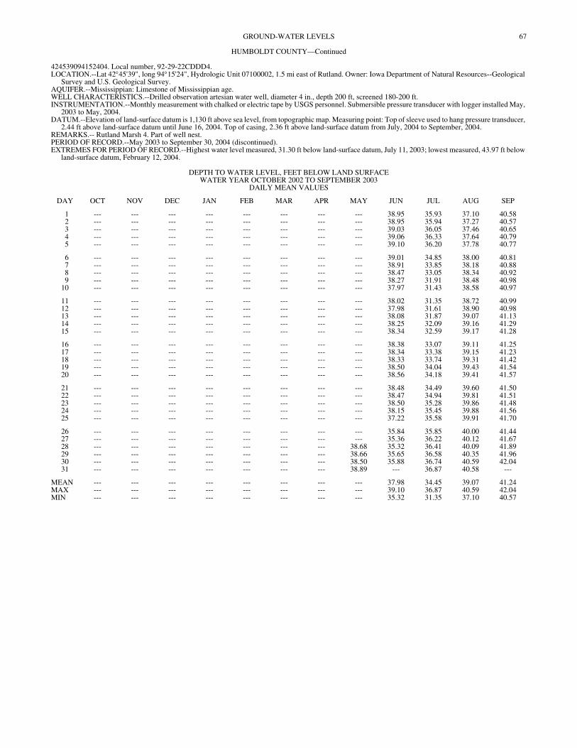
67GROUND-WATER LEVELS
HUMBOLDT COUNTY—Continued
424539094152404. Local number, 92-29-22CDDD4. LOCATION.--Lat 42°45'39", long 94°15'24", Hydrologic Unit 07100002, 1.5 mi east of Rutland. Owner: Iowa Department of Natural Resources--Geological
Survey and U.S. Geological Survey. AQUIFER.--Mississippian: Limestone of Mississippian age. WELL CHARACTERISTICS.--Drilled observation artesian water well, diameter 4 in., depth 200 ft, screened 180-200 ft. INSTRUMENTATION.--Monthly measurement with chalked or electric tape by USGS personnel. Submersible pressure transducer with logger installed May,
2003 to May, 2004. DATUM.--Elevation of land-surface datum is 1,130 ft above sea level, from topographic map. Measuring point: Top of sleeve used to hang pressure transducer,
2.44 ft above land-surface datum until June 16, 2004. Top of casing, 2.36 ft above land-surface datum from July, 2004 to September, 2004. REMARKS.-- Rutland Marsh 4. Part of well nest. PERIOD OF RECORD.--May 2003 to September 30, 2004 (discontinued). EXTREMES FOR PERIOD OF RECORD.--Highest water level measured, 31.30 ft below land-surface datum, July 11, 2003; lowest measured, 43.97 ft below
land-surface datum, February 12, 2004.
DEPTH TO WATER LEVEL, FEET BELOW LAND SURFACE WATER YEAR OCTOBER 2002 TO SEPTEMBER 2003
DAILY MEAN VALUES
DAY OCT NOV DEC JAN FEB MAR APR MAY JUN JUL AUG SEP
1 --- --- --- --- --- --- --- --- 38.95 35.93 37.10 40.582 --- --- --- --- --- --- --- --- 38.95 35.94 37.27 40.573 --- --- --- --- --- --- --- --- 39.03 36.05 37.46 40.654 --- --- --- --- --- --- --- --- 39.06 36.33 37.64 40.795 --- --- --- --- --- --- --- --- 39.10 36.20 37.78 40.77
6 --- --- --- --- --- --- --- --- 39.01 34.85 38.00 40.817 --- --- --- --- --- --- --- --- 38.91 33.85 38.18 40.888 --- --- --- --- --- --- --- --- 38.47 33.05 38.34 40.929 --- --- --- --- --- --- --- --- 38.27 31.91 38.48 40.98
10 --- --- --- --- --- --- --- --- 37.97 31.43 38.58 40.97
11 --- --- --- --- --- --- --- --- 38.02 31.35 38.72 40.9912 --- --- --- --- --- --- --- --- 37.98 31.61 38.90 40.9813 --- --- --- --- --- --- --- --- 38.08 31.87 39.07 41.1314 --- --- --- --- --- --- --- --- 38.25 32.09 39.16 41.2915 --- --- --- --- --- --- --- --- 38.34 32.59 39.17 41.28
16 --- --- --- --- --- --- --- --- 38.38 33.07 39.11 41.2517 --- --- --- --- --- --- --- --- 38.34 33.38 39.15 41.2318 --- --- --- --- --- --- --- --- 38.33 33.74 39.31 41.4219 --- --- --- --- --- --- --- --- 38.50 34.04 39.43 41.5420 --- --- --- --- --- --- --- --- 38.56 34.18 39.41 41.57
21 --- --- --- --- --- --- --- --- 38.48 34.49 39.60 41.5022 --- --- --- --- --- --- --- --- 38.47 34.94 39.81 41.5123 --- --- --- --- --- --- --- --- 38.50 35.28 39.86 41.4824 --- --- --- --- --- --- --- --- 38.15 35.45 39.88 41.5625 --- --- --- --- --- --- --- --- 37.22 35.58 39.91 41.70
26 --- --- --- --- --- --- --- --- 35.84 35.85 40.00 41.4427 --- --- --- --- --- --- --- --- 35.36 36.22 40.12 41.6728 --- --- --- --- --- --- --- 38.68 35.32 36.41 40.09 41.8929 --- --- --- --- --- --- --- 38.66 35.65 36.58 40.35 41.9630 --- --- --- --- --- --- --- 38.50 35.88 36.74 40.59 42.0431 --- --- --- --- --- --- --- 38.89 --- 36.87 40.58 ---
MEAN --- --- --- --- --- --- --- --- 37.98 34.45 39.07 41.24MAX --- --- --- --- --- --- --- --- 39.10 36.87 40.59 42.04MIN --- --- --- --- --- --- --- --- 35.32 31.35 37.10 40.57

68 GROUND-WATER LEVELS
DEPTH TO WATER LEVEL, FEET BELOW LAND SURFACE WATER YEAR OCTOBER 2003 TO SEPTEMBER 2004
DAILY MEAN VALUES
DAY OCT NOV DEC JAN FEB MAR APR MAY JUN JUL AUG SEP
1 42.08 42.79 43.32 43.20 43.62 42.77 42.45 42.08 --- --- --- ---2 41.99 42.68 43.18 43.06 43.60 43.29 42.51 42.07 --- --- --- ---3 41.71 42.57 43.04 43.40 43.78 43.30 42.51 42.03 --- --- --- ---4 41.85 42.46 42.99 43.47 43.85 43.06 42.51 41.91 --- --- --- ---5 41.93 42.79 43.13 43.65 43.67 42.58 42.35 41.89 --- --- --- ---
6 41.96 42.85 43.09 43.56 43.60 42.41 42.34 41.98 --- --- --- ---7 41.98 42.90 42.76 43.43 43.78 42.63 42.29 42.19 --- --- --- ---8 42.00 43.01 42.76 43.42 43.60 42.58 42.42 41.94 --- --- --- ---9 42.03 42.84 42.92 43.62 43.63 42.72 42.56 41.84 --- --- --- ---
10 42.05 42.50 42.93 43.47 43.68 42.49 42.64 42.01 --- --- --- ---
11 42.05 42.42 43.14 43.22 43.65 42.68 42.60 41.92 --- --- --- ---12 42.17 42.61 43.20 43.50 43.90 42.74 42.63 41.91 --- --- --- ---13 42.10 42.95 43.07 43.58 43.62 42.51 42.56 42.12 --- --- --- ---14 42.13 42.62 42.89 43.37 43.75 42.69 42.49 42.17 --- --- --- ---15 42.24 42.55 42.70 43.42 43.91 42.76 42.36 42.16 --- --- --- ---
16 42.36 42.71 43.06 43.33 43.83 42.60 42.45 41.98 --- --- --- ---17 42.36 42.50 43.07 43.42 43.91 42.49 42.57 41.94 --- --- --- ---18 42.22 42.49 43.16 43.60 43.63 42.68 42.33 42.08 --- --- --- ---19 42.26 42.63 43.31 43.65 43.35 42.64 42.71 41.95 --- --- --- ---20 42.21 42.54 43.11 43.60 43.42 42.87 42.36 41.96 --- --- --- ---
21 42.34 42.84 42.95 43.46 43.75 43.08 42.36 41.69 --- --- --- ---22 42.33 42.69 43.17 43.67 43.70 42.82 42.64 40.34 --- --- --- ---23 42.34 42.61 43.25 43.29 43.83 42.59 42.71 38.81 --- --- --- ---24 42.36 42.81 43.30 43.59 43.93 42.50 42.55 --- --- --- --- ---25 42.60 42.64 43.24 43.40 43.89 42.64 41.99 --- --- --- --- ---
26 42.54 42.77 43.22 43.47 43.78 42.76 42.00 --- --- --- --- ---27 42.24 42.97 42.97 43.64 43.65 42.56 41.85 --- --- --- --- ---28 42.14 43.08 43.05 43.76 43.39 42.38 41.49 --- --- --- --- ---29 42.27 42.75 43.18 43.72 43.06 42.50 41.90 --- --- --- --- ---30 42.34 42.89 43.17 43.70 --- 42.56 42.04 --- --- --- --- ---31 42.73 --- 43.43 43.59 --- 42.51 --- --- --- --- --- ---
MEAN 42.19 42.72 43.09 43.49 43.68 42.69 42.37 --- --- --- --- ---MAX 42.73 43.08 43.43 43.76 43.93 43.30 42.71 --- --- --- --- ---MIN 41.71 42.42 42.70 43.06 43.06 42.38 41.49 --- --- --- --- ---
HUMBOLDT COUNTY—Continued
WATER LEVELS IN FEET BELOW LAND SURFACE DATUM, WATER YEAR OCTOBER 2003 TO SEPTEMBER 2004
DATEWATER LEVEL DATE
WATER LEVEL DATE
WATER LEVEL DATE
WATER LEVEL DATE
WATER LEVEL DATE
WATER LEVEL
OCT 07 42.02 DEC 22 43.23 FEB 11 43.65 APR 22 42.68 JUN 16 38.63 AUG 12 40.85NOV 18 42.48 JAN 13 43.63 MAR 04 43.04 MAY 11 41.90 JUL 07 39.15 SEP 15 41.84
WATER YEAR 2004 HIGHEST 38.63 JUN 16, 2004 LOWEST 43.97 FEB 12, 2004
O N D2002
J F M A M J J A S O N D2003
J F M A M J J A S2004
44
42
40
38
36
34
32
30
WA
TE
R L
EV
EL
, IN
FE
ET
BE
LO
W L
AN
D S
UR
FAC
E TREND LINE

69GROUND-WATER LEVELS
HUMBOLDT COUNTY—Continued
424539094152405. Local number, 92-29-22CDDD5. LOCATION.--Lat 42°45'39", long 94°15'24", Hydrologic Unit 07100002, 1.5 mi east of Rutland. Owner: Iowa Department of Natural Resources--Geological
Survey and U.S. Geological Survey. AQUIFER.--Mississippian: Limestone of Mississippian age. WELL CHARACTERISTICS.--Drilled observation artesian water well, diameter 4 in., depth 280 ft, screened 240-280 ft. INSTRUMENTATION.--Monthly measurement with chalked or electric tape by USGS personnel. Submersible pressure transducer with logger installed May,
2003 to May, 2004. DATUM.--Elevation of land-surface datum is 1,130 ft above sea level, from topographic map. Measuring point: Top of sleeve used to hang pressure transducer,
2.34 ft above land-surface datum until June 16, 2004. Top of casing, 2.23 ft above land-surface datum from July, 2004 to September, 2004. REMARKS.-- Rutland Marsh 5. Part of well nest. PERIOD OF RECORD.--May 2003 to September 30, 2004 (discontinued). EXTREMES FOR PERIOD OF RECORD.--Highest water level measured, 31.83 ft below land-surface datum, July 11, 2003; lowest measured, 44.05 ft below
land-surface datum, February 12, 2004.
DEPTH TO WATER LEVEL, FEET BELOW LAND SURFACE WATER YEAR OCTOBER 2002 TO SEPTEMBER 2003
DAILY MEAN VALUES
DAY OCT NOV DEC JAN FEB MAR APR MAY JUN JUL AUG SEP
1 --- --- --- --- --- --- --- --- 39.05 36.14 37.20 40.612 --- --- --- --- --- --- --- --- 39.05 36.15 37.37 40.613 --- --- --- --- --- --- --- --- 39.11 36.24 37.55 40.684 --- --- --- --- --- --- --- --- 39.15 36.52 37.74 40.825 --- --- --- --- --- --- --- --- 39.18 36.42 37.89 40.80
6 --- --- --- --- --- --- --- --- 39.09 35.28 38.10 40.847 --- --- --- --- --- --- --- --- 39.00 34.33 38.28 40.918 --- --- --- --- --- --- --- --- 38.62 33.61 38.43 40.959 --- --- --- --- --- --- --- --- 38.42 32.53 38.57 41.00
10 --- --- --- --- --- --- --- --- 38.13 32.02 38.67 41.00
11 --- --- --- --- --- --- --- --- 38.17 31.89 38.80 41.0112 --- --- --- --- --- --- --- --- 38.12 32.08 38.98 41.0013 --- --- --- --- --- --- --- --- 38.21 32.29 39.14 41.1414 --- --- --- --- --- --- --- --- 38.37 32.47 39.24 41.3015 --- --- --- --- --- --- --- --- 38.46 32.92 39.25 41.29
16 --- --- --- --- --- --- --- --- 38.49 33.36 39.19 41.2517 --- --- --- --- --- --- --- --- 38.45 33.65 39.23 41.2318 --- --- --- --- --- --- --- --- 38.44 33.98 39.37 41.4119 --- --- --- --- --- --- --- --- 38.60 34.26 39.50 41.5320 --- --- --- --- --- --- --- --- 38.66 34.39 39.48 41.56
21 --- --- --- --- --- --- --- --- 38.58 34.68 39.66 41.5022 --- --- --- --- --- --- --- --- 38.57 35.11 39.87 41.5123 --- --- --- --- --- --- --- --- 38.59 35.44 39.92 41.5024 --- --- --- --- --- --- --- --- 38.31 35.60 39.93 41.5725 --- --- --- --- --- --- --- --- 37.51 35.72 39.97 41.72
26 --- --- --- --- --- --- --- --- 36.25 35.98 40.04 41.4727 --- --- --- --- --- --- --- --- 35.73 36.34 40.17 41.6928 --- --- --- --- --- --- --- 38.85 35.64 36.53 40.14 41.9229 --- --- --- --- --- --- --- 38.81 35.91 36.69 40.39 41.9930 --- --- --- --- --- --- --- 38.63 36.11 36.85 40.62 42.0831 --- --- --- --- --- --- --- 39.00 --- 36.97 40.61 ---
MEAN --- --- --- --- --- --- --- --- 38.13 34.72 39.14 41.26MAX --- --- --- --- --- --- --- --- 39.18 36.97 40.62 42.08MIN --- --- --- --- --- --- --- --- 35.64 31.89 37.20 40.61

70 GROUND-WATER LEVELS
DEPTH TO WATER LEVEL, FEET BELOW LAND SURFACE WATER YEAR OCTOBER 2003 TO SEPTEMBER 2004
DAILY MEAN VALUES
DAY OCT NOV DEC JAN FEB MAR APR MAY JUN JUL AUG SEP
1 42.12 42.89 43.49 43.32 43.70 42.89 42.57 42.21 --- --- --- ---2 42.04 42.78 43.36 43.19 43.67 43.39 42.63 42.20 --- --- --- ---3 41.77 42.68 43.22 43.51 43.85 43.39 42.63 42.15 --- --- --- ---4 41.92 42.56 43.17 43.57 43.92 43.15 42.62 42.03 --- --- --- ---5 41.99 42.88 43.30 43.74 43.75 42.71 42.47 42.01 --- --- --- ---
6 42.03 42.94 43.27 43.66 43.67 42.55 42.45 42.09 --- --- --- ---7 42.07 42.99 42.95 43.54 43.85 42.75 42.41 42.29 --- --- --- ---8 42.11 43.11 42.94 43.51 43.68 42.69 42.54 42.06 --- --- --- ---9 42.13 42.94 43.10 43.71 43.70 42.83 42.68 41.95 --- --- --- ---
10 42.15 42.61 43.11 43.57 43.75 42.60 42.76 42.10 --- --- --- ---
11 42.15 42.54 43.31 43.32 43.73 42.78 42.72 42.03 --- --- --- ---12 42.28 42.71 43.38 43.58 43.98 42.83 42.75 42.01 --- --- --- ---13 42.21 43.05 43.25 43.66 43.71 42.62 42.69 42.22 --- --- --- ---14 42.24 42.73 43.08 43.44 43.83 42.79 42.61 42.27 --- --- --- ---15 42.34 42.66 42.89 43.49 43.98 42.85 42.48 42.26 --- --- --- ---
16 42.46 42.82 43.24 43.41 43.91 42.70 42.57 42.09 --- --- --- ---17 42.46 42.62 43.26 43.49 43.99 42.59 42.70 42.05 --- --- --- ---18 42.32 42.64 43.34 43.67 43.72 42.77 42.47 42.19 --- --- --- ---19 42.36 42.81 43.49 43.72 43.44 42.74 42.83 42.05 --- --- --- ---20 42.32 42.72 43.30 43.67 43.50 42.96 42.50 42.07 --- --- --- ---
21 42.44 43.01 43.14 43.54 43.83 43.17 42.50 41.83 --- --- --- ---22 42.43 42.87 43.33 43.74 43.78 42.91 42.77 40.65 --- --- --- ---23 42.44 42.79 43.39 43.37 43.91 42.70 42.83 39.26 --- --- --- ---24 42.46 42.99 43.44 43.67 44.00 42.60 42.67 38.49 --- --- --- ---25 42.70 42.82 43.37 43.48 43.97 42.74 42.17 37.81 --- --- --- ---
26 42.64 42.94 43.35 43.54 43.86 42.86 42.17 --- --- --- --- ---27 42.35 43.14 43.12 43.71 43.75 42.67 42.01 --- --- --- --- ---28 42.25 43.25 43.18 43.83 43.50 42.51 41.66 --- --- --- --- ---29 42.38 42.94 43.30 43.79 43.18 42.63 42.04 --- --- --- --- ---30 42.45 43.07 43.30 43.77 --- 42.68 42.17 --- --- --- --- ---31 42.83 --- 43.54 43.67 --- 42.63 --- --- --- --- --- ---
MEAN 42.29 42.85 43.26 43.58 43.76 42.80 42.50 --- --- --- --- ---MAX 42.83 43.25 43.54 43.83 44.00 43.39 42.83 --- --- --- --- ---MIN 41.77 42.54 42.89 43.19 43.18 42.51 41.66 --- --- --- --- ---
HUMBOLDT COUNTY—Continued
WATER LEVELS IN FEET BELOW LAND SURFACE DATUM, WATER YEAR OCTOBER 2003 TO SEPTEMBER 2004
DATEWATER LEVEL DATE
WATER LEVEL DATE
WATER LEVEL DATE
WATER LEVEL DATE
WATER LEVEL DATE
WATER LEVEL
OCT 07 42.13 DEC 22 43.37 FEB 11 43.73 APR 22 42.81 JUN 16 38.82 AUG 12 41.00NOV 18 42.66 JAN 13 43.70 MAR 04 43.13 MAY 11 42.01 JUL 07 39.31 SEP 15 41.92
WATER YEAR 2004 HIGHEST 38.82 JUN 16, 2004 LOWEST 44.05 FEB 12, 2004
O N D2002
J F M A M J J A S O N D2003
J F M A M J J A S2004
46
44
42
40
38
36
34
32
30
WA
TE
R L
EV
EL
, IN
FE
ET
BE
LO
W L
AN
D S
UR
FAC
E TREND LINE
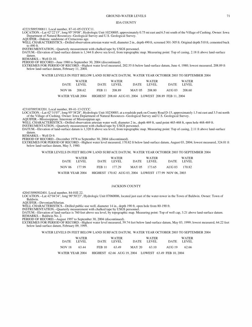
71GROUND-WATER LEVELS
IDA COUNTY
422215095390811. Local number, 87-41-05 CCCC11. LOCATION.--Lat 42°22'15", long 95°39'08", Hydrologic Unit 10230005, approximately 0.75 mi east and 6.5 mi south of the Village of Cushing. Owner: Iowa
Department of Natural Resources--Geological Survey and U.S. Geological Survey. AQUIFER.--Dakota: sandstone of Cretaceous age. WELL CHARACTERISTICS.--Drilled observation artesian water well, diameter 2 in., depth 490 ft, screened 301-305 ft. Original depth 510 ft, cemented back
to 490 ft. INSTRUMENTATION.--Quarterly measurement with chalked tape by USGS personnel. DATUM.--Elevation of land-surface datum is 1,344 ft above sea level, from topographic map. Measuring point: Top of casing, 2.18 ft above land-surface
datum. REMARKS.-- Well D-10. PERIOD OF RECORD.--June 1980 to September 30, 2004 (discontinued). EXTREMES FOR PERIOD OF RECORD.--Highest water level measured, 202.55 ft below land-surface datum, June 4, 1980; lowest measured, 208.89 ft
below land-surface datum, February 11, 2004.
WATER LEVELS IN FEET BELOW LAND SURFACE DATUM, WATER YEAR OCTOBER 2003 TO SEPTEMBER 2004
DATEWATER LEVEL DATE
WATER LEVEL DATE
WATER LEVEL DATE
WATER LEVEL
NOV 06 208.62 FEB 11 208.89 MAY 05 208.80 AUG 03 208.60
WATER YEAR 2004 HIGHEST 208.60 AUG 03, 2004 LOWEST 208.89 FEB 11, 2004
423107095383201. Local number, 89-41-13 CCCC. LOCATION.--Lat 42°31'07", long 95°38'28", Hydrologic Unit 10230003, at a roadside park on County Road D-15, approximately 1.5 mi east and 3.5 mi north
of the Village of Cushing. Owner: Iowa Department of Natural Resources--Geological Survey and U.S. Geological Survey. AQUIFER.--Mississippian: limestone of Mississippian age. WELL CHARACTERISTICS.--Drilled observation artesian water well, diameter 2 in., depth 469 ft, sand point 465-468 ft, open hole 468-469 ft. INSTRUMENTATION.--Quarterly measurement with chalked tape by USGS personnel. DATUM.--Elevation of land-surface datum is 1,320 ft above sea level, from topographic map. Measuring point: Top of casing, 2.11 ft above land-surface
datum. REMARKS.-- Well D-9. PERIOD OF RECORD.--December 1978 to September 30, 2004 (discontinued). EXTREMES FOR PERIOD OF RECORD.--Highest water level measured, 170.82 ft below land-surface datum, August 03, 2004; lowest measured, 324.01 ft
below land-surface datum, May 5, 1980.
WATER LEVELS IN FEET BELOW LAND SURFACE DATUM, WATER YEAR OCTOBER 2003 TO SEPTEMBER 2004
DATEWATER LEVEL DATE
WATER LEVEL DATE
WATER LEVEL DATE
WATER LEVEL
NOV 06 177.99 FEB 11 177.29 MAY 05 173.65 AUG 03 170.82
WATER YEAR 2004 HIGHEST 170.82 AUG 03, 2004 LOWEST 177.99 NOV 06, 2003
JACKSON COUNTY
420433090502401. Local number, 84-01E 22. LOCATION.--Lat 42°04'34", long 90°50'23", Hydrologic Unit 07060006, located just east of the water-tower in the Town of Baldwin. Owner: Town of
Baldwin. AQUIFER.--Devonian/Silurian. WELL CHARACTERISTICS.--Drilled public-use well, diameter 14 in., depth 190 ft, open hole from 80-190 ft. INSTRUMENTATION.--Quarterly measurement with chalked tape by USGS personnel. DATUM.--Elevation of land-surface is 760 feet above sea level, by topographic map. Measuring point: Top of well cap, 3.21 above land-surface datum. REMARKS.-- Baldwin No. 2. PERIOD OF RECORD.--August 1997 to September 30, 2004 (discontinued). EXTREMES FOR PERIOD OF RECORD.--Highest water level measured, 59.74 feet below land-surface datum, May 03, 1999; lowest measured, 64.22 feet
below land-surface datum, February 09, 1999.
WATER LEVELS IN FEET BELOW LAND SURFACE DATUM, WATER YEAR OCTOBER 2003 TO SEPTEMBER 2004
DATEWATER LEVEL DATE
WATER LEVEL DATE
WATER LEVEL DATE
WATER LEVEL
NOV 18 63.44 FEB 10 63.49 MAY 20 63.10 AUG 19 62.66
WATER YEAR 2004 HIGHEST 62.66 AUG 19, 2004 LOWEST 63.49 FEB 10, 2004
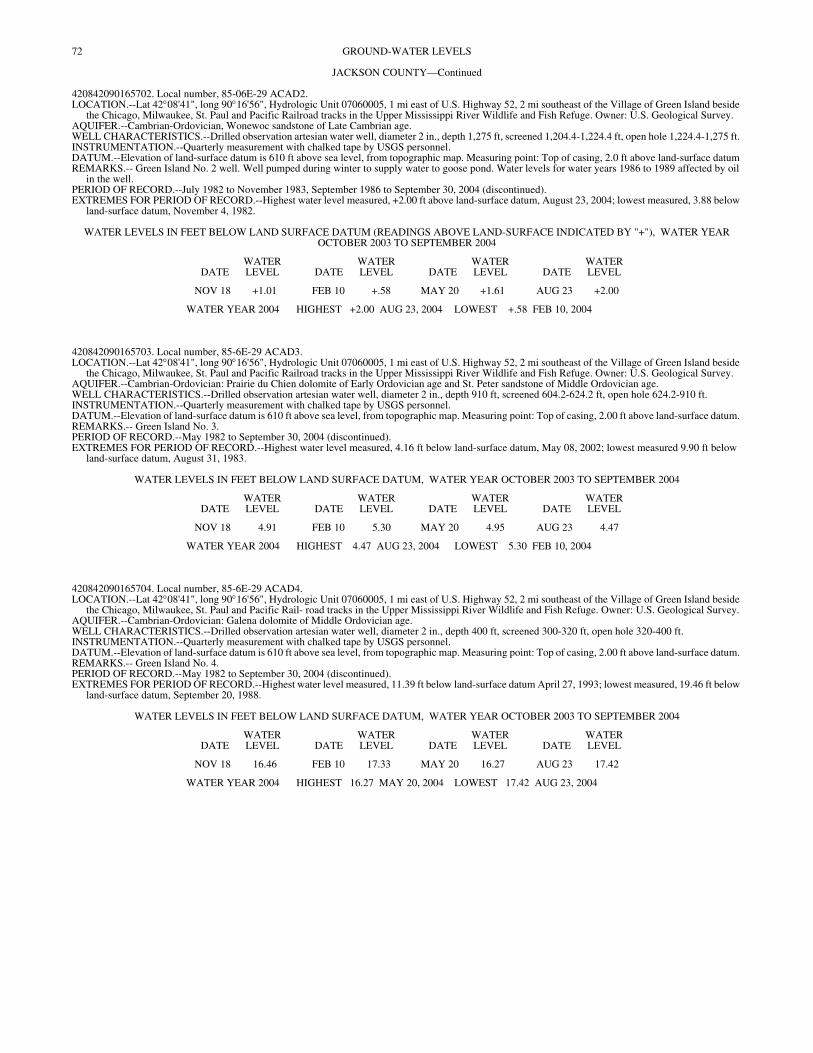
72 GROUND-WATER LEVELS
JACKSON COUNTY—Continued
420842090165702. Local number, 85-06E-29 ACAD2. LOCATION.--Lat 42°08'41", long 90°16'56", Hydrologic Unit 07060005, 1 mi east of U.S. Highway 52, 2 mi southeast of the Village of Green Island beside
the Chicago, Milwaukee, St. Paul and Pacific Railroad tracks in the Upper Mississippi River Wildlife and Fish Refuge. Owner: U.S. Geological Survey. AQUIFER.--Cambrian-Ordovician, Wonewoc sandstone of Late Cambrian age. WELL CHARACTERISTICS.--Drilled observation artesian water well, diameter 2 in., depth 1,275 ft, screened 1,204.4-1,224.4 ft, open hole 1,224.4-1,275 ft. INSTRUMENTATION.--Quarterly measurement with chalked tape by USGS personnel. DATUM.--Elevation of land-surface datum is 610 ft above sea level, from topographic map. Measuring point: Top of casing, 2.0 ft above land-surface datum REMARKS.-- Green Island No. 2 well. Well pumped during winter to supply water to goose pond. Water levels for water years 1986 to 1989 affected by oil
in the well. PERIOD OF RECORD.--July 1982 to November 1983, September 1986 to September 30, 2004 (discontinued). EXTREMES FOR PERIOD OF RECORD.--Highest water level measured, +2.00 ft above land-surface datum, August 23, 2004; lowest measured, 3.88 below
land-surface datum, November 4, 1982.
WATER LEVELS IN FEET BELOW LAND SURFACE DATUM (READINGS ABOVE LAND-SURFACE INDICATED BY "+"), WATER YEAR OCTOBER 2003 TO SEPTEMBER 2004
DATEWATER LEVEL DATE
WATER LEVEL DATE
WATER LEVEL DATE
WATER LEVEL
NOV 18 +1.01 FEB 10 +.58 MAY 20 +1.61 AUG 23 +2.00
WATER YEAR 2004 HIGHEST +2.00 AUG 23, 2004 LOWEST +.58 FEB 10, 2004
420842090165703. Local number, 85-6E-29 ACAD3. LOCATION.--Lat 42°08'41", long 90°16'56", Hydrologic Unit 07060005, 1 mi east of U.S. Highway 52, 2 mi southeast of the Village of Green Island beside
the Chicago, Milwaukee, St. Paul and Pacific Railroad tracks in the Upper Mississippi River Wildlife and Fish Refuge. Owner: U.S. Geological Survey. AQUIFER.--Cambrian-Ordovician: Prairie du Chien dolomite of Early Ordovician age and St. Peter sandstone of Middle Ordovician age. WELL CHARACTERISTICS.--Drilled observation artesian water well, diameter 2 in., depth 910 ft, screened 604.2-624.2 ft, open hole 624.2-910 ft. INSTRUMENTATION.--Quarterly measurement with chalked tape by USGS personnel. DATUM.--Elevation of land-surface datum is 610 ft above sea level, from topographic map. Measuring point: Top of casing, 2.00 ft above land-surface datum. REMARKS.-- Green Island No. 3. PERIOD OF RECORD.--May 1982 to September 30, 2004 (discontinued). EXTREMES FOR PERIOD OF RECORD.--Highest water level measured, 4.16 ft below land-surface datum, May 08, 2002; lowest measured 9.90 ft below
land-surface datum, August 31, 1983.
WATER LEVELS IN FEET BELOW LAND SURFACE DATUM, WATER YEAR OCTOBER 2003 TO SEPTEMBER 2004
DATEWATER LEVEL DATE
WATER LEVEL DATE
WATER LEVEL DATE
WATER LEVEL
NOV 18 4.91 FEB 10 5.30 MAY 20 4.95 AUG 23 4.47
WATER YEAR 2004 HIGHEST 4.47 AUG 23, 2004 LOWEST 5.30 FEB 10, 2004
420842090165704. Local number, 85-6E-29 ACAD4. LOCATION.--Lat 42°08'41", long 90°16'56", Hydrologic Unit 07060005, 1 mi east of U.S. Highway 52, 2 mi southeast of the Village of Green Island beside
the Chicago, Milwaukee, St. Paul and Pacific Rail- road tracks in the Upper Mississippi River Wildlife and Fish Refuge. Owner: U.S. Geological Survey. AQUIFER.--Cambrian-Ordovician: Galena dolomite of Middle Ordovician age. WELL CHARACTERISTICS.--Drilled observation artesian water well, diameter 2 in., depth 400 ft, screened 300-320 ft, open hole 320-400 ft. INSTRUMENTATION.--Quarterly measurement with chalked tape by USGS personnel. DATUM.--Elevation of land-surface datum is 610 ft above sea level, from topographic map. Measuring point: Top of casing, 2.00 ft above land-surface datum. REMARKS.-- Green Island No. 4. PERIOD OF RECORD.--May 1982 to September 30, 2004 (discontinued). EXTREMES FOR PERIOD OF RECORD.--Highest water level measured, 11.39 ft below land-surface datum April 27, 1993; lowest measured, 19.46 ft below
land-surface datum, September 20, 1988.
WATER LEVELS IN FEET BELOW LAND SURFACE DATUM, WATER YEAR OCTOBER 2003 TO SEPTEMBER 2004
DATEWATER LEVEL DATE
WATER LEVEL DATE
WATER LEVEL DATE
WATER LEVEL
NOV 18 16.46 FEB 10 17.33 MAY 20 16.27 AUG 23 17.42
WATER YEAR 2004 HIGHEST 16.27 MAY 20, 2004 LOWEST 17.42 AUG 23, 2004

73GROUND-WATER LEVELS
JASPER COUNTY
414210092592001. Local number, 80-18-31 ABBB. LOCATION.--Lat 41°42'10", long 92°59'20", Hydrologic Unit 07080105, approximately 3 mi east of the City of Newton just south of U.S. Highway 6. Owner:
P.W. Beukema. AQUIFER.--Glacial drift of Pleistocene age. WELL CHARACTERISTICS.--Dug stock water-table well, diameter 36 in., depth 37 ft, cribbed with brick. INSTRUMENTATION.--Quarterly measurement with chalked tape by USGS personnel. DATUM.--Elevation of land-surface datum is 940 ft above sea level, from topographic map. Measuring point: Top of cement platform, 0.70 ft above land-
surface datum. REMARKS.-- Beukema well. PERIOD OF RECORD.--February 1940 to September 30, 2004 (discontinued). EXTREMES FOR PERIOD OF RECORD.--Highest water level measured, 2.67 ft below land-surface datum, June 10, 1947; lowest measured, 27.15 ft below
land-surface datum, December 18, 1948.
WATER LEVELS IN FEET BELOW LAND SURFACE DATUM, WATER YEAR OCTOBER 2003 TO SEPTEMBER 2004
DATEWATER LEVEL DATE
WATER LEVEL DATE
WATER LEVEL DATE
WATER LEVEL
NOV 19 5.25 FEB 09 7.19 MAY 21 4.75 AUG 20 5.91
WATER YEAR 2004 HIGHEST 4.75 MAY 21, 2004 LOWEST 7.19 FEB 09, 2004
413908093071100. Local number, 79-19-01 CCCB. LOCATION.--Lat 41°39'08", long 93°07'11", Hydrologic Unit 07080105, located approximately .5 miles east of Newton airport on county road. Owner:
Newton Waterworks. AQUIFER.--Cambrian/Ordovician. WELL CHARACTERISTICS.--Drilled public-supply well, diameter 24 in. and 16 in., depth 2256.00 ft, open hole 1705-2256 ft. INSTRUMENTATION.--Intermitent measurement by Newton Waterworks personnel by airline. DATUM.--Elevation of land-surface datum is 775.00 ft above sea level, by levels. REMARKS.-- Newton No. 24. PERIOD OF RECORD.--October 2000 to current year. EXTREMES FOR PERIOD OF RECORD.--Highest water level measured, 182 feet below land surface datum, Decemeber 18, 2000; lowest measured, 205
feet below land-surface datum March 24, 2001 and September 16, 2003.
WATER LEVELS IN FEET BELOW LAND SURFACE DATUM, WATER YEAR OCTOBER 2003 TO SEPTEMBER 2004
DATEWATER LEVEL DATE
WATER LEVEL DATE
WATER LEVEL DATE
WATER LEVEL DATE
WATER LEVEL DATE
WATER LEVEL
OCT 15 203 MAY 17 195 JUN 15 195 JUL 15 195 AUG 15 195 SEP 17 197
WATER YEAR 2004 HIGHEST 195 MAY 17, 2004 JUN 15, 2004 JUL 15, 2004 AUG 15, 2004 LOWEST 203 OCT 15, 2003
JOHNSON COUNTY
413925091324001. Local number, 79-06-09 DDBC. LOCATION.--Lat 41°39'34", long 91°32'42", Hydrologic Unit 07080209, at the Quadrangle Dormitory, University of Iowa, Iowa City. Owner: University of
Iowa. AQUIFER.--Silurian: dolomite of Silurian age. WELL CHARACTERISTICS.--Drilled unused artesian water well, diameter 12 in., depth 430.5 ft, cased to 225 ft, open hole 225-430.5 ft. INSTRUMENTATION.--Quarterly measurement with chalked tape by USGS personnel, measured monthly as part of project 461908100. DATUM.--Elevation of land-surface datum is 714 ft above sea level, from topographic map. Measuring point: Nipple welded to plate on top of casing, 1.81 ft
above land- surface datum. REMARKS.-- University of Iowa Quadrangle Dormitory. Water levels affected by nearby wells pumping in late spring, summer, and early fall. PERIOD OF RECORD.--April 1975 to September 30, 2004 (discontinued). REVISED RECORDS.--WDR IA-84-1, WDR IA-88-1. EXTREMES FOR PERIOD OF RECORD.--Highest water level measured, 74.63 ft below land-surface datum, March 21, 1979; lowest measured, 179.42 ft
below land-surface datum, October 08, 1997.
WATER LEVELS IN FEET BELOW LAND SURFACE DATUM, WATER YEAR OCTOBER 2003 TO SEPTEMBER 2004
DATEWATER LEVEL DATE
WATER LEVEL DATE
WATER LEVEL DATE
WATER LEVEL DATE
WATER LEVEL DATE
WATER LEVEL
OCT 09 158.18 DEC 16 143.48 FEB 13 150.71 APR 12 144.16 JUN 16 150.09 AUG 16 160.17NOV 13 133.28 JAN 14 145.33 MAR 19 152.42 MAY 17 150.49 JUL 20 152.86 SEP 16 157.81
WATER YEAR 2004 HIGHEST 133.28 NOV 13, 2003 LOWEST 160.17 AUG 16, 2004
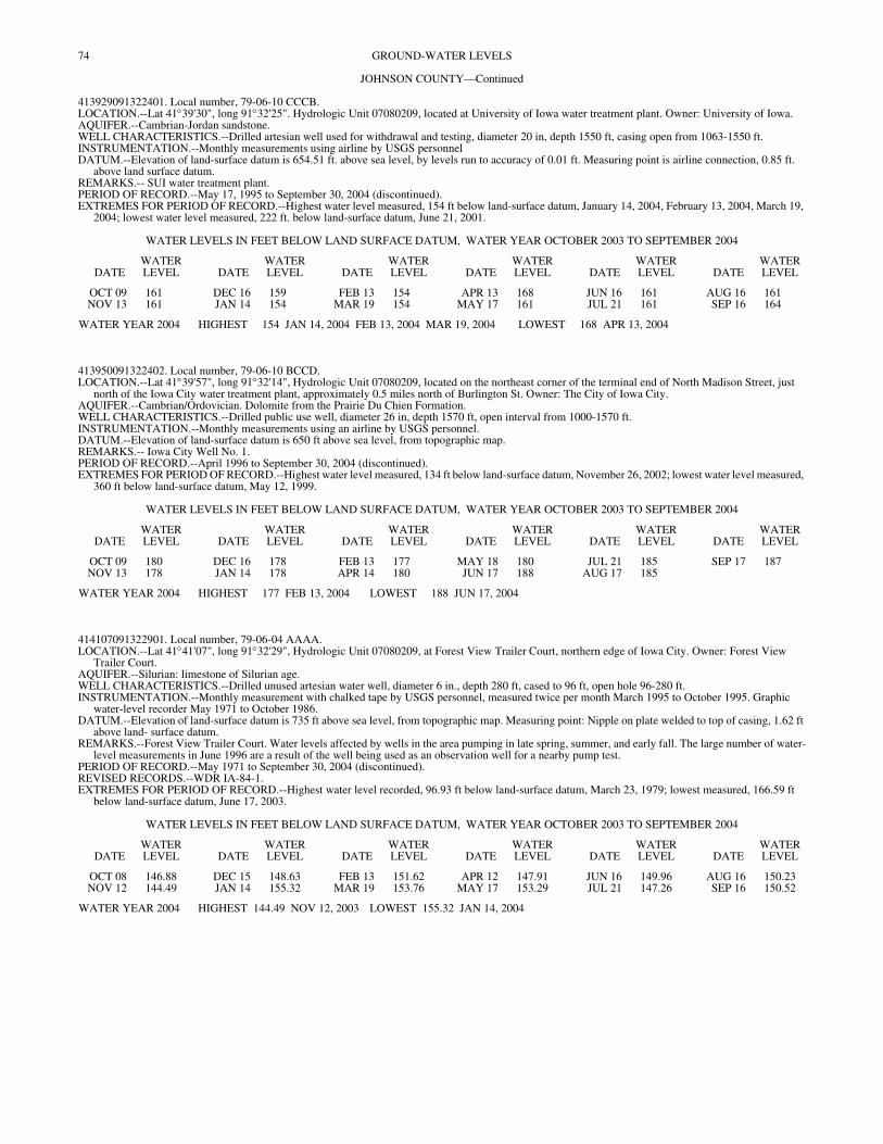
74 GROUND-WATER LEVELS
JOHNSON COUNTY—Continued
413929091322401. Local number, 79-06-10 CCCB. LOCATION.--Lat 41°39'30", long 91°32'25". Hydrologic Unit 07080209, located at University of Iowa water treatment plant. Owner: University of Iowa. AQUIFER.--Cambrian-Jordan sandstone. WELL CHARACTERISTICS.--Drilled artesian well used for withdrawal and testing, diameter 20 in, depth 1550 ft, casing open from 1063-1550 ft. INSTRUMENTATION.--Monthly measurements using airline by USGS personnel DATUM.--Elevation of land-surface datum is 654.51 ft. above sea level, by levels run to accuracy of 0.01 ft. Measuring point is airline connection, 0.85 ft.
above land surface datum. REMARKS.-- SUI water treatment plant. PERIOD OF RECORD.--May 17, 1995 to September 30, 2004 (discontinued). EXTREMES FOR PERIOD OF RECORD.--Highest water level measured, 154 ft below land-surface datum, January 14, 2004, February 13, 2004, March 19,
2004; lowest water level measured, 222 ft. below land-surface datum, June 21, 2001.
WATER LEVELS IN FEET BELOW LAND SURFACE DATUM, WATER YEAR OCTOBER 2003 TO SEPTEMBER 2004
DATEWATER LEVEL DATE
WATER LEVEL DATE
WATER LEVEL DATE
WATER LEVEL DATE
WATER LEVEL DATE
WATER LEVEL
OCT 09 161 DEC 16 159 FEB 13 154 APR 13 168 JUN 16 161 AUG 16 161NOV 13 161 JAN 14 154 MAR 19 154 MAY 17 161 JUL 21 161 SEP 16 164
WATER YEAR 2004 HIGHEST 154 JAN 14, 2004 FEB 13, 2004 MAR 19, 2004 LOWEST 168 APR 13, 2004
413950091322402. Local number, 79-06-10 BCCD. LOCATION.--Lat 41°39'57", long 91°32'14", Hydrologic Unit 07080209, located on the northeast corner of the terminal end of North Madison Street, just
north of the Iowa City water treatment plant, approximately 0.5 miles north of Burlington St. Owner: The City of Iowa City. AQUIFER.--Cambrian/Ordovician. Dolomite from the Prairie Du Chien Formation. WELL CHARACTERISTICS.--Drilled public use well, diameter 26 in, depth 1570 ft, open interval from 1000-1570 ft. INSTRUMENTATION.--Monthly measurements using an airline by USGS personnel. DATUM.--Elevation of land-surface datum is 650 ft above sea level, from topographic map. REMARKS.-- Iowa City Well No. 1. PERIOD OF RECORD.--April 1996 to September 30, 2004 (discontinued). EXTREMES FOR PERIOD OF RECORD.--Highest water level measured, 134 ft below land-surface datum, November 26, 2002; lowest water level measured,
360 ft below land-surface datum, May 12, 1999.
WATER LEVELS IN FEET BELOW LAND SURFACE DATUM, WATER YEAR OCTOBER 2003 TO SEPTEMBER 2004
DATEWATER LEVEL DATE
WATER LEVEL DATE
WATER LEVEL DATE
WATER LEVEL DATE
WATER LEVEL DATE
WATER LEVEL
OCT 09 180 DEC 16 178 FEB 13 177 MAY 18 180 JUL 21 185 SEP 17 187NOV 13 178 JAN 14 178 APR 14 180 JUN 17 188 AUG 17 185
WATER YEAR 2004 HIGHEST 177 FEB 13, 2004 LOWEST 188 JUN 17, 2004
414107091322901. Local number, 79-06-04 AAAA. LOCATION.--Lat 41°41'07", long 91°32'29", Hydrologic Unit 07080209, at Forest View Trailer Court, northern edge of Iowa City. Owner: Forest View
Trailer Court. AQUIFER.--Silurian: limestone of Silurian age. WELL CHARACTERISTICS.--Drilled unused artesian water well, diameter 6 in., depth 280 ft, cased to 96 ft, open hole 96-280 ft. INSTRUMENTATION.--Monthly measurement with chalked tape by USGS personnel, measured twice per month March 1995 to October 1995. Graphic
water-level recorder May 1971 to October 1986. DATUM.--Elevation of land-surface datum is 735 ft above sea level, from topographic map. Measuring point: Nipple on plate welded to top of casing, 1.62 ft
above land- surface datum. REMARKS.--Forest View Trailer Court. Water levels affected by wells in the area pumping in late spring, summer, and early fall. The large number of water-
level measurements in June 1996 are a result of the well being used as an observation well for a nearby pump test. PERIOD OF RECORD.--May 1971 to September 30, 2004 (discontinued). REVISED RECORDS.--WDR IA-84-1. EXTREMES FOR PERIOD OF RECORD.--Highest water level recorded, 96.93 ft below land-surface datum, March 23, 1979; lowest measured, 166.59 ft
below land-surface datum, June 17, 2003.
WATER LEVELS IN FEET BELOW LAND SURFACE DATUM, WATER YEAR OCTOBER 2003 TO SEPTEMBER 2004
DATEWATER LEVEL DATE
WATER LEVEL DATE
WATER LEVEL DATE
WATER LEVEL DATE
WATER LEVEL DATE
WATER LEVEL
OCT 08 146.88 DEC 15 148.63 FEB 13 151.62 APR 12 147.91 JUN 16 149.96 AUG 16 150.23NOV 12 144.49 JAN 14 155.32 MAR 19 153.76 MAY 17 153.29 JUL 21 147.26 SEP 16 150.52
WATER YEAR 2004 HIGHEST 144.49 NOV 12, 2003 LOWEST 155.32 JAN 14, 2004
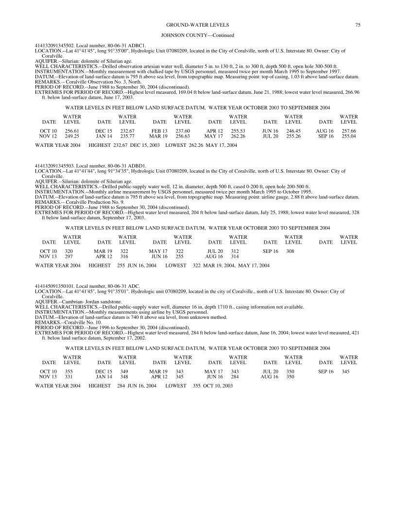
75GROUND-WATER LEVELS
JOHNSON COUNTY—Continued
414132091345502. Local number, 80-06-31 ADBC1. LOCATION.--Lat 41°41'45", long 91°35'00", Hydrologic Unit 07080209, located in the City of Coralville, north of U.S. Interstate 80. Owner: City of
Coralville. AQUIFER.--Silurian: dolomite of Silurian age. WELL CHARACTERISTICS.--Drilled observation artesian water well, diameter 5 in. to 130 ft, 2 in. to 300 ft, depth 500 ft, open hole 300-500 ft. INSTRUMENTATION.--Monthly measurement with chalked tape by USGS personnel, measured twice per month March 1995 to September 1997. DATUM.--Elevation of land-surface datum is 795 ft above sea level, from topographic map. Measuring point: top of casing, 1.03 ft above land-surface datum. REMARKS.-- Coralville Observation No. 3, North. PERIOD OF RECORD.--June 1988 to September 30, 2004 (discontinued). EXTREMES FOR PERIOD OF RECORD.--Highest level measured, 169.04 ft below land-surface datum, June 21, 1988; lowest water level measured, 266.96
ft. below land-surface datum, June 17, 2003.
WATER LEVELS IN FEET BELOW LAND SURFACE DATUM, WATER YEAR OCTOBER 2003 TO SEPTEMBER 2004
DATEWATER LEVEL DATE
WATER LEVEL DATE
WATER LEVEL DATE
WATER LEVEL DATE
WATER LEVEL DATE
WATER LEVEL
OCT 10 256.61 DEC 15 232.67 FEB 13 237.60 APR 12 255.53 JUN 16 246.45 AUG 16 257.66NOV 12 249.25 JAN 14 235.77 MAR 19 256.63 MAY 17 262.26 JUL 20 255.26 SEP 16 255.04
WATER YEAR 2004 HIGHEST 232.67 DEC 15, 2003 LOWEST 262.26 MAY 17, 2004
414132091345503. Local number, 80-06-31 ADBD1. LOCATION.--Lat 41°41'44", long 91°34'35", Hydrologic Unit 07080209, located in the City of Coralville, north of U.S. Interstate 80. Owner: City of
Coralville. AQUIFER.--Silurian: dolomite of Silurian age. WELL CHARACTERISTICS.--Drilled public-supply water well, 12 in. diameter, depth 500 ft, cased 0-200 ft, open hole 200-500 ft. INSTRUMENTATION.--Monthly airline measurement by USGS personnel, measured twice per month March 1995 to October 1995. DATUM.--Elevation of land-surface datum is 795 ft above sea level, from topographic map. Measuring point: airline gauge, 2.88 ft above land-surface datum. REMARKS.-- Coralville Production No. 9. PERIOD OF RECORD.--June 1988 to September 30, 2004 (discontinued). EXTREMES FOR PERIOD OF RECORD.--Highest water level measured, 204 ft below land-surface datum, July 25, 1988; lowest water level measured, 328
ft below land-surface datum, September 17, 2003.
WATER LEVELS IN FEET BELOW LAND SURFACE DATUM, WATER YEAR OCTOBER 2003 TO SEPTEMBER 2004
DATEWATER LEVEL DATE
WATER LEVEL DATE
WATER LEVEL DATE
WATER LEVEL DATE
WATER LEVEL DATE
WATER LEVEL
OCT 10 320 MAR 19 322 MAY 17 322 JUL 20 312 SEP 16 308NOV 13 297 APR 12 316 JUN 16 255 AUG 16 314
WATER YEAR 2004 HIGHEST 255 JUN 16, 2004 LOWEST 322 MAR 19, 2004, MAY 17, 2004
414145091350101. Local number, 80-06-31 ADC. LOCATION.--Lat 41°41'45", long 91°35'01". Hydrologic unit 07080209, located in the city of Coralville., north of U.S. Interstate 80. Owner: City of
Coralville. AQUIFER.--Cambrian- Jordan sandstone. WELL CHARACTERISTICS.--Drilled public-supply water well, diameter 16 in, depth 1710 ft., casing information not available. INSTRUMENTATION.--Monthly measurements using airline by USGS personnel. DATUM.--Elevation of land-surface datum is 740 ft above sea level, from unknown method. REMARKS.--Coralville No. 10. PERIOD OF RECORD.--June 1996 to September 30, 2004 (discontinued). EXTREMES FOR PERIOD OF RECORD.--Highest water level measured, 284 ft below land-surface datum, June 16, 2004; lowest water level measured, 421
ft. below land surface datum, September 17, 2002.
WATER LEVELS IN FEET BELOW LAND SURFACE DATUM, WATER YEAR OCTOBER 2003 TO SEPTEMBER 2004
DATEWATER LEVEL DATE
WATER LEVEL DATE
WATER LEVEL DATE
WATER LEVEL DATE
WATER LEVEL DATE
WATER LEVEL
OCT 10 355 DEC 15 349 MAR 19 343 MAY 17 343 JUL 20 350 SEP 16 345NOV 13 331 JAN 14 348 APR 12 345 JUN 16 284 AUG 16 350
WATER YEAR 2004 HIGHEST 284 JUN 16, 2004 LOWEST 355 OCT 10, 2003
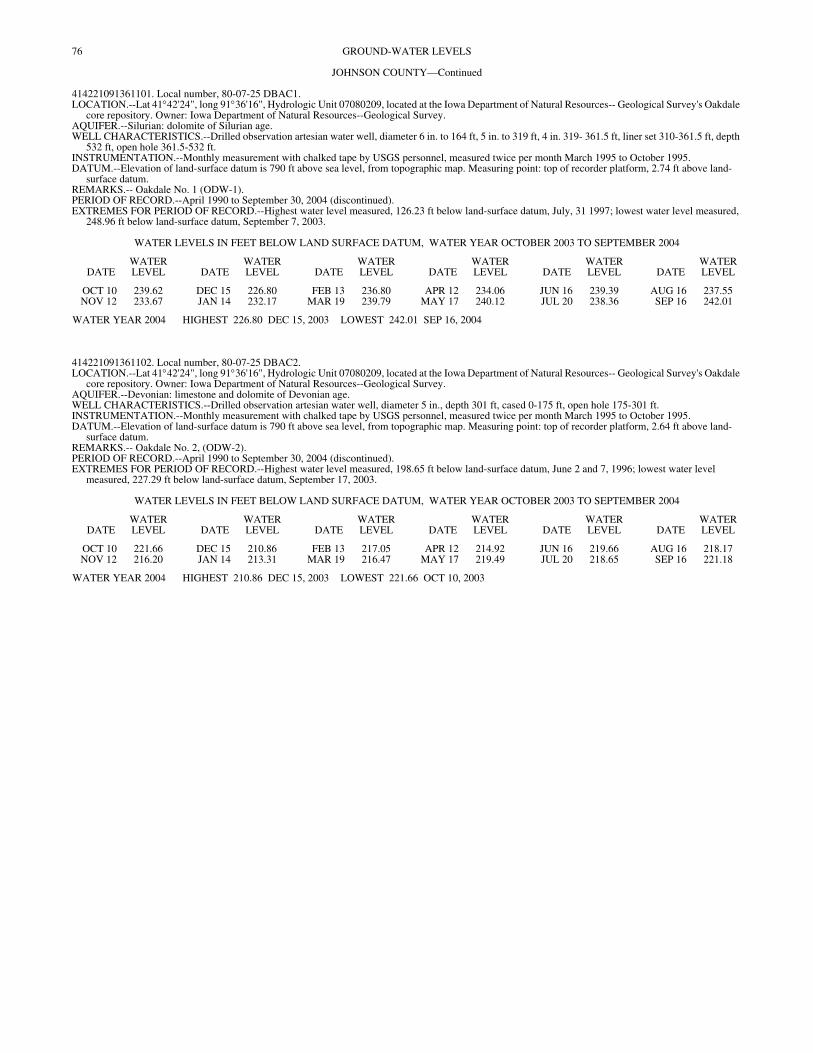
76 GROUND-WATER LEVELS
JOHNSON COUNTY—Continued
414221091361101. Local number, 80-07-25 DBAC1. LOCATION.--Lat 41°42'24", long 91°36'16", Hydrologic Unit 07080209, located at the Iowa Department of Natural Resources-- Geological Survey's Oakdale
core repository. Owner: Iowa Department of Natural Resources--Geological Survey. AQUIFER.--Silurian: dolomite of Silurian age. WELL CHARACTERISTICS.--Drilled observation artesian water well, diameter 6 in. to 164 ft, 5 in. to 319 ft, 4 in. 319- 361.5 ft, liner set 310-361.5 ft, depth
532 ft, open hole 361.5-532 ft. INSTRUMENTATION.--Monthly measurement with chalked tape by USGS personnel, measured twice per month March 1995 to October 1995. DATUM.--Elevation of land-surface datum is 790 ft above sea level, from topographic map. Measuring point: top of recorder platform, 2.74 ft above land-
surface datum. REMARKS.-- Oakdale No. 1 (ODW-1). PERIOD OF RECORD.--April 1990 to September 30, 2004 (discontinued). EXTREMES FOR PERIOD OF RECORD.--Highest water level measured, 126.23 ft below land-surface datum, July, 31 1997; lowest water level measured,
248.96 ft below land-surface datum, September 7, 2003.
WATER LEVELS IN FEET BELOW LAND SURFACE DATUM, WATER YEAR OCTOBER 2003 TO SEPTEMBER 2004
DATEWATER LEVEL DATE
WATER LEVEL DATE
WATER LEVEL DATE
WATER LEVEL DATE
WATER LEVEL DATE
WATER LEVEL
OCT 10 239.62 DEC 15 226.80 FEB 13 236.80 APR 12 234.06 JUN 16 239.39 AUG 16 237.55NOV 12 233.67 JAN 14 232.17 MAR 19 239.79 MAY 17 240.12 JUL 20 238.36 SEP 16 242.01
WATER YEAR 2004 HIGHEST 226.80 DEC 15, 2003 LOWEST 242.01 SEP 16, 2004
414221091361102. Local number, 80-07-25 DBAC2. LOCATION.--Lat 41°42'24", long 91°36'16", Hydrologic Unit 07080209, located at the Iowa Department of Natural Resources-- Geological Survey's Oakdale
core repository. Owner: Iowa Department of Natural Resources--Geological Survey. AQUIFER.--Devonian: limestone and dolomite of Devonian age. WELL CHARACTERISTICS.--Drilled observation artesian water well, diameter 5 in., depth 301 ft, cased 0-175 ft, open hole 175-301 ft. INSTRUMENTATION.--Monthly measurement with chalked tape by USGS personnel, measured twice per month March 1995 to October 1995. DATUM.--Elevation of land-surface datum is 790 ft above sea level, from topographic map. Measuring point: top of recorder platform, 2.64 ft above land-
surface datum. REMARKS.-- Oakdale No. 2, (ODW-2). PERIOD OF RECORD.--April 1990 to September 30, 2004 (discontinued). EXTREMES FOR PERIOD OF RECORD.--Highest water level measured, 198.65 ft below land-surface datum, June 2 and 7, 1996; lowest water level
measured, 227.29 ft below land-surface datum, September 17, 2003.
WATER LEVELS IN FEET BELOW LAND SURFACE DATUM, WATER YEAR OCTOBER 2003 TO SEPTEMBER 2004
DATEWATER LEVEL DATE
WATER LEVEL DATE
WATER LEVEL DATE
WATER LEVEL DATE
WATER LEVEL DATE
WATER LEVEL
OCT 10 221.66 DEC 15 210.86 FEB 13 217.05 APR 12 214.92 JUN 16 219.66 AUG 16 218.17NOV 12 216.20 JAN 14 213.31 MAR 19 216.47 MAY 17 219.49 JUL 20 218.65 SEP 16 221.18
WATER YEAR 2004 HIGHEST 210.86 DEC 15, 2003 LOWEST 221.66 OCT 10, 2003
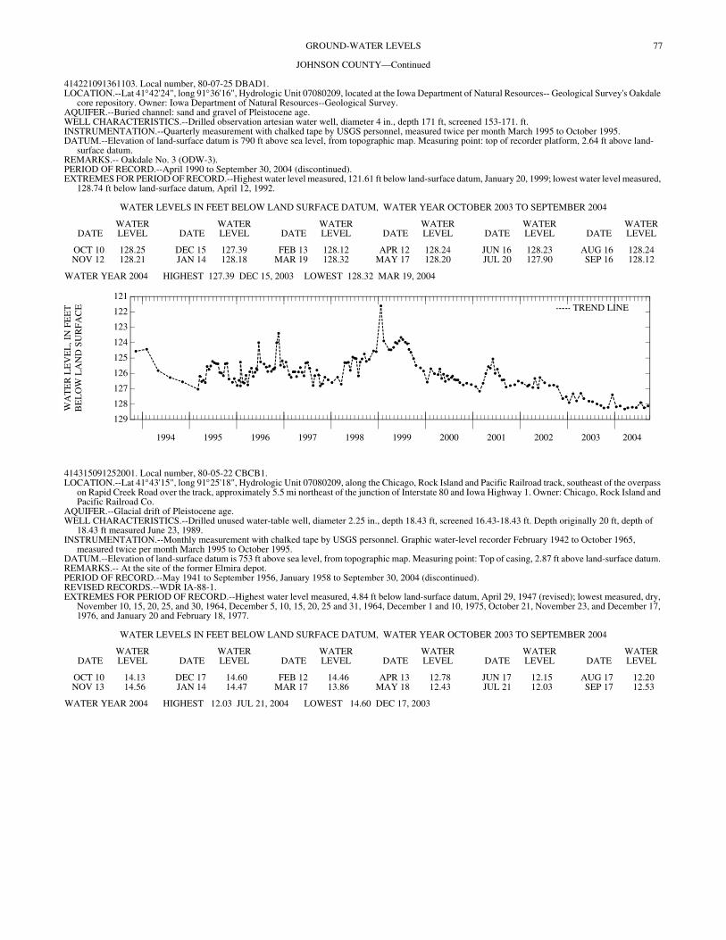
77GROUND-WATER LEVELS
JOHNSON COUNTY—Continued
414221091361103. Local number, 80-07-25 DBAD1. LOCATION.--Lat 41°42'24", long 91°36'16", Hydrologic Unit 07080209, located at the Iowa Department of Natural Resources-- Geological Survey's Oakdale
core repository. Owner: Iowa Department of Natural Resources--Geological Survey. AQUIFER.--Buried channel: sand and gravel of Pleistocene age. WELL CHARACTERISTICS.--Drilled observation artesian water well, diameter 4 in., depth 171 ft, screened 153-171. ft. INSTRUMENTATION.--Quarterly measurement with chalked tape by USGS personnel, measured twice per month March 1995 to October 1995. DATUM.--Elevation of land-surface datum is 790 ft above sea level, from topographic map. Measuring point: top of recorder platform, 2.64 ft above land-
surface datum. REMARKS.-- Oakdale No. 3 (ODW-3). PERIOD OF RECORD.--April 1990 to September 30, 2004 (discontinued). EXTREMES FOR PERIOD OF RECORD.--Highest water level measured, 121.61 ft below land-surface datum, January 20, 1999; lowest water level measured,
128.74 ft below land-surface datum, April 12, 1992.
WATER LEVELS IN FEET BELOW LAND SURFACE DATUM, WATER YEAR OCTOBER 2003 TO SEPTEMBER 2004
DATEWATER LEVEL DATE
WATER LEVEL DATE
WATER LEVEL DATE
WATER LEVEL DATE
WATER LEVEL DATE
WATER LEVEL
OCT 10 128.25 DEC 15 127.39 FEB 13 128.12 APR 12 128.24 JUN 16 128.23 AUG 16 128.24NOV 12 128.21 JAN 14 128.18 MAR 19 128.32 MAY 17 128.20 JUL 20 127.90 SEP 16 128.12
WATER YEAR 2004 HIGHEST 127.39 DEC 15, 2003 LOWEST 128.32 MAR 19, 2004
1994 1995 1996 1997 1998 1999 2000 2001 2002 2003 2004
129
128
127
126
125
124
123
122
121
WA
TE
R L
EV
EL
, IN
FE
ET
BE
LO
W L
AN
D S
UR
FAC
E TREND LINE
414315091252001. Local number, 80-05-22 CBCB1. LOCATION.--Lat 41°43'15", long 91°25'18", Hydrologic Unit 07080209, along the Chicago, Rock Island and Pacific Railroad track, southeast of the overpass
on Rapid Creek Road over the track, approximately 5.5 mi northeast of the junction of Interstate 80 and Iowa Highway 1. Owner: Chicago, Rock Island and Pacific Railroad Co.
AQUIFER.--Glacial drift of Pleistocene age. WELL CHARACTERISTICS.--Drilled unused water-table well, diameter 2.25 in., depth 18.43 ft, screened 16.43-18.43 ft. Depth originally 20 ft, depth of
18.43 ft measured June 23, 1989. INSTRUMENTATION.--Monthly measurement with chalked tape by USGS personnel. Graphic water-level recorder February 1942 to October 1965,
measured twice per month March 1995 to October 1995. DATUM.--Elevation of land-surface datum is 753 ft above sea level, from topographic map. Measuring point: Top of casing, 2.87 ft above land-surface datum. REMARKS.-- At the site of the former Elmira depot. PERIOD OF RECORD.--May 1941 to September 1956, January 1958 to September 30, 2004 (discontinued). REVISED RECORDS.--WDR IA-88-1. EXTREMES FOR PERIOD OF RECORD.--Highest water level measured, 4.84 ft below land-surface datum, April 29, 1947 (revised); lowest measured, dry,
November 10, 15, 20, 25, and 30, 1964, December 5, 10, 15, 20, 25 and 31, 1964, December 1 and 10, 1975, October 21, November 23, and December 17, 1976, and January 20 and February 18, 1977.
WATER LEVELS IN FEET BELOW LAND SURFACE DATUM, WATER YEAR OCTOBER 2003 TO SEPTEMBER 2004
DATEWATER LEVEL DATE
WATER LEVEL DATE
WATER LEVEL DATE
WATER LEVEL DATE
WATER LEVEL DATE
WATER LEVEL
OCT 10 14.13 DEC 17 14.60 FEB 12 14.46 APR 13 12.78 JUN 17 12.15 AUG 17 12.20NOV 13 14.56 JAN 14 14.47 MAR 17 13.86 MAY 18 12.43 JUL 21 12.03 SEP 17 12.53
WATER YEAR 2004 HIGHEST 12.03 JUL 21, 2004 LOWEST 14.60 DEC 17, 2003
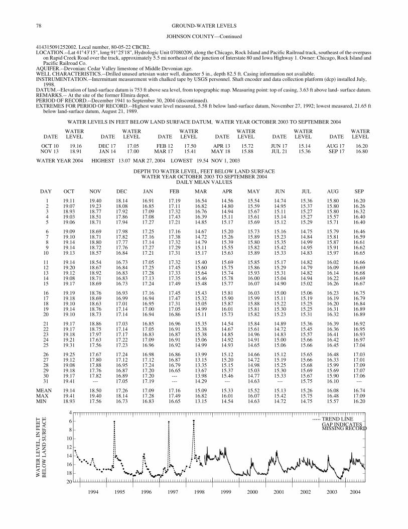
78 GROUND-WATER LEVELS
JOHNSON COUNTY—Continued
414315091252002. Local number, 80-05-22 CBCB2. LOCATION.--Lat 41°43'15", long 91°25'18", Hydrologic Unit 07080209, along the Chicago, Rock Island and Pacific Railroad track, southeast of the overpass
on Rapid Creek Road over the track, approximately 5.5 mi northeast of the junction of Interstate 80 and Iowa Highway 1. Owner: Chicago, Rock Island and Pacific Railroad Co.
AQUIFER.--Devonian: Cedar Valley limestone of Middle Devonian age. WELL CHARACTERISTICS.--Drilled unused artesian water well, diameter 5 in., depth 82.5 ft. Casing information not available. INSTRUMENTATION.--Intermittant measurement with chalked tape by USGS personnel. Shaft encoder and data collection platform (dcp) installed July,
1998. DATUM.--Elevation of land-surface datum is 753 ft above sea level, from topographic map. Measuring point: top of casing, 3.63 ft above land- surface datum. REMARKS.-- At the site of the former Elmira depot. PERIOD OF RECORD.--December 1941 to September 30, 2004 (discontinued). EXTREMES FOR PERIOD OF RECORD.--Highest water level measured, 5.58 ft below land-surface datum, November 27, 1992; lowest measured, 21.65 ft
below land-surface datum, August 21, 1989.
WATER LEVELS IN FEET BELOW LAND SURFACE DATUM, WATER YEAR OCTOBER 2003 TO SEPTEMBER 2004
DATEWATER LEVEL DATE
WATER LEVEL DATE
WATER LEVEL DATE
WATER LEVEL DATE
WATER LEVEL DATE
WATER LEVEL
OCT 10 19.16 DEC 17 17.05 FEB 12 17.50 APR 13 15.72 JUN 17 15.14 AUG 17 16.20NOV 13 18.91 JAN 14 17.00 MAR 17 15.41 MAY 18 15.88 JUL 21 15.36 SEP 17 16.80
WATER YEAR 2004 HIGHEST 13.07 MAR 27, 2004 LOWEST 19.54 NOV 1, 2003
DEPTH TO WATER LEVEL, FEET BELOW LAND SURFACE WATER YEAR OCTOBER 2003 TO SEPTEMBER 2004
DAILY MEAN VALUES
DAY OCT NOV DEC JAN FEB MAR APR MAY JUN JUL AUG SEP
1 19.11 19.40 18.14 16.91 17.19 16.54 14.56 15.54 14.74 15.36 15.80 16.202 19.07 19.23 18.08 16.85 17.11 16.82 14.80 15.59 14.95 15.37 15.80 16.263 18.93 18.77 17.92 17.09 17.32 16.76 14.94 15.67 15.11 15.27 15.80 16.324 19.03 18.51 17.86 17.08 17.43 16.39 15.11 15.61 15.14 15.27 15.57 16.405 19.06 18.71 17.94 17.27 17.21 14.85 15.17 15.69 15.12 15.29 15.71 16.40
6 19.09 18.69 17.98 17.25 17.16 14.67 15.20 15.73 15.16 14.75 15.79 16.467 19.10 18.71 17.82 17.16 17.38 14.72 15.26 15.89 15.23 14.84 15.81 16.598 19.14 18.80 17.77 17.14 17.32 14.79 15.39 15.80 15.35 14.99 15.87 16.619 19.14 18.72 17.76 17.27 17.29 15.11 15.55 15.82 15.42 14.95 15.91 16.62
10 19.13 18.57 16.84 17.21 17.31 15.17 15.63 15.89 15.33 14.83 15.97 16.65
11 19.14 18.54 16.73 17.05 17.32 15.40 15.69 15.85 15.17 14.82 16.02 16.6612 19.20 18.67 16.84 17.25 17.45 15.60 15.75 15.86 15.29 14.79 16.09 16.6913 19.12 18.92 16.83 17.28 17.33 15.64 15.74 15.93 15.31 14.82 16.14 16.6814 19.08 18.71 16.83 17.13 17.35 15.46 15.78 16.00 15.04 14.94 16.22 16.6915 19.17 18.69 16.73 17.24 17.49 15.48 15.77 16.07 14.90 15.02 16.26 16.67
16 19.19 18.76 16.93 17.16 17.45 15.43 15.81 16.03 15.00 15.06 16.23 16.7517 19.18 18.69 16.99 16.94 17.47 15.32 15.90 15.99 15.11 15.19 16.19 16.7918 19.10 18.63 17.01 16.95 17.31 15.05 15.87 15.88 15.22 15.25 16.20 16.8419 19.14 18.76 17.14 17.00 17.05 14.99 16.01 15.81 15.30 15.25 16.31 16.8920 19.10 18.73 17.14 16.94 16.86 15.11 15.73 15.82 15.23 15.31 16.32 16.89
21 19.17 18.86 17.03 16.85 16.96 15.35 14.54 15.84 14.89 15.36 16.39 16.9222 19.17 18.75 17.14 17.05 16.91 15.38 14.67 15.61 14.72 15.45 16.36 16.9523 19.18 17.97 17.17 16.83 16.87 15.38 14.85 14.96 14.83 15.57 16.41 16.9324 19.21 17.63 17.22 17.09 16.91 15.06 14.92 14.91 15.00 15.66 16.42 16.9725 19.31 17.56 17.23 16.96 16.92 14.99 14.93 14.65 15.06 15.66 16.45 17.04
26 19.25 17.67 17.24 16.98 16.86 13.99 15.12 14.66 15.12 15.65 16.48 17.0327 19.12 17.80 17.12 17.12 16.87 13.15 15.20 14.72 15.19 15.66 16.33 17.0128 19.08 17.88 16.95 17.24 16.79 13.35 15.15 14.98 15.25 15.68 15.99 17.0929 19.18 17.76 16.87 17.20 16.65 13.67 15.37 15.03 15.30 15.69 15.69 17.0730 19.17 17.82 16.89 17.20 --- 13.98 15.46 14.77 15.33 15.67 15.90 17.0631 19.41 --- 17.05 17.19 --- 14.29 --- 14.63 --- 15.75 16.10 ---
MEAN 19.14 18.50 17.26 17.09 17.16 15.09 15.33 15.52 15.13 15.26 16.08 16.74MAX 19.41 19.40 18.14 17.28 17.49 16.82 16.01 16.07 15.42 15.75 16.48 17.09MIN 18.93 17.56 16.73 16.83 16.65 13.15 14.54 14.63 14.72 14.75 15.57 16.20
1994 1995 1996 1997 1998 1999 2000 2001 2002 2003 2004
20
18
16
14
12
10
8
6
4
WA
TE
R L
EV
EL
, IN
FE
ET
BE
LO
W L
AN
D S
UR
FAC
E TREND LINEGAP INDICATESMISSING RECORD
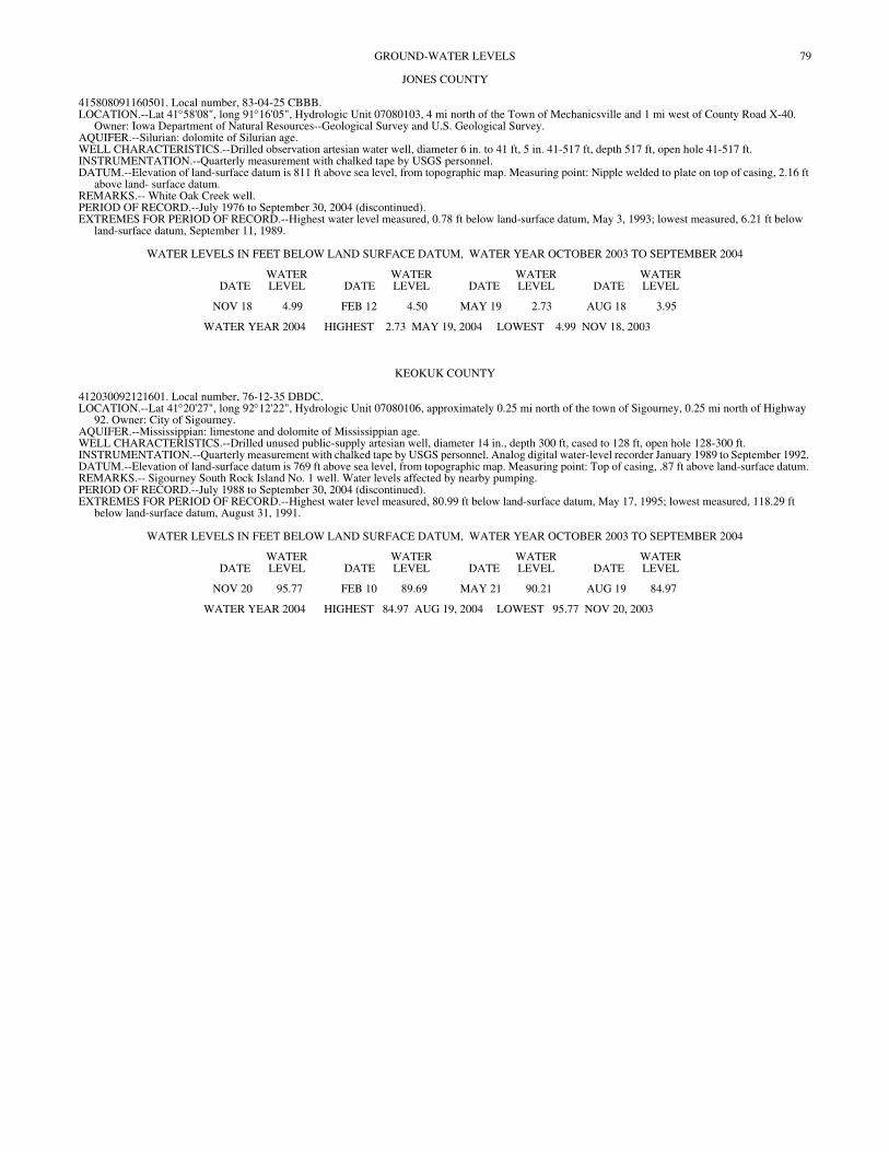
79GROUND-WATER LEVELS
JONES COUNTY
415808091160501. Local number, 83-04-25 CBBB. LOCATION.--Lat 41°58'08", long 91°16'05", Hydrologic Unit 07080103, 4 mi north of the Town of Mechanicsville and 1 mi west of County Road X-40.
Owner: Iowa Department of Natural Resources--Geological Survey and U.S. Geological Survey. AQUIFER.--Silurian: dolomite of Silurian age. WELL CHARACTERISTICS.--Drilled observation artesian water well, diameter 6 in. to 41 ft, 5 in. 41-517 ft, depth 517 ft, open hole 41-517 ft. INSTRUMENTATION.--Quarterly measurement with chalked tape by USGS personnel. DATUM.--Elevation of land-surface datum is 811 ft above sea level, from topographic map. Measuring point: Nipple welded to plate on top of casing, 2.16 ft
above land- surface datum. REMARKS.-- White Oak Creek well. PERIOD OF RECORD.--July 1976 to September 30, 2004 (discontinued). EXTREMES FOR PERIOD OF RECORD.--Highest water level measured, 0.78 ft below land-surface datum, May 3, 1993; lowest measured, 6.21 ft below
land-surface datum, September 11, 1989.
WATER LEVELS IN FEET BELOW LAND SURFACE DATUM, WATER YEAR OCTOBER 2003 TO SEPTEMBER 2004
DATEWATER LEVEL DATE
WATER LEVEL DATE
WATER LEVEL DATE
WATER LEVEL
NOV 18 4.99 FEB 12 4.50 MAY 19 2.73 AUG 18 3.95
WATER YEAR 2004 HIGHEST 2.73 MAY 19, 2004 LOWEST 4.99 NOV 18, 2003
KEOKUK COUNTY
412030092121601. Local number, 76-12-35 DBDC. LOCATION.--Lat 41°20'27", long 92°12'22", Hydrologic Unit 07080106, approximately 0.25 mi north of the town of Sigourney, 0.25 mi north of Highway
92. Owner: City of Sigourney. AQUIFER.--Mississippian: limestone and dolomite of Mississippian age. WELL CHARACTERISTICS.--Drilled unused public-supply artesian well, diameter 14 in., depth 300 ft, cased to 128 ft, open hole 128-300 ft. INSTRUMENTATION.--Quarterly measurement with chalked tape by USGS personnel. Analog digital water-level recorder January 1989 to September 1992. DATUM.--Elevation of land-surface datum is 769 ft above sea level, from topographic map. Measuring point: Top of casing, .87 ft above land-surface datum. REMARKS.-- Sigourney South Rock Island No. 1 well. Water levels affected by nearby pumping. PERIOD OF RECORD.--July 1988 to September 30, 2004 (discontinued). EXTREMES FOR PERIOD OF RECORD.--Highest water level measured, 80.99 ft below land-surface datum, May 17, 1995; lowest measured, 118.29 ft
below land-surface datum, August 31, 1991.
WATER LEVELS IN FEET BELOW LAND SURFACE DATUM, WATER YEAR OCTOBER 2003 TO SEPTEMBER 2004
DATEWATER LEVEL DATE
WATER LEVEL DATE
WATER LEVEL DATE
WATER LEVEL
NOV 20 95.77 FEB 10 89.69 MAY 21 90.21 AUG 19 84.97
WATER YEAR 2004 HIGHEST 84.97 AUG 19, 2004 LOWEST 95.77 NOV 20, 2003
80
GROUND-WATER LEVELSLINN COUNTY
415343091360101. Local number, 82-07-25 AAAB. LOCATION.--Lat 41°53'43", long 91°36'01", Hydrologic Unit 07080208, 0.5 mi northwest of the Town of Ely at the southwest corner of the junction of County
Roads E-70 and W-6E. Owner: Iowa Department of Natural Resources--Geological Survey and U.S. Geological Survey. AQUIFER.--Silurian: limestone and dolomite of Silurian age. WELL CHARACTERISTICS.--Drilled observation artesian water well, diameter 6 in., depth 401 ft, cased to 121.5 ft, open hole 121.5-401 ft. INSTRUMENTATION.--Quarterly measurement with chalked tape by USGS personnel. Graphic water-level recorder April 1978 to October 1979.
Intermittent measurement with chalked tape by USGS personnel May 1976 to April 1978. DATUM.--Elevation of land-surface datum is 772 ft above sea level, from topographic map. Measuring point: Top of casing, 1.76 ft above land-surface datum. REMARKS.-- Ely (Northwest) Railroad well. Records for May 1976 to September 1988 are unpublished and available in the files of the Iowa District Office. PERIOD OF RECORD.--May 1976 to September 30, 2004 (discontinued). EXTREMES FOR PERIOD OF RECORD.--Highest water level measured, 3.03 ft below land-surface datum, August 26, 1993; lowest measured, 19.96 ft
below land-surface datum, June 14, 1977.
WATER LEVELS IN FEET BELOW LAND SURFACE DATUM, WATER YEAR OCTOBER 2003 TO SEPTEMBER 2004
DATEWATER LEVEL DATE
WATER LEVEL DATE
WATER LEVEL DATE
WATER LEVEL
NOV 17 15.42 FEB 12 13.72 MAY 19 11.29 AUG 18 11.40
WATER YEAR 2004 HIGHEST 11.29 MAY 19, 2004 LOWEST 15.42 NOV 17, 2003
415422091422601. Local number, 82-07-18 CDCD. LOCATION.--Lat 41°54'22", long 91°42'29", Hydrologic Unit 07080205, on 76th Avenue SW, approximately 1.5 mi west of U.S. Highway 218, Cedar Rapids.
Owner: Edwin J. Hynek. AQUIFER.--Glacial drift of Pleistocene age. WELL CHARACTERISTICS.--Dug unused water-table well, diameter 4 ft, depth 13.5 ft, cribbed with brick. INSTRUMENTATION.--Quarterly measurement with chalked tape by USGS personnel. Graphic water-level recorder July 1959 to September 1987. DATUM.--Elevation of land-surface datum is 835 ft above sea level, from topographic map. Measuring point: Base of recorder shelter, 0.37 ft above land-
surface datum. REMARKS.-- Well previously owned by Lester Petrak. PERIOD OF RECORD.--July 1959 to September 30, 2004 (discontinued). REVISED RECORDS.--WDR IA-84-1. EXTREMES FOR PERIOD OF RECORD.--Highest water level recorded, 1.09 ft below land-surface datum, August 4, 1968; lowest recorded, 11.75 ft below
land-surface datum, February 8, 1977.
WATER LEVELS IN FEET BELOW LAND SURFACE DATUM, WATER YEAR OCTOBER 2003 TO SEPTEMBER 2004
DATEWATER LEVEL DATE
WATER LEVEL DATE
WATER LEVEL DATE
WATER LEVEL
NOV 17 8.04 FEB 13 6.17 MAY 19 5.21 AUG 18 8.35
WATER YEAR 2004 HIGHEST 5.21 MAY 19, 2004 LOWEST 8.35 AUG 18, 2004
415725091410101. Local number, 83-07-32 ACDC. LOCATION.--Lat 41°57'25", long 91°41'01", Hydrologic Unit 07080205, northwest corner of 22nd Avenue SW and 11th Street SW, Cedar Rapids. Owner:
Dayle Moyer. AQUIFER.--Silurian: limestone of Silurian age. WELL CHARACTERISTICS.--Drilled unused artesian water well, diameter 5 in., depth 282 ft. Casing information not available. INSTRUMENTATION.--Quarterly measurement with chalked tape by USGS personnel. DATUM.--Elevation of land-surface datum is 805 ft above sea level, from topographic map. Measuring point: Plug in well cover at land-surface datum. REMARKS.-- Water levels may be affected by pumping of near by wells. Well previously owned by Floyd Fetter. PERIOD OF RECORD.--July 1940 to September 30, 2004 (discontinued). REVISED RECORDS.--WDR IA-88-1. EXTREMES FOR PERIOD OF RECORD.--Highest water level measured, 75.88 ft below land-surface datum, January 26, 1942; lowest measured, 107.00 ft
below land-surface datum, September 16, 1976.
WATER LEVELS IN FEET BELOW LAND SURFACE DATUM, WATER YEAR OCTOBER 2003 TO SEPTEMBER 2004
DATEWATER LEVEL DATE
WATER LEVEL DATE
WATER LEVEL DATE
WATER LEVEL
NOV 17 87.74 FEB 12 86.18 MAY 19 86.24 AUG 18 87.38
WATER YEAR 2004 HIGHEST 86.18 FEB 12, 2004 LOWEST 87.74 NOV 17, 2003
81GROUND-WATER LEVELS
LINN COUNTY—Continued
415834091351601. Local number, 83-06-30 ABBA. LOCATION.--Lat 41°58'34", long 91°35'14", Hydrologic Unit 07080206, approximately 200 ft west of 5201 Mount Vernon Road SE, Cedar Rapids. Owner:
Vulcan Auto Yard. Formerly owned by B.L. Anderson. AQUIFER.--Silurian-Devonian: dolomite of Silurian and limestone and dolomite of Devonian age. WELL CHARACTERISTICS.--Drilled unused artesian water well, diameter 6 in., depth 76.5 ft. Casing information not available. INSTRUMENTATION.--Quarterly measurement with chalked tape by USGS personnel. DATUM.--Elevation of land-surface datum is 755 ft above sea level, from topographic map. Measuring point: Hole in pump base, 0.50 ft above land-surface
datum. REMARKS.-- Katz well. PERIOD OF RECORD.--May 1940 to September 30, 2004 (discontinued). EXTREMES OF PERIOD OF RECORD.--Highest water level measured, 37.68 ft below land-surface datum, August 24, 1993; lowest measured, 53.90 ft below
land-surface datum, December 21, 1970.
WATER LEVELS IN FEET BELOW LAND SURFACE DATUM, WATER YEAR OCTOBER 2003 TO SEPTEMBER 2004
DATEWATER LEVEL DATE
WATER LEVEL DATE
WATER LEVEL DATE
WATER LEVEL
NOV 17 50.90 FEB 12 51.09 MAY 19 50.11 AUG 18 49.84
WATER YEAR 2004 HIGHEST 49.84 AUG 18, 2004 LOWEST 51.09 FEB 12, 2004
420300091325801. Local number, 84-06-33 ABBB. LOCATION.--Lat 42°03'00", long 91°32'58", Hydrologic Unit 07080206, near the City of Marion on the east side of Iowa Highway 13, approximately 1 mi
north of U.S. Highway 151. Owner: Iowa Department of Natural Resources--Geological Survey and U.S. Geological Survey. AQUIFER.--Silurian: dolomite of Silurian age. WELL CHARACTERISTICS.--Drilled observation artesian well, diameter 6 in. to 142 ft, 5 in. 142-161 ft, depth 481 ft, open hole 161-481 ft. INSTRUMENTATION.--Quarterly measurement with chalked tape by USGS personnel. DATUM.--Elevation of land-surface datum is 838 ft above sea level, from topographic map. Measuring point: Top of casing, 0.90 ft above land-surface datum. REMARKS.-- Marion well. PERIOD OF RECORD.--June 1976 to September 30, 2004 (discontinued). EXTREMES FOR PERIOD OF RECORD.--Highest water level measured, 42.15 ft below land-surface datum, June 18, 1986; lowest measured, 50.49 ft below
land-surface datum, February 6, 2003.
WATER LEVELS IN FEET BELOW LAND SURFACE DATUM, WATER YEAR OCTOBER 2003 TO SEPTEMBER 2004
DATEWATER LEVEL DATE
WATER LEVEL DATE
WATER LEVEL DATE
WATER LEVEL
NOV 17 48.45 FEB 11 49.94 MAY 19 47.20 AUG 18 48.24
WATER YEAR 2004 HIGHEST 47.20 MAY 19, 2004 LOWEST 49.94 FEB 11, 2004
420508091395811. Local number, 84-07-16 DBBB. LOCATION.--Lat 42°05'15", long 91°40'04", Hydrologic Unit 07080205, approximately 0.5 mi south of County Road E-34, north of the Town of Robins.
Owner: Iowa Department of Natural Resources--Geological Survey and U.S. Geological Survey. AQUIFER.--Silurian: dolomite of Silurian age. WELL CHARACTERISTICS.--Drilled observation artesian water well, diameter 6 in. to 60.6 ft, 5 in. to 173 ft, depth 520 ft, open hole 173-520 ft. Open to
Devonian rock 173-197, Silurian 196.5-510 ft. INSTRUMENTATION.--Quarterly measurement with chalked tape by USGS personnel. Graphic water-level recorder November 1975 to September 1979.
Intermittent measurement with chalked tape by USGS personnel April 1975 to November 1975. DATUM.--Elevation of land-surface datum is 873 ft above sea level, from topographic map. Measuring point: Top of casing, 1.20 ft above land-surface datum. REMARKS.-- Robins well. Records for April 1975 to September 1988 are unpublished and available in the files of the Iowa District Office. PERIOD OF RECORD.--April 1975 to September 30, 2004 (discontinued). EXTREMES FOR PERIOD OF RECORD.--Highest water level measured, 36.33 ft below land-surface datum, August 24, 1993; lowest measured, 57.50 ft
below land-surface datum, December 1, 1989.
WATER LEVELS IN FEET BELOW LAND SURFACE DATUM, WATER YEAR OCTOBER 2003 TO SEPTEMBER 2004
DATEWATER LEVEL DATE
WATER LEVEL DATE
WATER LEVEL DATE
WATER LEVEL
NOV 17 47.48 FEB 11 48.49 MAY 19 45.96 AUG 18 49.32
WATER YEAR 2004 HIGHEST 45.96 MAY 19, 2004 LOWEST 49.32 AUG 18, 2004
82 GROUND-WATER LEVELS
LINN COUNTY—Continued
420526091370701. Local number, 84-07-13 BCBB. LOCATION.--Lat 42°05'26", long 91°37'07", Hydrologic Unit 07080206, approximately 0.25 mi south of the junction of County Roads W-58 and E-34, on
the east side of the road, or approximately 3.75 mi north of the City of Marion. Owner: U.S. Geological Survey. AQUIFER.--Glacial drift of Pleistocene age. WELL CHARACTERISTICS.--Drilled observation water-table well, diameter 1.25 in., depth 17 ft, screened 15-17 ft. INSTRUMENTATION.--Monthly measurement with chalked tape by USGS personnel. DATUM.--Elevation of land-surface datum is 882 ft above sea level, from topographic map. Measuring point: Nipple welded to casing, 1.24 ft above land-
surface datum. REMARKS.-- USGS13E2 well. PERIOD OF RECORD.--September 1948 to September 30, 2004 (discontinued). EXTREMES FOR PERIOD OF RECORD.--Highest water level measured, 0.93 ft below land-surface datum, May 18, 1982; lowest measured, 15.19 ft below
land-surface datum, January 20, 1977.
WATER LEVELS IN FEET BELOW LAND SURFACE DATUM, WATER YEAR OCTOBER 2003 TO SEPTEMBER 2004
DATEWATER LEVEL DATE
WATER LEVEL DATE
WATER LEVEL DATE
WATER LEVEL DATE
WATER LEVEL DATE
WATER LEVEL
OCT 10 8.06 DEC 17 3.57 FEB 11 4.81 APR 13 3.73 JUN 17 3.56 AUG 18 6.58NOV 13 4.13 JAN 13 3.76 MAR 17 2.42 MAY 19 3.87 JUL 23 5.74 SEP 17 7.56
WATER YEAR 2004 HIGHEST 2.42 MAR 17, 2004 LOWEST 8.06 OCT 10, 2003
420730091490401. Local number, 85-08-31 DDCD1. LOCATION.--Lat 42°07'29", long 91°49'01", Hydrologic Unit 07080205, at the fenced north end of Pleasant Creek Reservoir near the beach house in the beach
area. Owner: Iowa Department of Natural Resources--Geological Survey and U.S. Geological Survey. AQUIFER.--Silurian: dolomite of Silurian age. WELL CHARACTERISTICS.--Drilled observation artesian water well, diameter 6 in. to 53.5 ft, 5 in. to 214 ft, depth 481 ft, open hole 214-481 ft. INSTRUMENTATION.--Quarterly measurement with chalked tape by USGS personnel. Graphic water-level recorder May 1975 to December 1979. DATUM.--Elevation of land-surface datum is 833 ft above sea level, from topographic map. Measuring point: Top of casing, 1.17 ft above land-surface datum. REMARKS.-- Pleasant Creek Reservoir/Silurian well. Records for May 1975 to September 1988 are unpublished and available in the files of the Iowa District
Office. PERIOD OF RECORD.--May 1975 to September 30, 2004 (discontinued). EXTREMES FOR PERIOD OF RECORD.--Highest water level measured, 20.73 ft below land-surface datum, May 03, 1999; lowest measured, 108.49 ft
below land-surface datum, August 4, 1997.
WATER LEVELS IN FEET BELOW LAND SURFACE DATUM, WATER YEAR OCTOBER 2003 TO SEPTEMBER 2004
DATEWATER LEVEL DATE
WATER LEVEL DATE
WATER LEVEL DATE
WATER LEVEL
NOV 17 30.72 FEB 12 32.58 MAY 19 30.46 AUG 18 31.00
WATER YEAR 2004 HIGHEST 30.46 MAY 19, 2004 LOWEST 32.58 FEB 12, 2004
420730091490402. Local number, 85-08-31 DDCD2. LOCATION.--Lat 42°07'29", long 91°49'01", Hydrologic Unit 07080205, at the fenced north end of Pleasant Creek Reservoir near the beach house in the beach
area. Owner: Iowa Department of Natural Resources--Geological Survey and U.S. Geological Survey. AQUIFER.--Devonian: limestone and dolomite of Devonian age. WELL CHARACTERISTICS.--Drilled observation artesian well, diameter 5 in., depth 205 ft, cased to 52 ft, open hole 52-205 ft. INSTRUMENTATION.--Quarterly measurement with chalked tape by USGS personnel. Graphic water-level recorder May 1975 to December 1979. DATUM.--Elevation of land-surface datum is 841 ft above sea level, from topographic map. Measuring point: Top of casing, 2.38 ft above land-surface datum. REMARKS.-- Pleasant Creek Reservoir/Devonian well. Records for May 1975 to September 1989 are unpublished and available in the Iowa District Office. PERIOD OF RECORD.--May 1975 to May 1980, April 1984 to September 30, 2004 (discontinued). EXTREMES FOR PERIOD OF RECORD.--Highest water level measured, 14.60 ft below land-surface datum, May 31, 1991; lowest measured, 48.55 ft below
land-surface datum, November 12, 1976.
WATER LEVELS IN FEET BELOW LAND SURFACE DATUM, WATER YEAR OCTOBER 2003 TO SEPTEMBER 2004
DATEWATER LEVEL DATE
WATER LEVEL DATE
WATER LEVEL DATE
WATER LEVEL
NOV 17 18.83 FEB 12 19.07 MAY 19 18.78 AUG 18 19.30
WATER YEAR 2004 HIGHEST 18.78 MAY 19, 2004 LOWEST 19.30 AUG 18, 2004
83GROUND-WATER LEVELS
LINN COUNTY—Continued
421149091403301. Local number, 85-07-04 CCCC. LOCATION.--Lat 42°11'51", long 91°40'33", Hydrologic Unit 07080205, approximately 5 mi east of the Town of Center Point, north side of County Road E-
16. Owner: Iowa Department of Natural Resources--Geological Survey and U.S. Geological Survey. AQUIFER.--Silurian-Devonian: dolomite of Silurian age and limestone and dolomite of Devonian age. WELL CHARACTERISTICS.--Drilled observation artesian water well, diameter 6 in. to 41 ft, 5 in 129-147 ft, depth 435 ft, open hole 41-129 ft and 147-435
ft. Devonian rock 23-139 ft, Silurian rock 139-431 ft. INSTRUMENTATION.--Quarterly measurement with chalked tape by USGS personnel. Graphic water-level recorder March 1974 to December 1979.
Intermittent measurement with chalked tape by USGS personnel July 1973 to March 1974. DATUM.--Elevation of land-surface datum is 912 ft above sea level, from topographic map. Measuring point: Nipple welded to plate on top of casing, 1.21 ft
above land- surface datum. REMARKS.-- Alice well. PERIOD OF RECORD.--July 1973 to September 30, 2004 (discontinued). REVISED RECORDS.--WDR IA-84-1. EXTREMES FOR PERIOD OF RECORD.--Highest water level measured, 17.06 ft below land-surface datum, June 10, 1974; lowest measured, 34.27 ft below
land-surface datum, December 1, 1989.
WATER LEVELS IN FEET BELOW LAND SURFACE DATUM, WATER YEAR OCTOBER 2003 TO SEPTEMBER 2004
DATEWATER LEVEL DATE
WATER LEVEL DATE
WATER LEVEL DATE
WATER LEVEL
NOV 17 28.09 FEB 11 27.27 MAY 19 24.99 AUG 18 27.56
WATER YEAR 2004 HIGHEST 24.99 MAY 19, 2004 LOWEST 28.09 NOV 17, 2003
421207091312201. Local number, 85-06-03 DABB. LOCATION.--Lat 42°12'07", long 91°31'24", Hydrologic Unit 07080102, located east of State Highway 13 in the Town of Central City. Owner: Town of
Central City. AQUIFER.--Silurian. WELL CHARCTERISTICS.--Drilled pumping well, diameter 6 in., depth 106 ft., casing information not available. INSTRUMENTATION.--Quarterly measurements with airline by USGS personnel. DATUM.--Elevation of land-surface datum is 825 ft, by topographic map. REMARKS.--Central City Well. PERIOD OF RECORD.--August 1997 to September 30, 2004 (discontinued). EXTREMES FOR PERIOD OF RECORD.--Highest water level measured, 8.0 feet below land-surface datum, May 09, 2001; lowest measured, 22 ft below
land-surface datum, February 23, 1998.
WATER LEVELS IN FEET BELOW LAND SURFACE DATUM, WATER YEAR OCTOBER 2003 TO SEPTEMBER 2004
DATEWATER LEVEL DATE
WATER LEVEL DATE
WATER LEVEL DATE
WATER LEVEL
NOV 17 18 FEB 11 18 MAY 19 16 AUG 18 16
WATER YEAR 2004 HIGHEST 16 MAY 19, 2004 AUG 18, 2004LOWEST 18 NOV 17, 2003 FEB 11, 2004
LYON COUNTY
431812096302701. Local number, 98-48-16 DDAD. LOCATION.--Lat 43°18'21", long 96°30'29", Hydrologic Unit 10170203, approximately 3.5 mi east of the City of Canton, S.D., south of U.S. Highway 18.
Owner: Iowa Department of Natural Resources--Geological Survey and U.S. Geological Survey. AQUIFER.--Dakota: sandstone of Cretaceous age. WELL CHARACTERISTICS.--Drilled observation artesian water well, diameter 2 in., depth 358 ft, screened 335-355 ft. Open to Late Precambrian Sioux
quartzite 353-358 ft. INSTRUMENTATION.--Quarterly measurement with chalked tape by USGS personnel. DATUM.--Elevation of land-surface datum is 1,268 ft above sea level, from topographic map. Measuring point: Top of casing, 2.00 ft above land-surface
datum. REMARKS.-- Well D-20. PERIOD OF RECORD.--December 1978 to December 1980, May 1982 to September 30, 2004 (discontinued). EXTREMES FOR PERIOD OF RECORD.--Highest water level measured, 91.89 ft below land-surface datum, July 8, 1986; lowest measured, 107.60 ft below
land-surface datum, November 7, 1991.
WATER LEVELS IN FEET BELOW LAND SURFACE DATUM, WATER YEAR OCTOBER 2003 TO SEPTEMBER 2004
DATEWATER LEVEL DATE
WATER LEVEL DATE
WATER LEVEL DATE
WATER LEVEL
NOV 06 101.79 FEB 10 102.06 MAY 04 101.99 AUG 03 102.80
WATER YEAR 2004 HIGHEST 101.79 NOV 06, 2003 LOWEST 102.80 AUG 03, 2004
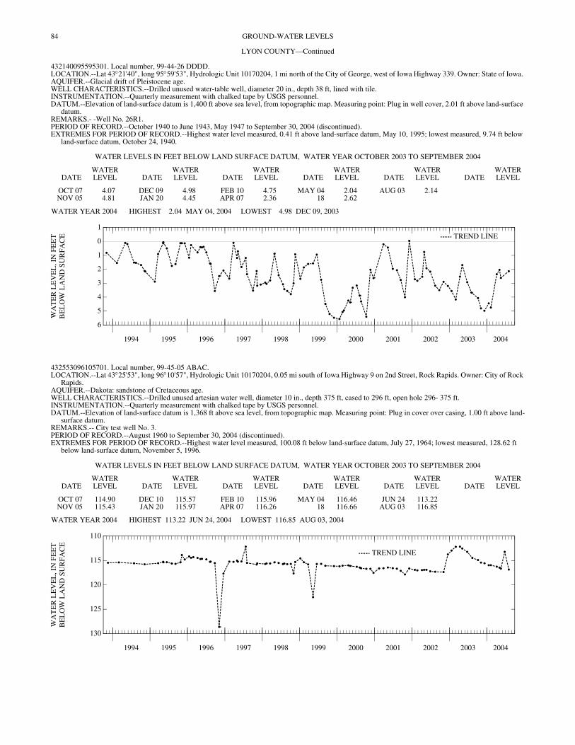
84 GROUND-WATER LEVELS
LYON COUNTY—Continued
432140095595301. Local number, 99-44-26 DDDD. LOCATION.--Lat 43°21'40", long 95°59'53", Hydrologic Unit 10170204, 1 mi north of the City of George, west of Iowa Highway 339. Owner: State of Iowa. AQUIFER.--Glacial drift of Pleistocene age. WELL CHARACTERISTICS.--Drilled unused water-table well, diameter 20 in., depth 38 ft, lined with tile. INSTRUMENTATION.--Quarterly measurement with chalked tape by USGS personnel. DATUM.--Elevation of land-surface datum is 1,400 ft above sea level, from topographic map. Measuring point: Plug in well cover, 2.01 ft above land-surface
datum. REMARKS.- -Well No. 26R1. PERIOD OF RECORD.--October 1940 to June 1943, May 1947 to September 30, 2004 (discontinued). EXTREMES FOR PERIOD OF RECORD.--Highest water level measured, 0.41 ft above land-surface datum, May 10, 1995; lowest measured, 9.74 ft below
land-surface datum, October 24, 1940.
WATER LEVELS IN FEET BELOW LAND SURFACE DATUM, WATER YEAR OCTOBER 2003 TO SEPTEMBER 2004
DATEWATER LEVEL DATE
WATER LEVEL DATE
WATER LEVEL DATE
WATER LEVEL DATE
WATER LEVEL DATE
WATER LEVEL
OCT 07 4.07 DEC 09 4.98 FEB 10 4.75 MAY 04 2.04 AUG 03 2.14NOV 05 4.81 JAN 20 4.45 APR 07 2.36 18 2.62
WATER YEAR 2004 HIGHEST 2.04 MAY 04, 2004 LOWEST 4.98 DEC 09, 2003
1994 1995 1996 1997 1998 1999 2000 2001 2002 2003 2004
6
5
4
3
2
1
0
1
WA
TE
R L
EV
EL
, IN
FE
ET
BE
LO
W L
AN
D S
UR
FAC
E TREND LINE
432553096105701. Local number, 99-45-05 ABAC. LOCATION.--Lat 43°25'53", long 96°10'57", Hydrologic Unit 10170204, 0.05 mi south of Iowa Highway 9 on 2nd Street, Rock Rapids. Owner: City of Rock
Rapids. AQUIFER.--Dakota: sandstone of Cretaceous age. WELL CHARACTERISTICS.--Drilled unused artesian water well, diameter 10 in., depth 375 ft, cased to 296 ft, open hole 296- 375 ft. INSTRUMENTATION.--Quarterly measurement with chalked tape by USGS personnel. DATUM.--Elevation of land-surface datum is 1,368 ft above sea level, from topographic map. Measuring point: Plug in cover over casing, 1.00 ft above land-
surface datum. REMARKS.-- City test well No. 3. PERIOD OF RECORD.--August 1960 to September 30, 2004 (discontinued). EXTREMES FOR PERIOD OF RECORD.--Highest water level measured, 100.08 ft below land-surface datum, July 27, 1964; lowest measured, 128.62 ft
below land-surface datum, November 5, 1996.
WATER LEVELS IN FEET BELOW LAND SURFACE DATUM, WATER YEAR OCTOBER 2003 TO SEPTEMBER 2004
DATEWATER LEVEL DATE
WATER LEVEL DATE
WATER LEVEL DATE
WATER LEVEL DATE
WATER LEVEL DATE
WATER LEVEL
OCT 07 114.90 DEC 10 115.57 FEB 10 115.96 MAY 04 116.46 JUN 24 113.22NOV 05 115.43 JAN 20 115.97 APR 07 116.26 18 116.66 AUG 03 116.85
WATER YEAR 2004 HIGHEST 113.22 JUN 24, 2004 LOWEST 116.85 AUG 03, 2004
1994 1995 1996 1997 1998 1999 2000 2001 2002 2003 2004
130
125
120
115
110
WA
TE
R L
EV
EL
, IN
FE
ET
BE
LO
W L
AN
D S
UR
FAC
E
TREND LINE

85GROUND-WATER LEVELS
LYON COUNTY—Continued
432601096335511. Local number, 100-48-31 CCCC11. LOCATION.--Lat 43°26'01", long 96°33'55", Hydrologic Unit 10170203, 0.5 mi west and 2.5 mi south of the Village of Granite. Owner: Iowa Department of
Natural Resources--Geological Survey and U.S. Geological Survey. AQUIFER.--Dakota: sandstone of Cretaceous age. WELL CHARACTERISTICS.--Drilled observation artesian water well, diameter 2 in., depth 657 ft, screened 450-455 ft and 630-650 ft. Dakota 437-653 ft,
Sioux Quartzite 653-657 ft. INSTRUMENTATION.--Quarterly measurement with chalked tape by USGS personnel. DATUM.--Elevation of land-surface datum is 1,417 ft above sea level, from topographic map. Measuring point: Top of casing at land-surface datum. REMARKS.-- Well D-19. PERIOD OF RECORD.--December 1978 to December 1980, May 1982 to September 30, 2004 (discontinued). EXTREMES FOR PERIOD OF RECORD.--Highest water level measured, 151.57 ft below land-surface datum, February 11, 1994; lowest measured, 164.00
ft below land-surface datum, February 05, 1992.
WATER LEVELS IN FEET BELOW LAND SURFACE DATUM, WATER YEAR OCTOBER 2003 TO SEPTEMBER 2004
DATEWATER LEVEL DATE
WATER LEVEL DATE
WATER LEVEL DATE
WATER LEVEL
NOV 06 156.43 FEB 10 156.50 MAY 04 156.15 AUG 03 155.59
WATER YEAR 2004 HIGHEST 155.59 AUG 03, 2004 LOWEST 156.50 FEB 10, 2004
MADISON COUNTY
411727093483001. Local number, 75-26-23 AAAC. LOCATION.--Lat 41°17'26", long 93°48'36", Hydrologic Unit 07100008, near the shelter house in the city park, St. Charles. Owner: City of St. Charles. AQUIFER.--Mississippian: limestone of Mississippian age. WELL CHARACTERISTICS.--Drilled unused artesian water well, diameter 8 in., depth 867 ft, cased to 657 ft, open hole 657- 867 ft. INSTRUMENTATION.--Quarterly measurement with chalked tape by USGS personnel. DATUM.--Elevation of land-surface datum is 1,067 ft above sea level, from topographic map. Measuring point: Plug in well cover, 1.20 ft above land-surface
datum. REMARKS.-- City well No. 1. PERIOD OF RECORD.--November 1962 to September 30, 2004 (discontinued). EXTREMES FOR PERIOD OF RECORD.--Highest water level measured, 181.93 ft below land-surface datum, August 14, 2002; lowest measured, 283.37 ft
below land-surface datum, August 02, 2004.
WATER LEVELS IN FEET BELOW LAND SURFACE DATUM, WATER YEAR OCTOBER 2003 TO SEPTEMBER 2004
DATEWATER LEVEL DATE
WATER LEVEL DATE
WATER LEVEL DATE
WATER LEVEL
NOV 14 283.18 FEB 10 283.08 MAY 06 283.15 AUG 02 283.37
WATER YEAR 2004 HIGHEST 283.08 FEB 10, 2004 LOWEST 283.37 AUG 02, 2004
MAHASKA COUNTY
411912092273601. Local number, 75-14-10 BAAC. LOCATION.--Lat 41°19'13", long 92°27'36", Hydrologic Unit 07080106, approximately 0.5 mi south of Iowa Highway 92 in the town of Rose Hill. Owner:
City of Rose Hill. AQUIFER.--Mississippian: limestone and dolomite of Mississippian age. WELL CHARACTERISTICS.--Drilled unused public-supply artesian well, diameter 6 in., depth 370 ft, casing information not available. INSTRUMENTATION.--Quarterly measurement with chalked tape by USGS personnel. Analog digital water-level recorder July 1990 to October 1992.
Intermittent measurement with chalked tape by USGS personnel May 1989 to June 1989. DATUM.--Elevation of land-surface datum is 815 ft above sea level, from topographic map. Measuring point: Top of recorder platform, 1.63 ft above land-
surface datum. REMARKS.-- Rose Hill No. 2 well. PERIOD OF RECORD.--May 1989 to September 30, 2004 (discontinued). EXTREMES FOR PERIOD OF RECORD.--Highest water level measured, 100.03 ft below land-surface datum, May 05, 1999; lowest measured, 107.51 ft
below land-surface datum, February 08, 1999.
WATER LEVELS IN FEET BELOW LAND SURFACE DATUM, WATER YEAR OCTOBER 2003 TO SEPTEMBER 2004
DATEWATER LEVEL DATE
WATER LEVEL DATE
WATER LEVEL DATE
WATER LEVEL
NOV 20 101.45 FEB 10 102.03 MAY 21 101.52 AUG 19 101.63
WATER YEAR 2004 HIGHEST 101.45 NOV 20, 2003 LOWEST 102.03 FEB 10, 2004
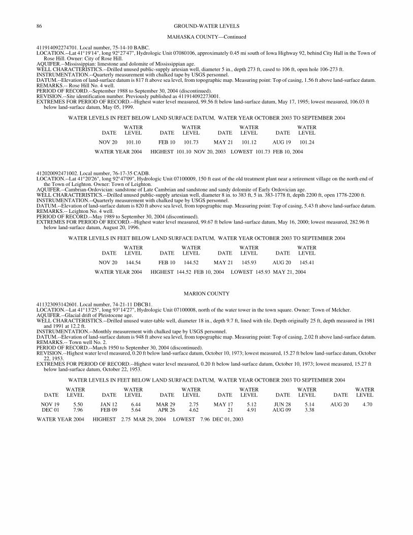
86 GROUND-WATER LEVELS
MAHASKA COUNTY—Continued
411914092274701. Local number, 75-14-10 BABC. LOCATION.--Lat 41°19'14", long 92°27'47", Hydrologic Unit 07080106, approximately 0.45 mi south of Iowa Highway 92, behind City Hall in the Town of
Rose Hill. Owner: City of Rose Hill. AQUIFER.--Mississippian: limestone and dolomite of Mississippian age. WELL CHARACTERISTICS.--Drilled unused public-supply artesian well, diameter 5 in., depth 273 ft, cased to 106 ft, open hole 106-273 ft. INSTRUMENTATION.--Quarterly measurement with chalked tape by USGS personnel. DATUM.--Elevation of land-surface datum is 817 ft above sea level, from topographic map. Measuring point: Top of casing, 1.56 ft above land-surface datum. REMARKS.-- Rose Hill No. 4 well. PERIOD OF RECORD.--September 1988 to September 30, 2004 (discontinued). REVISION.--Site identification number. Previously published as 411914092273001. EXTREMES FOR PERIOD OF RECORD.--Highest water level measured, 99.56 ft below land-surface datum, May 17, 1995; lowest measured, 106.03 ft
below land-surface datum, May 05, 1999.
WATER LEVELS IN FEET BELOW LAND SURFACE DATUM, WATER YEAR OCTOBER 2003 TO SEPTEMBER 2004
DATEWATER LEVEL DATE
WATER LEVEL DATE
WATER LEVEL DATE
WATER LEVEL
NOV 20 101.10 FEB 10 101.73 MAY 21 101.12 AUG 19 101.24
WATER YEAR 2004 HIGHEST 101.10 NOV 20, 2003 LOWEST 101.73 FEB 10, 2004
412020092471002. Local number, 76-17-35 CADB. LOCATION.--Lat 41°20'26", long 92°47'09", Hydrologic Unit 07100009, 150 ft east of the old treatment plant near a retirement village on the north end of
the Town of Leighton. Owner: Town of Leighton. AQUIFER.--Cambrian-Ordovician: sandstone of Late Cambrian and sandstone and sandy dolomite of Early Ordovician age. WELL CHARACTERISTICS.--Drilled unused public-supply artesian well, diameter 8 in. to 383 ft, 5 in. 383-1778 ft, depth 2200 ft, open 1778-2200 ft. INSTRUMENTATION.--Quarterly measurement with chalked tape by USGS personnel. DATUM.--Elevation of land-surface datum is 820 ft above sea level, from topographic map. Measuring point: Top of casing, 5.43 ft above land-surface datum. REMARKS.-- Leighton No. 4 well. PERIOD OF RECORD.--May 1989 to September 30, 2004 (discontinued). EXTREMES FOR PERIOD OF RECORD.--Highest water level measured, 99.67 ft below land-surface datum, May 16, 2000; lowest measured, 282.96 ft
below land-surface datum, August 20, 1996.
WATER LEVELS IN FEET BELOW LAND SURFACE DATUM, WATER YEAR OCTOBER 2003 TO SEPTEMBER 2004
DATEWATER LEVEL DATE
WATER LEVEL DATE
WATER LEVEL DATE
WATER LEVEL
NOV 20 144.54 FEB 10 144.52 MAY 21 145.93 AUG 20 145.41
WATER YEAR 2004 HIGHEST 144.52 FEB 10, 2004 LOWEST 145.93 MAY 21, 2004
MARION COUNTY
411323093142601. Local number, 74-21-11 DBCB1. LOCATION.--Lat 41°13'25", long 93°14'27", Hydrologic Unit 07100008, north of the water tower in the town square. Owner: Town of Melcher. AQUIFER.--Glacial drift of Pleistocene age. WELL CHARACTERISTICS.--Drilled unused water-table well, diameter 18 in., depth 9.7 ft, lined with tile. Depth originally 25 ft, depth measured in 1981
and 1991 at 12.2 ft. INSTRUMENTATION.--Monthly measurement with chalked tape by USGS personnel. DATUM.--Elevation of land-surface datum is 948 ft above sea level, from topographic map. Measuring point: Top of casing, 2.02 ft above land-surface datum. REMARKS.-- Town well No. 2. PERIOD OF RECORD.--March 1950 to September 30, 2004 (discontinued). REVISION.--Highest water level measured, 0.20 ft below land-surface datum, October 10, 1973; lowest measured, 15.27 ft below land-surface datum, October
22, 1953. EXTREMES FOR PERIOD OF RECORD.--Highest water level measured, 0.20 ft below land-surface datum, October 10, 1973; lowest measured, 15.27 ft
below land-surface datum, October 22, 1953.
WATER LEVELS IN FEET BELOW LAND SURFACE DATUM, WATER YEAR OCTOBER 2003 TO SEPTEMBER 2004
DATEWATER LEVEL DATE
WATER LEVEL DATE
WATER LEVEL DATE
WATER LEVEL DATE
WATER LEVEL DATE
WATER LEVEL
NOV 19 5.50 JAN 12 6.44 MAR 29 2.75 MAY 17 5.12 JUN 28 5.14 AUG 20 4.70DEC 01 7.96 FEB 09 5.64 APR 26 4.62 21 4.91 AUG 09 3.38
WATER YEAR 2004 HIGHEST 2.75 MAR 29, 2004 LOWEST 7.96 DEC 01, 2003
87GROUND-WATER LEVELS
MARION COUNTY—Continued
411328093143503. Local number, 74-21-11 CAAD3. LOCATION.--Lat 41°13'30", long 93°14'33", Hydrologic Unit 07100008, northeast corner of the junction of West 1st Street and North A Street, Melcher.
Owner: Town of Melcher. AQUIFER.--Glacial drift of Pleistocene age. WELL CHARACTERISTICS.--Drilled unused artesian water well, diameter 1.25 in., depth 96.5 ft, screened 78-80 ft, open hole 80-96.5 ft. INSTRUMENTATION.--Monthly measurement with chalked tape by USGS personnel. DATUM.--Elevation of land-surface datum is 944 ft above sea level, from topographic map. Measuring point: Nipple welded to casing, 0.51 ft above land-
surface datum. REMARKS.--Town well No. 5, well 11L1. PERIOD OF RECORD.--August 1953 to September 30, 2004 (discontinued). EXTREMES FOR PERIOD OF RECORD.--Highest water level measured, 8.29 ft below land-surface datum, May 7, 1996; lowest measured (nearby well
pumping), 55.16 ft, revised, below land-surface datum, March 4, 1954.
WATER LEVELS IN FEET BELOW LAND SURFACE DATUM, WATER YEAR OCTOBER 2003 TO SEPTEMBER 2004
DATEWATER LEVEL DATE
WATER LEVEL DATE
WATER LEVEL DATE
WATER LEVEL
NOV 19 13.09 FEB 09 12.64 MAY 21 12.10 AUG 20 11.86
WATER YEAR 2004 HIGHEST 11.86 AUG 20, 2004 LOWEST 13.09 NOV 19, 2003
411329093142902. Local number, 74-21-11 DBBB2. LOCATION.--Lat 41°13'33", long 93°14'29", Hydrologic Unit 07100008, southeast corner of the T junction of North B Street and Main Street, Melcher.
Owner: Town of Melcher. AQUIFER.--Glacial drift of Pleistocene age. WELL CHARACTERISTICS.--Drilled unused artesian water well, diameter 6 in., depth 119 ft, cased to 76 ft, open hole 76-119 ft. INSTRUMENTATION.--Monthly measurement with chalked tape by USGS personnel. DATUM.--Elevation of land-surface datum is 943 ft above sea level, from topographic map. Measuring point: Nipple welded to plate on top of casing, 1.82 ft
above land- surface datum. REMARKS.-- Town well No. 3, well 11K1. PERIOD OF RECORD.--July 1945 to December 1955, October 1976 to September 30, 2004 (discontinued). EXTREMES FOR PERIOD OF RECORD.--Highest water level measured, 11.16 ft below land-surface datum, May 07, 1996; lowest measured (nearby well
pumping), 108.85 ft below land-surface datum, December 4, 6-7, 1949.
WATER LEVELS IN FEET BELOW LAND SURFACE DATUM, WATER YEAR OCTOBER 2003 TO SEPTEMBER 2004
DATEWATER LEVEL DATE
WATER LEVEL DATE
WATER LEVEL DATE
WATER LEVEL
NOV 19 21.52 FEB 09 21.40 MAY 19 21.12 AUG 20 20.89
WATER YEAR 2004 HIGHEST 20.89 AUG 20, 2004 LOWEST 21.52 NOV 19, 2003
MARSHALL COUNTY
420355092534701. Local number, 84-18-24 CDCA. LOCATION.--Lat 42°03'55", long 92°53'47", Hydrologic Unit 07080208, east of Riverview Park and south of the sewage treatment plant, Marshalltown.
Owner: City of Marshalltown. AQUIFER.--Glacial drift of Pleistocene age. WELL CHARACTERISTICS.--Drilled unused artesian water well, diameter 8 in., depth 200 ft, screened 190-200 ft. INSTRUMENTATION.--Quarterly measurement with electric line or chalked tape by USGS personnel. DATUM.--Elevation of land-surface datum is 871 ft above sea level, from topographic map. Measuring point: Top of casing, 0.22 ft above land-surface datum. REMARKS.-- Marshalltown city well. PERIOD OF RECORD.--May 1949 to August 1971, March 1973 to September 30, 2004 (discontinued). EXTREMES FOR PERIOD OF RECORD.--Highest water level measured, 4.92 ft below land-surface datum, July 13, 1951; lowest measured, 61.04 ft below
land-surface datum, November 2, 1995.
WATER LEVELS IN FEET BELOW LAND SURFACE DATUM, WATER YEAR OCTOBER 2003 TO SEPTEMBER 2004
DATEWATER LEVEL DATE
WATER LEVEL DATE
WATER LEVEL DATE
WATER LEVEL
NOV 13 49.65 FEB 09 46.21 MAY 04 42.07 AUG 02 48.95
WATER YEAR 2004 HIGHEST 42.07 MAY 04, 2004 LOWEST 49.65 NOV 13, 2003

88 GROUND-WATER LEVELS
MILLS COUNTY
405641095365101. Local number, 71-42-24 AAAA. LOCATION.--Lat 40°56'41", long 95°36'51", Hydrologic Unit 10240002, at the intersection of County Roads M-16 and H-46, approximately 5 mi southeast
of the City of Malvern. Owner: Iowa Department of Natural Resources--Geological Survey and U.S. Geological Survey. AQUIFER.--Buried channel of Pleistocene age. WELL CHARACTERISTICS.--Drilled observation water-table well, diameter 2 in., depth 255 ft, screened 240-250 ft, gravel packed. INSTRUMENTATION.--Quarterly measurement with chalked tape by USGS personnel. DATUM.--Elevation of land-surface datum is 1,102 ft above sea level, from topographic map. Measuring point: Top of casing, 2.20 ft above land-surface
datum. REMARKS.-- Well SW-41. PERIOD OF RECORD.--June 1990 and August 1992 to September 30, 2004. EXTREMES FOR PERIOD OF RECORD.--Highest water level measured, 135.50 feet below land-surface datum, August 5, 1993; lowest measured, 170.00
ft below land-surface datum, July 30, 2001.
WATER LEVELS IN FEET BELOW LAND SURFACE DATUM, WATER YEAR OCTOBER 2003 TO SEPTEMBER 2004
DATEWATER LEVEL DATE
WATER LEVEL DATE
WATER LEVEL DATE
WATER LEVEL
NOV 06 143.33 FEB 17 143.37 MAY 06 142.71 AUG 02 140.29
WATER YEAR 2004 HIGHEST 140.29 AUG 02, 2004 LOWEST 143.37 FEB 17, 2004
405813095433201. Local number, 71-42-07 BBCD. LOCATION.--Lat 40°58'13", long 95°43'32", Hydrologic Unit 10240001, on the west side of the T-intersection of county roads, approximately 5.5 mi south
of the City of Glenwood. Owner: Iowa Department of Natural Resources--Geological Survey and U.S. Geological Survey. AQUIFER.--Buried channel: sand and gravel of Pleistocene age. WELL CHARACTERISTICS.--Drilled observation water-table well, diameter 2 in., depth 351 ft, screened 332-342 ft, gravel packed. INSTRUMENTATION.--Quarterly measurement with chalked tape by USGS personnel. DATUM.--Elevation of land-surface datum is 1,122 ft above sea level, from topographic map. Measuring point: Top of casing, 1.80 ft above land-surface
datum. REMARKS.-- Well SW-40. PERIOD OF RECORD.--August 1992 to September 30, 2004 (discontinued). EXTREMES FOR PERIOD OF RECORD.--Highest water level measured, 165.70 feet below land-surface datum, August 5, 1993; lowest measured, 175.86
ft below land-surface datum, August 14, 2002.
WATER LEVELS IN FEET BELOW LAND SURFACE DATUM, WATER YEAR OCTOBER 2003 TO SEPTEMBER 2004
DATEWATER LEVEL DATE
WATER LEVEL DATE
WATER LEVEL DATE
WATER LEVEL
NOV 06 174.43 FEB 17 174.59 MAY 06 173.10 AUG 02 171.40
WATER YEAR 2004 HIGHEST 171.40 AUG 02, 2004 LOWEST 174.59 FEB 17, 2004
MITCHELL COUNTY
432156092484101. Local number, 95-17-23 DAA1. LOCATION.--Lat 43°22'42", long 92°48'41", Hydrologic Unit 07080201, approximately 4 mi southwest of Staceyville, at the intersection of Highway 218 and
County Road T40. Owner: Iowa Department of Natural Resources--Geological Survey and U.S. Geological Survey. AQUIFER.--Glacial drift of Pleistocene age. WELL CHARACTERISTICS.--Drilled observation well, diameter 2 in., depth 27 ft, screened 10-27 ft. INSTRUMENTATION.--Quarterly measurement with chalked tape by USGS personnel. DATUM.--Elevation of land-surface datum is 1,210 ft above sea level, from topographic map. Measuring point: Top of casing, 2.41 ft above land-surface
datum. REMARKS.-- Well FM-2T. PERIOD OF RECORD.--August 1992 to September 30, 2004 (discontinued). EXTREMES FOR PERIOD OF RECORD.--Highest water level measured, 1.46 ft above land-surface datum, May 6, 1993; lowest measured, 7.32 ft below
land-surface datum, February 04, 2004.
WATER LEVELS IN FEET BELOW LAND SURFACE DATUM, WATER YEAR OCTOBER 2003 TO SEPTEMBER 2004
DATEWATER LEVEL DATE
WATER LEVEL DATE
WATER LEVEL DATE
WATER LEVEL
NOV 13 5.58 FEB 04 7.32 MAY 05 3.34 AUG 03 3.21
WATER YEAR 2004 HIGHEST 3.21 AUG 03, 2004 LOWEST 7.32 FEB 04, 2004
89GROUND-WATER LEVELS
MITCHELL COUNTY—Continued
432156092484102. Local number, 95-17-23 DAA2. LOCATION.--Lat 43°22'42", long 92°48'41", Hydrologic Unit 07080201, approximately 4 mi southwest of Staceyville, at the intersection of Highway 218 and
County Road T40. Owner: Iowa Department of Natural Resources--Geological Survey and U.S. Geological Survey. AQUIFER.--Devonian: dolomite of Devonian age. WELL CHARACTERISTICS.--Drilled observation well, diameter 1 in., depth 70 ft, screened 55-70 ft. INSTRUMENTATION.--Quarterly measurement with chalked tape by USGS personnel. DATUM.--Elevation of land-surface datum is 1,210 ft above sea level, from topographic map. Measuring point: Top of casing, 2.58 ft above land-surface
datum. REMARKS.-- Well FM-2 (1). PERIOD OF RECORD.--August 1992 to September 30, 2004 (discontinued). EXTREMES FOR PERIOD OF RECORD.--Highest water level measured, 6.89 ft above land-surface datum, August 23, 1993; lowest measured, 14.07 ft
below land-surface datum, February 04, 2004.
WATER LEVELS IN FEET BELOW LAND SURFACE DATUM, WATER YEAR OCTOBER 2003 TO SEPTEMBER 2004
DATEWATER LEVEL DATE
WATER LEVEL DATE
WATER LEVEL DATE
WATER LEVEL
NOV 13 12.54 FEB 04 14.07 MAY 05 12.42 AUG 03 9.78
WATER YEAR 2004 HIGHEST 9.78 AUG 03, 2004 LOWEST 14.07 FEB 04, 2004
432156092484103. Local number, 95-17-23 DAA3. LOCATION.--Lat 43°22'42", long 92°48'41", Hydrologic Unit 07080201, approximately 4 mi southwest of Staceyville, at the intersection of Highway 218 and
County Road T40. Owner: Iowa Department of Natural Resources--Geological Survey and U.S. Geological Survey. AQUIFER.--Devonian: dolomite of Devonian age. WELL CHARACTERISTICS.--Drilled observation well, diameter 1.5 in., depth 150 ft, screened 110-150 ft. INSTRUMENTATION.--Quarterly measurement with chalked tape by USGS personnel. DATUM.--Elevation of land-surface datum is 1,210 ft above sea level, from topographic map. Measuring point: Top of casing, 2.55 ft above land-surface
datum. REMARKS.-- Well FM-2 (2). PERIOD OF RECORD.--August 1992 to September 30, 2004 (discontinued). EXTREMES FOR PERIOD OF RECORD.--Highest water level measured, 6.78 ft above land-surface datum, August 23, 1993; lowest measured, 15.41 ft
below land-surface datum, February 04, 2004.
WATER LEVELS IN FEET BELOW LAND SURFACE DATUM, WATER YEAR OCTOBER 2003 TO SEPTEMBER 2004
DATEWATER LEVEL DATE
WATER LEVEL DATE
WATER LEVEL DATE
WATER LEVEL
NOV 13 13.60 FEB 04 15.41 MAY 05 13.81 AUG 03 10.11
WATER YEAR 2004 HIGHEST 10.11 AUG 03, 2004 LOWEST 15.41 FEB 04, 2004
432156092484104. Local number, 95-17-23 DAA4. LOCATION.--Lat 43°22'42", long 92°48'41", Hydrologic Unit 07080201, approximately 4 mi southwest of Staceyville, at the intersection of Highway 218 and
County Road T40. Owner: Iowa Department of Natural Resources--Geological Survey and U.S. Geological Survey. AQUIFER.--Devonian: dolomite of Devonian age. WELL CHARACTERISTICS.--Drilled observation well, diameter 1.5 in., depth 250 ft, screened 188-250 ft. INSTRUMENTATION.--Quarterly measurement with chalked tape by USGS personnel. DATUM.--Elevation of land-surface datum is 1,210 ft above sea level, from topographic map. Measuring point: Top of casing, 2.44 ft above land-surface
datum. REMARKS.-- Well FM-2 (3). PERIOD OF RECORD.--August 1992 to September 30, 2004 (discontinued). EXTREMES FOR PERIOD OF RECORD.--Highest water level measured, 5.54 ft above land-surface datum, May 6, 1993; lowest measured, 19.52 ft below
land-surface datum, February 04, 2004.
WATER LEVELS IN FEET BELOW LAND SURFACE DATUM, WATER YEAR OCTOBER 2003 TO SEPTEMBER 2004
DATEWATER LEVEL DATE
WATER LEVEL DATE
WATER LEVEL DATE
WATER LEVEL
NOV 13 17.27 FEB 04 19.52 MAY 05 18.17 AUG 03 11.82
WATER YEAR 2004 HIGHEST 11.82 AUG 03, 2004 LOWEST 19.52 FEB 04, 2004
90 GROUND-WATER LEVELS
MITCHELL COUNTY—Continued
432156092484105. Local number, 95-17-23 DAA5. LOCATION.--Lat 43°22'42", long 92°48'41", Hydrologic Unit 07080201, approximately 4 mi southwest of Staceyville, at the intersection of Highway 218 and
County Road T40. Owner: Iowa Department of Natural Resources--Geological Survey and U.S. Geological Survey. AQUIFER.--Devonian: dolomite of Devonian age. WELL CHARACTERISTICS.--Drilled observation well, diameter 1.5 in., depth 348 ft, screened 278-348 ft. INSTRUMENTATION.--Quarterly measurement with chalked tape by USGS personnel. DATUM.--Elevation of land-surface datum is 1,210 ft above sea level, from topographic map. Measuring point: Top of casing, 2.37 ft above land-surface
datum. REMARKS.-- Well FM-2 (4). PERIOD OF RECORD.--August 1992 to September 30, 2004 (discontinued). EXTREMES FOR PERIOD OF RECORD.--Highest water level measured, 10.04 ft above land-surface datum, August 23, 1993; lowest measured, 25.59 ft
below land-surface datum, February 04, 2004.
WATER LEVELS IN FEET BELOW LAND SURFACE DATUM, WATER YEAR OCTOBER 2003 TO SEPTEMBER 2004
DATEWATER LEVEL DATE
WATER LEVEL DATE
WATER LEVEL DATE
WATER LEVEL
NOV 13 22.58 FEB 04 25.59 MAY 05 24.42 AUG 03 17.08
WATER YEAR 2004 HIGHEST 17.08 AUG 03, 2004 LOWEST 25.59 FEB 04, 2004
MONONA COUNTY
415456095414101. Local number, 82-42-14 ADCA. LOCATION.--Lat 41°54'56", long 95°41'41", Hydrologic Unit 10230007, approximately 6 mi southeast of the Town of Soldier, on the north side of Iowa
Highway 37. Owner: Iowa Department of Natural Resources--Geological Survey and U.S. Geological Survey. AQUIFER.--Dakota: sandstone of Cretaceous age. WELL CHARACTERISTICS.--Drilled observation artesian water well, diameter 2 in., depth 341 ft, slotted 311-336 ft, gravel- packed, open 336-341 ft. INSTRUMENTATION.--Quarterly measurement with chalked tape or electric line by USGS personnel. DATUM.--Elevation of land-surface datum is 1,340 ft above sea level, from topographic map. Measuring point: Top of casing, 2.02 ft above land-surface
datum. REMARKS.-- Well WC-4. PERIOD OF RECORD.--May 1981 to September 30, 2004 (discontinued). EXTREMES FOR PERIOD OF RECORD.--Highest water level measured, 240.25 ft below land-surface datum, January 10, 1984; lowest measured, 249.00 ft
below land-surface datum, November 04, 1996.
WATER LEVELS IN FEET BELOW LAND SURFACE DATUM, WATER YEAR OCTOBER 2003 TO SEPTEMBER 2004
DATEWATER LEVEL DATE
WATER LEVEL DATE
WATER LEVEL DATE
WATER LEVEL
NOV 05 245.57 FEB 12 245.23 MAY 04 245.37 AUG 04 245.43
WATER YEAR 2004 HIGHEST 245.23 FEB 12, 2004 LOWEST 245.57 NOV 05, 2003
420004095451501. Local number, 83-42-17 ACDD. LOCATION.--Lat 41°00'04", long 95°45'15", Hydrologic Unit 10230001, approximately 1.75 mi northeast of the Town of Soldier, 0.25 mi west of Iowa
Highway 183. Owner: Iowa Department of Natural Resources--Geological Survey and U.S. Geological Survey. AQUIFER.--Glacial drift of Pleistocene age. WELL CHARACTERISTICS.--Drilled observation artesian water well, diameter 2 in., depth 161 ft, screened 149-154 ft. Open to Pennsylvanian shale and
limestone 153-161 ft. INSTRUMENTATION.--Quarterly measurement with chalked tape by USGS personnel. DATUM.--Elevation of land-surface datum is 1,160 ft above sea level, from topographic map. Measuring point: Top of casing, 2.20 ft above land-surface
datum. REMARKS.-- Well WC-176. PERIOD OF RECORD.--May 1983 to September 30, 2004 (discontinued). EXTREMES FOR PERIOD OF RECORD.--Highest water level measured, 54.50 ft below land-surface datum, November 6, 1991; lowest measured, 64.09 ft
below land-surface datum, September 7, 1983.
WATER LEVELS IN FEET BELOW LAND SURFACE DATUM, WATER YEAR OCTOBER 2003 TO SEPTEMBER 2004
DATEWATER LEVEL DATE
WATER LEVEL DATE
WATER LEVEL DATE
WATER LEVEL
NOV 05 61.79 FEB 12 61.64 MAY 04 61.29 AUG 04 62.17
WATER YEAR 2004 HIGHEST 61.29 MAY 04, 2004 LOWEST 62.17 AUG 04, 2004
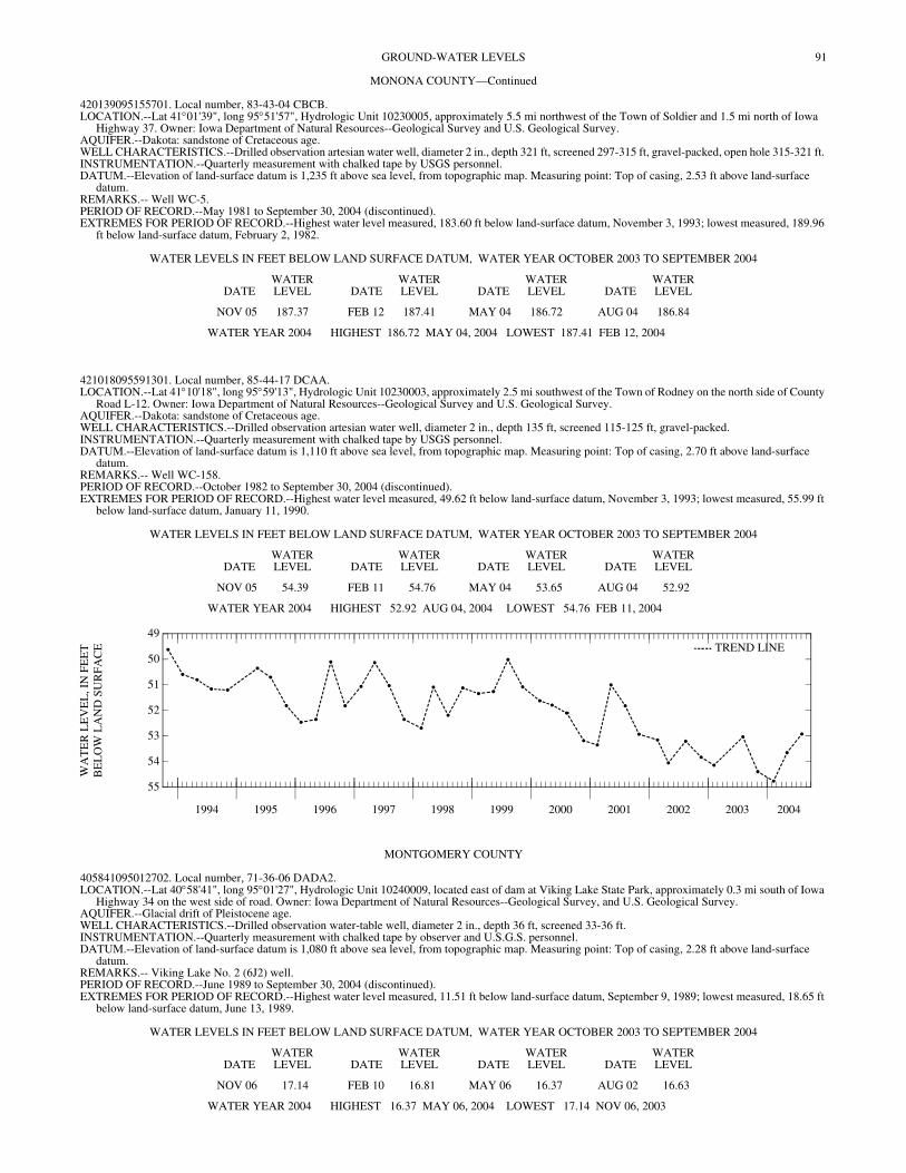
91GROUND-WATER LEVELS
MONONA COUNTY—Continued
420139095155701. Local number, 83-43-04 CBCB. LOCATION.--Lat 41°01'39", long 95°51'57", Hydrologic Unit 10230005, approximately 5.5 mi northwest of the Town of Soldier and 1.5 mi north of Iowa
Highway 37. Owner: Iowa Department of Natural Resources--Geological Survey and U.S. Geological Survey. AQUIFER.--Dakota: sandstone of Cretaceous age. WELL CHARACTERISTICS.--Drilled observation artesian water well, diameter 2 in., depth 321 ft, screened 297-315 ft, gravel-packed, open hole 315-321 ft. INSTRUMENTATION.--Quarterly measurement with chalked tape by USGS personnel. DATUM.--Elevation of land-surface datum is 1,235 ft above sea level, from topographic map. Measuring point: Top of casing, 2.53 ft above land-surface
datum. REMARKS.-- Well WC-5. PERIOD OF RECORD.--May 1981 to September 30, 2004 (discontinued). EXTREMES FOR PERIOD OF RECORD.--Highest water level measured, 183.60 ft below land-surface datum, November 3, 1993; lowest measured, 189.96
ft below land-surface datum, February 2, 1982.
WATER LEVELS IN FEET BELOW LAND SURFACE DATUM, WATER YEAR OCTOBER 2003 TO SEPTEMBER 2004
DATEWATER LEVEL DATE
WATER LEVEL DATE
WATER LEVEL DATE
WATER LEVEL
NOV 05 187.37 FEB 12 187.41 MAY 04 186.72 AUG 04 186.84
WATER YEAR 2004 HIGHEST 186.72 MAY 04, 2004 LOWEST 187.41 FEB 12, 2004
421018095591301. Local number, 85-44-17 DCAA. LOCATION.--Lat 41°10'18", long 95°59'13", Hydrologic Unit 10230003, approximately 2.5 mi southwest of the Town of Rodney on the north side of County
Road L-12. Owner: Iowa Department of Natural Resources--Geological Survey and U.S. Geological Survey. AQUIFER.--Dakota: sandstone of Cretaceous age. WELL CHARACTERISTICS.--Drilled observation artesian water well, diameter 2 in., depth 135 ft, screened 115-125 ft, gravel-packed. INSTRUMENTATION.--Quarterly measurement with chalked tape by USGS personnel. DATUM.--Elevation of land-surface datum is 1,110 ft above sea level, from topographic map. Measuring point: Top of casing, 2.70 ft above land-surface
datum. REMARKS.-- Well WC-158. PERIOD OF RECORD.--October 1982 to September 30, 2004 (discontinued). EXTREMES FOR PERIOD OF RECORD.--Highest water level measured, 49.62 ft below land-surface datum, November 3, 1993; lowest measured, 55.99 ft
below land-surface datum, January 11, 1990.
WATER LEVELS IN FEET BELOW LAND SURFACE DATUM, WATER YEAR OCTOBER 2003 TO SEPTEMBER 2004
DATEWATER LEVEL DATE
WATER LEVEL DATE
WATER LEVEL DATE
WATER LEVEL
NOV 05 54.39 FEB 11 54.76 MAY 04 53.65 AUG 04 52.92
WATER YEAR 2004 HIGHEST 52.92 AUG 04, 2004 LOWEST 54.76 FEB 11, 2004
1994 1995 1996 1997 1998 1999 2000 2001 2002 2003 2004
55
54
53
52
51
50
49
WA
TE
R L
EV
EL
, IN
FE
ET
BE
LO
W L
AN
D S
UR
FA
CE TREND LINE
MONTGOMERY COUNTY
405841095012702. Local number, 71-36-06 DADA2. LOCATION.--Lat 40°58'41", long 95°01'27", Hydrologic Unit 10240009, located east of dam at Viking Lake State Park, approximately 0.3 mi south of Iowa
Highway 34 on the west side of road. Owner: Iowa Department of Natural Resources--Geological Survey, and U.S. Geological Survey. AQUIFER.--Glacial drift of Pleistocene age. WELL CHARACTERISTICS.--Drilled observation water-table well, diameter 2 in., depth 36 ft, screened 33-36 ft. INSTRUMENTATION.--Quarterly measurement with chalked tape by observer and U.S.G.S. personnel. DATUM.--Elevation of land-surface datum is 1,080 ft above sea level, from topographic map. Measuring point: Top of casing, 2.28 ft above land-surface
datum. REMARKS.-- Viking Lake No. 2 (6J2) well. PERIOD OF RECORD.--June 1989 to September 30, 2004 (discontinued). EXTREMES FOR PERIOD OF RECORD.--Highest water level measured, 11.51 ft below land-surface datum, September 9, 1989; lowest measured, 18.65 ft
below land-surface datum, June 13, 1989.
WATER LEVELS IN FEET BELOW LAND SURFACE DATUM, WATER YEAR OCTOBER 2003 TO SEPTEMBER 2004
DATEWATER LEVEL DATE
WATER LEVEL DATE
WATER LEVEL DATE
WATER LEVEL
NOV 06 17.14 FEB 10 16.81 MAY 06 16.37 AUG 02 16.63
WATER YEAR 2004 HIGHEST 16.37 MAY 06, 2004 LOWEST 17.14 NOV 06, 2003
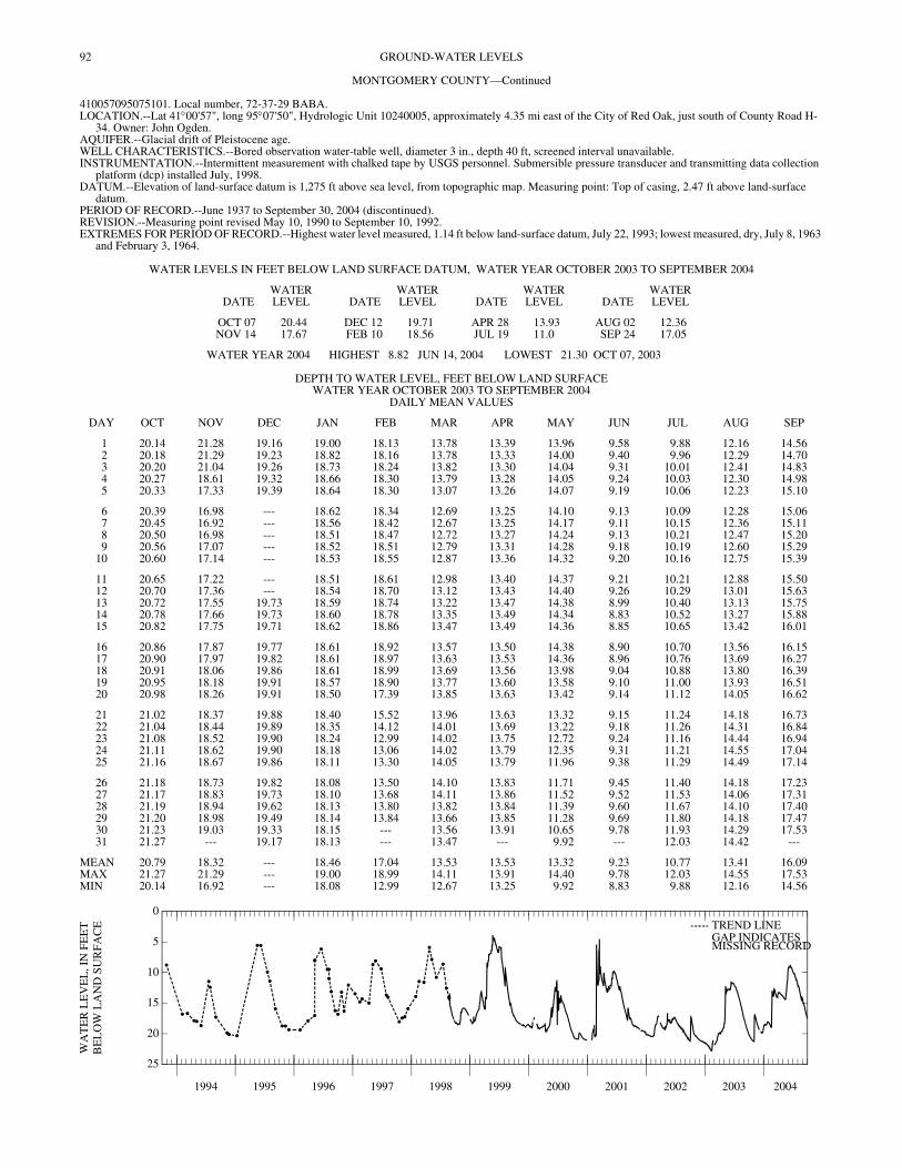
92 GROUND-WATER LEVELS
MONTGOMERY COUNTY—Continued
410057095075101. Local number, 72-37-29 BABA. LOCATION.--Lat 41°00'57", long 95°07'50", Hydrologic Unit 10240005, approximately 4.35 mi east of the City of Red Oak, just south of County Road H-
34. Owner: John Ogden. AQUIFER.--Glacial drift of Pleistocene age. WELL CHARACTERISTICS.--Bored observation water-table well, diameter 3 in., depth 40 ft, screened interval unavailable. INSTRUMENTATION.--Intermittent measurement with chalked tape by USGS personnel. Submersible pressure transducer and transmitting data collection
platform (dcp) installed July, 1998. DATUM.--Elevation of land-surface datum is 1,275 ft above sea level, from topographic map. Measuring point: Top of casing, 2.47 ft above land-surface
datum. PERIOD OF RECORD.--June 1937 to September 30, 2004 (discontinued). REVISION.--Measuring point revised May 10, 1990 to September 10, 1992. EXTREMES FOR PERIOD OF RECORD.--Highest water level measured, 1.14 ft below land-surface datum, July 22, 1993; lowest measured, dry, July 8, 1963
and February 3, 1964.
WATER LEVELS IN FEET BELOW LAND SURFACE DATUM, WATER YEAR OCTOBER 2003 TO SEPTEMBER 2004
DATEWATER LEVEL DATE
WATER LEVEL DATE
WATER LEVEL DATE
WATER LEVEL
OCT 07 20.44 DEC 12 19.71 APR 28 13.93 AUG 02 12.36NOV 14 17.67 FEB 10 18.56 JUL 19 11.0 SEP 24 17.05
WATER YEAR 2004 HIGHEST 8.82 JUN 14, 2004 LOWEST 21.30 OCT 07, 2003
DEPTH TO WATER LEVEL, FEET BELOW LAND SURFACE WATER YEAR OCTOBER 2003 TO SEPTEMBER 2004
DAILY MEAN VALUES
DAY OCT NOV DEC JAN FEB MAR APR MAY JUN JUL AUG SEP
1 20.14 21.28 19.16 19.00 18.13 13.78 13.39 13.96 9.58 9.88 12.16 14.562 20.18 21.29 19.23 18.82 18.16 13.78 13.33 14.00 9.40 9.96 12.29 14.703 20.20 21.04 19.26 18.73 18.24 13.82 13.30 14.04 9.31 10.01 12.41 14.834 20.27 18.61 19.32 18.66 18.30 13.79 13.28 14.05 9.24 10.03 12.30 14.985 20.33 17.33 19.39 18.64 18.30 13.07 13.26 14.07 9.19 10.06 12.23 15.10
6 20.39 16.98 --- 18.62 18.34 12.69 13.25 14.10 9.13 10.09 12.28 15.067 20.45 16.92 --- 18.56 18.42 12.67 13.25 14.17 9.11 10.15 12.36 15.118 20.50 16.98 --- 18.51 18.47 12.72 13.27 14.24 9.13 10.21 12.47 15.209 20.56 17.07 --- 18.52 18.51 12.79 13.31 14.28 9.18 10.19 12.60 15.29
10 20.60 17.14 --- 18.53 18.55 12.87 13.36 14.32 9.20 10.16 12.75 15.39
11 20.65 17.22 --- 18.51 18.61 12.98 13.40 14.37 9.21 10.21 12.88 15.5012 20.70 17.36 --- 18.54 18.70 13.12 13.43 14.40 9.26 10.29 13.01 15.6313 20.72 17.55 19.73 18.59 18.74 13.22 13.47 14.38 8.99 10.40 13.13 15.7514 20.78 17.66 19.73 18.60 18.78 13.35 13.49 14.34 8.83 10.52 13.27 15.8815 20.82 17.75 19.71 18.62 18.86 13.47 13.49 14.36 8.85 10.65 13.42 16.01
16 20.86 17.87 19.77 18.61 18.92 13.57 13.50 14.38 8.90 10.70 13.56 16.1517 20.90 17.97 19.82 18.61 18.97 13.63 13.53 14.36 8.96 10.76 13.69 16.2718 20.91 18.06 19.86 18.61 18.99 13.69 13.56 13.98 9.04 10.88 13.80 16.3919 20.95 18.18 19.91 18.57 18.90 13.77 13.60 13.58 9.10 11.00 13.93 16.5120 20.98 18.26 19.91 18.50 17.39 13.85 13.63 13.42 9.14 11.12 14.05 16.62
21 21.02 18.37 19.88 18.40 15.52 13.96 13.63 13.32 9.15 11.24 14.18 16.7322 21.04 18.44 19.89 18.35 14.12 14.01 13.69 13.22 9.18 11.26 14.31 16.8423 21.08 18.52 19.90 18.24 12.99 14.02 13.75 12.72 9.24 11.16 14.44 16.9424 21.11 18.62 19.90 18.18 13.06 14.02 13.79 12.35 9.31 11.21 14.55 17.0425 21.16 18.67 19.86 18.11 13.30 14.05 13.79 11.96 9.38 11.29 14.49 17.14
26 21.18 18.73 19.82 18.08 13.50 14.10 13.83 11.71 9.45 11.40 14.18 17.2327 21.17 18.83 19.73 18.10 13.68 14.11 13.86 11.52 9.52 11.53 14.06 17.3128 21.19 18.94 19.62 18.13 13.80 13.82 13.84 11.39 9.60 11.67 14.10 17.4029 21.20 18.98 19.49 18.14 13.84 13.66 13.85 11.28 9.69 11.80 14.18 17.4730 21.23 19.03 19.33 18.15 --- 13.56 13.91 10.65 9.78 11.93 14.29 17.5331 21.27 --- 19.17 18.13 --- 13.47 --- 9.92 --- 12.03 14.42 ---
MEAN 20.79 18.32 --- 18.46 17.04 13.53 13.53 13.32 9.23 10.77 13.41 16.09MAX 21.27 21.29 --- 19.00 18.99 14.11 13.91 14.40 9.78 12.03 14.55 17.53MIN 20.14 16.92 --- 18.08 12.99 12.67 13.25 9.92 8.83 9.88 12.16 14.56
1994 1995 1996 1997 1998 1999 2000 2001 2002 2003 2004
25
20
15
10
5
0
WA
TE
R L
EV
EL
, IN
FE
ET
BE
LO
W L
AN
D S
UR
FAC
E TREND LINEGAP INDICATESMISSING RECORD
93GROUND-WATER LEVELS
MUSCATINE COUNTY
412120091080401. Local number, 76-02-30 CBAA1. LOCATION.--Lat 41°21'20", long 91°08'01", Hydrologic Unit 07080101, west of the Town of Fruitland on an Iowa State University Agricultural Experiment
Farm. Owner: U.S. Geological Survey. AQUIFER.--Alluvial: Mississippi River sand and gravel of Holocene age. WELL CHARACTERISTICS.--Drilled observation water-table well, diameter 6 in., depth 27 ft, screened 24-27 ft. INSTRUMENTATION.--Intermittent measurement with chalked tape by USGS personnel. Graphic water-level recorder May 1966 to October 1987. DATUM.--Elevation of land-surface datum is 546 ft above sea level, from topographic map. Measuring point: Top of casing, 3.40 ft above land-surface datum. REMARKS.--Fruitland/30M4 well. PERIOD OF RECORD.--May 1966 to September 30, 2004 (discontinued). REVISED RECORDS.-- WDR IA-84-1. EXTREMES FOR PERIOD OF RECORD.--Highest water level recorded, 7.15 ft below land-surface datum, September 7, 1993; lowest measured, 18.13 ft
below land-surface datum, November 20, 2003.
WATER LEVELS IN FEET BELOW LAND SURFACE DATUM, WATER YEAR OCTOBER 2003 TO SEPTEMBER 2004
DATEWATER LEVEL DATE
WATER LEVEL DATE
WATER LEVEL DATE
WATER LEVEL
NOV 20 18.13 FEB 10 17.73 MAY 20 17.02 AUG 23 17.70
WATER YEAR 2004 HIGHEST 17.02 MAY 20, 2004 LOWEST 18.13 NOV 20, 2003
412120091080402. Local number, 76-02-30 CBAA. LOCATION.--Lat 41°21'20", long 91°08'04", Hydrologic Unit 07080101, west of the Town of Fruitland on an Iowa State University Agricultural Experiment
Farm. Owner: U.S. Geological Survey. AQUIFER.--Silurian-Devonian: limestone of Silurian and Devonian age. WELL CHARACTERISTICS.--Drilled observation water-table well, diameter 2 in., depth 189 ft, screened 169-189 ft. INSTRUMENTATION.--Intermittent measurement with chalked tape by USGS personnel. DATUM.--Elevation of land-surface datum is 546 ft above sea level, from topographic map. Measuring point: Top of casing, 3.01 ft above land-surface datum. REMARKS.-- Fruitland 13B well. PERIOD OF RECORD.--October 1992 to September 30, 2004 (discontinued). EXTREMES FOR PERIOD OF RECORD.--Highest water level recorded, 7.12 ft below land-surface datum, August 24, 1993; lowest measured, 18.06 ft below
land-surface datum, November 20, 2003.
WATER LEVELS IN FEET BELOW LAND SURFACE DATUM, WATER YEAR OCTOBER 2003 TO SEPTEMBER 2004
DATEWATER LEVEL DATE
WATER LEVEL DATE
WATER LEVEL DATE
WATER LEVEL
NOV 20 18.06 FEB 10 17.64 MAY 20 16.95 AUG 23 17.65
WATER YEAR 2004 HIGHEST 16.95 MAY 20, 2004 LOWEST 18.06 NOV 20, 2003
412120091080403. Local number, 76-02-30 CBAA. LOCATION.--Lat 41°21'20", long 91°08'04", Hydrologic Unit 07080101, west of the Town of Fruitland on an Iowa State University Agricultural Experiment
Farm. Owner: U.S. Geological Survey. AQUIFER.--Alluvial: Mississippi River sand and gravel of Quarternary age. WELL CHARACTERISTICS.--Drilled observation water-table well, diameter 2 in., depth 100 ft, screened 90-100 ft. INSTRUMENTATION.--Intermittent measurement with chalked tape by USGS personnel. DATUM.--Elevation of land-surface datum is 546 ft above sea level, from topographic map. Measuring point: Top of casing, 3.13 ft above land-surface datum. REMARKS.-- Fruitland 13C well. PERIOD OF RECORD.--October 1992 to September 30, 2004 (discontinued). EXTREMES FOR PERIOD OF RECORD.--Highest water level recorded, 7.20 ft below land-surface datum, September 10, 1993; lowest measured, 19.70 ft
below land-surface datum, May 06, 1997 .
WATER LEVELS IN FEET BELOW LAND SURFACE DATUM, WATER YEAR OCTOBER 2003 TO SEPTEMBER 2004
DATEWATER LEVEL DATE
WATER LEVEL DATE
WATER LEVEL DATE
WATER LEVEL
NOV 20 18.12 FEB 10 17.69 MAY 20 17.00 AUG 23 17.71
WATER YEAR 2004 HIGHEST 17.00 MAY 20, 2004 LOWEST 18.12 NOV 20, 2003
94 GROUND-WATER LEVELS
O'BRIEN COUNTY
425610095250611. Local number, 94-39-26 BADB11. LOCATION.--Lat 41°56'10", long 95°25'06", Hydrologic Unit 10230003, near a dead-end road just south of the Little Sioux River, 0.9 mi north of Iowa
Highway 10, approximately 5 mi southeast of the Town of Sutherland. Owner: Iowa Department of Natural Resources--Geological Survey and U.S. Geological Survey.
AQUIFER.--Dakota: sandstone of Cretaceous age. WELL CHARACTERISTICS.--Drilled observation artesian water well, diameter 2.5 in, depth 352 ft, screened 291-295 ft. INSTRUMENTATION.--Quarterly measurement with chalked tape by USGS personnel. DATUM.--Elevation of land-surface datum is 1,212 ft above sea level, from topographic map. Measuring point: Top of casing, 2.30 ft above land-surface
datum. REMARKS.-- Well D-3. PERIOD OF RECORD.--April 1980 to September 30, 2004 (discontinued). EXTREMES FOR PERIOD OF RECORD.--Highest water level measured, 34.94 ft below land-surface datum, May 09, 1995; lowest measured, 39.76 ft below
land-surface datum, November 12, 2003.
WATER LEVELS IN FEET BELOW LAND SURFACE DATUM, WATER YEAR OCTOBER 2003 TO SEPTEMBER 2004
DATEWATER LEVEL DATE
WATER LEVEL DATE
WATER LEVEL DATE
WATER LEVEL
NOV 12 39.76 FEB 05 38.69 MAY 06 39.52 AUG 04 39.60
WATER YEAR 2004 HIGHEST 38.69 FEB 05, 2004 LOWEST 39.76 NOV 12, 2003
430930095350401. Local number, 96-40-05 DDDA1. LOCATION.--Lat 43°09'28", long 95°35'06", Hydrologic Unit 10230003, approximately 3 mi east of the Town of Sanborn and 2 mi south of U.S. Highway
18. Owner: Iowa Department of Natural Resources--Geological Survey and U.S. Geological Survey. AQUIFER.--Ordovician and Dakota: sandy shale of Ordovician age and sandstone of Cretaceous age. WELL CHARACTERISTICS.--Drilled observation artesian water well, diameter 2 in., depth 701 ft, screened 661-701 ft. Dakota 487-688 ft, Ordovician 688-
701 ft. INSTRUMENTATION.--Quarterly measurement with chalked tape by USGS personnel. DATUM.--Elevation of land-surface datum is 1,560 ft above sea level, from topographic map. Measuring point: Top of casing, 4.00 ft above land-surface
datum. REMARKS.-- Well D-41. PERIOD OF RECORD.--June 1980 to September 30, 2004 (discontinued). EXTREMES FOR PERIOD OF RECORD.--Highest water level measured, 358.39 ft below land-surface datum, July 8, 1986; lowest measured, 364.74 ft below
land-surface datum, November 7, 1991.
WATER LEVELS IN FEET BELOW LAND SURFACE DATUM, WATER YEAR OCTOBER 2003 TO SEPTEMBER 2004
DATEWATER LEVEL DATE
WATER LEVEL DATE
WATER LEVEL DATE
WATER LEVEL
NOV 06 363.19 FEB 10 363.20 MAY 05 363.12 AUG 03 363.36
WATER YEAR 2004 HIGHEST 363.12 MAY 05, 2004 LOWEST 363.36 AUG 03, 2004
OSCEOLA COUNTY
431613095251801. Local number, 98-39-26 CDCC. LOCATION.--Lat 43°16'13", long 95°25'18", Hydrologic Unit 10230003, 3.5 mi south and 2.5 mi east of the Village of May City. Owner: Iowa Department
of Natural Resources--Geological Survey and U.S. Geological Survey. AQUIFER.--Dakota: sandstone of Cretaceous age. WELL CHARACTERISTICS.--Drilled observation artesian water well, diameter 2 in., depth 500 ft, screened 490-500 ft. INSTRUMENTATION.--Quarterly measurement with chalked tape or electric line by USGS personnel. DATUM.--Elevation of land-surface datum is 1,398 ft above sea level, from topographic map. Measuring point: Top of casing, 2.70 ft above land-surface
datum. REMARKS.-- Well D-39. PERIOD OF RECORD.--June 1980 to September 30, 2004 (discontinued). EXTREMES FOR PERIOD OF RECORD.--Highest water level measured, 189.99 ft below land-surface datum, June 17, 1980; lowest measured, 198.38 ft
(nearby well pumping) below land-surface datum, August 14, 2003.
WATER LEVELS IN FEET BELOW LAND SURFACE DATUM, WATER YEAR OCTOBER 2003 TO SEPTEMBER 2004
DATEWATER LEVEL DATE
WATER LEVEL DATE
WATER LEVEL DATE
WATER LEVEL
NOV 12 193.99 FEB 05 193.99 MAY 06 193.71 AUG 04 193.86
WATER YEAR 2004 HIGHEST 193.71 MAY 06, 2004LOWEST 193.99 NOV 12, 2003 FEB 05, 2004
95GROUND-WATER LEVELS
OSCEOLA COUNTY—Continued
431620095250501. Local number, 98-39-26 CDAD1. LOCATION.--Lat 43°16'18", long 95°25'01", Hydrologic Unit 10230003, 3.5 mi south and 2.5 mi east of the Village of May City. Owner: Iowa Department
of Natural Resources--Geological Survey and U.S. Geological Survey. AQUIFER.--Cambrian-Ordovician: St. Peter sandstone of Middle Ordovician age. WELL CHARACTERISTICS.--Drilled observation artesian water well, diameter 2 in., depth 662 ft, screened 622-662 ft. INSTRUMENTATION.--Quarterly measurement with chalked tape or electric line by USGS personnel. DATUM.--Elevation of land-surface datum is 1,402 ft above sea level, from topographic map. Measuring point: Top of low pipe, 1.47 ft above land-surface
datum. REMARKS.-- Well D-38, Deep Hibbing; in same borehole as well D-38 Shallow Hibbing. PERIOD OF RECORD.--June 1980 to September 30, 2004 (discontinued). EXTREMES FOR PERIOD OF RECORD.--Highest water level measured, 192.96 ft below land-surface datum, November 20, 1989; lowest measured, 202.43
ft below land-surface datum, February 07, 1996.
WATER LEVELS IN FEET BELOW LAND SURFACE DATUM, WATER YEAR OCTOBER 2003 TO SEPTEMBER 2004
DATEWATER LEVEL DATE
WATER LEVEL DATE
WATER LEVEL DATE
WATER LEVEL
NOV 12 200.46 FEB 05 196.12 MAY 06 200.15 AUG 04 200.33
WATER YEAR 2004 HIGHEST 196.12 FEB 05, 2004 LOWEST 200.46 NOV 12, 2003
431620095250511. Local number, 98-39-26 CDAD11. LOCATION.--Lat 43°16'18", long 95°25'01", Hydrologic Unit 10230003, 3.5 mi south and 2.5 mi east of the Village of May City. Owner: Iowa Department
of Natural Resources--Geological Survey and U.S. Geological Survey. AQUIFER.--Dakota: sandstone of Cretaceous age. WELL CHARACTERISTICS.--Drilled observation artesian water well, diameter 2 in., depth 345 ft, screened 335-345 ft. INSTRUMENTATION.--Quarterly measurement with chalked tape or electric line by USGS personnel. DATUM.--Elevation of land-surface datum is 1,402 ft above sea level, from topographic map. Measuring point: Top of high pipe, 2.60 ft above land-surface
datum. REMARKS.-- Well D-38, Shallow Hibbing; in same borehole as well D-38 Deep Hibbing. PERIOD OF RECORD.--June 1980 to September 30, 2004 (discontinued). EXTREMES FOR PERIOD OF RECORD.--Highest water level measured, 192.20 ft below land-surface datum, September 10, 1981; lowest measured, 200.42
ft below land-surface datum, August 14, 2003.
WATER LEVELS IN FEET BELOW LAND SURFACE DATUM, WATER YEAR OCTOBER 2003 TO SEPTEMBER 2004
DATEWATER LEVEL DATE
WATER LEVEL DATE
WATER LEVEL DATE
WATER LEVEL
NOV 12 195.89 FEB 05 195.99 MAY 06 195.74 AUG 04 195.89
WATER YEAR 2004 HIGHEST 195.74 MAY 06, 2004 LOWEST 195.99 FEB 05, 2004
432828095283611. Local number, 100-39-17 DCCB11. LOCATION.--Lat 43°28'33", long 95°28'35", Hydrologic Unit 10230003, approximately 2 mi west and 2 mi north of the Town of Harris, east of County Road
M-12. Owner: Iowa Department of Natural Resources--Geological Survey and U.S. Geological Survey. AQUIFER.--Dakota: sandstone of Cretaceous age. WELL CHARACTERISTICS.--Drilled observation artesian water well, diameter 5 in. to 461 ft, 4 in. 440-760 ft, depth 760 ft, screened 680-700 ft. INSTRUMENTATION.--Quarterly measurement with electric line or chalked tape by USGS personnel. DATUM.--Elevation of land-surface datum is 1,560 ft above sea level, from topographic map. Measuring point: Top of casing, 3.00 ft above land-surface
datum. REMARKS.-- Well D-13. PERIOD OF RECORD.--July 1980 to September 30, 2004 (discontinued). EXTREMES FOR PERIOD OF RECORD.--Highest water level measured, 341.80 ft below land-surface datum, August 5, 1980; lowest measured, 350.68 ft
below land-surface datum, November 05, 1997.
WATER LEVELS IN FEET BELOW LAND SURFACE DATUM, WATER YEAR OCTOBER 2003 TO SEPTEMBER 2004
DATEWATER LEVEL DATE
WATER LEVEL DATE
WATER LEVEL DATE
WATER LEVEL
NOV 12 345.88 FEB 05 345.80 MAY 06 348.58 AUG 04 345.90
WATER YEAR 2004 HIGHEST 345.80 FEB 05, 2004 LOWEST 348.58 MAY 06, 2004
96 GROUND-WATER LEVELS
PAGE COUNTY
404257095150801. Local number, 68-38-07 CCAA. LOCATION.--Lat 40°42'57", long 95°15'08", Hydrologic Unit 10240005, approximately 2 mi south of the Village of Norwich and 1.5 mi west of County Road
M-48. Owner: William Brayman. AQUIFER.--Glacial drift of Pleistocene age. WELL CHARACTERISTICS.--Drilled unused water-table well, diameter 12 in., depth 44 ft, lined with tile. INSTRUMENTATION.--Quarterly measurement with chalked tape by USGS personnel. DATUM.--Elevation of land-surface datum is 1,087 ft above sea level, from topographic map. Measuring point: Top of well, 1.20 ft below original land-surface
datum. Current measuring point: 3.57 ft below original land-surface datum. REMARKS.-- Braymen Farm Well. Terracing of the farm land surrounding well has lowered the land surface below the original measuring point. PERIOD OF RECORD.--January 1938 to September 30, 2004 (discontinued). EXTREMES FOR PERIOD OF RECORD.--Highest water level measured, 2.09 ft below land-surface datum, March 26, 1946; lowest measured, 22.76 ft below
land-surface datum, June 23, 1947.
WATER LEVELS IN FEET BELOW LAND SURFACE DATUM, WATER YEAR OCTOBER 2003 TO SEPTEMBER 2004
DATEWATER LEVEL DATE
WATER LEVEL DATE
WATER LEVEL DATE
WATER LEVEL DATE
WATER LEVEL DATE
WATER LEVEL
OCT 07 12.54 DEC 18 11.93 MAR 18 8.43 JUN 07 6.08 AUG 02 7.94NOV 14 11.83 FEB 09 12.07 APR 28 9.16 JUL 21 7.45 SEP 24 9.47
WATER YEAR 2004 HIGHEST 6.08 JUN 07, 2004 LOWEST 12.54 OCT 07, 2003
1994 1995 1996 1997 1998 1999 2000 2001 2002 2003 2004
14
12
10
8
6
4
2
WA
TE
R L
EV
EL
, IN
FE
ET
BE
LO
W L
AN
D S
UR
FAC
E TREND LINE
PLYMOUTH COUNTY
424833096324701. Local number, 92-48-06 DDDA. LOCATION.--Lat 42°48'35", long 96°32'49", Hydrologic Unit 10170203, just south of the curve on Iowa Highway 3, 1 mi south of the Town of Akron. Owner:
Iowa Department of Natural Resources--Geological Survey and U.S. Geological Survey. AQUIFER.--Dakota: in sandstone of Cretaceous age. WELL CHARACTERISTICS.--Drilled observation artesian water well, diameter 4 in. to 184 ft, 2 in. to 581 ft, depth 581 ft, screened 430-434 ft and 510-515
ft. Paleozoic rock 576-581 ft. INSTRUMENTATION.--Quarterly measurement with chalked tape by USGS personnel. DATUM.--Elevation of land-surface datum is 1,282 ft above sea level, from topographic map. Measuring point: Top of casing, 4.50 ft above land-surface
datum. REMARKS.-- Well D-35. PERIOD OF RECORD.--December 1979 to December 1980, May 1982 to September 30, 2004 (discontinued). EXTREMES FOR PERIOD OF RECORD.--Highest water level measured, 135.73 ft below land-surface datum, February 10, 1999; lowest measured, 159.82
ft below land-surface datum, August 06, 1980.
WATER LEVELS IN FEET BELOW LAND SURFACE DATUM, WATER YEAR OCTOBER 2003 TO SEPTEMBER 2004
DATEWATER LEVEL DATE
WATER LEVEL DATE
WATER LEVEL DATE
WATER LEVEL
NOV 05 137.53 FEB 10 137.56 MAY 04 137.34 AUG 04 137.31
WATER YEAR 2004 HIGHEST 137.31 AUG 04, 2004 LOWEST 137.56 FEB 10, 2004
97GROUND-WATER LEVELS
PLYMOUTH COUNTY—Continued
424850096074801. Local number, 92-45-02 CBCB. LOCATION.--Lat 42°48'50", long 96°08'02", Hydrologic Unit 10230002, approximately 3.8 mi west and 0.6 mi south of the Village of Oyens. Owner: Iowa
Department of Natural Resources--Geological Survey and U.S. Geological Survey. AQUIFER.--Cambrian-Ordovician: dolomite of Cambrian and Ordovician age. WELL CHARACTERISTICS.--Drilled observation artesian water well, diameter 5 in. to 161 ft, 4 in. to 598 ft, 2 in. to 1,340 ft, depth 1,340 ft, cased to 598 ft,
open hole 598-1,340 ft. Well deepened from 1,089 ft to 1,340 ft in May, 1984. Ordovician rock 568-782 ft, Cambrian rock 782-1062 ft, Precambrian 1062-1340 ft.
INSTRUMENTATION.--Quarterly measurement with chalked tape by USGS personnel. DATUM.--Elevation of land-surface datum is 1,245 ft above sea level, from topographic map. Measuring point: Top of casing, 2.80 ft above land-surface
datum. REMARKS.-- Well D-21. PERIOD OF RECORD.--May 1979 to January 1981, May 1982 to September 30, 2004 (discontinued). EXTREMES FOR PERIOD OF RECORD.--Highest water level measured, 55.40 ft below land-surface datum, May 06, 1996; Lowest measured, 102.64 ft
below land-surface datum, August 07, 2000.
WATER LEVELS IN FEET BELOW LAND SURFACE DATUM, WATER YEAR OCTOBER 2003 TO SEPTEMBER 2004
DATEWATER LEVEL DATE
WATER LEVEL DATE
WATER LEVEL DATE
WATER LEVEL
NOV 05 100.14 FEB 10 86.21 MAY 04 62.23 AUG 04 60.91
WATER YEAR 2004 HIGHEST 60.91 AUG 04, 2004 LOWEST 100.14 NOV 05, 2003
1994 1995 1996 1997 1998 1999 2000 2001 2002 2003 2004
110
100
90
80
70
60
50
WA
TE
R L
EV
EL
, IN
FE
ET
BE
LO
W L
AN
D S
UR
FAC
E TREND LINE
425249096125001. Local number, 93-46-12 DDDD. LOCATION.--Lat 42°52'49", long 96°12'50", Hydrologic Unit 10230002, 1 mi west and 1 mi south of the Village of Struble. Owner: Iowa Department of
Natural Resources--Geological Survey and U.S. Geological Survey. AQUIFER.--Dakota: sandstone of Cretaceous age. WELL CHARACTERISTICS.--Drilled observation artesian water well, diameter 2.5 in., depth 570 ft, screened 356-360 ft. INSTRUMENTATION.--Quarterly measurement with chalked tape by USGS personnel. DATUM.--Elevation of land-surface datum is 1,280 ft above sea level, from topographic map. Measuring point: Top of coupling, 2.25 ft above land-surface
datum. REMARKS.-- Well D-2. PERIOD OF RECORD.--March 1980 to December 1980, May 1982 to September 30, 2004 (discontinued). EXTREMES FOR PERIOD OF RECORD.--Highest water level measured, 117.78 ft below land-surface datum, April 9, 1980; lowest measured, 129.55 ft
below land-surface datum, August 04, 2004.
WATER LEVELS IN FEET BELOW LAND SURFACE DATUM, WATER YEAR OCTOBER 2003 TO SEPTEMBER 2004
DATEWATER LEVEL DATE
WATER LEVEL DATE
WATER LEVEL DATE
WATER LEVEL
NOV 05 129.49 FEB 10 127.25 MAY 04 128.69 AUG 04 129.55
WATER YEAR 2004 HIGHEST 127.25 FEB 10, 2004 LOWEST 129.55 AUG 04, 2004

98 GROUND-WATER LEVELS
POTTAWATTAMIE COUNTY
411359095171901. Local number, 74-39-01 CCCC. LOCATION.--Lat 41°13'59", long 95°17'19", Hydrologic Unit 10240002, approximately 6.5 mi east of the Town of Carson, on the northeast corner of the
junction of Iowa Highway 92 and County Road M-41. Owner: Iowa Department of Natural Resources--Geological Survey and U.S. Geological Survey. AQUIFER.--Buried channel: sand and gravel of Pleistocene age. WELL CHARACTERISTICS.--Drilled observation well, diameter 2 in., depth 216 ft, screened 189-206 ft, gravel-packed, open to Pennsylvanian shale 207-
216 ft. INSTRUMENTATION.--Quarterly measurement with chalked tape by USGS personnel. DATUM.--Elevation of land-surface datum is 1,245 ft above sea level, from topographic map. Measuring point: Top of casing, 2.35 ft above land-surface
datum. REMARKS.-- Well SW-21. PERIOD OF RECORD.--July 1986 to September 30, 2004 (discontinued). REVISION.--Lowest water level measured, 129.38 ft below land-surface datum, August 20, 1986. EXTREMES FOR PERIOD OF RECORD.--Highest water level measured, 122.74 ft below land-surface datum, May 11, 2000; lowest measured, 129.38 ft
below land-surface datum, August 20, 1986.
WATER LEVELS IN FEET BELOW LAND SURFACE DATUM, WATER YEAR OCTOBER 2003 TO SEPTEMBER 2004
DATEWATER LEVEL DATE
WATER LEVEL DATE
WATER LEVEL DATE
WATER LEVEL
NOV 06 128.00 FEB 10 128.15 MAY 06 127.95 AUG 02 127.84
WATER YEAR 2004 HIGHEST 127.84 AUG 02, 2004 LOWEST 128.15 FEB 10, 2004
412407095391201. Local number, 76-42-10 ADBC. LOCATION.--Lat 41°24'01", long 95°39'17", Hydrologic Unit 10230006, approximately 1 mi east of the Town of Underwood, behind structure at reststop on
eastbound Interstate 80. Owner: Iowa Highway Commission. AQUIFER.--Cambrian: sandstone and dolomite. from the Jordan and Prairie du Chen formations. WELL CHARACTERISTICS.--Drilled public use well, diameter 16 in., depth 2520 ft, screened 2420-2460 ft, gravel packed. INSTRUMENTATION.--Quarterly measurement with chalked tape by USGS personnel. DATUM.--Elevation of land-surface datum is 1,093 ft above sea level, from topographic map. Measuring point: Top of casing, 1.72 ft above land-surface
datum. REMARKS.--Underwood Well. PERIOD OF RECORD.--October 1996 to September 30, 2004 (discontinued). EXTREMES FOR PERIOD OF RECORD.--Highest water level measured, 70.98 ft below land surface datum, May 07, 2004; lowest measured, 85.00 ft below
land surface datum, November 19, 1969.
WATER LEVELS IN FEET BELOW LAND SURFACE DATUM, WATER YEAR OCTOBER 2003 TO SEPTEMBER 2004
DATEWATER LEVEL DATE
WATER LEVEL DATE
WATER LEVEL DATE
WATER LEVEL
NOV 13 71.70 FEB 12 71.60 MAY 07 70.98 AUG 05 70.99
WATER YEAR 2004 HIGHEST 70.98 MAY 07, 2004 LOWEST 71.70 NOV 13, 2003
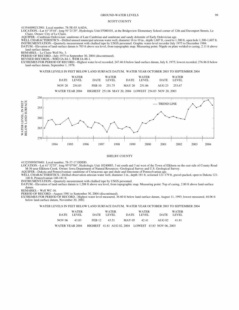
99GROUND-WATER LEVELS
SCOTT COUNTY
413544090212901. Local number, 78-5E-03 AADA. LOCATION.--Lat 41°35'44", long 91°21'29", Hydrologic Unit 07080101, at the Bridgeview Elementary School corner of 12th and Davenport Streets, Le
Claire. Owner: City of Le Claire. AQUIFER.--Cambrian-Ordovician: sandstone of Late Cambrian and sandstone and sandy dolomite of Early Ordovician age. WELL CHARACTERISTICS.--Drilled unused municipal artesian water well, diameter 16 to 10 in., depth 1,607 ft, cased to 1,300 ft, open hole 1,300-1,607 ft. INSTRUMENTATION.--Quarterly measurement with chalked tape by USGS personnel. Graphic water-level recorder July 1975 to December 1984. DATUM.--Elevation of land-surface datum is 703 ft above sea level, from topographic map. Measuring point: Nipple on plate welded to casing, 2.11 ft above
land-surface datum. REMARKS.-- Le Claire Well No. 3. PERIOD OF RECORD.--July 1975 to September 30, 2004 (discontinued). REVISED RECORDS.--WRD IA-84-1, WDR IA-88-1. EXTREMES FOR PERIOD OF RECORD.--Highest water level recorded, 247.46 ft below land-surface datum, July 8, 1975; lowest recorded, 276.86 ft below
land-surface datum, September 1, 1978.
WATER LEVELS IN FEET BELOW LAND SURFACE DATUM, WATER YEAR OCTOBER 2003 TO SEPTEMBER 2004
DATEWATER LEVEL DATE
WATER LEVEL DATE
WATER LEVEL DATE
WATER LEVEL
NOV 20 254.03 FEB 10 251.75 MAY 20 251.06 AUG 23 253.67
WATER YEAR 2004 HIGHEST 251.06 MAY 20, 2004 LOWEST 254.03 NOV 20, 2003
1994 1995 1996 1997 1998 1999 2000 2001 2002 2003 2004
270
265
260
255
250
WA
TE
R L
EV
EL
, IN
FE
ET
BE
LO
W L
AN
D S
UR
FAC
E
TREND LINE
SHELBY COUNTY
413255095070401. Local number, 78-37-17 DDDD. LOCATION.--Lat 41°32'55", long 95°07'04", Hydrologic Unit 10240003, 3 mi south and 3 mi west of the Town of Elkhorn on the east side of County Road
M-56 near Elkhorn Creek. Owner: Iowa Department of Natural Resources--Geological Survey and U.S. Geological Survey. AQUIFER.--Dakota and Pennsylvanian: sandstone of Cretaceous age and shale and limestone of Pennsylvanian age. WELL CHARACTERISTICS.--Drilled observation artesian water well, diameter 2 in., depth 181 ft, screened 121-179 ft, gravel-packed, open to Dakota 121-
140 ft, Pennsylvanian 140-181 ft. INSTRUMENTATION.--Quarterly measurement with chalked tape by USGS personnel. DATUM.--Elevation of land-surface datum is 1,208 ft above sea level, from topographic map. Measuring point: Top of casing, 2.80 ft above land-surface
datum. REMARKS.-- Well WC-16. PERIOD OF RECORD.--August 1981 to September 30, 2004 (discontinued). EXTREMES FOR PERIOD OF RECORD.--Highest water level measured, 36.60 ft below land-surface datum, August 11, 1993; lowest measured, 44.06 ft
below land-surface datum, November 20, 2002.
WATER LEVELS IN FEET BELOW LAND SURFACE DATUM, WATER YEAR OCTOBER 2003 TO SEPTEMBER 2004
DATEWATER LEVEL DATE
WATER LEVEL DATE
WATER LEVEL DATE
WATER LEVEL
NOV 06 43.83 FEB 12 43.51 MAY 05 42.41 AUG 02 41.81
WATER YEAR 2004 HIGHEST 41.81 AUG 02, 2004 LOWEST 43.83 NOV 06, 2003
100 GROUND-WATER LEVELS
SHELBY COUNTY—Continued
413359095182701. Local number, 78-39-11 CCBC. LOCATION.--Lat 41°33'59", long 95°18'27", Hydrologic Unit 10240002, approximately 5.5 mi south of the City of Harlan, 0.75 mi south of County Road F-
58, and 1.5 mi east of U.S. Highway 59. Owner: Iowa Department of Natural Resources--Geological Survey and U.S. Geological Survey. AQUIFER.--Fremont buried channel: sand and gravel of Pleistocene age. WELL CHARACTERISTICS.--Drilled observation artesian water well, diameter 2 in., depth 541 ft, screened 520-535 ft, gravel-packed. Pennsylvanian shale
537-541 ft. INSTRUMENTATION.--Quarterly measurement with chalked tape by USGS personnel. DATUM.--Elevation of land-surface datum is 1,310 ft above sea level, from topographic map. Measuring point: Top of casing, 1.65 ft above land-surface
datum. REMARKS.-- Well WC-227. PERIOD OF RECORD.--July 1983 to September 30, 2004 (discontinued). REVISION.--Lowest water level measured, 153.32 below land-surface datum, April 12, 1990. EXTREMES FOR PERIOD OF RECORD.--Highest water level measured, 146.61 ft below land-surface datum, September 6, 1983; lowest measured, 154.33
ft below land-surface datum, November 06, 2003.
WATER LEVELS IN FEET BELOW LAND SURFACE DATUM, WATER YEAR OCTOBER 2003 TO SEPTEMBER 2004
DATEWATER LEVEL DATE
WATER LEVEL DATE
WATER LEVEL DATE
WATER LEVEL
NOV 06 154.33 FEB 12 154.16 MAY 05 153.82 AUG 03 154.04
WATER YEAR 2004 HIGHEST 153.82 MAY 05, 2004 LOWEST 154.33 NOV 06, 2003
413953095302601. Local number, 79-40-09 DBCA. LOCATION.--Lat 41°39'53", long 95°30'26", Hydrologic Unit 10230006, east of State Highway 191, approximately 1 mi northeast of the Town of Portsmouth.
Owner: Iowa Department of Natural Resources--Geological Survey and U.S. Geological Survey. AQUIFER.--Glacial drift of Pleistocene age. WELL CHARACTERISTICS.--Drilled observation artesian water well, diameter 2 in., depth 210 ft, screened 160-175 ft, gravel packed, open hole 200-210 ft. INSTRUMENTATION.--Quarterly measurement with chalked tape by USGS personnel. DATUM.--Elevation of land-surface datum is 1,205 ft above sea level, from topographic map. Measuring point: Top of casing, 4.10 ft above land-surface
datum. REMARKS.-- Well WC-15. PERIOD OF RECORD.--August 1992 to September 30, 2004 (discontinued). EXTREMES FOR PERIOD OF RECORD.--Highest water level measured, 18.07 feet below land-surface datum, November 04, 1996; lowest measured, 20.27
ft below land-surface datum, November 13, 2003.
WATER LEVELS IN FEET BELOW LAND SURFACE DATUM, WATER YEAR OCTOBER 2003 TO SEPTEMBER 2004
DATEWATER LEVEL DATE
WATER LEVEL DATE
WATER LEVEL DATE
WATER LEVEL
NOV 13 20.27 FEB 12 20.04 MAY 05 19.85 AUG 03 19.96
WATER YEAR 2004 HIGHEST 19.85 MAY 05, 2004 LOWEST 20.27 NOV 13, 2003
414624095252301. Local number, 80-39-06 AADC. LOCATION.--Lat 41°46'24", long 95°25'22", Hydrologic Unit 10230006, west of the Town of Earling on the north side of Iowa Highway 37 near the junction
of Iowa Highways 37 and 191. Owner: Geological Survey Bureau, DNR and U.S. Geological Survey. AQUIFER.--Dakota: sandstone of Cretaceous age. WELL CHARACTERISTICS.--Drilled observation artesian water well, diameter 2 in., depth 370 ft, screened 332-347 ft, open to Pennsylvanian sandstone,
shale, and limestone 347-370 ft. INSTRUMENTATION.--Quarterly measurement with chalked tape by USGS personnel. DATUM.--Elevation of land-surface datum is 1,305 ft above sea level, from topographic map. Measuring point: Top of casing, 2.60 ft above land-surface
datum. REMARKS.-- Well WC-10. PERIOD OF RECORD.--June 1981 to September 30, 2004 (discontinued). EXTREMES FOR PERIOD OF RECORD.--Highest water level measured, 89.91 ft below land-surface datum, April 10, 1984; lowest measured, 131.70 ft
below land-surface datum, April 12, 1990.
WATER LEVELS IN FEET BELOW LAND SURFACE DATUM, WATER YEAR OCTOBER 2003 TO SEPTEMBER 2004
DATEWATER LEVEL DATE
WATER LEVEL DATE
WATER LEVEL DATE
WATER LEVEL
NOV 06 108.95 FEB 12 108.65 MAY 05 108.59 AUG 03 108.19
WATER YEAR 2004 HIGHEST 108.19 AUG 03, 2004 LOWEST 108.95 NOV 06, 2003
101GROUND-WATER LEVELS
SHELBY COUNTY—Continued
414856095160101. Local number, 81-38-21 ADAD. LOCATION.--Lat 41°48'56", long 95°16'01", Hydrologic Unit 10240002, approximately 3.75 mi east of the Town of Defiance on the west side of County
Road M-36. Owner: Iowa Department of Natural Resources--Geological Survey and U.S. Geological Survey. AQUIFER.--Fremont buried channel: sand and gravel of Pleistocene age. WELL CHARACTERISTICS.--Drilled observation artesian water well, diameter 2 in., depth 535 ft, screened 525-535 ft, gravel-packed. Open to
Pennsylvanian shale 530-535 ft. INSTRUMENTATION.--Quarterly measurement with chalked tape by USGS personnel. DATUM.--Elevation of land-surface datum is 1,370 ft above sea level, from topographic map. Measuring point: Top of casing, 2.90 ft above land-surface
datum. REMARKS.-- Well WC-222. PERIOD OF RECORD.--August 1983 to September 30, 2004 (discontinued). EXTREMES FOR PERIOD OF RECORD.--Highest water level measured, 208.09 ft below land-surface datum, April 15, 1987; lowest measured, 213.80 ft
below land-surface datum, November 06, 2004.
WATER LEVELS IN FEET BELOW LAND SURFACE DATUM, WATER YEAR OCTOBER 2003 TO SEPTEMBER 2004
DATEWATER LEVEL DATE
WATER LEVEL DATE
WATER LEVEL DATE
WATER LEVEL
NOV 06 213.80 FEB 12 213.63 MAY 05 213.36 AUG 03 213.49
WATER YEAR 2004 HIGHEST 213.36 MAY 05, 2004 LOWEST 213.80 NOV 06, 2003
SIOUX COUNTY
430140095573101. Local number, 95-43-07 AAAA. LOCATION.--Lat 43°04'10", long 95°57'32", Hydrologic Unit 10230002, just south of County Road B-40, 1 mi east of the Village of Newkirk. Owner: Iowa
Department of Natural Resources--Geological Survey and U.S. Geological Survey. AQUIFER.--Dakota: sandstone of Cretaceous age. WELL CHARACTERISTICS.--Drilled observation artesian water well, diameter 2 in., depth 681 ft, screened 641-681 ft. Open to Paleozoic rock from 674-
681 ft. INSTRUMENTATION.--Quarterly measurement with chalked tape by USGS personnel. DATUM.--Elevation of land-surface datum is 1,390 ft above sea level, from topographic map. Measuring point: Top of casing, 3.70 ft above land-surface
datum. REMARKS.-- Well D-43. PERIOD OF RECORD.--July 1980 to December 1980, May 1982 to September 30, 2004 (discontinued). REVISED RECORDS.--WDR IA-88-1. EXTREMES FOR PERIOD OF RECORD.--Highest water level measured, 213.66 ft below land-surface datum, March 13, 1984; lowest measured, 221.19 ft
below land-surface datum, November 05, 2003.
WATER LEVELS IN FEET BELOW LAND SURFACE DATUM, WATER YEAR OCTOBER 2003 TO SEPTEMBER 2004
DATEWATER LEVEL DATE
WATER LEVEL DATE
WATER LEVEL DATE
WATER LEVEL
NOV 05 221.19 FEB 10 221.13 MAY 04 220.94 AUG 03 221.08
WATER YEAR 2004 HIGHEST 220.94 MAY 04, 2004 LOWEST 221.19 NOV 05, 2003
430913096033201. Local number, 96-44-08 ADAA. LOCATION.--Lat 43°09'13", long 96°03'32", Hydrologic Unit 10230002, west side of County Road K-64, approximately 2.5 mi west of the Town of Boyden
and approximately 2.2 mi south of U.S. Highway 18. Owner: Iowa Department of Natural Resources--Geological Survey and U.S. Geological Survey. AQUIFER.--Dakota: sandstone of Cretaceous age. WELL CHARACTERISTICS.--Drilled observation artesian water well, diameter 2 in., depth 682 ft, screened 647-667 ft. Open to Paleozoic rock 681-682 ft. INSTRUMENTATION.--Quarterly measurement with chalked tape by USGS personnel. DATUM.--Elevation of land-surface datum is 1,373 ft above sea level, from topographic map. Measuring point: Top of casing, 3.70 ft above land-surface
datum. REMARKS.-- Well D-44. PERIOD OF RECORD.--August 1980 to December 1980, May 1982 to September 30, 2004 (discontinued). EXTREMES FOR PERIOD OF RECORD.--Highest water level measured, 187.85 ft below land-surface datum, October 16, 1984; lowest measured, 198.35
ft below land-surface datum, February 10, 2004.
WATER LEVELS IN FEET BELOW LAND SURFACE DATUM, WATER YEAR OCTOBER 2003 TO SEPTEMBER 2004
DATEWATER LEVEL DATE
WATER LEVEL DATE
WATER LEVEL DATE
WATER LEVEL
NOV 05 198.32 FEB 10 198.35 MAY 04 198.13 AUG 03 198.31
WATER YEAR 2004 HIGHEST 198.13 MAY 04, 2004 LOWEST 198.35 FEB 10, 2004

102 GROUND-WATER LEVELS
STORY COUNTY
420129093273701. Local number, 83-22-06 CDBD. LOCATION.--Lat 42°01'30", long 93°27'33", Hydrologic Unit 07080105, approximately one mile north of Highway 30 near 1st and N ave. Owner: City of
Nevada. AQUIFER.--Cambrian-Ordovician aquifer. WELL CHARACTERISTICS.--Drilled public supply well, diameter 16 in., depth 2630 ft, open hole 2015-2630 ft. INSTRUMENTATION.--Quarterly measurement with airline by USGS personnel. DATUM.--Elevation of land-surface datum is 991 ft above sea level, from topographic map. REMARKS.-- Nevada well no. 4. PERIOD OF RECORD.--February 1997 to September 30, 2004 (discontinued). EXTREMES FOR PERIOD OF RECORD.--Highest water level measured, 295 ft below land-surface datum, February 08, 1999; lowest measured, 415 ft below
land-surface datum, November 13, 2003.
WATER LEVELS IN FEET BELOW LAND SURFACE DATUM, WATER YEAR OCTOBER 2003 TO SEPTEMBER 2004
DATEWATER LEVEL DATE
WATER LEVEL DATE
WATER LEVEL DATE
WATER LEVEL
NOV 13 415 FEB 09 380 MAY 04 410 AUG 02 390
WATER YEAR 2004 HIGHEST 380 FEB 09, 2004 LOWEST 415 NOV 13, 2003
420137093361501. Local number, 83-24-02 DABC. LOCATION.--Lat 42°01'32", long 93°36'21", Hydrologic Unit 07080105, in Ames, north of the Chicago and Northwestern Railroad and County Road E-41,
approximately 0.75 mi east of U.S. Highway 69. Owner: City of Ames. AQUIFER.--Glacial drift of Pleistocene age. WELL CHARACTERISTICS.--Drilled municipal well, depth 124 ft, casing information unavailable. INSTRUMENTATION.--Quarterly measurement with chalked tape or electric line by USGS personnel. DATUM.--Elevation of land-surface datum is 926 ft above sea level, from topographic map. Measuring point: Top of casing, 2.65 ft above land-surface datum. REMARKS.-- Ames city well No. 4. PERIOD OF RECORD.--September 1987 to September 30, 2004 (discontinued). EXTREMES FOR PERIOD OF RECORD.--Highest water level measured, 49.98 ft below land-surface datum, March 14, 1991; lowest measured, 84.06 ft
below land-surface datum, August 02, 2004.
WATER LEVELS IN FEET BELOW LAND SURFACE DATUM, WATER YEAR OCTOBER 2003 TO SEPTEMBER 2004
DATEWATER LEVEL DATE
WATER LEVEL DATE
WATER LEVEL DATE
WATER LEVEL
NOV 13 81.22 FEB 09 79.46 MAY 04 68.63 AUG 02 84.06
WATER YEAR 2004 HIGHEST 68.63 MAY 04, 2004 LOWEST 84.06 AUG 02, 2004
VAN BUREN COUNTY
404150091483001. Local number, 68-08-08 CDD. LOCATION.--Lat 40°41'53", long 91°48'20", Hydrologic Unit 07100009, located at the west end of the park in the City of Bonaparte, south of County Road
J-40. Owner: City of Bonaparte. AQUIFER.--Mississippian: limestone and dolomite of Mississippian age. WELL CHARACTERISTICS.--Drilled unused semi-confined public-supply well, diameter 6 in., depth 205 ft, cased to 18 ft, open hole 18-205 ft. INSTRUMENTATION.--Intermittent measurement with chalked tape by USGS personnel. Graphic water-level recorder December 1988 to July 1990.
Intermittent measurement with chalked tape by USGS personnel August 1988 to December 1988. DATUM.--Elevation of land-surface datum is 552 ft above sea level, from topographic map. Measuring point: Top of recorder platform, 0.65 ft above land-
surface datum. REMARKS.-- Bonaparte No. 1 well. Recorder removed July 17, 1990. PERIOD OF RECORD.--August 1988 to September 30, 2004 (discontinued). EXTREMES FOR PERIOD OF RECORD.--Highest water level measured, 15.08 ft below land-surface datum, August 10, 1993; lowest measured, 32.13 ft
below land-surface datum, August 16, 1989.
WATER LEVELS IN FEET BELOW LAND SURFACE DATUM, WATER YEAR OCTOBER 2003 TO SEPTEMBER 2004
DATEWATER LEVEL DATE
WATER LEVEL DATE
WATER LEVEL DATE
WATER LEVEL
NOV 19 22.69 FEB 09 22.28 MAY 21 20.54 AUG 20 23.34
WATER YEAR 2004 HIGHEST 20.54 MAY 21, 2004 LOWEST 23.34 AUG 20, 2004
1994 1995 1996 1997 1998 1999 2000 2001 2002 2003 2004
26
24
22
20
18
16
WA
TE
R L
EV
EL
, IN
FE
ET
BE
LO
W L
AN
D S
UR
FAC
E TREND LINE
103GROUND-WATER LEVELS
WASHINGTON COUNTY
411300091320701. Local number, 74-06-15 BDAC. LOCATION.--Lat 41°12'59", long 91°32'07", Hydrologic Unit 07080107, in the water treatment plant, beneath the water tower in Crawfordsville. Owner:
Town of Crawfordsville. AQUIFER.--Mississippian: dolomite of Mississippian age. WELL CHARACTERISTICS.--Drilled unused municipal artesian water well, diameter 6.5 in., depth 215 ft, cased to 132 ft, open hole 132-215 ft. INSTRUMENTATION.--Quarterly measurement with chalked tape by USGS personnel. DATUM.--Elevation of land-surface datum is 725 ft above sea level, from topographic map. Measuring point: Nipple on plate welded to casing, 1.10 ft above
land-surface datum. REMARKS: Crawfordsville North.
PERIOD OF RECORD.--September 1983, March 1987 to September 30, 2004 (discontinued). EXTREMES FOR PERIOD OF RECORD.--Highest water level measured, 69.23 ft below land-surface datum, March 25, 1987; lowest measured, 78.09 ft
below land-surface datum, August 05, 1999.
WATER LEVELS IN FEET BELOW LAND SURFACE DATUM, WATER YEAR OCTOBER 2003 TO SEPTEMBER 2004
DATEWATER LEVEL DATE
WATER LEVEL DATE
WATER LEVEL DATE
WATER LEVEL
NOV 19 73.46 FEB 09 72.54 MAY 26 72.36 AUG 20 73.12
WATER YEAR 2004 HIGHEST 72.36 MAY 26, 2004 LOWEST 73.46 NOV 19, 2003
412750091495201. Local number, 77-09-24 AADA. LOCATION.--Lat 41°27'53", long 91°49'47", Hydrologic Unit 07080209, north of the city sewage treatment plant and west of First Avenue SE, Wellman.
Owner: City of Wellman. AQUIFER.--Mississippian: dolomite of Mississippian age. WELL CHARACTERISTICS.--Drilled unused artesian water well, diameter 10 in. to 27 ft, 8 in. to 47 ft, depth 110 ft, cased to 47 ft, open hole 47 to 110 ft. INSTRUMENTATION.--Quarterly measurement with chalked tape by USGS personnel. DATUM.--Elevation of land-surface datum is 695 ft above sea level, from topographic map. Measuring point: Nipple on plate welded to casing, 1.87 ft above
land-surface datum. REMARKS.-- City test well No. 1. PERIOD OF RECORD.--May 1963 to October 1971, May 1973 to September 30, 2004 (discontinued). REVISED RECORDS.--WDR IA-84-1, WDR IA-88-1. EXTREMES FOR PERIOD OF RECORD.--Highest water level measured, 1.38 ft above land-surface datum, May 03, 1993; lowest measured, 6.80 ft below
land-surface datum, October 20, 1964.
WATER LEVELS IN FEET BELOW LAND SURFACE DATUM, WATER YEAR OCTOBER 2003 TO SEPTEMBER 2004
DATEWATER LEVEL DATE
WATER LEVEL DATE
WATER LEVEL DATE
WATER LEVEL
NOV 20 3.83 FEB 10 2.68 MAY 21 .66 AUG 19 1.93
WATER YEAR 2004 HIGHEST .66 MAY 21, 2004 LOWEST 3.83 NOV 20, 2003
421829091304701. Local number, 75-06-14 ABBB. LOCATION.--Lat 41°18'28", long 91°30'47", Hydrologic Unit 07080209, 1 mi north and 1.5 mi east of the junction of U.S. Highway 218 and Iowa Highway
92. Owner: Mrs. David Armstrong. AQUIFER.--Glacial drift of Pleistocene age. WELL CHARACTERISTICS.--Bored unused water-table well, diameter 12 in., depth 45 ft, lined with tile. INSTRUMENTATION.--Monthly measurement with chalked tape by USGS personnel. DATUM.--Elevation of land-surface datum is 745 ft above sea level, from topographic map. Measuring point: Nipple welded to barrel, 4.08 ft above land-
surface datum. PERIOD OF RECORD.--November 1983 to September 30, 2004 (discontinued). EXTREMES FOR PERIOD OF RECORD.--Highest water level measured, 1.29 ft below land-surface datum, April 16, 1999; lowest measured, 13.64 ft below
land-surface datum, August 22, 1996.
WATER LEVELS IN FEET BELOW LAND SURFACE DATUM, WATER YEAR OCTOBER 2003 TO SEPTEMBER 2004
DATEWATER LEVEL DATE
WATER LEVEL DATE
WATER LEVEL DATE
WATER LEVEL DATE
WATER LEVEL DATE
WATER LEVEL
OCT 08 11.68 DEC 15 8.69 FEB 09 9.24 APR 14 3.74 JUN 16 3.32 AUG 20 4.88NOV 12 11.51 JAN 13 9.19 MAR 17 2.39 MAY 26 2.52 JUL 23 4.20 SEP 16 6.09
WATER YEAR 2004 HIGHEST 2.39 MAR 17, 2004 LOWEST 11.68 OCT 08, 2003
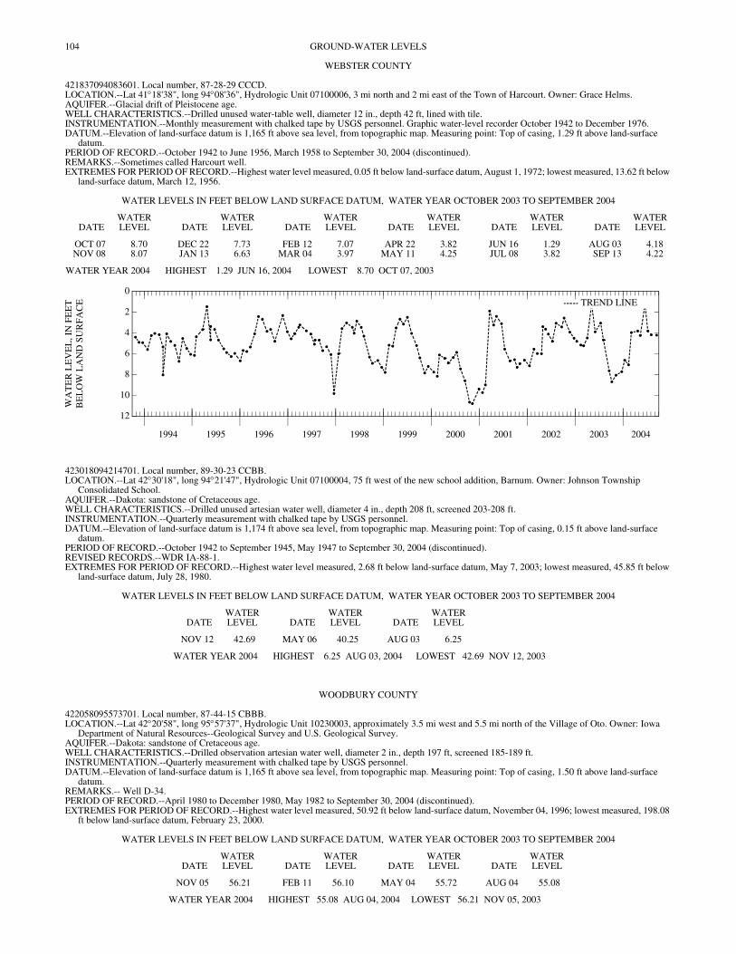
104 GROUND-WATER LEVELS
WEBSTER COUNTY
421837094083601. Local number, 87-28-29 CCCD. LOCATION.--Lat 41°18'38", long 94°08'36", Hydrologic Unit 07100006, 3 mi north and 2 mi east of the Town of Harcourt. Owner: Grace Helms. AQUIFER.--Glacial drift of Pleistocene age. WELL CHARACTERISTICS.--Drilled unused water-table well, diameter 12 in., depth 42 ft, lined with tile. INSTRUMENTATION.--Monthly measurement with chalked tape by USGS personnel. Graphic water-level recorder October 1942 to December 1976. DATUM.--Elevation of land-surface datum is 1,165 ft above sea level, from topographic map. Measuring point: Top of casing, 1.29 ft above land-surface
datum. PERIOD OF RECORD.--October 1942 to June 1956, March 1958 to September 30, 2004 (discontinued). REMARKS.--Sometimes called Harcourt well. EXTREMES FOR PERIOD OF RECORD.--Highest water level measured, 0.05 ft below land-surface datum, August 1, 1972; lowest measured, 13.62 ft below
land-surface datum, March 12, 1956.
WATER LEVELS IN FEET BELOW LAND SURFACE DATUM, WATER YEAR OCTOBER 2003 TO SEPTEMBER 2004
DATEWATER LEVEL DATE
WATER LEVEL DATE
WATER LEVEL DATE
WATER LEVEL DATE
WATER LEVEL DATE
WATER LEVEL
OCT 07 8.70 DEC 22 7.73 FEB 12 7.07 APR 22 3.82 JUN 16 1.29 AUG 03 4.18NOV 08 8.07 JAN 13 6.63 MAR 04 3.97 MAY 11 4.25 JUL 08 3.82 SEP 13 4.22
WATER YEAR 2004 HIGHEST 1.29 JUN 16, 2004 LOWEST 8.70 OCT 07, 2003
1994 1995 1996 1997 1998 1999 2000 2001 2002 2003 2004
12
10
8
6
4
2
0
WA
TE
R L
EV
EL
, IN
FE
ET
BE
LO
W L
AN
D S
UR
FAC
E TREND LINE
423018094214701. Local number, 89-30-23 CCBB. LOCATION.--Lat 42°30'18", long 94°21'47", Hydrologic Unit 07100004, 75 ft west of the new school addition, Barnum. Owner: Johnson Township
Consolidated School. AQUIFER.--Dakota: sandstone of Cretaceous age. WELL CHARACTERISTICS.--Drilled unused artesian water well, diameter 4 in., depth 208 ft, screened 203-208 ft. INSTRUMENTATION.--Quarterly measurement with chalked tape by USGS personnel. DATUM.--Elevation of land-surface datum is 1,174 ft above sea level, from topographic map. Measuring point: Top of casing, 0.15 ft above land-surface
datum. PERIOD OF RECORD.--October 1942 to September 1945, May 1947 to September 30, 2004 (discontinued). REVISED RECORDS.--WDR IA-88-1. EXTREMES FOR PERIOD OF RECORD.--Highest water level measured, 2.68 ft below land-surface datum, May 7, 2003; lowest measured, 45.85 ft below
land-surface datum, July 28, 1980.
WATER LEVELS IN FEET BELOW LAND SURFACE DATUM, WATER YEAR OCTOBER 2003 TO SEPTEMBER 2004
DATEWATER LEVEL DATE
WATER LEVEL DATE
WATER LEVEL
NOV 12 42.69 MAY 06 40.25 AUG 03 6.25
WATER YEAR 2004 HIGHEST 6.25 AUG 03, 2004 LOWEST 42.69 NOV 12, 2003
WOODBURY COUNTY
422058095573701. Local number, 87-44-15 CBBB. LOCATION.--Lat 42°20'58", long 95°57'37", Hydrologic Unit 10230003, approximately 3.5 mi west and 5.5 mi north of the Village of Oto. Owner: Iowa
Department of Natural Resources--Geological Survey and U.S. Geological Survey. AQUIFER.--Dakota: sandstone of Cretaceous age. WELL CHARACTERISTICS.--Drilled observation artesian water well, diameter 2 in., depth 197 ft, screened 185-189 ft. INSTRUMENTATION.--Quarterly measurement with chalked tape by USGS personnel. DATUM.--Elevation of land-surface datum is 1,165 ft above sea level, from topographic map. Measuring point: Top of casing, 1.50 ft above land-surface
datum. REMARKS.-- Well D-34. PERIOD OF RECORD.--April 1980 to December 1980, May 1982 to September 30, 2004 (discontinued). EXTREMES FOR PERIOD OF RECORD.--Highest water level measured, 50.92 ft below land-surface datum, November 04, 1996; lowest measured, 198.08
ft below land-surface datum, February 23, 2000.
WATER LEVELS IN FEET BELOW LAND SURFACE DATUM, WATER YEAR OCTOBER 2003 TO SEPTEMBER 2004
DATEWATER LEVEL DATE
WATER LEVEL DATE
WATER LEVEL DATE
WATER LEVEL
NOV 05 56.21 FEB 11 56.10 MAY 04 55.72 AUG 04 55.08
WATER YEAR 2004 HIGHEST 55.08 AUG 04, 2004 LOWEST 56.21 NOV 05, 2003
105GROUND-WATER LEVELS
WOODBURY COUNTY—Continued
422830096000511. Local number, 88-44-16 BAAB11. LOCATION.--Lat 42°28'30", long 96°00'31", Hydrologic Unit 10230004, approximately 3 mi east and 0.5 mi south of the Town of Moville. Owner: Iowa
Department of Natural Resources--Geological Survey and U.S. Geological Survey. AQUIFER.--Dakota: sandstone of Cretaceous age. WELL CHARACTERISTICS.--Drilled observation artesian water well, diameter 4 in. to 235 ft, 2 in. to 337 ft, depth 337 ft, screened 332-337 ft. INSTRUMENTATION.--Quarterly measurement with chalked tape by USGS personnel. DATUM.--Elevation of land-surface datum is 1,340 ft above sea level, from topographic map. Measuring point: Top of casing, 2.47 ft above land-surface
datum. REMARKS.-- Well D-33. Damaged March 1998. PERIOD OF RECORD.--October 1979 to December 1980, May 1982 to September 30, 2004 (discontinued). EXTREMES FOR PERIOD OF RECORD.--Highest water level measured, 198.60 ft below land-surface datum, November 09, 1999; lowest measured, 202.90
ft below land-surface datum, October 17, 1979.
WATER LEVELS IN FEET BELOW LAND SURFACE DATUM, WATER YEAR OCTOBER 2003 TO SEPTEMBER 2004
DATEWATER LEVEL DATE
WATER LEVEL DATE
WATER LEVEL DATE
WATER LEVEL
NOV 05 200.11 FEB 11 200.07 MAY 04 199.89 AUG 04 199.63
WATER YEAR 2004 HIGHEST 199.63 AUG 04, 2004 LOWEST 200.11 NOV 05, 2003
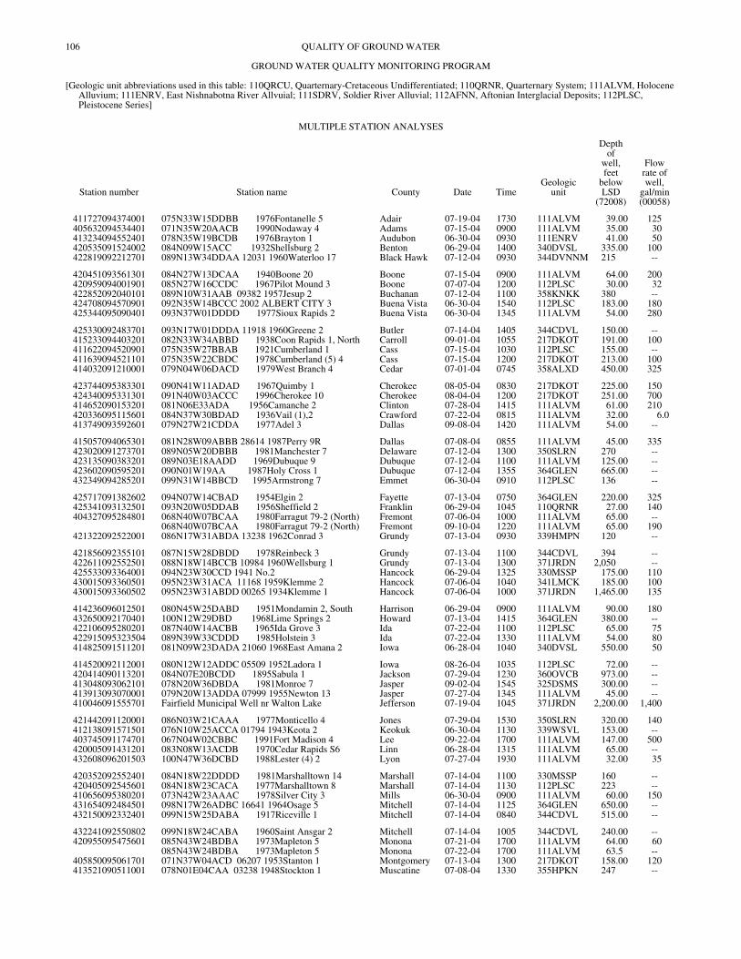
106
QUALITY OF GROUND WATERGROUND WATER QUALITY MONITORING PROGRAM
[Geologic unit abbreviations used in this table: 110QRCU, Quarternary-Cretaceous Undifferentiated; 110QRNR, Quarternary System; 111ALVM, Holocene Alluvium; 111ENRV, East Nishnabotna River Allvuial; 111SDRV, Soldier River Alluvial; 112AFNN, Aftonian Interglacial Deposits; 112PLSC, Pleistocene Series]
MULTIPLE STATION ANALYSES
Station number Station name County Date TimeGeologic
unit
Depthof
well,feet
belowLSD
(72008)
Flowrate ofwell,
gal/min(00058)
411727094374001 075N33W15DDBB 1976Fontanelle 5 Adair 07-19-04 1730 111ALVM 39.00 125405632094534401 071N35W20AACB 1990Nodaway 4 Adams 07-15-04 0900 111ALVM 35.00 30413234094552401 078N35W19BCDB 1976Brayton 1 Audubon 06-30-04 0930 111ENRV 41.00 50420535091524002 084N09W15ACC 1932Shellsburg 2 Benton 06-29-04 1400 340DVSL 335.00 100422819092212701 089N13W34DDAA 12031 1960Waterloo 17 Black Hawk 07-12-04 0930 344DVNNM 215 --
420451093561301 084N27W13DCAA 1940Boone 20 Boone 07-15-04 0900 111ALVM 64.00 200420959094001901 085N27W16CCDC 1967Pilot Mound 3 Boone 07-07-04 1200 112PLSC 30.00 32422852092040101 089N10W31AAB 09382 1957Jesup 2 Buchanan 07-12-04 1100 358KNKK 380 --424708094570901 092N35W14BCCC 2002 ALBERT CITY 3 Buena Vista 06-30-04 1540 112PLSC 183.00 180425344095090401 093N37W01DDDD 1977Sioux Rapids 2 Buena Vista 06-30-04 1345 111ALVM 54.00 280
425330092483701 093N17W01DDDA 11918 1960Greene 2 Butler 07-14-04 1405 344CDVL 150.00 --415233094403201 082N33W34ABBD 1938Coon Rapids 1, North Carroll 09-01-04 1055 217DKOT 191.00 100411622094520901 075N35W27BBAB 1921Cumberland 1 Cass 07-15-04 1030 112PLSC 155.00 --411639094521101 075N35W22CBDC 1978Cumberland (5) 4 Cass 07-15-04 1200 217DKOT 213.00 100414032091210001 079N04W06DACD 1979West Branch 4 Cedar 07-01-04 0745 358ALXD 450.00 325
423744095383301 090N41W11ADAD 1967Quimby 1 Cherokee 08-05-04 0830 217DKOT 225.00 150424340095331301 091N40W03ACCC 1996Cherokee 10 Cherokee 08-04-04 1200 217DKOT 251.00 700414652090153201 081N06E33ADA 1956Camanche 2 Clinton 07-28-04 1415 111ALVM 61.00 210420336095115601 084N37W30BDAD 1936Vail (1),2 Crawford 07-22-04 0815 111ALVM 32.00 6.0413749093592601 079N27W21CDDA 1977Adel 3 Dallas 09-08-04 1420 111ALVM 54.00 --
415057094065301 081N28W09ABBB 28614 1987Perry 9R Dallas 07-08-04 0855 111ALVM 45.00 335423020091273701 089N05W20DBBB 1981Manchester 7 Delaware 07-12-04 1300 350SLRN 270 --423135090383201 089N03E18AADD 1969Dubuque 9 Dubuque 07-12-04 1100 111ALVM 125.00 --423602090595201 090N01W19AA 1987Holy Cross 1 Dubuque 07-12-04 1355 364GLEN 665.00 --432349094285201 099N31W14BBCD 1995Armstrong 7 Emmet 06-30-04 0910 112PLSC 136 --
425717091382602 094N07W14CBAD 1954Elgin 2 Fayette 07-13-04 0750 364GLEN 220.00 325425341093132501 093N20W05DDAB 1956Sheffield 2 Franklin 06-29-04 1045 110QRNR 27.00 140404327095284801 068N40W07BCAA 1980Farragut 79-2 (North) Fremont 07-06-04 1000 111ALVM 65.00 --
068N40W07BCAA 1980Farragut 79-2 (North) Fremont 09-10-04 1220 111ALVM 65.00 190421322092522001 086N17W31ABDA 13238 1962Conrad 3 Grundy 07-13-04 0930 339HMPN 120 --
421856092355101 087N15W28DBDD 1978Reinbeck 3 Grundy 07-13-04 1100 344CDVL 394 --422611092552501 088N18W14BCCB 10984 1960Wellsburg 1 Grundy 07-13-04 1300 371JRDN 2,050 --425533093364001 094N23W30CCD 1941 No.2 Hancock 06-29-04 1325 330MSSP 175.00 110430015093360501 095N23W31ACA 11168 1959Klemme 2 Hancock 07-06-04 1040 341LMCK 185.00 100430015093360502 095N23W31ABDD 00265 1934Klemme 1 Hancock 07-06-04 1000 371JRDN 1,465.00 135
414236096012501 080N45W25DABD 1951Mondamin 2, South Harrison 06-29-04 0900 111ALVM 90.00 180432650092170401 100N12W29DBD 1968Lime Springs 2 Howard 07-13-04 1415 364GLEN 380.00 --422106095280201 087N40W14ACBB 1965Ida Grove 3 Ida 07-22-04 1100 112PLSC 65.00 75422915095323504 089N39W33CDDD 1985Holstein 3 Ida 07-22-04 1330 111ALVM 54.00 80414825091511201 081N09W23DADA 21060 1968East Amana 2 Iowa 06-28-04 1040 340DVSL 550.00 50
414520092112001 080N12W12ADDC 05509 1952Ladora 1 Iowa 08-26-04 1035 112PLSC 72.00 --420414090113201 084N07E20BCDD 1895Sabula 1 Jackson 07-29-04 1230 360OVCB 973.00 --413048093062101 078N20W36DBDA 1981Monroe 7 Jasper 09-02-04 1545 325DSMS 300.00 --413913093070001 079N20W13ADDA 07999 1955Newton 13 Jasper 07-27-04 1345 111ALVM 45.00 --410046091555701 Fairfield Municipal Well nr Walton Lake Jefferson 07-19-04 1045 371JRDN 2,200.00 1,400
421442091120001 086N03W21CAAA 1977Monticello 4 Jones 07-29-04 1530 350SLRN 320.00 140412138091571501 076N10W25ACCA 01794 1943Keota 2 Keokuk 06-30-04 1130 339WSVL 153.00 --403745091174701 067N04W02CBBC 1991Fort Madison 4 Lee 09-22-04 1700 111ALVM 147.00 500420005091431201 083N08W13ACDB 1970Cedar Rapids S6 Linn 06-28-04 1315 111ALVM 65.00 --432608096201503 100N47W36DCBD 1988Lester (4) 2 Lyon 07-27-04 1930 111ALVM 32.00 35
420352092552401 084N18W22DDDD 1981Marshalltown 14 Marshall 07-14-04 1100 330MSSP 160 --420405092545601 084N18W23CACA 1977Marshalltown 8 Marshall 07-14-04 1130 112PLSC 223 --410656095380201 073N42W23AAAC 1978Silver City 3 Mills 06-30-04 0900 111ALVM 60.00 150431654092484501 098N17W26ADBC 16641 1964Osage 5 Mitchell 07-14-04 1125 364GLEN 650.00 --432150092332401 099N15W25DABA 1917Riceville 1 Mitchell 07-14-04 0840 344CDVL 515.00 --
432241092550802 099N18W24CABA 1960Saint Ansgar 2 Mitchell 07-14-04 1005 344CDVL 240.00 --420955095475601 085N43W24BDBA 1973Mapleton 5 Monona 07-21-04 1700 111ALVM 64.00 60
085N43W24BDBA 1973Mapleton 5 Monona 07-22-04 1700 111ALVM 63.5 --405850095061701 071N37W04ACD 06207 1953Stanton 1 Montgomery 07-13-04 1300 217DKOT 158.00 120413521090511001 078N01E04CAA 03238 1948Stockton 1 Muscatine 07-08-04 1330 355HPKN 247 --
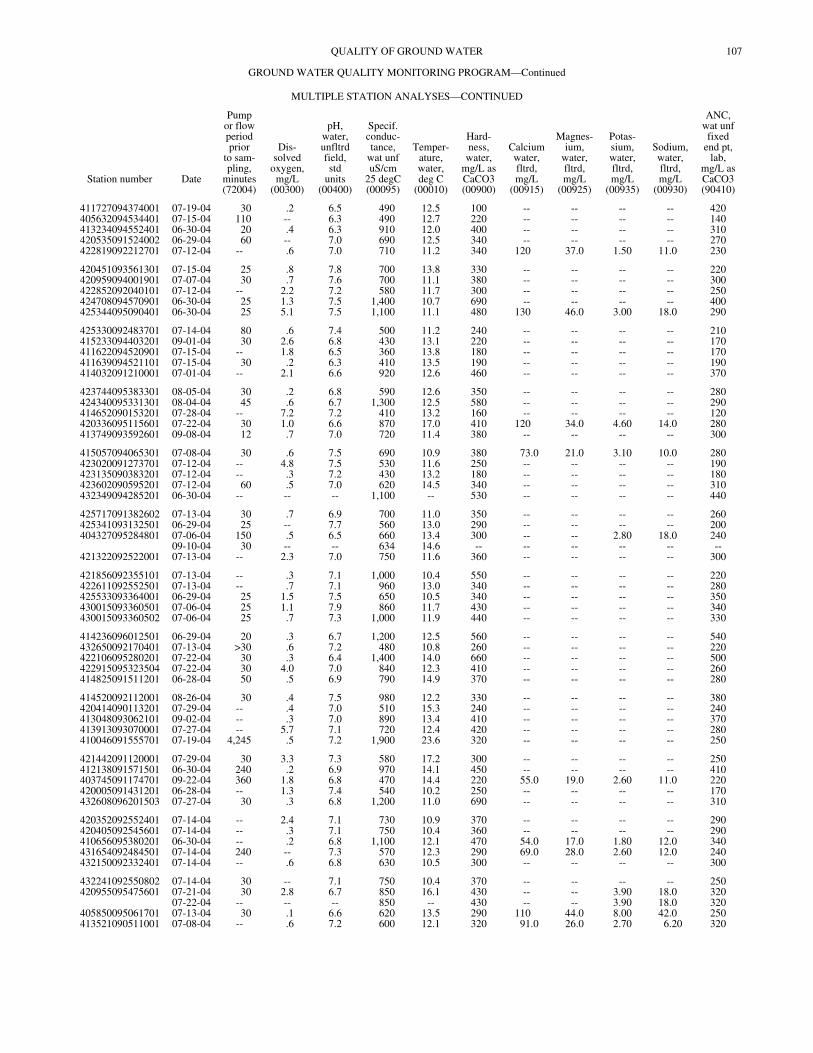
107QUALITY OF GROUND WATER
GROUND WATER QUALITY MONITORING PROGRAM—Continued
MULTIPLE STATION ANALYSES—CONTINUED
Station number Date
Pumpor flowperiodprior
to sam-pling,
minutes(72004)
Dis-solved
oxygen,mg/L
(00300)
pH,water,unfltrdfield,std
units(00400)
Specif.conduc-tance,
wat unfuS/cm
25 degC(00095)
Temper-ature,water,deg C
(00010)
Hard-ness,
water,mg/L asCaCO3(00900)
Calciumwater,fltrd,mg/L
(00915)
Magnes-ium,
water,fltrd,mg/L
(00925)
Potas-sium,water,fltrd,mg/L
(00935)
Sodium,water,fltrd,mg/L
(00930)
ANC,wat unffixed
end pt,lab,
mg/L asCaCO3(90410)
411727094374001 07-19-04 30 .2 6.5 490 12.5 100 -- -- -- -- 420405632094534401 07-15-04 110 -- 6.3 490 12.7 220 -- -- -- -- 140413234094552401 06-30-04 20 .4 6.3 910 12.0 400 -- -- -- -- 310420535091524002 06-29-04 60 -- 7.0 690 12.5 340 -- -- -- -- 270422819092212701 07-12-04 -- .6 7.0 710 11.2 340 120 37.0 1.50 11.0 230
420451093561301 07-15-04 25 .8 7.8 700 13.8 330 -- -- -- -- 220420959094001901 07-07-04 30 .7 7.6 700 11.1 380 -- -- -- -- 300422852092040101 07-12-04 -- 2.2 7.2 580 11.7 300 -- -- -- -- 250424708094570901 06-30-04 25 1.3 7.5 1,400 10.7 690 -- -- -- -- 400425344095090401 06-30-04 25 5.1 7.5 1,100 11.1 480 130 46.0 3.00 18.0 290
425330092483701 07-14-04 80 .6 7.4 500 11.2 240 -- -- -- -- 210415233094403201 09-01-04 30 2.6 6.8 430 13.1 220 -- -- -- -- 170411622094520901 07-15-04 -- 1.8 6.5 360 13.8 180 -- -- -- -- 170411639094521101 07-15-04 30 .2 6.3 410 13.5 190 -- -- -- -- 190414032091210001 07-01-04 -- 2.1 6.6 920 12.6 460 -- -- -- -- 370
423744095383301 08-05-04 30 .2 6.8 590 12.6 350 -- -- -- -- 280424340095331301 08-04-04 45 .6 6.7 1,300 12.5 580 -- -- -- -- 290414652090153201 07-28-04 -- 7.2 7.2 410 13.2 160 -- -- -- -- 120420336095115601 07-22-04 30 1.0 6.6 870 17.0 410 120 34.0 4.60 14.0 280413749093592601 09-08-04 12 .7 7.0 720 11.4 380 -- -- -- -- 300
415057094065301 07-08-04 30 .6 7.5 690 10.9 380 73.0 21.0 3.10 10.0 280423020091273701 07-12-04 -- 4.8 7.5 530 11.6 250 -- -- -- -- 190423135090383201 07-12-04 -- .3 7.2 430 13.2 180 -- -- -- -- 180423602090595201 07-12-04 60 .5 7.0 620 14.5 340 -- -- -- -- 310432349094285201 06-30-04 -- -- -- 1,100 -- 530 -- -- -- -- 440
425717091382602 07-13-04 30 .7 6.9 700 11.0 350 -- -- -- -- 260425341093132501 06-29-04 25 -- 7.7 560 13.0 290 -- -- -- -- 200404327095284801 07-06-04 150 .5 6.5 660 13.4 300 -- -- 2.80 18.0 240
09-10-04 30 -- -- 634 14.6 -- -- -- -- -- --421322092522001 07-13-04 -- 2.3 7.0 750 11.6 360 -- -- -- -- 300
421856092355101 07-13-04 -- .3 7.1 1,000 10.4 550 -- -- -- -- 220422611092552501 07-13-04 -- .7 7.1 960 13.0 340 -- -- -- -- 280425533093364001 06-29-04 25 1.5 7.5 650 10.5 340 -- -- -- -- 350430015093360501 07-06-04 25 1.1 7.9 860 11.7 430 -- -- -- -- 340430015093360502 07-06-04 25 .7 7.3 1,000 11.9 440 -- -- -- -- 330
414236096012501 06-29-04 20 .3 6.7 1,200 12.5 560 -- -- -- -- 540432650092170401 07-13-04 >30 .6 7.2 480 10.8 260 -- -- -- -- 220422106095280201 07-22-04 30 .3 6.4 1,400 14.0 660 -- -- -- -- 500422915095323504 07-22-04 30 4.0 7.0 840 12.3 410 -- -- -- -- 260414825091511201 06-28-04 50 .5 6.9 790 14.9 370 -- -- -- -- 280
414520092112001 08-26-04 30 .4 7.5 980 12.2 330 -- -- -- -- 380420414090113201 07-29-04 -- .4 7.0 510 15.3 240 -- -- -- -- 240413048093062101 09-02-04 -- .3 7.0 890 13.4 410 -- -- -- -- 370413913093070001 07-27-04 -- 5.7 7.1 720 12.4 420 -- -- -- -- 280410046091555701 07-19-04 4,245 .5 7.2 1,900 23.6 320 -- -- -- -- 250
421442091120001 07-29-04 30 3.3 7.3 580 17.2 300 -- -- -- -- 250412138091571501 06-30-04 240 .2 6.9 970 14.1 450 -- -- -- -- 410403745091174701 09-22-04 360 1.8 6.8 470 14.4 220 55.0 19.0 2.60 11.0 220420005091431201 06-28-04 -- 1.3 7.4 540 10.2 250 -- -- -- -- 170432608096201503 07-27-04 30 .3 6.8 1,200 11.0 690 -- -- -- -- 310
420352092552401 07-14-04 -- 2.4 7.1 730 10.9 370 -- -- -- -- 290420405092545601 07-14-04 -- .3 7.1 750 10.4 360 -- -- -- -- 290410656095380201 06-30-04 -- .2 6.8 1,100 12.1 470 54.0 17.0 1.80 12.0 340431654092484501 07-14-04 240 -- 7.3 570 12.3 290 69.0 28.0 2.60 12.0 240432150092332401 07-14-04 -- .6 6.8 630 10.5 300 -- -- -- -- 300
432241092550802 07-14-04 30 -- 7.1 750 10.4 370 -- -- -- -- 250420955095475601 07-21-04 30 2.8 6.7 850 16.1 430 -- -- 3.90 18.0 320
07-22-04 -- -- -- 850 -- 430 -- -- 3.90 18.0 320405850095061701 07-13-04 30 .1 6.6 620 13.5 290 110 44.0 8.00 42.0 250413521090511001 07-08-04 -- .6 7.2 600 12.1 320 91.0 26.0 2.70 6.20 320
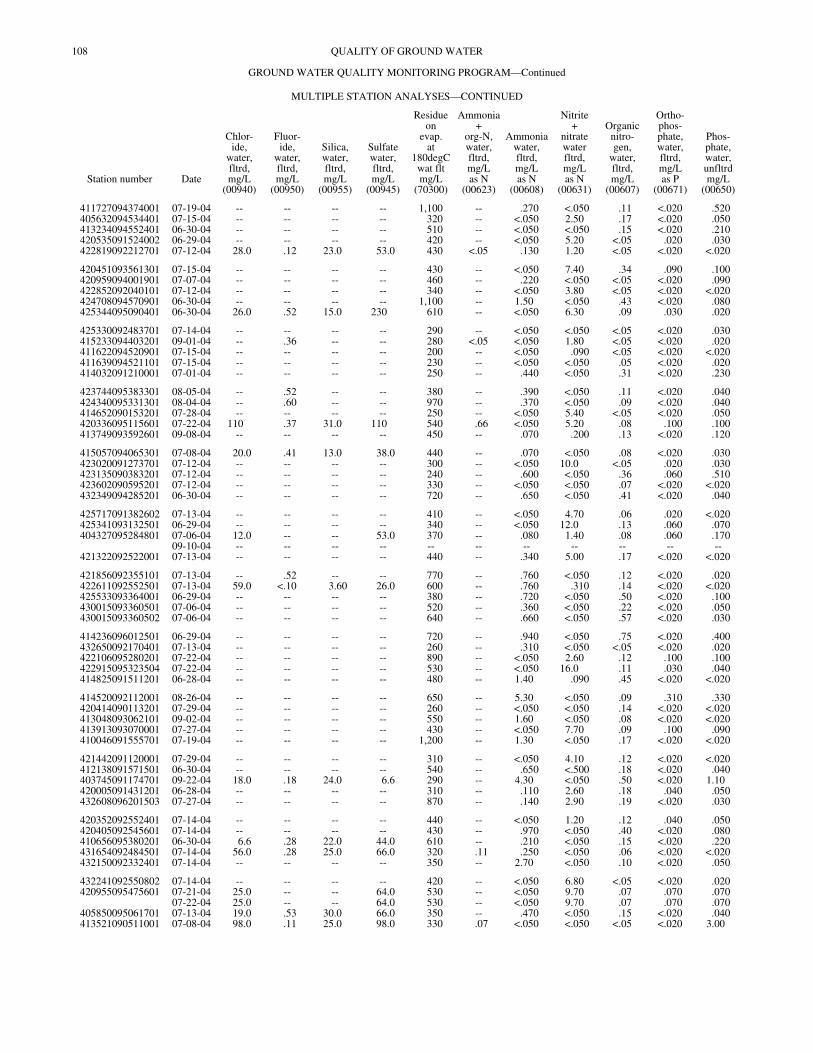
108 QUALITY OF GROUND WATER
GROUND WATER QUALITY MONITORING PROGRAM—Continued
MULTIPLE STATION ANALYSES—CONTINUED
Station number Date
Chlor-ide,
water,fltrd,mg/L
(00940)
Fluor-ide,
water,fltrd,mg/L
(00950)
Silica,water,fltrd,mg/L
(00955)
Sulfatewater,fltrd,mg/L
(00945)
Residueon
evap.at
180degCwat fltmg/L
(70300)
Ammonia+
org-N,water,fltrd,mg/Las N
(00623)
Ammoniawater,fltrd,mg/Las N
(00608)
Nitrite+
nitratewaterfltrd,mg/Las N
(00631)
Organicnitro-gen,
water,fltrd,mg/L
(00607)
Ortho-phos-phate,water,fltrd,mg/Las P
(00671)
Phos-phate,water,unfltrdmg/L
(00650)
411727094374001 07-19-04 -- -- -- -- 1,100 -- .270 <.050 .11 <.020 .520405632094534401 07-15-04 -- -- -- -- 320 -- <.050 2.50 .17 <.020 .050413234094552401 06-30-04 -- -- -- -- 510 -- <.050 <.050 .15 <.020 .210420535091524002 06-29-04 -- -- -- -- 420 -- <.050 5.20 <.05 .020 .030422819092212701 07-12-04 28.0 .12 23.0 53.0 430 <.05 .130 1.20 <.05 <.020 <.020
420451093561301 07-15-04 -- -- -- -- 430 -- <.050 7.40 .34 .090 .100420959094001901 07-07-04 -- -- -- -- 460 -- .220 <.050 <.05 <.020 .090422852092040101 07-12-04 -- -- -- -- 340 -- <.050 3.80 <.05 <.020 <.020424708094570901 06-30-04 -- -- -- -- 1,100 -- 1.50 <.050 .43 <.020 .080425344095090401 06-30-04 26.0 .52 15.0 230 610 -- <.050 6.30 .09 .030 .020
425330092483701 07-14-04 -- -- -- -- 290 -- <.050 <.050 <.05 <.020 .030415233094403201 09-01-04 -- .36 -- -- 280 <.05 <.050 1.80 <.05 <.020 .020411622094520901 07-15-04 -- -- -- -- 200 -- <.050 .090 <.05 <.020 <.020411639094521101 07-15-04 -- -- -- -- 230 -- <.050 <.050 .05 <.020 .020414032091210001 07-01-04 -- -- -- -- 250 -- .440 <.050 .31 <.020 .230
423744095383301 08-05-04 -- .52 -- -- 380 -- .390 <.050 .11 <.020 .040424340095331301 08-04-04 -- .60 -- -- 970 -- .370 <.050 .09 <.020 .040414652090153201 07-28-04 -- -- -- -- 250 -- <.050 5.40 <.05 <.020 .050420336095115601 07-22-04 110 .37 31.0 110 540 .66 <.050 5.20 .08 .100 .100413749093592601 09-08-04 -- -- -- -- 450 -- .070 .200 .13 <.020 .120
415057094065301 07-08-04 20.0 .41 13.0 38.0 440 -- .070 <.050 .08 <.020 .030423020091273701 07-12-04 -- -- -- -- 300 -- <.050 10.0 <.05 .020 .030423135090383201 07-12-04 -- -- -- -- 240 -- .600 <.050 .36 .060 .510423602090595201 07-12-04 -- -- -- -- 330 -- <.050 <.050 .07 <.020 <.020432349094285201 06-30-04 -- -- -- -- 720 -- .650 <.050 .41 <.020 .040
425717091382602 07-13-04 -- -- -- -- 410 -- <.050 4.70 .06 .020 <.020425341093132501 06-29-04 -- -- -- -- 340 -- <.050 12.0 .13 .060 .070404327095284801 07-06-04 12.0 -- -- 53.0 370 -- .080 1.40 .08 .060 .170
09-10-04 -- -- -- -- -- -- -- -- -- -- --421322092522001 07-13-04 -- -- -- -- 440 -- .340 5.00 .17 <.020 <.020
421856092355101 07-13-04 -- .52 -- -- 770 -- .760 <.050 .12 <.020 .020422611092552501 07-13-04 59.0 <.10 3.60 26.0 600 -- .760 .310 .14 <.020 <.020425533093364001 06-29-04 -- -- -- -- 380 -- .720 <.050 .50 <.020 .100430015093360501 07-06-04 -- -- -- -- 520 -- .360 <.050 .22 <.020 .050430015093360502 07-06-04 -- -- -- -- 640 -- .660 <.050 .57 <.020 .030
414236096012501 06-29-04 -- -- -- -- 720 -- .940 <.050 .75 <.020 .400432650092170401 07-13-04 -- -- -- -- 260 -- .310 <.050 <.05 <.020 .020422106095280201 07-22-04 -- -- -- -- 890 -- <.050 2.60 .12 .100 .100422915095323504 07-22-04 -- -- -- -- 530 -- <.050 16.0 .11 .030 .040414825091511201 06-28-04 -- -- -- -- 480 -- 1.40 .090 .45 <.020 <.020
414520092112001 08-26-04 -- -- -- -- 650 -- 5.30 <.050 .09 .310 .330420414090113201 07-29-04 -- -- -- -- 260 -- <.050 <.050 .14 <.020 <.020413048093062101 09-02-04 -- -- -- -- 550 -- 1.60 <.050 .08 <.020 <.020413913093070001 07-27-04 -- -- -- -- 430 -- <.050 7.70 .09 .100 .090410046091555701 07-19-04 -- -- -- -- 1,200 -- 1.30 <.050 .17 <.020 <.020
421442091120001 07-29-04 -- -- -- -- 310 -- <.050 4.10 .12 <.020 <.020412138091571501 06-30-04 -- -- -- -- 540 -- .650 <.500 .18 <.020 .040403745091174701 09-22-04 18.0 .18 24.0 6.6 290 -- 4.30 <.050 .50 <.020 1.10420005091431201 06-28-04 -- -- -- -- 310 -- .110 2.60 .18 .040 .050432608096201503 07-27-04 -- -- -- -- 870 -- .140 2.90 .19 <.020 .030
420352092552401 07-14-04 -- -- -- -- 440 -- <.050 1.20 .12 .040 .050420405092545601 07-14-04 -- -- -- -- 430 -- .970 <.050 .40 <.020 .080410656095380201 06-30-04 6.6 .28 22.0 44.0 610 -- .210 <.050 .15 <.020 .220431654092484501 07-14-04 56.0 .28 25.0 66.0 320 .11 .250 <.050 .06 <.020 <.020432150092332401 07-14-04 -- -- -- -- 350 -- 2.70 <.050 .10 <.020 .050
432241092550802 07-14-04 -- -- -- -- 420 -- <.050 6.80 <.05 <.020 .020420955095475601 07-21-04 25.0 -- -- 64.0 530 -- <.050 9.70 .07 .070 .070
07-22-04 25.0 -- -- 64.0 530 -- <.050 9.70 .07 .070 .070405850095061701 07-13-04 19.0 .53 30.0 66.0 350 -- .470 <.050 .15 <.020 .040413521090511001 07-08-04 98.0 .11 25.0 98.0 330 .07 <.050 <.050 <.05 <.020 3.00
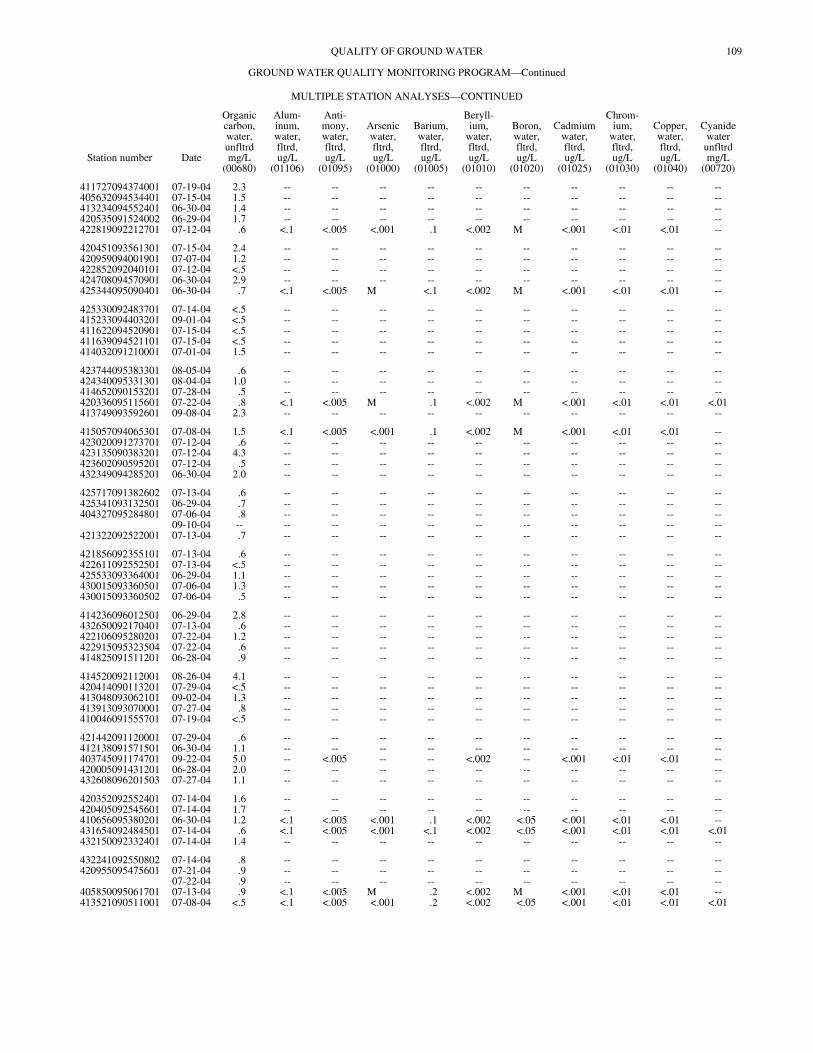
109QUALITY OF GROUND WATER
GROUND WATER QUALITY MONITORING PROGRAM—Continued
MULTIPLE STATION ANALYSES—CONTINUED
Station number Date
Organiccarbon,water,unfltrdmg/L
(00680)
Alum-inum,water,fltrd,ug/L
(01106)
Anti-mony,water,fltrd,ug/L
(01095)
Arsenicwater,fltrd,ug/L
(01000)
Barium,water,fltrd,ug/L
(01005)
Beryll-ium,
water,fltrd,ug/L
(01010)
Boron,water,fltrd,ug/L
(01020)
Cadmiumwater,fltrd,ug/L
(01025)
Chrom-ium,
water,fltrd,ug/L
(01030)
Copper,water,fltrd,ug/L
(01040)
Cyanidewaterunfltrdmg/L
(00720)
411727094374001 07-19-04 2.3 -- -- -- -- -- -- -- -- -- --405632094534401 07-15-04 1.5 -- -- -- -- -- -- -- -- -- --413234094552401 06-30-04 1.4 -- -- -- -- -- -- -- -- -- --420535091524002 06-29-04 1.7 -- -- -- -- -- -- -- -- -- --422819092212701 07-12-04 .6 <.1 <.005 <.001 .1 <.002 M <.001 <.01 <.01 --
420451093561301 07-15-04 2.4 -- -- -- -- -- -- -- -- -- --420959094001901 07-07-04 1.2 -- -- -- -- -- -- -- -- -- --422852092040101 07-12-04 <.5 -- -- -- -- -- -- -- -- -- --424708094570901 06-30-04 2.9 -- -- -- -- -- -- -- -- -- --425344095090401 06-30-04 .7 <.1 <.005 M <.1 <.002 M <.001 <.01 <.01 --
425330092483701 07-14-04 <.5 -- -- -- -- -- -- -- -- -- --415233094403201 09-01-04 <.5 -- -- -- -- -- -- -- -- -- --411622094520901 07-15-04 <.5 -- -- -- -- -- -- -- -- -- --411639094521101 07-15-04 <.5 -- -- -- -- -- -- -- -- -- --414032091210001 07-01-04 1.5 -- -- -- -- -- -- -- -- -- --
423744095383301 08-05-04 .6 -- -- -- -- -- -- -- -- -- --424340095331301 08-04-04 1.0 -- -- -- -- -- -- -- -- -- --414652090153201 07-28-04 .5 -- -- -- -- -- -- -- -- -- --420336095115601 07-22-04 .8 <.1 <.005 M .1 <.002 M <.001 <.01 <.01 <.01413749093592601 09-08-04 2.3 -- -- -- -- -- -- -- -- -- --
415057094065301 07-08-04 1.5 <.1 <.005 <.001 .1 <.002 M <.001 <.01 <.01 --423020091273701 07-12-04 .6 -- -- -- -- -- -- -- -- -- --423135090383201 07-12-04 4.3 -- -- -- -- -- -- -- -- -- --423602090595201 07-12-04 .5 -- -- -- -- -- -- -- -- -- --432349094285201 06-30-04 2.0 -- -- -- -- -- -- -- -- -- --
425717091382602 07-13-04 .6 -- -- -- -- -- -- -- -- -- --425341093132501 06-29-04 .7 -- -- -- -- -- -- -- -- -- --404327095284801 07-06-04 .8 -- -- -- -- -- -- -- -- -- --
09-10-04 -- -- -- -- -- -- -- -- -- -- --421322092522001 07-13-04 .7 -- -- -- -- -- -- -- -- -- --
421856092355101 07-13-04 .6 -- -- -- -- -- -- -- -- -- --422611092552501 07-13-04 <.5 -- -- -- -- -- -- -- -- -- --425533093364001 06-29-04 1.1 -- -- -- -- -- -- -- -- -- --430015093360501 07-06-04 1.3 -- -- -- -- -- -- -- -- -- --430015093360502 07-06-04 .5 -- -- -- -- -- -- -- -- -- --
414236096012501 06-29-04 2.8 -- -- -- -- -- -- -- -- -- --432650092170401 07-13-04 .6 -- -- -- -- -- -- -- -- -- --422106095280201 07-22-04 1.2 -- -- -- -- -- -- -- -- -- --422915095323504 07-22-04 .6 -- -- -- -- -- -- -- -- -- --414825091511201 06-28-04 .9 -- -- -- -- -- -- -- -- -- --
414520092112001 08-26-04 4.1 -- -- -- -- -- -- -- -- -- --420414090113201 07-29-04 <.5 -- -- -- -- -- -- -- -- -- --413048093062101 09-02-04 1.3 -- -- -- -- -- -- -- -- -- --413913093070001 07-27-04 .8 -- -- -- -- -- -- -- -- -- --410046091555701 07-19-04 <.5 -- -- -- -- -- -- -- -- -- --
421442091120001 07-29-04 .6 -- -- -- -- -- -- -- -- -- --412138091571501 06-30-04 1.1 -- -- -- -- -- -- -- -- -- --403745091174701 09-22-04 5.0 -- <.005 -- -- <.002 -- <.001 <.01 <.01 --420005091431201 06-28-04 2.0 -- -- -- -- -- -- -- -- -- --432608096201503 07-27-04 1.1 -- -- -- -- -- -- -- -- -- --
420352092552401 07-14-04 1.6 -- -- -- -- -- -- -- -- -- --420405092545601 07-14-04 1.7 -- -- -- -- -- -- -- -- -- --410656095380201 06-30-04 1.2 <.1 <.005 <.001 .1 <.002 <.05 <.001 <.01 <.01 --431654092484501 07-14-04 .6 <.1 <.005 <.001 <.1 <.002 <.05 <.001 <.01 <.01 <.01432150092332401 07-14-04 1.4 -- -- -- -- -- -- -- -- -- --
432241092550802 07-14-04 .8 -- -- -- -- -- -- -- -- -- --420955095475601 07-21-04 .9 -- -- -- -- -- -- -- -- -- --
07-22-04 .9 -- -- -- -- -- -- -- -- -- --405850095061701 07-13-04 .9 <.1 <.005 M .2 <.002 M <.001 <.01 <.01 --413521090511001 07-08-04 <.5 <.1 <.005 <.001 .2 <.002 <.05 <.001 <.01 <.01 <.01
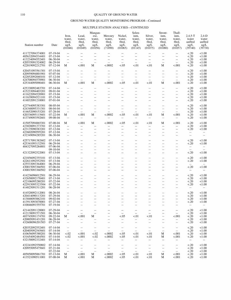
110 QUALITY OF GROUND WATER
GROUND WATER QUALITY MONITORING PROGRAM—Continued
MULTIPLE STATION ANALYSES—CONTINUED
Station number Date
Iron,water,fltrd,ug/L
(01046)
Lead,water,fltrd,ug/L
(01049)
Mangan-ese,
water,fltrd,ug/L
(01056)
Mercurywater,fltrd,ug/L
(71890)
Nickel,water,fltrd,ug/L
(01065)
Selen-ium,
water,fltrd,ug/L
(01145)
Silver,water,fltrd,ug/L
(01075)
Stront-ium,
water,fltrd,ug/L
(01080)
Thall-ium,
water,fltrd,ug/L
(01057)
2,4,5-Twaterunfltrdug/L
(39740)
2,4-Dwaterunfltrdug/L
(39730)
411727094374001 07-19-04 -- -- -- -- -- -- -- -- -- <.20 <1.00405632094534401 07-15-04 -- -- -- -- -- -- -- -- -- <.20 <1.00413234094552401 06-30-04 -- -- -- -- -- -- -- -- -- <.20 <1.00420535091524002 06-29-04 -- -- -- -- -- -- -- -- -- <.20 <1.00422819092212701 07-12-04 M <.001 M <.0002 <.05 <.01 <.01 M <.001 <.20 <1.00
420451093561301 07-15-04 -- -- -- -- -- -- -- -- -- <.20 <1.00420959094001901 07-07-04 -- -- -- -- -- -- -- -- -- <.20 <1.00422852092040101 07-12-04 -- -- -- -- -- -- -- -- -- <.20 <1.00424708094570901 06-30-04 -- -- -- -- -- -- -- -- -- <.20 <1.00425344095090401 06-30-04 M <.001 M <.0002 <.05 <.01 <.01 M <.001 <.20 <1.00
425330092483701 07-14-04 -- -- -- -- -- -- -- -- -- <.20 <1.00415233094403201 09-01-04 -- -- -- -- -- -- -- -- -- <.20 <1.00411622094520901 07-15-04 -- -- -- -- -- -- -- -- -- <.20 <1.00411639094521101 07-15-04 -- -- -- -- -- -- -- -- -- <.20 <1.00414032091210001 07-01-04 -- -- -- -- -- -- -- -- -- <.20 <1.00
423744095383301 08-05-04 -- -- -- -- -- -- -- -- -- <.20 <1.00424340095331301 08-04-04 -- -- -- -- -- -- -- -- -- <.20 <1.00414652090153201 07-28-04 -- -- -- -- -- -- -- -- -- <.20 <1.00420336095115601 07-22-04 M <.001 M <.0002 <.05 <.01 <.01 M <.001 <.20 <1.00413749093592601 09-08-04 -- -- -- -- -- -- -- -- -- <.20 <1.00
415057094065301 07-08-04 M <.001 M <.0002 <.05 <.01 <.01 M <.001 <.20 <1.00423020091273701 07-12-04 -- -- -- -- -- -- -- -- -- <.20 <1.00423135090383201 07-12-04 -- -- -- -- -- -- -- -- -- <.20 <1.00423602090595201 07-12-04 -- -- -- -- -- -- -- -- -- -- --432349094285201 06-30-04 -- -- -- -- -- -- -- -- -- -- --
425717091382602 07-13-04 -- -- -- -- -- -- -- -- -- <.20 <1.00425341093132501 06-29-04 -- -- -- -- -- -- -- -- -- <.20 <1.00404327095284801 07-06-04 -- -- -- -- -- -- -- -- -- -- --
09-10-04 -- -- -- -- -- -- -- -- -- -- --421322092522001 07-13-04 -- -- -- -- -- -- -- -- -- <.20 <1.00
421856092355101 07-13-04 -- -- -- -- -- -- -- -- -- <.20 <1.00422611092552501 07-13-04 -- -- -- -- -- -- -- -- -- <.20 <1.00425533093364001 06-29-04 -- -- -- -- -- -- -- -- -- -- --430015093360501 07-06-04 -- -- -- -- -- -- -- -- -- <.20 <1.00430015093360502 07-06-04 -- -- -- -- -- -- -- -- -- -- --
414236096012501 06-29-04 -- -- -- -- -- -- -- -- -- <.20 <1.00432650092170401 07-13-04 -- -- -- -- -- -- -- -- -- <.20 <1.00422106095280201 07-22-04 -- -- -- -- -- -- -- -- -- <.20 <1.00422915095323504 07-22-04 -- -- -- -- -- -- -- -- -- <.20 <1.00414825091511201 06-28-04 -- -- -- -- -- -- -- -- -- -- --
414520092112001 08-26-04 -- -- -- -- -- -- -- -- -- <.20 <1.00420414090113201 07-29-04 -- -- -- -- -- -- -- -- -- <.20 <1.00413048093062101 09-02-04 -- -- -- -- -- -- -- -- -- <.20 <1.00413913093070001 07-27-04 -- -- -- -- -- -- -- -- -- <.20 <1.00410046091555701 07-19-04 -- -- -- -- -- -- -- -- -- -- --
421442091120001 07-29-04 -- -- -- -- -- -- -- -- -- <.20 <1.00412138091571501 06-30-04 -- -- -- -- -- -- -- -- -- <.20 <1.00403745091174701 09-22-04 M <.001 M -- <.05 <.01 <.01 -- <.001 <.20 <1.00420005091431201 06-28-04 -- -- -- -- -- -- -- -- -- <.20 <1.00432608096201503 07-27-04 -- -- -- -- -- -- -- -- -- <.20 <1.00
420352092552401 07-14-04 -- -- -- -- -- -- -- -- -- <.20 <1.00420405092545601 07-14-04 -- -- -- -- -- -- -- -- -- <.20 <1.00410656095380201 06-30-04 <.02 <.001 <.02 <.0002 <.05 <.01 <.01 M <.001 <.20 <1.00431654092484501 07-14-04 <.02 <.001 <.02 <.0002 <.05 <.01 <.01 M <.001 <.20 <1.00432150092332401 07-14-04 -- -- -- -- -- -- -- -- -- -- --
432241092550802 07-14-04 -- -- -- -- -- -- -- -- -- <.20 <1.00420955095475601 07-21-04 -- -- -- -- -- -- -- -- -- <.20 <1.00
07-22-04 -- -- -- -- -- -- -- -- -- <.20 <1.00405850095061701 07-13-04 M <.001 M <.0002 <.05 <.01 <.01 M <.001 <.20 <1.00413521090511001 07-08-04 M <.001 M <.0002 <.05 <.01 <.01 M <.001 <.20 <1.00

111QUALITY OF GROUND WATER
GROUND WATER QUALITY MONITORING PROGRAM—Continued
MULTIPLE STATION ANALYSES—CONTINUED
Station number Date
2,4-DBwaterunfltrdug/L
(30219)
CIAT,water,unfltrdug/L
(75981)
CEAT,water,unfltrdug/L
(75980)
Aceto-chlor,water,unfltrdug/L
(49259)
Aci-fluor-fen,
waterunfltrdug/L
(79193)
Ala-chlor,water,unfltrdug/L
(77825)
Ametrynwaterunfltrdug/L
(82184)
Atra-zine,
water,unfltrdug/L
(39630)
Ben-tazon,water,unfltrdug/L
(38710)
Broma-cil,
water,unfltrdug/L
(30234)
Bromo-methane
waterunfltrdug/L
(30202)
411727094374001 07-19-04 <1.0 <.1 <.1 <.050 <.20 <.1 <.1 <.1 <1.0 <.1 <.50405632094534401 07-15-04 <1.0 <.1 <.1 <.050 <.20 <.1 <.1 <.1 <1.0 <.1 <.50413234094552401 06-30-04 <1.0 <.1 <.1 <.050 <.20 <.1 <.1 <.1 <1.0 <.1 <.50420535091524002 06-29-04 <1.0 <.1 <.1 <.050 <.20 <.1 <.1 <.1 <1.0 <.1 <.50422819092212701 07-12-04 <1.0 <.1 <.1 <.050 <.20 <.1 <.1 <.1 <1.0 <.1 <.50
420451093561301 07-15-04 <1.0 .1 <.1 <.050 <.20 <.1 <.1 .3 <1.0 <.1 <.50420959094001901 07-07-04 <1.0 <.1 <.1 <.050 <.20 <.1 <.1 <.1 <1.0 <.1 <.50422852092040101 07-12-04 <1.0 <.1 <.1 <.050 <.20 <.1 <.1 <.1 <1.0 <.1 <.50424708094570901 06-30-04 <1.0 <.1 <.1 <.050 <.20 <.1 <.1 <.1 <1.0 <.1 <.50425344095090401 06-30-04 <1.0 <.1 <.1 <.050 <.20 <.1 <.1 <.1 <1.0 <.1 <.50
425330092483701 07-14-04 <1.0 <.1 <.1 <.050 <.20 <.1 <.1 <.1 <1.0 <.1 <.50415233094403201 09-01-04 <1.0 <.1 <.1 <.050 <.20 <.1 <.1 <.1 <1.0 <.1 <.50411622094520901 07-15-04 <1.0 <.1 <.1 <.050 <.20 <.1 <.1 <.1 <1.0 <.1 <.50411639094521101 07-15-04 <1.0 <.1 <.1 <.050 <.20 <.1 <.1 <.1 <1.0 <.1 <.50414032091210001 07-01-04 <1.0 <.1 <.1 <.050 <.20 <.1 <.1 .1 <1.0 <.1 <.50
423744095383301 08-05-04 <1.0 <.1 <.1 <.050 <.20 <.1 <.1 <.1 <1.0 <.1 <.50424340095331301 08-04-04 <1.0 <.1 <.1 <.050 <.20 <.1 <.1 <.1 <1.0 <.1 <.50414652090153201 07-28-04 <1.0 <.1 <.1 <.050 <.20 <.1 <.1 <.1 <1.0 <.1 <.50420336095115601 07-22-04 <1.0 <.1 <.1 <.050 <.20 <.1 <.1 <.1 <1.0 <.1 <.50413749093592601 09-08-04 <1.0 <.1 <.1 <.050 <.20 <.1 <.1 <.1 <1.0 <.1 <.50
415057094065301 07-08-04 <1.0 <.1 <.1 <.050 <.20 <.1 <.1 <.1 <1.0 <.1 <.50423020091273701 07-12-04 <1.0 .2 <.1 <.050 <.20 <.1 <.1 .1 <1.0 <.1 <.50423135090383201 07-12-04 <1.0 <.1 <.1 <.050 <.20 <.1 <.1 <.1 <1.0 <.1 <.50423602090595201 07-12-04 -- -- -- -- -- -- -- -- -- -- --432349094285201 06-30-04 -- -- -- -- -- -- -- -- -- -- --
425717091382602 07-13-04 <1.0 <.1 <.1 <.050 <.20 <.1 <.1 <.1 <1.0 <.1 <.50425341093132501 06-29-04 <1.0 .1 .1 <.050 <.20 <.1 <.1 <.1 <1.0 <.1 <.50404327095284801 07-06-04 -- -- -- -- -- -- -- -- -- -- <.50
09-10-04 -- -- -- -- -- -- -- -- -- -- --421322092522001 07-13-04 <1.0 <.1 <.1 <.050 <.20 .2 <.1 .1 <1.0 <.1 <.50
421856092355101 07-13-04 <1.0 <.1 <.1 <.050 <.20 <.1 <.1 <.1 <1.0 <.1 <.50422611092552501 07-13-04 <1.0 <.1 <.1 <.050 <.20 <.1 <.1 <.1 <1.0 <.1 <.50425533093364001 06-29-04 -- -- -- -- -- -- -- -- -- -- --430015093360501 07-06-04 <1.0 <.1 <.1 <.050 <.20 <.1 <.1 <.1 <1.0 <.1 <.50430015093360502 07-06-04 -- -- -- -- -- -- -- -- -- -- --
414236096012501 06-29-04 <1.0 <.1 <.1 <.050 <.20 <.1 <.1 <.1 <1.0 <.1 <.50432650092170401 07-13-04 <1.0 <.1 <.1 <.050 <.20 <.1 <.1 <.1 <1.0 <.1 <.50422106095280201 07-22-04 <1.0 <.1 <.1 <.050 <.20 <.1 <.1 <.1 <1.0 <.1 <.50422915095323504 07-22-04 <1.0 <.1 <.1 .860 <.20 <.1 <.1 .1 <1.0 <.1 <.50414825091511201 06-28-04 -- -- -- -- -- -- -- -- -- -- --
414520092112001 08-26-04 <1.0 <.1 <.1 <.050 <.20 <.1 <.1 <.1 <1.0 <.1 <.50420414090113201 07-29-04 <1.0 <.1 <.1 <.050 <.20 <.1 <.1 <.1 <1.0 <.1 <.50413048093062101 09-02-04 <1.0 <.1 <.1 <.050 <.20 <.1 <.1 <.1 <1.0 <.1 <.50413913093070001 07-27-04 <1.0 <.1 <.1 <.050 <.20 <.1 <.1 <.1 <1.0 <.1 <.50410046091555701 07-19-04 -- -- -- -- -- -- -- -- -- -- --
421442091120001 07-29-04 <1.0 <.1 <.1 <.050 <.20 <.1 <.1 <.1 <1.0 <.1 <.50412138091571501 06-30-04 <1.0 <.1 <.1 <.050 <.20 <.1 <.1 <.1 <1.0 <.1 <.50403745091174701 09-22-04 <1.0 <.1 <.1 <.050 <.20 <.1 <.1 <.1 <1.0 <.1 <.50420005091431201 06-28-04 <1.0 .1 <.1 <.050 <.20 <.1 <.1 .3 <1.0 <.1 <.50432608096201503 07-27-04 <1.0 <.1 <.1 <.050 <.20 <.1 <.1 <.1 <1.0 <.1 <.50
420352092552401 07-14-04 <1.0 <.1 <.1 <.050 <.20 <.1 <.1 <.1 <1.0 <.1 <.50420405092545601 07-14-04 <1.0 <.1 <.1 <.050 <.20 <.1 <.1 <.1 <1.0 <.1 <.50410656095380201 06-30-04 <1.0 <.1 <.1 <.050 <.20 <.1 <.1 <.1 <1.0 <.1 <.50431654092484501 07-14-04 <1.0 <.1 <.1 <.050 <.20 <.1 <.1 <.1 <1.0 <.1 <.50432150092332401 07-14-04 -- -- -- -- -- -- -- -- -- -- --
432241092550802 07-14-04 <1.0 .1 <.1 <.050 <.20 <.1 <.1 <.1 <1.0 <.1 <.50420955095475601 07-21-04 <1.0 <.1 <.1 <.050 <.20 <.1 <.1 <.1 <1.0 <.1 <.50
07-22-04 <1.0 <.1 <.1 <.050 <.20 <.1 <.1 <.1 <1.0 <.1 <.50405850095061701 07-13-04 <1.0 <.1 <.1 <.050 <.20 <.1 <.1 <.1 <1.0 <.1 <.50413521090511001 07-08-04 <1.0 <.1 <.1 <.050 <.20 <.1 <.1 <.1 <1.0 <.1 <.50
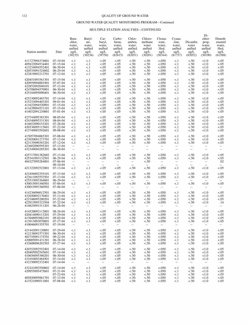
112 QUALITY OF GROUND WATER
GROUND WATER QUALITY MONITORING PROGRAM—Continued
MULTIPLE STATION ANALYSES—CONTINUED
Station number Date
Buta-chlor,water,unfltrdug/L
(30235)
Butyl-ate,
water,unfltrdug/L
(30236)
Car-baryl,water,unfltrdug/L
(39750)
Carbo-furan,water,unfltrdug/L
(82615)
Chlor-amben,water,unfltrdug/L
(82051)
Chloro-methane
waterunfltrdug/L
(30201)
Cloma-zone,water,fltrd,ug/L
(50344)
Cyana-zine,
water,unfltrdug/L
(81757)
Dicambawaterunfltrdug/L
(82052)
Di-chlor-prop,water,unfltrdug/L
(30190)
Dimeth-enamidwater,fltrd,ug/L
(61588)
411727094374001 07-19-04 <.1 <.1 <.05 <.05 <.50 <.50 <.050 <.1 <.50 <1.0 <.05405632094534401 07-15-04 <.1 <.1 <.05 <.05 <.50 <.50 <.050 <.1 <.50 <1.0 <.05413234094552401 06-30-04 <.1 <.1 <.05 <.05 <.50 <.50 <.050 <.1 <.50 <1.0 <.05420535091524002 06-29-04 <.1 <.1 <.05 <.05 <.50 <.50 <.050 <.1 <.50 <1.0 <.05422819092212701 07-12-04 <.1 <.1 <.05 <.05 <.50 <.50 <.050 <.1 <.50 <1.0 <.05
420451093561301 07-15-04 <.1 <.1 <.05 <.05 <.50 <.50 <.050 <.1 <.50 <1.0 <.05420959094001901 07-07-04 <.1 <.1 <.05 <.05 <.50 <.50 <.050 <.1 <.50 <1.0 <.05422852092040101 07-12-04 <.1 <.1 <.05 <.05 <.50 <.50 <.050 <.1 <.50 <1.0 <.05424708094570901 06-30-04 <.1 <.1 <.05 <.05 <.50 <.50 <.050 <.1 <.50 <1.0 <.05425344095090401 06-30-04 <.1 <.1 <.05 <.05 <.50 <.50 <.050 <.1 <.50 <1.0 <.05
425330092483701 07-14-04 <.1 <.1 <.05 <.05 <.50 <.50 <.050 <.1 <.50 <1.0 <.05415233094403201 09-01-04 <.1 <.1 <.05 <.05 <.50 <.50 <.050 <.1 <.50 <1.0 <.05411622094520901 07-15-04 <.1 <.1 <.05 <.05 <.50 <.50 <.050 <.1 <.50 <1.0 <.05411639094521101 07-15-04 <.1 <.1 <.05 <.05 <.50 <.50 <.050 <.1 <.50 <1.0 <.05414032091210001 07-01-04 <.1 <.1 <.05 <.05 <.50 <.50 <.050 <.1 <.50 <1.0 <.05
423744095383301 08-05-04 <.1 <.1 <.05 <.05 <.50 <.50 <.050 <.1 <.50 <1.0 <.05424340095331301 08-04-04 <.1 <.1 <.05 <.05 <.50 <.50 <.050 <.1 <.50 <1.0 <.05414652090153201 07-28-04 <.1 <.1 <.05 <.05 <.50 <.50 <.050 <.1 <.50 <1.0 <.05420336095115601 07-22-04 <.1 <.1 <.05 <.05 <.50 <.50 <.050 <.1 <.50 <1.0 <.05413749093592601 09-08-04 <.1 <.1 <.05 <.05 <.50 <.50 <.050 <.1 <.50 <1.0 <.05
415057094065301 07-08-04 <.1 <.1 <.05 <.05 <.50 <.50 <.050 <.1 <.50 <1.0 <.05423020091273701 07-12-04 <.1 <.1 <.05 <.05 <.50 <.50 <.050 <.1 <.50 <1.0 <.05423135090383201 07-12-04 <.1 <.1 <.05 <.05 <.50 <.50 <.050 <.1 <.50 <1.0 <.05423602090595201 07-12-04 -- -- -- -- -- -- -- -- -- -- --432349094285201 06-30-04 -- -- -- -- -- -- -- -- -- -- --
425717091382602 07-13-04 <.1 <.1 <.05 <.05 <.50 <.50 <.050 <.1 <.50 <1.0 <.05425341093132501 06-29-04 <.1 <.1 <.05 <.05 <.50 <.50 <.050 <.1 <.50 <1.0 <.05404327095284801 07-06-04 -- -- -- -- -- <.50 -- -- -- -- .02
09-10-04 -- -- -- -- -- -- -- -- -- -- --421322092522001 07-13-04 <.1 <.1 <.05 <.05 <.50 <.50 <.050 <.1 <.50 <1.0 <.05
421856092355101 07-13-04 <.1 <.1 <.05 <.05 <.50 <.50 <.050 <.1 <.50 <1.0 <.05422611092552501 07-13-04 <.1 <.1 <.05 <.05 <.50 <.50 <.050 <.1 <.50 <1.0 <.05425533093364001 06-29-04 -- -- -- -- -- -- -- -- -- -- --430015093360501 07-06-04 <.1 <.1 <.05 <.05 <.50 <.50 <.050 <.1 <.50 <1.0 <.05430015093360502 07-06-04 -- -- -- -- -- -- -- -- -- -- --
414236096012501 06-29-04 <.1 <.1 <.05 <.05 <.50 <.50 <.050 <.1 <.50 <1.0 <.05432650092170401 07-13-04 <.1 <.1 <.05 <.05 <.50 <.50 <.050 <.1 <.50 <1.0 <.05422106095280201 07-22-04 <.1 <.1 <.05 <.05 <.50 <.50 <.050 <.1 <.50 <1.0 <.05422915095323504 07-22-04 <.1 <.1 <.05 <.05 <.50 <.50 <.050 <.1 <.50 <1.0 .14414825091511201 06-28-04 -- -- -- -- -- -- -- -- -- -- --
414520092112001 08-26-04 <.1 <.1 <.05 <.05 <.50 <.50 <.050 <.1 <.50 <1.0 <.05420414090113201 07-29-04 <.1 <.1 <.05 <.05 <.50 <.50 <.050 <.1 <.50 <1.0 <.05413048093062101 09-02-04 <.1 <.1 <.05 <.05 <.50 <.50 <.050 <.1 <.50 <1.0 <.05413913093070001 07-27-04 <.1 <.1 <.05 <.05 <.50 <.50 <.050 <.1 <.50 <1.0 <.05410046091555701 07-19-04 -- -- -- -- -- -- -- -- -- -- --
421442091120001 07-29-04 <.1 <.1 <.05 <.05 <.50 <.50 <.050 <.1 <.50 <1.0 <.05412138091571501 06-30-04 <.1 <.1 <.05 <.05 <.50 <.50 <.050 <.1 <.50 <1.0 <.05403745091174701 09-22-04 <.1 <.1 <.05 <.05 <.50 <.50 <.050 <.1 <.50 <1.0 <.05420005091431201 06-28-04 <.1 <.1 <.05 <.05 <.50 <.50 <.050 <.1 <.50 <1.0 <.05432608096201503 07-27-04 <.1 <.1 <.05 <.05 <.50 <.50 <.050 <.1 <.50 <1.0 <.05
420352092552401 07-14-04 <.1 <.1 <.05 <.05 <.50 <.50 <.050 <.1 <.50 <1.0 <.05420405092545601 07-14-04 <.1 <.1 <.05 <.05 <.50 <.50 <.050 <.1 <.50 <1.0 <.05410656095380201 06-30-04 <.1 <.1 <.05 <.05 <.50 <.50 <.050 <.1 <.50 <1.0 <.05431654092484501 07-14-04 <.1 <.1 <.05 <.05 <.50 <.50 <.050 <.1 <.50 <1.0 <.05432150092332401 07-14-04 -- -- -- -- -- -- -- -- -- -- --
432241092550802 07-14-04 <.1 <.1 <.05 <.05 <.50 <.50 <.050 <.1 <.50 <1.0 <.05420955095475601 07-21-04 <.1 <.1 <.05 <.05 <.50 <.50 <.050 <.1 <.50 <1.0 <.05
07-22-04 <.1 <.1 <.05 <.05 <.50 <.50 <.050 <.1 <.50 <1.0 <.05405850095061701 07-13-04 <.1 <.1 <.05 <.05 <.50 <.50 <.050 <.1 <.50 <1.0 <.05413521090511001 07-08-04 <.1 <.1 <.05 <.05 <.50 <.50 <.050 <.1 <.50 <1.0 <.05
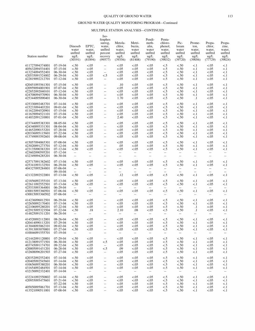
113QUALITY OF GROUND WATER
GROUND WATER QUALITY MONITORING PROGRAM—Continued
MULTIPLE STATION ANALYSES—CONTINUED
Station number Date
Dinosebwaterunfltrdug/L
(30191)
EPTC,water,unfltrdug/L
(81894)
Iso-fenphossurrog,water,unfltrdpercentrecovry(99577)
Metola-chlor,water,unfltrdug/L
(39356)
Metri-buzin,waterunfltrdug/L
(81408)
Pendi-meth-alin,waterunfltrdug/L
(79190)
Penta-chloro-phenol,water,unfltrdug/L
(39032)
Pic-loramwaterunfltrdug/L
(39720)
Prome-ton,
water,unfltrdug/L
(39056)
Propa-chlor,water,unfltrdug/L
(77729)
Propa-zine,
water,unfltrdug/L
(39024)
411727094374001 07-19-04 <.50 <.05 -- <.05 <.05 <.05 <.5 <.50 <.1 <.05 <.1405632094534401 07-15-04 <.50 <.05 -- <.05 <.05 <.05 <.5 <.50 <.1 <.05 <.1413234094552401 06-30-04 <.50 <.05 -- <.05 <.05 <.05 <.5 <.50 <.1 <.05 <.1420535091524002 06-29-04 <.50 <.05 <.5 <.05 <.05 <.05 <.5 <.50 <.1 <.05 <.1422819092212701 07-12-04 <.50 <.05 -- <.05 <.05 <.05 <.5 <.50 <.1 <.05 <.1
420451093561301 07-15-04 <.50 <.05 -- .10 <.05 <.05 <.5 <.50 <.1 <.05 <.1420959094001901 07-07-04 <.50 <.05 -- <.05 <.05 <.05 <.5 <.50 <.1 <.05 <.1422852092040101 07-12-04 <.50 <.05 -- <.05 <.05 <.05 <.5 <.50 <.1 <.05 <.1424708094570901 06-30-04 <.50 <.05 -- <.05 <.05 <.05 <.5 <.50 <.1 <.05 <.1425344095090401 06-30-04 <.50 <.05 -- 1.70 <.05 <.05 <.5 <.50 .1 <.05 <.1
425330092483701 07-14-04 <.50 <.05 -- <.05 <.05 <.05 <.5 <.50 <.1 <.05 <.1415233094403201 09-01-04 <.50 <.05 -- <.05 <.05 <.05 <.5 <.50 <.1 <.05 <.1411622094520901 07-15-04 <.50 <.05 -- <.05 <.05 <.05 <.5 <.50 <.1 <.05 <.1411639094521101 07-15-04 <.50 <.05 -- <.05 <.05 <.05 <.5 <.50 <.1 <.05 <.1414032091210001 07-01-04 <.50 <.05 -- 2.40 <.05 <.05 <.5 <.50 <.1 <.05 <.1
423744095383301 08-05-04 <.50 <.05 -- <.05 <.05 <.05 <.5 <.50 <.1 <.05 <.1424340095331301 08-04-04 <.50 <.05 -- <.05 <.05 <.05 <.5 <.50 <.1 <.05 <.1414652090153201 07-28-04 <.50 <.05 -- <.05 <.05 <.05 <.5 <.50 <.1 <.05 <.1420336095115601 07-22-04 <.50 <.05 -- <.05 <.05 <.05 <.5 <.50 <.1 <.05 <.1413749093592601 09-08-04 <.50 <.05 -- <.05 <.05 <.05 <.5 <.50 <.1 <.05 <.1
415057094065301 07-08-04 <.50 <.05 -- <.05 <.05 <.05 <.5 <.50 <.1 <.05 <.1423020091273701 07-12-04 <.50 <.05 -- .05 <.05 <.05 <.5 <.50 <.1 <.05 <.1423135090383201 07-12-04 <.50 <.05 -- <.05 <.05 <.05 <.5 <.50 <.1 <.05 <.1423602090595201 07-12-04 -- -- -- -- -- -- -- -- -- -- --432349094285201 06-30-04 -- -- -- -- -- -- -- -- -- -- --
425717091382602 07-13-04 <.50 <.05 -- <.05 <.05 <.05 <.5 <.50 <.1 <.05 <.1425341093132501 06-29-04 <.50 <.05 -- <.05 <.05 <.05 <.5 <.50 <.1 <.05 <.1404327095284801 07-06-04 -- -- -- -- -- -- -- -- -- -- --
09-10-04 -- -- -- -- -- -- -- -- -- -- --421322092522001 07-13-04 <.50 <.05 -- .12 <.05 <.05 <.5 <.50 <.1 <.05 <.1
421856092355101 07-13-04 <.50 <.05 -- <.05 <.05 <.05 <.5 <.50 <.1 <.05 <.1422611092552501 07-13-04 <.50 <.05 -- <.05 <.05 <.05 <.5 <.50 <.1 <.05 <.1425533093364001 06-29-04 -- -- -- -- -- -- -- -- -- -- --430015093360501 07-06-04 <.50 <.05 -- <.05 <.05 <.05 <.5 <.50 <.1 <.05 <.1430015093360502 07-06-04 -- -- -- -- -- -- -- -- -- -- --
414236096012501 06-29-04 <.50 <.05 -- <.05 <.05 <.05 <.5 <.50 <.1 <.05 <.1432650092170401 07-13-04 <.50 <.05 -- <.05 <.05 <.05 <.5 <.50 <.1 <.05 <.1422106095280201 07-22-04 <.50 <.05 -- <.05 <.05 <.05 <.5 <.50 .1 <.05 <.1422915095323504 07-22-04 <.50 .18 -- 2.10 .08 <.05 <.5 <.50 .1 <.05 <.1414825091511201 06-28-04 -- -- -- -- -- -- -- -- -- -- --
414520092112001 08-26-04 <.50 <.05 -- <.05 <.05 <.05 <.5 <.50 <.1 <.05 <.1420414090113201 07-29-04 <.50 <.05 -- <.05 <.05 <.05 <.5 <.50 <.1 <.05 <.1413048093062101 09-02-04 <.50 <.05 -- <.05 <.05 <.05 <.5 <.50 <.1 <.05 <.1413913093070001 07-27-04 <.50 <.05 -- <.05 <.05 <.05 <.5 <.50 <.1 <.05 <.1410046091555701 07-19-04 -- -- -- -- -- -- -- -- -- -- --
421442091120001 07-29-04 <.50 <.05 -- <.05 <.05 <.05 <.5 <.50 <.1 <.05 <.1412138091571501 06-30-04 <.50 <.05 <.5 <.05 <.05 <.05 <.5 <.50 <.1 <.05 <.1403745091174701 09-22-04 <.50 <.05 -- <.05 <.05 <.05 <.5 <.50 <.1 <.05 <.1420005091431201 06-28-04 <.50 <.05 <.5 .09 <.05 <.05 <.5 <.50 <.1 <.05 <.1432608096201503 07-27-04 <.50 <.05 -- <.05 <.05 <.05 <.5 <.50 <.1 <.05 <.1
420352092552401 07-14-04 <.50 <.05 -- <.05 <.05 <.05 <.5 <.50 <.1 <.05 <.1420405092545601 07-14-04 <.50 <.05 -- <.05 <.05 <.05 <.5 <.50 <.1 <.05 <.1410656095380201 06-30-04 <.50 <.05 -- <.05 <.05 <.05 <.5 <.50 <.1 <.05 <.1431654092484501 07-14-04 <.50 <.05 -- <.05 <.05 <.05 <.5 <.50 <.1 <.05 <.1432150092332401 07-14-04 -- -- -- -- -- -- -- -- -- -- --
432241092550802 07-14-04 <.50 <.05 -- <.05 <.05 <.05 <.5 <.50 <.1 <.05 <.1420955095475601 07-21-04 <.50 <.05 -- <.05 <.05 <.05 <.5 <.50 <.1 <.05 <.1
07-22-04 <.50 <.05 -- <.05 <.05 <.05 <.5 <.50 <.1 <.05 <.1405850095061701 07-13-04 <.50 <.05 -- <.05 <.05 <.05 <.5 <.50 <.1 <.05 <.1413521090511001 07-08-04 <.50 <.05 -- <.05 <.05 <.05 <.5 <.50 <.1 <.05 <.1
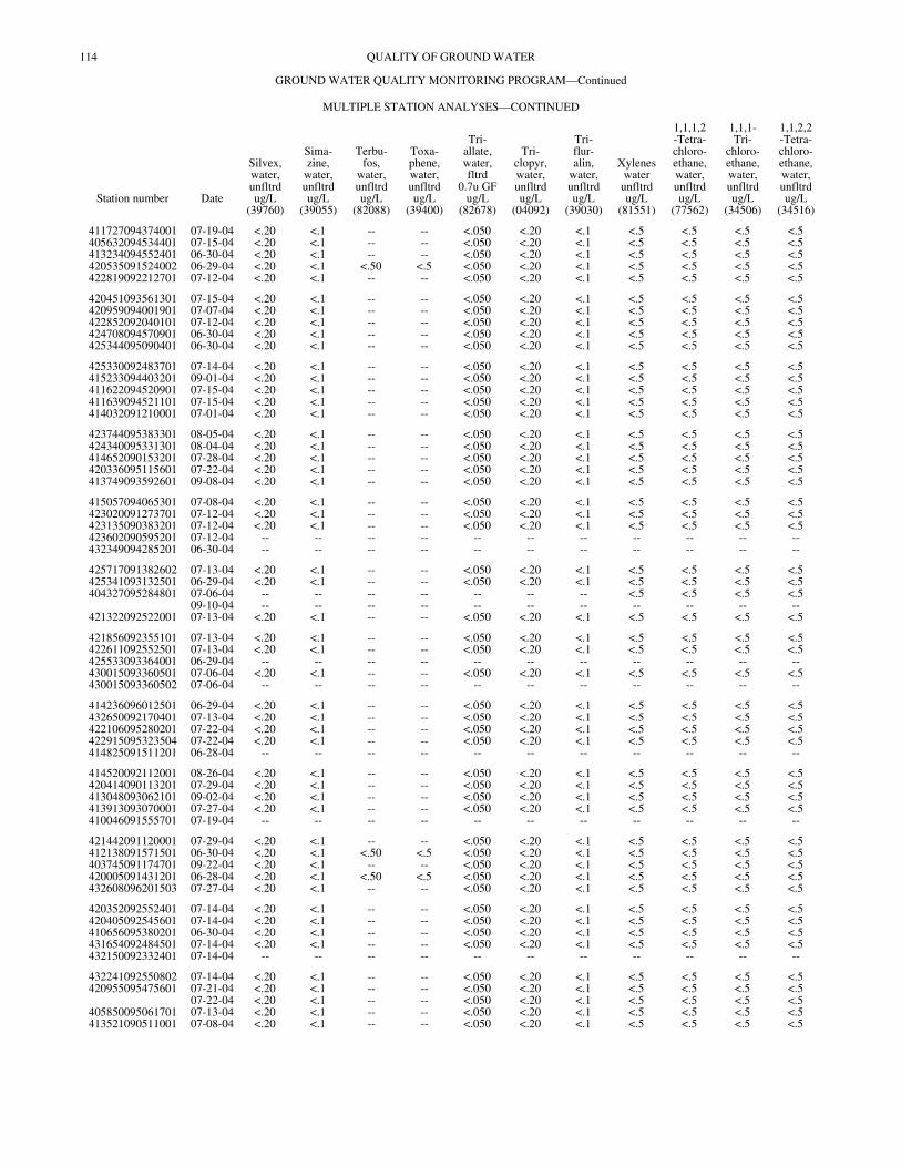
114 QUALITY OF GROUND WATER
GROUND WATER QUALITY MONITORING PROGRAM—Continued
MULTIPLE STATION ANALYSES—CONTINUED
Station number Date
Silvex,water,unfltrdug/L
(39760)
Sima-zine,
water,unfltrdug/L
(39055)
Terbu-fos,
water,unfltrdug/L
(82088)
Toxa-phene,water,unfltrdug/L
(39400)
Tri-allate,water,fltrd
0.7u GFug/L
(82678)
Tri-clopyr,water,unfltrdug/L
(04092)
Tri-flur-alin,
water,unfltrdug/L
(39030)
Xyleneswaterunfltrdug/L
(81551)
1,1,1,2-Tetra-chloro-ethane,water,unfltrdug/L
(77562)
1,1,1-Tri-
chloro-ethane,water,unfltrdug/L
(34506)
1,1,2,2-Tetra-chloro-ethane,water,unfltrdug/L
(34516)
411727094374001 07-19-04 <.20 <.1 -- -- <.050 <.20 <.1 <.5 <.5 <.5 <.5405632094534401 07-15-04 <.20 <.1 -- -- <.050 <.20 <.1 <.5 <.5 <.5 <.5413234094552401 06-30-04 <.20 <.1 -- -- <.050 <.20 <.1 <.5 <.5 <.5 <.5420535091524002 06-29-04 <.20 <.1 <.50 <.5 <.050 <.20 <.1 <.5 <.5 <.5 <.5422819092212701 07-12-04 <.20 <.1 -- -- <.050 <.20 <.1 <.5 <.5 <.5 <.5
420451093561301 07-15-04 <.20 <.1 -- -- <.050 <.20 <.1 <.5 <.5 <.5 <.5420959094001901 07-07-04 <.20 <.1 -- -- <.050 <.20 <.1 <.5 <.5 <.5 <.5422852092040101 07-12-04 <.20 <.1 -- -- <.050 <.20 <.1 <.5 <.5 <.5 <.5424708094570901 06-30-04 <.20 <.1 -- -- <.050 <.20 <.1 <.5 <.5 <.5 <.5425344095090401 06-30-04 <.20 <.1 -- -- <.050 <.20 <.1 <.5 <.5 <.5 <.5
425330092483701 07-14-04 <.20 <.1 -- -- <.050 <.20 <.1 <.5 <.5 <.5 <.5415233094403201 09-01-04 <.20 <.1 -- -- <.050 <.20 <.1 <.5 <.5 <.5 <.5411622094520901 07-15-04 <.20 <.1 -- -- <.050 <.20 <.1 <.5 <.5 <.5 <.5411639094521101 07-15-04 <.20 <.1 -- -- <.050 <.20 <.1 <.5 <.5 <.5 <.5414032091210001 07-01-04 <.20 <.1 -- -- <.050 <.20 <.1 <.5 <.5 <.5 <.5
423744095383301 08-05-04 <.20 <.1 -- -- <.050 <.20 <.1 <.5 <.5 <.5 <.5424340095331301 08-04-04 <.20 <.1 -- -- <.050 <.20 <.1 <.5 <.5 <.5 <.5414652090153201 07-28-04 <.20 <.1 -- -- <.050 <.20 <.1 <.5 <.5 <.5 <.5420336095115601 07-22-04 <.20 <.1 -- -- <.050 <.20 <.1 <.5 <.5 <.5 <.5413749093592601 09-08-04 <.20 <.1 -- -- <.050 <.20 <.1 <.5 <.5 <.5 <.5
415057094065301 07-08-04 <.20 <.1 -- -- <.050 <.20 <.1 <.5 <.5 <.5 <.5423020091273701 07-12-04 <.20 <.1 -- -- <.050 <.20 <.1 <.5 <.5 <.5 <.5423135090383201 07-12-04 <.20 <.1 -- -- <.050 <.20 <.1 <.5 <.5 <.5 <.5423602090595201 07-12-04 -- -- -- -- -- -- -- -- -- -- --432349094285201 06-30-04 -- -- -- -- -- -- -- -- -- -- --
425717091382602 07-13-04 <.20 <.1 -- -- <.050 <.20 <.1 <.5 <.5 <.5 <.5425341093132501 06-29-04 <.20 <.1 -- -- <.050 <.20 <.1 <.5 <.5 <.5 <.5404327095284801 07-06-04 -- -- -- -- -- -- -- <.5 <.5 <.5 <.5
09-10-04 -- -- -- -- -- -- -- -- -- -- --421322092522001 07-13-04 <.20 <.1 -- -- <.050 <.20 <.1 <.5 <.5 <.5 <.5
421856092355101 07-13-04 <.20 <.1 -- -- <.050 <.20 <.1 <.5 <.5 <.5 <.5422611092552501 07-13-04 <.20 <.1 -- -- <.050 <.20 <.1 <.5 <.5 <.5 <.5425533093364001 06-29-04 -- -- -- -- -- -- -- -- -- -- --430015093360501 07-06-04 <.20 <.1 -- -- <.050 <.20 <.1 <.5 <.5 <.5 <.5430015093360502 07-06-04 -- -- -- -- -- -- -- -- -- -- --
414236096012501 06-29-04 <.20 <.1 -- -- <.050 <.20 <.1 <.5 <.5 <.5 <.5432650092170401 07-13-04 <.20 <.1 -- -- <.050 <.20 <.1 <.5 <.5 <.5 <.5422106095280201 07-22-04 <.20 <.1 -- -- <.050 <.20 <.1 <.5 <.5 <.5 <.5422915095323504 07-22-04 <.20 <.1 -- -- <.050 <.20 <.1 <.5 <.5 <.5 <.5414825091511201 06-28-04 -- -- -- -- -- -- -- -- -- -- --
414520092112001 08-26-04 <.20 <.1 -- -- <.050 <.20 <.1 <.5 <.5 <.5 <.5420414090113201 07-29-04 <.20 <.1 -- -- <.050 <.20 <.1 <.5 <.5 <.5 <.5413048093062101 09-02-04 <.20 <.1 -- -- <.050 <.20 <.1 <.5 <.5 <.5 <.5413913093070001 07-27-04 <.20 <.1 -- -- <.050 <.20 <.1 <.5 <.5 <.5 <.5410046091555701 07-19-04 -- -- -- -- -- -- -- -- -- -- --
421442091120001 07-29-04 <.20 <.1 -- -- <.050 <.20 <.1 <.5 <.5 <.5 <.5412138091571501 06-30-04 <.20 <.1 <.50 <.5 <.050 <.20 <.1 <.5 <.5 <.5 <.5403745091174701 09-22-04 <.20 <.1 -- -- <.050 <.20 <.1 <.5 <.5 <.5 <.5420005091431201 06-28-04 <.20 <.1 <.50 <.5 <.050 <.20 <.1 <.5 <.5 <.5 <.5432608096201503 07-27-04 <.20 <.1 -- -- <.050 <.20 <.1 <.5 <.5 <.5 <.5
420352092552401 07-14-04 <.20 <.1 -- -- <.050 <.20 <.1 <.5 <.5 <.5 <.5420405092545601 07-14-04 <.20 <.1 -- -- <.050 <.20 <.1 <.5 <.5 <.5 <.5410656095380201 06-30-04 <.20 <.1 -- -- <.050 <.20 <.1 <.5 <.5 <.5 <.5431654092484501 07-14-04 <.20 <.1 -- -- <.050 <.20 <.1 <.5 <.5 <.5 <.5432150092332401 07-14-04 -- -- -- -- -- -- -- -- -- -- --
432241092550802 07-14-04 <.20 <.1 -- -- <.050 <.20 <.1 <.5 <.5 <.5 <.5420955095475601 07-21-04 <.20 <.1 -- -- <.050 <.20 <.1 <.5 <.5 <.5 <.5
07-22-04 <.20 <.1 -- -- <.050 <.20 <.1 <.5 <.5 <.5 <.5405850095061701 07-13-04 <.20 <.1 -- -- <.050 <.20 <.1 <.5 <.5 <.5 <.5413521090511001 07-08-04 <.20 <.1 -- -- <.050 <.20 <.1 <.5 <.5 <.5 <.5
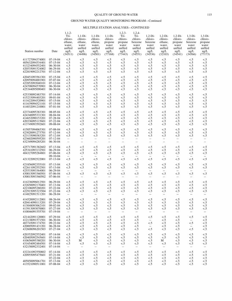
115QUALITY OF GROUND WATER
GROUND WATER QUALITY MONITORING PROGRAM—Continued
MULTIPLE STATION ANALYSES—CONTINUED
Station number Date
1,1,2-Tri-
chloro-ethane,water,unfltrdug/L
(34511)
1,1-Di-chloro-ethane,waterunfltrdug/L
(34496)
1,1-Di-chloro-ethene,water,unfltrdug/L
(34501)
1,1-Di-chloro-propene
waterunfltrdug/L
(77168)
1,2,3-Tri-
chloro-propane
waterunfltrdug/L
(77443)
1,2,4-Tri-
chloro-benzene
waterunfltrdug/L
(34551)
1,2-Di-chloro-benzene
waterunfltrdug/L
(34536)
1,2-Di-chloro-ethane,water,unfltrdug/L
(32103)
1,2-Di-chloro-propane
waterunfltrdug/L
(34541)
1,3-Di-chloro-benzene
waterunfltrdug/L
(34566)
1,3-Di-chloro-propanewaterunfltrdug/L
(77173)
411727094374001 07-19-04 <.5 <.5 <.5 <.5 <.5 <.5 <.5 <.5 <.5 <.5 <.5405632094534401 07-15-04 <.5 <.5 <.5 <.5 <.5 <.5 <.5 <.5 <.5 <.5 <.5413234094552401 06-30-04 <.5 <.5 <.5 <.5 <.5 <.5 <.5 <.5 <.5 <.5 <.5420535091524002 06-29-04 <.5 <.5 <.5 <.5 <.5 <.5 <.5 <.5 <.5 <.5 <.5422819092212701 07-12-04 <.5 <.5 <.5 <.5 <.5 <.5 <.5 <.5 <.5 <.5 <.5
420451093561301 07-15-04 <.5 <.5 <.5 <.5 <.5 <.5 <.5 <.5 <.5 <.5 <.5420959094001901 07-07-04 <.5 <.5 <.5 <.5 <.5 <.5 <.5 <.5 <.5 <.5 <.5422852092040101 07-12-04 <.5 <.5 <.5 <.5 <.5 <.5 <.5 <.5 <.5 <.5 <.5424708094570901 06-30-04 <.5 <.5 <.5 <.5 <.5 <.5 <.5 <.5 <.5 <.5 <.5425344095090401 06-30-04 <.5 <.5 <.5 <.5 <.5 <.5 <.5 <.5 <.5 <.5 <.5
425330092483701 07-14-04 <.5 <.5 <.5 <.5 <.5 <.5 <.5 <.5 <.5 <.5 <.5415233094403201 09-01-04 <.5 <.5 <.5 <.5 <.5 <.5 <.5 <.5 <.5 <.5 <.5411622094520901 07-15-04 <.5 <.5 <.5 <.5 <.5 <.5 <.5 <.5 <.5 <.5 <.5411639094521101 07-15-04 <.5 <.5 <.5 <.5 <.5 <.5 <.5 <.5 <.5 <.5 <.5414032091210001 07-01-04 <.5 <.5 <.5 <.5 <.5 <.5 <.5 <.5 <.5 <.5 <.5
423744095383301 08-05-04 <.5 <.5 <.5 <.5 <.5 <.5 <.5 <.5 <.5 <.5 <.5424340095331301 08-04-04 <.5 <.5 <.5 <.5 <.5 <.5 <.5 <.5 <.5 <.5 <.5414652090153201 07-28-04 <.5 <.5 <.5 <.5 <.5 <.5 <.5 <.5 <.5 <.5 <.5420336095115601 07-22-04 <.5 <.5 <.5 <.5 <.5 <.5 <.5 <.5 <.5 <.5 <.5413749093592601 09-08-04 <.5 <.5 <.5 <.5 <.5 <.5 <.5 <.5 <.5 <.5 <.5
415057094065301 07-08-04 <.5 <.5 <.5 <.5 <.5 <.5 <.5 <.5 <.5 <.5 <.5423020091273701 07-12-04 <.5 <.5 <.5 <.5 <.5 <.5 <.5 <.5 <.5 <.5 <.5423135090383201 07-12-04 <.5 <.5 <.5 <.5 <.5 <.5 <.5 <.5 <.5 <.5 <.5423602090595201 07-12-04 -- -- -- -- -- -- -- -- -- -- --432349094285201 06-30-04 -- -- -- -- -- -- -- -- -- -- --
425717091382602 07-13-04 <.5 <.5 <.5 <.5 <.5 <.5 <.5 <.5 <.5 <.5 <.5425341093132501 06-29-04 <.5 <.5 <.5 <.5 <.5 <.5 <.5 <.5 <.5 <.5 <.5404327095284801 07-06-04 <.5 <.5 <.5 <.5 <.5 <.5 <.5 <.5 <.5 <.5 <.5
09-10-04 -- -- -- -- -- -- -- -- -- -- --421322092522001 07-13-04 <.5 <.5 <.5 <.5 <.5 <.5 <.5 <.5 <.5 <.5 <.5
421856092355101 07-13-04 <.5 <.5 <.5 <.5 <.5 <.5 <.5 <.5 <.5 <.5 <.5422611092552501 07-13-04 <.5 <.5 <.5 <.5 <.5 <.5 <.5 <.5 <.5 <.5 <.5425533093364001 06-29-04 -- -- -- -- -- -- -- -- -- -- --430015093360501 07-06-04 <.5 <.5 <.5 <.5 <.5 <.5 <.5 <.5 <.5 <.5 <.5430015093360502 07-06-04 -- -- -- -- -- -- -- -- -- -- --
414236096012501 06-29-04 <.5 <.5 <.5 <.5 <.5 <.5 <.5 <.5 <.5 <.5 <.5432650092170401 07-13-04 <.5 <.5 <.5 <.5 <.5 <.5 <.5 <.5 <.5 <.5 <.5422106095280201 07-22-04 <.5 <.5 <.5 <.5 <.5 <.5 <.5 <.5 <.5 <.5 <.5422915095323504 07-22-04 <.5 <.5 <.5 <.5 <.5 <.5 <.5 <.5 <.5 <.5 <.5414825091511201 06-28-04 -- -- -- -- -- -- -- -- -- -- --
414520092112001 08-26-04 <.5 <.5 <.5 <.5 <.5 <.5 <.5 <.5 <.5 <.5 <.5420414090113201 07-29-04 <.5 <.5 <.5 <.5 <.5 <.5 <.5 <.5 <.5 <.5 <.5413048093062101 09-02-04 <.5 <.5 <.5 <.5 <.5 <.5 <.5 <.5 <.5 <.5 <.5413913093070001 07-27-04 <.5 <.5 <.5 <.5 <.5 <.5 <.5 <.5 <.5 <.5 <.5410046091555701 07-19-04 -- -- -- -- -- -- -- -- -- -- --
421442091120001 07-29-04 <.5 <.5 <.5 <.5 <.5 <.5 <.5 <.5 <.5 <.5 <.5412138091571501 06-30-04 <.5 <.5 <.5 <.5 <.5 <.5 -- <.5 <.5 -- <.5403745091174701 09-22-04 <.5 <.5 <.5 <.5 <.5 <.5 <.5 <.5 <.5 <.5 <.5420005091431201 06-28-04 <.5 <.5 <.5 <.5 <.5 <.5 -- <.5 <.5 -- <.5432608096201503 07-27-04 <.5 <.5 <.5 <.5 <.5 <.5 <.5 <.5 <.5 <.5 <.5
420352092552401 07-14-04 <.5 <.5 <.5 <.5 <.5 <.5 <.5 <.5 <.5 <.5 <.5420405092545601 07-14-04 <.5 <.5 <.5 <.5 <.5 <.5 <.5 <.5 <.5 <.5 <.5410656095380201 06-30-04 <.5 M <.5 <.5 <.5 <.5 <.5 M <.5 <.5 <.5431654092484501 07-14-04 <.5 <.5 <.5 <.5 <.5 <.5 <.5 <.5 <.5 <.5 <.5432150092332401 07-14-04 -- -- -- -- -- -- -- -- -- -- --
432241092550802 07-14-04 <.5 <.5 <.5 <.5 <.5 <.5 <.5 <.5 <.5 <.5 <.5420955095475601 07-21-04 <.5 <.5 <.5 <.5 <.5 <.5 <.5 <.5 <.5 <.5 <.5
07-22-04 <.5 <.5 <.5 <.5 <.5 <.5 <.5 <.5 <.5 <.5 <.5405850095061701 07-13-04 <.5 <.5 <.5 <.5 <.5 <.5 <.5 <.5 <.5 <.5 <.5413521090511001 07-08-04 <.5 <.5 <.5 <.5 <.5 <.5 <.5 <.5 <.5 <.5 <.5

116 QUALITY OF GROUND WATER
GROUND WATER QUALITY MONITORING PROGRAM—Continued
MULTIPLE STATION ANALYSES—CONTINUED
Station number Date
1,4-Di-chloro-benzene
waterunfltrdug/L
(34571)
2,2-Di-chloro-propane
waterunfltrdug/L
(77170)
2-Chloro-toluenewaterunfltrdug/L
(77275)
4-Chloro-toluenewaterunfltrdug/L
(77277)
Benzenewaterunfltrdug/L
(34030)
Bromo-benzene
waterunfltrdug/L
(81555)
Bromo-di-
chloro-methane
waterunfltrdug/L
(32101)
Chloro-benzene
waterunfltrdug/L
(34301)
Chloro-ethane,water,unfltrdug/L
(34311)
cis-1,2-Di-chloro-ethene,water,unfltrdug/L
(77093)
cis-1,3-Di-chloro-propenewaterunfltrdug/L
(34704)
411727094374001 07-19-04 <.5 <.5 <.5 <.5 <.5 <.5 <.5 <.5 <.5 <.5 <.5405632094534401 07-15-04 <.5 <.5 <.5 <.5 <.5 <.5 <.5 <.5 <.5 <.5 <.5413234094552401 06-30-04 <.5 <.5 <.5 <.5 <.5 <.5 <.5 <.5 <.5 <.5 <.5420535091524002 06-29-04 <.5 <.5 <.5 <.5 <.5 <.5 <.5 <.5 <.5 <.5 <.5422819092212701 07-12-04 <.5 <.5 <.5 <.5 <.5 <.5 <.5 <.5 <.5 <.5 <.5
420451093561301 07-15-04 <.5 <.5 <.5 <.5 <.5 <.5 <.5 <.5 <.5 <.5 <.5420959094001901 07-07-04 <.5 <.5 <.5 <.5 <.5 <.5 <.5 <.5 <.5 <.5 <.5422852092040101 07-12-04 <.5 <.5 <.5 <.5 <.5 <.5 <.5 <.5 <.5 <.5 <.5424708094570901 06-30-04 <.5 <.5 <.5 <.5 <.5 <.5 <.5 <.5 <.5 <.5 <.5425344095090401 06-30-04 <.5 <.5 <.5 <.5 <.5 <.5 <.5 <.5 <.5 <.5 <.5
425330092483701 07-14-04 <.5 <.5 <.5 <.5 <.5 <.5 <.5 <.5 <.5 <.5 <.5415233094403201 09-01-04 <.5 <.5 <.5 <.5 <.5 <.5 <.5 <.5 <.5 <.5 <.5411622094520901 07-15-04 <.5 <.5 <.5 <.5 <.5 <.5 <.5 <.5 <.5 <.5 <.5411639094521101 07-15-04 <.5 <.5 <.5 <.5 <.5 <.5 <.5 <.5 <.5 <.5 <.5414032091210001 07-01-04 <.5 <.5 <.5 <.5 <.5 <.5 <.5 <.5 <.5 <.5 <.5
423744095383301 08-05-04 <.5 <.5 <.5 <.5 <.5 <.5 <.5 <.5 <.5 <.5 <.5424340095331301 08-04-04 <.5 <.5 <.5 <.5 <.5 <.5 <.5 <.5 <.5 <.5 <.5414652090153201 07-28-04 <.5 <.5 <.5 <.5 <.5 <.5 <.5 <.5 <.5 <.5 <.5420336095115601 07-22-04 <.5 <.5 <.5 <.5 <.5 <.5 <.5 <.5 <.5 <.5 <.5413749093592601 09-08-04 <.5 <.5 <.5 <.5 <.5 <.5 <.5 <.5 <.5 <.5 <.5
415057094065301 07-08-04 <.5 <.5 <.5 <.5 <.5 <.5 <.5 <.5 <.5 <.5 <.5423020091273701 07-12-04 <.5 <.5 <.5 <.5 <.5 <.5 <.5 <.5 <.5 <.5 <.5423135090383201 07-12-04 <.5 <.5 <.5 <.5 <.5 <.5 <.5 <.5 <.5 <.5 <.5423602090595201 07-12-04 -- -- -- -- -- -- -- -- -- -- --432349094285201 06-30-04 -- -- -- -- -- -- -- -- -- -- --
425717091382602 07-13-04 <.5 <.5 <.5 <.5 <.5 <.5 <.5 <.5 <.5 <.5 <.5425341093132501 06-29-04 <.5 <.5 <.5 <.5 <.5 <.5 <.5 <.5 <.5 <.5 <.5404327095284801 07-06-04 <.5 <.5 <.5 <.5 <.5 <.5 <.5 <.5 <.5 <.5 <.5
09-10-04 -- -- -- -- -- -- -- -- -- -- --421322092522001 07-13-04 <.5 <.5 <.5 <.5 <.5 <.5 <.5 <.5 <.5 <.5 <.5
421856092355101 07-13-04 <.5 <.5 <.5 <.5 <.5 <.5 <.5 <.5 <.5 <.5 <.5422611092552501 07-13-04 <.5 <.5 <.5 <.5 <.5 <.5 <.5 <.5 <.5 <.5 <.5425533093364001 06-29-04 -- -- -- -- -- -- -- -- -- -- --430015093360501 07-06-04 <.5 <.5 <.5 <.5 <.5 <.5 <.5 <.5 <.5 <.5 <.5430015093360502 07-06-04 -- -- -- -- -- -- -- -- -- -- --
414236096012501 06-29-04 <.5 <.5 <.5 <.5 <.5 <.5 <.5 <.5 <.5 <.5 <.5432650092170401 07-13-04 <.5 <.5 <.5 <.5 <.5 <.5 <.5 <.5 <.5 <.5 <.5422106095280201 07-22-04 <.5 <.5 <.5 <.5 <.5 <.5 <.5 <.5 <.5 <.5 <.5422915095323504 07-22-04 <.5 <.5 <.5 <.5 <.5 <.5 <.5 <.5 <.5 <.5 <.5414825091511201 06-28-04 -- -- -- -- -- -- -- -- -- -- --
414520092112001 08-26-04 <.5 <.5 <.5 <.5 <.5 <.5 <.5 <.5 <.5 <.5 <.5420414090113201 07-29-04 <.5 <.5 <.5 <.5 <.5 <.5 <.5 <.5 <.5 <.5 <.5413048093062101 09-02-04 <.5 <.5 <.5 <.5 <.5 <.5 <.5 <.5 <.5 <.5 <.5413913093070001 07-27-04 <.5 <.5 <.5 <.5 <.5 <.5 <.5 <.5 <.5 <.5 <.5410046091555701 07-19-04 -- -- -- -- -- -- -- -- -- -- --
421442091120001 07-29-04 <.5 <.5 <.5 <.5 <.5 <.5 <.5 <.5 <.5 <.5 <.5412138091571501 06-30-04 -- <.5 <.5 <.5 <.5 <.5 <.5 <.5 <.5 -- <.5403745091174701 09-22-04 <.5 <.5 <.5 <.5 <.5 <.5 <.5 <.5 <.5 <.5 <.5420005091431201 06-28-04 -- <.5 <.5 <.5 <.5 <.5 <.5 <.5 <.5 -- <.5432608096201503 07-27-04 <.5 <.5 <.5 <.5 <.5 <.5 <.5 <.5 <.5 <.5 <.5
420352092552401 07-14-04 <.5 <.5 <.5 <.5 <.5 <.5 <.5 <.5 <.5 <.5 <.5420405092545601 07-14-04 <.5 <.5 <.5 <.5 <.5 <.5 <.5 <.5 <.5 <.5 <.5410656095380201 06-30-04 <.5 <.5 <.5 <.5 <.5 <.5 <.5 <.5 <.5 <.5 <.5431654092484501 07-14-04 <.5 <.5 <.5 <.5 <.5 <.5 <.5 <.5 <.5 <.5 <.5432150092332401 07-14-04 -- -- -- -- -- -- -- -- -- -- --
432241092550802 07-14-04 <.5 <.5 <.5 <.5 <.5 <.5 <.5 <.5 <.5 <.5 <.5420955095475601 07-21-04 <.5 <.5 <.5 <.5 <.5 <.5 <.5 <.5 <.5 <.5 <.5
07-22-04 <.5 <.5 <.5 <.5 <.5 <.5 <.5 <.5 <.5 <.5 <.5405850095061701 07-13-04 <.5 <.5 <.5 <.5 <.5 <.5 <.5 <.5 <.5 <.5 <.5413521090511001 07-08-04 <.5 <.5 <.5 <.5 <.5 <.5 <.5 <.5 <.5 <.5 <.5
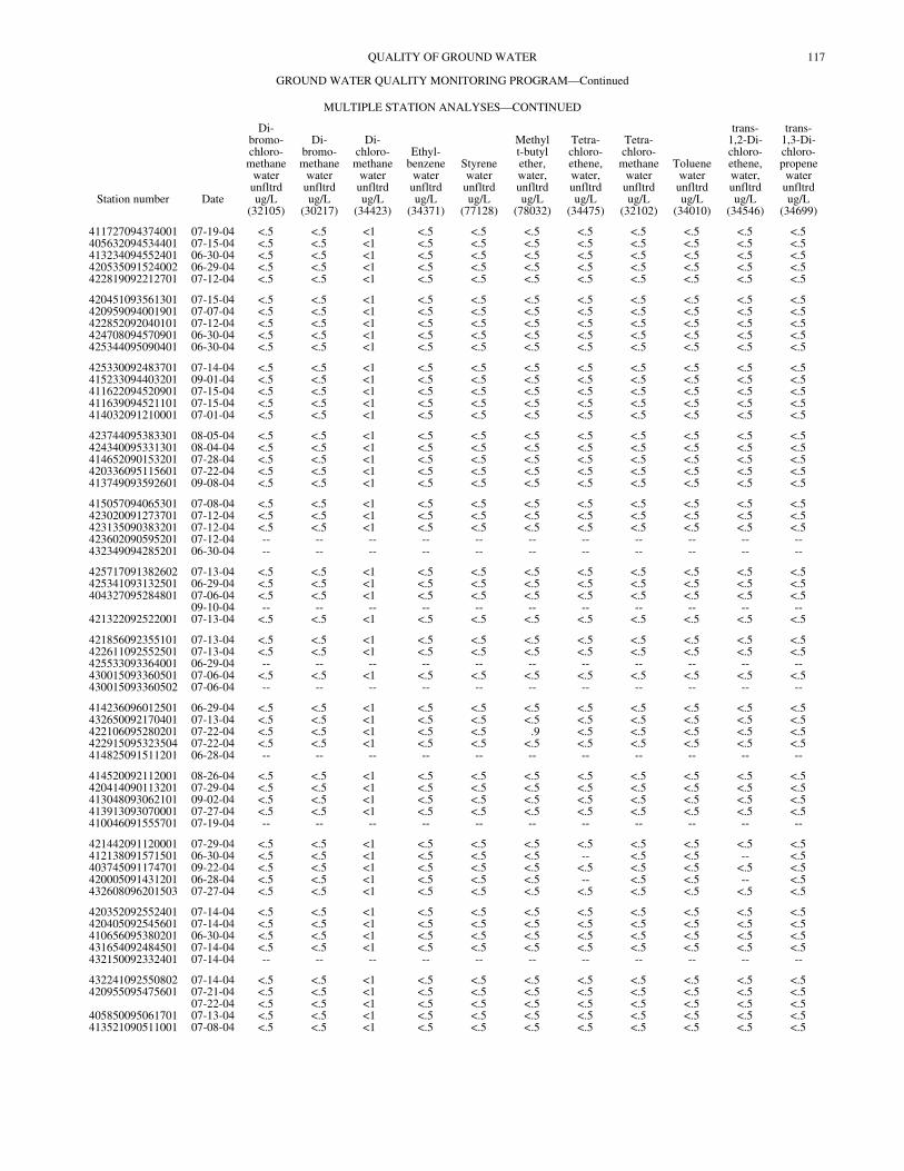
117QUALITY OF GROUND WATER
GROUND WATER QUALITY MONITORING PROGRAM—Continued
MULTIPLE STATION ANALYSES—CONTINUED
Station number Date
Di-bromo-chloro-methane
waterunfltrdug/L
(32105)
Di-bromo-methane
waterunfltrdug/L
(30217)
Di-chloro-
methanewaterunfltrdug/L
(34423)
Ethyl-benzene
waterunfltrdug/L
(34371)
Styrenewaterunfltrdug/L
(77128)
Methylt-butylether,water,unfltrdug/L
(78032)
Tetra-chloro-ethene,water,unfltrdug/L
(34475)
Tetra-chloro-
methanewaterunfltrdug/L
(32102)
Toluenewaterunfltrdug/L
(34010)
trans-1,2-Di-chloro-ethene,water,unfltrdug/L
(34546)
trans-1,3-Di-chloro-propenewaterunfltrdug/L
(34699)
411727094374001 07-19-04 <.5 <.5 <1 <.5 <.5 <.5 <.5 <.5 <.5 <.5 <.5405632094534401 07-15-04 <.5 <.5 <1 <.5 <.5 <.5 <.5 <.5 <.5 <.5 <.5413234094552401 06-30-04 <.5 <.5 <1 <.5 <.5 <.5 <.5 <.5 <.5 <.5 <.5420535091524002 06-29-04 <.5 <.5 <1 <.5 <.5 <.5 <.5 <.5 <.5 <.5 <.5422819092212701 07-12-04 <.5 <.5 <1 <.5 <.5 <.5 <.5 <.5 <.5 <.5 <.5
420451093561301 07-15-04 <.5 <.5 <1 <.5 <.5 <.5 <.5 <.5 <.5 <.5 <.5420959094001901 07-07-04 <.5 <.5 <1 <.5 <.5 <.5 <.5 <.5 <.5 <.5 <.5422852092040101 07-12-04 <.5 <.5 <1 <.5 <.5 <.5 <.5 <.5 <.5 <.5 <.5424708094570901 06-30-04 <.5 <.5 <1 <.5 <.5 <.5 <.5 <.5 <.5 <.5 <.5425344095090401 06-30-04 <.5 <.5 <1 <.5 <.5 <.5 <.5 <.5 <.5 <.5 <.5
425330092483701 07-14-04 <.5 <.5 <1 <.5 <.5 <.5 <.5 <.5 <.5 <.5 <.5415233094403201 09-01-04 <.5 <.5 <1 <.5 <.5 <.5 <.5 <.5 <.5 <.5 <.5411622094520901 07-15-04 <.5 <.5 <1 <.5 <.5 <.5 <.5 <.5 <.5 <.5 <.5411639094521101 07-15-04 <.5 <.5 <1 <.5 <.5 <.5 <.5 <.5 <.5 <.5 <.5414032091210001 07-01-04 <.5 <.5 <1 <.5 <.5 <.5 <.5 <.5 <.5 <.5 <.5
423744095383301 08-05-04 <.5 <.5 <1 <.5 <.5 <.5 <.5 <.5 <.5 <.5 <.5424340095331301 08-04-04 <.5 <.5 <1 <.5 <.5 <.5 <.5 <.5 <.5 <.5 <.5414652090153201 07-28-04 <.5 <.5 <1 <.5 <.5 <.5 <.5 <.5 <.5 <.5 <.5420336095115601 07-22-04 <.5 <.5 <1 <.5 <.5 <.5 <.5 <.5 <.5 <.5 <.5413749093592601 09-08-04 <.5 <.5 <1 <.5 <.5 <.5 <.5 <.5 <.5 <.5 <.5
415057094065301 07-08-04 <.5 <.5 <1 <.5 <.5 <.5 <.5 <.5 <.5 <.5 <.5423020091273701 07-12-04 <.5 <.5 <1 <.5 <.5 <.5 <.5 <.5 <.5 <.5 <.5423135090383201 07-12-04 <.5 <.5 <1 <.5 <.5 <.5 <.5 <.5 <.5 <.5 <.5423602090595201 07-12-04 -- -- -- -- -- -- -- -- -- -- --432349094285201 06-30-04 -- -- -- -- -- -- -- -- -- -- --
425717091382602 07-13-04 <.5 <.5 <1 <.5 <.5 <.5 <.5 <.5 <.5 <.5 <.5425341093132501 06-29-04 <.5 <.5 <1 <.5 <.5 <.5 <.5 <.5 <.5 <.5 <.5404327095284801 07-06-04 <.5 <.5 <1 <.5 <.5 <.5 <.5 <.5 <.5 <.5 <.5
09-10-04 -- -- -- -- -- -- -- -- -- -- --421322092522001 07-13-04 <.5 <.5 <1 <.5 <.5 <.5 <.5 <.5 <.5 <.5 <.5
421856092355101 07-13-04 <.5 <.5 <1 <.5 <.5 <.5 <.5 <.5 <.5 <.5 <.5422611092552501 07-13-04 <.5 <.5 <1 <.5 <.5 <.5 <.5 <.5 <.5 <.5 <.5425533093364001 06-29-04 -- -- -- -- -- -- -- -- -- -- --430015093360501 07-06-04 <.5 <.5 <1 <.5 <.5 <.5 <.5 <.5 <.5 <.5 <.5430015093360502 07-06-04 -- -- -- -- -- -- -- -- -- -- --
414236096012501 06-29-04 <.5 <.5 <1 <.5 <.5 <.5 <.5 <.5 <.5 <.5 <.5432650092170401 07-13-04 <.5 <.5 <1 <.5 <.5 <.5 <.5 <.5 <.5 <.5 <.5422106095280201 07-22-04 <.5 <.5 <1 <.5 <.5 .9 <.5 <.5 <.5 <.5 <.5422915095323504 07-22-04 <.5 <.5 <1 <.5 <.5 <.5 <.5 <.5 <.5 <.5 <.5414825091511201 06-28-04 -- -- -- -- -- -- -- -- -- -- --
414520092112001 08-26-04 <.5 <.5 <1 <.5 <.5 <.5 <.5 <.5 <.5 <.5 <.5420414090113201 07-29-04 <.5 <.5 <1 <.5 <.5 <.5 <.5 <.5 <.5 <.5 <.5413048093062101 09-02-04 <.5 <.5 <1 <.5 <.5 <.5 <.5 <.5 <.5 <.5 <.5413913093070001 07-27-04 <.5 <.5 <1 <.5 <.5 <.5 <.5 <.5 <.5 <.5 <.5410046091555701 07-19-04 -- -- -- -- -- -- -- -- -- -- --
421442091120001 07-29-04 <.5 <.5 <1 <.5 <.5 <.5 <.5 <.5 <.5 <.5 <.5412138091571501 06-30-04 <.5 <.5 <1 <.5 <.5 <.5 -- <.5 <.5 -- <.5403745091174701 09-22-04 <.5 <.5 <1 <.5 <.5 <.5 <.5 <.5 <.5 <.5 <.5420005091431201 06-28-04 <.5 <.5 <1 <.5 <.5 <.5 -- <.5 <.5 -- <.5432608096201503 07-27-04 <.5 <.5 <1 <.5 <.5 <.5 <.5 <.5 <.5 <.5 <.5
420352092552401 07-14-04 <.5 <.5 <1 <.5 <.5 <.5 <.5 <.5 <.5 <.5 <.5420405092545601 07-14-04 <.5 <.5 <1 <.5 <.5 <.5 <.5 <.5 <.5 <.5 <.5410656095380201 06-30-04 <.5 <.5 <1 <.5 <.5 <.5 <.5 <.5 <.5 <.5 <.5431654092484501 07-14-04 <.5 <.5 <1 <.5 <.5 <.5 <.5 <.5 <.5 <.5 <.5432150092332401 07-14-04 -- -- -- -- -- -- -- -- -- -- --
432241092550802 07-14-04 <.5 <.5 <1 <.5 <.5 <.5 <.5 <.5 <.5 <.5 <.5420955095475601 07-21-04 <.5 <.5 <1 <.5 <.5 <.5 <.5 <.5 <.5 <.5 <.5
07-22-04 <.5 <.5 <1 <.5 <.5 <.5 <.5 <.5 <.5 <.5 <.5405850095061701 07-13-04 <.5 <.5 <1 <.5 <.5 <.5 <.5 <.5 <.5 <.5 <.5413521090511001 07-08-04 <.5 <.5 <1 <.5 <.5 <.5 <.5 <.5 <.5 <.5 <.5
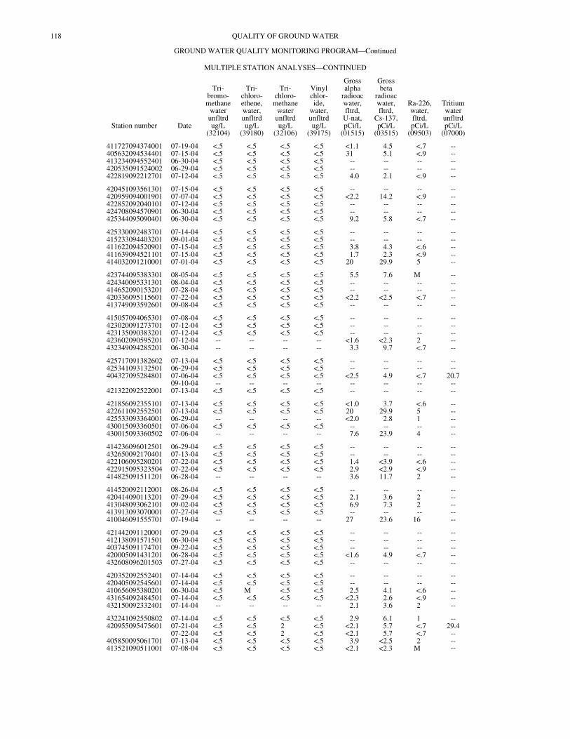
118 QUALITY OF GROUND WATER
GROUND WATER QUALITY MONITORING PROGRAM—Continued
MULTIPLE STATION ANALYSES—CONTINUED
Station number Date
Tri-bromo-methane
waterunfltrdug/L
(32104)
Tri-chloro-ethene,water,unfltrdug/L
(39180)
Tri-chloro-
methanewaterunfltrdug/L
(32106)
Vinylchlor-ide,
water,unfltrdug/L
(39175)
Grossalpha
radioacwater,fltrd,
U-nat,pCi/L
(01515)
Grossbeta
radioacwater,fltrd,
Cs-137,pCi/L
(03515)
Ra-226,water,fltrd,pCi/L
(09503)
TritiumwaterunfltrdpCi/L
(07000)
411727094374001 07-19-04 <.5 <.5 <.5 <.5 <1.1 4.5 <.7 --405632094534401 07-15-04 <.5 <.5 <.5 <.5 31 5.1 <.9 --413234094552401 06-30-04 <.5 <.5 <.5 <.5 -- -- -- --420535091524002 06-29-04 <.5 <.5 <.5 <.5 -- -- -- --422819092212701 07-12-04 <.5 <.5 <.5 <.5 4.0 2.1 <.9 --
420451093561301 07-15-04 <.5 <.5 <.5 <.5 -- -- -- --420959094001901 07-07-04 <.5 <.5 <.5 <.5 <2.2 14.2 <.9 --422852092040101 07-12-04 <.5 <.5 <.5 <.5 -- -- -- --424708094570901 06-30-04 <.5 <.5 <.5 <.5 -- -- -- --425344095090401 06-30-04 <.5 <.5 <.5 <.5 9.2 5.8 <.7 --
425330092483701 07-14-04 <.5 <.5 <.5 <.5 -- -- -- --415233094403201 09-01-04 <.5 <.5 <.5 <.5 -- -- -- --411622094520901 07-15-04 <.5 <.5 <.5 <.5 3.8 4.3 <.6 --411639094521101 07-15-04 <.5 <.5 <.5 <.5 1.7 2.3 <.9 --414032091210001 07-01-04 <.5 <.5 <.5 <.5 20 29.9 5 --
423744095383301 08-05-04 <.5 <.5 <.5 <.5 5.5 7.6 M --424340095331301 08-04-04 <.5 <.5 <.5 <.5 -- -- -- --414652090153201 07-28-04 <.5 <.5 <.5 <.5 -- -- -- --420336095115601 07-22-04 <.5 <.5 <.5 <.5 <2.2 <2.5 <.7 --413749093592601 09-08-04 <.5 <.5 <.5 <.5 -- -- -- --
415057094065301 07-08-04 <.5 <.5 <.5 <.5 -- -- -- --423020091273701 07-12-04 <.5 <.5 <.5 <.5 -- -- -- --423135090383201 07-12-04 <.5 <.5 <.5 <.5 -- -- -- --423602090595201 07-12-04 -- -- -- -- <1.6 <2.3 2 --432349094285201 06-30-04 -- -- -- -- 3.3 9.7 <.7 --
425717091382602 07-13-04 <.5 <.5 <.5 <.5 -- -- -- --425341093132501 06-29-04 <.5 <.5 <.5 <.5 -- -- -- --404327095284801 07-06-04 <.5 <.5 <.5 <.5 <2.5 4.9 <.7 20.7
09-10-04 -- -- -- -- -- -- -- --421322092522001 07-13-04 <.5 <.5 <.5 <.5 -- -- -- --
421856092355101 07-13-04 <.5 <.5 <.5 <.5 <1.0 3.7 <.6 --422611092552501 07-13-04 <.5 <.5 <.5 <.5 20 29.9 5 --425533093364001 06-29-04 -- -- -- -- <2.0 2.8 1 --430015093360501 07-06-04 <.5 <.5 <.5 <.5 -- -- -- --430015093360502 07-06-04 -- -- -- -- 7.6 23.9 4 --
414236096012501 06-29-04 <.5 <.5 <.5 <.5 -- -- -- --432650092170401 07-13-04 <.5 <.5 <.5 <.5 -- -- -- --422106095280201 07-22-04 <.5 <.5 <.5 <.5 1.4 <3.9 <.6 --422915095323504 07-22-04 <.5 <.5 <.5 <.5 2.9 <2.9 <.9 --414825091511201 06-28-04 -- -- -- -- 3.6 11.7 2 --
414520092112001 08-26-04 <.5 <.5 <.5 <.5 -- -- -- --420414090113201 07-29-04 <.5 <.5 <.5 <.5 2.1 3.6 2 --413048093062101 09-02-04 <.5 <.5 <.5 <.5 6.9 7.3 2 --413913093070001 07-27-04 <.5 <.5 <.5 <.5 -- -- -- --410046091555701 07-19-04 -- -- -- -- 27 23.6 16 --
421442091120001 07-29-04 <.5 <.5 <.5 <.5 -- -- -- --412138091571501 06-30-04 <.5 <.5 <.5 <.5 -- -- -- --403745091174701 09-22-04 <.5 <.5 <.5 <.5 -- -- -- --420005091431201 06-28-04 <.5 <.5 <.5 <.5 <1.6 4.9 <.7 --432608096201503 07-27-04 <.5 <.5 <.5 <.5 -- -- -- --
420352092552401 07-14-04 <.5 <.5 <.5 <.5 -- -- -- --420405092545601 07-14-04 <.5 <.5 <.5 <.5 -- -- -- --410656095380201 06-30-04 <.5 M <.5 <.5 2.5 4.1 <.6 --431654092484501 07-14-04 <.5 <.5 <.5 <.5 <2.3 2.6 <.9 --432150092332401 07-14-04 -- -- -- -- 2.1 3.6 2 --
432241092550802 07-14-04 <.5 <.5 <.5 <.5 2.9 6.1 1 --420955095475601 07-21-04 <.5 <.5 2 <.5 <2.1 5.7 <.7 29.4
07-22-04 <.5 <.5 2 <.5 <2.1 5.7 <.7 --405850095061701 07-13-04 <.5 <.5 <.5 <.5 3.9 <2.5 2 --413521090511001 07-08-04 <.5 <.5 <.5 <.5 <2.1 <2.3 M --
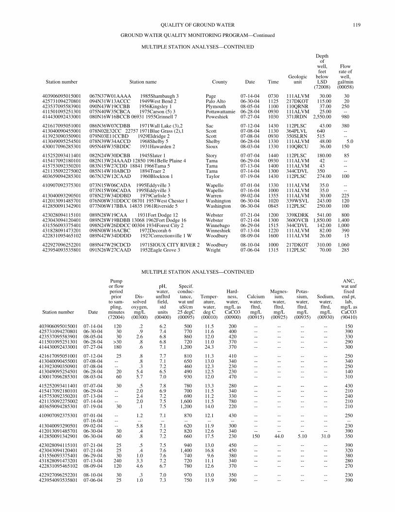
119QUALITY OF GROUND WATER
GROUND WATER QUALITY MONITORING PROGRAM—Continued
MULTIPLE STATION ANALYSES—CONTINUED
Station number Station name County Date TimeGeologic
unit
Depthof
well,feet
belowLSD
(72008)
Flowrate ofwell,
gal/min(00058)
403906095015001 067N37W01AAAA 1985Shambaugh 3 Page 07-14-04 0730 111ALVM 30.00 30425731094270801 094N31W13ACCC 1949West Bend 2 Palo Alto 06-30-04 1125 217DKOT 115.00 20423537095583901 090N43W19CCBB 1956Kingsley 1 Plymouth 08-05-04 1100 110QRNR 37.00 250411501095251301 075N40W35CBCA 1975Carson (5) 3 Pottawattamie 06-28-04 0930 111ALVM 25.00 --414430092433001 080N16W16BCCB 06931 1955Grinnell 7 Poweshiek 07-27-04 1030 371JRDN 2,550.00 980
421617095051001 086N36W07CDBB 1971Wall Lake (3),2 Sac 07-12-04 1430 112PLSC 43.00 380413040090455001 078N02E32CC 22757 1971Blue Grass (2),1 Scott 07-08-04 1130 364PLVL 640 --413923090350901 079N03E11CCBD 1929Eldridge 2 Scott 07-08-04 0930 350SLRN 515 --413049095254501 078N39W34ACCD 1968Shelby 5 Shelby 06-28-04 1330 111ALVM 48.00 5.0430017096285301 095N48W35BDDC 1931Hawarden 2 Sioux 08-03-04 1330 110QRCU 36.00 150
415252093411401 082N24W30DCBB 1945Slater 1 Story 07-07-04 1440 112PLSC 180.00 85415417092180101 082N13W24AAAD 12850 1961Belle Plaine 4 Tama 06-29-04 0930 111ALVM 42 --415753092350201 083N15W27CDD 18841 1966Tama 5 Tama 07-13-04 1400 111ALVM 43 --421135092275002 085N14W10ABCD 1894Traer 2 Tama 07-14-04 1300 344CDVL 350 --403659094285301 067N32W12CAAD 1960Blockton 1 Taylor 07-19-04 1430 112PLSC 274.00 100
410907092375301 073N15W06CADA 1995Eddyville 3 Wapello 07-01-04 1330 111ALVM 35.0 --073N15W06CADA 1995Eddyville 3 Wapello 07-16-04 1000 111ALVM 35.0 --
413040093290501 078N23W34DDBD 1979Carlisle 5 Warren 09-02-04 1355 111ALVM 30.00 225412013091485701 076N08W31DDCC 08701 1957West Chester 1 Washington 06-30-04 1020 339WSVL 243.00 120412850091342901 077N06W17BBA 14835 1961Riverside 5 Washington 06-30-04 0845 112PLSC 250.00 100
423028094115101 089N28W19CAA 1931Fort Dodge 12 Webster 07-21-04 1200 339KDRK 541.00 800423043094120401 089N28W19BDBB 13068 1962Fort Dodge 16 Webster 07-21-04 1300 360OVCB 1,850.00 1,400431556093375401 098N24W26DDCC 00304 1934Forest City 2 Winnebago 06-29-04 1515 344CDVL 142.00 1,000431828091473201 098N08W16ACBC 1972Decorah 6 Winneshiek 07-13-04 1220 111ALVM 82.00 390422831095465102 089N42W34DDDD 1927Correctionville 1 W Woodbury 08-09-04 1600 111ALVM 26.00 15
422927096252201 089N47W29CDCD 1971SIOUX CITY RIVER 2 Woodbury 08-10-04 1000 217DKOT 310.00 1,060423954093535801 091N26W27CAAD 1952Eagle Grove 3 Wright 07-06-04 1315 112PLSC 70.00 285
MULTIPLE STATION ANALYSES—CONTINUED
Station number Date
Pumpor flowperiodprior
to sam-pling,
minutes(72004)
Dis-solved
oxygen,mg/L
(00300)
pH,water,unfltrdfield,std
units(00400)
Specif.conduc-tance,
wat unfuS/cm
25 degC(00095)
Temper-ature,water,deg C
(00010)
Hard-ness,
water,mg/L asCaCO3(00900)
Calciumwater,fltrd,mg/L
(00915)
Magnes-ium,
water,fltrd,mg/L
(00925)
Potas-sium,water,fltrd,mg/L
(00935)
Sodium,water,fltrd,mg/L
(00930)
ANC,wat unffixed
end pt,lab,
mg/L asCaCO3(90410)
403906095015001 07-14-04 120 .2 6.2 500 11.5 200 -- -- -- -- 150425731094270801 06-30-04 30 .9 7.4 770 11.6 400 -- -- -- -- 390423537095583901 08-05-04 30 2.6 6.8 860 12.0 420 -- -- -- -- 330411501095251301 06-28-04 >30 .8 6.8 720 11.0 370 -- -- -- -- 290414430092433001 07-27-04 180 .6 7.1 1,200 24.3 370 -- -- -- -- 300
421617095051001 07-12-04 25 .8 7.7 810 11.3 410 -- -- -- -- 250413040090455001 07-08-04 -- .8 7.1 650 13.0 340 -- -- -- -- 340413923090350901 07-08-04 -- .3 7.2 460 12.3 230 -- -- -- -- 250413049095254501 06-28-04 20 5.4 6.5 490 12.5 230 -- -- -- -- 140430017096285301 08-03-04 60 5.7 7.0 930 12.0 470 -- -- -- -- 310
415252093411401 07-07-04 30 .5 7.8 780 13.3 280 -- -- -- -- 430415417092180101 06-29-04 -- 2.0 6.9 700 11.5 340 -- -- -- -- 210415753092350201 07-13-04 -- 2.4 7.2 690 11.2 330 -- -- -- -- 240421135092275002 07-14-04 -- 2.0 7.5 1,600 11.5 780 -- -- -- -- 210403659094285301 07-19-04 30 .1 7.5 1,200 14.0 220 -- -- -- -- 210
410907092375301 07-01-04 -- 1.2 7.1 870 12.1 430 -- -- -- -- 25007-16-04 -- -- -- -- -- -- -- -- -- -- --
413040093290501 09-02-04 -- 5.8 7.1 620 11.9 300 -- -- -- -- 230412013091485701 06-30-04 30 .4 7.2 820 12.6 340 -- -- -- -- 390412850091342901 06-30-04 60 .8 7.2 660 17.5 230 150 44.0 5.10 31.0 350
423028094115101 07-21-04 25 .5 7.5 940 13.0 450 -- -- -- -- 390423043094120401 07-21-04 25 .4 7.6 1,400 16.8 450 -- -- -- -- 320431556093375401 06-29-04 30 1.0 7.6 740 9.6 380 -- -- -- -- 380431828091473201 07-13-04 240 3.3 7.2 720 11.1 340 -- -- -- -- 280422831095465102 08-09-04 120 4.6 6.7 780 12.6 370 -- -- -- -- 270
422927096252201 08-10-04 30 .3 7.0 970 13.0 350 -- -- -- -- 230423954093535801 07-06-04 25 1.0 7.3 750 11.9 390 -- -- -- -- 390
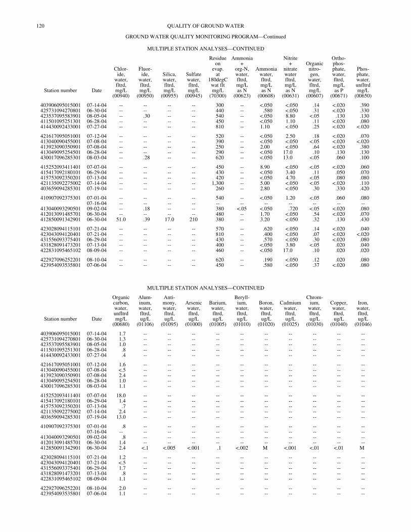
120 QUALITY OF GROUND WATER
GROUND WATER QUALITY MONITORING PROGRAM—Continued
MULTIPLE STATION ANALYSES—CONTINUED
Station number Date
Chlor-ide,
water,fltrd,mg/L
(00940)
Fluor-ide,
water,fltrd,mg/L
(00950)
Silica,water,fltrd,mg/L
(00955)
Sulfatewater,fltrd,mg/L
(00945)
Residueon
evap.at
180degCwat fltmg/L
(70300)
Ammonia+
org-N,water,fltrd,mg/Las N
(00623)
Ammoniawater,fltrd,mg/Las N
(00608)
Nitrite+
nitratewaterfltrd,mg/Las N
(00631)
Organicnitro-gen,
water,fltrd,mg/L
(00607)
Ortho-phos-phate,water,fltrd,mg/Las P
(00671)
Phos-phate,water,unfltrdmg/L
(00650)
403906095015001 07-14-04 -- -- -- -- 300 -- <.050 <.050 .14 <.020 .390425731094270801 06-30-04 -- -- -- -- 440 -- .580 <.050 .31 <.020 .330423537095583901 08-05-04 -- .30 -- -- 540 -- <.050 8.80 <.05 .130 .130411501095251301 06-28-04 -- -- -- -- 450 -- <.050 1.10 .11 <.020 .080414430092433001 07-27-04 -- -- -- -- 810 -- 1.10 <.050 .25 <.020 <.020
421617095051001 07-12-04 -- -- -- -- 520 -- <.050 2.50 .18 <.020 .070413040090455001 07-08-04 -- -- -- -- 390 -- <.050 <.050 <.05 <.020 <.020413923090350901 07-08-04 -- -- -- -- 250 -- 2.00 <.050 .64 <.020 .380413049095254501 06-28-04 -- -- -- -- 290 -- <.050 17.0 .10 .130 .130430017096285301 08-03-04 -- .28 -- -- 620 -- <.050 13.0 <.05 .060 .100
415252093411401 07-07-04 -- -- -- -- 450 -- 8.90 <.050 <.05 <.020 .060415417092180101 06-29-04 -- -- -- -- 430 -- <.050 3.40 .11 .050 .070415753092350201 07-13-04 -- -- -- -- 420 -- <.050 4.70 <.05 .080 .080421135092275002 07-14-04 -- -- -- -- 1,300 -- 5.00 <.050 <.05 <.020 .110403659094285301 07-19-04 -- -- -- -- 260 -- 2.80 <.050 .30 .330 .420
410907092375301 07-01-04 -- -- -- -- 540 -- <.050 1.20 <.05 .060 .08007-16-04 -- -- -- -- -- -- -- -- -- -- --
413040093290501 09-02-04 -- .18 -- -- 380 <.05 <.050 .720 <.05 <.020 .080412013091485701 06-30-04 -- -- -- -- 480 -- 1.70 <.050 .54 <.020 .070412850091342901 06-30-04 51.0 .39 17.0 210 380 -- 3.20 <.050 .32 .130 .430
423028094115101 07-21-04 -- -- -- -- 570 -- .620 <.050 .14 <.020 .040423043094120401 07-21-04 -- -- -- -- 810 -- .400 <.050 .07 <.020 <.020431556093375401 06-29-04 -- -- -- -- 430 -- .570 <.050 .30 <.020 .080431828091473201 07-13-04 -- -- -- -- 400 -- <.050 3.80 <.05 .020 .040422831095465102 08-09-04 -- -- -- -- 460 -- <.050 17.0 .10 .020 .020
422927096252201 08-10-04 -- -- -- -- 620 -- .190 <.050 .12 .020 .080423954093535801 07-06-04 -- -- -- -- 450 -- .580 <.050 .37 <.020 .080
MULTIPLE STATION ANALYSES—CONTINUED
Station number Date
Organiccarbon,water,unfltrdmg/L
(00680)
Alum-inum,water,fltrd,ug/L
(01106)
Anti-mony,water,fltrd,ug/L
(01095)
Arsenicwater,fltrd,ug/L
(01000)
Barium,water,fltrd,ug/L
(01005)
Beryll-ium,
water,fltrd,ug/L
(01010)
Boron,water,fltrd,ug/L
(01020)
Cadmiumwater,fltrd,ug/L
(01025)
Chrom-ium,
water,fltrd,ug/L
(01030)
Copper,water,fltrd,ug/L
(01040)
Iron,water,fltrd,ug/L
(01046)
403906095015001 07-14-04 1.7 -- -- -- -- -- -- -- -- -- --425731094270801 06-30-04 1.3 -- -- -- -- -- -- -- -- -- --423537095583901 08-05-04 1.0 -- -- -- -- -- -- -- -- -- --411501095251301 06-28-04 .8 -- -- -- -- -- -- -- -- -- --414430092433001 07-27-04 .4 -- -- -- -- -- -- -- -- -- --
421617095051001 07-12-04 1.6 -- -- -- -- -- -- -- -- -- --413040090455001 07-08-04 <.5 -- -- -- -- -- -- -- -- -- --413923090350901 07-08-04 2.4 -- -- -- -- -- -- -- -- -- --413049095254501 06-28-04 1.0 -- -- -- -- -- -- -- -- -- --430017096285301 08-03-04 1.1 -- -- -- -- -- -- -- -- -- --
415252093411401 07-07-04 18.0 -- -- -- -- -- -- -- -- -- --415417092180101 06-29-04 1.4 -- -- -- -- -- -- -- -- -- --415753092350201 07-13-04 .7 -- -- -- -- -- -- -- -- -- --421135092275002 07-14-04 2.4 -- -- -- -- -- -- -- -- -- --403659094285301 07-19-04 13.0 -- -- -- -- -- -- -- -- -- --
410907092375301 07-01-04 .8 -- -- -- -- -- -- -- -- -- --07-16-04 -- -- -- -- -- -- -- -- -- -- --
413040093290501 09-02-04 .8 -- -- -- -- -- -- -- -- -- --412013091485701 06-30-04 1.4 -- -- -- -- -- -- -- -- -- --412850091342901 06-30-04 2.4 <.1 <.005 <.001 .1 <.002 M <.001 <.01 <.01 M
423028094115101 07-21-04 1.2 -- -- -- -- -- -- -- -- -- --423043094120401 07-21-04 <.5 -- -- -- -- -- -- -- -- -- --431556093375401 06-29-04 1.7 -- -- -- -- -- -- -- -- -- --431828091473201 07-13-04 .8 -- -- -- -- -- -- -- -- -- --422831095465102 08-09-04 1.1 -- -- -- -- -- -- -- -- -- --
422927096252201 08-10-04 2.0 -- -- -- -- -- -- -- -- -- --423954093535801 07-06-04 1.1 -- -- -- -- -- -- -- -- -- --
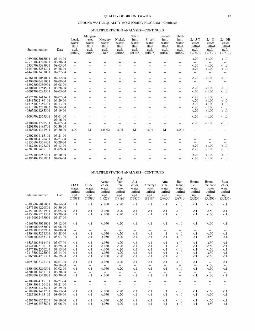
121QUALITY OF GROUND WATER
GROUND WATER QUALITY MONITORING PROGRAM—Continued
MULTIPLE STATION ANALYSES—CONTINUED
Station number Date
Lead,water,fltrd,ug/L
(01049)
Mangan-ese,
water,fltrd,ug/L
(01056)
Mercurywater,fltrd,ug/L
(71890)
Nickel,water,fltrd,ug/L
(01065)
Selen-ium,
water,fltrd,ug/L
(01145)
Silver,water,fltrd,ug/L
(01075)
Stront-ium,
water,fltrd,ug/L
(01080)
Thall-ium,
water,fltrd,ug/L
(01057)
2,4,5-Twaterunfltrdug/L
(39740)
2,4-Dwaterunfltrdug/L
(39730)
2,4-DBwaterunfltrdug/L
(30219)
403906095015001 07-14-04 -- -- -- -- -- -- -- -- <.20 <1.00 <1.0425731094270801 06-30-04 -- -- -- -- -- -- -- -- -- -- --423537095583901 08-05-04 -- -- -- -- -- -- -- -- <.20 <1.00 <1.0411501095251301 06-28-04 -- -- -- -- -- -- -- -- <.20 <1.00 <1.0414430092433001 07-27-04 -- -- -- -- -- -- -- -- -- -- --
421617095051001 07-12-04 -- -- -- -- -- -- -- -- <.20 <1.00 <1.0413040090455001 07-08-04 -- -- -- -- -- -- -- -- -- -- --413923090350901 07-08-04 -- -- -- -- -- -- -- -- -- -- --413049095254501 06-28-04 -- -- -- -- -- -- -- -- <.20 <1.00 <1.0430017096285301 08-03-04 -- -- -- -- -- -- -- -- <.20 <1.00 <1.0
415252093411401 07-07-04 -- -- -- -- -- -- -- -- <.20 <1.00 <1.0415417092180101 06-29-04 -- -- -- -- -- -- -- -- <.20 <1.00 <1.0415753092350201 07-13-04 -- -- -- -- -- -- -- -- <.20 <1.00 <1.0421135092275002 07-14-04 -- -- -- -- -- -- -- -- <.20 <1.00 <1.0403659094285301 07-19-04 -- -- -- -- -- -- -- -- <.20 <1.00 <1.0
410907092375301 07-01-04 -- -- -- -- -- -- -- -- <.20 <1.00 <1.007-16-04 -- -- -- -- -- -- -- -- -- -- --
413040093290501 09-02-04 -- -- -- -- -- -- -- -- <.20 <1.00 <1.0412013091485701 06-30-04 -- -- -- -- -- -- -- -- -- -- --412850091342901 06-30-04 <.001 M <.0002 <.05 M <.01 M <.001 -- -- --
423028094115101 07-21-04 -- -- -- -- -- -- -- -- -- -- --423043094120401 07-21-04 -- -- -- -- -- -- -- -- -- -- --431556093375401 06-29-04 -- -- -- -- -- -- -- -- -- -- --431828091473201 07-13-04 -- -- -- -- -- -- -- -- <.20 <1.00 <1.0422831095465102 08-09-04 -- -- -- -- -- -- -- -- <.20 <1.00 <1.0
422927096252201 08-10-04 -- -- -- -- -- -- -- -- <.20 <1.00 <1.0423954093535801 07-06-04 -- -- -- -- -- -- -- -- <.20 <1.00 <1.0
MULTIPLE STATION ANALYSES—CONTINUED
Station number Date
CIAT,water,unfltrdug/L
(75981)
CEAT,water,unfltrdug/L
(75980)
Aceto-chlor,water,unfltrdug/L
(49259)
Aci-fluor-fen,
waterunfltrdug/L
(79193)
Ala-chlor,water,unfltrdug/L
(77825)
Ametrynwaterunfltrdug/L
(82184)
Atra-zine,
water,unfltrdug/L
(39630)
Ben-tazon,water,unfltrdug/L
(38710)
Broma-cil,
water,unfltrdug/L
(30234)
Bromo-methane
waterunfltrdug/L
(30202)
Buta-chlor,water,unfltrdug/L
(30235)
403906095015001 07-14-04 <.1 <.1 <.050 <.20 <.1 <.1 <.1 <1.0 <.1 <.50 <.1425731094270801 06-30-04 -- -- -- -- -- -- -- -- -- -- --423537095583901 08-05-04 <.1 <.1 <.050 <.20 <.1 <.1 <.1 <1.0 <.1 <.50 <.1411501095251301 06-28-04 <.1 <.1 <.050 <.20 <.1 <.1 <.1 <1.0 <.1 <.50 <.1414430092433001 07-27-04 -- -- -- -- -- -- -- -- -- -- --
421617095051001 07-12-04 <.1 <.1 <.050 <.20 <.1 <.1 <.1 <1.0 <.1 <.50 <.1413040090455001 07-08-04 -- -- -- -- -- -- -- -- -- -- --413923090350901 07-08-04 -- -- -- -- -- -- -- -- -- -- --413049095254501 06-28-04 <.1 <.1 <.050 <.20 <.1 <.1 .1 <1.0 <.1 <.50 <.1430017096285301 08-03-04 .1 <.1 <.050 <.20 <.1 <.1 <.1 <1.0 <.1 <.50 <.1
415252093411401 07-07-04 <.1 <.1 <.050 <.20 <.1 <.1 <.1 <1.0 <.1 <.50 <.1415417092180101 06-29-04 .1 <.1 <.050 <.20 <.1 <.1 .1 <1.0 <.1 <.50 <.1415753092350201 07-13-04 <.1 <.1 <.050 <.20 <.1 <.1 <.1 <1.0 <.1 <.50 <.1421135092275002 07-14-04 <.1 <.1 <.050 <.20 <.1 <.1 <.1 <1.0 <.1 <.50 <.1403659094285301 07-19-04 <.1 <.1 <.050 <.20 <.1 <.1 <.1 <1.0 <.1 <.50 <.1
410907092375301 07-01-04 <.1 <.1 <.050 <.20 <.1 <.1 <.1 <1.0 <.1 -- <.107-16-04 -- -- -- -- -- -- -- -- -- <.50 --
413040093290501 09-02-04 <.1 <.1 <.050 <.20 <.1 <.1 <.1 <1.0 <.1 <.50 <.1412013091485701 06-30-04 -- -- -- -- -- -- -- -- -- -- --412850091342901 06-30-04 <.1 <.1 <.050 -- <.1 <.1 <.1 -- <.1 <.50 <.1
423028094115101 07-21-04 -- -- -- -- -- -- -- -- -- -- --423043094120401 07-21-04 -- -- -- -- -- -- -- -- -- -- --431556093375401 06-29-04 -- -- -- -- -- -- -- -- -- -- --431828091473201 07-13-04 <.1 <.1 <.050 <.20 <.1 <.1 .1 <1.0 <.1 <.50 <.1422831095465102 08-09-04 <.1 <.1 <.050 <.20 <.1 <.1 <.1 <1.0 <.1 <.50 <.1
422927096252201 08-10-04 <.1 <.1 <.050 <.20 <.1 <.1 <.1 <1.0 <.1 <.50 <.1423954093535801 07-06-04 <.1 <.1 <.050 <.20 <.1 <.1 <.1 <1.0 <.1 <.50 <.1
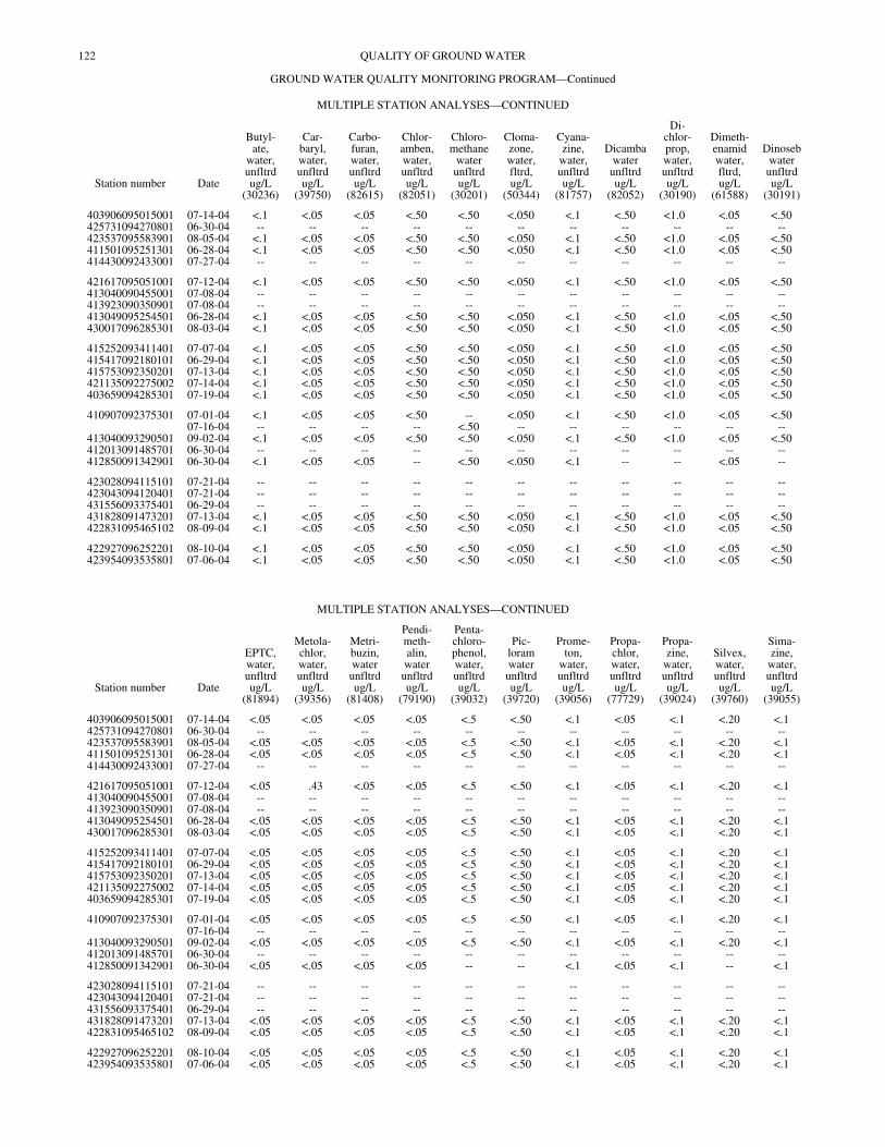
122 QUALITY OF GROUND WATER
GROUND WATER QUALITY MONITORING PROGRAM—Continued
MULTIPLE STATION ANALYSES—CONTINUED
Station number Date
Butyl-ate,
water,unfltrdug/L
(30236)
Car-baryl,water,unfltrdug/L
(39750)
Carbo-furan,water,unfltrdug/L
(82615)
Chlor-amben,water,unfltrdug/L
(82051)
Chloro-methane
waterunfltrdug/L
(30201)
Cloma-zone,water,fltrd,ug/L
(50344)
Cyana-zine,
water,unfltrdug/L
(81757)
Dicambawaterunfltrdug/L
(82052)
Di-chlor-prop,water,unfltrdug/L
(30190)
Dimeth-enamidwater,fltrd,ug/L
(61588)
Dinosebwaterunfltrdug/L
(30191)
403906095015001 07-14-04 <.1 <.05 <.05 <.50 <.50 <.050 <.1 <.50 <1.0 <.05 <.50425731094270801 06-30-04 -- -- -- -- -- -- -- -- -- -- --423537095583901 08-05-04 <.1 <.05 <.05 <.50 <.50 <.050 <.1 <.50 <1.0 <.05 <.50411501095251301 06-28-04 <.1 <.05 <.05 <.50 <.50 <.050 <.1 <.50 <1.0 <.05 <.50414430092433001 07-27-04 -- -- -- -- -- -- -- -- -- -- --
421617095051001 07-12-04 <.1 <.05 <.05 <.50 <.50 <.050 <.1 <.50 <1.0 <.05 <.50413040090455001 07-08-04 -- -- -- -- -- -- -- -- -- -- --413923090350901 07-08-04 -- -- -- -- -- -- -- -- -- -- --413049095254501 06-28-04 <.1 <.05 <.05 <.50 <.50 <.050 <.1 <.50 <1.0 <.05 <.50430017096285301 08-03-04 <.1 <.05 <.05 <.50 <.50 <.050 <.1 <.50 <1.0 <.05 <.50
415252093411401 07-07-04 <.1 <.05 <.05 <.50 <.50 <.050 <.1 <.50 <1.0 <.05 <.50415417092180101 06-29-04 <.1 <.05 <.05 <.50 <.50 <.050 <.1 <.50 <1.0 <.05 <.50415753092350201 07-13-04 <.1 <.05 <.05 <.50 <.50 <.050 <.1 <.50 <1.0 <.05 <.50421135092275002 07-14-04 <.1 <.05 <.05 <.50 <.50 <.050 <.1 <.50 <1.0 <.05 <.50403659094285301 07-19-04 <.1 <.05 <.05 <.50 <.50 <.050 <.1 <.50 <1.0 <.05 <.50
410907092375301 07-01-04 <.1 <.05 <.05 <.50 -- <.050 <.1 <.50 <1.0 <.05 <.5007-16-04 -- -- -- -- <.50 -- -- -- -- -- --
413040093290501 09-02-04 <.1 <.05 <.05 <.50 <.50 <.050 <.1 <.50 <1.0 <.05 <.50412013091485701 06-30-04 -- -- -- -- -- -- -- -- -- -- --412850091342901 06-30-04 <.1 <.05 <.05 -- <.50 <.050 <.1 -- -- <.05 --
423028094115101 07-21-04 -- -- -- -- -- -- -- -- -- -- --423043094120401 07-21-04 -- -- -- -- -- -- -- -- -- -- --431556093375401 06-29-04 -- -- -- -- -- -- -- -- -- -- --431828091473201 07-13-04 <.1 <.05 <.05 <.50 <.50 <.050 <.1 <.50 <1.0 <.05 <.50422831095465102 08-09-04 <.1 <.05 <.05 <.50 <.50 <.050 <.1 <.50 <1.0 <.05 <.50
422927096252201 08-10-04 <.1 <.05 <.05 <.50 <.50 <.050 <.1 <.50 <1.0 <.05 <.50423954093535801 07-06-04 <.1 <.05 <.05 <.50 <.50 <.050 <.1 <.50 <1.0 <.05 <.50
MULTIPLE STATION ANALYSES—CONTINUED
Station number Date
EPTC,water,unfltrdug/L
(81894)
Metola-chlor,water,unfltrdug/L
(39356)
Metri-buzin,waterunfltrdug/L
(81408)
Pendi-meth-alin,waterunfltrdug/L
(79190)
Penta-chloro-phenol,water,unfltrdug/L
(39032)
Pic-loramwaterunfltrdug/L
(39720)
Prome-ton,
water,unfltrdug/L
(39056)
Propa-chlor,water,unfltrdug/L
(77729)
Propa-zine,
water,unfltrdug/L
(39024)
Silvex,water,unfltrdug/L
(39760)
Sima-zine,
water,unfltrdug/L
(39055)
403906095015001 07-14-04 <.05 <.05 <.05 <.05 <.5 <.50 <.1 <.05 <.1 <.20 <.1425731094270801 06-30-04 -- -- -- -- -- -- -- -- -- -- --423537095583901 08-05-04 <.05 <.05 <.05 <.05 <.5 <.50 <.1 <.05 <.1 <.20 <.1411501095251301 06-28-04 <.05 <.05 <.05 <.05 <.5 <.50 <.1 <.05 <.1 <.20 <.1414430092433001 07-27-04 -- -- -- -- -- -- -- -- -- -- --
421617095051001 07-12-04 <.05 .43 <.05 <.05 <.5 <.50 <.1 <.05 <.1 <.20 <.1413040090455001 07-08-04 -- -- -- -- -- -- -- -- -- -- --413923090350901 07-08-04 -- -- -- -- -- -- -- -- -- -- --413049095254501 06-28-04 <.05 <.05 <.05 <.05 <.5 <.50 <.1 <.05 <.1 <.20 <.1430017096285301 08-03-04 <.05 <.05 <.05 <.05 <.5 <.50 <.1 <.05 <.1 <.20 <.1
415252093411401 07-07-04 <.05 <.05 <.05 <.05 <.5 <.50 <.1 <.05 <.1 <.20 <.1415417092180101 06-29-04 <.05 <.05 <.05 <.05 <.5 <.50 <.1 <.05 <.1 <.20 <.1415753092350201 07-13-04 <.05 <.05 <.05 <.05 <.5 <.50 <.1 <.05 <.1 <.20 <.1421135092275002 07-14-04 <.05 <.05 <.05 <.05 <.5 <.50 <.1 <.05 <.1 <.20 <.1403659094285301 07-19-04 <.05 <.05 <.05 <.05 <.5 <.50 <.1 <.05 <.1 <.20 <.1
410907092375301 07-01-04 <.05 <.05 <.05 <.05 <.5 <.50 <.1 <.05 <.1 <.20 <.107-16-04 -- -- -- -- -- -- -- -- -- -- --
413040093290501 09-02-04 <.05 <.05 <.05 <.05 <.5 <.50 <.1 <.05 <.1 <.20 <.1412013091485701 06-30-04 -- -- -- -- -- -- -- -- -- -- --412850091342901 06-30-04 <.05 <.05 <.05 <.05 -- -- <.1 <.05 <.1 -- <.1
423028094115101 07-21-04 -- -- -- -- -- -- -- -- -- -- --423043094120401 07-21-04 -- -- -- -- -- -- -- -- -- -- --431556093375401 06-29-04 -- -- -- -- -- -- -- -- -- -- --431828091473201 07-13-04 <.05 <.05 <.05 <.05 <.5 <.50 <.1 <.05 <.1 <.20 <.1422831095465102 08-09-04 <.05 <.05 <.05 <.05 <.5 <.50 <.1 <.05 <.1 <.20 <.1
422927096252201 08-10-04 <.05 <.05 <.05 <.05 <.5 <.50 <.1 <.05 <.1 <.20 <.1423954093535801 07-06-04 <.05 <.05 <.05 <.05 <.5 <.50 <.1 <.05 <.1 <.20 <.1

123QUALITY OF GROUND WATER
GROUND WATER QUALITY MONITORING PROGRAM—Continued
MULTIPLE STATION ANALYSES—CONTINUED
Station number Date
Tri-allate,water,fltrd
0.7u GFug/L
(82678)
Tri-clopyr,water,unfltrdug/L
(04092)
Tri-flur-alin,
water,unfltrdug/L
(39030)
Xyleneswaterunfltrdug/L
(81551)
1,1,1,2-Tetra-chloro-ethane,water,unfltrdug/L
(77562)
1,1,1-Tri-
chloro-ethane,water,unfltrdug/L
(34506)
1,1,2,2-Tetra-chloro-ethane,water,unfltrdug/L
(34516)
1,1,2-Tri-
chloro-ethane,water,unfltrdug/L
(34511)
1,1-Di-chloro-ethane,waterunfltrdug/L
(34496)
1,1-Di-chloro-ethene,water,unfltrdug/L
(34501)
1,1-Di-chloro-propenewaterunfltrdug/L
(77168)
403906095015001 07-14-04 <.050 <.20 <.1 <.5 <.5 <.5 <.5 <.5 <.5 <.5 <.5425731094270801 06-30-04 -- -- -- -- -- -- -- -- -- -- --423537095583901 08-05-04 <.050 <.20 <.1 <.5 <.5 <.5 <.5 <.5 <.5 <.5 <.5411501095251301 06-28-04 <.050 <.20 <.1 <.5 <.5 <.5 <.5 <.5 <.5 <.5 <.5414430092433001 07-27-04 -- -- -- -- -- -- -- -- -- -- --
421617095051001 07-12-04 <.050 <.20 <.1 <.5 <.5 <.5 <.5 <.5 <.5 <.5 <.5413040090455001 07-08-04 -- -- -- -- -- -- -- -- -- -- --413923090350901 07-08-04 -- -- -- -- -- -- -- -- -- -- --413049095254501 06-28-04 <.050 <.20 <.1 <.5 <.5 <.5 <.5 <.5 <.5 <.5 <.5430017096285301 08-03-04 <.050 <.20 <.1 <.5 <.5 <.5 <.5 <.5 <.5 <.5 <.5
415252093411401 07-07-04 <.050 <.20 <.1 <.5 <.5 <.5 <.5 <.5 <.5 <.5 <.5415417092180101 06-29-04 <.050 <.20 <.1 <.5 <.5 <.5 <.5 <.5 <.5 <.5 <.5415753092350201 07-13-04 <.050 <.20 <.1 <.5 <.5 <.5 <.5 <.5 <.5 <.5 <.5421135092275002 07-14-04 <.050 <.20 <.1 <.5 <.5 <.5 <.5 <.5 <.5 <.5 <.5403659094285301 07-19-04 <.050 <.20 <.1 <.5 <.5 <.5 <.5 <.5 <.5 <.5 <.5
410907092375301 07-01-04 <.050 <.20 <.1 -- -- -- -- -- -- -- --07-16-04 -- -- -- <.5 <.5 <.5 <.5 <.5 <.5 <.5 <.5
413040093290501 09-02-04 <.050 <.20 <.1 <.5 <.5 <.5 <.5 <.5 <.5 <.5 <.5412013091485701 06-30-04 -- -- -- -- -- -- -- -- -- -- --412850091342901 06-30-04 <.050 -- <.1 <.5 <.5 <.5 <.5 <.5 <.5 <.5 <.5
423028094115101 07-21-04 -- -- -- -- -- -- -- -- -- -- --423043094120401 07-21-04 -- -- -- -- -- -- -- -- -- -- --431556093375401 06-29-04 -- -- -- -- -- -- -- -- -- -- --431828091473201 07-13-04 <.050 <.20 <.1 <.5 <.5 <.5 <.5 <.5 <.5 <.5 <.5422831095465102 08-09-04 <.050 <.20 <.1 <.5 <.5 <.5 <.5 <.5 <.5 <.5 <.5
422927096252201 08-10-04 <.050 <.20 <.1 <.5 <.5 <.5 <.5 <.5 <.5 <.5 <.5423954093535801 07-06-04 <.050 <.20 <.1 <.5 <.5 <.5 <.5 <.5 <.5 <.5 <.5
MULTIPLE STATION ANALYSES—CONTINUED
Station number Date
1,2,3-Tri-
chloro-propane
waterunfltrdug/L
(77443)
1,2,4-Tri-
chloro-benzene
waterunfltrdug/L
(34551)
1,2-Di-chloro-benzene
waterunfltrdug/L
(34536)
1,2-Di-chloro-ethane,water,unfltrdug/L
(32103)
1,2-Di-chloro-propane
waterunfltrdug/L
(34541)
1,3-Di-chloro-benzene
waterunfltrdug/L
(34566)
1,3-Di-chloro-propane
waterunfltrdug/L
(77173)
1,4-Di-chloro-benzene
waterunfltrdug/L
(34571)
2,2-Di-chloro-propane
waterunfltrdug/L
(77170)
2-Chloro-toluenewaterunfltrdug/L
(77275)
4-Chloro-toluenewaterunfltrdug/L
(77277)
403906095015001 07-14-04 <.5 <.5 <.5 <.5 <.5 <.5 <.5 <.5 <.5 <.5 <.5425731094270801 06-30-04 -- -- -- -- -- -- -- -- -- -- --423537095583901 08-05-04 <.5 <.5 <.5 <.5 <.5 <.5 <.5 <.5 <.5 <.5 <.5411501095251301 06-28-04 <.5 <.5 <.5 <.5 <.5 <.5 <.5 <.5 <.5 <.5 <.5414430092433001 07-27-04 -- -- -- -- -- -- -- -- -- -- --
421617095051001 07-12-04 <.5 <.5 <.5 <.5 <.5 <.5 <.5 <.5 <.5 <.5 <.5413040090455001 07-08-04 -- -- -- -- -- -- -- -- -- -- --413923090350901 07-08-04 -- -- -- -- -- -- -- -- -- -- --413049095254501 06-28-04 <.5 <.5 <.5 <.5 <.5 <.5 <.5 <.5 <.5 <.5 <.5430017096285301 08-03-04 <.5 <.5 <.5 <.5 <.5 <.5 <.5 <.5 <.5 <.5 <.5
415252093411401 07-07-04 <.5 <.5 <.5 <.5 <.5 <.5 <.5 <.5 <.5 <.5 <.5415417092180101 06-29-04 <.5 <.5 <.5 <.5 <.5 <.5 <.5 <.5 <.5 <.5 <.5415753092350201 07-13-04 <.5 <.5 <.5 <.5 <.5 <.5 <.5 <.5 <.5 <.5 <.5421135092275002 07-14-04 <.5 <.5 <.5 <.5 <.5 <.5 <.5 <.5 <.5 <.5 <.5403659094285301 07-19-04 <.5 <.5 <.5 <.5 <.5 <.5 <.5 <.5 <.5 <.5 <.5
410907092375301 07-01-04 -- -- -- -- -- -- -- -- -- -- --07-16-04 <.5 <.5 <.5 <.5 <.5 <.5 <.5 <.5 <.5 <.5 <.5
413040093290501 09-02-04 <.5 <.5 <.5 <.5 <.5 <.5 <.5 <.5 <.5 <.5 <.5412013091485701 06-30-04 -- -- -- -- -- -- -- -- -- -- --412850091342901 06-30-04 <.5 <.5 <.5 <.5 <.5 <.5 <.5 <.5 <.5 <.5 <.5
423028094115101 07-21-04 -- -- -- -- -- -- -- -- -- -- --423043094120401 07-21-04 -- -- -- -- -- -- -- -- -- -- --431556093375401 06-29-04 -- -- -- -- -- -- -- -- -- -- --431828091473201 07-13-04 <.5 <.5 <.5 <.5 <.5 <.5 <.5 <.5 <.5 <.5 <.5422831095465102 08-09-04 <.5 <.5 <.5 <.5 <.5 <.5 <.5 <.5 <.5 <.5 <.5
422927096252201 08-10-04 <.5 <.5 <.5 <.5 <.5 <.5 <.5 <.5 <.5 <.5 <.5423954093535801 07-06-04 <.5 <.5 <.5 <.5 <.5 <.5 <.5 <.5 <.5 <.5 <.5
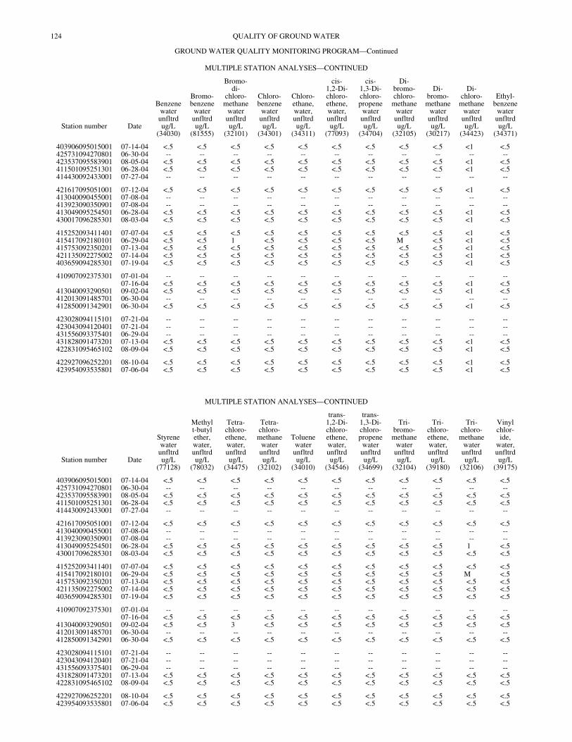
124 QUALITY OF GROUND WATER
GROUND WATER QUALITY MONITORING PROGRAM—Continued
MULTIPLE STATION ANALYSES—CONTINUED
Station number Date
Benzenewaterunfltrdug/L
(34030)
Bromo-benzene
waterunfltrdug/L
(81555)
Bromo-di-
chloro-methane
waterunfltrdug/L
(32101)
Chloro-benzene
waterunfltrdug/L
(34301)
Chloro-ethane,water,unfltrdug/L
(34311)
cis-1,2-Di-chloro-ethene,water,unfltrdug/L
(77093)
cis-1,3-Di-chloro-propene
waterunfltrdug/L
(34704)
Di-bromo-chloro-
methanewaterunfltrdug/L
(32105)
Di-bromo-methane
waterunfltrdug/L
(30217)
Di-chloro-
methanewaterunfltrdug/L
(34423)
Ethyl-benzene
waterunfltrdug/L
(34371)
403906095015001 07-14-04 <.5 <.5 <.5 <.5 <.5 <.5 <.5 <.5 <.5 <1 <.5425731094270801 06-30-04 -- -- -- -- -- -- -- -- -- -- --423537095583901 08-05-04 <.5 <.5 <.5 <.5 <.5 <.5 <.5 <.5 <.5 <1 <.5411501095251301 06-28-04 <.5 <.5 <.5 <.5 <.5 <.5 <.5 <.5 <.5 <1 <.5414430092433001 07-27-04 -- -- -- -- -- -- -- -- -- -- --
421617095051001 07-12-04 <.5 <.5 <.5 <.5 <.5 <.5 <.5 <.5 <.5 <1 <.5413040090455001 07-08-04 -- -- -- -- -- -- -- -- -- -- --413923090350901 07-08-04 -- -- -- -- -- -- -- -- -- -- --413049095254501 06-28-04 <.5 <.5 <.5 <.5 <.5 <.5 <.5 <.5 <.5 <1 <.5430017096285301 08-03-04 <.5 <.5 <.5 <.5 <.5 <.5 <.5 <.5 <.5 <1 <.5
415252093411401 07-07-04 <.5 <.5 <.5 <.5 <.5 <.5 <.5 <.5 <.5 <1 <.5415417092180101 06-29-04 <.5 <.5 1 <.5 <.5 <.5 <.5 M <.5 <1 <.5415753092350201 07-13-04 <.5 <.5 <.5 <.5 <.5 <.5 <.5 <.5 <.5 <1 <.5421135092275002 07-14-04 <.5 <.5 <.5 <.5 <.5 <.5 <.5 <.5 <.5 <1 <.5403659094285301 07-19-04 <.5 <.5 <.5 <.5 <.5 <.5 <.5 <.5 <.5 <1 <.5
410907092375301 07-01-04 -- -- -- -- -- -- -- -- -- -- --07-16-04 <.5 <.5 <.5 <.5 <.5 <.5 <.5 <.5 <.5 <1 <.5
413040093290501 09-02-04 <.5 <.5 <.5 <.5 <.5 <.5 <.5 <.5 <.5 <1 <.5412013091485701 06-30-04 -- -- -- -- -- -- -- -- -- -- --412850091342901 06-30-04 <.5 <.5 <.5 <.5 <.5 <.5 <.5 <.5 <.5 <1 <.5
423028094115101 07-21-04 -- -- -- -- -- -- -- -- -- -- --423043094120401 07-21-04 -- -- -- -- -- -- -- -- -- -- --431556093375401 06-29-04 -- -- -- -- -- -- -- -- -- -- --431828091473201 07-13-04 <.5 <.5 <.5 <.5 <.5 <.5 <.5 <.5 <.5 <1 <.5422831095465102 08-09-04 <.5 <.5 <.5 <.5 <.5 <.5 <.5 <.5 <.5 <1 <.5
422927096252201 08-10-04 <.5 <.5 <.5 <.5 <.5 <.5 <.5 <.5 <.5 <1 <.5423954093535801 07-06-04 <.5 <.5 <.5 <.5 <.5 <.5 <.5 <.5 <.5 <1 <.5
MULTIPLE STATION ANALYSES—CONTINUED
Station number Date
Styrenewaterunfltrdug/L
(77128)
Methylt-butylether,water,unfltrdug/L
(78032)
Tetra-chloro-ethene,water,unfltrdug/L
(34475)
Tetra-chloro-
methanewaterunfltrdug/L
(32102)
Toluenewaterunfltrdug/L
(34010)
trans-1,2-Di-chloro-ethene,water,unfltrdug/L
(34546)
trans-1,3-Di-chloro-propene
waterunfltrdug/L
(34699)
Tri-bromo-methane
waterunfltrdug/L
(32104)
Tri-chloro-ethene,water,unfltrdug/L
(39180)
Tri-chloro-
methanewaterunfltrdug/L
(32106)
Vinylchlor-ide,
water,unfltrdug/L
(39175)
403906095015001 07-14-04 <.5 <.5 <.5 <.5 <.5 <.5 <.5 <.5 <.5 <.5 <.5425731094270801 06-30-04 -- -- -- -- -- -- -- -- -- -- --423537095583901 08-05-04 <.5 <.5 <.5 <.5 <.5 <.5 <.5 <.5 <.5 <.5 <.5411501095251301 06-28-04 <.5 <.5 <.5 <.5 <.5 <.5 <.5 <.5 <.5 <.5 <.5414430092433001 07-27-04 -- -- -- -- -- -- -- -- -- -- --
421617095051001 07-12-04 <.5 <.5 <.5 <.5 <.5 <.5 <.5 <.5 <.5 <.5 <.5413040090455001 07-08-04 -- -- -- -- -- -- -- -- -- -- --413923090350901 07-08-04 -- -- -- -- -- -- -- -- -- -- --413049095254501 06-28-04 <.5 <.5 <.5 <.5 <.5 <.5 <.5 <.5 <.5 1 <.5430017096285301 08-03-04 <.5 <.5 <.5 <.5 <.5 <.5 <.5 <.5 <.5 <.5 <.5
415252093411401 07-07-04 <.5 <.5 <.5 <.5 <.5 <.5 <.5 <.5 <.5 <.5 <.5415417092180101 06-29-04 <.5 <.5 <.5 <.5 <.5 <.5 <.5 <.5 <.5 M <.5415753092350201 07-13-04 <.5 <.5 <.5 <.5 <.5 <.5 <.5 <.5 <.5 <.5 <.5421135092275002 07-14-04 <.5 <.5 <.5 <.5 <.5 <.5 <.5 <.5 <.5 <.5 <.5403659094285301 07-19-04 <.5 <.5 <.5 <.5 <.5 <.5 <.5 <.5 <.5 <.5 <.5
410907092375301 07-01-04 -- -- -- -- -- -- -- -- -- -- --07-16-04 <.5 <.5 <.5 <.5 <.5 <.5 <.5 <.5 <.5 <.5 <.5
413040093290501 09-02-04 <.5 <.5 3 <.5 <.5 <.5 <.5 <.5 <.5 <.5 <.5412013091485701 06-30-04 -- -- -- -- -- -- -- -- -- -- --412850091342901 06-30-04 <.5 <.5 <.5 <.5 <.5 <.5 <.5 <.5 <.5 <.5 <.5
423028094115101 07-21-04 -- -- -- -- -- -- -- -- -- -- --423043094120401 07-21-04 -- -- -- -- -- -- -- -- -- -- --431556093375401 06-29-04 -- -- -- -- -- -- -- -- -- -- --431828091473201 07-13-04 <.5 <.5 <.5 <.5 <.5 <.5 <.5 <.5 <.5 <.5 <.5422831095465102 08-09-04 <.5 <.5 <.5 <.5 <.5 <.5 <.5 <.5 <.5 <.5 <.5
422927096252201 08-10-04 <.5 <.5 <.5 <.5 <.5 <.5 <.5 <.5 <.5 <.5 <.5423954093535801 07-06-04 <.5 <.5 <.5 <.5 <.5 <.5 <.5 <.5 <.5 <.5 <.5
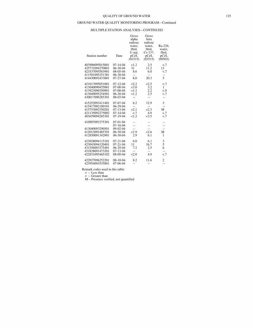
125QUALITY OF GROUND WATER
GROUND WATER QUALITY MONITORING PROGRAM—Continued
MULTIPLE STATION ANALYSES—CONTINUED
Station number Date
Grossalpha
radioacwater,fltrd,
U-nat,pCi/L
(01515)
Grossbeta
radioacwater,fltrd,
Cs-137,pCi/L
(03515)
Ra-226,water,fltrd,pCi/L
(09503)
403906095015001 07-14-04 <1.2 2.5 <.7425731094270801 06-30-04 31 11.2 13423537095583901 08-05-04 8.6 6.0 <.7411501095251301 06-28-04 -- -- --414430092433001 07-27-04 8.0 20.3 5
421617095051001 07-12-04 <2.2 <2.5 <.7413040090455001 07-08-04 <3.0 3.2 1413923090350901 07-08-04 <1.1 2.2 <.9413049095254501 06-28-04 <1.2 2.5 <.7430017096285301 08-03-04 -- -- --
415252093411401 07-07-04 6.2 12.9 3415417092180101 06-29-04 -- -- --415753092350201 07-13-04 <2.1 <2.3 M421135092275002 07-14-04 <.7 4.9 <.7403659094285301 07-19-04 <1.2 <3.5 <.7
410907092375301 07-01-04 -- -- --07-16-04 -- -- --
413040093290501 09-02-04 -- -- --412013091485701 06-30-04 <1.9 <2.6 M412850091342901 06-30-04 2.9 6.1 1
423028094115101 07-21-04 6.0 6.1 3423043094120401 07-21-04 11 16.7 5431556093375401 06-29-04 7.2 2.5 6431828091473201 07-13-04 -- -- --422831095465102 08-09-04 <2.0 4.9 <.7
422927096252201 08-10-04 8.2 11.6 2423954093535801 07-06-04 -- -- --
Remark codes used in this table: < -- Less than > -- Greater than M-- Presence verified, not quantified
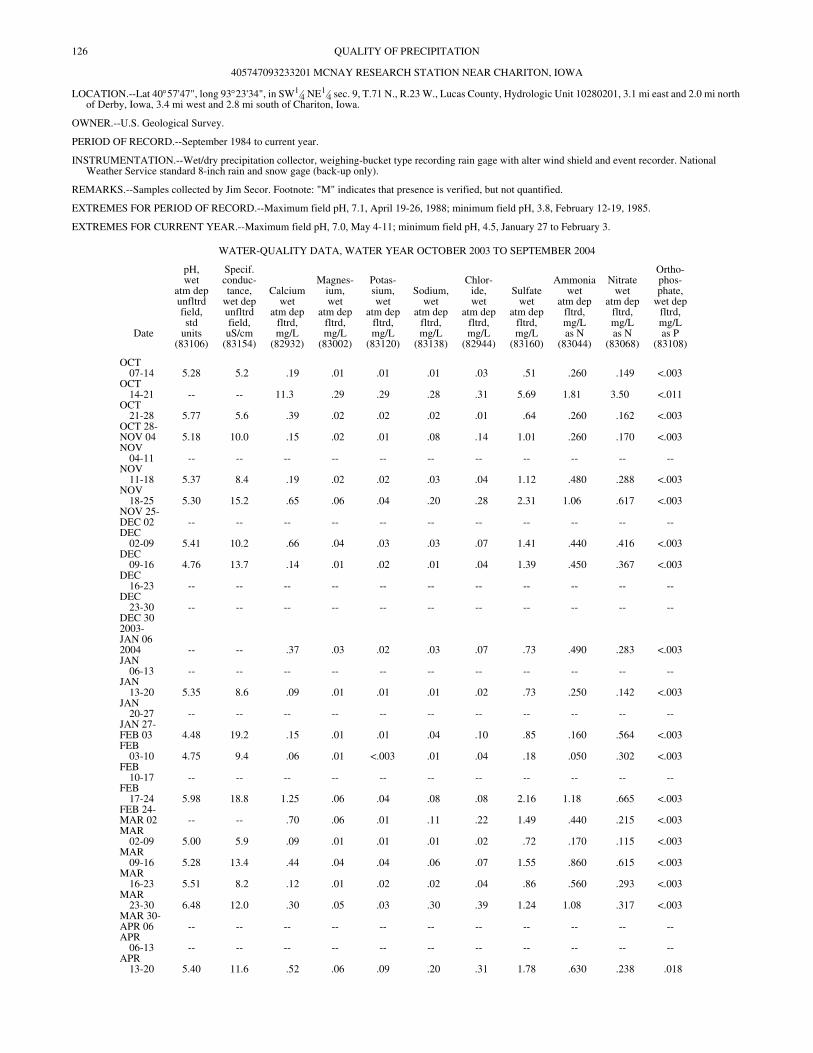
126
QUALITY OF PRECIPITATION405747093233201 MCNAY RESEARCH STATION NEAR CHARITON, IOWA
LOCATION.--Lat 40°57'47", long 93°23'34", in SW1⁄4 NE1⁄4 sec. 9, T.71 N., R.23 W., Lucas County, Hydrologic Unit 10280201, 3.1 mi east and 2.0 mi north of Derby, Iowa, 3.4 mi west and 2.8 mi south of Chariton, Iowa.
OWNER.--U.S. Geological Survey.
PERIOD OF RECORD.--September 1984 to current year.
INSTRUMENTATION.--Wet/dry precipitation collector, weighing-bucket type recording rain gage with alter wind shield and event recorder. National Weather Service standard 8-inch rain and snow gage (back-up only).
REMARKS.--Samples collected by Jim Secor. Footnote: "M" indicates that presence is verified, but not quantified.
EXTREMES FOR PERIOD OF RECORD.--Maximum field pH, 7.1, April 19-26, 1988; minimum field pH, 3.8, February 12-19, 1985.
EXTREMES FOR CURRENT YEAR.--Maximum field pH, 7.0, May 4-11; minimum field pH, 4.5, January 27 to February 3.
WATER-QUALITY DATA, WATER YEAR OCTOBER 2003 TO SEPTEMBER 2004
Date
pH,wet
atm depunfltrdfield,std
units(83106)
Specif.conduc-tance,
wet depunfltrdfield,uS/cm
(83154)
Calciumwet
atm depfltrd,mg/L
(82932)
Magnes-ium,wet
atm depfltrd,mg/L
(83002)
Potas-sium,wet
atm depfltrd,mg/L
(83120)
Sodium,wet
atm depfltrd,mg/L
(83138)
Chlor-ide,wet
atm depfltrd,mg/L
(82944)
Sulfatewet
atm depfltrd,mg/L
(83160)
Ammoniawet
atm depfltrd,mg/Las N
(83044)
Nitratewet
atm depfltrd,mg/Las N
(83068)
Ortho-phos-phate,
wet depfltrd,mg/Las P
(83108)
OCT07-14 5.28 5.2 .19 .01 .01 .01 .03 .51 .260 .149 <.003
OCT14-21 -- -- 11.3 .29 .29 .28 .31 5.69 1.81 3.50 <.011
OCT21-28 5.77 5.6 .39 .02 .02 .02 .01 .64 .260 .162 <.003
OCT 28-NOV 04 5.18 10.0 .15 .02 .01 .08 .14 1.01 .260 .170 <.003NOV
04-11 -- -- -- -- -- -- -- -- -- -- --NOV
11-18 5.37 8.4 .19 .02 .02 .03 .04 1.12 .480 .288 <.003NOV
18-25 5.30 15.2 .65 .06 .04 .20 .28 2.31 1.06 .617 <.003NOV 25-DEC 02 -- -- -- -- -- -- -- -- -- -- --DEC
02-09 5.41 10.2 .66 .04 .03 .03 .07 1.41 .440 .416 <.003DEC
09-16 4.76 13.7 .14 .01 .02 .01 .04 1.39 .450 .367 <.003DEC
16-23 -- -- -- -- -- -- -- -- -- -- --DEC
23-30 -- -- -- -- -- -- -- -- -- -- --DEC 30 2003-JAN 06 2004 -- -- .37 .03 .02 .03 .07 .73 .490 .283 <.003JAN
06-13 -- -- -- -- -- -- -- -- -- -- --JAN
13-20 5.35 8.6 .09 .01 .01 .01 .02 .73 .250 .142 <.003JAN
20-27 -- -- -- -- -- -- -- -- -- -- --JAN 27-FEB 03 4.48 19.2 .15 .01 .01 .04 .10 .85 .160 .564 <.003FEB
03-10 4.75 9.4 .06 .01 <.003 .01 .04 .18 .050 .302 <.003FEB
10-17 -- -- -- -- -- -- -- -- -- -- --FEB
17-24 5.98 18.8 1.25 .06 .04 .08 .08 2.16 1.18 .665 <.003FEB 24-MAR 02 -- -- .70 .06 .01 .11 .22 1.49 .440 .215 <.003MAR
02-09 5.00 5.9 .09 .01 .01 .01 .02 .72 .170 .115 <.003MAR
09-16 5.28 13.4 .44 .04 .04 .06 .07 1.55 .860 .615 <.003MAR
16-23 5.51 8.2 .12 .01 .02 .02 .04 .86 .560 .293 <.003MAR
23-30 6.48 12.0 .30 .05 .03 .30 .39 1.24 1.08 .317 <.003MAR 30-APR 06 -- -- -- -- -- -- -- -- -- -- --APR
06-13 -- -- -- -- -- -- -- -- -- -- --APR
13-20 5.40 11.6 .52 .06 .09 .20 .31 1.78 .630 .238 .018
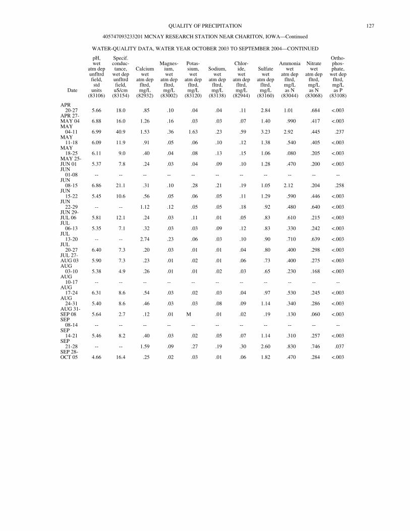
127QUALITY OF PRECIPITATION
405747093233201 MCNAY RESEARCH STATION NEAR CHARITON, IOWA—Continued
WATER-QUALITY DATA, WATER YEAR OCTOBER 2003 TO SEPTEMBER 2004—CONTINUED
Date
pH,wet
atm depunfltrdfield,std
units(83106)
Specif.conduc-tance,
wet depunfltrdfield,uS/cm
(83154)
Calciumwet
atm depfltrd,mg/L
(82932)
Magnes-ium,wet
atm depfltrd,mg/L
(83002)
Potas-sium,wet
atm depfltrd,mg/L
(83120)
Sodium,wet
atm depfltrd,mg/L
(83138)
Chlor-ide,wet
atm depfltrd,mg/L
(82944)
Sulfatewet
atm depfltrd,mg/L
(83160)
Ammoniawet
atm depfltrd,mg/Las N
(83044)
Nitratewet
atm depfltrd,mg/Las N
(83068)
Ortho-phos-phate,
wet depfltrd,mg/Las P
(83108)
APR20-27 5.66 18.0 .85 .10 .04 .04 .11 2.84 1.01 .684 <.003
APR 27-MAY 04 6.88 16.0 1.26 .16 .03 .03 .07 1.40 .990 .417 <.003MAY
04-11 6.99 40.9 1.53 .36 1.63 .23 .59 3.23 2.92 .445 .237MAY
11-18 6.09 11.9 .91 .05 .06 .10 .12 1.38 .540 .405 <.003MAY
18-25 6.11 9.0 .40 .04 .08 .13 .15 1.06 .080 .205 <.003MAY 25-JUN 01 5.37 7.8 .24 .03 .04 .09 .10 1.28 .470 .200 <.003JUN
01-08 -- -- -- -- -- -- -- -- -- -- --JUN
08-15 6.86 21.1 .31 .10 .28 .21 .19 1.05 2.12 .204 .258JUN
15-22 5.45 10.6 .56 .05 .06 .05 .11 1.29 .590 .446 <.003JUN
22-29 -- -- 1.12 .12 .05 .05 .18 .92 .480 .640 <.003JUN 29-JUL 06 5.81 12.1 .24 .03 .11 .01 .05 .83 .610 .215 <.003JUL
06-13 5.35 7.1 .32 .03 .03 .09 .12 .83 .330 .242 <.003JUL
13-20 -- -- 2.74 .23 .06 .03 .10 .90 .710 .639 <.003JUL
20-27 6.40 7.3 .20 .03 .01 .01 .04 .80 .400 .298 <.003JUL 27-AUG 03 5.90 7.3 .23 .01 .02 .01 .06 .73 .400 .275 <.003AUG
03-10 5.38 4.9 .26 .01 .01 .02 .03 .65 .230 .168 <.003AUG
10-17 -- -- -- -- -- -- -- -- -- -- --AUG
17-24 6.31 8.6 .54 .03 .02 .03 .04 .97 .530 .245 <.003AUG
24-31 5.40 8.6 .46 .03 .03 .08 .09 1.14 .340 .286 <.003AUG 31-SEP 08 5.64 2.7 .12 .01 M .01 .02 .19 .130 .060 <.003SEP
08-14 -- -- -- -- -- -- -- -- -- -- --SEP
14-21 5.46 8.2 .40 .03 .02 .05 .07 1.14 .310 .257 <.003SEP
21-28 -- -- 1.59 .09 .27 .19 .30 2.60 .830 .746 .037SEP 28-OCT 05 4.66 16.4 .25 .02 .03 .01 .06 1.82 .470 .284 <.003
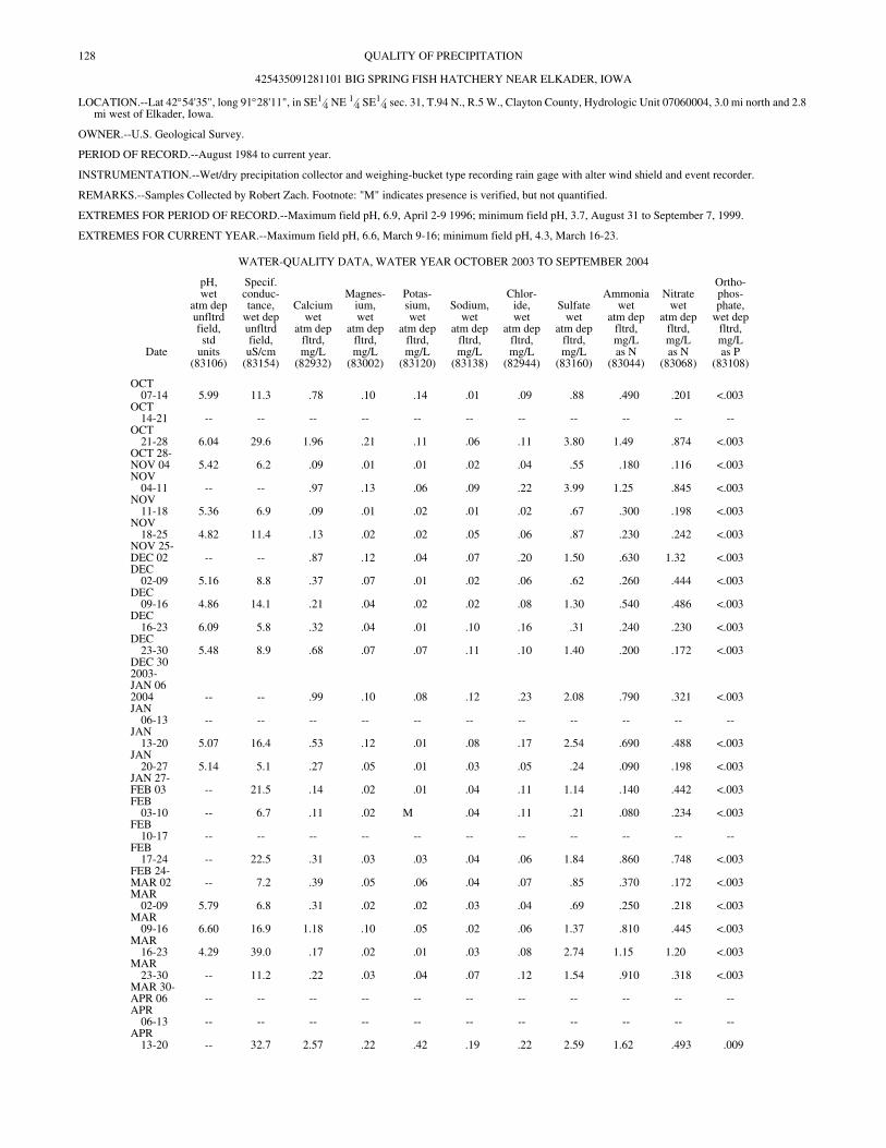
128
QUALITY OF PRECIPITATION425435091281101 BIG SPRING FISH HATCHERY NEAR ELKADER, IOWA
LOCATION.--Lat 42°54'35", long 91°28'11", in SE1⁄4 NE 1⁄4 SE1⁄4 sec. 31, T.94 N., R.5 W., Clayton County, Hydrologic Unit 07060004, 3.0 mi north and 2.8 mi west of Elkader, Iowa.
OWNER.--U.S. Geological Survey.
PERIOD OF RECORD.--August 1984 to current year.
INSTRUMENTATION.--Wet/dry precipitation collector and weighing-bucket type recording rain gage with alter wind shield and event recorder.
REMARKS.--Samples Collected by Robert Zach. Footnote: "M" indicates presence is verified, but not quantified.
EXTREMES FOR PERIOD OF RECORD.--Maximum field pH, 6.9, April 2-9 1996; minimum field pH, 3.7, August 31 to September 7, 1999.
EXTREMES FOR CURRENT YEAR.--Maximum field pH, 6.6, March 9-16; minimum field pH, 4.3, March 16-23.
WATER-QUALITY DATA, WATER YEAR OCTOBER 2003 TO SEPTEMBER 2004
Date
pH,wet
atm depunfltrdfield,std
units(83106)
Specif.conduc-tance,
wet depunfltrdfield,uS/cm
(83154)
Calciumwet
atm depfltrd,mg/L
(82932)
Magnes-ium,wet
atm depfltrd,mg/L
(83002)
Potas-sium,wet
atm depfltrd,mg/L
(83120)
Sodium,wet
atm depfltrd,mg/L
(83138)
Chlor-ide,wet
atm depfltrd,mg/L
(82944)
Sulfatewet
atm depfltrd,mg/L
(83160)
Ammoniawet
atm depfltrd,mg/Las N
(83044)
Nitratewet
atm depfltrd,mg/Las N
(83068)
Ortho-phos-phate,
wet depfltrd,mg/Las P
(83108)
OCT07-14 5.99 11.3 .78 .10 .14 .01 .09 .88 .490 .201 <.003
OCT14-21 -- -- -- -- -- -- -- -- -- -- --
OCT21-28 6.04 29.6 1.96 .21 .11 .06 .11 3.80 1.49 .874 <.003
OCT 28-NOV 04 5.42 6.2 .09 .01 .01 .02 .04 .55 .180 .116 <.003NOV
04-11 -- -- .97 .13 .06 .09 .22 3.99 1.25 .845 <.003NOV
11-18 5.36 6.9 .09 .01 .02 .01 .02 .67 .300 .198 <.003NOV
18-25 4.82 11.4 .13 .02 .02 .05 .06 .87 .230 .242 <.003NOV 25-DEC 02 -- -- .87 .12 .04 .07 .20 1.50 .630 1.32 <.003DEC
02-09 5.16 8.8 .37 .07 .01 .02 .06 .62 .260 .444 <.003DEC
09-16 4.86 14.1 .21 .04 .02 .02 .08 1.30 .540 .486 <.003DEC
16-23 6.09 5.8 .32 .04 .01 .10 .16 .31 .240 .230 <.003DEC
23-30 5.48 8.9 .68 .07 .07 .11 .10 1.40 .200 .172 <.003DEC 30 2003-JAN 06 2004 -- -- .99 .10 .08 .12 .23 2.08 .790 .321 <.003JAN
06-13 -- -- -- -- -- -- -- -- -- -- --JAN
13-20 5.07 16.4 .53 .12 .01 .08 .17 2.54 .690 .488 <.003JAN
20-27 5.14 5.1 .27 .05 .01 .03 .05 .24 .090 .198 <.003JAN 27-FEB 03 -- 21.5 .14 .02 .01 .04 .11 1.14 .140 .442 <.003FEB
03-10 -- 6.7 .11 .02 M .04 .11 .21 .080 .234 <.003FEB
10-17 -- -- -- -- -- -- -- -- -- -- --FEB
17-24 -- 22.5 .31 .03 .03 .04 .06 1.84 .860 .748 <.003FEB 24-MAR 02 -- 7.2 .39 .05 .06 .04 .07 .85 .370 .172 <.003MAR
02-09 5.79 6.8 .31 .02 .02 .03 .04 .69 .250 .218 <.003MAR
09-16 6.60 16.9 1.18 .10 .05 .02 .06 1.37 .810 .445 <.003MAR
16-23 4.29 39.0 .17 .02 .01 .03 .08 2.74 1.15 1.20 <.003MAR
23-30 -- 11.2 .22 .03 .04 .07 .12 1.54 .910 .318 <.003MAR 30-APR 06 -- -- -- -- -- -- -- -- -- -- --APR
06-13 -- -- -- -- -- -- -- -- -- -- --APR
13-20 -- 32.7 2.57 .22 .42 .19 .22 2.59 1.62 .493 .009
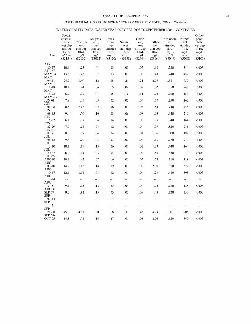
129QUALITY OF PRECIPITATION
425435091281101 BIG SPRING FISH HATCHERY NEAR ELKADER, IOWA—Continued
WATER-QUALITY DATA, WATER YEAR OCTOBER 2003 TO SEPTEMBER 2004—CONTINUED
Date
Specif.conduc-tance,
wet depunfltrdfield,uS/cm
(83154)
Calciumwet
atm depfltrd,mg/L
(82932)
Magnes-ium,wet
atm depfltrd,mg/L
(83002)
Potas-sium,wet
atm depfltrd,mg/L
(83120)
Sodium,wet
atm depfltrd,mg/L
(83138)
Chlor-ide,wet
atm depfltrd,mg/L
(82944)
Sulfatewet
atm depfltrd,mg/L
(83160)
Ammoniawet
atm depfltrd,mg/Las N
(83044)
Nitratewet
atm depfltrd,mg/Las N
(83068)
Ortho-phos-phate,
wet depfltrd,mg/Las P
(83108)
APR20-27 10.6 .23 .04 .03 .03 .05 1.68 .720 .344 <.003
APR 27-MAY 04 13.8 .45 .07 .03 .02 .06 1.48 .740 .452 <.003MAY
04-11 24.0 1.49 .12 .08 .21 .21 2.77 1.38 .739 <.003MAY
11-18 10.4 .44 .06 .15 .04 .07 1.02 .550 .247 <.003MAY
18-23 6.2 .32 .04 .05 .10 .11 .74 .260 .156 <.003MAY 26-JUN 01 7.9 .15 .03 .02 .02 .04 .77 .250 .162 <.003JUN
01-08 20.8 2.03 .22 .08 .01 .06 1.54 .740 .458 <.003JUN
08-15 9.4 .70 .10 .03 .06 .08 .95 .440 .219 <.003JUN
15-22 6.1 .17 .04 .04 .01 .03 .75 .240 .164 <.003JUN
22-29 7.7 .24 .04 .02 .01 .04 .99 .520 .241 <.003JUN 29-JUL 06 8.0 .17 .04 .04 .01 .04 1.06 .500 .189 <.003JUL
06-13 9.4 .20 .03 .03 .03 .06 1.16 .270 .210 <.003JUL
13-20 10.1 .89 .13 .06 .01 .02 .33 .440 .164 <.003JUL
20-27 6.9 .44 .03 .04 .01 .04 .83 .350 .279 <.003JUL 27-AUG 03 10.1 .42 .07 .16 .01 .07 1.24 .510 .328 <.003AUG
03-10 14.7 1.05 .18 .09 .03 .09 2.00 .650 .522 <.003AUG
10-17 12.1 1.01 .08 .02 .01 .04 1.23 .480 .308 <.003AUG
17-24 -- -- -- -- -- -- -- -- -- --AUG
24-31 9.1 .35 .18 .35 .04 .04 .76 .280 .188 <.003AUG 31-SEP 07 9.2 .92 .15 .05 .02 .09 1.48 .220 .253 <.003SEP
07-14 -- -- -- -- -- -- -- -- -- --SEP
14-21 -- -- -- -- -- -- -- -- -- --SEP
21-28 45.3 4.91 .30 .18 .37 .45 4.79 1.00 .905 <.003SEP 28-OCT 05 14.8 .71 .16 .27 .01 .08 2.06 .620 .360 <.003
130
INDEXAcid neutralizing capacity, definition of . . . . . . . . . . . . . 14Acre-foot, definition of . . . . . . . . . . . . . . . . . . . . . . . . . . 15Adenosine triphosphate, definition of . . . . . . . . . . . . . . . 15Adjusted discharge, definition of . . . . . . . . . . . . . . . . . . . 15Algae,
Blue-green, definition of . . . . . . . . . . . . . . . . . . . . . . 16Fire, definition of . . . . . . . . . . . . . . . . . . . . . . . . . . . 20Green, definition of . . . . . . . . . . . . . . . . . . . . . . . . . . 20
Algal growth potential, definition of . . . . . . . . . . . . . . . . 15Alkalinity, definition of . . . . . . . . . . . . . . . . . . . . . . . . . . 15Annual runoff, definition of . . . . . . . . . . . . . . . . . . . . . . . 15Annual 7-day minimum, definition of . . . . . . . . . . . . . . . 15Aquifer
Confined, definition of . . . . . . . . . . . . . . . . . . . . . . . 17Unconfined, definition of . . . . . . . . . . . . . . . . . . . . . 31Water-table, definition of . . . . . . . . . . . . . . . . . . . . . 32
Aroclor, definition of . . . . . . . . . . . . . . . . . . . . . . . . . . . . 15Artificial substrate, definition of . . . . . . . . . . . . . . . . . . . 15Ash mass, definition of . . . . . . . . . . . . . . . . . . . . . . . . . . . 15Aspect, definition of . . . . . . . . . . . . . . . . . . . . . . . . . . . . . 15
Bacteria, definition of . . . . . . . . . . . . . . . . . . . . . . . . . . . . 15Enterococcus, definition of . . . . . . . . . . . . . . . . . . . . 19Escherichia coli, definition of . . . . . . . . . . . . . . . . . . 19Fecal coliform, definition of . . . . . . . . . . . . . . . . . . . 19Fecal streptococcal, definition of . . . . . . . . . . . . . . . 20Total coliform, definition of . . . . . . . . . . . . . . . . . . . 30
Bankfull stage, definition of . . . . . . . . . . . . . . . . . . . . . . . 15Base discharge, definition of . . . . . . . . . . . . . . . . . . . . . . 15Base flow, definition of . . . . . . . . . . . . . . . . . . . . . . . . . . 15Bed material, definition of . . . . . . . . . . . . . . . . . . . . . . . . 16Bedload, definition of . . . . . . . . . . . . . . . . . . . . . . . . . . . . 16Bedload discharge, definition of . . . . . . . . . . . . . . . . . . . 16Benthic organisms, definition of . . . . . . . . . . . . . . . . . . . 16Biochemical oxygen demand, definition of . . . . . . . . . . . 16Biomass, definition of . . . . . . . . . . . . . . . . . . . . . . . . . . . 16Biomass pigment ratio, definition of . . . . . . . . . . . . . . . . 16Blue-green algae, definition of . . . . . . . . . . . . . . . . . . . . . 16Bottom material, definition of . . . . . . . . . . . . . . . . . . . . . 16Bulk electrical conductivity, definition of . . . . . . . . . . . . 16
Canadian Geodetic Vertical Datum 1928, definition of . . 16Cell volume, definition of . . . . . . . . . . . . . . . . . . . . . . . . 16Cells/volume, definition of . . . . . . . . . . . . . . . . . . . . . . . . 16Cfs-day, definition of . . . . . . . . . . . . . . . . . . . . . . . . . . . . 17Channel bars, definition of . . . . . . . . . . . . . . . . . . . . . . . . 17Chemical oxygen demand, definition of . . . . . . . . . . . . . 17Clostridium perfringens, definition of . . . . . . . . . . . . . . . 17Coliphages, definition of . . . . . . . . . . . . . . . . . . . . . . . . . 17Color unit, definition of . . . . . . . . . . . . . . . . . . . . . . . . . . 17Conductivity, definition of . . . . . . . . . . . . . . . . . . . . . . . . 28Confined aquifer, definition of . . . . . . . . . . . . . . . . . . . . . 17Contents, definition of . . . . . . . . . . . . . . . . . . . . . . . . . . . 17Continuous-record station, definition of . . . . . . . . . . . . . 17Control, definition of . . . . . . . . . . . . . . . . . . . . . . . . . . . . 17Control structure, definition of . . . . . . . . . . . . . . . . . . . . . 17Cubic foot per second, definition of . . . . . . . . . . . . . . . . . 17
Cubic foot per second-day, definition of . . . . . . . . . . . . . 17Cubic foot per second per square mile, definition of . . . . 17
Daily mean suspended-sediment concentration, definition of . . . . . . . . . . . . . . . . . . . . . . . . . . . . . . . . . 17
Daily record station, definition of . . . . . . . . . . . . . . . . . . 18Data collection platform, definition of . . . . . . . . . . . . . . 18Data logger, definition of . . . . . . . . . . . . . . . . . . . . . . . . . 18Datum, definition of . . . . . . . . . . . . . . . . . . . . . . . . . . . . . 18Diatoms, definition of . . . . . . . . . . . . . . . . . . . . . . . . . . . 18Diel, definition of . . . . . . . . . . . . . . . . . . . . . . . . . . . . . . . 18Discharge, definition of . . . . . . . . . . . . . . . . . . . . . . . . . . 18Dissolved, definition of . . . . . . . . . . . . . . . . . . . . . . . . . . 18Dissolved oxygen, definition of . . . . . . . . . . . . . . . . . . . . 18Dissolved solids concentration, definition of . . . . . . . . . 18Diversity index, definition of . . . . . . . . . . . . . . . . . . . . . . 18Drainage area, definition of . . . . . . . . . . . . . . . . . . . . . . . 18Drainage basin, definition of . . . . . . . . . . . . . . . . . . . . . . 19Dry mass, definition of . . . . . . . . . . . . . . . . . . . . . . . . . . 19Dry weight, definition of . . . . . . . . . . . . . . . . . . . . . . . . . 19
Embeddedness, definition of . . . . . . . . . . . . . . . . . . . . . . 19Enterococcus bacteria, definition of . . . . . . . . . . . . . . . . 19EPT Index, definition of . . . . . . . . . . . . . . . . . . . . . . . . . 19Escherichia coli (E. coli), definition of . . . . . . . . . . . . . . 19Estimated (E) value, definition of . . . . . . . . . . . . . . . . . . 19Euglenoids, definition of . . . . . . . . . . . . . . . . . . . . . . . . . 19Extractable organic halides, definition of . . . . . . . . . . . . 19
Fecal coliform bacteria, definition of . . . . . . . . . . . . . . . 19Fecal streptococcal bacteria, definition of . . . . . . . . . . . . 20Filtered, definition of . . . . . . . . . . . . . . . . . . . . . . . . . . . . 20Filtered, recoverable, definition of . . . . . . . . . . . . . . . . . 20Fire algae, definition of . . . . . . . . . . . . . . . . . . . . . . . . . . 20Flow, definition of . . . . . . . . . . . . . . . . . . . . . . . . . . . . . . 18Flow-duration percentiles, definition of . . . . . . . . . . . . . 19
Gage datum, definition of . . . . . . . . . . . . . . . . . . . . . . . . 20Gage height, definition of . . . . . . . . . . . . . . . . . . . . . . . . 20Gage values, definition of . . . . . . . . . . . . . . . . . . . . . . . . 20Gaging station, definition of . . . . . . . . . . . . . . . . . . . . . . 20Gas chromatography/flame ionization detector,
definition of . . . . . . . . . . . . . . . . . . . . . . . . . . . . . . . . . 20Geomorphic channel units, definition of . . . . . . . . . . . . . 20Green algae, definition of . . . . . . . . . . . . . . . . . . . . . . . . 20
Habitat, definition of . . . . . . . . . . . . . . . . . . . . . . . . . . . . 21Habitat quality index, definition of . . . . . . . . . . . . . . . . . 21Hardness, definition of . . . . . . . . . . . . . . . . . . . . . . . . . . . 21High tide, definition of . . . . . . . . . . . . . . . . . . . . . . . . . . . 21Hilsenhoff’s Biotic Index, definition of . . . . . . . . . . . . . . 21Horizontal datum, definition of . . . . . . . . . . . . . . . . . . . . 20Hydrologic conditions, summary of
Ground water . . . . . . . . . . . . . . . . . . . . . . . . . . . . . . . 3Ground-water quality . . . . . . . . . . . . . . . . . . . . . . . . . 6
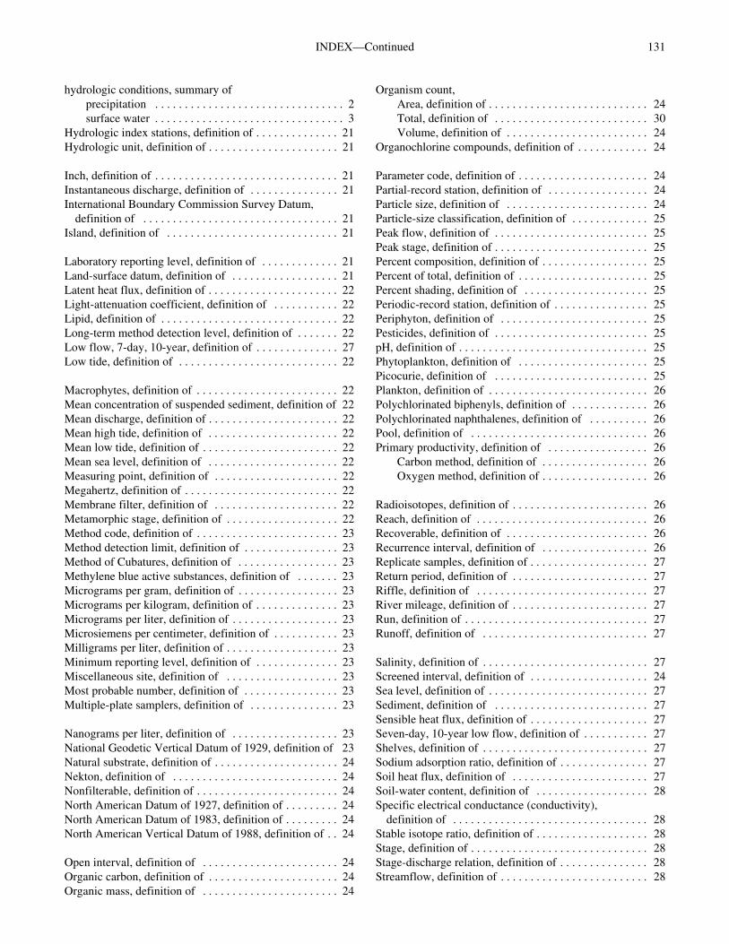
131INDEX—Continued
hydrologic conditions, summary ofprecipitation . . . . . . . . . . . . . . . . . . . . . . . . . . . . . . . . 2surface water . . . . . . . . . . . . . . . . . . . . . . . . . . . . . . . . 3
Hydrologic index stations, definition of . . . . . . . . . . . . . . 21Hydrologic unit, definition of . . . . . . . . . . . . . . . . . . . . . . 21
Inch, definition of . . . . . . . . . . . . . . . . . . . . . . . . . . . . . . . 21Instantaneous discharge, definition of . . . . . . . . . . . . . . . 21International Boundary Commission Survey Datum,
definition of . . . . . . . . . . . . . . . . . . . . . . . . . . . . . . . . . 21Island, definition of . . . . . . . . . . . . . . . . . . . . . . . . . . . . . 21
Laboratory reporting level, definition of . . . . . . . . . . . . . 21Land-surface datum, definition of . . . . . . . . . . . . . . . . . . 21Latent heat flux, definition of . . . . . . . . . . . . . . . . . . . . . . 22Light-attenuation coefficient, definition of . . . . . . . . . . . 22Lipid, definition of . . . . . . . . . . . . . . . . . . . . . . . . . . . . . . 22Long-term method detection level, definition of . . . . . . . 22Low flow, 7-day, 10-year, definition of . . . . . . . . . . . . . . 27Low tide, definition of . . . . . . . . . . . . . . . . . . . . . . . . . . . 22
Macrophytes, definition of . . . . . . . . . . . . . . . . . . . . . . . . 22Mean concentration of suspended sediment, definition of 22Mean discharge, definition of . . . . . . . . . . . . . . . . . . . . . . 22Mean high tide, definition of . . . . . . . . . . . . . . . . . . . . . . 22Mean low tide, definition of . . . . . . . . . . . . . . . . . . . . . . . 22Mean sea level, definition of . . . . . . . . . . . . . . . . . . . . . . 22Measuring point, definition of . . . . . . . . . . . . . . . . . . . . . 22Megahertz, definition of . . . . . . . . . . . . . . . . . . . . . . . . . . 22Membrane filter, definition of . . . . . . . . . . . . . . . . . . . . . 22Metamorphic stage, definition of . . . . . . . . . . . . . . . . . . . 22Method code, definition of . . . . . . . . . . . . . . . . . . . . . . . . 23Method detection limit, definition of . . . . . . . . . . . . . . . . 23Method of Cubatures, definition of . . . . . . . . . . . . . . . . . 23Methylene blue active substances, definition of . . . . . . . 23Micrograms per gram, definition of . . . . . . . . . . . . . . . . . 23Micrograms per kilogram, definition of . . . . . . . . . . . . . . 23Micrograms per liter, definition of . . . . . . . . . . . . . . . . . . 23Microsiemens per centimeter, definition of . . . . . . . . . . . 23Milligrams per liter, definition of . . . . . . . . . . . . . . . . . . . 23Minimum reporting level, definition of . . . . . . . . . . . . . . 23Miscellaneous site, definition of . . . . . . . . . . . . . . . . . . . 23Most probable number, definition of . . . . . . . . . . . . . . . . 23Multiple-plate samplers, definition of . . . . . . . . . . . . . . . 23
Nanograms per liter, definition of . . . . . . . . . . . . . . . . . . 23National Geodetic Vertical Datum of 1929, definition of 23Natural substrate, definition of . . . . . . . . . . . . . . . . . . . . . 24Nekton, definition of . . . . . . . . . . . . . . . . . . . . . . . . . . . . 24Nonfilterable, definition of . . . . . . . . . . . . . . . . . . . . . . . . 24North American Datum of 1927, definition of . . . . . . . . . 24North American Datum of 1983, definition of . . . . . . . . . 24North American Vertical Datum of 1988, definition of . . 24
Open interval, definition of . . . . . . . . . . . . . . . . . . . . . . . 24Organic carbon, definition of . . . . . . . . . . . . . . . . . . . . . . 24Organic mass, definition of . . . . . . . . . . . . . . . . . . . . . . . 24
Organism count,Area, definition of . . . . . . . . . . . . . . . . . . . . . . . . . . . 24Total, definition of . . . . . . . . . . . . . . . . . . . . . . . . . . 30Volume, definition of . . . . . . . . . . . . . . . . . . . . . . . . 24
Organochlorine compounds, definition of . . . . . . . . . . . . 24
Parameter code, definition of . . . . . . . . . . . . . . . . . . . . . . 24Partial-record station, definition of . . . . . . . . . . . . . . . . . 24Particle size, definition of . . . . . . . . . . . . . . . . . . . . . . . . 24Particle-size classification, definition of . . . . . . . . . . . . . 25Peak flow, definition of . . . . . . . . . . . . . . . . . . . . . . . . . . 25Peak stage, definition of . . . . . . . . . . . . . . . . . . . . . . . . . . 25Percent composition, definition of . . . . . . . . . . . . . . . . . . 25Percent of total, definition of . . . . . . . . . . . . . . . . . . . . . . 25Percent shading, definition of . . . . . . . . . . . . . . . . . . . . . 25Periodic-record station, definition of . . . . . . . . . . . . . . . . 25Periphyton, definition of . . . . . . . . . . . . . . . . . . . . . . . . . 25Pesticides, definition of . . . . . . . . . . . . . . . . . . . . . . . . . . 25pH, definition of . . . . . . . . . . . . . . . . . . . . . . . . . . . . . . . . 25Phytoplankton, definition of . . . . . . . . . . . . . . . . . . . . . . 25Picocurie, definition of . . . . . . . . . . . . . . . . . . . . . . . . . . 25Plankton, definition of . . . . . . . . . . . . . . . . . . . . . . . . . . . 26Polychlorinated biphenyls, definition of . . . . . . . . . . . . . 26Polychlorinated naphthalenes, definition of . . . . . . . . . . 26Pool, definition of . . . . . . . . . . . . . . . . . . . . . . . . . . . . . . 26Primary productivity, definition of . . . . . . . . . . . . . . . . . 26
Carbon method, definition of . . . . . . . . . . . . . . . . . . 26Oxygen method, definition of . . . . . . . . . . . . . . . . . . 26
Radioisotopes, definition of . . . . . . . . . . . . . . . . . . . . . . . 26Reach, definition of . . . . . . . . . . . . . . . . . . . . . . . . . . . . . 26Recoverable, definition of . . . . . . . . . . . . . . . . . . . . . . . . 26Recurrence interval, definition of . . . . . . . . . . . . . . . . . . 26Replicate samples, definition of . . . . . . . . . . . . . . . . . . . . 27Return period, definition of . . . . . . . . . . . . . . . . . . . . . . . 27Riffle, definition of . . . . . . . . . . . . . . . . . . . . . . . . . . . . . 27River mileage, definition of . . . . . . . . . . . . . . . . . . . . . . . 27Run, definition of . . . . . . . . . . . . . . . . . . . . . . . . . . . . . . . 27Runoff, definition of . . . . . . . . . . . . . . . . . . . . . . . . . . . . 27
Salinity, definition of . . . . . . . . . . . . . . . . . . . . . . . . . . . . 27Screened interval, definition of . . . . . . . . . . . . . . . . . . . . 24Sea level, definition of . . . . . . . . . . . . . . . . . . . . . . . . . . . 27Sediment, definition of . . . . . . . . . . . . . . . . . . . . . . . . . . 27Sensible heat flux, definition of . . . . . . . . . . . . . . . . . . . . 27Seven-day, 10-year low flow, definition of . . . . . . . . . . . 27Shelves, definition of . . . . . . . . . . . . . . . . . . . . . . . . . . . . 27Sodium adsorption ratio, definition of . . . . . . . . . . . . . . . 27Soil heat flux, definition of . . . . . . . . . . . . . . . . . . . . . . . 27Soil-water content, definition of . . . . . . . . . . . . . . . . . . . 28Specific electrical conductance (conductivity),
definition of . . . . . . . . . . . . . . . . . . . . . . . . . . . . . . . . . 28Stable isotope ratio, definition of . . . . . . . . . . . . . . . . . . . 28Stage, definition of . . . . . . . . . . . . . . . . . . . . . . . . . . . . . . 28Stage-discharge relation, definition of . . . . . . . . . . . . . . . 28Streamflow, definition of . . . . . . . . . . . . . . . . . . . . . . . . . 28
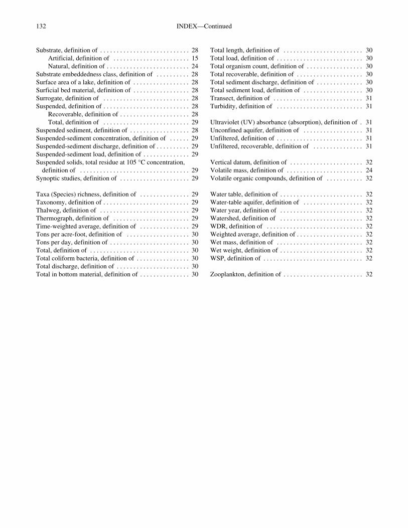
132 INDEX—Continued
Substrate, definition of . . . . . . . . . . . . . . . . . . . . . . . . . . . 28Artificial, definition of . . . . . . . . . . . . . . . . . . . . . . . 15Natural, definition of . . . . . . . . . . . . . . . . . . . . . . . . . 24
Substrate embeddedness class, definition of . . . . . . . . . . 28Surface area of a lake, definition of . . . . . . . . . . . . . . . . . 28Surficial bed material, definition of . . . . . . . . . . . . . . . . . 28Surrogate, definition of . . . . . . . . . . . . . . . . . . . . . . . . . . 28Suspended, definition of . . . . . . . . . . . . . . . . . . . . . . . . . . 28
Recoverable, definition of . . . . . . . . . . . . . . . . . . . . . 28Total, definition of . . . . . . . . . . . . . . . . . . . . . . . . . . 29
Suspended sediment, definition of . . . . . . . . . . . . . . . . . . 28Suspended-sediment concentration, definition of . . . . . . 29Suspended-sediment discharge, definition of . . . . . . . . . . 29Suspended-sediment load, definition of . . . . . . . . . . . . . . 29Suspended solids, total residue at 105 °C concentration,
definition of . . . . . . . . . . . . . . . . . . . . . . . . . . . . . . . . . 29Synoptic studies, definition of . . . . . . . . . . . . . . . . . . . . . 29
Taxa (Species) richness, definition of . . . . . . . . . . . . . . . 29Taxonomy, definition of . . . . . . . . . . . . . . . . . . . . . . . . . . 29Thalweg, definition of . . . . . . . . . . . . . . . . . . . . . . . . . . . 29Thermograph, definition of . . . . . . . . . . . . . . . . . . . . . . . 29Time-weighted average, definition of . . . . . . . . . . . . . . . 29Tons per acre-foot, definition of . . . . . . . . . . . . . . . . . . . 30Tons per day, definition of . . . . . . . . . . . . . . . . . . . . . . . . 30Total, definition of . . . . . . . . . . . . . . . . . . . . . . . . . . . . . . 30Total coliform bacteria, definition of . . . . . . . . . . . . . . . . 30Total discharge, definition of . . . . . . . . . . . . . . . . . . . . . . 30Total in bottom material, definition of . . . . . . . . . . . . . . . 30
Total length, definition of . . . . . . . . . . . . . . . . . . . . . . . . 30Total load, definition of . . . . . . . . . . . . . . . . . . . . . . . . . . 30Total organism count, definition of . . . . . . . . . . . . . . . . . 30Total recoverable, definition of . . . . . . . . . . . . . . . . . . . . 30Total sediment discharge, definition of . . . . . . . . . . . . . . 30Total sediment load, definition of . . . . . . . . . . . . . . . . . . 30Transect, definition of . . . . . . . . . . . . . . . . . . . . . . . . . . . 31Turbidity, definition of . . . . . . . . . . . . . . . . . . . . . . . . . . 31
Ultraviolet (UV) absorbance (absorption), definition of . 31Unconfined aquifer, definition of . . . . . . . . . . . . . . . . . . 31Unfiltered, definition of . . . . . . . . . . . . . . . . . . . . . . . . . . 31Unfiltered, recoverable, definition of . . . . . . . . . . . . . . . 31
Vertical datum, definition of . . . . . . . . . . . . . . . . . . . . . . 32Volatile mass, definition of . . . . . . . . . . . . . . . . . . . . . . . 24Volatile organic compounds, definition of . . . . . . . . . . . 32
Water table, definition of . . . . . . . . . . . . . . . . . . . . . . . . . 32Water-table aquifer, definition of . . . . . . . . . . . . . . . . . . 32Water year, definition of . . . . . . . . . . . . . . . . . . . . . . . . . 32Watershed, definition of . . . . . . . . . . . . . . . . . . . . . . . . . 32WDR, definition of . . . . . . . . . . . . . . . . . . . . . . . . . . . . . 32Weighted average, definition of . . . . . . . . . . . . . . . . . . . . 32Wet mass, definition of . . . . . . . . . . . . . . . . . . . . . . . . . . 32Wet weight, definition of . . . . . . . . . . . . . . . . . . . . . . . . . 32WSP, definition of . . . . . . . . . . . . . . . . . . . . . . . . . . . . . . 32
Zooplankton, definition of . . . . . . . . . . . . . . . . . . . . . . . . 32
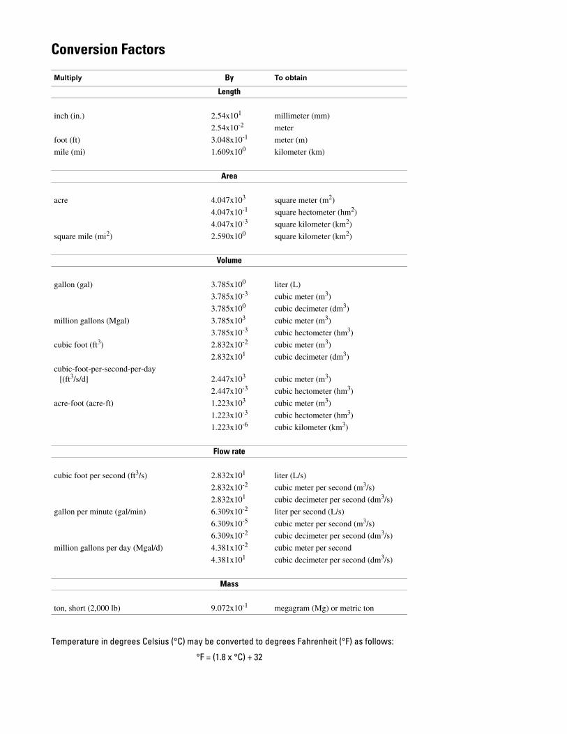
Conversion Factors
Multiply By To obtain
Length
inch (in.) 2.54x101 millimeter (mm)
2.54x10⁻² meter
foot (ft) 3.048x10⁻¹ meter (m)
mile (mi) 1.609x100 kilometer (km)
Area
acre 4.047x10³ square meter (m2)
4.047x10⁻¹ square hectometer (hm2)
4.047x10⁻³ square kilometer (km2)
square mile (mi2) 2.590x100 square kilometer (km2)
Volume
gallon (gal) 3.785x100 liter (L)
3.785x10⁻³ cubic meter (m3)
3.785x100 cubic decimeter (dm3)
million gallons (Mgal) 3.785x10³ cubic meter (m3)
3.785x10⁻³ cubic hectometer (hm3)
cubic foot (ft3) 2.832x10⁻² cubic meter (m3)
2.832x101 cubic decimeter (dm3)
cubic-foot-per-second-per-day [(ft3/s/d] 2.447x10³ cubic meter (m3)
2.447x10⁻³ cubic hectometer (hm3)
acre-foot (acre-ft) 1.223x10³ cubic meter (m3)
1.223x10⁻³ cubic hectometer (hm3)
1.223x10⁻⁶ cubic kilometer (km3)
Flow rate
cubic foot per second (ft3/s) 2.832x101 liter (L/s)
2.832x10⁻² cubic meter per second (m3/s)
2.832x101 cubic decimeter per second (dm3/s)
gallon per minute (gal/min) 6.309x10⁻² liter per second (L/s)
6.309x10⁻⁵ cubic meter per second (m3/s)
6.309x10⁻² cubic decimeter per second (dm3/s)
million gallons per day (Mgal/d) 4.381x10⁻² cubic meter per second
4.381x101 cubic decimeter per second (dm3/s)
Mass
ton, short (2,000 lb) 9.072x10⁻¹ megagram (Mg) or metric ton
Temperature in degrees Celsius (°C) may be converted to degrees Fahrenheit (°F) as follows:
°F = (1.8 x °C) + 32

Water Resources D
ata, Iowa, W
ater Year 2004—IA-04-2
Printed on recycled paper