Embed Size (px)
Citation preview

Water Quality Planning for the Houston-Galveston Region
Final Report, FY 2013
Funding for this project was provided by the Environmental Protection Agency through a Clean Water Act 604(b) grant to the Houston-Galveston Area Council, administered by the Texas Commission on Environmental Quality.

Cover photos by Justin Bower.
Water Quality Planning for the
Houston-Galveston Region
Final Report, FY 2013
Prepared by the Houston-Galveston Area Council, in coordination with the Texas Commission
on Environmental Quality. This project was funded under a Clean Water Act Section 604(b)
grant; TCEQ contract number 582-13-30047.
Houston Galveston Area Council
3555 Timmons Lane, Suite 120
Houston, TX 77027
For further information, please contact:
Justin Bower
Senior Environmental Planner
Houston-Galveston Area Council
713-499-6653

Final Report Contract 582-13-30047
Revision Date: 12/31/13 V.1.0
Table of Contents
Acronyms ...................................................................................................................................................... 3
Executive Summary ....................................................................................................................................... 1
Introduction .................................................................................................................................................. 5
Project Significance and Background ............................................................................................................ 7
Background ............................................................................................................................................... 7
Significance ............................................................................................................................................... 8
Project Objectives ....................................................................................................................................... 10
Objective 2: Quality Assurance ............................................................................................................... 10
Task 2.1 – QAPP Meeting .................................................................................................................... 10
Task 2.2 – QAPP .................................................................................................................................. 10
Task 2.3 – QAPP Updates/Amendments ............................................................................................. 10
Task 2.4 – Regional QAPP facilitation ................................................................................................. 10
Objective 3: Water Quality Management Plan Review, Update and Coordination ............................... 11
Task 3.1 - Service Area Boundaries ..................................................................................................... 11
Task 3.2 – Wastewater Database Maintenance ................................................................................. 11
Task 3.3 - State Revolving Fund .......................................................................................................... 14
Task 3.4 - Coordination ....................................................................................................................... 15
Task 3.5 – Bacteria Reporting Evaluation ........................................................................................... 16
Objective 4 - Support Watershed Planning............................................................................................. 16
Tasks 4.1 – Continuous Monitoring Sites ............................................................................................ 17
Tasks 4.2 – Compatibility .................................................................................................................... 17
Task 4.3 - Water Quality Statistical Summary Reports ....................................................................... 17
Task 4.4 - Additional Data Responsibilities ......................................................................................... 18
Task 4.5 – Stakeholder Coordination .................................................................................................. 18
Objective 5 – Coastal NPS Development ................................................................................................ 18
Task 5.1 – Program Evaluation ............................................................................................................ 19
Task 5.2 – Needs Assessment ............................................................................................................. 19

Final Report Contract 582-13-30047
Revision Date: 12/31/13 V.1.0
Task 5.3 – Program Development ....................................................................................................... 19
Objective 6 – Stormwater Circuit Rider Program ................................................................................... 21
Task 6.1 – Evaluate Stormwater Programs ......................................................................................... 22
Task 6.2 – Develop Model Program Resources................................................................................... 24
Task 6.3 – Provide Assistance to Local Governments ......................................................................... 24
Task 6.4 – Summary Report ................................................................................................................ 25
Objective 7 – OSSF Database Update ..................................................................................................... 25
Task 7.1 – Maintain OSSF Database .................................................................................................... 25
Task 7.2 – Update Unpermitted OSSFs ............................................................................................... 27
Objective 8 – San Bernard River BMP Pre-Implementation Water Quality Monitoring ........................ 27
Task 8.1 – Pre-Implementation Monitoring ........................................................................................ 27
Methods ........................................................................................................................................................ 1
Results and Observations .............................................................................................................................. 4
Discussion...................................................................................................................................................... 6
Summary ....................................................................................................................................................... 7
Appendices .................................................................................................................................................... 8
Appendix A – Summary of Materials included on Media ......................................................................... 9
Appendix B – Coastal Communities Program Evaluation/Needs Assessment Update ........................... 10
Appendix C – Stormwater Smart Recognition and Certification Program Proposal ............................... 17
Figures
Figure 1 – Wastewater Treatment Permit Plant Information Database………………………………………………..12
Figure 2 – Coastal Communities Program Website..………………………………………………………………………..……21
Tables
Table 1 –Projects Reviewed in FY 2013…………………………………………………………………………………………………13
Table 2 – OSSF Records Received…………………………………………………………………………………………………………26

Final Report Contract 582-13-30047
Revision Date: 12/31/13 V.1.0
Acronyms
BMP Best Management Practice
CCP Coastal Communities Program
CWQMN Continuous Water Quality Monitoring Network
CWSRF Clean Water State Revolving Fund
DMR Discharge Monitoring Report
EPA United States Environmental Protection Agency
FOG Fats, Oils, and Grease
GIS Geographic Information System(s)
H-GAC Houston-Galveston Area Council
HHW Household Hazardous Waste
MS4 Municipal Separate Storm Sewer System
MUD Municipal Utility District
NPS Nonpoint Source
OLD Outfall Location Dataset
OSSF On-Site Sewage Facility
PID Permit Information Database
QAPP Quality Assurance Project Plan
QA/QC Quality Assurance/Quality Control
SABD Service Area Boundary Dataset
SAS Statistical Analysis Software
SEP Supplemental Environmental Project(s)
SRF State Revolving Fund
SSO Sanitary Sewer Overflow
TCEQ Texas Commission on Environmental Quality
TEHA Texas Environmental Health Association

Final Report Contract 582-13-30047
Revision Date: 12/31/13 V.1.0
TMDL Total Maximum Daily Load
TSSWCB Texas State Soil and Water Conservation Board
TWDB Texas Water Development Board
TxDOT Texas Department of Transportation
USGS United States Geologic Survey
WCID Water Conservation and Improvement District
WQMP Water Quality Management Plan
WPP Watershed Protection Plan
WWTF Wastewater Treatment Facility

Final Report Contract 582-13-30047
Revision Date: 12/31/13 V.1.0
1
Executive Summary
This report summarizes Contract 582-13-30047 (Project), a 604b project administered by the Texas Commission on Environmental Quality (TCEQ). The Project entailed a series of seven (7) water quality data collection, special study, and coordination activity objectives1 completed by the Houston-Galveston Area Council (H-GAC) in conjunction with the TCEQ. The purpose of these activities is to provide data and analysis regarding wastewater infrastructure and other sources of nonpoint source (NPS) pollution that impact water quality in the 13-county Houston Galveston area Region (Region) of the Upper Gulf Coast of Texas. This document2 is a summary of the results of these efforts, and a discussion of future needs.
Objective 2 – Quality Assurance – This objective involved the maintenance and renewal of three existing Quality Assurance Project Plans (QAPPs): the Regional Water Quality Data Acquisition and Compilation QAPP (Data QAPP) for the collection and assessment of the various data sources described under Objective 3; the Regional Geospatial Data QAPP (Geospatial QAPP) for the collection and analysis of geospatial data as described in Objective 7; and the San Bernard Watershed Protection Plan Pre-BMP Monitoring QAPP (San Bernard QAPP) for auto-sampler monitoring as part of Objective 8. The following tasks were completed:
A QAPP meeting was held (as part of a general post-award meeting) on 9/19/2012 between H-GAC and TCEQ staff, along with continuing conversations throughout the Project term, to discuss the development and terms of the QAPP (Task 2.1)
Updates of the Data and Geospatial QAPPs were developed and submitted by H-GAC, and approved by TCEQ and EPA. The San Bernard QAPP (See Objective 8) was maintained during the portion of the contract under which that task was included (Task 2.3).
H-GAC continued to support TCEQ review of a Regional Non-ambient Water Quality Monitoring QAPP. No specific support was utilized by TCEQ during this Project term other than informal staff briefings and discussions of alternative approaches between Project staff and TCEQ (Task 2.4).
Objective 3 - Water Quality Management Plan Review, Update and Coordination – Objective 3 of this Project involved the continued development and maintenance of a series of integrated wastewater treatment facility (WWTF) datasets, the review of State Revolving Fund (SRF) applications for compliance with regional data and aims, coordination of regional watershed management efforts, and an evaluation of bacteria data reported in WWTFs’ discharge monitoring reports (DMRs). The following tasks were completed:
1 These seven water quality objectives are Objectives 2-8 of the Project. Objective 1 – Administration, and
Objective 9 – Final Report are not discussed separately, but are referenced in relation to other Objectives. 2 Due to size and length considerations, some documents or deliverables are provided on the enclosed DVD, as
noted in the Report.

Final Report Contract 582-13-30047
Revision Date: 12/31/13 V.1.0
2
Datasets containing spatial information related to WWTF service area boundaries and permitted outfalls were updated and amended to reflect changes and better reconcile with other related datasets (Task 3.1).
The WWTF permit information database was updated with new permit information, reviewed for outdated or erroneous data, and then compared against the service area boundaries and outfall location datasets. Effluent data from Discharge Monitoring Reports was acquired and incorporated for use in a wide array of watershed, wastewater infrastructure, and other related projects3. A significant overhaul of existing discrepancies was conducted, completing a final phase of database integration by removing outdated or erroneous permit data (Task 3.2).
H-GAC reviewed one application to the State Revolving Fund (SRF), and provided formal comment to the TCEQ (Task 3.3).
H-GAC provided general watershed/water quality management coordination through the staffing and facilitation of the Natural Resources Advisory Committee, coordination of data and efforts with ongoing Total Maximum Daily Load (TMDL) and Watershed Protection Plan (WPP) projects, sending liaisons to a variety of local water quality and watershed organizations, and coordinating efforts between other H-GAC environmental efforts and this Project (Task 3.4).
H-GAC completed a review of bacteria testing results conducted as part of DMRs from WTTFs in the region (Task 3.5).
Objective 4 - Support Watershed Planning in the Lake Houston Watershed – Objective 4 involved oversight of continuous monitoring on tributaries to Lake Houston, and coordination of watershed management efforts among local stakeholders to promote water quality in this important drinking water source. The following tasks were completed:
Continuous monitoring was conducted at two sites on the West Fork of the San Jacinto by the USGS (subcontractor) and overseen by H-GAC staff, and results were compiled and submitted to TCEQ quarterly (Task 4.1-4.4).
Stakeholder Coordination for the Bastrop Bayou and San Bernard WPP projects was facilitated by H-GAC. One joint meeting and one distributed (individual calls to key partners) was conducted for the Bastrop Bayou project. A delay in approval for the San Bernard WPP approval necessitated postponing stakeholder meetings until FY14. However, an executive summary document was developed in support of future meetings (Task 4.5).
Objective 5 – Coastal Nonpoint Source Program Development – For the fifth objective, H-GAC updated its evaluation of the infrastructure and maintenance challenges faced by two additional non-MS4 permitted entities in the Region’s coastal counties. The update was part of the second phase in an ongoing program to prioritize support for local needs that impact NPS
3 These data collection and analysis activities took place under the auspices of the H-GAC Regional Water Quality
Data Acquisition and Compilation QAPP. This QAPP was updated and approved during this contract period prior to initiation of data work.

Final Report Contract 582-13-30047
Revision Date: 12/31/13 V.1.0
3
issues in these communities4. In addition, H-GAC provided support and services to help the program communities to meet needs related to a nonpoint source impact. A program website was developed to host model materials, funding resources, and other pertinent information. Lastly, H-GAC engaged local stakeholders in reviewing potential funding opportunities and involvement with the RESTORE Act funding process. The following tasks were completed:
H-GAC updated the program evaluation and needs assessment from the FY13 604(b) phase I report to include two additional coastal communities (Tasks 5.1, 5.2).
H-GAC provided support services to the program participants (Task, including initiating a multi-party flood planning grant proposal development processes in Brazoria County (TWDB flood planning grant);initiating a funds solicitation process for pet waste management for the Village of Surfside Beach; working one-on-one the City of <Manville and other several communities to identify and consider grant resources; coordinating with a corresponding coastal stormwater BMP study through the University of Texas; and disseminating grant opportunity and programmatic resources information to all participants.
In addition, H-GAC developed a program website5 to host program resources, funding opportunities, and related information relevant to our program participants (Task 5.3).
Objective 6 – Stormwater Circuit Rider Program – To address stormwater-relates tasks under Objective 6, H-GAC conducted a series of in-depth interviews with MS4 Phase II entities; acquired and compiled the latest annual reports from all MS4 entities in the Region in a database and on a program website6; developed the Stormwater Smart certification and recognition program proposal; coordinated with the Clean Water Initiatives program on a series of stormwater/minimum control measure seminars; and developed a summary report on the state of MS4 annual reports and stormwater BMP tracking with recommendations for the TCEQ and local stakeholders. The following tasks were completed:
Evaluate of local stormwater programs and regulatory controls for all MS4 Phase II permittees in the Region through a series of in-depth interviews on the status of their program implementation, the Annual Report process, and impediments and successes related to their regulatory controls and implementation strategies. The results were compiled in a database and used to inform recommendations in the summary report (Task 6.1, 6.2).
Acquisition and hosting of the latest Annual Reports from MS4 permittees on the program website. The data from the reports was entered into a shared database to allow for comparative assessment (Task 6.2).
Development of a certification and recognition proposal (Stormwater Smart) as an incentive for stormwater implementation and permit compliance, in conjunction with similar efforts under the Houston-are Bacteria Implementation Group (Task 6.2).
4 The summary report for Objective 5 deliverables is contained within this report as Appendix XXX.
5 www.coastalcommunitiestx.com
6 The reports are hosted on the H-GAC website at www.h-gac.com/community/water/MS4Reports.aspx.

Final Report Contract 582-13-30047
Revision Date: 12/31/13 V.1.0
4
Coordination with the H-GAC’s CWI on a series of stormwater-related seminars focusing on minimum control measures (Task 6.3).
Development of a Summary Report on the state of MS4 annual reporting and stormwater BMP implementation with recommendations for the TCEQ and local stakeholders.
Objective 7 - OSSF Database Update – In fulfillment of Objective 7, H-GAC updated and expanded an existing GIS database of regional on-site sewage facility (OSSF) locations and a spatial projection of likely locations for unpermitted systems7. Additionally, H-GAC developed an online spatial application for viewing OSSF locations. The following tasks were completed:
The OSSF location database was updated with new data received during the contract period (Tasks 7.1).
An online OSSF application was developed for easier dissemination of OSSF data (Task 7.1).
The Non-permitted OSSF methodology was reviewed and updated by H-GAC staff to include commercial and industrial properties. (Task 7.2)
Objective 8 – San Bernard River BMP Pre-Implementation Water Quality Monitoring – H-GAC operated and maintained a series of automated water sampling stations8 at select locations in the San Bernard Watershed to evaluate pre-implementation conditions at potential BMP sites. The following tasks were completed:
H-GAC staff maintained and operated four (4) automated water quality sampling stations. Due to insufficient rainfall, only two viable samples were collected. (Tasks 8.1).
7 These data collection and analysis activities took place under the auspices of the H-GAC Regional Geospatial Data
QAPP. This QAPP was amended and approved during this contract period. 8 The autosampler effort began as part of a previous TCEQ/ARRA grant. Initial acquisition and installation of the
stations was completed under that grant

Final Report Contract 582-13-30047
Revision Date: 12/31/13 V.1.0
5
Introduction
This document is the culminating report for the fiscal year 2013 efforts conducted under 604b-funded Contract 582-13-30047 (Project) between the H-GAC and the TCEQ. The Project involved acquiring, compiling and evaluating water and wastewater data, and a series of special studies and coordination activities. The purpose of the Project is to support current and future planning decisions concerning water quality efforts, wastewater infrastructure development, watershed management, and related issues on both a regional and state level.
The 13-county Houston-Galveston Area Region (Region) has a variety of water quality concerns and developmental challenges. The majority of our local water bodies are impaired under state water quality standards, and our developmental patterns have resulted in a relatively patchwork and diffuse network of wastewater infrastructure. With population expected to expand dramatically in the coming decades, the ability to make informed decisions regarding water quality and wastewater infrastructure development will be a key tool in planning for the Region’s future. The background of this Project is discussed in the Project Significance and Background section. The efforts summarized in this document serve to advance these purposes through a series of specific studies and the maintenance of regional datasets for local use and in support of the state’s Water Quality Management Plan.
This report will focus on the progress achieved in the seven primary objectives9 set forth in the Project:
Quality Assurance
Water Quality Management Plan Data Update and Coordination
Support Watershed Planning
Coastal NPS Program Development
Stormwater Circuit Rider Program
OSSF Database Update
San Bernard River BMP Pre-implementation Water Quality Monitoring
Each of these primary tasks serves to maintain, expand or implement the H-GAC’s store of water quality and wastewater infrastructure data, or provide related services to the Region. Each objective is explained in greater depth later in the Project Studies and Coordination Activities section.
The Project required a series of interim deliverables related to these tasks. A description of the methodologies employed to generate outcomes is provided in the Methods section. Some of the deliverables are generated as large electronic datasets, unsuitable for full inclusion in a
9 Objective 1 (Administration) and Objective 9 (Final Report) are not specifically reported on in this document, as
they relate only to the maintenance of the contract and the development of this document.

Final Report Contract 582-13-30047
Revision Date: 12/31/13 V.1.0
6
printed version of this final report10. However, representative pieces of each deliverable are included, and all Project outcomes are discussed in the Results and Observations section. The synthesis of the information gathered and tasks implemented under this Project is discussed in the Discussion and Summary sections. Additional information and standalone reports completed for some deliverables are provided in the Appendices.
10
Copies of these electronic data are contained within the media that accompanies this report, and have been provided under separate cover.

Final Report Contract 582-13-30047
Revision Date: 12/31/13 V.1.0
7
Project Significance and Background
Background
The Region has experienced robust economic expansion over the last several decades. That expansion resulted in a proportional increase in population growth and resulting land development. While this has been a boon to local prosperity, increased population and development also carry with them the challenges for our utility infrastructure and the potential for increased impact on our local waterways. With 3.5 to 4 million more residents expected by 2035, these challenges will only be exacerbated by future population growth.
The majority of the stream segments in the Houston area are listed on the State of Texas’s list of impaired water bodies (303d list). Approximately 83% of the major segments are unable to meet one or more state water quality standards. The most common source of impairment is elevated bacteria levels in excess of the contact recreation standard. Other development related issues like low dissolved oxygen, PCBs, and dioxins are also present in some water bodies. The bacteria in our lakes, creeks, streams and bayous comes from a variety of sources, including human waste, domestic animal waste, pet waste, and wildlife. These wastes may enter the water through point sources, i.e. discrete “end of pipe” discharges, or diffusely through nonpoint sources, carried in precipitation flowing over the land. While some bacteria are naturally occurring, development brings with it additional bacterial sources and a greater potential impact to water bodies unless careful planning is employed.
The wastewater infrastructure that serves the Region’s increasing population has expanded and developed much like the Region itself. The availability to fund infrastructure through political subdivisions like Municipal Utility Districts (MUDs) and other special districts allowed for a wastewater treatment network that is relatively widespread and diffuse rather than limited by the bounds of a traditional, centralized model. The resulting patchwork of regional wastewater infrastructure development offers both future challenges and opportunities for local decision-makers. These challenges are best served by the accumulation, maintenance and application of regional wastewater and effluent quality data to inform regional decisions. As management measures designed to deal with the current and potential water and wastewater infrastructure issues are put into place, the need for coordinated, regional sources of information becomes plain.
Under previous 604b projects, H-GAC has sought to address aspects of the information and data needs related to the water quality issues the Region faces. These projects have typically been a mix of ongoing efforts and short term special studies. Some of the project efforts have been continuous (wastewater data collection and maintenance, etc.) while others have been standalone research efforts relating to specific data needs or questions (GIS analyses for infrastructure consolidation, etc.). This balance allows the long term accumulation of data while retaining flexibility to address specific issues. The ongoing efforts in the FY13 Project focus on updating and improving existing regional wastewater infrastructure databases and spatial

Final Report Contract 582-13-30047
Revision Date: 12/31/13 V.1.0
8
datasets of OSSF locations, providing nonpoint source management support to small coastal communities, supporting local watershed protection planning efforts, and continuing water quality analysis for Lake Houston. Short term efforts include an evaluation of bacteria data in DMR reports, evaluation of aspects of the Phase I and II MS4 permit implementation and annual reporting process, developing recognition programs and model resources for MS4 permittees, and conducting automated sampling in the San Bernard River watershed.
Significance
From a regional perspective, the water quality and wastewater infrastructure decisions facing our local areas are more effectively considered on a watershed basis, as contaminants do not adhere to political boundaries along waterways. This is especially important for watersheds that serve as significant drinking water sources, like Lake Houston. In order to provide useful information and viable recommendations, a large store of relevant and accessible data is necessary.
The data collection and analysis tasks completed under this Project have significant value for a variety of efforts in the Region, benefitting local watershed protection planning, wastewater infrastructure planning, and program development.
The significance of the efforts undertaken in this Project is demonstrated by the variety of capacities in which the outcomes are used:
Internal data collection – The wastewater permit data, service area boundaries, Lake Houston monitoring data, and OSSF location data collected/created under this Project serve to augment existing datasets, inform project decisions on related efforts, and expand internal abilities of both the H-GAC and TCEQ to incorporate and produce future data and analyses.
Regional coordination – Maintaining and expanding regional data resources allow the H-GAC and TCEQ to better understand and facilitate regional efforts between parties involved in wastewater infrastructure decisions, and general water quality/watershed protection efforts (WPP and TMDL efforts, etc.)
Source water protection – A large portion of the Region’s population is served by treated surface water that originates in our local rivers and lakes, of which Lake Houston is a primary source for the greater Houston area. The monitoring and coordination activities of this Project fostered greater understanding of the issues facing this prominent drinking water source.
Stormwater implementation – As the Region’s TPDES MS4 permittees reach the end of the first permit cycle, the success of stormwater BMP implementation and reporting requirements are significant aspects of the success of efforts to address this appreciable source of water quality impairment. The data and recommendations of this project are designed to increase the efficiency of MS4 reporting and BMP tracking to ensure greater accountability and ability to more accurately measure implementation success.

Final Report Contract 582-13-30047
Revision Date: 12/31/13 V.1.0
9
Project review – Data and analyses allow H-GAC Project staff to assist state and federal granting agencies in review of regional grant applications. These reviews ensure that potential projects concur with regional priorities and regional data projections.
Education and outreach – Data gathered under this project has been used as a focal point or basis for several educational efforts, including the OSSF location database, and various facilitated meetings like the ongoing Natural Resources Advisory Committee.
Coastal NPS program development– The outcome of the second phase of the Coastal Communities Program is a set of recommended priorities for addressing NPS issues in small communities in the Region’s coastal counties. This intent for this information is to help shape local, regional and state projects seeking to address NPS pollution in these areas.

Final Report Contract 582-13-30047
Revision Date: 12/31/13 V.1.0
10
Project Objectives
This section details the background, process and outcomes for the seven Objectives that represent the component efforts of this year’s Project (Objectives 1 and 9 of the Project are administrative tasks and Final Report requirements, and therefore are not reported on this document).
Objective 2: Quality Assurance
This objective includes tasks related to maintenance and update of three existing Quality Assurance Project Plans (QAPPs): the Regional Water Quality Data Acquisition and Compilation QAPP (Data QAPP) for acquisition, compilation and assessment of TPDES permit data and related information as part of Objective 3; the Regional Geospatial Data QAPP (Geospatial QAPP) for the collection and analysis of geospatial data as described in Objective 7; and the San Bernard Watershed protection Plan Pre-BMP Monitoring QAPP, for collection of rain flow events via auto-samplers as part of Objective 8.
The purpose of this objective is to ensure all data are collected and analyzed in a manner appropriate for the data objectives of the Project.
Task 2.1 – QAPP Meeting
H-GAC and TCEQ met to formally discuss the QAPP needs for the project as part of a project kickoff conversation on 9/19/2012 after the initiation of the contract. The outcome of the meeting was a confirmation of the elements covered by each QAPP. Informal discussions regarding the maintenance and update of the QAPPs occurred continuously throughout the project term.
Task 2.2 – QAPP
The existing QAPPs were maintained during this time period, with updates and revisions made as part of Task 2.3. No new QAPPs were required during this project term.
Task 2.3 – QAPP Updates/Amendments
H-GAC amended the Data QAPP and the Geospatial QAPPs for content and for annual update. The revised versions were submitted and approved by TCEQ and EPA.
Task 2.4 – Regional QAPP facilitation
H-GAC developed a Regional Non-Ambient Water Quality Monitoring QAPP in the FY 2011 604b Project. Based on discussions with TCEQ, H-GAC provided for continuing support for review under this Project term on an as-needed basis. Informal discussions and short staff briefings for a new TCEQ PM were conducted, but TCEQ did not request additional meetings or provide additional comments on the QAPP. H-GAC held informal discussions with other TCEQ staff about related efforts and alternatives to this QAPP effort.

Final Report Contract 582-13-30047
Revision Date: 12/31/13 V.1.0
11
Objective 3: Water Quality Management Plan Review, Update and
Coordination
This objective includes tasks related to wastewater infrastructure data collection, dataset update and management, coordination of watershed planning efforts, and SRF project proposal reviews.
H-GAC maintains a series of datasets related to TPDES-permitted wastewater infrastructure facilities in the region. They are the Service Area Boundaries Dataset (SABD), the Outfall Locations Database (OLD), and the Permit Information Database (PID). A primary task under this Project is to update and continue to integrate these data sources.
Task 3.1 - Service Area Boundaries
The SABD is the spatial representation of the wastewater dischargers’ service area boundaries. Typically, this boundary data include municipalities, public districts (MUDs, WCIDs, etc) and private utilities.
During previous annual Projects, the SABD was modified to integrate it with the Permit Information Database (PID) and the Outfall Location Dataset (OLD) directly in a shared GIS, to allow data updates to be shared across platforms directly, rather than through duplicated effort.
H-GAC GIS staff accumulated and integrated service area boundaries during this project term on an ongoing basis. The current version of the SABD is included in digital format on the media accompanying this report.
Task 3.2 – Wastewater Database Maintenance
In addition to the SABD, H-GAC maintains two other sets of data, the Outfall Location Database, a GIS layer, and the Permit Information Database, and Excel database.
Outfall Location Database (OLD) – The OLD is a companion dataset to the SABD, and maintains the outfall location of each permitted wastewater outfall. TCEQ updates are the initial source of this dataset, as precise outfall location coordinates are not provided in permit documents (only general descriptions of the outfall path). However, when H-GAC receives data from individual permit holders or other sources that contradicts TCEQ data, staff members review the conflicting data against the existing records.
During this project period, staff continually updated the OLD, and conducted an in-depth integration review after incorporating the most recent version of TCEQ data. As part of the review process, project staff compared the existing dataset with the most current TCEQ dataset to identify and resolve any discrepancies. Subsequent to this review, the outfall dataset was compared to the PID to ensure that each outfall record in the PID had a corresponding outfall location.

Final Report Contract 582-13-30047
Revision Date: 12/31/13 V.1.0
12
The current outfalls database is provided in digital format in the media that accompanies this Report.
Permit Information Database (PID) – The PID is the collecting point for wastewater discharge permit data from regulated wastewater dischargers across the region. The H-GAC receives copies of permit information from the TCEQ, and incorporates it into periodic updates and reviews of a centralized database. The data H-GAC receives includes new permits, permit renewals, permit modifications, notices of permit applications/renewal applications, preliminary decisions on permit applications/renewal applications, and permit information updates11. From these documents, all relevant information is extracted into pre-determined fields. These fields include name of discharger, name of facility, addresses, EPA and TCEQ permit numbers, capacity and permitted flow requirements, contaminant limits, outfall path, and other identifying data and regulatory restrictions.
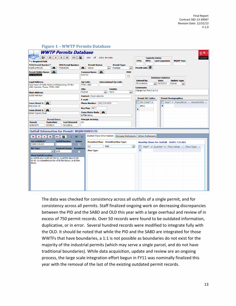
Two updates, one major and one minor, occurred during this Project term, bring the PID current with data received through at least 10/1/2013. The H-GAC Project Manager conducted a quality control audit for the data entry on 10% of the data. No appreciable errors were found. The current database includes records for 1505 permits, representing well over 2000 individual outfalls. A screenshot of the database format is attached as Figure 1.
11
It should be noted that H-GAC does not receive notices of permit expiration, abandonment, or administrative enforcement orders.
Final Report Contract 582-13-30047
Revision Date: 12/31/13 V.1.0
13
Figure 1 – WWTP Permits Database
The data was checked for consistency across all outfalls of a single permit, and for
consistency across all permits. Staff finalized ongoing work on decreasing discrepancies
between the PID and the SABD and OLD this year with a large overhaul and review of in
excess of 750 permit records. Over 50 records were found to be outdated information,
duplicative, or in error. Several hundred records were modified to integrate fully with
the OLD. It should be noted that while the PID and the SABD are integrated for those
WWTFs that have boundaries, a 1:1 is not possible as boundaries do not exist for the
majority of the industrial permits (which may serve a single parcel, and do not have
traditional boundaries). While data acquisition, update and review are an ongoing
process, the large scale integration effort begun in FY11 was nominally finalized this
year with the removal of the last of the existing outdated permit records.
Final Report Contract 582-13-30047
Revision Date: 12/31/13 V.1.0
14
Task 3.3 - State Revolving Fund
In conjunction with H-GAC’s role as a regional planning group and the council of governments for the Houston-Galveston area of the Upper Gulf Coast, staff regularly provides comment on grant proposals of varying types. These reviews help to assure that regional goals were represented in project funding decisions at variety of governmental levels.
H-GAC reviews the grant applications and associated engineering documentation (PER, Environmental Review, population projections) for concurrence with regional planning goals. Specifically, staff looked for:
Population projections that matched TWDB, H-GAC or other relevant forecasts
Consideration of engineering alternatives and general due diligence
Concurrence with regional priorities and goals (water quality impacts, etc.)
As part of this Project, H-GAC staff used data gathered under this and previous projects to
provide comment on one (1) State Revolving Fund (SRF) projects for the TCEQ. The outcomes of
the reviews are shown in Table 1 below.

Final Report Contract 582-13-30047
Revision Date: 12/31/13 V.1.0
15
Table 1 – Projects Reviewed in FY 2013
Granting Agency
Project ID# Requesting Entity Project Summary Findings Notes
TWDB
CWSRF 73652 City of Houston
Rehabilitation of
multiple wastewater
systems/infrastructure. Support
Sent letter of support. Annual
multi-area project.
Task 3.4 - Coordination
As an extension of H-GAC’s role as a coordinator of regional planning efforts in a variety of fields, project staff members develop and maintain relationships with other local and state governments, community groups, and other organizations involved in efforts related to the aims of this Project.
Staff members facilitate the H-GAC’s Natural Resources Advisory Committee, which provides policy recommendations for the H-GAC’s Board of Directors, and serves as a regional roundtable for coordinating environmental efforts. The NRAC provides an efficient communication network and point of contact for H-GAC staff with other local and regional water quality decision makers, and four (4) meetings were held during the original Project term, and one in the extended timeframe (November meeting). The topics discussed at these meetings included the RESTORE ACT, potential impacts of dredging activities, the current state of the Galveston Bay system, pharmaceuticals in the water supply, natural resource legislation in the current session of the Texas Legislature, and regional watershed coordination and water quality opportunities. Project staff members also routinely attend meetings of, or otherwise support, a variety of other organizations involved in water quality efforts. This project term, staff helped coordinate activities with a wide variety of organizations. An example of these groups that staff worked with this year includes:
Coordination with the Clean Rivers Program in Lake Houston water quality efforts.
Coordination with the Harris County Flood Control District on the Halls Ahead assessment project for the Halls Bayou watershed.
Promotion of OSSF data collection efforts relating to Objective 6, and other water quality efforts through presence and speaking engagements with a variety of conferences including the Texas Environmental Health Association (TEHA), Texas Watershed Stewards trainings, the Texas Watershed Coordinators Roundtable, and other watershed coordinator meetings at the local and regional level.
The Galveston Bay Estuary Program – Water and Sediment Committee membership and leadership (Justin Bower is vice-chair of the Committee).
A variety of interactions with state and local policy and regulatory efforts (including coordination with ongoing TMDL, Watershed Protection Plan, and other efforts). Some projects of specific note are:

Final Report Contract 582-13-30047
Revision Date: 12/31/13 V.1.0
16
o Bacteria Implementation Group (BIG) and Upper Oyster Creek TMDL Implementation Plans
o Cedar Bayou, San Bernard River, and Bastrop Bayou Watershed Protection Plans
In addition to facilitating regional communication, coordination, and cooperation on water quality efforts through staff presence and participation, H-GAC also uses the data generated under this project to support various internal and external project needs.
Task 3.5 – Bacteria Reporting Evaluation
An ongoing concern for watershed protection and water quality efforts in the region has been the extent to which WWTFs contribute bacteria to impaired waterways. As part of the maintenance of permit data in Task 3.2, project staff obtained an updated version of the past 5 years of discharge monitoring report (DMR) data for all permitted WWTFs in the 13-county region. The intent of the effort was to evaluate the character and scope of bacteria releases from permitted outfalls in relation to permit limits, plant size and other factors. BOD/CBOD, Ammonia, TSS, and flow were also evaluated for these facilities. The results of the statistical analysis are included in the digital media that accompanies this report.
In brief summary, the evaluation indicated that:
Of the 1189 reporting facilities in the data set, only 373 were regularly reported bacteria data (for either indicator). To some degree this is due to many facilities not yet having limits appended to their permits.
An appreciable number of plants reported exceedences of the daily average limit; 32 large facilities (permitted flow in excess of 2 MGD), 59 medium facilities (flow of 0.5-2.0 MGD) and 44 small facilities (permitted flow less than 0.5 MGD).
For all bacteria samples, only 0.9% of the large facility samples were in exceedence, compared to 3.3% of the medium facility samples, and 8.7% of the small facility samples.
While large facilities accounted for an overwhelming majority of the total flow, they accounted for only slightly over a third of the total estimated bacteria loading. Small plants had the most disproportionate amount of bacteria loading.
Overall, there was a general indication that size of WWTF is a potential factor in bacteria loading.
Objective 4 - Support Watershed Planning
Objective 4 provides targeted support for ongoing source water and watershed planning in three priority watersheds of the region. This efforts under this objective include continuous water quality monitoring in the Lake Houston watershed (Tasks 4.1-4.4), and stakeholder facilitation in the Bastrop Bayou Watershed and the San Bernard River Watershed (Task 4.5).

Final Report Contract 582-13-30047
Revision Date: 12/31/13 V.1.0
17
Tasks 4.1 – Continuous Monitoring Sites
Lake Houston serves as source water for a large population, and therefore elicits special attention for water quality protection efforts. H-GAC maintains two continuous water quality monitoring sites in the Lake Houston Watershed, both located on the West Fork of the San Jacinto River. These stations are operated by the USGS under contract with H-GAC, and operated under the auspices of the TCEQ’s Continuous Water Quality Monitoring Network (CWQMN) QAPP.
The two sites are:
Monitoring Station 08067650 on the West Fork San Jacinto River, below Lake Conroe, near Conroe, TX.
Monitoring Station 08068000 on the West Fork San Jacinto River near Conroe TX.
Monitoring efforts at the two stations are focused specifically on total dissolved solids, as an indicator of water quality concerns in Lake Houston. The actual parameters monitored include pH, dissolved oxygen, temperature and specific conductance. The specific conductance values are used to generate total dissolved solids values. The USGS provides the data directly to H-GAC and the TCEQ. Data collected at these sites is used as part of the City of Houston’s overall continuous monitoring network, also maintained by the USGS.
Data from the sites is useful in determining impacts of upstream activities on Lake Houston, and thus a large portion of the Region’s water supply. These monitoring activities are conducted as part of a long term effort to look at changes to conditions in the watershed. These particular sites have been monitored since FY 2008, but other sites in the same watershed have supplied similar data since as early as the mid-90’s. Data from these monitoring efforts is submitted to the TCEQ along with the regular quarterly progress reports.
This multi-year effort was finalized in FY2013. H-GAC and USGS staff are pursuing other options for another entity to take over this effort on an ongoing basis. The data collected under this contract will continue to inform water quality decisions made for this vital water source.
Tasks 4.2 – Compatibility
H-GAC and USGS took the proper steps to ensure that the sites, instrumentation, data loggers, and communications are fully compatible with the TCEQ standards, as specified in the Project.
Task 4.3 - Water Quality Statistical Summary Reports
The USGS prepares monthly Water Quality Summary Statistics Reports for each site. These reports, along with quality assurance data completeness reports, are submitted to the H-GAC, who then submits them to the TCEQ with each quarterly report.

Final Report Contract 582-13-30047
Revision Date: 12/31/13 V.1.0
18
Task 4.4 - Additional Data Responsibilities
H-GAC Clean Rivers Program staff attended regular Continuous Water Quality Monitoring meetings and provided H-GAC with all quality assurance and other data as requested, and as specified in the Project. No additional training was completed during this Project term.
Task 4.5 – Stakeholder Coordination
H-GAC has established Watershed Protection Plan efforts in the Bastrop Bayou and San Bernard River Watersheds through previous 319h grants from the TCEQ. While both of the WPPs awaited review and approval by TCEQ and EPA, H-GAC has continued to work with the stakeholders in these watersheds to coordinate implementation efforts and disseminative project information. The following was completed during this Project:
Bastrop Bayou Watershed Protection Plan – In support of extensive review and revision in response to EPA comments, H-GAC staff worked with individual stakeholder to assess current conditions, identify upcoming planned projects, and revise schedules and BMPs accordingly. H-GAC submitted a revised WPP and submittal letter to TCEQ for review prior to resubmittal to EPA. In addition, H-GAC developed a grant project to begin implementation in the watershed. As part of the Project, H-GAC held one joint stakeholder meeting (via conference call by stakeholder request, on 11/12/13), and a series of follow-up conversations with individual stakeholders (rather than a second joint meeting, per stakeholder preference). The primary intent was to confirm implementation commitments related to the new 319 project and initiate the implementation process. Additional conversations with individual stakeholders and coordination with Stream Team volunteers in the watershed continued throughout the time period of the contract.
San Bernard River Watershed Protection Plan – project staff worked with TCEQ to revise the Watershed Protection Plan. Due to an extended WPP approval process, no additional stakeholder meetings were held. In support of planned stakeholder meetings in FY14, Project staff developed a draft Executive Summary document (included with the digital media attached with this report). Additional conversations with individual stakeholders and coordination with Stream Team volunteers in the watershed continued throughout the time period of the contract.
Objective 5 – Coastal NPS Development
While many communities in the Region are covered by MS4 storm water permits, there are a large number of small communities with known NPS issues who have received less attention and have less access, or less knowledge of, existing resources that could mitigate challenges they face and lessen the impact of NPS sources in their communities. Of specific interest to the Region are those small communities in our coastal counties that may impact our coastal bays and estuaries.

Final Report Contract 582-13-30047
Revision Date: 12/31/13 V.1.0
19
Under the FY12 604b project, H-GAC initiated a Coastal Communities Program to evaluate the needs of these communities, the nexus of those needs with NPS contributions, and potential services that would serve elements of the communities’ needs while alleviating NPS pollution. During this Project term, H-GAC expanded its previous evaluation, developed and/or disseminated a series of model resources, and provided direct services to a number of its Coastal Communities Program participants.
Task 5.1 – Program Evaluation
Project staff revisited the previous year’s evaluation by renewing contacts with Program entities, conducting a follow-up interview conversation with each, and inviting additional communities to take part. Two additional communities (Village of Surfside Beach and City of Palacios) participated, and a full evaluation and needs assessment update was completed for each community.
Task 5.2 – Needs Assessment
As per Task 6.1, H-GAC revisited the previous year’s assessment with existing participants and added two new communities. The updated assessment is included as Appendix B of this report. The two communities added during this Project year had needs similar to other program participants, leading to no appreciable change to the recommendations of the original report.
Task 5.3 – Program Development
The primary focus of this year’s Program effort was to make program resources and services available to the participating communities. The following services or products were delivered to the participants:
A program website (www.coastalcommunitiestx.com) was developed and disseminated to the participants. The website hosts model programmatic resources, the previous year’s assessments, information on funding resources, information on events of interest (RESTORE Act, etc.), and project updates. Branding elements for the program were developed as part of this effort. Figure 2 is a screenshot of the website landing page.
Grant opportunities were disseminated to the program participants as they were developed. Examples of grant announcements disseminated include the RESTORE Act information, TWDB SRF solicitations, TWDB Flood Planning grant RFP, and other coastal environmental opportunities.
Grant-writing and grant opportunity development services were provided for: o TWDB Flood Protection Planning Grant – H-GAC facilitated the formation of a
coalition of small coastal communities in Brazoria County in pursuit of a TWDB Flood Planning grant. Project staff held a series of conference calls with the cities of Sweeny, West Columbia, and Brazoria and the Brazoria County Drainage District 11. H-GAC drafted a grant proposal for targeted flood mitigation studies in the Drainage District, for submission in January, 201412. The Drainage District
12
Final submission will be subject to stakeholder approval and Drainage District agreement to sponsor the grant.

Final Report Contract 582-13-30047
Revision Date: 12/31/13 V.1.0
20
would be the final applicant; H-GAC’s role is limited to facilitating the initial coalition and developing the proposal.
o Village of Surfside Beach Pet Waste Solicitation – Project staff worked with the Village of Surfside Beach to develop a solicitation campaign to fund pet waste stations and signage on their beachfront. The need for the stations was identified in the initial assessment, and the large industrial presence in the adjacent area was prioritized as a likely source of public-private partnership contribution. H-GAC drafted initial solicitation letters for the Village, and is continuing to work with them on supporting their funding requests. H-GAC also provided cost information for stations, and identified potential vendors for the Village’s consideration.
o City of Manvel Water Conservation Grant – H-GAC worked with the City of Manvel to identify grant opportunities for a series of water supply/water conservation grant projects. Among other opportunities, H-GAC evaluated and recommended the Department of the Interior, Bureau of Reclamation “WaterSmart: Water and Energy Efficiency Grants for FY 2013” grant program. H-GAC will continue to support Manvel with grant development if they chose to pursue this opportunity in the FY14 project year.
o RESTORE Act Representation – As part of a large effort to ensure representation of the needs of coastal communities in the region, H-GAC took part in several meetings, seminars, and trainings surrounding the development of RESTORE Act funding priorities for the state of Texas. These meetings included H-GAC hosted NRAC discussions of RESTORE Act priorities, trainings hosted by a local coalition of environmental organizations, and individual discussions and briefings with regional stakeholders. The intent of this representation is to ensure that the needs and NPS sources identified under this coastal program are part of the priority for funding/project selection.
BMP Resource Guide Development – H-GAC worked with a team from the University of Texas to support their development of a BMP handbook for small coastal communities. H-GAC staff is serving on their advisory committee, and met on several occasions to discuss potential shared goals and how to avoid redundancies between our efforts. H-GAC helped disseminate information for their public listening sessions, held during this Project year, and will continue to help develop and disseminate their product.

Final Report Contract 582-13-30047
Revision Date: 12/31/13 V.1.0
21
Figure 2 – Coastal Communities Program Website
Objective 6 – Stormwater Circuit Rider Program Urban stormwater is an appreciable source of contamination for the region’s waterways, and the
implementation of the Phase II MS4 permit program is one of the largest single efforts to address it. The
ability to accurately track, assess, and improve the program is a necessary element for its success.
During previous Project years and under various TMDL projects, H-GAC has developed a BMP
implementation database, developed a draft Regional Non-Ambient Monitoring QAPP as an umbrella for
MS4 entities who are testing BMPs and stormwater conditions, and generally identified a need for
better data to assess the success of the MS4 permit program.
The intent of this objective was to make an evaluation of aspects of TPDES Phase II MS4 program
implementation and reporting in the H-GAC region, towards the goal of improving compliance and the
ability to track and evaluate BMP successes. H-GAC pursued this goal through in-depth interviews with
MS4 permittees, development of model resources, acquisition and assessment of the latest round of

Final Report Contract 582-13-30047
Revision Date: 12/31/13 V.1.0
22
Annual Reports, development of a proposal for a certification and recognition program, and
development of recommendations for TCEQ and MS4 permittees for improved reporting.
Task 6.1 – Evaluate Stormwater Programs
This task required an audit of local stormwater programs to assess the success of their
implementation, challenges faced, the extent of BMP implementation, and develop
recommendations for improving individual programs and the MS4 implementation for Phase II
in general. H-GAC evaluated individual programs (Permittee Interviews), Annual Report
contents and applicability (Annual Reports Evaluation), and comparative tracking in other large
urban regions in the United States (Comparative Tracking). Common themes and needs
identified in these three elements were used to produce a summary report with
recommendations.
Permittee Interviews - Project staff contacted all Phase II MS4s in the region to conduct an in-
depth interview regarding their program implementation, successes and challenges, regulatory
mechanisms they have employed, and needs. Of the 142 Phase II MS4s in the region, H-GAC
was able to successfully interview 107 (approximately 75% of total permits)13. A standardized
interview form was used, but the interviewers were able to pursue additional questions as the
conversation led them. The full results of the interviews can be accessed in the digital media
attached with this report. Project staff assessed the sum of the interviews to identify prominent
trends, common themes, and potential success stories. In brief, the communities overall:
did not have a high degree of structural BMP implementation;
had not made significant changes to their stormwater programs in the past year(s);
did not have appreciable BMP effectiveness evaluation methods;
were focused primarily on education and outreach;
indicated a clarification of expectations for Annual Report format and requirements would be
helpful;
were interested in additional training opportunities;
were not heavily involved in reviewing their program against peer programs;
(especially for smaller MS4s) often contracted their SWMP program management or
development out to an operator or consultant, sometimes creating a distance between
implementation and the responsible person for the entity; and
primarily relied on traditional regulatory mechanisms (ordinances, etc.) to enforce their
stormwater program, and did not find them a barrier to BMP implementation.
13
The remaining 35 permittees did not respond to repeated requests for interview. It is not expected that these systems would greatly shift the outcome of the assessment or the recommendations developed.

Final Report Contract 582-13-30047
Revision Date: 12/31/13 V.1.0
23
Annual Report Evaluation – Project staff acquired the latest round of Annual Reports for all
MS4s in the Region14. In conjunction with Task 6.2, the reports were entered into an existing
MS4 BMP Implementation Database (a copy of which is included in the digital media that
accompanies this report). Common issues in locating information, the sufficiency of
information, and the uniformity of format between the Annual Reports were noted by project
staff. Briefly, the common issues noted were:
reports often had insufficient information to assess the effectiveness of their implementation,
especially for specific BMPs;
the reliance on outreach and education as opposed to structural BMPs described in the Reports
mirrored the responses in interviews;
location and format of information differed greatly; and
locational/spatial data for BMPs was almost universally lacking.
Comparative Tracking - Project staff interviewed a series of representatives from other large
urban regions to assess the relative successes or challenges they have had in tracking BMP
implementation/MS4 permit successes in their respective regions. H-GAC held detailed
conversations with representatives from the North Central Texas Council of Governments
(NCTCOG) and California State Water Resources Control Board, specifically. In relative terms,
these organizations indicated that the BMP tracking efforts of TCEQ and H-GAC (through the
604b and other related programs), and other regional partners like the Harris County Flood
Control District, were at the leading edge of what is being done nationwide. However, the
result of these conversations was a general consensus that ability to track MS4 program
implementation in general, and BMP success specifically, continues to be a problem
nationwide.
Summary Report - The results of the three assessment elements described above were used to
inform a Summary Report. The Report combined the three perspectives and includes
recommendations for TCEQ and local MS4 permittees. The full report is included on the digital
media attached with this document. In brief, the recommendations of the Summary Report are:
Clarification and increased reporting requirements for Annual Reports are needed to
ensure sufficient information to track program progress;
A greater focus on location data and BMP monitoring/evaluation is needed to assess
effectiveness and inform future choices; and
14
A small number of MS4s had not filed a new report since the last round of reports collected and evaluated by H-GAC.

Final Report Contract 582-13-30047
Revision Date: 12/31/13 V.1.0
24
Task 6.2 – Develop Model Program Resources
Project staff developed a series of programmatic resources as part of this Task, including:
Compilation of regulatory mechanisms – this element was completed as part of the
broader assessment process detailed in Task 6.1, based on acquiring and evaluating
Annual Reports and the Permittee Interviews.
Acquisition of MS4 Annual Reports – H-GAC staff acquired the latest Annual Report for
each MS4 in the region for which a report existed. The reports are hosted on the H-GAC
website at http://www.h-gac.com/community/water/MS4Reports.aspx.
Transfer of Annual Report Data to BMP Database – pertinent details regarding program
implementation were evaluated and populated in the existing BMP implementation
Database for all acquired Annual Reports (the database is included in the digital media
that accompanies this document)
Recognition Program Proposal – H-GAC staff developed a comprehensive Stormwater
Smart MS4 certification and annual recognition program, along with branding elements.
The program is intended to incentivize MS4 permit compliance and excellence through
marketable branding elements and annual recognition opportunities. The program
proposal is included as Appendix C of this document.
Task 6.3 – Provide Assistance to Local Governments
The intent of this task was to provide support for MS4 program implementation through
educational and outreach elements. H-GAC fulfilled this task by:
Clean Waters Initiative Coordination – H-GAC’s CWI provides educational seminars
aimed at expanding professional knowledge for industry professionals, local
government, and interested stakeholders. During the FY13 Project, the CWIs were
shaped to have a stormwater focus15, including seminars on:
o Education and Outreach (February);
o Asset Management (March);
o Construction Site Runoff (for stormwater minimum control measures, April);
o Industrial Stormwater Permits (July); and
o Water Quality Applications Training (October);
BIG Coordination – Project staff drew the impetus for this objective as a whole from
needs identified during the development of the BIG TMDL I-Plan. To ensure that the
product met Project goals but also served the needs of the BIG, project staff routinely
15
The information and presentations from these meetings can be found at: http://www.h-gac.com/community/water/cwi/past-workshops/default.aspx. The CWI is not funded by this project, but works closely to coordinate shared educational activities like these.

Final Report Contract 582-13-30047
Revision Date: 12/31/13 V.1.0
25
worked with the BIG project manager(s), who was directly involved in the development
of the summary document. The results of this assessment will be used by the BIG to
forward efforts to reduce bacterial contamination from urban stormwater sources.
Task 6.4 – Summary Report
As described in Task 6.1, the Summary Report for this objective is included on the digital media
attached with this document. Additional information regarding activities for this objective can
be found in the Quarterly Progress Reports submitted under separate cover throughout the
Project term.
Objective 7 – OSSF Database Update
On-Site Sewage Facilities (OSSFs), or septic systems, are a widespread wastewater treatment
technology in the Region, especially in the developing counties on the Region’s borders. OSSFs
are relied upon for the treatment and disposal of wastewater in areas not conducive to sanitary
service, but can be appreciable sources of contamination. The Houston-Galveston Area Council
estimates that there are over 300,000 OSSFs within the region. This constitutes, roughly, 13% of
all OSSFs within the state of Texas. Annually thousands of additional OSSFs are designed, sited,
and installed within the Region, especially in the rapidly developing unincorporated areas of
northern Harris and Montgomery Counties, as well as the rural counties that reside along the
Region’s periphery. While new systems are subject to permit requirements, systems older than
1989 may be grandfathered, and specific locations may be unknown.
Authority over managing OSSF permitting is designated to Authorized Agents (counties, municipalities and other responsible entities), who have traditionally kept this data in a variety of formats. To ensure a regional, uniform set of data for use by authorized agents and water quality planning efforts, H-GAC developed a comprehensive inventory or permitted system locations and likely unpermitted system locations under previous grant contracts16.
During the 2013 Project, new data from the Authorized Agents and old data not previously converted were added to the OSSF permit database. Additionally, H-GAC staff updated the unpermitted OSSF location methodology to include commercial and industrial OSSFs.
Task 7.1 – Maintain OSSF Database
The intent of the existing OSSF database is to provide a comprehensive, spatially-explicit inventory for all permitted OSSF locations throughout the region. No such inventory existed prior to the initiation of H-GAC’s initial database development. The initial work had collected existing location data for permitted OSSFs and developed a program under which participating
16
The effort was initiated in an ARRA grant (Federal ID #96690301), and continued in previous years’ 604b projects.

Final Report Contract 582-13-30047
Revision Date: 12/31/13 V.1.0
26
Authorized Agents would submit new system data on a regular basis, including spatial locations using GPS units provided by H-GAC17.
In total 3,406 records were submitted to H-GAC as of November. However, during the quality assurance/quality control process, it was determined that 153 records submitted contained insufficient information to include in the OSSF Permits Database. Prior to the recent update, the database consisted of 81,864 records of permitted OSSFs. With the update of 3,253 records, the database now contains 85,117 records. This update is a net 4% increase to the database total. The updated OSSF database is included in the digital media attached to this report. Our partners have been very responsive with data submittals, partly in thanks to increased efforts (monthly emails, increased contact) to remind them to submit data. A summary of the records received from each of the Authorized Agents is in Table 2 below. Records submitted by Brazoria County, Chambers County, Fort Bend County, Galveston County, Liberty County, Montgomery County, Waller County, and Wharton County contained latitude and longitude coordinates of the location of the system’s septic or trash tank. Permit Records received by the remaining Authorized Agents were geo-referenced, or identified on a map, by the permit address.
Table 2 – OSSF Records Received
Authorized Agent Number of
Records Received
Austin County 86
Brazoria County 467
Chambers County 77
City of Manvel 14
Colorado County 93
Fort Bend County 147
Galveston County 400
Harris County 545
Liberty County 205
Matagorda County 84
Montgomery County 733
SJRA – Lake Conroe 52
Village of Surfside Beach 12
Walker County 181
Waller County 169
Wharton County 141
17
Further information about the development of the database, the methodologies employed, and previous efforts can be found in the FY12 604b Final Report and the Geospatial QAPP.

Final Report Contract 582-13-30047
Revision Date: 12/31/13 V.1.0
27
Project staff worked directly with several Authorized Agents to improve their data quality and
submissions. H-GAC held a GPS training and audit with Waller County staff, and provided
database management support and advice for Fort Bend, Chambers and Montgomery Counties.
Task 7.2 – Update Unpermitted OSSFs
The OSSF inventory data developed by H-GAC under Task 5.1 dealt with permitted OSSFs. For most Agents, systems began to be permitted subsequent to 1989. OSSFs installed prior to this date were not required to have a permit and in most cases are not actively tracked unless violation data exists for that site. While many of these systems are well maintained, aging systems in general pose a greater threat of failure and contamination of surface water sources. These systems also potentially represent an appreciable portion of the systems in service. H-GAC devised and tested a methodology to use existing data to identify by process of deduction, likely locations for unpermitted systems. During this Project year, the initial identification run was re-run to include industrial and commercial properties in additional to residential parcels. The updated Unpermitted OSSF map is included in the digital media attached to this report.
Objective 8 – San Bernard River BMP Pre-Implementation Water Quality
Monitoring
H-GAC maintains an ongoing targeted water quality monitoring project in the San Bernard River Watershed with the intent of characterizing existing runoff conditions on potential BMP installation sites. The primary constituent of interest is fecal bacteria.
The monitoring is conducted by automated samplers located at four (4) sites: Site A, in Wharton County on the Middle Bernard; Site B1 and B2 in Wharton County on the West Bernard; and Site C in Brazoria County on the San Bernard proper. Monitoring at these sites was initiated under previous ARRA and 319(h) grant projects.
Task 8.1 – Pre-Implementation Monitoring
H-GAC staff maintained and operated the four stations for the duration of the time this task existed under this Project18. Unfortunately, due to lack of sufficient rainfall, only 3 viable samples were completed during this Project period. The data for these sampling runs is included in the digital media that is attached with this document.
H-GAC staff are currently evaluating the potential to improve the sites to facilitate additional sampling events under new funding sources. While the sites provided ample runoff, or the promise thereof, when they were designated originally, efforts to collect viable samples in the intervening years have been hampered by continued insufficient rainfall and runoff.
18
This objective was a mid-year addition; therefore the stations were not operated under this Project for the full FY13 period or the extended contract term.

Final Report Contract 582-13-30047
Revision Date: 12/31/13 V.1.0
1
Methods The following is a brief summary of the methods employed by Project staff, and their strategy and approach to each of the primary Objectives. The methods used, objective goals, and results for each are described in more detail in their respective sections in the Project Objectives section.
Objective 2: Quality Assurance
The general strategy employed by H-GAC was to first confirm that the new Project year tasks were covered under the existing QAPPs, and the implement the existing QAPPS. Annual Updates were completed as required.
H-GAC utilized its existing QA/QC methods developed with TCEQ and other agencies over the course of many years of related projects, in application to the FY13 Project.
Objective 3: Water Quality Management Plan (WQMP) Review, Update and Coordination
In FY10-FY12, H-GAC spent a great deal of effort in integrating the various datasets. The data gaps and needs identified in these projects drove the approach to Objective 3 during this year’s Project. In FY13, the focus was on finalizing the integration process.
The permit database updates were routine, and adhered to existing QAPPs and QC methods. The DMR bacteria evaluation was based primarily on plant size because the relationship between plant size and exceedences was part of the original research question being answered. However, to support future analysis, the methods employed in generating the information were focused on a broad range of constituents and comparisons. SAS was employed to give the greatest efficiency in conducting the analysis.
For the coordination aspects of the Objective, Project staff maintained a manifest in which to log SRF and other project reviews, and in which transition time was monitored internally. Staff first reviewed population projections, then engineering alternatives, then relevance for regional goals.
Objective 4: Support Watershed Planning in the Lake Houston Watershed
Staff used the existing methods and relationship with USGS in finalizing the Lake Houston sampling effort. No appreciable change was made to the data acquisition and submittal process this year.
The stakeholder coordination efforts were fit to the status of the WPP approval processes. Because both the Bastrop and San Bernard WPPs were delayed from their originally projected approval timelines, the need for meetings in the Project time period shifted. Towards that end, staff shifted efforts under this task to address the needs of the stakeholders at that time. In the

Final Report Contract 582-13-30047
Revision Date: 12/31/13 V.1.0
2
Bastrop watershed, that meant a greater focus on implementation and one-on-one conversations, and in the San Bernard that meant a focus on support materials for future meetings.
Objective 5: Coastal NPS Program Development
The methods employed in the further development of the Coastal Communities Program focused on moving from the assessment of needs in the first phase, to providing services to support those needs in this second phase.
To meet this goal, H-GAC focused on identifying feasible needs and matching services to meet them. A brief revisiting of existing partners and the addition of the two new communities was completed first to reevaluate potential opportunities for providing services. To keep consistency, H-GAC approached Tasks 5.1 and 5.2 in the same manner as the initial round was completed last year.
In providing services, H-GAC developed ongoing relationships with key personnel, and dedicated a staff member specifically to this item to ensure a primary point of contact. H-GAC’s methods in developing grant opportunities were to screen all grant possibilities, disseminate those with universal applicability, and custom-fit those grants with a specific focus to specific needs. The approach with the participants was designed to be as community specific as possible. The website was chosen as an approach that would allow a central depository for information and a quick reference for all resources.
Recognizing the benefit of shared resources and potential redundancy, H-GAC worked proactively with the UT study group to support their efforts and avoid redundancy.
Objective 6: Stormwater Circuit Rider
To meet the goals of this objective, H-GAC devised an approach that combined evaluations of multiple elements of MS4 program implementation and assessment. The need for the program assessment was defined in the BIG TMDL I-Plan and other related efforts.
The program evaluation had to consider aspects of permittee perspective, regional tracking, and other comparable approaches around the nation. To ensure a comprehensive evaluation, H-GAC chose the in-depth interview format as a way of generating the most information about a permittee in the most efficient manner, since the operators are nominally the experts with their programs. The evaluation of the Annual Reports added a regional perspective, and the comparison with similar efforts in other regions and states helped to identify universal challenges. The method for arriving at the final recommendations was to gather multiple perspectives, identify common themes and challenges, and then match recommendations to the challenges.

Final Report Contract 582-13-30047
Revision Date: 12/31/13 V.1.0
3
The approach to developing the program resources was based on moving from the results of the program evaluation to supporting the needs identified therein. Accessibility of information was a challenge to regional tracking, so H-GAC hosted the reports on a central web page.
The method employed in developing the certification and recognition program was to identify existing, successful programs, and build on their success. Successful certification programs like Energy Star have utilized simple titles and catchy branding elements. Therefore, the Stormwater Smart proposal was shaped to rely heavily on branding elements and positive reinforcement.
Because H-GAC already had outlets for education and providing technical assistance to local governments, project staff worked within these outlets (CWI, BIG, NRAC) to disseminate stormwater training, etc.
Methods Summary
In general, the methodical approach of the Project team for all tasks was to assess available data/resources, make a preliminary plan toward the task objective, periodically review the progress and plan, and make adjustments as necessary.
For those objectives dealing with public interaction, staff utilized existing communication networks and meetings to maximize the number of people reached, and incorporated feedback into revised versions of deliverables.
As much of the data and analysis developed under this Project will likely serve other water quality and watershed efforts, H-GAC coordinated with internal and external project managers to assure that the format and approach to these efforts would provide meaningful products.
For all objectives, future needs not covered under the current fiscal year’s project were identified and recorded for potential inclusion in the FY 13 Project proposal. To the greatest degree possible, project staff attempted to streamline and make uniform the methods and processes involved in the various Tasks to increase efficiency in future project years.
Final Report Contract 582-13-30047
Revision Date: 12/31/13 V.1.0
4
Results and Observations
This year’s project was successful in building on progress made in last fiscal year’s project, and providing a solid base for a number of regional efforts. The following observations will inform the approach to future iterations of this Project.
Objective 2, QAPP - The extent of QAPP coverage under the FY13 contract, and the addition of new modeling tasks in the FY14 contract will necessitate consideration of consolidating these separate documents.
Objective 3, WWTF Data - Finalizing the integration of the WWTF datasets will allow for a more streamlined update process in the future, and greater flexibility in providing useful data to internal and external clients. Continued attention to bacteria reporting data would be advisable and should be augmented with consideration of SSOs.
Objective 4, Watershed Planning Support - The conclusion of the Lake Houston continuous monitoring effort is a successful milestone for the Project. As the number of watershed efforts in the region continues to grow, the coordination aspect of this Objective will continue to remain relevant.
Objective 5, Coastal NPS Program Development - The shift from planning to assistance in the Coastal Communities Program will serve the FY14 project well, allowing staff to focus specifically on serving participants based on the established needs and priorities. Relationships developed or maintained during this fiscal year will be crucial for continued implementation of program goals in the FY 14 project. Cooperation between the UT coastal communities BMG handbook project and this Project will continue to be beneficial to both parties.
Objective 6, Stormwater Circuit Rider – The assessments completed during this Project will provide a sound footing for other efforts, especially the BIG, to move forward in evaluating stormwater efforts on a regional basis. With the advent of the new permit cycle, it is hopeful that the recommendations made will increase the usefulness of the Annual Reports.
Objective 7, OSSF Database Update – The OSSF data continues to be one of the most useful elements produced under this Project. It has already been used for a variety of watershed protection efforts. With the population expansion of the coming decades, and aging infrastructure, additional information about unpermitted system locations will be vital to utility planning.
Objective 8, San Bernard River Monitoring – Insufficient runoff has continually hampered these sites. H-GAC staff have already begun to explore alternative locations or means by which to
Final Report Contract 582-13-30047
Revision Date: 12/31/13 V.1.0
5
improve the number of viable samples collected. Lack of ongoing funding has required starts and stops for this effort, limiting the applicability of its data.
In general, H-GAC project staff members are confident in the results of this year’s Project. H-GAC feels that the deliverables meet the needs of the current Project, and will provide a solid foundation for future work.
Results and observations specific to each task and objective of this Project are described in detail in their corresponding subsection of the Project Objectives section of this document.
Future needs identified during this year’s Project are established in the Discussion section of this document.

Final Report Contract 582-13-30047
Revision Date: 12/31/13 V.1.0
6
Discussion
This section will detail the areas of need identified for inclusion in future projects, including any recommended solutions.
Additional WWTF Data Connections
Deeper integration of DMR data and SSO data continues to be a need for the WWTF data collection efforts. With the advent of permit scans by TCEQ, a means by which to provide a link in the PID to the scanned permit document would be beneficial to implement.
OSSF Inventory
With the new permit data submission process streamlined, the focus of subsequent efforts will need to be on expanding and improving the process by which unpermitted systems are located. Outer counties currently have limited parcel or single unit data, making specific site locations unworkable. Additional means to limit assessments in these areas to single parcels will need to be developed, rather than reliance on census blocks (which are very large in these areas).
Coastal Communities
With the successful completion of the second phase of the program, and growing integration with other efforts (the UT study, RESTORE Act opportunities), the next step will be to continue to provide services to the participants but also to shift their focus to long term plans rather than just short term, single projects.

Final Report Contract 582-13-30047
Revision Date: 12/31/13 V.1.0
7
Summary
This year’s Project was successful in updating valuable infrastructure capacity data for the Region, for the benefit of both local and state purposes. This Project year’s efforts finalized integration between WWTF datasets to expand the usefulness of the Project’s deliverables.
H-GAC continues to provide its unique regional perspective to the review of SRF projects, and continued refinement of databases and GIS resources allowed us to be more efficient this year.
H-GAC continues to develop and foster relationships with interested parties in the Region’s watersheds, and coordinate regional water quality activities. We have been leaders in previous TMDL and WPP efforts, and the coordination activities of this Project mesh well with our overall approach of outreach, targeted studies and implementation activities. By having multiple water quality projects within the same organization, we are able to achieve a good vertical integration between base data sources, internal analysis, planning efforts (WPPs, TMDLs, etc), and external coordination.
The Coastal Communities Program has received great interest over the past Project year, and has great opportunity for integration with RESTORE Act funding. H-GAC will continue to grow this effort with an eye toward potential future expansion to a stand-alone effort if appropriate.
The OSSF inventory development continued during this fiscal year, and improvements to communications with partners helped streamline and regulate the submittal process. This deliverable remains one of our most popular efforts among internal and external clients. .
This report, the accumulated datasets, the GIS analyses, and other deliverables of this Project are attached in electronic format on accompanying media. Where allowable and appropriate, data from this Project will be used to support other related efforts and/or made available (upon TCEQ approval) on H-GAC’s website at http://www.h-gac.com/community/water/quality. This Final Report document, when approved, will be made available at this location.

Final Report Contract 582-13-30047
Revision Date: 12/31/13 V.1.0
8
Appendices

Final Report Contract 583-13-30047
Revision Date: 12/31/13 V.1.0
Appendix A – Summary of Materials included on Media
The following materials are included on the media attached with this Report:
1) Service Area Boundaries Dataset and map (GIS format) – Task 3.1
2) Outfall Location Dataset (GIS format) – Task 3.2
3) Permit Information Database (Microsoft Access database format) – Task 3.2
4) DMR Bacteria Analysis (PDF)– Task 3.5
5) San Bernard River Watershed Protection Plan Draft Executive Summary (PDF) – Task 4.5
6) Stormwater Permittee Interviews (Microsoft Access database format) – Task 6.2
7) MS4 BMP Implementation Database ((Microsoft Access database format)- Task 6.3
8) Permitted OSSFs (GIS format) – Task 7.1
9) Potential Non-Permitted Systems Location Map(image file) – Task 7.2
10) San Bernard Monitoring Data (Excel Spreadsheet) – Task 8.1
11) Final Report, digital version (Objective 9)

Final Report Contract 583-13-30047
Revision Date: 12/31/13 V.1.0
Appendix B – Coastal Communities Program Evaluation/Needs
Assessment Update
Coastal Community Program Evaluation/Needs Assessment Report,
FY 2013 Update
Background
The Coastal Communities Program was initiated in FY 2012 as an attempt to evaluate the needs of
coastal communities in relation to their drainage and utility infrastructure, identify where those needs
intersected with potential opportunities for nonpoint source reduction, and assist communities in
planning and implementing solutions that served both purposes. Focus was given to small coastal
communities in the region who were not already covered under TPDES/MS4 permits. The project area
for the Coastal Communities program encompasses the five coastal counties in the H-GAC region:
Brazoria, Chambers, Harris, Galveston and Matagorda Counties.
Under the first phase of the project, H-GAC contacted and held meetings with a number of the
communities and compiled information on the status of their drainage and utility systems, as well as any
specific NPS issues they may have identified. From these conversations, project staff identified common
themes, and developed a nexus of these needs with NPS issues/reduction potential. From this program
evaluation, project staff drew policy recommendations for the future phases of the program19.
Program Evaluation Update
During the second (current) phase of the project, the program evaluation and needs assessment tasks of
the program involved identifying and contacting any additional small coastal communities not already
participating. The evaluation conducted under phase I was reviewed against census-designated places in
the coastal counties to ensure no additional potential candidates needed to be included on the list for
consideration. The initial criteria for candidate selection were the same as the first phase, which
required that:
the community must be a city or census-based place within one of the coastal counties
of the H-GAC region;
19
For additional information on this process and its findings, please refer to the corresponding Task section of the FY 2012 H-GAC 604b Final Report document. In brief, the primary issues encountered by the communities that had a direct nexus with NPS issues were aging infrastructure, limited funding for remediation, and limited staff and financial resources to pursue funding, implementation or educational BMPs.

Final Report Contract 583-13-30047
Revision Date: 12/31/13 V.1.0
the community must be responsible for the management of its own drainage system,
and ideally its own water and wastewater utilities; and
the community must not have its own MS4 permit or be participating in another
entity’s MS4 permit.
H-GAC project staff reviewed the potential program candidates and eliminated any who either had did
not meet the aforementioned community. After this winnowing of candidates, only two additional
communities were identified as potential participants; the City of Palacios and Village of Surfside Beach.
H-GAC contacted these communities and discussed potential nonpoint sources of pollution within the
community and also gathered information on other water utility resources. The following are the
program evaluations and needs assessments for these additional communities.
City of Palacios
H-GAC staff held a conference call with David Kocurek, City Manager, on August 14, 2013. Table
1 provides a summary of the discussion with the city. The City of Palacios is a historic
community, located in Matagorda county and adjacent to Tres Palacios Bay and Matagorda Bay.
It is primarily residential, with a small mix of commercial and industrial land uses.
The City of Palacios’s gets their drinking water from well water and almost all of their population
is on sanitary sewer. The stormwater system is a mix of open ditch and closed conduit with
some sedimentation problems in driveway culverts and open ditches. All utilities are paid out of
a dedicated fee-based utility fund.
Palacios has an existing pet waste ordinance in public parks but lacks dedicated disposal
facilities. The city also has an existing fats, oils and grease (FOG) ordinance. City staff indicated
that there is no household hazardous waste (HHW) program but there is a city recycling
program that recycles oil, paper, plastic and electronics. Palacios would be interested in a HHW
program if funds were made available. The city is also interested in expanding their education
and outreach program.
The major problems in the City of Palacios pertain to stormwater system management and
conveyance but there are some sanitary sewer problems that can become a nonpoint source
problem. The city mentioned that there is some sedimentation in their open ditch stormwater
conveyance channels and driveway culverts. They would like to create a master drainage plan,
should funds be made available, to identify major drainage conveyance options for the city.
Also, the city is concerned with I&I in sewer lines between the house and the property line. It
was suggested that funding for people within the appropriate income range be made available
to repair or replace lines between the property line and the house to eliminate this potential
bacteria and nutrient source. All of this is contingent upon the identification of additional
funding resources.

Final Report Contract 583-13-30047
Revision Date: 12/31/13 V.1.0
Table 1. City Summary - Palacios
Palacios Problems
Sedimentation in open ditches and culverts
I&I between house and property line on sewer line
Stormwater conveyance
Education/Outreach
Lack education/outreach program
Any outreach needs to be in English, Spanish and Vietnamese
Needs
Master Drainage Plan
Funding for increased fire protection/drinking water capacity
Utilities
Open ditch and closed conduit drainage
Fee-based utility fund
Most residents on sanitary sewer
Drinking water source Groundwater
Expect slight population increase
Village of Surfside Beach
H-GAC staff held a conference call with Sully Griffin, Mayor Pro Tem, on August 21, 2013. Table
2 provides a summary of the discussion with the city. The Village of Surfside Beach is a partially
seasonal community, located at the outlet of the Brazos River, between the Intercoastal
Waterway and the Gulf of Mexico. It is a beachside, primarily residential community, although it
is directly adjacent to the large industrial complexes of Freeport and Quintana. It is a popular
recreation destination for its beach and jetty.
The Village of Surfside Beach drinking water comes from well water however all of their wells
exceed U.S. Environmental Protection Agency limits for arsenic. The city recently had an
unsuccessful bid solicitation to remove the arsenic from their drinking water due to limitations
of equipment and funds. Their population has a mix of on-site sewage facilities (OSSF; i.e.
septic) and vacuum line collection system to handle their wastewater. All sewage collected
through the vacuum line is treated at the Oyster Creek wastewater treatment facility. There are
several homes on neither system and some of these homes drain directly into a waterway. The
stormwater system is entirely open ditch and is mowed by the Village but Brazoria County will

Final Report Contract 583-13-30047
Revision Date: 12/31/13 V.1.0
periodically clean out the ditches. Utilities are paid through the general fund through a
combination of tax and fee based revenue.
The Village of Surfside Beach does not currently have a pet waste ordinance however the Village
is interested in seeing pet waste disposal stations in parks and on the beach. The Village does
not have a HHW program or recycling program. City staff indicated that there is interest
amongst residents for a recycling program however there are issues keeping garbage out of
recycling collection dumpsters.
The major water resource problem facing the Village of Surfside Beach is the level or arsenic in
the drinking water. The Village does not have the financial resources or equipment to remove
arsenic from the drinking water. Mayor Pro Tem Griffin indicated that if their wells were
deeper (currently around 300 ft - 350 ft), they may get better drinking water. Deeper wells may
eliminate the amount of arsenic in the drinking water. Additionally, several residents currently
do not treat their sewage before it empties into a water body. Financial assistance for these
residents would likely be needed to install OSSF or connect these residents to the Village’s
vacuum line. The Village of Surfside is interested in H-GAC providing assistance through funding
source identification, installation of pet waste stations and inclusion in RESTORE Act discussions.
Table 2. City Summary – Surfside Beach
Surfside Beach Problems
Unsafe levels of arsenic in drinking water
Untreated sewage from several homes emptying into water body
Education/Outreach
Lack education/outreach program
Would like pet waste station installation
Needs
Funding Source Identification
Way to remove arsenic from drinking water
Utilities
Open ditch drainage
Major source of tax revenue from tourism
Mix of OSSF and sanitary sewer vacuum line. Some residents have neither
Drinking water from groundwater
Population largely seasonal
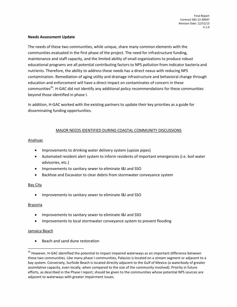
Final Report Contract 583-13-30047
Revision Date: 12/31/13 V.1.0
Needs Assessment Update
The needs of these two communities, while unique, share many common elements with the
communities evaluated in the first phase of the project. The need for infrastructure funding,
maintenance and staff capacity, and the limited ability of small organizations to produce robust
educational programs are all potential contributing factors to NPS pollution from indicator bacteria and
nutrients. Therefore, the ability to address these needs has a direct nexus with reducing NPS
contamination. Remediation of aging utility and drainage infrastructure and behavioral change through
education and enforcement will have a direct impact on contaminates of concern in these
communities20. H-GAC did not identify any additional policy recommendations for these communities
beyond those identified in phase I.
In addition, H-GAC worked with the existing partners to update their key priorities as a guide for
disseminating funding opportunities.
MAJOR NEEDS IDENTIFIED DURING COASTAL COMMUNITY DISCUSSIONS
Anahuac
Improvements to drinking water delivery system (upsize pipes)
Automated resident alert system to inform residents of important emergencies (i.e. boil water
advisories, etc.)
Improvements to sanitary sewer to eliminate I&I and SSO
Backhoe and Excavator to clear debris from stormwater conveyance system
Bay City
Improvements to sanitary sewer to eliminate I&I and SSO
Brazoria
Improvements to sanitary sewer to eliminate I&I and SSO
Improvements to local stormwater conveyance system to prevent flooding
Jamaica Beach
Beach and sand dune restoration
20
However, H-GAC identified the potential to impact impaired waterways as an important difference between these two communities. Like many phase I communities, Palacios is located on a stream segment or adjacent to a bay system. Conversely, Surfside Beach is located directly adjacent to the Gulf of Mexico (a waterbody of greater assimilative capacity, even locally, when compared to the size of the community involved). Priority in future efforts, as described in the Phase I report, should be given to the communities whose potential NPS sources are adjacent to waterways with greater impairment issues.

Final Report Contract 583-13-30047
Revision Date: 12/31/13 V.1.0
Manvel
Provide sanitary sewer and drinking water to city center (many residents still on well and septic)
Interested in implementing LID
Improvements/rehab to sanitary sewer and lift stations to prevent I&I and SSO
Palacios
Improvements to stormwater conveyance system and master drainage plan
Improvements to sanitary sewer to prevent I&I and SSO
Oyster Creek
Improvements to drinking water system needed to prevent stagnation
Surfside
Need funding to either remove arsenic from drinking water or drill better wells (currently
exceeds EPA standards)
Need funding to extend sanitary sewer to some residences that are draining into waterway
Sweeny
Improvements to stormwater system to prevent flooding (currently experiences severe flooding
during heavy rain events)
Large volumes of water enter sanitary sewer during rain events (I&I) overwhelming wastewater
treatment plant
West Columbia
Improvements to sanitary sewer system to eliminate I&I and SSO
Improvements to stormwater conveyance system to prevent flooding
Next Steps
In the continuation of the program’s second phase, H-GAC project staff is offering services to the
communities that include grant-writing support, educational materials, model ordinances, and limited
planning and technical support. Between the two phases, H-GAC project staff identified the RESTORE
Act21 as an important potential source for funding and assistance to these and other coastal
communities. Due to the potential for this funding source to dramatically impact the needs identified in
phase I, H-GAC project staff have been actively involved in developing the regional approach to shaping
21
For more information, refer to www.restorethegulf.gov.

Final Report Contract 583-13-30047
Revision Date: 12/31/13 V.1.0
the state of Texas’ project selection. As part of this effort, H-GAC will maintain continual contact with
these communities and keep them apprised of new developments and opportunities as they progress.
In fulfillment of discussions with these communities and the requirements of the remaining tasks in the
current 604b agreement, H-GAC also plans to distribute educational materials and information on
training opportunities to participating communities that address such issues as feral hogs, on-site sewer
facility (OSSF) maintenance, and funding mechanisms for infrastructure and NPS solution
implementation. H-GAC will also review, develop, and disseminate information on model ordinances
designed to reduce NPS issues related to pet waste and other sources.

Final Report Contract 583-13-30047
Revision Date: 12/31/13 V.1.0
Appendix C – Stormwater Smart Recognition and Certification Program
Proposal
Stormwater Smart Certification and Recognition Program Proposal
Houston-Galveston Area Council Contract No. 582-13-30047
Deliverable Task 6.2 FY 2013

Final Report Contract 583-13-30047
Revision Date: 12/31/13 V.1.0
Executive Summary
The Houston-Galveston Area Council (H-GAC), in conjunction with the Bacteria Implementation Group (BIG), proposes the creation of the Stormwater Smart™ Certification and Recognition Program by the Texas Commission on Environmental Quality (TCEQ). The intent of the program is to incentivize implementation of water quality-oriented stormwater best management practices (BMPs) by a variety of public and private entities through marketable branding and public recognition of successes.
The majority of waterways in the 13-county Houston-Galveston region exceed the state water quality standard for contact recreation due to elevated levels of fecal bacteria, endangering the public health and local economies. One of the primary sources of bacteria is contamination from urban and suburban stormwater. Reducing the source of this impairment, as well as other related water quality issues, has been identified as a priority under a variety of local TMDL Implementation Plans, Watershed Protection Plans, and other water quality planning efforts.
Existing regulatory and recognition programs do not cover the full extent of stormwater sources in the area, and are not specifically aimed at reducing bacteria. The proposed certification and recognition program would provide a comprehensive, scalable, and publically visible means of incentivizing bacteria reduction in stormwater. The program involves a certification and branding element for public and private entities akin to other successful programs (ENERGY STAR,et al.) as well as a public recognition and award component. Both programs include proposed criteria for consideration, multiple categories, and an integrated branding strategy. The proposal is designed to be scalable to allow for future expansion to other areas, consideration of other related issues (water conservation, etc), and additional program elements (certification for non-profits and community organizations, etc.).
The desired outcome of this proposal is the consideration and adoption of this program by the BIG and its adaption to broader regional and state needs by the TCEQ or other interested parties.

Final Report Contract 583-13-30047
Revision Date: 12/31/13 V.1.0
Introduction
Background of the Region
The Houston-Galveston region encompasses 13 counties and over 12,500 square miles, and is home to more than 6 million people, thriving commercial and industrial sectors, and the fourth largest city in the country. Current growth projections indicate the region will attract an additional 3.5 million residents by 2035, with a corresponding increase in commercial and industrial development. The developed urban core of the region surrounding the City of Houston and Harris County is characterized by high impervious cover. Expected growth is projected to expand from existing urban centers and follow existing developmental patterns.
The Houston metropolitan area at the region’s core receives approximately 50 inches of rain a year. The high impervious cover of its developed areas is compounded by its soil profile which includes dense clay soils that are not as conducive to infiltration.
State of the Water
The majority of the waterways in the region are impaired for one or more designated uses. The most common surface water quality impairment in the Houston-Galveston region is a failure to meet the contact recreation standard due to elevated levels of indicator bacteria (Escherichia coli and Enterococcus spp.). These impairments indicate the presence of fecal contamination through point and non-point sources, and pose an elevated risk to residents involved in contact recreation activities. Additionally, high levels of fecal bacteria endanger the productive oysteries of the Galveston Bay system and the recreational economies of the region. Over half of all the stream miles of the region’s waterways are impaired for contact recreation. While not as prevalent as bacterial impairments, depressed dissolved oxygen levels are common in local waterways. Stormwater outfalls and sheet flow from land surfaces during rain events are sources of nutrients and other factors that cause or exacerbate local DO issues. Similar to fecal bacteria contamination, depressed DO can negatively impact fisheries and local recreational economies. Figure 1 shows the extent of water quality impairment and the concentration of impairments in the urban core.
Stormwater and Water Quality
The large volumes of precipitation falling on areas of high impervious cover and dense soils lead to high volumes of runoff during storm events. The greatest spatial concentrations of potential sources of bacteria tend to be found in the denser developed areas (WWTFs, OSSFs, pets, feral animals, etc). The combination of large runoff volumes and concentrated sources of bacteria and other contaminants in developed areas leads to significant water quality issues in local waterways during storm events. Monitoring through the Clean Rivers Program and analysis conducted under various regional water quality and watershed planning efforts have identified stormwater flows as appreciable sources of contamination in the region’s impaired waterways, especially concerning fecal bacteria and nutrients.

Final Report Contract 583-13-30047
Revision Date: 12/31/13 V.1.0
The existing drainage paradigm of the region is based on rapid removal of storm flows to prevent flooding, reducing the ability to filter out contaminants in the runoff through natural surfaces. Current approaches to managing storm flows, driven by concern over water quality impairments and the advent of the TPDES MS4 permitting process, are starting to consider the quality as well as quantity.
Figure 1 Bacteria Impairments in the Houston-Galveston Region

Final Report Contract 583-13-30047
Revision Date: 12/31/13 V.1.0
Need for Stormwater Smart™
The link between stormwater flows and water quality impairments in the region necessitates a greater focus on implementing BMPs to address contaminated runoff. The need for a shared and branded incentive program has been identified by several of the ongoing regulatory and voluntary water quality efforts22 of the region as a means toward this end.
For regional stormwater implementation, the identified need for an incentive and recognition program is based on the:
Appreciable impact of contaminated stormwater on the region’s waterways;
Lack of an existing incentive program specific to stormwater BMPs;
Need for a more publically-visible outreach component to generate public awareness;
Desire to address stormwater best management practices throughout the region rather just in existing MS4 permits and watershed project areas; and
Lack of recognition for local successes in implementing stormwater BMPs.
In general, a properly implemented incentive and recognition program will work in a complimentary fashion with the current, existing regulatory program. This way, participants are enticed to participate by both a “carrot” and a “stick” (Grabosky, 1995). The ability to garner positive public image or marketable branding can buffer the expense or perception of unfunded mandates that can accompany regulatory compliance. For example, TCEQ’s certification of Superior Water Systems for compliance with drinking water quality regulations reflects regulatory compliance, but allows regulated entities a means to publically advertise and benefit from their compliance (via signage, etc.).
Another factor of a successful incentive program is cost effectiveness. The incentive program must be cost effective and able to be implemented under a prescribed budget. The minimal financial requirements of a non-monetary incentive can increase the longevity of this type of incentive program. An incentive program life span is important to consider because when an incentive is offered and later removed, the participants in that incentive program can exhibit reduced motivation to complete tasks that are required (Gneezy et al., 2011). Makkai and Braithwaite (1993) found that praise, which cost nothing, was one of the best incentive rewards to be given when improvements were made. In general, incentive programs provide value to the regulating entity by generating publicity, public education, and awareness (Grabosky, 1995). For private entities, brand recognition can be a powerful selling point (e.g., ENERGY STAR) and become a marketable commodity. The cost of obtaining certification or recognition under a known branding element can be offset by the additional revenue generated by brand recognition.
22 The direct impetus for this proposal arose from the ongoing TMDL Implementation Plan process guided by the
Houston area Bacteria Implementation Group (BIG), which includes the majority of the urban core of the region. In reviewing the state of stormwater implementation efforts under the Annual Reports for MS4 permittees, it became clear that there were many opportunities to greatly enhance implementation and publicity of best management practices. One of the implementation activities designed to address this need was the development of a recognition and incentive program. Similar recommendations or needs were identified in other local I-Plans and WPPs.

Final Report Contract 583-13-30047
Revision Date: 12/31/13 V.1.0
The impact of contaminated stormwater on regional water quality impairments has been documented under many local watershed and water quality planning efforts, including the BIG I-Plan effort. As the region’s urban core continues to expand rapidly over the coming decades, contaminated stormwater is likely to continue to grow in prominence as a source of contamination.
Existing incentive or branding programs, such asLeadership in Energy and Environmental Design (LEED) are not specific to the contaminant concerns facing the region’s waterways and are generally not scalable to a watershed or regional level. Local watershed and stormwater efforts with good brand recognition (e.g. Harris County’s “Clean Water, Clear Choice” programs) do not offer specific certification or incentive opportunities.
While the impact of stormwater in the region is appreciable, public awareness lags considerably. Some implementation efforts (storm drain marking, etc.) are publically recognizable, but do not provide incentive or recognition elements. Public awareness of energy consumption by household appliances was greatly enhanced by the ENERGY STAR certification program, which simultaneously incentivized manufacturer participation by providing marketable branding.
While there are regulatory programs (TPDES Phase I/II MS4 permits) in place to address some stormwater systems, not all entities in the region fall under their jurisdiction, especially in critical coastal management areas. Additionally, these regulatory efforts do not specifically require focus on the contaminants of concern to the region. Unlike drinking water regulations and the “Superior Water System” ratings, there are no existing positive incentives or recognition for compliance with MS4 permit requirements.
Lastly, the status of stormwater BMP implementation efforts is not tracked in a uniform way across the region, or even across project areas. Ongoing efforts to create regional databases to track this information would be greatly enhanced by proving publically visible recognition elements (annual awards, etc) as a framework for recognizing and promoting successful efforts. Similar successful programs exist in the region for innovative parks and natural areas projects.
The combination of these elements drives the need for a stormwater incentive and recognition program for the Houston-Galveston Region. Recognizing that successful programs can have application beyond their original scope, this proposal also identifies scalable elements for future expansion.
Purpose of Stormwater Smart™
The Stormwater Smart Certification and Recognition Program is intended to provide a positive incentive through public recognition and marketable branding to participants who are making substantial progress in implementing identified stormwater quality BMPs. The two components of the program mirror the needs identified in the preceding section, and by a variety of local water quality planning efforts. The program is designed to provide meaningful incentives for a variety of public and private entities to implement stormwater quality management in a substantial manner. The ultimate aim of this and other related efforts is to reduce the amount of fecal bacteria and other contaminants of concern reaching local waterways through storm flows from developed areas.
The certification component builds on the success of programs like “ENERGY STAR”, utilizing easily-recognizable branding elements as a way to increase public and professional awareness or

Final Report Contract 583-13-30047
Revision Date: 12/31/13 V.1.0
add value to achieving a standard. Its purpose is to incentivize pursuit of certification as a way to associate with the value added by the marketable brand, whether the value stems from public recognition for public entities or as a sales point for private entities.
The public recognition component reinforces the branding and aims of the certification component by providing visible, public positive feedback for successes of the program at an annual event and through related publicity. The intent of this component is to make good stewardship of stormwater an achievement that is accompanied by public praise and recognition. As with the certification component, the recognition can serve as a positive incentive by providing public entities a public relations point and private entities with a marketable recognition.
Certification Program
Overview
The certification program provides for recognition of public and private entities who meet defined and
objective criteria concerning stormwater BMPs. Criteria were developed for two categories. The first
category is to certify public entities or private entities operating under existing MS4 permits that have
achieved or exceeded the implementation goals of their SWMPs23, and the second is to certify private
development that incorporates stormwater management elements above and beyond statutory
requirements. Participants who are certified under either class will be recognized as such on a regional
website and allowed the use of uniform branding elements (Stormwater Smart™ logo, etc.) The
branding elements are designed to serve as an easily recognizable way to associate a program or
product with a desirable status. This “reputation capital” allows the recipient greater leverage in
promoting their program or in marketing their product. Certification will be reviewed for renewal on a
biannual basis.
Certification Categories
1. Permitted Systems
Stormwater Smart Certification will be awarded to those MS4s that have demonstrated an exemplary record of compliance and implementation of their SWMPs.
This category includes municipalities, counties, and private communities who have existing Phase I/Phase II permits. Comparison of participants’ SWMPs against progress indicated in their MS4 annual reports will be the primary means of evaluating adherence with certification criteria.
2. Private Development/Unpermitted Systems
23
Public MS4 Systems not operating under Phase I/II permits can seek certification under the second category.

Final Report Contract 583-13-30047
Revision Date: 12/31/13 V.1.0
Stormwater Smart Certification will be awarded to those private developers or unpermitted systems that have implemented BMPs conducive to managing stormwater quality in excess of regulatory requirements. For example, a private developer who installs LID features in a neighborhood, rain gardens, or other features other than those required by mitigation requirements (that meet program criteria) would be an eligible participant.
Eligibility and Criteria
It is important that the criteria for certification are written clearly and concisely for each certification
category, and they are based to the greatest degree on objective measures. This approach stresses the
accountability and fairness of the certification process for all applicants.
1. Permitted Systems
The basis for review of permitted systems will be their adherence to their SWMPs. The
certification criteria provide a uniform way to assess how well SWMPs are being implemented,
and recognize those systems who are doing so.
To be eligible, the applicant must:
1) Be the owner or designee of a permitted MS4 system in the H-GAC region;
2) Clearly delineate the implementation elements outlined for the preceding two-year period24
in their SWMP;
3) Provide a detailed description of implementation activities conducted to meet the planned
elements, or substitutions therefore;
4) Provide a summary of any activities that went above and beyond, or specific successes in
implementation; and
The criteria for success are:
1) In a comparison of the SWMP to actual implementation activities, at least 75% of planned
activities must have been implemented, or have been substituted for equivalent activities25;
or
2) If no specific activities were planned in the SWMP for that time frame, at least one activity
was conducted for each of the minimum control measures (Phase II permits) or specific
requirements (Phase I) each year.
24
If the SWMP has not been approved for a two-year period, the period from the approval of the SWMP to the initial certification application will suffice. 25
E.g., if a city has planned to hold two feral hog events, but in response to logistics issues decides to hold two pet waste events of similar scope, they will be credited for meeting their planned activities.

Final Report Contract 583-13-30047
Revision Date: 12/31/13 V.1.0
2. Private Development and Unpermitted Systems
The review of applications from private development and unpermitted systems are criteria based on those activities undertaken above and beyond applicant specific requirements26.
For example, applicants could not seek certification based solely on mitigation required under administrative orders from TCEQ, or as part of mitigation for a 404 permit. Eligible activities could include a broad range of LID practices, LEED elements specific to water quantity or quality, or other typical stormwater management practices. While the primary focus of certification will be on activities above and beyond requirements, applicants must be current with regulatory requirements to be eligible.
To be eligible, the applicant must:
1) Be an unpermitted MS4 system, or a private development (including single structures);
2) Be in good standing with the TCEQ, USACE, or other applicable regulatory body concerning
adherence to regulatory requirements;
3) Clearly detail:
a. The stormwater quality BMPs, activities, or infrastructure initiated for their system or
included in their development in excess of regulatory requirements; or
The development of a stormwater management plan sufficiently detailed to define future
activities for managing stormwater quality for the community. The criteria for success are:
1) Installation of stormwater management infrastructure or programmatic elements not
required or in excess of the scale required of the entity; or
2) Development of a planning document similar in scope or detail to a permitted MS4’s SWMP.
Implementation
Application - In order to apply for the Stormwater Smart™ certification, an applicant must submit their
application form, SWMP, and annual report (if applicable to their category) for the two-year period
directly preceding their application. Applications will be accepted on a roiling basis; there is no
application deadline for initial applications. Renewals of previous certifications must be submitted 30
days prior to the expiration of the certifications (two years from the approval date).
No fee is currently planned for this process; however, robust participation or loss of current funding
resources may require the program to assess cost recovery options.
26
While the permitted system category focuses on required elements, the intent for this category is to incentivize compliance with the less stringent and more flexible Phase I/Phase II permit requirements. The intent for the private/unpermitted category, for whom regulatory requirements may be more stringent (mitigation due to 404 permits, etc), is to recognize efforts that are above and beyond these base requirements. It is assumed that these additional activities would be akin to efforts undertaken in a permitted community.

Final Report Contract 583-13-30047
Revision Date: 12/31/13 V.1.0
Review - Reviews will be conducted by H-GAC staff. Once an applicant’s application has been vetted and
reviewed against the established criteria, the applicant will receive notification whether they have
received the Stormwater Smart™ certification within four weeks of submission. Certified applicants will
be listed on a regional website, and will receive formal written certificate and approval to utilize
trademarked logo elements in their publications. Any entity rejected for certification will receive written
notification highlighting the specific reasons for rejection, and an invitation to provide additional
information and/or appeal the decision. Applicants may appeal a rejection by presenting additional
information to project staff to overcome delinquencies. Staff will review and respond to the appeal
within four weeks.
Publicity - H-GAC will contact each county, municipality, developer, and other potentially interested
stakeholder identified by project staff within the region advertising the presence of the Stormwater
Smart™ program, certification criteria, submission information, and a blank, digital application form for
the program as part of an initial and sustained outreach program. Project staff will utilize social media, a
website, and existing newsletters and publications to promote the program. Project staff will also work
with other regional organizations to promote the program through their existing networks. Applicants
will be notified within 60 days of a renewal date that they need to renew.
Branding – One of the core elements of the certification incentive is the use of the branding elements
associated with the program. Simple graphic brands and slogans help cross awareness thresholds for the
general public and serve as focal points for marketing. Brands used under this certification program will
be trademarked, and their use will be contingent on current certification. Greater detail about branding
elements is discussed later in this document.
Scalability
The Stormwater Smart™ certification program operates on a simple incentive principle that is not
specific to the H-GAC region. Therefore, it can be scalable to a larger area of application or even to
include other related categories (water conservation, nonprofit outreach/education, etc). H-GAC is just
one of 23 regional councils of government (COG) across the state. Each COG could potentially
implement the program in their region, or a statewide entity could implement it across the state. The
current regional approach is designed to help improve accountability of stormwater programs and
provide uniform incentives and branding. Implementing this program on a larger scale would enhance
these goals and allow for a greater ability to track progress statewide.
The value of the program as an incentive is also scalable. Of the non-monetary incentives associated
with this program, recognizable branding and the appearance of corporate / public responsibility is of
significant value.. Local or regional entities may elect to add additional incentives to achieving

Final Report Contract 583-13-30047
Revision Date: 12/31/13 V.1.0
certification in the form of tax incentives, expedited permit and plan processing27, additional publicity,
granting variances to local ordinances, etc. One, or several, of these items can be implemented as an
additional “partner” incentive for recipients of the Stormwater Smart™ certification to increase
participation and value without additional cost to the program itself.
27
In many examples, private developers preferred expedited permit processing over other incentives (The National Association of Industrial and Office Properties Research Foundation, 2007).

Final Report Contract 583-13-30047
Revision Date: 12/31/13 V.1.0
Recognition Program
Overview
The annual recognition program (awards) will encourage stormwater management innovation and
provide publicity for novel stormwater programs and practices in a variety of categories of certified
entities. The recognition element helps to reinforce public image of the certification program and
branding elements, while also providing incentives through competition and public acknowledgement.
Lastly, while the awards are non-monetary, value may be ascribed to them based on the entity’s ability
to market their success28.
Award Categories
To account for the broad range of implementation activities and potential program participants, and to
recognize an appreciable number of achievements, nine separate categories have been delineated. The
first six correspond to the six minimum control measures of the Phase II permits29, while the last three
recognize superior overall projects.
1. Best Public Involvement Program 2. Best Public Education and Outreach Program 3. Best Illicit Discharge Detection and Elimination Program 4. Best Construction Site Stormwater Runoff Program 5. Best Post-Construction Program 6. Best Pollution Prevention/Good Housekeeping Program 7. Best Overall (Permitted System) 8. Best Overall (Private Development/Unpermitted System) 9. Best Overall Project
Eligibility and Criteria
Only Stormwater Smart™ certified applicants will be eligible for participation.
As with the certification program, it is important that the criteria for evaluating the recognition award
nominees are written clearly and concisely to ensure objectivity, accountability, and fairness of the
award selection.
The criteria generally reflect a focus on singling out innovative and successful implementation activities.
This serves to recognize creative work, reinforces the Stormwater Smart™ brand, and also fosters
dissemination of successful project ideas to the greater stormwater management community. The
recommended award criteria can be found below:
28
For example, a private developer who wins an award for best overall private development may gain value by using the award as a marketing point in sales literature. 29
While these categories refer to Phase II components, they are not limited to permitted phase II programs.

Final Report Contract 583-13-30047
Revision Date: 12/31/13 V.1.0

Final Report Contract 583-13-30047
Revision Date: 12/31/13 V.1.0
AWARD CATEGORY 1-6 CRITERIA Did the applicant receive Stormwater Smart certification for award year Yes No
Was the entry submitted on time Yes No
Which award category is the application for?
SCORE Least Most
Does the entry meet the BMP objective? 1 2 3 4
How much success has the entry experienced? 1 2 3 4
How cost effective is the proposed entry? 1 2 3 4
How innovative is the entry? 1 2 3 4
How much region-wide applicability does the entry have? 1 2 3 4
How much state-wide applicability does the entry have? 1 2 3 4
AWARD CATEGORY 7-9 CRITERIA Did the applicant receive Stormwater Smart certification for award year Yes No
Was the entry submitted on time Yes No
Is the entry a nonprofit organization? Yes No
Which award category is the application for?
SCORE Least Most
How proactive is the entry at addressing stormwater quality? 1 2 3 4
How much success has the entry experienced? 1 2 3 4
How cost effective is the proposed entry? 1 2 3 4
How innovative is the entry? 1 2 3 4
How much region-wide applicability does the entry have? 1 2 3 4
How much state-wide applicability does the entry have? 1 2 3 4
Implementation
H-GAC will contact each certified Stormwater Smart™ participant within the region to advertise the
presence of the recognition award program, associated criteria, submission details, and a blank, digital
application form for the program 90 days prior to the award ceremony. A follow up reminder email will
be sent during 60 days prior. The award submissions will be received 30 days prior to the award
ceremony. H-GAC will seek to publicize the award opportunity through social media, websites, and
existing agency and partner communication networks.
Applicants will submit up a completed version of the application form with up to an additional page,
front and back, of supporting information.

Final Report Contract 583-13-30047
Revision Date: 12/31/13 V.1.0
A subcommittee of the Bacteria Implementation Group (or Natural Resources Advisory Committee will
be formed to evaluate the merits of each award application based upon the established criteria.
Projects will be scored for each metric 1 – 4 (least – most). The application with the highest score for
each award category will receive the Stormwater Smart recognition award. H-GAC staff will not
participate in selection, other than to facilitate the efforts of the subcommittee.
All submissions will receive a formal written recognition of participation. Winning entries will be
recognized at an award ceremony held annually.
Scalability
The Stormwater Smart™ recognition program can be applied at a regional level across the entire state.
H-GAC is just one of 23 regional COGs across the state. Each COG could implement the program in their
region.
Alternatively, a TCEQ-lead program could be initiated to complement statewide implementation of the
certification program. The current regional approach is designed to help improve accountability of
stormwater programs and provide uniform incentives and branding. Implementing this program on a
larger scale would enhance these goals and allow for a greater ability to track and recognize progress
statewide. Similar recognition programs include H-GAC’s local Parks and Natural Areas Awards.
Branding
The incentives offered under this certification and recognition proposal rely heavily on the marketable
nature of a recognized brand.
ENERGY STAR certification for electrical devices is a prime example of a successful, marketable
certification program that allows partners to incentivize brand recognition. In fact, the complex
interaction of electrical efficiency, the desire to reduce energy waste and promote uniform design, and
the ability to realize savings on the end user level embodied by ENERGY STAR is an excellent example of
what Stormwater Smart™ can become.
Because Stormwater Smart™ is not regulatory in nature, and there is no inherent value in applying and
being recognized by it absent the branding elements, development and promotion of the brand is of
utmost importance for the program’s success.
One of the greatest challenges faced by the program is breaking through the attention threshold of the
general public. The primary goal of outreach is to find a way to make what may not be of immediate and
personal concern to a citizen understandable, relatable, and – above all - desirable. As mentioned in the
above ENERGY STAR example, Stormwater Smart™ seeks to distill down the complexities of regulatory

Final Report Contract 583-13-30047
Revision Date: 12/31/13 V.1.0
and voluntary sotrmwater management practices to an effective brand badge that will be associated, on
a basic level, with quality and environmental responsibility.
A preliminary brand logo and slogan design process was completed by H-GAC project staff. Additional
review and revision is expected when this proposal is submitted for the BIG’s consideration, and from
TCEQ as part of review of this deliverable or in consideration of a scaled-up statewide program. The
brand logo development prototypes are included as Appendix A. The logo highlighted previously in this
document is the recommended version. Stormwater Smart was chosen as a brand name/slogan based
on being simple, memorable (in part due to alliteration), and not reliant on an acronym. A review of the
brand name indicated that there were other programs with similar names, but none that involved a
similar trademarked logo or that were regional/statewide in nature.

Final Report Contract 583-13-30047
Revision Date: 12/31/13 V.1.0
Works Cited
Gneezy, U., Meier, S., & Rey-Biel, P. (2011). When and Why Incentives (Don't) Work to
Modify Behavior. Journal of Economic Perspectives , 25 (4), 191-210.
Grabosky, P. (1995). Regulation by Reward: On the Use of Incentives as Regulatory
Instruments. Law & Policy , 17 (3), 257-282.
Makkai, T., & Braithwaite, J. (1993). Praise, Pride and Corporate Compliance. International
Journal of Sociology of Law , 21, 73-91.
The National Association of Industrial and Office Properties Research Foundation. (2007).
Green Building Incentives That Work: A Look at How Local Governments Are Incentivizing
Green Development.

Final Report Contract 583-13-30047
Revision Date: 12/31/13 V.1.0
Appendix A
Logo Design Prototype Contact Sheet