Embed Size (px)
Citation preview

BRITISH STANDARD BS EN 14614:2004BS 6068-5.36:2004
Water quality —Guidance standard for assessing the hydromorphological features of rivers
The European Standard EN 14614:2004 has the status of a British Standard
ICS 13.060.70
���������������� ������������������������������� �������������Lice
nsed
Cop
y: U
nive
rsity
of G
lasg
ow, T
he U
nive
rsity
of G
lasg
ow, 1
3/04
/201
0 19
:46,
Unc
ontr
olle
d C
opy,
(c)
BS
I
BS EN 14614:2004
This British Standard was published under the authority of the Standards Policy and Strategy Committee on 24 January 2005
© BSI 24 January 2005
ISBN 0 580 45346 4
National foreword
This British Standard is the official English language version of EN 14614:2004.
The UK participation in its preparation was entrusted by Technical Committee EH/3, Water quality, to Subcommittee EH/3/5, Biological methods, which has the responsibility to:
A list of organizations represented on this subcommittee can be obtained on request to its secretary.
Cross-referencesThe British Standards which implement international or European publications referred to in this document may be found in the BSI Catalogue under the section entitled “International Standards Correspondence Index”, or by using the “Search” facility of the BSI Electronic Catalogue or of British Standards Online.
This publication does not purport to include all the necessary provisions of a contract. Users are responsible for its correct application.
Compliance with a British Standard does not of itself confer immunity from legal obligations.
— aid enquirers to understand the text;
— present to the responsible international/European committee any enquiries on the interpretation, or proposals for change, and keep the UK interests informed;
— monitor related international and European developments and promulgate them in the UK.
Summary of pages
This document comprises a front cover, an inside front cover, the EN title page, pages 2 to 21 and a back cover.
The BSI copyright notice displayed in this document indicates when the document was last issued.
Amendments issued since publication
Amd. No. Date Comments
Lice
nsed
Cop
y: U
nive
rsity
of G
lasg
ow, T
he U
nive
rsity
of G
lasg
ow, 1
3/04
/201
0 19
:46,
Unc
ontr
olle
d C
opy,
(c)
BS
I

EUROPEAN STANDARD
NORME EUROPÉENNE
EUROPÄISCHE NORM
EN 14614
November 2004
ICS 13.060.70
English version
Water Quality - Guidance standard for assessing thehydromorphological features of rivers
Qualité de l'eau - Guide pour l'évaluation descaractéristiques hydromorphologiques des rivières
Wasserbeschaffenheit - Anleitung zur Beurteilunghydromorphologischer Eigenschaften von Fließgewässern
This European Standard was approved by CEN on 23 September 2004.
CEN members are bound to comply with the CEN/CENELEC Internal Regulations which stipulate the conditions for giving this EuropeanStandard the status of a national standard without any alteration. Up-to-date lists and bibliographical references concerning such nationalstandards may be obtained on application to the Central Secretariat or to any CEN member.
This European Standard exists in three official versions (English, French, German). A version in any other language made by translationunder the responsibility of a CEN member into its own language and notified to the Central Secretariat has the same status as the officialversions.
CEN members are the national standards bodies of Austria, Belgium, Cyprus, Czech Republic, Denmark, Estonia, Finland, France,Germany, Greece, Hungary, Iceland, Ireland, Italy, Latvia, Lithuania, Luxembourg, Malta, Netherlands, Norway, Poland, Portugal, Slovakia,Slovenia, Spain, Sweden, Switzerland and United Kingdom.
EUROPEAN COMMITTEE FOR STANDARDIZATIONC OM ITÉ EUR OP ÉEN DE NOR M ALIS AT IONEUROPÄISCHES KOMITEE FÜR NORMUNG
Management Centre: rue de Stassart, 36 B-1050 Brussels
© 2004 CEN All rights of exploitation in any form and by any means reservedworldwide for CEN national Members.
Ref. No. EN 14614:2004: E
Lice
nsed
Cop
y: U
nive
rsity
of G
lasg
ow, T
he U
nive
rsity
of G
lasg
ow, 1
3/04
/201
0 19
:46,
Unc
ontr
olle
d C
opy,
(c)
BS
I

EN 14614:2004 (E)
2
Contents
Page
Foreword..............................................................................................................................................................3 Introduction .........................................................................................................................................................4 1 Scope ......................................................................................................................................................5 2 Terms and definitions ...........................................................................................................................5 3 Principle..................................................................................................................................................9 4 Survey requirements .............................................................................................................................9 4.1 River ‘types’............................................................................................................................................9 4.2 Dividing rivers into reaches................................................................................................................11 4.3 Survey strategy....................................................................................................................................11 4.4 Scale of surveys and evaluations ......................................................................................................13 4.5 Timing and frequency of field surveys..............................................................................................13 4.6 Reference conditions ..........................................................................................................................13 5 Features for survey and assessment ................................................................................................14 5.1 Standard suite of features ..................................................................................................................14 5.2 Feature recording related to purpose and method of data gathering............................................14 6 Field survey procedure .......................................................................................................................16 7 Classification and reporting based on hydromorphological assessment.....................................17 7.1 General..................................................................................................................................................17 7.2 Bed and bank character ......................................................................................................................17 7.3 Planform and river profile ...................................................................................................................17 7.4 Lateral connectivity and freedom of lateral movement ...................................................................17 7.5 Free flow of water and sediment in the channel...............................................................................17 7.6 Vegetation in the riparian zone ..........................................................................................................17 8 Data presentation.................................................................................................................................18 8.1 General..................................................................................................................................................18 9 Quality assurance................................................................................................................................19 9.1 Training and quality assurance for survey and assessment ..........................................................19 9.2 Training manuals .................................................................................................................................19 9.3 Data entry and validation ....................................................................................................................19 Bibliography ......................................................................................................................................................20
Lice
nsed
Cop
y: U
nive
rsity
of G
lasg
ow, T
he U
nive
rsity
of G
lasg
ow, 1
3/04
/201
0 19
:46,
Unc
ontr
olle
d C
opy,
(c)
BS
I

EN 14614:2004 (E)
3
Foreword
This document (EN 14614:2004) has been prepared by Technical Committee CEN/TC 230 “Water analysis”, the secretariat of which is held by DIN.
This European Standard shall be given the status of a national standard, either by publication of an identical text or by endorsement, at the latest by May 2005, and conflicting national standards shall be withdrawn at the latest by May 2005.
According to the CEN/CENELEC Internal Regulations, the national standards organizations of the following countries are bound to implement this European Standard : Austria, Belgium, Cyprus, Czech Republic, Denmark, Estonia, Finland, France, Germany, Greece, Hungary, Iceland, Ireland, Italy, Latvia, Lithuania, Luxembourg, Malta, Netherlands, Norway, Poland, Portugal, Slovakia, Slovenia, Spain, Sweden, Switzerland and United Kingdom.
WARNING — Safety issues are paramount when surveying rivers. Surveyors should conform to EU and national Health and Safety legislation, and any additional guidelines appropriate for working in or near rivers.
Lice
nsed
Cop
y: U
nive
rsity
of G
lasg
ow, T
he U
nive
rsity
of G
lasg
ow, 1
3/04
/201
0 19
:46,
Unc
ontr
olle
d C
opy,
(c)
BS
I

EN 14614:2004 (E)
4
Introduction
Historically, many countries in Europe have assessed river ‘quality’ simply in terms of the chemical or pollution status of the water flowing in river channels. A more comprehensive view of river habitats is needed, however, to answer pressing ecological questions such as those arising from the EC Water Framework Directive (WFD) (Commission of the European Communities, 2000) and the EC Habitats Directive, to underpin the International Convention on Biodiversity, or to assess proposed river engineering schemes and other catchment developments. In most European countries there are now pressures from statutory and voluntary environment and conservation agencies to see rivers returned to a more natural condition. This implies a need to evaluate areas deserving protection and those requiring rehabilitation, and to encourage better management of river systems throughout Europe.
Lice
nsed
Cop
y: U
nive
rsity
of G
lasg
ow, T
he U
nive
rsity
of G
lasg
ow, 1
3/04
/201
0 19
:46,
Unc
ontr
olle
d C
opy,
(c)
BS
I
EN 14614:2004 (E)
5
1 Scope
This document provides guidance on the features to be recorded when characterising and assessing the hydromorphology of rivers. It is based on methods developed, tested, and compared in Europe. Its main aim is to improve the comparability of hydromorphological survey methods, data processing, interpretation and presentation of results. Whilst it has particular importance in relation to the reporting requirements of the WFD, it also has considerably wider scope for other applications. Although hydromorphology is dependent on hydrology and underlying geology, this standard is focused on the structural features of rivers and on river continuity. In addition, whilst recognising the important influence of hydromorphology on plant and animal ecology and, conversely, the influence of plants and animals on hydromorphology, no attempt is made to provide guidance in this area.
2 Terms and definitions
For the purposes of this document, the following terms and definitions apply.
2.1 aquatic macrophytes larger plants of fresh water which are easily seen with the naked eye, including all aquatic vascular plants, bryophytes, stoneworts (Characeae) and macro-algal growths
NOTE This definition includes plants associated with open water or wetlands with shallow water.
2.2 attribute specific recorded element of a hydromorphological feature (e.g. ‘boulders’ and ‘silt’ are substrate attributes; ‘sheet piling’ and ‘gabions’ are attributes of engineered banks)
2.3 backwater area of low velocity or static water under dry-weather flows, most commonly former river channels or flood channels within the alluvial floodplain, connected to the river channel at least in periods of high flow
2.4 bank permanent side of a river or island, which is above the normal water level and only submerged during periods of high river flow
NOTE In the context of this standard, the top is marked by the first major break in slope, above which cultivation or development is possible.
2.5 bankfull maximum point on banks at which floods are held within the channel before spilling over onto the floodplain
2.6 berm natural or artificial shelf within a river that is exposed above water level during low flows, but is submerged during high flows
2.7 bog wetland, in which the vegetation communities (frequently dominated by Sphagnum mosses) form peat over long periods of time
Lice
nsed
Cop
y: U
nive
rsity
of G
lasg
ow, T
he U
nive
rsity
of G
lasg
ow, 1
3/04
/201
0 19
:46,
Unc
ontr
olle
d C
opy,
(c)
BS
I
EN 14614:2004 (E)
6
2.8 braiding course of a river naturally divided by deposited sediment accumulations, characterised by at least two channels which often change their course regularly
2.9 bryophytes collective term for liverworts and mosses – plants which are often abundant on boulders and bedrock of upland streams
2.10 compaction consolidation of the river bed through physical, chemical or biological processes
2.11 contiguous survey survey carried out along entire river reaches, with data collected from adjoining survey units
2.12 ecological status expression of the quality of the structure and functioning of aquatic ecosystems, expressed by comparing the prevailing conditions with reference conditions
NOTE As classified in accordance with Annex V of the EC Water Framework Directive.
2.13 embankment (levee) artificial bank built to raise the natural bank level thereby reducing the frequency of flooding of adjacent land
2.14 floodplain valley floor adjacent to a river that is (or was historically) inundated periodically by flood waters
2.15 fluvial features features shaped by sedimentation and erosion
2.16 gabion wire basket containing stones, used for river-bed or bank protection
2.17 glide moderately-flowing water with undisturbed surface other than occasional swirls or eddies, and with constant depth across part of the channel (cf ‘run’).
2.18 hydromorphology physical and hydrological characteristics of rivers including the underlying processes from which they result
2.19 lateral connectivity freedom for water to move between the channel and the floodplain
2.20 lateral movement freedom for a river channel to move across a floodplain
Lice
nsed
Cop
y: U
nive
rsity
of G
lasg
ow, T
he U
nive
rsity
of G
lasg
ow, 1
3/04
/201
0 19
:46,
Unc
ontr
olle
d C
opy,
(c)
BS
I

EN 14614:2004 (E)
7
2.21 levee see ‘embankment’
2.22 planform view of river pattern from above (e.g. sinuous, straight)
2.23 point bar bar of river sediment formed on the inside of a bend in a river (cf. side bar)
2.24 pool habitat feature characterised by distinctly deeper parts of the channel that are usually no longer than one to three times the channel’s bankfull width, and where the hollowed river bed profiles are sustained by scouring
2.25 reach major sub-division of a river, defined by physical, hydrological, and chemical character that distinguishes it from other parts of the river system upstream and downstream
2.26 reference conditions conditions representing a totally undisturbed state, lacking human impact, or near-natural with only minor evidence of distortion
NOTE For waters not designated as heavily modified or artificial, synonymous with ‘high ecological status’ in the Water Framework Directive.
2.27 revetment facing built to reinforce a bank
2.28 riffle fast-flowing shallow water with distinctly broken or disturbed surface over gravel/pebble or cobble substrate
2.29 riparian zone area of land adjoining a river channel (including the river bank) capable of directly influencing the condition of the aquatic ecosystem (e.g. by shading and leaf litter input)
NOTE In this document, the term ‘riparian zone’ does not include the wider floodplain.
2.30 riparian zone vegetation structure physical character of the vegetation that creates habitat on the banks and land immediately adjacent to the river; e.g. ‘complex’ – mixture of trees or scrub, herbaceous vegetation, etc. or ‘simple’ – e.g. only herbaceous vegetation
2.31 river rehabilitation partial return of a river to a pre-disturbance condition (e.g. by changing the planform of channelised reaches, or planting riparian vegetation)
Lice
nsed
Cop
y: U
nive
rsity
of G
lasg
ow, T
he U
nive
rsity
of G
lasg
ow, 1
3/04
/201
0 19
:46,
Unc
ontr
olle
d C
opy,
(c)
BS
I

EN 14614:2004 (E)
8
2.32 river type group of rivers that can be broadly differentiated from other groups on the basis of their physical and chemical characteristics (e.g. lowland chalk streams; upland ultra-oligotrophic rivers)
2.33 run fast-flowing water with a disturbed, but not broken, surface (cf. ‘glide’)
2.34 sheet piling material used for vertical bank protection (e.g. corrugated metal sheets)
2.35 side bar discrete sediment deposit made by the river along the sides of relatively straight reaches (cf. point bar)
2.36 sinuosity degree of deviation from a straight line, defined as channel length/valley length
2.37 stream ordering methods for classifying rivers and streams related to the complexity of the drainage basin, generally with progressively higher order numbers usually assigned to streams with greater discharge lower down the catchment
2.38 survey unit length of river from which data are collected during field survey; this may be a fixed length (e.g. 500 m) or variable, according to the method used, but must always be defined and recorded
2.39 submerged vegetation plants rooted to the bed and either completely submerged or with only part of their shoots floating or emergent
2.40 substrate/substratum material making up the bed of a river
2.41 weir structure used for controlling flow and upstream surface level, or for measuring discharge
2.42 wetlands habitats (e.g. marsh, fen, shallow temporary water) occupying the transitional zone between permanently inundated, and generally dry, environments
Lice
nsed
Cop
y: U
nive
rsity
of G
lasg
ow, T
he U
nive
rsity
of G
lasg
ow, 1
3/04
/201
0 19
:46,
Unc
ontr
olle
d C
opy,
(c)
BS
I

EN 14614:2004 (E)
9
3 Principle
A standard assessment protocol is described for recording the physical features of river channels, banks, riparian zones and floodplains. The range of features surveyed, and the methods used for survey, may vary according to river character and the objectives of the study. This standard provides a common framework for these different methods, details of which can be found in the references cited in the Bibliography. Guidance is given on the hydromorphological features that should be used for characterising river types and for further assessment of morphological integrity through comparisons with reference conditions. The selection of features for survey will depend upon geographical scale and on the purpose of the exercise, with some features suitable for characterising river types, some for assessment, and some for both.
4 Survey requirements
4.1 River ‘types’
Describing and identifying river ‘types’ enables the results of hydromorphological surveys from similar types to be compared. In addition, defining ‘high status’, type-specific, reference conditions in rivers is a requirement of the WFD, allowing the quality of rivers to be compared in an equitable and ecologically meaningful way.
Some hydromorphological assessment methods are not linked to river types but can still provide useful information for better river management; this standard therefore includes consideration of such methods.
The core information required to define river types can usually be derived from maps or catchment-wide databases. Types may be refined by using information gathered during field surveys, or through input from expert opinion.
It is recommended that as a minimum the following factors should be considered in the definition of river types:
Size: e.g. stream order, catchment size, distance from source;
Gradient: channel slope;
Geology: a minimum of three categories, preferably more – e.g. siliceous, calcareous, mixed, organic;
Geographical location: latitude and longitude;
Altitude: altitude of source within the catchment, altitude of the reach being assessed;
Hydrological regime: characteristic discharge patterns
Table 1 provides an example of the way in which physical and chemical features are used to derive river types in the legislative context of the WFD. In this example, rivers are ‘typed’ either according to geographic location (ecoregions) together with a set of obligatory ‘descriptors’ (System A), or using an equivalent approach based on ‘obligatory and optional factors’ (System B).
Lice
nsed
Cop
y: U
nive
rsity
of G
lasg
ow, T
he U
nive
rsity
of G
lasg
ow, 1
3/04
/201
0 19
:46,
Unc
ontr
olle
d C
opy,
(c)
BS
I

EN 14614:2004 (E)
10
Table 1 — The two systems used in the Water Framework Directive to type rivers
System A
Key Factors Descriptors
Altitude high – > 800 m
mid-altitude – 200 m to 800 m
lowland – < 200m
Size (based on catchment area) small – 10 km2 to 100 km2
medium – > 100 km2 to 1,000 km2
large – > 1,000 km2 to 10,000 km2
very large – > 10,000 km2
Geology calcareous
siliceous
organic
Ecoregion ecoregions shown on map in Annex XI of WFD
System B
Obligatory factors altitude
latitude
longitude
geology
size
Optional factors distance from source
energy of flow (function of flow and slope)
mean water width
mean water depth
mean water slope
form and shape of main river bed
river discharge (flow) category
valley shape
transport of solids
acid neutralising capacity
mean substratum composition
chloride
air temperature range
mean air temperature
precipitation
Lice
nsed
Cop
y: U
nive
rsity
of G
lasg
ow, T
he U
nive
rsity
of G
lasg
ow, 1
3/04
/201
0 19
:46,
Unc
ontr
olle
d C
opy,
(c)
BS
I
EN 14614:2004 (E)
11
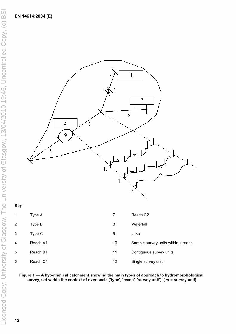
4.2 Dividing rivers into reaches
The relationship between river type, river reach and survey unit is fundamental to survey strategy and assessment. An individual catchment needs first to be divided into river type(s) and then component reaches (Figure 1) based on the factors listed in Table 2.
Table 2 — Factors determining reach boundaries
Significant change in:
• geology
• valley form
• slope
• planform
• discharge (input of significant tributary/change in stream order)
• land use
• sediment transport (lake, reservoir, dam, major weirs)
4.3 Survey strategy
The reach provides the primary framework for survey. Reaches can be characterised hydromorphologically using various survey strategies (Figure 1).
4.3.1 Survey of the whole reach
Single survey: the entire reach is assessed in a single survey unit.
Contiguous survey: the reach is split into a series of contiguous survey units.
4.3.2 Sampling within a reach
Survey units are located at random along the reach, or using any other statistically valid approaches.
Survey design should take account of the objectives of the work and the reporting requirements. Where the primary objective is an overall assessment of a river reach, this can be obtained by combining the results from smaller survey units. Individual reaches can also be combined – for example, to assist in reporting the status of ‘water bodies’ under the WFD. In these cases the overall assessment should take account of the relative length of the constituent reaches. Where the sampling protocol option is used, care must be taken to ensure that the density of the site network is adequate for representing the overall character of the length of river assessed. If the survey is designed to characterise the hydromorphology of rivers over a wide area (rather than targeted on particular areas of impact) a stratified random sampling procedure may be used to survey only a proportion of sites (e.g. 10 %) within a type.
In contrast, where the purpose of a survey is to determine the impact of specific environmental pressures on hydromorphology (an aspect of ‘investigative monitoring’ in the WFD), a more focused survey strategy will be required.
Lice
nsed
Cop
y: U
nive
rsity
of G
lasg
ow, T
he U
nive
rsity
of G
lasg
ow, 1
3/04
/201
0 19
:46,
Unc
ontr
olle
d C
opy,
(c)
BS
I
EN 14614:2004 (E)
12
Key
1 Type A 7 Reach C2
2 Type B 8 Waterfall
3 Type C 9 Lake
4 Reach A1 10 Sample survey units within a reach
5 Reach B1 11 Contiguous survey units
6 Reach C1 12 Single survey unit
Figure 1 — A hypothetical catchment showing the main types of approach to hydromorphological survey, set within the context of river scale ('type', 'reach', 'survey unit') ( = survey unit)
Lice
nsed
Cop
y: U
nive
rsity
of G
lasg
ow, T
he U
nive
rsity
of G
lasg
ow, 1
3/04
/201
0 19
:46,
Unc
ontr
olle
d C
opy,
(c)
BS
I

EN 14614:2004 (E)
13
4.4 Scale of surveys and evaluations
The length of a survey unit is dependent on the purpose of the assessment and the size of the river. If contiguous survey is used, survey units should be 100 m, 500 m, 1 km, or variable lengths according to the degree of morphological uniformity. Lateral survey boundaries need to encompass floodplain features as well as river features. For large, active, rivers in their lower reaches these features could extend several kilometres from the channel. Where the river valley is less than 100 m wide, it is possible for surveys to include the river and its floodplain. A standard distance of 50 m on either side is recommended for all other watercourses. A category of ‘special features’ should be used to ensure that any features of ecological or conservation importance but beyond the 50 m boundary are included as well. Where embankments are present, hydromorphological field survey may extend beyond them, but the hydromorphological characteristics of the potential floodplain have not to be included into the hydromorphological classification scheme. Hydromorphological information should be gathered for the left and right banks, enabling assessments to be made for each bank separately or both banks together.
4.5 Timing and frequency of field surveys
Assessments should be carried out during periods of the year when all features can be described with confidence. This will often be during periods of low flow (but not when flows have ceased) and where the vegetation type or structure within the channel, bank and riparian zone can be recorded accurately.
The frequency of survey should ideally be linked with the rate of hydromorphological change; this in turn is partly related to the rate of change in land-use pressures. Other survey frequencies may be dictated by specific monitoring requirements, e.g. WFD. As a general rule, the interval between surveys should be no longer than 10 years.
4.6 Reference conditions
4.6.1 General
The identification of hydromorphological ‘reference conditions’ is an essential pre-requisite for assessing hydromorphological quality, and is a specific requirement of the WFD to enable classification of other levels of status. Reference conditions should be identified within each river type reflecting totally, or nearly totally, undisturbed conditions. The criteria for reference conditions given below are intended to give a general indication, not a detailed description:
4.6.2 Bed and bank character
Reference conditions: lacking any artificial instream and bank structures that obviously disrupt natural hydromorphological processes, and/or unaffected by any such structures outside the site; bed and banks composed of natural materials.
4.6.3 Planform and river profile
Reference conditions: planform and river profiles not obviously modified by human activities.
4.6.4 Lateral connectivity and freedom of lateral movement
Reference conditions: lacking any structural modifications that obviously hinder the flow of water between the channel and the floodplain, or obviously prevent the migration of a river channel across the floodplain.
4.6.5 Free flow of water and sediment in the channel
Reference conditions: lacking any instream structural modifications that obviously affect the natural movement of sediment, water and biota.
Lice
nsed
Cop
y: U
nive
rsity
of G
lasg
ow, T
he U
nive
rsity
of G
lasg
ow, 1
3/04
/201
0 19
:46,
Unc
ontr
olle
d C
opy,
(c)
BS
I

EN 14614:2004 (E)
14
4.6.6 Vegetation in the riparian zone
Reference conditions: having adjacent natural vegetation appropriate to the type and geographical location of the river.
If reference conditions for any particular type cannot be found, they may be sought in other countries or regions, by modelling, or by using expert judgement. (Note that the reach scale is not necessarily the scale at which reference conditions will be set under the WFD.)
5 Features for survey and assessment
5.1 Standard suite of features
Table 3 provides a standard check-list of hydromorphological features for survey and assessment. These are grouped within 10 categories and cover the three broad zones of river environments: (a) channel; (b) river banks/riparian zone; (c) floodplain.
5.2 Feature recording related to purpose and method of data gathering
The following examples show the way that the assessment categories and groups of features (as defined in Table 3) may be selected for survey according to purpose:
• For a comprehensive overview of river hydromorphology, it is recommended that all categories and features should be assessed.
• To identify sites or reaches that should be classified as ‘high status’ under the WFD, attention should focus on features within categories 1, 2, 5, 6, 7, 8 and aspects of 3, 9 and 10.
• For ‘operational monitoring’ under the WFD, features should be selected that are likely to be the most sensitive to the prevailing pressures on hydromorphology.
• For survey and monitoring linked to river rehabilitation projects:
record the full suite of features for monitoring the success of a project involving re-meandering or restoring connectivity of the river with its floodplain;
record only instream and bank features if habitat rehabilitation undertaken within the channel has no effects on the floodplain or flood hydraulics;
record floodplain features if developments are likely to affect adjacent land.
Remote sensing methods such as aerial photography, video recording, or satellite imagery are recommended where appropriate as they can yield valuable data on large-scale features (e.g. extent of riparian zones, location of embankments, river planform, artificial structures). Other features that are smaller or those that may be found under water (e.g. substrate types, channel vegetation, organic debris) may not readily be assessed in this way.
Lice
nsed
Cop
y: U
nive
rsity
of G
lasg
ow, T
he U
nive
rsity
of G
lasg
ow, 1
3/04
/201
0 19
:46,
Unc
ontr
olle
d C
opy,
(c)
BS
I

EN 14614:2004 (E)
15
Table 3 — Assessment categories, features and attributes comprising a standard hydromorphological assessment
No Assessment Categories
Generic Features Examples of Attributes Assessed
CHANNEL
1 Channel geometry Planform Braiding, sinuosity
Modification to natural planform
Longitudinal section Gradient, long section profiles
Cross-section Variations in cross-section shown by depth, width, bank profiles, etc.
2 Substrates Artificial Concrete, bed-fixing
Natural substrate types Embedded (non-movable boulders, bedrock, etc.)
Large (boulders and cobbles)
Coarse (pebble and gravel)
Fine (sand)
Cohesive (silt and clay)
Organic (peat, etc.)
Management/catchment impacts
Degree of siltation, compaction
3 Channel vegetation Structural form of macrophytes present
Emergent, free-floating, broad-leaved submerged, bryophytes, macro-algae
and
Organic debris Leafy and woody debris Type and size of feature/material
Vegetation management Weed cutting
4 Erosion/deposition character
Features in channel and at base of bank
Point bars, side bars, mid-channel bars and islands (vegetated or bare);
Stable or eroding cliffs; slumped or terraced banks
5 Flow Flow patterns Free-flow, rippled, smooth
Effect of artificial structures ( groynes, deflectors)
Flow features Pools, riffles, glides, runs
Discharge regime Off-takes, augmentation points, water transfers, releases from hydropower dams
6 Longitudinal continuity as affected by artificial structures
Artificial barriers affecting continuity of flow, sediment transport and migration for biota
Weirs, dams, sluices across beds, culverts
RIVER BANKS/ RIPARIAN ZONE
7 Bank structure and modifications
Bank materials Gravel, sand, clay, artificial
Types of revetment/bank protection
Sheet piling, stone walls, gabions, rip-rap
Lice
nsed
Cop
y: U
nive
rsity
of G
lasg
ow, T
he U
nive
rsity
of G
lasg
ow, 1
3/04
/201
0 19
:46,
Unc
ontr
olle
d C
opy,
(c)
BS
I

EN 14614:2004 (E)
16
Table 3 (continued)
No Assessment Categories
Generic Features Examples of Attributes Assessed
8 Vegetation type/ structure on banks and adjacent land
Structure of vegetation Vegetation types, stratification, continuity
Vegetation management Bank mowing, tree felling
Types of land-use, extent and types of development
Agriculture, urban development
FLOODPLAIN
9 Adjacent land-use and associated features
Types of land-use, extent and types of development
Floodplain forest, agriculture, urban development
Types of open water/wetland features
Ancient fluvial/floodplain features (cut-off meanders, remnant channels, bog)
Artificial water features (irrigation channels, fish ponds, gravel pits)
10 Degree of (a) lateral connectivity of river and floodplain; (b) lateral movement of river channel
Degree of constraint to potential mobility of river channel and water flow across floodplain
Embankments and levees (integrated with banks or set back from river), flood walls and other constraining features
Continuity of floodplain Any major artificial structures partitioning the floodplain
6 Field survey procedure
Depending on the purpose of the assessment, field survey should be preceded or followed by exhaustive use and interpretation of all available data, such as from historical or recent maps or from remote sensing.
Field survey should be carried out by walking along the river bank. Where floodplain features on the opposite side of the river cannot be seen clearly, access to that side of the river will normally be required. Using a boat can help in seeing channel and bank features in places not easily accessible from the banks. Under certain conditions it may be impossible to gain access to the channel to record features such as river substrates. These may sometimes be obvious from the bank, but entering the channel to check is recommended wherever possible.
Field recorders require a good understanding of the survey method, and familiarity with the features recorded. Surveys should characterise the river by recording the presence and relative abundance of hydromorphological features and attributes at the river scale, whether natural or artificial, rather than producing detailed descriptions. Completed survey forms should be accompanied by photographs of the site with details of the location carefully recorded; these are important for reporting purposes as well as providing a record for future comparisons. Locations of sites (e.g. upstream and downstream limits, positions of photographs) may be accurately determined using GPS equipment, taking care always to check site locations against a map.
Lice
nsed
Cop
y: U
nive
rsity
of G
lasg
ow, T
he U
nive
rsity
of G
lasg
ow, 1
3/04
/201
0 19
:46,
Unc
ontr
olle
d C
opy,
(c)
BS
I

EN 14614:2004 (E)
17
7 Classification and reporting based on hydromorphological assessment
7.1 General
The procedure for assessing hydromorphological survey data will vary according to the purpose of assessment (e.g. assisting with local river management, guiding the rehabilitation of degraded stretches of rivers, or identifying sites or reaches in reference condition under the WFD).
This European Standard takes account of the present level of sophistication of national hydromorphological assessment methods and provides guidance to enable a basic assessment of the extent of deviation from reference conditions. It is intended that further development of national methods and inter-comparison of the results that they produce will lead to harmonised assessments based on type-specific predictions of the occurrence of physical features within a river.
The extent of deviation from reference condition is used to place a site or reach in one of five classes according to its degree of modification (see clause 8). This is achieved by assessing data from field survey and other sources (e.g. maps, remote sensing) to determine how far the five criteria described in 4.6 are met. The following are examples from Table 3 of attributes and features (together with the category number) that contribute to this assessment:
7.2 Bed and bank character
Artificial substrates (2); Artificial bank material (7); Re-graded or trampled banks (7); Any revetments or bank protection measures (7).
7.3 Planform and river profile
Modifications to planform (1); Modifications to long section and cross-sectional profiles (1).
7.4 Lateral connectivity and freedom of lateral movement
Embankments, levees and other constraining features (10).
7.5 Free flow of water and sediment in the channel
Vegetation management (3); Modifications to flow (5); Artificial barriers (6) (10).
7.6 Vegetation in the riparian zone
Types of adjacent land-use (e.g. urban development) (8); Vegetation management (8).
Whilst an overall assessment of quality should be determined, it is essential that individual quality assessments for the channel, banks and floodplain are kept separate and can be used as three distinct outputs (as shown in Annex A).
Reference conditions (WFD ‘high status’) for hydromorphology take into account the natural range of variation but form a narrow quality band. The boundaries between the other hydromorphological quality bands should reflect deviation from reference conditions. Adjustment of the boundaries to ensure an even spread of sites across the full quality spectrum in any particular country should not be made, as this will give a misleading impression of hydromorphological quality.
Lice
nsed
Cop
y: U
nive
rsity
of G
lasg
ow, T
he U
nive
rsity
of G
lasg
ow, 1
3/04
/201
0 19
:46,
Unc
ontr
olle
d C
opy,
(c)
BS
I
EN 14614:2004 (E)
18
8 Data presentation
8.1 General
For strategic reporting purposes, a single composite assessment for a river or river reach is likely to be a necessity. However, for operational or monitoring purposes it will be essential to keep elements of the assessment (i.e. channel, banks/riparian zone, and floodplain) separate. An ability to map these separate components will be important, both for a fuller understanding of the outputs and to encourage managers to make better use of the information. With the use of GIS ‘layering’ technology, it is possible to present information at different scales and levels of integration, including the relationship between hydromorphological features and artificial modifications.
Whilst the WFD does not require hydromorphology to be reported in five classes, this standard recommends the use of an equivalent 5-band classification system in which reference conditions (high status) are defined as Class 1, and the remaining classes as 2 to 5. For the purposes of this standard, use of the WFD terms such as ‘good status’ and ‘moderate status’ should be avoided as they are linked entirely to WFD assessments of biological conditions. Where maps of hydromorphological quality are produced, it is recommended that the following colours are used:
Blue Class 1 (reference conditions)
Green Class 2
Yellow Class 3
Orange Class 4
Red Class 5
It should be stressed that guidance on an integrated quality classification of the features in Table 3, or on ways of classifying the quality of individual features, has yet to be developed.
Lice
nsed
Cop
y: U
nive
rsity
of G
lasg
ow, T
he U
nive
rsity
of G
lasg
ow, 1
3/04
/201
0 19
:46,
Unc
ontr
olle
d C
opy,
(c)
BS
I

EN 14614:2004 (E)
19
9 Quality assurance
9.1 Training and quality assurance for survey and assessment
Surveyor training is essential to ensure consistency in recording river features. Surveyors should have a background in environmental science, but they should not normally be expected to have specialist knowledge of plant identification or fluvial geomorphology.
Training should be structured to cover aspects such as:
safety issues;
planning surveys, including issues of access and permission;
recognising features;
determining boundaries for field surveys;
accurate completion of recording forms;
how to compile a series of reference photographs;
how to collect and interpret non-survey data – historical maps, aerial photos. Training should: a) incorporate a certification system; b) include regular refresher courses; c) be carried out over a wide range of river types (in the absence of this, certification is only valid for the
range of river types experienced during the training); d) be fully supported by manuals and other teaching aids (e.g. videos). Procedures should be put in place to test the results obtained by different surveyors on the same stretches of river. If a surveyor consistently records results which vary from those recorded by others, the problem should be rectified by additional training.
9.2 Training manuals
Manuals should present general background on the development of the method, and unambiguous information on how to carry out the survey, with accurate descriptions of the features to be recorded. Text should be supported by illustrative material (e.g. photographs, videos, DVDs, CDs) to illustrate what features look like (not just the typical, but the full forms which might be encountered).
Manuals should include guidance on:
how to transfer information from field sheets to databases;
how to obtain and interpret information from maps;
how to apply the results to assessments of hydromorphological quality;
how to apply quality assurance protocols;
Issues of Health and Safety;
matters relating to access to rivers.
9.3 Data entry and validation
It is important that no errors occur when transferring data from field sheets to databases. Suitable quality assurance methods should be used, such as double entry of data onto databases by two different operators, followed by tests to ensure the results are identical. Random testing should also be carried out on hydromorphological quality assessments and other applications to ensure that consistent results are obtained from the same data. Data corruption can occur when systems are up-dated or during information transfer; some form of checking procedure is required following such changes.
Lice
nsed
Cop
y: U
nive
rsity
of G
lasg
ow, T
he U
nive
rsity
of G
lasg
ow, 1
3/04
/201
0 19
:46,
Unc
ontr
olle
d C
opy,
(c)
BS
I
EN 14614:2004 (E)
20
Bibliography [1] Agences de l’Eau and Ministère de l’Environnement 1998. SEQ-Physique: a System for the
Evaluation of the Physical Quality of Watercourses, 15 pp.
[2] Bayerisches Landesamt für Wasserwirtschaft (LFW) (Hrsg.) 1999. Gewässerstrukturgütekartierung in der Bundesrepublik Deutschland – Übersichtsverfahren, München.
[3] Boon, P. J., Wilkinson, J. and Martin, J. 1998. The application of SERCON (System for Evaluating Rivers for Conservation) to a selection of rivers in Britain. Aquatic Conservation: Marine and Freshwater Ecosystems, 8: 597-616.
[4] Buhmann, D. and Hutter, G. 1996. Fließgewässer in Vorarlberg. Gewässerstrukturen Erfassen - Bewerten - Darstellen. Ein Konzept.Schriftenreihe Lebensraum Vorarlberg, Band 33, Bregenz.
[5] Commission of the European Communities (2000). Directive 2000/60/EC Establishing a Framework for Community Action in the Field of Water Policy. Official Journal of the European Communities, L327, 1-71.
[6] Fox, P. J. A., Naura, M. and Scarlett, P. 1998. An account of the derivation and testing of a standard field method, River Habitat Survey. Aquatic Conservation: Marine and Freshwater Ecosystems, 8: 455-475.
[7] Indrist, M. et al., 1996. Fließgewässer Tirol – Bezirk Kufstein. Bachmorphologische und nutzungsorientierte Inventarisierung. Amt der Tiroler Landesregierung, Abt. VI h Wasserwirtschaft, Innsbruck.
[8] Jeffers, J. N. R. 1998. Characterization of river habitat and prediction of habitat features using ordination techniques. Aquatic Conservation: Marine and Freshwater Ecosystems, 8: 529-540.
[9] Länderarbeitsgemeinschaft Wasser (LAWA) (Hrsg.) 2000. Gewässerstrukturgütekartierung in der Bundesrepublik Deutschland – Verfahren für kleine bis mittelgroße Fließgewässer, Berlin.
[10] Landesumweltamt Nordrhein-Westfalen (LUA) (2001) (Hrsg.): Gewässerstrukturgüte in Nordrhein-Westfalen, Anleitung für die Kartierung mittelgroßer bis großer Fließgwässer. Merkblätter Nr. 26, Essen.
[11] Muhar, S., Muhar, A., Schmutz, S., Wimmer, R., Wiesbauer, H., Hozang, B., Imhof, G. and Tschemernig, P. 1993. Ausweisung naturnaher Fließgewässerabschnitte in Österreich – Methodik-Vorstudie. Blaue Reihe des BMUJF, Bd. 1, Wien, 175 pp.
[12] Muhar, S., Kainz, M., Kaufmann M., and Schwarz, M. 1996. Ausweisung flußtypspezifisch erhaltener Fließgewässerabschnitte in Österreich - Österreichische Bundesgewässer, BMLF, Wasserwirtschaftskataster. Wien, 176 pp.
[13] Muhar, S., Kainz, M. and Schwarz, M. 1998. Ausweisung flußtypspezifisch erhaltener Fließgewässerabschnitte in Österreich – Fließgewässer mit einem Einzugsgebiet >500km2 ohne Bundesflüsse, BMLF, BMUJF, Wasserwirtschaftskataster. Wien, 177 pp.
[14] Muhar, S., Schwarz, M., Schmutz, S. and Jungwirth, M. (2000). Identification of rivers with high and good habitat quality: methodological approach and applications in Austria. Hydrobiologia 422/423:343-358.
[15] ÖNORM M 6232. 1997. Guidelines for the ecological study and assessment of rivers. Austrian Standards Institute, Vienna.
Lice
nsed
Cop
y: U
nive
rsity
of G
lasg
ow, T
he U
nive
rsity
of G
lasg
ow, 1
3/04
/201
0 19
:46,
Unc
ontr
olle
d C
opy,
(c)
BS
I

EN 14614:2004 (E)
21
[16] Raven, P. J., Fox, P. J. A., Everard, M., Holmes, N. T. H. and Dawson, F. D. 1997. River Habitat Survey: a new system for classifying rivers according to their habitat quality. In: Boon, P. J. and Howell, D. L. (Eds.), Freshwater Quality: Defining the Indefinable? The Stationery Office, Edinburgh, 215-234.
[17] Raven, P. J., Holmes, N. T. H., Dawson, F. D., Fox, P. J. A., Everard, M., Fozzard, I. R. and Rouen, K. J. 1998. River Habitat Quality: the Physical Character of Rivers and Streams in the UK and Isle of Man. Environment Agency, Bristol.
[18] Siligardi, M., Bernabei, S., Cappeletti, C., Chierici, E., Ciutti, F., Egaddi, F., Franceschini, F., Maiolini, B., Mancini, L., Minciardi, M. R., Monauni, C., Rossi, G., Sansoni, G., Spaggiari, R., and Zanetti, M. 2000. I. F. F. Indice di funzionalità fluviale. Manuale ANPA 223 pp.
[19] Werth, W. 1992. Ökologische Geewässerszustandsbewertung in Oberösterreich. In: Friedrich, G. and Lacombe J. (Hrsg.): Ökologische Bewertung von Fließgewässern. Limnologie aktuell, Band 3, Gustav Fischer Verlag, Stuttgart, S. 67-77.
[20] Zumbroich, Th., Müller, A., Friedrich, G. (Hrsg.) 1999. Strukturgüte von Fließgewässen. Grundlagen und Bewertung. Springer, Heidelberg.
[21] Frissell, C.A., Liss, W.J., Warren, C.E. and Hurley, M.D., 1986. A hierarchical framework for stream habitat classification: viewing streams in a watershed context. * Environmental Management 10: 199-214.Guidance on Monitoring for the Water Framework Directive. 2003. Final version, January 2003.
[22] Rabeni, C,F., 2000. Evaluating physical habitat integrity in relation to the biological potential of streams. * Hydrobiologia 422/423: 245-256.
[23] Raven, P.J., Holmes, N.T.H., Dawson, F.H. and Everard M., 1998. Quality assessment using River Habitat Survey data. * Aquatic Conservation: Marine and Freshwater Ecosystems 8: 477-499.
Lice
nsed
Cop
y: U
nive
rsity
of G
lasg
ow, T
he U
nive
rsity
of G
lasg
ow, 1
3/04
/201
0 19
:46,
Unc
ontr
olle
d C
opy,
(c)
BS
I

BS EN 14614:2004BS 6068-5.36:2004
BSI
389 Chiswick High Road
London
W4 4AL
BSI — British Standards InstitutionBSI is the independent national body responsible for preparing British Standards. It presents the UK view on standards in Europe and at the international level. It is incorporated by Royal Charter.
Revisions
British Standards are updated by amendment or revision. Users of British Standards should make sure that they possess the latest amendments or editions.
It is the constant aim of BSI to improve the quality of our products and services. We would be grateful if anyone finding an inaccuracy or ambiguity while using this British Standard would inform the Secretary of the technical committee responsible, the identity of which can be found on the inside front cover. Tel: +44 (0)20 8996 9000. Fax: +44 (0)20 8996 7400.
BSI offers members an individual updating service called PLUS which ensures that subscribers automatically receive the latest editions of standards.
Buying standards
Orders for all BSI, international and foreign standards publications should be addressed to Customer Services. Tel: +44 (0)20 8996 9001. Fax: +44 (0)20 8996 7001. Email: [email protected]. Standards are also available from the BSI website at http://www.bsi-global.com.
In response to orders for international standards, it is BSI policy to supply the BSI implementation of those that have been published as British Standards, unless otherwise requested.
Information on standards
BSI provides a wide range of information on national, European and international standards through its Library and its Technical Help to Exporters Service. Various BSI electronic information services are also available which give details on all its products and services. Contact the Information Centre. Tel: +44 (0)20 8996 7111. Fax: +44 (0)20 8996 7048. Email: [email protected].
Subscribing members of BSI are kept up to date with standards developments and receive substantial discounts on the purchase price of standards. For details of these and other benefits contact Membership Administration. Tel: +44 (0)20 8996 7002. Fax: +44 (0)20 8996 7001. Email: [email protected].
Information regarding online access to British Standards via British Standards Online can be found at http://www.bsi-global.com/bsonline.
Further information about BSI is available on the BSI website at http://www.bsi-global.com.
Copyright
Copyright subsists in all BSI publications. BSI also holds the copyright, in the UK, of the publications of the international standardization bodies. Except as permitted under the Copyright, Designs and Patents Act 1988 no extract may be reproduced, stored in a retrieval system or transmitted in any form or by any means – electronic, photocopying, recording or otherwise – without prior written permission from BSI.
This does not preclude the free use, in the course of implementing the standard, of necessary details such as symbols, and size, type or grade designations. If these details are to be used for any other purpose than implementation then the prior written permission of BSI must be obtained.
Details and advice can be obtained from the Copyright & Licensing Manager. Tel: +44 (0)20 8996 7070. Fax: +44 (0)20 8996 7553. Email: [email protected].
Lice
nsed
Cop
y: U
nive
rsity
of G
lasg
ow, T
he U
nive
rsity
of G
lasg
ow, 1
3/04
/201
0 19
:46,
Unc
ontr
olle
d C
opy,
(c)
BS
I