Embed Size (px)
Citation preview
Queensland
Water Act 2000
Water Plan (Moreton) 2007
Current as at 2 October 2020

© State of Queensland 2020
This work is licensed under a Creative Commons Attribution 4.0 International License.
Queensland
Water Plan (Moreton) 2007
Contents
Page
Part 1 Preliminary
1 Short title . . . . . . . . . . . . . . . . . . . . . . . . . . . . . . . . . . . . . . . . . . . 7
2 Purposes of plan . . . . . . . . . . . . . . . . . . . . . . . . . . . . . . . . . . . . . 7
3 Definitions . . . . . . . . . . . . . . . . . . . . . . . . . . . . . . . . . . . . . . . . . . 7
Part 2 Plan area and water to which plan applies
4 Plan area . . . . . . . . . . . . . . . . . . . . . . . . . . . . . . . . . . . . . . . . . . . 8
5 Groundwater management areas, implementation areas and groundwater units . . . . . . . . . . . . . . . . . . . . . . . . . . . . . . . . . . . . 8
6 Subcatchment areas . . . . . . . . . . . . . . . . . . . . . . . . . . . . . . . . . . 9
6A Trading zones . . . . . . . . . . . . . . . . . . . . . . . . . . . . . . . . . . . . . . . 9
7 Information about areas . . . . . . . . . . . . . . . . . . . . . . . . . . . . . . . 9
8 Nodes . . . . . . . . . . . . . . . . . . . . . . . . . . . . . . . . . . . . . . . . . . . . . 10
9 Water to which plan applies . . . . . . . . . . . . . . . . . . . . . . . . . . . . 10
Part 3 Outcomes for sustainable management of water
10 Outcomes for water in plan area . . . . . . . . . . . . . . . . . . . . . . . . . 11
11 General outcomes . . . . . . . . . . . . . . . . . . . . . . . . . . . . . . . . . . . . 11
12 Ecological outcomes . . . . . . . . . . . . . . . . . . . . . . . . . . . . . . . . . . 13
Part 3A Measures for achieving water plan outcomes
12A Measures that contribute to achieving particular water plan outcomes 14
Part 4 Performance indicators and objectives
Division 2 Environmental flow objectives
13 Application of division . . . . . . . . . . . . . . . . . . . . . . . . . . . . . . . . . 15
14 Performance indicators for environmental flow objectives . . . . . 15
15 Environmental flow objectives . . . . . . . . . . . . . . . . . . . . . . . . . . . 16
Division 3 Water allocation security objectives
15A Application of division . . . . . . . . . . . . . . . . . . . . . . . . . . . . . . . . . 16
Contents
Water Plan (Moreton) 2007
16 Performance indicators for water allocation security objectives . 16
17 Water allocation security objectives . . . . . . . . . . . . . . . . . . . . . . 17
Part 5 Strategies for achieving outcomes (surface water)
Division 1 Preliminary
18 Strategies for surface water . . . . . . . . . . . . . . . . . . . . . . . . . . . . 17
Division 2 Decisions about surface water made under this plan
19 Application of div 2 . . . . . . . . . . . . . . . . . . . . . . . . . . . . . . . . . . . 17
20 Decisions about surface water must be consistent with objectives 18
21 Assessing impact of decisions about surface water . . . . . . . . . . 18
22 Decisions about surface water not to increase amount of water taken 18
23 Restriction on taking water from waterholes or lakes . . . . . . . . . 19
Division 3 Unallocated water
24 Unallocated water held as general reserve or strategic reserve . 20
24A Processes for releasing unallocated water—Act, s 43 . . . . . . . . 20
25 Granting unallocated water . . . . . . . . . . . . . . . . . . . . . . . . . . . . . 21
26 Matters chief executive must consider . . . . . . . . . . . . . . . . . . . . 21
Division 5 Resource operations licences
36 Water entitlements to be managed under resource operations licences 23
37 Deciding operating arrangements and supply requirements . . . . 23
Division 6 Water entitlements
38 Authorising existing taking of water from Morton Vale Pipeline zone 24
39 Matters for chief executive to consider . . . . . . . . . . . . . . . . . . . . 25
Division 7 Converting authorisations to water allocations
Subdivision 1 General
40 Purpose of division . . . . . . . . . . . . . . . . . . . . . . . . . . . . . . . . . . . 25
41 Authorisations may be converted to water allocations . . . . . . . . 25
44 Location for taking water . . . . . . . . . . . . . . . . . . . . . . . . . . . . . . . 26
45 Purpose to be stated on water allocation . . . . . . . . . . . . . . . . . . 26
Subdivision 2 Water allocations for taking supplemented water
46 Nominal volume for water allocation . . . . . . . . . . . . . . . . . . . . . . 26
47 Priority groups . . . . . . . . . . . . . . . . . . . . . . . . . . . . . . . . . . . . . . . 26
Subdivision 3 Water allocations for taking unsupplemented water
48 Elements of a water allocation . . . . . . . . . . . . . . . . . . . . . . . . . . 27
49 Nominal volume for water allocation . . . . . . . . . . . . . . . . . . . . . . 28
Page 2
Contents
Water Plan (Moreton) 2007
50 Annual volumetric limit for water allocation . . . . . . . . . . . . . . . . . 29
52 Maximum rates . . . . . . . . . . . . . . . . . . . . . . . . . . . . . . . . . . . . . . 30
53 Conditions . . . . . . . . . . . . . . . . . . . . . . . . . . . . . . . . . . . . . . . . . . 31
54 Water allocation groups . . . . . . . . . . . . . . . . . . . . . . . . . . . . . . . . 31
Division 8 Water licences for taking unsupplemented water
55 Elements of a water licence . . . . . . . . . . . . . . . . . . . . . . . . . . . . 32
56 Amending water licences . . . . . . . . . . . . . . . . . . . . . . . . . . . . . . 32
57 Annual volumetric limit for water licence . . . . . . . . . . . . . . . . . . . 33
58 Maximum rates . . . . . . . . . . . . . . . . . . . . . . . . . . . . . . . . . . . . . . 33
Division 10 Miscellaneous
61 Releasing water through fish ways . . . . . . . . . . . . . . . . . . . . . . . 33
Part 6 Strategies for achieving outcomes (groundwater)
Division 1 Preliminary
62 Strategies for groundwater . . . . . . . . . . . . . . . . . . . . . . . . . . . . . 34
Division 1A Decisions about groundwater made under this plan
62A Application of division . . . . . . . . . . . . . . . . . . . . . . . . . . . . . . . . . 34
62B Decision about groundwater to be consistent with objectives . . . 34
Division 2 Cressbrook Creek alluvial groundwater management area
63 Limitation on taking groundwater—Act, s 101 . . . . . . . . . . . . . . . 35
64 Decisions about taking groundwater . . . . . . . . . . . . . . . . . . . . . . 35
65 Amending water licences to take groundwater . . . . . . . . . . . . . . 35
Division 3 Lockyer Valley groundwater management area
Subdivision 1 General strategies
66 Limitation on taking groundwater—Act, s 101 . . . . . . . . . . . . . . . 36
67 Decisions about taking groundwater . . . . . . . . . . . . . . . . . . . . . . 37
Subdivision 2 Implementation area 1
68 Supplemented and unsupplemented groundwater areas . . . . . . 37
Subdivision 3 Implementation areas 2A, 2B, 3 and 4
70 Implementation areas 2A, 2B and 3 . . . . . . . . . . . . . . . . . . . . . . 38
72 Continued taking of groundwater authorised . . . . . . . . . . . . . . . . 38
73 Granting water licences . . . . . . . . . . . . . . . . . . . . . . . . . . . . . . . . 38
Subdivision 4 Water sharing rules
74 Water sharing rules for unsupplemented groundwater . . . . . . . . 39
Subdivision 5 Amending water licences
75 Amending water licences to state an annual volumetric limit . . . 40
Division 4 Warrill-Bremer alluvial groundwater management area
Page 3
Contents
Water Plan (Moreton) 2007
76 Limitation on taking groundwater—Act, s 101 . . . . . . . . . . . . . . . 40
77 Decisions about taking groundwater . . . . . . . . . . . . . . . . . . . . . . 40
78 Continued taking of groundwater authorised . . . . . . . . . . . . . . . . 41
79 Granting water licences . . . . . . . . . . . . . . . . . . . . . . . . . . . . . . . . 41
80 Granting water licence to take groundwater for allowable urban purpose 42
Division 5 Watercourse buffer zone groundwater management area
81 Boundaries of watercourse buffer zone . . . . . . . . . . . . . . . . . . . . 42
82 Limitation on taking groundwater—Act, s 101 . . . . . . . . . . . . . . . 42
83 Continued taking of groundwater authorised . . . . . . . . . . . . . . . . 43
Division 6 Converting water licences to water allocations to take supplemented groundwater
Subdivision 1 Preliminary
84 Purpose of division . . . . . . . . . . . . . . . . . . . . . . . . . . . . . . . . . . . 43
84A Definitions . . . . . . . . . . . . . . . . . . . . . . . . . . . . . . . . . . . . . . . . . . 43
Subdivision 2 Water allocations
84B Water licences may be converted to water allocations . . . . . . . . 44
84C Location for taking water . . . . . . . . . . . . . . . . . . . . . . . . . . . . . . . 44
84D Nominal volumes for water allocations for water licences held by particular regional councils . . . . . . . . . . . . . . . . . . . . . . . . . . . . . 44
84E Nominal volumes—1 licence converted to 2 water allocations . . 45
84F Nominal volumes—2 or more licences converted to 2 water allocations 45
84G Nominal volume—rounding down . . . . . . . . . . . . . . . . . . . . . . . . 45
84H Priority group . . . . . . . . . . . . . . . . . . . . . . . . . . . . . . . . . . . . . . . . 46
84I Purpose to be stated for taking water . . . . . . . . . . . . . . . . . . . . . 46
84J Management of water allocations . . . . . . . . . . . . . . . . . . . . . . . . 46
Subdivision 3 Working out irrigable area
84K Working out irrigable area . . . . . . . . . . . . . . . . . . . . . . . . . . . . . . 46
84L Working out preliminary irrigable area . . . . . . . . . . . . . . . . . . . . . 47
84M Working out additional irrigable area . . . . . . . . . . . . . . . . . . . . . . 47
Part 7 Strategies for achieving outcomes (overland flow water)
85 Applications for water licences to take overland flow water must not be accepted . . . . . . . . . . . . . . . . . . . . . . . . . . . . . . . . . . . . . . . . . . . 48
86 Limitation on taking overland flow water—Act, s 101 . . . . . . . . . 48
87 Taking water using particular existing overland flow works authorised 49
88 Notification of reconfiguration of existing overland flow works . . 49
Page 4
Contents
Water Plan (Moreton) 2007
Part 8 Accounting period
89 Accounting period for resource operations licences—Water Regulation 2016, s 142 . . . . . . . . . . . . . . . . . . . . . . . . . . . . . . . . . . . . . . . . . 50
Part 9 Monitoring and reporting requirements
90 Monitoring and reporting requirements . . . . . . . . . . . . . . . . . . . . 50
Part 10 Implementing and amending this plan
94 Priority areas for converting to, or granting, water allocations . . 51
95 Implementation schedule . . . . . . . . . . . . . . . . . . . . . . . . . . . . . . 51
96 Minor or stated amendment of plan—Act, s 51 . . . . . . . . . . . . . . 52
97 Amending or replacing plan . . . . . . . . . . . . . . . . . . . . . . . . . . . . . 53
Part 11 Transitional provisions
98 Transitional provision for Water Plan (Moreton) (Warrill Valley Water Supply Scheme) Amendment Plan 2020 . . . . . . . . . . . . . . . . . . 54
Schedule 1 Plan area . . . . . . . . . . . . . . . . . . . . . . . . . . . . . . . . . . . . . . . . . . 55
Schedule 2 Groundwater management areas . . . . . . . . . . . . . . . . . . . . . . 56
Schedule 3 Implementation areas for Lockyer Valley groundwater management area . . . . . . . . . . . . . . . . . . . . . . . . . . . . . . . . . . . . . . . . . . . . . . . 57
Schedule 4 Subcatchment areas . . . . . . . . . . . . . . . . . . . . . . . . . . . . . . . . . 58
Schedule 5 Subcatchment area names . . . . . . . . . . . . . . . . . . . . . . . . . . . . 59
Schedule 5A Trading zones . . . . . . . . . . . . . . . . . . . . . . . . . . . . . . . . . . . . . . 60
Schedule 6 Nodes . . . . . . . . . . . . . . . . . . . . . . . . . . . . . . . . . . . . . . . . . . . . . 64
Schedule 7 Environmental flow objectives . . . . . . . . . . . . . . . . . . . . . . . . . 65
Schedule 8 Water allocation security objectives . . . . . . . . . . . . . . . . . . . . 71
Schedule 10 Volumes for simulated mean annual diversions . . . . . . . . . . 76
Schedule 11 Rates and pump sizes . . . . . . . . . . . . . . . . . . . . . . . . . . . . . . . . 77
Schedule 12 Watercourse buffer zones . . . . . . . . . . . . . . . . . . . . . . . . . . . . 78
Schedule 13 Priority areas . . . . . . . . . . . . . . . . . . . . . . . . . . . . . . . . . . . . . . . 80
Schedule 14 Formula . . . . . . . . . . . . . . . . . . . . . . . . . . . . . . . . . . . . . . . . . . . 81
Schedule 15 Dictionary . . . . . . . . . . . . . . . . . . . . . . . . . . . . . . . . . . . . . . . . . . 82
Page 5

[s 1]
Water Plan (Moreton) 2007Part 1 Preliminary
Water Plan (Moreton) 2007
Part 1 Preliminary
1 Short title
This water plan may be cited as the Water Plan (Moreton)2007.
2 Purposes of plan
The following are the purposes of this plan—
(a) to define the availability of water in the plan area;
(b) to provide a framework for sustainably managing waterand the taking of water;
(c) to identify priorities and mechanisms for dealing withfuture water requirements;
(d) to provide a framework for reversing, where practicable,degradation that has occurred in natural ecosystems;
(e) to provide a framework for—
(i) establishing water allocations to take surfacewater; and
(ii) granting and amending water entitlements forgroundwater; and
(iii) granting water entitlements for overland flowwater.
3 Definitions
The dictionary in schedule 15 defines particular words used inthis plan.
Current as at 2 October 2020 Page 7
Authorised by the Parliamentary Counsel
[s 4]
Water Plan (Moreton) 2007Part 2 Plan area and water to which plan applies
Part 2 Plan area and water to which plan applies
4 Plan area
This plan applies to the area shown as the plan area on themap in schedule 1.
5 Groundwater management areas, implementation areas and groundwater units
(1) Each part of the plan area that is within a groundwatermanagement area shown on the map in schedule 2 is agroundwater management area for this plan.
(2) Each of the following parts of the plan area that is within theLockyer Valley groundwater management area and shown onthe map in schedule 3 is an implementation area for thisplan—
(a) Central Lockyer Creek (implementation area 1);
(b) Upper Lockyer Creek and Flagstone Creek(implementation area 2A);
(c) Tenthill Creek and Ma Ma Creek (implementation area2B);
(d) Sandy Creek (parish of Blenheim) and Upper LaidleyCreek (implementation area 3);
(e) Lower Lockyer Creek and Buaraba Creek(implementation area 4).
(3) Implementation areas 2A, 2B, 3 and 4 consist of—
(a) alluvial aquifers (groundwater unit 1); and
(b) hard rock aquifers (groundwater unit 2).
(4) Implementation area 1 consists of groundwater unit 1.
Page 8 Current as at 2 October 2020
Authorised by the Parliamentary Counsel
[s 6]
Water Plan (Moreton) 2007Part 2 Plan area and water to which plan applies
6 Subcatchment areas
Each part of the plan area that is within a subcatchment areashown on the map in schedule 4, and named in schedule 5, is asubcatchment area for this plan.
6A Trading zones
(1) Each zone shown on the map in schedule 5A, part 1 is atrading zone for surface water to which this plan applies, otherthan surface water in the Central Lockyer Valley water supplyscheme.
(2) Each zone shown on the map in schedule 5A, part 2 is atrading zone for surface water in the Central Lockyer Valleywater supply scheme.
(3) Each zone shown on the map in schedule 5A, part 3 is atrading zone for groundwater in the Central Lockyer Valleywater supply scheme.
(4) A trading zone for surface water includes—
(a) each part of a watercourse, lake or spring that is in thezone; and
(b) those sections of tributaries from which there is accessto flow or pondage from a watercourse or lake in thezone.
(5) A trading zone for groundwater includes the part of agroundwater management area that is in the zone.
7 Information about areas
(1) The exact location of the boundaries on maps shown inschedules 1 to 4 and 5A is held in digital electronic form bythe department.
(2) The information held in digital electronic form can be reducedor enlarged to show the details of the boundaries.
Current as at 2 October 2020 Page 9
Authorised by the Parliamentary Counsel
[s 8]
Water Plan (Moreton) 2007Part 2 Plan area and water to which plan applies
Editor’s note—
The boundary locations in digital electronic form may be inspected atthe department’s offices at the Gatton Research Station, WarregoHighway, Gatton.
8 Nodes
(1) A node mentioned in this plan is a place—
(a) on a watercourse in the plan area; and
(b) for which environmental flow objectives are set forperformance indicators.
(2) The location of each node is shown on the map in schedule 1and described in schedule 6.
(3) Each node is identified on the map by a letter.
9 Water to which plan applies
(1) This plan applies to the following water (surface water) in theplan area—
(a) water in a watercourse or lake;
(b) water in springs not connected to groundwater.
(2) This plan also applies to the following water in the planarea—
(a) groundwater, other than groundwater to which the WaterPlan (Great Artesian Basin and Other RegionalAquifers) 2017 applies;
(b) overland flow water, other than water in springsconnected to groundwater.
Page 10 Current as at 2 October 2020
Authorised by the Parliamentary Counsel
[s 10]
Water Plan (Moreton) 2007Part 3 Outcomes for sustainable management of water
Part 3 Outcomes for sustainable management of water
10 Outcomes for water in plan area
Water is to be allocated and sustainably managed in a waythat—
(a) recognises the natural state of watercourses, lakes andsprings has changed because of water infrastructure,flow supplementation and the taking of water; and
(b) seeks to achieve a balance in the following outcomes—
(i) the general outcomes mentioned in section 11;
(ii) the ecological outcomes mentioned in section 12.
11 General outcomes
(1) Each of the following is a general outcome for surface waterin the plan area—
(a) to provide for additional water to be taken from the planarea for future water requirements;
(b) to protect the probability of taking water under waterentitlements;
(c) to provide options for water users to implement theirown provisions for security of supply;
(d) to provide for the continued use of all water entitlementsand other authorisations to take or interfere with waterin the plan area;
(e) to encourage the efficient use of water;
(f) to ensure water is available for essential services;
(g) to achieve ecological outcomes consistent withsupporting natural ecosystems by minimising changesto natural flow regimes;
Current as at 2 October 2020 Page 11
Authorised by the Parliamentary Counsel
[s 11]
Water Plan (Moreton) 2007Part 3 Outcomes for sustainable management of water
(h) to allow water-related cultural use of parts of the planarea by the traditional owners of the area;
(i) to provide consistency between this plan and the SEQregional plan.
(2) Each of the following is a general outcome for groundwater inthe plan area—
(a) to provide for the continued use of all water entitlementsand other authorisations to take or interfere withgroundwater in the plan area;
(b) to encourage the efficient use of the water;
(c) to maintain long-term water quality;
(d) to protect, as far as practicable, baseflow towatercourses that support natural ecosystems;
(e) to allow water-related cultural use of parts of the planarea by the traditional owners of the area;
(f) to provide consistency between this plan and the SEQregional plan.
(3) Each of the following is a general outcome for overland flowwater in the plan area—
(a) to provide for the continued use of existing overlandflow works;
(b) to encourage the efficient use of the water;
(c) to support natural ecosystems by minimising changes tonatural flow regimes;
(d) to maintain run-off to achieve the general outcomes forsurface water;
(e) to provide consistency between this plan and the SEQregional plan.
(4) Each of the following is a general outcome for surface waterand groundwater in the Central Lockyer Valley water supplyscheme—
Page 12 Current as at 2 October 2020
Authorised by the Parliamentary Counsel
[s 12]
Water Plan (Moreton) 2007Part 3 Outcomes for sustainable management of water
(a) to support long-term agricultural productivity andinvestment and the financial security of people who usethe water for agriculture;
(b) to recognise the different contributions that naturalrecharge and recharge through infrastructure make tothe availability of groundwater, to inform futureallocations and support agricultural businesses;
(c) to increase information held about the water, through thecollection and analysis of relevant information about thewater, to support future decision making andimprovements in this plan;
(d) to provide opportunities for initiatives that allowadditional water to become available through thecoordinated storage, management and delivery of thewater, for future agricultural purposes.
(5) In this section—
relevant information, about water, means—
(a) trends in the levels of the groundwater; and
(b) the volume of groundwater used; and
(c) the recharge characteristics of the groundwater; and
(d) the quality of the groundwater.
12 Ecological outcomes
(1) Particular ecological outcomes for water in the part of the planarea stated for the outcome are as follows—
(a) for Stanley River and tributaries, upstream of theimpounded area of Woodford Weir—
(i) to minimise changes to flows that supportriver-forming processes; and
(ii) to minimise changes to the low flow regime;
(b) for Boondall Wetlands—to provide freshwater flowsnecessary to maintain the long-term pattern of inflowsto, and ecological functions of, the wetlands;
Current as at 2 October 2020 Page 13
Authorised by the Parliamentary Counsel
[s 12A]
Water Plan (Moreton) 2007Part 3A Measures for achieving water plan outcomes
(c) for estuarine reaches—to minimise changes to brackishwater habitats;
(d) for Moreton Bay and Pumicestone Channel—tominimise changes to the natural movement and deliveryof sediment, and the delivery of fresh water, naturalnutrients and organic matter.
(2) In this section—
impounded area, of Woodford Weir, means the area of theweir that is inundated when the weir is at its full supply level.
Part 3A Measures for achieving water plan outcomes
12A Measures that contribute to achieving particular water plan outcomes
(1) Measures that contribute to achieving the water plan outcomesstated in section 11(2) and (4) are—
(a) the development, before this plan expires, by the chiefexecutive in consultation with Seqwater and water users,of a new model for the management and allocation ofgroundwater in groundwater unit 1 in implementationarea 1; and
(b) the collection and analysis of relevant information aboutgroundwater in the part of groundwater unit 1 inimplementation area 1—
(i) for groundwater that is not in the Central LockyerValley water supply scheme—by the chiefexecutive to help the chief executive makedecisions about the sustainable management ofgroundwater use and the protection of groundwateraquifers in the area mentioned in that subsection;and
(ii) for groundwater in the Central Lockyer Valleywater supply scheme—by a resource operations
Page 14 Current as at 2 October 2020
Authorised by the Parliamentary Counsel
[s 13]
Water Plan (Moreton) 2007Part 4 Performance indicators and objectives
licence holder to help the licence holder makedecisions about the sustainable management ofgroundwater use and the protection of groundwateraquifers in the area mentioned in that subsection.
(2) The information collected, and analysis of the information,mentioned in subsection (1)(b)(i) is research and monitoringfor the Water Regulation 2016, section 22(4)(d).
(3) In this section—
relevant information, about groundwater, means—
(a) trends in the levels of the groundwater; and
(b) the volume of groundwater used; and
(c) the recharge characteristics of the groundwater; and
(d) the quality of the groundwater.
Part 4 Performance indicators and objectives
Division 2 Environmental flow objectives
13 Application of division
This division applies to surface water.
14 Performance indicators for environmental flow objectives
The performance indicators for the environmental flowobjectives are—
(a) for assessing periods of low flow—
(i) 50% daily flow; and
(ii) 90% daily flow; and
(iii) daily flow less than 1ML; and
Current as at 2 October 2020 Page 15
Authorised by the Parliamentary Counsel
[s 15]
Water Plan (Moreton) 2007Part 4 Performance indicators and objectives
(iv) number of periods of no flow of at least 1 monthbut less than 3 months; and
(v) number of periods of no flow of at least 3 monthsbut less than 6 months; and
(vi) number of periods of no flow of at least 6 months;and
(b) for assessing periods of medium to high flow—
(i) mean annual flow; and
(ii) 1.5 year daily flow volume; and
(iii) 5 year daily flow volume; and
(iv) 20 year daily flow volume; and
(c) for assessing seasonal flow patterns—
(i) flow regime class; and
(ii) annual proportional flow deviation.
15 Environmental flow objectives
The environmental flow objectives for this plan are stated inschedule 7.
Division 3 Water allocation security objectives
15A Application of division
This division applies to surface water and groundwater.
16 Performance indicators for water allocation security objectives
The performance indicators for the water allocation securityobjectives are—
(a) for a water allocation to take supplemented water—themonthly supplemented water sharing index; and
Page 16 Current as at 2 October 2020
Authorised by the Parliamentary Counsel
[s 17]
Water Plan (Moreton) 2007Part 5 Strategies for achieving outcomes (surface water)
(b) for a water allocation to take unsupplemented water in aclass A, B, C, D or E water allocation group—70%unsupplemented water sharing index; and
(c) for a water allocation to take supplemented groundwaterin a zone—the maximum allowable volume for the zonefor the water allocation’s priority group.
17 Water allocation security objectives
The water allocation security objectives for this plan are statedin schedule 8.
Part 5 Strategies for achieving outcomes (surface water)
Division 1 Preliminary
18 Strategies for surface water
This part—
(a) applies to surface water; and
(b) states the strategies for achieving the outcomesmentioned in part 3.
Division 2 Decisions about surface water made under this plan
19 Application of div 2
This division applies to decisions about the allocation ormanagement of surface water in the plan area, other than adecision—
(a) about reinstating or replacing an expired water licence;or
Current as at 2 October 2020 Page 17
Authorised by the Parliamentary Counsel
[s 20]
Water Plan (Moreton) 2007Part 5 Strategies for achieving outcomes (surface water)
(b) to grant a water entitlement to a local government,government agency or the bulk water supply authorityfor supply under operations or water infrastructure thatwere in existence on the commencement of this plan.
20 Decisions about surface water must be consistent with objectives
Decisions about the allocation or management of surfacewater in the plan area, other than a decision about a waterpermit, must be consistent with—
(a) the environmental flow objectives for surface waterstated in schedule 7; and
(b) the water allocation security objectives for surface waterstated in schedule 8.
21 Assessing impact of decisions about surface water
(1) The IQQM computer program’s simulation for the simulationperiod is used to assess consistency with the objectives forsurface water.
(2) If it is not practicable to use the IQQM computer program,another assessment method approved by the chief executivemay be used.
(3) The chief executive may approve an assessment method forsubsection (2) only if the chief executive is satisfied themethod will assess consistency with the objectives at least asaccurately as the IQQM computer program.
22 Decisions about surface water not to increase amount of water taken
(1) The chief executive must not make a decision about themanagement or allocation of surface water that wouldincrease the average volume of surface water available to betaken in the plan area.
(2) Subsection (1) does not apply to a decision—
Page 18 Current as at 2 October 2020
Authorised by the Parliamentary Counsel
[s 23]
Water Plan (Moreton) 2007Part 5 Strategies for achieving outcomes (surface water)
(a) about unallocated water made under section 25; or
(b) about a water permit.
(3) For subsection (1), a decision includes a decision about anapplication for an authorisation to take water made but notdealt with before the commencement of this plan.
23 Restriction on taking water from waterholes or lakes
(1) The chief executive may grant an authorisation to take waterfrom a waterhole or lake only if—
(a) the chief executive imposes a condition on theauthorisation about maintaining the cultural orenvironmental values of the waterhole or lake; or
(b) the chief executive is satisfied the taking of the waterwill not adversely affect the cultural and environmentalvalues of the waterhole or lake.Example for paragraph (a)—
a condition that the water may be taken only if the water level inthe waterhole or lake is above the level that is 0.5m below thelevel at which the waterhole or lake naturally overflows
(2) In making a decision under subsection (1), the chief executivemust consider—
(a) the impact the proposed taking of the water may have onthe following—
(i) water quality;
(ii) brackish water habitats in estuarine reaches;
(iii) inundation of habitats;
(iv) the movement of fish and other aquatic species;
(v) the natural movement and delivery of sediment,and the delivery of fresh water, natural nutrients ororganic matter, to Moreton Bay or PumicestoneChannel;
(vi) recreation and aesthetic values;
Current as at 2 October 2020 Page 19
Authorised by the Parliamentary Counsel
[s 24]
Water Plan (Moreton) 2007Part 5 Strategies for achieving outcomes (surface water)
(vii) cultural values including, for example, culturalvalues of the traditional owners of the area; and
(b) whether the proposed taking is likely to have a directadverse effect on groundwater flows.
(3) An authorisation mentioned in subsection (1) does not includea water allocation converted from an authorisation underdivision 7.
(4) Subsection (1) does not limit the restrictions that may beimposed on the taking of water from a waterhole or lake.
(5) Subsection (2) does not limit the matters the chief executivemay consider.
Division 3 Unallocated water
24 Unallocated water held as general reserve or strategic reserve
(1) Unallocated water in the plan area is held as a general reserveor strategic reserve and dealt with under this division.
(2) For section 43(1)(c) of the Act, the volume of unallocatedwater held as reserves under subsection (1) is 100ML.
24A Processes for releasing unallocated water—Act, s 43
(1) For section 43(2)(f) of the Act, the processes for releasingunallocated water reserved under this division are theprocesses stated in the Water Regulation 2016, part 2, division2, subdivision 2.
(2) In preparing and implementing a process for releasingunallocated water under subsection (1), the chief executivemust consider the matters stated in the water managementprotocol.
Page 20 Current as at 2 October 2020
Authorised by the Parliamentary Counsel
[s 25]
Water Plan (Moreton) 2007Part 5 Strategies for achieving outcomes (surface water)
25 Granting unallocated water
(1) Unallocated water may be granted only—
(a) for infrastructure for a project declared under the StateDevelopment and Public Works Organisation Act 1971,section 26, to be a coordinated project; or
(b) for infrastructure identified for—
(i) the SEQ regional plan; or
(ii) a regional water security program; or
(c) for a community facility; or
(d) for a small scale commercial enterprise; or
(e) under a process in the water management protocol.
(2) In this section—
community facility includes—
(a) a public recreational facility; or
(b) a sporting facility; or
(c) another facility used by a not for profit organisation.
26 Matters chief executive must consider
(1) In dealing with unallocated water, the chief executive mustconsider—
(a) the need for, and efficiency of, current and proposeduses of water including—
(i) the extent to which water is being taken underauthorisations in the plan area; and
(ii) emerging requirements for additional water, in andoutside the plan area, and the likely timeframe inwhich the additional water will be required; and
(iii) alternative water sources including, for example,recycled water and water savings fromimprovements in the efficiency of water use; and
Current as at 2 October 2020 Page 21
Authorised by the Parliamentary Counsel
[s 26]
Water Plan (Moreton) 2007Part 5 Strategies for achieving outcomes (surface water)
(b) the availability of an alternative water supply for thepurpose for which the water is required; and
(c) the impact the proposed taking of or interfering with thewater may have on the following—
(i) water quality;
(ii) brackish water habitats in estuarine reaches;
(iii) inundation of habitats;
(iv) the movement of fish and other aquatic species;
(v) the natural movement and delivery of sediment,and the delivery of fresh water, natural nutrients ororganic matter, to Moreton Bay or PumicestoneChannel;
(vi) recreation and aesthetic values;
(vii) cultural values, including, for example, culturalvalues of the traditional owners of the area; and
(d) whether the proposed taking or interfering with, or theproposed use of, the water is likely to—
(i) have a direct adverse effect on groundwater; or
(ii) lead to degradation, including salinity, of land ordownstream watercourses; and
(e) whether the proposed use of the water is consistentwith—
(i) the SEQ regional plan; and
(ii) any system operating plan applying to the planarea; and
(iii) any regional water security program for the SEQregion.
(2) Subsection (1) does not limit the matters the chief executivemay consider.
Page 22 Current as at 2 October 2020
Authorised by the Parliamentary Counsel
[s 36]
Water Plan (Moreton) 2007Part 5 Strategies for achieving outcomes (surface water)
Division 5 Resource operations licences
36 Water entitlements to be managed under resource operations licences
Water allocations for the following water supply schemes areto be managed under the resource operations licence for thescheme—
(a) Central Lockyer Valley water supply scheme;
(b) Lower Lockyer Valley water supply scheme;
(c) Warrill Valley water supply scheme.
37 Deciding operating arrangements and supply requirements
(1) In deciding the operating arrangements and supplyrequirements for water infrastructure and proposed waterinfrastructure under the resource operations licence for eachwater supply scheme mentioned in section 36, the chiefexecutive must consider—
(a) the impact of the infrastructure’s or proposedinfrastructure’s operation on the following—
(i) the water allocation security objectives;
(ii) water quality;
(iii) brackish water habitats in estuarine reaches;
(iv) instream water levels;
(v) erosion of the bed and banks of watercourses;
(vi) riparian vegetation;
(vii) the extent to which artificial variations in instreamwater levels and flows may adversely affect naturalecosystems;
(viii) recreation and aesthetic values of the plan area;
Current as at 2 October 2020 Page 23
Authorised by the Parliamentary Counsel
[s 38]
Water Plan (Moreton) 2007Part 5 Strategies for achieving outcomes (surface water)
(ix) cultural values, including, for example, culturalvalues of the traditional owners of the plan area;and
(b) the impact of the infrastructure or proposedinfrastructure on the movement of fish and other aquaticspecies; and
(c) the impact of the transfer of water betweenwatercourses; and
(d) the likelihood of fish deaths caused by the operation ofthe infrastructure; and
(e) the joint operation of existing and proposedinfrastructure; and
(f) any system operating plan applying to the plan area; and
(g) any regional water security program for the SEQ region.
(2) Subsection (1) does not limit the matters the chief executivemay consider.
Division 6 Water entitlements
38 Authorising existing taking of water from Morton Vale Pipeline zone
(1) The chief executive must grant 2 water allocations to the bulkwater supply authority to take surface water from the MortonVale Pipeline zone.
(2) The first water allocation—
(a) must state a nominal volume of 3,507ML; and
(b) belongs to the medium priority B group.
(3) The second water allocation—
(a) must state a nominal volume of 185ML; and
(b) belongs to the high priority group.
Page 24 Current as at 2 October 2020
Authorised by the Parliamentary Counsel
[s 39]
Water Plan (Moreton) 2007Part 5 Strategies for achieving outcomes (surface water)
39 Matters for chief executive to consider
(1) This section applies to the chief executive in deciding thewater allocation dealing rules to be included in the watermanagement protocol for the water allocation granted undersection 38(1).
(2) The chief executive must consider existing water useagreements and supply contracts between the bulk watersupply authority and water users.
(3) Subsection (2) does not limit the matters the chief executivemay consider.
Division 7 Converting authorisations to water allocations
Subdivision 1 General
40 Purpose of division
This division states, for section 43(2)(g) of the Act, thearrangements and process for converting, under a waterentitlement notice for this plan, particular authorisations towater allocations.
41 Authorisations may be converted to water allocations
A water entitlement notice may, under section 70(1)(a) of theAct, implement this plan by providing for an authorisation totake surface water from the Central Lockyer Valley watersupply scheme to be converted to a water allocation to takesurface water from the Central Lockyer Valley water supplyscheme.
43
Current as at 2 October 2020 Page 25
Authorised by the Parliamentary Counsel
[s 44]
Water Plan (Moreton) 2007Part 5 Strategies for achieving outcomes (surface water)
44 Location for taking water
The location for taking water stated on a water allocation mustinclude the place at which water could have been taken underthe authorisation.
45 Purpose to be stated on water allocation
The purpose stated on a water allocation must be—
(a) if the purpose stated on the authorisation is ‘distributionloss’—‘distribution loss’; or
(b) otherwise—‘any’.
Subdivision 2 Water allocations for taking supplemented water
46 Nominal volume for water allocation
The nominal volume for a water allocation to takesupplemented water is—
(a) if the authorisation states an annual volume—the statedvolume; or
(b) if the authorisation is an interim water allocation to takesupplemented water in the Central Lockyer Valley watersupply scheme that states an area that may beirrigated—the volume decided by the chief executivehaving regard to the volume of water required toefficiently irrigate the area, but not more than thevolume, expressed in megalitres, calculated bymultiplying the area, in hectares, by 3.4.
47 Priority groups
(1) In the Central Brisbane River, Pine Valleys and Stanley Riverwater supply schemes, a water allocation to takesupplemented water belongs to—
Page 26 Current as at 2 October 2020
Authorised by the Parliamentary Counsel
[s 48]
Water Plan (Moreton) 2007Part 5 Strategies for achieving outcomes (surface water)
(a) for an authorisation to take water that states a volumetriclimit—the medium priority group; and
(b) for an authorisation to take water for water harvestingpurposes in the Central Brisbane River water supplyscheme—the medium priority group; and
(c) for other authorisations—the high priority A group.
(2) In the Central Lockyer Valley water supply scheme, a waterallocation to take surface water belongs to—
(a) for a water allocation to take surface water from theMorton Vale Pipeline zone—the medium priority Bgroup or the high priority group; or
(b) for a water allocation to take surface water from a zoneother than the Morton Vale Pipeline zone—the mediumpriority C group.
(3) In the Cressbrook Creek water supply scheme, a waterallocation to take supplemented water belongs to the highpriority A group.
(4) In the Lower Lockyer Valley water supply scheme, a waterallocation to take supplemented water belongs to the mediumpriority group.
(5) In the Warrill Valley water supply scheme, a water allocationto take supplemented water belongs to the medium prioritygroup or the high priority C group.
(6) In the Caboolture River, a water allocation to takesupplemented water belongs to the high priority B group.
Subdivision 3 Water allocations for taking unsupplemented water
48 Elements of a water allocation
A water allocation to take unsupplemented water must state—
(a) the maximum rate at which water may be taken underthe allocation; and
Current as at 2 October 2020 Page 27
Authorised by the Parliamentary Counsel

[s 49]
Water Plan (Moreton) 2007Part 5 Strategies for achieving outcomes (surface water)
(b) the annual volumetric limit for the allocation.
49 Nominal volume for water allocation
In deciding the nominal volume for a water allocation to takeunsupplemented water, the chief executive—
(a) must consider, for each authorisation—
(i) the local availability of water; and
(ii) the conditions under which water may be takenunder the authorisation; and
(iii) the volume of water required to efficiently irrigatethe area being irrigated under the authorisation;and
(iv) the water taking capacity of any works, inexistence on the commencement of this plan, fortaking water under the authorisation; and
(v) the annual volumes of water estimated by the chiefexecutive to have been taken under theauthorisation during the period, of not more than10 years, immediately before the commencementof this plan; and
(vi) the efficiency of the use of the water mentioned insubparagraph (v); and
(b) must ensure the following—
(i) for all authorisations in a class A water allocationgroup in a subcatchment area mentioned inschedule 10, column 1—the simulated meanannual diversion for the water allocation group isnot more than the volume stated in column 2 of theschedule for the subcatchment area;
(ii) for all authorisations in a class B water allocationgroup in a subcatchment area mentioned inschedule 10, column 1—the simulated meanannual diversion for the water allocation group is
Page 28 Current as at 2 October 2020
Authorised by the Parliamentary Counsel
[s 50]
Water Plan (Moreton) 2007Part 5 Strategies for achieving outcomes (surface water)
not more than the volume stated in column 3 of theschedule for the subcatchment area;
(iii) for all authorisations in a class C water allocationgroup in a subcatchment area mentioned inschedule 10, column 1—the simulated meanannual diversion for the water allocation group isnot more than the volume stated in column 4 of theschedule for the subcatchment area;
(iv) for all authorisations in a class D water allocationgroup in a subcatchment area mentioned inschedule 10, column 1—the simulated meanannual diversion for the water allocation group isnot more than the volume stated in column 5 of theschedule for the subcatchment area;
(v) for all authorisations in a class E water allocationgroup in a subcatchment area mentioned inschedule 10, column 1—the simulated meanannual diversion for the water allocation group isnot more than the volume stated in column 6 of theschedule for the subcatchment area.
50 Annual volumetric limit for water allocation
(1) The annual volumetric limit for a water allocation to takeunsupplemented water is—
(a) if the authorisation states an annual volume of water—the stated volume; and
(b) if the authorisation does not state an annual volume ofwater—the volume decided by the chief executivehaving regard to—
(i) the conditions under which water may be takenunder the authorisation; and
(ii) the water taking capacity of any works, being usedor authorised to be used, for taking water under theauthorisation; and
Current as at 2 October 2020 Page 29
Authorised by the Parliamentary Counsel
[s 52]
Water Plan (Moreton) 2007Part 5 Strategies for achieving outcomes (surface water)
(iii) the annual volumes of water estimated by the chiefexecutive to have been taken under theauthorisation during the period, of not more than10 years, immediately before the commencementof this plan; and
(iv) the efficiency of the use of the water mentioned insubparagraph (iii).
(2) Subsection (1)(b) does not limit the matters the chiefexecutive may consider.
52 Maximum rates
The maximum rate at which unsupplemented water may betaken under a water allocation is—
(a) if the authorisation states a maximum rate—the statedrate; and
(b) if the authorisation does not state a maximum rate but arelated development permit states a pump sizementioned in schedule 11, column 1—
(i) if the authorisation holder satisfies the chiefexecutive that the actual rate at which water can betaken is different from the rate stated inschedule 11, column 2, for the pump size—the ratedecided by the chief executive having regard to—
(A) the conditions under which water may betaken; and
(B) the water taking capacity of the pump towhich the development permit relates (theexisting pump) under normal operatingconditions; and
(C) the irrigation or water distribution systemrelated to the existing pump during theperiod of not more than 10 yearsimmediately before the commencement ofthis plan; and
Page 30 Current as at 2 October 2020
Authorised by the Parliamentary Counsel
[s 53]
Water Plan (Moreton) 2007Part 5 Strategies for achieving outcomes (surface water)
(D) the efficiency of the irrigation or waterdistribution system mentioned insubsubparagraph (C); or
(ii) otherwise—the rate stated in schedule 11, column2, for the pump size; and
(c) if the authorisation does not state a maximum rate but arelated development permit states a pump size otherthan a pump size mentioned in schedule 11, column 1—the rate decided by the chief executive having regard tothe matters mentioned in paragraph (b)(i)(A) to (D); and
(d) if paragraphs (a) to (c) do not apply—the rate decidedby the chief executive having regard to—
(i) the nature of the authorisation; and
(ii) an estimate of the rate, or measurement of theactual rate, at which water is taken under theauthorisation.
53 Conditions
In deciding the conditions under which water may be takenunder a water allocation to take unsupplemented water, thechief executive must have regard to the conditions stated onthe authorisation.
54 Water allocation groups
A water allocation to take unsupplemented water belongs to—
(a) for an authorisation, or part of an authorisation, to takewater for irrigation purposes or that the chief executivedecides is for irrigation purposes—a class A waterallocation group; or
(b) for an authorisation to take unsupplemented water inany of the following areas—a class B water allocationgroup—
(i) Central Brisbane River water supply scheme;
Current as at 2 October 2020 Page 31
Authorised by the Parliamentary Counsel
[s 55]
Water Plan (Moreton) 2007Part 5 Strategies for achieving outcomes (surface water)
(ii) Central Lockyer Valley water supply scheme;
(iii) Lower Lockyer Valley water supply scheme;
(iv) Pine Valleys water supply scheme;
(v) Stanley River water supply scheme;
(vi) Warrill Valley water supply scheme; or
(c) for an authorisation to take unsupplemented water otherthan from a water supply scheme for water harvestingpurposes or that the chief executive decides is for waterharvesting purposes—a class C water allocation group;or
(d) for an authorisation for town water supply purposes—aclass D water allocation group; or
(e) for any other authorisation—a class E water allocationgroup.
Division 8 Water licences for taking unsupplemented water
55 Elements of a water licence
A water licence to take unsupplemented water must state—
(a) an annual volumetric limit; and
(b) the maximum rate at which water may be taken underthe water licence during a particular period of time or inparticular circumstances; and
(c) a purpose of ‘any’.
56 Amending water licences
(1) This section applies to a water licence to take unsupplementedwater in force on the commencement of this plan.
(2) The licence may be amended to state the following—
Page 32 Current as at 2 October 2020
Authorised by the Parliamentary Counsel
[s 57]
Water Plan (Moreton) 2007Part 5 Strategies for achieving outcomes (surface water)
(a) the purpose for which water may be taken under thelicence;
(b) the annual volumetric limit for the licence;
(c) the maximum rate at which water may be taken underthe licence;
(d) the flow conditions for the licence;
(e) any other conditions decided by the chief executive.
57 Annual volumetric limit for water licence
The annual volumetric limit to take unsupplemented water fora water licence mentioned in section 56(1) is the annualvolumetric limit mentioned in section 50 or decided by thechief executive under that section as if the water licence werea water allocation.
58 Maximum rates
The maximum rate at which unsupplemented water may betaken under a water licence mentioned in section 56(1) is themaximum rate mentioned in section 52 or decided by thechief executive under that section as if the water licence werea water allocation.
Division 10 Miscellaneous
61 Releasing water through fish ways
If water to which this plan applies can be released from a damor weir through fish ways, each resource operations licencemust include environmental management rules for the releaseof the water.
Current as at 2 October 2020 Page 33
Authorised by the Parliamentary Counsel
[s 62]
Water Plan (Moreton) 2007Part 6 Strategies for achieving outcomes (groundwater)
Part 6 Strategies for achieving outcomes (groundwater)
Division 1 Preliminary
62 Strategies for groundwater
This part—
(a) applies only to groundwater; and
(b) states the strategies for achieving the outcomesmentioned in part 3.
Division 1A Decisions about groundwater made under this plan
62A Application of division
This division applies to decisions about the allocation ormanagement of groundwater to which this plan applies.
62B Decision about groundwater to be consistent with objectives
A decision about the allocation or management ofgroundwater to which this plan applies, other than a decisionabout a water permit, must be consistent with the waterallocation security objectives stated in section 17.
Page 34 Current as at 2 October 2020
Authorised by the Parliamentary Counsel
[s 63]
Water Plan (Moreton) 2007Part 6 Strategies for achieving outcomes (groundwater)
Division 2 Cressbrook Creek alluvial groundwater management area
63 Limitation on taking groundwater—Act, s 101
A person may not take groundwater in the Cressbrook Creekalluvial groundwater management area (the managementarea) other than—
(a) for stock or domestic purposes; or
(b) under a water entitlement or water permit; or
(c) to allow monitoring or salinity control.
64 Decisions about taking groundwater
(1) The chief executive must not make a decision, about theallocation or management of groundwater in the managementarea, that would increase the average volume of groundwaterthat may be taken in the management area.
(2) A decision mentioned in subsection (1) includes a decisionabout an application for a water licence, made but not decidedbefore the commencement of this plan.
(3) Subsections (1) and (2) do not apply to a decision—
(a) about a water permit; or
(b) about reinstating or replacing an expired water licence;or
(c) about water sharing rules.
65 Amending water licences to take groundwater
(1) This section applies to a water licence to take groundwater inforce on the commencement of this plan.
(2) The chief executive may amend the water licence to state—
(a) an annual volumetric limit for the licence; and
(b) any other condition decided by the chief executive.
Current as at 2 October 2020 Page 35
Authorised by the Parliamentary Counsel
[s 66]
Water Plan (Moreton) 2007Part 6 Strategies for achieving outcomes (groundwater)
(3) In deciding the annual volumetric limit for a water licence, thechief executive must have regard to—
(a) the water taking capacity of any works, in existence onthe commencement of this plan, for taking water underthe water licence; and
(b) the annual volumes of groundwater estimated by thechief executive to have been taken during the period, ofnot more than 10 years, immediately before thecommencement of this plan; and
(c) the efficiency of the use of the water mentioned inparagraph (b); and
(d) the impact the taking of groundwater under the waterlicence has on the flow of surface water; and
(e) data collected by the chief executive about groundwaterlevels; and
(f) whether the amount of water to be taken under the waterlicence is consistent with the outcomes mentioned inpart 3 and the objectives of this plan.
Division 3 Lockyer Valley groundwater management area
Subdivision 1 General strategies
66 Limitation on taking groundwater—Act, s 101
A person may not take groundwater in the Lockyer Valleygroundwater management area (the management area) otherthan—
(a) for stock or domestic purposes; or
(b) under a water entitlement or water permit; or
(c) to allow monitoring or salinity control; or
(d) under an authorisation under section 72.
Page 36 Current as at 2 October 2020
Authorised by the Parliamentary Counsel
[s 67]
Water Plan (Moreton) 2007Part 6 Strategies for achieving outcomes (groundwater)
67 Decisions about taking groundwater
(1) The chief executive must not make a decision, about theallocation or management of groundwater in the managementarea, that would increase the average volume of groundwaterthat may be taken in the management area.
(2) A decision mentioned in subsection (1) includes a decisionabout an application for a water licence, made but not decidedbefore the commencement of this plan.
(3) Subsections (1) and (2) do not apply to a decision—
(a) about a water permit; or
(b) about reinstating or replacing an expired water licence;or
(c) about water sharing rules.
Subdivision 2 Implementation area 1
68 Supplemented and unsupplemented groundwater areas
(1) Groundwater unit 1 in implementation area 1 consists of—
(a) the supplemented groundwater area; and
(b) the unsupplemented groundwater area.Note—
See subdivision 4 (Water sharing rules) for the process formanaging groundwater in the unsupplemented groundwaterarea.
(2) The supplemented groundwater area is supplemented by therelease of surface water from the Central Lockyer Valleywater supply scheme.
Current as at 2 October 2020 Page 37
Authorised by the Parliamentary Counsel
[s 70]
Water Plan (Moreton) 2007Part 6 Strategies for achieving outcomes (groundwater)
Subdivision 3 Implementation areas 2A, 2B, 3 and 4
70 Implementation areas 2A, 2B and 3
Groundwater unit 1 in implementation area 2A, 2B or 3consists of the unsupplemented groundwater area.Note—
See subdivision 4 (Water sharing rules) for the process for managinggroundwater in the unsupplemented groundwater area.
72 Continued taking of groundwater authorised
(1) An owner of land in implementation area 2A, 2B, 3 or 4 who,on the commencement of this plan, is using an existing waterbore on the land to take groundwater may continue to takegroundwater using the bore.
(2) If the chief executive is reasonably satisfied the outcomesmentioned in part 3 or the objectives mentioned in part 4 arenot being achieved, the chief executive may, under section 116of the Act, grant a water licence to the owner to takegroundwater using the bore.
(3) The water licence must state an annual volumetric limit forthe licence.
73 Granting water licences
(1) This section applies if, under section 36 of the Act, a chiefexecutive’s notice requires the owner of land inimplementation area 2A, 2B, 3 or 4 on which there areexisting works for taking water to notify the chief executive ofthe works and the water use.
(2) After the chief executive receives the notice, the chiefexecutive may, under section 116 of the Act, grant a waterlicence to the owner to continue to take groundwater using theworks.
Page 38 Current as at 2 October 2020
Authorised by the Parliamentary Counsel
[s 74]
Water Plan (Moreton) 2007Part 6 Strategies for achieving outcomes (groundwater)
(3) For groundwater unit 2, the water licence must state an annualvolumetric limit for the licence.
(4) In deciding the annual volumetric limit for the water licencefor groundwater unit 2, the chief executive must have regardto—
(a) the water taking capacity of the works; and
(b) the annual volume of groundwater estimated by thechief executive to have been taken during the period, ofnot more than 10 years, immediately before thecommencement; and
(c) the efficiency of the use of the water mentioned inparagraph (b); and
(d) data collected by the chief executive about groundwaterlevels; and
(e) whether the amount of water to be taken under thelicence is consistent with the outcomes mentioned inpart 3 and the objectives of this plan.
Subdivision 4 Water sharing rules
74 Water sharing rules for unsupplemented groundwater
(1) The water management protocol must contain water sharingrules for the unsupplemented groundwater in groundwaterunit 1 in the management area.
(2) In developing the water sharing rules for the managementarea, the chief executive must consult with water users andwater service providers in the area.
Current as at 2 October 2020 Page 39
Authorised by the Parliamentary Counsel
[s 75]
Water Plan (Moreton) 2007Part 6 Strategies for achieving outcomes (groundwater)
Subdivision 5 Amending water licences
75 Amending water licences to state an annual volumetric limit
(1) This section applies if the chief executive is reasonablysatisfied the water sharing rules for an implementation areaare not achieving the outcomes mentioned in part 3 or theobjectives of this plan.
(2) The chief executive may amend the water licences in theimplementation area to state annual volumetric limits for thelicences.
Division 4 Warrill-Bremer alluvial groundwater management area
76 Limitation on taking groundwater—Act, s 101
A person may not take groundwater in the Warrill-Bremeralluvial groundwater management area (the managementarea) other than—
(a) for stock or domestic purposes; or
(b) under a water entitlement or water permit; or
(c) to allow monitoring or salinity control; or
(d) under an authorisation under section 78.
77 Decisions about taking groundwater
(1) The chief executive must not make a decision, about theallocation or management of groundwater in the managementarea, that would increase the average volume of groundwaterthat may be taken in the management area.
(2) Subsection (1) does not apply to a decision—
(a) about a water permit; or
Page 40 Current as at 2 October 2020
Authorised by the Parliamentary Counsel
[s 78]
Water Plan (Moreton) 2007Part 6 Strategies for achieving outcomes (groundwater)
(b) about water sharing rules; or
(c) about taking groundwater for an allowable urbanpurpose.
78 Continued taking of groundwater authorised
(1) An owner of land in the management area who, on thecommencement of this plan, is using an existing water bore onthe land to take groundwater may continue to takegroundwater using the bore.
(2) If the chief executive is reasonably satisfied the outcomesmentioned in part 3 or the objectives mentioned in part 4 arenot being achieved, the chief executive may, under section 116of the Act, grant a water licence to the owner to takegroundwater using the bore.
(3) The water licence must state an annual volumetric limit forthe licence.
79 Granting water licences
(1) This section applies if, under section 36 of the Act, a chiefexecutive’s notice requires the owner of land who isauthorised under section 78(1) to take groundwater using anexisting water bore to notify the chief executive of the boreand the water use.
(2) After the chief executive receives the notice, the chiefexecutive may, under section 116 of the Act, grant a waterlicence to the owner to take groundwater using the bore.
(3) In deciding the annual volumetric limit for the licence, thechief executive must have regard to—
(a) the water taking capacity of the bore; and
(b) the annual volume of groundwater estimated by thechief executive to have been taken during the period, ofnot more than 10 years, immediately before thecommencement; and
Current as at 2 October 2020 Page 41
Authorised by the Parliamentary Counsel
[s 80]
Water Plan (Moreton) 2007Part 6 Strategies for achieving outcomes (groundwater)
(c) the efficiency of the use of the water mentioned inparagraph (b); and
(d) the impact on surface water flows; and
(e) data collected by the chief executive about groundwaterlevels; and
(f) whether the amount of water to be taken under thelicence is consistent with the outcomes mentioned inpart 3 and the objectives of this plan.
80 Granting water licence to take groundwater for allowable urban purpose
(1) The chief executive may grant a water licence to takegroundwater for an allowable urban purpose using a bore.
(2) The maximum rate at which groundwater may be taken underthe water licence is 5L/sec.
Division 5 Watercourse buffer zone groundwater management area
81 Boundaries of watercourse buffer zone
The watercourse buffer zone groundwater management area(the watercourse buffer zone) consists of, for eachwatercourse or lake mentioned in schedule 12, column 1—
(a) the reach of the watercourse or lake stated in column 2of the schedule; and
(b) the area between the high bank of the watercourse orlake and the setback distance stated in column 3 of theschedule.
82 Limitation on taking groundwater—Act, s 101
A person may not take groundwater in the watercourse bufferzone other than—
Page 42 Current as at 2 October 2020
Authorised by the Parliamentary Counsel
[s 83]
Water Plan (Moreton) 2007Part 6 Strategies for achieving outcomes (groundwater)
(a) for stock or domestic purposes; or
(b) to allow monitoring or salinity control; or
(c) under an authorisation under section 83.
83 Continued taking of groundwater authorised
The owner of land in the watercourse buffer zone on which anexisting water bore is situated may continue to takegroundwater using the bore.
Division 6 Converting water licences to water allocations to take supplemented groundwater
Subdivision 1 Preliminary
84 Purpose of division
This division states, for section 43(2)(g) of the Act, thearrangements and process for converting, under a waterentitlement notice for this plan, particular water licences towater allocations.
84A Definitions
In this division—
additional irrigable area see section 84M.
irrigable area see section 84K.
preliminary irrigable area see section 84L.
relevant period means the period that starts on 1 July 2007and ends on 30 June 2018.
Current as at 2 October 2020 Page 43
Authorised by the Parliamentary Counsel
[s 84B]
Water Plan (Moreton) 2007Part 6 Strategies for achieving outcomes (groundwater)
Subdivision 2 Water allocations
84B Water licences may be converted to water allocations
(1) This section applies to a water licence to take supplementedgroundwater from the Central Lockyer Valley water supplyscheme for a purpose other than stock purposes or domesticpurposes.
(2) A water entitlement notice may, under section 70(1)(a) of theAct, implement this plan by providing for 1 or more of thewater licences to be converted to 1 or more water allocationsto take supplemented groundwater from the Central LockyerValley water supply scheme.
84C Location for taking water
The location from which water may be taken under a waterallocation converted from 1 or more water licences must be alocation—
(a) from which water could have been taken under—
(i) for a water allocation converted from 1 waterlicence—the water licence; or
(ii) for a water allocation converted from more than 1water licence—only 1 of the water licences; and
(b) that is in a trading zone for groundwater.
84D Nominal volumes for water allocations for water licences held by particular regional councils
(1) The nominal volume for the water allocation converted fromwater licence 401310 held by the Lockyer Valley RegionalCouncil is 60ML.
(2) The nominal volume for the water allocation converted fromwater licences 66442G and 98268G held by the LockyerValley Regional Council is 10ML.
Page 44 Current as at 2 October 2020
Authorised by the Parliamentary Counsel
[s 84E]
Water Plan (Moreton) 2007Part 6 Strategies for achieving outcomes (groundwater)
84E Nominal volumes—1 licence converted to 2 water allocations
(1) This section applies if 1 water licence is converted to 2 waterallocations (the first water allocation and the second waterallocation respectively).
(2) The nominal volume for the first water allocation is thevolume, in megalitres, calculated by multiplying the irrigablearea for the water licence by 2.
(3) The nominal volume for the second water allocation is thevolume, in megalitres, calculated by multiplying the irrigablearea for the water licence by 4.
84F Nominal volumes—2 or more licences converted to 2 water allocations
(1) This section applies if 2 or more water licences are convertedto 2 water allocations (the first water allocation and thesecond water allocation respectively).
(2) The nominal volume for the first water allocation is thevolume, in megalitres, calculated by multiplying thecombined irrigable area for the water licences by 2.
(3) The nominal volume for the second water allocation is thevolume, in megalitres, calculated by multiplying thecombined irrigable area for the water licences by 4.
(4) In this section—
combined irrigable area, for water licences, means the sum ofthe irrigable areas for the water licences.
84G Nominal volume—rounding down
If the nominal volume for a water allocation worked out undersection 84E or 84F is not a whole number, the nominalvolume for the water allocation must be rounded down to thenearest whole number.
Current as at 2 October 2020 Page 45
Authorised by the Parliamentary Counsel
[s 84H]
Water Plan (Moreton) 2007Part 6 Strategies for achieving outcomes (groundwater)
84H Priority group
(1) A water allocation with a nominal volume decided undersection 84E(2) or 84F(2) belongs to the medium priority Agroup.
(2) A water allocation with a nominal volume decided undersection 84E(3) or 84F(3) belongs to the low priority group.
84I Purpose to be stated for taking water
The purpose to be stated for taking water under a waterallocation converted from a water licence must be—
(a) for a water allocation mentioned in section 84D—‘urban’; or
(b) otherwise—‘any’.
84J Management of water allocations
Water allocations converted from water licences under thisdivision are managed under the resource operations licencefor the Central Lockyer Valley water supply scheme.
Subdivision 3 Working out irrigable area
84K Working out irrigable area
The irrigable area for a water licence is the area, in hectares,that is the total of—
(a) the preliminary irrigable area for the water licenceworked out under section 84L; and
(b) if an additional irrigable area for the water licence isworked out under section 84M—the area worked out.
Note—
The irrigable area for a water licence is held in digital electronic formby the department and can be made available on request to the chiefexecutive.
Page 46 Current as at 2 October 2020
Authorised by the Parliamentary Counsel
[s 84L]
Water Plan (Moreton) 2007Part 6 Strategies for achieving outcomes (groundwater)
84L Working out preliminary irrigable area
(1) This section applies in relation to the land attached to a waterlicence on the commencement.
(2) The preliminary irrigable area for the water licence is thearea, in hectares, that is the sum of each of the following partsof the land—
(a) if the licence allows the whole of a parcel of land to beirrigated using water taken under the licence—the partof the land that the chief executive decides, havingconsidered geological mapping and spatial imagery ofthe land, is—
(i) land with alluvium; or
(ii) land without alluvium that has been irrigated,during the relevant period, using water taken underthe licence from the land;
(b) if the licence allows only a part of a parcel of land to beirrigated using water taken under the licence—the partof the land.
(3) However, the preliminary irrigable area for the water licencedoes not include the area of any part of the land attached to thewater licence that has been included in the preliminaryirrigable area of another water licence.
84M Working out additional irrigable area
(1) This section applies if—
(a) the holder of a water licence to which section 84Bapplies makes a submission under the Act, section 72about the draft water entitlement notice mentioned insection 84B; and
(b) the submission states that—
(i) land (the relevant land), owned by the licenceholder but not attached to the water licence, wasirrigated during the relevant period using
Current as at 2 October 2020 Page 47
Authorised by the Parliamentary Counsel
[s 85]
Water Plan (Moreton) 2007Part 7 Strategies for achieving outcomes (overland flow water)
groundwater taken from land attached to the waterlicence; and
(ii) the groundwater was taken from the CentralLockyer Valley water supply scheme using workslocated on land attached to the water licence; and
(iii) the groundwater was conveyed to the relevant landusing a pipeline or channel; and
(c) the area of the relevant land has not been included in theadditional irrigable area for another water licence.
(2) The additional irrigable area for the water licence is the totalarea, in hectares, of the relevant land, or the part of therelevant land, that the chief executives decides was irrigatedduring the relevant period in the way described in subsection(1)(b).
Part 7 Strategies for achieving outcomes (overland flow water)
85 Applications for water licences to take overland flow water must not be accepted
For section 43(2)(j) of the Act, the chief executive must notaccept an application for a water licence to take overland flowwater made under section 107 of the Act.
86 Limitation on taking overland flow water—Act, s 101
(1) For section 101(1) of the Act, a person must not take overlandflow water to which this plan applies under section 101(1)(b)of the Act, unless the water is taken—
(a) for stock or domestic purposes; or
(b) under a water licence; or
(c) for another purpose using works that have a capacity ofnot more than 5ML; or
Page 48 Current as at 2 October 2020
Authorised by the Parliamentary Counsel
[s 87]
Water Plan (Moreton) 2007Part 7 Strategies for achieving outcomes (overland flow water)
(d) for a purpose the chief executive reasonably considers isfor water sensitive urban design; or
(e) to satisfy the requirements of—
(i) an environmental authority under theEnvironmental Protection Act 1994; or
(ii) a development permit for carrying out anenvironmentally relevant activity, other than amining activity or petroleum activity, under theEnvironmental Protection Act 1994; or
(f) under an authority under section 87.
(2) For subsection (1)(e), the volume of overland flow watertaken must not be more than the amount necessary to satisfythe requirements of the environmental authority ordevelopment permit.
(3) In this section—
water sensitive urban design means urban planning or designthat includes integrated water cycle management.
87 Taking water using particular existing overland flow works authorised
(1) This section applies to the owner of land on which existingoverland flow works are situated, other than works for onlytaking water that may be taken under section 86(1)(a) to (e).
(2) The owner is authorised to continue to use the existingoverland flow works to take overland flow water.
88 Notification of reconfiguration of existing overland flow works
(1) This section applies to an owner of land authorised to useexisting overland flow works to take overland flow waterunder section 87.
Current as at 2 October 2020 Page 49
Authorised by the Parliamentary Counsel
[s 89]
Water Plan (Moreton) 2007Part 8 Accounting period
(2) If the owner reconfigures the works, the owner must give thechief executive notice, in the approved form, about thereconfiguration.
(3) If the owner gives the notice mentioned in subsection (2) tothe chief executive, and any further information the chiefexecutive reasonably requires, the owner may continue to usethe works to take overland flow water.
Part 8 Accounting period
89 Accounting period for resource operations licences—Water Regulation 2016, s 142
For the Water Regulation 2016, section 142(a), the accountingperiod for a resource operations licence to take water from theCentral Lockyer Valley water supply scheme is 1 January to31 December.
Part 9 Monitoring and reporting requirements
90 Monitoring and reporting requirements
(1) To help the Minister assess the effectiveness of themanagement strategies for achieving the outcomes mentionedin part 3, the water management protocol must state—
(a) the monitoring requirements for water and naturalecosystems for this plan; and
(b) the reporting requirements for this plan for operators ofinfrastructure interfering with water in the plan area.
(2) Also, a monitoring requirement for this plan is to monitor thepressure and levels of groundwater in the plan area.
(3) Subsections (1) and (2) do not limit the monitoringrequirements the chief executive may impose for this plan.
Page 50 Current as at 2 October 2020
Authorised by the Parliamentary Counsel
[s 94]
Water Plan (Moreton) 2007Part 10 Implementing and amending this plan
Part 10 Implementing and amending this plan
94 Priority areas for converting to, or granting, water allocations
Each area described in schedule 13 is a priority area for thisplan for the conversion to, or granting of, water allocations totake water in the plan area.
95 Implementation schedule
(1) This section states the proposed arrangements forimplementing this plan.
(2) Within 4 years after the commencement, it is proposed toamend this plan—
(a) to convert authorisations in the priority area to waterallocations; and
(b) to deal with unallocated surface water available forfuture water requirements in the priority area.
(3) Within 4 years after the commencement, it is proposed toamend—
(a) the water management protocol to make waterallocation change rules; and
(b) each resource operations licence that relates to thepriority area—
(i) to make environmental management rules; and
(ii) to implement the monitoring requirements in part 9for the priority area; and
(c) the operations manual required under each resourceoperations licence that relates to the priority area tomake—
(i) water sharing rules; and
(ii) seasonal water assignment rules.
Current as at 2 October 2020 Page 51
Authorised by the Parliamentary Counsel
[s 96]
Water Plan (Moreton) 2007Part 10 Implementing and amending this plan
(4) Subsections (2) and (3) do not limit the matters that may beincluded in the water management protocol.
96 Minor or stated amendment of plan—Act, s 51
The following types of amendment may be made to this planunder section 51(2)(a) of the Act—
(a) an amendment or addition of an environmental flowobjective if the amendment or addition achieves anequivalent or improved ecological outcome withoutadversely affecting the water allocation securityobjectives or the outcomes under part 3;
(b) an amendment or addition of a water allocation securityobjective if the amendment or addition does notadversely affect existing water allocations,environmental flow objectives or the outcomes underpart 3;
(c) an amendment or addition of a priority area;
(d) an amendment or addition of a node;
(e) an amendment or addition of a priority group;
(f) an amendment or addition of a water allocation group;
(g) an amendment to subdivide a subcatchment area oramalgamate subcatchment areas;
(h) an amendment to the boundary of a groundwatermanagement area;
(i) an amendment to the boundary of an implementationarea;
(j) an amendment to subdivide an implementation area oramalgamate implementation areas;
(k) an amendment to the boundary, or the addition, of awatercourse buffer zone;
(l) an amendment to subdivide a volume, or amalgamatevolumes, stated in schedule 10;
Page 52 Current as at 2 October 2020
Authorised by the Parliamentary Counsel
[s 97]
Water Plan (Moreton) 2007Part 10 Implementing and amending this plan
(m) an amendment of the type of water entitlement that maybe granted for town water supply purposes;
(n) an amendment or addition of a monitoring or reportingrequirement under part 9.
97 Amending or replacing plan
The Minister must consider amending this plan or preparing anew plan to replace this plan if the Minister is satisfied—
(a) in relation to the outcomes mentioned in part 3—
(i) water entitlements in the plan area are notsufficient to meet water needs sourced from theplan area having regard to—
(A) the extent to which water is being takenunder the water entitlements; and
(B) the efficiency of present, and expectedfuture, water use; and
(C) emerging requirements for additional water;and
(D) alternative water sources including, forexample, recycled water and water savingsfrom improvements in the efficiency of wateruse; and
(E) the likely timeframe in which additionalwater will be required; and
(ii) there are economically viable and ecologicallysustainable uses for additional water; or
(b) the plan is inconsistent with the SEQ regional plan.
Current as at 2 October 2020 Page 53
Authorised by the Parliamentary Counsel
[s 98]
Water Plan (Moreton) 2007Part 11 Transitional provisions
Part 11 Transitional provisions
98 Transitional provision for Water Plan (Moreton) (Warrill Valley Water Supply Scheme) Amendment Plan 2020
Section 47(5), as amended by the Water Plan (Moreton)(Warrill Valley Water Supply Scheme) Amendment Plan 2020,is taken to have applied from 13 December 2019.
Page 54 Current as at 2 October 2020
Authorised by the Parliamentary Counsel
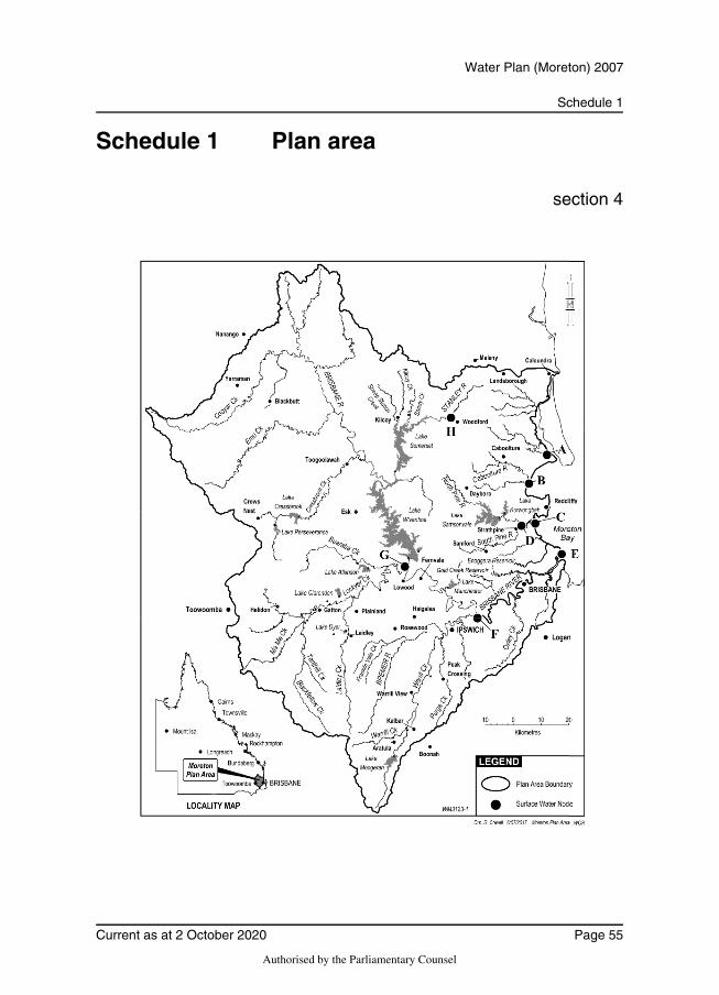
Schedule 1
Water Plan (Moreton) 2007
Schedule 1 Plan area
section 4
Current as at 2 October 2020 Page 55
Authorised by the Parliamentary Counsel
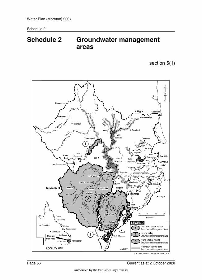
Schedule 2
Water Plan (Moreton) 2007
Schedule 2 Groundwater management areas
section 5(1)
Page 56 Current as at 2 October 2020
Authorised by the Parliamentary Counsel
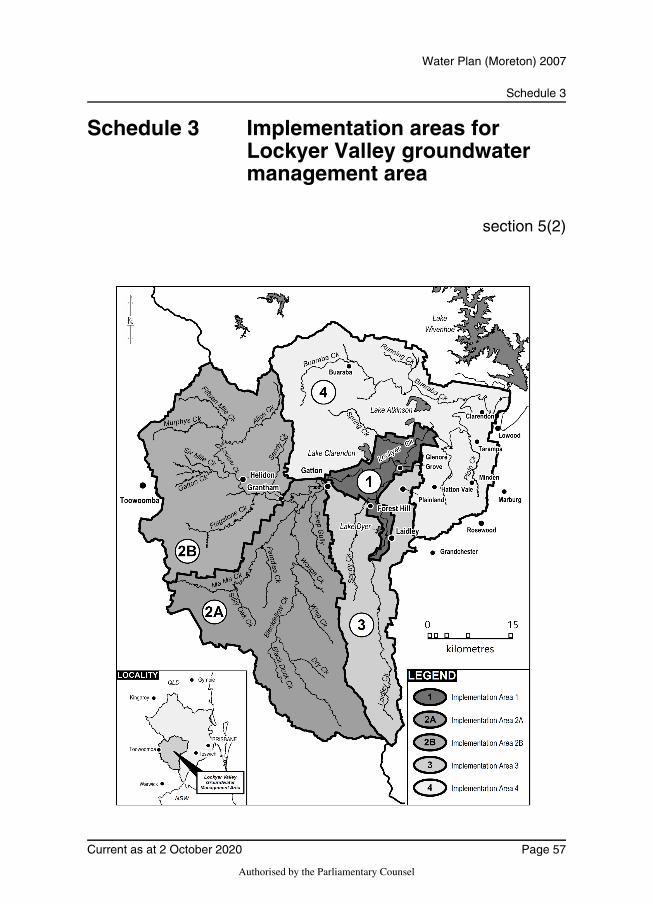
Schedule 3
Water Plan (Moreton) 2007
Schedule 3 Implementation areas for Lockyer Valley groundwater management area
section 5(2)
Current as at 2 October 2020 Page 57
Authorised by the Parliamentary Counsel
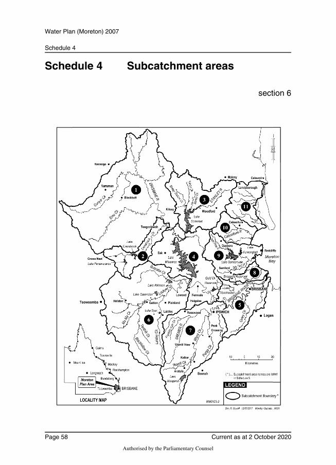
Schedule 4
Water Plan (Moreton) 2007
Schedule 4 Subcatchment areas
section 6
Page 58 Current as at 2 October 2020
Authorised by the Parliamentary Counsel
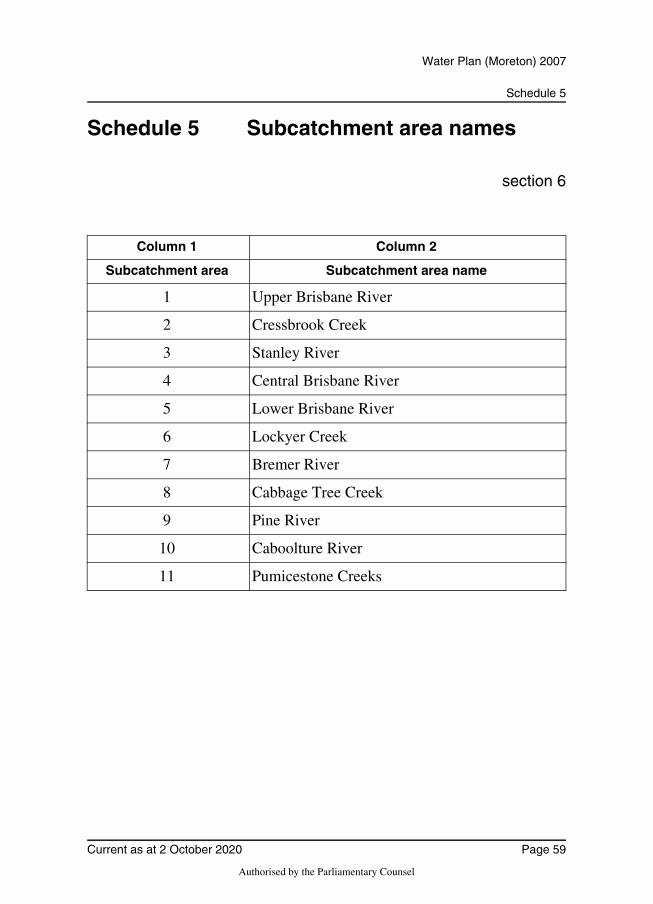
Schedule 5
Water Plan (Moreton) 2007
Schedule 5 Subcatchment area names
section 6
Column 1 Column 2
Subcatchment area Subcatchment area name
1 Upper Brisbane River
2 Cressbrook Creek
3 Stanley River
4 Central Brisbane River
5 Lower Brisbane River
6 Lockyer Creek
7 Bremer River
8 Cabbage Tree Creek
9 Pine River
10 Caboolture River
11 Pumicestone Creeks
Current as at 2 October 2020 Page 59
Authorised by the Parliamentary Counsel

Schedule 5A
Water Plan (Moreton) 2007
Schedule 5A Trading zones
section 6A
Page 60 Current as at 2 October 2020
Authorised by the Parliamentary Counsel

Schedule 5A
Water Plan (Moreton) 2007
Part 1 Surface water trading zones in plan area other than Central Lockyer Valley water supply scheme
Current as at 2 October 2020 Page 61
Authorised by the Parliamentary Counsel
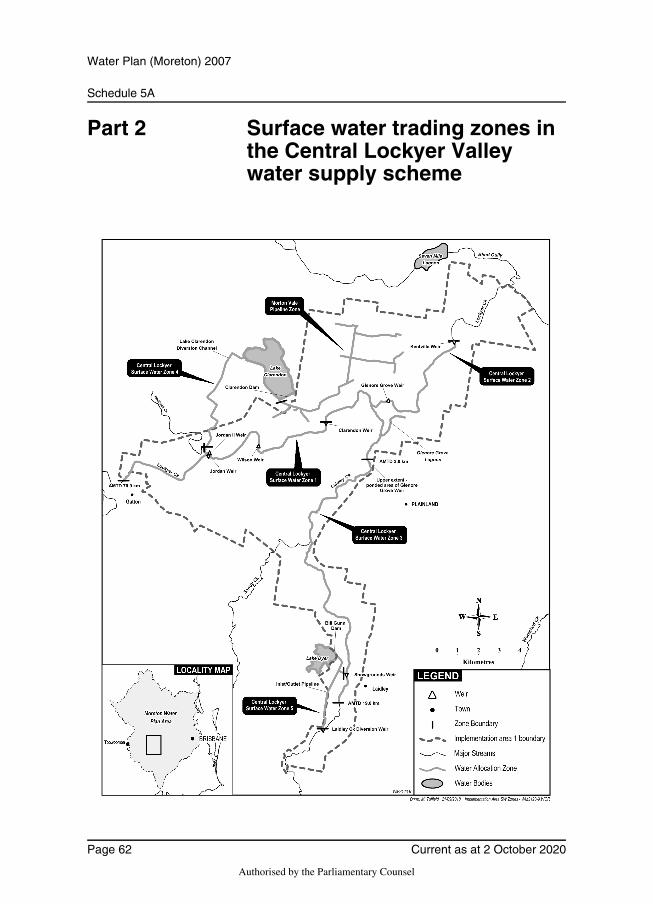
Schedule 5A
Water Plan (Moreton) 2007
Part 2 Surface water trading zones in the Central Lockyer Valley water supply scheme
Page 62 Current as at 2 October 2020
Authorised by the Parliamentary Counsel
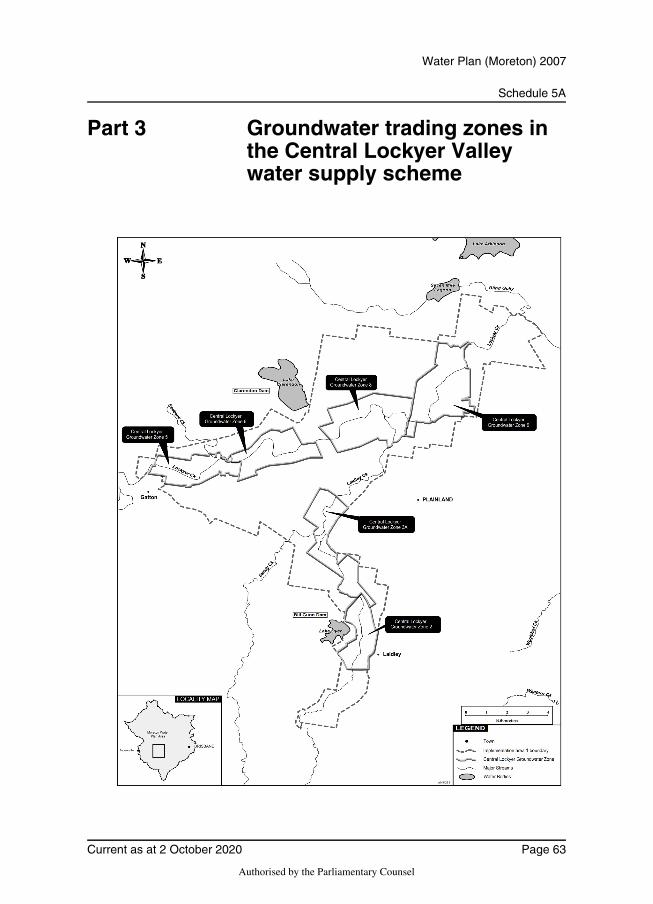
Schedule 5A
Water Plan (Moreton) 2007
Part 3 Groundwater trading zones in the Central Lockyer Valley water supply scheme
Current as at 2 October 2020 Page 63
Authorised by the Parliamentary Counsel
Schedule 6
Water Plan (Moreton) 2007
Schedule 6 Nodes
section 8
Column 1 Column 2
Node Location
A Pumicestone Creeks at end of system (AMTD 0.0km)
B Caboolture River at end of system (AMTD 0.0km)
C Pine River at end of system (AMTD 0.0km)
D South Pine River at North Pine River confluence (AMTD 8.0km)
E Brisbane River end of system (AMTD 0.0km)
F Bremer River at Brisbane River confluence (AMTD 72.9km)
G Lockyer Creek at O’Reillys Weir GS143207A (AMTD 1.4km)
H Stanley River at Woodford Weir inflow (AMTD 64.0km)
Page 64 Current as at 2 October 2020
Authorised by the Parliamentary Counsel
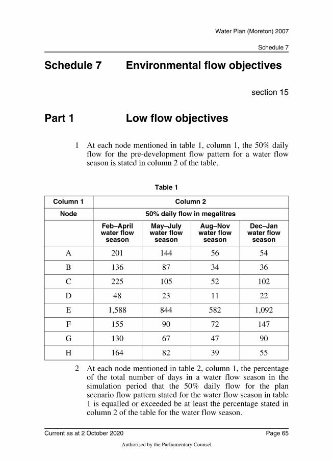
Schedule 7
Water Plan (Moreton) 2007
Schedule 7 Environmental flow objectives
section 15
Part 1 Low flow objectives
1 At each node mentioned in table 1, column 1, the 50% dailyflow for the pre-development flow pattern for a water flowseason is stated in column 2 of the table.
Table 1
2 At each node mentioned in table 2, column 1, the percentageof the total number of days in a water flow season in thesimulation period that the 50% daily flow for the planscenario flow pattern stated for the water flow season in table1 is equalled or exceeded be at least the percentage stated incolumn 2 of the table for the water flow season.
Column 1 Column 2
Node 50% daily flow in megalitres
Feb–April water flow
season
May–July water flow
season
Aug–Nov water flow
season
Dec–Jan water flow
season
A 201 144 56 54
B 136 87 34 36
C 225 105 52 102
D 48 23 11 22
E 1,588 844 582 1,092
F 155 90 72 147
G 130 67 47 90
H 164 82 39 55
Current as at 2 October 2020 Page 65
Authorised by the Parliamentary Counsel
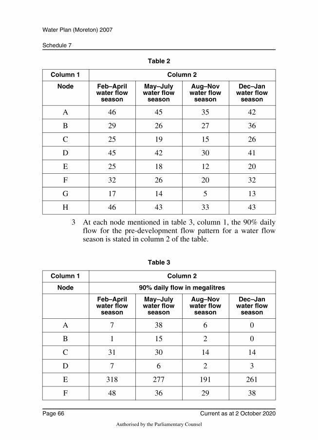
Schedule 7
Water Plan (Moreton) 2007
Table 2
3 At each node mentioned in table 3, column 1, the 90% dailyflow for the pre-development flow pattern for a water flowseason is stated in column 2 of the table.
Table 3
Column 1 Column 2
Node Feb–April water flow
season
May–July water flow
season
Aug–Nov water flow
season
Dec–Jan water flow
season
A 46 45 35 42
B 29 26 27 36
C 25 19 15 26
D 45 42 30 41
E 25 18 12 20
F 32 26 20 32
G 17 14 5 13
H 46 43 33 43
Column 1 Column 2
Node 90% daily flow in megalitres
Feb–April water flow
season
May–July water flow
season
Aug–Nov water flow
season
Dec–Jan water flow
season
A 7 38 6 0
B 1 15 2 0
C 31 30 14 14
D 7 6 2 3
E 318 277 191 261
F 48 36 29 38
Page 66 Current as at 2 October 2020
Authorised by the Parliamentary Counsel
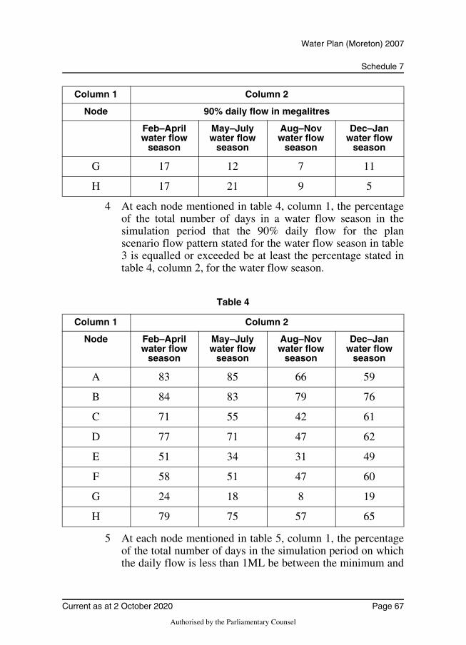
Schedule 7
Water Plan (Moreton) 2007
4 At each node mentioned in table 4, column 1, the percentageof the total number of days in a water flow season in thesimulation period that the 90% daily flow for the planscenario flow pattern stated for the water flow season in table3 is equalled or exceeded be at least the percentage stated intable 4, column 2, for the water flow season.
Table 4
5 At each node mentioned in table 5, column 1, the percentageof the total number of days in the simulation period on whichthe daily flow is less than 1ML be between the minimum and
G 17 12 7 11
H 17 21 9 5
Column 1 Column 2
Node Feb–April water flow
season
May–July water flow
season
Aug–Nov water flow
season
Dec–Jan water flow
season
A 83 85 66 59
B 84 83 79 76
C 71 55 42 61
D 77 71 47 62
E 51 34 31 49
F 58 51 47 60
G 24 18 8 19
H 79 75 57 65
Column 1 Column 2
Node 90% daily flow in megalitres
Feb–April water flow
season
May–July water flow
season
Aug–Nov water flow
season
Dec–Jan water flow
season
Current as at 2 October 2020 Page 67
Authorised by the Parliamentary Counsel
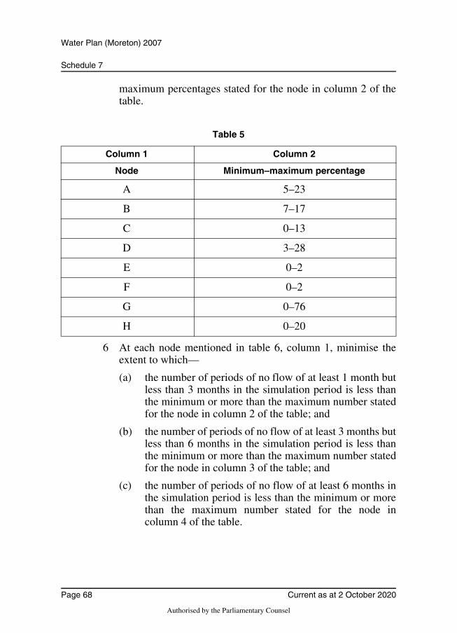
Schedule 7
Water Plan (Moreton) 2007
maximum percentages stated for the node in column 2 of thetable.
Table 5
6 At each node mentioned in table 6, column 1, minimise theextent to which—
(a) the number of periods of no flow of at least 1 month butless than 3 months in the simulation period is less thanthe minimum or more than the maximum number statedfor the node in column 2 of the table; and
(b) the number of periods of no flow of at least 3 months butless than 6 months in the simulation period is less thanthe minimum or more than the maximum number statedfor the node in column 3 of the table; and
(c) the number of periods of no flow of at least 6 months inthe simulation period is less than the minimum or morethan the maximum number stated for the node incolumn 4 of the table.
Column 1 Column 2
Node Minimum–maximum percentage
A 5–23
B 7–17
C 0–13
D 3–28
E 0–2
F 0–2
G 0–76
H 0–20
Page 68 Current as at 2 October 2020
Authorised by the Parliamentary Counsel
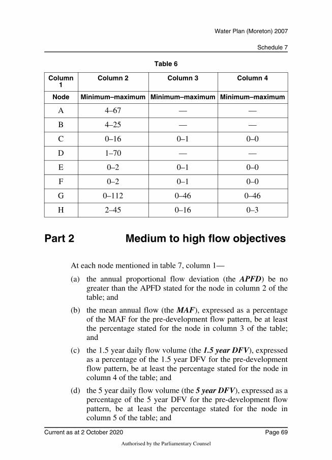
Schedule 7
Water Plan (Moreton) 2007
Table 6
Part 2 Medium to high flow objectives
At each node mentioned in table 7, column 1—
(a) the annual proportional flow deviation (the APFD) be nogreater than the APFD stated for the node in column 2 of thetable; and
(b) the mean annual flow (the MAF), expressed as a percentageof the MAF for the pre-development flow pattern, be at leastthe percentage stated for the node in column 3 of the table;and
(c) the 1.5 year daily flow volume (the 1.5 year DFV), expressedas a percentage of the 1.5 year DFV for the pre-developmentflow pattern, be at least the percentage stated for the node incolumn 4 of the table; and
(d) the 5 year daily flow volume (the 5 year DFV), expressed as apercentage of the 5 year DFV for the pre-development flowpattern, be at least the percentage stated for the node incolumn 5 of the table; and
Column 1
Column 2 Column 3 Column 4
Node Minimum–maximum Minimum–maximum Minimum–maximum
A 4–67 — —
B 4–25 — —
C 0–16 0–1 0–0
D 1–70 — —
E 0–2 0–1 0–0
F 0–2 0–1 0–0
G 0–112 0–46 0–46
H 2–45 0–16 0–3
Current as at 2 October 2020 Page 69
Authorised by the Parliamentary Counsel
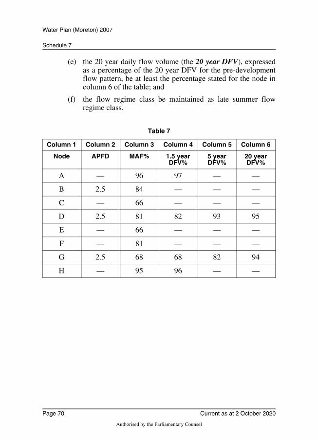
Schedule 7
Water Plan (Moreton) 2007
(e) the 20 year daily flow volume (the 20 year DFV), expressedas a percentage of the 20 year DFV for the pre-developmentflow pattern, be at least the percentage stated for the node incolumn 6 of the table; and
(f) the flow regime class be maintained as late summer flowregime class.
Table 7
Column 1 Column 2 Column 3 Column 4 Column 5 Column 6
Node APFD MAF% 1.5 year DFV%
5 yearDFV%
20 year DFV%
A — 96 97 — —
B 2.5 84 — — —
C — 66 — — —
D 2.5 81 82 93 95
E — 66 — — —
F — 81 — — —
G 2.5 68 68 82 94
H — 95 96 — —
Page 70 Current as at 2 October 2020
Authorised by the Parliamentary Counsel
Schedule 8
Water Plan (Moreton) 2007
Schedule 8 Water allocation security objectives
section 17
Part 1 Supplemented water
1 For water allocations in high priority A group—
(a) the monthly supplemented water sharing index be atleast 95%; and
(b) the extent to which it is less than 100% be minimised.
2 For water allocations in high priority B group—
(a) the monthly supplemented water sharing index be atleast 85%; and
(b) the extent to which it is less than 90% be minimised.
3 For water allocations in high priority C group—
(a) the monthly supplemented water sharing index be atleast 75%; and
(b) the extent to which it is less than 85% be minimised.
4 For water allocations in a medium priority group in theCentral Brisbane River water supply scheme—
(a) the monthly supplemented water sharing index be atleast 90%; and
(b) the extent to which it is less than 95% be minimised.
5 For water allocations in a medium priority group in LaidleyCreek in the Central Lockyer Valley water supply scheme, themonthly supplemented water sharing index be not less than35%.
6 For water allocations in a medium priority group in LockyerCreek in the Central Lockyer Valley water supply scheme, the
Current as at 2 October 2020 Page 71
Authorised by the Parliamentary Counsel
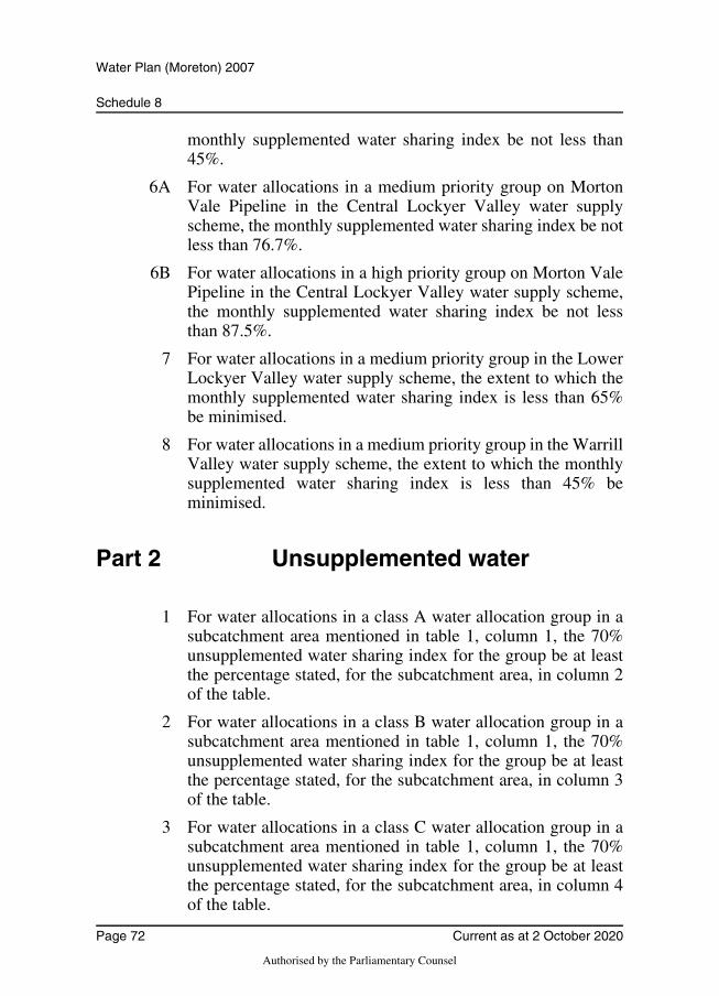
Schedule 8
Water Plan (Moreton) 2007
monthly supplemented water sharing index be not less than45%.
6A For water allocations in a medium priority group on MortonVale Pipeline in the Central Lockyer Valley water supplyscheme, the monthly supplemented water sharing index be notless than 76.7%.
6B For water allocations in a high priority group on Morton ValePipeline in the Central Lockyer Valley water supply scheme,the monthly supplemented water sharing index be not lessthan 87.5%.
7 For water allocations in a medium priority group in the LowerLockyer Valley water supply scheme, the extent to which themonthly supplemented water sharing index is less than 65%be minimised.
8 For water allocations in a medium priority group in the WarrillValley water supply scheme, the extent to which the monthlysupplemented water sharing index is less than 45% beminimised.
Part 2 Unsupplemented water
1 For water allocations in a class A water allocation group in asubcatchment area mentioned in table 1, column 1, the 70%unsupplemented water sharing index for the group be at leastthe percentage stated, for the subcatchment area, in column 2of the table.
2 For water allocations in a class B water allocation group in asubcatchment area mentioned in table 1, column 1, the 70%unsupplemented water sharing index for the group be at leastthe percentage stated, for the subcatchment area, in column 3of the table.
3 For water allocations in a class C water allocation group in asubcatchment area mentioned in table 1, column 1, the 70%unsupplemented water sharing index for the group be at leastthe percentage stated, for the subcatchment area, in column 4of the table.
Page 72 Current as at 2 October 2020
Authorised by the Parliamentary Counsel
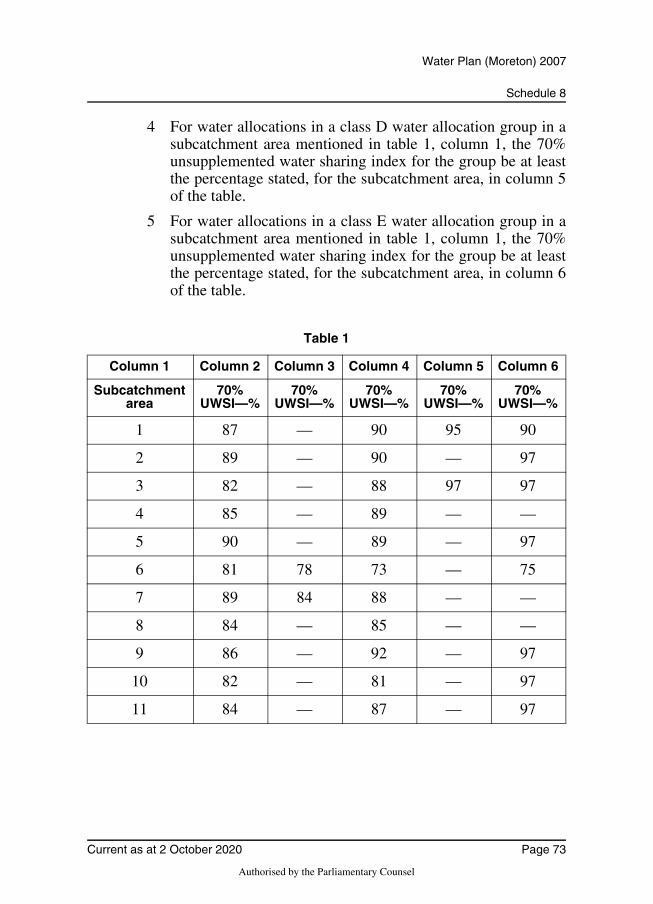
Schedule 8
Water Plan (Moreton) 2007
4 For water allocations in a class D water allocation group in asubcatchment area mentioned in table 1, column 1, the 70%unsupplemented water sharing index for the group be at leastthe percentage stated, for the subcatchment area, in column 5of the table.
5 For water allocations in a class E water allocation group in asubcatchment area mentioned in table 1, column 1, the 70%unsupplemented water sharing index for the group be at leastthe percentage stated, for the subcatchment area, in column 6of the table.
Table 1
Column 1 Column 2 Column 3 Column 4 Column 5 Column 6
Subcatchment area
70% UWSI—%
70% UWSI—%
70% UWSI—%
70% UWSI—%
70% UWSI—%
1 87 — 90 95 90
2 89 — 90 — 97
3 82 — 88 97 97
4 85 — 89 — —
5 90 — 89 — 97
6 81 78 73 — 75
7 89 84 88 — —
8 84 — 85 — —
9 86 — 92 — 97
10 82 — 81 — 97
11 84 — 87 — 97
Current as at 2 October 2020 Page 73
Authorised by the Parliamentary Counsel
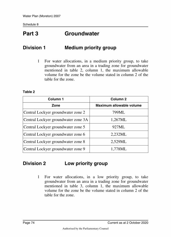
Schedule 8
Water Plan (Moreton) 2007
Part 3 Groundwater
Division 1 Medium priority group
1 For water allocations, in a medium priority group, to takegroundwater from an area in a trading zone for groundwatermentioned in table 2, column 1, the maximum allowablevolume for the zone be the volume stated in column 2 of thetable for the zone.
Table 2
Division 2 Low priority group
1 For water allocations, in a low priority group, to takegroundwater from an area in a trading zone for groundwatermentioned in table 3, column 1, the maximum allowablevolume for the zone be the volume stated in column 2 of thetable for the zone.
Column 1 Column 2
Zone Maximum allowable volume
Central Lockyer groundwater zone 2 799ML
Central Lockyer groundwater zone 3A 1,267ML
Central Lockyer groundwater zone 5 927ML
Central Lockyer groundwater zone 6 2,232ML
Central Lockyer groundwater zone 8 2,529ML
Central Lockyer groundwater zone 9 1,778ML
Page 74 Current as at 2 October 2020
Authorised by the Parliamentary Counsel
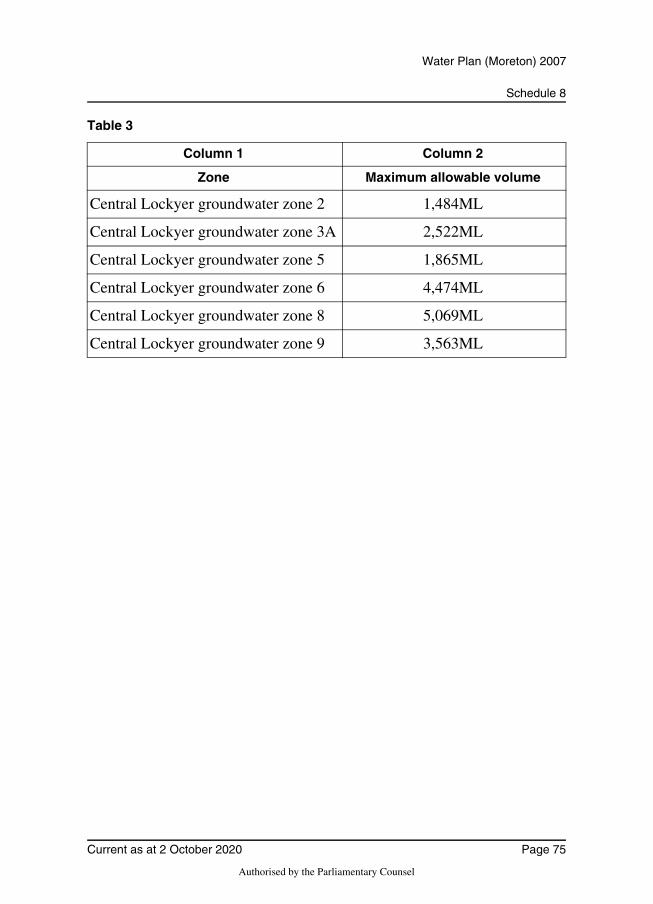
Schedule 8
Water Plan (Moreton) 2007
Table 3
Column 1 Column 2
Zone Maximum allowable volume
Central Lockyer groundwater zone 2 1,484ML
Central Lockyer groundwater zone 3A 2,522ML
Central Lockyer groundwater zone 5 1,865ML
Central Lockyer groundwater zone 6 4,474ML
Central Lockyer groundwater zone 8 5,069ML
Central Lockyer groundwater zone 9 3,563ML
Current as at 2 October 2020 Page 75
Authorised by the Parliamentary Counsel
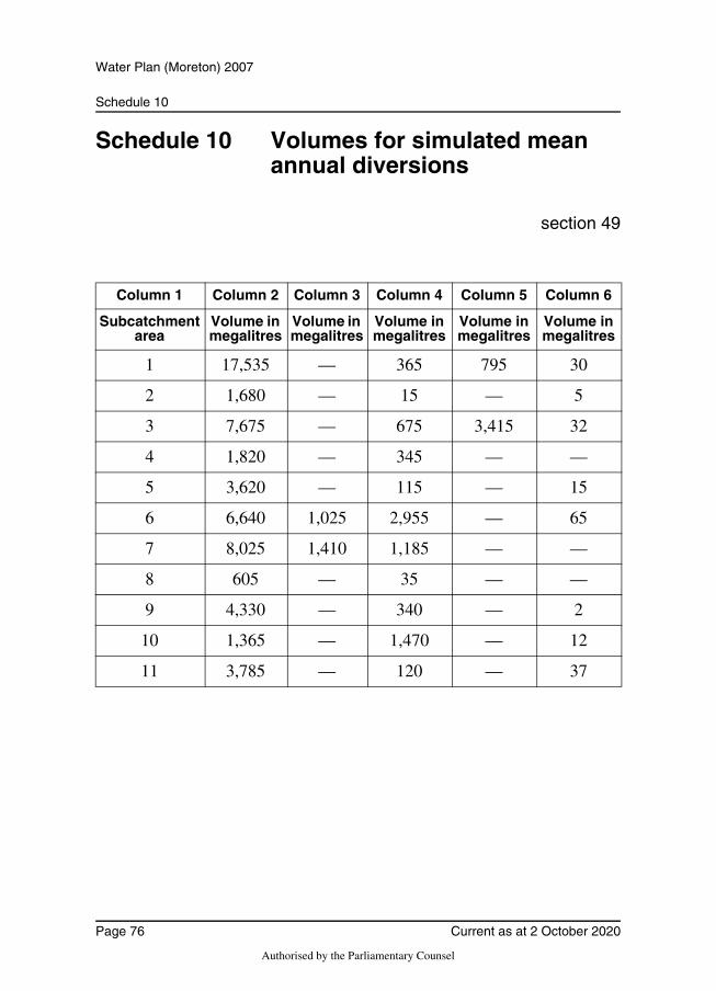
Schedule 10
Water Plan (Moreton) 2007
Schedule 10 Volumes for simulated mean annual diversions
section 49
Column 1 Column 2 Column 3 Column 4 Column 5 Column 6
Subcatchment area
Volume in megalitres
Volume in megalitres
Volume in megalitres
Volume in megalitres
Volume in megalitres
1 17,535 — 365 795 30
2 1,680 — 15 — 5
3 7,675 — 675 3,415 32
4 1,820 — 345 — —
5 3,620 — 115 — 15
6 6,640 1,025 2,955 — 65
7 8,025 1,410 1,185 — —
8 605 — 35 — —
9 4,330 — 340 — 2
10 1,365 — 1,470 — 12
11 3,785 — 120 — 37
Page 76 Current as at 2 October 2020
Authorised by the Parliamentary Counsel
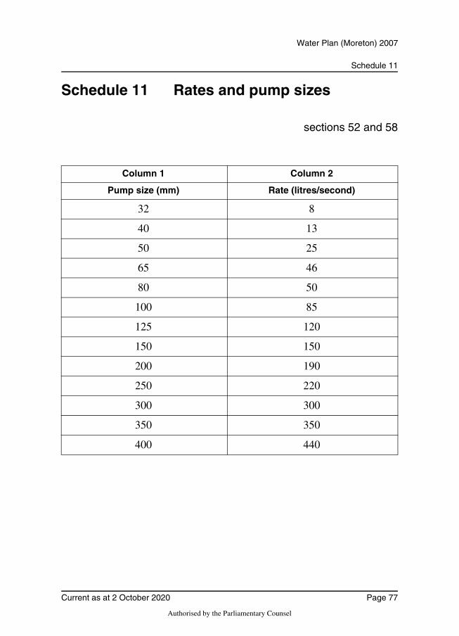
Schedule 11
Water Plan (Moreton) 2007
Schedule 11 Rates and pump sizes
sections 52 and 58
Column 1 Column 2
Pump size (mm) Rate (litres/second)
32 8
40 13
50 25
65 46
80 50
100 85
125 120
150 150
200 190
250 220
300 300
350 350
400 440
Current as at 2 October 2020 Page 77
Authorised by the Parliamentary Counsel
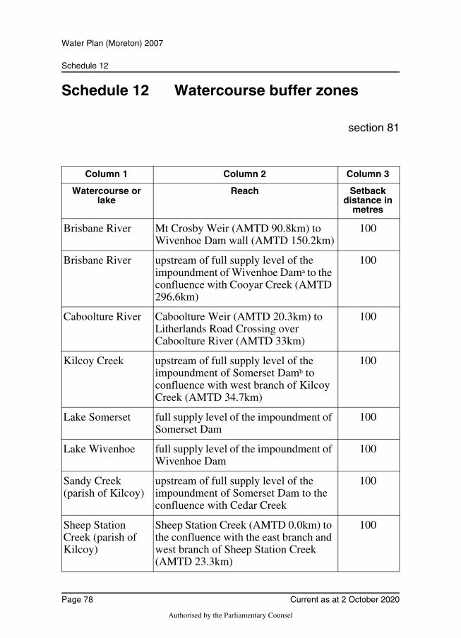
Schedule 12
Water Plan (Moreton) 2007
Schedule 12 Watercourse buffer zones
section 81
Column 1 Column 2 Column 3
Watercourse or lake
Reach Setback distance in
metres
Brisbane River Mt Crosby Weir (AMTD 90.8km) to Wivenhoe Dam wall (AMTD 150.2km)
100
Brisbane River upstream of full supply level of the impoundment of Wivenhoe Dama to the confluence with Cooyar Creek (AMTD 296.6km)
100
Caboolture River Caboolture Weir (AMTD 20.3km) to Litherlands Road Crossing over Caboolture River (AMTD 33km)
100
Kilcoy Creek upstream of full supply level of the impoundment of Somerset Damb to confluence with west branch of Kilcoy Creek (AMTD 34.7km)
100
Lake Somerset full supply level of the impoundment of Somerset Dam
100
Lake Wivenhoe full supply level of the impoundment of Wivenhoe Dam
100
Sandy Creek (parish of Kilcoy)
upstream of full supply level of the impoundment of Somerset Dam to the confluence with Cedar Creek
100
Sheep Station Creek (parish of Kilcoy)
Sheep Station Creek (AMTD 0.0km) to the confluence with the east branch and west branch of Sheep Station Creek (AMTD 23.3km)
100
Page 78 Current as at 2 October 2020
Authorised by the Parliamentary Counsel
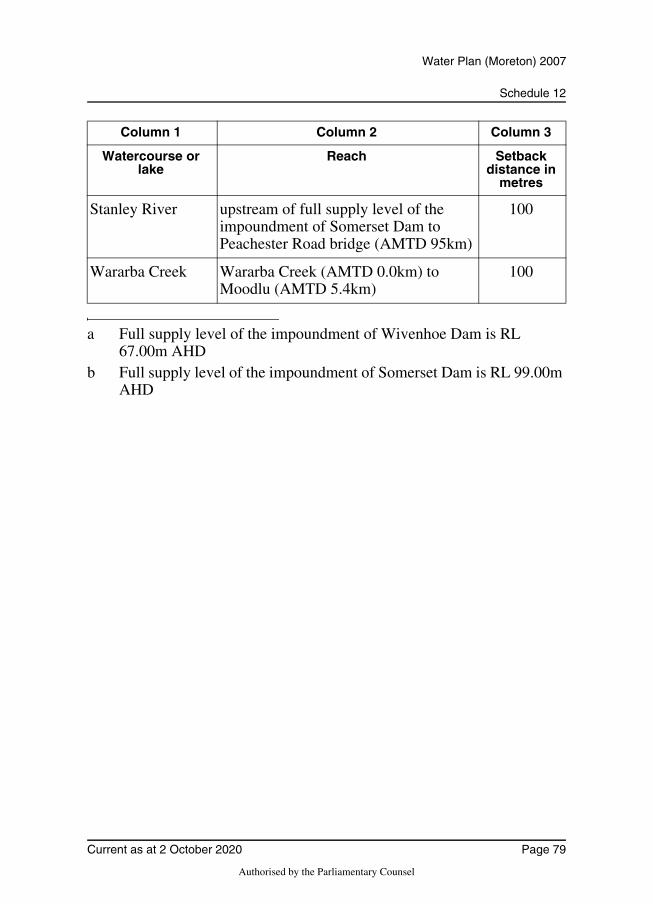
Schedule 12
Water Plan (Moreton) 2007
Stanley River upstream of full supply level of the impoundment of Somerset Dam to Peachester Road bridge (AMTD 95km)
100
Wararba Creek Wararba Creek (AMTD 0.0km) to Moodlu (AMTD 5.4km)
100
a Full supply level of the impoundment of Wivenhoe Dam is RL 67.00m AHD
b Full supply level of the impoundment of Somerset Dam is RL 99.00m AHD
Column 1 Column 2 Column 3
Watercourse or lake
Reach Setback distance in
metres
Current as at 2 October 2020 Page 79
Authorised by the Parliamentary Counsel
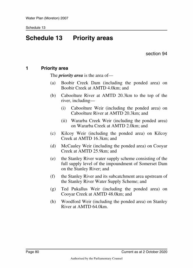
Schedule 13
Water Plan (Moreton) 2007
Schedule 13 Priority areas
section 94
1 Priority area
The priority area is the area of—
(a) Boobir Creek Dam (including the ponded area) onBoobir Creek at AMTD 4.0km; and
(b) Caboolture River at AMTD 20.3km to the top of theriver, including—
(i) Caboolture Weir (including the ponded area) onCaboolture River at AMTD 20.3km; and
(ii) Wararba Creek Weir (including the ponded area)on Wararba Creek at AMTD 2.0km; and
(c) Kilcoy Weir (including the ponded area) on KilcoyCreek at AMTD 16.3km; and
(d) McCauley Weir (including the ponded area) on CooyarCreek at AMTD 25.9km; and
(e) the Stanley River water supply scheme consisting of thefull supply level of the impoundment of Somerset Damon the Stanley River; and
(f) the Stanley River and its subcatchment area upstream ofthe Stanley River Water Supply Scheme; and
(g) Ted Pukallus Weir (including the ponded area) onCooyar Creek at AMTD 48.0km; and
(h) Woodford Weir (including the ponded area) on StanleyRiver at AMTD 64.0km.
Page 80 Current as at 2 October 2020
Authorised by the Parliamentary Counsel
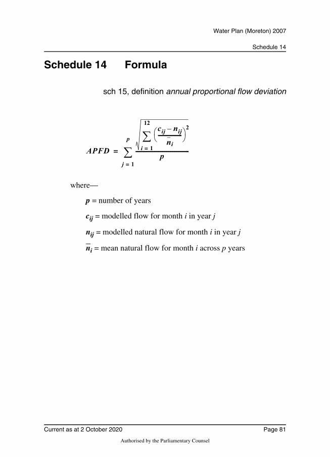
Schedule 14
Water Plan (Moreton) 2007
Schedule 14 Formula
sch 15, definition annual proportional flow deviation
where—
p = number of years
cij = modelled flow for month i in year j
nij = modelled natural flow for month i in year j
ni = mean natural flow for month i across p years
APFD
cij nij–
ni------------------
2
i 1=
12
p----------------------------------------
j 1=
p
=
Current as at 2 October 2020 Page 81
Authorised by the Parliamentary Counsel
Schedule 15
Water Plan (Moreton) 2007
Schedule 15 Dictionary
section 3
1.5 year daily flow volume means the daily flow that has a
67% probability of being reached at least once a year.
5 year daily flow volume means the daily flow that has a 20%probability of being reached at least once a year.
20 year daily flow volume means the daily flow that has a 5%probability of being reached at least once a year.
50% daily flow, for a month, means the flow, in megalitres,that is equalled or exceeded on 50% of days in the month inthe simulation period.
70% unsupplemented water sharing index, or 70% UWSI,for a group of water allocations for taking unsupplementedwater in a subcatchment area, means—
(a) for the group of allocations in the subcatchment areaconverted from authorisations that stated the areas thatmay be irrigated—the percentage of the simulated meanannual diversion, for all those allocations, calculated tooccur in at least 70% of years in the simulation period;and
(b) for the group of other allocations in the subcatchmentarea—the percentage of the simulated mean annualdiversion, for all those allocations, calculated to occur inat least 70% of years in the simulation period.
90% daily flow, for a month, means the flow, in megalitres,that is equalled or exceeded on 90% of days in the month inthe simulation period.
additional irrigable area, for part 6, division 6, see section84M.
adopted middle thread distance means the distance inkilometres, measured along the middle of a watercourse, that
Page 82 Current as at 2 October 2020
Authorised by the Parliamentary Counsel
Schedule 15
Water Plan (Moreton) 2007
a specific point in the watercourse is, at the commencement ofthis plan, from—
(a) the watercourse’s mouth; or
(b) if the watercourse is not a main watercourse—thewatercourse’s confluence with its main watercourse.
allowable urban purpose, for taking groundwater, means—
(a) taking the groundwater for developments that use watersensitive urban design; or
(b) taking the groundwater for irrigating sporting fields orsupplying the water to a toilet block, or for publicamenity purposes, at a recreational or sporting facility;or
(c) taking, by a local government, the groundwater formaintenance, to provide for public amenity purposes, toenhance public safety or for projects for which the localgovernment has a water efficiency plan; or
(d) taking the groundwater at an education institution if theuse of the groundwater is not—
(i) for irrigation purposes; or
(ii) linked to a large scale research project.
AMTD means adopted middle thread distance.
annual proportional flow deviation, for a node, means thestatistical measure of changes to flow season and volume inthe simulation period, at the node, calculated using theformula in schedule 14.
annual variability, for a flow at a point in a watercourse,means the amount of change in the flow that happens betweenyears.
annual volumetric limit, for an authorisation, means themaximum volume of water that may be taken under theauthorisation in a water year.
authorisation means a water licence, water permit, interimwater allocation or other authority to take water given under
Current as at 2 October 2020 Page 83
Authorised by the Parliamentary Counsel
Schedule 15
Water Plan (Moreton) 2007
the Act or the repealed Act, other than a permit for stock ordomestic purposes.
class, of water allocation group to which a water allocation totake unsupplemented water belongs, means the class of waterallocation to which the allocation belongs under section 54.
daily flow, for a node, means the volume of water that flowspast the node in a day.
discharge, for a flow at a point in a watercourse, means therate at which water passes the point, measured in cubic metresa second or megalitres a day.
ecological assets include a species, a group of species, abiological function, an ecosystem and a place of natural value.
existing overland flow works means—
(a) works for taking overland flow water that—
(i) were in existence on the commencement of theWater Plan (Moreton) (Supply SchemeArrangements) Amendment Plan 2019; or
(ii) were started, but not completed by thecommencement of the Water Plan (Moreton)(Supply Scheme Arrangements) Amendment Plan2019; or
(b) works that—
(i) are a reconfiguration of existing overland flowworks mentioned in paragraph (a); and
(ii) do not increase the average annual volume of watertaken above the average annual volume taken usingthe existing works.
existing water bore—
1 Existing water bore means a water bore that—
(a) is able to take groundwater; and
(b) either—
(i) was in existence on 24 March 2005; or
Page 84 Current as at 2 October 2020
Authorised by the Parliamentary Counsel
Schedule 15
Water Plan (Moreton) 2007
(ii) was started, but not completed by 24 March2005 and—
(A) if a variation to a moratorium noticewas granted for the bore undersection 27 of the Act—has been, or isbeing, completed in accordance withthe moratorium notice, as varied; or
(B) if subsubparagraph (A) does notapply—was completed by 31 March2006.
2 The term does not include a water bore that allowstaking groundwater only for stock or domestic purposes.Note—
See section 20 (Authorised taking of water without waterentitlement) of the Act.
flow regime means the entire range of flows at a point in awatercourse including variations in the watercourse height,discharge, seasonality, annual variability and duration of aflow event.
flow regime class means the measure of flow regimeseasonality worked out using the method stated in Haines,A.T., Finlayson, B.L. and McMahon, T.A., ‘A globalclassification of river regimes. Applied Geography, 1988’.
groundwater means underground water.
groundwater management area means a groundwatermanagement area under section 5(1).
groundwater unit means an aquifer in a multi-layered aquifersystem that is not hydraulically connected to another aquifereither above or below it.
groundwater unit 1 see section 5(3)(a).
groundwater unit 2 see section 5(3)(b).
high priority A group means the water allocations in a watersupply scheme that are stated to be high priority A group inthe water allocations register.
Current as at 2 October 2020 Page 85
Authorised by the Parliamentary Counsel
Schedule 15
Water Plan (Moreton) 2007
high priority B group means the water allocations in a watersupply scheme that are stated to be high priority B group inthe water allocations register.
high priority C group means the water allocations in a watersupply scheme that are stated to be high priority C group inthe water allocations register.
high priority group means the water allocations in a watersupply scheme that are stated to belong to the high prioritygroup in the water allocations register.
hydraulic habitat requirements, of an ecological asset, arethe biophysical conditions created by aspects of the flowregime that are—
(a) required for a particular biological process or responseto happen in relation to the asset; or
(b) necessary to maintain the long-term biological integrityof the asset.
implementation area means an implementation area undersection 5(2).
implementation area 1 see section 5(2)(a).
implementation area 2A see section 5(2)(b).
implementation area 2B see section 5(2)(c).
implementation area 3 see section 5(2)(d).
implementation area 4 see section 5(2)(e).
IQQM computer program means the department’s IntegratedQuantity and Quality Modelling computer program, andassociated statistical analysis and reporting programs, thatsimulate daily stream flows, flow management, storages,releases, instream infrastructure, water diversions, waterdemands and other hydrologic events in the plan area.
irrigable area, for part 6, division 6, see section 84K.
irrigation purposes means any of the following purposes—
(a) aquaculture;
(b) dairying;
Page 86 Current as at 2 October 2020
Authorised by the Parliamentary Counsel
Schedule 15
Water Plan (Moreton) 2007
(c) irrigation;
(d) piggery;
(e) stock or domestic purposes;
(f) water harvesting.
low flow regime, for a watercourse, means the minimumflows that provide a continuous flow through the watercourse.
low priority group means the water allocations in a watersupply scheme that are stated to belong to the priority group inthe water allocations register.
management area—
(a) for part 6, division 2, see section 63; or
(b) for part 6, division 3, see section 66; or
(c) for part 6, division 4, see section 76.
maximum allowable volume, for a zone, means the totalvolume of supplemented groundwater that may be taken underall water allocations to take supplemented groundwater in thezone.
mean annual flow, for a node, means the total volume offlow, at the node, in the simulation period divided by thenumber of years in the simulation period.
medium priority A group means the water allocations in awater supply scheme that are stated to belong to the mediumpriority A group in the water allocations register.
medium priority B group means the water allocations in awater supply scheme that are stated to belong to the mediumpriority B group in the water allocations register.
medium priority C group means the water allocations in awater supply scheme that are stated to belong to the mediumpriority C group in the water allocations register.
medium priority group means the water allocations in a watersupply scheme that are stated to be medium priority group inthe water allocations register.
Current as at 2 October 2020 Page 87
Authorised by the Parliamentary Counsel
Schedule 15
Water Plan (Moreton) 2007
monthly supplemented water sharing index, for waterallocations in a water supply scheme, means the percentage ofmonths in the simulation period in which the allocations arefully supplied.
node see section 8.
period of no flow, for a node, means a period in which theflow of water in the watercourse at the node is less than 1MLa day.
plan area means the area shown as the plan area on the map inschedule 1.
plan scenario flow pattern means the pattern of water flows,during the simulation period, decided by the chief executiveusing the IQQM computer program as if—
(a) all unallocated water in the strategic reserve and generalreserve is being taken; and
(b) the maximum volume allowed to be taken under eachauthorisation in the plan area is being taken.
pre-development flow pattern means the pattern of waterflows, during the simulation period, decided by the chiefexecutive using the IQQM computer program as if—
(a) there were no dams or other water infrastructure in theplan area; and
(b) no water was taken under authorisations in the plan area.
preliminary irrigable area, for part 6, division 6, see section84L.
priority area see section 94.
priority area see schedule 13, section 1.
related development permit, for an authorisation, means thedevelopment permit for the works for taking water under theauthorisation.
relevant period, part 6, division 6, see section 84A.
seasonality, for a flow at a point in a watercourse, means thetime of year when the flow happens.
Page 88 Current as at 2 October 2020
Authorised by the Parliamentary Counsel
Schedule 15
Water Plan (Moreton) 2007
SEQ regional plan means the regional plan under thePlanning Act for the region named the SEQ region under thePlanning Regulation 2017.
simulated mean annual diversion, for a water allocation orgroup of water allocations, means the total volume of watersimulated to have been taken under the allocation or group, ifthe allocation or group were in existence for the whole of thesimulation period, divided by the number of years in thesimulation period.
simulation period means the period from 1 July 1889 to 30June 2000.
started, for an existing water bore or existing overland flowworks, means—
(a) construction of the bore or works had physically begunor, if construction had not physically begun, a contracthad been entered into to begin construction; and
(b) an independently verifiable construction programexisted for progressive construction towards completionof the bore or works; and
(c) detailed design plans existed showing, among otherthings, the extent of the bore or works; and
(d) if a permit under the Local Government Act 1993,section 940, was required for the bore or works—thepermit had been issued; and
(e) if a development permit was required for the bore orworks—the permit had been given.
subcatchment area see section 6.
supplemented groundwater means groundwater that isrecharged by water supplied under a resource operationslicence or other authority to operate water infrastructure.
supplemented groundwater area, for groundwater unit 1 in animplementation area, means the part of the groundwater unitin the implementation area that contains supplementedgroundwater.
Current as at 2 October 2020 Page 89
Authorised by the Parliamentary Counsel
Schedule 15
Water Plan (Moreton) 2007
supplemented water means surface water supplied under aresource operations licence or other authority to operate waterinfrastructure.
surface water see section 9(1).
traditional owners, of an area, means the Aboriginal peoplewho identify as descendants of the original inhabitants of thearea.
unsupplemented groundwater means groundwater that is notsupplemented groundwater.
unsupplemented groundwater area, for groundwater unit 1 inan implementation area, means the part of the groundwaterunit in the implementation area that does not containsupplemented groundwater.
unsupplemented water means surface water that is notsupplemented water.
watercourse buffer zone see section 81.
water flow season means any of the following periods in ayear—
(a) the period from 1 February to 30 April (Feb–April waterflow season);
(b) the period from 1 May to 31 July (May–July water flowseason);
(c) the period from 1 August to 30 November (Aug–Novwater flow season);
(d) the period from 1 December to 31 January (Dec–Janwater flow season).
water management protocol means a water managementprotocol made to implement this plan.
water sensitive urban design means design that integrates themanagement of the water cycle into urban design to—
(a) minimise the effects of development on the water cycleand the environment; and
(b) address matters related to the supply and use of thewater.
Page 90 Current as at 2 October 2020
Authorised by the Parliamentary Counsel