Embed Size (px)
Citation preview
Water of Leith catchment (Potentially Vulnerable Area
10/18)
Local Plan District
Forth Estuary
Local authority Main catchment
The City of Edinburgh Council, Midlothian Council
Water of Leith
Ob
jec
tive
s
Su
mm
ary
of flo
od
ing
imp
ac
ts
Objectives have been set by SEPA and agreed with flood risk management authorities. These are the aims for managing local flood risk. The objectives have been grouped in three main ways: by reducing risk, avoiding increasing risk or accepting risk by maintaining current levels of management.
Many organisations, such as Scottish Water and energy companies, actively maintain and manage their own assets including their risk from flooding. Where known, these actions are described here. Scottish Natural Heritage and Historic Environment Scotland work with site owners to manage flooding where appropriate at designated environmental and/or cultural heritage sites. These actions are not detailed further in the Flood Risk Management Strategies.
Summary of objectives to manage flooding
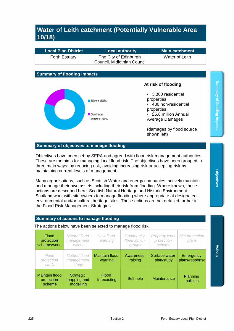
Summary of flooding impacts
• 3,300 residential properties• 480 non-residential properties• £5.8 million Annual Average Damages (damages by flood source shown left)
At risk of flooding
Ac
tion
s
The actions below have been selected to manage flood risk.
Summary of actions to manage flooding
Maintain flood warning
Site protection plans
MaintenanceSelf helpMaintain flood
protection scheme
Strategic mapping and
modelling
Flood forecasting
Emergency plans/response
Community flood action
groups
Awareness raising
Planning policies
Surface water plan/study
New flood warning
Property level protection
scheme
Natural flood management
works
Natural flood management
study
Flood protection
scheme/works
Flood protection
study
Flood protection
scheme/works
Surface water plan/study
Planning policies
Awareness raising
Emergency plans/response
Flood forecasting
Strategic mapping and
modelling
Maintain flood protection
scheme
Self help Maintenance
Maintain flood warning
225 Forth Estuary Local Plan DistrictSection 2

Water of Leith Catchment (Potentially Vulnerable Area 10/18)
Local Plan District Local authority Main catchment Forth Estuary The City of Edinburgh
Council, Midlothian Council Water of Leith
Background This Potentially Vulnerable Area is 73km2 and includes the lower reaches of the Water of Leith catchment (shown below). It includes central Edinburgh and suburban areas to the south west including Balerno, Currie and the foothills of the Pentland Hills. The main watercourses are the Water of Leith and its tributary, the Murray Burn. The Union Canal also flows through this Potentially Vulnerable Area.
© Crown copyright. SEPA licence number 100016991 (2015). All rights reserved.
The area has a risk of river and surface water flooding. The majority of damages are caused by river flooding. There are approximately 3,300 residential properties and 480 non-residential properties at risk of flooding. The Annual Average Damages are approximately £5.8 million.
Figure 1: Annual Average Damages by flood source
Summary of flooding impacts The highest risk of river flooding is from the Water of Leith and Murray Burn to Murrayfield, Roseburn and Sighthill. The risk of surface water flooding is spread across the greater Edinburgh urban area. The risk of flooding to people, property, as well as to community facilities, utilities, the transport network, designated sites and agricultural land is summarised in Table 1. The damages associated with floods of different likelihood are shown in Figure 2. For this Potentially Vulnerable Area the highest damages are to residential properties followed by damages to non-residential properties. The location of the impacts of flooding is shown in Figure 3.
River 80%
Surfacewater20%
Forth Estuary Local Plan District 226Section 2
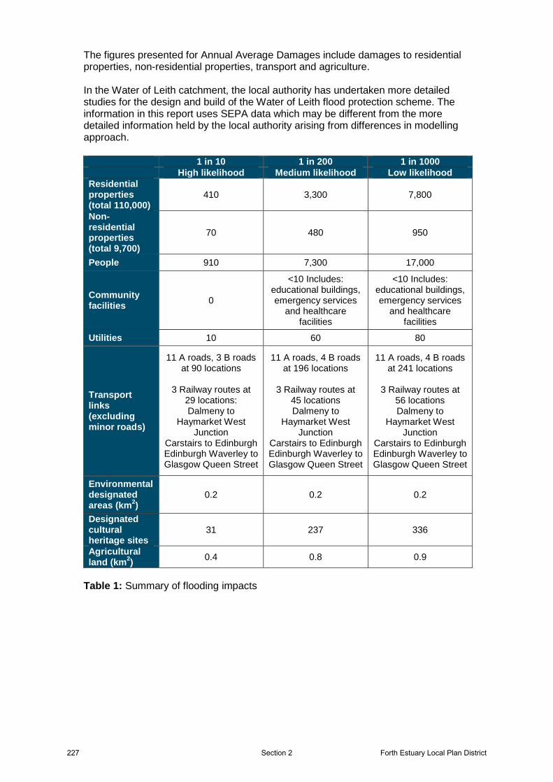
The figures presented for Annual Average Damages include damages to residential properties, non-residential properties, transport and agriculture. In the Water of Leith catchment, the local authority has undertaken more detailed studies for the design and build of the Water of Leith flood protection scheme. The information in this report uses SEPA data which may be different from the more detailed information held by the local authority arising from differences in modelling approach. 1 in 10 1 in 200 1 in 1000 High likelihood Medium likelihood Low likelihood Residential properties (total 110,000)
410 3,300 7,800
Non-residential properties (total 9,700)
70 480 950
People 910 7,300 17,000
Community facilities 0
<10 Includes: educational buildings, emergency services
and healthcare facilities
<10 Includes: educational buildings, emergency services
and healthcare facilities
Utilities 10 60 80
Transport links (excluding minor roads)
11 A roads, 3 B roads at 90 locations
3 Railway routes at
29 locations: Dalmeny to
Haymarket West Junction
Carstairs to Edinburgh Edinburgh Waverley to Glasgow Queen Street
11 A roads, 4 B roads at 196 locations
3 Railway routes at
45 locations Dalmeny to
Haymarket West Junction
Carstairs to Edinburgh Edinburgh Waverley to Glasgow Queen Street
11 A roads, 4 B roads at 241 locations
3 Railway routes at
56 locations Dalmeny to
Haymarket West Junction
Carstairs to Edinburgh Edinburgh Waverley to Glasgow Queen Street
Environmental designated areas (km2)
0.2 0.2 0.2
Designated cultural heritage sites
31 237 336
Agricultural land (km2) 0.4 0.8 0.9
Table 1: Summary of flooding impacts
227 Forth Estuary Local Plan DistrictSection 2
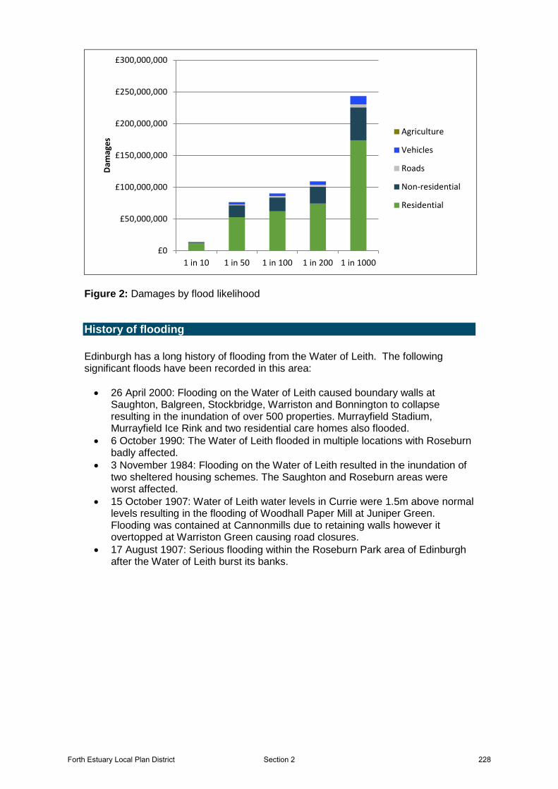
Figure 2: Damages by flood likelihood
History of flooding Edinburgh has a long history of flooding from the Water of Leith. The following significant floods have been recorded in this area: • 26 April 2000: Flooding on the Water of Leith caused boundary walls at
Saughton, Balgreen, Stockbridge, Warriston and Bonnington to collapse resulting in the inundation of over 500 properties. Murrayfield Stadium, Murrayfield Ice Rink and two residential care homes also flooded.
• 6 October 1990: The Water of Leith flooded in multiple locations with Roseburn badly affected.
• 3 November 1984: Flooding on the Water of Leith resulted in the inundation of two sheltered housing schemes. The Saughton and Roseburn areas were worst affected.
• 15 October 1907: Water of Leith water levels in Currie were 1.5m above normal levels resulting in the flooding of Woodhall Paper Mill at Juniper Green. Flooding was contained at Cannonmills due to retaining walls however it overtopped at Warriston Green causing road closures.
• 17 August 1907: Serious flooding within the Roseburn Park area of Edinburgh after the Water of Leith burst its banks.
£0
£50,000,000
£100,000,000
£150,000,000
£200,000,000
£250,000,000
£300,000,000
1 in 10 1 in 50 1 in 100 1 in 200 1 in 1000
Dam
ages
Agriculture
Vehicles
Roads
Non-residential
Residential
Forth Estuary Local Plan District 228Section 2

Figure 3: Impacts of flooding
229 Forth Estuary Local Plan DistrictSection 2
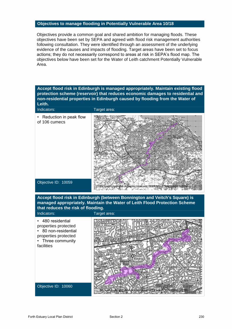
Objectives provide a common goal and shared ambition for managing floods. These objectives have been set by SEPA and agreed with flood risk management authorities following consultation. They were identified through an assessment of the underlying evidence of the causes and impacts of flooding. Target areas have been set to focus actions; they do not necessarily correspond to areas at risk in SEPA’s flood map. The objectives below have been set for the Water of Leith catchment Potentially Vulnerable Area.
Objectives to manage flooding in Potentially Vulnerable Area 10/18
Accept flood risk in Edinburgh is managed appropriately. Maintain existing flood
protection scheme (reservoir) that reduces economic damages to residential and
non-residential properties in Edinburgh caused by flooding from the Water of
Leith.
Indicators:
• Reduction in peak flow of 106 cumecs
Objective ID: 10059
Target area:
Image found and displayed.
©Crown copyright. All rights reserved. SEPA lic.no. 100016991 (2015)
Accept flood risk in Edinburgh (between Bonnington and Veitch's Square) is
managed appropriately. Maintain the Water of Leith Flood Protection Scheme
that reduces the risk of flooding.
Indicators:
• 480 residential properties protected• 80 non-residential properties protected• Three community facilities
Objective ID: 10060
Target area:
Image found and displayed.
©Crown copyright. All rights reserved. SEPA lic.no. 100016991 (2015)
Forth Estuary Local Plan District 230Section 2

Reduce risk to community facilities and economic damages to residential and
non-residential properties in Edinburgh at Murrayfield and Roseburn caused by
flooding from the Water of Leith
Indicators:
• 440 residential properties• <10 non-residential properties• Three community facilities
Objective ID: 10061
Target area:
Image found and displayed.
©Crown copyright. All rights reserved. SEPA lic.no. 100016991 (2015)
Reduce risk to community facilities and economic damages to residential and
non-residential properties in Edinburgh (Coltbridge, Gorgie and Saughton) from
the Water of Leith
Indicators:
• 80 residential and non-residential properties• One educational building
Objective ID: 10062
Target area:
Image found and displayed.
©Crown copyright. All rights reserved. SEPA lic.no. 100016991 (2015)
231 Forth Estuary Local Plan DistrictSection 2
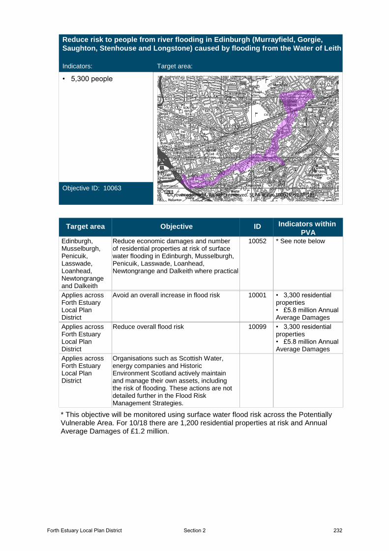
Reduce risk to people from river flooding in Edinburgh (Murrayfield, Gorgie,
Saughton, Stenhouse and Longstone) caused by flooding from the Water of Leith
Indicators:
• 5,300 people
Objective ID: 10063
Target area:
Image found and displayed.
©Crown copyright. All rights reserved. SEPA lic.no. 100016991 (2015)
Target area Objective ID Indicators within
PVAEdinburgh, Musselburgh, Penicuik, Lasswade, Loanhead, Newtongrange and Dalkeith
10052 * See note belowReduce economic damages and number of residential properties at risk of surface water flooding in Edinburgh, Musselburgh, Penicuik, Lasswade, Loanhead, Newtongrange and Dalkeith where practical
Applies across Forth Estuary Local Plan District
10001 • 3,300 residential properties• £5.8 million Annual Average Damages
Avoid an overall increase in flood risk
Applies across Forth Estuary Local Plan District
10099 • 3,300 residential properties• £5.8 million Annual Average Damages
Reduce overall flood risk
Applies across Forth Estuary Local Plan District
Organisations such as Scottish Water, energy companies and Historic Environment Scotland actively maintain and manage their own assets, including the risk of flooding. These actions are not detailed further in the Flood Risk Management Strategies.
* This objective will be monitored using surface water flood risk across the Potentially Vulnerable Area. For 10/18 there are 1,200 residential properties at risk and Annual Average Damages of £1.2 million.
Forth Estuary Local Plan District 232Section 2
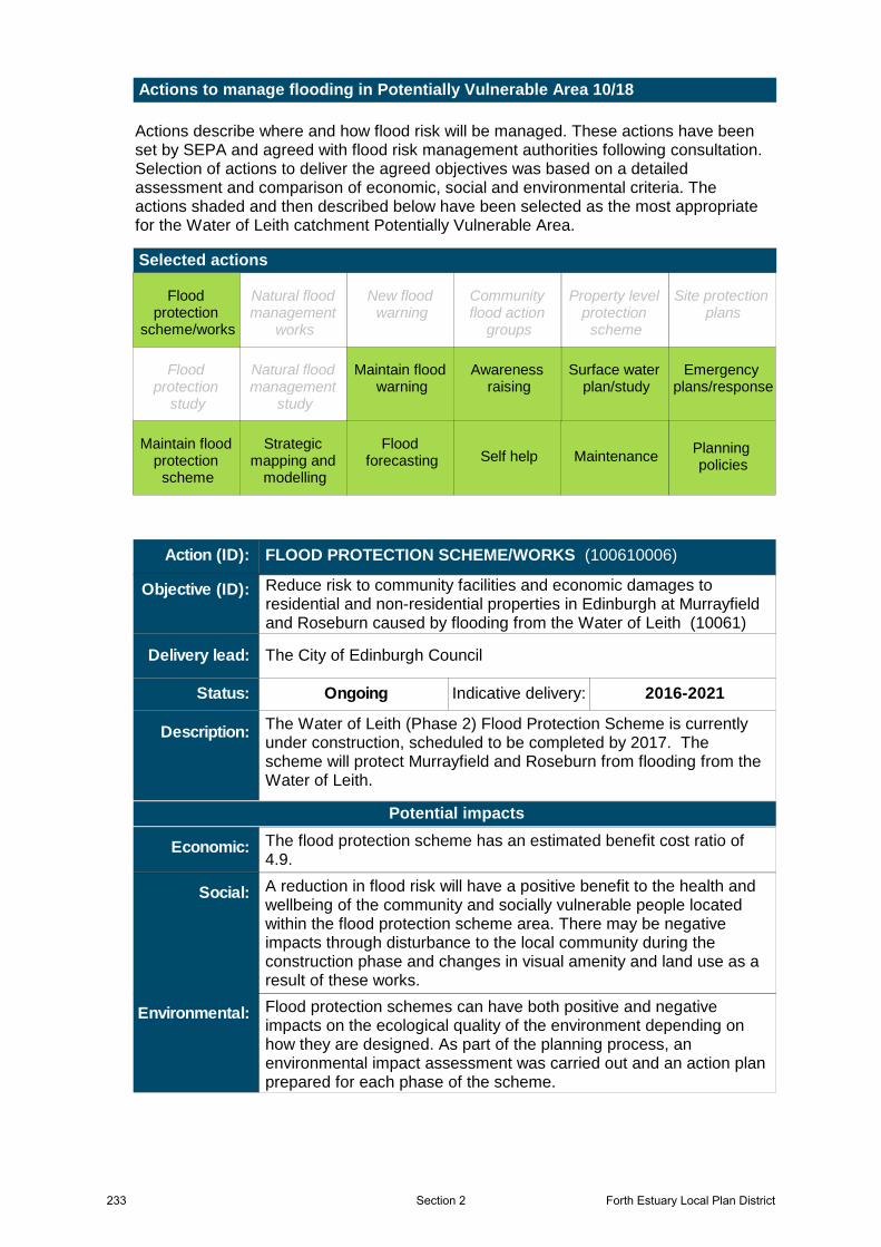
Actions describe where and how flood risk will be managed. These actions have been set by SEPA and agreed with flood risk management authorities following consultation. Selection of actions to deliver the agreed objectives was based on a detailed assessment and comparison of economic, social and environmental criteria. The actions shaded and then described below have been selected as the most appropriate for the Water of Leith catchment Potentially Vulnerable Area.
Selected actions
Actions to manage flooding in Potentially Vulnerable Area 10/18
Maintain flood warning
Site protection plans
MaintenanceSelf helpMaintain flood
protection scheme
Strategic mapping and
modelling
Flood forecasting
Emergency plans/response
Community flood action
groups
Awareness raising
Planning policies
Surface water plan/study
New flood warning
Property level protection
scheme
Natural flood management
works
Natural flood management
study
Flood protection
scheme/works
Flood protection
study
Flood protection
scheme/works
Surface water plan/study
Planning policies
Awareness raising
Emergency plans/response
Flood forecasting
Strategic mapping and
modelling
Maintain flood protection
scheme
Self help Maintenance
Maintain flood warning
The Water of Leith (Phase 2) Flood Protection Scheme is currently under construction, scheduled to be completed by 2017. The scheme will protect Murrayfield and Roseburn from flooding from the Water of Leith.
The City of Edinburgh Council
Ongoing Indicative delivery: 2016-2021
Action (ID): FLOOD PROTECTION SCHEME/WORKS (100610006)
Description:
Objective (ID):
Delivery lead:
Status:
Reduce risk to community facilities and economic damages to residential and non-residential properties in Edinburgh at Murrayfield and Roseburn caused by flooding from the Water of Leith (10061)
A reduction in flood risk will have a positive benefit to the health and wellbeing of the community and socially vulnerable people located within the flood protection scheme area. There may be negative impacts through disturbance to the local community during the construction phase and changes in visual amenity and land use as a result of these works.
Flood protection schemes can have both positive and negative impacts on the ecological quality of the environment depending on how they are designed. As part of the planning process, an environmental impact assessment was carried out and an action plan prepared for each phase of the scheme.
The flood protection scheme has an estimated benefit cost ratio of 4.9.
Potential impacts
Economic:
Social:
Environmental:
233 Forth Estuary Local Plan DistrictSection 2

Flood protection works have been proposed for Edinburgh to further reduce flooding from Water of Leith. The proposed works will likely include Coltbridge, Gorgie and Saughton, subject to the availability of funding.
The City of Edinburgh Council
Under development Indicative delivery: 2016-2021
Action (ID): FLOOD PROTECTION SCHEME/WORKS (100620006)
Description:
Objective (ID):
Delivery lead:
Status:
Reduce risk to people from river flooding in Edinburgh (Murrayfield, Gorgie, Saughton, Stenhouse and Longstone) caused by flooding from the Water of Leith (10063)
Reduce risk to community facilities and economic damages to residential and non-residential properties in Edinburgh (Coltbridge, Gorgie and Saughton) from the Water of Leith (10062)
22 of 42 1 of 1
National: Within local authority:Priority:
A reduction in flood risk would have a positive benefit to the health and wellbeing of the community and socially vulnerable people located within the area. In addition there is one educational building which has been identified as potentially benefitting from this action. There may be negative impacts through disturbance to the local community during the construction phase.
Flood protection works can have both positive and negative impacts on the ecological quality of the environment depending on how they are designed. The proposed flood protection works are located on parts of the Water of Leith (water body ID 3700). The physical condition of this river has been identified by SEPA to be at less than good status. Opportunities to improve the condition of the river should be considered by coordinating with river basin management planning.
The proposed works may benefit 75 residential properties at risk of flooding in this location, with estimated damages avoided of £22.9 million. The flood protection works have an estimated benefit cost ratio of 2.53 (Coltbridge); 0.98 (Gorgie); 2.45 (Saughton).
Potential impacts
Economic:
Social:
Environmental:
The area must be covered by a surface water management plan or plans that set objectives for the management of surface water flood risk and identify the most sustainable actions to achieve the objectives.
The City of Edinburgh Council, Midlothian Council, East Lothian Council
Not started Indicative delivery: 2016-2021
Action (ID): SURFACE WATER PLAN/STUDY (100520018)
Description:
Objective (ID):
Delivery lead:
Status:
Reduce economic damages and number of residential properties at risk of surface water flooding in Edinburgh, Musselburgh, Penicuik, Lasswade, Loanhead, Newtongrange and Dalkeith where practical (10052)
Forth Estuary Local Plan District 234Section 2
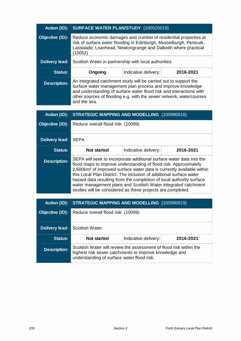
An integrated catchment study will be carried out to support the surface water management plan process and improve knowledge and understanding of surface water flood risk and interactions with other sources of flooding e.g. with the sewer network, watercourses and the sea.
Scottish Water in partnership with local authorities
Ongoing Indicative delivery: 2016-2021
Action (ID): SURFACE WATER PLAN/STUDY (100520019)
Description:
Objective (ID):
Delivery lead:
Status:
Reduce economic damages and number of residential properties at risk of surface water flooding in Edinburgh, Musselburgh, Penicuik, Lasswade, Loanhead, Newtongrange and Dalkeith where practical (10052)
SEPA will seek to incorporate additional surface water data into the flood maps to improve understanding of flood risk. Approximately 2,600km² of improved surface water data is currently available within this Local Plan District. The inclusion of additional surface water hazard data resulting from the completion of local authority surface water management plans and Scottish Water integrated catchment studies will be considered as these projects are completed.
SEPA
Not started Indicative delivery: 2016-2021
Action (ID): STRATEGIC MAPPING AND MODELLING (100990016)
Description:
Objective (ID):
Delivery lead:
Status:
Reduce overall flood risk (10099)
Scottish Water will review the assessment of flood risk within the highest risk sewer catchments to improve knowledge and understanding of surface water flood risk.
Scottish Water
Not started Indicative delivery: 2016-2021
Action (ID): STRATEGIC MAPPING AND MODELLING (100990019)
Description:
Objective (ID):
Delivery lead:
Status:
Reduce overall flood risk (10099)
235 Forth Estuary Local Plan DistrictSection 2
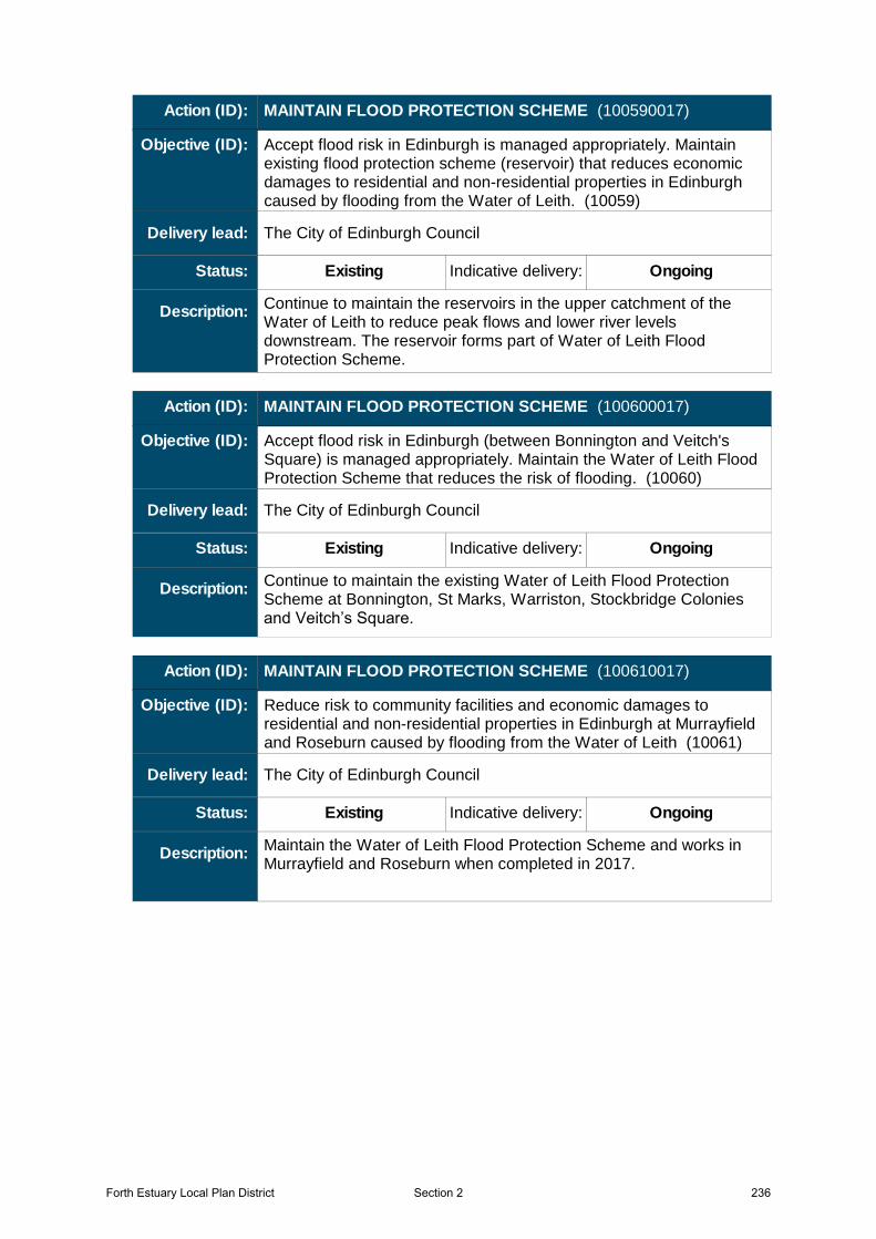
Continue to maintain the reservoirs in the upper catchment of the Water of Leith to reduce peak flows and lower river levels downstream. The reservoir forms part of Water of Leith Flood Protection Scheme.
The City of Edinburgh Council
Existing Indicative delivery: Ongoing
Action (ID): MAINTAIN FLOOD PROTECTION SCHEME (100590017)
Description:
Objective (ID):
Delivery lead:
Status:
Accept flood risk in Edinburgh is managed appropriately. Maintain existing flood protection scheme (reservoir) that reduces economic damages to residential and non-residential properties in Edinburgh caused by flooding from the Water of Leith. (10059)
Continue to maintain the existing Water of Leith Flood Protection Scheme at Bonnington, St Marks, Warriston, Stockbridge Colonies and Veitch’s Square.
The City of Edinburgh Council
Existing Indicative delivery: Ongoing
Action (ID): MAINTAIN FLOOD PROTECTION SCHEME (100600017)
Description:
Objective (ID):
Delivery lead:
Status:
Accept flood risk in Edinburgh (between Bonnington and Veitch's Square) is managed appropriately. Maintain the Water of Leith Flood Protection Scheme that reduces the risk of flooding. (10060)
Maintain the Water of Leith Flood Protection Scheme and works in Murrayfield and Roseburn when completed in 2017.
The City of Edinburgh Council
Existing Indicative delivery: Ongoing
Action (ID): MAINTAIN FLOOD PROTECTION SCHEME (100610017)
Description:
Objective (ID):
Delivery lead:
Status:
Reduce risk to community facilities and economic damages to residential and non-residential properties in Edinburgh at Murrayfield and Roseburn caused by flooding from the Water of Leith (10061)
Forth Estuary Local Plan District 236Section 2
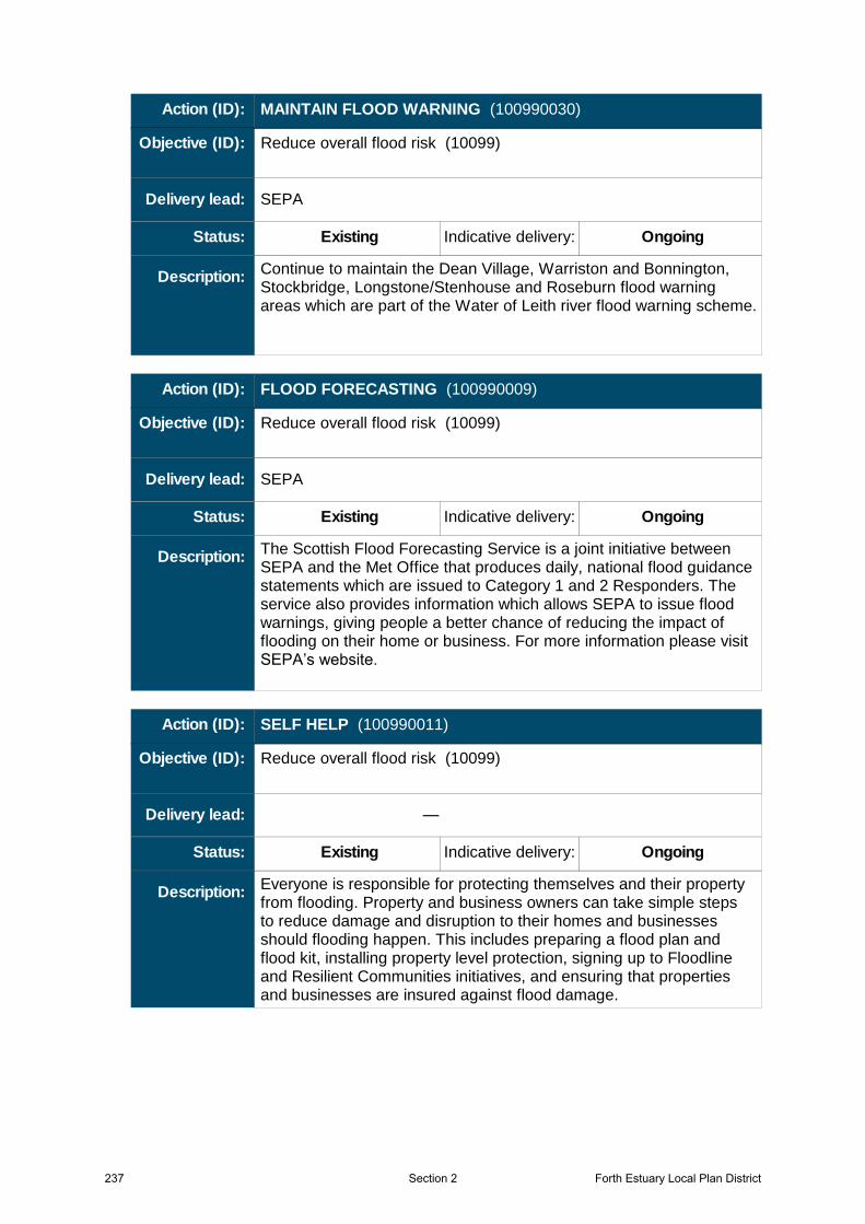
Continue to maintain the Dean Village, Warriston and Bonnington, Stockbridge, Longstone/Stenhouse and Roseburn flood warning areas which are part of the Water of Leith river flood warning scheme.
SEPA
Existing Indicative delivery: Ongoing
Action (ID): MAINTAIN FLOOD WARNING (100990030)
Description:
Objective (ID):
Delivery lead:
Status:
Reduce overall flood risk (10099)
The Scottish Flood Forecasting Service is a joint initiative between SEPA and the Met Office that produces daily, national flood guidance statements which are issued to Category 1 and 2 Responders. The service also provides information which allows SEPA to issue flood warnings, giving people a better chance of reducing the impact of flooding on their home or business. For more information please visit SEPA’s website.
SEPA
Existing Indicative delivery: Ongoing
Action (ID): FLOOD FORECASTING (100990009)
Description:
Objective (ID):
Delivery lead:
Status:
Reduce overall flood risk (10099)
Everyone is responsible for protecting themselves and their property from flooding. Property and business owners can take simple steps to reduce damage and disruption to their homes and businesses should flooding happen. This includes preparing a flood plan and flood kit, installing property level protection, signing up to Floodline and Resilient Communities initiatives, and ensuring that properties and businesses are insured against flood damage.
—
Existing Indicative delivery: Ongoing
Action (ID): SELF HELP (100990011)
Description:
Objective (ID):
Delivery lead:
Status:
Reduce overall flood risk (10099)
237 Forth Estuary Local Plan DistrictSection 2

SEPA and the responsible authorities have a duty to raise public awareness of flood risk. Improved awareness of flood risk and actions that prepare individuals, homes and businesses for flooding can reduce the overall impact.SEPA will undertake flood risk education and awareness raising activities. In addition, SEPA will engage with community resilience groups and participate in property level protection events delivered by the Scottish Flood Forum where possible.Local authorities will be undertaking additional awareness raising activities. Further details will be set out in the Local FRM Plan.
Responsible authorities
Existing Indicative delivery: Ongoing
Action (ID): AWARENESS RAISING (100990013)
Description:
Objective (ID):
Delivery lead:
Status:
Reduce overall flood risk (10099)
Local authorities have a duty to assess watercourses and carry out clearance and repair works where such works would substantially reduce flood risk. They produce schedules of clearance and repair works and make these available for public inspection. Scottish Water undertake inspection and repair on the public sewer network. Asset owners and riparian landowners are responsible for the maintenance and management of their own assets including those which help to reduce flood risk.
Local authorities, asset / land managers
Existing Indicative delivery: Ongoing
Action (ID): MAINTENANCE (100990007)
Description:
Objective (ID):
Delivery lead:
Status:
Reduce overall flood risk (10099)
Forth Estuary Local Plan District 238Section 2
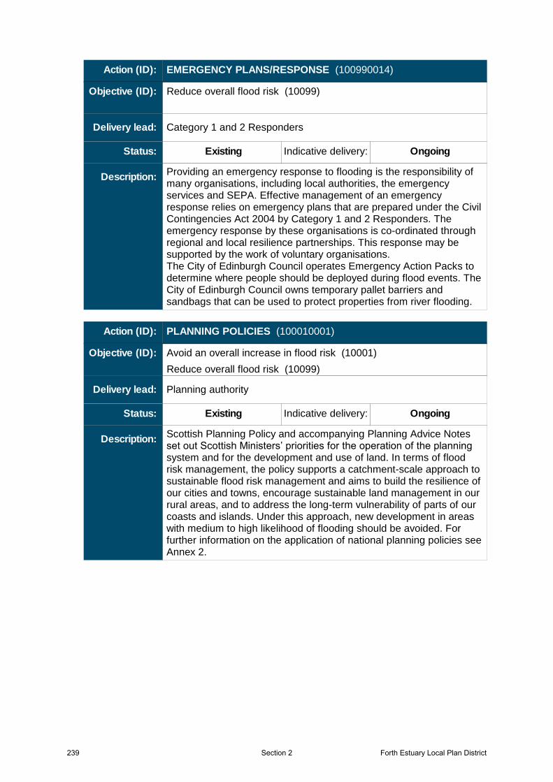
Providing an emergency response to flooding is the responsibility of many organisations, including local authorities, the emergency services and SEPA. Effective management of an emergency response relies on emergency plans that are prepared under the Civil Contingencies Act 2004 by Category 1 and 2 Responders. The emergency response by these organisations is co-ordinated through regional and local resilience partnerships. This response may be supported by the work of voluntary organisations.The City of Edinburgh Council operates Emergency Action Packs to determine where people should be deployed during flood events. The City of Edinburgh Council owns temporary pallet barriers and sandbags that can be used to protect properties from river flooding.
Category 1 and 2 Responders
Existing Indicative delivery: Ongoing
Action (ID): EMERGENCY PLANS/RESPONSE (100990014)
Description:
Objective (ID):
Delivery lead:
Status:
Reduce overall flood risk (10099)
Scottish Planning Policy and accompanying Planning Advice Notes set out Scottish Ministers’ priorities for the operation of the planning system and for the development and use of land. In terms of flood risk management, the policy supports a catchment-scale approach to sustainable flood risk management and aims to build the resilience of our cities and towns, encourage sustainable land management in our rural areas, and to address the long-term vulnerability of parts of our coasts and islands. Under this approach, new development in areas with medium to high likelihood of flooding should be avoided. For further information on the application of national planning policies see Annex 2.
Planning authority
Existing Indicative delivery: Ongoing
Action (ID): PLANNING POLICIES (100010001)
Description:
Objective (ID):
Delivery lead:
Status:
Avoid an overall increase in flood risk (10001)
Reduce overall flood risk (10099)
239 Forth Estuary Local Plan DistrictSection 2