Embed Size (px)
Citation preview

1
1
Water Framework Directive Fish Stock Survey of Lough Barra,
July 2014
Fiona L. Kelly, Lynda Connor, Emma Morrissey, John Coyne, Rory Feeney, Ronan Matson and Kieran
Rocks
Inland Fisheries Ireland, 3044 Lake Drive, Citywest Business Campus, Dublin 24.
CITATION: Kelly, F.L., Connor, L., Morrissey, E., Coyne, J., Feeney, R., Matson, R. and Rocks, K. (2015c) Water
Framework Directive Fish Stock Survey of Lough Barra, July 2014. Inland Fisheries Ireland, 3044 Lake Drive,
Citywest Business Campus, Dublin 24.
Cover photo: Netting survey on Lough Brin © Inland Fisheries Ireland
© Inland Fisheries Ireland 2015
2
ACKNOWLEDGEMENTS
The authors wish to gratefully acknowledge the help and co-operation of the regional director Dr. Milton
Matthews and the staff from IFI, Ballyshannon. The authors would also like to gratefully acknowledge
the help and cooperation of all their colleagues in IFI, Swords.
The authors would also like to acknowledge the funding provided for the project from the Department of
Communications, Energy and Natural Resources for 2014.
The authors would also like to thank National Parks and Wildlife service (NPWS) and their staff in
Glenveagh National Park for facilitating access and providing assistance during the survey.
We would also like to thank Ms. Ruth Hanniffy for the photographs.
The report includes Ordnance Survey Ireland data reproduced under OSi Copyright Permit No. MP
007508.
Unauthorised reproduction infringes Ordnance Survey Ireland and Government of Ireland copyright.
© Ordnance Survey Ireland, 2011.
3
1.1 Introduction
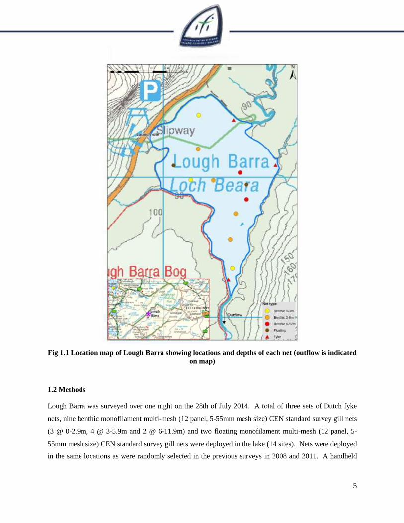
Lough Barra is situated in the upper part of the Gweebarra River catchment close to the south-western
perimeter of Glenveagh National Park in Co. Donegal. The lake is situated at an altitude of 88.6m above
sea level. It has a surface area of 63ha, a mean depth of 4.4m and a maximum depth of 11.6m (Fig. 1.1).
The lake is categorised as typology class 4 (as designated by the EPA for the Water Framework
Directive), i.e. deep (>4m), greater than 50ha and low alkalinity (<20mg/l CaCO3). The lake has been
classed as 2a (i.e. expected to meet good status by 2015) in the WFD Characterisation report (EPA,
2005).
The geology of the area is predominantly granite, felsite and other intrusive rocks rich in silica. Lough
Barra Bog SPA is situated immediately to the south-west of the lake (Fig. 1.1) and part of the bog is a
nature reserve (NPWS, 2005). Lough Barra itself forms part of the Cloghernagore Bog and Glenveagh
National Park Special Area of Conservation. This is a particularly large SAC located in north-west
Donegal. It contains many different habitats ranging from exposed rock and scree mountains to blanket
bogs, lakes and rivers.
The brown trout in the lake are small and an occasional salmon and sea trout reach the lake (O’ Reilly,
1998). The lake was previously surveyed in August 2005 by Inland Fisheries Ireland (previously the
Central Fisheries Board and the Northern Regional Fisheries Board) as part of the NS Share “Fish in
Lakes” project (Kelly et al., 2007). The lake was then surveyed in 2008 and 2011 as part of the Water
Framework Directive surveillance monitoring programme (Kelly et al., 2009 and Kelly et al., 2012a).
Brown trout, salmon and eels were recorded in all three surveys.
This report summarises the results of the 2014 fish stock survey carried out on the lake, as part of the
Water Framework Directive surveillance monitoring programme.
4
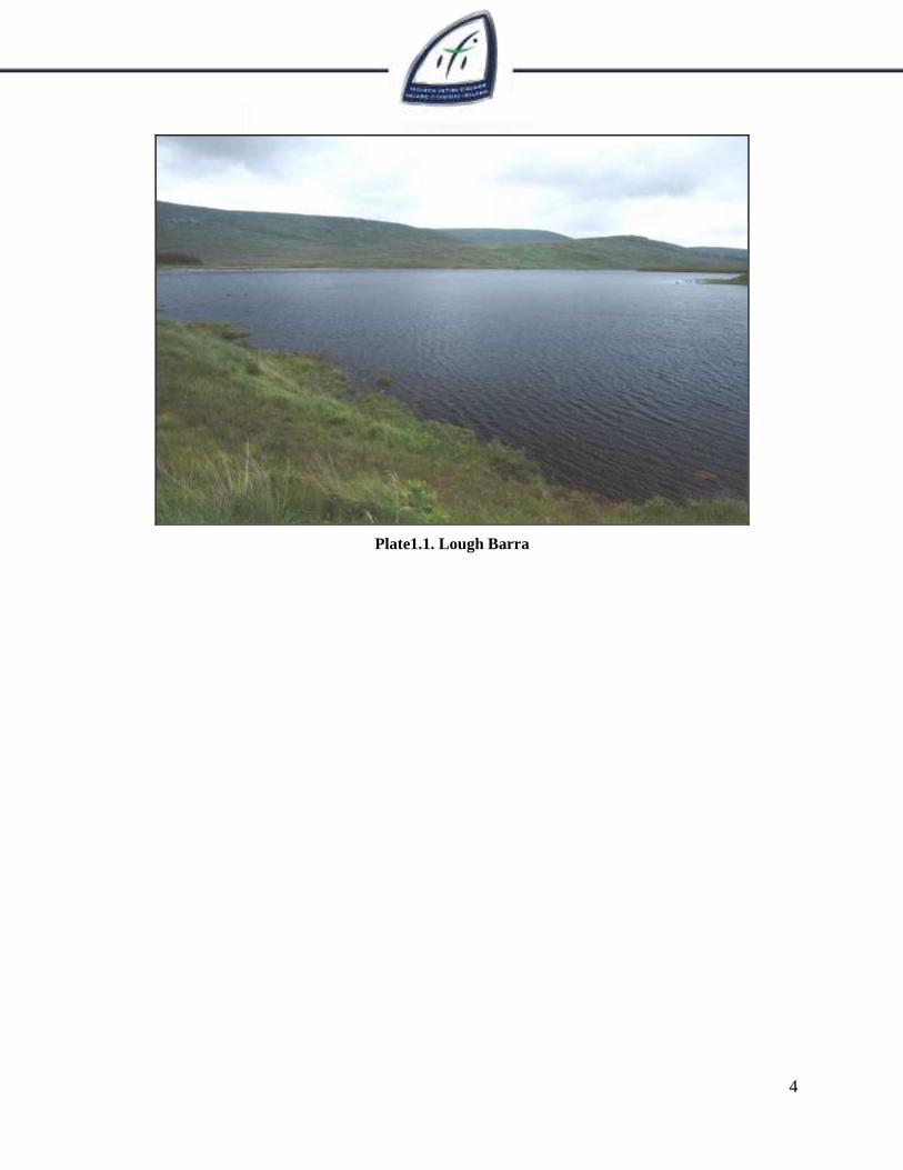
Plate1.1. Lough Barra
5
Fig 1.1 Location map of Lough Barra showing locations and depths of each net (outflow is indicated
on map)
1.2 Methods
Lough Barra was surveyed over one night on the 28th of July 2014. A total of three sets of Dutch fyke
nets, nine benthic monofilament multi-mesh (12 panel, 5-55mm mesh size) CEN standard survey gill nets
(3 @ 0-2.9m, 4 @ 3-5.9m and 2 @ 6-11.9m) and two floating monofilament multi-mesh (12 panel, 5-
55mm mesh size) CEN standard survey gill nets were deployed in the lake (14 sites). Nets were deployed
in the same locations as were randomly selected in the previous surveys in 2008 and 2011. A handheld
6
GPS was used to mark the precise location of each net. The angle of each gill net in relation to the
shoreline was randomised.
All fish were measured and weighed on site and scales were removed from all brown trout and salmon.
Live fish were returned to the water whenever possible (i.e. when the likelihood of their survival was
considered to be good). Samples of fish were retained for further analysis.
1.3 Results
1.3.1 Species Richness
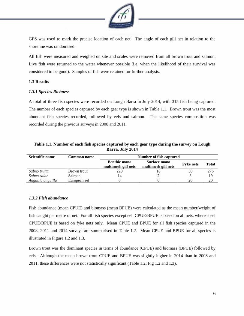
A total of three fish species were recorded on Lough Barra in July 2014, with 315 fish being captured.
The number of each species captured by each gear type is shown in Table 1.1. Brown trout was the most
abundant fish species recorded, followed by eels and salmon. The same species composition was
recorded during the previous surveys in 2008 and 2011.
Table 1.1. Number of each fish species captured by each gear type during the survey on Lough
Barra, July 2014
Scientific name Common name Number of fish captured
Benthic mono
multimesh gill nets
Surface mono
multimesh gill nets Fyke nets Total
Salmo trutta Brown trout 228 18 30 276
Salmo salar Salmon 14 2 3 19
Anguilla anguilla European eel 0 0 20 20
1.3.2 Fish abundance
Fish abundance (mean CPUE) and biomass (mean BPUE) were calculated as the mean number/weight of
fish caught per metre of net. For all fish species except eel, CPUE/BPUE is based on all nets, whereas eel
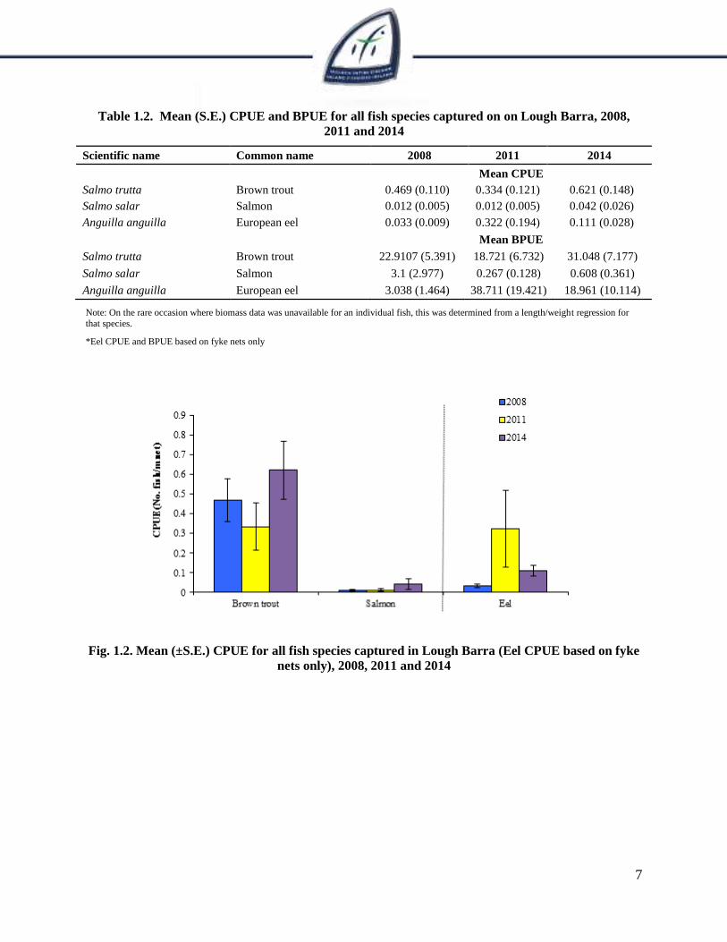
CPUE/BPUE is based on fyke nets only. Mean CPUE and BPUE for all fish species captured in the
2008, 2011 and 2014 surveys are summarised in Table 1.2. Mean CPUE and BPUE for all species is
illustrated in Figure 1.2 and 1.3.
Brown trout was the dominant species in terms of abundance (CPUE) and biomass (BPUE) followed by
eels. Although the mean brown trout CPUE and BPUE was slightly higher in 2014 than in 2008 and
2011, these differences were not statistically significant (Table 1.2; Fig 1.2 and 1.3).
7
Table 1.2. Mean (S.E.) CPUE and BPUE for all fish species captured on on Lough Barra, 2008,
2011 and 2014
Scientific name Common name 2008 2011 2014
Mean CPUE
Salmo trutta Brown trout 0.469 (0.110) 0.334 (0.121) 0.621 (0.148)
Salmo salar Salmon 0.012 (0.005) 0.012 (0.005) 0.042 (0.026)
Anguilla anguilla European eel 0.033 (0.009) 0.322 (0.194) 0.111 (0.028)
Mean BPUE
Salmo trutta Brown trout 22.9107 (5.391) 18.721 (6.732) 31.048 (7.177)
Salmo salar Salmon 3.1 (2.977) 0.267 (0.128) 0.608 (0.361)
Anguilla anguilla European eel 3.038 (1.464) 38.711 (19.421) 18.961 (10.114)
Note: On the rare occasion where biomass data was unavailable for an individual fish, this was determined from a length/weight regression for
that species.
*Eel CPUE and BPUE based on fyke nets only
Fig. 1.2. Mean (±S.E.) CPUE for all fish species captured in Lough Barra (Eel CPUE based on fyke
nets only), 2008, 2011 and 2014
8
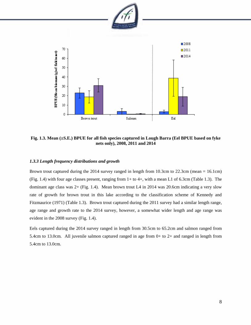
Fig. 1.3. Mean (±S.E.) BPUE for all fish species captured in Lough Barra (Eel BPUE based on fyke
nets only), 2008, 2011 and 2014
1.3.3 Length frequency distributions and growth
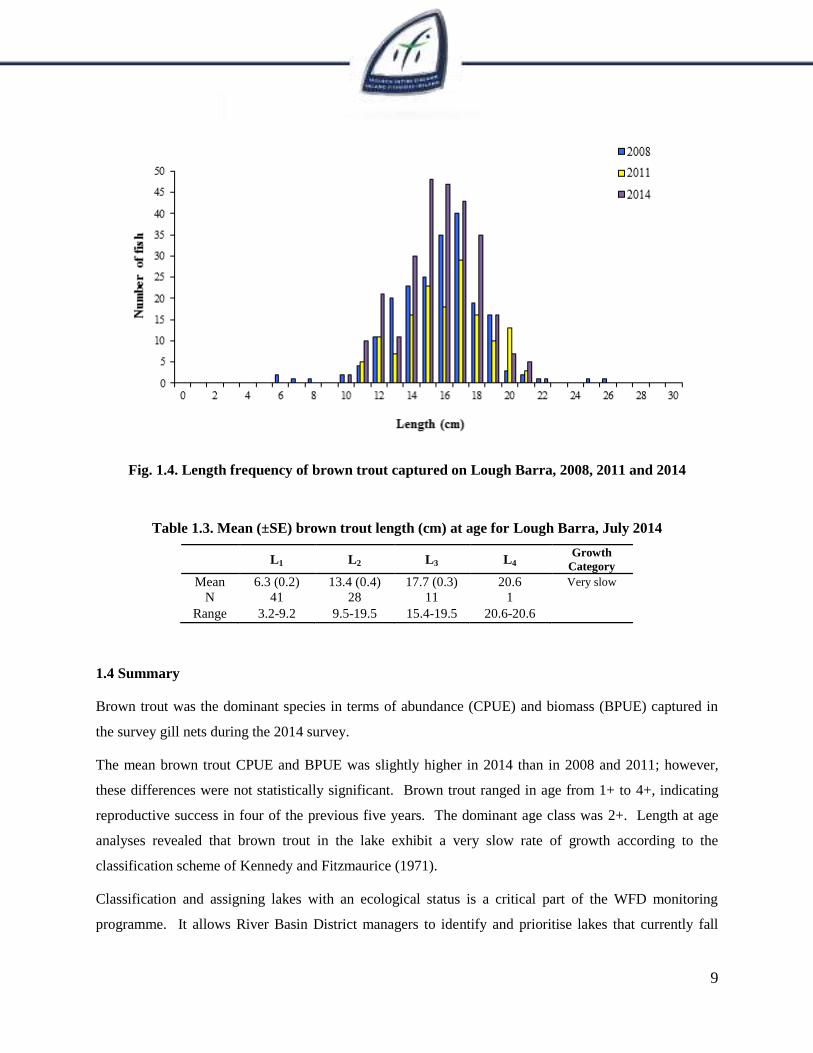
Brown trout captured during the 2014 survey ranged in length from 10.3cm to 22.3cm (mean = 16.1cm)
(Fig. 1.4) with four age classes present, ranging from 1+ to 4+, with a mean L1 of 6.3cm (Table 1.3). The
dominant age class was 2+ (Fig. 1.4). Mean brown trout L4 in 2014 was 20.6cm indicating a very slow
rate of growth for brown trout in this lake according to the classification scheme of Kennedy and
Fitzmaurice (1971) (Table 1.3). Brown trout captured during the 2011 survey had a similar length range,
age range and growth rate to the 2014 survey, however, a somewhat wider length and age range was
evident in the 2008 survey (Fig. 1.4).
Eels captured during the 2014 survey ranged in length from 30.5cm to 65.2cm and salmon ranged from
5.4cm to 13.0cm. All juvenile salmon captured ranged in age from 0+ to 2+ and ranged in length from
5.4cm to 13.0cm.
9
Fig. 1.4. Length frequency of brown trout captured on Lough Barra, 2008, 2011 and 2014
Table 1.3. Mean (±SE) brown trout length (cm) at age for Lough Barra, July 2014
L1 L2 L3 L4 Growth
Category
Mean 6.3 (0.2) 13.4 (0.4) 17.7 (0.3) 20.6 Very slow
N 41 28 11 1
Range 3.2-9.2 9.5-19.5 15.4-19.5 20.6-20.6
1.4 Summary
Brown trout was the dominant species in terms of abundance (CPUE) and biomass (BPUE) captured in
the survey gill nets during the 2014 survey.
The mean brown trout CPUE and BPUE was slightly higher in 2014 than in 2008 and 2011; however,
these differences were not statistically significant. Brown trout ranged in age from 1+ to 4+, indicating
reproductive success in four of the previous five years. The dominant age class was 2+. Length at age
analyses revealed that brown trout in the lake exhibit a very slow rate of growth according to the
classification scheme of Kennedy and Fitzmaurice (1971).
Classification and assigning lakes with an ecological status is a critical part of the WFD monitoring
programme. It allows River Basin District managers to identify and prioritise lakes that currently fall
10
short of the minimum “Good Ecological Status” that is required by 2015 if Ireland is not to incur
penalties.
A multimetric fish ecological classification tool (Fish in Lakes – ‘FIL’) was developed for the island of
Ireland (Ecoregion 17) using IFI and Agri-Food and Biosciences Institute Northern Ireland (AFBINI) data
generated during the NSSHARE Fish in Lakes project (Kelly et al., 2008). This tool was further
developed during 2010 (FIL2) in order to make it fully WFD compliant, including producing EQR values
for each lake and associated confidence in classification (Kelly et al., 2012b). Using the FIL2
classification tool, Lough Barra has been assigned an ecological status of Good for 2005, 2008 and 2014
and was High in 2011 based on the fish populations present.
In the 2010 to 2012 surveillance monitoring reporting period, the EPA assigned Lough Barra an overall
draft ecological status of High, based on all monitored physico-chemical and biological elements,
including fish.
1.5 References
EPA (2005) The Characterisation and Analysis of Ireland’s River Basin Districts in accordance with
section 7 (2&3) of the European Communities (Water Policy) Regulations 2003 (S.I. No. 722 of
2003). National Summary Report (Ireland). 166pp.
Kelly, F.L., Connor, L., and Champ, W.S.T. (2007) A Survey of the Fish Populations in 46 lakes in the
Northern Regional Fisheries Board, June to September 2005 and 2006. Central Fisheries Board,
unpublished report.
Kelly, F.L., Harrison, A., Connor, L., Allen, M., Rosell, R. and Champ, T. (2008) FISH IN LAKES Task
6.9: Classification tool for Fish in Lakes. FINAL REPORT. Central Fisheries Board, NS Share
project.
Kelly, F.L., Connor, L., Wightman, G., Matson, R. Morrissey, E., O’Callaghan, R., Feeney, R., Hanna, G.
and Rocks, K. (2009) Sampling fish for the Water Framework Directive – Summary report 2008.
Central and Regional Fisheries Boards report.
Kelly, F., Harrison A., Connor, L., Matson, R., Morrissey, E., Wogerbauer, C., Feeney, R., O’Callaghan,
R. and Rocks, K. (2012a) Sampling Fish for the Water Framework Directive – Summary Report
2011. Inland Fisheries Ireland.
11
Kelly, F.L., Harrison, A.J., Allen, M., Connor, L. and Rosell, R. (2012b) Development and application of
an ecological classification tool for fish in lakes in Ireland. Ecological Indicators, 18, 608-619.
Kennedy, M. and Fitzmaurice, P. (1971) Growth and Food of Brown Trout Salmo Trutta (L.) in Irish
Waters. Proceedings of the Royal Irish Academy, 71 (B) (18), 269-352.
NPWS (2005) Site Synopsis, Lough Barra Bog SPA. (www.npws.ie)
NPWS (2005) Site synopsis: Cloghernagore Bog and Glenveagh National Park. Site code: 002047. Site
Synopsis report, National Parks and Wildlife Service.
O’ Reilly, P., (1998) Loughs of Ireland, A Flyfisher’s Guide. UK. Merlin Unwin Books.

12