Embed Size (px)
Citation preview
Thirteenth International Water Technology Conference, IWTC 13 2009, Hurghada, Egypt
839
WATER AND SEDIMENT MANAGEMENT
FOR THE BLUE NILE BASIN
Tarek Mohamed Abdel-Aziz
Nile Research Institute (NRI), National Water Research Center (NWRC) EL-Qanater P.O. Box 13621, Egypt
E-mail: [email protected] ABSTRACT The sediment yield of rivers is often sensitive to changes in catchments land use and human activities. Such an impact is most likely to be demonstrated at a restricted spatial scale, particularly in headwater catchments. In large river basins such as Nile River Basin, there are needs to study, understand, and quantify the impacts of these modifications on the hydrologic regime. In Aswan High Dam Reservoir (AHDR) most of sediment (�95%) comes from Abay and Tekeze Rivers in Ethiopia; which are known as Blue Nile and Atbara Rivers respectively in Sudan during the flood season (July-October). Also, most of water (�71%) comes from Blue Nile and Atbara Rivers; consequently water and sediment management for Abay basin is very essential. Rainfall measurements for 142 rainfall gauge stations in Ethiopia were collected and used to develop contour maps for rainfall and river runoff. Also, measurements of rainfall and soil loss for 7 rainfall gauge stations were collected and used to develop a polynomial equation of second degree between rainfall and soil loss at the whole basin. The developed equation was applied at the mentioned 142 rainfall gauge stations to estimate contour map of soil losses in Ethiopia. Also, contour map of soil loss in Abay basin was produced using the coordinates from a geographical map for this basin. This contour map was used to estimate the volume of average annual soil loss in Abay basin. This volume was estimated; using another method; based on the Revised Universal Soil Loss Equation (RUSLE equation) by carefully determining its various parameters. The estimated volume using the contour map was found close to the estimated one by RUSLE equation. The sediment yield at EL-Diem station; 120 km upstream EL-Roseires Dam (the outlet of Abay Basin) was estimated to define the sediment delivery ratio for this basin. Estimation of volume of soil loss and sediment delivery ratio of Abay basin help in tracing deposited sediment from its source until Aswan High Dam Reservoir. Understanding the phenomena of Blue Nile River and good estimation of average annual soil loss and sediment yield will improve the estimation of sedimentation processes in Aswan High Dam Reservoir. Accordingly, this will give more clear overview for the decision makers in management of water resources and sediment process in the three countries; Ethiopia, Sudan, and Egypt. Keywords: Blue Nile, Sediment yield, Aswan High Dam Reservoir.
Thirteenth International Water Technology Conference, IWTC 13 2009, Hurghada, Egypt 840
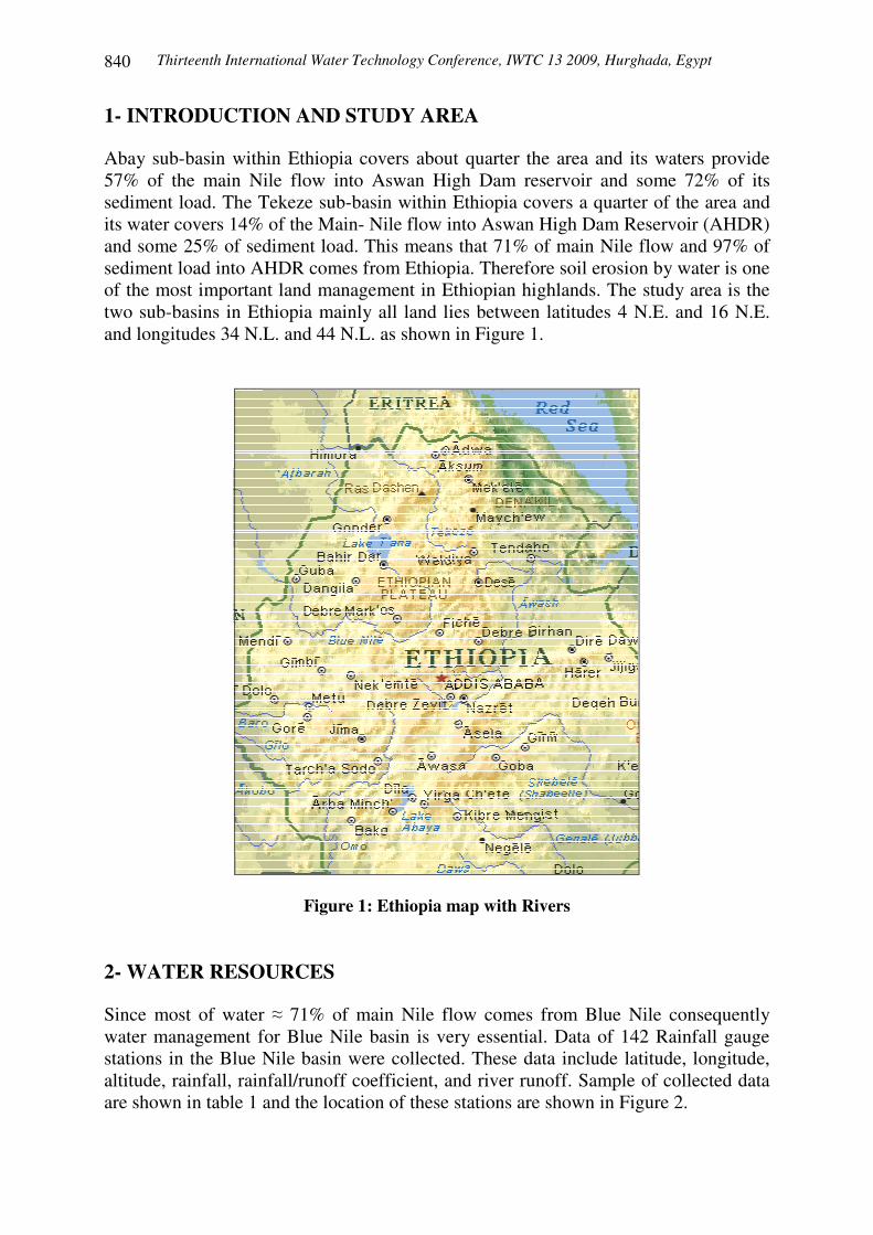
1- INTRODUCTION AND STUDY AREA Abay sub-basin within Ethiopia covers about quarter the area and its waters provide 57% of the main Nile flow into Aswan High Dam reservoir and some 72% of its sediment load. The Tekeze sub-basin within Ethiopia covers a quarter of the area and its water covers 14% of the Main- Nile flow into Aswan High Dam Reservoir (AHDR) and some 25% of sediment load. This means that 71% of main Nile flow and 97% of sediment load into AHDR comes from Ethiopia. Therefore soil erosion by water is one of the most important land management in Ethiopian highlands. The study area is the two sub-basins in Ethiopia mainly all land lies between latitudes 4 N.E. and 16 N.E. and longitudes 34 N.L. and 44 N.L. as shown in Figure 1.
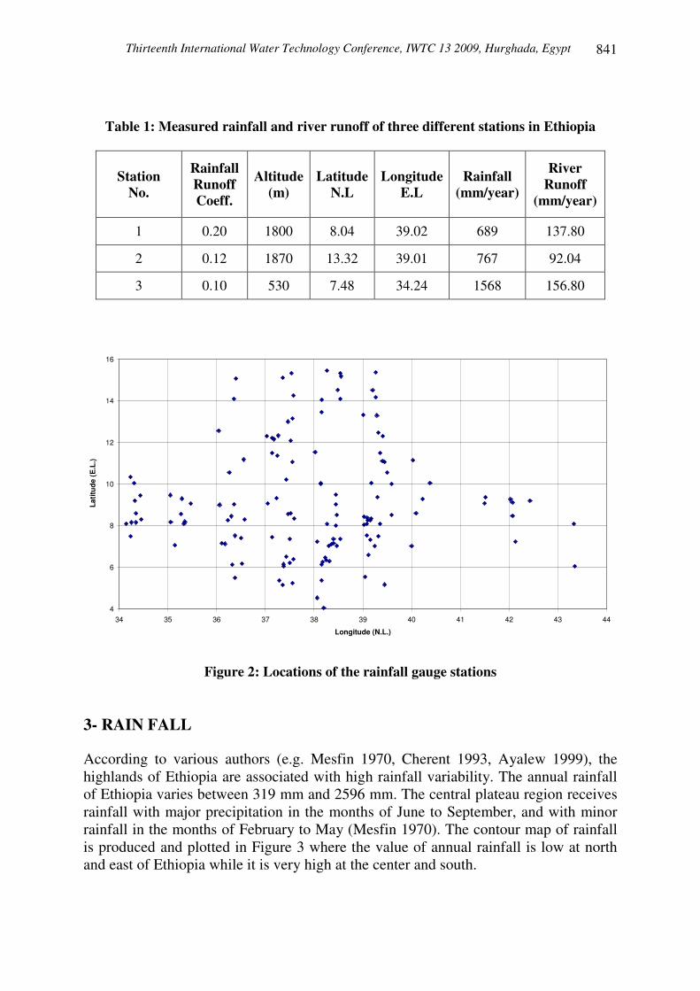
Figure 1: Ethiopia map with Rivers 2- WATER RESOURCES Since most of water � 71% of main Nile flow comes from Blue Nile consequently water management for Blue Nile basin is very essential. Data of 142 Rainfall gauge stations in the Blue Nile basin were collected. These data include latitude, longitude, altitude, rainfall, rainfall/runoff coefficient, and river runoff. Sample of collected data are shown in table 1 and the location of these stations are shown in Figure 2.
Thirteenth International Water Technology Conference, IWTC 13 2009, Hurghada, Egypt
841
Table 1: Measured rainfall and river runoff of three different stations in Ethiopia
Station No.
Rainfall Runoff Coeff.
Altitude (m)
Latitude N.L
Longitude E.L
Rainfall (mm/year)
River Runoff
(mm/year)
1 0.20 1800 8.04 39.02 689 137.80
2 0.12 1870 13.32 39.01 767 92.04
3 0.10 530 7.48 34.24 1568 156.80
4
6
8
10
12
14
16
34 35 36 37 38 39 40 41 42 43 44
Longitude (N.L.)
Latit
ude
(E.L
.)
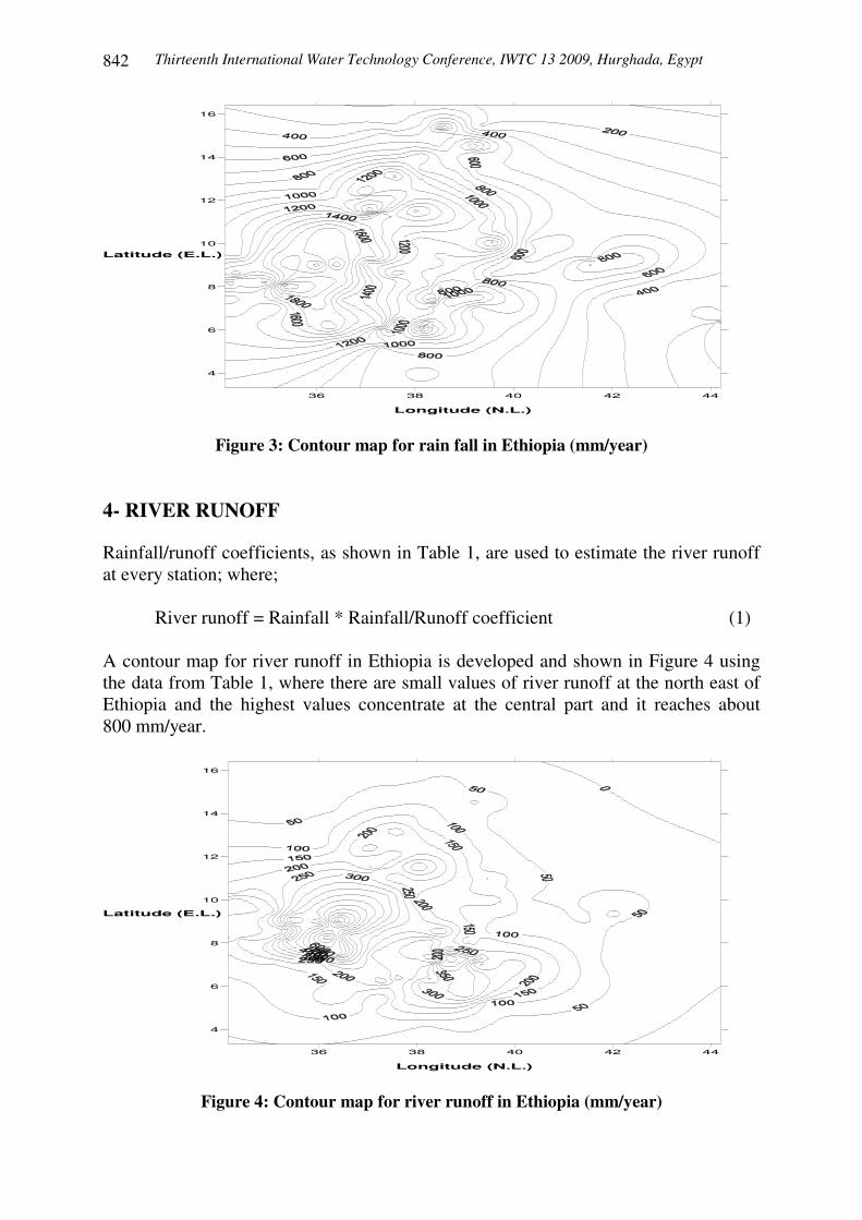
Figure 2: Locations of the rainfall gauge stations 3- RAIN FALL According to various authors (e.g. Mesfin 1970, Cherent 1993, Ayalew 1999), the highlands of Ethiopia are associated with high rainfall variability. The annual rainfall of Ethiopia varies between 319 mm and 2596 mm. The central plateau region receives rainfall with major precipitation in the months of June to September, and with minor rainfall in the months of February to May (Mesfin 1970). The contour map of rainfall is produced and plotted in Figure 3 where the value of annual rainfall is low at north and east of Ethiopia while it is very high at the center and south.
Thirteenth International Water Technology Conference, IWTC 13 2009, Hurghada, Egypt 842
Longitude (N.L.)
Latitude (E.L.)
36 38 40 42 44
4
6
8
10
12
14
16
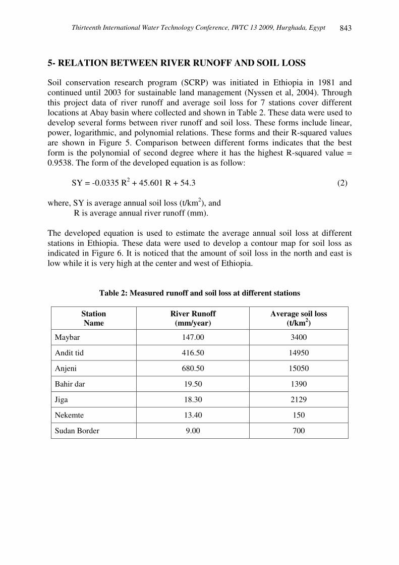
Figure 3: Contour map for rain fall in Ethiopia (mm/year) 4- RIVER RUNOFF Rainfall/runoff coefficients, as shown in Table 1, are used to estimate the river runoff at every station; where; River runoff = Rainfall * Rainfall/Runoff coefficient (1) A contour map for river runoff in Ethiopia is developed and shown in Figure 4 using the data from Table 1, where there are small values of river runoff at the north east of Ethiopia and the highest values concentrate at the central part and it reaches about 800 mm/year.
Longitude (N.L.)
Latitude (E.L.)
36 38 40 42 44
4
6
8
10
12
14
16
Figure 4: Contour map for river runoff in Ethiopia (mm/year)
Thirteenth International Water Technology Conference, IWTC 13 2009, Hurghada, Egypt
843
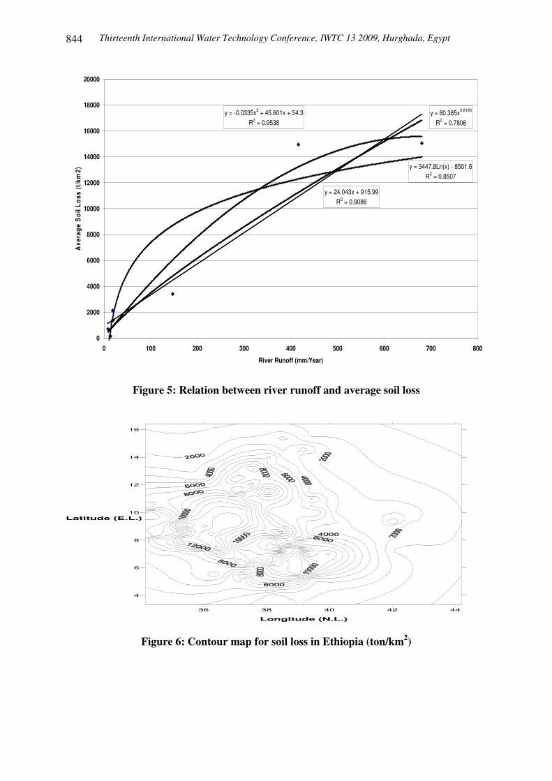
5- RELATION BETWEEN RIVER RUNOFF AND SOIL LOSS Soil conservation research program (SCRP) was initiated in Ethiopia in 1981 and continued until 2003 for sustainable land management (Nyssen et al, 2004). Through this project data of river runoff and average soil loss for 7 stations cover different locations at Abay basin where collected and shown in Table 2. These data were used to develop several forms between river runoff and soil loss. These forms include linear, power, logarithmic, and polynomial relations. These forms and their R-squared values are shown in Figure 5. Comparison between different forms indicates that the best form is the polynomial of second degree where it has the highest R-squared value = 0.9538. The form of the developed equation is as follow: SY = -0.0335 R2 + 45.601 R + 54.3 (2) where, SY is average annual soil loss (t/km2), and
R is average annual river runoff (mm). The developed equation is used to estimate the average annual soil loss at different stations in Ethiopia. These data were used to develop a contour map for soil loss as indicated in Figure 6. It is noticed that the amount of soil loss in the north and east is low while it is very high at the center and west of Ethiopia.
Table 2: Measured runoff and soil loss at different stations
Station Name
River Runoff (mm/year)
Average soil loss (t/km2)
Maybar 147.00 3400
Andit tid 416.50 14950
Anjeni 680.50 15050
Bahir dar 19.50 1390
Jiga 18.30 2129
Nekemte 13.40 150
Sudan Border 9.00 700
Thirteenth International Water Technology Conference, IWTC 13 2009, Hurghada, Egypt 844
y = 24.043x + 915.99R2 = 0.9086
y = -0.0335x2 + 45.601x + 54.3R2 = 0.9538
y = 3447.8Ln(x) - 8501.6R2 = 0.8507
y = 80.385x0.8193
R2 = 0.7806
0
2000
4000
6000
8000
10000
12000
14000
16000
18000
20000
0 100 200 300 400 500 600 700 800
River Runoff (mm/Year)
Ave
rage
Soi
l Los
s (t
/km
2)
Figure 5: Relation between river runoff and average soil loss
36 38 40 42 44
4
6
8
10
12
14
16
Latitude (E.L.)
Longitude (N.L.)
Figure 6: Contour map for soil loss in Ethiopia (ton/km2)
Thirteenth International Water Technology Conference, IWTC 13 2009, Hurghada, Egypt
845
6- ESTIMATION OF VOLUME OF SOIL LOSS FROM CONTOUR MAP IN ABAY BASIN
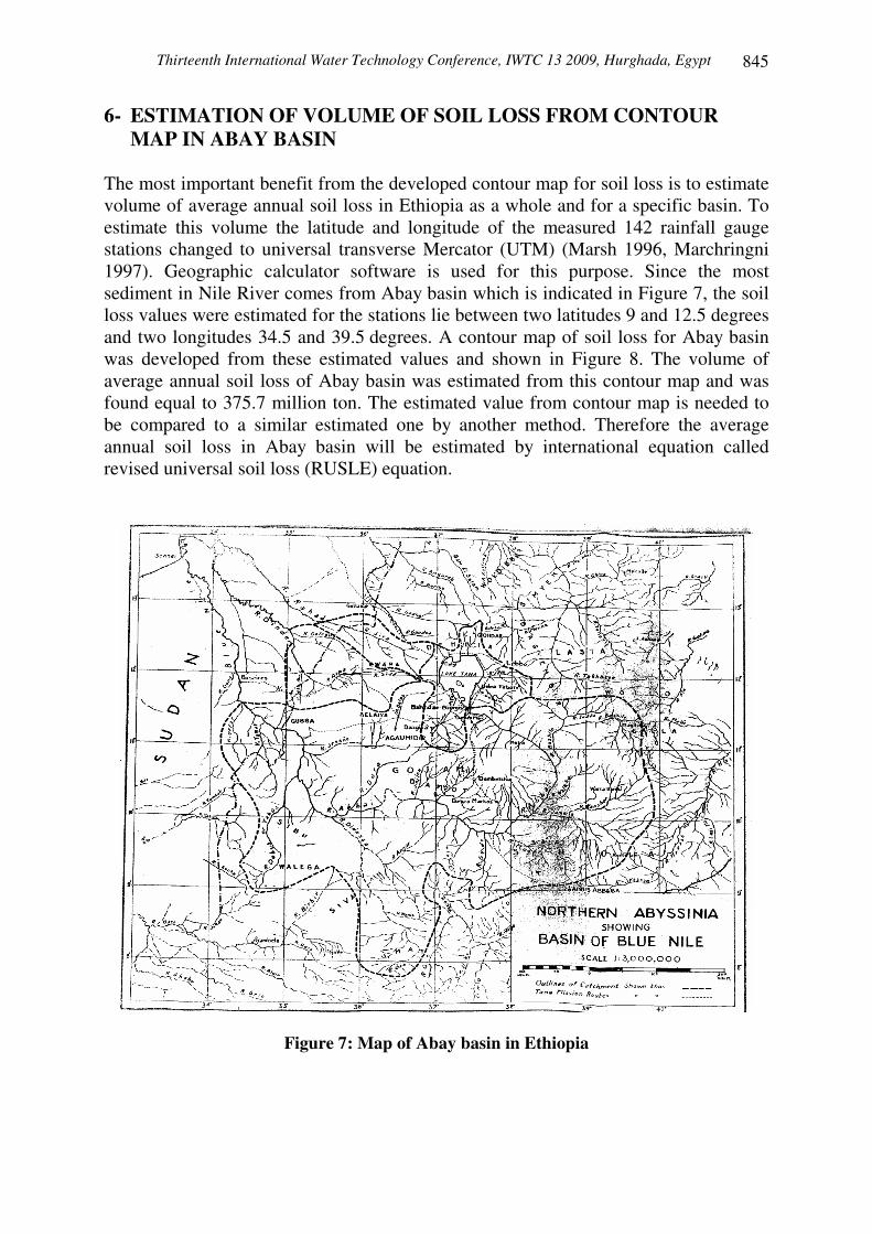
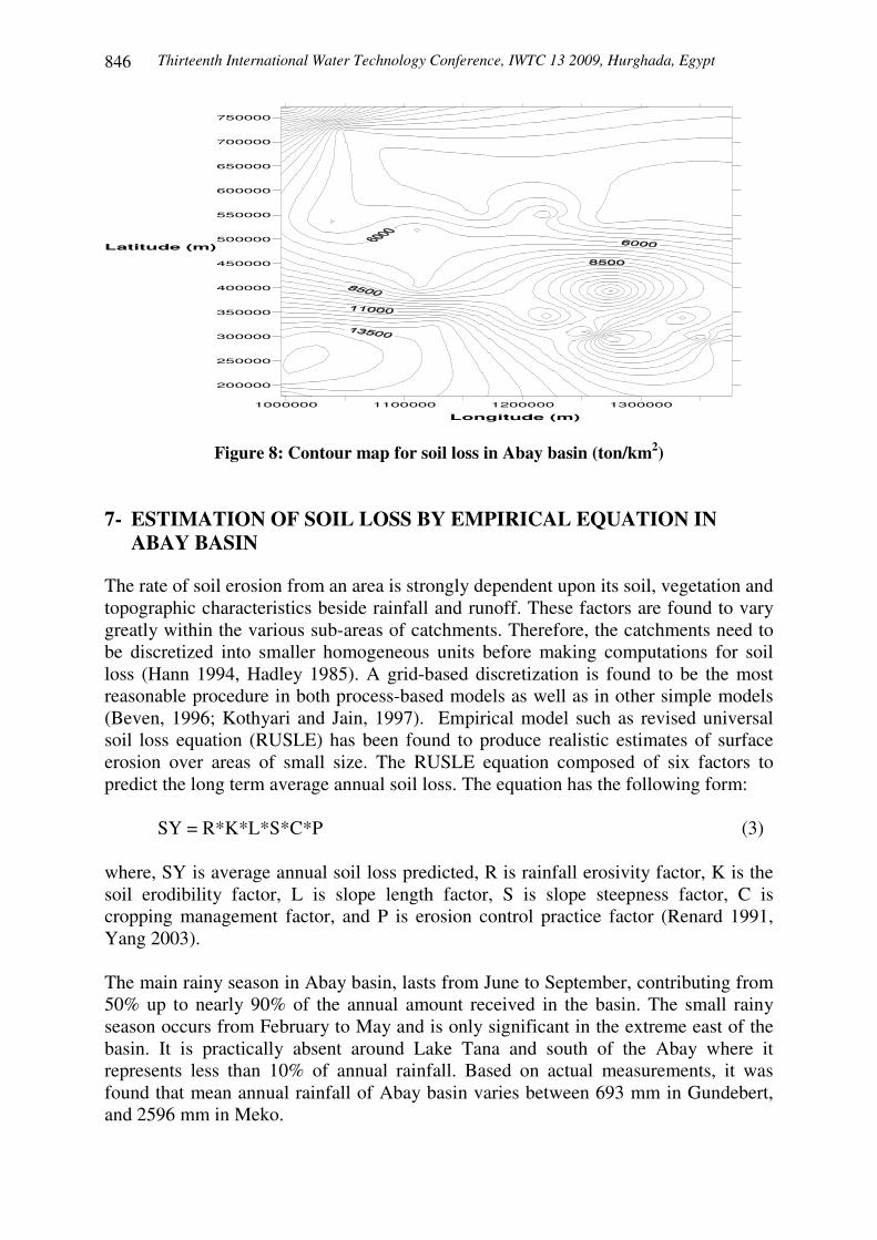
The most important benefit from the developed contour map for soil loss is to estimate volume of average annual soil loss in Ethiopia as a whole and for a specific basin. To estimate this volume the latitude and longitude of the measured 142 rainfall gauge stations changed to universal transverse Mercator (UTM) (Marsh 1996, Marchringni 1997). Geographic calculator software is used for this purpose. Since the most sediment in Nile River comes from Abay basin which is indicated in Figure 7, the soil loss values were estimated for the stations lie between two latitudes 9 and 12.5 degrees and two longitudes 34.5 and 39.5 degrees. A contour map of soil loss for Abay basin was developed from these estimated values and shown in Figure 8. The volume of average annual soil loss of Abay basin was estimated from this contour map and was found equal to 375.7 million ton. The estimated value from contour map is needed to be compared to a similar estimated one by another method. Therefore the average annual soil loss in Abay basin will be estimated by international equation called revised universal soil loss (RUSLE) equation.
Figure 7: Map of Abay basin in Ethiopia
Thirteenth International Water Technology Conference, IWTC 13 2009, Hurghada, Egypt 846
1000000 1100000 1200000 1300000
200000
250000
300000
350000
400000
450000
500000
550000
600000
650000
700000
750000
Latitude (m)
Longitude (m)
Figure 8: Contour map for soil loss in Abay basin (ton/km2) 7- ESTIMATION OF SOIL LOSS BY EMPIRICAL EQUATION IN
ABAY BASIN The rate of soil erosion from an area is strongly dependent upon its soil, vegetation and topographic characteristics beside rainfall and runoff. These factors are found to vary greatly within the various sub-areas of catchments. Therefore, the catchments need to be discretized into smaller homogeneous units before making computations for soil loss (Hann 1994, Hadley 1985). A grid-based discretization is found to be the most reasonable procedure in both process-based models as well as in other simple models (Beven, 1996; Kothyari and Jain, 1997). Empirical model such as revised universal soil loss equation (RUSLE) has been found to produce realistic estimates of surface erosion over areas of small size. The RUSLE equation composed of six factors to predict the long term average annual soil loss. The equation has the following form: SY = R*K*L*S*C*P (3) where, SY is average annual soil loss predicted, R is rainfall erosivity factor, K is the soil erodibility factor, L is slope length factor, S is slope steepness factor, C is cropping management factor, and P is erosion control practice factor (Renard 1991, Yang 2003). The main rainy season in Abay basin, lasts from June to September, contributing from 50% up to nearly 90% of the annual amount received in the basin. The small rainy season occurs from February to May and is only significant in the extreme east of the basin. It is practically absent around Lake Tana and south of the Abay where it represents less than 10% of annual rainfall. Based on actual measurements, it was found that mean annual rainfall of Abay basin varies between 693 mm in Gundebert, and 2596 mm in Meko.
Thirteenth International Water Technology Conference, IWTC 13 2009, Hurghada, Egypt
847
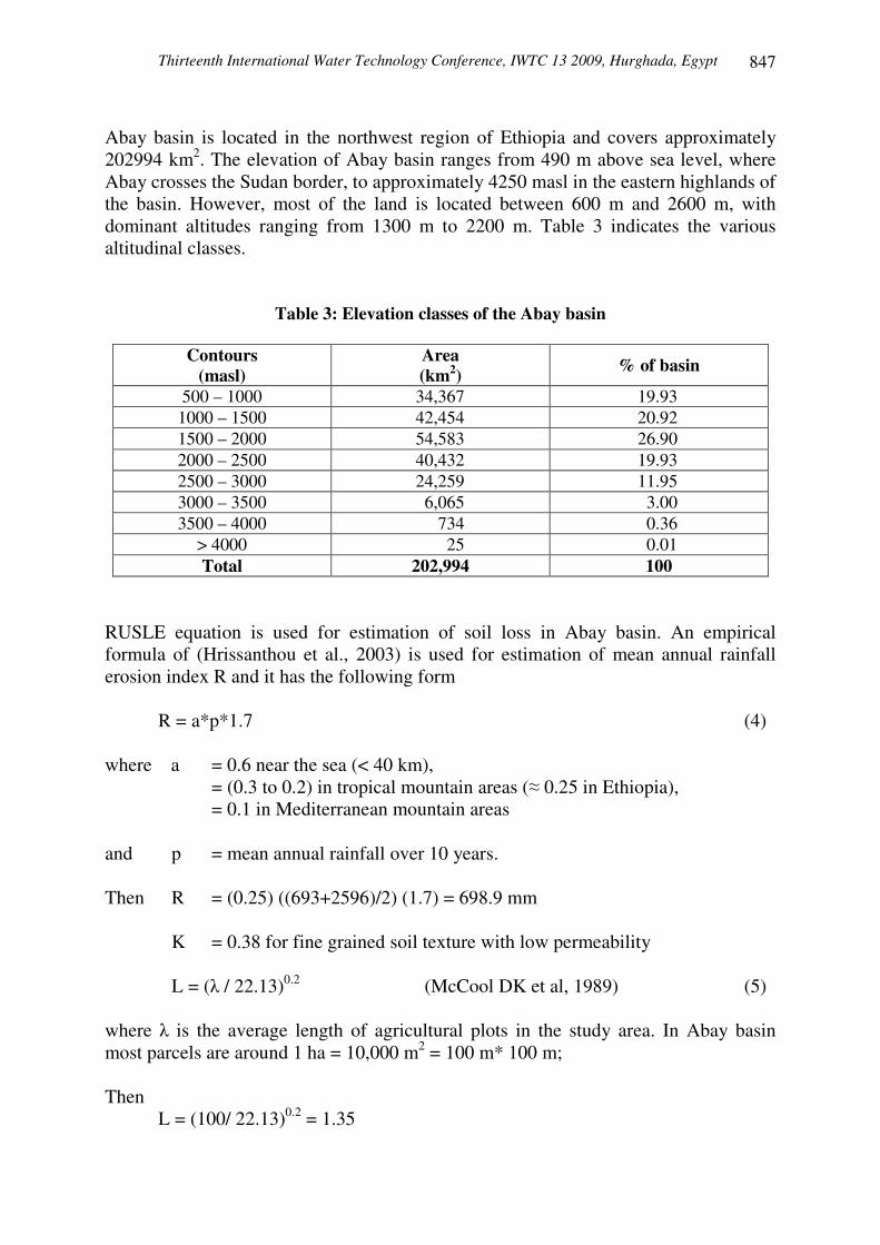
Abay basin is located in the northwest region of Ethiopia and covers approximately 202994 km2. The elevation of Abay basin ranges from 490 m above sea level, where Abay crosses the Sudan border, to approximately 4250 masl in the eastern highlands of the basin. However, most of the land is located between 600 m and 2600 m, with dominant altitudes ranging from 1300 m to 2200 m. Table 3 indicates the various altitudinal classes.
Table 3: Elevation classes of the Abay basin
Contours (masl)
Area (km2) % of basin
500 – 1000 34,367 19.93 1000 – 1500 42,454 20.92 1500 – 2000 54,583 26.90 2000 – 2500 40,432 19.93 2500 – 3000 24,259 11.95 3000 – 3500 6,065 3.00 3500 – 4000 734 0.36
> 4000 25 0.01 Total 202,994 100
RUSLE equation is used for estimation of soil loss in Abay basin. An empirical formula of (Hrissanthou et al., 2003) is used for estimation of mean annual rainfall erosion index R and it has the following form
R = a*p*1.7 (4) where a = 0.6 near the sea (< 40 km),
= (0.3 to 0.2) in tropical mountain areas (� 0.25 in Ethiopia), = 0.1 in Mediterranean mountain areas
and p = mean annual rainfall over 10 years. Then R = (0.25) ((693+2596)/2) (1.7) = 698.9 mm
K = 0.38 for fine grained soil texture with low permeability
L = (� / 22.13)0.2 (McCool DK et al, 1989) (5)
where � is the average length of agricultural plots in the study area. In Abay basin most parcels are around 1 ha = 10,000 m2 = 100 m* 100 m; Then L = (100/ 22.13)0.2 = 1.35
Thirteenth International Water Technology Conference, IWTC 13 2009, Hurghada, Egypt 848
S = 10.8 sin � + 0.03 for S < 9 % (McCool DK et al, 1987) S = 16.8 sin � − 0.05 for S � 9 % where � = slope angle (degrees) of agricultural parcels; for Abay basin average slope gradient = 4 %; Then
S = 10.8 sin 4 + 0.03 = 0.7834
C = 0.28 in case of having average soil cover by plants by 50%.
P = Pc * Ps * Pt (Schwab et al., 1981) (6) Pc is contouring factor based on slope = 0.5 in case of slope between 3 - 5 degrees Ps is strip cropping factor for crop strip widths = 0.5 in case of one year of row crop. Pt is terrace sedimentation factor = 0.1 for terraces with underground outlets; Then P = (0.5) (0.5) (0.1) = 0.025 then
SY = (698.9) (0.38) (1.35) (0.7834) (0.28) (0.025) = 1.57 kg/m2 or SY = (1.57) (202994) (106 / 103) = 320 million ton/year This means that the average annual soil loss in Abay basin equals 320 million ton/year. Comparison between the value of average annual soil loss estimated from developed contour map of soil loss based on actual field measurement of river runoff and soil loss (375.7 million ton) and the same value estimated from RUSLE equation (320 million ton) indicates that the two methods are close to each other. Consequently the two methods can be used for precise estimation of soil loss in Abay basin in Ethiopia. It should be noted that increasing number of rainfall gauge stations will increase the accuracy of developed soil loss contour map. Application of RUSLE equation at small catchments will improve the estimated value of average annual soil loss. 8- ESTIMATION OF MEAN ANNUAL SEDIMENT YIELD AT EL-DIEM STATION AND SEDIMENT DELIVERY RATIO Infrequent, unsystematic and incomplete suspended sediment data for EL-Diem gauging station (120 km upstream EL-Roseires Dam) which is considered the outlet of Abay basin just across the border in Sudan is available. This has been analyzed by group 1 of the NBCBN/ River Morphology Research Cluster (Ahmed Siyam et al, 2005). They estimated that the long-term mean suspended sediment at EL-Diem to be 123 million tons. Also they estimated bed load to be 15% giving a total mean annual
Thirteenth International Water Technology Conference, IWTC 13 2009, Hurghada, Egypt
849
sediment inflow 140 million tons. Therefore the sediment delivery ratio (SDR) at Abay basin equals 44 % since according to (Walling DE, 1988, 1983) ; Sediment Delivery Ratio = Mean annual sediment inflow /Average annual soil loss = (140 m.t.) / (320 m.t.) = 44 % This value is very close to the mean SDR estimated by The Tekeze Hydro Study (MWR, 1998) which equals to 49%. 9- TRACING OF DEPOSITED SEDIMENT FROM BLUE NILE RIVER
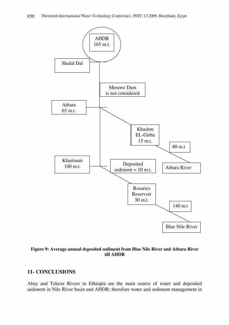
TILL AHDR Based on estimated values of soil loss and sediment delivery ratio in Abay basin (Blue Nile); the average annual sediment yield at EL-Diem station is estimated to be about 140 million tons. The average annual deposited sediment in Rosaries reservoir (at the path of Blue Nile before Khartoum) is estimated to be about 30 million tons. There is about 10 million tons of sediment deposited in the drainage system before Khartoum. Therefore the average annual sediment yield from Blue Nile River equals (140-30-10) about 100 million tons. On the other hand average annual sediment yield from Tekeze (Atbara) River is estimated to be about 80 million tons, and the trapped sediment in Khashm EL-Girba reservoir at Atbara River is estimated to be about 15 million tons per year. Therefore the average annual sediment yield from Atbara River equals (80-15) about 65 million tons. In the distance from Khartoum to Shalal Dal (500 km upstream AHD) there is a deposition in Merawe Dam (800 km downstream Khartoum on the Nile River) which was constructed in the period 2003 to 2008. This research work does not consider the effect of Merawe Dam. Accordingly the average annual sediment deposited in AHDR from Blue Nile and Atbara Rivers equals about 165 million tons. These values of sediment flow and trapped sediment in different reservoirs are shown in Figure 9. 10- RELATION BETWEEN RIVER RUNOFF IN ETHIOPIA AND
DEPOSITED SEDIMENT IN AHDR In general, increasing of river runoff in Ethiopia causes an increase of soil loss as shown in Figure 4 and Table 2. Increasing of soil loss causes an increase of sediment yield at EL-Diem station. Accordingly the deposited sediment in AHDR will increase. These values of river runoff and soil losses in Ethiopia and deposited sediment in AHDR can be estimated and predicted under the condition of measuring rain fall in the mentioned 142 stations in Ethiopia or application of RUSLE equations at different sub-basins in Ethiopia.
Thirteenth International Water Technology Conference, IWTC 13 2009, Hurghada, Egypt 850
Figure 9: Average annual deposited sediment from Blue Nile River and Atbara River
till AHDR 11- CONCLUSIONS Abay and Tekeze Rivers in Ethiopia are the main source of water and deposited sediment in Nile River basin and AHDR; therefore water and sediment management in
Blue Nile River
Atbara River
Rosaries Reservoir
30 m.t.
Khashm EL-Girba
15 m.t.
140 m.t
Deposited sediment = 10 m.t.
Khartoum 100 m.t.
80 m.t
Atbara 65 m.t.
Merawe Dam is not considered
Shalal Dal
AHDR 165 m.t.
Thirteenth International Water Technology Conference, IWTC 13 2009, Hurghada, Egypt
851
Abay basin is very essential. Rainfall measurements of 142 rainfall gauge stations were collected and used to produce contour maps of rainfall and river runoff. Other data of river runoff and soil loss for 7 rainfall gauge stations were collected and used to produce a polynomial equation. This equation was used to estimate a contour map of soil loss in Ethiopia. Also, using this equation the contour map of soil loss in Abay basin was produced. This contour map was used to estimate the average annual soil loss in Abay basin and found to be 375.7 million ton. The revised universal soil loss (RUSLE) equation was also used for this purpose. The average annual soil loss in Abay basin using RUSLE equation was found to be 320 million ton which is close to previous one. The annual sediment yield at EL-Diem station was estimated and found equal to 140 million ton. Accordingly the sediment delivery ratio of Abay basin was found to be 44%. Also, a tracing of sediment flow from Blue Nile River passing Rosieres reservoir and Atbara river passing Khashm EL-Girba reservoir until AHDR was done. The estimated values of soil loss, sediment yield and sediment delivery ratio gives a general view for sedimentation process in Blue Nile River and AHDR. Accordingly, this will help the decision makers in Ethiopia, Sudan and Egypt in water and sediment management. 12- RECOMMENDATIONS
1- Increasing the number of measured values of rainfall in the mentioned 142 will improve the accuracy of mean annual rain fall. Accordingly, this will increase the accuracy of estimated average annual soil loss by RUSLE equation.
2- Complete records of suspended sediment data at EL-Diem station will improve the accuracy of estimated sediment yield and sediment delivery ratio for Blue Nile River Basin.
3- Increasing the number of stations for both data of runoff and average soil loss (more than 7 stations as mentioned) will improve the accuracy of estimated soil loss equation based on measurements of river runoff and soil loss.
4- Equation between river rainfall in Blue Nile River and deposited sediment in AHDR is needed. This kind of equation will help the decision makers to have a general view for deposited sediment in Nile River and AHDR just after knowing the values of river rain fall in Ethiopia. This general view will guide the decision makers in the three countries; Ethiopia, Sudan, and Egypt in good management of water resources and sediment process.
ACKNOWLEDGMENT
The author appreciates deeply Prof. Dr. Eng. Mohamed El-Moattassem Mohamed El-Kotb, Professor, Nile Research Institute, National Water Research Center, for his keen interest, his support, guidance and positive encouragement through this work.
Thirteenth International Water Technology Conference, IWTC 13 2009, Hurghada, Egypt 852
REFERENCES 1. Ahmed Musa Siyam et al, Assessment of the current state of the Nile Basin
Reservoir sedimentation problems, UNESCO Report, 2005. 2. Ayalew L, The effect of seasonal rainfall on landslides in the highlands of
Ethiopia, Bulletin Engineering Geology Environment, Vol. 58, pp 9-19., 1999. 3. Beven KJ, A discussion of distributed hydrological modeling, In: Abott MB,
Refsgaard JC (eds.) Distributed hydrological modeling. Kluwer, Dordrecht, The Netherlands, pp 278-255, 1996.
4. Chernet T, Hydrogeology of Ethiopia, Ethiopian Institute of Geological Surveys, Professional paper, Addis Ababa, pp 175-188, 1993.
5. Haan CT, Barfield BJ, Hayes JC, Design hydrology and sedimentology for small catchments, Academic, New York, 1994.
6. Hadley RF, Lal R, Onstad CA, Walling DE, Yair A, Recent developments in erosion and sediment yield study, UNESCO (IHP), Paris, France, 1985.
7. Hrissanthou V, Mylopouls N, Tolikas D, Mylopouls Y, Simulation modeling of runoff, groundwater flow and sediment transport into Kastoria Lake, Greece. Water Resource Management, Vol. 17, pp 223-242, 2003.
8. Kothyari UC, Jain SK., Sediment yield estimation using GIS, Hydrol Science Journal, Vol. 42, Part 6, pp 833-843, 1997.
9. Marchringni HS, Cruise JF, Sediment yield modeling by grouped response units, Journal of Water Resource Plan Manage, Vol. 123, Part 2, pp 95-104, 1997.
10. Marsh WM, Grossa JJ, Environmental geography, science land use, and earth systems, Wiley, Toronto, Canada, 1996.
11. McCool DK, Brown LC, Foster GR, Mutchler CK, Mayer LD, Revised slope steepness factor for the Universal Soil Loss Equation. Trans ASAE 30, pp 1387-1396, 1987.
12. McCool DK, Foster GR, Muchler CK, Mayer LD, Revised slope length factor for Universal Soil Loss Equation. Trans ASAE 32, pp 1571-1576, 1989.
13. Mesfin W.M., An atlas of Ethiopia, II Polografico, Asmara, 1970. 14. MWR Tekeze Medium Hydro Study, Addis Ababa, 1998. 15. Nyssen J., Poesen J., Moeyersons J., Deckers J., Mititku H., Lang A., Human
impact on the environment in the Ethiopian and Eritrean highlands, Earth-Science Reviews, Vol. 64, pp 273-320, 2004.
16. Renard KG, Foster GR, Weesies GA, Porter JP, RUSLE, Revised Universal Soil Loss Equation, Journal of Soil Water Conservation, Vol. 46, Part 1, pp 30-33, 1991.
17. Schwab GO, Frevert PK, Edminster TW, Bames KK, Soil and water conservation engineering, 3rd edn, Wily, New York, USA, 1981.
18. Walling DE, Erosion and sediment yield research-some recent perspectives, Journal of Hydrology, Vol. 100, pp 113-141, 1988.
19. Walling DE, The sediment delivery problem, Journal of Hydrology, Vol. 65, pp 209-237, 1983.
20. Yang D, Kanae S, Oki T, koikel T, Musinke T, Global potential soil erosion with reference to land use and climate change, Hydrology Process, Vol. 17, Part 14, pp 2913-2928, 2003.