Embed Size (px)
Citation preview
Washington’s Complete Streets and Main Street HighwaysCase Study Resource

Research ReportResearch Project GCB 1037
WA-RD 780.1Washington’s Complete Streets and Main Street Highways
Case Study Resource
ByJim Nicholls
Senior LecturerUniversity of Washington Department of Architecture
Stacy Cannon, Sara Duffy, Rory StevensUniversity of Washington Department of Architecture
Research Assistants
Washington State Transportation Center (TRAC)University of Washington, Box 354802
University District Building1107 NE 45th Street, Suite 535
Seattle, Washington 98105-4631
Kathy LindquistResearch Project Manager
Washington State Department of Transportation
Paula ReevesTechnical Monitor
Washington State Department of Transportation
A report prepared for Washington State Department of Transportation
In cooperation withU.S. Department of Transportation
Federal Highway Administration
November 2011
DisclaimerThe contents of this report reflect the views of the authors, who are
responsible for the facts and the accuracy of the data presented herein.
The contents do not necessarily reflect the official views or policies
of the Washington State Department of Transportation or the Federal
Highway Administration. This report does not constitute a standard,
specification, or regulation.
Title VI Statement to Public: WSDOT ensures full compliance with Title VI of the Civil Rights Act of 1964 by prohibiting discrimination against any person on the basis of race, color, national origin or sex in the provision of benefits and services resulting from its federally assisted programs and activities. For questions regarding WSDOT’s Title VI Program contact Jonté Sulton at 360-705-7082 or [email protected].
Americans with Disabilities Act (ADA) Information: Materials can be provided in alternative formats for people with disabilities by calling Shawn Murinko at 360-705-7097 or [email protected]. Persons who are deaf or hard of hearing may contact Office of Equal Opportunity through the Washington Relay Service at 7-1-1.
Summary 1
Washington’s Complete Streets 2
Goals and benefits 4
Complete Street Components 8 Pedestrian 8Bicycles 10 Transit 12 Cars 14Trucks 16
Washington’s Main Street Highways 18
Washington’s Case Studies in Community Design 20 Grandview 20Roslyn 26 Wenatchee 38
Complete Streets and Main Street Highways Grant Program 48
Contents

Summary
Washington State Complete Streets 1
“Complete Streets” refers to a national movement that promotes street and road designs accommodating all users. Typical components of a complete street accommodate pedestrians, bicyclists, transit users, motor vehicles and freight trucks. A growing number of communities in Washington state and nationwide have existing complete streets policies or ordinances. Washington state passed a Complete Streets Bill (RCW 47.04.257) that went into effect July 2011, creating a program that would provide grants to communities meeting specific criteria.
The grant program would fund projects on city streets as well as city streets in communities that also serve as state highways, referred to in this report as main street highways. There are about 500 miles of main street highways in Washington. Grant funded projects on city streets and main street highways must be context-specific based on size, location and community needs. This report provides some case studies and serves as a resource for communities developing complete streets and main street highways.
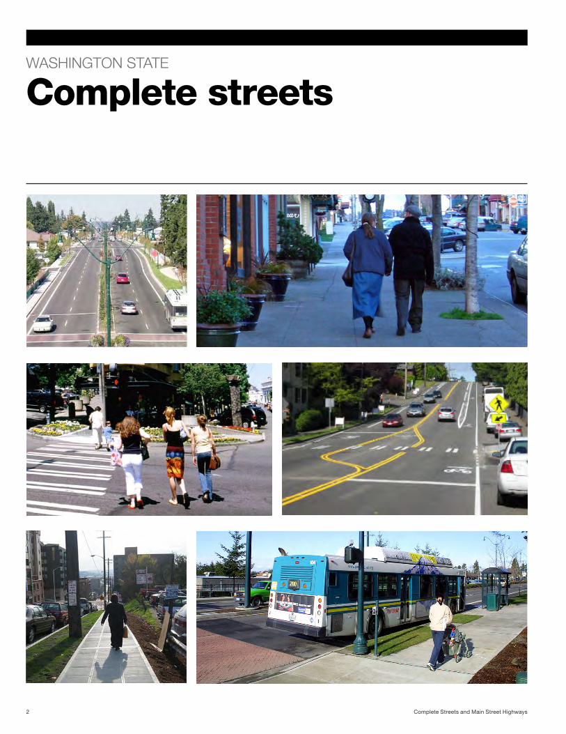
WASHINGTON STATE
Complete streets
Complete Streets and Main Street Highways2
Completing Washington’s streets
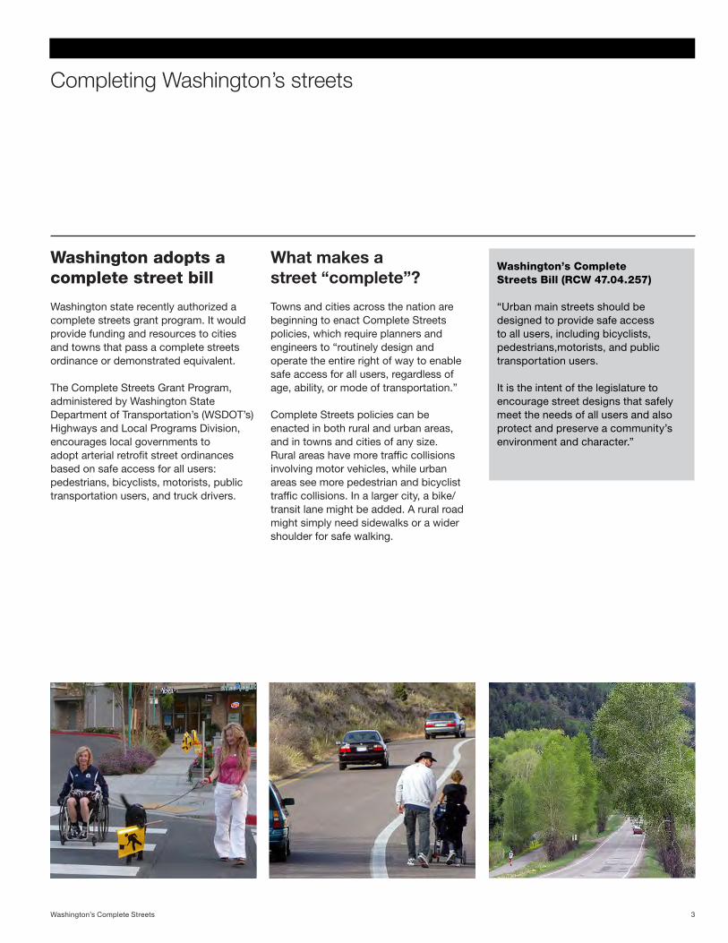
What makes a street “complete”?
Washington adopts a complete street bill
Towns and cities across the nation are beginning to enact Complete Streets policies, which require planners and engineers to “routinely design and operate the entire right of way to enable safe access for all users, regardless of age, ability, or mode of transportation.”
Complete Streets policies can be enacted in both rural and urban areas, and in towns and cities of any size. Rural areas have more traffic collisions involving motor vehicles, while urban areas see more pedestrian and bicyclist traffic collisions. In a larger city, a bike/transit lane might be added. A rural road might simply need sidewalks or a wider shoulder for safe walking.
Washington state recently authorized a complete streets grant program. It would provide funding and resources to cities and towns that pass a complete streets ordinance or demonstrated equivalent.
The Complete Streets Grant Program, administered by Washington State Department of Transportation’s (WSDOT’s) Highways and Local Programs Division, encourages local governments to adopt arterial retrofit street ordinances based on safe access for all users: pedestrians, bicyclists, motorists, public transportation users, and truck drivers.
Washington’s Complete Streets Bill (RCW 47.04.257)
“Urban main streets should be designed to provide safe access to all users, including bicyclists, pedestrians,motorists, and public transportation users. It is the intent of the legislature to encourage street designs that safely meet the needs of all users and also protect and preserve a community’s environment and character.”
3Washington’s Complete Streets
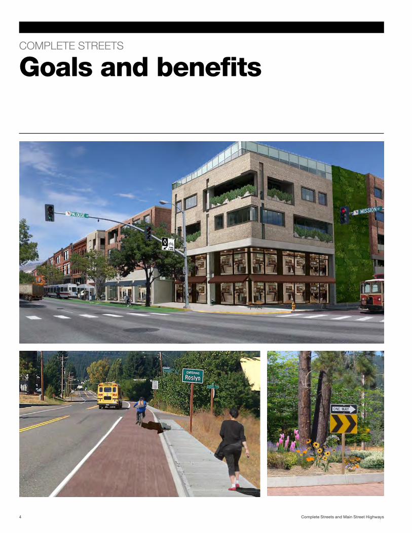
COMPLETE STREETS
Goals and benefits
Complete Streets and Main Street Highways4
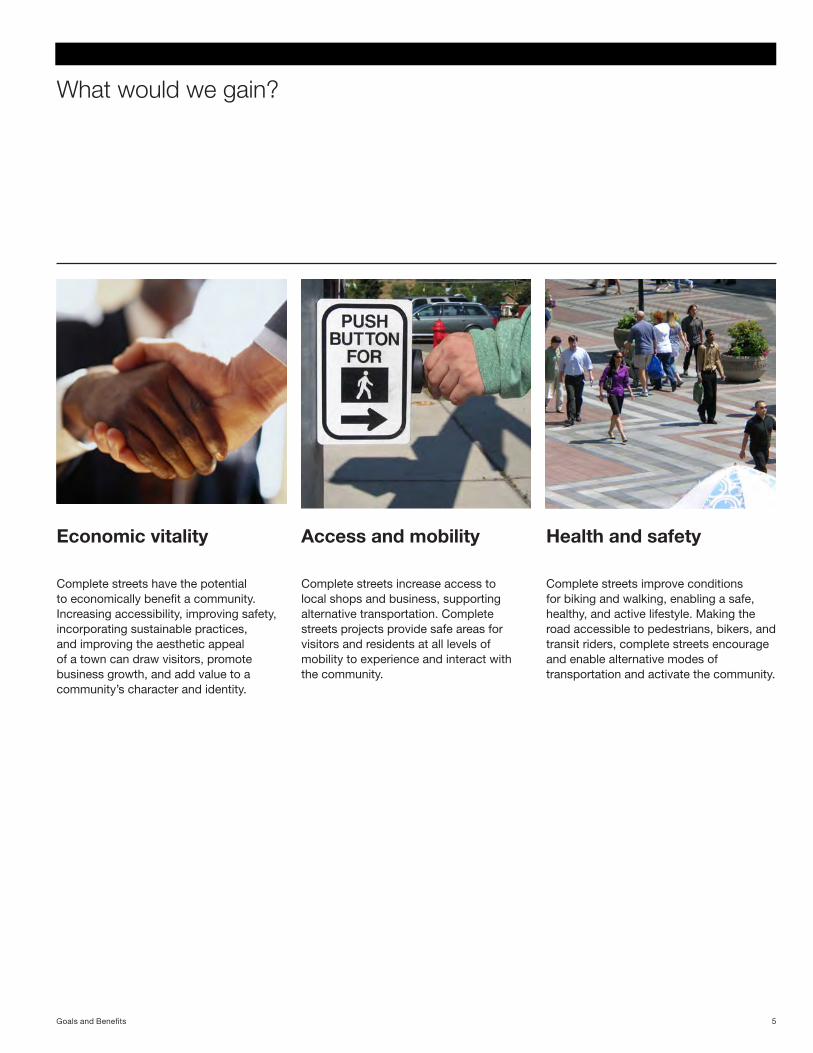
What would we gain?
Health and safety
Complete streets improve conditions for biking and walking, enabling a safe, healthy, and active lifestyle. Making the road accessible to pedestrians, bikers, and transit riders, complete streets encourage and enable alternative modes of transportation and activate the community.
Access and mobility
Complete streets increase access to local shops and business, supporting alternative transportation. Complete streets projects provide safe areas for visitors and residents at all levels of mobility to experience and interact with the community.
Economic vitality
Complete streets have the potential to economically benefit a community. Increasing accessibility, improving safety, incorporating sustainable practices, and improving the aesthetic appeal of a town can draw visitors, promote business growth, and add value to a community’s character and identity.
5Goals and Benefits
Complete streets in Washington state
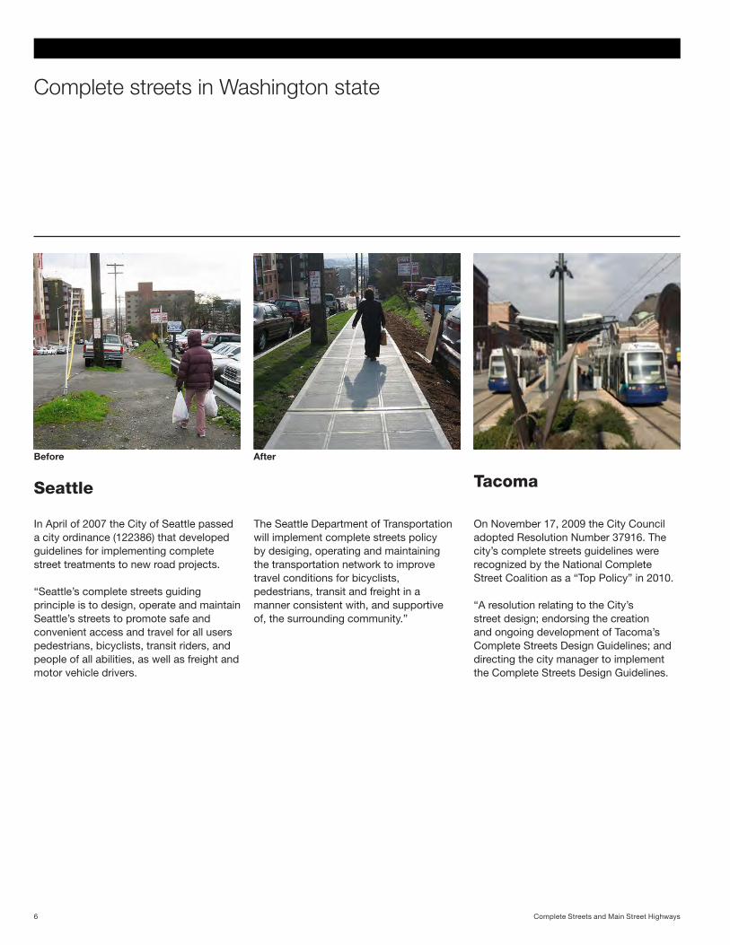
Tacoma
On November 17, 2009 the City Council adopted Resolution Number 37916. The city’s complete streets guidelines were recognized by the National Complete Street Coalition as a “Top Policy” in 2010.
“A resolution relating to the City’s street design; endorsing the creation and ongoing development of Tacoma’s Complete Streets Design Guidelines; and directing the city manager to implement the Complete Streets Design Guidelines.
Seattle
In April of 2007 the City of Seattle passed a city ordinance (122386) that developed guidelines for implementing complete street treatments to new road projects.
“Seattle’s complete streets guiding principle is to design, operate and maintain Seattle’s streets to promote safe and convenient access and travel for all users pedestrians, bicyclists, transit riders, and people of all abilities, as well as freight and motor vehicle drivers.
The Seattle Department of Transportation will implement complete streets policy by desiging, operating and maintaining the transportation network to improve travel conditions for bicyclists, pedestrians, transit and freight in a manner consistent with, and supportive of, the surrounding community.”
Before After
Complete Streets and Main Street Highways6
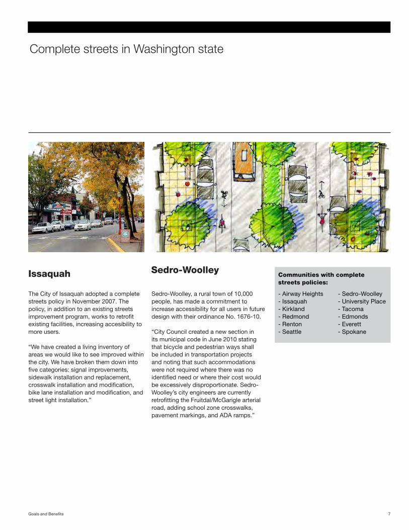
Sedro-Woolley
Sedro-Woolley, a rural town of 10,000 people, has made a commitment to increase accessibility for all users in future design with their ordinance No. 1676-10.
“City Council created a new section in its municipal code in June 2010 stating that bicycle and pedestrian ways shall be included in transportation projects and noting that such accommodations were not required where there was no identified need or where their cost would be excessively disproportionate. Sedro-Woolley’s city engineers are currently retrofitting the Fruitdal/McGarigle arterial road, adding school zone crosswalks, pavement markings, and ADA ramps.”
Issaquah
The City of Issaquah adopted a complete streets policy in November 2007. The policy, in addition to an existing streets improvement program, works to retrofit existing facilities, increasing accesibility to more users.
“We have created a living inventory of areas we would like to see improved within the city. We have broken them down into five categories: signal improvements, sidewalk installation and replacement, crosswalk installation and modification, bike lane installation and modification, and street light installation.”
Complete streets in Washington state
Communities with complete streets policies:
- Airway Heights - Issaquah - Kirkland - Redmond - Renton - Seattle
- Sedro-Woolley - University Place - Tacoma - Edmonds - Everett - Spokane
7Goals and Benefits
COMPLETE STREETS COMPONENTS
Pedestrians
Complete Streets and Main Street Highways8
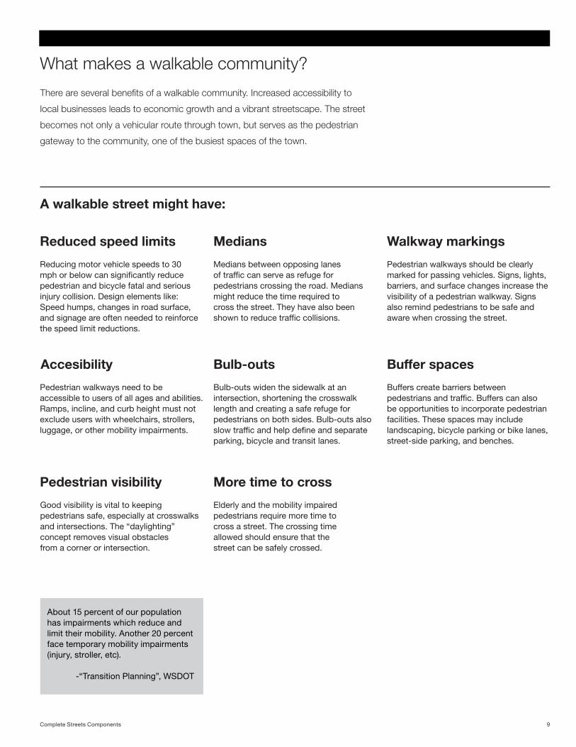
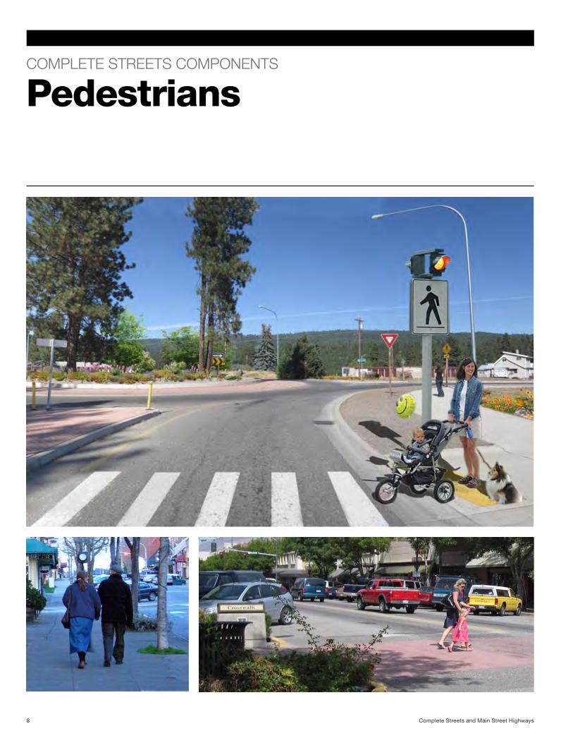
What makes a walkable community?
Reduced speed limits
Reducing motor vehicle speeds to 30 mph or below can significantly reduce pedestrian and bicycle fatal and serious injury collision. Design elements like: Speed humps, changes in road surface, and signage are often needed to reinforce the speed limit reductions.
There are several benefits of a walkable community. Increased accessibility to
local businesses leads to economic growth and a vibrant streetscape. The street
becomes not only a vehicular route through town, but serves as the pedestrian
gateway to the community, one of the busiest spaces of the town.
About 15 percent of our population has impairments which reduce and limit their mobility. Another 20 percent face temporary mobility impairments (injury, stroller, etc).
-“Transition Planning”, WSDOT
A walkable street might have:
Walkway markings
Pedestrian walkways should be clearly marked for passing vehicles. Signs, lights, barriers, and surface changes increase the visibility of a pedestrian walkway. Signs also remind pedestrians to be safe and aware when crossing the street.
Pedestrian visibility
Good visibility is vital to keeping pedestrians safe, especially at crosswalks and intersections. The “daylighting” concept removes visual obstacles from a corner or intersection.
More time to cross
Elderly and the mobility impaired pedestrians require more time to cross a street. The crossing time allowed should ensure that the street can be safely crossed.
Medians
Medians between opposing lanes of traffic can serve as refuge for pedestrians crossing the road. Medians might reduce the time required to cross the street. They have also been shown to reduce traffic collisions.
Bulb-outs
Bulb-outs widen the sidewalk at an intersection, shortening the crosswalk length and creating a safe refuge for pedestrians on both sides. Bulb-outs also slow traffic and help define and separate parking, bicycle and transit lanes.
Buffers create barriers between pedestrians and traffic. Buffers can also be opportunities to incorporate pedestrian facilities. These spaces may include landscaping, bicycle parking or bike lanes, street-side parking, and benches.
Buffer spacesAccesibility
Pedestrian walkways need to be accessible to users of all ages and abilities. Ramps, incline, and curb height must not exclude users with wheelchairs, strollers, luggage, or other mobility impairments.
9Complete Streets Components
COMPLETE STREETS COMPONENTS
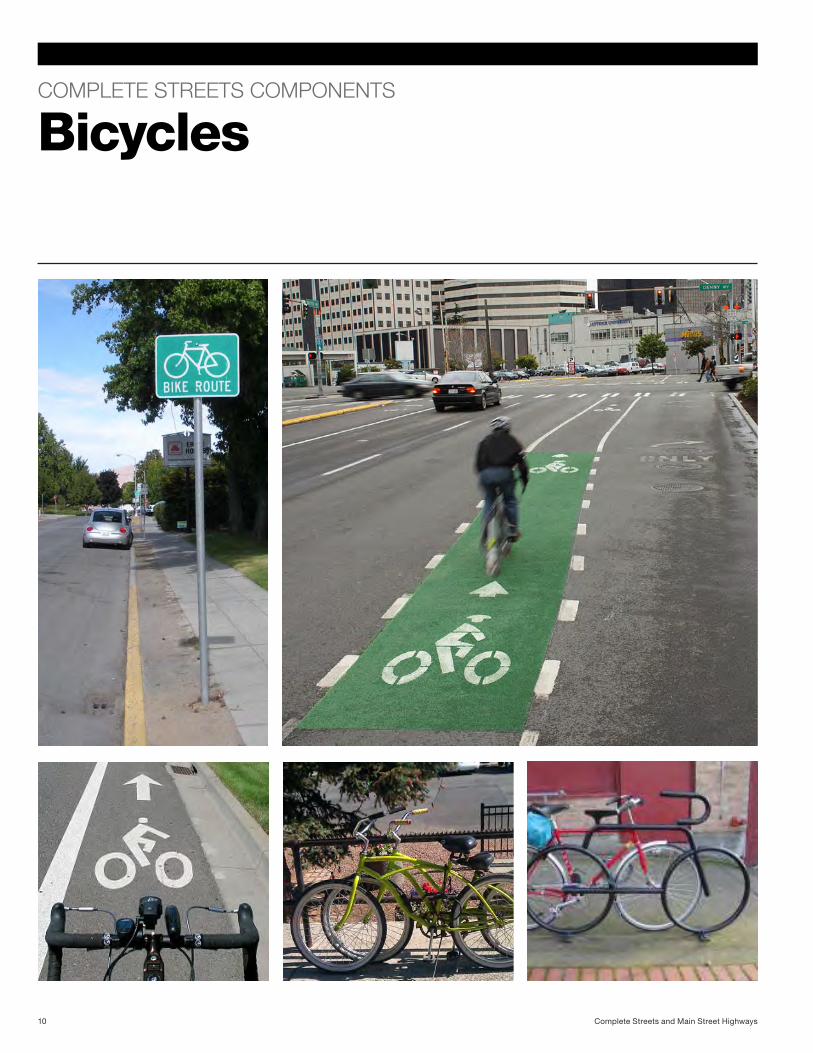
Bicycles
Complete Streets and Main Street Highways10
Do bicyclists feel safe?
Ways to accomodate bicycle travel:
Wrong-way riding and riding on the sidewalk are two of the main contributors to car and bike collisions.
-League of American Bicyclists
Bicyclists ride for several reasons. Cyclists can commute
solely on their bicycle or combine a bike route with a bus trip.
Bicycles are used for errands, personal visits, transporting
children to school, exercise and recreation.
Give bicycles space
Bicycle lanes provide a safe space for bicycles on the road, reducing the risk of vehicle - bicycle collisions. Bicycle travel-lanes can be wide curb lanes, bicycle lanes or separate bicycle paths. Bicycle lanes can be tinted green or buffered with striping or barriers to increase visibility and improve safety.
Communication
Vehicular and bicycle paths need to be clearly marked. Posted signs and roadway pavement markings are useful to drivers and bicyclists. They denote space, indicate where bicyclists can safely ride, and bring awareness.
Communicating pertinent bicycle information is also important. Bicycle routes must be easy to navigate, well-marked, and clearly distinguished from pedestrian routes. Maps and posted information can inform bicyclists of existing policies and systems.
Accesibility
Bicycling is often combined with walking or public transit use. Bike facilities like lockers and bicycle racks should be in close proximity to walkways, transit stops, and business entrances. Then the bicycle system would be accessible to a variety of users.
Connectivity
Well-connected bicycle facilities encourage biking and enable better accessibility. They can also generate income for the city and help streetside shops and businesses. Shared bicycle programs, encourage the community’s bicycle use and build support for the existing bicycle system.
Bicyclists riding on the sidewalk are at greater risk of being hit by a motor vehicle than those who ride on the road. According to the League of American Bicyclists, wrong-way riding and riding on the sidewalk are two of the main contributors to vehicle and bicycle collisions. Designating road space for bicycles not only creates a safe route for bicyclists, but it also keeps bicycles off the sidewalk.
Stay off the sidewalk
If bicycle facilities were well-connected and located close to
destinations like shops, schools, parks, the bicycling network
will be more appealing and successful. There are valuable
economic, social, and health benefits to a bikable community.
11Complete Streets Components
COMPLETE STREETS COMPONENTS
Transit
Complete Streets and Main Street Highways12
How accessible is public transit?
How can we encourage transit use?
13Complete Streets Components
A street designed thoughtfully for all users enables a reliable,
efficient public transit system as an alternative mode of
transportation. In addition to reducing traffic crashes and
vehicle emissions, public transit increases physical activity,
Nearly 1/3 of transit users meet the Surgeon General’s recommendations for minimum daily exercise by walking to and from transit stops.
-Complete Streets Coalition
Accessibility
Transit should be accessible to users of all modes of transportation, and should accommodate all ages and mobility levels. An accessible transit system can also encourage bicycling and walking.
Waiting areas
Waiting areas at transit stops should be universally accessible. They should provide buffer space (between 5-10 feet) from traffic. In areas with heavy transit use, bus stops should be sheltered to protect users from weather, and they should provide seating and transit information.
Transit stops should also be safe, clean and well maintained. They should be well-lit so users feel safe during their wait. Video surveillance adds an extra level of security and assurance. Transit stops are also opportunities for planting and streetscaping.
Placement
Transit stop locations are based on traffic levels, parking, safety, and convenience, and typically located near intersections. They should be clearly visible without blocking a driver’s line-of-sight.
Bicycle access
To encourage bicycle commuting, the transit stop should be equipped with bicycle facilities like storage racks and lockers. There should be ample space for bicyclists to transition.
Pedestrian access
To keep pedestrians safe while using the transit system, transit stops should be directly adjacent to pedestrian walkways. A sheltered bus stop should be located in a safe place and be convenient for users, without blocking the sidewalk or the road.
Car access
Park and Ride faciliites connect vehicle drivers to the transit system. A Park and Ride encourages carpooling and reduces fuel usage, and provides parking.
HOV lanes
High-Occupancy Vehicle (HOV) Lanes provide transit carpools, and vanpools with an advantageous separated lane. This lane provides additional safety to transit vehicles. It may also be used as a combined bicycle - transit lane .
and accessibility. By designing with all users in mind, public
transit can contribute to increased mobility, connectivity and
safety along these roads.
COMPLETE STREETS COMPONENTS
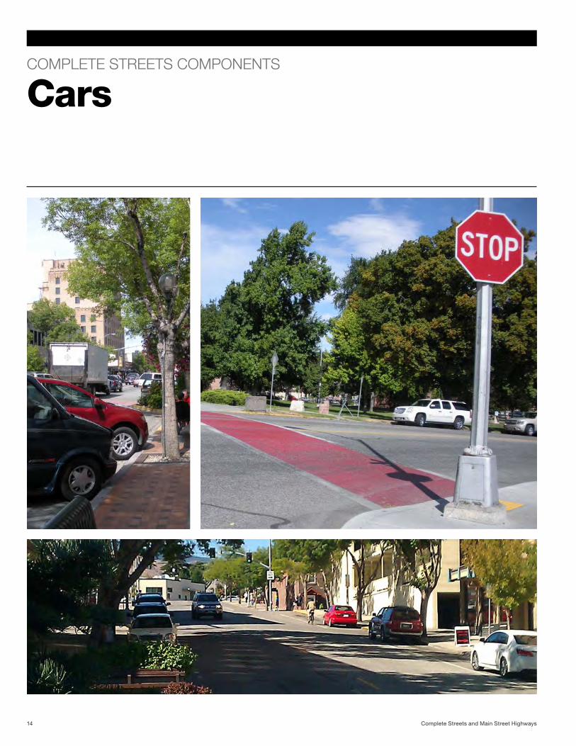
Cars
Complete Streets and Main Street Highways14
How can we increase safety and improve efficiency?
Addressing car-related needs:
Typical roadways are often designed primarily for motor
vehicles. The complete streets concept aims to integrate
all modes of transportation. Roads must provide safety for
users of all modes and abilities. A comprehensive design
strategy can alleviate traffic safety concerns. Drivers must be
Over more than half of the daily trips made are under 3 miles. 87 percent of those trips take place in personal vehicles.
-National Household Travel Survey
Parking areas
Parking, while important for business and accessibility, can be rearranged to keep passengers safe while loading and unloading. Parking areas may be buffer spaces between different modes of transportation. A well-designed parking area can ease traffic flow and improve visibility at intersections.
Reasonable speed limits are vital to the safety of a roadway. Eighty-three percent of pedestrians hit by a vehicle traveling at 40 miles per hour will not survive; the percentage improves significantly when the speed limit is reduced to even 35 miles per hour.
Reduced speed
Automotive traffic can create noise in the surrounding community. Reduced speed significantly reduces traffic noise. In addition, a streetscape may provide barriers, like plantings or walls, to improve visual quality in the community.
Noise barriers
An essential part of road safety is clear signage. Drivers must be made aware of nearby pedestrians, bicycles, transit, other vehicles, and any surrounding obstacles with appropriate signage and markings.
Communication
“Road diets” help oversized roads minimize lanes and width to maximize efficiency. Somewhat counter-intuitively, a “road diet” conversion makes a road more efficient, able to carry a greater volume of vehicles and safer for bicycles, pedestrians, and transit users.
This conversion often involves narrowing or removing lanes of travel, which increases awareness of speed and surroundings. Two-way left-turn lanes, or medians with turning pockets, reduce collisions and assist in maintaining traffic flow. Often, the space redeemed by such a conversion can accommodate a bicycle lane, a transit lane, and wider sidewalks.
“Road diet”
made aware of the other modes of transportation with which
they share the road. As the dominant transportation system,
personal vehicles can pose serious dangers to pedestrians,
bicyclists, and transit users.
15Complete Streets Components
COMPLETE STREETS COMPONENTS
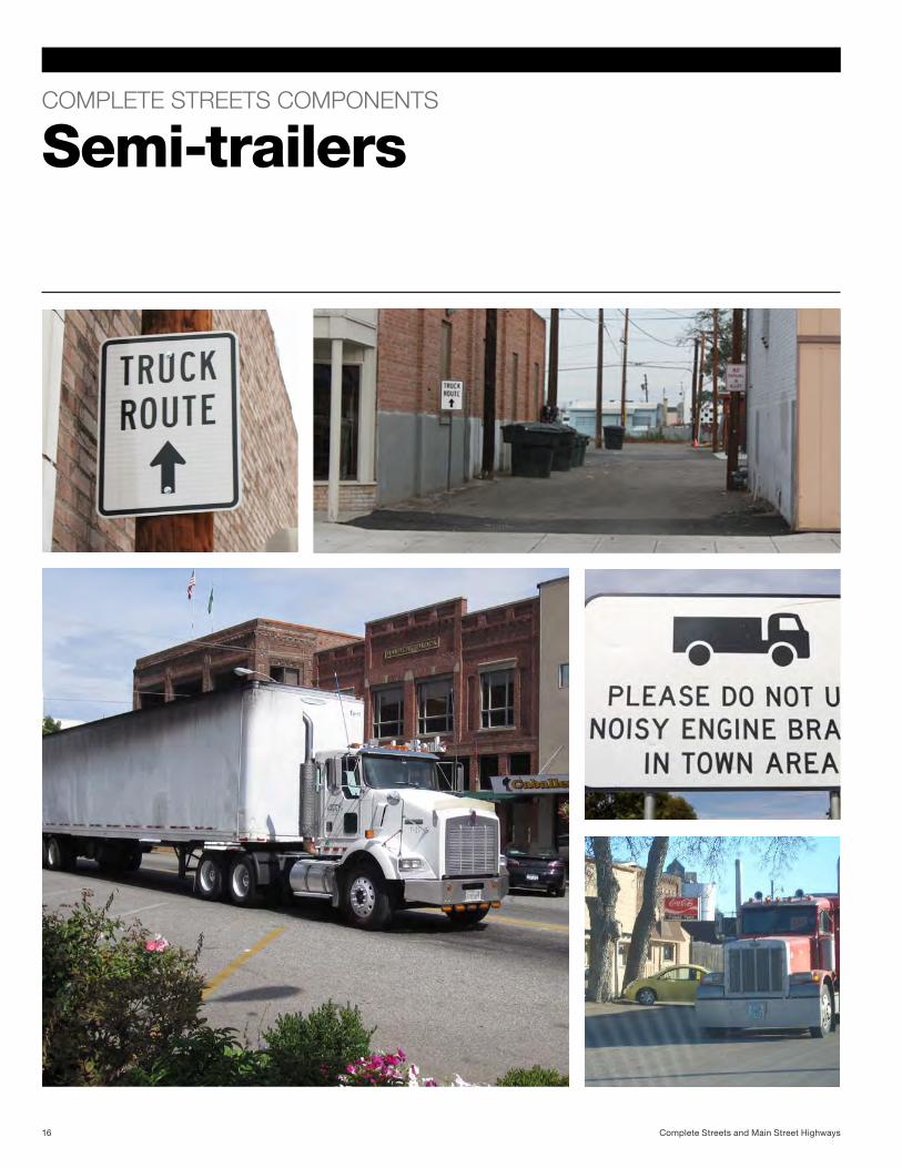
Semi-trailers
Complete Streets and Main Street Highways16

How can freight traffic be more efficient?
Special considerations for trucks:
Washington State’s abundant natural resources and thriving
economy require efficient oversize vehicle and semi-truck
accessibility. Logging trucks, agricultural equipment, horse
trailers, and cargo beds are common across the state.
Maintaining truck routes in all contexts is important.
Many freight companies are achieving economic advantages through initiatives including: increasing vehicle load factors through consolidating urban freight, making deliveries during non-peak traffic times, use of new routing and scheduling technologies, more fuel efficient vehicles, etc...
-New Sustainable Transportation Solutions in Urban Areas,
J.H.R. van Duin
Communities may provide alternative truck routes. This solution may be costly, but providing alternative routes may prove more efficient for freight carriers in some cases, and may make local businesses, public spaces, and the streetscape more appealing. In Grandview, WA, for example, the alternative truck route is an efficient system of service alleys that separates trucks from pedestrian areas and maximizes delivery efficiency.
Regionally specific
Methods to maximize freight route efficiency must be informed by the freight carriers and the community. Some communities may see primarily logging trucks, some may see agricultural vehicles, and others may see only delivery vehicles. Improvements for freight should be case specific, addressing the situation most relevant to the community.
Alternative truck routes
Speed is especially important on city streets in community centers and main street highways. The speed limits are often lower through these areas for safety.
Reduced speed
Truck and motor vehicle traffic can have noise impacts. While some road noise is due to engines and brakes, the dominant source of noise is tire-pavement noise. An effective way to reduce road noise is to use noise-minimizing pavement which can be combined with added vegetation and better building insulation, for example. Barriers like vegetated walls can also serve a storm water function.
Noise barriers
Delivery schedules
Making deliveries before and after peak traffic times can help increase efficiency and reduce delay for freight carriers.
The requirements for trucks are similar to personal vehicles.
Trucks need more space, more allowances, and more
noise control.
17Complete Streets Components
WASHINGTON STATE
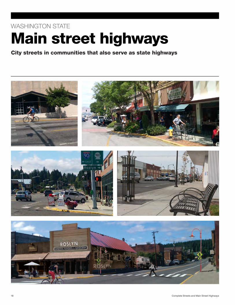
Main street highways
Complete Streets and Main Street Highways18
City streets in communities that also serve as state highways
When city streets also serve as state highways . . .
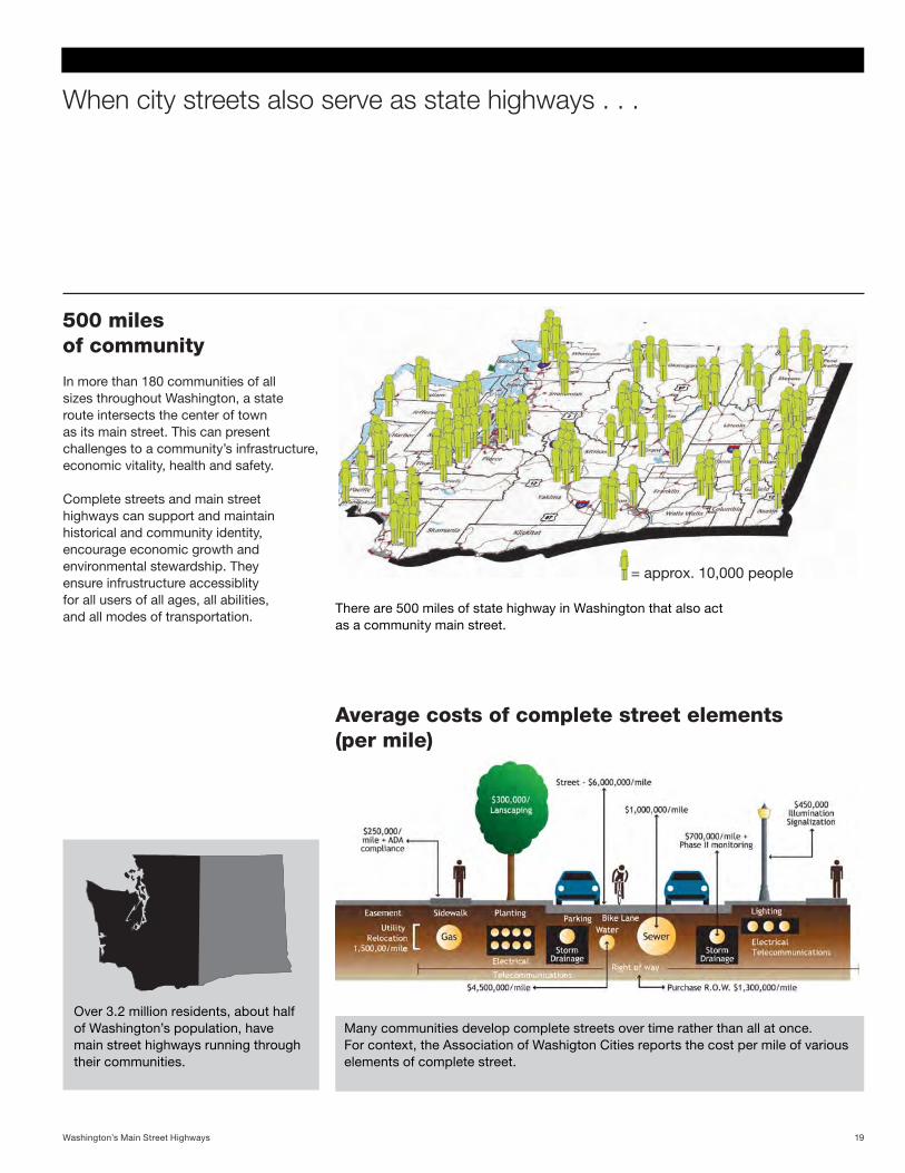
500 miles of community
In more than 180 communities of all sizes throughout Washington, a state route intersects the center of town as its main street. This can present challenges to a community’s infrastructure, economic vitality, health and safety.
Complete streets and main street highways can support and maintain historical and community identity, encourage economic growth and environmental stewardship. They ensure infrustructure accessiblity for all users of all ages, all abilities, and all modes of transportation.
Over 3.2 million residents, about half of Washington’s population, have main street highways running through their communities.
There are 500 miles of state highway in Washington that also act as a community main street.
Many communities develop complete streets over time rather than all at once. For context, the Association of Washigton Cities reports the cost per mile of various elements of complete street.
Average costs of complete street elements (per mile)
19Washington’s Main Street Highways
= approx. 10,000 people
WASHINGTON STATE CASE STUDY
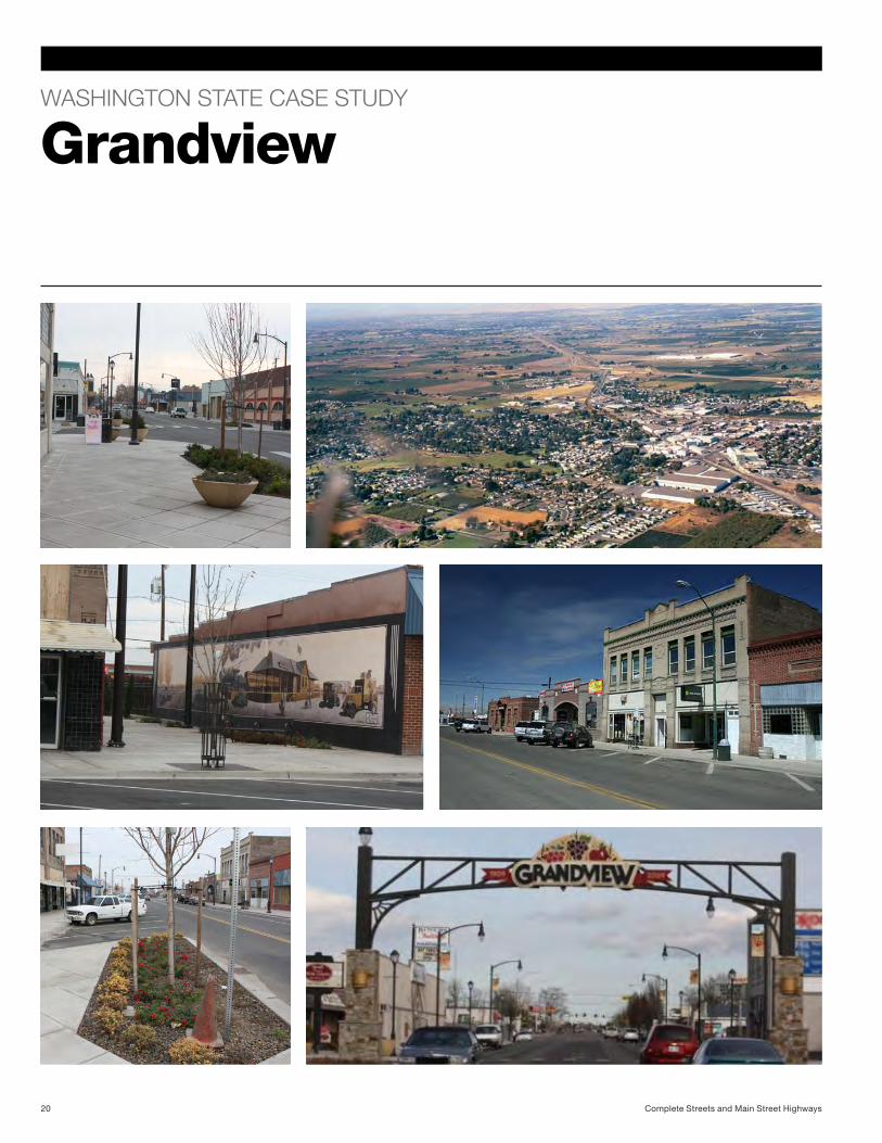
Grandview
Complete Streets and Main Street Highways20
Downtown “Alive!”
The vision
In 2006, the city of Grandview created an action plan to reinvigorate the downtown core. By 2008, they had received $3.8 million in funding from at least 10 different sources. Construction began in March 2010 and was completed in October 2010. The community worked with city officials to overhaul a six-block area of downtown Grandview. The plan, “Downtown Alive!”, created a streetscape that is welcoming, comfortable, and safer to use as a place for people to explore and interact. A redesigned road system maximizes efficiency and improves access for all users. Since the project’s completion, existing businesses have experienced growth, and seven new businesses have been established.
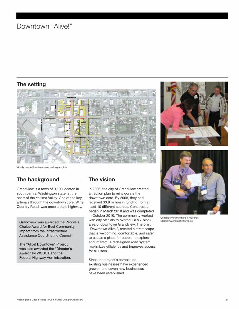
Vicinity map with surface street parking and lots.
The background
Grandview is a town of 9,100 located in south central Washington state, at the heart of the Yakima Valley. One of the key arterials through the downtown core, Wine Country Road, was once a state highway.
Community involvement in meetings. Source: www.grandview.wa.usGrandview was awarded the People’s
Choice Award for Best Community Impact from the Infrastructure Assistance Coordinating Council.
The “Alive! Downtown” Project was also awarded the “Director’s Award” by WSDOT and the Federal Highway Administration.
The setting
21Washington’s Case Studies in Community Design: Grandview
Main street components
Semi-trailersPedestrians
Goals and benefits
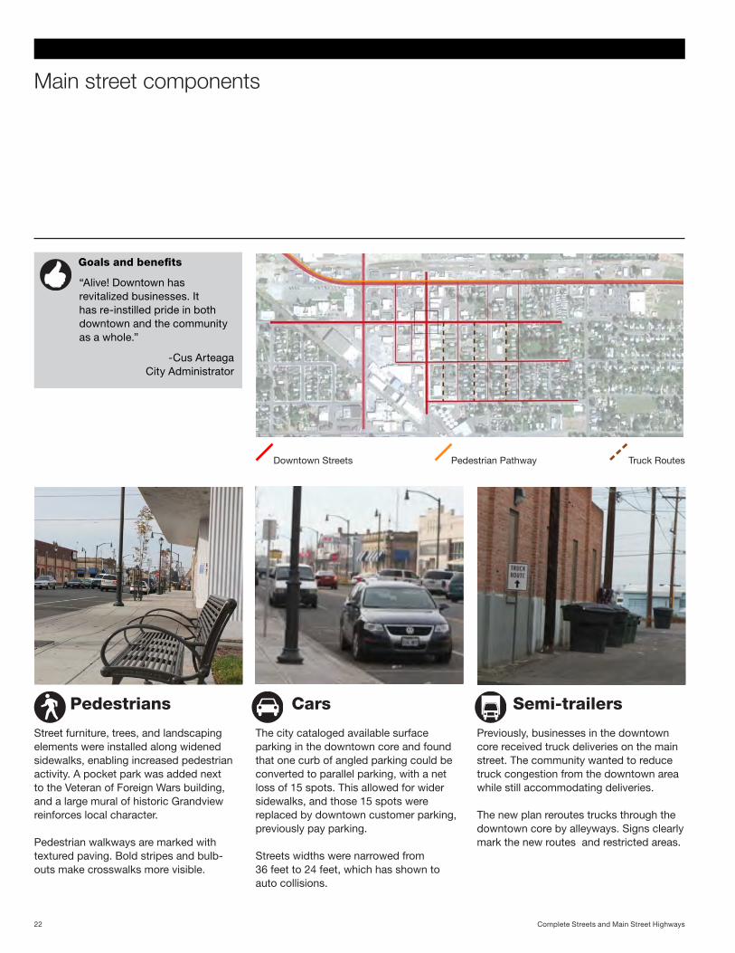
“Alive! Downtown has revitalized businesses. It has re-instilled pride in both downtown and the community as a whole.”
-Cus Arteaga City Administrator
The city cataloged available surface parking in the downtown core and found that one curb of angled parking could be converted to parallel parking, with a net loss of 15 spots. This allowed for wider sidewalks, and those 15 spots were replaced by downtown customer parking, previously pay parking.
Streets widths were narrowed from 36 feet to 24 feet, which has shown to auto collisions.
Previously, businesses in the downtown core received truck deliveries on the main street. The community wanted to reduce truck congestion from the downtown area while still accommodating deliveries.
The new plan reroutes trucks through the downtown core by alleyways. Signs clearly mark the new routes and restricted areas.
Street furniture, trees, and landscaping elements were installed along widened sidewalks, enabling increased pedestrian activity. A pocket park was added next to the Veteran of Foreign Wars building, and a large mural of historic Grandview reinforces local character.
Pedestrian walkways are marked with textured paving. Bold stripes and bulb-outs make crosswalks more visible.
Pedestrian PathwayDowntown Streets Truck Routes
Cars
Complete Streets and Main Street Highways22
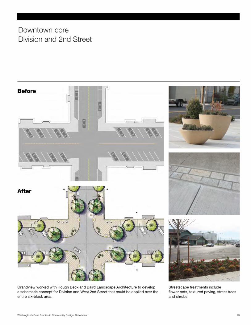
Downtown core Division and 2nd Street
Grandview worked with Hough Beck and Baird Landscape Architecture to develop a schematic concept for Division and West 2nd Street that could be applied over the entire six-block area.
Before
After
Streetscape treatments include flower pots, textured paving, street trees and shrubs.
23Washington’s Case Studies in Community Design: Grandview
West 2nd Street Before and After
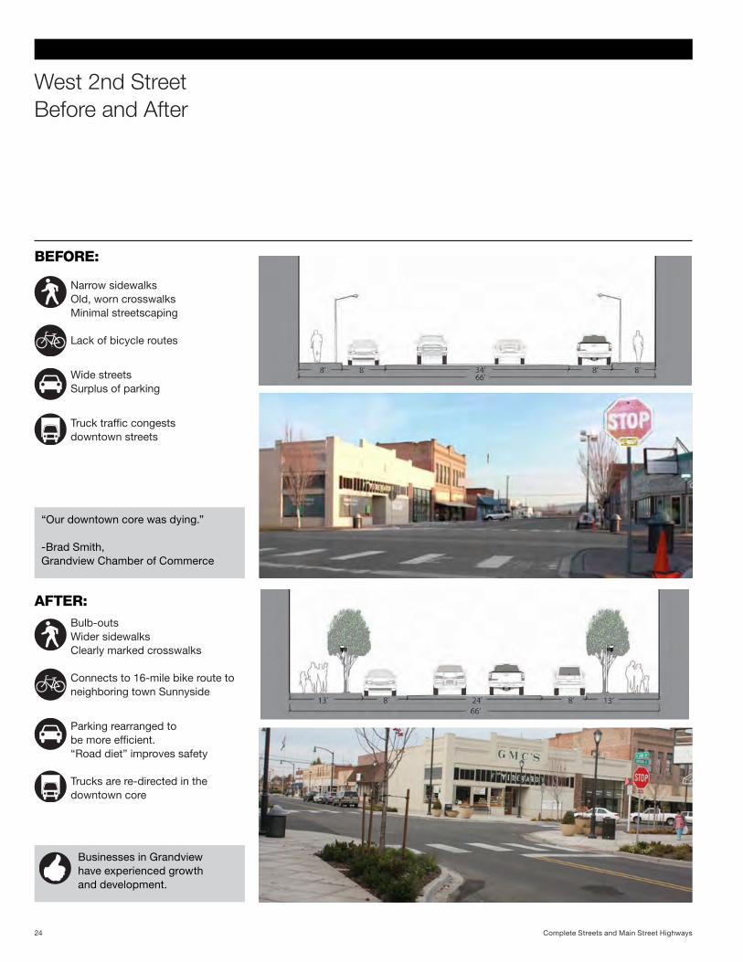
“Our downtown core was dying.”
-Brad Smith, Grandview Chamber of Commerce
BEFORE:
AFTER:
Narrow sidewalksOld, worn crosswalksMinimal streetscaping
Lack of bicycle routes
Wide streetsSurplus of parking
Truck traffic congests downtown streets
Bulb-outsWider sidewalksClearly marked crosswalks
Connects to 16-mile bike route to neighboring town Sunnyside
Parking rearranged to be more efficient. “Road diet” improves safety
Trucks are re-directed in the downtown core
Businesses in Grandview have experienced growth and development.
Complete Streets and Main Street Highways24
Division Street Before and After
Grandview’s keys to success
Work and communicate with existing businesses to ensure economic security during construction.
Keep the community up to date and involved for full support throughout the project.
Combine complete street projects with existing renovation needs and code requirements.
Extend revitalization out of downtown: inspire other businesses, promote town activities and events, and connect to and promote existing town features.
Don’t stop here. Grandview is continuing its downtown revitalization efforts with a community wide project called EDGE: Enhancing Development of Grandview’s Economy.
-Brad Smith, Grandview Chamber of Commerce.
25Washington’s Case Studies in Community Design: Grandview
WASHINGTON STATE CASE STUDY
Roslyn
Complete Streets and Main Street Highways26
A ten mile rural collector for local and recreational use.
UW Faculty Jim Nicholls speaks with local news crew.
Downtown Cle Elum
Background
State Route 903 connects the towns of Cle Elum, Roslyn, Ronald, and the recreational area of Lake Cle Elum. Accessed from I-90 via SR 970, the two-lane undivided highway serves as the main arterial, 1st Street, through Roslyn. The surrounding areas are zoned as Residential Low Density, Commercial Central, and Public. The Storefront Studio, through the University of Washington, has studied in Roslyn for the past three years, developing design proposals that engage the community.
• Populationof893(2010)inatotal area of 4.9 square miles.
• Averagedailytrafficofupto7400cars at downtown core
• Knownforitsoutdoorrecreation,coalmining history, and for hosting the TV program “Northern Exposure.”
• Recentadditionof500+singlefamilyhomes in Suncadia, a resort community south of Roslyn
Local “complete streets” achievements
Improved walking routes Suncadia roundabout
Sidewalk curbs have been extended to formbulb-outs,atrafficcalmingfeaturethat shortens crossing distance for pedestrians, allows better visibility past cars parked in the shoulder, and increases motorists’ awareness of the crosswalk.
New sidewalks have been added along SR903north(aboveleft).Towardsdowntown, “Progress Path” lines SR 903, separated from the highway by a grassy bank(aboveright).TheCleElumresidentsenjoy a direct, safe route to walk or bike.
A housing development about 1 mile south of Roslyn, has a similarly sized roundabout on Bullfrog Road. Its’ signage and landscaping can be examples for potential treatment of the SR 903/Bullfrog roundabout to Roslyn.
27Washington’s Case Studies in Community Design: Roslyn
Main street components
Semi-trailers
Pedestrians
The majority of accidents in the Roslyn area are rear-end or driveway collisions caused by motorists entering or exiting SR 903. Proposed solutions include left-turn channelization, a continuous two-way left turn lane, and a consistent, reduced speed limit.
Between 4.7 million and 7.0 million tons of freight is transported annually through Roslyn. Major commodities transported include timber, livestock, and grain products.
Cars
In 2004, WSDOT developed a 20 year route improvement plan for SR 903.
The following information includes both existing conditions and recommended
improvement goals from the plan.
• Improvecrosswalks/sidewalks• Adddesignatedbicycleroutes• CreateParkandRidefacility• Adjustshoulderuse/size• Addtrafficcalmingmeasures• Saferoutestoschool • Enhancelocalcharacter
SR903hasfiveblockswithsidewalkon both sides and four marked crosswalks in downtown Roslyn. As it moves south, the poorly maintained sidewalks are limited to one side, and disappear near the town limit.
Bicycles
Bicycling is a popular recreational activity in Roslyn during the summer months, but there are no designated bike lanes along SR 903. Bicyclists must ride along the shoulder, which ranges from 0-16 ft., or on the sidewalk. Cars park along the shoulders, which can obstruct cyclists’ path.
There is no public transit system other than a paratransit service for Medicaid patients. A Park and Ride facility and carpool system, has been suggested by WSDOT. A well-used school bus system services the outer reaches of the area, including Roslyn, Cle Elum, Ronald, and Liberty.
Transit
Goals
1 Downtown core Key issues:
2 Shoulder/sidewalk 3 Bullfrog roundabout
1
2
3
Complete Streets and Main Street Highways28
Downtown core Existing conditions
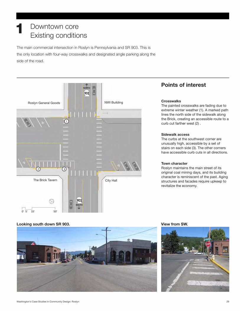
1The main commercial intersection in Roslyn is Pennsylvania and SR 903. This is
the only location with four-way crosswalks and designated angle parking along the
side of the road.
Points of interest
CrosswalksThe painted crosswalks are fading due to extremewinterweather(1).Amarkedpathlines the north side of the sidewalk along the Brick, creating an accessible route to a curbcutfartherwest(2).
Sidewalk accessThe curbs at the southwest corner are unusually high, accessible by a set of stairsoneachside(3).Theothercornershave accessible curb cuts in all directions.
Town character Roslyn maintains the main street of its original coal mining days, and its building character is reminiscent of the past. Aging structures and facades require upkeep to revitalize the economy.
1
2 3
5’ 15’ 50’0’
Roslyn General Goods
The Brick Tavern
NWI Building
City Hall
SOUTH
NORTH
Looking south down SR 903. View from SW.
29Washington’s Case Studies in Community Design: Roslyn
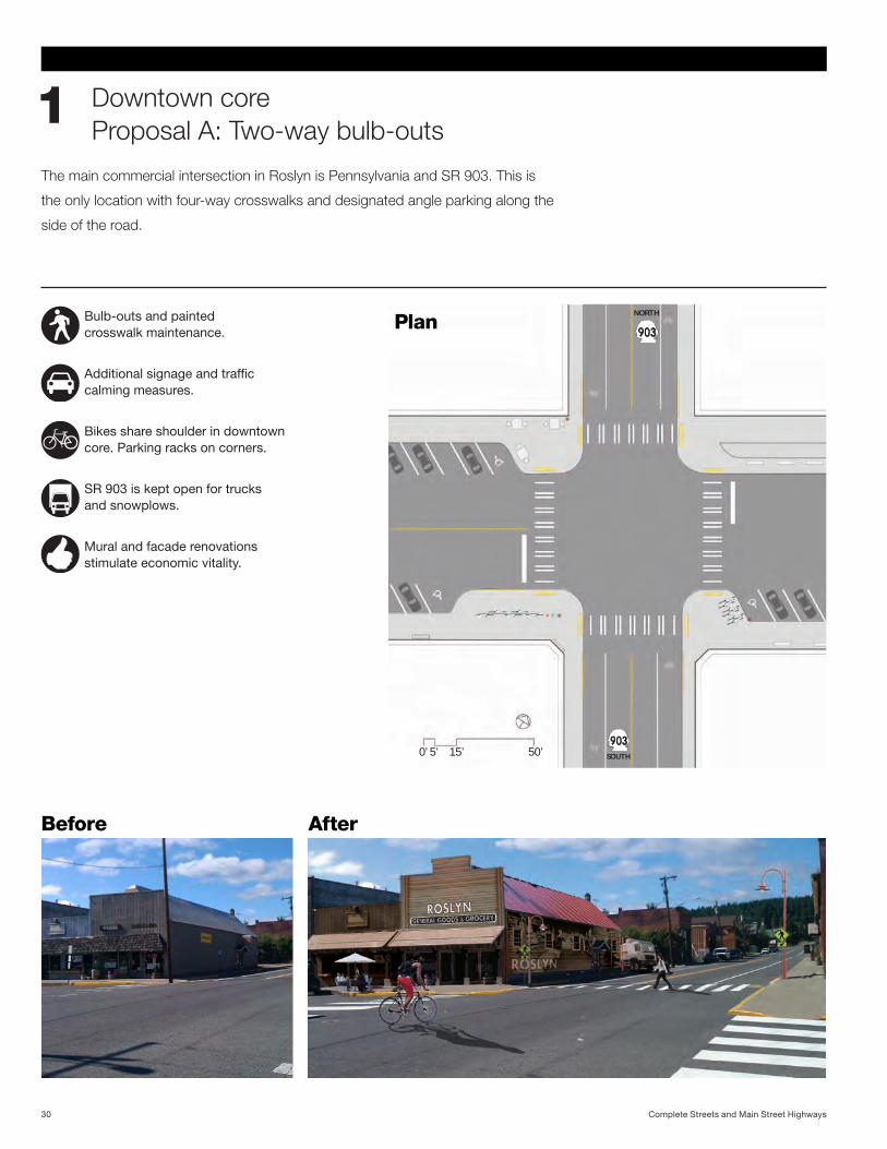
Downtown core Proposal A: Two-way bulb-outs
1The main commercial intersection in Roslyn is Pennsylvania and SR 903. This is
the only location with four-way crosswalks and designated angle parking along the
side of the road.
Before After
NORTH
SOUTH 5’ 15’0’ 50’
Bulb-outs and painted crosswalk maintenance.
Additionalsignageandtraffic calming measures.
Bikes share shoulder in downtown core. Parking racks on corners.
SR 903 is kept open for trucks and snowplows.
Mural and facade renovations stimulate economic vitality.
Plan
Complete Streets and Main Street Highways30
5’ 15’0’
NORTH
50’SOUTH
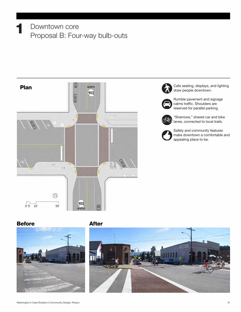
Downtown core Proposal B: Four-way bulb-outs
1
Before After
Cafe seating, displays, and lighting draw people downtown.
Rumble pavement and signage calmstraffic.Shouldersarereserved for parallel parking.
“Sharrows,” shared car and bike lanes, connected to local trails.
Safety and community features make downtown a comfortable and appealing place to be.
Plan
31Washington’s Case Studies in Community Design: Roslyn
Shoulder/sidewalk Existing conditions
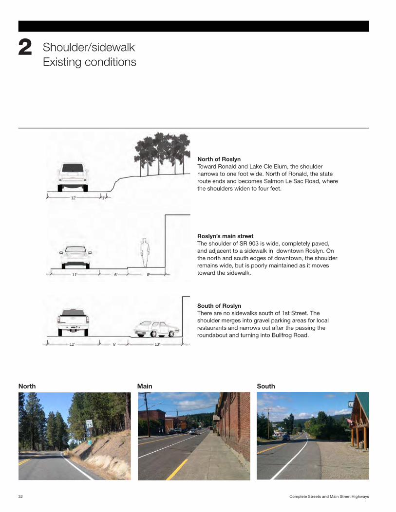
2
North of RoslynToward Ronald and Lake Cle Elum, the shoulder narrows to one foot wide. North of Ronald, the state route ends and becomes Salmon Le Sac Road, where the shoulders widen to four feet.
12’ 6’ 13’
11’ 6’ 8’
12’ 1’
North Main South
Roslyn’s main streetThe shoulder of SR 903 is wide, completely paved, and adjacent to a sidewalk in downtown Roslyn. On the north and south edges of downtown, the shoulder remains wide, but is poorly maintained as it moves toward the sidewalk.
South of RoslynThere are no sidewalks south of 1st Street. The shoulder merges into gravel parking areas for local restaurants and narrows out after the passing the roundabout and turning into Bullfrog Road.
Complete Streets and Main Street Highways32
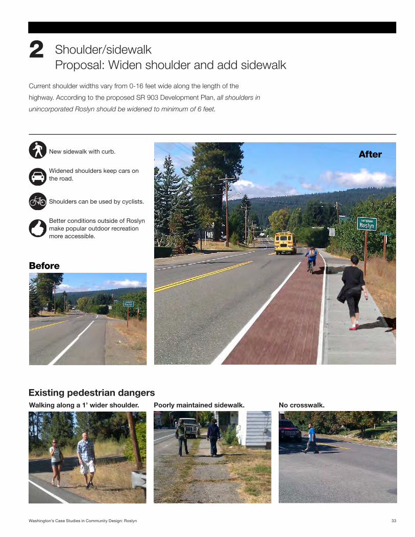
Current shoulder widths vary from 0-16 feet wide along the length of the
highway. According to the proposed SR 903 Development Plan, all shoulders in
unincorporated Roslyn should be widened to minimum of 6 feet.
Shoulder/sidewalk Proposal: Widen shoulder and add sidewalk
2
Existing pedestrian dangersWalking along a 1’ wider shoulder. Poorly maintained sidewalk. No crosswalk.
New sidewalk with curb.
Widened shoulders keep cars on the road.
Shoulders can be used by cyclists.
Better conditions outside of Roslyn make popular outdoor recreation more accessible.
Before
After
33Washington’s Case Studies in Community Design: Roslyn
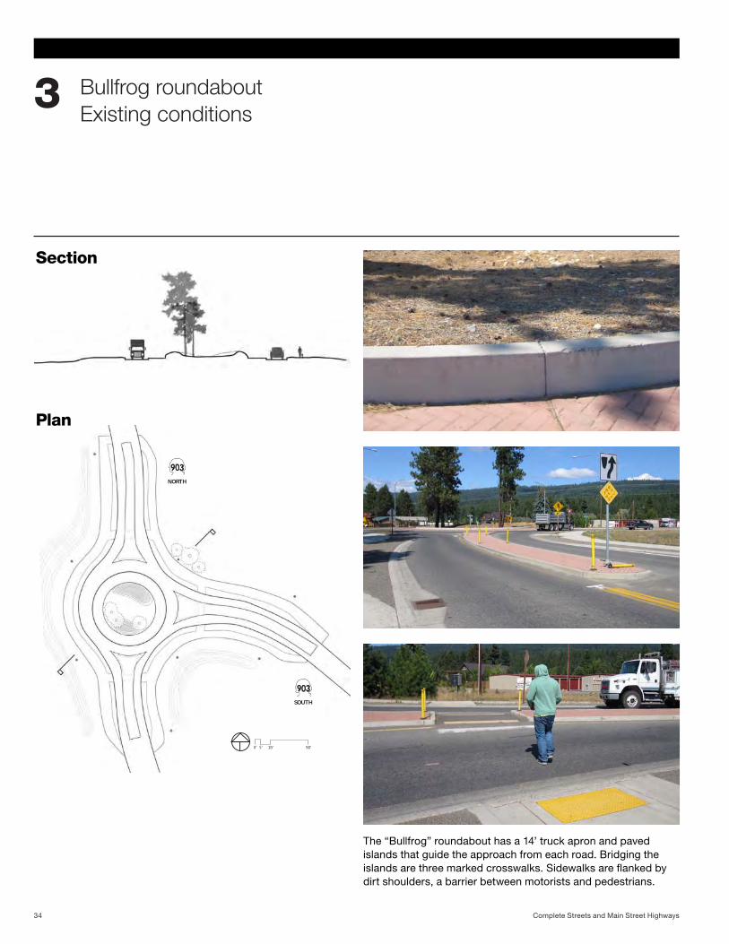
Bullfrog roundabout Existing conditions
3
SOUTH
NORTH
0’ 5’ 15’ 50’
Plan
Section
The “Bullfrog” roundabout has a 14’ truck apron and paved islands that guide the approach from each road. Bridging the islands are three marked crosswalks. Sidewalks are flanked by dirt shoulders, a barrier between motorists and pedestrians.
Complete Streets and Main Street Highways34
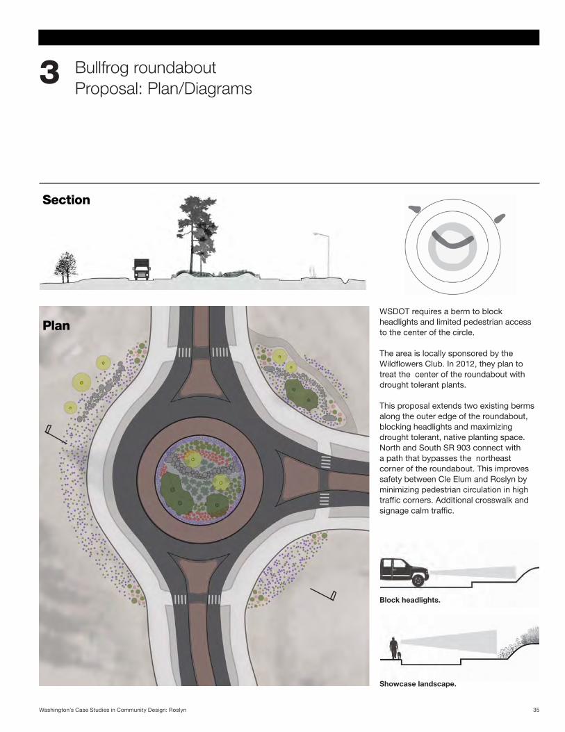
WSDOT requires a berm to block headlights and limited pedestrian access to the center of the circle.
The area is locally sponsored by the Wildflowers Club. In 2012, they plan to treat the center of the roundabout with drought tolerant plants.
This proposal extends two existing berms along the outer edge of the roundabout, blocking headlights and maximizing drought tolerant, native planting space. North and South SR 903 connect with a path that bypasses the northeast corner of the roundabout. This improves safety between Cle Elum and Roslyn by minimizing pedestrian circulation in high trafficcorners.Additionalcrosswalkandsignagecalmtraffic.
Bullfrog roundabout Proposal: Plan/Diagrams
3
Showcase landscape.
Block headlights.
Plan
Section
35Washington’s Case Studies in Community Design: Roslyn
Before
After
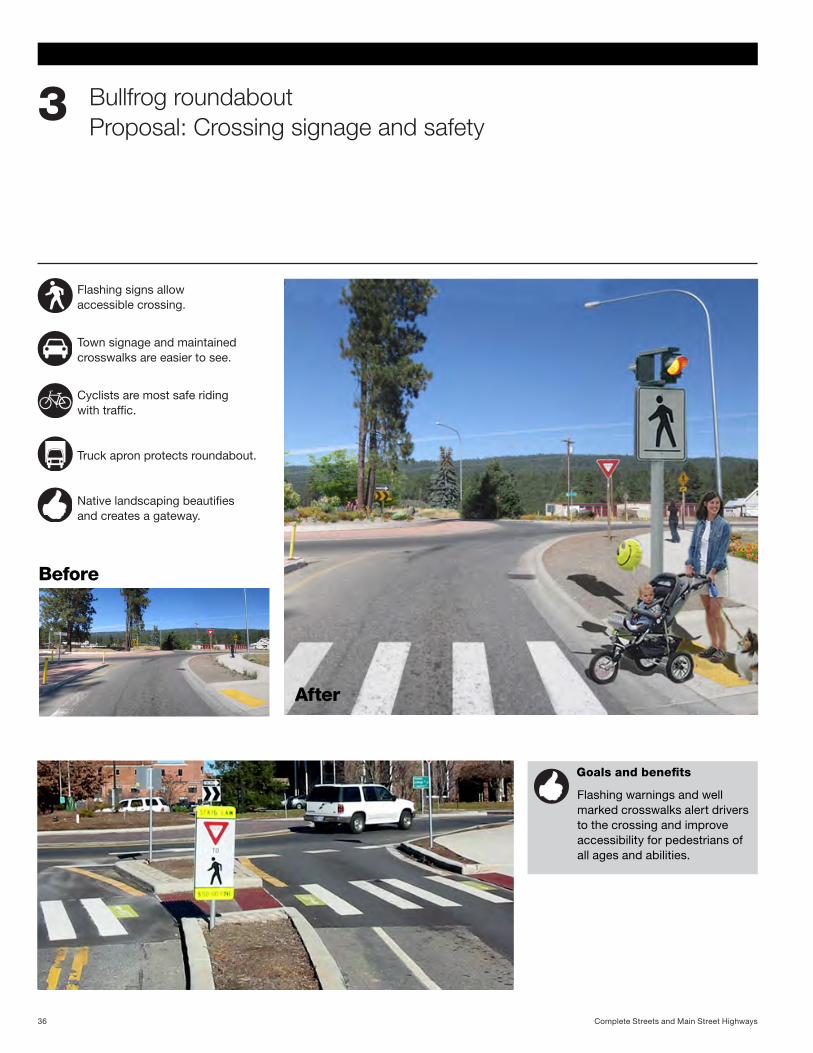
Bullfrog roundabout Proposal: Crossing signage and safety
3
Flashing signs allow accessible crossing.
Town signage and maintained crosswalks are easier to see.
Cyclists are most safe riding withtraffic.
Truck apron protects roundabout.
Nativelandscapingbeautifies and creates a gateway.
Goals and benefits
Flashing warnings and well marked crosswalks alert drivers to the crossing and improve accessibility for pedestrians of all ages and abilities.
Complete Streets and Main Street Highways36
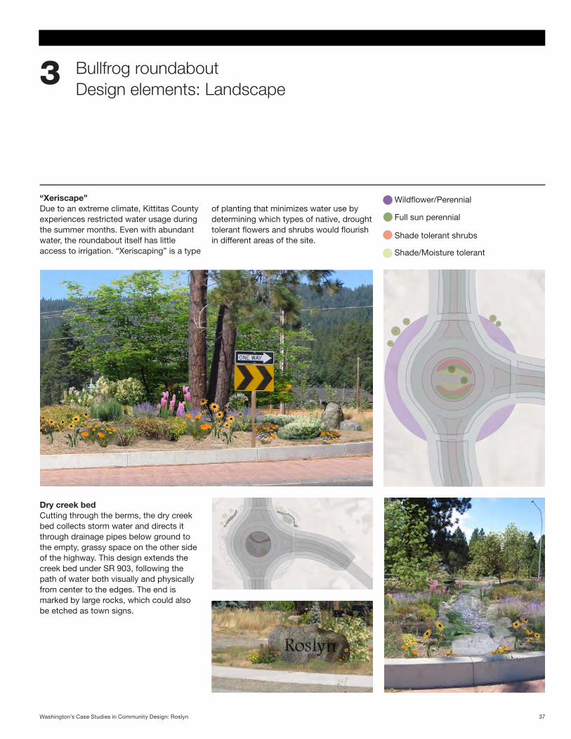
Bullfrog roundabout Design elements: Landscape
3
Wildflower/Perennial
Full sun perennial
Shade tolerant shrubs
Shade/Moisture tolerant
“Xeriscape”Duetoanextremeclimate,KittitasCountyexperiences restricted water usage during the summer months. Even with abundant water, the roundabout itself has little access to irrigation. “Xeriscaping” is a type
of planting that minimizes water use by determining which types of native, drought tolerant flowers and shrubs would flourish in different areas of the site.
Dry creek bedCutting through the berms, the dry creek bed collects storm water and directs it through drainage pipes below ground to the empty, grassy space on the other side of the highway. This design extends the creek bed under SR 903, following the path of water both visually and physically from center to the edges. The end is marked by large rocks, which could also be etched as town signs.
37Washington’s Case Studies in Community Design: Roslyn
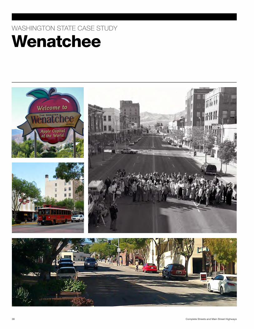
WASHINGTON STATE CASE STUDY
Wenatchee
Complete Streets and Main Street Highways38
The Apple Capital of the World
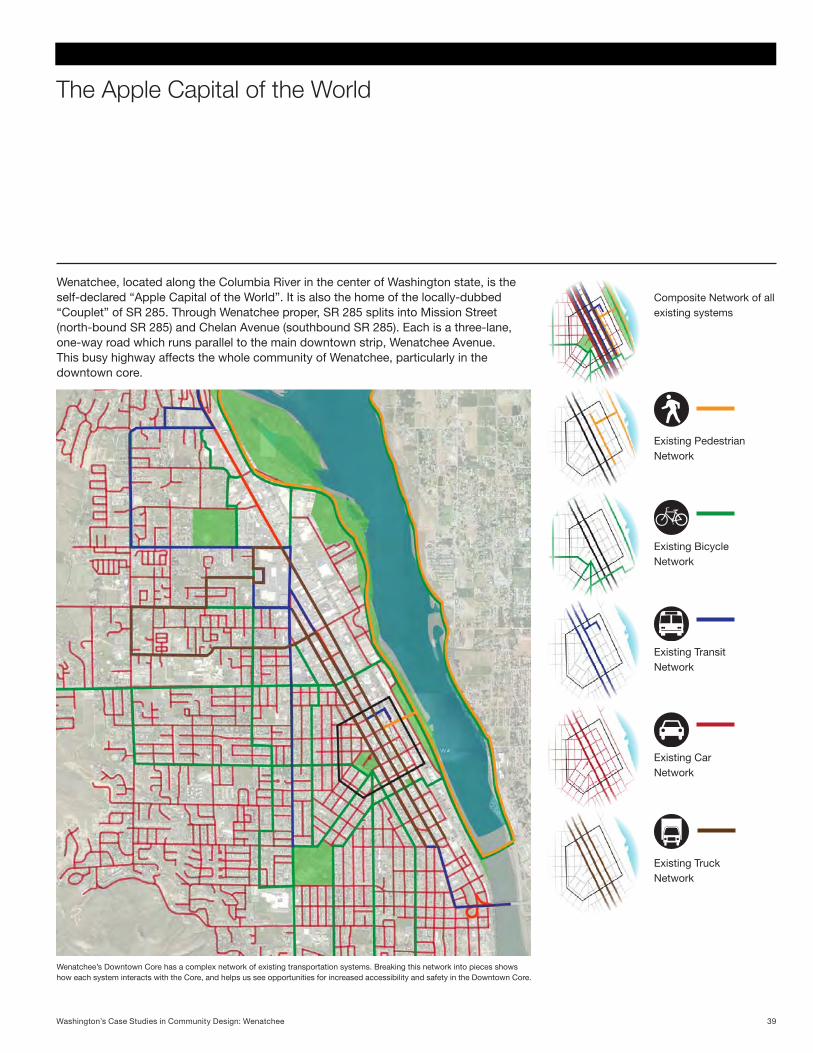
Wenatchee, located along the Columbia River in the center of Washington state, is the self-declared “Apple Capital of the World”. It is also the home of the locally-dubbed “Couplet” of SR 285. Through Wenatchee proper, SR 285 splits into Mission Street (north-bound SR 285) and Chelan Avenue (southbound SR 285). Each is a three-lane, one-way road which runs parallel to the main downtown strip, Wenatchee Avenue. This busy highway affects the whole community of Wenatchee, particularly in the downtown core.
Wenatchee’s Downtown Core has a complex network of existing transportation systems. Breaking this network into pieces shows how each system interacts with the Core, and helps us see opportunities for increased accessibility and safety in the Downtown Core.
Composite Network of all existing systems
Existing Pedestrian Network
Existing Bicycle Network
Existing Transit Network
Existing Car Network
Existing Truck Network
39Washington’s Case Studies in Community Design: Wenatchee
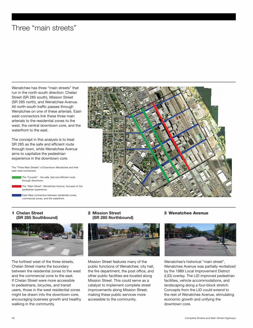
Three “main streets”
Wenatchee has three “main streets” that run in the north-south direction: Chelan Street (SR 285 south), Mission Street (SR 285 north), and Wenatchee Avenue. All north-south traffic passes through Wenatchee on one of these arterials. East-west connectors link these three main arterials to the residential zones to the west, the central downtown core, and the waterfront to the east.
The concept in this analysis is to treat SR 285 as the safe and efficient route through town, while Wenatchee Avenue aims to capitalize the pedestrian experience in the downtown core.
The “Couplet” - the safe, fast and efficient route through downtown.
The “Main Street”, Wenatchee Avenue, focused on the pedestrian experience.
East-West connectors between residential zones, commercial zones, and the waterfront.
The “Three Main Streets” of Downtown Wenatchee and their east-west connectors.
1 Chelan Street (SR 285 Southbound)
2 Mission Street (SR 285 Northbound)
3 Wenatchee Avenue
The furthest west of the three streets, Chelan Street marks the boundary between the residential zones to the west and the commercial zone to the east. If Chelan Street were more accessible to pedestrians, bicycles, and transit users, those in the west residential zones might be drawn into the downtown core, encouraging business growth and healthy walking in the community.
Mission Street features many of the public functions of Wenatchee: city hall, the fire department, the post office, and other public facilities are located along Mission Street. This could serve as a catalyst to implement complete street improvements along Mission Street, making these public services more accessible to the community.
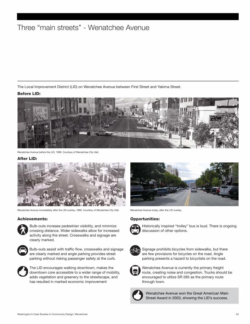
Wenatchee’s historical “main street”, Wenatchee Avenue was partially revitalized by the 1989 Local Improvement District (LID) overlay. The LID improved pedestrian facilities, vehicle accommodations, and landscaping along a four-block stretch. Concepts from the LID could extend to the rest of Wenatchee Avenue, stimulating economic growth and unifying the downtown core.
Complete Streets and Main Street Highways40
Reclaiming parking areas
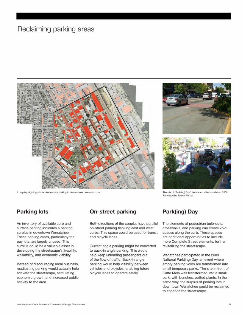
A map highlighting all available surface parking in Wenatchee’s downtown core.
Parking lots On-street parking Park(ing) Day
An inventory of available curb and surface parking indicates a parking surplus in downtown Wenatchee. These parking areas, particularly the pay lots, are largely unused. This surplus could be a valuable asset in developing the streetscape’s livability, walkability, and economic viability.
Instead of discouraging local business, readjusting parking would actually help activate the streetscape, stimulating economic growth and increased public activity to the area.
Both directions of the couplet have parallel on-street parking flanking east and west curbs. This space could be used for transit and bicycle lanes.
Current angle parking might be converted to back-in angle parking. This would help keep unloading passengers out of the flow of traffic. Back-in angle parking would help visibility between vehicles and bicycles, enabling future bicycle lanes to operate safely.
The elements of pedestrian bulb-outs, crosswalks, and parking can create void spaces along the curb. These spaces are additional opportunities to include more Complete Street elements, further revitalizing the streetscape.
Wenatchee participated in the 2009 National Park(ing) Day, an event where empty parking voids are transformed into small temporary parks. The site in front of Caffè Mela was transformed into a small park, with benches, potted plants. In the same way, the surplus of parking lots in downtown Wenatchee could be reclaimed to enhance the streetscape.
The site of “Park(ing) Day”, before and after installation. 2009. Providede by Patrick Walker.
41Washington’s Case Studies in Community Design: Wenatchee
Previous studies and community participation
Extending business
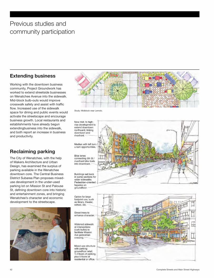
Working with the downtown business community, Project Groundwork has worked to extend streetside businesses on Wenatchee Avenue into the sidewalk. Mid-block bulb-outs would improve crosswalk safety and assist with traffic flow. Increased use of the sidewalk space for dining and public events would activate the streetscape and encourage business growth. Local restaurants and establishments have already begun extendingbusiness into the sidewalk, and both report an increase in business and productivity.
Reclaiming parking The City of Wenatchee, with the help of Makers Architecture and Urban Design, has examined the surplus of parking available in the Wenatchee downtown core. The Central Business District Subarea Plan proposes mixed-use development in the under-used parking lot on Mission St and Palouse St, defining downtown core into historic and entertainment zones, and bringing Wenatchee’s character and economic development to the streetscape.
Study: Midblock near Lemolo.
Complete Streets and Main Street Highways42
Three “main streets” - Wenatchee Avenue
Wenatchee Avenue won the Great American Main Street Award in 2003, showing the LID’s success.
Bulb-outs increase pedestrian visibility, and minimize crossing distance. Wider sidewalks allow for increased activity along the street. Crosswalks and signage are clearly marked.
Bulb-outs assist with traffic flow, crosswalks and signage are clearly marked and angle parking provides street parking without risking passenger safety at the curb.
Historically inspired “trolley” bus is loud. There is ongoing discussion of other options.
The LID encourages walking downtown, makes the downtown core accessible to a wider range of mobility, adds vegetation and greenery to the streetscape, and has resulted in marked economic improvement
Signage prohibits bicycles from sidewalks, but there are few provisions for bicycles on the road. Angle parking presents a hazard to bicyclists on the road.
Wenatchee Avenue is currently the primary freight route, creating noise and congestion. Trucks should be encouraged to utilize SR 285 as the primary route through town.
The Local Improvement District (LID) on Wenatchee Avenue between First Street and Yakima Street.
Before LID:
Wenatchee Avenue before the LID, 1989. Courtesy of Wenatchee City Hall.
Achievements: Opportunities:
Wenatchee Avenue immediately after the LID overlay, 1989. Courtesy of Wenatchee City Hall. Wenatchee Avenue today, after the LID overlay.
After LID:
43Washington’s Case Studies in Community Design: Wenatchee
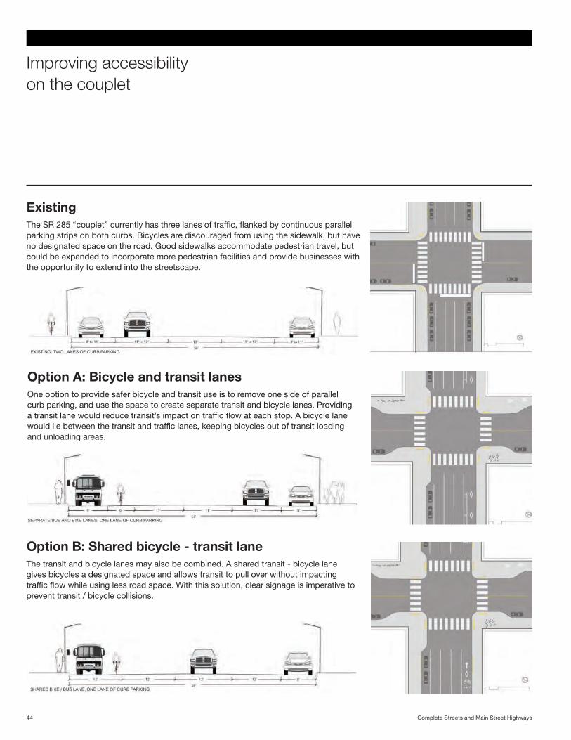
Improving accessibilityon the couplet
The SR 285 “couplet” currently has three lanes of traffic, flanked by continuous parallel parking strips on both curbs. Bicycles are discouraged from using the sidewalk, but have no designated space on the road. Good sidewalks accommodate pedestrian travel, but could be expanded to incorporate more pedestrian facilities and provide businesses with the opportunity to extend into the streetscape.
Existing
One option to provide safer bicycle and transit use is to remove one side of parallel curb parking, and use the space to create separate transit and bicycle lanes. Providing a transit lane would reduce transit’s impact on traffic flow at each stop. A bicycle lane would lie between the transit and traffic lanes, keeping bicycles out of transit loading and unloading areas.
Option A: Bicycle and transit lanes
The transit and bicycle lanes may also be combined. A shared transit - bicycle lane gives bicycles a designated space and allows transit to pull over without impacting traffic flow while using less road space. With this solution, clear signage is imperative to prevent transit / bicycle collisions.
Option B: Shared bicycle - transit lane
Complete Streets and Main Street Highways44
Three “main streets” - Chelan Street
An appealing and accessible public space along Chelan, a key arterial to downtown, encourages walking and cycling, provides pause along the sidewalk, and stimulates economic growth along the streetscape.
Bulb-outs increase pedestrian visibility, and minimize crossing distance. Public space creates a place of pause for passing pedestrians.
Bulb-outs assist with traffic flow. Parking is readjusted to allow for HOV lane and mixed-use development.
Transit HOV lane allows busses to separate from traffic when loading and unloading.
Bicycle lane and turn box designate space for bicycles on the road. Bicycle storage racks make bicycling on Chelan more appealing.
Efficient speed and reduced obstacles encourage freight to use SR 285 as preferred route over Wenatchee Ave.
The view of the intersection of Chelan and Yakima shows how transit and bicycle lanes might look along the SR 285 couplet.
Existing lot:
Site with main street highway components:
45Washington’s Case Studies in Community Design: Wenatchee
Three “main streets” - Mission Street
A surplus parking lot is reclaimed for mixed-use development, stimulating economic streetside growth. Business extends into the sidewalk.
Parking is now in the garage beneath the building.
Wider sidewalks allow for increased business activity along the street. Bulb-outs increase pedestrian visibility and minimize crossing distance.
Parking is readjusted, and moved to a structure underneath the building, to allow for new development and the shared transit - bicycle lane.
Shared transit - bicycle lane allows busses to separate from traffic flow when loading and unloading.
Shared transit - bicycle lane encourages alternative transportation and provides a safe place for bicycles on the road.
Efficient speed and reduced obstacles encourage freight to use SR 285 as preferred route over Wenatchee Ave.
A large under-used parking lot is converted into a mixed-use development, with a parking structure at the alley, new businesses and public spaces at the street level, and residential above.
Existing lot:
Site with main street highway components:
Complete Streets and Main Street Highways46
Three “main streets” - Mission Street
Reclaiming one side of curb parking for bike and transit lanes increase accessibility for alternative modes of transportation. New-mixed use building activates the street physically, economically, and aesthetically.
Bulb-outs increase pedestrian visibility and minimize crossing distance. Wider sidewalks allow for increased activity along the street.
Bulb-outs assist with traffic flow. Parking is readjusted to allow for bicycle and transit lanes.
Transit HOV lane allows busses to separate from traffic flow when loading and unloading.
Separate bicycle lane designates space for bicycles on the road. Facilities like off-street bicycle parking and storage make bicycling easier.
Efficient speed and reduced obstacles encourage freight to use SR 285 as preferred route rather than Wenatchee Ave.
Another under-utilized parking lot on Mission Street is reclaimed for a mixed-use development with commercial and residential space.
Existing lot:
Site with main street highway components:
47Washington’s Case Studies in Community Design: Wenatchee
Grant program
Complete Streets and Main Street Highways Program48
Developing a Grant Program
The purpose a grant program (RCW 47.04.257) is to encourage street designs that safely meet the needs of all users, including bicyclists, pedestrians, motorists, and public transportation users while protecting and preserving community environment and character. Recognizing that improvements to these city streets and main street highways are critical to community development in cities and towns across the state, this program provides funding for transportation improvements that support infill and redevelopment, and connect housing and employment in order to improve the health, safety, and economic vitality of Washington residents.
EPA-HUD-DOT Partnership Goals:
• Providingmore transportation choices
• Promotingequitable, affordable housing
• Enhancingeconomiccompetitiveness
• Supportingexistingcommunities
• Coordinatingpoliciesand leverage investment
• Valuingcommunities and neighborhood
The scope of every project is informed bycontext-specificcircumstances.Some rely on pedestrian features while others may focus on cyclist safety.
Size and scope
Notallprojectswillrequiremulti-milliondollarinvestments.Forexample,stripingmay be all that is needed to increase safety and accessibility. One project might aim to create a more complete bike network, freight traffic might be the driving catalyst in another project. The goal is to achieve accessibility for all users while dealing with the primary needs specific to eachcontext.
Systems
• Crossingandintersection treatments or roundabouts
• Signage,striping,markings
• Streetscape,gatewaytreatments
• Sidewalks
• Roadwayconstruction
• Lighting
• AmericanswithDisabilitiesAct(ADA)accommodations
• Bicyclefacilities
• Urbantrailsandcrossings
• Bicycleparkingandstations
• Trafficcalmingmeasures
• Freightaccommodation
• Transitaccommodation
• Electricvehiclechargingstations
• Frontageimprovements
Projects could feature elements such as:
49Grant Program
How does a project receive grant funding?
Cities must have adopted a complete streetsordinanceorequivalentandhaveintegrated it into a community plan in order toapplyforgrantfunding.Allprojectswill be evaluated based on the following criteria, found in RCW 47.04.257:
“In Grandview, we worked with 10 or 11 different funding sources, which each had their own reporting formatandmethods.Asinglecomplete streets grant program would really help.”
-BradSmith, Grandview Chamber of Commerce
The project promotes healthy communities by encouraging walking, bicycling and using public transportation. The project should improve connections and/or establish safer and fully accessible crossings, sidewalks, trails, bike facilities, and transit connections consistent with AASHTO,ITEorotherpeerreviewed,contextsensitivesolutionsguides.
The project protects the environment and reduces congestion by providing safe alternatives to single occupancy driving. In order to make alternatives to single occupancy driving safe and viable, proximityandconnectionsareneededbetweenandamongexistinghousing,centers of employment, education, retail and recreation. The project should support infill, encourage redevelopment andreuseofexistingbuildingstock,andconnect housing and employment.
The project preserves community character by involving local citizens and stakeholders to participate in planning and design. Transportation projects on urban arterials and main street highways have a greater likelihood of scope, schedule and budget changes that often result in additional costs. Research has shown that more and better up front coordination and communication with the community during the design process can reduce the potential for project delay orcostover-runs.
The project improves safety on major arterials by including wider sidewalks, bicycle facilities, medians, and pedestrian features.Locationswithhigh-speedarterial streets, higher motor vehicle volumes,andhousingmixedwithcommercial attractions, transit service, and other pedestrian and bicycle generators have the most transportation conflicts, collisions and risk. Mobility
Safety
Sustainibility
Community outreach
Complete Streets and Main Street Highways Program50