Embed Size (px)
Citation preview
January 2000 Vol. 20, Number 1
publication
Washington MonumentGPS Pr o j e c t
8 PROFESSIONAL SURVEYOR • January 2000
and computed a third-order (1:10,000)position by the method of intersectionusing a 10-inch Gamby theodolite. Theseobservations were computed as part ofthe New England Datum, later readjustedinto the U.S. Standard Datum in 1901 andsubsequently renamed the North Ameri-can Datum in 1913. No attempt was
Like the pyramids of Egypt, the EiffelTower, the Parthenon, or the temples
of Ankor Wat, the Washington Monumentin Washington D.C. is truly a monumentthat commands universal re c o g n i t i o n .This marvel of 19th century engineeringis a symbol of national pride, democraticprincipals, cultural variety, social struggleand political freedom. The monument isnow also one of the most important ele-ments of the National Spatial ReferenceSystem (NSRS) maintained by the Nation-al Geodetic Survey (NGS), an agency ofthe National Oceanic and AtmosphericAdministration’s (NOAA), NationalOcean Service (NOS). Standing approxi-mately 555 feet 5 inches, the Monumentis the tallest structure in Washington D.C.and on a clear day provides a command-ing and dramatic view of the Marylandand Virginia countryside.
Authorized by Congress in 1833
Construction of a monument to honorthe first President and Father of His Coun-try was authorized by Congress in 1833,h o w e v e r, construction was not actuallybegun until 1848. The simple structure wesee today is the design of architect RobertMills who was hired by the Wa s h i n g t o nNational Monument Society. Construction
was halted in 1854, whenmembers of the “Know-Nothing Party” gainedc o n t rol of the Society andfinancial contributionsf rom private donorsstopped. A frustratedP resident Grant persuad-ed the Society to donatethe project to the countryin 1876, and constructionwas restarted in 1878, un-der the direction of theU.S. Army Corps of Engi-neers. The external struc-t u re was completed in1884, and finally openedto the public in 1888. In1933 the care and main-tenance of the Monu-ment was transferred tothe National Park Service(NPS). Today, the Monu-ment and the Park Service are host to ap-p roximately 3,000 visitors each day.
The first geodetic survey of the Mon-ument was performed shortly after itscompletion. From April 4-11, 1886, a fieldunit of the U.S. Coast and Geodetic Sur-vey (USCGS), the predecessor of NGS,performed a local triangulation network
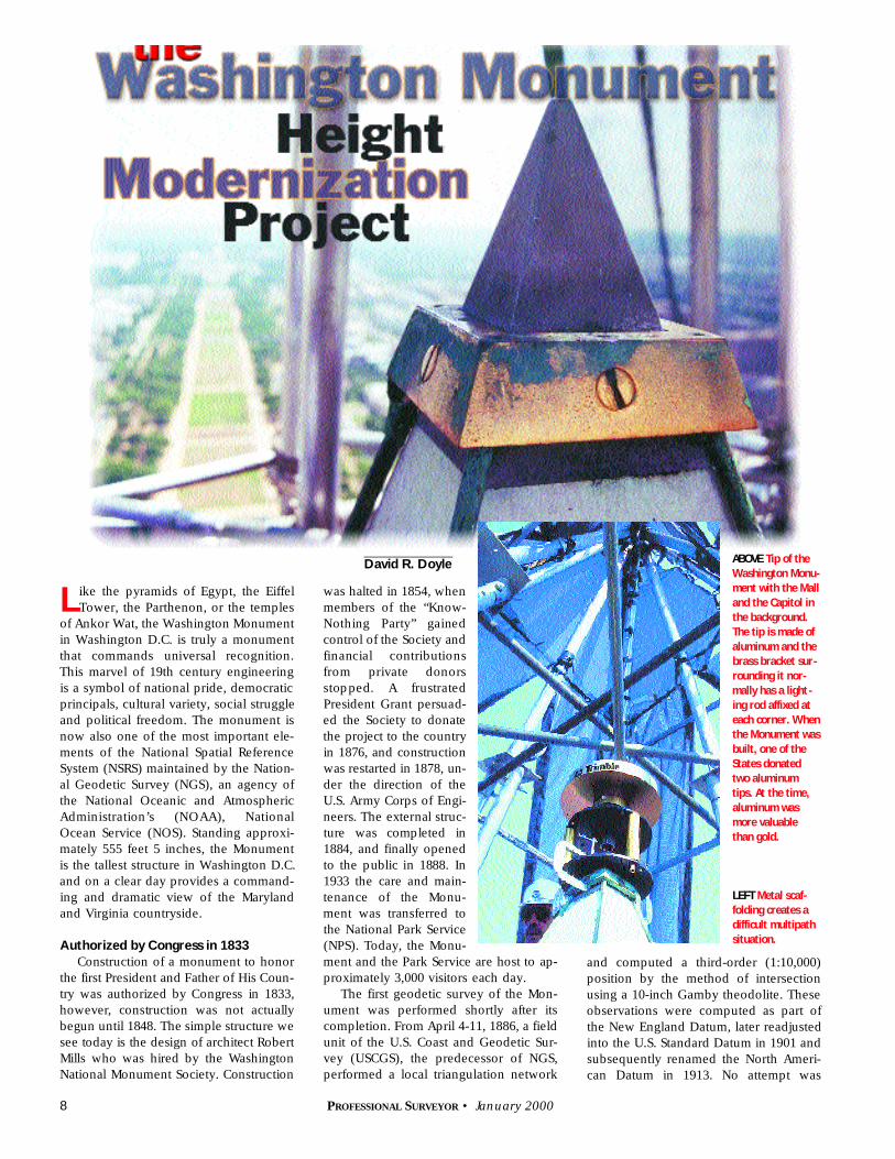
David R. Doyle ABOVE Tip of the
Washington Monu-
ment with the Mall
and the Capitol in
the background.
The tip is made of
aluminum and the
brass bracket sur-
rounding it nor-
mally has a light -
ing rod affixed at
each corner. When
the Monument was
built, one of the
States donated
two aluminum
tips. At the time,
aluminum was
more valuable
than gold.
LEFT Metal scaf-
folding creates a
difficult multipath
situation.
10 PROFESSIONAL SURVEYOR • January 2000
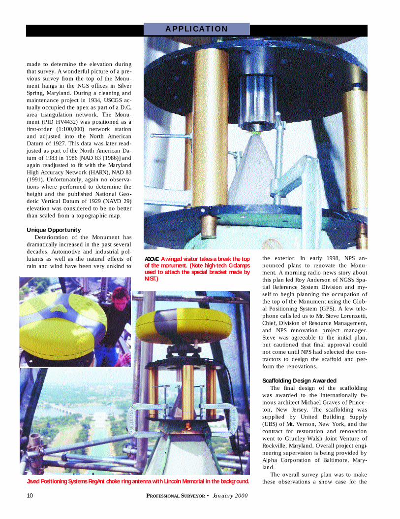
the exterior. In early 1998, NPS an-nounced plans to renovate the Monu-ment. A morning radio news story aboutthis plan led Roy Anderson of NGS’s Spa-tial Reference System Division and my-self to begin planning the occupation ofthe top of the Monument using the Glob-al Positioning System (GPS). A few tele-phone calls led us to Mr. Steve Lorenzetti,Chief, Division of Resource Management,and NPS renovation project manager.Steve was agreeable to the initial plan,but cautioned that final approval couldnot come until NPS had selected the con-tractors to design the scaffold and per-form the renovations.
Scaffolding Design Awarded
The final design of the scaffoldingwas awarded to the internationally fa-mous architect Michael Graves of Prince-ton, New Jersey. The scaffolding wassupplied by United Building Supply(UBS) of Mt. Vernon, New York, and thecontract for restoration and renovationwent to Grunley-Walsh Joint Venture ofRockville, Maryland. Overall project engi-neering supervision is being provided byAlpha Corporation of Baltimore, Mary-land.
The overall survey plan was to makethese observations a show case for the
A P P L I C AT I O N
Javad Positioning Systems RegAnt choke ring antenna with Lincoln Memorial in the background.
made to determine the elevation duringthat survey. A wonderful picture of a pre-vious survey from the top of the Monu-ment hangs in the NGS offices in SilverSpring, Maryland. During a cleaning andmaintenance project in 1934, USCGS ac-tually occupied the apex as part of a D.C.area triangulation network. The Monu-ment (PID HV4432) was positioned as afirst-order (1:100,000) network stationand adjusted into the North AmericanDatum of 1927. This data was later read-justed as part of the North American Da-tum of 1983 in 1986 [NAD 83 (1986)] andagain readjusted to fit with the MarylandHigh Accuracy Network (HARN), NAD 83(1991). Unfortunately, again no observa-tions where performed to determine theheight and the published National Geo-detic Vertical Datum of 1929 (NAVD 29)elevation was considered to be no betterthan scaled from a topographic map.
Unique Opportunity
Deterioration of the Monument hasdramatically increased in the past severaldecades. Automotive and industrial pol-lutants as well as the natural effects ofrain and wind have been very unkind to
ABOVE A winged visitor takes a break the topof the monument. (Note high-tech C-clampsused to attach the special bracket made byNIST.)

12 PROFESSIONAL SURVEYOR • January 2000
use of GPS for height determination as part of the NGS NationalHeight Modernization initiative. The capability of determining ahigh accuracy horizontal position with GPS would be reasonablystraightforward. Using this technology to also determine highquality ellipsoid and North American Vertical Datum of 1988(NAVD 88) orthometric heights would be a significant chal-lenge—a challenge that could not be imagined during the plan-ning stages. To ensure that sufficient vertical control existed toperform the survey, a second-order class I (1.0 mm x sqrt of thelevel loop in km) leveling was observed around the grounds ofthe Monument, the Ellipse and the White House. A team of NGSemployees performed leveling operations during September 29and 30, 1998. Particular attention was given to the station JEF-FERSON PIER (PID UA0024), the only Federal Base Network(FBN), High Accuracy Reference Network (HARN) station in theDistrict of Columbia. This station had never been previously lev-eled to, and it was to serve as a primary station in the Monumentproject. Additional information about this very historic marker ispublished in a recently released book The Jefferson Stone by Sil-vio Bedini, renowned Historian Emeritus of the Smithsonian In-stitution. (See book review on page 53.)
Digital Level Used to Bring In Vertical Control
Using a Zeiss DiNi 11 digital bar-code level, David Crockett,Roy Anderson, Frank Maida, Joyce Turpin and Jeff Olsen, all ofNGS, connected the Pier to existing NSRS vertical control pointsat the NPS “Survey Office” (M 17, PID HV1845) building justsouth of the Monument, as well as special stainless steel benchmarks, A 8 (PID HV8076) and B 8 (PID HV8077) set in the north
and south faces of the Monument (used to measure subsidence)and a deep rod mark RS (PID HV7993) on the grounds of theWhite House. Leveling operations were completed just as UBSbegan the installation of the scaffolding to surround the monu-ment for the next year. During the course of the initial level runsthe field crew was unable to achieve the required second-orderclass I closure. After reviewing the leveling data, concerns wereraised about the stability of a bench mark, 813 HV 85003 (PIDHV9076) set in a sidewalk near the southwest gate of the WhiteHouse. Marks set in sidewalks are notoriously unstable for geo-detic applications. To resolve the misclosure, it was necessary tomake additional connections to marks of very high stability. For-tunately, such a mark, RS, exists on the grounds of the WhiteHouse, just inside the southeast gate. The connection between813 HV 85003 and RS was a single level setup, however gainingaccess to the White House grounds is a very complex process.
“Close Enough For Government Work”
Making all the appropriate security connections required sev-eral weeks of extensive telephone calls and e-mails. Finally, withall the pieces in place, the level crew arrived early in the morn-ing of November 3, 1998 to perform the observations. Afterclearing the security check, the crew was met by an escort fromthe White House Ushers Office. As it turned out, our “guide” wasa graduate Civil Engineer and was intrigued by the levelingprocess. When it was explained that original leveling had notmet the national specification and failed to close by less by 2mm, he was impressed that the phrase “close enough for gov-ernment work” had a new meaning. The level crew was quickto explain, “That’s the way it’s been for the last one hundred andninety two years at NGS!” Leaving the White House grounds, thecrew leveled to another high stability bench mark, S 4 (PIDHV1832) on the south side of Lafayette Park, a favorite area formany protesters of U.S. Government programs and policies, andlife in general. Afteruncovering themark, one nearbyprotester was heardto remark that it hadto be a listening de-vice placed by theCIA! The results ofthe additional level-ing were computedand found to closewell within the de-sired tolerance. Thisdata also helped toprove that over thelast 25 years the re-peated measure-ments of subsidenceat the Monumentshowed diff e re n c e sof less than 6 mm.
Finally, after sev-eral months theclearances were
A P P L I C AT I O N
Observation atthe Jefferson
Stone.
Dr. Jim Collins and author Dave Doyle withJavad equipment at the Jefferson Stone
14 PROFESSIONAL SURVEYOR • January 2000
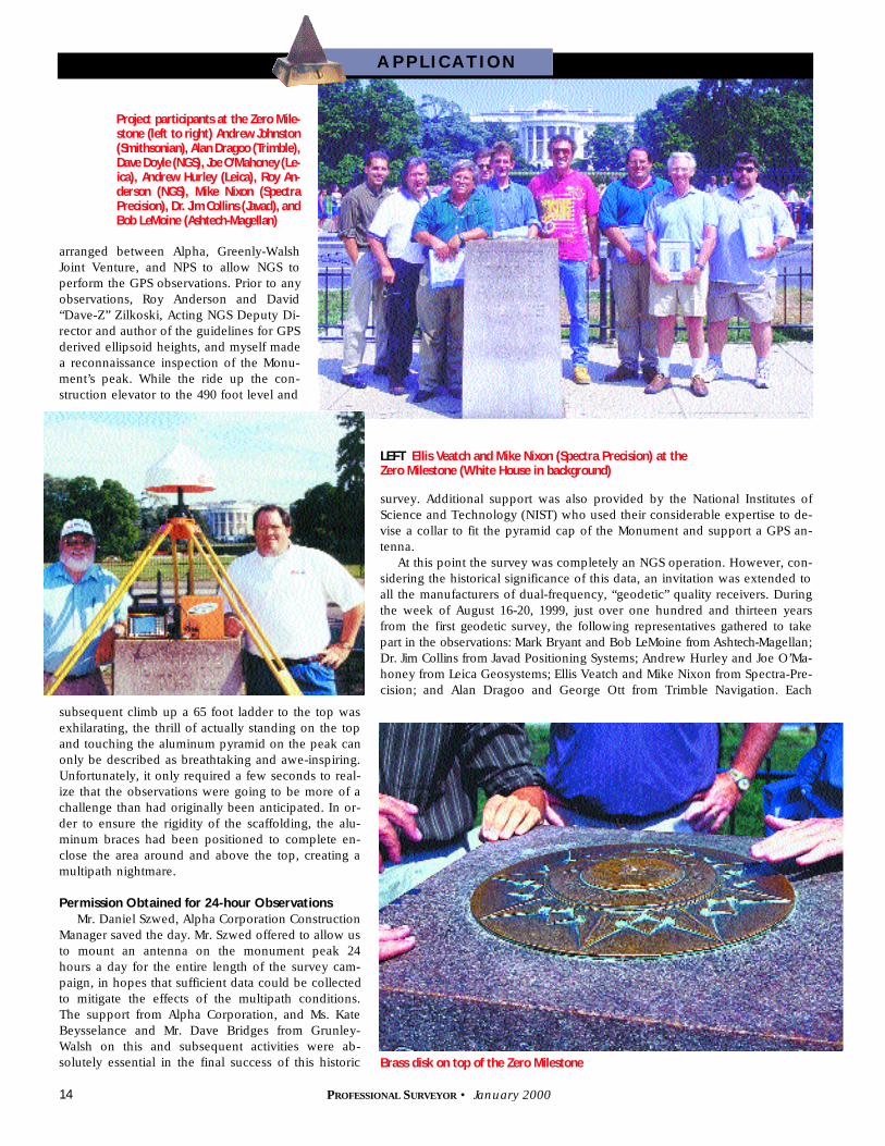
arranged between Alpha, Greenly-WalshJoint Venture, and NPS to allow NGS toperform the GPS observations. Prior to anyobservations, Roy Anderson and David“Dave-Z” Zilkoski, Acting NGS Deputy Di-rector and author of the guidelines for GPSderived ellipsoid heights, and myself madea reconnaissance inspection of the Monu-ment’s peak. While the ride up the con-struction elevator to the 490 foot level and
survey. Additional support was also provided by the National Institutes ofScience and Technology (NIST) who used their considerable expertise to de-vise a collar to fit the pyramid cap of the Monument and support a GPS an-tenna.
At this point the survey was completely an NGS operation. However, con-sidering the historical significance of this data, an invitation was extended toall the manufacturers of dual-frequency, “geodetic” quality receivers. Duringthe week of August 16-20, 1999, just over one hundred and thirteen yearsfrom the first geodetic survey, the following re p resentatives gathered to takepart in the observations: Mark Bryant and Bob LeMoine f rom Asht e c h -Magellan;D r. Jim Collins from Javad Positioning Systems; Andrew Hurley and Joe O’Ma-honey from Leica Geosystems; Ellis Veatch and Mike Nixon from Spectra-Pre-cision; and Alan Dragoo and George Ott from Trimble Navigation. Each
subsequent climb up a 65 foot ladder to the top wasexhilarating, the thrill of actually standing on the topand touching the aluminum pyramid on the peak canonly be described as breathtaking and awe-inspiring.Unfortunately, it only required a few seconds to real-ize that the observations were going to be more of achallenge than had originally been anticipated. In or-der to ensure the rigidity of the scaffolding, the alu-minum braces had been positioned to complete en-close the area around and above the top, creating amultipath nightmare.
Permission Obtained for 24-hour Observations
Mr. Daniel Szwed, Alpha Corporation ConstructionManager saved the day. Mr. Szwed offered to allow usto mount an antenna on the monument peak 24hours a day for the entire length of the survey cam-paign, in hopes that sufficient data could be collectedto mitigate the effects of the multipath conditions.The support from Alpha Corporation, and Ms. KateBeysselance and Mr. Dave Bridges from Grunley-Walsh on this and subsequent activities were ab-solutely essential in the final success of this historic
A P P L I C AT I O N
LEFT Ellis Veatch and Mike Nixon (Spectra Precision) at theZero Milestone (White House in background)
Project participants at the Zero Mile-stone (left to right) Andrew Johnston(Smithsonian), Alan Dragoo (Tr i m b l e ) ,Dave Doyle (NGS), Joe O’Mahoney (Le-ica), Andrew Hurley (Leica), Roy An-derson (NGS), Mike Nixon (SpectraPrecision), Dr. Jim Collins (Javad), andBob LeMoine (Ashtech-Magellan)
Brass disk on top of the Zero Milestone
16 PROFESSIONAL SURVEYOR • January 2000
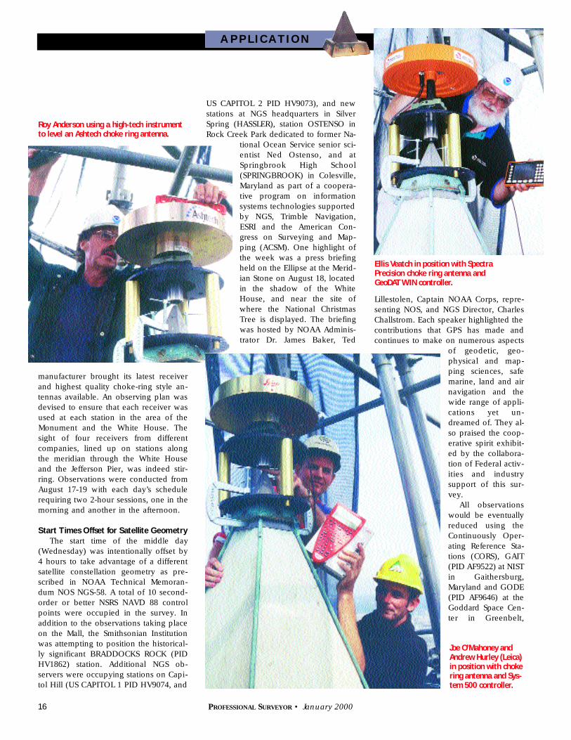
manufacturer brought its latest receiverand highest quality choke-ring style an-tennas available. An observing plan wasdevised to ensure that each receiver wasused at each station in the area of theMonument and the White House. Thesight of four receivers from differentcompanies, lined up on stations alongthe meridian through the White Houseand the Jefferson Pier, was indeed stir-ring. Observations were conducted fromAugust 17-19 with each day’s schedulerequiring two 2-hour sessions, one in themorning and another in the afternoon.
Start Times Offset for Satellite Geometry
The start time of the middle day(Wednesday) was intentionally offset by4 hours to take advantage of a differentsatellite constellation geometry as pre-scribed in NOAA Technical Memoran-dum NOS NGS-58. A total of 10 second-order or better NSRS NAVD 88 controlpoints were occupied in the survey. Inaddition to the observations taking placeon the Mall, the Smithsonian Institutionwas attempting to position the historical-ly significant BRADDOCKS ROCK (PIDHV1862) station. Additional NGS ob-servers were occupying stations on Capi-tol Hill (US CAPITOL 1 PID HV9074, and
US CAPITOL 2 PID HV9073), and newstations at NGS headquarters in SilverSpring (HASSLER), station OSTENSO inRock Creek Park dedicated to former Na-
tional Ocean Service senior sci-entist Ned Ostenso, and atS p r i n g b rook High School(SPRINGBROOK) in Colesville,Maryland as part of a coopera-tive program on inform a t i o nsystems technologies supportedby NGS, Trimble Navigation,ESRI and the American Con-gress on Surveying and Map-ping (ACSM). One highlight ofthe week was a press briefingheld on the Ellipse at the Merid-ian Stone on August 18, locatedin the shadow of the WhiteHouse, and near the site ofwhere the National ChristmasTree is displayed. The briefingwas hosted by NOAA Adminis-trator Dr. James Baker, Te d
Lillestolen, Captain NOAA Corps, repre-senting NOS, and NGS Director, CharlesChallstrom. Each speaker highlighted thecontributions that GPS has made andcontinues to make on numerous aspects
of geodetic, geo-physical and map-ping sciences, safemarine, land and airnavigation and thewide range of appli-cations yet un-dreamed of. They al-so praised the coop-erative spirit exhibit-ed by the collabora-tion of Federal activ-ities and industrysupport of this sur-vey.
All observationswould be eventuallyreduced using theContinuously Oper-ating Reference Sta-tions (CORS), GAIT(PID AF9522) at NISTin Gaithersburg ,Maryland and GODE(PID AF9646) at theGoddard Space Cen-ter in Gre e n b e l t ,
Ellis Veatch in position with SpectraPrecision choke ring antenna and GeoDAT WIN controller.
Joe O’Mahoney andAndrew Hurley (Leica)in position with chokering antenna and Sys-tem 500 controller.
A P P L I C AT I O N
Roy Anderson using a high-tech instrumentto level an Ashtech choke ring antenna.
18 PROFESSIONAL SURVEYOR • January 2000
Maryland. All receivers worked perfectly during the entire survey pro-gram. On Friday, August 20, the final day of operations, each manu-f a c t u rer’s antenna and receiver was taken to the top for a brief 45-minute session and photo opportunity.
GPS vector processing was perf o rmed using precise orbits and thevector reduction programs OMNI and PAGES, developed by the NGSGeosciences Research Division. Final coordinates and heights re l a t i v eto NSRS will be solved with the NGS ADJUST network adjustment soft-w a re package.
Complex Historical Data
The assumption that the determinationof the height of the Monument is verystraightforward does not address the com-plexities of understanding the relationshipof historical data, similar to the researchthat would be required for a 114-year-oldboundary survey. Before the currently pub-lished height of 555 feet, 5 inches can bechallenged or confirmed, every effort mustbe made to ensure that the same referencepoints used in the 1884 measurements bythe Corps of Engineers are used in the cur-rent survey. The top of the Monument iswithout question. However, this is not truefor the control points used on the groundor at the base of the monument. Evidenceseems to indicate that measurements wereoriginally taken from points on the basefloor at the entrance to the Monument and
on bench marks set to monitor subsidence. Recovery and re-observations of these points are critical to the final analysis ofthese data. No final figures will be released until these pointscan be confirmed. A complete research and analysis of theseactivities and data is being investigated by NGS with the sup-port of Dan Szwed from Alpha, and the National Archives. Todate, NGS has completed an analysis of the elevation of thepeak published in 1885 by Lt. Col. Casey of the Corps of En-gineers. Casey’s determination of the height of 597 feet, 3inches was related to the local mean low water vertical datum(a national vertical datum did not exist at that time). Researchby NGS using the tidal series of 1891-1901 derived from ob-servations at the MERIDIAN STONE (PID. HV1846) compareswith a value of 597 feet, 2.9 inches.
Difficulty in Finding an Apples-to-Apples Vertical Datum
While this would appear to confirm the 1885 determina-tion, it is still not clear if the tidal series of 1891-1901 is simi-lar to or significantly different from the series used in 1885 byCasey. Research continues on this issue. It is hoped that thereview of data in the National Archives will reveal the infor-mation required to assure this comparison as well. Completionof the least squares adjustment of the final NAD 83 coordi-nates and NAVD 88 height data for all stations in this project,along with the associated meta-data elements for inclusion inNSRS will be completed following the review of informationavailable from the National Archives. (For more information,visit www.ngs.noaa.gov)
One additional interesting aspect of this survey will be thedetermination and monumentation of the point that marks theactual intersection of the meridian of the White House and thelatitude through the center Capitol. The position of the centerCapitol (FREEDOM; PID UA0016) was previously determinedusing GPS by NGS in 1993 (see “Where Freedom Stands,” Pro-
A P P L I C AT I O N
Roy Andersonchecks a
Trimble chokering antenna
for level.
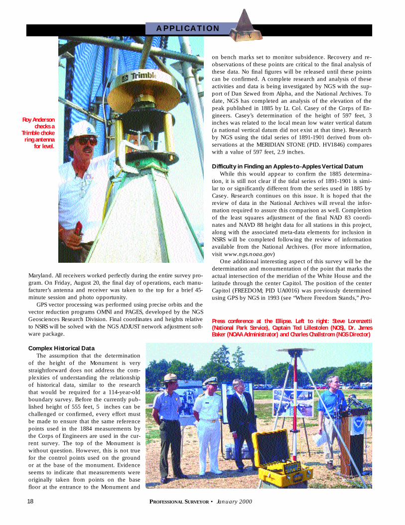
Press conference at the Ellipse. Left to right: Steve Lorenzetti (National Park Service), Captain Ted Lillestolen (NOS), Dr. James Baker (NOAA Administrator) and Charles Challstrom (NGS Director)
20 PROFESSIONAL SURVEYOR • January 2000
fessional Surveyor M a g a z i n eJan/Feb 1994, pp. 4-9).
Originally the Jefferson Pier wassupposed to mark the location ofthis intersection. H o w e v e r, due tothe limitations of the original survey-ors’ equipment, and an obstructedline of sight from the Jefferson Pierto the Capitol, the point actually fallsa p p roximately 0.680 meter (2.23feet) north of the center of the Jef-ferson Pier. To determine a morep recise location of the intersectionpoint, the survey monument used byNPS to locate the meridian of theWhite House, 868 H 90002 was alsopositioned in this campaign. Subse-quent to the completion of the finaladjustment and in cooperation withNPS, NGS will set a new monumentat the intersection of these celebrat-ed lines with a precision of appro x i-mately 1-2 cm. On behalf of NGS, Iwould like to take this opportunityto thank the many talented and ded-icated people who helped make thissurvey a success. The cooperationbetween Federal agencies—NGS,
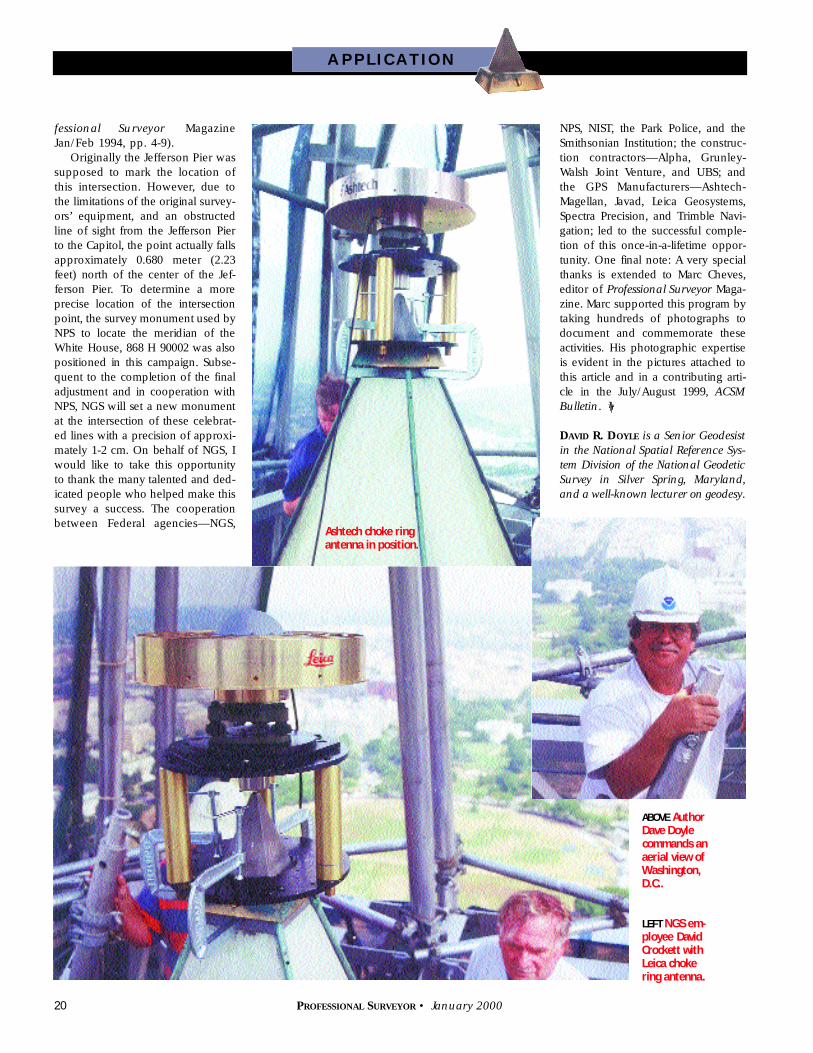
Ashtech choke ringantenna in position.
ABOVE AuthorDave Doylecommands anaerial view ofWashington,D.C..
LEFT NGS em-p l o y e e D a v i dCrockett withLeica chokering antenna.
A P P L I C AT I O N
NPS, NIST, the Park Police, and theSmithsonian Institution; the construc-tion contractors—Alpha, Grunley-Walsh Joint Ve n t u re, and UBS; andthe GPS Manufacturers—Ashtech-Magellan, Javad, Leica Geosystems,Spectra Precision, and Trimble Navi-gation; led to the successful comple-tion of this once-in-a-lifetime oppor-tunity. One final note: A very specialthanks is extended to Marc Cheves,editor of P rofessional Surveyor M a g a-zine. Marc supported this program bytaking hundreds of photographs todocument and commemorate theseactivities. His photographic expertiseis evident in the pictures attached tothis article and in a contributing arti-cle in the July/August 1999, A C S MB u l l e t i n.
DAV I D R. DO Y L E is a Senior Geodesistin the National Spatial Reference Sys-tem Division of the National GeodeticSurvey in Silver Spring, Maryland,and a well-known lecturer on g e o d e s y .