Embed Size (px)
Citation preview
Preserving the quality of our lakes and waterways A companion guide for Chapter 23
Washington County Shoreland, Wetland, and Floodplain Ordinance
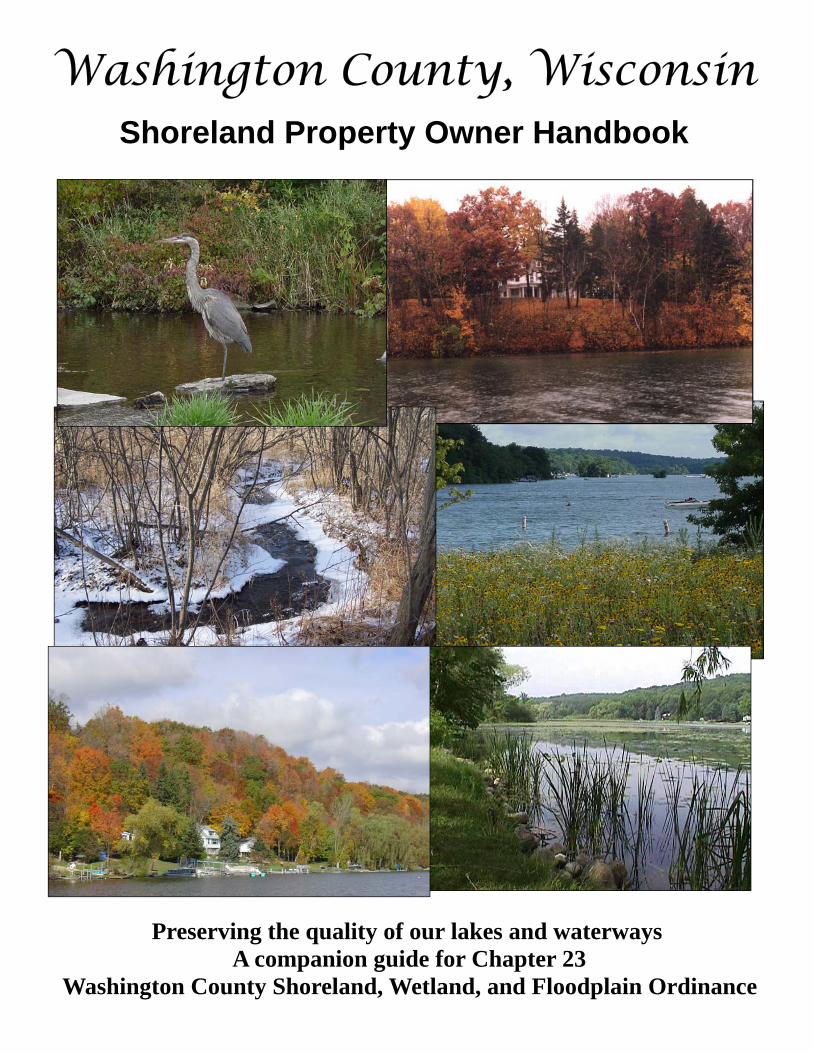
Washington County, Wisconsin Shoreland Property Owner Handbook
For Washington County Information Contact: Washington County Planning and Parks Department
Land Use Division Zoning Administrator 262-335-4445 Toll-free 800-616-0446 (Wisconsin only) Fax 262-335-6868
Land and Water Conservation Division 262-335-4800 County Engineer/Surveyor 262-335-6881 Geographic Information Systems (GIS) Division 262-306-2218 Real Property Lister Division 262-306-2217 Parks Division 262-335-4445 Golf Division 262-335-6870
Planning and Parks Department Email [email protected] site http://www.co.washington.wi.us
Assistance provided by: Washington County Planning and Parks Department University of Wisconsin – Extension Southeastern Wisconsin Regional Planning Commission Ruekert & Mielke
Funding for this publication was provided through a Wisconsin Department of Natural Resources Lake Protection Grant.
This document is intended to provide general information regarding shoreland, wetland, and floodplain zoning requirements. Please check with the Washington County Land Use Division for specific and updated regulations that may apply to your property.
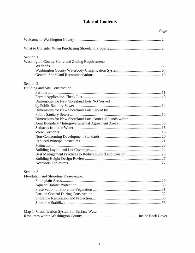
Table of Contents
Page
Welcome to Washington County .......................................................................................... 2
What to Consider When Purchasing Shoreland Property ..................................................... 2
Section 1 Washington County Shoreland Zoning Requirements Wetlands ................................................................................................................... 5 Washington County Waterbody Classification System............................................ 6 General Shoreland Recommendations...................................................................... 10
Section 2 Building and Site Construction Permits ...................................................................................................................... 11 Permit Application Check List.................................................................................. 13 Dimensions for New Shoreland Lots Not Served by Public Sanitary Sewer .......................................................................................... 14 Dimensions for New Shoreland Lots Served by Public Sanitary Sewer ............................................................................................... 15 Dimensions for New Shoreland Lots, Annexed Lands within Joint Boundary / Intergovernmental Agreement Areas ............................................ 15 Setbacks from the Water ........................................................................................... 16 View Corridors.......................................................................................................... 16 Non-Conforming Development Standards ............................................................... 20 Reduced Principal Structures.................................................................................... 21 Mitigation.................................................................................................................. 23 Building Layout and Lot Coverage........................................................................... 24 Best Management Practices to Reduce Runoff and Erosion .................................... 26 Building Height Design Review ............................................................................... 27 Accessory Structures................................................................................................. 27
Section 3 Floodplain and Shoreline Preservation Floodplain Areas....................................................................................................... 29 Aquatic Habitat Protection........................................................................................ 30 Preservation of Shoreline Vegetation ....................................................................... 31 Erosion Control During Construction....................................................................... 32 Shoreline Restoration and Protection........................................................................ 33 Shoreline Stabilization .............................................................................................. 38
Map 1- Classification System for Surface Water Resources within Washington County.......................................................... Inside Back Cover
1
Welcome to Washington County
Welcome to Washington County! Residents of Washington County enjoy natural scenery and wildlife as well as a pleasant small town atmosphere within the rolling hills of the Kettle Moraine. Washington County is home to lakes, rivers, and waterways that make living here a distinctive way of life. Maintaining and improving the quality of our lakes, rivers and waterways is the goal of the Washington County Shoreland, Wetland, and Floodplain Ordinance.
Shoreland property owners play an important role in preserving the quality of our lakes, rivers and waterways. As a shoreland property owner, your responsibilities extend beyond your individual property.How you take care of your shoreland property can impact an entire lake or waterway system. The purpose of this guide is to help shoreland property owners, contractors, and others understand the important provisions of the ordinance and how you can protect our valuable delicate natural systems that include the lakes, rivers and waterways in Washington County through good environmental practices.
What to Consider When Purchasing Shoreland Property
The most important consideration is to ask yourself what you want from the shoreland property—do you envision it as a weekend retreat or a friendly lakeside neighborhood to enjoy nature and water-related activities? Before you decide on a particular piece of shoreland, it is a good idea to spend some time in the area and to gather information about the waterbody and surrounding resources such as:
Physical Characteristics
�� Parcel Size—The lot should be large enough to accommodate your intended use, as well as comply with the local zoning requirements. Lots that have been created since the statewide shoreland zoning standards took effect typically are large enough for most residential uses and comply with local zoning requirements. However, there are many lots that were created prior to the shoreland rules that may be substantially smaller than the current lot size requirements. These substandard lots may still be bought and sold, but they may be too small to accommodate a structure or a Private On-Site Wastewater Treatment System (POWTS). If you are considering buying such a lot, you should carefully review your intended use and the limitations of the property.
2
�� Parcel Shape—Although the size of the lot may meet zoning requirements, the shape can restrict the use and location of structures. Long, narrow lots or pie-shaped lots may make it difficult to meet some of the requirements for setbacks, lot widths and POWTS. Carefully consider the compatibility of a lot shape with your intended use.
�� Topography and Soil Conditions—Land surface elevations are important for several reasons. First, the lot should be high enough so that the dwelling will not be flooded by water level fluctuations. The site should be able to accommodate the lowest portion of the building, including the basement, at least two feet above the highest known water level or the 100 year regional floodplain elevation. The site must also accommodate a POWTS. The soils should be suitable for your intended use, as both structures and sewage treatment systems have specific requirements. It is necessary to hire a certified soil tester to determine what type of POWTS the site will accommodate.
�� Vegetation—The aesthetic and ecological value of shoreland property is linked to the type and quality of existing vegetation. Large trees and wooded landscapes are attractive and help to screen structures from the waterbody. Shoreland zoning ordinances regulate the amount of vegetation that can be removed.
�� Adjacent Development—Locate adjacent properties’ POWTS and wells to determine setback restrictions on your property and consider sideyard setbacks and privacy.
�� Potential Building Sites—After an analysis of your site, select an appropriate location for your building based on the above factors; remember, the best building site in many cases may be back beyond the required minimum setback.
�� Recreational Use of Lake— What type of recreational water usage do you want, i.e., water skiing, fishing, canoeing, sailing? Note: Wisconsin lakes 50 acres or less with public access are slow/no wake lakes by state statute.
�� Lakes Class Criteria—Check the county waterbody classification to get the appropriate development standards for your waterbody.
�� Public Access—Does the waterbody have developed public access and, if so, how close?
�� Proximity to Public Lands— Public lands provide additional recreational opportunities. �� Existing Development—What kind of development exists on the waterbody that may
generate additional recreational water use, i.e., campgrounds, resorts, etc?�� Distance to Services and Your Place of Employment—How far to schools, churches,
hospitals, shopping, transportation arteries, etc.
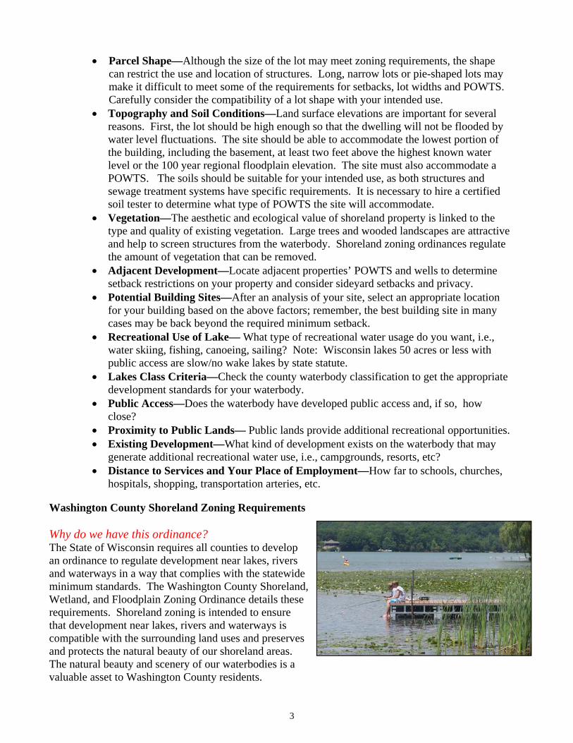
Washington County Shoreland Zoning Requirements
Why do we have this ordinance? The State of Wisconsin requires all counties to develop an ordinance to regulate development near lakes, rivers and waterways in a way that complies with the statewide minimum standards. The Washington County Shoreland, Wetland, and Floodplain Zoning Ordinance details these requirements. Shoreland zoning is intended to ensure that development near lakes, rivers and waterways is compatible with the surrounding land uses and preserves and protects the natural beauty of our shoreland areas.The natural beauty and scenery of our waterbodies is a valuable asset to Washington County residents.
3
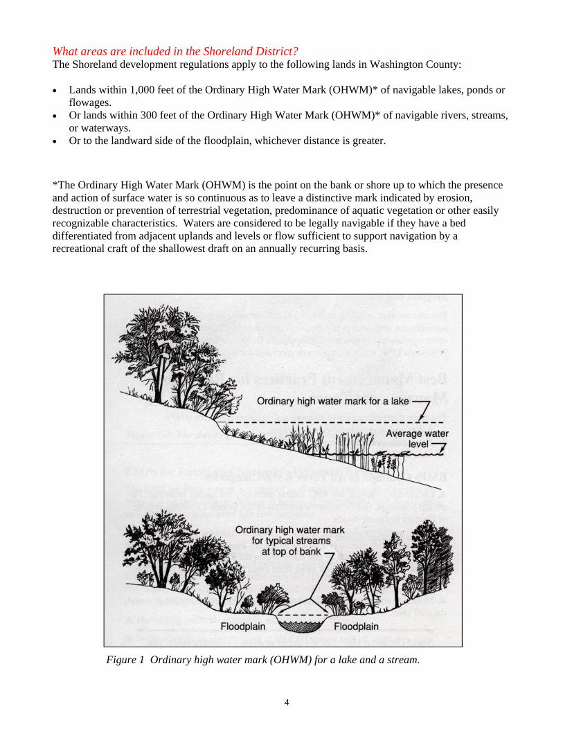
What areas are included in the Shoreland District? The Shoreland development regulations apply to the following lands in Washington County:
�� Lands within 1,000 feet of the Ordinary High Water Mark (OHWM)* of navigable lakes, ponds or flowages.
�� Or lands within 300 feet of the Ordinary High Water Mark (OHWM)* of navigable rivers, streams, or waterways.
�� Or to the landward side of the floodplain, whichever distance is greater.
*The Ordinary High Water Mark (OHWM) is the point on the bank or shore up to which the presence and action of surface water is so continuous as to leave a distinctive mark indicated by erosion, destruction or prevention of terrestrial vegetation, predominance of aquatic vegetation or other easily recognizable characteristics. Waters are considered to be legally navigable if they have a bed differentiated from adjacent uplands and levels or flow sufficient to support navigation by a recreational craft of the shallowest draft on an annually recurring basis.
4
Figure 1 Ordinary high water mark (OHWM) for a lake and a stream.
Wetlands
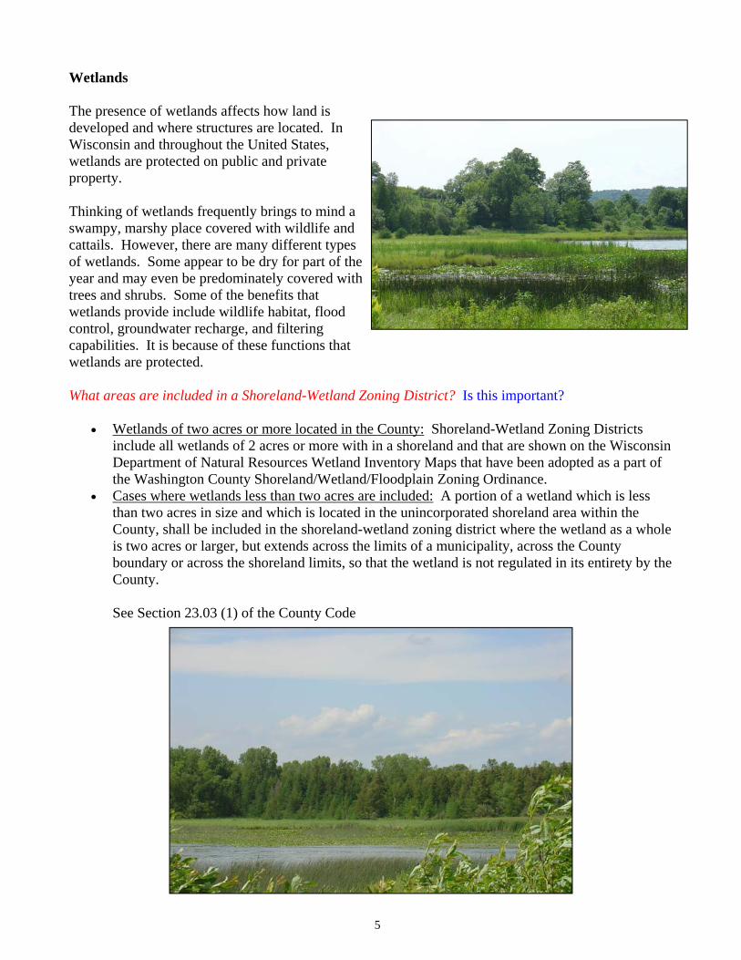
The presence of wetlands affects how land is developed and where structures are located. In Wisconsin and throughout the United States, wetlands are protected on public and private property.
Thinking of wetlands frequently brings to mind a swampy, marshy place covered with wildlife and cattails. However, there are many different types of wetlands. Some appear to be dry for part of the year and may even be predominately covered with trees and shrubs. Some of the benefits that wetlands provide include wildlife habitat, flood control, groundwater recharge, and filtering capabilities. It is because of these functions that wetlands are protected.
What areas are included in a Shoreland-Wetland Zoning District? Is this important?
�� Wetlands of two acres or more located in the County: Shoreland-Wetland Zoning Districts include all wetlands of 2 acres or more with in a shoreland and that are shown on the Wisconsin Department of Natural Resources Wetland Inventory Maps that have been adopted as a part of the Washington County Shoreland/Wetland/Floodplain Zoning Ordinance.
�� Cases where wetlands less than two acres are included: A portion of a wetland which is less than two acres in size and which is located in the unincorporated shoreland area within the County, shall be included in the shoreland-wetland zoning district where the wetland as a whole is two acres or larger, but extends across the limits of a municipality, across the County boundary or across the shoreland limits, so that the wetland is not regulated in its entirety by the County.
See Section 23.03 (1) of the County Code
5
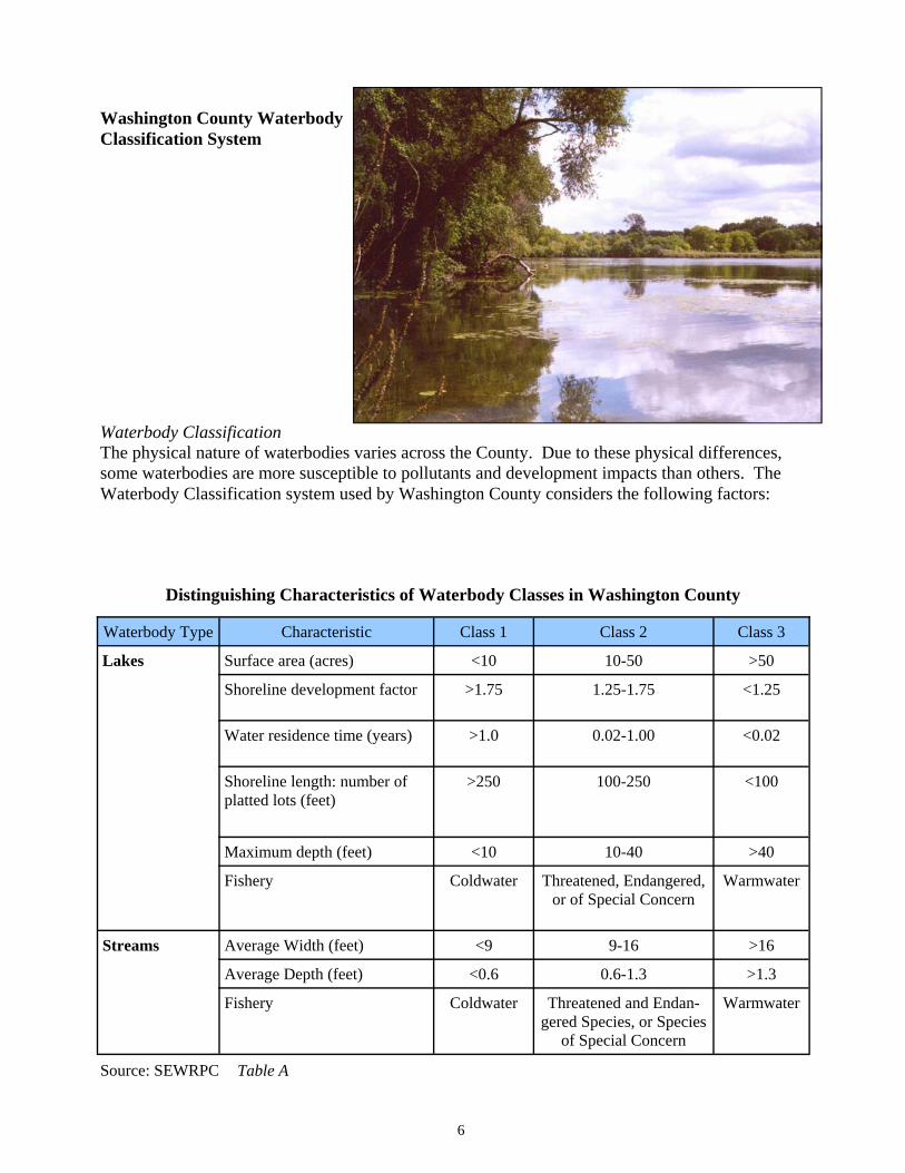
Table A
Washington County Waterbody Classification System
Waterbody ClassificationThe physical nature of waterbodies varies across the County. Due to these physical differences, some waterbodies are more susceptible to pollutants and development impacts than others. The Waterbody Classification system used by Washington County considers the following factors:
6
Distinguishing Characteristics of Waterbody Classes in Washington County
Waterbody Type Characteristic Class 1 Class 2 Class 3
Lakes Surface area (acres) <10 10-50 >50
Shoreline development factor >1.75 1.25-1.75 <1.25
Water residence time (years) >1.0 0.02-1.00 <0.02
Shoreline length: number of platted lots (feet)
>250 100-250 <100
Maximum depth (feet) <10 10-40 >40
Fishery Coldwater Threatened, Endangered,or of Special Concern
Warmwater
Streams Average Width (feet) <9 9-16 >16
Average Depth (feet) <0.6 0.6-1.3 >1.3
Fishery Coldwater Threatened and Endan-gered Species, or Species
of Special Concern
Warmwater
Source: SEWRPC
7
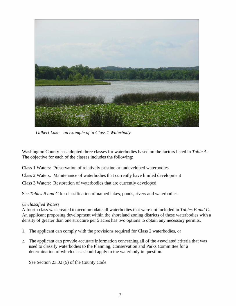
Washington County has adopted three classes for waterbodies based on the factors listed in Table A.The objective for each of the classes includes the following:
Class 1 Waters: Preservation of relatively pristine or undeveloped waterbodies
Class 2 Waters: Maintenance of waterbodies that currently have limited development Class 3 Waters: Restoration of waterbodies that are currently developed
See Tables B and C for classification of named lakes, ponds, rivers and waterbodies.
Unclassified Waters A fourth class was created to accommodate all waterbodies that were not included in Tables B and C.An applicant proposing development within the shoreland zoning districts of these waterbodies with a density of greater than one structure per 5 acres has two options to obtain any necessary permits.
1. The applicant can comply with the provisions required for Class 2 waterbodies, or
2. The applicant can provide accurate information concerning all of the associated criteria that was used to classify waterbodies to the Planning, Conservation and Parks Committee for a determination of which class should apply to the waterbody in question.
See Section 23.02 (5) of the County Code
Gilbert Lake—an example of a Class 1 Waterbody
8
Class 1 Beck
Gilbert
Hartford Millpond
Hawthorn
Kewaskum Millpond
Lehner
Malloy
Mayer Millpond
McConville
Mud
Newburg Pond
Werner Pond
Allis / Leinberger Lohr Pond
Boltonville Millpond Lowe / Loews
Brickyard Lucas
Ehne Miller
Erler Mud
Hackbarth / L. Silver Mueller
Hasmer Murphy
Hickey Proschinger
Keown Quaas
Kohlsville Millpond Radtke
Lent Rockfield Quarry Pond
Little Drickens Smith
Little Friess Tilly
Class 2 Class 3 Amy Belle
Bark
Big Cedar
Druid
Lake Five
Friess
Green
Lenwood
Little Cedar
Pike
Silver
Lake Twelve
Wallace
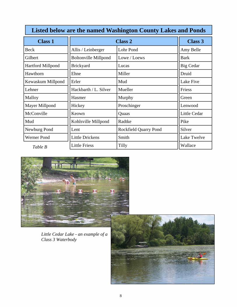
Listed below are the named Washington County Lakes and Ponds
Table B
Little Cedar Lake - an example of a Class 3 Waterbody
9
Class 1
Allenton Creek
Coney Creek
Engmon Creek
Evergreen Creek
Junk Creek
Myra Creek
Lehner Lake Outlet
Mason Creek
Myra Creek
Silver Creek
Stony Creek
W. Branch Menomonee River
W. Branch Milwaukee River
Class 2Ashippun River Nolan Creek
Bark River N. Branch Cedar Creek
Cedarburg Creek Oconomowoc River
Erler Lake Outlet Polk Springs Creek
Flynn Creek Quaas Creek
Kewaskum Creek Rubicon River
Kohlsville River Wallace Creek
Limestone Creek Wayne Creek
Little Cedar Creek Willow Creek
Little Oconomowoc River
Class 3 Cedar Creek
E. Branch Milwaukee River
E. Branch Rock River
Kressin Branch
Meadow Brook Creek
Menomonee River
Milwaukee River
N. BranchMilwaukee River
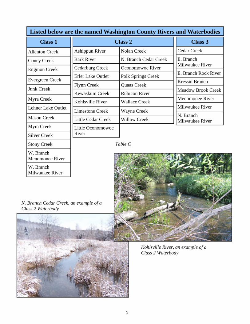
Listed below are the named Washington County Rivers and Waterbodies
Table C
N. Branch Cedar Creek, an example of a Class 2 Waterbody
Kohlsville River, an example of a Class 2 Waterbody
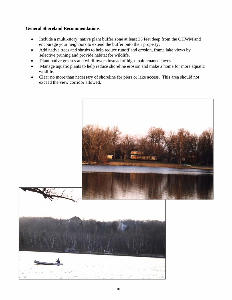
General Shoreland Recommendations
�� Include a multi-story, native plant buffer zone at least 35 feet deep from the OHWM and encourage your neighbors to extend the buffer onto their property.
�� Add native trees and shrubs to help reduce runoff and erosion, frame lake views by selective pruning and provide habitat for wildlife.
�� Plant native grasses and wildflowers instead of high-maintenance lawns. �� Manage aquatic plants to help reduce shoreline erosion and make a home for more aquatic wildlife. �� Clear no more than necessary of shoreline for piers or lake access. This area should not
exceed the view corridor allowed.
10
Building and Site Construction
Permits
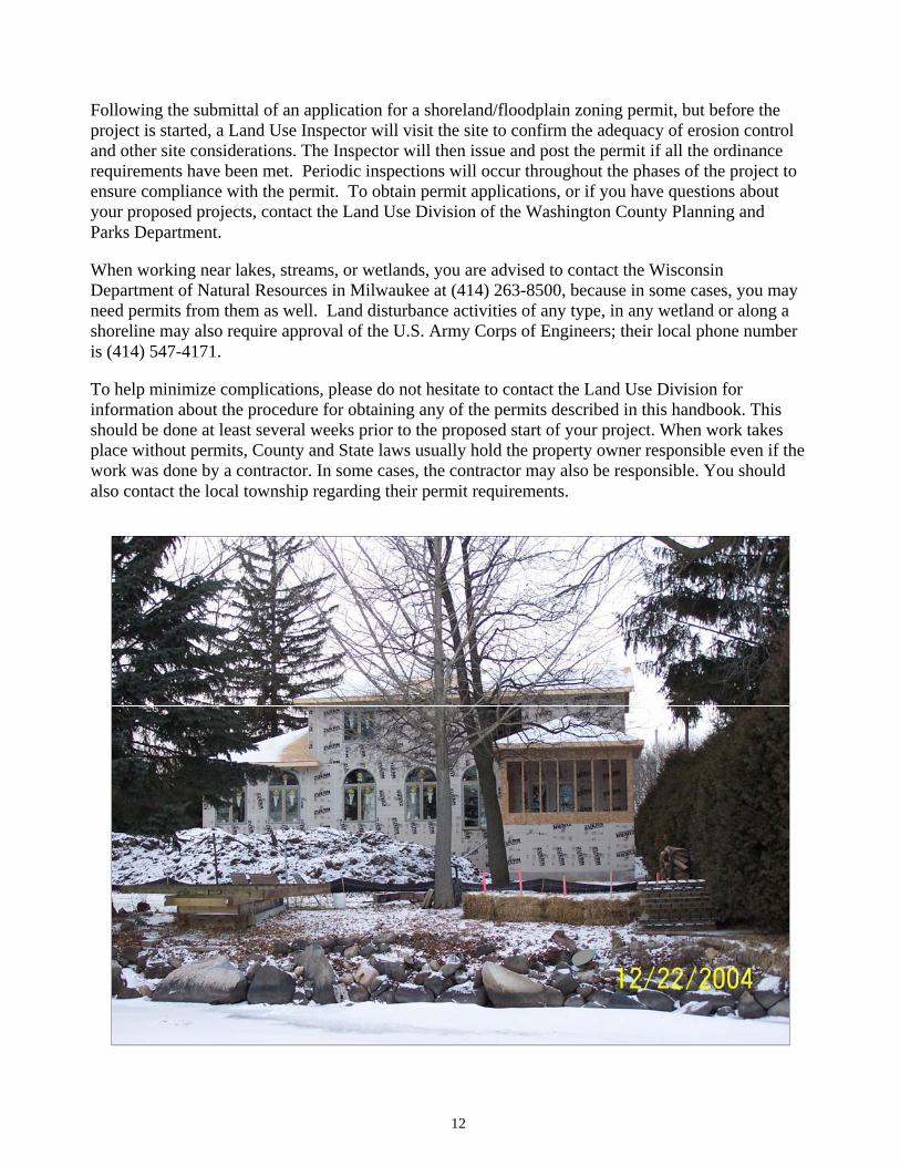
The Land Use Division of the Washington County Planning and Parks Department administers and enforces the Shoreland, Wetland, and Floodplain Zoning Ordinance for all unincorporated townships. Permits may require approval by the Land Use Division, the Washington County Planning, Conservation and Parks Committee, the Washington County Board of Adjustment, or the full Washington County Board prior to your starting work on the following projects within the shoreland/wetland or floodplain zoning district. Before beginning work on any of these projects, please contact the Land Use Division and request information on what permits and/or inspections may be necessary:
�� Filling, grading, excavating, ponding, lagooning, dredging or any soil disturbance work �� Shoreline stabilization including rip-rap and other approved methods �� Additions/alterations to existing structures or reconstruction of structures�� New or replacement construction of any type �� New or replacement retaining walls, sidewalks, driveways, patios, decks or other landscaping
The owner of the property or their representative can apply for a permit by filling out an application, along with supplying plot plans and diagrams of the project and submitting the appropriate fee. Some projects will require only basic drawings, while others may require detailed building and grading plans. In floodplains, structures must meet stringent FEMA requirements. Projects sometimes require the application to be reviewed at a hearing before the County Planning, Conservation, and Parks Committee or the County Board of Adjustment. These applications need to be signed by all property owners or designated corporation officers. If the project meets all of the related code requirements, a permit will be issued.
11
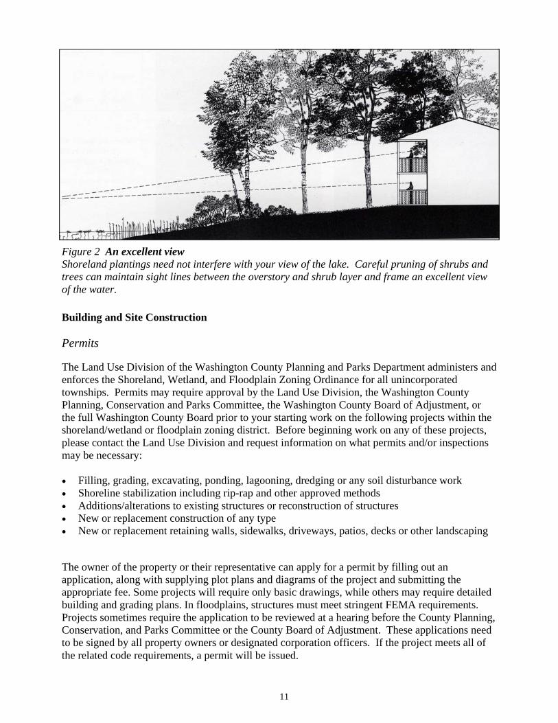
Figure 2 An excellent view Shoreland plantings need not interfere with your view of the lake. Careful pruning of shrubs and trees can maintain sight lines between the overstory and shrub layer and frame an excellent view of the water.
Following the submittal of an application for a shoreland/floodplain zoning permit, but before the project is started, a Land Use Inspector will visit the site to confirm the adequacy of erosion control and other site considerations. The Inspector will then issue and post the permit if all the ordinance requirements have been met. Periodic inspections will occur throughout the phases of the project to ensure compliance with the permit. To obtain permit applications, or if you have questions about your proposed projects, contact the Land Use Division of the Washington County Planning and Parks Department.
When working near lakes, streams, or wetlands, you are advised to contact the Wisconsin Department of Natural Resources in Milwaukee at (414) 263-8500, because in some cases, you may need permits from them as well. Land disturbance activities of any type, in any wetland or along a shoreline may also require approval of the U.S. Army Corps of Engineers; their local phone number is (414) 547-4171.
To help minimize complications, please do not hesitate to contact the Land Use Division for information about the procedure for obtaining any of the permits described in this handbook. This should be done at least several weeks prior to the proposed start of your project. When work takes place without permits, County and State laws usually hold the property owner responsible even if the work was done by a contractor. In some cases, the contractor may also be responsible. You should also contact the local township regarding their permit requirements.
12
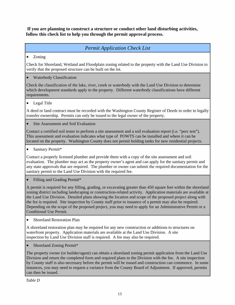
If you are planning to construct a structure or conduct other land disturbing activities, follow this check list to help you through the permit approval process.
13
Table D
Permit Application Check List �� Zoning
Check for Shoreland, Wetland and Floodplain zoning related to the property with the Land Use Division to verify that the proposed structure can be built on the lot.
�� Waterbody Classification
Check the classification of the lake, river, creek or waterbody with the Land Use Division to determine which development standards apply to the property. Different waterbody classifications have different requirements.
�� Legal Title
A deed or land contract must be recorded with the Washington County Register of Deeds in order to legally transfer ownership. Permits can only be issued to the legal owner of the property.
�� Site Assessment and Soil Evaluation
Contact a certified soil tester to perform a site assessment and a soil evaluation report (i.e. “perc test”). This assessment and evaluation indicates what type of POWTS can be installed and where it can be located on the property. Washington County does not permit holding tanks for new residential projects.
�� Sanitary Permit*
Contact a properly licensed plumber and provide them with a copy of the site assessment and soil evaluation. The plumber may act as the property owner’s agent and can apply for the sanitary permit and any state approvals that are required. The plumber or owner can submit the required documentation for the sanitary permit to the Land Use Division with the required fee.
�� Filling and Grading Permit*
A permit is required for any filling, grading, or excavating greater than 450 square feet within the shoreland zoning district including landscaping or construction-related activity. Application materials are available at the Land Use Division. Detailed plans showing the location and scope of the proposed project along with the fee is required. Site inspection by County staff prior to issuance of a permit may also be required. Depending on the scope of the proposed project, you may need to apply for an Administrative Permit or a Conditional Use Permit.
�� Shoreland Restoration Plan
A shoreland restoration plan may be required for any new construction or additions to structures on waterfront property. Application materials are available at the Land Use Division. A site inspection by Land Use Division staff is required. A fee may also be required.
�� Shoreland Zoning Permit*
The property owner (or builder/agent) can obtain a shoreland zoning permit application from the Land Use Division and return the completed form and required plans to the Division with the fee. A site inspection by County staff is also necessary before the permit will be issued and construction can commence. In some instances, you may need to request a variance from the County Board of Adjustment. If approved, permits can then be issued.
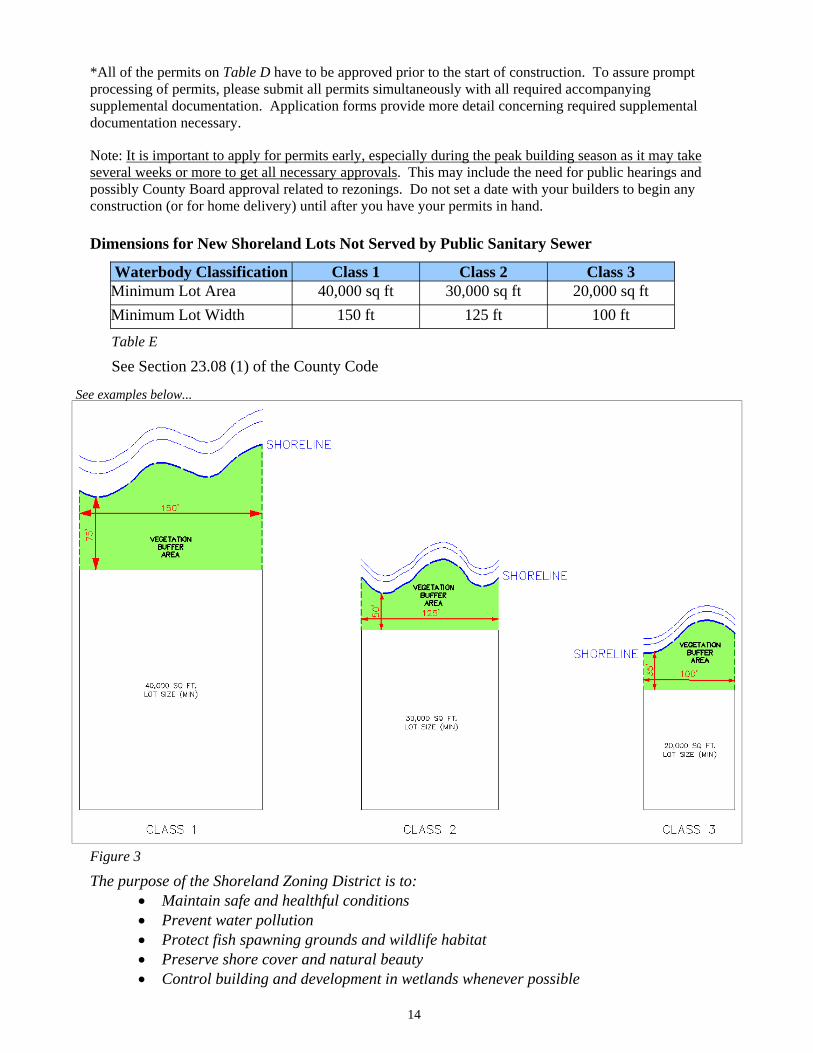
Table E
Dimensions for New Shoreland Lots Not Served by Public Sanitary Sewer
Waterbody Classification Class 1 Class 2 Class 3 Minimum Lot Area 40,000 sq ft 30,000 sq ft 20,000 sq ftMinimum Lot Width 150 ft 125 ft 100 ft
The purpose of the Shoreland Zoning District is to: �� Maintain safe and healthful conditions �� Prevent water pollution �� Protect fish spawning grounds and wildlife habitat �� Preserve shore cover and natural beauty �� Control building and development in wetlands whenever possible
14
*All of the permits on Table D have to be approved prior to the start of construction. To assure prompt processing of permits, please submit all permits simultaneously with all required accompanying supplemental documentation. Application forms provide more detail concerning required supplemental documentation necessary.
Note: It is important to apply for permits early, especially during the peak building season as it may take several weeks or more to get all necessary approvals. This may include the need for public hearings and possibly County Board approval related to rezonings. Do not set a date with your builders to begin any construction (or for home delivery) until after you have your permits in hand.
Figure 3
See examples below...
See Section 23.08 (1) of the County Code
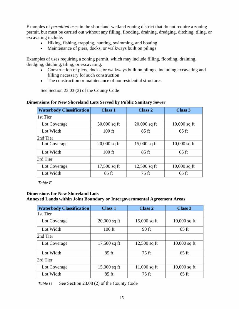
Examples of permitted uses in the shoreland-wetland zoning district that do not require a zoning permit, but must be carried out without any filling, flooding, draining, dredging, ditching, tiling, or excavating include:
�� Hiking, fishing, trapping, hunting, swimming, and boating �� Maintenance of piers, docks, or walkways built on pilings
Examples of uses requiring a zoning permit, which may include filling, flooding, draining, dredging, ditching, tiling, or excavating:
�� Construction of piers, docks, or walkways built on pilings, including excavating and filling necessary for such construction
�� The construction or maintenance of nonresidential structures
See Section 23.03 (3) of the County Code
Dimensions for New Shoreland Lots Served by Public Sanitary Sewer
15
Waterbody Classification Class 1 Class 2 Class 3 1st Tier Lot Coverage 30,000 sq ft 20,000 sq ft 10,000 sq ft Lot Width 100 ft 85 ft 65 ft 2nd Tier Lot Coverage 20,000 sq ft 15,000 sq ft 10,000 sq ft
Lot Width 100 ft 85 ft 65 ft 3rd Tier Lot Coverage 17,500 sq ft 12,500 sq ft 10,000 sq ft Lot Width 85 ft 75 ft 65 ft
Table F
Dimensions for New Shoreland Lots Annexed Lands within Joint Boundary or Intergovernmental Agreement Areas
Waterbody Classification Class 1 Class 2 Class 3 1st Tier Lot Coverage 20,000 sq ft 15,000 sq ft 10,000 sq ft
Lot Width 100 ft 90 ft 65 ft 2nd Tier Lot Coverage 17,500 sq ft 12,500 sq ft 10,000 sq ft
Lot Width 85 ft 75 ft 65 ft 3rd Tier Lot Coverage 15,000 sq ft 11,000 sq ft 10,000 sq ft Lot Width 85 ft 75 ft 65 ft
Table G See Section 23.08 (2) of the County Code

New Construction Setbacks
Applies to all temporary and permanent structures (except piers, boat hoists, boathouses, and open fences)
Setbacks From the Water
Unless provided specifically in the County Shoreland/Wetland/Floodplain Zoning Ordinance, all temporary and permanent structures shall be set back from the OHWM of all navigable waterways as follows:
See Section 23.09 (1) of the County Code
16
Table I
Waterbody Classification
Class 1 Class 2 Class 3
Minimum Depth of VegetativeBuffer
75 feet landward of the OHWM
50 feet landward of the OHWM
35 feet landward of the OHWM
View Corridor
View Corridors are limited to a maximum of 30% of the recorded shoreline lot width, i.e., 15 feet for a lot 50 feet wide, 30 feet for a lot 100 feet wide, etc.
See Section 23.10 (2) of the County Code
Table H
Waterbody Classification
Class 1 Class 2 Class 3
Minimum Setback
125 feet or reduced to 100 feet with mitigation
100 feet or reduced to 75 feet with mitigation
75 feet
17
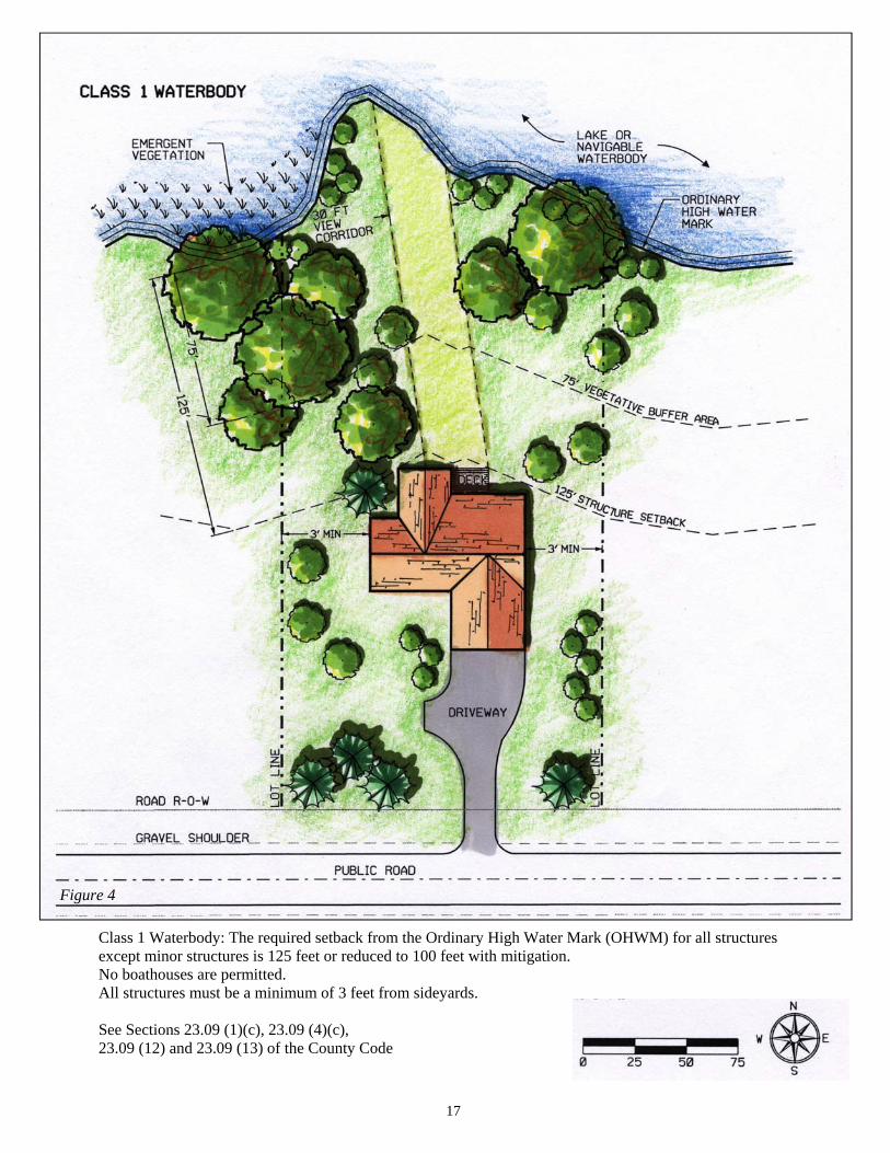
Class 1 Waterbody: The required setback from the Ordinary High Water Mark (OHWM) for all structures except minor structures is 125 feet or reduced to 100 feet with mitigation. No boathouses are permitted. All structures must be a minimum of 3 feet from sideyards.
See Sections 23.09 (1)(c), 23.09 (4)(c), 23.09 (12) and 23.09 (13) of the County Code
Figure 4
18
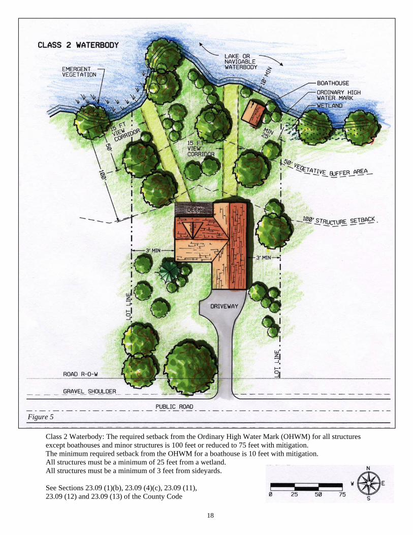
Class 2 Waterbody: The required setback from the Ordinary High Water Mark (OHWM) for all structures except boathouses and minor structures is 100 feet or reduced to 75 feet with mitigation. The minimum required setback from the OHWM for a boathouse is 10 feet with mitigation. All structures must be a minimum of 25 feet from a wetland. All structures must be a minimum of 3 feet from sideyards.
See Sections 23.09 (1)(b), 23.09 (4)(c), 23.09 (11), 23.09 (12) and 23.09 (13) of the County Code
Figure 5
19
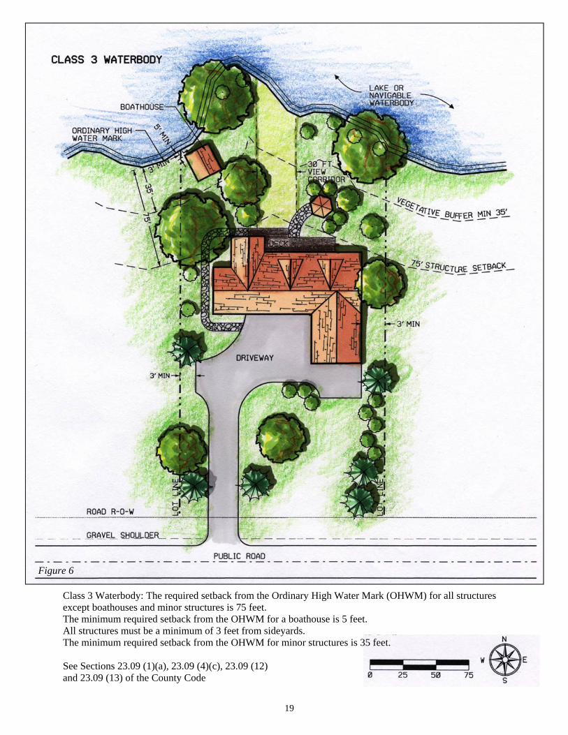
Class 3 Waterbody: The required setback from the Ordinary High Water Mark (OHWM) for all structures except boathouses and minor structures is 75 feet. The minimum required setback from the OHWM for a boathouse is 5 feet. All structures must be a minimum of 3 feet from sideyards. The minimum required setback from the OHWM for minor structures is 35 feet.
See Sections 23.09 (1)(a), 23.09 (4)(c), 23.09 (12) and 23.09 (13) of the County Code
Figure 6
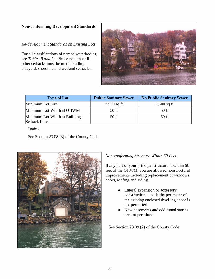
Non-conforming Development Standards
Re-development Standards on Existing Lots
For all classifications of named waterbodies, see Tables B and C. Please note that all other setbacks must be met including sideyard, shoreline and wetland setbacks.
Type of Lot Public Sanitary Sewer No Public Sanitary Sewer Minimum Lot Size 7,500 sq ft 7,500 sq ftMinimum Lot Width at OHWM 50 ft 50 ft Minimum Lot Width at Building Setback Line
50 ft 50 ft
20
Table J
See Section 23.08 (3) of the County Code
Non-conforming Structure Within 50 Feet
If any part of your principal structure is within 50 feet of the OHWM, you are allowed nonstructural improvements including replacement of windows, doors, roofing and siding.
�� Lateral expansion or accessory construction outside the perimeter of the existing enclosed dwelling space is not permitted.
�� New basements and additional stories are not permitted.
See Section 23.09 (2) of the County Code
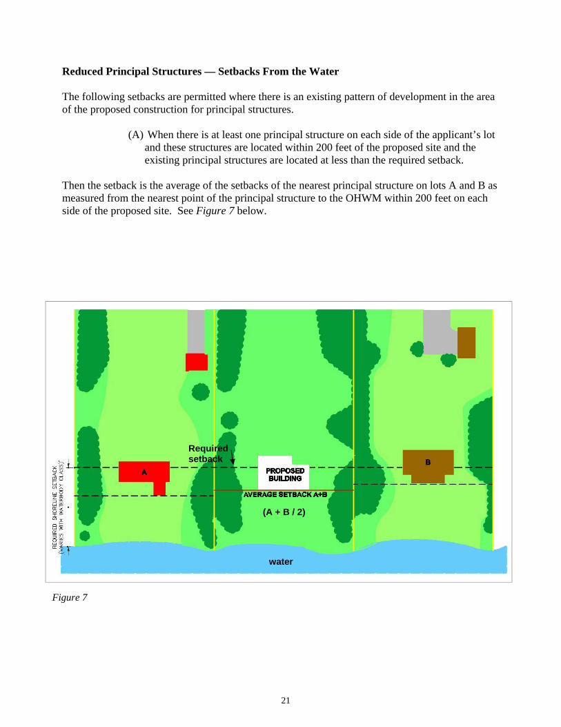
Reduced Principal Structures — Setbacks From the Water
The following setbacks are permitted where there is an existing pattern of development in the area of the proposed construction for principal structures.
(A) When there is at least one principal structure on each side of the applicant’s lot and these structures are located within 200 feet of the proposed site and the existing principal structures are located at less than the required setback.
Then the setback is the average of the setbacks of the nearest principal structure on lots A and B as measured from the nearest point of the principal structure to the OHWM within 200 feet on each side of the proposed site. See Figure 7 below.
21
Figure 7
(A + B / 2)
water
Required setback
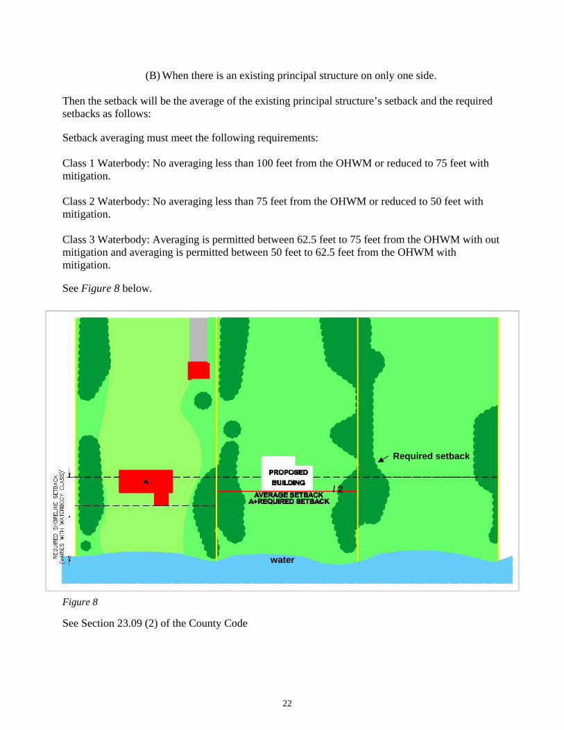
(B) When there is an existing principal structure on only one side.
Then the setback will be the average of the existing principal structure’s setback and the required setbacks as follows:
Setback averaging must meet the following requirements:
Class 1 Waterbody: No averaging less than 100 feet from the OHWM or reduced to 75 feet with mitigation.
Class 2 Waterbody: No averaging less than 75 feet from the OHWM or reduced to 50 feet with mitigation.
Class 3 Waterbody: Averaging is permitted between 62.5 feet to 75 feet from the OHWM with out mitigation and averaging is permitted between 50 feet to 62.5 feet from the OHWM with mitigation.
See Figure 8 below.
22
Figure 8
See Section 23.09 (2) of the County Code
Required setback
water
/ 2
Mitigation
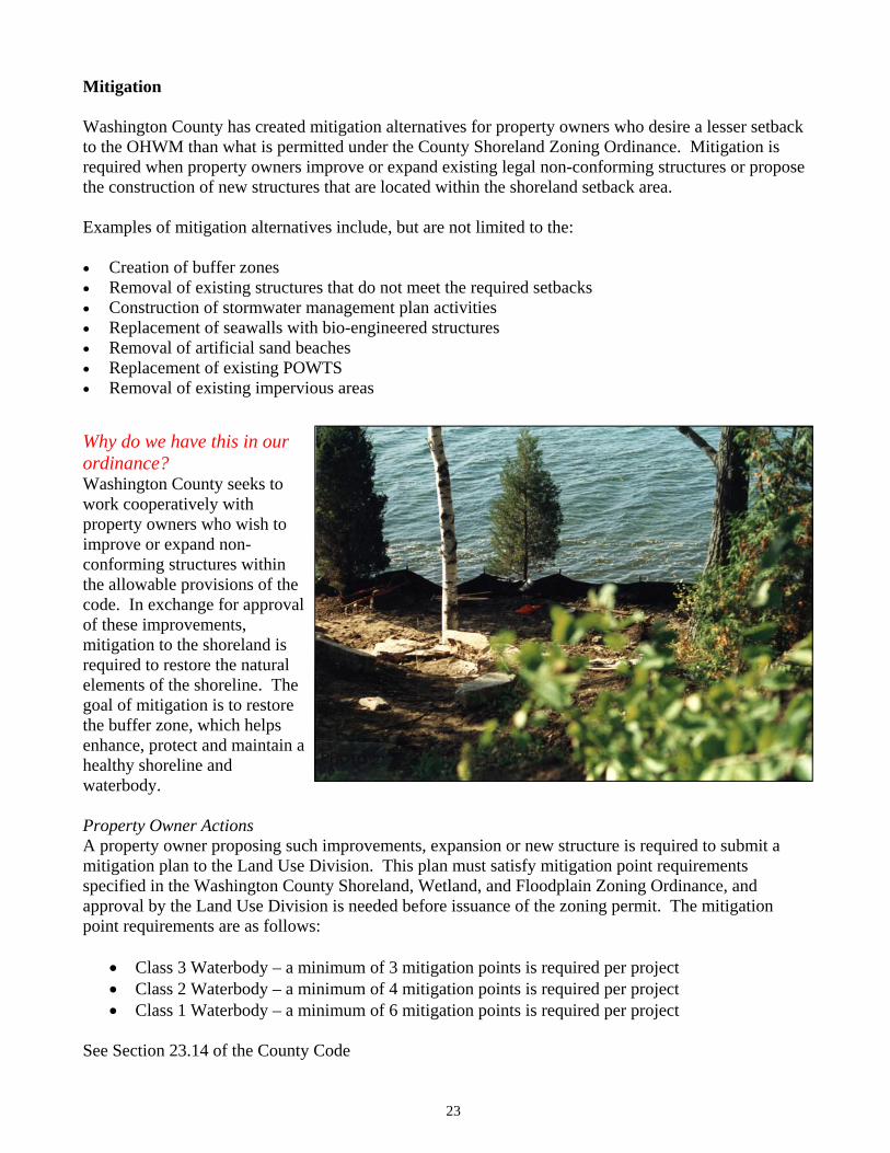
Washington County has created mitigation alternatives for property owners who desire a lesser setback to the OHWM than what is permitted under the County Shoreland Zoning Ordinance. Mitigation is required when property owners improve or expand existing legal non-conforming structures or propose the construction of new structures that are located within the shoreland setback area.
Examples of mitigation alternatives include, but are not limited to the:
�� Creation of buffer zones�� Removal of existing structures that do not meet the required setbacks �� Construction of stormwater management plan activities �� Replacement of seawalls with bio-engineered structures �� Removal of artificial sand beaches �� Replacement of existing POWTS �� Removal of existing impervious areas
23
Why do we have this in our ordinance? Washington County seeks to work cooperatively with property owners who wish to improve or expand non-conforming structures within the allowable provisions of the code. In exchange for approval of these improvements, mitigation to the shoreland is required to restore the natural elements of the shoreline. The goal of mitigation is to restore the buffer zone, which helps enhance, protect and maintain a healthy shoreline and waterbody.
Property Owner Actions A property owner proposing such improvements, expansion or new structure is required to submit a mitigation plan to the Land Use Division. This plan must satisfy mitigation point requirements specified in the Washington County Shoreland, Wetland, and Floodplain Zoning Ordinance, and approval by the Land Use Division is needed before issuance of the zoning permit. The mitigation point requirements are as follows:
�� Class 3 Waterbody – a minimum of 3 mitigation points is required per project �� Class 2 Waterbody – a minimum of 4 mitigation points is required per project�� Class 1 Waterbody – a minimum of 6 mitigation points is required per project
See Section 23.14 of the County Code
Building Layout and Lot Coverage
Why do we have this in our ordinance? During development, the construction of new rooftops, decks, patios, sidewalks and driveways creates additional impervious surfaces on your lot. These new impervious surfaces affect the way water flows from your property, especially in the case of non-point source stormwater runoff and spring melts. Stormwater runoff carries nutrients, sediment, and other pollutants into lakes, rivers, and other waterbodies, which in turn have adverse impacts on water quality.
The purpose of limiting impervious surfaces on shoreland property is to reduce the adverse affects that the volumes and velocities associated with stormwater runoff have on our waterbodies.Rooftops, driveways, and other significant impervious surfaces are managed to prevent direct discharge into waterbodies and to promote infiltration and surface dispersal. Shoreland buffer zones help to reduce runoff. A DNR study compared the amount of runoff on an undeveloped shoreland lot to the amount of runoff generated by a large lake home (approximately 4,000 square feet of impervious surfaces) on a lot that was converted entirely to lawn. They found up to a 500% increase in runoff volume, 700% increase in phosphorous loading and 900% increase in sediment flowing to the lake. Unfortunately, this is pretty much the standard level of development or redevelopment that we see adjacent to the waterbodies in Washington County. Therefore, it is essential that shoreland property owners follow the recommendations in this handbook to protect and improve the shoreline of the waterbodies they live next to.
See Section 23.14 of the County Code
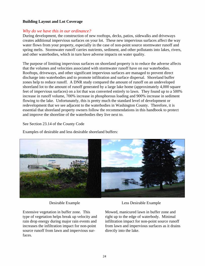
Examples of desirable and less desirable shoreland buffers:
Desirable Example
24
Less Desirable Example
Extensive vegetation in buffer zone. This type of vegetation helps break up velocity and rain drop energy during major rain events and increases the infiltration impact for non-point source runoff from lawn and impervious sur-faces.
Mowed, manicured lawn in buffer zone and right up to the edge of waterbody. Minimal infiltration impact for non-point source runoff from lawn and impervious surfaces as it drains directly into the lake.
Impervious Areas on Shoreland LotsThe percentage of impervious surface permitted on a lot depends on the waterbody classification. Table K below shows the standards for total impervious areas and principal structures on a lot. The total impervious areas include rooftops, driveways, sidewalks, patios and other significant impervious surfaces. This applies to redevelopment projects too. Total square footage footprint for principal structures (i.e. residential, commercial, industrial) applies to both new and existing structures.
Waterbody Classification Total Impervious Area Cannot Exceed
Total Square Footage for Principal Structures
Footprint Cannot Exceed Class 1 Waterbody 30% of the total lot area 15% of the total lot area Class 2 Waterbody 40% of the total lot area 30% of the total lot area
Class 3 Waterbody 45% of the total lot area 35% of the total lot area
A conditional use permit with a public hearing is required if:
�� The impervious area is greater than the percentages shown in the table above and/or �� The impervious area proposed and/or existing area exceeds 15,000 square feet in total
You must submit a detailed, scaled, site plan or drawing showing the entire lot, scope of project, including all structures, stormwater runoff management vegetative buffer, erosion control practices and POWTS location.
See Section 23.12 of the County Code
25
Table K
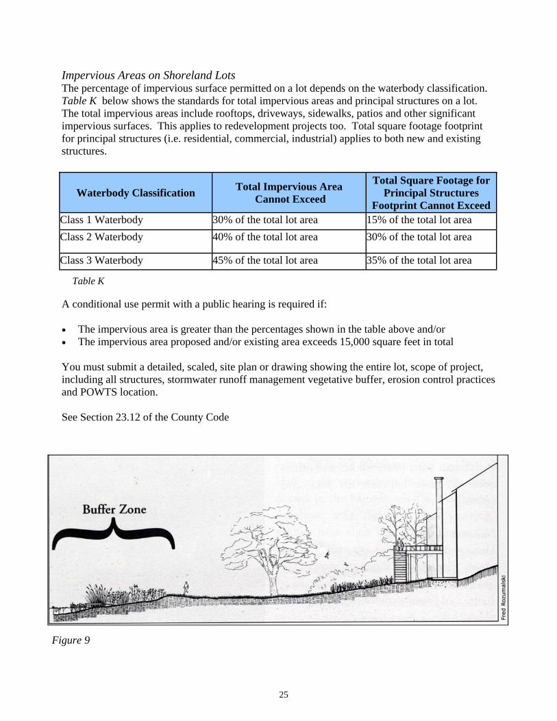
Figure 9

Use Best Management Practices to Reduce Runoff and Erosion
The following best management practices can help you reduce stormwater runoff and minimize sediments from entering the waterbody:
�� Limit hard surface and covered areas that prevent water from seeping into the ground. �� Where paved areas are necessary, locate them as close to the main road as possible to
minimize the length of paved driveway and keep the paved areas as far from the water as possible and still provide adequate access.
�� Consider using porous building materials (i.e. gravel or porous pavers) when designing driveways, walkways, patios, and parking areas. A porous surface will help absorb and reduce runoff flows to the waterway.
�� Plant new vegetation including canopy trees, understory shrubs, and ground layer plants and help divert drainage away from the waterbody whenever possible. Consider the use of rain gardens. See www.uwex.edu/pubs/raingarden
�� Retain existing trees and shrubs, as their leaves and branches intercept rain, slowing down its energy so runoff is reduced by as much as 50%.
�� Limit vegetation removal, clearing and grading on slopes that drain to the water. �� Because steeper slopes have greater erosion potential, locate driveways, sidewalks,
stairways, and footpaths away from slopes. Follow the contour of the slope if your walkway goes across a hillside.
�� Use steps when a walkway must go directly up and down a slope, particularly near the shore.
Design the house and landscape to fit the lot, thus minimizing the need for significant cutting, and filling for roads, driveways, sidewalks, stairways, decks, patios and retaining walls. This will provide for adequate access while reducing potential erosion.
Example of a co-operator at a commercial site utilizing a subsurface retention system to collect and treat stormwater runoff thereby improving the quality and reducing the quantity of runoff entering Pike Lake.
26
Building Height Design Review
When building heights exceed 20 feet as measured from the lowest portion of the final grade adjacent to the building, up to the roof peak as viewed from the waterbody shoreline, the owner or their agent must apply for an administrative permit. This standard applies to both construction of new structures and the construction of an addition to an existing structure.
As part of the application, you must provide detailed plans that identify existing trees and other plantings on your property. If the existing trees and plantings are not adequate to offset any portion of the building that exceeds 20 feet in height, they will need to be supplemented by new additional plantings to meet the provisions in the County Shoreland Zoning Ordinance. If your proposal does not comply with these provisions, you can appeal your circumstances via a conditional use permit and public hearing before the Washington County Planning, Conservation and Parks Committee.
If you design your home to fit within its surroundings by limiting removal of existing vegetation and minimizing its overall size, particularly the profile facing the waterbody, it will add privacy and give your home a more natural appeal.
Accessory Structures
Additional structures typically add visual clutter to the shoreland, especially when viewed from the waterbody. In order to preserve the natural scenery, restrictions on locating new structures have been implemented.
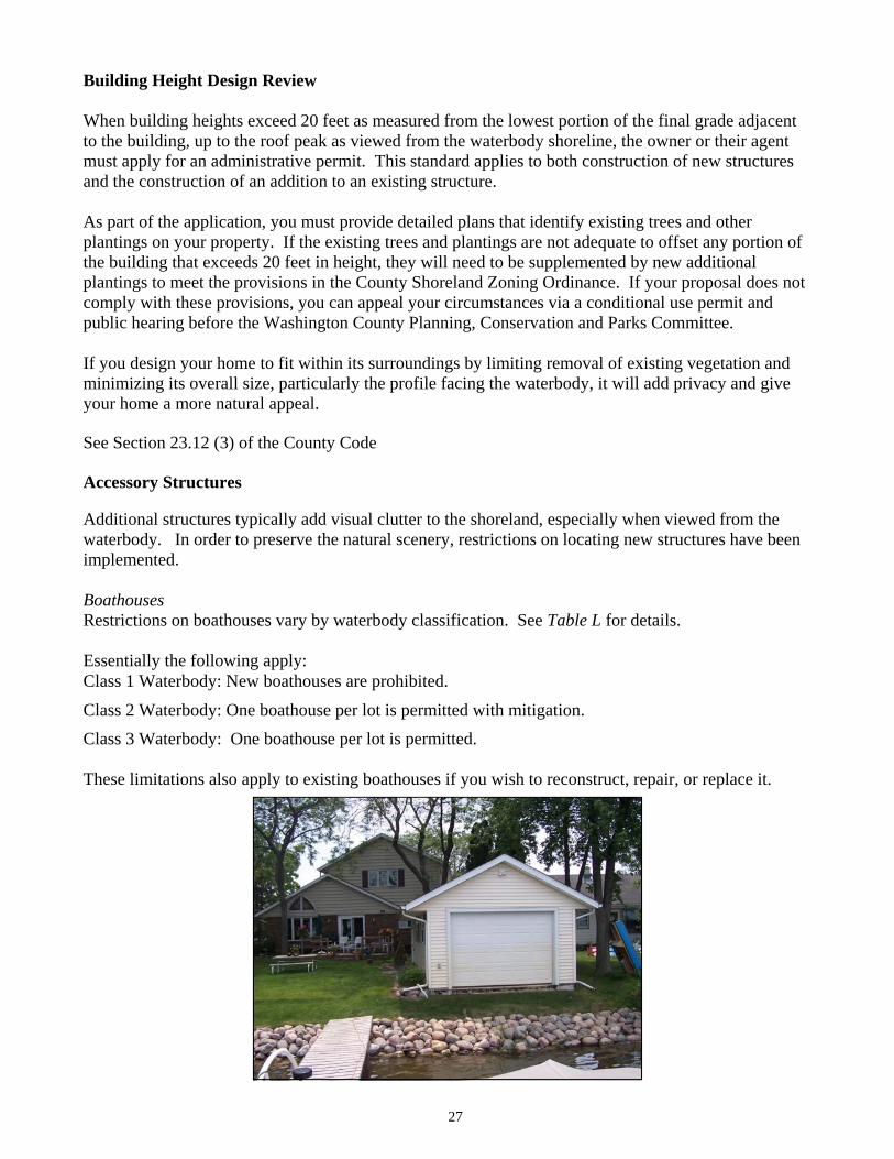
BoathousesRestrictions on boathouses vary by waterbody classification. See Table L for details.
Essentially the following apply: Class 1 Waterbody: New boathouses are prohibited.
Class 2 Waterbody: One boathouse per lot is permitted with mitigation. Class 3 Waterbody: One boathouse per lot is permitted.
These limitations also apply to existing boathouses if you wish to reconstruct, repair, or replace it.
27
See Section 23.12 (3) of the County Code
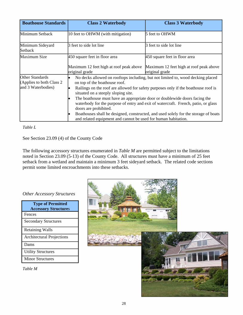
Boathouse Standards Class 2 Waterbody Class 3 Waterbody
Minimum Setback 10 feet to OHWM (with mitigation) 5 feet to OHWM
Minimum Sideyard Setback
3 feet to side lot line 3 feet to side lot line
Maximum Size 450 square feet in floor area
Maximum 12 feet high at roof peak above original grade
450 square feet in floor area
Maximum 12 feet high at roof peak above original grade
Other Standards (Applies to both Class 2 and 3 Waterbodies)
�� No decks allowed on rooftops including, but not limited to, wood decking placed on top of the boathouse roof. �� Railings on the roof are allowed for safety purposes only if the boathouse roof is
situated on a steeply sloping site. �� The boathouse must have an appropriate door or doublewide doors facing the
waterbody for the purpose of entry and exit of watercraft. French, patio, or glass doors are prohibited.
�� Boathouses shall be designed, constructed, and used solely for the storage of boats and related equipment and cannot be used for human habitation.
28
Table L
See Section 23.09 (4) of the County Code
Other Accessory Structures
Type of Permitted Accessory Structures
FencesSecondary Structures
Retaining WallsArchitectural Projections
Minor StructuresUtility Structures Dams
Table M
The following accessory structures enumerated in Table M are permitted subject to the limitations noted in Section 23.09 (5-13) of the County Code. All structures must have a minimum of 25 feet setback from a wetland and maintain a minimum 3 feet sideyard setback. The related code sections permit some limited encroachments into these setbacks.
Floodplain and Shoreline Protection
Floodplain Areas
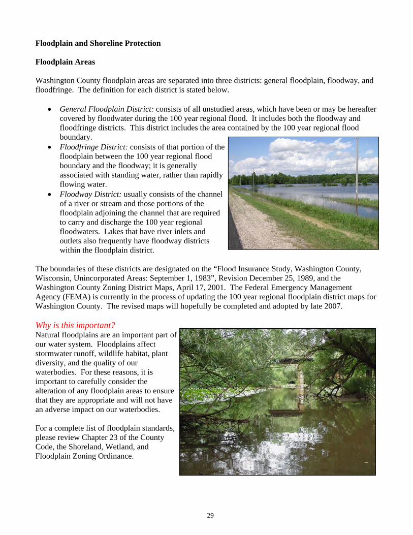
Washington County floodplain areas are separated into three districts: general floodplain, floodway, and floodfringe. The definition for each district is stated below.
�� General Floodplain District: consists of all unstudied areas, which have been or may be hereafter covered by floodwater during the 100 year regional flood. It includes both the floodway and floodfringe districts. This district includes the area contained by the 100 year regional flood boundary.
�� Floodfringe District: consists of that portion of the floodplain between the 100 year regional flood boundary and the floodway; it is generally associated with standing water, rather than rapidly flowing water.
�� Floodway District: usually consists of the channel of a river or stream and those portions of the floodplain adjoining the channel that are required to carry and discharge the 100 year regional floodwaters. Lakes that have river inlets and outlets also frequently have floodway districts within the floodplain district.
The boundaries of these districts are designated on the “Flood Insurance Study, Washington County, Wisconsin, Unincorporated Areas: September 1, 1983”, Revision December 25, 1989, and the Washington County Zoning District Maps, April 17, 2001. The Federal Emergency Management Agency (FEMA) is currently in the process of updating the 100 year regional floodplain district maps for Washington County. The revised maps will hopefully be completed and adopted by late 2007.
Why is this important? Natural floodplains are an important part of our water system. Floodplains affect stormwater runoff, wildlife habitat, plant diversity, and the quality of our waterbodies. For these reasons, it is important to carefully consider the alteration of any floodplain areas to ensure that they are appropriate and will not have an adverse impact on our waterbodies.
For a complete list of floodplain standards, please review Chapter 23 of the County Code, the Shoreland, Wetland, and Floodplain Zoning Ordinance.
29
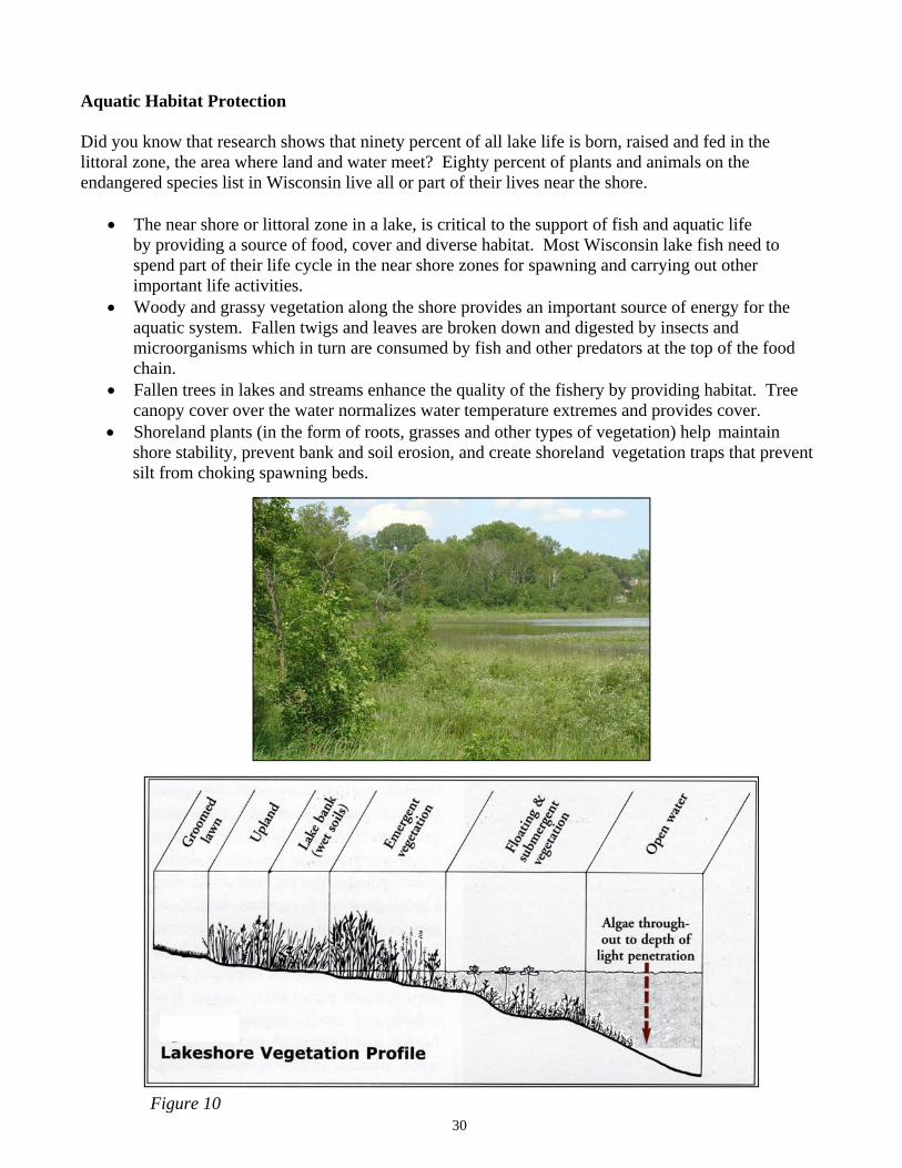
Figure 10
Aquatic Habitat Protection
Did you know that research shows that ninety percent of all lake life is born, raised and fed in the littoral zone, the area where land and water meet? Eighty percent of plants and animals on the endangered species list in Wisconsin live all or part of their lives near the shore.
� The near shore or littoral zone in a lake, is critical to the support of fish and aquatic life by providing a source of food, cover and diverse habitat. Most Wisconsin lake fish need to
spend part of their life cycle in the near shore zones for spawning and carrying out other important life activities.
�� Woody and grassy vegetation along the shore provides an important source of energy for the aquatic system. Fallen twigs and leaves are broken down and digested by insects and microorganisms which in turn are consumed by fish and other predators at the top of the food chain.
�� Fallen trees in lakes and streams enhance the quality of the fishery by providing habitat. Tree canopy cover over the water normalizes water temperature extremes and provides cover.
�� Shoreland plants (in the form of roots, grasses and other types of vegetation) help maintain shore stability, prevent bank and soil erosion, and create shoreland vegetation traps that prevent silt from choking spawning beds.
30
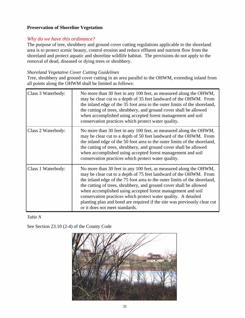
Preservation of Shoreline Vegetation
Why do we have this ordinance? The purpose of tree, shrubbery and ground cover cutting regulations applicable to the shoreland area is to protect scenic beauty, control erosion and reduce effluent and nutrient flow from the shoreland and protect aquatic and shoreline wildlife habitat. The provisions do not apply to the removal of dead, diseased or dying trees or shrubbery.
Shoreland Vegetative Cover Cutting Guidelines Tree, shrubbery and ground cover cutting in an area parallel to the OHWM, extending inland from all points along the OHWM shall be limited as follows:
�
See Section 23.10 (2-4) of the County Code
31
Class 3 Waterbody: No more than 30 feet in any 100 feet, as measured along the OHWM, may be clear cut to a depth of 35 feet landward of the OHWM. From the inland edge of the 35 foot area to the outer limits of the shoreland, the cutting of trees, shrubbery, and ground cover shall be allowed when accomplished using accepted forest management and soil conservation practices which protect water quality.
Class 2 Waterbody: No more than 30 feet in any 100 feet, as measured along the OHWM, may be clear cut to a depth of 50 feet landward of the OHWM. From the inland edge of the 50 foot area to the outer limits of the shoreland, the cutting of trees, shrubbery, and ground cover shall be allowed when accomplished using accepted forest management and soil conservation practices which protect water quality.
Class 1 Waterbody: No more than 30 feet in any 100 feet, as measured along the OHWM, may be clear cut to a depth of 75 feet landward of the OHWM. From the inland edge of the 75 foot area to the outer limits of the shoreland, the cutting of trees, shrubbery, and ground cover shall be allowed when accomplished using accepted forest management and soil conservation practices which protect water quality. A detailed planting plan and bond are required if the site was previously clear cut or it does not meet standards.
Table N
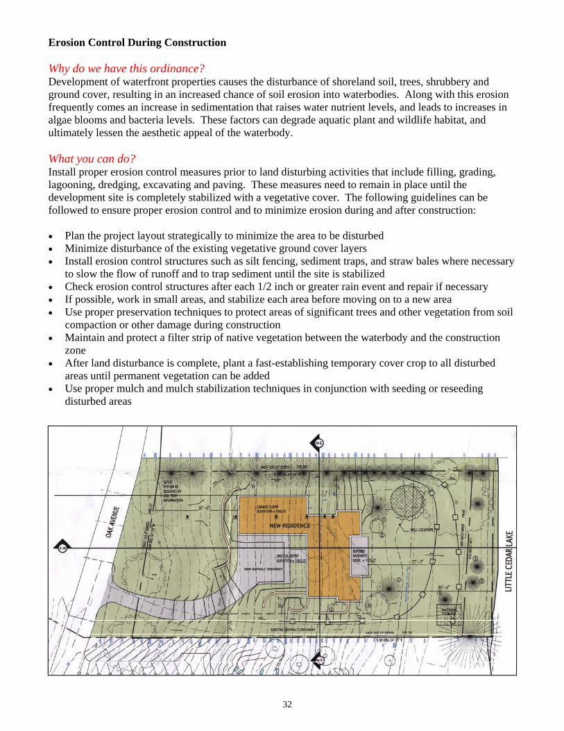
Erosion Control During Construction
Why do we have this ordinance? Development of waterfront properties causes the disturbance of shoreland soil, trees, shrubbery and ground cover, resulting in an increased chance of soil erosion into waterbodies. Along with this erosion frequently comes an increase in sedimentation that raises water nutrient levels, and leads to increases in algae blooms and bacteria levels. These factors can degrade aquatic plant and wildlife habitat, and ultimately lessen the aesthetic appeal of the waterbody.
What you can do? Install proper erosion control measures prior to land disturbing activities that include filling, grading, lagooning, dredging, excavating and paving. These measures need to remain in place until the development site is completely stabilized with a vegetative cover. The following guidelines can be followed to ensure proper erosion control and to minimize erosion during and after construction:
�� Plan the project layout strategically to minimize the area to be disturbed �� Minimize disturbance of the existing vegetative ground cover layers�� Install erosion control structures such as silt fencing, sediment traps, and straw bales where necessary
to slow the flow of runoff and to trap sediment until the site is stabilized �� Check erosion control structures after each 1/2 inch or greater rain event and repair if necessary �� If possible, work in small areas, and stabilize each area before moving on to a new area �� Use proper preservation techniques to protect areas of significant trees and other vegetation from soil
compaction or other damage during construction �� Maintain and protect a filter strip of native vegetation between the waterbody and the construction
zone�� After land disturbance is complete, plant a fast-establishing temporary cover crop to all disturbed
areas until permanent vegetation can be added �� Use proper mulch and mulch stabilization techniques in conjunction with seeding or reseeding
disturbed areas
32
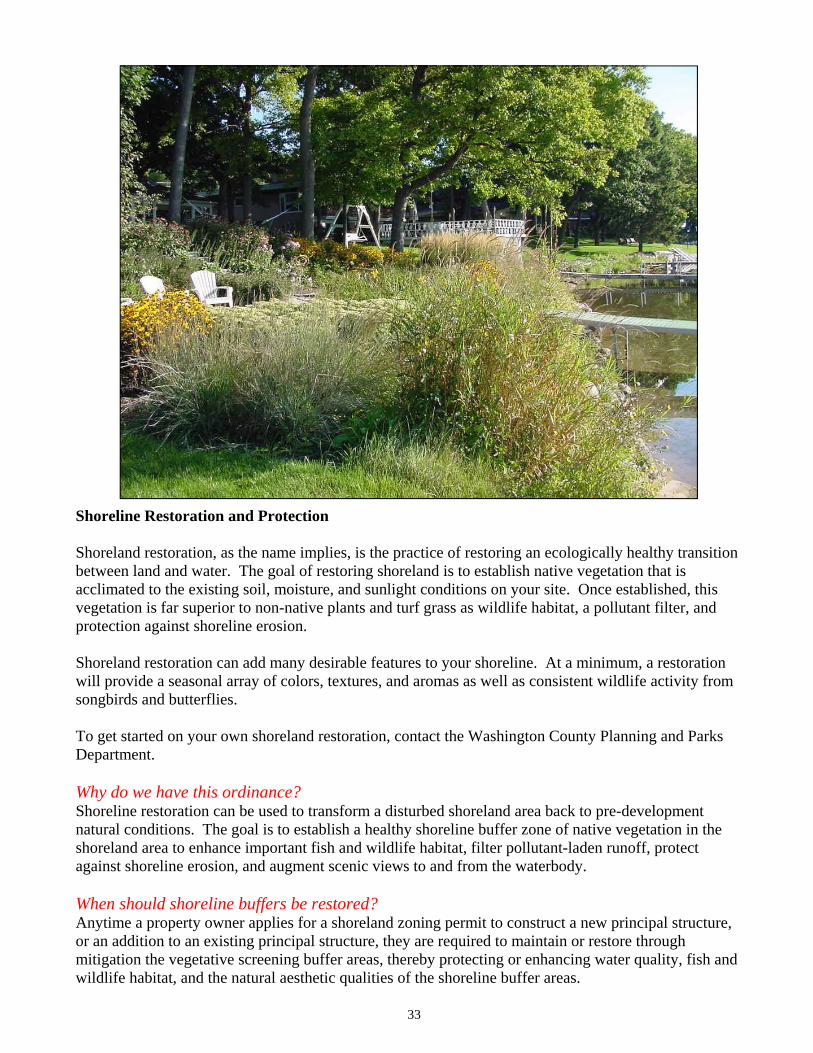
Shoreline Restoration and Protection
Shoreland restoration, as the name implies, is the practice of restoring an ecologically healthy transition between land and water. The goal of restoring shoreland is to establish native vegetation that is acclimated to the existing soil, moisture, and sunlight conditions on your site. Once established, this vegetation is far superior to non-native plants and turf grass as wildlife habitat, a pollutant filter, and protection against shoreline erosion.
Shoreland restoration can add many desirable features to your shoreline. At a minimum, a restoration will provide a seasonal array of colors, textures, and aromas as well as consistent wildlife activity from songbirds and butterflies.
To get started on your own shoreland restoration, contact the Washington County Planning and Parks Department.
Why do we have this ordinance? Shoreline restoration can be used to transform a disturbed shoreland area back to pre-development natural conditions. The goal is to establish a healthy shoreline buffer zone of native vegetation in the shoreland area to enhance important fish and wildlife habitat, filter pollutant-laden runoff, protect against shoreline erosion, and augment scenic views to and from the waterbody.
When should shoreline buffers be restored? Anytime a property owner applies for a shoreland zoning permit to construct a new principal structure, or an addition to an existing principal structure, they are required to maintain or restore through mitigation the vegetative screening buffer areas, thereby protecting or enhancing water quality, fish and wildlife habitat, and the natural aesthetic qualities of the shoreline buffer areas.
33
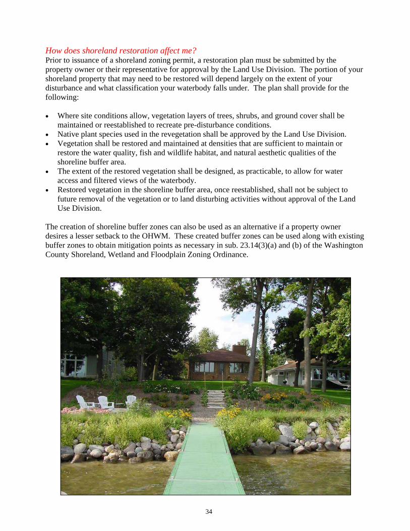
How does shoreland restoration affect me? Prior to issuance of a shoreland zoning permit, a restoration plan must be submitted by the property owner or their representative for approval by the Land Use Division. The portion of your shoreland property that may need to be restored will depend largely on the extent of your disturbance and what classification your waterbody falls under. The plan shall provide for the following:
�� Where site conditions allow, vegetation layers of trees, shrubs, and ground cover shall be maintained or reestablished to recreate pre-disturbance conditions.
�� Native plant species used in the revegetation shall be approved by the Land Use Division. �� Vegetation shall be restored and maintained at densities that are sufficient to maintain or
restore the water quality, fish and wildlife habitat, and natural aesthetic qualities of the shoreline buffer area.
�� The extent of the restored vegetation shall be designed, as practicable, to allow for water access and filtered views of the waterbody.
�� Restored vegetation in the shoreline buffer area, once reestablished, shall not be subject to future removal of the vegetation or to land disturbing activities without approval of the Land Use Division.
The creation of shoreline buffer zones can also be used as an alternative if a property owner desires a lesser setback to the OHWM. These created buffer zones can be used along with existing buffer zones to obtain mitigation points as necessary in sub. 23.14(3)(a) and (b) of the Washington County Shoreland, Wetland and Floodplain Zoning Ordinance.
34
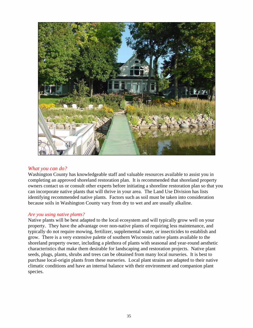
What you can do? Washington County has knowledgeable staff and valuable resources available to assist you in completing an approved shoreland restoration plan. It is recommended that shoreland property owners contact us or consult other experts before initiating a shoreline restoration plan so that you can incorporate native plants that will thrive in your area. The Land Use Division has lists identifying recommended native plants. Factors such as soil must be taken into consideration because soils in Washington County vary from dry to wet and are usually alkaline.
Are you using native plants? Native plants will be best adapted to the local ecosystem and will typically grow well on your property. They have the advantage over non-native plants of requiring less maintenance, and typically do not require mowing, fertilizer, supplemental water, or insecticides to establish and grow. There is a very extensive palette of southern Wisconsin native plants available to the shoreland property owner, including a plethora of plants with seasonal and year-round aesthetic characteristics that make them desirable for landscaping and restoration projects. Native plant seeds, plugs, plants, shrubs and trees can be obtained from many local nurseries. It is best to purchase local-origin plants from these nurseries. Local plant strains are adapted to their native climatic conditions and have an internal balance with their environment and companion plant species.
35
TREESSome of the best native trees for shoreland restoration projects include maple, basswood, oak, birch, aspen, white cedar, red pine and juniper. Tree species should be selected based on soil conditions and available light and moisture, and should be sited to provide screening and frame views.
SHRUBSNumerous native shrub species are available to provide a seasonal array of colors, textures, and aromas. They can also serve as attractors for specific wildlife species such as songbirds, butterflies or deer. Some of the more ornamental shrub species include viburnum, dogwood, hazelnut and juneberry. If you want to plant shorter shrubs to enhance your view of the waterbody, there are many species that grow to only 1 to 3 feet in height.
GROUND LAYER PLANTS Numerous flowering plants and grass species are native to Washington County shoreland areas. Endless possibilities exist to incorporate varieties of colorful or aromatic forbs (flowering plants) and grasses into your shoreline restoration project as well as in the upland areas of your property. Native plants may already exist naturally on your property; you just need to allow them to grow. Simple steps such as not stepping on young plant shoots in the spring, and not mowing vegetated areas can be taken without cost to you. This will encourage native plants already present in the soil to grow, establish, and multiply. In the early spring, look for emerging native ephemerals in wooded areas, or forbs and grasses on the shoreline and in upland areas to determine the extent of the existing native plants on your property. You can hire professionals or purchase books to help you identify the native vegetation and distinguish these plants from non-native plants and exotic weeds. Creating a walking path to your waterbody will help protect these plants and keep the underlying soil from compacting.
THREE STEPS TO A HEALTHIER LAWN Avoid pesticide use: Pesticides can be dangerous for children and pets. These harmful chemicals can be tracked into the house or leach into the groundwater. Pesticides include insecticides, fungicides, herbicides and are in weed and feed products.
Choose zero-phosphorus fertilizer: Before you fertilize, test your soil and see if it needs fertilizer. Use phosphorus free fertilizer. Phosphorous accelerates algae growth in our lakes and rivers.
Consider downsizing your lawn: Mow areas that you use. Plant more trees and shrubs, wildflowers and tall grasses to provide fun play areas for kids as well as nesting spots and food for songbirds, butterflies, and other wildlife.
INVASIVE NON-NATIVE PLANTS Invasive non-native plant species are plants that have been carried to an area outside of their historic range through unnatural means. Many of these non-native (or exotic) plants are thriving in Washington County because they are not subject to the competition, predators, or diseases that keep them in check in their home region. These plants can then dominate many native plants and aggressively grow into large colonies. Some of the non-native plants to avoid planting along shorelines include buckthorn, honeysuckle, Norway maple, purple loosestrife, crown vetch, and birds foot trefoil. If these plants already exist on your site, they should be eliminated by an ecologically safe means before any planting of native vegetation takes place, and by no means should be incorporated into your restoration project. It can be tempting to use some of these non-native plants because some of them do have desirable ornamental characteristics, but planting them must be avoided because they can compromise the biodiversity of the native ecosystem in and around your property. This can lead to the decline of native wildlife as well, since the native plants that they depend on for food are choked out by the exotic vegetation.
36
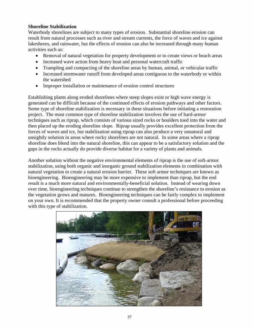
Shoreline Stabilization Waterbody shorelines are subject to many types of erosion. Substantial shoreline erosion can result from natural processes such as river and stream currents, the force of waves and ice against lakeshores, and rainwater, but the effects of erosion can also be increased through many human activities such as:
�� Removal of natural vegetation for property development or to create views or beach areas �� Increased wave action from heavy boat and personal watercraft traffic�� Trampling and compacting of the shoreline areas by human, animal, or vehicular traffic �� Increased stormwater runoff from developed areas contiguous to the waterbody or within
the watershed �� Improper installation or maintenance of erosion control structures
Establishing plants along eroded shorelines where steep slopes exist or high wave energy is generated can be difficult because of the continued effects of erosion pathways and other factors. Some type of shoreline stabilization is necessary in these situations before initiating a restoration project. The most common type of shoreline stabilization involves the use of hard-armor techniques such as riprap, which consists of various sized rocks or boulders toed into the water and then placed up the eroding shoreline slope. Riprap usually provides excellent protection from the forces of waves and ice, but stabilization using riprap can also produce a very unnatural and unsightly solution in areas where rocky shorelines are not natural. In some areas where a riprap shoreline does blend into the natural shoreline, this can appear to be a satisfactory solution and the gaps in the rocks actually do provide diverse habitat for a variety of plants and animals.
Another solution without the negative environmental elements of riprap is the use of soft-armor stabilization, using both organic and inorganic ground stabilization elements in combination with natural vegetation to create a natural erosion barrier. These soft armor techniques are known as bioengineering. Bioengineering may be more expensive to implement than riprap, but the end result is a much more natural and environmentally-beneficial solution. Instead of wearing down over time, bioengineering techniques continue to strengthen the shoreline’s resistance to erosion as the vegetation grows and matures. Bioengineering techniques can be fairly complex to implement on your own. It is recommended that the property owner consult a professional before proceeding with this type of stabilization.
37
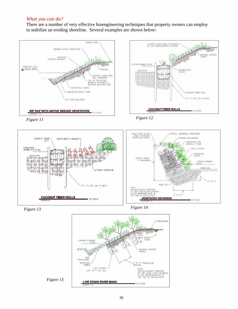
Figure 15
Figure 12 Figure 11
Figure 13 Figure 14
What you can do? There are a number of very effective bioengineering techniques that property owners can employ to stabilize an eroding shoreline. Several examples are shown below:
38
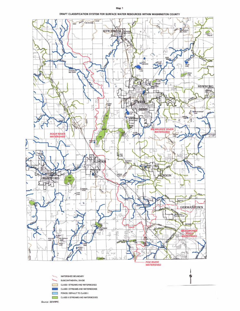
Photo by Art Krull
Photo by Art Krull