Embed Size (px)
Citation preview

Wasatch Mountain State Park Resource Management Plan 2010
Utah State Parks Utah State Parks

Division of Utah State Parks and Recreation Planning Section 1594 West North Temple, Ste. 116 P.O. Box 146001 Salt Lake City, UT 84116-6001 (877) UT-PARKS stateparks.utah.gov

i i

ii ii

iii iii
Acknowledgements
Wasatch Mountain State Park Resource Management Planning Team
- Chris Briscoe – The Homestead Resort - George Hansen – Friends of Wasatch Mountain State Park - Howard Peterson – Soldier Hollow Legacy Foundation/Concessionaire - Jason Giles – Heber Valley Chamber of Commerce - John Logan – Uinta National Forest, Pleasant Grove Ranger District - Ashley Green – Utah Division of Wildlife Resources, Central Region - Sheriff Ken VanWagoner – Wasatch County Sheriff - Shad Sorenson – Utah Valley University - Steve Farrell – Wasatch County Council and Midway Irrigation - Trish Murphy – Mountainlands Association of Governments - Gerald Hayward – Midway City Council and Water Advisory Board - Dale Jablonski – Utah Division of Forestry, Fire and State Lands - Glenn Greenhalgh – State Park Board Member - Bruce Hamilton – Northern Region Manager, Utah State Parks - Jim Harland – Northeast Region Manager, Utah State Parks - Bruce Strom – Manager, Wasatch Mountain State Park - Dave Stobart – Asst. Park Manager, Wasatch Mountain State Park Other Participants
- Rock Smith – Planning Manager, Division of Utah State Parks and Recreation - Edie Trimmer – Planner, Division of Utah State Parks and Recreation - Jamie Dalton – Planning Manager, Division of Utah State Parks and Recreation Administration
- Mary Tullius – Director, Division of Utah State Parks and Recreation - Fred Hayes – Deputy Director for Operations, Division of Utah State Parks and
Recreation - Karen Krieger – Deputy Director for Administration, Division of Utah State Parks
and Recreation - Michael R. Styler – Executive Director, Utah Department of Natural Resources - Robyn Pearson – Deputy Director, Utah Department of Natural Resources - Darin Bird – Deputy Director, Utah Department of Natural Resources

iv iv

v v
List of Figures and Maps Figures
Figure 1 Visitation by Major Activity Type, 2008 ........................................ Page 22 Figure 2 Primary Recreation Activity, Summer Visitors............................. Page 23 Figure 3 Primary Recreation Activity, Winter Visitors ............................... Page 23 Maps
Map 1 Utah State Parks and Wasatch Mountain ........................................ Page i Map 2 Wasatch Mountain State Park Wildfire Risk ................................ Page 19 Map 3 Park Recreation Areas, Facilities, Trails, and Roads.................... Page 28 Map 4 Geographic Management Zones...................................................... Page 40

vi vi
This page intentionally left blank

vii vii
Table of Contents Acknowledgements ................................................................................................... iii
List of Figures and Maps .......................................................................................... v
Executive Summary................................................................................................... 1
Mission and Vision Statements ............................................................................... 5 Mission Statement ................................................................................................... 5 Vision Statement...................................................................................................... 5
Resource Management Plan Purpose and Process ............................................ 7 Purpose of the Plan .................................................................................................. 7 The Planning Process............................................................................................... 7
Park History, Natural Resources, and Natural Hazards ................................. 9 Overview................................................................................................................... 9 History of the Park................................................................................................... 9 Human History of the Heber Valley and Surrounding Area................................ 12 Geography and Geology ......................................................................................... 13 Climate ................................................................................................................... 14 Ecosystem ............................................................................................................... 15 Natural Hazards..................................................................................................... 16
Visitor Impacts and Socioeconomic Relationship to Local Communities .. 21 Wasatch County ..................................................................................................... 21 Wasatch Mountain State Park Visitation ............................................................. 22 Visitor Survey Results ........................................................................................... 22 Economic Impacts of Wasatch Mountain State Park ........................................... 25
Issues and Recommendations ............................................................................... 27 Effective Management of Park Resources............................................................. 27 Facilities Development and Improvement Needs................................................. 33 Education and Interpretation................................................................................ 36 Marketing and Revenue Enhancement................................................................. 36 Funding and Budget Concerns .............................................................................. 37 Community Relations and Support ....................................................................... 38 Geographic Management Zones............................................................................. 39
Conclusion ................................................................................................................. 57
References ................................................................................................................. 59 Appendix A: Wasatch Mtn. State Park Business Plan ..................................... 61

viii viii
This page intentionally left blank
1 1
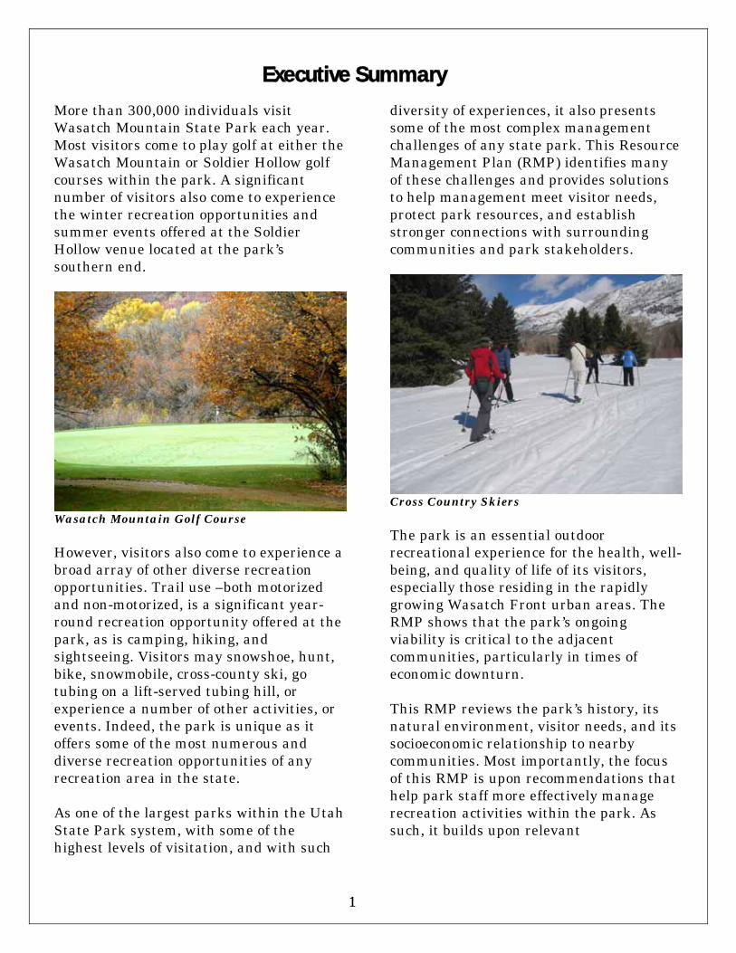
More than 300,000 individuals visit Wasatch Mountain State Park each year. Most visitors come to play golf at either the Wasatch Mountain or Soldier Hollow golf courses within the park. A significant number of visitors also come to experience the winter recreation opportunities and summer events offered at the Soldier Hollow venue located at the park’s southern end.
Wasatch Mountain Golf Course However, visitors also come to experience a broad array of other diverse recreation opportunities. Trail use –both motorized and non-motorized, is a significant year-round recreation opportunity offered at the park, as is camping, hiking, and sightseeing. Visitors may snowshoe, hunt, bike, snowmobile, cross-county ski, go tubing on a lift-served tubing hill, or experience a number of other activities, or events. Indeed, the park is unique as it offers some of the most numerous and diverse recreation opportunities of any recreation area in the state. As one of the largest parks within the Utah State Park system, with some of the highest levels of visitation, and with such
diversity of experiences, it also presents some of the most complex management challenges of any state park. This Resource Management Plan (RMP) identifies many of these challenges and provides solutions to help management meet visitor needs, protect park resources, and establish stronger connections with surrounding communities and park stakeholders.
Cross Country Skiers The park is an essential outdoor recreational experience for the health, well-being, and quality of life of its visitors, especially those residing in the rapidly growing Wasatch Front urban areas. The RMP shows that the park’s ongoing viability is critical to the adjacent communities, particularly in times of economic downturn. This RMP reviews the park’s history, its natural environment, visitor needs, and its socioeconomic relationship to nearby communities. Most importantly, the focus of this RMP is upon recommendations that help park staff more effectively manage recreation activities within the park. As such, it builds upon relevant
Executive Summary

2 2
recommendations put forward in previous planning efforts. The RMP contains recommendations developed by a stakeholder-based planning team to address key issues. More specifically, the team developed goals and recommendations that protect the park’s natural and cultural resources. Team recommendations also provide for a variety of rewarding and safe recreational and interpretive opportunities that will also result in positive economic impacts. Because of its large area, adequately managing far-flung park areas with limited resources is problematic. The RMP includes specific strategies that allow staff to more effectively manage park resources and to facilitate appropriate visitor access and use in the park’s remote locations. Recommendations are also included to minimize the impacts of nearby development.
Likewise, there is a need to more efficiently protect and preserve the park’s vast resource base. This RMP includes strategies to better protect park habitat areas by improving the health of plant and wildlife communities in the park, to minimize wildfire danger, and to control invasive species and prevent insect infestation. There is significant concern about the condition of the park’s aging and obsolete infrastructure. Park campgrounds and site amenities cannot accommodate newer, larger recreational vehicles (RVs), and much of the associated infrastructure is aging and is dilapidated. Likewise, there is a need to improve aging infrastructure at the Wasatch Mountain Golf Course.
Additional facilities such as yurts, group use areas and more backcountry campsites are needed to meet changing visitor needs. Trail use for hiking, biking, and motorized use is increasing. There is a need to provide more diverse experiences for trail users. There is a corresponding need for additional signage or information identifying trail difficulty and more directional signage on trails. Adjacent developing communities would also like greater access and more linkages to the park and its trails. Non-motorized users request additional or improved trailheads and parking for biking, hiking, and equestrian activities. The RMP includes recommendations to address these issues. In addition, the RMP includes actions to improve park interpretation and education efforts.
Hiking in Huber Grove The RMP team identified a need to more effectively market park opportunities. Strategies to build and maintain community support are included to ensure that the adjacent community recognizes the park as a valuable asset and partner. These efforts will be critical in enlisting broader-based support. They are also
3 3
needed to ensure that the park remains a viable and going concern, particularly in a time of declining budgets and falling state revenues. Concession services are another important ingredient in helping the park enhance revenue. The RMP identified various strategies to identify additional concession service opportunities and to boost park revenues. With staff and resources stretched thin, it is critical that additional revenue sources are identified, and that business planning efforts are implemented to identify the most cost-effective path to greater financial self-sufficiency.
Finally, to better identify and manage the resources and opportunities specific to each park locale, the RMP identifies seven separate planning zones. These zones identify resources and constraints unique to each area, and help to prioritize the implementation of management actions unique to each area. Each planning zone specifies desired and suitable recreation activities, concession or contract service opportunities, and needed facilities enhancements. This approach identifies the limits of acceptable change that trigger required management actions to minimize negative impacts on resources or visitor experiences. This approach also enables park staff to implement the most efficient and sustainable recreation activities to increase park revenues and minimize costs – both explicit financial costs and implicit costs of resource degradation.

4 4
This page intentionally left blank

5 5
The park’s mission and vision statements are this plan’s guiding principles. The mission and vision statements outline future conditions desired through implementation of this plan. The elements within the vision statement guide the team’s recommendations regarding necessary actions to achieve the desired future conditions at the park. They also help ensure that recommendations are consistent with the park’s mission. Mission Statement The mission of Wasatch Mountain State Park is to preserve and protect natural and cultural resources, provide a variety of rewarding and safe recreational and interpretive opportunities, while having a positive impact on the local and state economies. Vision Statement Wasatch Mountain State Park will accomplish its mission by:
Protecting and preserving park resources by exercising good stewardship practices
Developing and maintaining facilities that offer safe, affordable, healthy and suitable recreation opportunities for visitors focus on families and youth
Providing management that maintains current experiences, while also allowing for other appropriate types of new activities to occur in the park
Offering engaging and interesting interpretive and educational programs that enhance the visitor’s experience
and appreciation of the park and surrounding landscape
Partnering or collaborating with local government, businesses, educational institutions, citizens and other agencies to maximize the contribution of the park and staff to the State and local community
Ensuring the park has adequate and appropriate staff, equipment, and support
A Red-tailed hawk soars above the park
Mission and Vision Statements

6 6
This page intentionally left blank

7 7
Purpose of the Plan Wasatch Mountain State Park is unique among parks within the Utah State Parks system. It is one of the oldest parks and offers some of the most numerous and diverse recreation opportunities of any state park. It is one of the largest parks within the Utah State Park system, has some of the highest levels of visitation, and is seen as an essential outdoor recreational experience, particularly for visitors residing in the rapidly growing Wasatch Front urban areas. It also has a world-renowned legacy and identity as one of the state’s remaining venues from the 2002 Olympic Winter Games. The park is located in northern Utah in the Wasatch Back community of Midway, Utah. The park’s ongoing viability is critical to Midway’s socioeconomic well-being, and to the vitality of other nearby Wasatch County communities. Planning for the park is essential to protect park resources while at the same time meeting the needs of a growing user base that demand a diversity of new or enhanced recreation opportunities. Planning also ensures that the park becomes more financially self-sufficient in a time of limited funding opportunities. Finally, planning serves to strengthen the park’s linkages to local communities – an essential element to the park’s future viability. The plan’s recommendations will guide and inform park staff and Division administration about the stewardship obligations for the park. It addresses numerous issues and defines strategies to meet future needs. It also helps ensure that the park operates efficiently and becomes
an even more essential asset that improves the welfare and quality of both visitors and Utah’s citizens. The issues addressed in this plan were identified through a variety of means including public meetings, planning team meetings, visitor surveys, and from existing research and data sources. Planning team members identified goals and recommendations to: • More effectively manage park resources; • Address facilities development and
improvement needs; • Enhance park interpretation and
education efforts; • More effectively market the park; • Address funding and budget concerns; • Improve community relations and
increase external support; and • Identify desired and sustainable
activities within identified geographic management zones that meet visitor needs and enhance park revenues.
The plan provides flexible guidelines for the management and development of the park over the next five to 10 years. The plan is based on a foundation of public input and consensus of the key stakeholders. These stakeholders include park visitors, local government and business leaders, park concessionaires, natural resource agency experts, and park and Division staff. The Division believes this broad-based, inclusive approach is superior to the unilateral direction of the Division. The Planning Process Planning for an outstanding recreational asset like Wasatch Mountain State Park is required for the efficient expenditure of state and local funds and for the long-term
Resource Management Plan Purpose and Process

8 8
protection and public enjoyment of the park’s many opportunities and resources. This RMP is required by the Utah State Legislature and the Board of Utah State Parks and Recreation to guide short and long-term management and capital development. The Division’s long-range strategic plan, Vision 2010, outlines the required planning actions needed to effectively meet customer recreational and leisure needs for the next five to 10 years. Vision 2010 identifies resource management planning as essential to the effective administration and operation of all parks in the Division. Under the guidance of Vision 2010, each RMP is developed around one core concept: meeting the needs and expectations of customers, visitors and the citizens of the state of Utah, while protecting each park’s unique resource base. In short, the process is customer driven and resource based. The planning process recommends acceptable changes and a future vision for the park. Specifically, the process recognizes impacts will result from use and enjoyment of the site; defines how much and what types of impacts may be accommodated while providing reasonable protection of the resources for future visitors; incorporates values of resource sustainability, quality facilities, education and interpretation for visitors; and seeks to determine the conditions under which this can be attained. In early 2008, Division representatives met with community stakeholders to familiarize them with the planning process and the need for creating a resource management plan for the park. During this meeting, the Division solicited the names of community members and various users with an
interest and expertise in the park to serve as members of a resource management planning team. Team members were selected for a variety of reasons ranging from technical expertise to interest in the park. All team members participated on a voluntary basis and expressed a willingness to contribute a significant portion of their time and expertise to the process. Sixteen individuals were selected to serve on the planning team, with three representatives from the Division planning section serving as staff to the team. The team participated in public meetings and sought input as they developed issues and recommendations for the park. The team met subsequently on several occasions to develop the recommendations in the plan.

9 9
Overview Wasatch Mountain State Park is located in northeastern Utah, encompassing the north and west boundary of Midway, Utah, along the eastern slopes of the Wasatch Mountains. The park lies entirely in Wasatch County and comprises an area of approximately 23,000 acres of mountain and foothill terrain acquired by the state from Wasatch County, the Bureau of Land Management (BLM), State and Institutional Trust Lands Administration (school trust lands), and private land owners. The western boundary abuts the Uinta National Forest. The park contains pockets of private land, including several mining districts, private homes, and cabins. The park is accessible on the north from Big Cottonwood Canyon and Park City along Guardsman’s Pass, on the west from American Fork Canyon, on the northeast through Dutch Canyon along River Road, and in several areas along the eastern boundaries of the park, including Soldier Hollow. Recreational amenities at Wasatch Mountain include four 18-hole golf courses, two campgrounds serving primitive and motor home campers, several miles of off-highway vehicle trails accessible both summer and winter, non-motorized trails for use by hikers, bikers, equestrians, and winter users, and two historical sites. Wasatch Mountain was host to the cross-country and biathlon events of the 2002 Winter Olympics at Soldier Hollow. This area now provides the public with cross-country skiing access, tubing, hiking, and biking, among other activities. The
majority of the park’s winter visitation occurs within the Soldier Hollow area. History of the Park The establishment of Wasatch Mountain State Park followed shortly after the creation of the Utah State Park and Recreation Commission by the Utah Legislature in 1957. Once appointed, the commission moved quickly to inventory the state for potential lands to be designated as state parks. The inventory results were published and submitted to the legislature on January 2, 1959. Wasatch Mountain State Park was recommended and given high priority for immediate acquisition and development. The proposed park would be 25,800 acres with 560 acres to be acquired from the BLM, 1,280 acres already owned by the state in school trust land sections, and the remaining 23,960 acres to be purchased from private land owners (Powell, 1989). The report noted that the public use of the proposed park would be for camping, picnicking, horseback riding, hiking, hunting, winter sports, scenery, photography, history, and geology.
Snake Creek Overlook In 1959, Wasatch County donated a 46-acre tract, and 537 acres of private land were purchased by the state. These lands, most of which are located at the junction of Pine Creek and Snake Creek Canyons were
Park History, Natural Resources and Natural Hazards

10 10
considered the nucleus of the park and the beginning of the acquisition of the approximately 23,000 acres that presently comprise the park (Powell, 1989). By the end of 1959, options on approximately 20,000 acres had been secured for total purchase price of $1,172,648. The area secured included all of the proposed park with the exceptions of some mining claims high in the mountains and a 122-acre subdivision. In 1961, Governor George Dewey Clyde signed a bill that allowed the park commission to acquire the land over a 10-year period at the cost of approximately $1.5 million. Since the 1960s, additional monies for acquisitions have been made with funds provided by the Utah State Legislature. The majority of the development that currently exists in the park was provided through matching grants from the federal Land and Water Conservation Fund.1
Wasatch Mountain State Park Visitor Center The park’s visitor center was built and dedicated in 1968. It was renovated and rededicated in 2003. However, in 1964, even before the visitor center was dedicated, Little Deer Creek Campground (17 primitive sites) and the Chalet opened 1 National Park Service, Land and Water Conservation Fund Project Nos. 49-0010, 49-0138, 49-332d, and 49-00263.
for use. Then in 1967 the first 18 holes of the Wasatch Golf Course were developed, and the first two campground loops within the Pine Creek Campground were built. The two ranger homes were built in 1976 and the park maintenance shop was built in 1977. The park’s Soldier Hollow area has been the site of considerable development since the mid-1990s. This is primarily due to the selection of the area as the biathlon and cross-country venue for the 2002 Winter Olympic games.
The 2002 Soldier Hollow Winter Olympic Venue In 1996 development was initiated on the 2002 Winter Olympic venue for biathlon and cross-country skiing. Initial development included construction of what would eventually become a 16-mile system of cross-country ski trails. The trail system included two sets of trails, one of which was specifically designed for Olympic events. Subsequent Olympic venue construction included visitor seating, a shooting range, and a 7,000 square foot competition building for event management (timing, scoreboard operation, audio and video production, and competition scheduling). The Olympic venue was deemed highly

11 11
successful, and has become the area’s focal point in terms of the legacy left by the 2002 Winter Olympic games. The venue is now used as a recreational site for cross-country skiing, hiking, biking, festivals, and special events. It also serves as a permanent training facility for professional athletes. While it is located within the Park Boundaries, the venue is operated by the Soldier Hollow Legacy Foundation, a park concessionaire. Additional planning and development efforts were made to both preserve the legacy of the 2002 Winter Olympics and to provide the recreating public with future recreation use of the facilities. In December 2000, the area’s Day Lodge was constructed adjacent to the Olympic venue site. The lodge was designed to facilitate public access to the Olympic facilities by providing cross-country skiing, snowshoeing, mountain biking, hiking, and running. A concessionaire operates the lodge and provides ski rentals, food and beverages, accessories and souvenirs. The lodge serves as a facility for meetings and social gatherings. It also serves as the venue for the adjacent concession-operated tubing hill that provides family-oriented winter recreation opportunities. In late 1997, the Division developed a Soldier Hollow recreational site plan to anticipate post-Olympic future use of the area. This plan called for development of a golf course, additional camping and day-use areas and facilities, winter sports activities, facilities to accommodate business and social functions, and additional trail development.2 2 Utah State Parks, Soldier Hollow Golf Task Force: A Feasibility Study, October 2000, p. 4.
As noted above, the Olympic venue and the Day Lodge serve as the base facilities for many of the recreational opportunities envisioned in the 1997 site plan. In addition, a railroad loading and unloading platform to accommodate visitors using the Heber Valley Railroad system was completed prior to the 2002 Olympic games, as was the reconstruction of the area’s historic Tate Barn. Following the 2002 Winter Olympic Games, planning and development was initiated on a 36-hole golf course. The championship course was opened to the public in July 2004. Golf course development also included construction of a unique clubhouse that serves as a pro shop, provides concession services, and is capable of hosting social events. Enhancement and development of support facilities were also part of this effort.
Soldier Hollow Club House The Soldier Hollow course consists of two adjoining 18-hole golf courses named the “Silver” and the “Gold” courses. Like the Wasatch courses, the Soldier Hollow courses have received critical acclaim for their design and for the challenge they offer to golfers. This was certainly a factor

12 12
in the selection of Soldier Hollow as the site of the 2012 Amateur Public Links Championship. The Soldier Hollow courses were designed to use the native vegetation and minimize impacts to the area. As part of the Olympic development, wetland areas occurring below the Olympic venue site were reclaimed. Additional developments in this area included snowmaking infrastructure, renovation of the Chalet facility, and development of maintenance and shop facilities. In 2006, trail development linking the park to the Provo Canyon trail system was completed, and a group camping area was constructed. Human History of the Heber Valley and Surrounding area Little is known of the American Indians who inhabited the Heber Valley area before 1776. Archaeological remains are almost non-existent in the area, and anthropologists have had to rely on interpolations made between scattered archaeological sites. The earliest known American Indians in the Great Salt Lake Area have been categorized as members of the Desert Culture. They were hunters and gatherers in a continual state of movement and migration harvesting wild plant foods in the various seasons. They may have visited the Heber Valley and the surrounding mountains during their migrations. The Desert Culture is believed to have existed from about 10,000 years ago, to nearly 400 A.D. After 400 A.D groups of the Fremont Culture appeared to have occupied or
visited the region. These were pueblo-type farmers supplemented with food gleaned by gathering and hunting. During the period from 1176 until 1849, when Mormon settlers arrived in Utah Valley, the Utes appear to have considered the region near Utah Lake and the surrounding valleys and mountains that contain Wasatch Mountain State Park as their homeland. Early explorers described the Utes as hunters and gatherers who subsisted primarily on fish, rabbit, seeds, herbs, and other plant and animal species endemic to the area. Dominguez and Escalante were the first known white men to visit the general region of Wasatch Mountain State Park as they sought a route to connect the new California missions with the settlements in New Mexico. In the early 1800s trappers began visiting the region in search of beaver pelts. The first of these trappers known to have arrived was Etienne Provost. During the summer of 1824, Provost and his party entered the Heber Valley, discovering the river that now bears his name, and followed it to Utah Lake. Provost passed back and forth through the Heber Valley on several occasions during this period. Cattle ranchers established the first permanent homes in the valley, attracted by the rich meadow lands along the Provo River. In July of 1858, the first survey work began at what later became the Heber townsite. In 1859 larger-scale settlement commenced. A square mile reserve was laid out in blocks and lots. A site for a fort was located, and settlers began building homes.

13 13
By late 1862 the community was firmly established. The settlement was called London until the summer of 1860 when it was renamed in honor of Heber C. Kimball, popular counselor to LDS Church President Brigham Young.
Early 20th Century Midway and the Heber Valley Only a year after the settlement of Heber, settlers were establishing farms and ranches on the west side of the valley. Present-day Midway began in the summer of 1859 as a string of homes and farms along Snake Creek below the present boundaries of Wasatch Mountain State Park. Growth has continued in the Heber Valley with resorts and community centers built around the local hot springs. Farming and ranching were the main form of livelihood in the valley for many years. Recently, however, the growth of resorts and an
influx of residents have begun to re-shape the face of the Heber Valley. Recreation and open space is a major draw for those who come to this area, for both full time and part time residences, as well as for visitors and tourists. Geography and Geology Wasatch Mountain State Park is situated near the junction of the north-south trending Wasatch Range and the Uinta Mountains, the only major east-west trending range in the western hemisphere.
The Wasatch Range at the park's western boundary For the eons between 1 billion and 200 million years ago, this region lay beneath shallow seas that alternately submerged and exposed the landscape. Thick layers of limestone and sandstone were deposited in these shallow seas over the eons. Nugget Sandstone, commonly found in the area, was deposited during the Jurassic (about 200 million years ago) when a large, sandy desert covered most of Utah. Approximately 100 million years ago a period of uplift and unrest began with

14 14
broad folding of the rock layers. Faulting began thrusting up large blocks of terrain that became the early Wasatch Range. As the mountain rose, the Provo River cut the present Provo Canyon through the block. Materials washed down from the eastern slope of the mountain block and formed the flat plain of the Heber Valley. In addition to movement along the faults, molten rock (Diorite) from the interior of the earth has pushed its way to the outer crust of the uplift and cooled. The heat and pressure caused by this intrusion of molten material has caused shattering and transformation of the sedimentary rocks in the area surrounding the intrusion. The intrusive material in the northern Wasatch Mountains caused the formation of the extensive lead-zinc-silver ore bodies and mineral veins which have been mined in the park and several surrounding areas, including Park City. During the last Ice Age, about 10,000 years ago, glaciers formed in the upper reaches of Pine Creek and Snake Creek canyons. As these glaciers moved down hill, they began to deepen and widen their channel into the characteristic u-shape valleys observable in the canyons. As the glaciers melted, vast quantities of rock and debris of various sizes were left behind in long mounds or ridges called moraines. Streams and mountain springs continue to cut and deepen the canyons as they constantly rush down hill. Just outside the park are numerous thermal springs that form several “hot pots”. The water starts as rain and snow melt high in the mountains. It follows natural “pipelines” of fractures beneath the mountains where it is heated as the
temperature of the earth increases with depth. Hydrostatic pressure, the weight of overlying water, forces the heated water back to the surface as hot springs. The water found in local hot springs is highly mineralized and gradually deposits calcite, the calcium carbonate mineral that makes up limestone. These deposits of porous limestone are called tufa. Climate Wasatch Mountain State Park is characterized by cool summers with relatively low humidity, abundant sunshine during most of the year, and light to moderate precipitation depending on elevation. Prevailing winds are from the northwest, placing most of the park in the rain shadow on the leeward side of the Wasatch Range. On average, the park receives about 17 inches of precipitation annually. At the Snake Creek Power House, at a slightly higher elevation, average annual precipitation is about 22.3 inches. Most precipitation is received during the period from October through May with October being the wettest month. Summers in the park and surrounding area are pleasant with maximum temperatures reaching the high 80s during July and August with night-time temperatures falling to the 40s. The frost-free season is very short, averaging approximately two and one-half months in the valley, and below freezing temperatures occurring every month at higher elevations. Winters are characterized by cold weather with occasional periods of snow. In January, the average daily temperature is 35 degrees Fahrenheit. Nearly half of the annual precipitation falls in the form of

15 15
moderate to heavy amounts of snow. Mean annual snowfall in the valley is approximately 70 inches with 146 inches reported at the Snake Creek Power House.3
Winter at Wasatch Mountain State Park Ecosystem A wide range of vegetation types occur within Wasatch Mountain State Park. Elevations in the park range from 6,500 to 10,000 feet, with a total of 20 distinct vegetation communities identified. Oak, Aspen, and Sagebrush/Perennial Grass communities make up the majority of the park’s vegetation. The Clayton Peak area approaches timberline in elevation, with corresponding low shrubs, herbs, mosses, and lichens for vegetation. Vegetation on high alpine slopes is representative of tundra-like conditions. Wetland and riparian areas are an important resource within Wasatch Mountain State Park that provides 3 National Oceanic and Atmospheric Administration (NOAA), Nation Weather Service, Western Region Climate Center, Utah Climate Summaries, Weather Data for Heber City, Utah and Snake Creek Powerhouse.
biological diversity and habitat for a wide range of species of flora and fauna. These areas are very sensitive to development and water availability. Adequate flows from streams and springs are critical to maintaining the integrity of the riparian areas.
Wetlands in the park's Soldier Hollow area One of the key resources at the park is the habitat it provides for a wide variety of wildlife species. The park is part of the larger ecosystem that provides forage, shelter, and a home to many wildlife species. Large and small mammals, birds, fish, amphibians, and reptiles all depend on the largely undisturbed landscape of the park for habitat and sanctuary. In 2009, the Utah Division of Wildlife Resources (UDWR) noted that various sensitive species occur in or around the park. These include bald eagle, American three-toed woodpecker, black swift, bobolink, Columbia spotted frog, grasshopper sparrow, greater sage-grouse, southern leatherside chub, whooping crane and yellow-billed cuckoo. UDWR also notes historical occurrence of smooth greensnake and western toad within the area.

16 16
An American kestrel in the park According to UDWR, all of these species are included on the Utah Sensitive Species List. Sensitive species are those vulnerable to population declines or changes in habitat. UDWR focuses on these species and recommends appropriate conservation and protection measures to preclude more proscriptive actions that may be taken by the federal government under the Endangered Species Act. UDWR also notes that within the park there is also a record of occurrence for Ute Ladies’ tresses, a federally listed plant species. With all such species, park management should first consult with UDWR on how to appropriately mitigate impacts to sensitive or federally listed species occurring within a proposed development site. The Utah Partners for Conservation and Development (UPCD), an advisory group consisting of habitat restoration experts from UDWR, U.S. Forest Service (USFS), and the Natural Resources Conservation Service, identified areas within the park as potential habitat restoration areas. UPCD provides assistance for agencies or entities
desiring to restore designated habitat areas. UPCD identified what they term as a habitat restoration “focus area” along Little Deer Creek’s riparian zone. They likewise identified rangeland habitat in Dutch Hollow as an area of special focus for restoration. Park management may coordinate with UPCD to receive assistance in park habitat restoration efforts. Natural Hazards In 2009, the Utah Division of Emergency Services and Homeland Security developed a Hazard Mitigation Plan for the park. The Hazard Mitigation Plan identifies and defines the natural hazards potentially affecting park areas. The plan evaluates hazard risks from events such as wildfires, severe weather, flooding, earthquake, or landslides. The purpose of the plan is to identify actions that will help eliminate or reduce visitor and staff exposure to natural hazard risks. This RMP integrates the recommendations put forward in the Hazard Mitigation Plan. A summary of report findings and recommendations is presented below. Wildfire Risks Wildfire risk is high at the park. The park is situated in an area that contains the topography, fuel types, and weather patterns that make it susceptible to wildfire. The Hazard Mitigation Plan notes that almost 86 percent of the park’s land area is classified as having a high risk of wildfire exposure. Low wildfire risk areas within the park include the golf courses and those areas adjacent to the city of

17 17
Midway. Wildfire risk within the park is shown in map 1. The Hazard Mitigation Plan recommends that staff take the following actions to reduce park wildfire risk:
1. Monitor State and Federal wildfire mitigation and response activities in the area;
2. Post burn restrictions, distribute wildfire awareness materials and discuss burn restrictions in surrounding areas with park visitors;
3. In the event of a wildfire, have a plan in place to ensure the safety of park visitors. Note possible evacuation routes, and in extreme cases, consider moving visitors to the golf-course grass area to shelter them from fire;
4. Be aware of local wildfire conditions, and communicate those conditions to park employees and visitors.
Severe Weather Risks and Flooding During summer months, the park has the potential to experience extreme weather events such as severe thunderstorms that include lightning, high winds, hail, and cloudbursts and related flooding. These events can threaten visitor safety and can cause damage to park facilities. During winter months, the park can experience severe winter storms. Exposure to cold temperatures and potential avalanche events near steep slopes in and around the park are the primary winter weather threats. The Hazard Mitigation Plan also indicates that the park has the potential to experience the impacts of flooding from
heavy rainfall or rapid snowmelt. The report noted that flooding is more likely to occur on roads leading into and out of the park. To minimize severe weather and flood risks, the Hazard Mitigation Plan recommends that park management take the following actions:
1. Monitor weather and take steps to inform park visitors of impending severe weather, particularly during the summer thunderstorm season;
2. Consider providing park employees with NOAA Weather Radios and facilitate staff access to the Salt Lake National Weather Service web site to monitor weather assessments and recommendations;
3. Monitor avalanche forecasts through the USFS Utah Avalanche Center and the Utah Department of Transportation. Also, warn visitors about backcountry avalanche danger;
4. Install flood hazard signs for low-lying park areas susceptible to flooding;
5. Maintain small drainage channels in camping areas to allow free flow of floodwaters;
6. Be aware of flooding potential outside the park boundaries and in nearby areas along main roads to and from the park where access may be temporarily cut off.
Earthquake and Landslide Hazards The Natural Hazards Mitigation Report notes that the park is in close proximity to three active faults. The report finds that during an earthquake event, the park may experience liquefaction in valley areas or at
18 18
locations near water sources. Rock falls and landslides are also risks that may occur during an earthquake event. The report classifies the park as having a moderate landslide risk. It notes that about 81 percent of the park’s land area falls within a “moderate” landslide susceptibility classification. Only 2 percent of the park’s area is within a “high” risk area, and the remainder is classified as being low or very low. To minimize the risk of earthquake and landslide, the report recommends that park staff:
1. Tie down, brace, or secure non-structural items or equipment (such as computers, bookcases, or other equipment);
2. Prepare an emergency response plan and ensure that 72 hour kits are on site and accessible;
3. Identify alternate routes into and out of the park;
4. Ensure that there are alternate communication systems in place to coordinate emergency response following an earthquake;
5. Develop procedures for providing safety guidance for visitors present at the park during an earthquake event;
6. Identify potential landslide and rock fall areas within the park that could potentially affect facilities, infrastructure, trails and visitors and effectively post such areas with appropriate hazard signage;
7. Where possible, stabilize and retain slopes to minimize threat of rock fall and landslide.

19 19
Map 2: Wasatch Mountain State Park Wildfire Risk (Source: Utah Division of Emergency Services and Homeland Security)

20 20
This page intentionally left blank
21 21
Wasatch County Wasatch County along with adjacent Summit County is part of the state referred to as the Wasatch Back, an area that has experienced rapid growth because of its proximity to a large urban area. These counties offer a semi-rural lifestyle with natural and recreational amenities. They also share similar economic histories, as both economies have evolved from natural resource-based industries such as mining and agriculture to recreation and tourism dependent economies. Wasatch Mountain State Park is closely linked to the socioeconomic composition of Wasatch County. In an effort to attract economic growth and investment, local governments promote Wasatch County’s numerous and diverse array of year-round recreational opportunities such as boating, golfing, camping, hiking, and skiing. Wasatch Mountain and other adjacent state parks within the area provide all of these recreational opportunities. Three state parks, Wasatch Mountain, Deer Creek, and Jordanelle, are literally located adjacent to the Heber Valley communities of Heber, Midway and Charleston. Almost 1 million individuals visit these three state parks each year.4 Beyond these state parks lie national forest lands, another major recreational attraction of the area. Residents are drawn to the area by the improved quality of life that residing adjacent to such natural surroundings affords. As a result, these parks and lands are a driver of local population growth, and economic development.
4 Utah State Park 2009 Annual Visitation Report.
Wasatch County has grown from 15,433 in 2000 to 23,429 in 2009, a 51.2 percent increase in population.5 Despite the high growth rate, the county’s population is still small relative to the urban Wasatch Front. Over the past two decades, the Wasatch County economy has been dependent on construction, real estate and recreation/tourism. The county has experienced significant increases in housing and real estate development. Since 1990, Wasatch County experienced two large “boom” periods in residential construction, first in the late 1990s, prior to the 2002 Winter Olympics, and then again during the period 2003 through 2006.6 However, after 2006 residential construction fell sharply, decreasing at an average annual rate of about 47.6 percent per year between the period 2007 through 2009.7 Wasatch County planners propose greater future economic diversity through the creation of more varied job and retail opportunities within the county. Many residents currently commute out of the county due to the lack of employment opportunities. While local governments promote a growing and more diverse economy, they face challenges in maintaining the characteristics that draw individuals to the area: preserved open space, vibrant recreational areas, and
5 Governor’s Offices of Planning and Budget, Total Population by County, 1940 – 2009, Utah Population Estimates Committee. 6 University of Utah, Bureau of Economic and Business Research (BEBR), Utah Construction Information Database, Table 9: Yearly Totals for County and State by Building Type, 1994 through 2009. 7 Ibid.
Visitor Impacts and Socioeconomic Relationships to Local Communities
22 22
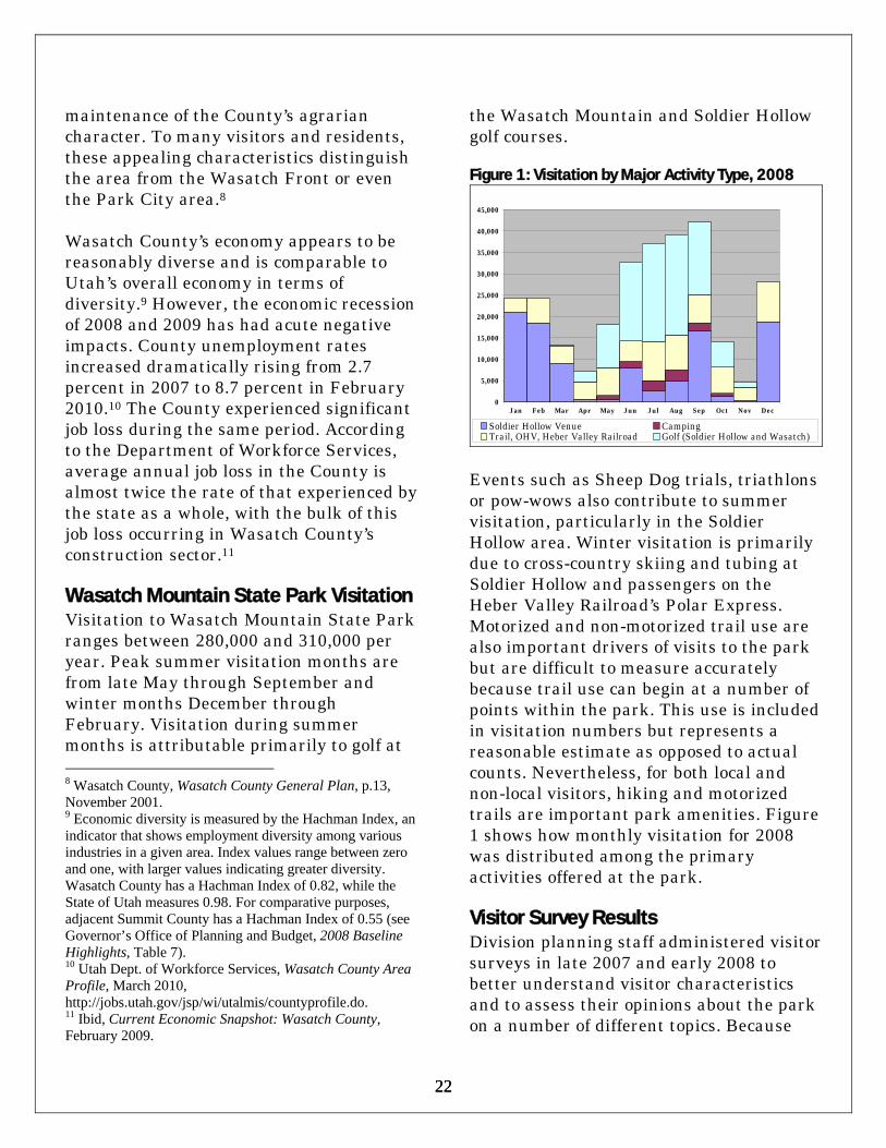
maintenance of the County’s agrarian character. To many visitors and residents, these appealing characteristics distinguish the area from the Wasatch Front or even the Park City area.8 Wasatch County’s economy appears to be reasonably diverse and is comparable to Utah’s overall economy in terms of diversity.9 However, the economic recession of 2008 and 2009 has had acute negative impacts. County unemployment rates increased dramatically rising from 2.7 percent in 2007 to 8.7 percent in February 2010.10 The County experienced significant job loss during the same period. According to the Department of Workforce Services, average annual job loss in the County is almost twice the rate of that experienced by the state as a whole, with the bulk of this job loss occurring in Wasatch County’s construction sector.11 Wasatch Mountain State Park Visitation Visitation to Wasatch Mountain State Park ranges between 280,000 and 310,000 per year. Peak summer visitation months are from late May through September and winter months December through February. Visitation during summer months is attributable primarily to golf at 8 Wasatch County, Wasatch County General Plan, p.13, November 2001. 9 Economic diversity is measured by the Hachman Index, an indicator that shows employment diversity among various industries in a given area. Index values range between zero and one, with larger values indicating greater diversity. Wasatch County has a Hachman Index of 0.82, while the State of Utah measures 0.98. For comparative purposes, adjacent Summit County has a Hachman Index of 0.55 (see Governor’s Office of Planning and Budget, 2008 Baseline Highlights, Table 7). 10 Utah Dept. of Workforce Services, Wasatch County Area Profile, March 2010, http://jobs.utah.gov/jsp/wi/utalmis/countyprofile.do. 11 Ibid, Current Economic Snapshot: Wasatch County, February 2009.
the Wasatch Mountain and Soldier Hollow golf courses. Figure 1: Visitation by Major Activity Type, 2008
0
5,000
10,000
15,000
20,000
25,000
30,000
35,000
40,000
45,000
Jan Feb Mar Apr May Jun Jul Aug Sep Oct Nov Dec
Soldier Hollow Venue CampingTrail, OHV, Heber Valley Railroad Golf (Soldier Hollow and Wasatch)
Events such as Sheep Dog trials, triathlons or pow-wows also contribute to summer visitation, particularly in the Soldier Hollow area. Winter visitation is primarily due to cross-country skiing and tubing at Soldier Hollow and passengers on the Heber Valley Railroad’s Polar Express. Motorized and non-motorized trail use are also important drivers of visits to the park but are difficult to measure accurately because trail use can begin at a number of points within the park. This use is included in visitation numbers but represents a reasonable estimate as opposed to actual counts. Nevertheless, for both local and non-local visitors, hiking and motorized trails are important park amenities. Figure 1 shows how monthly visitation for 2008 was distributed among the primary activities offered at the park. Visitor Survey Results Division planning staff administered visitor surveys in late 2007 and early 2008 to better understand visitor characteristics and to assess their opinions about the park on a number of different topics. Because

23 23
Wasatch Mountain State Park has distinct summer and winter seasons, two surveys were conducted at the park. The summer survey was conducted at Dutch Hollow and Deer Creek trailheads, the Visitor Center, Pine Creek and Little Deer Creek campgrounds and Soldier Hollow and Wasatch Mountain golf courses. The winter survey was conducted at the Soldier Hollow Olympic venue and at the snowmobile concessionaire site in the park’s western portion. Both winter and summer surveys indicate that over 75 percent of respondents are Utah residents, primarily from Salt Lake and Utah counties. Because it is close to a large urban area, Wasatch Mountain State Park attracts repeat visitors in both the winter and summer. More than half of all respondents surveyed indicated that they visited the park at least once during the previous 12 months. Figure 2: Primary Recreation Activity, Summer Visitors
43.6%
16.0% 13.8%6.1% 5.0%
15.5%
0%
10%
20%
30%
40%
50%
Golf
Camping
Hikin
g
Sightse
eing
Bikin
g
All Oth
er
Almost 45 percent of summer visitor survey respondents reported golf as their primary recreation activity and their primary reason for visiting the park. This is significantly greater than any other primary visitor activity. Golf was followed
by camping (16 percent) and hiking (14 percent) as the primary activities among summer survey respondents. Other primary activities experienced by summer respondents included sightseeing, biking, horseback riding, and riding the Heber Creeper. Figure 2 shows the primary activities that visitors participate in during the summer season. Among winter survey respondents, cross-country skiing or tubing was the primary activity for 82 percent of those surveyed. As figure 3 shows, these two activities appear to be the predominant recreation activities for winter visitors. Figure 3: Primary Recreation Activity, Winter Visitors
42.0% 40.0%
6.0% 3.0% 1.0% 1.0%0%
10%20%30%40%50%
X - Country
Skiing
Tubing
Snowmobiling
Snowshoein
g
Inter
pretiv
e Stu
dyOth
er
Information provided word-of-mouth is the way most visitors are informed of the park. More than half of all visitor respondents indicated that they were made aware of the park from family and friends. About 20 percent of visitors listed the Internet as the primary park information source. Summer visitors indicated that road signs were an important information source. While day use appears to be prevalent year-round, non-local users (visitors residing more than 25 miles away from the park) make most overnight visits during

24 24
the summer months (no formal winter camping opportunities are currently offered within the park). Approximately 77 percent of non-local visitors surveyed in the summer period indicated that they spent the night at the park or at other locations within the local area. Of these, campgrounds within the park were the most commonly used accommodation. Seventeen percent of non-local visitors stayed in hotels or condos within 25 miles of the park. Total non-local visitor spending appears to be higher for summer visitors.12 Summer non-local survey respondents spent about $500 per group while winter respondents spent about $383 per group. However, non-local summer visitors averaged 2.5 nights staying in the area while winter visitors averaged 1.2 nights. So, on a visit per-day basis, winter visitors effectively spend more (averaging $320 per group per night compared to summer visitors who average $200 per night). The average length of stay in the park was longer for summer visitors (just over a full day) than for winter visitors (a half to a full day). Summer visitors were more likely to report multiple recreational activities during their stay. Those who selected both golfing and camping had the longest average stay length. Winter respondents were less likely to be involved in multiple recreational activities.
12 Note that there was significant non-response bias regarding visitor expenditures of local park visitors (visitors residing within 25 miles of the park). While reported average visitor spending among local visitors was comparable to non-local spending, only half of this group responded to questions about how much they spent during their visit. This suggests that local visitor spending may be lower than non-local spending, but accurate estimates cannot be determined from the survey results.
Visitors appear to be satisfied with their experience at the park. A significant majority of both winter and summer survey respondents reported that they were either satisfied or very satisfied with their visit (95 percent for winter respondents and 89 percent for summer respondents). Comments and criticisms were more diverse among summer survey respondents. Summer visitors commented on aspects of the park ranging from drinking water, to campgrounds, golf, and wi-fi at the visitor center. Winter survey participants commented mainly on the need for additional food services. Winter survey respondents were more supportive of yurt or cabin development at the park (45 percent) than summer survey respondents (16 percent). A higher number of summer survey respondents supported the addition of more campsites with full RV hookups. The winter survey did not ask about campground facilities. A significantly higher percentage of winter survey respondents traveled in groups with children (54 percent) than summer survey respondents (30 percent). Average group size in groups with children was also higher in winter (10) than summer (7). The demographic results of the surveys show that overall Wasatch Mountain State Park attracts a lot of local Utah families; however the average user groups vary greatly between seasons. Summer park users, on average, are older and less likely to be traveling with children. Winter visitors often come from nearby Utah County, are young, and are likely to be traveling in large groups including children.

25 25
Economic Impacts of Wasatch Mountain State Park In 2008, park visitors were responsible for more than $10 million in local spending. Clearly, there are significant and important economic interconnections between the park and local economies within Wasatch County. The economic impacts of Wasatch Mountain State Park were estimated using the visitor survey information highlighted above. Utah State Park’s planning staff used IMPLAN Professional Version 2.01.1025 software to estimate the economic impacts of annual visitation to Wasatch Mountain State Park. The IMPLAN model measures the direct, indirect, and induced impacts of park visitor expenditures for lodging, restaurants and bars, vehicle operation, recreation fees and other associated recreation activities and supplies. While IMPLAN measures park-related economic impacts on Wasatch County as a whole, it can be assumed that since Heber and Midway are the largest communities within Wasatch County, these two communities probably receive the largest share of economic benefit from visitor spending. Impact of Summer Visitors Assuming average annual seasonal visitation is 215,000, with approximately 95 percent of visitors coming from outside Wasatch County, Wasatch Mountain State Park accounts for an estimated $8.6 million in annual total value-added impacts to local economies (in 2006 dollars) within Wasatch County. Value-added impacts are the sum of labor income (wages, proprietors’ incomes), other property
income and indirect business taxes generated by the spending of visitors and park expenditures. Employment attributed to summer visitor spending at Wasatch Mountain State Park is 220 full or part-time jobs in a variety of industries. Impact of Winter Visitors Winter visitation is assumed to be 90,000 with approximately 88 percent of visitors coming from outside of Wasatch County. Valued-added impacts for these visitors is estimated to be about $1.5 million. Approximately 40 full or part-time jobs were created as a result of these expenditures. The lower impact per visitor rate among winter visitors appears to be attributable to larger groups such as families participating in group-oriented winter activities, where spending per-person is lower.

26 26
This page intentionally left blank

27 27
Overview Wasatch Mountain State Park staff manage more than 23,000 acres of land area that has numerous access points, contains inholdings of private land, and lies in an area that has experienced significant residential development over the past two decades. Effectively managing the diverse recreation uses over such a large land area while protecting resources and providing safe experiences for visitors is a major challenge. The planning team recommendations focus on ways to better manage these challenges. The team determined that a more effective approach would be to narrow the scope of work by targeting the most critical planning issues in specific park areas. Accordingly, the team identified seven specific planning zones within the park: the Chalet area; Cascade Springs/Little Deer Creek; Midway Canyons; Mill Flat/Snake Creek Canyon; Pine Creek/Bonanza Flat; Dutch Hollow/Cottonwood Canyon; and Lower Snake Creek. Plan recommendations address the major issues and needs occurring within each of these designated areas. In developing these recommendations, the planning team, park staff, and public participants identified a number of issues and recommended actions to address these issues. Plan recommendations will help park staff better manage the park’s natural resources. They also identify facilities improvement and development needs, and new recreation opportunities. The recommendations also promote stronger interrelationships between the park and local communities, identify strategies to help the park become more sustainable and
financially viable, and assure that budgeting and staff needs are met. The process used to identify these issues was open, dynamic, and included broad-based input from numerous sources. It involved input from planning team members and the public-at-large. The process also provided for direct feedback from park visitors through visitor surveys. An analytical technique was used to determine the park’s strengths, weaknesses, opportunities and future threats (known as “SWOT” analysis) and to explicitly identify and prioritize each issue area. A specific description or statement summarizing each issue was constructed to clearly identify and articulate each problem or challenge. The planning team developed specific recommendations for the identified issues. The team’s recommendations were achieved through consensus of opinion among those who attended team meetings. The balance of this document summarizes each issue area and discusses the associated problems or needs identified. It also articulates the team’s specific goals developed to address each issue and lists the relevant recommendation to achieve each goal. Issue: Effective Management of Park Resources Wasatch Mountain State Park is a large park bounded by a national forest on one side and by a rapidly urbanizing community on the other. The park has large land base that supports a variety of natural and cultural resources. Its location near large and growing populations along
Issues and Recommendations

28 28
Map 3: Park Recreation Areas, Facilities, Trails, and Roads

29 29
the Wasatch front and back has increased recreation and access demand at the park. The park has many existing access points and routes. Many of these are located in remote locations far from park offices and duty stations. In addition, the park’s natural resources have been adversely affected by drought, insect infestations, invasive species and encroaching development. Team members expressed concerns about how to preserve the park’s scenic beauty in the face of these varied resource management challenges. The team identified three primary resource goals and associated recommendations to deal with these issues. Resource Management Goal #1: Identify Strategies to Effectively Manage Park Access, Encroachment, and Dispersed Recreation In the identification of this goal, the team raised a number of questions that were of concern: How should park management deal with the demand for access from a number of dispersed and remote locations? What should be done to minimize the impacts of adjacent development? How can private in-holdings within the park be more effectively managed? Likewise, what kinds of strategies can be identified to better manage recreation activities in remote locations? Road maintenance and improvement is also a key concern of park managers. Currently, the park has no budget for interior road maintenance. Road conditions can affect visitor and employee access to portions of the park and can reduce water quality due to improper runoff from roads into streams and wetlands. The various entrance roads into the park lessen management control,
particularly in remote areas. Visitors frequently express a need for more directional and informational signage on external roads leading to the park and for internal circulation. The team developed a number of recommendations to deal with these issues under several resource management categories. These are listed below. Property Management Recommendations: 1. Park management should work with the
Division’s Land’s Coordinator to resolve in holding, boundary and access issues with private landowners in the Pine Creek/Bonanza Flats area, through purchase or exchange of parcels. Staff will explore the feasibility of acquiring critical in-holdings in this area.
2. Park managers should also work with the Land’s Coordinator to resolve all in holding issues in Upper Snake Creek Canyon. Staff will explore the feasibility of acquiring critical in-holdings in this area.
Access Management Recommendations (please refer to Map 3 on p.28 for park facility, road, and trail locations): 1. Park managers should work to preserve
all access points and routes currently used by park visitors, particularly those used for trail and trailhead access.
2. Park managers should identify and document all such access points and routes, and identify use patterns occurring within these areas. Similarly, park management should coordinate with relevant Division staff and external entities to determine ownership and maintenance. The park contains roads and access points whereby there is no definitive information about ownership, rights-of-

30 30
ways, easements, and maintenance responsibilities. A determination also needs to be made about which of these roads or access points should be designated for motorized or non-motorized use.
3. Under this plan, there should be no improvements made to the Pine Creek Road because resulting increases in traffic would create potential negative impacts to park property and existing recreation opportunities. In addition, road maintenance costs associated with these improvements would likely be unsustainable. The team also recommends that park managers effectively coordinate with Wasatch County officials to ensure that the County thoroughly identifies potential impacts on park resources and visitor experiences when improvements or changes in traditional use to the Pine Creek and Snake Creek roads are considered.
4. Warm Springs Drive is the road from the Visitor’s Center to Pine Canyon. Park Management is concerned about future development and encroachment along this road. This road needs to be preserved in its present condition to protect current recreation use. The park should explore the feasibility of acquiring an easement for a non-motorized trail along this road.
5. Park management should specifically work with Wasatch County officials to clearly identify road ownership and jurisdiction, particularly regarding those roads claimed by the County within their transportation plan. It will be essential that the Division obtains County assistance in road ownership and jurisdiction identification efforts.
6. Where possible, new trails developed in the park should be constructed to also serve as firebreaks.
7. There is a need to determine ownership and responsibility for roads and access points in and leading to the park. Park management needs to work with county officials to clearly identify road ownership and jurisdiction, including those claimed by county in their transportation plan. Special focus should be placed on, but not limited to, roads and access point issues described within the following management zones (please refer to Map 4 on p. 40 to view area locations): • Dutch Hollow/Pine Canyon Area ◊ Below Jordanelle Dam there is a
fishing access parking lot managed by the Utah Reclamation and Mitigation Commission (URMC). This access point contains a trail from this area that runs under Highway 40 and accesses the Park. Park management should contact the URMC to determine if non-motorized access to the park from this point is feasible.
◊ Hiking trail links need to be established from Pine Canyon through Interlachen to the Dutch Hollow trailhead.
• Upper Snake Creek Area ◊ There is a concern about safe access
along the road extending from Snake Creek which crosses USFS, park and private lands reaching into steep upper basins. Park managers are concerned that motorized use in the upper canyon areas is dangerous and unsafe. Park management needs to determine where motorized use should be prevented or redirected in this area.

31 31
• Bonanza Flat Area ◊ There is a public access right to the
road into Brighton Estates to access the park and other lands from the Pine Canyon road. This right needs to be clarified with all parties. Wasatch County apparently has affidavits on several of these roads for 2477 classification. This issue needs to be investigated.
• Midway Canyons Area ◊ There is concern about access on
roads leading to Lime Canyon, Sids Canyon, and Faucet’s Canyon. Coordination with the County and private land owners will be needed to ensure that access to the park is maintained through these areas.
◊ There are no trailheads or parking facilities at either the Swiss Alpine or Lime Canyon areas. Park management should investigate developing trailheads at the park boundary or in other adjacent areas for visitors using these access points.
◊ It is recommended that park managers examine the feasibility of developing a trail from the Soldier Hollow area to the Visitor Center. This will be a multi-jurisdictional trail and will require cooperation from local governmental and private entities. It may be possible to coordinate with Midway Irrigation and use their ditch easement for trail use.
• Cascade and Cummings Parkway Area ◊ Park management should coordinate
with the USFS to develop an OHV trail that connects the upper Cascade Springs parking area to the Little Deer Creek campground.
◊ Park management should evaluate the feasibility of developing a
connection to Soldier Hollow from the Deer Creek trail.
Resource Management Goal #2: Forest, Range, Wildlife and Habitat, and Wetlands Management Issues Much of the park is comprised of undeveloped forest or rangeland. Additional forest and rangeland management strategies are needed to better protect park habitat areas and to minimize wildfire danger. The team identified recommendations aimed at improving and maintaining the health of the plant communities in the park, controlling invasive species and insect infestations, and better protecting wildlife habitat. In addition, the potential for wildfire danger is high in some park areas, and, as development occurs adjacent to the park, private as well as park lands and improvements could be in jeopardy from fires. The team explored the various measures that can be taken to reduce the risk and impacts from wildfire. The park also contains a number of wetlands areas and is a large part of the watershed for the Heber Valley. In this goal, the team identified several recommendations for protecting wetlands and preserving park water quality. Park management should take the following actions. Forest and Range Management Recommendations: 1. Develop a vegetation management plan
in partnership with Wasatch County, UDWR and Utah Division of Forestry, Fire and State Lands (FF&SL) to protect park habitat and minimize
32 32
wildfire around urban interface property using partnerships with private property owners. For example, park management should consider implementing policies such as a firewood gathering permit system or instituting controlled grazing strategies for fuel management. The proposed vegetation management plan should include a wildfire management component.
2. Identify, and put designated park areas back into cultivation. Focus efforts in areas where cultivation was practiced historically.
3. Consider developing demonstration forest projects with FF&SL and UDWR. Such plans should focus on aspen grove health along the Cummings Parkway and within Snake Creek Canyon.
4. Identify prevention measures for beetle control and eradication in areas identified by park management.
5. Partner with FF&SL and the U.S.D.A, Resource Conservation and Development Service (RC&D)/Natural Resource Conservation Service (NRCS) for funding and planning for wildfire breaks and vegetation management plans.
6. Identify strategies to protect critical wildlife habitat and movement in connection with development and placement of all new trails and roads.
7. Inventory and develop treatment plans for noxious weeds throughout the park.
Wetlands and Riparian Area Recommendations: 1. Control dispersed camping along Little
Deer Creek. 2. Tate Lane currently consists of
designated wetlands. Ensure that any future development actions are
consistent with existing requirements that protect this designated area.
Water Development Recommendations: 1. Complete the comprehensive water
study and plan with Barnett engineering. This plan will document all water sources owned and used by the park and will identify future needs.
2. Develop criteria to determine where water well development is appropriate. Integrate this recommendation into the Barnett comprehensive water study.
3. Identify water storage, development and distribution needs for the park by relevant area. Add this into the Barnett comprehensive water study.
Resource Goal #3: Protection of the Park’s Scenic and Aesthetic Resources and Values The aesthetic values of the park are an important attraction to visitors and an important part of their experiences. The team identified recommendations for park management to protect the park’s viewshed and aesthetic attributes. Recommendations: 1. Implement recreation zoning strategies
to identify areas most conducive to specific types of recreation use. Where feasible, separate incompatible recreation use to enhance experiences and minimize conflicts among various users.
2. Identify areas for concentrated enforcement where there is illegal recreation use. Consider installing barriers, signage, or closures.
3. To better inform and educate the public about areas open to motorized use, coordinate with federal and county

33 33
agencies and update maps, brochures and other public information.
4. Use native materials and landscaping in future development actions, where possible.
Issue: Facilities Development and Improvement Needs Wasatch Mountain offers a variety of opportunities for visitors. Golfing, camping, motorized and non-motorized trail use, sightseeing, and wildlife viewing are some of the most predominant uses. Each of these uses requires development and ongoing maintenance of supporting facilities and infrastructure. The team identified several recommendations to improve the park’s aging facilities and infrastructure. The team also identified new facilities that should be developed to provide more opportunities for an increasing visitor base and to enhance visitor experiences. Large RV in Pine Creek Campground
Facilities Development and Improvement Goal #1 – Improvements to Camping Facilities and Opportunities Concerns were raised about the condition of the park’s aging Pine Creek campground.
The individual sites and circulation roads were not designed for today’s large RVs, and the infrastructure and site amenities are in poor condition. In particular, the campground’s sewer and electrical systems are more than 40 years old, are obsolescent, and require frequent costly repairs. Likewise, the campground’s asphalt surfaces are dilapidated, and its tables and grills need to be upgraded. It has also been suggested that improvements be made to the remote Little Deer Creek Campground. It has also been recommended that additional backcountry campsites and a yurt system be added to the park. Based on some of this input provided by the public, the team recommended that park and Division staff implement the following actions. Recommendations: 1. Prioritize maintenance and
improvement needs and identify interim strategies to maintain the Pine Creek campground until full funding for its renovation is obtained.
2. Redesign the Pine Creek campground by using its current spatial footprint. However, accommodate larger RVs in the redesign by utilizing campground space not currently used.
3. Offer Pine Creek campground visitors transportation routes to adjacent golf courses.
4. Partner with FS at Little Deer Creek campground to employ a FS campground camp host at Little Deer Creek to collect fees as well as other duties. Share revenues under the US Dept. of Interior Federal Lands Recreation Enhancement Act fund.

34 34
5. Improve the Little Deer Creek Road to Little Deer Creek campground through partnerships with county.
6. Find additional funding sources to better maintain and upgrade the Little Deer Creek and Cummings Parkway roads.
7. Add upgrades such as picnic tables and fire rings to the Little Deer Creek campground. At the same time, make sure that any such improvements maintain the campground’s rustic quality.
8. Expand the group day use pavilion at Soldier Hollow to include overnight group camping and use by adding activity sites, power, and a dump station.
9. Consider a concessionaire or a private/public partnership to develop and maintain yurts for backcountry winter use at designated areas.
10. Identify and evaluate potential sites that could be used for dispersed camping, taking into consideration the impacts where such use would take place. Develop criteria to determine if potential sites are suitable for dispersed camping. Determine if there should be a fee for dispersed use or reservations made for such use. Also determine if such use may be seasonal (hunting for example). As an alternative, utilize OHV funding to install CXT restrooms in the Little Deer Creek Campground that are open all year and then direct campers to the campground.
11. Investigate the feasibility of installing WiFi access in the Pine Canyon campground.
Facility Development and Improvement Goal #2 – Improvements to Trail Amenities and Opportunities The use of trails for hiking, biking and motorized use is an important activity at the park. There are concerns that the lack of funding for trail maintenance is an issue that needs to be addressed. At the same time, there is increased visitor demand that more trails be developed to provide more diverse experiences for trail users. There is a corresponding need for additional signage or information identifying trail difficulty and more directional signage on trails. Trail access is also an issue. Adjacent developing communities would like greater access and more linkages to the park and its trails. Non-motorized users request additional or improved trailheads and parking for biking, hiking, and equestrian activities. The following actions were recommended. Recommendations: Identify additional trailheads and associated trail additions and/or upgrades using the following classifications: Class A (parking, directional signage, informational kiosk, toilet and running water (if feasible), Class B (parking and directional signage). Evaluate and identify potential trail needs in the following park areas. 1. Mill Flat – Currently Mill Flat is a
designated OHV trailhead (OHVs in summer, snowmobiles in winter) that includes parking, a restroom, information kiosks, and directional signage. There is a need for additional non-motorized trails in this area. A. Determine if a suitable linkage
between the Great Western Trail

35 35
(GWT) and the Cummings Parkway upper Snake Creek area is feasible, and consider trailhead development and improvements for equestrian and pedestrian use.
B. Add a 1.5-mile non-motorized trail to Big Flat.
C. Add a 3-mile non-motorized connecting trail to the Great Western Trail.
2. Pine Creek Campground –
Currently, the campground’s nature trail is the only hiking trail in this area. This area also serves as a snowmobile trailhead in the winter. It includes parking, restrooms, and running water. A. Connect the campground with the
Dutch Hollow trail system. B. Obtain right of way along the Warm
Springs Road from Pine Creek Campground to the Visitor Center for non-motorized trail use.
C. Consider developing a trail from the campground across Snake Creek and Bonner Hollow to Gerber Spring then to the Visitor Center.
D. Take actions to improve campground information and directional signage.
3. Dutch Hollow – This area provides
non-motorized use with parking, restroom, informational kiosk, and directional signage. A. Upgrade and maintain existing trails
for non-motorized uses. Identify trails, or consider other similar management actions that help separate equestrian users from mountain bikers.
B. Consider developing a connecting trail to the Deer Valley trail system.
4. Visitor Center – This area facilitates pedestrian-oriented family use. Current facilities include parking, restrooms, information kiosks, and directional signage. A. Consider development of a trail from
Midway’s proposed West Bench Ditch Trail to Soldier Hollow.
5. Soldier Hollow – This area includes
parking and restrooms, and facilitates non-motorized use. A. Consider development of a non-
motorized trail linking Soldier Hollow area to Provo Canyon via the Deer Creek trail. Support completion of the Provo River trail connection.
6. Cascade Springs – This is a motorized
trailhead that provides for winter and summer motorized use. It includes parking, restrooms, information kiosks, and directional signage. A. If the Cascade Springs road is paved,
provide an alternate OHV trail. B. The proposed West Bench Ditch
Trail would terminate at the Cascade Springs trailhead.

36 36
Narrow campground roads in need of repair
Facility Development and Improvement Goal #3 – Golf Course Recommendations Survey information shows that in general, visitors to Wasatch Mountain are satisfied with the golf courses and related experiences. However, team members identified recommendations to enhance visitor experiences regarding golf. Interpretive Presentation at Huber Grove area
Recommendations: 1. Upgrade the irrigation pipeline system
at Wasatch Mountain golf courses to increase capacity and replace old pipes.
2. Replace culinary lines to the Wasatch Mountain clubhouse and convert use to Midway City water supplies.
3. Identify and promote long term financing mechanisms for development and upgrade for golf courses.
4. Change the assessment of user fees from a flat rate to a sliding scale fee based on a percentage of golf fees.
5. Identify locations for interpretive signs at locations within golf course areas and install relevant interpretive signage and information.
6. Increase the promotion of the Soldier Hollow golf courses for tournaments, corporate events, or other similar activities. Set a goal to make use levels comparable to that of the Wasatch Mountain courses.
7. Redesign water holding ponds to allow for more efficient distribution of irrigation water through use of gravity to reduce pumping costs.
8. Professionally evaluate the irrigation systems and identify a design to efficiently provide water to various golf course areas – upsize lines, pump locations, use gravity where possible.
9. Continue current marketing efforts for golf opportunities during off-peak hours and seasons.
10. Develop and incorporate an ongoing marketing plan into the RMP.
11. Install a phone line in the golf course pro shops that allows for queuing up of incoming calls.
Issue: Interpretation and Education (I/E) While the park has one of the most active interpretive/educational programs in the Utah State Parks system, there may be opportunities to improve existing I/E

37 37
efforts and add new items to the park’s program where needed.
Interpretation and Education Goal #1 – Enhancements to the Interpretive and Educational Programming and Materials What existing efforts should or could be improved and how? What additional programs should be offered, and in what form? Team recommendations address these questions. Recommendations: 1. Adopt the park’s current interpretive
plan and update and revise it as needed. 2. Integrate interpretive efforts with the
USFS interpretive plan that is currently under development. Work with park naturalist for connections with WMSP.
Issue Area: Marketing and Revenue Enhancement Wasatch Mountain needs to market to a variety of potential visitors to increase visitation and revenue. Enhanced marketing efforts will be needed to more effectively advertise the recreational and educational park opportunities and to show that the park is more than just a golf destination. Revenue, through fees and other sources, is very important to the Division of State Parks and Recreation. Currently, the Division is required to collect approximately 40 percent of its operating costs. However, increasing pressure to reduce reliance on state general funds mandates that the park work toward greater self-sufficiency. Stronger marketing efforts are essential in bringing more visitors, and hence, more revenues to the park.
Marketing and Revenue Goal #1 – Market the Park and Surrounding Area There is a need to identify marketing strategies that target specific demographic populations. There is also a need to determine the specific types of opportunities, activities, seasons, or time periods, that should be marketed. The team developed the following recommendations to address these issues. Recommendations: 1. Continue to employ current marketing
efforts to attract additional use during off-peak hours and seasons for the golf courses.
2. Explore a one-stop reservation system for camping, golfing and other recreation opportunities.
3. Consider advertising on large billboard signs on major travel corridors along interstates, state highways and local streets to direct visitors to local recreation opportunities, particularly those offered at the park.
4. Continue to work with UDOT to ensure that existing informational highway signs include international activity symbols. Also work with UDOT to install needed directional and informational signs at key highway access locations.
5. Promote concessionaire opportunities in a cooperative effort to better market the park and improve visitor expectations.
6. Promote stronger links that better associate Soldier Hollow with the rest of the park. Identify actions to help the public understand that the Soldier Hollow facility is part of Wasatch Mountain State Park.
7. Work with the Division’s Facilities and Construction Manager to review

38 38
progress of current park signage projects. The Park Manager will ensure that signage placement and locations are appropriate.
8. Improve the website for Wasatch Mountain State Park. Specifically, include more information about current events and activities. Also include more links that contain GPS points for different park locations.
9. Continue geocache opportunities. Issue Area: Funding & Budget Concerns (F&B) There is concern about the Park’s current staffing levels. Park managers express concern that there are insufficient staff to patrol and monitor activities in critical areas on a regular basis. The park does not have the funding to maintain campgrounds, trails and roads in a manner that, while sufficient to keep the facilities open, is clearly inadequate to meet long-term visitor needs. There is a consensus of opinion among Park staff, the public, and the team that staff and resources are already at or beyond the limits of their capacity. If more development occurs, or if new programs are added, additional operational funding must be included to properly staff and operate the park. This will include any development or workload increases recommended in the RMP. Without additional resources, park managers will have to prioritize recommendations contained in this RMP and will have to allocate current resources to actions that can be feasibly implemented without imposing additional burdens on staff.
Funding &Budget Goal #1 – Limited Funding and Staff There is a need to determine what funding and staffing levels are required to provide effective and efficient service at the park. Both the team and the public listed insufficient staff and funding levels as a major threat to the effective provision of park services. The team identified various actions that Park management should consider to deal with this issue. Recommendations: 1. Develop a comprehensive business plan
to determine which programs or actions will result in the most effective path toward the achievement of key park goals and objectives.
2. Use the park’s friends group, community members, and local government officials to help advocate for key park issues.
3. Continue to work for funding for approved positions.
4. Identify new approaches to create golf course maintenance funds for both golf courses.
Issue Area: Community Relations and Support (Community) The park staff realizes that to be successful, the park must have the support of the local community. It is also a goal of Utah State Parks that every park be perceived as a valuable asset and partner in their local communities. Community Goal #1 – Building and Maintaining Community Support The team identified the following actions to improve support in the community, and to

39 39
involve community members in its activities and programming. Recommendations: 1. Maintain the existing mutually
beneficial relationship between Midway and the park.
2. Create and maintain website links among various agencies such as Midway, Wasatch County, USFS, and others.
3. Integrate cross-jurisdictional trail plans.
4. Attend Wasatch County Public Lands Committee meetings when held.
5. Increase Park Naturalist participation in community radio programs and with Friends of Wasatch Mountain State Park to advertise and promote park events and opportunities.
6. Establish partnerships with Wasatch County, Midway City, and others to better educate legislators on search and rescue activities, law enforcement needs, and maintenance needs, particularly those incurred by the Division and local entities to serve visitors from outside of the area.
7. Consider offering park discount programs for Wasatch County residents.
8. Provide more volunteer opportunities for local residents.
9. Identify additional youth programs that can be accessed by local residents and can be advertised in local media sources.
10. Identify strategies about how to establish and strengthen partnerships and to mobilize user groups on behalf of the park.
Issue: Identify Geographic Management Zones
The planning team identified seven separate geographic management zones to better deal with the resources and opportunities specific to each locale. Each planning zone specifies desired and suitable recreation activities, concession or contract service opportunities, and needed facilities enhancements. This approach also identifies the limits of acceptable change that trigger required management actions to minimize negative impacts on resources or visitor experiences. These zones identify resources and constraints unique to each area, and help to prioritize the implementation of management actions unique to each area. This will help park staff to more clearly identify appropriate and sustainable uses within the park. In addition, this approach will help the park implement sustainable strategies to increase park revenues through identification of additional concession opportunities, user fees and other sources. Through this zoning approach, the team identified various strategies to implement additional concession service opportunities and to boost park revenues. Many of the recommendations discussed above are integrated into each appropriate zone. The zones encompass the following areas (see map 4 on p. 40): 1. Soldier Hollow/Chalet/ Heber Valley
Railroad (HVRR) platform 2. Cascade Springs/Little Deer Creek 3. Midway Canyons 4. Mill Flat/Snake Creek Canyon 5. Pine Creek/Bonanza Flat 6. Dutch Hollow/Cottonwood Canyon

40 40
7. Lower Snake Creek (Wasatch Golf Course/Visitor Center/Campground)
For all areas, where applicable, park staff will manage each zone for the limits of acceptable change using the following criteria: • Conduct exit surveys. If results show that
less than 70 percent of visitors are satisfied with their experiences in a zone, management actions will be developed to identify the problem and implement solutions.
• Monitor impacts in each area. Take additional action if monitoring indicates that closed or rehabilitated dispersed sites, or designated campsites are continuing to be adversely impacted or rehabilitation efforts are not shown to be successful.
• Take action if monitoring indicates that roads or trails need maintenance to sustain safe and enjoyable recreation use or to protect natural resources from erosion, road/trail widening or extension. Also take action, if necessary, to mitigate impacts to adjacent vegetation and water quality.
Staff will also take action in the planning, development, and improvement of facilities to ensure that the desired visitor experience provides for use of quality facilities and amenities that allows a visitor to enjoy the activities identified as suitable. Criteria and recommendations specific to each zone area are listed in the discussion that follows.

41 41
Map 4: Geographic Management Zones

42 42
Management Zone #1 - Soldier Hollow/Chalet/HVRR
1. Soldier Hollow/Chalet/HVRR
platform
• Suitable Visitor Activities - Winter activities like tubing,
cross country skiing - Events including triathlons, dog
trials - HVRR connections with WMSP
or Soldier Hollow - Group camping at the Chalet - Group day activities - Athlete training
- Adaptive recreation and training activities
- Sightseeing - Trailhead activities - Walking for pleasure - Hiking - Bicycling - Golf play, practice and
instruction - Eating/dining - Wildlife viewing
• Desired visitor experiences
- Affordable youth activities – such as school programs like team

43 43
Soldier Hollow (a cross-country ski team) or golf.
- Family oriented experiences. - Easy access to trails. - Ability to experience natural and
rural scenery. - Cultural oriented activities –
music, pow wow, sheep dog trials, Olympic legacy, etc.
• Recommended
Concession/Contract Services - Food services - Olympic venue management (day
lodge, competition building use, equestrian, facilities, trails, events promotion and management, tubing hill, equipment rental, bicycle shuttles, etc.).
- Activities sponsored and supported by the Legacy Foundation as per contract.
• Recommended facility
improvements and development, and additional visitor opportunities - Expand group day use pavilion at
Soldier Hollow to include overnight group use by adding activity sites, power, possibly a dump station. This is compatible with activities offered at Soldier Hollow.
- Consider cabin, yurts and warming huts on trails (park or concession).
- Maintain the Tate Barn as a historical/culture replica and enhance with historic equipment displays, etc.
- Provide additional toilets and multi-use spaces (event facilities,
meeting rooms, etc.) in the Soldier Hollow competition area.
- Provide a golf short-game practice area (greens, chipping).
- Repair and replace snowmaking infrastructure.
- Sell or exchange the Tate Lane north property (10 acres) if it will benefit the park.
• Limits of acceptable change.
- Monitor for noxious weeds, and if indicated, plan and treat infestations.
- Monitor events to assess impacts on natural resources and act to deal with impacts.

44 44
Management Zone #2: Cascade Springs/Little Deer Creek
2. Cascade Springs/Little Deer Creek
• Suitable Visitor Activities - Sightseeing/driving for pleasure - Trailhead activity (year round)
- OHV road and trail use - Snowmobiling - Mountain biking - Camping - Equestrian use - Hiking

45 45
- Hunting - Day use/picnicking
• Desired visitor experiences
- Easy access to trails within park and on surrounding public lands.
- Access to scenic/recreation roads and attractions outside of the park.
- Ability to experience natural and rural scenery.
- Access to the park’s primary OHV/motorized use area.
- Ability to access motorized loops.
• Recommended Concession/Contract Services - OHV and snowmobile rentals and
guided trips.
• Recommended facility improvements and development, and additional visitor opportunities - Develop alternative OHV trail if
Cascade Springs road is ever hardened or if vehicle traffic increases significantly.
- Investigate including the Cascade Springs road (access) in the USFS fee system if use increases to a sufficient level.
- Partner with the USFS to employ a campground camp host at Little Deer Creek to collect fees and to conduct other duties.
- Improve the level of maintenance in the access road to the Little Deer Creek campground through partnerships with Wasatch County.
- Determine how to qualify the Little Deer Creek and Cummings
Parkway roads to receive Park Access funds.
- Add picnic tables, fire rings, to replace old facilities but maintain the rustic quality of the Little Deer Creek Campground.
- Evaluate and identify sites that can be used for dispersed camping in the Little Deer Creek area (control the location and add basic facilities), considering where use is currently taking place. Develop criteria to determine if sites are suitable for dispersed camping.
- End dispersed camping in the riparian zone of Little Deer Creek.
- Coordinate with FF&SL to identify permitted firewood collecting (particularly in the Cascade Springs/Little Deer Creek, Mill Flat, and Snake Creeks) to thin and reduce fuels.

46 46
Management Zone #3: Midway Canyons
3. Midway Canyons
• Suitable Visitor Activities - Hiking - OHV use - Snowmobile use - Trailhead use
- Sightseeing - Hunting - Equestrian - Mountain biking
• Desired visitor experiences

47 47
- Easy access to park trails and connections from adjacent communities.
• Recommended
Concession/Contract Services - Guided trail activities
• Recommended facility
improvements and development, and additional visitor opportunities - Work with communities to
consider and develop trailheads and access points at: ⋅ 200 north and 500 South
Midway ⋅ Sids and Faucets - Swiss
Alpine ⋅ Lime Canyon ⋅ North/South trail connector
- Maintain historic public access to Midway Canyons

48 48
Management Zone #4: Mill Flat/Snake Creek Canyon
4. Mill Flat/Snake Creek Canyon
• Suitable Visitor Activities - Hiking - OHV use - Snowmobile use - Trailhead use - Sightseeing - Hunting - Equestrian - Mountain biking
• Desired visitor experiences - Easy access to trails
• Recommended
Concession/Contract Services - OHV and Snowmobile guided
trips - OHV rentals - Guided hikes and bike trips
• Recommended facility
improvements and development, and additional visitor opportunities

49 49
- Where feasible, maintain OHV connections to Midway City, including loop trails or routes (Snake Creek and Cascade Springs, in particular).
- Manage OHV use and access in upper Snake Creek for safety and resource concerns.
- Consider Yurts near the Mill Flat.
- Expand and pave the Mill Flat trailhead and.
- Pursue acquisition of in-holdings.

50 50
Management Zone #5: Pine Creek/Bonanza Flat
5. Pine Creek/Bonanza Flat
• Suitable Visitor Activities - Sightseeing - Hiking - Mountain biking - Picnicking - Snowmobiling - Equestrian - Access to adjacent recreation
lands and roads, and private property
• Recommended Concession/Contract Services - Guided hiking, biking, and
snowmobile access - Yurts
• Recommended facility
improvements and development, and additional visitor opportunities - Firewood collection

51 51
- Work with the county and cities with respect to any changes of use in Pine Canyon road and area that would affect the park.
- Resolve in-holding, boundary and access issues with private landowners in the Pine Canyon/Bonanza Flat Area through purchase or exchange.
• Limits of acceptable change
- Monitor park boundary near external development for encroachments and impacts and if necessary, address concerns.
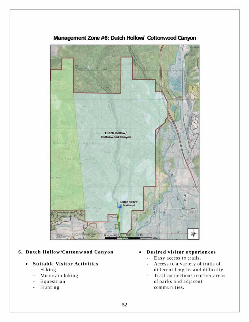
52 52
Management Zone #6: Dutch Hollow/ Cottonwood Canyon
6. Dutch Hollow/Cottonwood Canyon
• Suitable Visitor Activities - Hiking - Mountain biking - Equestrian - Hunting
• Desired visitor experiences
- Easy access to trails. - Access to a variety of trails of
different lengths and difficulty. - Trail connections to other areas
of parks and adjacent communities.

53 53
• Recommended Concession/Contract Services - Guided hiking and mountain
biking tours.
• Recommended facility improvements and development, and additional visitor opportunities - Ensure adequate maintenance
and improvement of trails and trailheads

54 54
Management Zone #7: Lower Snake Creek
7. Lower Snake Creek (Wasatch Golf
Course/Visitor Center/Campground)
• Suitable Visitor Activities
- Golf - Camping - Visiting Huber Grove
historic/interpretive site - Visitor information (visitor
center) - Picnicking - Hiking
- Bird watching - Cross-country skiing
• Recommended Concession/Contract Services - Resale items - Yurts
• Recommended facility
improvements and development, and additional visitor opportunities - Prioritize maintenance issues in
Pine Creek Campground until

55 55
full funding for redevelopment of the campground is obtained.
- Redesign Pine Creek campground to use current campground footprint, but utilize existing unused space to accommodate larger RVs.
- Offer Pine Creek campers transportation routes (trails) to golf courses.
- Explore the feasibility of developing a trail that connects the lower Snake Creek area to Soldier Hollow.
- Improve trail grooming operations for better cross-country skiing access.
- Investigate installation of WiFi services in Pine Canyon campground.

56 56
This page intentionally left blank
57 57
Conclusion This plan is a blueprint to help implement the planning team’s recommendations. The plan outlines the initial steps to be taken in cooperation with Wasatch Mountain State Park visitors, local communities, and other interested users to: determine the best management strategies for state park resources; develop and improve facilities to serve visitor needs now and into the future; ensure adequate staff and funding; protect the natural and cultural resources at the park; enhance the impact on local communities and on local and state economies; and expand the recreational opportunities that Wasatch Mountain State Park offers. The continued support of the park’s many stakeholders is crucial to accomplishing the mission and vision set out by the planning team. The recommendations contained within this plan were based upon an open and collaborative process. It is important that this collaborative spirit continues as the plan’s recommendations are implemented. The plan should be reviewed on a regular basis to ensure its viability, relevance and usefulness. This document has enough flexibility to be amended in response to changing resource conditions, visitor needs and expectations, community needs, and agency priorities. Amendments may occur under the auspices of the Division. Any such changes will include input from visitors, local citizens, community leaders, staff or other stakeholders with interest in Wasatch Mountain State Park.

58 58
This page intentionally left blank

59 59
References
Headwater Economics (2009). A SocioEconomic Profile Wasatch County Utah, Economic Profile Systems.
National Oceanic and Atmospheric Administration (2010), Utah Climate
Summaries, Weather Data for Heber City, Utah and Snake Creek Powerhouse, Nation Weather Service, Western Region Climate Center.
Powell, Allan K. (1989). Preliminary Overview History of Wasatch Mountain
State Park. Utah State Historical Society. State of Utah. (2009). Summer Visitor Survey Results – Wasatch Mountain
State Park. Division of Utah State Parks and Recreation. State of Utah. (2009). Winter Visitor Survey Results – Wasatch Mountain
State Park. Division of Utah State Parks and Recreation. State of Utah. (2000). Soldier Hollow Golf Task Force: A Feasibility Study.
Division of Utah State Parks and Recreation. State of Utah. (1995). Wasatch Mountain State Park Resource Management
Plan. Division of Utah State Parks and Recreation. State of Utah. (1978). Wasatch Mountain State Park Interpretive Plan.
Division of Utah State Parks and Recreation. State of Utah. (2008). 2008 Population Estimates. Utah Population Estimate
Committee, Governor’s Office of Planning and Budget. State of Utah. (2008). 2008 Baseline Highlights: State of Utah Long Term
Projections 2008 - 2060. Governor’s Office of Planning and Budget. State of Utah. (2008). Total Population by County, 1940 – 2009. Utah
Population Estimates Committee, Governor’s Office of Planning and Budget.
State of Utah (2009). Wasatch Mountain State Park Hazard Mitigation Plan
2009, Utah Division of Emergency Services and Homeland Security. State of Utah. (2008). 2007 State and County Economic & Travel Indicator
Profiles. Utah Division of Travel Development.

60 60
State of Utah. (2007). Utah Sensitive Species List. Utah Division of Wildlife Resources.
State of Utah. (2010). Wasatch County Profile, March 2010. Utah Dept. of
Workforce Services, http://jobs.utah.gov/jsp/wi/utalmis/countyprofile.do State of Utah. (2009). Current Economic Snapshot: Wasatch County Profile,
February 2009. Utah Dept. of Workforce Services, http://jobs.utah.gov/jsp/ University of University of Utah. (2010). Utah Construction Information
Database, Table 9: Yearly Totals for County and State by Building Type, 1994 through 2009. Bureau of Economic and Business Research.
U.S. Census, American FactFinder (2009). Wasatch County, Utah. Wasatch County. (2001). Wasatch County General Plan.

61 61
Appendix A: Wasatch Mountain State Park Business Plan

62 62
This page intentionally left blank

63 63
Wa satc h Mountain State Park
Business Planning Strategies2010 - 2013
Utah State Parks

64 64
This page intentionally left blank
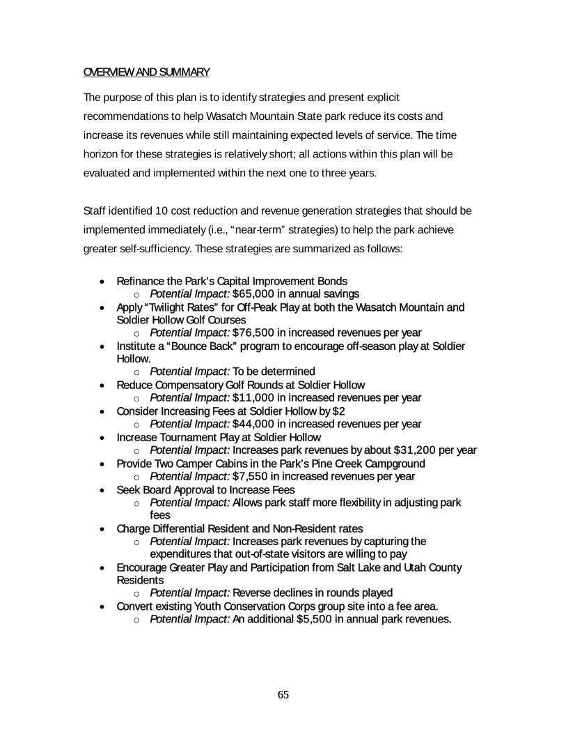
65 65
OVERVIEW AND SUMMARY The purpose of this plan is to identify strategies and present explicit
recommendations to help Wasatch Mountain State park reduce its costs and
increase its revenues while still maintaining expected levels of service. The time
horizon for these strategies is relatively short; all actions within this plan will be
evaluated and implemented within the next one to three years.
Staff identified 10 cost reduction and revenue generation strategies that should be
implemented immediately (i.e., “near-term” strategies) to help the park achieve
greater self-sufficiency. These strategies are summarized as follows:
• Refinance the Park’s Capital Improvement Bonds
o Potential Impact: $65,000 in annual savings • Apply “Twilight Rates” for Off-Peak Play at both the Wasatch Mountain and
Soldier Hollow Golf Courses o Potential Impact: $76,500 in increased revenues per year
• Institute a “Bounce Back” program to encourage off-season play at Soldier Hollow.
o Potential Impact: To be determined • Reduce Compensatory Golf Rounds at Soldier Hollow
o Potential Impact: $11,000 in increased revenues per year • Consider Increasing Fees at Soldier Hollow by $2
o Potential Impact: $44,000 in increased revenues per year • Increase Tournament Play at Soldier Hollow
o Potential Impact: Increases park revenues by about $31,200 per year • Provide Two Camper Cabins in the Park’s Pine Creek Campground
o Potential Impact: $7,550 in increased revenues per year • Seek Board Approval to Increase Fees
o Potential Impact: Allows park staff more flexibility in adjusting park fees
• Charge Differential Resident and Non-Resident rates o Potential Impact: Increases park revenues by capturing the
expenditures that out-of-state visitors are willing to pay • Encourage Greater Play and Participation from Salt Lake and Utah County
Residents o Potential Impact: Reverse declines in rounds played
• Convert existing Youth Conservation Corps group site into a fee area. o Potential Impact: An additional $5,500 in annual park revenues.

66 66
Explicit estimates for 7 of these recommendations were identified totaling $240,750
in potential annual cost savings or revenue increases. All the programs associated
with these estimates are either cost-effective, or will yield significant revenues at
virtually no cost. It is expected that additional revenues will be generated from some
of the additional near-term promotional strategies identified. However, explicit
estimates for these actions could not be determined at this time.
As the majority of the park’s annual revenues and expenditures are associated with
golf at the Wasatch Mountain and Soldier Hollow golf courses, it follows that the most
significant cost savings or revenue generation strategies relate to golf.
Staff also identified a number of additional “long-term” cost reduction and revenue
enhancement strategies that should be evaluated for feasibility through fiscal year
2011. If proven feasible, these actions can be implemented within the next one to
three year period. Explicit revenue and cost estimates have yet to be determined for
these strategies, as more analysis is needed to validate the estimates.
This document first summarizes the park’s major expenditure and revenue
categories. It then provides a brief summary of recent golf trends at the park. Finally,
the report provides both the near-term and longer-term strategies identified to help
the park become more self-sufficient.
PARK REVENUES AND EXPENDITURES
A combination of adverse weather conditions and economic factors appear to be
responsible for recent declines in park revenues. The park posted revenue increases
each year between fiscal year 2005 and 2008.13 Revenues increased during this
period by about 13 percent from about $3 million in fiscal year 2005 to more than
$3.4 million in fiscal year 2008. Since 2008, park revenues have been on the
decline, dropping by about 9 percent (see figure 1, below), with the most of this
decrease (about 8.6 percent) occurring between fiscal year 2009 and fiscal year
13 Revenues include golf user fees charged at both the Wasatch Mountain and Soldier Hollow golf courses.

67 67
2010. Declines in golf rounds played (see table 1 below) are a major factor in these
trends. While weather is always a variable, recent adverse economic conditions
appear to be a contributing factor in the revenue decreases occurring after 2008.
Park expenditures increased by an average of about 4.7% per year between fiscal
years 2005 and 2009. Increases in personnel and energy costs were the driving
force behind these increases. With recent budget reductions, park expenditures
dipped slightly (by about 3.7 percent) between fiscal years 2009 and 2010, primarily
due to reductions in staff time.
Figure 4: Wasatch Mtn. State Park, Revenues and Expenditures, FY 2005 - 2010
$3,040,212$3,250,248 $3,420,759 $3,435,444 $3,408,348
$3,115,417
$3,898,065$4,124,736 $4,218,046
$4,520,087 $4,684,810 $4,509,699
$0$500,000
$1,000,000$1,500,000$2,000,000$2,500,000$3,000,000$3,500,000$4,000,000$4,500,000$5,000,000
2005 2006 2007 2008 2009 2010
Revenues Expenditures
Major Expenditure (Cost) Categories
The park’s fiscal year (FY) 2010 budget was approximately $4.5 million. Within this
budget are found three major park cost units: Soldier Hollow Golf Course, with a
budget of $2,140,734; Wasatch Mountain Golf Course, with a budget of $1,512,447;
and Wasatch Mountain, Park Operations/Campground with a budget of $854,918. A
smaller budget entitled Soldier Hollow Venue, totaled about $10,000.
There are three major expenditure/cost categories at the park: Personnel Services
(staffing), Bond Payments (for development of the Soldier Hollow golf course and for
improvements at the Wasatch Mountain course), and Current Expense (park
operations and maintenance expenses). Actual FY 2010 expenditures totaled about

68 68
$4.4 million. Of this total, personnel Services expenditures were $1,939,221 (about
44 percent). Bond Payments totaled $1,471,900 ($1,098,700 for Soldier Hollow
Golf and $373,200 for Wasatch Mountain Golf – about 34 percent of total) and total
park Current Expenses were about $956,957 (22 percent of total). Figure 2 shows
how total expenditures are distributed among these three categories.
Figure 2: Major Park Expenditures, Fiscal Year 2010
44%
34%
22%
Personnel ServicesBond PaymentsCurrent Expense
Cost reduction efforts in this plan target each of these areas. Short-term focus is on
potential reductions in bond payments and current expenses, as there may be more
immediate flexibility here.
Major Revenue Sources
Wasatch Mountain State Park revenues totaled just over $3.1 million in fiscal year
2010. These revenues were generated from the following sources:
• Wasatch Mountain Golf Course - $1,703,131 • Soldier Hollow Golf Course - $899,261 • Wasatch Mtn. State Park/Campground - $237,564 • Golf User Fee Revenue - $234,619 • Soldier Hollow Concession/Leases – $40,745

69 69
Figure 3: Major Park Revenue Sources, Fiscal Year 2010
54%
29%
8%
8% 1%
Wastch Mtn. Golf
Soldier Hollow Golf
Wastch Mtn. Camping
Golf User Fees
Soldier HollowConcessions/Leases
Golf green fees and golf cart rentals, account for the vast majority (approximately 80
percent) of park revenues. This plan focuses on revenue-enhancement actions
related to these two areas.
Current Golf Trends
Since 2007, there have been declining trends in golf rounds played at both of the
Wasatch Mountain State Park courses. While weather certainly is a critical factor
affecting rounds played, economic conditions have undoubtedly been a factor in the
declines experienced since 2007. Table 1 highlights these trends.

70 70
Table 1: 9-Hole Rounds Played, May 2006 – July 2010 Wasatch 2006 2007 2008 2009 2010 Jan N/A 0 0 0 0 Feb N/A 0 0 0 0 Mar N/A 864 0 0 0 Apr N/A 5,839 780 1,715 1,269 May 10,440 12,372 8,805 10,787 6,479 Jun 21,527 20,865 17,608 17,556 12,893 Jul 24,331 24,891 23,863 23,025 22,554 Aug 12,882 24,712 23,887 18,735 N/A Sep 8,769 17,208 16,623 16,808 N/A Oct 6,224 6,018 6,279 4,844 N/A Nov 812 2,167 1,150 1,094 N/A Dec 0 0 0 0 N/A Total: 84,985 114,936 98,995 94,564 43,195
Soldier Hollow 2006 2007 2008 2009 2010 Jan 0 0 0 0 Feb 0 0 0 0 Mar 494 0 0 0 Apr 2,673 1,023 877 1,863 May 3,819 4,930 4,368 3666 3,428 Jun 10,361 11,123 9,440 7,786 7,568 Jul 12,000 12,780 11,516 10,820 13,263 Aug 7,047 14,682 15,607 11,312 N/A Sep 4,992 11,130 10,549 8,193 N/A Oct 2,927 2,213 4,501 1,946 N/A Nov 573 846 537 626 N/A Dec 0 0 0 0 N/A Total: 41,719 60,871 57,541 44,075 26,122
Other local courses have experienced similar declines. Courses within Salt Lake and
Davis Counties have experienced declines in rounds and revenues in the 4 to 5
percent range, over the past year. Year over year fluctuations are even more
significant at Wasatch and Soldier Hollow. As table 1 shows, the average declines (in
rounds played) were in the 4 to 5 percent range Wasatch between 2008 and 2009,
but were much more significant the previous year. Alternatively, Soldier Hollow
experienced a 5.5 percent decline between 2007 and 2008. However, the 23.4
percent decline in rounds played between 2008 and 2009 was significant.

71 71
The bottom line is that it appears that there is some other structural factor behind
the declines beyond weather. As golf is the greatest revenue-generating activity at
the park, it is critical that declining trends be checked and reversed. It also follows
that many of the most significant strategies put forward in this business plan revolve
around ways to increase course play.
POTENTIAL NEAR-TERM COST REDUCTION/REVENUE ENHANCEMENT STRATEGIES 1. Refinance Capital Development Bonds • Potential Impact: $65,000 in annual savings Following personnel expenditures, the most significant expenditure item at the park
involves capital improvement bond payments. Currently, the park incurs an
approximate $1.5 million annual expense in bond payments from additions to the
Wasatch Mountain golf course in 1997 and from development of the Soldier Hollow
Golf Course in 2003. Annual bond payments are $373,200 per year for Wasatch with
approximately 7 years left on the bond and about $1.1 million per year with about 14
years of payments remaining on the Soldier Hollow course.
Under current economic conditions, there are potential significant savings to be
realized by taking advantage of historically low interest rates and economic
uncertainty that have made bonds a preferred (and safe) investment strategy. Under
current economic conditions, if the Division does not take advantage of potential
refinancing opportunities, it stands to effectively “lose” money by paying more than it
should for debt incurred. It is therefore in the public interest to reduce debt and
operate more efficiently by implementing this strategy.
Accordingly, there is a need to explore the potential of “refinancing” the bond debt to
reduce annual current expense. In July 2010, the Division engaged in discussions
with the State Treasurer’s Office and with the Division of Facilities Construction and
Management (DFCM). The Treasurer’s Office indicated it was possible to refinance
the Soldier Hollow Bond. A preliminary analysis conducted by Zion’s bank determined
that based on current rates, the refinancing would yield approximately 6.767% or

72 72
$736,213 in total savings (in net present value) through the remaining life of the
bond. Refinancing will result in approximately $65,000 in cash flow savings to the
park annually through the final maturity date of May 2024. Park and Division staff
will work with both the State Treasurer’s Office and DFCM to achieve these potential
savings.14
2. Apply “Twilight Rates” for Off-Peak Play at both the Wasatch Mountain and Soldier
Hollow Golf Courses • Potential Impact: $76,500 in increased revenues per year This is a discount program that offers golfers a discount rate for playing at both
courses in off-peak hours. The goal is to attract additional play for golfers seeking an
“after work” or “after hours” golfing experience. This will increase play that would not
otherwise have occurred during afternoon hours.
This proposal uses the following assumptions:
• Participating Wasatch Course customers can play 18 holes after 3:00 p.m. for $33. Participating Soldier Hollow customers can play 18 holes after 2:00 p.m. for $27.15
• It is assumed that the Wasatch incentive will result in an additional 1,500 rounds played each year, while the Soldier Hollow incentive will result in an additional 1,000 rounds annually.16
• Park staff will work closely with the Division’s Marketing and Communications Section to promote the program, with emphasis on attracting Utah, Summit, and Wasatch County residents.
• It is assumed that there are negligible additional costs at the park or for promotion of the program.
• It is also assumed that the program continues indefinitely.
Based on these assumptions, this program would yield approximately $76,500 in
new revenues. 17 There may be additional costs associated with marketing and
14 Note that as the Wasatch Mountain course bond has already been refinanced, further debt restructuring is not possible for this bond payment, according to State Treasurer, Richard Ellis. 15 As days get shorter in the fall, the start times for twilight rates may be moved back. 16 Soldier Hollow previously had a similar discount that resulted in approximately 1,000 new rounds played. 17 Calculated as follows: Wasatch – 1,500 new rounds x $33 = $49,500; Soldier Hollow – 1,000 new rounds x $27 = $27,000; Total impact = $76,500

73 73
promotion of the program, but it is likely that these costs will largely be “sunk” or will
be minimal.
3. Institute a “Bounce Back” program to encourage off-season play at Soldier Hollow • Potential Impact: To be determined This is a discount program that offers golfers paying full price at Soldier Hollow during
peak periods a discount for playing at the course during off-season or off-peak
periods.
In August 2010, park staff implemented a bounce-back program that has the
following components:
• Participants purchasing an 18-hole round with a cart during August 2010 receive
a free cart (an $11 discount) if they purchase an 18-hole round after September 7, 2010 through the end of the 2010 season.
It is recommended that staff evaluate the effectiveness of this incentive as a test
case for similar programs in the future.
4. Reduce the number of compensatory or donated golf rounds at Soldier Hollow • Potential Impact: $11,000 in increased revenues per year Park management recommends reducing the number of compensatory and donated
rounds offered at Soldier Hollow. Management has latitude to donate free golf
rounds to better promote the course or to accommodate charitable events. Most
typically, staff will charge customers a regular rate for 18-holes with no charge for a
cart. Such actions are an essential part of course operations. However, the number
of these rounds can be reduced without damaging goodwill or effective promotion of
the course.
Staff believes that the following assumptions for this proposal are reasonable: • Reducing compensatory rates will net approximately 1,000 rounds played at full
price. • The additional fees applied to these new rounds played would be $11, which
represents the difference between current full price fees with cart ($38), and the current introductory discount price ($27).

74 74
• It is assumed that reducing compensatory rounds will result in no loss or cost to the park.
Based on these assumptions, this program would yield approximately $11,000 in
new revenues. This represents the $11 net increase in price applied to the
approximate 1,000 rounds that are played under a “free-cart” discount.
5. Consider Increasing Fees at Soldier Hollow by $2 • Potential Impact: $44,000 in increased revenues per year In 2008, Soldier Hollow dropped greens fees by $4 to attract additional play. In
2009, fees were raised by $2 at both the Soldier Hollow and Wasatch Mountain
courses. This resulted in the current full price green fee of $38 with a cart for an 18-
hole round. Even though current rates are still lower than the levels they were at prior
to 2008, price reductions have not increased play at the course. It follows that the
discount may have led to the unintended consequence of reduced revenue. It also
appears that while fees do affect play, there are other factors that may have more
weight than small changes in fees.
Soldier Hollow can raise fees by this amount without having to seek State Parks
Board approval, as it already has authority to set fees to a level that the $2 increase
would not exceed. While staff are still reviewing the major factors affecting rounds
played, they are confident that a $2 fee increase will not be met with much
resistance in the form of reduced play, as the new rate will still be lower than rates
charged previously.
Staff believes that the following assumptions to this proposal are reasonable: • The number of rounds played would essentially remain the same with the fee
increase. In 2009, approximately 22,000 18-hole rounds were played at Soldier Hollow. If it is likely that rounds will not be lower than this figure under the $2 increase, the additional fee should be implemented.
• Park staff review trends to ensure that no significant declines in projected rounds played are likely to occur.
Assuming that rounds drop no further than 2009 levels, the $2 fee increase will
result in about $44,000 in additional revenues.

75 75
6. Increase Tournament Play at Soldier Hollow • Potential Impact: Increases park revenues by about $31,207 per year There is potential to increase tournament play at Soldier Hollow. In addition, with
current economic conditions dampening tournament play, there is a need to retain
tournament sponsors.
It is recommended that park staff focus on retaining current tournament contacts
and obtaining commitments from them to rebook for future years. It is also
recommended that staff set a goal to make at least 15 to 20 regular tournament
contacts and obtain commitments, and then host at least 7 to 8 new tournaments
(corporate events) per season, with additional tournaments to follow. It is also
recommended that Soldier Hollow provide additional course-sponsored tournaments,
such as those that cater to juniors, seniors, or families. This will help to promote
more return visits, particularly with local golfers.
Focus should be on filling-in rounds through tournaments during traditionally slow or
shoulder-season periods. Increased media contact will also be required to fully
promote such efforts.
Assumptions: 1. There is no further loss in tournament contacts; 2. Staff host 7 TO 8 additional full-field tournaments (144 golfers) at an average
80% participation rate; 3. Total fees for participant are $43 per person; 4. There is minimal or no displacement in rounds played on tournament days. 5. A dedicated staff member is paid on a commission-only basis to promote
these tournaments.18 Based on these assumptions, there would be an increase in revenues of about
$31,207, all other things held constant.
18 This position would receive a 10% commission on gross tournament receipts. Gross receipts for 7 full-field tournaments are calculated as follows: 7 rounds x 144 players x 80% participation rate x $43 = $34,675; Net receipts are $31,207 calculated as follows; $34,675 x 10% commission = $3,468 commission. Gross receipts $34,675 – commission $3,468 = net receipts of $31,207.

76 76
Park staff note that there is a need to work with division Marketing and
Communications staff to promote the course as the site selected by the United
States Golf Association (USGA) for the 2012 U.S. Amateur Public Links
Championship. This is a major opportunity to attract participants seeking experiences
on a USGA tournament site.
Additionally, staff indicate that there is a need to provide additional rental equipment
for tournament play. Many corporate tournaments at the course have out of state
participants who do not travel with golf clubs or related equipment. This is a longer-
term cost element that should be considered as efforts to promote additional
tournament play are enhanced.
7. Provide Two Camper Cabins in the Park’s Pine Creek Campground • Potential Impact: $7,550 in increased revenues per year
This proposal would result in the installation of two cabins within the park’s main
campground area. These cabins would include minimal (“rustic”) accommodations,
and would be opened year-round in an effort to increase off-season/winter use. The
analysis for these cabins is as follows:
Assumptions:
1. Occupancy averages 34.3 percent over the 6-month (27-week) period May through October. This results in approximately 65 days of occupancy for each cabin.19
2. Total annual gross revenues are $9,750 calculated as follows: a. 65 occupied days x 2 cabins = 130 occupied rental days. b. Rental rate per day is $75. c. 130 x $75 = $9,750
3. Total finished capital cost is $74,000 ($37,000 each, installed) 4. Total operating and maintenance cost is $2,200/year. 5. Assume a 20-year life and a 5 percent discount rate.
19 Reservations staff note that current campground weekend occupancy averages approximately 70 percent during the 6–month/27 week operational period, and 20 percent on weekdays during the period. As a result, effective overall campground occupancy averages about 34.3 percent over the period. Keep in mind that this is for campground units, many of which are inaccessible to larger R.V. units. The Division argues that with campground renovation, occupancy rates would be even higher. In addition, the occupancy figure used here does not include year-round use that the project is anticipated to accommodate, nor does it account for increased marketing efforts that would accompany installation of cabins. As a result, these assumptions may be conservative.

77 77
Table 2: Financial Results - Installation of Camper Cabins Financial Measure Amount
Average Annual Net Cash Flow $7,550
Present Value of Project Benefits $115,721
Present Value of Total Project Costs $83,254
Net Present Value of Project Benefits $32,467
Project Benefit/Cost Ratio 1.4
Internal Rate of Return 11%
Estimated Impacts:
1. Total discounted net benefits (discounted benefits minus discounted costs) over the 20-year life of project are about $32,467.
2. The internal rate of return is about 11%. 3. The benefit-cost ratio is about 1.4.
Based on the assumptions, the project is cost-beneficial, and provides reasonable
returns on investment. This project will yield an additional $7,550 in revenues each
year. In addition, these facilities will broaden the spectrum of camping opportunities
and other use at the park.
8. Seek Board Approval to Increase Fees • Potential Impact: Allows park staff more flexibility in adjusting park fees
Greater price flexibility is crucial in helping the park more rapidly meet its revenue
targets. Since formal approval is needed before the park can increase fees, there is a
need for the park to obtain “headroom” for future fee increases.
Park staff should immediately seek approval from the board to increase fees. While
there may or may not be an immediate need to adjust fees, this gives the park the
price flexibility it needs to accomplish revenue goals. Staff should estimate what the
maximum feasible increases in fees may be through the next three-year period, and
seek approval to set fees to forecasted levels.
9. Charge Differential Resident and Non-Resident rates
78 78
• Potential Impact: Increases park revenues by capturing the expenditures that out-of-state visitors are willing to pay
Efforts to differentiate prices among various user groups may help increase park
revenues. At Park City’s municipal golf course, non-residents currently pay $57 for 18
holes with a cart, while residents pay $46 for 18 holes with a cart. Another potential
strategy is to revisit and enhance linkages with local resorts. Higher out-of-state rates
could be applied to these visitors.
Recommendations: Consider providing differential rates for local residents (reduced rates for residents
from Wasatch and Summit Counties), higher rates for out-of-state visitors, and
reduced rates for off-peak hours to increase play. Park staff could establish (or
reestablish) contacts with local resorts to encourage enhanced promotional efforts.
Development of a promotional strategy will likely be needed. More analysis is also
needed to fully evaluate costs and impact.
This option may be difficult to implement due to the problem of verifying residency. It
is recommended that staff contact other courses (such as Park City) who currently
charge differential rates for non-local visitors to evaluate the pros and cons of this
approach.
10. Encourage Greater Play and Participation from Salt Lake and Utah County
Residents • Potential Impact: Reverse declines in rounds played Golfers playing at Wasatch Mountain and Soldier Hollow are predominantly Wasatch
Front residents. There is a concern that given current economic conditions, a number
of Wasatch Front golfers who typically frequent these courses are choosing to either
golf near home, or forego golf participation entirely. Systematic declines in rounds
played at both the park’s courses appear to indicate that economic conditions (falling
incomes, limited expenditures, etc.) are taking a toll on play.

79 79
This effort is somewhat problematic, as the Division already has extensive marketing
and promotional efforts that target the Wasatch Front. Hence, other additional
strategies may be needed, particularly in light of the difficult economic conditions
that have persisted since 2008 which may warrant commensurate changes
marketing efforts.
It is recommended that park staff work with Division Communication and Marketing
staff to reassess the effectiveness of existing marketing strategies and identify
additional potential strategies that may be employed to increase play from this
market. Part of this strategy should highlight the fact that both the park’s courses are
very competitive with local public courses and offer visitors opportunities to play at
world-renowned courses in a unique mountain setting at reasonable rates. As
recommended above, this effort should likewise promote Soldier Hollow Park as the
site selected by the United States Golf Association (USGA) for the 2012 U.S. Amateur
Public Links Championship. This may help to attract participants seeking experiences
on a USGA tournament site.
11. Convert existing Youth Conservation Corps group site into a fee area • Potential Impact: An additional $5,500 in annual park revenues The Youth Conservation Corps (YCC) group area located near the park staff
residences adjacent to Huber Grove has historically been used to accommodate
displaced campers from the park’s main campground, service groups, and
employees. The park has not charged a fee for use of the area. Recently, there has
been high demand for use of the area as a group camping site, particularly for groups
holding family reunions or other similar large group outings.
The area is part of an apple orchard with well-maintained turf grass, a large fire pit,
horseshoe pits, water, electric and sewer utilities for RV hookups as well as two flush
toilets. The park recently received $30,000 in Park Enhancement Funds to convert
the existing Youth Conservation Corps day-use group area into an overnight group-
use site/area and put it on the Division’s reservation system. This action is a high
priority to park management.

80 80
This $30,000 would be used to upgrade the restroom facilities and perform minor
site improvements. Revenue and cost assumptions for this project are as follows:
• Development costs are $30,000, for use as described above. • Staff estimated that annual operation and maintenance costs will be
approximately $750 per year (for utilities, supplies, and minor maintenance; no additional park staff will be needed to operate the facility).
• The site is available for 14 weekends between Memorial Day and Labor Day. • Weekend occupancy is 75% during the period, resulting in 21 days of total
occupancy. • Weekday occupancy is 10% during the 14-week period, resulting in about 7 days
of total occupancy. • Staff estimate that the site will be occupied an additional 8 days during the
shoulder season. • Rates are $175 per night, with a 2-night minimum stay. • The development has a 20 year useful life. • The discount rate applied to the analysis is 5 percent. Based on these assumptions, visitors will utilize this site for a total of 36 days during
the year. At a rate of $175 per day (night), this project will generate an additional
$6,300 in revenue annually, and will net approximately $5,550 when operations and
maintenance costs are deducted. In addition, the project is cost-effective with a
benefit-cost ratio 2.1. The project also results in an internal rate of return20 of 17.8
percent.
POTENTIAL LONG-TERM STRATEGIES (to be evaluated for implementation over the next one to two years) Cost Reduction Actions: 1. Action: Evaluate Current Expense and Personnel Services Budgets
• Description: During fiscal year 2011, park staff should work with Region and Division Administration to carefully review additional potential savings in current expenses and personnel services. This action will be critical if there are continuing declines in golf revenues and rounds played.
Revenue Enhancement Actions: 1. Action: Evaluate Feasibility of Increasing Wasatch Green Fees
• Description: During fiscal year 2011, park and Division staff should explore the feasibility of increasing green fees at both park courses. In the near-term,
20 The interest rate at which the net present value of total project cash flows equal the present value of total project costs.

81 81
it appears that while fee increases may be implemented at Soldier Hollow without significant impacts to rounds played, there is some concern about impacts on play at Wasatch Mountain. If declining trends in play are checked or reversed, this option should be explored and, if feasible, implemented before the end of FY 2011. Staff should obtain immediate approval from Board to increase fees.21
2. Action: Establish Fee Areas
• Description: Partnership with the Forest Service to establish fee areas at the park. One strategy is to encourage the Forest Service assist with actual fee collection at specified remote areas. There is a need to evaluate this action further.
3. Action: Renovate and Upgrade Campground Sites
• Description: Conduct a limited improvement project to upgrade at least 10-15 within the Pine Creek campground. Improvements would include upgraded electrical service, and associated improvements to site and paving. This small-scale improvement action is needed to stem increased campground vacancies due to dilapidated or obsolete facilities. As with the above strategy cost and potential revenue information is needed from both the Development Section and from the Reservation Section to fully assess cost-effectivness.
4. Action: Identify New Concession Opportunities
• Description: Per RMP recommendations, identify potential areas/site for concession-managed yurt rentals.
21 In general, there is a need to have greater price flexibility to increase revenues at both the Wasatch Mountain and Soldier Hollow golf courses. One way to evaluate the feasibility of a green fee increase is to compare fees at Salt Lake City’s Mountain Dell course. Park staff view this course the primary competitor for Wasatch and Soldier Hollow, and rates serve as a benchmark. In January 2010, Salt Lake City increased green fees at its Mountain Dell course from $41/18-rounds to $44/18-rounds (from its regular rates of $27/18-rounds to $30/18, with a $14 cart fee).

82 82