Embed Size (px)
Citation preview
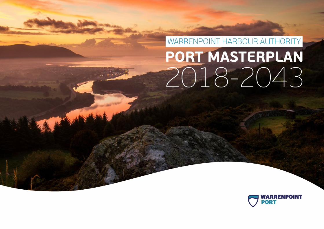
WARRENPOINT HARBOUR AUTHORITY

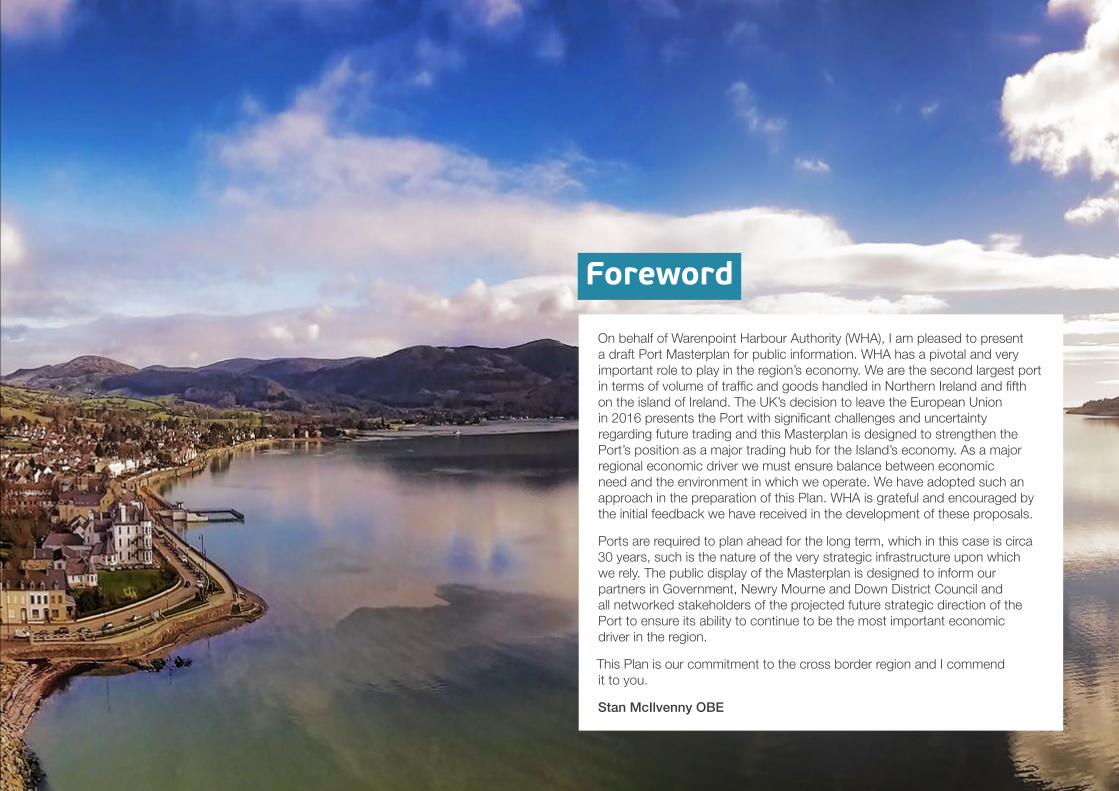
On behalf of Warenpoint Harbour Authority (WHA), I am pleased to present a draft Port Masterplan for public information. WHA has a pivotal and very important role to play in the region’s economy. We are the second largest port in terms of volume of traffic and goods handled in Northern Ireland and fifth on the island of Ireland. The UK’s decision to leave the European Union in 2016 presents the Port with significant challenges and uncertainty regarding future trading and this Masterplan is designed to strengthen the Port’s position as a major trading hub for the Island’s economy. As a major regional economic driver we must ensure balance between economic need and the environment in which we operate. We have adopted such an approach in the preparation of this Plan. WHA is grateful and encouraged by the initial feedback we have received in the development of these proposals.
Ports are required to plan ahead for the long term, which in this case is circa 30 years, such is the nature of the very strategic infrastructure upon which we rely. The public display of the Masterplan is designed to inform our partners in Government, Newry Mourne and Down District Council and all networked stakeholders of the projected future strategic direction of the Port to ensure its ability to continue to be the most important economic driver in the region.
This Plan is our commitment to the cross border region and I commend it to you.
Stan McIlvenny OBE
Foreword
N O R T HA T L A N T I C
O C E A N
I R I S HS E A
Belfast
Dublin
S T. G E O R G E ’ S C H A N N E L
I R E L AND
NOR TH E RNI R E L AND
Warrenpoint
Newry
Dundalk
Warrenpoint
Newcastle
Kilkeel
Greenore
Downpatrick
N O R T H E R N I R E L A N D
I R E L A N D
Location Plan
1.0 Executive Summary 6
1.1 Trade Growth 7
1.2 Operating Capacity 7
1.3 Masterplan Objectives 7
1.4 Brexit Challenges 8
1.5 Interim Response 8
1.6 Engine of the Regional Economy 9
2.0 Introduction 11
2.1 Approach to the Masterplan 11
2.2 Warrenpoint Harbour Authority – Corporate Plan and Strategy Document 11
2.3 Main Strategic Challenges of the Corporate Plan 12
2.4 Guidance on the Preparation of Port Master Plans 13
2.5 Projects of Influence 13
3.0 The Port Masterplan 15
3.1 Traffic Forecasts 15
3.1.1 RO-RO Freight Forecasts 15
3.1.2 LO-LO Freight Forecasts 15
3.1.3 Summary Traffic Forecasts 16
3.2 The Port Estate 17
3.3 The Spatial Masterplan 2018-2042 18
4.0 Masterplan Objectives 19
4.1 Objective 1: Improve Transportation and Circulation to and Within the Port 19
4.1.1 Strategic Actions 19
4.1.2 Operational Actions 20
4.2 Objective 2: Improve Port Capacity, Operations and Facilities 21
4.2.1 Port Facilities and Maintenance 21
4.2.2 Maintenance 21
4.2.3 Equipment 21
4.2.4 Utilities 21
4.2.5 Former Gilbert Ash Site 22
4.2.6 RO-RO Terminal 24
4.2.7 General Cargo Port 25
4.3 Objective 3: Construct a Diverse Customer Base 26
4.3.1 Marine Access Dredging 27
4.3.2 Vessel Size Trends 28
4.3.3 Pilotage and Tugs 28
4.3.4 Vessel Movement Management 28
4.3.5 Health, Safety and the Environment 28
4.4 Objective 4: Develop and Improve Linkages with the Town 29
4.4.1 Town Dock 31
4.5 Objective 5: Develop a Long-term Strategy for Expansion 32
4.5.1 Development Options Beyond 2040 32
Contents
Vision, Mission and Values
Vision
To be a leading commercial port, continually growing whilst maximising our contribution to the regional economy and community.
Mission
By exceeding our customers’ expectations and fully utilising our assets to grow in a safe and sustainable way for our stakeholders.
Values
• Safety First: We adhere to the highest health and safety standards to deliver safe environment for customers and colleagues.
• Complete Integrity: We are honest, open and ethical in all our activities and interactions.
• Our Team: We work as one team, flexible and willing to learn for the benefit of all.
• Total Respect: We treat everyone as we would like to be treated ourselves.
Clare Guinness
It is a pleasure to share our draft Port Masterplan as, together with our stakeholders, we look ahead to the next 25 years of progress at Warrenpoint Harbour Authority.
This document, which outlines our key objectives and priorities over the period, is the result of many hours of preparation by our Chairman Stan McIlvenny OBE and his board and follows the recent publication of the Warrenpoint Harbour Authority Economic Impact Statement.
That provided a comprehensive overview of the significant contribution the Port makes to Warrenpoint, south Down and the wider regional economy.
We are proud of our role as a major economic driver for the local region and it is a responsibility we treat with the utmost seriousness, as we aim to grow in a manner that is sensitive to our local environment.
Our newly launched Vision, Mission and Values seek to illustrate that commitment while also reflecting the ambitious strategy set out in this Masterplan to work with all our partners in government, politics, commerce and the community to build on our position as the second largest Port in Northern Ireland.
6 | WARRENPOINT HARBOUR AUTHORITY | PORT MASTERPLAN 2018-2043
1.0 Executive Summary
Warrenpoint Port is one of Northern Ireland’s main commercial ports serving a hinterland which includes the southern part of Northern Ireland (NI) and the northern part of the Republic of Ireland (RoI).
As a Trust Port, Warrenpoint Harbour Authority is required to operate in a commercial manner and is an independent statutory body.
In 2016, NI ports handled some 26.6 million tonnes of traffic, with Belfast handling the majority (66%) of traffic. Warrenpoint ranked 2nd, handling 12% of NI’s total port traffic. On an all-island basis, Warrenpoint Port is ranked 5th behind Dublin, Belfast, Shannon-Foynes and Cork.
In 2017, the value of goods moving through Warrenpoint Harbour was £6.2 billion, £164 million of which was direct international trade. The Port handled 3.48 million tonnes of cargo in 2016 increasing to 3.56 million tonnes in 2017.
The Port Masterplan has been prepared by Warrenpoint Harbour Authority to guide strategic development decisions over the next 25 years.
The Masterplan is supported by a technical report covering baseline data, a review of relevant statutory and environmental policy, trade growth forecasts, an economic impact statement, and an operational review of Port activities.
The Port Masterplan has been prepared to cover the medium to long-term development of the Port – looking 25 years forward. Its purpose is to consult and inform stakeholders and assist local and regionalplanning authorities to prepare and revise their own plans.
The Port handled
3.48 million tonnes of cargo in 2016 increasing to
3.56 milliontonnes in 2017
The total throughput value of this cargo was
£6.2 billion
WARRENPOINT HARBOUR AUTHORITY | PORT MASTERPLAN 2018-2043 | 7
1.1 Trade Growth The trade growth forecast indicates that the major traffic at Warrenpoint is likely to remain RO-RO (Roll on, Roll off) freight. The central case forecast for this traffic, which assumes that the Port’s traffic increases in line with the market, is 136,000 units in 2040 compared to 88,000 units in 2015. As an additional hectare of land is required on average to store the equivalent of 20,000 trailers of extra traffic, this means that the Masterplan needs to allow for additional storage land to accommodate this growth.
The High Case forecast is for growth to 162,000 units by 2040 and, as this is in line with the its RO-RO operator Seatruck’s own forecasts, the Port should also plan for this level of growth while not limiting the potential for growth in other traffics.
The other unitised and non-unitised traffics will require some storage land to accommodate the forecast growth, but the Port infrastructure should be able to accommodate any increase in ship calls.
1.2 Operating CapacityAnalysis of the existing fleets operating in the Irish Sea suggest that the Port can accommodate a large proportion of the RO-RO fleet but the turning circle (rather than the available draft) is most likely to be the key restriction for marine access in the future. In the LO-LO (Load on, Load off) sector, the operating vessels are already too deep drafted to access the Port, which will make it more difficult for it to remain competitive in this market sector.
The deep water quay at Warrenpoint is essential to the Port maintaining its competitiveness in the non-unitised sectors (bulk cargoes), particularly for vessels unloading grain, though such vessels also carry steel products, cement, forest products and a range of other cargoes. However, the main restriction for the larger vessels at Warrenpoint is vessel length and the location of the turning circle.
1.3 Masterplan ObjectivesDuring the course of the baseline assessment, survey work and subsequent analysis, the Harbour Authority has identified a number of key issues that will adversely affect the future operation of the Port if left unaltered. The five core objectives of the Masterplan are directly related to addressing these issues.
They are:
Objective 1: Improve transportation and circulation
Objective 2: Improve capacity, operations and facilities
Objective 3: Maintain a diverse customer base
Objective 4: Develop and improve linkages with the town
Objective 5: Develop a long-term strategy for expansion
A series of priority projects have been identified to deliver these core objectives.
Project Priorities
To deliver the Masterplan’s core objectives, the following project priorities should be pursued:
• Broaden regional / strategic access through delivery of the Newry Southern Relief Road;
• Enhance marine access through an improved maintenance dredging regime;
• Address limited storage space which has been identified as the main constraint within the Port’s operational area; and
• Progress acquisition of sites within the potential port footprint.
8 | WARRENPOINT HARBOUR AUTHORITY | PORT MASTERPLAN 2018-2043
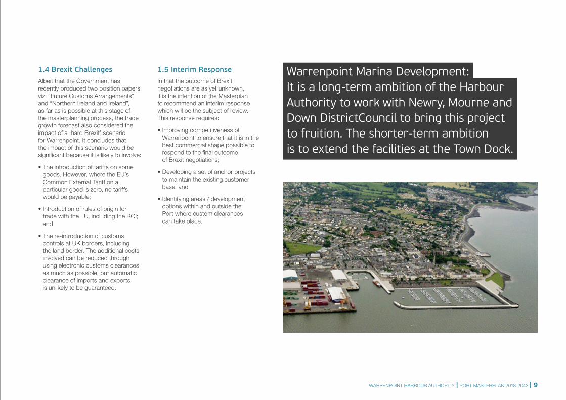
Warrenpoint Marina Development:It is a long-term ambition of the Harbour Authority to work with Newry, Mourne and Down DistrictCouncil to bring this project to fruition. The shorter-term ambition is to extend the facilities at the Town Dock.
1.4 Brexit Challenges Albeit that the Government has recently produced two position papers viz: “Future Customs Arrangements” and “Northern Ireland and Ireland”, as far as is possible at this stage of the masterplanning process, the trade growth forecast also considered the impact of a ‘hard Brexit’ scenario for Warrenpoint. It concludes that the impact of this scenario would be significant because it is likely to involve:
• The introduction of tariffs on some goods. However, where the EU’s Common External Tariff on a particular good is zero, no tariffs would be payable;
• Introduction of rules of origin for trade with the EU, including the ROI; and
• The re-introduction of customs controls at UK borders, including the land border. The additional costs involved can be reduced through using electronic customs clearances as much as possible, but automatic clearance of imports and exports is unlikely to be guaranteed.
1.5 Interim ResponseIn that the outcome of Brexit negotiations are as yet unknown, it is the intention of the Masterplan to recommend an interim response which will be the subject of review. This response requires:
• Improving competitiveness of Warrenpoint to ensure that it is in the best commercial shape possible to respond to the final outcome of Brexit negotiations;
• Developing a set of anchor projects to maintain the existing customer base; and
• Identifying areas / development options within and outside the Port where custom clearances can take place.
WARRENPOINT HARBOUR AUTHORITY | PORT MASTERPLAN 2018-2043 | 9
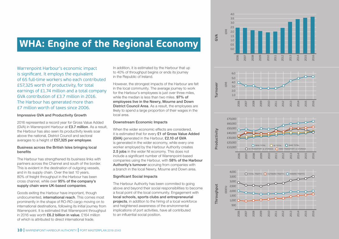
Warrenpoint Harbour’s economic impact is significant. It employs the equivalent of 65 full-time workers who each contributed £57,325 worth of productivity, for total earnings of £1.74 million and a total company GVA contribution of £3.7 million in 2016. The Harbour has generated more than £7 million worth of taxes since 2006.
Impressive GVA and Productivity Growth
2016 represented a record year for Gross Value Added (GVA) in Warrenpoint Harbour at £3.7 million. As a result, the Harbour has also seen its productivity levels soar above the national, District Council and sectoral averages to a height of £57,325 per employee.
Business across the British Isles bringing local benefits
The Harbour has strengthened its business links with partners across the Channel and south of the border. This is evident in the destination of outgoing vessels, and in its supply chain. Over the last 10 years, 80% of freight throughput in the Harbour has been cross channel, while over 95% of the company’s supply chain were UK-based companies.
Goods exiting the Harbour have important, though undocumented, international reach. This comes most prominently in the shape of RO-RO cargo moving on to international destinations, following its initial journey from Warrenpoint. It is estimated that Warrenpoint throughput in 2016 was worth £6.2 billion in value, £164 million of which is attributed to direct international trade.
WHA: Engine of the Regional Economy
In addition, it is estimated by the Harbour that up to 40% of throughput begins or ends its journey in the Republic of Ireland.
However, the strongest impacts of the Harbour are felt in the local community. The average journey to work for the Harbour’s employees is just over three miles, while the median is less than two miles. 97% of employees live in the Newry, Mourne and Down District Council Area. As a result, the employees are likely to spend a large proportion of their wages in the local area.
Downstream Economic Impacts
When the wider economic effects are considered, it is estimated that for every £1 of Gross Value Added (GVA) generated in the Harbour, £2.10 of GVA is generated in the wider economy, while every one worker employed by the Harbour Authority creates 2.5 jobs in the wider NI economy. This does not include a significant number of Warrenpoint-based companies using the Harbour, with 58% of the Harbour Authority’s turnover accruing from companies with a branch in the local Newry, Mourne and Down area.
Significant Social Impacts
The Harbour Authority has been commited to going above and beyond their social responsibilities to become a focal point of the local community. Engagement with local schools, sports clubs and entrepreneurial projects, in addition to the hiring of a local workforce and heightened awareness of the environmental implications of port activities, have all contributed to an influential social position.
0.0
0.5
1.01.5
2.0
3.0
2.5
3.5
4.0
2006
2007
2008
2009
2010
2011
2012
2013
2014
2015
2016
(£M
)
GVA
1.0
2.0
3.0
4.0
5.0
6.0
2006
2007
2008
2009
2010
2011
2012
2013
2014
2015
2016
(£M
)
Turn
over
2006
2007
2008
2009
2010
2011
2012
2013
2014
2015
2016
(000
’s)
500
1,000
1,500
2,000
2,500
3,000
3,500
4,000INWARD TRAFFICOUTWARD TRAFFICTOTAL TRAFFIC
Thro
ughp
utP
rodu
ctiv
ity
2006
2007
2008
2009
2010
2011
2012
2013
2014
2015
2016
£10,000
£20,000
£30,000
£40,000
£50,000
£60,000
£70,000
WHA TOTAL
NMD TRANSPORT & STORAGENI TRANSPORT & STORAGE
NI TOTAL NMD TOTAL
10 | WARRENPOINT HARBOUR AUTHORITY | PORT MASTERPLAN 2018-2043
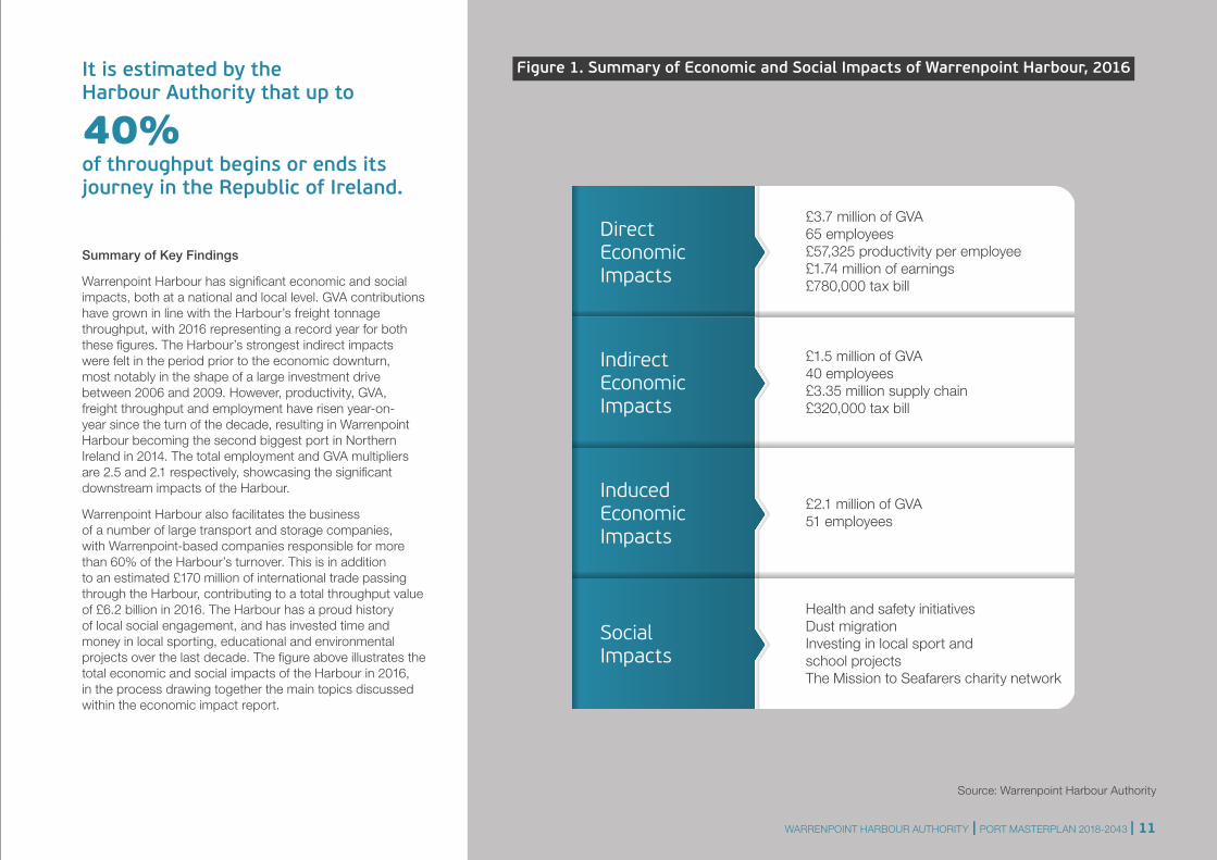
Figure 1. Summary of Economic and Social Impacts of Warrenpoint Harbour, 2016
Source: Warrenpoint Harbour Authority
Summary of Key Findings
Warrenpoint Harbour has significant economic and social impacts, both at a national and local level. GVA contributions have grown in line with the Harbour’s freight tonnage throughput, with 2016 representing a record year for both these figures. The Harbour’s strongest indirect impacts were felt in the period prior to the economic downturn, most notably in the shape of a large investment drive between 2006 and 2009. However, productivity, GVA, freight throughput and employment have risen year-on-year since the turn of the decade, resulting in Warrenpoint Harbour becoming the second biggest port in Northern Ireland in 2014. The total employment and GVA multipliers are 2.5 and 2.1 respectively, showcasing the significant downstream impacts of the Harbour.
Warrenpoint Harbour also facilitates the business of a number of large transport and storage companies, with Warrenpoint-based companies responsible for more than 60% of the Harbour’s turnover. This is in addition to an estimated £170 million of international trade passing through the Harbour, contributing to a total throughput value of £6.2 billion in 2016. The Harbour has a proud history of local social engagement, and has invested time and money in local sporting, educational and environmental projects over the last decade. The figure above illustrates the total economic and social impacts of the Harbour in 2016, in the process drawing together the main topics discussed within the economic impact report.
Direct Economic Impacts
Social Impacts
Indirect Economic Impacts
£1.5 million of GVA40 employees£3.35 million supply chain£320,000 tax bill
£3.7 million of GVA65 employees£57,325 productivity per employee£1.74 million of earnings£780,000 tax bill
Health and safety initiatives Dust migrationInvesting in local sport and school projectsThe Mission to Seafarers charity network
Induced Economic Impacts
£2.1 million of GVA51 employees
It is estimated by the Harbour Authority that up to
40% of throughput begins or ends its journey in the Republic of Ireland.
WARRENPOINT HARBOUR AUTHORITY | PORT MASTERPLAN 2018-2043 | 11
2.0 Introduction
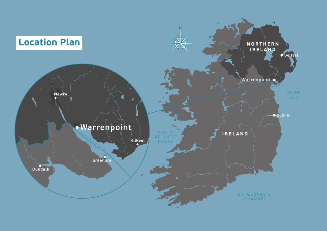
Warrenpoint Harbour Authority is one of Northern Ireland's main commercial ports serving a hinterland which includes the southern part of Northern Ireland and the northern part of the Republic of Ireland. Warrenpoint is the second port in Northern Ireland and the fifth on the island of Ireland. Its geographic position constitutes a major strategic advantage located halfway on the main strategic network of the Belfast to Dublin economic corridor.
Warrenpoint Port is a Trust Port and, like other Trust Ports across the UK, is not owned by Government but operates autonomously. The Port is required to operate in a commercial manner and is an independent statutory body. The main governing legislation under which Warrenpoint Port operates is the Harbours Act (Northern Ireland) 1970, The Warrenpoint Harbour Authority Order 1971, The Harbours (Northern Ireland) Order 2002 and The Warrenpoint Harbour Authority Order (Northern Ireland) 2002. Under this legislation, it is the duty of the designated Harbour Authority to take account of the Code of Practice as issued by the Department for Regional Development. The current Code of Practice was issued in November 2003 and updated in May 2008.
Warrenpoint Port is a Trust Port established by Actof Parliament. It is independent of government and isrequired to fund all of its activities from its own resources.
2.1 Approach to the MasterplanThe purpose of this Masterplan is to address the strategic challenges facing the Port:
• Economics – business climate and resultant market challenges;
• Dredging requirements and cost;
• Access – in particular the Southern Relief Road;
• The challenges surrounding Public Corporation status and the current debate around Trust Ports involvement in Whole of Government Accounting; and
• Implications of the UK decision to leave the European Union.
The Department for Infrastructure (formerly Department for Regional Development) issued an advisory document in relation to the production of Port Masterplans. As is consistent with this guidance, the Warrenpoint Harbour Port Masterplan is envisaged to cover a mid to long-term period of 25 years.
2.2 Warrenpoint Harbour Authority – Corporate Plan and Strategy Document
Taking advantage of its location, Warrenpoint Port aims to be the preferred location for import and export of goods. Its principle corporate objectives are:
Operate Profitably: The Port strives to operate profitably in order to build reserves and sustain future investments. These investments require a commercial rate of return, thus improving the Port for the benefit of all stakeholders;
Health, Safety and Environment: Operate in a manner where health, safety and environmental awareness are of the highest standards;
Regional Economic Driver and Good Corporate Citizen: Utilise all assets for the enhancement of stakeholder value for the Port and its hinterland. The Port will continue to build relationships with all its stakeholders (commercial, local, educational and social);
Corporate Governance: Ensure the Port is open and transparent to its stakeholders and that highest Corporate Governance standards are met as consistent with Trust Port requirements; and
Invest in People: Maintain the Port’s position as a good and fair employer which invests in its people to deliver the quality and efficiency of service required by stakeholders.
A2
A2
A2
B7
B7
R173
A2
NE W
RY R I V E R WARRENPOINTHARBOUR
0 250 500
12 | WARRENPOINT HARBOUR AUTHORITY | PORT MASTERPLAN 2018-2043
A2
A2
A2
B7
B7
R173
A2
NE W
RY R I V E R WARRENPOINTHARBOUR
0 250 500
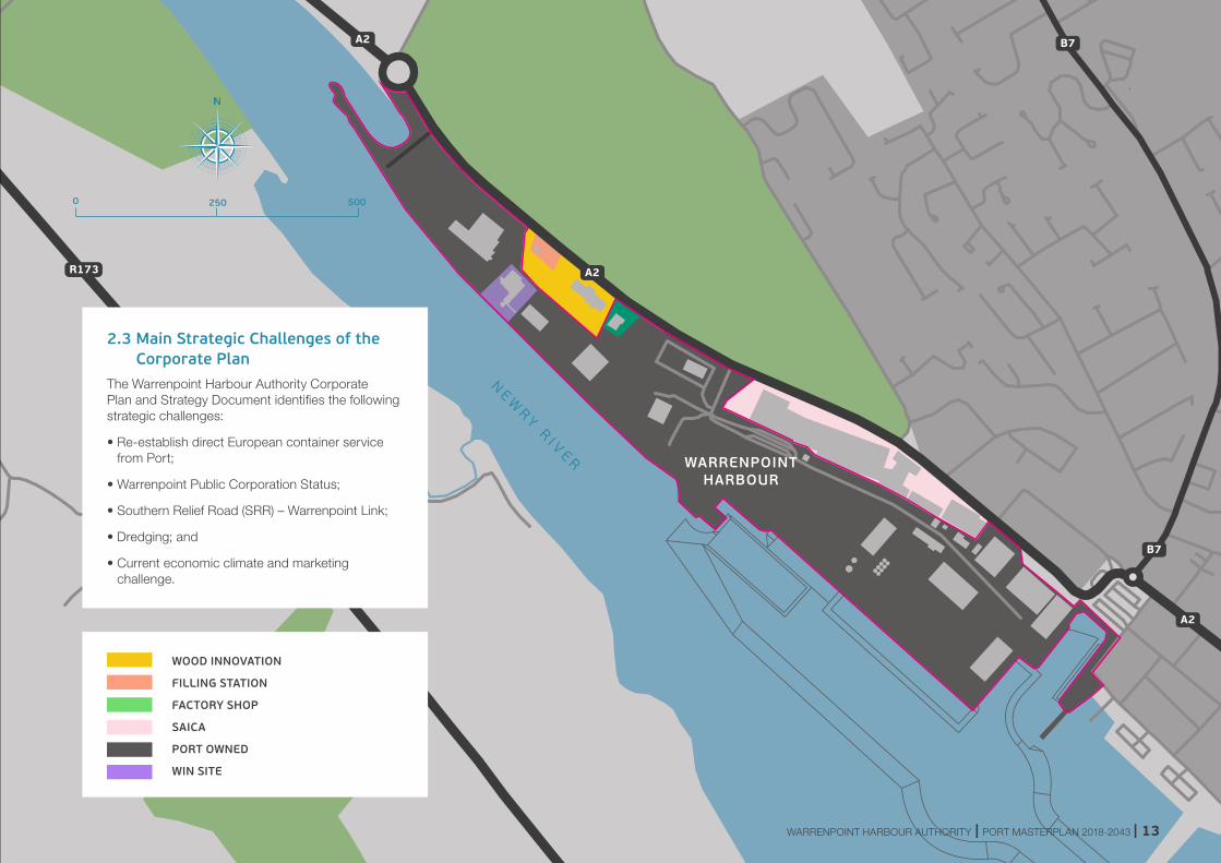
2.3 Main Strategic Challenges of the Corporate Plan
The Warrenpoint Harbour Authority Corporate Plan and Strategy Document identifies the following strategic challenges:
• Re-establish direct European container service from Port;
• Warrenpoint Public Corporation Status;
• Southern Relief Road (SRR) – Warrenpoint Link;
• Dredging; and
• Current economic climate and marketing challenge.
WOOD INNOVATION
FILLING STATION
FACTORY SHOP
SAICA
PORT OWNED
WIN SITE
WARRENPOINT HARBOUR AUTHORITY | PORT MASTERPLAN 2018-2043 | 13
2.4 Guidance on the Preparation of Port Masterplans (Department for Regional Development, 2009)The Department for Infrastructure (formerly Department for Regional Development) issued an advisory document in relation to the production of Port Masterplans. As is consistent with this guidance, the Warrenpoint Harbour Masterplan is envisaged to cover a mid to long-term period of 25 years. It also suggests that port masterplans address:
• Forecasts
• Update to corporate plan and strategy
• Safeguarding, property and blight
• Inland access
• Coastal shipping connectivity
• Social and economic impacts/regeneration
• Safety and security
• Environmental impacts: habitats, water pollution, marine spatial planning and the Water Framework Directive
• 'Local' emissions and 'cold ironing'
• Global emissions, climate change and extreme weather events
• Noise
2.5 Projects of Influence2.5.1 Newry Southern Relief Road
Within the draft Banbridge, Newry and Mourne Area Plan 2015, a proposal was included for the Newry Southern Bypass. This road will act as a long-term strategic road improvement to link the A1 Dublin Road, a key strategic route, to the A2 Warrenpoint Road, a trunk road leading to Warrenpoint Port.
In October 2006, Roads Service undertook a study to assess a range of options to provide relief to traffic on the Dublin Road, Bridge Street, William Street, Abbey Way and Warrenpoint Road area of the city of Newry. A Feasibility Study Report, published in August 2009, concluded that the provision of the new road link between the A2 Warrenpoint Road and the A1 Belfast/Dublin Key Transport Corridor was feasible and would be expected to provide significant economic benefits. The Feasibility Report stated that:
“Traffic conditions within the city are influenced significantly by the large volume of traffic, which includes a significant proportion of heavy goods vehicles travelling to/from Belfast and Dublin to the port of Warrenpoint. The geographical relationship between Newry, Warrenpoint Harbour and the strategic road network has led to a difficult mix of local traffic and strategic heavy goods traffic, which contributes to the delays and congestion experienced on some of the main routes through the city.”
The following benefits of the Newry Southern Relief Road were highlighted:
• Removing traffic from Newry City, reducing congestion and improving air quality;
• Road Safety: providing significant reductions in the number of accidents;
• Economic Impact: significantly reduced peak and off-peak journey times on the road network and facilitating economic growth through the provision of improved strategic transport links;
• Transport Economic: Corridor options would return Net Present Values of between £70m and £112m;
• Low-medium crossing corridor; and
• High crossing corridor.
More recently, the Newry Southern Relief Road proposal has been included in Transport NI’s Forward Planning Schedule and work has commenced on the Stage 1 Preliminary Options Scheme Assessment. This work will involve updating key project information and will require traffic and environmental surveys to be undertaken. Currently, four possible route corridors for the southern relief road are under assessment.
2.5.2 Narrow Water Bridge
Plans to build the cross-border road bridge across the Newry River linking counties Down and Louth, also known as the Narrow Water Bridge, secured planning permission in 2012. The WHA Masterplan provides for any future bridge at Narrow Water to be accommodated in its proposed treatment of any new road scheme proposed at Narrow Water roundabout.
14 | WARRENPOINT HARBOUR AUTHORITY | PORT MASTERPLAN 2018-2043
© MOURNE IMAGES WARRENPOINT HARBOUR AUTHORITY | PORT MASTERPLAN 2018-2043 | 15
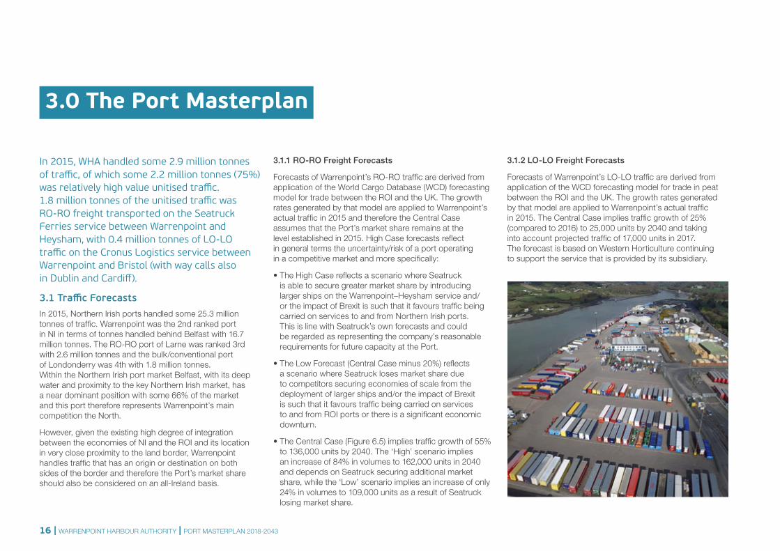
In 2015, WHA handled some 2.9 million tonnes of traffic, of which some 2.2 million tonnes (75%) was relatively high value unitised traffic. 1.8 million tonnes of the unitised traffic was RO-RO freight transported on the Seatruck Ferries service between Warrenpoint and Heysham, with 0.4 million tonnes of LO-LO traffic on the Cronus Logistics service between Warrenpoint and Bristol (with way calls also in Dublin and Cardiff).
3.1 Traffic Forecasts In 2015, Northern Irish ports handled some 25.3 million tonnes of traffic. Warrenpoint was the 2nd ranked port in NI in terms of tonnes handled behind Belfast with 16.7 million tonnes. The RO-RO port of Larne was ranked 3rd with 2.6 million tonnes and the bulk/conventional port of Londonderry was 4th with 1.8 million tonnes. Within the Northern Irish port market Belfast, with its deep water and proximity to the key Northern Irish market, has a near dominant position with some 66% of the market and this port therefore represents Warrenpoint’s main competition the North.
However, given the existing high degree of integration between the economies of NI and the ROI and its location in very close proximity to the land border, Warrenpoint handles traffic that has an origin or destination on both sides of the border and therefore the Port’s market share should also be considered on an all-Ireland basis.
3.1.1 RO-RO Freight Forecasts
Forecasts of Warrenpoint’s RO-RO traffic are derived from application of the World Cargo Database (WCD) forecasting model for trade between the ROI and the UK. The growth rates generated by that model are applied to Warrenpoint’s actual traffic in 2015 and therefore the Central Case assumes that the Port’s market share remains at the level established in 2015. High Case forecasts reflect in general terms the uncertainty/risk of a port operating in a competitive market and more specifically:
• The High Case reflects a scenario where Seatruck is able to secure greater market share by introducing larger ships on the Warrenpoint–Heysham service and/or the impact of Brexit is such that it favours traffic being carried on services to and from Northern Irish ports. This is line with Seatruck’s own forecasts and could be regarded as representing the company’s reasonable requirements for future capacity at the Port.
• The Low Forecast (Central Case minus 20%) reflects a scenario where Seatruck loses market share due to competitors securing economies of scale from the deployment of larger ships and/or the impact of Brexit is such that it favours traffic being carried on services to and from ROI ports or there is a significant economic downturn.
• The Central Case (Figure 6.5) implies traffic growth of 55% to 136,000 units by 2040. The ‘High’ scenario implies an increase of 84% in volumes to 162,000 units in 2040 and depends on Seatruck securing additional market share, while the ‘Low’ scenario implies an increase of only 24% in volumes to 109,000 units as a result of Seatruck losing market share.
3.1.2 LO-LO Freight Forecasts
Forecasts of Warrenpoint’s LO-LO traffic are derived from application of the WCD forecasting model for trade in peat between the ROI and the UK. The growth rates generated by that model are applied to Warrenpoint’s actual traffic in 2015. The Central Case implies traffic growth of 25% (compared to 2016) to 25,000 units by 2040 and taking into account projected traffic of 17,000 units in 2017. The forecast is based on Western Horticulture continuing to support the service that is provided by its subsidiary.
3.0 The Port Masterplan
16 | WARRENPOINT HARBOUR AUTHORITY | PORT MASTERPLAN 2018-2043
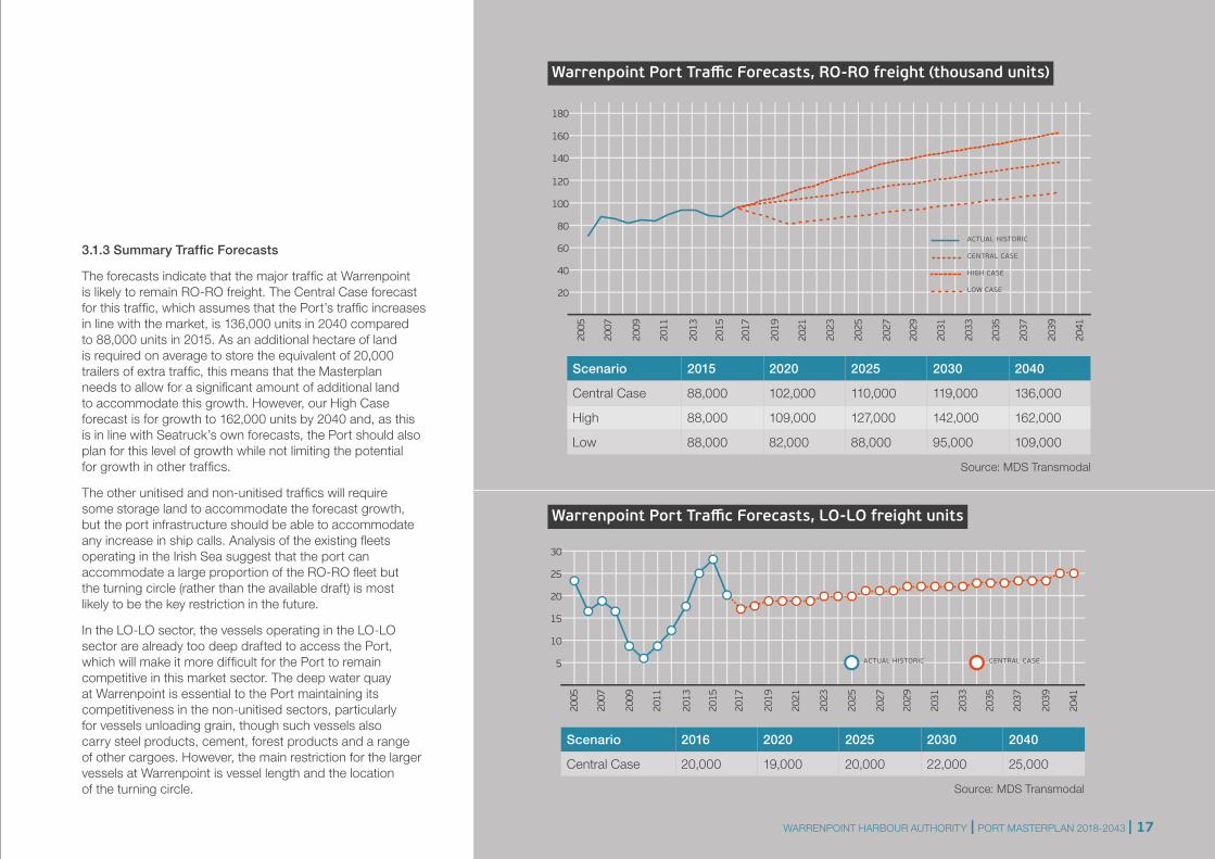
3.1.3 Summary Traffic Forecasts
The forecasts indicate that the major traffic at Warrenpoint is likely to remain RO-RO freight. The Central Case forecast for this traffic, which assumes that the Port’s traffic increases in line with the market, is 136,000 units in 2040 compared to 88,000 units in 2015. As an additional hectare of land is required on average to store the equivalent of 20,000 trailers of extra traffic, this means that the Masterplan needs to allow for a significant amount of additional land to accommodate this growth. However, our High Case forecast is for growth to 162,000 units by 2040 and, as this is in line with Seatruck’s own forecasts, the Port should also plan for this level of growth while not limiting the potential for growth in other traffics.
The other unitised and non-unitised traffics will require some storage land to accommodate the forecast growth, but the port infrastructure should be able to accommodate any increase in ship calls. Analysis of the existing fleets operating in the Irish Sea suggest that the port can accommodate a large proportion of the RO-RO fleet but the turning circle (rather than the available draft) is most likely to be the key restriction in the future.
In the LO-LO sector, the vessels operating in the LO-LO sector are already too deep drafted to access the Port, which will make it more difficult for the Port to remain competitive in this market sector. The deep water quay at Warrenpoint is essential to the Port maintaining its competitiveness in the non-unitised sectors, particularly for vessels unloading grain, though such vessels also carry steel products, cement, forest products and a range of other cargoes. However, the main restriction for the larger vessels at Warrenpoint is vessel length and the location of the turning circle.
Scenario 2016 2020 2025 2030 2040
Central Case 20,000 19,000 20,000 22,000 25,000
5
2005
2007
2009
2011
2013
2015
2017
2019
2021
2023
2025
2027
2029
2031
2033
2035
2037
2039
2041
10
15
20
25
30
ACTUAL HISTORIC CENTRAL CASE
Source: MDS Transmodal
Scenario 2015 2020 2025 2030 2040
Central Case 88,000 102,000 110,000 119,000 136,000
High 88,000 109,000 127,000 142,000 162,000
Low 88,000 82,000 88,000 95,000 109,000
20
2005
2007
2009
2011
2013
2015
2017
2019
2021
2023
2025
2027
2029
2031
2033
2035
2037
2039
2041
40
60
80
100
120
140
160
180
ACTUAL HISTORIC
CENTRAL CASE
HIGH CASE
LOW CASE
Source: MDS Transmodal
Warrenpoint Port Traffic Forecasts, RO-RO freight (thousand units)
Warrenpoint Port Traffic Forecasts, LO-LO freight units
WARRENPOINT HARBOUR AUTHORITY | PORT MASTERPLAN 2018-2043 | 17
A2
A2
A2
B7
B7
R173
A2
WARRENPOINTHARBOUR
NE W
RY R I V E R
THE GUT GILBERT ASH
GILBERT ASH ENTRANCE
FILLING STATION
FARRELL’S YARD MAIN ENTRANCE
PROPOSED CO2 PLANT
RO-RO GATEHOUSE
PORT GATEHOUSE
MAINTENANCE FACILITIES
OPERATIONS BUILDINGS
CEMENT SILOS
GRAIN SILOS
KELLY’S QUAY
CUSTOM HOUSE QUAY 3.0m CD
SECONDARY EMERGENCY ACCESS
0 250 500
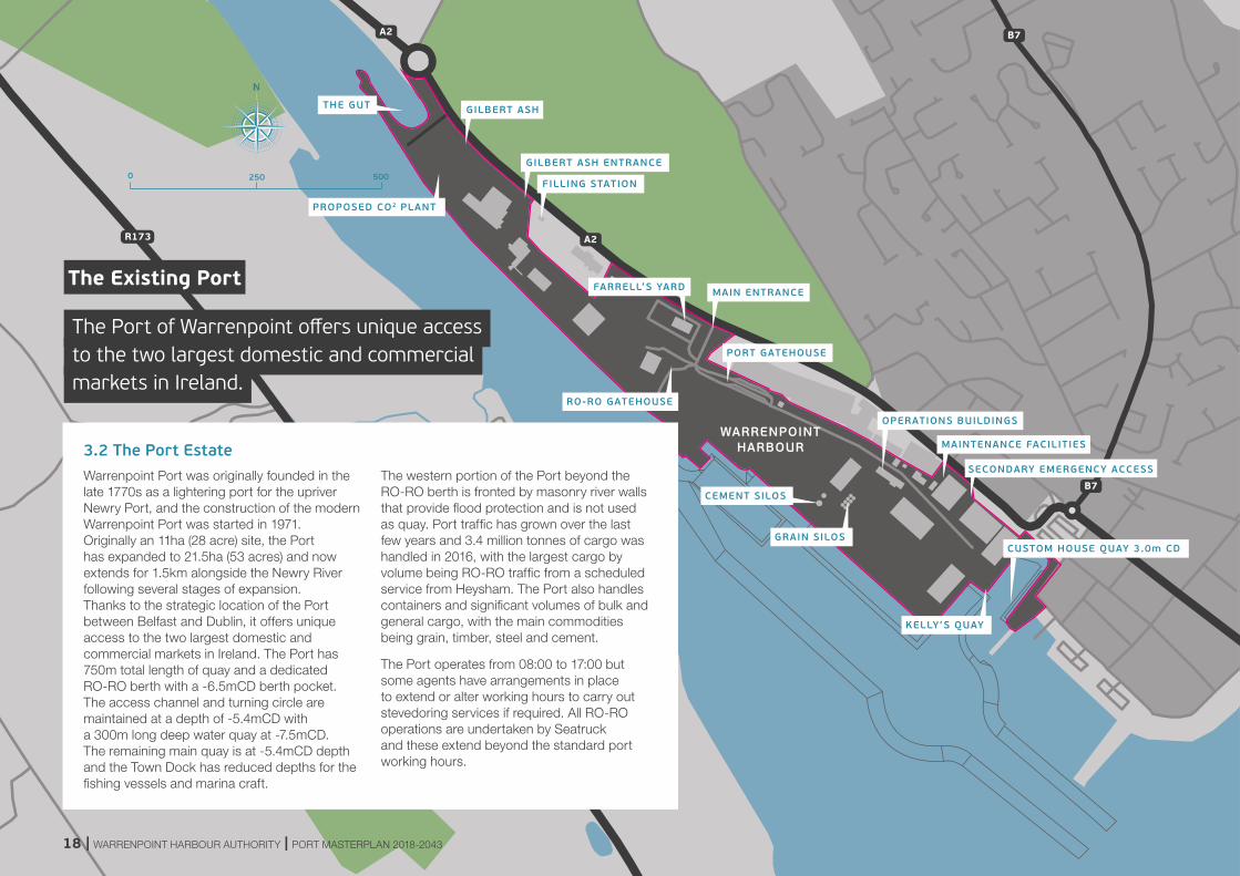
3.2 The Port EstateWarrenpoint Port was originally founded in the late 1770s as a lightering port for the upriver Newry Port, and the construction of the modern Warrenpoint Port was started in 1971. Originally an 11ha (28 acre) site, the Port has expanded to 21.5ha (53 acres) and now extends for 1.5km alongside the Newry River following several stages of expansion. Thanks to the strategic location of the Port between Belfast and Dublin, it offers unique access to the two largest domestic and commercial markets in Ireland. The Port has 750m total length of quay and a dedicated RO-RO berth with a -6.5mCD berth pocket. The access channel and turning circle are maintained at a depth of -5.4mCD with a 300m long deep water quay at -7.5mCD. The remaining main quay is at -5.4mCD depth and the Town Dock has reduced depths for the fishing vessels and marina craft.
The western portion of the Port beyond the RO-RO berth is fronted by masonry river walls that provide flood protection and is not used as quay. Port traffic has grown over the last few years and 3.4 million tonnes of cargo was handled in 2016, with the largest cargo by volume being RO-RO traffic from a scheduled service from Heysham. The Port also handles containers and significant volumes of bulk and general cargo, with the main commodities being grain, timber, steel and cement.
The Port operates from 08:00 to 17:00 but some agents have arrangements in place to extend or alter working hours to carry out stevedoring services if required. All RO-RO operations are undertaken by Seatruck and these extend beyond the standard port working hours.
The Existing Port
The Port of Warrenpoint offers unique access to the two largest domestic and commercialmarkets in Ireland.
18 | WARRENPOINT HARBOUR AUTHORITY | PORT MASTERPLAN 2018-2043
A2
A2
A2
B7
B7
R173
A2
NE W
RY R I V E R
WARRENPOINTHARBOUR
4a PROPOSED OFFICE/COMMERCIAL BUILDING
4b PROPOSED WHA OFFICES (OPT 1)
4c PROPOSED WHA OFFICES (OPT 2)
EXISTING PORT ENTRANCE
3 PROPOSED SECOND ENTRANCE
5 RECLAIMED LAND
ADDITIONAL MARINE BERTHS
NEW PORT OFFICE AT TOWN DOCK
6 PROPOSED CO2 PLANT
8 DEMOLISH SHED 10
7 RELOCATE SHED 9 TO GILBERT ASH
0 250 500
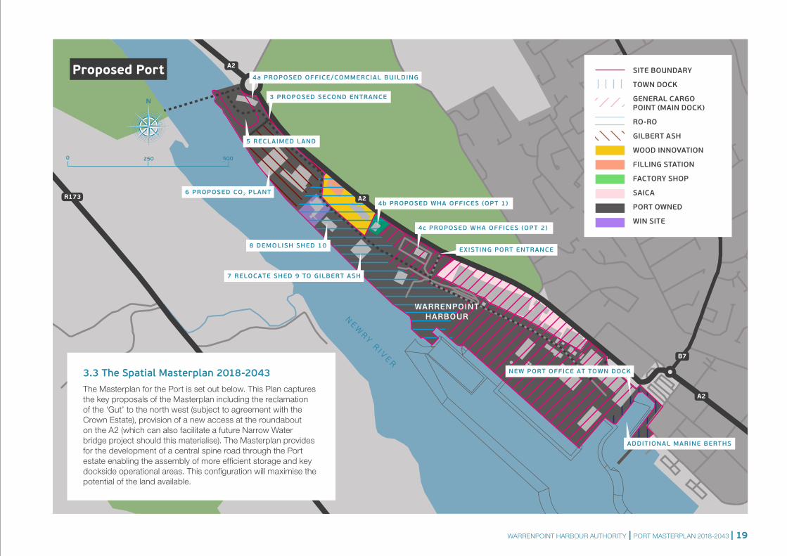
3.3 The Spatial Masterplan 2018-2043 The Masterplan for the Port is set out below. This Plan captures the key proposals of the Masterplan including the reclamation of the ‘Gut’ to the north west (subject to agreement with the Crown Estate), provision of a new access at the roundabout on the A2 (which can also facilitate a future Narrow Water bridge project should this materialise). The Masterplan provides for the development of a central spine road through the Port estate enabling the assembly of more efficient storage and key dockside operational areas. This configuration will maximise the potential of the land available.
SITE BOUNDARY
TOWN DOCK
GENERAL CARGO POINT (MAIN DOCK)
RO-RO
GILBERT ASH
WOOD INNOVATION
FILLING STATION
FACTORY SHOP
SAICA
PORT OWNED
WIN SITE
Proposed Port
WARRENPOINT HARBOUR AUTHORITY | PORT MASTERPLAN 2018-2043 | 19
3 lane road2 lane in to allow for queuing1 lane out
Harbour administration building
(to be Warrenpoint gateway feature)
20m radius bend
Ferry check inHarbour SecurityWeighbridge'sLocation and layout to be determined.
No private cars to be permitted beyond securitypoint.
NOTEDepending on location of Ferry Check in, theinternal road may be reduced to two lane, but aminimum 100m long third lane must be providedat the ferry check in.
Reclaimed landopen storage or staff parking
Reclaimed landLandscaping
Harbour Security Weighbridge's
Ferry check in
FerryHarbour
Exit
FerryHarbourExit
Exact position of the internal roadway to be determined.The location of the roadway must ensure that any landeither side remains of use to the harbour authority
Narrow Water Bridge
Harbour access 50m fromroundaboutNo right turn into harbour
Staff and visitor car park33 spaces shown
A2
A2
N E W R Y R I V E R
0
Metres
10 20 30 40 60 80
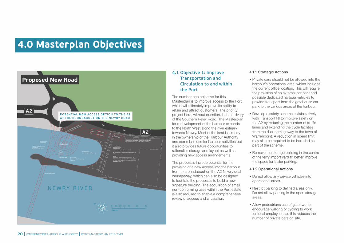
4.0 Masterplan Objectives
4.1 Objective 1: Improve Transportation and Circulation to and within the Port
The number one objective for this Masterplan is to improve access to the Port which will ultimately improve its ability to retain and attract customers. The priority project here, without question, is the delivery of the Southern Relief Road. The Masterplan for redevelopment of the harbour expands to the North West along the river estuary towards Newry. Most of the land is already in the ownership of the Harbour Authority and some is in use for harbour activities but it also provides future opportunities to rationalise storage and layout as well as providing new access arrangements.
The proposals include potential for the provision of a new access into the harbour from the roundabout on the A2 Newry dual carriageway, which can also be designed to facilitate the proposals to build a new signature building. The acquisition of small non-conforming uses within the Port estate is also required to enable a comprehensive review of access and circulation.
4.1.1 Strategic Actions
• Private cars should not be allowed into the harbour’s operational area, which includes the current office location. This will require the provision of an external car park and possible dedicated harbour vehicles to provide transport from the gatehouse car park to the various areas of the harbour.
• Develop a safety scheme collaboratively with Transport NI to improve safety on the A2 by reducing the number of traffic lanes and extending the cycle facilities from the dual carriageway to the town of Warrenpoint. A reduction in speed limit may also be required to be included as part of the scheme.
• Remove the storage building in the centre of the ferry import yard to better improve the space for trailer parking.
4.1.2 Operational Actions
• Do not allow any private vehicles into operational areas.
• Restrict parking to defined areas only. Do not allow parking in the open storage areas.
• Allow pedestrians use of gate two to encourage walking or cycling to work for local employees, as this reduces the number of private cars on site.
POTENTIAL NE W ACCE SS OP TION TO THE A2 AT THE ROUNDABOUT ON THE NE WRY ROAD
Proposed New Road
20 | WARRENPOINT HARBOUR AUTHORITY | PORT MASTERPLAN 2018-2043
Priority Projects
• Secure delivery of the Southern Relief Road to broaden regional strategic access
• Improve the road layout within the Port’s operational area
• Traffic calming on the A2
• Develop new entrance and Port administration building
• Better define pedestrian routes and keep them clear.
• Purge the site to remove items that do not need to be in the harbour, relocate long-term storage items such as trailers to non-operational areas and dispose of scrap items.
• Fit flashing beacons to all harbour vehicles that move in the operational area, and require all vehicles moving within the harbour to use them along with flashing hazard lights.
• Identify locations where HGV drivers can take rest breaks, and prevent rest breaks being taken in areas that can affect safety (such as covering directional signs).
• Request the ferry company to provide an additional gate for times of high demand as facilitating quicker access for HGVs will reduce the length of queue.
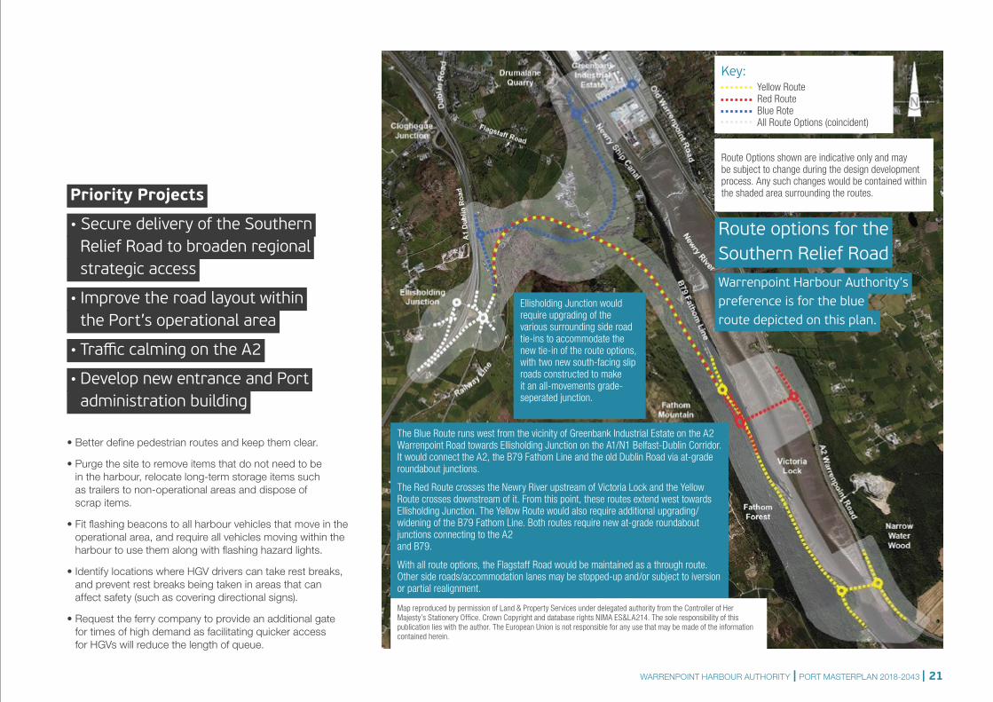
Route options for the Southern Relief Road
Warrenpoint Harbour Authority’s preference is for the blue route depicted on this plan.
Ellisholding Junction would require upgrading of the various surrounding side road tie-ins to accommodate the new tie-in of the route options, with two new south-facing slip roads constructed to make it an all-movements grade-seperated junction.
Route Options shown are indicative only and may be subject to change during the design development process. Any such changes would be contained within the shaded area surrounding the routes.
Key: Yellow Route Red Route Blue Rote All Route Options (coincident)
The Blue Route runs west from the vicinity of Greenbank Industrial Estate on the A2 Warrenpoint Road towards Ellisholding Junction on the A1/N1 Belfast-Dublin Corridor. It would connect the A2, the B79 Fathom Line and the old Dublin Road via at-grade roundabout junctions.
The Red Route crosses the Newry River upstream of Victoria Lock and the Yellow Route crosses downstream of it. From this point, these routes extend west towards Ellisholding Junction. The Yellow Route would also require additional upgrading/widening of the B79 Fathom Line. Both routes require new at-grade roundabout junctions connecting to the A2 and B79.
With all route options, the Flagstaff Road would be maintained as a through route. Other side roads/accommodation lanes may be stopped-up and/or subject to iversion or partial realignment.
Map reproduced by permission of Land & Property Services under delegated authority from the Controller of Her Majesty’s Stationery Office. Crown Copyright and database rights NIMA ES&LA214. The sole responsibility of this publication lies with the author. The European Union is not responsible for any use that may be made of the information contained herein.
WARRENPOINT HARBOUR AUTHORITY | PORT MASTERPLAN 2018-2043 | 21
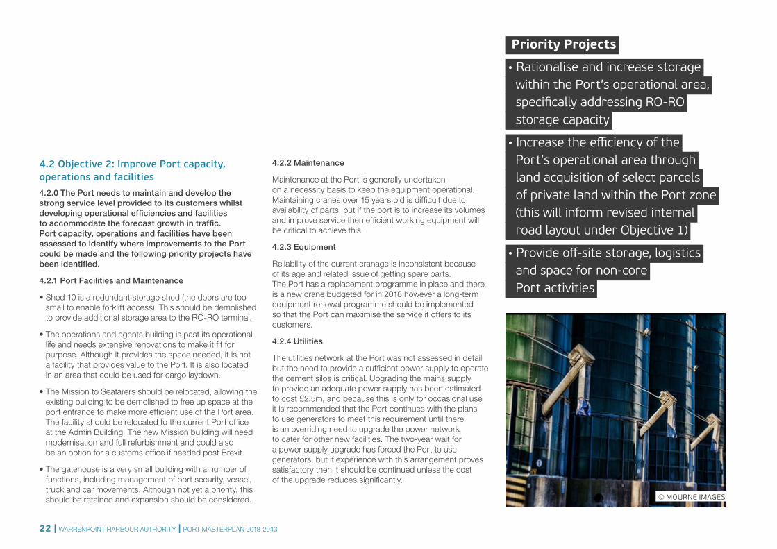
4.2 Objective 2: Improve Port capacity, operations and facilities 4.2.0 The Port needs to maintain and develop the strong service level provided to its customers whilst developing operational efficiencies and facilities to accommodate the forecast growth in traffic. Port capacity, operations and facilities have been assessed to identify where improvements to the Port could be made and the following priority projects have been identified.
4.2.1 Port Facilities and Maintenance
• Shed 10 is a redundant storage shed (the doors are too small to enable forklift access). This should be demolished to provide additional storage area to the RO-RO terminal.
• The operations and agents building is past its operational life and needs extensive renovations to make it fit for purpose. Although it provides the space needed, it is not a facility that provides value to the Port. It is also located in an area that could be used for cargo laydown.
• The Mission to Seafarers should be relocated, allowing the existing building to be demolished to free up space at the port entrance to make more efficient use of the Port area. The facility should be relocated to the current Port office at the Admin Building. The new Mission building will need modernisation and full refurbishment and could also be an option for a customs office if needed post Brexit.
• The gatehouse is a very small building with a number of functions, including management of port security, vessel, truck and car movements. Although not yet a priority, this should be retained and expansion should be considered.
4.2.2 Maintenance
Maintenance at the Port is generally undertaken on a necessity basis to keep the equipment operational. Maintaining cranes over 15 years old is difficult due to availability of parts, but if the port is to increase its volumes and improve service then efficient working equipment will be critical to achieve this.
4.2.3 Equipment
Reliability of the current cranage is inconsistent because of its age and related issue of getting spare parts. The Port has a replacement programme in place and there is a new crane budgeted for in 2018 however a long-term equipment renewal programme should be implemented so that the Port can maximise the service it offers to its customers.
4.2.4 Utilities
The utilities network at the Port was not assessed in detail but the need to provide a sufficient power supply to operate the cement silos is critical. Upgrading the mains supply to provide an adequate power supply has been estimated to cost £2.5m, and because this is only for occasional use it is recommended that the Port continues with the plans to use generators to meet this requirement until there is an overriding need to upgrade the power network to cater for other new facilities. The two-year wait for a power supply upgrade has forced the Port to use generators, but if experience with this arrangement proves satisfactory then it should be continued unless the cost of the upgrade reduces significantly.
Priority Projects
• Rationalise and increase storage within the Port’s operational area, specifically addressing RO-RO storage capacity
• Increase the efficiency of the Port’s operational area through land acquisition of select parcels of private land within the Port zone (this will inform revised internal road layout under Objective 1)
• Provide off-site storage, logistics and space for non-core Port activities
© MOURNE IMAGES
22 | WARRENPOINT HARBOUR AUTHORITY | PORT MASTERPLAN 2018-2043

A2
A2
A2
B7
B7
R173
A2
NE W
RY R I V E R
WARRENPOINTHARBOUR
0 250 500
4.2.5 Former Gilbert Ash site
The former Gilbert Ash site could play a more significant role in improving capacity and operations within the context of the Port’s existing landholding although it is assumed that the CO2 storage facility, which has already been granted full planning permission, will be constructed and will take up a portion of the currently undeveloped plot to the west of the timber yard.
The existing timber storage facility in this area should be maintained and there would be some operational value in constructing a new shed to replace the existing sheds but the cost of this is not justified for the limited benefit.
The proposals for the remainder of the site are considered in two phases. Phase 1 is recommended and Phase 2 are options than could be considered if further expansion is needed.
TOWN DOCK
GENERAL CARGO PORT (MAIN PORT)
RO-RO
GILBERT ASH
WARRENPOINT HARBOUR AUTHORITY | PORT MASTERPLAN 2018-2043 | 23
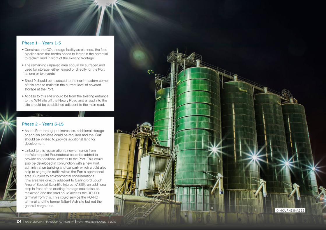
Phase 1 – Years 1-5• Construct the CO2 storage facility as planned, the feed
pipeline from the berths needs to factor in the potential to reclaim land in front of the existing frontage.
• The remaining unpaved area should be surfaced and used for storage, either leased or directly for the Port as one or two yards.
• Shed 9 should be relocated to the north-eastern corner of this area to maintain the current level of covered storage at the Port.
• Access to this site should be from the existing entrance to the WIN site off the Newry Road and a road into the site should be established adjacent to the main road.
Phase 2 – Years 6-15• As the Port throughput increases, additional storage
or add-on services could be required and the ‘Gut’ should be in-filled to provide additional land for development.
• Linked to this reclamation a new entrance from the Warrenpoint Roundabout could be added to provide an additional access to the Port. This could also be developed in conjunction with a new Port administration building and car park which would also help to segregate traffic within the Port’s operational area. Subject to environmental considerations (this area lies directly adjacent to Carlingford Lough Area of Special Scientific Interest (ASSI)), an additional strip in front of the existing frontage could also be reclaimed and the road could access the RO-RO terminal from this. This could service the RO-RO terminal and the former Gilbert Ash site but not the general cargo area.
© MOURNE IMAGES
24 | WARRENPOINT HARBOUR AUTHORITY | PORT MASTERPLAN 2018-2043
A2
A2
A2
B7
B7
R173
A2
NE W
RY R I V E R
WARRENPOINTHARBOUR
0 250 500
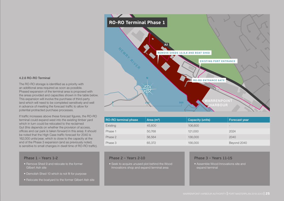
4.2.6 RO-RO Terminal
The RO-RO storage is identified as a priority with an additional area required as soon as possible. Phased expansion of the terminal area is proposed with the areas provided and capacities shown in the table below. This expansion will involve the purchase of third-party land which will need to be completed sensitively and well in advance of meeting the forecast traffic to allow for potential protracted purchase processes.
If traffic increases above these forecast figures, the RO-RO terminal could expand west into the existing timber yard which in turn could be relocated to the reclaimed Gut (this depends on whether the provision of access, offices and car park is taken forward in this area). It should be noted that the High Case traffic forecast for 2040 is 162,000 units/year, which is close to the capacity at the end of the Phase 3 expansion (and as previously noted, is sensitive to small changes in dwell time of RO-RO traffic).
RO-RO terminal phase Area (m²) Capacity (units) Forecast year
Existing 45,600 106,600 -
Phase 1 50,768 121,000 2024
Phase 2 56,564 136,000 2040
Phase 3 65,372 156,000 Beyond 2040
Phase 1 – Years 1-2• Remove Shed 9 and relocate to the former
Gilbert Ash site
• Demolish Shed 10 which is not fit for purpose
• Relocate the boatyard to the former Gilbert Ash site
Phase 3 – Years 11-15• Assemble Wood Innovations site and
expand terminal
Phase 2 – Years 2-10• Seek to acquire unused plot behind the Wood
Innovations shop and expand terminal area
E XIST ING PORT ENTR ANCE
REMOVE SHEDS 10,9,8 AND BOAT SHED
RO -RO ENTR ANCE GATE
RO-RO Terminal Phase 1
WARRENPOINT HARBOUR AUTHORITY | PORT MASTERPLAN 2018-2043 | 25

A2
A2
A2
B7
B7
R173
A2
NE W
RY R I V E R
WARRENPOINTHARBOUR
0 250 500
4.2.7 General Cargo Port
There are several improvements identified for the main Port area to improve the efficiency of the area. The capacity assessments identified that there are sufficient quays and storage facilities to handle the projected cargoes but improvements should be made so that the Port can work more efficiently and so is able to handle any new cargoes or unforeseen cargo growth whilst improving already good service levels.
The developments are shown in only two phases but these are guideline timescales only and the Port should invest when the need is identified. Safe access off the Newry Road to and from the Port is the priority here and steps should be taken to address this immediately (see Objective 1). Only one drawing is shown for both phases.
The capacity assessment has not identified the need to acquire and develop the SAICA site but this area does offer potential expansion opportunities if new business and new demands are realised. SAICA is an important local employer and has been at this site since 1948 so expansion here should only be considered if the site becomes available and if the Port undergoes major growth that cannot be accommodated within the existing Port boundary.
Phase 2 – Years 6-15• Refurbish Admin Building for customs
offices (if required) and The Mission to Seafarers.
• Removal of The Mission to Seafarers building and relocate to the Admin Building.
• Demolish old grain silos when at the end of their working life and construct new larger capacity silos nearer the quay adjacent to the cement silos.
• Expand Shed 12 if needed for grain storage.
Phase 1 – Years 1-5• Improve safety of the Port entrance from
Newry Road.
• Define road system through the Port and relocate the existing trailer parking along the boundary with the SAICA plant.
• If the option of a new Port operations building at the roundabout is discounted, progress the options of locating the Harbour offices at the Marina Dock or at a redeveloped Aylesfort site. In either scenario, a new office building could incorporate office space for lease and meeting or small conference facilities, as it would be outside the Port. Meeting space for Warrenpoint Enterprise Centre (WIN site) should also be provided where this site is purchased as part of the implementation of the Masterplan.
• Once a new office building is constructed, the existing operations building should be demolished and the area turned over to open storage.
General Cargo Port
E XIST ING PORT ENTR ANCE
OTHER C ARGO STOR AGE ARE A
CUSTOM HOUSE
NE W AGRIBULK S ILOS
E XPANDED MAINTENANCE FACIL IT Y
26 | WARRENPOINT HARBOUR AUTHORITY | PORT MASTERPLAN 2018-2043
A2
A2
A2
B7
B7
R173
A2
NE W
RY R I V E R
WARRENPOINTHARBOUR
0 250 500
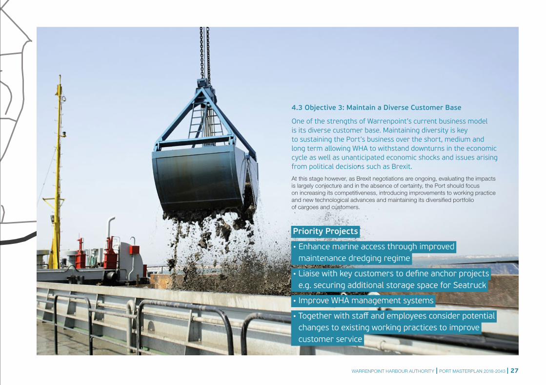
4.3 Objective 3: Maintain a Diverse Customer Base
One of the strengths of Warrenpoint’s current business model is its diverse customer base. Maintaining diversity is key to sustaining the Port’s business over the short, medium and long term allowing WHA to withstand downturns in the economic cycle as well as unanticipated economic shocks and issues arising from political decisions such as Brexit.
At this stage however, as Brexit negotiations are ongoing, evaluating the impacts is largely conjecture and in the absence of certainty, the Port should focus on increasing its competitiveness, introducing improvements to working practice and new technological advances and maintaining its diversified portfolio of cargoes and customers.
Priority Projects
• Enhance marine access through improved maintenance dredging regime
• Liaise with key customers to define anchor projects e.g. securing additional storage space for Seatruck
• Improve WHA management systems
• Together with staff and employees consider potential changes to existing working practices to improve customer service
WARRENPOINT HARBOUR AUTHORITY | PORT MASTERPLAN 2018-2043 | 27
N1
1
N1
20
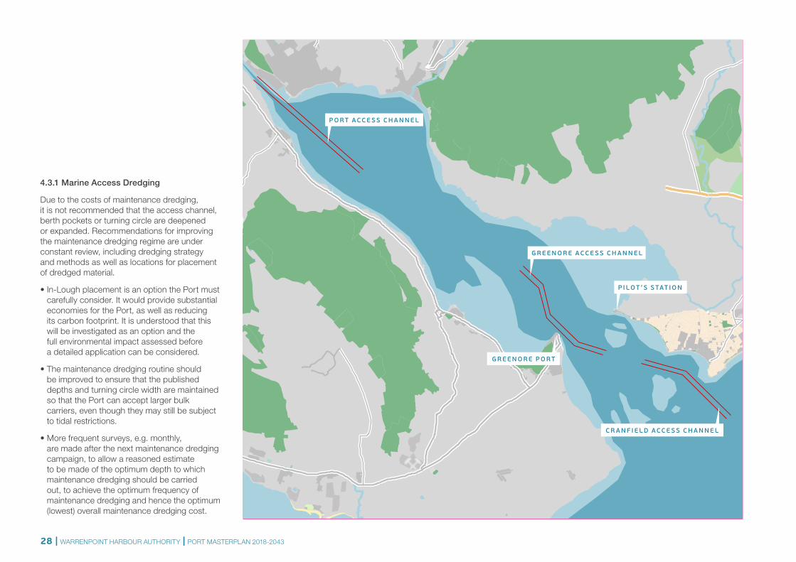
194.3.1 Marine Access Dredging
Due to the costs of maintenance dredging, it is not recommended that the access channel, berth pockets or turning circle are deepened or expanded. Recommendations for improving the maintenance dredging regime are under constant review, including dredging strategy and methods as well as locations for placement of dredged material.
• In-Lough placement is an option the Port must carefully consider. It would provide substantial economies for the Port, as well as reducing its carbon footprint. It is understood that this will be investigated as an option and the full environmental impact assessed before a detailed application can be considered.
• The maintenance dredging routine should be improved to ensure that the published depths and turning circle width are maintained so that the Port can accept larger bulk carriers, even though they may still be subject to tidal restrictions.
• More frequent surveys, e.g. monthly, are made after the next maintenance dredging campaign, to allow a reasoned estimate to be made of the optimum depth to which maintenance dredging should be carried out, to achieve the optimum frequency of maintenance dredging and hence the optimum (lowest) overall maintenance dredging cost.
P I L OT ’S S TAT I O N
G R EE N O R E ACCE S S C H A N N E L
P O R T ACCE S S C H A N N E L
G R EE N O R E P O R T
C R A N F I E L D ACCE S S C H A N N E L
28 | WARRENPOINT HARBOUR AUTHORITY | PORT MASTERPLAN 2018-2043
4.3.2 Vessel Size Trends
There is a continued trend in increasing vessel sizes as economy of scale becomes more important for many shippers. This has mainly been in container and bulk vessels and has been accompanied by developments at ports to deepen and expand facilities to handle these larger ships. At Warrenpoint the grain importer is the only customer to have an interest in increasing vessel size as the other cargoes are smaller volume shipments that would not require ships up to the 190m bulk carriers that could potentially come.
Warrenpoint is currently limited by the access channel, the size of the turning circle and also the limitations at receiving ports. Deepening and potentially widening the access channels would have expensive capital and maintenance costs so would not be recommended at this time.
An increase in turning circle to accommodate larger vessels operating within the tidal window could be considered if sufficient traffic was guaranteed to come. Due to the dredging commitment, the demand for larger vessels should be monitored and, if warranted, the turning circle could be widened to accommodate larger bulk carriers but tidal restrictions will still remain in place as the access channel will remain a constraint.
4.3.3 Pilotage and Tugs
The pilotage and tugs at the Port are operated by a third party company, Carlingford Lough Pilots, who are licensed by Carlingford Lough Commissioners. Pilotage is compulsory for all ships, though the RO-RO and container services have exemptions and vessels over 100m require tug assistance. The pilots are based in Greencastle on the north side of the Lough and serve both Warrenpoint and Greenore ports. They are able to handle the volume of traffic at both ports and do not currently represent a capacity constraint.
4.3.4 Vessel Movement Management
No radar or traffic management system is currently used at the Port. The one way channel and current and projected volumes of traffic do not lend themselves to needing a dedicated port system so radio remains the most effective communication with vessels.
4.3.5 Health, Safety and the Environment
Health and safety is always an area to be improved. There are clear policies at the Port and there is a continued effort to implement them, but firmer enforcement of these policies is needed. The main safety issue at the Port is the access off the main road and vehicle movements within the Port.
The main junction off the Newry Road needs to be improved to ensure safe access and egress from the Port. Specific recommendations are listed below:
• The Port is accessed off a four-lane 60mph road and it is very fortunate that no major accidents have occurred. A safer access needs to be developed and this is discussed in more detail under Objective 1.
• Correct use of PPE around the site should be enforced for all users and visitors.
• Use of banksmen for all truck movements onto roads, and any reversing, should be mandatory.
• Improved signage and a defined road network within the Port will improve vehicle and pedestrian safety for all port users and visitors.
• Purchase of a fast response RIB boat for rapid access to any incident in the channel or within the Port (such as oil spillage or any other safety issue on the water).
• The RDF storage should be monitored to ensure that no detrimental impact is caused to the other Port operations through smell or flies, most importantly the grain storage. This has improved significantly but needs to be monitored.
© MOURNE IMAGES
WARRENPOINT HARBOUR AUTHORITY | PORT MASTERPLAN 2018-2043 | 29
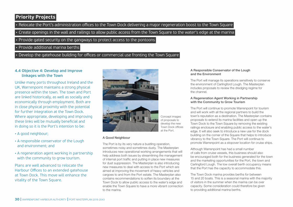
4.4 Objective 4: Develop and Improve linkages with the Town
Unlike many ports throughout Ireland and the UK, Warrenpoint maintains a strong physical presence within the town. The town and Port are linked historically, as well as socially and economically through employment. Both are in close physical proximity with the potential for further integration at the Town Dock. Where appropriate, developing and improving these links will be mutually beneficial and in doing so it is the Port’s intention to be:
• A good neighbour;
• A responsible conservator of the Lough and environment; and
• A regeneration agent working in partnership with the community to grow tourism.
Plans are well advanced to relocate the Harbour Offices to an extended gatehouse at Town Dock. This move will enhance the vitality of the Town Square.
A Good Neighbour
The Port is by its very nature a bustling operation, sometimes noisy and sometimes dusty. The Masterplan introduces new operational working arrangements that will help address both issues by streamlining the management of internal port traffic and putting in place new measures for dust suppression. The Masterplan is also introducing new measures to deal with access to the Port which are aimed at improving the movement of heavy vehicles and cargoes to and from the Port estate. The Masterplan also contains recommendations to soften its boundary at the Town Dock to allow public access to the water’s edge and enable the Town Square to have a more vibrant connection to the marina.
A Responsible Conservator of the Lough and the Environment
The Port will manage its operations sensitively to conserve the environment of Carlingford Lough. The Masterplan includes proposals to review the dredging regime for the channel.
A Regeneration Agent Working in Partnership with the Community to Grow Tourism
The Port will continue to promote Warrenpoint for tourism and will work with all the regional partners to build the town’s reputation as a destination. The Masterplan contains proposals to extend its marina facilities and open up the Town Dock to the Town Square by removing the existing railings enclosure and enabling public access to the water’s edge. It will also seek to introduce a new use for the dock building on the corner of the Square that helps to introduce vibrancy to the Town Square. The Port will continue to promote Warrenpoint as a stopover location for cruise ships.
Although Warrenpoint has had a small number of calls from cruise vessels, this business should also be encouraged both for the business generated for the town and the marketing opportunities for the Port, the town and Carlingford Lough. The low overall berth occupancy means that the Port has the capacity to accommodate this.
The Town Dock marina provides berths for between 15 and 20 boats. This is a seasonal marina with the majority of visitors in the summer when the marina can be over capacity. Some consideration could therefore be given to providing additional marina berths.
Priority Projects • Relocate the Port’s administration offices to the Town Dock delivering a major regeneration boost to the Town Square
• Create openings in the wall and railings to allow public access from the Town Square to the water’s edge at the marina
• Provide gated security on the gangways to protect access to the pontoons
• Provide additional marina berths
• Develop the gatehouse building for offices or commercial use fronting the Town Square
Concept images of proposals to develop the new Town Dock offices at the Port.
30 | WARRENPOINT HARBOUR AUTHORITY | PORT MASTERPLAN 2018-2043
A2
A2
A2
B7
B7
R173
A2
NE W
RY R I V E R
0 250 500
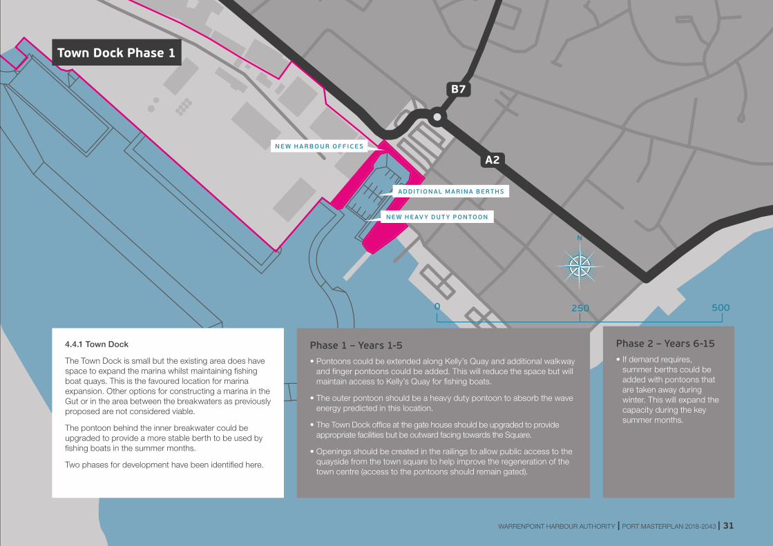
Phase 2 – Years 6-15• If demand requires,
summer berths could be added with pontoons that are taken away during winter. This will expand the capacity during the key summer months.
Phase 1 – Years 1-5• Pontoons could be extended along Kelly’s Quay and additional walkway
and finger pontoons could be added. This will reduce the space but will maintain access to Kelly’s Quay for fishing boats.
• The outer pontoon should be a heavy duty pontoon to absorb the wave energy predicted in this location.
• The Town Dock office at the gate house should be upgraded to provide appropriate facilities but be outward facing towards the Square.
• Openings should be created in the railings to allow public access to the quayside from the town square to help improve the regeneration of the town centre (access to the pontoons should remain gated).
4.4.1 Town Dock
The Town Dock is small but the existing area does have space to expand the marina whilst maintaining fishing boat quays. This is the favoured location for marina expansion. Other options for constructing a marina in the Gut or in the area between the breakwaters as previously proposed are not considered viable.
The pontoon behind the inner breakwater could be upgraded to provide a more stable berth to be used by fishing boats in the summer months.
Two phases for development have been identified here.
ADDIT IONAL MARINA BERTHS
NE W HE AV Y DUT Y PONTOON
N E W H A R B O U R O F F I CE S
Town Dock Phase 1
WARRENPOINT HARBOUR AUTHORITY | PORT MASTERPLAN 2018-2043 | 31
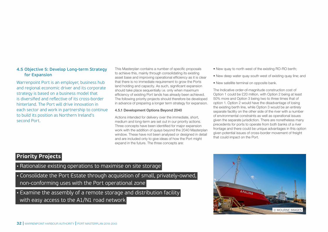
4.5 Objective 5: Develop Long-term Strategy for Expansion
Warrenpoint Port is an employer, business hub and regional economic driver and its corporate strategy is based on a business model that is diversified and reflective of its cross-border hinterland. The Port will drive innovation in each sector and work in partnership to continue to build its position as Northern Ireland’s second Port.
This Masterplan contains a number of specific proposals to achieve this, mainly through consolidating its existing asset base and improving operational efficiency as it is clear that there is no immediate requirement to grow the Ports land holding and capacity. As such, significant expansion should take place sequentially i.e. only when maximum efficiency of existing Port lands has already been achieved. The following priority projects should therefore be developed in advance of preparing a longer term strategy for expansion.
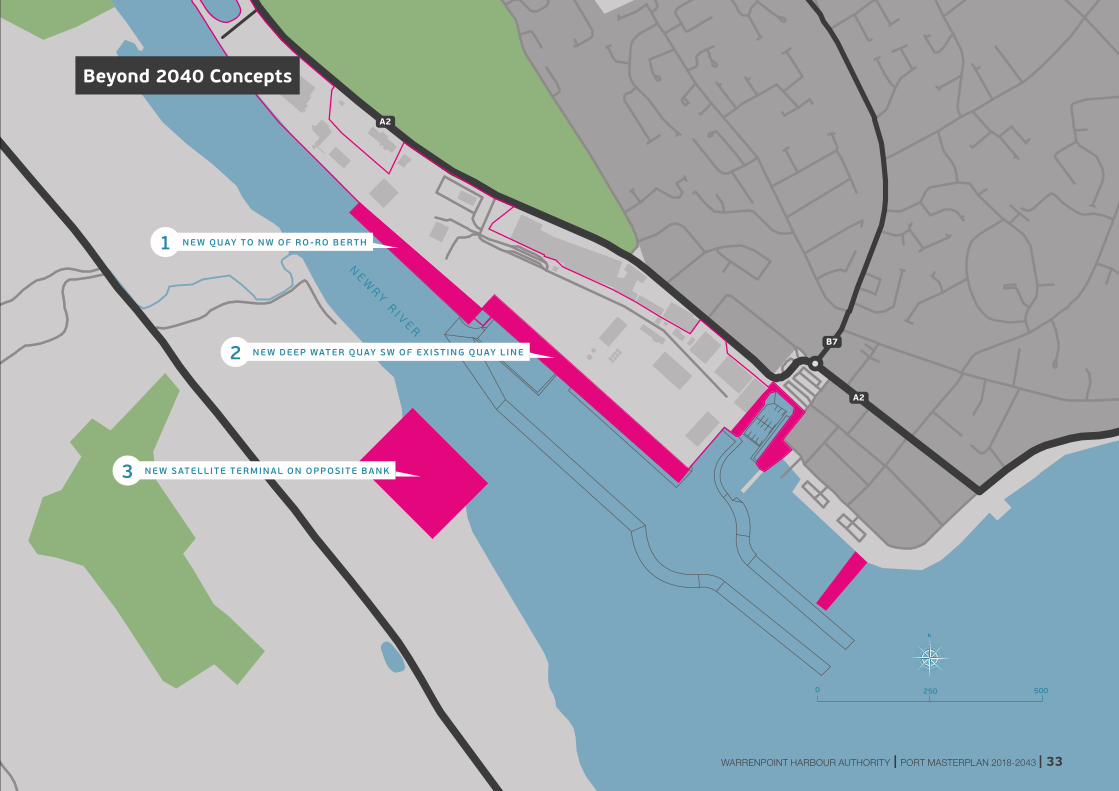
4.5.1 Development Options Beyond 2040
Actions intended for delivery over the immediate, short, medium and long-term are set out in our priority actions. Three concepts have been identified for major expansion work with the addition of quays beyond the 2040 Masterplan window. These have not been analysed or designed in detail and are included only to give ideas of how the Port might expand in the future. The three concepts are:
• New quay to north west of the existing RO-RO berth;
• New deep water quay south west of existing quay line; and
• New satellite terminal on opposite bank.
The Indicative order-of-magnitude construction cost of Option 1 could be £20 million, with Option 2 being at least 50% more and Option 3 being two to three times that of option 1. Option 2 would have the disadvantage of losing the existing berth line, while Option 3 would be an entirely separate facility on the other side of the river with a number of environmental constraints as well as operational issues given the separate jurisdiction. There are nonetheless many precedents for ports to operate from both banks of a river frontage and there could be unique advantages in this option given potential issues of cross-border movement of freight that could impact on the Port.
Priority Projects
• Rationalise existing operations to maximise on site storage
• Consolidate the Port Estate through acquisition of small, privately-owned, non-conforming uses with the Port operational zone
• Examine the assembly of a remote storage and distribution facility with easy access to the A1/N1 road network
© MOURNE IMAGES
32 | WARRENPOINT HARBOUR AUTHORITY | PORT MASTERPLAN 2018-2043
A2
A2
A2
B7
B7
R173
A2
NE W
RY R I V E R
0 250 500
Beyond 2040 Concepts
NE W QUAY TO NW OF RO -RO BERTH1
NE W DEEP WATER QUAY SW OF E X IST ING QUAY L INE2
NE W SATELLITE TERMINAL ON OPPOSITE BANK3
WARRENPOINT HARBOUR AUTHORITY | PORT MASTERPLAN 2018-2043 | 33
For illustrative purposes only
Boundary with A2 – Post development
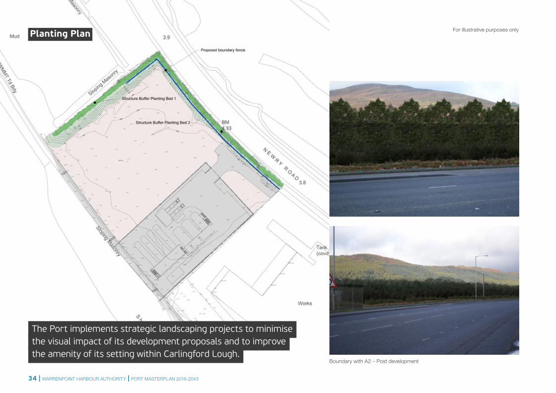
The Port implements strategic landscaping projects to minimisethe visual impact of its development proposals and to improve the amenity of its setting within Carlingford Lough.
Planting Plan
34 | WARRENPOINT HARBOUR AUTHORITY | PORT MASTERPLAN 2018-2043
Warrenpoint Harbour AuthorityThe Docks, WarrenpointNewry BT34 3JR
T: +44 (0)28 4177 3381E: [email protected]
warrenpointport.com
With thanks:
Design: whitenoisestudios.com