Embed Size (px)
Citation preview

WARD 07_17 20/00364/APP 18th March 2020
Development of a Multi-Use Games Area (MUGA) providing a 3G football/rugby pitch 2no 5-a-side pitches and a Sports Court area at Lesser Borough Briggs Borough Briggs Road Elgin Moray for Elgin Sports Community Trust
Comments:
The application has been referred to the Emergency Cabinet as the matter would be in the wider public interest and a proposal that would have normally been referred to the Planning and Regulatory Services Committee for determination.
No representations received.
Procedure:
None. Recommendation Grant Planning Permission - Subject to the Following:- Conditions/Reasons
1. The new main synthetic pitch shall have a surface that is designed and constructed by a recognised (e.g. SAPCA* registered) specialist pitch contractor(s), details of contractor(s) and pitch specification shall be submitted for the written approval of the planning authority (in consultation with Sports Scotland) prior to the commencement of development.*SAPCA is The Sports and Play Construction Association (www.sapca.org.uk)
Reason: To ensure quality of the pitch provision.
2. Notwithstanding the submitted details, no works shall commence until the
following has been submitted to and approved by the Council, as Planning Authority in consultation with the Roads Authority:
a) Detailed drawings (Scale 1:500 minimum) showing the location, design
specifications and timescale for the provision of the vehicular access to the site,
including details of the required visibility splay of 2.4 metres by 43 metres in
both directions to be clear of any obstruction above 0.26 metres in height
measured from the level of the public carriageway, dropped kerbs and tactile
paving for pedestrians at the access, relocation of/additional drainage at the

access and taking cognisance of the existing bus stop and any requirement for
relation of bus stop;
b) Detailed drawings (Scale 1:500 minimum) showing the location, design
specifications and timescale for the provision of dropped kerbs and tactile
paving on the route from the Lossie Green car park to any pedestrian access to
the site;
c) Detailed drawings (Scale 1:500 minimum) showing the location, design
specifications and timescale for the provision of the new cycle ramp from the
NCN1 River Lossie Cycle path into the site and
d) Detailed drawings (scale 1:200 minimum) showing the location, design
specification and timescale for the provision of disabled parking provision and
secure cycle parking facilities for users of the facilities with the development
site.
Thereafter the proposed access, improvements to pedestrian access, new cycle ramp, disabled parking provision and cycle storage facilities shall be provided in accordance with the approved details and agreed timescales. Reason: To ensure provision of a safe and suitable access for vehicles, pedestrians and cyclists in the interests of road safety.
3. No works shall commence on any area of the proposed development until details have been submitted to and approved by the Council, as Planning Authority in consultation with the Roads Authority regarding:
a) A construction traffic management plan which shall include the following
information:
(i) Duration of works;
(ii) Construction programme;
(iii) Number of vehicle movements (materials, plant, staff etc);
(iv) Anticipated schedule for delivery of materials and plant;
(v) Measures to be put in place to prevent material being deposited on the
public road;
(vi) Measure to be put in place to safeguard the movements of pedestrians
and cyclists;
(vii) Traffic management measures to be put in place during the works
including any specific instructions to drivers; and
(viii) Parking provision, loading and unloading areas for construction traffic.
And
b) Details of any required/proposed temporary construction access which shall
include the following information:
(i) A drawing (scale 1:500 minimum) regarding the location and design
specifications of the proposed access(es);

(ii) Specification of the materials used for the construction access(es);
(iii) All traffic management measures required to ensure safe operation of the
construction access(es);
(iv) Details, including materials, for the reinstatement of any temporary
construction access(es); and
(v) Details regarding the timescale for the opening up and closure of any
temporary access(es) together with the time period over which the
temporary access(es) will be used.
Thereafter the development shall be implemented in accordance with the approved details. Reason: To ensure an acceptable form of development in terms of the arrangements to manage traffic during construction works at the site, road safety and the amenity of the area/adjacent properties.
4. Unless otherwise agreed in writing with the Council as Planning Authority, the artificial lighting shall be constructed in accordance with the “Elgin Sports Centre, Outdoor Lighting Report”, prepared by CU Phosco Lighting and dated 25th February 2020. Furthermore, unless also agreed in writing with the Council as Planning Authority, the hours of operation of the lights shall be in accordance with the operation described in the “Elgin Sports Community Trust, Lesser Borough Briggs, MUGA Pitch Development 3G Pitch Elgin, Planning Statement” dated 13 March 2020 paragraph 2.2.1 where the artificial lighting shall not be operated between the hours of 22.00 and 09:00. Any proposed late night events outwith these hours may only be permissible with the prior written approval of the Council as Planning Authority (minimum 7 days advance notice in consultation with other relevant stakeholders).
Reason: In order to ensure that the artificial lighting is constructed and operated so as not to cause a nuisance.
5. Prior to the development coming into use, written details must be submitted to the Council as Planning Authority of the ongoing maintenance provisions for the sites grassed areas. Thereafter the grass areas must be maintained in accordance with the approved maintenance provisions. Reason: In order to ensure that proper landscape maintenance arrangements are in place.
6. Prior to their instillation, details (including floor plans and elevations) of the proposed office cabin structure and covered cycle store must be submitted to and approved in writing by the Council as Planning Authority. Reason: In order that consideration can be given to the finished details of the two structures.

Reason(s) for Decision The Council’s reason(s) for making this decision are:- The proposal accords with the adopted Moray Local Development Plan 2020 and there were no other material considerations preventing approval. List of Informatives: THE DEVELOPMENT MANAGEMENT & BUILDING STANDARDS MANAGER has commented that: If the portacabin office is to connect to the public sewer and water supply this may require a Building Warrant application and contact should be made with the Building Standards Section. THE TRANSPORTATION MANAGER, DIRECT SERVICES has commented that: Planning consent does not carry with it the right to carry out works within the public road boundary. Before commencing development the applicant is obliged to apply for Construction Consent in accordance with Section 21 of the Roads (Scotland) Act 1984 for new roads. The applicant will be required to provide technical information, including drawings and drainage calculations. Advice on this matter can be obtained from the Moray Council web site or by emailing [email protected] Before staring any work on the existing public road the applicant is obliged to apply for a road opening permit in accordance with Section 56 of the Roads (Scotland) Act 1984. This includes any temporary access joining with the public road. Advice on these matters can be obtained by emailing [email protected] Public utility apparatus may be affected by this proposal. Contact the appropriate utility service in respect of any necessary utility service alterations which have to be carried out at the expense of the developer. No building materials/scaffolding/builder’s skip shall obstruct the public road (including footpaths) without permission from the Roads Authority. The applicant shall be responsible for ensuring that surface/ground water does not run from the public road into his property. The applicants shall free and relieve the Roads Authority from any claims arising out of their operations on the road or extension to the road. No retaining structures or embankments shall be constructed along the edge of

the road, whether retaining the public road or ground adjoining the public road without prior consultation and agreement of the Roads Authority. The developer must contact the Roads Authority Street Lighting Section at Ashgrove Depot, Elgin – Tel (01343) 557300, Ext 7327 to discuss the proposals. The formation of the required visibility splay will involve the removal of vegetation, setting back of boundary fences and the lowering of ground levels. There is already an existing footway along the Boroughbriggs Road frontage of the site. This footway is relatively new and not shown on Google Maps. When the new footway was installed along the site frontage dropped kerbs and tactile paving was also installed to enable crossing of Boroughbriggs Road. This crossing point is just to the west of Trinity Road. The proposals include the provision of an additional crossing point on Boroughbriggs Road to the west of the proposed new access. Full details of this proposed crossing are required to demonstrate how the dropped kerbs and tactile paving would comply with guidance and standards. Confirmation is also required regarding the opportunity to provide a widened footway to the south of the existing Elgin City changing rooms as part of the Phase 2 development to remove this pinch point on the network. Full details of the proposed pedestrian/cycle access from NCN Route 1 River Lossie cycle path into the site are required including a long section to demonstrate the maximum gradient of the access. The specifications for cycle path gradients will be taken from the Scottish Government document Cycling by Design and a maximum gradient of 3% sought. If a 3% maximum gradient cannot be achieved then ramped arrangement will be required. The SCOTTISH ENVIRONMENT PROTECTION AGENCY has commented that:
Regulatory requirements for applicant You will need to comply with CAR General Binding Rule 10 which requires, amongst other things, that all reasonable steps must be taken to ensure that the discharge of surface water from a site does not result in pollution of the water environment. Good practice guidelines regarding construction and pollution prevention should be followed and can be found at the Guidance for Pollution Prevention (GPPs) Netregs webpage. For waste management refer the waste management measures and specifically the Waste Management Plan template on the NetRegs website. Management of surplus peat or soils may require an exemption under The Waste Management Licensing (Scotland) Regulations 2011.
Details of regulatory requirements and good practice advice for the applicant can be found on the Regulations section of our website. If you are unable to find the advice you need for a specific regulatory matter, please contact a member of the regulatory services team at [email protected]. If you have any queries relating to this letter, please contact me by e-mail at [email protected].
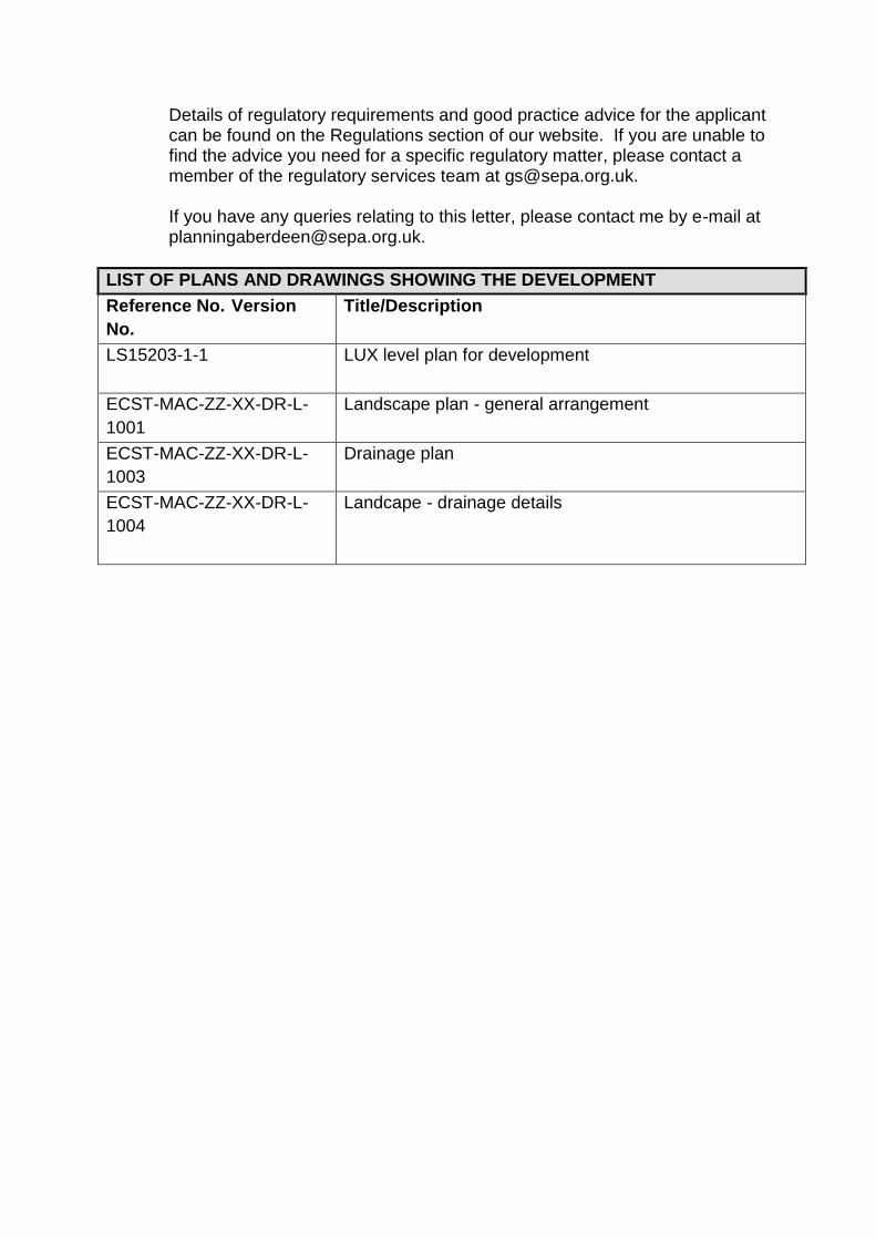
LIST OF PLANS AND DRAWINGS SHOWING THE DEVELOPMENT
Reference No. Version
No.
Title/Description
LS15203-1-1 LUX level plan for development
ECST-MAC-ZZ-XX-DR-L-
1001
Landscape plan - general arrangement
ECST-MAC-ZZ-XX-DR-L-
1003
Drainage plan
ECST-MAC-ZZ-XX-DR-L-
1004
Landcape - drainage details
Plans, drawings and other material submitted to the local authority are protected by the Copyright, Designs and Patents Act 1988 (section 47). You may only use material which is downloaded and/or printed for consultation purposes, to compare current applications with previous schemes and to check whether developments have been completed in accordance with approved plans.
Further copies must not be made without the prior permission of the copyright owner.
Maps shown in the Planning Committee Report can only be used for the purposes of the Planning Committee. Any other use risks infringing Crown Copyright and may lead to prosecution or civil proceedings. Maps produced within this Planning Committee Report can only be reproduced with the express permission of the Moray Council and other Copyright holders. This permission must be granted in advance.
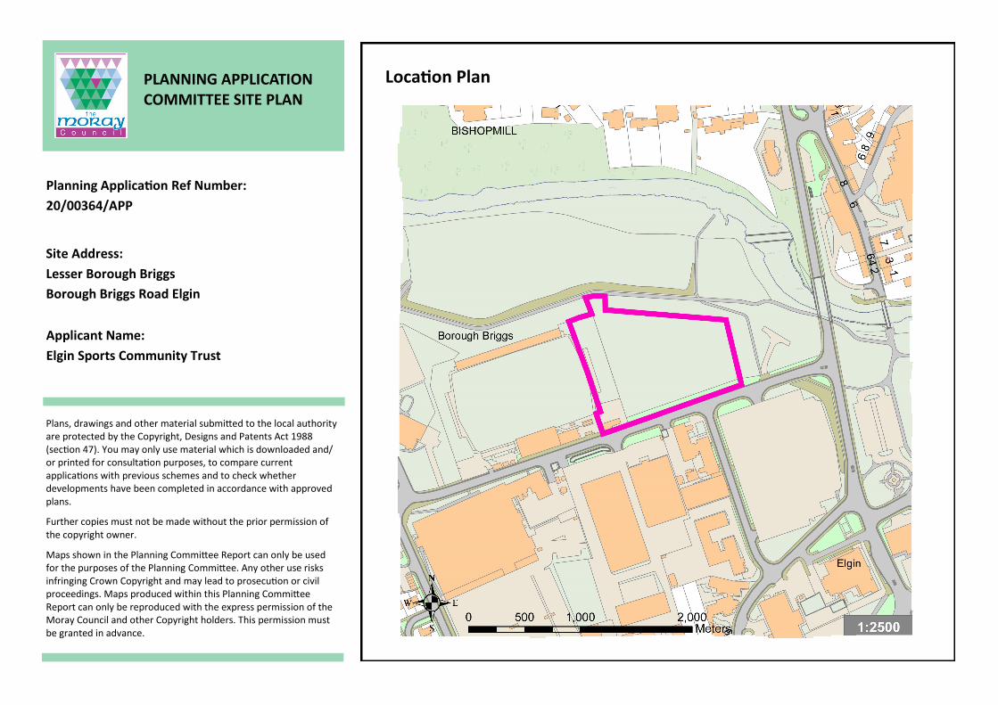
PLANNING APPLICATION COMMITTEE SITE PLAN
Site Address:
Lesser Borough Briggs
Borough Briggs Road Elgin
Planning Application Ref Number:
20/00364/APP
Location Plan
Applicant Name:
Elgin Sports Community Trust

Site Location

16
/

16
/
PLANNING APPLICATION: 20/00364/APP
In the event that a recommendation on this planning application is overturned the Committee is reminded of the advice contained on the front page of the agenda for Reports on Applications
THE PROPOSAL
The Proposed Development will operate as a Multi-Use Games Area (MUGA) comprising;-
i. a 3G football/rugby pitch (89m x 55m) ii. Two 5-a-side pitches (32m x 18m)
3 Disabled parking spaces and turning area.
Footpath connection to the Elgin flood scheme embankment path to the north.
The operating hours are proposed to be 09:00 – 17:30 – for schools, community groups and Elgin City Football Club; and 17.30 – 22.00 – for public bookings.
The main playing surface (synthetic) will be bound by a 5m high solid metal ‘ball stop’ fence. The other 5-a-side pitches will be surrounded with similar high fences.
A two metre close-boarded fence will bound other parts of the site.
There will be flood lighting for the main pitch area, using six 15m light standards. Lower 8m high lighting columns will illuminate the 5-a-side pitches.
A 10 x 3m portacabin in the south west corner of the site will be used as a booking office.
A storage container will be located on the site, near the carpark and an enclosed asphalt equipment storage area will be provided at the north east corner of the site.
The site shall also host other equipment/furniture such as covered team shelters (seating 12), wooden benches through the site, a covered cycle store and spectator rails inside the main pitch enclosure.
The only grassed areas are proposed beyond the proposed playing surfaced areas.
The bund along the frontage of Boroughbriggs Road is to be removed.
Boarded edges and drainage filters are designed to contain any rubber granules from leaving the site.
THE SITE
Located immediately east of Elgin City football ground and bound to the south by Boroughbriggs Road. The site is bound to the north and north east by the Elgin flood alleviation scheme embankment and path. A small informal hardstanding area lies immediately to the east.
A bund lies along the southern side of the site.
The site area is 1.18 hectares.
Within the Moray Local Development Plan 2020 (MLDP2020) the site is covered by an Opportunity designation OPP11 Lesser Borough Briggs and also falls within the Elgin Town Centre designation.
There are currently no trees upon the site.

HISTORY On the site 08/00077/EIA - Construct Elgin flood alleviation scheme between Glen Moray Distillery and Pitgaveny (includes alterations to Listed Buildings at Mary Well Mansion House Hotel and Bishopmill Bridge) at River Lossie, Elgin, Moray. Approved by Committee in October 2009. This bounds the north side of the site. 08/00078/LBC - Listed Building consent to construct Elgin flood alleviation scheme between Glen Moray Distillery and Pitgaveny (includes alterations to Listed Buildings at Mary Well, Mansion House Hotel and Bishopmill Bridge) at the River Lossie, Elgin, Moray. This was approved in December 2009 by committee and following consultation with Historic Environment Scotland. 10/01287/APP Continuation of existing planning consent ref 07/00040/FUL to site burger van on Site at Lossie Green, Boroughbriggs Road, Elgin. This temporary consent was granted in January 2011under delegated powers and expired two years later. 18/00484/APP - Proposed ground levelling at land adjacent to Elgin City FC, Borough Briggs Road, Elgin. Approved under delegated power in May 2018. Nearby planning history 00/00604/FUL - Erect concrete terracing at Elgin City Football Club (FC), Borough Briggs Road, Elgin. Approved under delegated powers in June 2000. 11/00812/APP - Formation of ground floor commercial office within existing structure and form new entrance feature at Elgin City FC, Borough Briggs Road, Elgin. Approved under delegated power in July 2011. 13/02016/APP - Erect store and toilet block at Elgin City FC, Borough Briggs Road, Elgin. Approved under delegated power in January 2014. These were to be located at the west end of the ground, away from the current site. POLICY - SEE APPENDIX CONSULTATIONS Strategic Development Planning – No objection as the proposal accords with MLDP 2020. Flood Risk Management Team – following consideration of additional information, no objection to the proposed scheme. Sports Scotland – no objection subject to a condition regarding the standard of the playing surface.

Archaeological Service – no objection Moray Council Property Service – comments to clarify that Elgin Sports Community Trust (ESCT) application for long lease of the Council part of the site is a completely separate process from the planning application process. SEPA – no objections subject to informatives. Transportation – approve subject to conditions and informatives. Environmental Health – no objection Environmental Health (Contaminated Land) – no objections. Scottish Water – no objection and the consultation response letter containing other information has been passed to the applicant. Developer Obligations – none sought. OBJECTIONS-REPRESENTATIONS No objections/representations received. OBSERVATIONS Section 25 of the 1997 Act as amended requires applications to be determined in accordance with the development plan i.e. the adopted Moray Local Development Plan 2020 (MLDP) unless material considerations indicate otherwise. Background The site was previously “white land” with no specific designation within Moray Local Development Plan 2015 but did lie within the town centre designation and still does lie within this designation as part of the now adopted Moray Local Development Plan 2020 (MLDP2020). There have been various pre-application discussions with the applicant regarding this proposal and the submission was supported by a number of documents including a Flood Risk Assessment, Planning Statement, Transport Statement, Lighting Report and Drainage information. From pre-application meetings it is clear that Elgin City Football Club is party to the proposed development and agreeable to the use of their land. The Planning Statement does indicate that there is potential for a second phase of development which may include permanent clubhouse building with changing and welfare facilities, booking office, and storage areas. This does not form part of the current development and no details have been provided.

The main issues are considered below: Principle of use of open space (PP3, DP1 and EP5) MLDP2020 policy PP3 Infrastructure and Services requires development to be planned and co-ordinated with infrastructure to ensure that places function properly and proposals are adequately served by infrastructure and services. The development should be suitably located to make use existing utilities and ensure provision of appropriate facilities. Policy DP1 Development Principles considers the impacts upon the environment, transport network, town centres, noise, air quality, landscape, trees, flood risk, protected habitats and species, contaminated land, built heritage and archaeology and what mitigation is required to address these impacts. It also considers whether the design of a development is appropriate to its setting. As the site sits in an area of open maintained land, it has also been considered against the requirements of policy EP5 Open Space although it should be noted, that as it is not covered by a specific ENV designation (designated as an opportunity site). As an opportunity site is has been identified as suitable for a variety of uses, but relevant to policy EP5 one exceptions is where a proposal is for essential community infrastructure required to deliver the key objectives of the Council. As a recreation and sports facility with disable parking, the proposal would contribute towards the Councils key objectives of providing a healthier and inclusive society. The area of land, although modified to the north some decade or more ago by the completion of the Elgin Flood Alleviation Scheme, has been open amenity land for some time. There had been a poorly drained football pitch in this locality prior to the development of the Elgin Flood Alleviation Scheme, which subsequently altered are area such that no pitch was ever re-instated. While used informally for sports and other recreation, it has had no formal use that would be displaced by the proposed development. In general terms the proximity to the town centre, other public facilities, Cooper Park etc. mean the proposed use would complement the variety other recreational facilities in the same locality. In terms of design and visual appearance, the proposal will introduce a substantive amount of high fencing (5m and 2m) and lighting columns (15m and 8m) into the area. The pitches, office cabin, equipment container and other infrastructure would not be prominent. Whilst the enclosure fencing and lighting would be prevalent from North Street to the east, the development would have the backdrop of the existing stands and flood light at Elgin City football ground, so would not be at odds with the design principles set out in policy DP1. Sports Scotland have also been consulted, and noted that no formal pitches exist at this location, and do not object to the artificial all weather surfaces, subject to conditions being imposed requiring conformity to a set recognised standard. Where the proposed use would see an enhanced recreational use the benefits would outweigh loss of the open grassed area. The development would result in outdoor, pitch based activities more commonly confined to daylight hours and drier times of year and could occur more frequently. The proximity of other extensive areas of formally designated ENV open space such as Cooper Park ensures that those seeking open space are catered for.

Town Centre designation (DP7 and Elgin TC designation) The site lies within Elgin Town Centre designation, which encompasses a large area within the centre of Elgin. The designation as described in the Elgin settlement statement of the MLDP 2020 does allow for a variety of uses. Of note the town centre designation allows for “leisure, entertainment, recreation, and cultural and community activities” and the proposed use for fall within several of these categories and would provide a useful community facility in the town centre close to other recreational and sporting facilities such as Moray Leisure Centre at the west end of Boroughbriggs Road. The proposal is therefore compliant with the aims of the town centre protection policy. Flooding and drainage (EP12, and OPP11) The site is in a locality known for its flooding, and lies close to the River Lossie and the Elgin Flood Alleviation Scheme. The OPP11 designation specifically requires a Flood Risk Assessment to be carried out. A Flood Risk Assessment has been submitted and assessed again policy EP12 Management and Enhancement of the Water Environment and the Councils own supplementary guidance on flood risk and Drainage. An arrangement has also been reached between the applicant and Elgin City football club so that the surface water discharge from the current site is collected to refill the football clubs water tanks which will in turn reduce the abstraction volumes from the River Lossie. The football club requires a store of water for routine watering the pitch during periods of low rainfall and already have a sizeable storage tank within the grounds that would receive water from development. The reduction in the amount of abstraction from the River Lossie and utilisation of surface water from the proposed development has been welcomed by SEPA. This offsets the absence of above ground surface water drainage treatment within the development site. The fencing surrounding the main 3G pitch will have small solid upstand (approx. 250mm high) and the smaller pitches a hoarding around them (approx. 1.0m high). These will prevent the rubber granules that form part of the pitch being blown out of the area of the pitch. The drainage system will also have a filter to ensure that the rubber granules do not enter the drainage system. Both SEPA and Moray Flood Risk Management Team were consulted, and subject to revisions to the drainage proposals have raised no objections to the proposed development. Access and Parking (PP3) It is acknowledged that there is parking within the locality and the application submission included a Transport Statement that includes various parking surveys and other assessments. It concludes that North Street and Boroughbriggs Road has capacity to deal with the anticipated additional traffic movements the development would generate. It also concludes that the number of trips generated by the development once operational would have a negligible effect on current levels of parking activity and the parking snapshot surveys have demonstrated that there is sufficient capacity at the nearby Lossie Green car park to cater for future users of the development. The proposal includes sufficient numbers of disabled and cycle parking spaces to accommodate the need generated. The Transportation Service, subject to the conditions recommended, agree with the conclusions of the Traffic Statement and raise no objections to the proposal. The proposal includes path connections to the footpath cycle way on top of the flood scheme, which would give the facility good connectivity to other parts of Elgin. The site

would be in close proximity to the bus station. The nature of the use and partial reliance upon existing public parking to the south of Boroughbriggs Road does not lend itself to the use or introduction of electrical charging points and none are being sought. The development would therefore comply with the Transportation requirements of policy PP3 Infrastructure and Services. Amenity (noise and lighting) (DP1) The proposal has been supported by an Outdoor Lighting Report and design which specifically seeks to contain lighting to the playing surfaces. The most likely sensitive receptors to lighting would be the residential properties on the north side of the River Lossie and it is noted that they are some distance from the application site. Furthermore these residences are positioned on higher ground than the playing surfaces, so would further benefit the avoidance of any light spill. The management of the facility will see the pitches booked used for specific periods, with the main playing surface no used any later than 10pm (unless previously agreed with the Council). The pitches would also be managed such that that would not be available for un-booked use after 10pm at night so further reducing the likelihood of out of hours use noise being generated. In terms of amenity, this locality is already host to a football stadium, large supermarket, the Moray Leisure Centre and busy streets which see audible activity, flood lights and movement by the public in the evenings and at the weekends. The level of noise generated from this outdoor use, would therefore not be dissimilar to other existing used in the locality. As described above the nearest residences are approximately 120m or more to the north or east on the north side of the River Lossie and North Street. The Environmental Health Section has expressed no concerns over the generation of noise from the proposed use. A condition is recommended relating to the proposed lighting and hours of operation to ensure that the pitches would be lit and operated in the manner as described in the supporting documents. Impact on natural environment (EP2) The site being presently covered in managed grass provides limited biodiversity and the limited space available on the development site to accommodate the various pitches and infrastructure least little space for additional landscaping. Where no trees were previously present, there would be no loss of trees from the development. Whilst it is noted that under policy EP2 Biodiversity the opportunity should be taken to enhance the natural environment where possible, this may not always be practical. It would also be advantageous in terms of the maintenance and management of the playing surfaces not to have trees within close proximity shedding leaves on the playing surfaces. Given that the applicants have sought to maximise the facilities in the space available, there are limited opportunities to place trees and other landscaping a suitable distance from playing surfaces. The re-use of collected surface water for irrigation of the neighbouring football ground, is also considered to be of minor environmental benefit by reducing the need for abstraction from the River Lossie by the football club. Given the nature of the development, and the pursuit of other wider objectives such as health and wellbeing, it is reasonable in this case to accept that the new facilities will have

significant wider benefits to justify the minor impact on the natural environment in this town centre location. Further mitigation is not considered to be necessary. Conclusion In considering the above policy issues, and other material considerations the proposed development would comply with the relevant policies and designations of the MLDP 2020. The development would contribute to the provision of sporting facilities in Moray and realise a benefit to its residents. The location, design and infrastructure of the proposed pitches would have no detrimental effect on the wider locality and town centre. REASON(S) FOR DECISION The Council’s reason(s) for making this decision are: - The proposal accords with the adopted Moray Local Development Plan 2020 and there were no other material considerations preventing approval. Author/Contact
Officer:
Neal MacPherson
Principal Planning Officer
Ext: 01343 563266
Beverly Smith Development Management & Building Standards Manager
APPENDIX POLICY Proposed Moray Local Development Plan 2020 PP1 PLACEMAKING a) Development must be designed to create successful, healthy places that support
good physical and mental health, help reduce health inequalities, improve people's wellbeing, safeguard the environment and support economic development.
b) A Placemaking Statement is required for residential developments of 10 units and
above to be submitted with the planning application to articulate how the development proposal addresses the requirements of policy PP1 Placemaking and other relevant LDP policies and guidance. The Placemaking Statement must include sufficient information for the council to carry out a Quality Audit. Where considered appropriate by the council, taking account of the nature and scale of the proposed development and of the site circumstances, this shall include a landscaping plan, a topographical survey, slope analysis, site sections, 3D visualisations, a Street Engineering Review and a Biodiversity Plan. The Placemaking Statement must demonstrate how the development promotes opportunities for healthy living and working. The landscape plan must set out details of species type, size, timescales for planting and maintenance.
c) To create successful, healthy places residential developments of 10 units and above
must comply with Scottish Government policy Creating Places and Designing Streets and must incorporate the following fundamental principles:
(i) Character and Identity
• Create places that are distinctive to prevent homogenous 'anywhere' development; • Provide a number of character areas reflecting site characteristics that have their own distinctive identity and are clearly distinguishable; • Provide distinctiveness between and in each character area through a
combination of measures including variation in urban form, street structure/network, architecture and masonry, accent features (such as porches), surrounds and detailing, materials (buildings and surfaces), colour, boundary treatments, hard/soft landscaping and a variety of approaches to tree species and planting that emphasises the hierarchy of open spaces and streets within a cohesive design strategy for the whole development;
• Distinctiveness must be reinforced along main thoroughfares, open spaces and places where people may congregate such as shopping/service centres; • Retain, incorporate and/or respond to relevant elements of the landscape such as
topography and planted features, natural and historic environment, and propose street naming (in residential developments of 20 units and above, where proposed names are to be submitted with the planning application) to retain and enhance local associations;

(ii) Healthier, Safer Environments • Designed to prevent crime, fear of crime and anti-social behaviour with good levels
of natural surveillance and security using treatments such as low boundary walls, dual frontages (principal rooms) and well-lit routes to encourage social interaction. Unbroken high boundary treatments such as wooden fencing and blank gables onto routes, open spaces and communal areas will not be acceptable.
• Designed to encourage physical exercise for people of all abilities. • Create a distinctive urban form with landmarks, key buildings, vistas, gateways and
public art to provide good orientation and navigation through the development. • Provide a mix of compatible uses, where indicated within settlement statements,
integrated into the fabric of buildings within the street. • Prioritise pedestrians and cyclists by providing a permeable movement framework
that incorporates desire lines (including connecting to and upgrading existing desire lines) and is fully integrated with the surrounding network to create walkable neighbourhoods and encourage physical activity.
• Integrate multi- functional active travel routes, green and open space into layout
and design, to create well connected places that encourage physical activity, provide attractive spaces for people to interact and to connect with nature.
• Create safe streets that influence driver behaviour to reduce vehicle speeds that
are appropriate to the local context such as through shorter streets, reduced visibility and varying the building line.
• Provide seating opportunities within streets, paths and open spaces for all
generations and mobility's to interact, participate in activity, and rest and reflect. • Provide for people with mobility problems or a disability to access buildings, places
and open spaces. • Create development with public fronts and private backs. • Maximise environmental benefits through the orientation of buildings, streets and
open space to maximise the health benefits associated with solar gain and wind shelter.
(iii) Housing Mix • Provide a wide range of well integrated tenures, including a range of house types
and plot sizes for different household sizes, incomes and generations and meet the affordable and accessible requirements of policy DP2 Housing.
• All tenures of housing should have equal access to amenities, greenspace and active travel routes.

(iv) Open Spaces/Landscaping • Provide accessible, multi-functional open space within a clearly defined hierarchy
integrated into the development and connected via an active travel network of green/blue corridors that are fully incorporated into the development and to the surrounding area, and meet the requirements of policy EP5 Open Space and the Open Space Strategy Supplementary Guidance and Policy EP12 Managing the Water Environment and Drainage Impact Assessment for New Developments Supplementary Guidance.
• Landscaped areas must provide seasonal variation, (mix of planting and colour) including native planting for pollination and food production.
• Landscaping areas that because of their size, shape or location would not form any useable space or that will not positively contribute to the character of an area will not contribute to the open space requirements of Policy EP4 Open Space.
• Semi-mature tree planting and shrubs must be provided along all routes with the variety of approaches reflecting and accentuating the street hierarchy.
• Public and private space must be clearly defined. • Play areas (where identified) must be inclusive, providing equipment so the facility is
for every child/young person regardless of ability and provided upon completion of 50% of the character area.
• Proposals must provide advance landscaping identified in site designations and meet the quality requirements of policy EP5 Open Space.
• Structural landscaping must incorporate countryside style paths (such as bound or compacted gravel) with waymarkers.
• Maintenance arrangements for all paths, trees, hedging, shrubs, play/ sports areas, roundabouts and other open/ green spaces and blue/green corridors must be provided.
(v) Biodiversity • Create a variety of high quality multi- functional green/blue spaces and networks that
connect people and nature, that include trees, hedges and planting to enhance biodiversity and support habitats/wildlife and comply with policy EP2 Biodiversity and Geodiversity and EP5 Open Space.
• A plan detailing how different elements of the development will contribute to supporting biodiversity must be included in the design statement submitted with the planning application.
• Integrate green and blue infrastructure such as swales, permeable paving, SUDS ponds, green roofs and walls and grass/wildflower verges into streets, parking areas and plots to sustainably address drainage and flooding issues and enhance biodiversity from the outset of the development.
• Developments must safeguard and where physically possible extend or enhance wildlife corridors and green/blue networks and prevent fragmentation of existing habitats.
(vi) Parking • Car parking must not dominate the streetscape to the front or rear of properties. On
all streets a minimum of 50% of car parking must be provided to the side or rear and behind the building line with a maximum of 50% car parking within the front curtilage or on street, subject to the visual impact being mitigated by hedging, low stone boundary walls or other acceptable treatments that enhance the streetscape.
• Provide semi-mature trees and planting within communal private and public/visitor parking areas and on-street parking at a maximum interval of 4 car parking spaces.
• Secure and covered cycle parking and storage, car sharing spaces and electric car charging points must be provided in accordance with policy DP1 Development Principles.
• Parking areas must use a variation in materials to reduce the visual impact on the streetscene.
(vii) Street Layout and Detail • Provide a clear hierarchy of streets reinforced through street width, building density
and street and building design, materials, hard/soft landscaping and a variety of approaches to tree planting and shrubs.
• Streets and connecting routes should encourage walking and cycling over use of the private car by providing well connected, safe and appealing routes.
• Design junctions to prioritise pedestrians, accommodate active travel and public transport and service/emergency vehicles to reflect the context and urban form and ensure that the street pattern is not standardised.
• Dead-end streets/cul-de-sacs will only be selectively permitted such as on rural edges or where topography, site size, shape or relationship to adjacent developments prevent an alternative more permeable layout. These must be short, serving no more than 10 units and provide walking and cycling through routes to maximise connectivity to the surrounding area.
• Where a roundabout forms a gateway into, or a landmark within, a town and/or a development, it must be designed to create a gateway feature or to contribute positively to the character of the area.
• Design principles for street layouts must be informed by a Street Engineering Review (SER) and align with Roads Construction Consent (RCC) to provide certainty that the development will be delivered as per the planning consent.
(d) Future masterplans will be prepared through collaborative working and in partnership
between the developer and the council for Lochyhill (Forres), Barhill Road (Buckie), Elgin Town Centre/Cooper Park, Elgin North East, Clarkly Hill, Burghead and West Mosstodloch. Masterplans that are not prepared collaboratively and in partnership with the council will not be supported. Masterplans that are approved will be Supplementary Guidance to the Plan.
(e) Proposals for sites must reflect the key design principles and safeguard or enhance
the green networks set out in the Proposals Maps and Settlement Statements. Alternative design solutions may be proposed where justification is provided to the planning authority's satisfaction to merit this.
PP2 SUSTAINABLE ECONOMIC GROWTH. "Development proposals which support the Moray Economic Strategy to deliver sustainable economic growth will be supported where the quality of the natural and built environment is safeguarded, there is a clear locational need and all potential impacts can be satisfactorily mitigated. "

DP1 DEVELOPMENT PRINCIPLES This policy applies to all development, including extensions and conversions and will be applied reasonably taking into account the nature and scale of a proposal and individual circumstances. The Council will require applicants to provide impact assessments in order to determine the impact of a proposal. Applicants may be asked to determine the impacts upon the environment, transport network, town centres, noise, air quality, landscape, trees, flood risk, protected habitats and species, contaminated land, built heritage and archaeology and provide mitigation to address these impacts. Development proposals will be supported if they conform to the relevant Local Development Plan policies, proposals and additional guidance, meet the following criteria and address their individual and cumulative impacts: (i) Design a) The scale, density and character must be appropriate to the surrounding area and
create a sense of place (see Policy PP1) and support the principles of a walkable neighbourhood.
b) The development must be integrated into the surrounding landscape which will
include safeguarding existing trees and undertaking replacement planting to include native trees for any existing trees that are felled, and safeguarding any notable topographical features (e.g. distinctive knolls), stone walls and existing water features by avoiding channel modifications and culverting. A tree survey and tree protection plan must be provided with planning applications for all proposals where mature trees are present on site or that may impact on trees outwith the site. The strategy for new tree provision should follow the principles of the "Right Tree in the Right Place".
c) Make provision for new open space and connect to existing open space under the
requirements of Policy EP5 and provide details of the future maintenance of these spaces. A detailed landscape plan must be submitted with planning applications and include information about green/blue infrastructure, tree species, planting, ground/soil conditions, and natural and man-made features (e.g. grass areas, wildflower verges, fencing, walls, paths, etc.).
d) Demonstrate how the development will conserve and enhance the natural and built
environment and cultural heritage resources, retain original land contours and integrate into the landscape.
e) Proposals must not adversely impact upon neighbouring properties in terms of
privacy, daylight or overbearing loss of amenity. f) Proposals do not result in backland development or plots that are subdivided by
more than 50% of the original plot. Sub-divided plots must be a minimum of 400m2, excluding access and the built-up area of the application site will not exceed one-third of the total area of the plot and the resultant plot density and layout reflects the character of the surrounding area.

g) Pitched roofs will be preferred to flat roofs and box dormers are not acceptable. h) Existing stone walls on buildings and boundaries must be retained. Alterations and extensions must be compatible with the character of the existing building in terms of design, form, choice of materials and positioning and meet all other relevant criteria of this policy. i) Proposals must orientate and design buildings to maximise opportunities for solar
gain. (ii) Transportation a) Proposals must provide safe entry and exit from the development, including the
appropriate number and type of junctions, maximise connections and routes for pedestrians and cyclists, including links to active travel and core path routes, reduce travel demands and ensure appropriate visibility for all road users at junctions and bends. Road, cycling, footpath and public transport connections and infrastructure must be provided at a level appropriate to the development and connect people to education, employment, recreation, health, community and retail facilities.
b) Car parking must not dominate the street scene and must be provided to the side or
rear and behind the building line. Maximum (50%) parking to the front of buildings and on street may be permitted provided that the visual impact of the parked cars is mitigated by hedging or low stone boundary walls. Roadways with a single carriageway must provide sufficient off road parking to avoid access routes being blocked to larger service vehicles and prevent parking on pavements.
c) Provide safe access to and from the road network, address any impacts on road
safety and the local road, rail and public transport network. Any impacts identified through Transport Assessments/ Statements must be identified and mitigated. This may include but would not be limited to, passing places, road widening, junction improvements, bus stop infrastructure and drainage infrastructure. A number of potential mitigation measures have been identified in association with the development of sites and the most significant are shown on the Proposals Map as TSP's.
d) Provide covered and secure facilities for cycle parking at all flats/apartments, retail,
community, education, health and employment centres. e) Garages and parking provision must be designed to comply with Moray Council
parking specifications see Appendix 2. f) The road layout must be designed to allow for the efficient mechanical sweeping of
all roadways and channels, paviors, turning areas and junctions. The road layout must also be designed to enable safe working practices, minimising reversing of service vehicles, with hammerheads minimised in preference to turning areas such as road stubs or hatchets, and to provide adequate space for the collection of waste and movement of waste collection vehicles.
g) The road and house layout in urban development should allow for communal refuse
collection points where the design does not allow for individual storage within the
curtilage and / or collections at kerbside. Communal collection points may either be for the temporary storage of containers taken by the individual householder or for the permanent storage of larger containers. The requirements for a communal storage area are stated within the Council's Kerbside Collection Policy, which will be a material consideration.
h) Road signs should be minimised designed and placed at the back of footpaths to
reduce street clutter, avoid obstructing pedestrian movements and safeguarding sightlines;
i) Within communal parking areas there will be a requirement for electric car charging
points. Parking spaces for car sharing must be provided where a need is identified by the Transportation Manager.
j) All developments must be designed so as to ensure that all new buildings avoid a
specified and rising proportion of the projected greenhouse gas emissions from their use (calculated on the basis of the approved design and plans for the specific development) through the installation and operation of low and zero-carbon generating technologies.
(iii) Water environment, pollution, contamination a) Acceptable water and drainage provision must be made, including the use of
sustainable urban drainage systems (SUDS) for dealing with surface water including temporary/ construction phase SUDS (see Policy EP12).
b) New development should not be located in areas at flood risk or increase
vulnerability to flooding (see Policy EP12). Exceptions to this would only be considered in specific circumstances, e.g. extension to an existing building or change of use to an equal or less vulnerable use. Where this exception is applied the proposed development must include resilience measures such as raised floor levels and electrical sockets.
c) Proposals must avoid major hazard sites and address any potential risk of pollution
including ground water contamination in accordance with recognised pollution prevention and control measures.
d) Proposals must protect and wherever practicable enhance water features through for
example naturalisation of watercourses by introducing a more natural planform and removing redundant or unnecessary structures.
e) Proposals must address and sufficiently mitigate any contaminated land issues. f) Make acceptable arrangements for waste collection and management and
encourage recycling. g) Avoid sterilising significant workable reserves of minerals, prime agricultural land or
productive forestry. h) Proposals must avoid areas at risk of coastal erosion and coastal change.
EP1 NATURAL HERITAGE DESIGNATIONS. a) Natura 2000 designations. Development likely to have a significant effect on a European Site and which is not directly connected with or necessary to the conservation management of that site must be subject to an appropriate assessment of the implications for its conservation objectives. Proposals will only be approved where the appropriate assessment has ascertained that there will be no adverse effect on the integrity of the site. In exceptional circumstances, proposals that could affect the integrity of a European Site may be approved where: i) There are no alternative solutions, and ii) There are imperative reasons of over-riding public interest including those of a social
or economic nature, and iii) Compensatory measures are provided to ensure that the overall coherence of the
Natura network is protected. For European Sites hosting a priority habitat or species (as defined in Article 1 of the The Conservation (Natural Habitat & c.) Regulations 1994), prior consultation with the European Commission via Scottish Ministers is required unless the imperative reasons of overriding public interest relate to human health, public safety or beneficial consequences of primary importance to the environment. b) National designations
Development proposals which will affect a National Park, National Scenic Area (NSA), Site of Special Scientific Interest (SSSI) or National Nature Reserve will only be permitted where:
i) The objectives of designation and the overall integrity of the area will not be compromised; or ii) Any significant adverse effects on the qualities for which the site has been
designated are clearly outweighed by social, environmental or economic benefits of national importance.
c) Local Designations
Development proposals likely to have a significant adverse effect on Local Nature Reserves, wildlife sites or other valuable local habitats will be refused unless it can be demonstrated that;
i) Public benefits clearly outweigh the nature conservation value of the site, and ii) There is a specific locational requirement for the development, and iii) Any potential impacts can be satisfactorily mitigated to conserve and enhance the site's residual conservation interest.

d) European Protected Species European Protected Species are identified in the Habitats Regulations 1994 (as amended in Scotland). Where a European Protected Species may be present or affected by development or activity arising from development, a species survey and where necessary a Species Protection Plan should be prepared to accompany the planning application, to demonstrate how the Regulations will be complied with. The survey should be carried out by a suitably experienced and licensed ecological surveyor. Proposals that would have an adverse effect on European Protected Species will not be approved unless; • The need for development is one that is possible for SNH to grant a license for under
the Regulations (e.g. to preserve public health or public safety). • There is no satisfactory alternative to the development. • The development will not be detrimental to the maintenance of the favourable
conservation status of the species. e) Other protected species Wild birds and a variety of other animals are protected under domestic legislation, such as the Wildlife and Countryside Act 1981 (as amended in Scotland by the Nature Conservation (Scotland) Act 2004 and the Wildlife and Natural Environment (Scotland) Act 2011), Protection of Badgers Act 1992 and Marine (Scotland) Act 2010. Where a protected species may be present or affected by development or activity arising from development, a species survey and where necessary a Species Protection Plan should be prepared to accompany the planning application to demonstrate how legislation will be complied with. The survey should be carried out by a suitably experienced ecological surveyor, who may also need to be licensed depending on the species being surveyed for. Proposals which would have an adverse effect on badgers or their setts must be accompanied by a Badger Protection Plan demonstrating how impacts will be avoided, mitigated, minimised or compensated for. EP13 FOUL DRAINAGE All development within or close to settlements (as defined in the Local Development Plan) of more than 2,000 population must connect to the public sewerage system unless connection is not permitted due to lack of capacity. In such circumstances, temporary provision of private sewerage systems may be allowed provided Scottish Water has confirmed investment to address this constraint has been allocated within its investment Programme and the following requirements have been met; • Systems must not have an adverse effect on the water environment • Systems must be designed and built to a standard which will allow adoption by
Scottish Water • Systems must be designed such that they can be easily connected to a public sewer
in the future. Typically this will mean providing a drainage line up to a likely point of connection.

All development within or close to settlements (as above) of less than 2,000 population will require to connect to public sewerage except where a compelling case is made otherwise. Factors to be considered in such a case will include size of the proposed development, whether the development would jeopardise delivery of public sewerage infrastructure and existing drainage problems within the area. Where a compelling case is made, a private system may be acceptable provided it does not pose or add a risk of detrimental effects, including cumulative, to the natural and built environment, surrounding uses or amenity of the general area. Where a private system is deemed to be acceptable, within settlements as above or small scale development in the countryside, a discharge to land, either full soakaway or raised mound soakaway, compatible with Technical Handbooks (which sets out guidance on how proposals may meet the Building Regulations) must be explored prior to considering a discharge to surface waters. EP14 POLLUTION, CONTAMINATION & HAZARDS a) Pollution.
Development Proposals which may cause significant air, water, soil, light or noise pollution or exacerbate existing issues must be accompanied by a detailed assessment report on the levels, character and transmission of the potential pollution with measures to mitigate impacts. Where significant or unacceptable impacts cannot be mitigated, proposals will be refused.
b) Contamination.
Development proposals on potentially contaminated land will be approved where they comply with other relevant policies and;
i) The applicant can demonstrate through site investigations and risk assessment,
that the site is in a condition suitable for the proposed development and is not causing significant pollution of the environment, and
ii) Where necessary, effective remediation measures are agreed to ensure the site is
made suitable for the new use and to ensure appropriate disposal and/ or treatment of any hazardous material.
c) Hazardous sites. Development proposals must avoid and not impact upon hazardous sites or result in public safety concerns due to proximity or use in the vicinity of hazardous sites. OPP11 Lesser Borough Briggs 1.1 ha Suitable Uses Leisure, office retail Site specific requirements • Transport Assessment required, the scope of which must be agreed with Transport
Scotland and Moray Council Transportation.
• Connectivity through the site, to the town centre and river for pedestrian and cyclists required.
• Level 2 Flood Risk Assessment (FRA) required. • Drainage Impact Assessment (DIA) required. • No development within 6m of existing flood alleviation measures will be permitted. • The site lies within the defended flood plain and is therefore not suitable for
vulnerable uses, including housing. TC Elgin Town Centre Suitable Uses/Role of Centre • To support a diverse mix of uses and be the largest regional retail offer. A focus for
leisure, entertainment, recreation, and cultural and community activities, particularly with a regional market/catchment.
• A Flood Risk Assessment may be required for planning applications in this area. Northern parts of the Town Centre that are defended by the Elgin Flood Alleviation Scheme are not suitable for more vulnerable uses.