Embed Size (px)
Citation preview

Wangaratta South Growth AreaStructure PlanSeptember 2018


TABLE OF CONTENTS
TABLE OF FIGURES
list of tables
1 INTRODUCTION 21.1 Purpose 21.2 Land to which the Structure Plan Applies 21.3 Implementation 2
2 SITE CONTEXT AND ANALYSIS 42.1 Regional and Local Context 42.2 Site Analysis 6
3 Forecast Population and Needs 183.1 Introduction 183.2 Land Budget and Housing Yield 183.3 Residential Housing Density Descriptions 18
4 VISION 22
5 STRUCTURE PLAN ELEMENTS 245.1 Introduction 245.2 Movement Network 245.3 Open Space, Biodiversity & Bushfire Management 285.4 Activity Centre 325.5 Neighbourhoods and Density 345.6 Utilities and Drainage 36
6 IMPLEMENTATION PLAN 386.1 Development Staging and Development Plan Areas 386.2 Subdivision works by Developers 396.3 Development Contributions Plan 39
7 REFERENCES 40
Figure 1: Wangaratta South Growth Area Structure Plan AreaFigure 2: Context Plan Figure 3: Land Ownership Plan Figure 4: Zoning and Overlays Figure 5: Landform and TopographyFigure 6: Drainage Catchments Figure 7a: Flora and Fauna –Native Vegetation Remnant PatchesFigures 7b, 7c & 7d: Flora and Fauna – Scattered Native Trees Figure 8a: Cultural Heritage Figure 8b: Heritage Overlays (Existing and Proposed)Figure 9: Movement Network Figure 10: Wangaratta South Growth Area Site Analysis Figure 11: Wangaratta South Growth Area Structure Plan Figure 12: Movement Network Figure 13: Collector & Local Road Cross-sections Figure 14: Open Space & Biodiversity Figure 15: Activity Centre Figure 16: Neighbourhoods and Density Figure 17: Drainage Infrastructure Figure 18: Development Plan Precincts
Table 1: Summary Land BudgetTable 2: Population ForecastsTable 3: Dwelling ForecastsTable 4: Social & Active Recreation Infrastructure Needs Analysis Summary

Wangaratta SOUTH GROWTH Area structure plan2
1INTRODUCTION
1.1Purpose
This Structure Plan outlines the planning and development framework for the land referred to as the Wangaratta South Growth Area, which is one of the regional city of Wangaratta’s two identified growth areas. The Structure Plan area includes a total of 83 hectares, comprising 12.5 hectares of land rezoned by Amendment C45 and approximately 71.5 hectares of land zoned Farming.
The Wangaratta South Growth Area Structure Plan (WSSP) defines a vision and broad structure for the movement network and land uses within the Structure Plan area to guide preparation of more detailed Development Plans and Planning Permit Applications that will be prepared for individual landholdings or groups of landholdings.
The WSSP also forms the strategic basis for the associated Wangaratta South Growth Area Development Contributions Plan (WSDCP), which will enable equitable and efficient delivery of infrastructure to service the planned growth. Both of these documents are intended to assume the status of Incorporated Documents in the Wangaratta Planning Scheme.
The Wangaratta South Growth Area Structure Plan and Development Contributions Plan have been informed by the Wangaratta Growth Areas Structure Planning Report (prepared by Aurecon, dated November 2015). This document should be referred to for additional background information.
1.2Land to which the Structure Plan Applies
The Structure Plan applies to land shown in Figure 1.
1.3Implementation
The Structure Plan is implemented by:
> The Wangaratta Planning Scheme including:
> The Wangaratta South Growth Area Development Contributions Plan Overlay under Clause 45.06;
> The open space requirements under Clause 52.01;
> The Development Plan Overlay under Clause 43.04; and
> Other requirements of the planning scheme.
> Development proponents who develop land generally in accordance with this WSSP.
> The Victorian Government and the Rural City of Wangaratta Council by funding, delivering and managing a range of infrastructure and services to support the development of the precinct.
> Non-government service providers and individuals such as volunteers who manage and deliver services.

3
Figure 1: Land to which the Structure Plan applies
83 ha
CRIBBES ROAD
SILVER WATTLE DRIVE
MASON STREET
SALI
SBU
RY S
TREE
T
GRETA
ROAD
CLARKES LANE
JORDANS LANE
One
Mile
Cre
ek

Wangaratta SOUTH GROWTH Area structure plan4
1 High growth forecast rates from Wangaratta Population and Housing Strategy, 2013, Aurecon and SGS Planning
2SITE CONTEXT AND ANALYSIS
2.1Regional and Local Context
The City of Wangaratta is identified as one of ten regional cities within the State of Victoria. The City is located on the Hume Freeway 240km north east of Melbourne and is well connected by road and rail networks to other major centres in the region and interstate. Wangaratta’s municipal population is forecast to grow from 29,000 in 2011, up to 33,000 by the year 20311. The City of Wangaratta’s population is forecast to grow from 18,475 in 2011 to 23,755 in 20311.
The shape of the city has been influenced by a number of factors, including:
> The Hume Freeway located to the east of the City;
> Wangaratta Road, Great Alpine Road, Greta Road, Wangaratta/Whitfield Road and Edwards Street/Wangaratta-Yarrawonga Road form the main arterial connections through Wangaratta and to surrounding townships and rural areas;
> the confluence of the King and Ovens Rivers and flood prone land; and
> views to the Warby ranges.
The Hume Regional Growth Plan (2010) identifies Wangaratta as one of three regional cities within the Hume region. Wangaratta is the principal urban centre for the central Hume region and provides a range of housing, employment, commercial, recreational, education and healthcare services and facilities for both the locals and network of surrounding towns. Wangaratta is a well known tourist destination due to its popular cycling tracks, annual festival of jazz and blues and close proximity to the Milawa, King Valley, Glenrowan and Beechworth wine regions.
The southern growth area was identified in the Wangaratta Population and Housing Strategy (2013) as one of two logical greenfield expansion locations. The southern area forms the secondary greenfield residential growth area for the City.

5
Figure 2: Context Plan
EDWARDS ST
PHIL
LIPS
ON
ST
GRET
A RD
JORDANS LN
CLARKES LN
MASON ST
TONE RD
CRIBBES RDM
UR
DO
CH
RD
WILLIAMS RD
WANGANDARY RD
WO
RLA
ND
RD
CH
RIS
TEN
SEN
LN
REI
TH R
D
BOW
SER
RD (C
314)
GREAT ALPINE RD (B500)
HUM
E FR
EEW
AY
Thre
e M
ile C
reek
One M
ile Creek
KALUNA PARK
HP BARR RESERVE
WANGARATTARACECOURSE
APEX PARK
SOUTHERNGROWTH
AREA
NORTHWEST
GROWTH AREA
Wangaratta SOUTH GROWTH Area structure plan6
2.2Site Analysis
2.2.1 Site Description
The southern growth area is located 3km from the Central Business District of Wangaratta. The WSSP area comprises approximately 83 hectares of land, 12.5 hectares of which has already been rezoned as part of Amendment C45 to the Wangaratta Planning Scheme. The southern growth area forms part of the broader growth of Wangaratta that will provide for establishment of a new community of approximately 1,800 people.
The Wangaratta South growth area is bounded by residential properties in Cribbes Road to the north, Salisbury Street and One Mile Creek to the east, Clarkes Lane to the south and Greta Road to the west. The study area is highly modified due to long-term agricultural use, currently comprising a mix of small scale farms, rural residential living and vacant land.
The area contains several road reserves (paper roads) some of which are constrained due to the presence of significant native vegetation. The site is relatively flat and is partly subject to flooding, and safe access onto Greta Road is of concern.
2.2.2 Properties, Ownership and Land Use
The Structure Plan area comprises a total of 17 individual land holdings of varying sizes ranging from 0.6 to 13 hectares (see Figure 3). The majority of the landholdings are around 4 hectares in size.
The majority of the WSSP area has been used predominantly for grazing and currently comprises a mix of small scale farms and lifestyle living; land uses which are not likely to impact significantly on the environment. Notwithstanding, preliminary environmental site assessments will be required for all landholdings that review and examine the history of land uses within the area and the potential for soil and groundwater contamination will be required as part of preparation of a Development Plan. The recommendations of these assessments, including any recommendation for further detailed assessments or management, will then need to be taken into account as part of planning permit applications/ conditions.

7
Figure 3: Land Ownership Plan Figure 5: Landform and Topography
Figure 4: Land Zoning and Overlays Figure 6: Drainage Catchments
1
17
2 3 4
5
6
789
10
12
11
16151413
CRIBBES ROAD
SILVER WATTLE DRIVE
MASON STREET
SALI
SBU
RY S
TREE
T
GRETA
ROAD
CLARKES LANE
JORDANS LANE
One
Mile
Cre
ek
CRIBBES ROAD
SILVER WATTLE DRIVE
MASON STREET
SALI
SBU
RY S
TREE
T
GRETA
ROAD
CLARKES LANE
JORDANS LANE
One
Mile
Cre
ek

Wangaratta SOUTH GROWTH Area structure plan8
2.2.3 Planning Context
As noted above, the WSSP area was identified in the Wangaratta Population and Housing Strategy (2013) as a preferred location to accommodate future growth. The recommendations of this Strategy were incorporated into the Municipal Strategic Statement (MSS), and the WSSP area was identified as one of two key growth areas within the municipality at Clause 21.06
The majority of the area is zoned Farming Zone and there is a small area zoned Public Park and Recreation Zone adjacent to One Mile Creek. The northern property was subject to Amendment C45 and is zoned Commercial 1 Zone and Commercial 2 Zone adjacent to Greta Road and the balance of the property is zoned General Residential.
The Flood Overlay applies to land adjacent to and generally affected by flooding of One Mile Creek. Two Heritage Overlays also apply to blocks of land in the northern section of the study area between Salisbury Street and One Mile Creek. The Heritage Overlays relate to the two remaining Closer Settlement houses.
In order to facilitate growth in the WSSP area a new suite of planning tools is required to be implemented,
including:
> Incorporation into the Planning Scheme of the Wangaratta South Growth Area Structure Plan to ensure that the land is developed in accordance with a clear and holistic vision for the growth area.
> Incorporation into the Planning Scheme of the Wangaratta South Growth Area Development Contributions Plan to define necessary infrastructure to support the new community and to provide a fair and equitable funding tool to deliver this infrastructure.
> Rezoning of the land to the General Residential Zone,
> Retention of the existing Flood Overlay which affects the area directly west of One Mile Creek.
> Review of the extent of the boundary of Heritage Overlays HO121 and HO122 Closer Settlement Houses.
> Application of the Development Plan Overlay which will require that any future subdivision or development of the land to be generally in accordance with an approved Development Plan and to ensure that more detailed design of the precinct is coordinated across property boundaries.
> Application of the Development Contributions Plan Overlay (excluding land affected by Amendment C45) to implement the Wangaratta South Growth Area Development Contributions Plan.
> Utilisation of Clause 52.01 to implement and equalise passive open space contributions across the plan area.
9
2.2.4 Landform and Topography
The landform and topography of the area is relatively uniform, the area comprises of little variation with a low lying area in the northern section of the study area. In addition, existing native vegetation is located throughout the area and along One Mile Creek.
2.2.5 Drainage
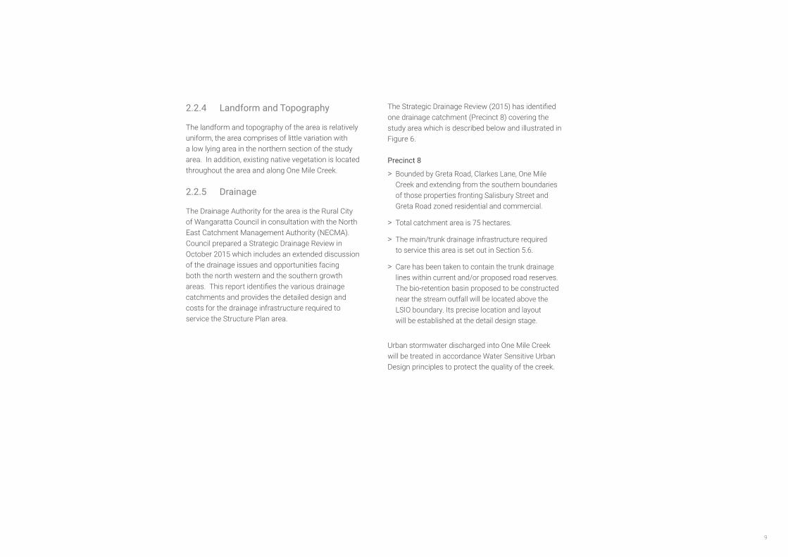
The Drainage Authority for the area is the Rural City of Wangaratta Council in consultation with the North East Catchment Management Authority (NECMA). Council prepared a Strategic Drainage Review in October 2015 which includes an extended discussion of the drainage issues and opportunities facing both the north western and the southern growth areas. This report identifies the various drainage catchments and provides the detailed design and costs for the drainage infrastructure required to service the Structure Plan area.
The Strategic Drainage Review (2015) has identified one drainage catchment (Precinct 8) covering the study area which is described below and illustrated in Figure 6.
Precinct 8
> Bounded by Greta Road, Clarkes Lane, One Mile Creek and extending from the southern boundaries of those properties fronting Salisbury Street and Greta Road zoned residential and commercial.
> Total catchment area is 75 hectares.
> The main/trunk drainage infrastructure required to service this area is set out in Section 5.6.
> Care has been taken to contain the trunk drainage lines within current and/or proposed road reserves. The bio-retention basin proposed to be constructed near the stream outfall will be located above the LSIO boundary. Its precise location and layout will be established at the detail design stage.
Urban stormwater discharged into One Mile Creek will be treated in accordance Water Sensitive Urban Design principles to protect the quality of the creek.

Wangaratta SOUTH GROWTH Area structure plan10
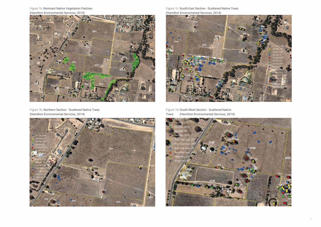
2.2.6 Flora and Fauna
An assessment of the Flora and Fauna values of the area has been undertaken by Hamilton Environmental Services in September 2014, and a report was prepared in November 2014.
The WSSP is defined as being within the Victorian Riverina Bioregion. Two ‘endangered’ Ecological Vegetation Classes (EVC) have been identified in the study area including Plains Grassy Woodland (EVC 55) and an area of Creekline Grassy Woodland (EVC 68) along One Mile Creek alignment along the eastern boundary of the study area.
However, it was noted that the extent of EVC mapping was not supported by the field assessment.
The WSSP area was found to be a highly modified and fragmented landscape; long-term agricultural land use, in particular stock grazing, has removed and simplified the composition of native vegetation, and while modified remnant elements remain, only small areas adequately represent the original flora of the area.
10 Remnant Patches were identified in the WSSP area, comprising a total of 6.1 hectares. The vast majority of scattered trees in the study area were found within these remnant patches.
There were no rare or threatened species observed or their presence inferred across the Growth Areas (Biosis, 2014).
The recommendations of the biodiversity report are summarised as follows:
> Protect and enhance all existing remnant patches
> Connect remnant patches along One Mile Creek corridor as Habitat Links,
> Avoid and minimise the loss of Scattered Trees and ensure tree protection zones are implemented, and
> Utilise remnant patches as offsets for any vegetation losses across the growth area.
Notwithstanding the above, it is noted that Hamilton Environmental Services were not able to gain access to seven properties. Therefore, flora and fauna assessments will need to be undertaken for these properties at the Development Plan stage.
11
Figure 7a: Remnant Native Vegetation Patches (Hamilton Environmental Services, 2014)
Figure 7b: Northern Section - Scattered Native Trees (Hamilton Environmental Services, 2014)
Figure 7c: South-East Section - Scattered Native Trees (Hamilton Environmental Services, 2014)
Figure 7d: South-West Section - Scattered Native Trees (Hamilton Environmental Services, 2014)
Biodiversity Study – North West and South Wangaratta Residential Growth Areas
120
Aerial image of the South Growth Area showing defined Remnant Patches. All Remnant Patches are shown with an associated number, which refers to the able in Appendix G. Title boundaries are shown as solid yellow lines, and Property numbers
are also shown (Image from NearMap 2014).Biodiversity Study – North West and South Wangaratta Residential Growth Areas
94
Aerial image of the northern section of the South Growth Area showing assessed trees. All trees are depicted with a symbol and associated number, which refers to the tree number in the table in Appendix D. ST is Small Trees, MOT is Medium Old Trees, LOT is Large Old Trees, and VLOT is Very Large Old Trees. Title boundaries are shown as solid yellow lines, and Property numbers are also shown (Image from NearMap 2014).
Biodiversity Study – North West and South Wangaratta Residential Growth Areas
95
Aerial image of the south-east section of the South Growth Area showing assessed trees. All trees are depicted with a symbol and associated number, which refers to the tree number in the table in Appendix D. ST is Small Trees, MOT is Medium Old Trees, LOT is Large Old Trees, and VLOT is Very Large Old Trees. Title boundaries are shown as solid yellow lines, and Property numbers are also shown (Image from NearMap 2014).
Biodiversity Study – North West and South Wangaratta Residential Growth Areas
96
Aerial image of the south-western section of the South Growth Area showing assessed trees. All trees are depicted with a symbol and associated number, which refers to the tree number in the table in Appendix D. ST is Small Trees, MOT is Medium Old Trees, LOT is Large Old Trees, and VLOT is Very Large Old Trees. Title
boundaries are shown as solid yellow lines, and Property numbers are also shown (Image from NearMap 2014).

12
2.2.7 Heritage & Culture
A Cultural Heritage Assessment was undertake by Biosis in October 2014 on behalf of Council.
This report identified evidence of land disturbance due to the construction of residences, the excavation of dams and stock watering holes. The southern study area comprises of a series of flat paddocks and has a number of developed household properties along its southern border, with the northern part trending to open undeveloped paddocks.
Furthermore, the study area is relatively featureless and a limited field study was undertaken as part of this report and no Aboriginal archeological material were identified (Biosis, 2015). Biosis noted that the low lying swamp in the northern section of the growth area, which is outside the designated area of cultural heritage sensitivity, as an area of archaeological potential.
Biosis recommended that a Cultural Heritage Management Plan (CHMP) must be prepared as part of preparation of a Development Plan for the northern area adjacent to One Mile Creek, and a voluntary CHMP should be undertaken for all other landholdings. All CHMPs will be required to be approved by Aboriginal Affairs Victoria (and/or any other Registered Aboriginal Party) prior to issue of a permit, in accordance with the Aboriginal Heritage Act 2006.
One Mile Creek contains alluvial terraces that have a moderate potential to yield archaeological material, and should be treated as archaeologically sensitive until further testing is possible (Figure 8A). One final area of archaeological potential was identified in a low lying swamp contained in the northern part of the study area. This zone may have been a focus for Aboriginal food
gathering as a natural drainage point in the landscape, and the marsh fringes and associated nearby land contain archaeological potential. Across the remainder of the study area there is low archaeological potential, however, there is still a possibility for undiscovered subsurface deposits to exist. A voluntary CHMP will effectively manage the risk of harming cultural heritage. Under Section 27 of the Aboriginal Heritage Act 2006, harming Aboriginal cultural heritage is unlawful, and applies if a person knowingly, recklessly or negligently harms Aboriginal cultural heritage.
Heritage OverlaysThe eastern section of the southern study area contains two places listed on the Wangaratta heritage overlay. South House (HO121) and Middle House (HO122) of the Closer Settlement Farmhouses are located immediately west of One Mile Creek. These Closer Settlements were sold or leased to returning servicemen following World War I and were intended as small pastoral or agricultural lots that the diggers could use to make a living after the war. Eventually these lots were abandoned by the diggers who usually had no farming knowledge or experience and were resold as residential lots (Biosis, 2014).
Council’s Heritage Advisor has undertaken an assessment of the two remaining Heritage Overlays and has determined that the houses still meet the criteria for cultural significance but has reviewed the extent of the boundary for the Heritage Overlay. It is recommended the extent of the existing boundary be revised (a reduction in the extent of the boundary). The proposed revised Heritage Overlay boundaries for HO121 and HO122 are illustrated in Figure 8b.
2.2.8 Bushfire Management
A Strategic Bushfire Risk Assessment of the study area was undertaken by Terramatrix in 2014. The report highlighted the need to include bushfire management throughout the planning and development process. The study area was identified as being predominantly grassland with small pockets of low-threat vegetation.
As the southern growth area is to the south of the existing urban area, it would be relatively sheltered from any fire spreading under a direct northerly influence. However, it does have grassland interface on its western and southern faces, meaning that a more likely impact is from a fire that is spreading towards Wangaratta from these directions as might occur following a south-westerly wind change. This scenario could correspond to a fire that started somewhere in the southerly end of the Warby Ranges and then spreads into the grassy valley country when exiting the forest (Terramatrix, 2014).
Any wildfire impacts on the study area would be from grass fires, as areas of forest that may burn in the same event are located at least 5km from the growth area. The fundamental principal of bushfire risk mitigation is to direct development away from high-risk areas as this reduces the exposure of people and property to potential impact. The report concludes that the WSSP area is appropriate for residential growth from a bushfire risk perspective.
The report outlines a number of broad guidelines around the design of the future growth areas such as:
> Ensuring the staging of the development occurs to allow emergency access at all times;
> That vulnerable uses such as housing for the elderly, nursing homes, health facilities, schools, child care centres, etc. be located in the inner areas of the development rather than on the outer edges; and
> Ensuring the area minimises fire risk during construction phases and on nearby vacant land.
The study area is currently within the Bushfire Prone Area (BPA) which may put unnecessary restrictions on building development. As such it is recommended that the future developers and stakeholders work together with Council, Country Fire Authority (CFA) and the Department of Environment, Land, Water and Planning (DELWP) to discuss the possible excising of the study area from the BPA as development stages progress.

13
One
Mile
Cree
k
Cribbes Rd
Bond Ct
Montgomery Ct
Clarkes Lane
Lom
andr
a St
Jordans Lane
Higgi
ns S
t
Dia
nella
St
Elm Av
Kend
all C
t
Casino Ct
Alpi
ne V
iew
Batchelor CrJackel St
Salis
bury
St
Mcauliffe Pl
Joyce Way
Silver Wattle Dr
Burke St
Adam
s St
Pin
Oak
Dr
Ward St
Tath
raPl
Bods
wor
th L
ane
Manley Cr
Mason St
Ora
nge
Ct
Lam
ont S
t
Greta
Rd
0 50 100 150 200 250
MetresMatter: 18409 CHMP No. Date: 29 October 2014, Checked by: TSC, Drawn by: LDM, Last edited by: jshepherdLocation:P:\18400s\18409\Mapping\18409_F7_8_Dev_Ob.mxd
Biosis Pty Ltd
Ballarat, Brisbane, Canberra, Melbourne, Sydney, Wangaratta & Wollongong
Acknowledgements: Vicmap (C) State of Victoria
Legend
Activity Area
Area of archaeological potential
Development obligation
Area of cultural heritage sensitivity.Mandatory requirement for a CHMP ifhigh impact activity proposed
Recommendation for a voluntaryCHMP if high impact activity proposed
Scale 1:5,000 @ A3Coordinate System: GDA 1994 MGA Zone 55
Figure 8: Development obligations - South
42
Figure 8a: Cultural Heritage (Biosis, 2014) Figure 8b: Heritage Overlays
HO122
HO121
CRIBBES ROAD
SILVER WATTLE DRIVE
MASON STREET
SALI
SBU
RY S
TREE
T
GRETA
ROAD
CLARKES LANE
JORDANS LANE
One
Mile
Cre
ek
DRAWING KEY
SITE FEATURES
Site Boundary
One Mile Creek
Existing Heritage Overlays
Proposed Revised Heritage Overlays

Wangaratta SOUTH GROWTH Area structure plan14
2.2.9 Movement Network
The study area is currently accessed via Greta Road (C523), Clarkes Lane and Salisbury Street. The southern portion of Salisbury Street is not constructed and there is an existing 18 metre wide east-west road reservation linking Salisbury Street to Greta Road and One Mile Creek. However, existing native vegetation is located within the east-west road reservation which will result in additional road widening being required from the properties located immediately north of the reservation.
Greta Road directly links the study area to the existing residential areas and centre of Wangaratta. Salisbury Street links the study area to the proposed commercial development, including an activity centre and bulky goods, located immediately to the north.
GHD completed a Transport Study to analyse the long term traffic implications for both the north western and southern growth areas in January 2015 and this was updated in 2017.
The GHD Report (2017) identified a number of upgrades required to the wider road network including:
> an upgrade of Greta Road between Riley Street and Joyce Way;
> an upgrade of Edwards Street/Evans Street/Green Street to a four lane, two way road;
> upgrade to Phillipson Street to a four lane, two way road between Williams Road and Rowan Street;
> upgrade of Rowan Street to a four lane, two way road between Phillipson Street and Green Street;
> upgrade of intersection of Joyce Way, Mason Street and Greta Road;
> signalisation of several intersections including:
> Wangandary Road/ Wangaratta/Yarrawonga Road;
> Williams Road/Phillipson Street; and
> Rowan Street/Green Street.
In terms of access to public transport the 402 bus route travels within close proximity of the study area along Cribbes Road and Hallett Court. Access to public transport will need to be provided within 400m (walking distance) of the majority of new dwellings within the WSSP area.
The Wangaratta Open Space Strategy (2012) places high importance on the provision of linear links, corridors and pathways as sources of open space and as a movement network. The Strategy identifies that there is insufficient provision of these linear connections to meet community demand. Currently, there is a linear shared path along the One Mile Creek and this should be continued as residential growth occurs. Future pedestrian and cycling networks need
to focus on linking to the existing linear networks.

15
Figure 9: Movement Network
PHIL
LIPS
ON
ST
WILLIAMS RD
WANGANDARY RD
WO
RLA
ND
RD
CH
RIS
TEN
SEN
LN
REI
TH R
D
BOW
SER
RD (C
314)
GREAT ALPINE RD (B500)
HUM
E FR
EEW
AY
GRE
A RD
TONE RD
T
JORDANS LN
CLARKES LN
MASON ST
MU
RD
OC
H R
D
EDWARDS ST
MU
RD
OC
H R
D
CRIBBES RD
DIX
ON
ST
SCHI
LLIN
G D
R
COLLEGE ST
ROWAN ST
REID ST
OVENS ST
PER
RY
ST
VINCENT ST
CRISP ST
HAL
LETT
CR
ES
DO
NO
VAN
DR
DRAWING KEY
PSP Extent
Cadastre
Freeway
Arterial Road
Connector Road
Existing Bus Route
Railway Line

Wangaratta SOUTH GROWTH Area structure plan16
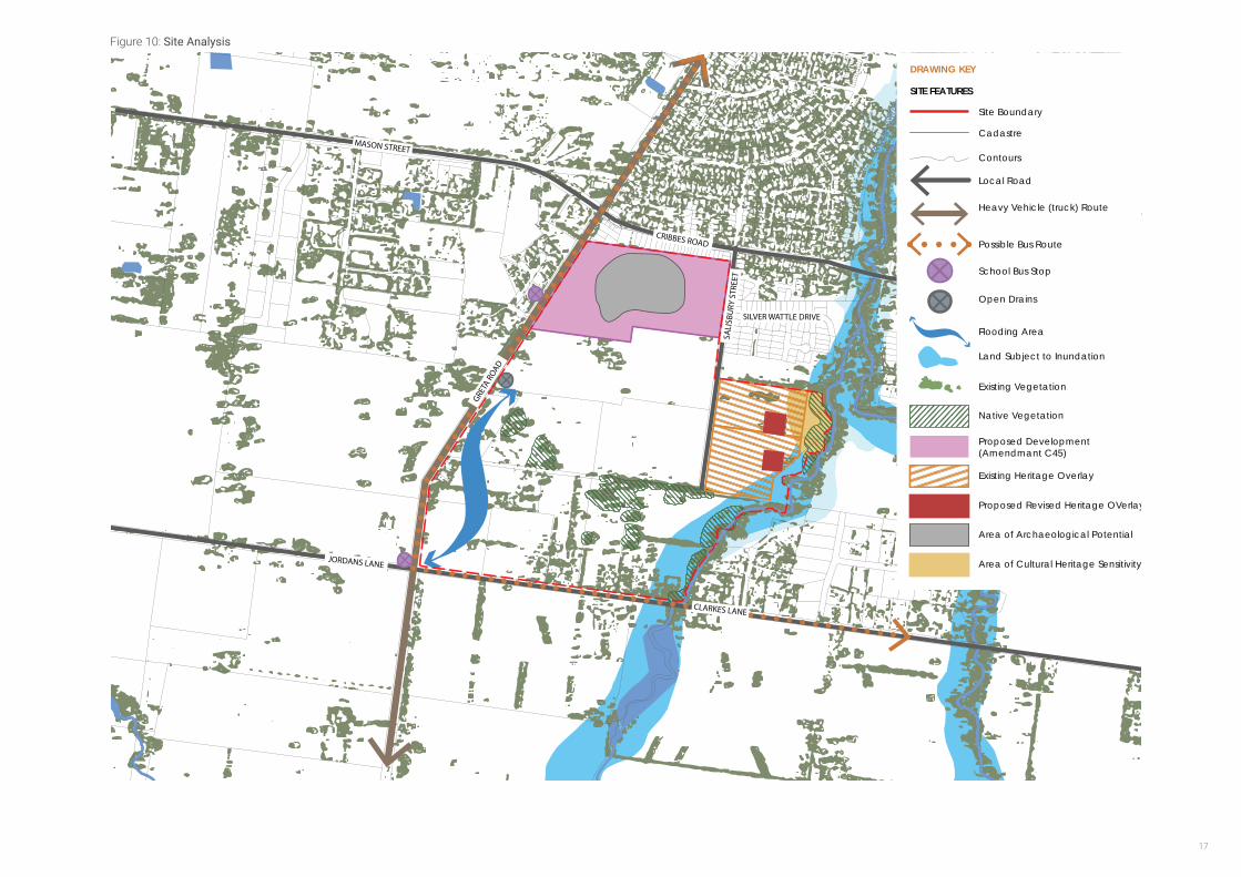
2.2.10 Site Analysis Summary
Figure 10 provides a summary of the site analysis features of the land and identifies key opportunities and constraints for development.
> The land is relatively flat.
> The existing Salisbury Street road reserve and east west road reserve provides the basis for the future collector road network.
> The site contains a small number of native vegetation patches and scattered trees. There is an opportunity to preserve and enhance these features and add to the character of the area.
> One Mile Creek, the Public Park and Recreation Zone and Flood Overlay affecting land immediately to the west of the creek presents the opportunity for wide green open space to be utilised for a range of activities. Design to provide public access to the river through edge roads. Connections (pedestrian/cycle and vehicle) will be required to connect communities.
> Close proximity to existing residential development and Wangaratta CBD.
> A neighbourhood activity centre is proposed in the northern section of the area.
> The land is relatively flat and flood prone and will require construction of drainage infrastructure to enable development of the land.
17
Figure 10: Site Analysis
CRIBBES ROAD
SILVER WATTLE DRIVE
MASON STREET
SALI
SBU
RY S
TREE
T
GRETA
ROAD
CLARKES LANE
JORDANS LANE
One
Mile
Cre
ekDRAWING KEY
SITE FEATURES
Cadastre
Heavy Vehicle (truck) Route
Local Road
Possible Bus Route
Site Boundary
Contours
Flooding Area
Land Subject to Inundation
Native Vegetation
Proposed Development(Amendmant C45)
Existing Heritage Overlay
Proposed Revised Heritage OVerlays
Area of Archaeological Potential
Area of Cultural Heritage Sensitivity
Open Drains
School Bus Stop
Existing Vegetation

Wangaratta SOUTH GROWTH Area structure plan18
3Forecast Population and Needs
3.1Introduction
The purpose of this chapter is to examine and describe the population forecast for the WSSP area, drawing on previous work undertaken, including the Wangaratta Population and Housing Strategy and the Wangaratta Growth Areas Structure Planning Report. Understanding the forecast population and approximate number of dwellings will enable an understanding to be gained of the needs of the future population.
3.2Land Budget and Housing Yield
The gross land area of the WSSP area (excluding the Am C45 area) is 71.5 hectares. However, approximately 12.5 hectares of land is not available for development as it is encumbered by native vegetation and drainage. The Amendment C45 area is to provide 108 residential lots.
Taking into account developable land that will be set aside for other purposes, including open space and for road widening, there is capacity to develop approximately 615 lots based on an average density of 10 lots per net developable ha. A more detailed lot yield for individual land holdings will be determined during preparation of Development Plans.
3.3Residential Housing Density Descriptions
Housing Type Definition
Low Density Lot size of a minimum of 2000 square metres
Medium Density
Medium density housing to provide for attached and semi-detached dwellings such as units and town houses or large designated medium density housing sites
Lot size less than 500 square metres
High Density Adopt a form of between 3 and four stories
Compact
Smaller lots to accommodate more compact and affordable detached or semi-detached dwellings
Lot sizes 500 - 600 metres
Table 1 Summary Land Budget
Land Budget (Ha)
Total Precinct Area 71.5
Encumbered Land
Drainage 0.6
Land Subject to Flood Overlay & LSIO 6.5
Native Vegetation 6.0
Open Space
Passive Open Space 2.7
Other Uses
Road widening 1.4
Shared Paths 0.06
Net Developable Area 54.2

19
3.2.1 Demographic Projections
The demographic profile of Wangaratta, as with other parts of Australia, is aging, with a significant decline in the size of households due to a trend towards a reduction in family size, an increase in the number of ‘one parent’ households, and an increase in the number of one and two person households.
The Wangaratta Population and Housing Strategy (2013) examined three growth rates: low, medium (base case) and high. The forecast population and dwelling figures for each growth rate are shown in Tables 2 and 3 below. The Population and Housing Strategy identifies the high growth scenario as the most desirable as this scenario provides the opportunity for growth and revitalisation of the municipality. This scenario also provides the critical mass that requires comprehensive planning of growth areas and will assist in addressing housing affordability and diversity, protection of environmental assets and the effective provision of new infrastructure.a Population and Housing Strategy (2013)
The average household size in Wangaratta in 2011 was estimated at 2.35 persons (id. Profile) and it is anticipated that the household size will continue to decline in the future. As such, the WSSP area is anticipated to accommodate approximately 615 dwellings and a population of around 1,800.
While initially the WSSP area is likely to cater for families, and as such create demand for traditional detached housing, over time, it is anticipated that smaller household types will create demand for smaller lot housing. The Wangaratta Population and Housing Strategy (2013) notes that urban separate/ detached houses will remain the most demanded type of housing, followed by low density separate houses, however, there is forecast to be strong growth in semidetached/townhouse dwellings in the future, 1.6% per annum. This was the highest growth of all dwelling types.
Accordingly, a variety of densities and housing typologies will need to be provided within the WSSP.
Table 2: Population Forecasts: High, medium and low growth scenarios
Population Forecasts
2011 2021 2031 2011-2031 Change
High Scenario 26,810 29,840 33,220 6,410
Medium (base) 26,810 27,990 29,160 2,350
Low Scenario 26,810 26,915 27,035 225
Source: Wangaratta Population and Housing Strategy (2013)
Table 3: Dwelling Forecasts: High, medium and low growth scenarios
Total Private Dwelling Forecasts
2011 2021 2031 2011-2031 Change
High Scenario 12,380 14,085 15,895 3,510
Medium (base) 12,380 13,300 14,125 1,745
Low Scenario 12,380 12,840 13,300 820
Source: Wangaratta Population and Housing Strategy (2013)
Wangaratta SOUTH GROWTH Area structure plan20
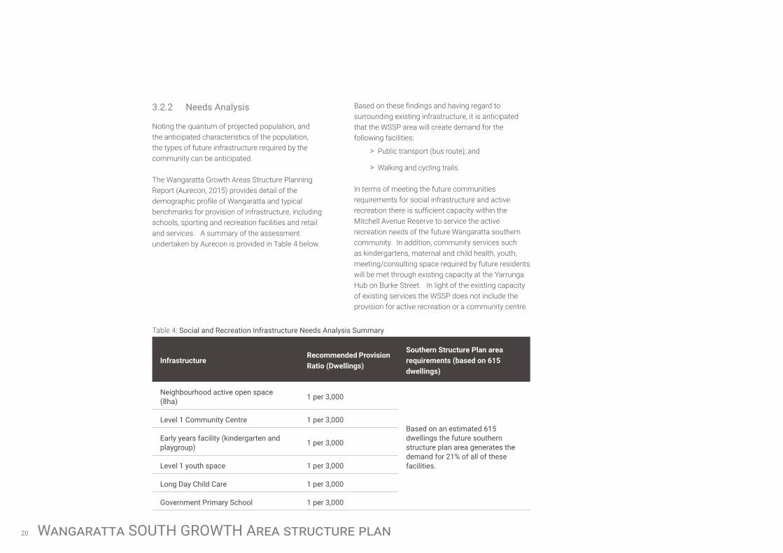
3.2.2 Needs Analysis
Noting the quantum of projected population, and the anticipated characteristics of the population, the types of future infrastructure required by the community can be anticipated.
The Wangaratta Growth Areas Structure Planning Report (Aurecon, 2015) provides detail of the demographic profile of Wangaratta and typical benchmarks for provision of infrastructure, including schools, sporting and recreation facilities and retail and services. A summary of the assessment undertaken by Aurecon is provided in Table 4 below.
Table 4: Social and Recreation Infrastructure Needs Analysis Summary
InfrastructureRecommended Provision Ratio (Dwellings)
Southern Structure Plan area requirements (based on 615 dwellings)
Neighbourhood active open space (8ha) 1 per 3,000
Based on an estimated 615 dwellings the future southern structure plan area generates the demand for 21% of all of these facilities.
Level 1 Community Centre 1 per 3,000
Early years facility (kindergarten and playgroup) 1 per 3,000
Level 1 youth space 1 per 3,000
Long Day Child Care 1 per 3,000
Government Primary School 1 per 3,000
Based on these findings and having regard to surrounding existing infrastructure, it is anticipated that the WSSP area will create demand for the following facilities:
> Public transport (bus route); and
> Walking and cycling trails.
In terms of meeting the future communities requirements for social infrastructure and active recreation there is sufficient capacity within the Mitchell Avenue Reserve to service the active recreation needs of the future Wangaratta southern community. In addition, community services such as kindergartens, maternal and child health, youth, meeting/consulting space required by future residents will be met through existing capacity at the Yarrunga Hub on Burke Street. In light of the existing capacity of existing services the WSSP does not include the provision for active recreation or a community centre.

21
This page has been intentionally left blank.

Wangaratta SOUTH GROWTH Area structure plan22
4VISION The vision for the Wangaratta Southern Structure
Plan area is to create a new, safe, beautiful and unique community where people will want to live and recreate.
Five key elements comprise the detailed, plan based vision for the Wangarratta Southern Structure Plan.
Movement NetworkA key collector road network that:
> Provides a base for a grid-based local road network;
> Incorporates a positive landscape character and responds to the existing native vegetation within the existing road reserves;
> Provides internal connections between, and externally to surrounding, neighbourhoods; and
> Incorporates an accessible public transport route and linked pedestrian/cycle network that encourages more sustainable living patterns including active transport.
Open Space, Biodiversity and Bushfire ManagementAn interlinked open space network that:
> Focuses on retaining and enhancing existing native vegetation and One Mile Creek;
> Is visually and physically connected to surrounding land uses;
> Can accommodate a range of functions, including drainage, active and passive recreation, walking/cycling trails and to preserve the native vegetation;
> Provides a high amenity setting for diverse housing outcomes, including medium density housing; and
> Ensures that the planting and landscaping of open spaces balances the CFA bushfire requirements.
Activity Centre A centralised neighbourhood activity centre that:
> Provides a local focus for the community;
> Takes a ‘street-based’ form;
> Provides a town square; and
> Provides a context for higher density housing.
Neighbourhood and DensityA series of internal neighbourhoods that:
> Create high quality residential environments;
> Are diverse in landscape, streetscape and built form character;
> Are clearly defined and incorporate sustainable design principles;
> Contain an identifiable neighbourhood ‘core’ (open space, activity centre, key natural feature) to establish a sense of place; and
> Provide opportunities for diverse housing outcomes, from smaller lots to larger lots, to achieve an average density of 10 lots per net developable hectare and meet the varying needs of the local population.
Utilities and DrainagePhysical services and Infrastructure that:
> Focuses on holistic and coordinated water sensitive urban design approaches to stormwater treatment and management;
> To protect and enhance key watercourses and drainage lines;
> To encourage innovative, sustainable energy efficient approaches to the provision of services;
> Meets the needs of the community and the development;
> Is equitably funded and efficiently delivered; and
> Represents ‘best practice’ provision and design.

23
Figure 11: Wangaratta South Growth Area Structure Plan
CRIBBES ROAD
SILVER WATTLE DRIVE
MASON STREET
SALI
SBU
RY S
TREE
T
GRETA
ROAD
CLARKES LANE
JORDANS LANE
N
1:7500 at A3
0 150 300 450 600METERS
WANGARATTA SOUTH STRUCTURE PLANS
Level 1, 6 Riverside Quay Southbank, VIC 3006 t 9695 3025 f 9695 3001
Structure Plan
28 August 2017
9695 3025 9695 3001
One
Mile
Cre
ek
DRAWING KEY
SITE FEATURES
Cadastre
Access St with Shared Path (18m)
Shared Path (In Road Reservation)
Proposed Future Bus Route
Off-Road Shared Path
Collector Roads (with Shared Path)(able to cater for future bus routes)
Arterial Road
Site Boundary
One Mile Creek
Standard Density Residential
Neighbourhood Activity Centre
Passive Open Space
Proposed Revised Heritage Overlay
Land Subject to Inundation
Native Vegetation
Diverse Housing / Medium Density Residential
Drainage (Retarding Basins / Bioretention/ Stormwater Management)and Trunk Infrastructure

Wangaratta SOUTH GROWTH Area structure plan24
5STRUCTURE PLAN ELEMENTS
5.1Introduction
Each of the key structure plan elements are described in turn in this Chapter. A set of design objectives have been outlined for each element, which seeks to describe in words the intent and aspirations for each element of the plan.
While each element is described separately, it is noted that they are interlinked, and as such, one component influences the other. As such, any alterations to one component must be considered more broadly in terms of the impact on the plan and the vision as a whole.
These objectives of the Structure Plan must be responded to during preparation of Development Plans and subsequent Planning Permit applications for subdivision. Specific direction for Development Plans and planning permit applications is included to provide guidance on more detailed matters.
5.2Movement Network
A key collector road network that:
> Provides a base for a grid-based local road network;
> Incorporates a positive landscape character and responds to the existing native vegetation within the existing road reserves;
> Provides internal connections between, and externally to surrounding, neighbourhoods; and
> Incorporates an accessible public transport route and linked pedestrian/cycle network that encourages more sustainable living patterns including active transport.
The proposed movement network extends Salisbury Street to the south, constructs an east-west collector road that links Salisbury Street with Greta Road. Together these roads will form a loop road linking the growth area to existing development to the north and providing an alternative access point onto Greta Road. This loop road will enable the provision to extend the local bus route in the future and will form the spine for a grid-based local street network.
Shared paths will be provided to link the growth area with the neighbourhood activity centre located directly to the north, Greta Road and One Three Mile Creek. An off-road shared path is proposed along the western edge of One Mile Creek to connect with the existing path to the north. Due to the presence of existing native vegetation along the east-west road reservation, there will be an off-road shared path located within the 11 metre road reservation and the road will be constructed directly north in a new 18 metre reservation.
VISION

25
Figure 12: Movement Network
CRIBBES ROAD
SILVER WATTLE DRIVE
MASON STREET
SALI
SBU
RY S
TREE
T
GRETA
ROAD
CLARKES LANE
JORDANS LANE
One
Mile
Cre
ek
DRAWING KEY
SITE FEATURES
Collector Roads (with Shared Path)(able to cater for future bus route)
Access St with Shared Path (18m)
Existing Bus Route
Possible Future Bus Route
Shared Path (in road reserve)
Off-RoadShared Path
Arterial Road
Roundabout
Site Boundary

Wangaratta SOUTH GROWTH Area structure plan26
Structure Plan Objectives:
> To utilise and extend Salisbury Street and construct a new southern peripheral east-west road using existing road reservation to provide external connections and define internal neighbourhoods.
> To provide a collector road network that is able to cater for bus routes that are within a five minute walk (400m) of the majority of residents.
> To provide a connected on and off road pedestrian/cycle network that utilises One Mile Creek and links the community to the proposed neighbourhood activity centre.
> To provide an active edge to all open space areas via edge roads.
> To provide ‘direct’ property access to all roads.
> To provide a sustainable transport network including a permeable grid-based layout that encourages multi-modal transport.
Direction for Development Plans:
Cross-sections
Typical cross-sections have been prepared for roads shown in the Structure Plan. These cross-sections reflect the access and design objectives set out above.
All collector roads provide a pavement width suitable for accommodating buses, and indented parking bays (with landscaped kerb outstands) to form an attractive and functional collector road.
Local roads are not shown on the Structure Plan, however they will need to be designed through the Development Plan process. Figure 13 illustrates a standard cross-section for local access streets, however, it is emphasised that the vision for WSSP is to create neighbourhoods that are distinct and diverse.
As such, a design objective of this Structure Plan that must be responded to at the Development Plan stage is to deliver diverse streetscapes through modifications to the local street cross-section. These modifications should respond specifically to the site, and may comprise alternative parking arrangements (for example angled), widened nature strips, central medians etc. However it is noted that narrowing of the road pavement will not generally be supported.
Road realignment to protect existing native
vegetation There is currently native vegetation located within the southern peripheral east –west road reservation, therefore it is proposed that the road pavement be constructed in a new 18m reservation directly north of the existing reservation. It is proposed that a 3 metre wide off-road shared path and drainage infrastructure be located within the existing 11 metre reservation.
Road Construction Timing
Development Plans must set out proposed road works and timing of construction of these works in accordance with the WSDCP. Please refer to the WSDCP for project details and indicative provision trigger.

27
Figure 13: Collector Road and Access Street Cross-sections
Wangaratta SOUTH GROWTH Area structure plan28
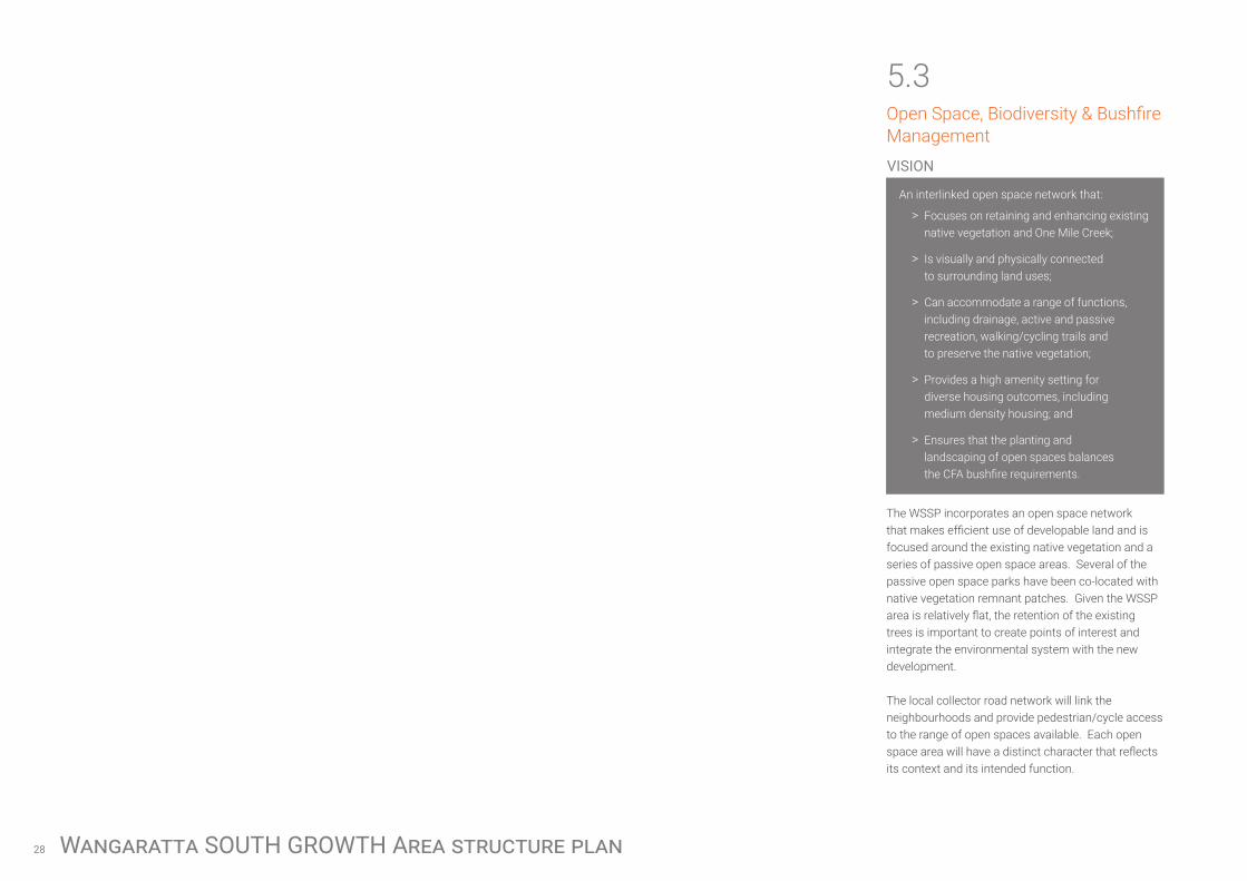
5.3Open Space, Biodiversity & Bushfire Management
An interlinked open space network that:
> Focuses on retaining and enhancing existing native vegetation and One Mile Creek;
> Is visually and physically connected to surrounding land uses;
> Can accommodate a range of functions, including drainage, active and passive recreation, walking/cycling trails and to preserve the native vegetation;
> Provides a high amenity setting for diverse housing outcomes, including medium density housing; and
> Ensures that the planting and landscaping of open spaces balances the CFA bushfire requirements.
The WSSP incorporates an open space network that makes efficient use of developable land and is focused around the existing native vegetation and a series of passive open space areas. Several of the passive open space parks have been co-located with native vegetation remnant patches. Given the WSSP area is relatively flat, the retention of the existing trees is important to create points of interest and integrate the environmental system with the new development.
The local collector road network will link the neighbourhoods and provide pedestrian/cycle access to the range of open spaces available. Each open space area will have a distinct character that reflects its context and its intended function.
VISION

29
Figure 14: Open Space & Biodiversity
CRIBBES ROAD
SILVER WATTLE DRIVE
MASON STREET
SALI
SBU
RY S
TREE
T
GRETA
ROAD
CLARKES LANE
JORDANS LANE
One
Mile
Cre
ek
DRAWING KEY
SITE FEATURES
Site Boundary
Passive Open Space (POS)
400m POS Catchment
Native Vegetation

Wangaratta SOUTH GROWTH Area structure plan30
Structure Plan Objectives:
> To identify, protect and enhance areas of significant environmental value through the open space network.
> To locate passive open space to coincide with native vegetation to protect and enhance these features and provide each space with its own distinct character.
> To visually and physically link open space to neighbourhoods through the use of edge road treatments and connected by an off-road pedestrian/cycle network.
> To incorporate small urban ‘green’ spaces within the detailed design of subdivisions, including small pockets parks, widened naturestrips, central medians to provide a point of difference within neighbourhoods that can be utilised as a context for higher density housing.
> To ensure that the location, design and construction of development considers the need to implement bushfire protection measures.
> To identify areas where the bushfire hazard requires specified bushfire management measures for subdivision and buildings and works to be implemented.
> To require future subdivision to set aside passive open space within 400m walkable catchments of 95% of all dwellings.
Direction for Development Plans:
Encumbered Open Space
The Structure Plan contains several types of encumbered land including drainage retarding basins; an existing Flood Overlay which applies to land directly abutting the One Mile Creek; and numerous patches of native vegetation. It is recognised that these areas can accommodate multiple functions, and are a valuable open space resource.
Native Vegetation
The WSSP has identified 7 of the 10 remnant native vegetation patches, or 5.47 of the total 6.14 hectares, to be retained. Remnant patches numbered 28-30 (as numbered in the Flora and Fauna Report prepared by Hamilton Environmental Services, 2014) are not shown as being retained. The Structure Plan prioritises the retention of existing scattered trees and native vegetation in open spaces which will contribute to the character of Wangaratta. It is intended that the Development Plan Overlay will include controls to protect scattered trees and remnant patches at the time of detailed subdivision.
It is important to note that Council has not sought approval from Department of Environment, Land, Water and Planning (DELWP) in relation to this approach. As part of the public exhibition process the Rural City of Wangaratta will seek confirmation and approval for this approach from the DELWP.
Furthermore, the areas identified as being retained have been removed from the net developable area for the purpose of calculating the Development Contributions Plan charge rate. Therefore any change to the amount of native vegetation being removed or retained will impact on the Development Contributions Plan.
Lastly, the method of satisfying offsets required with native vegetation removal will be resolved at the planning permit stage and will be met by the development proponent, offsets are not included in the Development Contributions Plan.
Active Open Space
The Rural City of Wangaratta have identified that the Mitchell Avenue Reserve has capacity to meet the demand for active recreation generated by the future community, therefore the structure plan does not make any allowance for provision of active open space.

31
Passive Open Space
A series of local parks are required to be provided throughout the Structure Plan, the majority of these parks are approximately 0.5 hectares in size. These small local parks are located to form the heart of neighbourhoods, and where possible have been co-located with existing vegetation to contribute to the protection and enhancement of the existing environmental habitats.
Overall 2.7 hectares of passive open space has been identified across the Wangaratta South Structure Plan area which is equivalent to 5% of the total net developable area and will be implemented via the DCP and Clause 52.01.
Specific objectives include:
> To protect significant roadside vegetation along the existing east-west road reservation.
> Prioritise the cohesive retention of existing trees, native vegetation and habitat design in open spaces which contribute to the character of the area.
> The local open space network must be integrated into the broader open space network including links to the One Mile Creek.
> Each open space area should be designed to have a distinct character that reflects its context and intended use.
> Passive parks should cater for a broad range of users by providing a mix of spaces and planting to support both structured and unstructured recreational activities and play opportunities for all ages and abilities.
> Any fencing of open space, whether encumbered or unencumbered, must be low scale and visually permeable to facilitate public safety and surveillance. Fences other than vehicle exclusion bollards or pedestrian exclusion fencing to prevent access to conservation areas are to be avoided.
> The design of waterway corridors, conservation areas, wetlands and retarding basins, and any other encumbered open space must seek to maximise the amenity value of that open space and provide for a range of flexible recreational opportunities. This is to be prioritised when such land abuts unencumbered passive open space.
> Open space areas should be located and designed to contribute to the protection and enhancement of existing environmental, habitat and historical values of the precinct.
> Ensure planting, landscaping and vegetation of open spaces balance the CFA bushfire requirements.
Bushfire Management
A Bushfire Hazard Management Plan is to be prepared before the commencement of works addressing the bushfire risk. The plan should specify, amongst other things:
> Bushfire hazard, whether from the land or nearby land, that may threaten life and property on the land during and after development;
> Measures to reduce the risk from fire within the surrounding rural landscape and protect residents from the threat of fire;
> The staging of development;
> How the bushfire hazard will change as development proceeds;
> How adequate opportunities for access and egress will be provided to early residents, construction workers and emergency vehicles; and
> Any lot on which buildings must be constructed to a specified Bushfire Attack Level (BAL)
The Plan must be carried out to the satisfaction of the responsible authority and relevant fire authority. The Bushfire Hazard Management Plan should address whether it is appropriate to remove the Bushfire Prone Area designation from the WSSP area as development stages progress.

Wangaratta SOUTH GROWTH Area structure plan32
5.4Activity Centre
A centralised neighbourhood activity centre that:
> Provides a local focus for the community;
> Takes a ‘street-based’ form;
> Provides a town square; and
> Provides a context for higher density housing.
A neighbourhood level activity centre is located in the north-western corner of the Structure Plan area. This local neighbourhood centre will meet the convenience retail and service needs of the community.
The neighbourhood activity centre area and balance of the property has already been rezoned as part of Amendment C45 to the Wangaratta Planning Scheme.
Structure Plan Objectives:
> To locate a neighbourhood-scale activity centre within the northern section of the WSSP area, within the land zoned Commercial 1.
> To provide local convenience centre retail and services, possibly including a small convenience/general store, small service businesses, a café and possibly community services such as childcare.
> To incorporate public space as a central part of the neighbourhood activity centre by co-locating the activity centre with a local park.
> To provide opportunities for higher density housing and mixed uses, such as home offices surrounding the activity centre.
> To ensure the activity centre is accessible via public transport by locating it close to Greta Road.
Direction for Activity Centre Design:
The land covering the neighbourhood activity centre was rezoned in May 2015 as Amendment C45 to the Wangaratta Planning Scheme. Amendment C45 included a Section 96A application, however final plans have yet to be prepared and endorsed under this permit.
It is necessary to develop a design for the structure of the activity centre, that integrates with the local road network and other land uses and comprises a high quality built form. Specific objectives include:
> Scale of activity centre (i.e. retail floor space) must reflect its local status as a Neighbourhood Convenience Centre, providing daily goods and services. It is anticipated that the retail floorspace would be around 4,000m2.
> Activity centre must be designed to be visible from Greta Road.
> Buildings fronting Greta Road must provide a continuous built form edge with fine grain development and outward facing built form.
> Mixed uses, incorporating higher density residential, community uses and home/ office style uses are encouraged in the area immediately surrounding the activity centre.
> The road and path networks within the neighbourhood centre must promote pedestrian and bicycle trips through a clear, direct layout and design.
> The activity centre should comprise high quality built form that positively address the surrounding streets, corners and public spaces, including open space.
> Buildings and uses should be of a scale sympathetic to the surrounding residential context.
> Adequate parking must be provided in a location that does not feature prominently from key locations, such as Greta Road.
> Future bus stop locations must include a bus stop at the activity centre.
VISION

33
Figure 15: Activity Centre and Community Facilities
CRIBBES ROAD
SILVER WATTLE DRIVE
MASON STREET
SALI
SBU
RY S
TREE
T
GRETA
ROAD
CLARKES LANE
JORDANS LANE
One
Mile
Cre
ek
DRAWING KEY
SITE FEATURES
Site Boundary
Neighbourhood Activity Centre

Wangaratta SOUTH GROWTH Area structure plan34
5.5Neighbourhoods and Density
A series of internal neighbourhoods that:
> Create high quality residential environments;
> Are diverse in landscape, streetscape and built form character;
> Are clearly defined and incorporate sustainable design principles;
> Contain an identifiable neighbourhood ‘core’ (open space, activity centre, key natural feature) to establish a sense of place; and
> Provide opportunities for diverse housing outcomes, from smaller lots to larger lots, to achieve an average density of 10 lots per net developable hectare and meet the varying needs of the local population.
The WSSP area comprises of a series of neighbourhoods of approximately 400m in radius (i.e. a five minute walk in each direction) which are focused around centralised features, such as a local park which serves to provide a local point of difference, to give the neighbourhood a distinct character and identity and as a context for diverse housing outcomes. The precise boudaries of these neighbourhoods will be determined during the Development Plan stage.
A density target of 10 lots per net developable hectare is to be adopted as the general density target for the area. It is considered that this target is appropriate taking into consideration the landform characteristics of the area and the likely market conditions. The structure plan provides for a range of housing density with the low density interface along the southern and northern boundaries and higher densities around the activity centre and open space.
Structure Plan Objectives:
> To create distinct neighbourhoods defined by a neighbourhood ‘core’ (such as passive open space).
> To link each neighbourhood by the key loop road comprising Salisbury Street and the southern peripheral east-west road.
> To provide a high amenity character to each neighbourhood through the use of diverse streetscape cross-sections and open spaces, that can be used as a context for diverse and higher density housing outcomes.
> To identity appropriate locations for smaller lots.
> To respect interfaces with adjoining land, including the neighbourhood activity centre and commercial development to the north, One Mile Creek to the east, and rural land to the south and west.
> To incorporate best practice passive design principles into new subdivision and housing development through road and housing orientation, solar access, shading, natural ventilation, thermal mass and insultation.
Direction for Development Plans:
Neighbourhood Design, Lot Planning and
Housing Design
The vision for the WSSP is to deliver densities of approximately 10 lots per net developable hectare across the entire site, via a diverse range of lot sizes. Indicative locations for smaller areas of housing diversity including smaller lot housing has been
identified on the Structure Plan, which mainly respond to locations with higher amenity (along One Mile Creek, adjacent to open space) and in close proximity to the neighbourhood activity centre.
Notwithstanding, diversity in lot size is encouraged throughout the Structure Plan area. Development Plans must be designed to respond to the average density requirement in the following ways: „
> Local road network must be designed to cater for a range of lot types within all streets, that incorporate variation in:
> Lot depth and width;
> Front, side and rear setbacks; and
> Access conditions.
> Incorporate streetscape diversity and character into the local street network via use of varied local cross-section designs to provide a high amenity context for smaller lot housing.
> Nominate a range of lot sizes throughout the plan area, which respond to the existing and planned site conditions e.g. smaller lot product around open spaceand around the activity centre.
> Development Plans must also identify types of interfaces and connections to adjoining land. In particular, Development Plans must specify what fencing and allotment treatment will be appropriate to interface with the rural land to the west and south.
VISION

35
Figure 16: Neighbourhoods and Density
CRIBBES ROAD
SILVER WATTLE DRIVE
MASON STREET
SALI
SBU
RY S
TREE
T
GRETA
ROAD
CLARKES LANE
JORDANS LANE
One
Mile
Cre
ek
DRAWING KEY
SITE FEATURES
Site Boundary
Standard Density Residential
Diverse Housing / Medium Density Residential

Wangaratta SOUTH GROWTH Area structure plan36
5.6Utilities and Drainage
Physical services and Infrastructure that:
> Focuses on holistic and coordinated water sensitive urban design approaches to stormwater treatment and management;
> To protect and enhance key watercourses and drainage lines;
> To utilise the Wangaratta Southern Development Contributions Plan to equitably distribute the costs associated with provision of drainage and road infrastructure.
Direction for Development Plans:
Servicing and Drainage
Current infrastructure providers to the WSSP area are:
Water & Sewerage North East Region Water Corporation
Electricity Ausnet Services
Telecommunications Telstra
Drainage
Rural City of Wangaratta, North East Catchment Management Authority
Gas APA Group
All providers have advised that the land can be serviced.
The major drainage infrastructure required to service the WSSP area is described below and illustrated in Figure 17.
DR01
Southern Growth Area Truck Drainage. Construction of major spine drainage system, mainly along Greta Road and the Southern Peripheral Road, to service the Southern Growth Area. A total of 2,159 lm of pipe is required along with the construction of one bio-retention basin. Total land area required is 0.6 hectares.
Details of servicing staging and delivery, including any easements which may be required, must be provided as part of future Development Plans.
Developments Plans must provide the details of servicing staging and delivery in the following ways:
> The development must provide best practice stormwater quality treatment.
> Delivery of underground services must be coordinated, located, and bundled (utilising common trenching) to facilitate the planting of trees and other vegetation within road verges to the satisfaction of the Responsible Authority.
> The design and layout of open space should maximise water use efficiency and long term viability of vegetation through the use of Water Sensitive Urban Design initiatives, including use of locally treated stormwater for irrigation purposes.
> Integrated water management systems should be designed to:
> Maximise habitat values for local flora and fauna species.
> Enable future harvesting and/or treatment and re-use of stormwater, including those options or opportunities.
> New electricity supply infrastructure should be provided underground where possible.
> Above ground utility infrastructure should be located outside of key view lines and must be screened with vegetation or architectural features.
> To encourage innovative, sustainable energy efficient approaches to the provision of services;
> Meets the needs of the community and the development;
> Is equitably funded and efficiently delivered; and
> Represents ‘best practice’ provision and design.
The WSSP area will be progressively provided with all necessary physical services (sewer, potable water and stormwater management) to support the ultimate population.
Structure Plan Objectives:
> To identify key infrastructure that will serve the broader WSSP community, and as such, funding of this infrastructure should be shared (see Figure 17 for list of infrastructure).
> To identify a Water Sensitive Urban Design approach to stormwater management that meets the drainage requirements of the development and also protects the water quality of the One Mile Creek. This approach provides for one catchment that will drain to a single retarding basin that will manage stormwater flows and quality, supported by main drainage infrastructure to be incorporated within the local street network.
VISION

37
Figure 17: Drainage Infrastructure
DR01
CRIBBES ROAD
SILVER WATTLE DRIVE
MASON STREET
SALI
SBU
RY S
TREE
T
GRETA
ROAD
CLARKES LANE
JORDANS LANE
N
1:7500 at A3
0 150 300 450 600METERS
WANGARATTA SOUTH STRUCTURE PLANS
Level 1, 6 Riverside Quay Southbank, VIC 3006 t 9695 3025 f 9695 3001
Drainage Infrastructure
28 August 2017
9695 3025 9695 3001
One
Mile
Cre
ek
DRAWING KEY
SITE FEATURES
Site Boundary
One Mile Creek
Land Subject to Inundation
Drainage (Retarding Basins / Bioretention/ Stormwater Management)and Trunk Infrastructure

Wangaratta SOUTH GROWTH Area structure plan38
Figure 18: Development Plan Precincts
6IMPLEMENTATION PLAN
6.1Development Staging and Development Plan Areas
A Development Plan is required to be approved by the responsible authority before a planning permit can be issued (some exemptions apply). Development Plans must be prepared in accordance with the Wangaratta South Development Plan Overlay Schedule 8, and must be prepared for a group of landholdings that represent a logically defined precinct. Indicative Development Plan areas are provided in Figure 18.
The key purpose of a Development Plan is to resolve:
> Layout issues at the local road network scale, including connections at property boundaries and local connections to adjoining land outside the Structure Plan area;
> Design of open space;
> Typical cross-sections for a variety of local streets;
> Provision of servicing infrastructure;
> Native vegetation and heritage issues; and
> Details of Development Contribution Plan items proposed to be undertaken as ‘works in lieu’ of cash contributions.
Amendmant C45
1
23
5 6
4
CRIBBES ROAD
SILVER WATTLE DRIVE
MASON STREET
SALI
SBU
RY S
TREE
T
GRETA
ROAD
CLARKES LANE
JORDANS LANE
N
1:7500 at A3
0 150 300 450 600METERS
WANGARATTA SOUTH STRUCTURE PLANS
Level 1, 6 Riverside Quay Southbank, VIC 3006 t 9695 3025 f 9695 3001
Development Staging
28 August 2017
9695 3025 9695 3001
One
Mile
Cre
ek

39
6.2Subdivision works by Developers
As part of subdivision construction works, new development is required to meet the cost of delivering the following infrastructure (where the infrastructure is not included in the Development Contributions Plan for the land incorporated into the Wangaratta Planning Scheme):
> East-west connector and local streets (with reimbursement for those that are included in the Wangaratta South Growth Area Development Contributions Plan incorporated in the scheme to the satisfaction of the collecting agency);
> Landscaping of all existing and future roads and local streets (with reimbursement for those that are included in the Wangaratta South Growth Area Development Contributions Plan incorporated in the scheme to the satisfaction of the collecting agency);
> Intersection works and traffic management measures along collector roads and local streets (with reimbursement for those that are included in Wangaratta South
Growth Area Development Contributions Plan incorporated in the scheme to the satisfaction of the collecting agency);
> Local pedestrian and bicycle paths along collector roads and local streets and within local parks (with reimbursement for those that are included in the Wangaratta South Growth Area Development Contributions Plan incorporated in the scheme to the satisfaction of the collecting agency);
> Basic improvements to local parks and passive open space including levelling, grassing, tree planting, local playgrounds and shared paths and footpaths;
> Local drainage systems; and
> Infrastructure as required by utility services providers including water, sewerage, drainage (except where the item is funded through the Wangaratta South Growth Area Development Contributions Plan), electricity, gas, and telecommunications.
The northern most property, subject to Amendment C45, is not included in the Wangaratta South Growth Area DCP, Accordingly, the development proponent of this property is to directly provide all necessary infrastructure at no cost to Council in accordance with their approved Section 96A planning permit and associated Section 173 Agreement.
6.3Development Contributions Plan
A Development Contributions Plan has been prepared for the Wangaratta South growth area in conjunction with this Structure Plan, which also details open space contributions.
The Wangaratta South Growth Area Development Contributions Plan is an incorporated document of the Wangaratta Planning Schedule and implemented through the Development Contributions Overlay. Open space contributions are to be provided in accordance with the Development Contributions Plan, with contributions implemented through the Schedule to Clause 52.01

Wangaratta SOUTH GROWTH Area structure plan40
7REFERENCES Aurecon, 2015, Wangaratta Growth areas Structure
Planning Report
Aurecon, SGS, Rural City of Wangaratta, 2013, Population and Housing Strategy
Biosis, 2014, Residential Growth Area Precinct Planning, Wangaratta, Victoria: Cultural Heritage Assessment
GHD, 2017, Wangaratta Growth Areas Transport Study – Final Report
Hamilton Environmental Services, 2014, Biodiversity Study – North West and South Wangaratta Residential Growth Area Precinct Plans
Rural City of Wangaratta, 2012, Recreation Strategy and Open Space Strategy
Rural City of Wangaratta, 2015, Strategic Drainage Review – Growth Areas
Terramatrix, 2014, Strategic Bushfire Assessment for Wangaratta Residential Growth Area

41