Embed Size (px)
Citation preview

1 2 3 4 5
6 7 8 9
11
15
10
5.3 miles (8.5km) approx. 10,625 steps Allow 3 hours
About the walk...This walk begins in Otford where you can catch a glimpse of the largest scale model in the world - the Otford Solar System. After a steep climb up onto the North Downs you are rewarded with some fantastic views of the surrounding countryside.
Descending back to Otford along part of the North Downs Way you also pass by Otford Pond interestingly designated as a listed building! Please note that the route has a short on-road section and the steep climbs may not be suitable for all.
�
Distance: 5.3 miles (8.5km) allow 3 hours
Start/Finish: Otford
Stiles: 9
Gates: 4
Terrain: Fields and tracks with some on-road sections. Undulating paths. Some steep slopes
Views: Some good views
Toilets: None on route
Refreshments: Pub and shops near start/finish
Walk Overview
How to get there...Road Map: Multimap website www.multimap.com. Search for “Otford”
By Car: Otford is on the A225, just north of Sevenoaks.
Parking: Free car parking is available opposite the Bull public house in Otford.
Train: Nearest station – Otford (500m). National Rail Enquiries: 08457 484950
Bus: 421 (Sevenoaks – Swanley). 3 journeys. Mon – Sat.434 (Sevenoaks – Shoreham) 3/4 journeys. Mon - SatTraveline: 0870 6082608
�
�
�
12 13
14 16 17
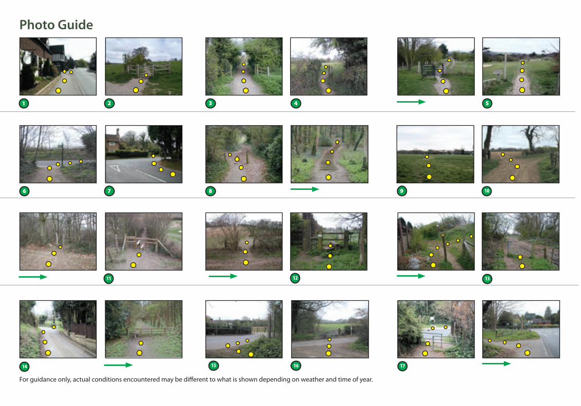
For guidance only, actual conditions encountered may be different to what is shown depending on weather and time of year.
Photo Guide This circular walk is one of a number of walks produced by Kent County Council. If you liked this walk you can find more on the Explore Kent website at www.kent.gov.uk/explorekent
We welcome any feedback about this walk or the content of the guide. If you know of a good walk and would like to share it, please let us know and we may feature it on our website.
If the route description or pictures are out-of-date please e-mail [email protected]
Please tell us about any problems concerning the paths using the Kent Report Line 0845 345 0210.This guide is available in other formats on request.
03/2007
When you’re out walking in the countryside, please respect the Countryside Code.
FAMILY FUN!Walking is not only a healthy activity but it can be fun and informative too. Free activity worksheets for children of all
ages to take on the walk can be ordered by emailing
[email protected] or calling
08458 247600.
www.kent.gov.uk/explorekent
Walks in West Kent
• Be safe – plan ahead and follow any arrows or signs
• Leave gates and property as you find them
• Protect plants and animals, and take your litter home
• Keep dogs under close control
• Consider other people
RESTRICTED BYWAY
BYWAY
BRIDLEWAY
FOOTPATH
© C
rown copyright reserved.Kent C
ounty Council licence num
ber 100019238. March 2006
Kilometres0
10.5
2
1
6
7
8
9
4
5
Take careN
Also use Ordnance Survey Map: Explorer 147Otford Circular Walk www.kent.gov.uk/explorekentMiles 0.5
�
Stile Gate View��
12
13
14
1516
17
�
10
3
11
�
�
�
�
�
�
�
�
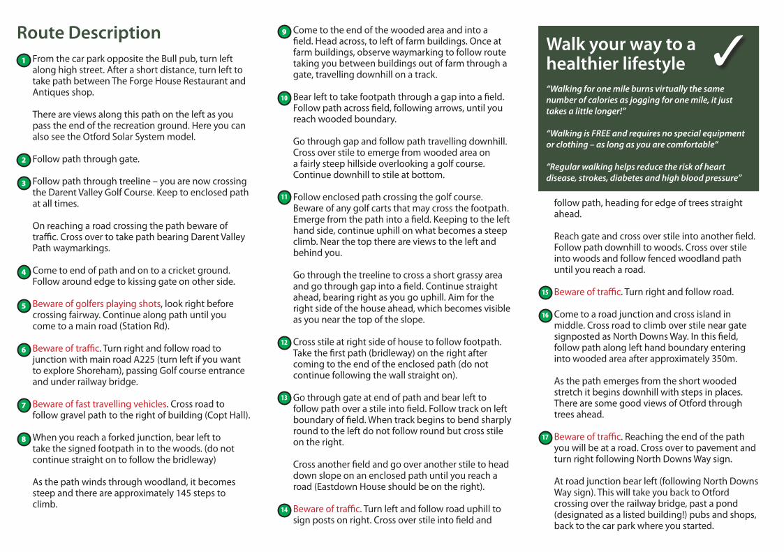
Route Description From the car park opposite the Bull pub, turn left along high street. After a short distance, turn left to take path between The Forge House Restaurant and Antiques shop.
There are views along this path on the left as you pass the end of the recreation ground. Here you can also see the Otford Solar System model.
Follow path through gate.
Follow path through treeline – you are now crossing the Darent Valley Golf Course. Keep to enclosed path at all times.
On reaching a road crossing the path beware of traffic. Cross over to take path bearing Darent Valley Path waymarkings.
Come to end of path and on to a cricket ground. Follow around edge to kissing gate on other side.
Beware of golfers playing shots, look right before crossing fairway. Continue along path until you come to a main road (Station Rd).
Beware of traffic. Turn right and follow road to junction with main road A225 (turn left if you want to explore Shoreham), passing Golf course entrance and under railway bridge.
Beware of fast travelling vehicles. Cross road to follow gravel path to the right of building (Copt Hall).
When you reach a forked junction, bear left to take the signed footpath in to the woods. (do not continue straight on to follow the bridleway)
As the path winds through woodland, it becomes steep and there are approximately 145 steps to climb.
Come to the end of the wooded area and into a field. Head across, to left of farm buildings. Once at farm buildings, observe waymarking to follow route taking you between buildings out of farm through a gate, travelling downhill on a track.
Bear left to take footpath through a gap into a field. Follow path across field, following arrows, until you reach wooded boundary.
Go through gap and follow path travelling downhill. Cross over stile to emerge from wooded area on a fairly steep hillside overlooking a golf course. Continue downhill to stile at bottom.
Follow enclosed path crossing the golf course. Beware of any golf carts that may cross the footpath. Emerge from the path into a field. Keeping to the left hand side, continue uphill on what becomes a steep climb. Near the top there are views to the left and behind you.
Go through the treeline to cross a short grassy area and go through gap into a field. Continue straight ahead, bearing right as you go uphill. Aim for the right side of the house ahead, which becomes visible as you near the top of the slope.
Cross stile at right side of house to follow footpath. Take the first path (bridleway) on the right after coming to the end of the enclosed path (do not continue following the wall straight on).
Go through gate at end of path and bear left to follow path over a stile into field. Follow track on left boundary of field. When track begins to bend sharply round to the left do not follow round but cross stile on the right.
Cross another field and go over another stile to head down slope on an enclosed path until you reach a road (Eastdown House should be on the right).
Beware of traffic. Turn left and follow road uphill to sign posts on right. Cross over stile into field and
1
2
Walk your way to a healthier lifestyle“Walking for one mile burns virtually the same number of calories as jogging for one mile, it just takes a little longer!”
“Walking is FREE and requires no special equipment or clothing – as long as you are comfortable”
“Regular walking helps reduce the risk of heart disease, strokes, diabetes and high blood pressure”
10
follow path, heading for edge of trees straight ahead.
Reach gate and cross over stile into another field. Follow path downhill to woods. Cross over stile into woods and follow fenced woodland path until you reach a road.
Beware of traffic. Turn right and follow road.
Come to a road junction and cross island in middle. Cross road to climb over stile near gate signposted as North Downs Way. In this field, follow path along left hand boundary entering into wooded area after approximately 350m.
As the path emerges from the short wooded stretch it begins downhill with steps in places. There are some good views of Otford through trees ahead.
Beware of traffic. Reaching the end of the path you will be at a road. Cross over to pavement and turn right following North Downs Way sign.
At road junction bear left (following North Downs Way sign). This will take you back to Otford crossing over the railway bridge, past a pond (designated as a listed building!) pubs and shops, back to the car park where you started.
3
4
5
6
9
7
8
11
12
13
15
16
17
14
✓
© C
rown copyright reserved.Kent C
ounty Council licence num
ber 100019238. March 2006
Kilometres0
10.5
2
1
6
7
8
9
4
5
Take careN
Also use Ordnance Survey Map: Explorer 147Otford Circular Walk www.kent.gov.uk/explorekentMiles 0.5
�
Stile Gate View��
12
13
14
1516
17
�
10
3
11
�
�
�
�
�
�
�
�
Route Description From the car park opposite the Bull pub, turn left along high street. After a short distance, turn left to take path between The Forge House Restaurant and Antiques shop.
There are views along this path on the left as you pass the end of the recreation ground. Here you can also see the Otford Solar System model.
Follow path through gate.
Follow path through treeline – you are now crossing the Darent Valley Golf Course. Keep to enclosed path at all times.
On reaching a road crossing the path beware of traffic. Cross over to take path bearing Darent Valley Path waymarkings.
Come to end of path and on to a cricket ground. Follow around edge to kissing gate on other side.
Beware of golfers playing shots, look right before crossing fairway. Continue along path until you come to a main road (Station Rd).
Beware of traffic. Turn right and follow road to junction with main road A225 (turn left if you want to explore Shoreham), passing Golf course entrance and under railway bridge.
Beware of fast travelling vehicles. Cross road to follow gravel path to the right of building (Copt Hall).
When you reach a forked junction, bear left to take the signed footpath in to the woods. (do not continue straight on to follow the bridleway)
As the path winds through woodland, it becomes steep and there are approximately 145 steps to climb.
Come to the end of the wooded area and into a field. Head across, to left of farm buildings. Once at farm buildings, observe waymarking to follow route taking you between buildings out of farm through a gate, travelling downhill on a track.
Bear left to take footpath through a gap into a field. Follow path across field, following arrows, until you reach wooded boundary.
Go through gap and follow path travelling downhill. Cross over stile to emerge from wooded area on a fairly steep hillside overlooking a golf course. Continue downhill to stile at bottom.
Follow enclosed path crossing the golf course. Beware of any golf carts that may cross the footpath. Emerge from the path into a field. Keeping to the left hand side, continue uphill on what becomes a steep climb. Near the top there are views to the left and behind you.
Go through the treeline to cross a short grassy area and go through gap into a field. Continue straight ahead, bearing right as you go uphill. Aim for the right side of the house ahead, which becomes visible as you near the top of the slope.
Cross stile at right side of house to follow footpath. Take the first path (bridleway) on the right after coming to the end of the enclosed path (do not continue following the wall straight on).
Go through gate at end of path and bear left to follow path over a stile into field. Follow track on left boundary of field. When track begins to bend sharply round to the left do not follow round but cross stile on the right.
Cross another field and go over another stile to head down slope on an enclosed path until you reach a road (Eastdown House should be on the right).
Beware of traffic. Turn left and follow road uphill to sign posts on right. Cross over stile into field and
1
2
Walk your way to a healthier lifestyle“Walking for one mile burns virtually the same number of calories as jogging for one mile, it just takes a little longer!”
“Walking is FREE and requires no special equipment or clothing – as long as you are comfortable”
“Regular walking helps reduce the risk of heart disease, strokes, diabetes and high blood pressure”
10
follow path, heading for edge of trees straight ahead.
Reach gate and cross over stile into another field. Follow path downhill to woods. Cross over stile into woods and follow fenced woodland path until you reach a road.
Beware of traffic. Turn right and follow road.
Come to a road junction and cross island in middle. Cross road to climb over stile near gate signposted as North Downs Way. In this field, follow path along left hand boundary entering into wooded area after approximately 350m.
As the path emerges from the short wooded stretch it begins downhill with steps in places. There are some good views of Otford through trees ahead.
Beware of traffic. Reaching the end of the path you will be at a road. Cross over to pavement and turn right following North Downs Way sign.
At road junction bear left (following North Downs Way sign). This will take you back to Otford crossing over the railway bridge, past a pond (designated as a listed building!) pubs and shops, back to the car park where you started.
3
4
5
6
9
7
8
11
12
13
15
16
17
14
✓
1 2 3 4 5
6 7 8 9
11
15
10
5.3 miles (8.5km) approx. 10,625 steps Allow 3 hours
About the walk...This walk begins in Otford where you can catch a glimpse of the largest scale model in the world - the Otford Solar System. After a steep climb up onto the North Downs you are rewarded with some fantastic views of the surrounding countryside.
Descending back to Otford along part of the North Downs Way you also pass by Otford Pond interestingly designated as a listed building! Please note that the route has a short on-road section and the steep climbs may not be suitable for all.
�
Distance: 5.3 miles (8.5km) allow 3 hours
Start/Finish: Otford
Stiles: 9
Gates: 4
Terrain: Fields and tracks with some on-road sections. Undulating paths. Some steep slopes
Views: Some good views
Toilets: None on route
Refreshments: Pub and shops near start/finish
Walk Overview
How to get there...Road Map: Multimap website www.multimap.com. Search for “Otford”
By Car: Otford is on the A225, just north of Sevenoaks.
Parking: Free car parking is available opposite the Bull public house in Otford.
Train: Nearest station – Otford (500m). National Rail Enquiries: 08457 484950
Bus: 421 (Sevenoaks – Swanley). 3 journeys. Mon – Sat.434 (Sevenoaks – Shoreham) 3/4 journeys. Mon - SatTraveline: 0870 6082608
�
�
�
12 13
14 16 17
For guidance only, actual conditions encountered may be different to what is shown depending on weather and time of year.
Photo Guide This circular walk is one of a number of walks produced by Kent County Council. If you liked this walk you can find more on the Explore Kent website at www.kent.gov.uk/explorekent
We welcome any feedback about this walk or the content of the guide. If you know of a good walk and would like to share it, please let us know and we may feature it on our website.
If the route description or pictures are out-of-date please e-mail [email protected]
Please tell us about any problems concerning the paths using the Kent Report Line 0845 345 0210.This guide is available in other formats on request.
03/2007
When you’re out walking in the countryside, please respect the Countryside Code.
FAMILY FUN!Walking is not only a healthy activity but it can be fun and informative too. Free activity worksheets for children of all
ages to take on the walk can be ordered by emailing
[email protected] or calling
08458 247600.
www.kent.gov.uk/explorekent
Walks in West Kent
• Be safe – plan ahead and follow any arrows or signs
• Leave gates and property as you find them
• Protect plants and animals, and take your litter home
• Keep dogs under close control
• Consider other people
RESTRICTED BYWAY
BYWAY
BRIDLEWAY
FOOTPATH