Embed Size (px)
DESCRIPTION
river fluvial processes
Citation preview

2007) 114–127www.elsevier.com/locate/geomorph
Geomorphology 85 (
Threshold-dominated fluvial styles in an arid-zone mud-aggregateriver: The uplands of Fowlers Creek, Australia
Gresley A. Wakelin-King ⁎,1, John A. Webb 1
Department of Earth Sciences, La Trobe University, Bundoora, Melbourne, Victoria 3086, Australia
Received 27 May 2005; received in revised form 28 November 2005; accepted 23 March 2006Available online 12 September 2006
Abstract
Fowlers Creek is a mud-aggregate fluvial system. Floodplain muds dominate the river's deposits and consist of silt, fine to veryfine quartzose sand, and clay. Up to ∼80% of the silts and clays are bound into sand- and silt-sized aggregates and comprise asubstantial component (>42%) of the floodplain muds. Mud-aggregate sediments behave like sands during transport, and as aresult, muds can be deposited under conditions of greater flow velocity than would otherwise be the case. Newly depositedfloodplain muds are loose and easily entrained, but older floodplain muds are cohesive, and the distribution of modern and olderfloodplain muds influences erosion patterns across Fowlers Creek.
In the lower order streams of the Fowlers Creek uplands, alternate reaches of shallow rectangular channels and unchannelledfloodplains collectively form discontinuous ephemeral streams. These landform sequences consist of gullies, coalescingdownstream to arroyos, which terminate in distributary intermediate floodouts. At Fowlers Creek, floodouts are preferentiallylocated at tributary junctions, reflecting their origin during very large floods. At floodouts, low slope and high vegetation densitypromote sheetflow infiltration and landform stability. Their efficiency in retaining runoff make floodouts drought refugia; they arean important ecological element in this arid area.
The higher order channel of the mid-uplands is a mobile, low-sinuosity, single-thread arroyo, incised into wide muddy unstablefloodplains. Fluvial processes are dominated by episodic flood-driven channel avulsion, and variability in stream energy andboundary resistance contributes to a non-equilibrium fluvial style. Frequent reach-scale channel relocation is accompanied by theburial of the abandoned channel in floodplain muds and both erosion and aggradation in downstream floodplains.© 2006 Elsevier B.V. All rights reserved.
Keywords: Arid environment; Arroyos; Ephemeral streams; Floodplains; Fluvial sedimentation
1. Introduction
Braided channels and single-thread, wide andshallow channels have been regarded as characteristic
⁎ Corresponding author. Tel.: +61 3 9479 2630; fax: +61 3 94791272.
E-mail address: [email protected](G.A. Wakelin-King).1 Now at: School of Environmental Sciences, La Trobe University,
Bundoora, Melbourne, Victoria 3086, Australia.
0169-555X/$ - see front matter © 2006 Elsevier B.V. All rights reserved.doi:10.1016/j.geomorph.2006.03.011
of desert environments, but dryland rivers encompass amuch wider range of river types (Tooth, 2000; Nanson etal., 2002). They may contain arroyos, or unchannelledreaches (floodouts), or both, and may transport a mud-aggregate sediment load. In this study, a mud-aggregateriver with both arroyos and floodouts is described, andthe relationships between its fluvial processes and itsmud-aggregate sediment load are explored. Firstly,mud-aggregate rivers and rivers containing arroyosand floodouts are briefly reviewed.

Fig. 1. (A) A mosaic of erosion cells (after Bourke and Pickup 1999).Flow is from left to right, grey areas indicate sediment deposition. (B)Planform and profile of a discontinuous ephemeral stream (after Bull,1997).
115G.A. Wakelin-King, J.A. Webb / Geomorphology 85 (2007) 114–127
1.1. Mud-aggregate rivers
Although aggregated grains of silt and clay are afundamental component of soils (Marshall et al., 1996),such particles usually disintegrate during fluvial trans-port. The silts and clays thus liberated are then depositedby settling out from slow or still waters. Interpretation ofmudstones preserved in the rock record usually reflectsthis expectation of low-energy depositional environ-ments (Nanson and Croke, 1992; Makaske, 2001).
However, some more robust mud aggregates are ableto survive fluvial transportation (Nanson et al., 1986;Maroulis and Nanson, 1996); behaving like sands, theycan be deposited in bedforms (Rust and Nanson, 1989;Gierlowski-Kordesch, 1998; Gierlowski-Kordesch andGibling, 2002; Müller et al., 2004). Such aggregatesoriginate in vertisols or other soils containing swellingclays (Nanson et al., 1986; Rust and Nanson, 1989,1991; Maroulis and Nanson, 1996; Gibling et al., 1998;Müller et al., 2004). Vertisols form where aridityexceeds moisture for at least part of the year, contain> 30% clay, usually including some smectites, and areoften associated with deep large cracks and gilgai(Blokhuis, 1996; Mermut et al., 1996). Many vertisolsare self-mulching (generate a surface of loose soilaggregates) but others can be massive, and this issometimes associated with a lower clay content(Blokhuis, 1996).
After mud aggregates are deposited, the aggregatestructure is commonly destroyed (Nanson et al., 1986;Rust and Nanson, 1989; Maroulis and Nanson, 1996;Gibling et al., 1998; Gierlowski-Kordesch and Gibling,2002). In the rock record, mud aggregates are usuallypreserved only under favourable circumstances, e.g.,rapid burial rate, early carbonate cementation, orprotection by non-compressible clasts (Rust and Nan-son, 1989; Gierlowski-Kordesch and Gibling, 2002;Müller et al., 2004).
Mud aggregates are being increasingly recognised inmodern and ancient fluvial systems. Cooper Creek is themost comprehensively documented (Nanson et al.,1986; Maroulis and Nanson, 1996; Tooth and Nanson,2000) and is the modern analogue most commonlyapplied to ancient mud-aggregate rivers (Rust andNanson, 1989; Marriott and Wright, 1996; Gierlowski-Kordesch, 1998).
1.2. Discontinuous ephemeral streams, erosion cells,arroyos and floodouts
Described in a fluvial setting by Schumm (1977),scour-transport-fill (STF) landform sequences form
erosion cells in non-fluvial as well as fluvial landscapes(Pickup, 1985; Tongway and Ludwig, 1990). InAustralia, erosion cells are a common and an ecologi-cally important landscape component (Pickup, 1985;Pickup, 1988; Bourke and Pickup, 1999). They consistof a sediment source (the scour zone), a transport zone,through which sediment is routed, and a fill zone, wheresediment is deposited and plant growth is enhanced(Pickup, 1985). Erosion cells can form complexinterlocking mosaics at different scales (Pickup, 1985;Pickup, 1988) (Fig. 1) and are likely where episodicshort-lived rainfall promotes discrete transport events(Pickup, 1988). Scour-transport-fill events on a mega-flood scale can have long-lasting effects on fluvialgeomorphology (Bourke and Pickup, 1999).
Alternating arroyos and unchannelled valley flats canbe thought of as a linear series of erosion cells. Termeddiscontinuous ephemeral streams by Bull (1997), theyrepresent STF sequences in which gullies and badlands

116 G.A. Wakelin-King, J.A. Webb / Geomorphology 85 (2007) 114–127
form the scour zone, an arroyo is primarily a zone oftransport, and sediment and water are deposited acrossthe “channel fan”. Differences in slope between channeland valley-floor govern the location of these elements(Fig. 1) (Schumm and Hadley, 1957; Bull, 1997).Channel slope decreases from the steep gully-headtowards the central arroyo, where the channel floor has asimilar slope to the valley floor. Downstream, thechannel slope decreases further until it intersects thevalley-floor slope. The channel vanishes and sheetflowspreads across the distributary “channel fan” (Bull,1997). The increased slope at the toe of the “channelfan” promotes incision, initiating the next scour-transport-fill sequence downstream (Pickup, 1985;Bull, 1997).
The fluvial processes in discontinuous ephemeralstreams fluctuate about the threshold between valley-floor aggradation and channel incision (Bull, 1997).Aggradation is promoted by factors which increase flowresistance or decrease flow strength (dense floodplainvegetation, shallow unchannellised flow, or a decreasedslope). Incision is promoted by factors which increaseflow strength above that which is required to entrainsediment, or which decrease valley-floor strength,making erosion more likely (decreased vegetation,increased slope, increased discharge during floods, orthe prior deposition of a surface layer of erodiblesediments) (Bull, 1997). Aggradational or erosionalreaches are relatively stable, until something triggers aswitch to the opposite state (Bull, 1997), as describedbelow for the unchannellised “channel fan” or floodout.
“Channel fans” (Bull, 1997) and fill zones (Pickup,1985; Pickup, 1988), both unchannellised areas down-stream from which flows re-gather into new channels,are intermediate floodouts (cf. terminal floodouts,where flows dissipate) (Tooth, 1999). Where the centralarroyo emerges from the transport zone (Fig. 1), thesystem becomes aggradational (Bull, 1997; Tooth,1999). The channel widens and shallows in the flood-out's most upstream zone (the channel tract, Fig. 1),then disappears downstream. Water spreads across thefloodout surface as sheetflow, allowing infiltration andsediment deposition (including seeds and organicmatter). Thus, the floodout is an ideal site for plantgermination and survival.
Floodout stability is maintained by self-reinforcingprocesses, in which the low slope enhances infiltrationwhich supports vegetation, and the vegetation's densitypromotes infiltration, inhibits erosion, and promotessediment deposition, all of which maintain the lowslope. Vegetation's critical role in maintaining floodoutstability (Bull, 1997; Bourke and Pickup, 1999) requires
a moderate level of aridity, such that vegetationflourishes in areas of extra moisture but has difficultysurviving elsewhere. If a channel is incised through thearea, the balance of fluvial process swings towardserosion. Flows will bypass the floodout, and itsvegetation will diminish or die (Pickup 1988; Bull,1997). Thus, a floodout's downstream section, where re-establishing drainage captures runoff from the flood-out's surface, may be barren (Fig. 1).
Scour-transport-fill processes create and maintain thegully–arroyo–floodout landform sequences which arecollectively known as discontinuous ephemeral streams.The formation of discontinuous ephemeral streams ispromoted by an over-abundant supply of poorly sortedbut dominantly fine sediment which balances erodibilitywith cohesion (Cooke and Reeves, 1976; Bull, 1997).Fine sediments and swelling clays promote runoff froma bare surface (Campbell, 1997; Dunkerley and Brown,1997), while also fostering water retention where otherfactors have allowed infiltration (Bull, 1997). A stronglyalternating climatic pattern will predispose the soil topiping or gullying, as will the soil characteristics ofdispersibility (swelling-clay and sodium content), loosetexture, fine grain size, and the presence of macropores(Campbell, 1997; Bull and Kirkby, 2002).
1.3. Fowlers Creek
Fowlers Creek is a ∼55-km-long endorheic river infar western New South Wales, Australia (Fig. 2). Theclimate is dry, with hot summers and mild winters, andan average annual potential evaporation (∼2800 mm)which exceeds the median annual rainfall (200 mm) byan order of magnitude (Australian Bureau of Meteorol-ogy, 1988). Rainfall over Fowlers Creek is variable intiming, intensity and spatial distribution, ranging fromshort intense storms over a single tributary to wide-spread gentle rain.
Fowlers Creek is usually dry, but may flow severaltimes a year to sub-bankfull, bankfull or overbanklevels. Most flows last only hours to days. According tohow many and which tributaries receive rain, flows maystart, peak, and finish almost anywhere in the drainagenetwork. Tributary asynchronicity is common. Inneighbouring Sandy Creek, extreme flow events haveoccurred on centennial and millennial timescales(Jansen, 2001), and Fowlers Creek is likely to haveexperienced a similar pattern. The limited availabledischarge data (five flows over an 8-month period) showthat short flows have a flashy hydrograph, and longerflows are multi-peaked, reflecting the input of differenttributaries.
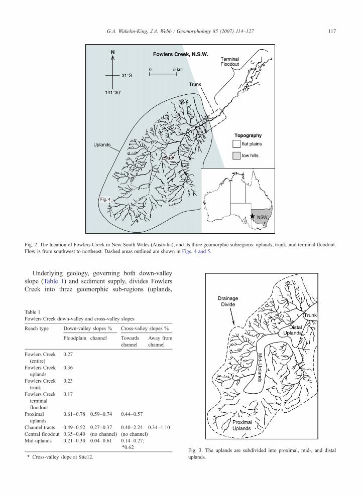
Fig. 2. The location of Fowlers Creek in New South Wales (Australia), and its three geomorphic subregions: uplands, trunk, and terminal floodout.Flow is from southwest to northeast. Dashed areas outlined are shown in Figs. 4 and 5.
117G.A. Wakelin-King, J.A. Webb / Geomorphology 85 (2007) 114–127
Underlying geology, governing both down-valleyslope (Table 1) and sediment supply, divides FowlersCreek into three geomorphic sub-regions (uplands,
Table 1Fowlers Creek down-valley and cross-valley slopes
Reach type Down-valley slopes % Cross-valley slopes %
Floodplain channel Towardschannel
Away fromchannel
Fowlers Creek(entire)
0.27
Fowlers Creekuplands
0.36
Fowlers Creektrunk
0.23
Fowlers Creekterminalfloodout
0.17
Proximaluplands
0.61–0.78 0.59–0.74 0.44–0.57
Channel tracts 0.49–0.52 0.27–0.37 0.40–2.24 0.34–1.10Central floodout 0.35–0.40 (no channel) (no channel)Mid-uplands 0.21–0.30 0.04–0.61 0.14–0.27;
⁎0.62
⁎ Cross-valley slope at Site12.Fig. 3. The uplands are subdivided into proximal, mid-, and distaluplands.

118 G.A. Wakelin-King, J.A. Webb / Geomorphology 85 (2007) 114–127
trunk, and terminal floodout, Fig. 2), each possessing acharacteristic fluvial style. In the trunk, the channels areanabranching, and in the terminal floodout the creekbecomes meandering and diminishes to disappearamongst gilgai-covered plains.
The uplands cover >75% of Fowlers Creek's totalarea (Fig. 2), and are the source of most of the water andsediment which flows through the creek. A dendriticnetwork of creek channels is incised into wide red-brownsilty floodplains, which occupy shallow valleys betweenlow hills. On the hillslopes, Adelaidean metasediments(Cooper et al., 1975) and a ≤1-m mantle of siltysediment combine to form contour-banded stony gilgai.Hillslope regolith includes massive to pedal loams andloamy sands, which contain smectite clays and abundantsand-sized mud aggregates (Corbett, 1973; Mabbutt etal., 1973; Ward and Sullivan, 1973; Chartres, 1982a,b).
The proximal uplands, occupying the upstreamsector of the system, consist of a narrow zone of rockyhills at the drainage divide, surrounding an area of
Fig. 4. Aerial photograph and sketch map of the proximal uplands; see Fig.Enclosure Tank (ET), and Gum Tank (GT). Gum Tank indicates the area of ovshown: the Enclosure Tank branch and the Little Acacia Tank branch. Flow
lower-order alluvial channels (up to third-order, Figs. 2,3). The mid-uplands contain the highest order channelsof the main drainage axis. The boundary between mid-and proximal uplands occurs where tributary channelsjoin the main drainage axis and is characterised by awidening of the floodplain (from tens to hundreds ofmetres), a decrease in floodplain slope (Table 1), andoften, the disappearance of the creek channel (Figs. 2and 5 and e.g., the Enclosure Tank branch, Fig. 4).Unchannelled reaches also occur at some tributaryconfluences within the proximal uplands (e.g., the LittleAcacia Tank branch, Fig. 4). (The distal uplands, whichare transitional to the trunk, are not discussed here.)
In the proximal and mid-uplands, channel banks andfloodplains are vegetated by sparse to closely spacedchenopod bushes and grasses. Riparian trees areuncommon, except in a few reaches (described below)which carry river red gum trees (Eucalyptus camaldu-lensis). In contrast, the channel banks in the trunk andterminal floodout carry a dense population of gum trees.
2 for location. Three earth dams are shown: Little Acacia Tank (LAT),erlap with Fig. 5. Two lower-order streams of the proximal uplands areis from left to right.
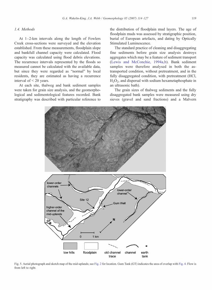
119G.A. Wakelin-King, J.A. Webb / Geomorphology 85 (2007) 114–127
1.4. Methods
At 1–2-km intervals along the length of FowlersCreek cross-sections were surveyed and the elevationestablished. From these measurements, floodplain slopeand bankfull channel capacity were calculated. Floodcapacity was calculated using flood debris elevations.The recurrence intervals represented by the floods someasured cannot be calculated with the available data,but since they were regarded as “normal” by localresidents, they are estimated as having a recurrenceinterval of < 20 years.
At each site, thalweg and bank sediment sampleswere taken for grain size analysis, and the geomorpho-logical and sedimentological features recorded. Bankstratigraphy was described with particular reference to
Fig. 5. Aerial photograph and sketch map of the mid-uplands; see Fig. 2 for locfrom left to right.
the distribution of floodplain mud layers. The age offloodplain muds was assessed by stratigraphic position,burial of European artefacts, and dating by OpticallyStimulated Luminescence.
The standard practice of cleaning and disaggregatingfine sediments before grain size analysis destroysaggregates which may be a feature of sediment transport(Lewis and McConchie, 1994a,b). Bank sedimentsamples were therefore analysed in both the as-transported condition, without pretreatment, and in thefully disaggregated condition, with pretreatment (HCl,H2O2, and dispersal with sodium hexametaphosphate inan ultrasonic bath).
The grain sizes of thalweg sediments and the fullydisaggregated bank samples were measured using drysieves (gravel and sand fractions) and a Malvern
ation. Gum Tank (GT) indicates the area of overlap with Fig. 4. Flow is

120 G.A. Wakelin-King, J.A. Webb / Geomorphology 85 (2007) 114–127
Mastersizer 2B.2 laser particle sizer (silt and clayfractions). The data were analysed using GRADISTAT(Blott and Pye, 2001). The as-transported bank samplescould not be measured in the same way becausecryptogam growth in the wet samples made laserparticle-sizing inaccurate. Instead, they were moistenedfor 24 h, then made into a slurry and the relativeproportions of (gravel+sand)/silt/clay measured usingan ASTM soil hydrometer with a Beuyoucee scale.Comparison of fully disaggregated and as-transportedgrain size distributions revealed the proportion ofsediment present as sand-sized mud aggregates. Fullydisaggregated bank sediments are only discussed in thatcontext. Elsewhere, sediments are described in their as-transported state.
2. Sediments
The channels of the Fowlers Creek uplands (Figs. 4,5) carry a bedload of poorly sorted quartzose and lithicgravelly coarse sand (Fig. 6). The channels lack finesediments, except for the occasional waning-flowdeposit in which a few centimetres of laminated finesediments overlie the clean coarse sands of the bedload.The floodplains are dominated by red-brown muds,divisible into pale red-brown modern muds (<150 yearssince deposition), distributed in patches across thefloodplains, and two or three layers of underlying red-brown to dark-brown old muds, often exposed at thefloodplain surface. Despite their textural differences,channel and floodplain sediments both originate fromerosion of the regolith-covered hillslopes, and recyclingof old fluvial sediments. Once entrained into the flowing
Fig. 6. An arroyo in the mid-uplands has a floor of flat gravely sands and bshrubs but has only a single small Acacia tree. Flow is away from the came
creek, sediments are rapidly sorted into bedload, whichtravels only short distances during the brief flood peaks,and suspended load, which is either deposited across thefloodplain or (when flows remain in-channel) flushedout of the uplands.
Modern muds are sandy, loose and non-cohesive, andrich in sedimentary structures (laminations, scours,current ripples, and intraclasts) indicating depositionunder conditions of moderate to moderately highenergy. Where they cover the floodplain, the surface isvery soft. The older muds are stiff, dense, and cohesive,appear to be more clayey, and lack sedimentarystructures, although they are sometimes faintly pedalor blocky. Where they are exposed at the surface, thefloodplain is hard to very hard. The boundary betweenmodern and older muds is generally erosional, but isoccasionally gradational showing decreasing clarity ofthe sedimentary structures, and/or increasing pedality,with depth.
The modern and older floodplain muds differsubstantially in appearance, but there is no realdifference in their grain sizes (Fig. 7A, B); when wettedin the laboratory, old muds re-separate into theirconstituent aggregates, sands, and silts and clays. Intheir as-transported state, both muds are sands or siltysands (sand 66–95%, silt 2–31%, clay 1–8%), and intheir fully disaggregated state, they are sandy silts orsilty sands (fine to very fine quartzose sand 10–76%, silt19–75%, clay 3–23%). This indicates that in their as-transported state, much (37–81%, median 72%) of thesilt and clay is bound up as sand-sized aggregates,comprising nearly half (14–59%, median 42%) offloodplain muds as a whole (Fig. 7C). (Coarse silt-
anks of floodplain muds. The riparian zone is vegetated by chenopodra; 1 m scale.

Fig. 7. Sand-silt-clay grain size distribution in (A) as-transported, and(B) fully disaggregated floodplain muds from all three of FowlersCreek's geomorphic subregions. The triangles are subdivided at 25%intervals. (C) Comparison of the sand:(silt+clay) ratios in the as-transported and fully disaggregated floodplain muds indicates theproportion of sediments travelling as sand-sized aggregates.
121G.A. Wakelin-King, J.A. Webb / Geomorphology 85 (2007) 114–127
sized aggregates are probably also present but could notbe detected with the methods used here.)
The fine sediments in Fowlers Creek (dominantlyfine to very fine to quartzose sand and sand- and silt-sized mud aggregates) are deposited across the flood-plain, but not in the channel, indicating that they travelin the suspended load. At deposition, however, they arebedload, as shown by their sedimentary structures.
3. Geomorphology
3.1. Proximal uplands
3.1.1. DescriptionIn the proximal uplands (Fig. 4), the creeks are small.
The straight to low-sinuosity channels, 5–20 m in width,have wide rectangular cross-sections (arroyos) and areusually single. Channel widening and extension occursthrough piping, sapping, and bank collapse. Scatteredriparian gum trees are occasionally present. Flooding inexcess of four times bankfull capacity covers the valleyfloor, lapping onto the rocky hills on either side, and thisreflects the relatively narrow floodplain (20–200 mwide; the channel occupies 15–25% of the total fluvialwidth).
Relatively steep channel slopes occur in bedrockcreeks of the drainage divide or in gullies incising intounchannelled valley floors. In the main arroyos, thechannel slopes are more gentle and are similar to thedown-valley slope of the floodplain (Table 1). Thecross-valley slopes towards the channels are similar toor slightly less than the down-valley slopes (Table 1),assisting the efficiency of runoff delivery into thechannel (or the return of floodwaters to the channel).
In most cases where arroyos approach tributaryconfluences, the channel becomes increasingly shallowand wide, and its slope becomes less than the floodplainslope (channel tract, Table 1). The floodplain becomesirregular, such that some sections slope away from thechannel, and the number of channel multiplies. Theseconditions promote avulsion, especially under a variableflow regime, and channel instability is evident inchannels’ irregular thalwegs and low, embayed banks.
Channels become increasingly shallow and poorlydefined with distance downstream. Near the upstreamedge of the confluence, the down-valley slope decreasesand the channels disappear entirely (central floodout,Table 1). Sheetflow spills out across the floodout,depositing thin sheets of bedload near the channel endsand suspended load (fine sands, mud aggregates, andorganic detritus) over the entire reach. Earth dams or“tanks”, installed by the graziers to collect runoff for
122 G.A. Wakelin-King, J.A. Webb / Geomorphology 85 (2007) 114–127
stock use, are often situated in or near these floodouts(Fig. 4).
The central floodouts are often notable for densestands of tall gum trees and thick understory growingtens to hundreds of metres downstream from thechannels’ ends (Fig. 4). These are the only places inthe uplands where gum trees grow so thickly and theonly places in all Fowlers Creek where gum trees are notconfined to channel banks. The density of the vegetationand its good condition during drought indicates arelative abundance of water. The dense vegetationdiscourages erosion by root-binding of the soil, and bycanopy- and leaf-litter protection of the soil surface fromrain splash. Vegetation slows water by making sheet-flow paths highly tortuous, increasing the floodplainroughness, and forming leaf-litter mini-dams perpendi-cular to the direction of flow; this promotes theinfiltration of water and the deposition of sediment.
Downstream from these densely vegetated areas, theunchannelled floodplain may be almost bare of vegeta-tion for several hundred metres. In this barren down-stream zone, drainage re-establishes in the form ofgullies and badlands leading to the next downstreamarroyo. Piping pits (usually small, but up to ∼4 m longand 0.5 m deep) focus runoff and promote gullying inthis zone.
3.1.2. InterpretationIn the proximal uplands, the gully–arroyo–floodout
landform sequences and the channel and floodplainslope relationships indicate that these creeks arediscontinuous ephemeral streams. Fowlers Creek ispredisposed to the formation of these systems by themoderately arid climate, the variable flow pattern, andthe abundant fine sediment, which is (because of itsmud-aggregate nature) both erodible and cohesive, andwhich contains swelling clays. These features contributeto piping and gullying, arroyo incision during largerflow events, the shedding of water from bare surfacesbut the retention of water once infiltration has beenachieved, and the preferential growth of vegetation inwell-watered areas, maintaining floodout stability.
The location of floodouts at tributary confluencesindicates that in Fowlers Creek, the gully–arroyo–floodout landform sequences may originate in large-scale scour-transport-fill events during low recurrence-interval floods. In other landscapes, scour-transport-fillsequences may repeat along the drainage axis. Thegullies of one cut into the floodout of the next oneupstream, and they may migrate slowly upstream(Pickup, 1985, 1988; Bull, 1997). The location of theerosion/aggradation threshold is not (in those cases)
linked to the position in the landscape. In FowlersCreek, however, floodouts are consistently found atlower order tributary confluences; this has also beennoted for the Todd River (Bourke and Pickup, 1999) andCooper Creek (Gibling et al., 1998). It is likely that thefloodouts originate as large-scale scour-transport-fillsequences during large flow events. As flows widen andshallow upon entering a larger valley, they depositsubstantial sediments, choking the tributary confluencesand decreasing the floodplain slope. With the growth ofvegetation germinated in the flood-borne sediments, thefloodout becomes self-sustaining.
3.2. Mid-uplands
3.2.1. DescriptionThe mid-uplands contains the higher order channel of
the Fowlers Creek main drainage axis. In its mostupstream reach, it consists of gullies expanding head-wards through the barren downstream edge of a floodout(Fig. 4). The headcut is influenced by piping pits whichpreferentially occur above buried channel sands, so newchannels tend to re-occupy older channel locations.Downstream, the gullies coalesce into a single channel,an arroyo (Fig. 6) incised into a broad floodplain. Thefloodplain has an irregular surface, especially where smalltributaries form heavily vegetated shallow interlinkedswales. Riparian gum trees are rare, except at Site 12 (Fig.5) which is unusual because many riparian gums arepresent, some of which are enormous and must thereforebe very old (gum trees live for at least 400–500 years,Ogden, 1978). There are no floodouts, and the mainchannel is continuous downstream into the distal uplands.
The channel has straight to curvilinear planform.Flood capacity is up to 10 times higher than the bankfullchannel capacity (Table 2). Unlike the proximaluplands, however, the whole valley width is notinundated even in large floods, due to the broaderfloodplain (∼500 m wide). The channel occupies amuch lower proportion (6–13%) of the total fluvialwidth. The down-valley slope is the lowest in theuplands (Table 1). The cross-valley slope may be lessthan half the down-valley slope, reducing the delivery offloodwaters back into the main channel. Only at Site 12is cross-valley slope steep enough (Table 1) to forcefloodwaters back into the main arroyo.
The degree of floodplain inundation varies, as shownby the patchy distribution of modern muds. Wherepresent, these sediments vary in thickness from a fewcentimetres to≤2 m (in abandoned channels), and somefloodplain reaches carry ≤1.2 m of vertically accretedmodern muds in 5–20-cm beds.

Table 2Hydraulic parameters of the Fowlers Creek Uplands: cross-sectional area, wetted perimeter (P) and hydraulic radius (R)
Hydraulic Parameters
Reach type Bankfull Flood
Area (m2) P (m) R (m) Area (m2) P (m) R (m)
Proximal Uplands - ET 21.3 37.3 0.57 (no flood debris)Proximal Uplands - ET 10.0 55.5 0.18 59.0 198.8 0.30Proximal Uplands - LAT 10.7 46.4 0.23 54.1 115.7 0.47Proximal Uplands - LAT 6.3 19.9 0.32 26.8 77.3 0.35Proximal Uplands - LAT 8.2 33.8 0.24 105.7 172.2 0.61Channel Tract 39.5 196.6 0.20 39.5 196.6 0.20Mid-Uplands 7.8 22.6 0.34 (no flood debris)Mid-Uplands (S12) 86.1 285.9 0.30 86.1 285.9 0.30Mid-Uplands 55.0 49.0 1.12 233.0 357.9 0.65Mid-Uplands 26.3 20.1 1.31 275.4 358.8 0.77Mid-Uplands 33.1 60.7 0.54 61.9 137.0 0.45
Parameters are calculated for bankfull, and recent flood level (as indicated by the height of flood debris), and are listed in upstream-downstream orderfor each reach type. LAT, the Little Acacia Tank branch in the Proximal Uplands; ET, the Enclosure Tank branch in the Proximal Uplands; S12, Site12 in the mid-uplands (see Figs. 4, 5 for locations).
123G.A. Wakelin-King, J.A. Webb / Geomorphology 85 (2007) 114–127
There is no evidence of incremental changes inchannel dimensions or location: no point bars in thecurved reaches, and no accretionary benches. However,channel relocation is evident from the old channel tracesvisible on the aerial photographs (Fig. 5). The lack ofriparian gum trees makes these old channels difficult tofind in the field.
The Gum Well reach (Fig. 5) has been affected byrecent catastrophic activity extending more than 5 kmdownstream. Gum Well's old (early 20th century?)stock trough has been buried by up to 2 m of modernmuds and subsequently re-excavated, and the channelhas been widened (3 m wide×3 m deep to 12 mwide×1.5 m deep) during a single 1-day rainfall event(1998). Downstream, channel incision has created anarrow, deep slot (∼5 m wide×∼8 m deep), and sheeterosion has stripped the flanking floodplain (present in1981 aerial photographs but still occurring). Furtherdownstream, a wide shallow network of gullies iseroded into old floodplain muds, and further down-stream, rapid channel incision has occurred. Overall, thespace created by the Gum Well reach erosion eventvaries greatly in depth and width and has a very irregularbottom surface.
3.2.2. InterpretationThe mid-uplands gullies and arroyo represents the
scour-transport zones of a discontinuous system, butinstead of finishing in a floodout, the arroyo persists forthe length of the uplands. This is because it is a higherorder channel with greater stream power; longerarroyos are favoured in higher order streams (Bull,1997).
The mid-uplands differ from the gully–arroyo–floodout systems of the proximal uplands in that thearroyo is very mobile and the floodplain is veryunstable. Arroyo mobility is demonstrated by the oldchannel traces (Fig. 5) and by the general absence ofriparian gum trees. This absence is not because the treeshave been killed, buried, or cut down, since elsewherealong Fowlers Creek, tree skeletons, deeply buried butliving trees, and axe-cut stumps are visible. Ripariangum trees in the trunk and terminal floodout rely on thechannels to provide water necessary for survival; theirgermination and growth are strongly linked to theavailability of moisture. The absence of trees in the mid-uplands indicates that rapid channel relocation isoccurring, and channel banks are generally not stablefor long enough to allow gum trees to grow. Movementof the channel by small distances (tens of metres) is notsufficient, elsewhere in Fowlers Creek, to eliminateriparian gum trees, and so this channel mobility mustoccur on a large scale.
This channel avulsion is promoted by the low down-valley slope, wide and topographically irregular flood-plains, the great degree to which flood flows exceedbankfull channel capacity, and the absence of ripariantrees. Site 12, where the steeper cross-valley slopes aremore effective in returning floodwaters to the channel, isless prone to avulsion and is the only mid-uplands reachsufficiently stable to maintain gum trees.
Because only a small proportion of the flood flow iscontained within the channel, bank cohesion can havelittle influence on maintaining channel stability. Never-theless, areas of recent floodplain mud deposition with aloose, erodible floodplain surface probably have

124 G.A. Wakelin-King, J.A. Webb / Geomorphology 85 (2007) 114–127
increased channel mobility. Channel avulsion results inthick deposits of fine sediments, both laterally, in theabandoned channel and its adjacent floodplain, anddownstream, as pulses of floodplain muds are releasedby channel cutting and intense floodplain erosionflanking the new channel. Downstream reaches mayalso experience floodplain erosion or channel incision.Together, the newly incised channel and its erodedfloodplain represent voids in the fluvial landscape whichwill be filled by a later generation of floodplain muds.
The width and depth of erosion are influenced by thenature of the floodplain surface as well as by flowstrength. Flows of low to moderate strength over hardold muds result in shallow rill erosion, and strong flowsover old muds lead to the incision of a narrow deepchannel. Flows over thin to medium layers (≤1 m) ofmodern muds strip a wide area back to a hard baresurface of the underlying older floodplain muds. Thick(∼2 m) modern muds in a channel's banks promotechannel alteration, and in a floodplain, they lower thethreshold of incision, making the reach vulnerable toavulsion.
4. Discussion
4.1. Fluvial processes in the Fowlers Creek uplands
4.1.1. Proximal uplandsIn the proximal uplands, each gully–arroyo–flood-
out landform sequence is a single system (a discontin-uous ephemeral stream). In each reach, stream power(channel incision) is balanced against valley-floorstrength (floodplain stability or aggradation). Differ-ences between reaches reflect their position withrespect to the erosion/aggradation threshold: gulliesoccur in erosional reaches, floodouts in aggradationalreaches, and arroyos exist where neither force isdominant.
The floodouts, located at tributary junctions, origi-nate during large flow events. They subsequentlybecome self-sustaining though positive feedback inwhich floodplain slope allows water infiltration, whichsupports dense vegetation; the vegetation preventserosion and maintains the slope by retarding flow andpromoting sediment deposition. The capacity of flood-outs to retain water and to support vegetation, evenduring hard drought, makes them ecologically impor-tant. They are also important economically andculturally, since their efficiency in trapping runoffmakes them a favoured location for the construction ofthe earth dams and wells which are used by the localgrazing industry.
The fluvial processes of discontinuous ephemeralstreams cross and re-cross the threshold betweenincision and aggradation (Bull, 1997). They are thresh-old-dominated and are therefore not equilibrium sys-tems (Knighton, 1998). However, once the threshold iscrossed in a reach, the system moves towards a newequilibrium. For example, a tributary-confluence reachwhich becomes aggradational is maintained by theslope-vegetation feedback. Such systems, which displayincremental adjustments towards an equilibrium state,are disequilibrium reaches (Tooth and Nanson, 2000).
4.1.2. Mid-uplandsThe mid-uplands are unusual in their geomorphic
character. Although the floodplain has some areas oflow-sinuosity interlinking swales, these are merelyheavily vegetated overflow channels, so this is not abraided system. The creek is muddy, but not mean-dering: the channel is low sinuosity and shows noevidence of incremental lateral migration. The mid-uplands channel also differs from the low-sinuositysand-bed channels of central Australia in its rectangularcross-section and its cohesive banks.
Fowlers Creek's mid-uplands are in some wayssimilar to Cooper Creek, which transports a mud-aggregate sediment load and includes narrow channelswith cohesive banks in its range of channel types(Nanson et al., 1986; Maroulis and Nanson, 1996;Gibling et al., 1998). However, Cooper Creek is muchlarger, has a lower gradient (Gibling et al., 1998), and itsmud aggregates are much richer in clay (35–60% clay,Fagan and Nanson, 2004). The Cooper Creek floodplainhas braid bars and active gilgai (Fagan and Nanson,2004), neither of which is present in the mid-uplands,and its large channels are part of an anabranchingsystem (Gibling et al., 1998), whereas the mid-uplandschannel is not.
The mid-uplands arroyo differs from those of theproximal uplands in its frequent reach-scale relocation.This reflects the wider mid-upland floodplain, lowerdown-valley slope and more irregular topography, sothat large floods have considerable freedom to find newdown-valley directions. A new channel is created whenthe flood's stream power exceeds the strength of thefloodplain alluvium.
The mid-uplands floodplain is dynamic in two ways.Firstly, floodwaters across the floodplain are not lowenergy, but rather are vigorous enough to createbedforms in sand-sized sediment, and to initiate channelincision. Secondly, the floodplain sediments are repeat-edly eroded and redeposited during the frequent channelrelocations. Cohesive old floodplain muds entering
125G.A. Wakelin-King, J.A. Webb / Geomorphology 85 (2007) 114–127
flowing waters re-separate into their component sands,sand-sized aggregates, and silts and clays, and areredeposited as cohesionless modern muds.
In fluvial systems, the opposing forces of streamenergy (e.g., velocity) and boundary resistance (e.g.,roughness) interact to create the river's geomorphology.Where the variability in these opposing forces is small,they can adjust to each other and the system reachesequilibrium. This is reflected in a relatively stablegeomorphology in which consistent relationships existbetween form and process, and there is temporal andspatial continuity of sediment transport (Richards, 1982;Tooth and Nanson, 2000). Where the variability in theseopposing forces is great and they cannot adjust to eachother, the system may be unable to develop equilibrium.
The mid-uplands has a high degree of variability.Stream energy is variable both because of flowfluctuation and because of variations in the size anddirection of floodplain slope. Boundary resistance ishighly variable because the mud-aggregate sedimentsmay be either loose or cohesive. The mid-uplands arenot equilibrium systems: they have unstable channelswhich are subject to rapid change, reach-scale differ-ences in flow strength and net sediment transport, andchaotic sediment assemblages. Their fluvial processesare threshold-driven, crossing physical thresholds (over-coming barriers to cross-valley flow, exceeding thecritical shear stress to cause entrenchment), and processthresholds (the transition between aggradation anderosion). Unlike the proximal uplands, the mid-uplandsshow no sign of adjustment towards an equilibrium,lacking any feedback processes which maintain a reachin its current condition. Such systems are non-equilibrium (Tooth and Nanson, 2000).
4.2. Mud aggregates and fluvial style
Fowlers Creek's fine sediments, dominated by mudaggregates and fine to very fine quartzose sand, aredeposited across the floodplain, indicating transport inthe suspended load. However, Fowlers Creek flowevents are transient. As flow velocity decreases, the finesediments behave like sands, and are deposited asbedload from flowing waters. This deposition of claysand silts would not occur if these fine sediments weretravelling as independent primary particles.
In the proximal uplands, conditions which favour theformation of mud aggregates (aridity, fine sediments,swelling clays) are also those which promote discontin-uous ephemeral streams, piping, gullying, arroyos andfloodouts. The aggregates and the fluvial style arisecoincidentally, rather than one being the cause of the
other. However, it is likely that the mud-aggregatesediment load contributed to the development offloodouts at tributary confluences. Because the finesediments behave like sands, they are more likely to bedeposited at confluences, choking them with sediment.Had all the fine sediments been travelling in a fullydisaggregated state, it is probable that they would havebeen washed downstream.
In the mid-uplands, mud-aggregate fine sedimentshave a more direct influence on fluvial style. In modernmuds, the aggregates are still separate and are easy toentrain, whereas the older muds are hard, cohesive, andresistant to erosion. The distribution of modern and oldmuds will therefore affect the balance between channelincision and floodplain stability and influence the widthand depth of floodplain erosion. The contrast in criticalshear stress of the old and new muds adds anothervariable to an already variable system, contributing to itsnon-equilibrium nature.
River systems balance the river's power to erode andtransport sediment with the cohesive resistance of thefloodplain sediments (Nanson and Croke, 1992). Therelationship between stream power and floodplaincohesion creates the different types of floodplain/channel, governing the resulting fluvial landforms. InFowlers Creek, the same flow strength will havedifferent geomorphic effects in different areas of thefloodplain, depending on the age of the floodplainacross which it has travelled.
5. Conclusions
This study describes the fluvial processes occurringin the uplands of Fowlers Creek, a mud-aggregate riverin Australia's arid inland.
The uplands of Fowlers Creek consist of arroyos,floored with quartzose and lithic coarse sands andgravels. They are incised into muddy floodplainsediments consisting of silt, fine to very fine quartzosesand, and clay. Most (∼72%) silts and clays areaggregated into sand- and silt-sized particles. Floodplainsediments are transported in the suspended load, butbecome bedload during deposition. Recently depositedfloodplain muds have the appearance of loose sands, butolder muds become compact and cohesive. Old muds re-separate into their component sands and aggregates afterwetting and re-entry into fluvial transport.
Reaches in the lower order channels of the proximaluplands form landscape sequences of gullies, arroyos,and floodouts (collectively, discontinuous ephemeralstreams) in which fluvial processes fluctuate betweenchannel incision and floodplain aggradation. Floodouts
126 G.A. Wakelin-King, J.A. Webb / Geomorphology 85 (2007) 114–127
originated when large floods dumped their sedimentloads upon entering the wider valleys of tributaryconfluences. They are self-maintaining by feedbackrelationships between vegetation and valley-floor slopeand are efficient at capturing and retaining water. Theyare characterised by dense vegetation and play animportant ecological role as drought refugia.
The mid-uplands experience great variability in theelements governing river flow, contributing to a non-equilibrium fluvial style. The higher order channel ofthe mid-uplands is a mobile arroyo in which frequentreach-scale channel avulsion is promoted by flowvariability, the wide and irregular floodplains, rela-tively low down-valley slope, variability in thefloodplain's resistance to erosion, and the absence ofriparian trees. Incision of a new channel releases apulse of fine sediments, burying the abandonedchannel and accreting vertically on some downstreamfloodplains. Channel incision is associated with flood-plain erosion, flanking the new channel and in somedownstream reaches. The erosion surface associatedwith channel relocation is irregular in its width anddepth.
The formation of robust mud aggregates is favouredby aridity and soils containing abundant fine sedimentsincluding some swelling clays. These conditions alsosupport the development of discontinuous ephemeralstreams. In this respect, the mud-aggregate sediments donot necessarily have a causal relationship with thefluvial style, but rather arise from the same circum-stances. Mud aggregates have a more direct influence onfluvial style in the floodouts and the mid-uplandsfloodplain, where the aggregated fine sediments can bedeposited under flow conditions which would be toovigorous for the deposition of non-aggregated silts andclays. In addition, the contrast between the loosemodern muds and the cohesive older muds governsthe location, degree, and extent of floodplain erosion.
Acknowledgements
Colin North and Gerald Nanson are thanked forthoughtful reviews which considerably improved themanuscript. We thank Peter and Tracy Botton (CoronaStation), Glenn and Debbie Cullen (Floods CreekStation), and the University of New South Wales(Fowlers Gap Research Station) for access to FowlersCreek. The following people and organizations assistedin data collection: Rudy Frank, Louise Turner, AndreaO'Sullivan, Sue White (EDM theodolite surveys); KenJohnston, Alisdair Walker and Phil Collier, Departmentof Geomatics, University of Melbourne (geodetic GPS
survey); Rio Tinto and the Department of ChemicalEngineering, Monash University (access to granulome-try equipment). GW-K thanks D.L. Dunkerley and K.Brown for introducing her to Fowlers Creek, and sheacknowledges the support of the Earth SciencesDepartment, La Trobe University, and an AustralianPostgraduate Award.
References
Australian Bureau of Meteorology, 1988. Climatic Atlas of Australia.Department of Administrative Services, Canberra. 67 pp.
Blokhuis, W.A., 1996. Classification of vertisols. In: Ahmad, N.,Mermut, A. (Eds.), Vertisols and Technologies for Their Manage-ment. Elsevier, Amsterdam, pp. 63–88.
Blott, S.J., Pye, K., 2001. GRADISTAT: a grain size distribution andstatistics package for the analysis of unconsolidated sediments.Earth Surface Processes and Landforms 26, 1237–1248.
Bourke, M.C., Pickup, G., 1999. Fluvial form variability in arid centralAustralia. In: Miller, A.J.G., Gupta, A. (Eds.), Varieties of FluvialForm. John Wiley & Sons, Chichester, pp. 249–271.
Bull, W.B., 1997. Discontinuous ephemeral streams. Geomorphology19, 227–276.
Bull, L.J., Kirkby, M.J., 2002. Channel heads and channel extension.In: Bull, L.J., Kirkby, M.J. (Eds.), Dryland Rivers: Hydrology andGeomorphology of Semi-Arid Channels. John Wiley & Sons,Chichester, pp. 263–298.
Campbell, I.A., 1997. Badlands and badland gullies. In: Thomas, D.S.G. (Ed.), Arid Zone Geomorphology: Process, Form and Changein Drylands. John Wiley & Sons, Chichester, pp. 261–291.
Chartres, C.J., 1982a. The pedogenesis of desert loam soils in theBarrier Range, western New South Wales: I. Soil parent materials.Australian Journal of Soil Research 20, 269–281.
Chartres, C.J., 1982b. The pedogenesis of desert loam soils in theBarrier Range, western New South Wales: II. Weathering and soilformation. Australian Journal of Soil Research 21, 1–13.
Cooke, R.U., Reeves, R.W., 1976. Arroyos and EnvironmentalChange in the American Southwest. Clarendon Press, Oxford.213 pp.
Cooper, P.F., Tuckwell, K.D., Gilligan, R.B., Meares, R.M.D., 1975.Torrowangee-Fowlers Gap 1:1000,000 Geological Sheet. Geolo-gical Survey, New South Wales, Sydney.
Corbett, J.R., 1973. Soils on Fowlers gap station. In: Mabbutt, J.A.,Sullivan, M.E. (Eds.), Land Systems of Fowlers Gap Station.Research Series, no. 3. University of New South Wales, Sydney,pp. 151–174.
Dunkerley, D.L., Brown, K.J., 1997. Desert soils. In: Thomas, D.S.G.(Ed.), Arid Zone Geomorphology: Process, Form and Change inDrylands. John Wiley & Sons, Chichester, pp. 55–68.
Fagan, S.D., Nanson, G.C., 2004. The morphology and formation offloodplain-surface channels, Cooper Creek, Australia. Geomor-phology 60, 107–126.
Gibling, M.R., Nanson, G.C., Maroulis, J.C., 1998. Anastomosingriver sedimentation in the Channel Country of central Australia.Sedimentology 45, 595–619.
Gierlowski-Kordesch, E.H., 1998. Carbonate deposition in anephemeral siliciclastic alluvial plain: Jurassic shuttle meadowformation, Hartford Basin, Newark Supergroup, USA. Palaeogeo-graphy, Palaeoclimatology, Palaeoecology 140, 161–184.
Gierlowski-Kordesch, E., Gibling, M., 2002. Pedogenic mud aggre-gates in rift sedimentation. In: Renaut, R.W., Ashley, G.M. (Eds.),

127G.A. Wakelin-King, J.A. Webb / Geomorphology 85 (2007) 114–127
Sedimentation in Continental Rifts. SEPM Special Publication,pp. 309–325.
Jansen, J.D., 2001. Bedrock Channel Morphodynamics and LandscapeEvolution in an Arid Zone Gorge: Sandy Creek, Northern BarrierRange, South-Eastern Central Australia. Ph.D. thesis, MacquarieUniversity, New South Wales. 513 pp.
Knighton, D., 1998. Fluvial Forms and Processes: A New Perspective.Arnold, London. 383 pp.
Lewis, D.W., McConchie, D., 1994a. Analytical Sedimentology.Chapman & Hall, New York. 197 pp.
Lewis, D.W., McConchie, D., 1994b. Practical Sedimentology.Chapman & Hall, New York. 213 pp.
Mabbutt, J.A., Burrell, J.P., Corbett, J.R., Sullivan, M.E., 1973. Landsystems of Fowlers Gap station. In: Mabbutt, J.A., Sullivan, M.E.(Eds.), Lands of Fowlers Gap Station, New South Wales. ResearchSeries, no. 3. University of New South Wales, Sydney, pp. 25–43.
Makaske, B., 2001. Anastomosing rivers; a review of their classifica-tion, origin and sedimentary products. Earth-Science Reviews 53,149–196.
Maroulis, J.C., Nanson, G.C., 1996. Bedload transport of aggregatedmuddy alluvium from Cooper Creek, central Australia; a flumestudy. Sedimentology 43, 771–790.
Marriott, S.B., Wright, V.P., 1996. Sediment recycling on Siluro-Devonian floodplains. Journal of the Geological Society, London153, 661–664.
Marshall, T.J., Holmes, J.W., Rose, C.W., 1996. Soil Physics.Cambridge University Press, Cambridge. 453 pp.
Mermut, A.R., Padmanabham, E., Eswaran, H., Dasog, G.S., 1996.Pedogenesis. In: Ahmad, N., Mermut, A. (Eds.), Vertisols and Tech-nologies for their Management. Elsevier, Amsterdam, pp. 43–61.
Müller, R., Nystuen, J.P., Wright, V.P., 2004. Pedogenic mud aggre-gates and paleosol development in ancient dryland river systems:criteria for interpreting alluvial mudrock origin and floodplaindynamics. Journal of Sedimentary Research 74, 537–551.
Nanson, G.C., Croke, J.C., 1992. A genetic classification offloodplains. Geomorphology 4, 459–486.
Nanson, G.C., Rust, B.R., Taylor, G., 1986. Coexistent mud braids andanastomosing channels in an arid zone river: Cooper Creek,Central Australia. Geology 14, 175–178.
Nanson, G.C., Tooth, S., Knighton, A.D., 2002. A global perspectiveon dryland rivers: perceptions, misconceptions, and distinctions.In: Bull, L.J., Kirkby, M.J. (Eds.), Dryland Rivers: Hydrology andGeomorphology of Semi-Arid Channels. John Wiley & Sons,Chichester, pp. 17–54.
Ogden, J., 1978. On the dendrochronological potential of Australiantrees. Australian Journal of Ecology 3, 339–356.
Pickup, G., 1985. The erosion cell - a geomorphic approach tolandscape classification in range assesment. Australian RangelandJournal 7, 114–121.
Pickup, G., 1988. Modelling arid zone soil erosion at the regionalscale. In: Warner, R.F. (Ed.), Fluvial Geomorphology of Australia.Academic Press, Sydney, pp. 105–127.
Richards, K., 1982. Rivers: Form and Process in Alluvial Channels.Methuen, London. 358 pp.
Rust, B.R., Nanson, G.C., 1989. Bedload transport of mud aspedogenic aggregates in modern and ancient rivers. Sedimentology36, 291–306.
Rust, B.R., Nanson, G.C., 1991. Reply: Bedload transport of mud aspedogenic aggregates in modern and ancient rivers. Sedimentology38, 158–160.
Schumm, S.A., 1977. The Fluvial System. Wylie-Interscience, NewYork. 338 pp.
Schumm, S.A., Hadley, R.F., 1957. Arroyos and the semiarid cycle oferosion. American Journal of Science 255, 161–174.
Tongway, D.J., Ludwig, J.A., 1990. Vegetation and soil patterning insemi-arid mulga lands of eastern Australia. Australian Journal ofEcology 15, 23–34.
Tooth, S., 1999. Floodouts in central Australia. In: Miller, A.J., Gupta,A. (Eds.), Varieties of Fluvial Form. John Wiley & Sons,Chichester, pp. 219–247.
Tooth, S., 2000. Process, form and change in dryland rivers; a reviewof recent research. Earth-Science Reviews 51, 67–107.
Tooth, S., Nanson, G.C., 2000. Equilibrium and nonequilibriumconditions in dryland rivers. Physical Geography 21, 183–211.
Ward, C.R., Sullivan, M.E., 1973. Geology of Fowlers gap station. In:Mabbutt, J.A., Sullivan, M.E. (Eds.), Lands of Fowlers GapStation, New South Wales. Research Series, no. 3. University ofNew South Wales, Sydney, pp. 67–84.