Embed Size (px)
Citation preview
WAKEFIELD LOCAL PLAN 2036
EXAMINATION IN PUBLIC
HEARING STATEMENT ON BEHALF OF NEWMARKET LANE LIMITED IN RESPECT OF MATTER NO. 14
6 October 2021
49569527.1
1
1. INTRODUCTION
1.1 This Hearing Statement is prepared on behalf of Newmarket Lane
Limited in respect of Matter no. 14.
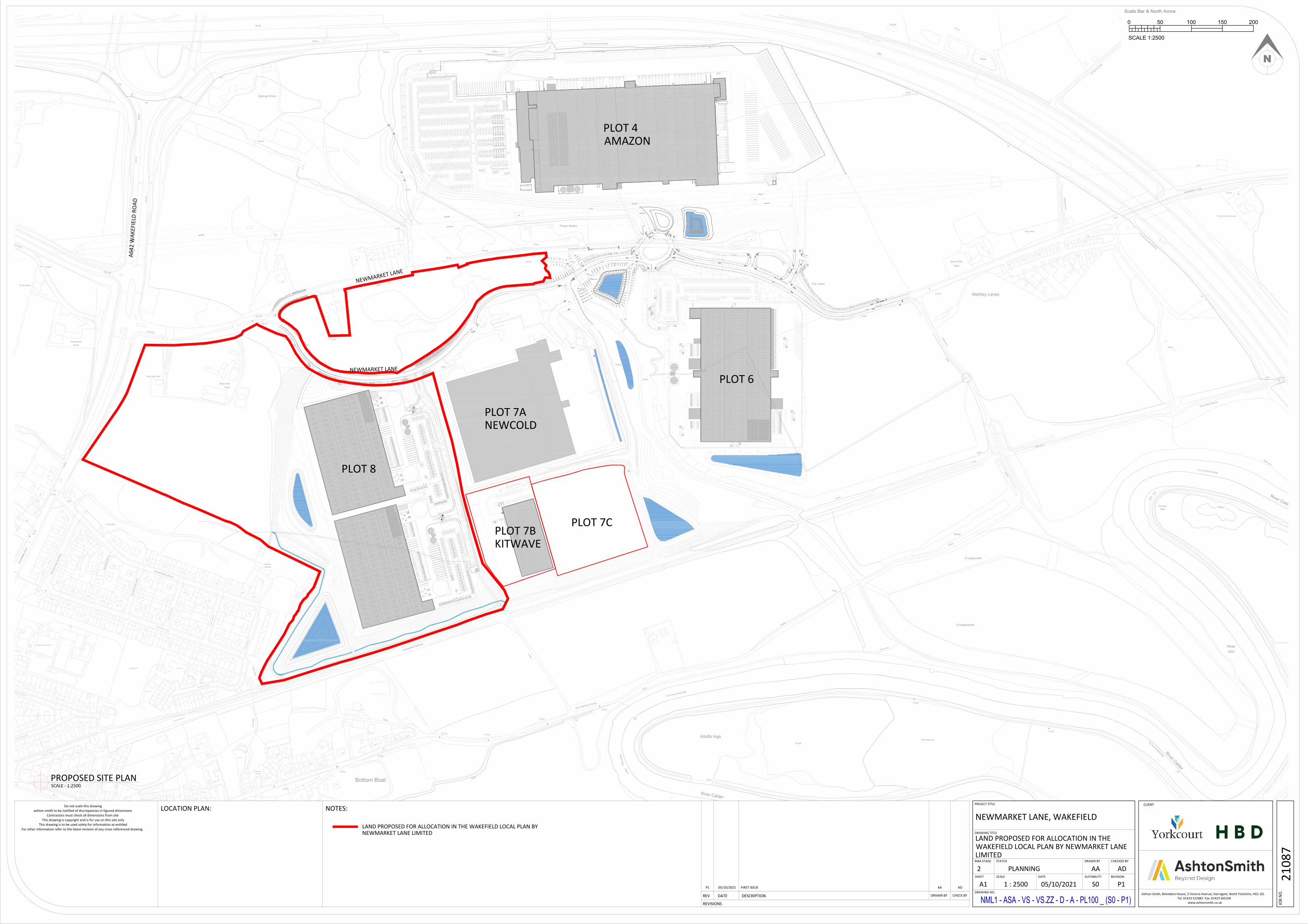
1.2 Newmarket Lane Limited has extensive land holdings at
Newmarket within and adjacent to the existing ES10 allocation. A
large part of the ES10 allocation is substantially built out, or is in
the process of being built out, with other parts of it and the adjacent
land the subject of current planning applications. Newmarket Lane
Limited is working alongside the other substantial Landowner at
Newmarket, Network Space Limited. Network Space Limited and
Newmarket Lane Limited have entered into an agreement in which
they will mutually exchange areas of land at Newmarket in order to
facilitate comprehensive development of land within and outwith of
the ES10 allocation for employment use. Newmarket Lane Limited
and Network Space Limited are working together, both in respect
of development proposals and also in respect of local plan
representations
1.3 This document addresses the Inspector’s issues and questions and
should be read in conjunction with Newmarket Lane Limited’s
December 2020 representations to the publication Wakefield Local
Plan 2036. Newmarket Lane Limited wishes to attend and
participate in the hearing in relation to his matter.
2. MATTER 14 - KNOTTINGLEY INCLUDING FERRYBRIDGE
DEVELOPMENT SITES
Issue
49569527.1
2
Are the proposed housing allocation, employment allocations and
special policy areas in Knottingley justified, effective,
developable/deliverable and in line with national policy.
2.1 LP75 – land at Ferrybridge C Power Station, Strang Land Lane
(Employment)
2.1.1 Colliers International on behalf of Newmarket Lane Ltd
have reviewed the allocation of LP75 which was originally
allocated in the Wakefield District Local Development
Framework Adopted 12th September 2012 in relation to
the same site:
“EZ 18 LAND AT FERRYBRIDGE POWER STATION,
FERRYBRIDGE - Within this zone permissible
development proposals will be restricted to employment
development directly associated with power generation
and related infrastructure, including the generation of
renewable energy. Future development proposals must
recognise, conserve and enhance the Fryston Park Wood
Local Wildlife Site, which is situated in this zone.
Development must also take full account of the parts of
the site affected by flood zones. ……The site coincides
with an area of high archaeological potential therefore a
desk-based archaeological assessment will be required,
but if this cannot assess the interest a field evaluation will
be required. The site has potential ecological value and
an ecological survey is required. The creation of an
Employment Zone on part of the operational land at
Ferrybridge Power Station, for power generation and
associated uses related infrastructure only will encourage
49569527.1
3
investment in power generation, including generation from
renewable energy sources.”
2.1.2 In 2012 construction began of a new 68MW low-carbon
power station known as ‘Ferrybridge Multifuel 1’. It
occupied 16.8 ha (41.5 ha) of land within the larger
Ferrybridge site and was opened three years later. The
plant is operated by a joint venture between the site owner
SSE and Wheelabrator Technology Inc.
2.1.3 In 2014, the same joint venture partners submitted a
Development Consent Order (DCO) application to gain
consent to develop a second larger (50MW) Multifuel
project at the Ferrybridge Power Station site, known as
Ferrybridge Multifuel 2 (FM2). Following the receipt of the
necessary consent, construction was undertaken, the
plant being formally opened in December 2019.
2.1.4 In July 2019 SSE’s contractors began demolition of the
first of eight cooling towers at the Ferrybridge site with
demolition of 5 of them due to complete by mid-2021.
2.1.5 More recently SSE instructed agents JLL to seek a
purchaser for the remaining land at the Ferrybridge site
comprising two separate parcels:
Phase 1 – 68 ha (168 acres) located to the east of the
power plant and abutting the River Aire. The site is
split into three irregular shaped plots of land
dissected by operational rail infrastructure. This will
limit the size and shape of the industrial units able to
be accommodated on site and we estimate that only
around 75% of the site will be developable, equating
49569527.1
4
to 51 ha (126 acres). Of this area 10.1 ha (25 acres)
is already occupied as a plasterboard factory (leased
to the tenant till 2056) suggesting a net developable
area of 40.9 ha (101 acres). Using the industry
standard measure of development density this land
area would be expected to accommodate circa
162,580 m2 (1.75m sq ft) of industrial buildings. The
agent’s particulars (see Appendix 3) state that the
site is being remediated but that structures adjacent
to the riverside are still to be cleared.
Phase 2 – approximately 8.1 ha (20 acres) of land
located at the centre of the site and split into two
irregular shaped areas. The agent’s state that Phase
2 ‘maybe offered to the preferred purchaser in due
course’. Our estimate is that the site is unlikely to be
able to accommodate a unit over 9,290m2 (100,000
sq ft) if it is to be offered for sale at a later stage.
2.1.6 The site represents a significant development opportunity,
but it is very complex:
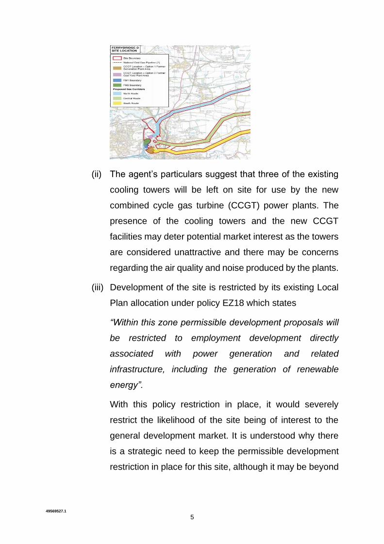
(i) As part of its dialogue with the public prior to the formal
stage of consultations regarding the new power station in
late 2018, SSE issued the following plan which shows
significant areas of the site affected by proposed ‘gas
corridors’. The effect of these corridors may severely
restrict the layout and size of development on the vacant
land resulting in a significant reduction in the net
development compared with our calculations above. We
are unsure of the current status of these corridors.
49569527.1
5
(ii) The agent’s particulars suggest that three of the existing
cooling towers will be left on site for use by the new
combined cycle gas turbine (CCGT) power plants. The
presence of the cooling towers and the new CCGT
facilities may deter potential market interest as the towers
are considered unattractive and there may be concerns
regarding the air quality and noise produced by the plants.
(iii) Development of the site is restricted by its existing Local
Plan allocation under policy EZ18 which states
“Within this zone permissible development proposals will
be restricted to employment development directly
associated with power generation and related
infrastructure, including the generation of renewable
energy”.
With this policy restriction in place, it would severely
restrict the likelihood of the site being of interest to the
general development market. It is understood why there
is a strategic need to keep the permissible development
restriction in place for this site, although it may be beyond
49569527.1
6
the Plan period before another power related occupier is
identified for it.
(iv) In their details (Appendix 3), the agent’s state that the
large former coal yards within Phase 1 contain made
ground and also falls within Flood Zone 2 (medium risk);
however, the lower extents of the area fall within Flood
Zone 3 (high risk). These are factors which also may
impact on both the viability of development on the site and
its deliverability.
(v) The need to preserve the Fryston Park Wood Local
Wildlife site identified on the Draft Plan significantly
reduces the developable area of the site and fragments it.
(vi) There is a Safeguarding Mineral Protection area along the
eastern edge of the site which may not be compatible with
commercial development occurring immediately adjacent
to it, further reducing the developable area.
(vii) The agents state that the purchaser is expected to
assume the responsibility for the operational railway line
running through the Phase 1 land and which serves the
existing plaster board plant. Some developers, funder and
investors may not be comfortable with any potential
liabilities associate with this responsibility.
(viii) It is not clear whether the existing highway infrastructure,
both on-site and off-site, is capable of fully
accommodating any proposed development without
significant upgrading works.
49569527.1
7
(ix) The site is at the eastern extremity of the Wakefield
District. It is relatively remote from the main built up areas
of the West Yorkshire conurbation. Operators considering
the site for B2/B8 development will almost certainly wish
to test the labour availability if they were to locate at the
site, particularly given the significant impact on workforce
availability of the nearby existing 111,500 m2 (1.2m sq ft)
TKMaxx development and the 47,840 m2 (515,000 sq ft)
Wakefield 515 development which has just begun to be
constructed on site on the remainder of the Trinity Farm
site. Given the availability of deliverable site options closer
to the M1/M62 interchange, many operators would prefer
it in terms of its increased labour catchment, proximity to
the West and South Yorkshire markets and improved
public transport availability.
2.1.7 In view of our comments it is uncertain how much, if any
of the SSE site will be able to realistically respond to
general (non-power related) demand for employment land
during the emerging Local Plan period and, in particular,
to respond to the forecast demand for large B2/B8 units
identified in Cushman & Wakefield’s Industrial Land
Market Assessment of March 2018.
2.1.8 The Ferrybridge site was being brought to the market by
JLL representing SSE with bids sought before 6th
November 2019. We understand that the sale to a
potential purchaser has been stopped and that it is SSE’s
intention to remarket the site later this year. We are
49569527.1
8
uncertain as to the reason for an existing sale not
progressing.
2.1.9 Since then we have spoken with parties who were
interested in the site but were deterred from considering it
because of the site issues identified above and the
conflicting requirements of the landowner’s operational
strategy with private sector development of the site for the
general industrial market.
2.1.10 We remain of the opinion that this is a secondary site
which, at best might see development of up to 62ha (154
acres). However, it is only likely to be attractive to heavy
industrial users and there is no guarantee that the reduced
site area would be developed out within the plan period.
Given the problems that this site has and the uncertainties
over its deliverability and availability it should not be
allocated at this stage.
3. LP227 – LAND AT SHILLING HILL (EMPLOYMENT)
Site LP 227 is the largest 21.7 ha (53.62 acres) of a cluster of sites
at Shilling Hill. It is the only site likely to be capable of
accommodating large scale warehousing and distribution units.
The land is dissected by the route of the South Knottingley Relief
Road (LP777) which we understand is a confirmed route but is not
programmed or funded. Uncertainty over the delivery of the new
road, which we understand to be necessary to open up the land for
development, will constrain its ability to contribute towards
Wakefield’s employment land supply within the plan period. The
49569527.1
9
cost of the new highway infrastructure may also constrain delivery
of the site.
The site has not to our knowledge been marketed although it was
allocated as part of Wakefield’s adopted Core Strategy Policy Map
2012.
4. LP537 – LAND SOUTH OF KNOTTINGLEY (EMPLOYMENT)
This large site of 168ha (415 acres) represents one of the most
significant employment allocations in the emerging plan. The site is
level and in the control of a developer. However, if allocated, its
deliverability and capacity are likely to be determined by a series of
factors:
4.1 Approximately 50% of the combined LP537/LP1278 site
South of Knottingley appears to be safeguarded for mineral
production as identified on the Initial Draft Policies Map. It
isn’t clear what elements of the site would therefore be able
to realistically respond to the future demand for employment
development within the Local Plan period given the potential
lack of compatibility between mineral extraction/production
and modern commercial development.
4.2 The access to the site from the motorway network appears
to be via the Leys Road exit from the A1 and then via
Havercroft Lane leading to Hedgewood Lane into part of the
site. Alternatively, Leys Road may provide access. In either
case the existing highway infrastructure appears to require
significant upgrading, probably including alterations to the
access to and from the A1. In its representations in respect
of the emerging Plan, Highways England state:
49569527.1
10
“The site is located adjacent to the SRN, namely M62
Junction 33. In addition, the site forms part of a wider
cumulative impact within the Knottingley area / cluster of
sites adjacent to M62 Junction 33 that could severely impact
the SRN, and this cumulative impact will need to be
considered by the Council. It is considered that the site will
severely impact upon the capacity, operation and safety of
the SRN, and this will be identified through the transport
evidence base being prepared by the Council / the individual
assessment of the transport implications of the site by the
site’s promoters.”
Costs associated with any off-site highway requirements
could be significant and may affect the site’s viability and
deliverability.
4.3 There is a significant exclusion from the site which contains
two clusters of farm buildings, (both including a farmhouse)
together with a cluster of other residences. It is not clear
what the impact on these residences would be in terms of
the proposed commercial development on the land adjacent.
Certainly, the farms and houses (accessed by a private
road) fragments the site and, in conjunction with the mineral
production safeguarded area may result in parts of the site
being difficult to access and develop.
4.4 The 2102 Local Plan Review references the possible loss of
good quality agricultural land and the potential for
archaeology as considerations in determining future
planning application at any of the adjoining sites. There is
therefore a good possibility that similar concerns may apply
49569527.1
11
to site LP 537/LP 1278 which may slow the potential delivery
of the site or result in development not being possible at all.
4.5 The site is at the eastern extremity of the Wakefield District.
It is relatively remote from the main built up areas of the
West Yorkshire conurbation. Operators considering the site
for B2/B8 development will almost certainly wish to test the
labour availability if they were to locate at the site,
particularly given the significant impact on workforce
availability of the massive TKMaxx and Wakefield 515
developments on the former Trinity Farm site close by.
Given the availability of deliverable site options closer to the
M1/M62 interchange than this site, it is our opinion that many
operators may prefer them given their increased labour catchment,
proximity to the West and South Yorkshire markets and improved
public transport availability.
5. PROPOSED CHANGES
• Site LP75 (Ferrybridge Sea Power Station) should be
removed from being allocated as it is not deliverable within
the plan period.
• Site LP227 – land at Shillinghill should be removed from
the allocation as its delivery is not proven.
• Site LP537 – land south of Knottingley should be
safeguarded rather than allocated given there are clear
uncertainties over its deliverability.

49569527.1
12
APPENDIX
EE
EE
E E E E E E EE
E
E
E E
EE
EE
E
E E E E E E E E E
EE
EE
EE
EE
EEE
EE
EEE
EE
E
EE
EE
EE
EE
EE
EE
EE
EE
1 in 40 Longfall1 in 20 Longfall (max) 1 in 40 Longfall1 in 20 Longfall (max)
E E
E E
E E E E E E E E E E EEEEEEEEEEEE
EEEEE
EEE
E
EEEEEEEEEEE
E
E
E
6
3
6
4
7
3
49
28.0m
1
1
3
2
9
3
2
S
T
P
E
T
E
R
'S
C
R
E
S
C
E
N
T
1
M
O
O
R
H
O
U
S
E
T
E
R
R
A
C
E
6
8
1
1
1
1
Smallholding
N
E
T
T
L
E
T
O
N
S
T
R
E
E
T
3
9
H
O
L
M
F
I
E
L
D
C
H
A
S
E
1
0
8
8
7
5
2
3
8
3
7
7
24.7m
M
E
A
D
O
W
F
IE
L
D
R
IS
E
The
1
1
3
M
O
O
R
H
O
U
S
E
A
V
E
N
U
E
S
C
A
R
T
H
T
E
R
R
A
C
E
6
77
3
1
0
0
1
3
1
1
2
4
2
6
2
4
9
5
3
2
5
3
3
6
5
B
A
R
K
E
R
S
T
R
E
E
T
El Sub Sta
1
1
2
7
6
2
1
65
S
T
P
E
T
E
R
'S
C
R
E
S
C
E
N
T
4
8
7
12
7
7
2
C
H
A
R
L
E
S
W
O
R
T
H
P
L
7
3
5
8
6
1
5
0
2
4
1
22.3m
17.4m
1
6
15.5m
2
23.5m
2
5
1
Altofts Ings
20.7m
1
6
5
23.2m
B
o
tto
m
B
o
a
t
1
9
9
T
r
a
c
k
D
r
a
i
n
FB
1
5
7
R
e
a
c
h
2
0
9
1
3
9
1
4
9
15.8m
7
4
1
6
7
14.9m
F
o
x
h
o
le
s
Cringlesworth
R
e
a
c
h
16.2m
8
2
4
10
14
16
1
8
1
9
2
1
3
5
2
3
2
9
3
0
4
2
C
R
C
R
7
1
0
4
3
3
4
8
3
5
4
5
5
5
9
6
4
M
O
O
R
H
O
U
S
E
G
R
O
V
E
5
4
9
1
6
4
TCB
8
3
4
LB
2
9
3
2
0
4
4
7
3
1
2
4
6
3
2
4
2
A 642
2
1
7
8
6
1
2
6
4
1
1
3
3
7
1
1
2
2
1
4
5
.
4
m
2
9
M
O
O
R
H
O
U
S
E
C
L
5
1
C
A
S
T
L
E
G
A
T
E
55.9m
2
5
5
6
1
B
6
1
3
5
43.7m
The Bungalow
2
6
Sinks
31.7m
Issues
Cottage
8
0
Dra
in
Sinks
1
3
9
The Lanes
Issues
D
r
a
i
n
ET
L
1
3
0
31.0m
Sinks
Garden
1
2
0
29.9m
1
4
1
D
r
a
in
Issues
44.4m
Issues
1
3
2
Issues
22.0m
Sinks
8
7
FB
9
4
D
r
a
in
Sinks
D
r
a
i
n
D
r
a
i
n
D
r
a
in
Farm
Cringlesworth
7
1
Methley Lanes
P
a
th
(
u
m
)
3
1
LB
8
1
4
9
D
ra
in
2
1
ET
L
15.2m
Savile Park
6
3
Shafts
3
9
Bight
Foxholes
21.2m
5
1
1
4
0
The Old School House
EK
U
n
d
C
F
C
P
U
n
d
CF
CFCo Const Bdy
Und
Boro Const & Met Dist Bdy
C
F
C
F
Und
U
n
d
C
F
R
iv
e
r C
a
ld
e
r
Pond
B
O
T
T
O
M
B
O
A
T
R
O
A
D
R
i
v
e
r
C
a
l
d
e
r
T
r
a
c
k
8
M
O
O
R
H
O
U
S
E
V
I
E
W
5
6
M
O
O
R
H
O
U
S
E
A
V
E
N
U
E
5
1
A
B
E
R
F
O
R
D
R
O
A
D
B
6
1
3
5
Springs Wood
M 62
NE
WM
AR
KE
T L
AN
E
H
U
N
G
A
T
E
L
A
N
E
R
i
v
e
r
C
a
l
d
e
r
N
E
W
M
A
R
K
E
T
L
A
N
E
B
6
1
3
5
Pond
C
o
C
o
n
s
t
&
W
a
r
d
B
d
y
C
o
C
o
n
s
t &
W
a
rd
B
d
y
C
o
C
o
n
s
t
&
M
e
t
D
i
s
t
B
d
y
C
o C
onst &
W
ard B
dy
LB
House
Farm
5
5
5
West Hall
El Sub Sta
5
5
1
Newmarket
T
r
a
c
k
L
a
y
-
b
y
Spring Cottage
Meadow House
2
3
3
2
4
9
D
is
m
a
n
t
le
d
R
a
ilw
a
y
D
is
m
a
n
tle
d
R
a
ilw
a
y
1
2
5
D
is
m
a
n
t
le
d
R
a
ilw
a
y
Workings (dis)
Ford
Gantry
Pond
P
a
t
h
(
u
m
)
Bottom Boat
7
2
b
7
2
a
6
8
7
2
Heap
(dis)
West Hall Villa
B 6135
Lay-by
Lay-by
ESS
Power Station
P
a
th
(
u
m
)
D
r
a
i
n
Pond
Pond
T
r
a
c
k
P
o
n
d
P
a
t
h
(
u
m
)
P
a
t
h
(
u
m
)
Posts
Mast
(Telecommunication)
Play Area
Pond
Playing Field
Shelter
Shelter
3
1
5
9
T
r
a
c
k
215
T
ra
c
k
Stoney Lane
M
6
2
Play Area
P
a
th
(
u
m
)
Path (um
)
El Sub Sta
Cottage
Kingsland Primary School
3
7
Rising Sun
Tank
Pond
N
Scale Bar & North Arrow
SCALE 1:2500
0 50 100 150 200
LOCATION PLAN: NOTES:
REVISIONS
Do not scale this drawingashton smith to be notified of discrepancies in figured dimensions
Contractors must check all dimensions from siteThis drawing is copyright and is for use on this site only
This drawing is to be used solely for information as entitledFor other information refer to the latest revision of any cross referenced drawing
DESCRIPTIONDATEREV DRAWN BY CHECK BY
CLIENT
JOB
NO
.
Ashton Smith, Belvedere House, 2 Victoria Avenue, Harrogate, North Yorkshire, HG1 1ELTel: 01423 522882 Fax: 01423 565104
www.ashtonsmith.co.uk
PROJECT TITLE
DRAWING TITLE
DRAWING NO.
REVISION
STATUS DRAWN BY CHECKED BY
SCALE
RIBA STAGE
SHEET SUITABILITYDATE
A1 P1
ADAAPLANNING2
LAND PROPOSED FOR ALLOCATION IN THEWAKEFIELD LOCAL PLAN BY NEWMARKET LANELIMITED
S005/10/2021
2108
7
NML1 - ASA - VS - VS.ZZ - D - A - PL100 _ (S0 - P1)
NEWMARKET LANE, WAKEFIELD
1 : 2500
PROPOSED SITE PLANSCALE - 1:2500
LAND PROPOSED FOR ALLOCATION IN THE WAKEFIELD LOCAL PLAN BYNEWMARKET LANE LIMITED
P1 05/10/2021 FIRST ISSUE AA AD
NEWMARKET LANE
PLOT 7ANEWCOLD
PLOT 7BKITWAVE
PLOT 8
PLOT 6
PLOT 4AMAZON
A642
WAK
EFIE
LD R
OAD
NEWMARKET LANE
PLOT 7C